ala wai canal watershed water quality improvement...
TRANSCRIPT

ALA WAI CANAL WATERSHED WATER QUALITY IMPROVEMENT PROJECT STEERING COMMITTEE • CITY & COUNTY OF HONOLULU • STATE OF HAWAI I
APRIL 1998
Management & Implementation Plan
Volume I
For more information, please contact:
Eugene P. Dashiell, AICP, Coordinator & Steering Committee Chairman 1314 South King Street, Suite 951; Honolulu, Hawai i 96814
Telephone & Facsimile: 808.593.8330; E-mail: [email protected]
June Harrigan, Ph.D., Manager, Environmental Planning Office Department of Health, State of Hawaii
919 Ala Moana Blvd., 3rd Floor, Honolulu, Hawai i, 96814 Telephone: 586.4337
Alex Ho, P.E., Environmental Engineer
Department of Public Works, City and County of Honolulu 650 South King St., 15th Floor, Honolulu, Hawai i, 96813
Telephone: 523.4150
Note This is a special reprint of the original
report. This reprint is provided as a guide to assist the implementation of projects which have been funded by
the State of Hawaii (DLNR projects – RFP for Design Build Contract –
about $500,000). This reprint does not include the appendices in Volume I, nor does it include Volume II. The
original report is available in libraries, from some government offices. Over
1,000 copies of the original report were printed and distributed.

Management and Implementation Plan April 1998 Ala Wai Canal Watershed Water Quality Improvement Project Page [ i ]
Chapters (Volume I) Page Acknowledgements ...................................................................... iv Glossary.......................................................................................... v 1. Executive Summary................................................................ 3 2. Recommendations.................................................................. 7 3. Water Quality Problems & Proposed Solutions................. 16
3.1. Soil Erosion in the Conservation District ................... 16 3.2. Degradation & Erosion of Streams
in the Urban District ..................................................... 19 3.3. Stream Quality .............................................................. 25 3.4. Ala Wai Canal Sedimentation & Dredging .................. 30 3.5. Flooding ......................................................................... 33 3.6. Vehicle............................................................................ 35 3.7. Litter ............................................................................... 39 3.8. Human Health ................................................................ 43
4. Existing Water Quality Conditions...................................... 47 5. Future Water Quality Conditions......................................... 56 6. Agency and Program Issues ............................................... 60 7. Public & Private Actions: ..................................................... 67 8. A Regional Approach to Management................................ 73 9. Costs and Benefits of Watershed Management ................ 77 References.................................................................................... 82 Index.............................................................................................. 85 Figures (Volume I) Page Ala Wai Canal Watershed Map............................... Follows Page vii
1. Steering Committee’s Vision .....................................................1 2. Consent Decree Project’s Accomplishments.............................3 3. Most Frequently Asked Question ..............................................6 4. Erosion Resistant Path (1930’s) Manoa Falls Trail .................16 5. Bank Erosion, Below Manoa Falls...........................................16 6. Erosion Control (1977), Manoa Falls Trail ...............................17 7. Kanaha Stream Bank, Gateway to Punchbowl........................19 8. Makiki Stream, Corner of So. King & Kalakaua.......................19 9. Stream Restoration in El Cerrito, CA.......................................20 10. Manoa Play-field at Manoa Recreation Center........................21 11. Kaimuki H.S. – Manoa-Palolo Canal Bank Improvement ........22 12. Manoa-Palolo Canal & Manoa Stream Restoration.................22 13. Manoa-Palolo Canal at Waialae Ave. Bridge ..........................24 14. Typical Cross Sections of Stream Restoration Projects ..........24 15. Proposed Cross-section, Manoa-Palolo Canal........................24 16. Maintenance Road & Bikepath Under Bridge..........................24 17. Stream Highlights ....................................................................25 18. Apoha .....................................................................................25 19. Design Considerations for Stream Channels ..........................28 19. A. Date St. to Woodlawn Dr. Corridor............... Follows Page 29 19. B. Pedestrian Underpass, Troutbridge ............ Follows Page 29 19. C. Pedestrian Underpass, Wildcat Creek......... Follows Page 29 19. D. Pedestrian Underpass, Wildcat Creek ........ Follows Page 29 19. E. Pedestrian Underpass, Wildcat Creek ........ Follows Page 29 19. F. Lower Silver Creek ...................................... Follows Page 29 19. G. Lower Silver Creek ..................................... Follows Page 29 19. H. Lower Silver Creek ..................................... Follows Page 29 20. Small Dredge in Lake Merritt, Oakland....................................30 21. Sediment from Water Separator..............................................32 22. Swollen Ala Wai Canal After Minor Rains ...............................33 22A. 100-Year Flood Plain Ala Wai Canal.............. Follows Page 34 23. The High Number of Vehicles..................................................35 24. Accumulated Sediment in Storm Drain, Kapahulu Ave ...........36 25. Road Runoff Metal Reduction Methods...................................37 26. Population of Watershed, Business Day .................................39 27. Typical Curbside Rubbish, Kapiolani Blvd/Date St. .................39 28. Storm Drain Inlet......................................................................40 29. Typical Amount of Litter in Bottom of Storm Drain ..................40 30. Volunteers. Waikiki Yacht Club Canal Crew............................41
Table of Contents – Volumes I & 2

Management and Implementation Plan April 1998 Ala Wai Canal Watershed Water Quality Improvement Project Page [ ii ]
31. State Harbor MOG Vessel ...................................................... 31 32. Debris-Catching Boom in Lake Merritt, Oakland..................... 42 32A. Debris Booms Locations (Proposed) ..............Follows Page 42 33. Fishers Taking Large Numbers of Tiliapia .............................. 44 34. Tilapia Capture for Contaminant Testing – 1997 .................... 44 35. Leptospirosis Warning............................................................. 45 36. 1920 Air photo – Pre-Ala Wai Canal ....................................... 47 37. Decrease in Permeability ........................................................ 48 38. Birds and Other Animals ......................................................... 50 39. Abandoned Car Battery........................................................... 50 39. A. 1920 Map Ala Wai Canal ..............................Follows Page 55 39. B. Permeable Area & Sub-watersheds .............Follows Page 55 40. Outrigger Canoe Under Kapahulu Ave. Bridge ....................... 56 41. Retaining Wall, Pukele (Palolo) Stream .................................. 63 42. Palolo Flood Control Project – Clean-up................................. 68 43. Palolo Pride Festival ............................................................... 68 44. Waiomao Stream, April 1997, Large Stump............................ 69 45. Pukele Stream Channel .......................................................... 68 46. Waiomao Stream, October 1997, Large Stump Moved .......... 70 47. Manoa Stream – Failed Attempt at Erosion Control................ 71 Tables (Volume I) 1. Evaluation of Aquatic Habitat in Ala Wai Canal Watershed Streams...................................................... 28 2. Estimate of Metals in Road Runoff........................................... 37 3. Land Area and Land Use: Ala Wai Canal Watershed .............. 49 4. Summary of Information: Ala Wai Canal .................................. 51 5. Sources of Contaminants Found in the Watershed ................. 53 6. Vehicle-Miles per Day ............................................................ 54 7. Annual Load Estimates: Automotive Sources .......................... 55 8. Summary of Watershed Regulatory, Enforcement................ and
Implementation Capabilities.................................................... 67 9. Watershed Project Cost Summary........................................... 79 10. Estimated Benefit to Cost Ratios ............................................. 81 Appendices (Volume I) Appendix A. Proposed Legislation –1998
List of Projects or Actions 1. Vehicle Contaminant Reduction 2. Manoa Recreation Center: Stream Bank Erosion Control 3. Ala Wai Canal to Manoa Trail System 4. Kaimuki High School Stream Bank Improvement 5. St. Louis Heights Trail & Erosion Reduction
6. Beautification of Makiki Stream from King St. Along 7. Kalakaua Avenue. 8. Kanaha Stream Restoration and Landscaping 9. Pukele Stream Lo’i Restoration and Trail 10. Waiomao Stream Restoration, Trail and Community Garden 11. Upper Palolo Valley and Ka’au Crater Trail and Stream Restoration 12. Erosion Control in the Urban District, Especially Along Stream Banks 13. Greenbelts and Vegetative Buffers 14. Dredge Manoa-Palolo Canal Between the Ala Wai Canal & Date St. to Serve
as a Sediment Catchment Basin 15. Inject Seawater Into the Ala Wai Canal to Clarify the Water, Reduce Odor...... 16. Reduce Cans, Bottles, Bags, Cups, and Fast Food Debris from Entering
Streams and Canal 17. Reduce Neighborhood Rubbish Collection Problems 18. Flood Damage Reduction Investigation of the Ala Wai Canal 19. Stop Illegal Construction, Filling in Streams and Reduce Rubbish Dumping .... 20. Dredge Ala Wai Canal between Kapahulu Av. & the Ala Wai Boat Harbor 21. Reduce Erosion and Improve Vegetative Cover in the Conservation District 22. Centralize All Watershed Water Quality Implementation within DLNR,
Especially Streams 23. Prepare a Master Plan for Watershed Management Including Project Designs,
plans, and Specifications for Construction and an Environmental Impact Statement
Status of Legislation (as of April 15, 1998) SB 2505 – Omnibus Ala Wai Canal Watershed Legislation SB 2506 – Plastics Recycling and Advance Deposit SB 3110 – Capital Improvements Funding HB 3385 – Omnibus Ala Wai Canal Watershed Legislation SCR 140 – Concurrent Res. Adopting Management and Implementation Plan HCR 177 – Concurrent Res. Adopting Management and Implementation Plan Note: This Appendix includes copies of the legislation and testimony presented. Appendix B. Review Comments Received Regarding the
Draft Management and Implementation Plan

Management and Implementation Plan April 1998 Ala Wai Canal Watershed Water Quality Improvement Project Page [ iii ]
Appendices (Volume II, Separately Bound) A. Consent Decree – Project Description B. List of Steering Committee Members C. Best Management Practices Workshop Report A Schedule of Presentors B Summary of BMP Workshop Presentations, Questions and
Answers C Water Quality Standards in the Ala Wai Canal Watershed,
Gordon Smith, Department of Health, Environmental Planning Office
D Criteria for Handling Drainage Discharge from Buildings and Appurtenant Structures, Gerald Takayesu, Chief, Storm Water Section, Department of Public Works, City & County of Honolulu
E Suggested BMPs for Litter and Debris Problems, Alex Ho, Environmental Engineer, DPW, C&C
F Gabion Streambank Protection Project Note, Richard Frey, Engineering Solutions, Inc, Aiea.
G Contaminants: Sources, problems, typical BMPs, Eugene Akazawa, Clean Water Branch, DOH.
H Streambank Vegetation BMPs, and Vegetation Types Suitable for the Ala Wai Canal Watershed, Lisa Farrantinos, Watershed Consultant.
I Contribution of Stream Channel Erosion to Sediment Yield from an Urbanizing Watershed, June Harrigan, Ph.D., DOH.
J Suspended Sediment Production from Forested Watersheds on Oahu, Hawaii, Submitted by U.S. Forest Service and DLNR Division of Forestry.
K Channel-Lock: Flexible Concrete Revetment, Manufacture’s Literature.
L Copper, Brake Pads, & Water Quality, City of Palo Alto, DPW. M Waikakalaua Stream Realignment Project, Troy Ogasawara,
Hawaiian Fertilizer Sales. N Port of Seattle Study Recommends that Sweepers Can
Replace More Expensive BMP’s for Removing Metals, Jackie Parnell, Environmental Planning Consultant
O Volunteer Monitors Aspire to Better Data P Water Quality Monitoring Report – May 1996 – 1997 Ala Wai
Canal Watershed Project, DOH. Q Stockpile Runoff Project – Chromium Leachate Exceeded
Standards, Khal Spenser, UH. R Trapping Metals in Stormwater from Highway Runoff. S Metal Removal from Stormwater in Street Storm Drain Catch
Basins – Fossil Filters T List of Manufacturers Contacts for Storm Water Treatment
Devices, per Joanne McLaughlin. U Aquashield Stormwater Filters for Street Storm Drain Catch
Basins V Stormceptor Stormwater Filters for Street Storm Drain Catch
Basins W Timari Pavement Grease & Oil Waterless Cleaner. Honolulu,
David Buck D. Fishers Study E. Paddlers Health Survey F. Fish Consumption Risk Assessment G. Abandoned Automotive Battery Survey H. Palolo Valley Tenants Association Kalo Club Report I. Benefit/Cost Analysis Manoa Stream Restoration & Bike
Path Project
Management and Implementation Plan April 1998 Ala Wai Canal Watershed Water Quality Improvement Project Page [ iv ]
Acknowledgements Our purpose is to heal the watershed – to nurture it, and to maintain it. Staff of County and State agencies cooperated to advise and manage this project. It is with their understanding and support that this project can be completed in the spirit and intent of the Consent Decree Project Agreement (Appendix A, Volume II). Under the Consent Decree, there are three primary advisors: ♦ State of Hawaii, Department of the Attorney-General, Regulatory
Division, Legal Advisor. ♦ State of Hawaii, Department of Health, Environmental Planning
Office, State Contracts Manager. ♦ City and County of Honolulu, Department of Public Works,
County Project Advisor. Many other Agency staff helped by providing data and interpretations. The names of their agencies occur throughout this report. The common objective of their assistance, and of this report, is to achieve improved water quality in the Ala Wai Canal, its tributary streams, and its groundwater. The full extent of commitment by agency personnel to the public interest and to the environment is not always understood or appreciated in the community. Agency staff are frequently called to be present on weekends, evenings and off-days in support of community projects. Their extensive and significant role in public information activities can never be repaid in monetary terms. This report is ultimately a product of the members of the Steering Committee, who have diligently followed this project from its inception, participated in its meetings and workshops, and continuously supported this effort. More than 250 persons, community groups, government agencies, neighborhood boards and elected officials participated as voting members of the Steering
Committee (See list, Appendix B, Volume II). This is truly a diverse group which is representative of both the community within the Ala Wai Canal Watershed, as well as the larger community of Oahu and the State. We extend special appreciation and aloha to:
♦ Ala Wai Elementary School ♦ Ala Wai Watershed Community Network ♦ Anuenue School ♦ Citizens Action Program ♦ Field Crews, Departments of Health (State) and Public Works
(City), who assisted on several occasions to get the job done. ♦ Friends of Palolo Stream ♦ Hawaii Canoe Racing Association ♦ Kaimuki High School ♦ Malama O Manoa ♦ Manoa Elementary School ♦ Neighborhood Boards (Ala Moana, Palolo, Moiliili-McCully,
Makiki, Waikiki) ♦ Polynesian Culture Club (Kaimuki High School) ♦ RE2 Corporation (P. Kaanapu, J. Pietch) ♦ Saint Francis School ♦ University of Hawaii (Departments of: Agriculture and Resource
Economics, Art, Economics, Environmental Center, Geography, Ocean and Earth Sciences and Technology, Water Resources Research Center, William S. Richardson School of Law, and Students of Dr. J. Miller and Ms. P. Wood)
♦ Youth for Environmental Services.
Ku ka kνhalelo, ke ν o kahawai. (A lot of trash accumulated with the rocks in the streams.)
[The sign of a storm. Also said of the many
useless, hurtful words uttered in anger.]
Olelo No'eau, Mary Kawena Pukui. #1,888.

Management and Implementation Plan April 1998 Ala Wai Canal Watershed Water Quality Improvement Project Page [ v ]
Glossary Ahupua a. A land division extending from the uplands to the sea. In
an ahupua a, one pays tribute (sometimes a pig - pua a - to a king, owner, landlord, or konohiki, for use of the resource. The ahupua a concept is analogous to the watershed management concept insofar as it implies stewardship of the land and water for preservation and conservation of resources. The ahupua a concept implies that a single person or entity is the manager of the land division, which will flourish under the leadership provided. Also, users of the land division have a responsibility to contribute to its maintenance.
Aquatic Life (or species). Organisms, such as fish, which live in
water. Average Annual Cost. The total cost of a project, averaged over the
number of years of the project’s life, using a current interest rate, same concept as a mortgage payment. A typical infrastructure project may have a project life of 25 to 50 years before major rehabilitation is required.
BMP. Best Management Practice. Term used to designate the best
project or action leading to improved water quality. Actions listed in each chapter consist of sets of BMPs, which may be structures, such as stream bank erosion control revetments, or trash removal from streams (a practice).
Catch Basin. Part of the storm drain system. Each storm drain inlet
includes a catch basin which is accessed for cleaning via a manhole cover. There are over 1,000 of these in the Ala Wai Canal Watershed.
cfs. Cubic feet per second, a common measure of water flow. One
cfs is equivalent to about 646,000 gallons per day or 0.65 mgd. Chlordane. Chemical compound used to kill termites. Used
extensively in Hawaii until its use was banned in 1988. Can cause cancer.
City, City and County of Honolulu. The city and county are a single administrative and political entity and encompass the entire island of Oahu.
Consent Decree and the Project Agreement. The Ala Wai Canal
Watershed Water Quality Improvement Project was initiated as the result of a consent decree between the City and the State. The Project Agreement lists details of the tasks to be accomplished to by the disputing parties.
Consent Decree Coordinator. Contractor retained to carry out the
tasks of the project agreement. Under the terms of the Project Agreement, the Coordinator is also designated Chairperson of the Steering Committee.
Conservation District. The State of Hawaii’s land use law divides
all lands in the State are divided into four Districts (or zones): Agriculture, Conservation, Rural and Urban. There is no Rural District on the Island of Oahu. There is little Agriculture District land in the Ala Wai Canal Watershed.
Dieldrin. Chemical compound used to kill termites. Used extensively
in Hawaii until its use was banned in 1988. Can cause cancer. Detected in a Kaimuki drinking water well in 1997.
fps. Feet per second. Describes the velocity of flowing water. Under
storm runoff conditions, the Ala Wai Canal flows slowly at 1 fps, the Manoa-Palolo Canal at 7 to 10 fps, and the streams are faster, up to 20 fps (about 14 miles per hour).
Government Agencies
BD. Building Department (City). BWS. Honolulu Board of Water Supply. Semi-independent
board (attached to the City) which manages the potable water system on the Island of Oahu.
COE. U.S. Army Corps of Engineers (Federal) DLNR. Department of Land and Natural Resources (State) DOE. Department of Education (State)

Management and Implementation Plan April 1998 Ala Wai Canal Watershed Water Quality Improvement Project Page [ vi ]
DOH. Department of Health (State) DOT. Department of Transportation (State) DPR. Department of Parks and Recreation (City) DPW Department of Public Works (City) DTS Department of Transportation Services (City) DWWM. Department of Wastewater Management (City) EPA. Environmental Protection Agency (Federal) HHA. Hawaii Housing Authority (State) NPS. National Parks Service (Department of Interior, Federal) NRCS. National Resources Conservation Service
(Department of Agriculture, Federal) Water Commission. Administers the State Water Code.
Administratively attached to DLNR.
Heavy metals (or metals). Arsenic, cadmium, chromium, copper, lead, mercury, nickel, zinc. Sometimes called “metals”. Metals in high concentrations can kill aquatic life.
Low-flow Channel. A specially designed and constructed feature of
a modified stream channel which constricts the flow of water so that some depth is always maintained for the benefit of fish or other aquatic life.
mgd. Million gallons per day. mg/kg. Milligrams per kilogram. mg/l. Milligrams per liter. O opu. Fish native to the Hawai ian Islands and found in all the
major streams in the Ala Wai Canal Watershed. In this report, o opu are recommended for use as a biological indicator of stream water quality. For example, an increase in numbers of the o opu would indicate improved water quality. The reason for this is that o opu require fresh, cool, flowing water of good quality. A confounding factor is the presence of introduced species which must be removed so that native fish can flourish.
One hundred year flood (or storm). The so-called one hundred year flood (or storm) has a statistical probability (or chance of occurrence) of one percent in any single year. The 10-year event has a 10 percent chance of occurrence in any single year. The two-year event has a 50 percent chance of occurrence in an single year.
Overflow Channel. The overflow channel is constructed in modified
streams to accept stream flows greater than can be accommodated by the low-flow channel. The overflow channel would fill with flowing water less frequently than the low-flow channel, a condition which would permit multiple use. For example, the overflow channel could be used as a temporary road for stream channel maintenance. This approach would allow convenient maintenance access by crews and equipment. In this way, routine maintenance would not disturb the aquatic habitat and stream life, which is reliant on special physical features of the low flow channel.
PAHs. Polynuclear Aromatic Hydrocarbons. A class of residues of
petroleum, oil and gasoline. Found in waterways as a product originating from internal combustion engines and vehicles which use petroleum based lubricants.
Steering Committee. The Consent Decree Project Agreement
required that the Coordinator establish and chair a Steering Committee. The membership includes government agencies, elected officials, neighborhood boards, other groups and individuals from the community. The project agreement did not specify the number of members, so the Steering Committee contains over 250 entities (agencies, groups, officials and individuals.)
Urban District. See Conservation District. Fifty-five percent of the
Ala Wai Canal Watershed is in an Urban District

Management and Implementation Plan April 1998 Ala Wai Canal Watershed Water Quality Improvement Project Page [ vii ]
Watershed. The watershed is a physical basin on the surface of the earth within which all falling rain flows to a single outlet or discharge area. The peaks of ridges, which divide one watershed from another, typically mark the boundaries of a watershed. In urban areas, development and construction of storm drains have altered the natural watershed divisions. For example, there were once three streams flowing directly to the ocean through the sand bar forming Waikiki. Construction of the Ala Wai Canal diverted water in these three streams to a single outlet to the ocean.
Management and Implementation Plan April 1998 Ala Wai Canal Watershed Water Quality Improvement Project Page [ 1 ]
What is the Management and Implementation Plan? The Plan is a combined product of the Steering Committee, the City and County of Honolulu and the State of Hawaii. The purpose of the Plan is to improve the water quality of the Ala Wai Canal, tributary streams (Makiki, Manoa and Palolo) and related groundwater flows. Who is on the Steering Committee? The Steering Committee is comprised of individuals, groups, agencies and elected officials representing County, State and Federal governments. For more information about this project and the Steering Committee, see Volume II (Appendix A. -- Consent Decree). What is the Vision of the Steering Committee? Early in the project, the Steering Committee agreed on a Vision (see Figure 1.) of the future conditions in the Canal with the intent that the Vision would be achieved early in the next century. The Vision acknowledges that the existing and most probable future uses of the Canal will be mostly recreational, but it does not preclude other uses of the Canal if they meet the goal of the Vision. For example, there is a proposal to use motor vessels on the Canal as a means of transportation for the Convention Center visitors. Provided the vessels do not generate pollutants, their use would be compatible with the vision. The Vision statement provides guidance in the form of water quality objectives to be achieved by the Management and Implementation Plan. Why Was the Ala Wai Canal Constructed? The Canal was constructed to reduce flooding and to create land for building in and around Waikiki. The Canal diverted the streams (which originated in the watershed’s three major valleys -- Makiki, Manoa and Palolo) away from Waikiki and into the ocean where the Ala Wai Boat Harbor exists today. Prior to construction of the Canal, the streams flowed from the mountains into an extensive wetland which was used for growing taro and rice. When the Canal was constructed in the 1920’s, no thought was given to its use for recreational or swimming purposes. Its sole function was to divert storm water runoff from developed areas For the last 70 years, the Canal has functioned very well as a
1. Executive Summary (Volume I)
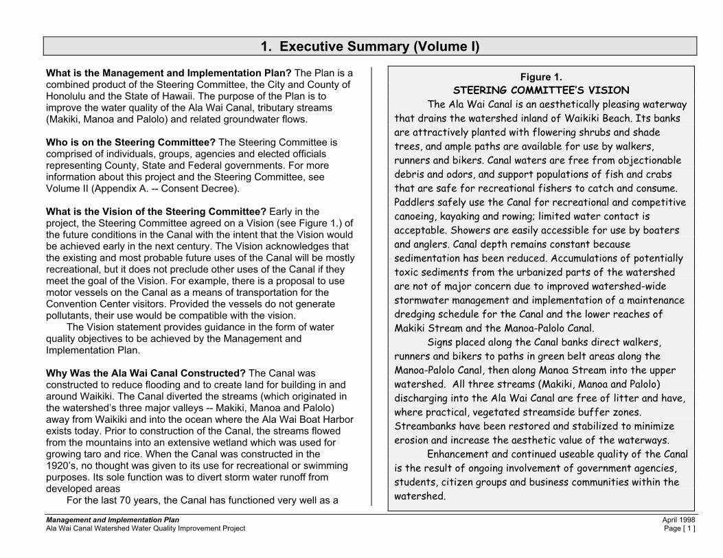
Figure 1. STEERING COMMITTEE’S VISION
The Ala Wai Canal is an aesthetically pleasing waterway that drains the watershed inland of Waikiki Beach. Its banks are attractively planted with flowering shrubs and shade trees, and ample paths are available for use by walkers, runners and bikers. Canal waters are free from objectionable debris and odors, and support populations of fish and crabs that are safe for recreational fishers to catch and consume. Paddlers safely use the Canal for recreational and competitive canoeing, kayaking and rowing; limited water contact is acceptable. Showers are easily accessible for use by boaters and anglers. Canal depth remains constant because sedimentation has been reduced. Accumulations of potentially toxic sediments from the urbanized parts of the watershed are not of major concern due to improved watershed-wide stormwater management and implementation of a maintenance dredging schedule for the Canal and the lower reaches of Makiki Stream and the Manoa-Palolo Canal.
Signs placed along the Canal banks direct walkers, runners and bikers to paths in green belt areas along the Manoa-Palolo Canal, then along Manoa Stream into the upper watershed. All three streams (Makiki, Manoa and Palolo) discharging into the Ala Wai Canal are free of litter and have, where practical, vegetated streamside buffer zones. Streambanks have been restored and stabilized to minimize erosion and increase the aesthetic value of the waterways.
Enhancement and continued useable quality of the Canal is the result of ongoing involvement of government agencies, students, citizen groups and business communities within the watershed.

Management and Implementation Plan April 1998 Ala Wai Canal Watershed Water Quality Improvement Project Page [ 2 ]
sedimentation basin, collecting eroded soil and debris and thereby preventing some contaminants from reaching coastal waters and the ocean. When did pollution in the Ala Wai Canal become a noticeable problem? In the 1930’s, within 10 years of completion (1928) of the Ala Wai Canal, water quality problems were apparent. People were advised not to swim in the Canal because of a risk of illness due to the presence of bacteria and wastes. The severity of the problem reached an action level by 1976 when the State Office of Environmental Quality Control and the University of Hawaii issued a report detailing the problems and suggesting some solutions. No remedial actions were taken and conditions worsened. Between 1992 and 1995 the Department of Land and Natural Resources issued a series of reports and recommendations to solve many of the problems. What are the contaminants in the Canal? • Sediments in the Canal contain chemicals, metals, bacteria, and
debris, some of which are toxic enough to make ocean disposal of dredged sediments unlikely, leading to increases in Canal maintenance costs in the future.
• When the sun sets, the Canal emits an odor from dying phytoplankton, populations of which have exploded during the day in the nutrient rich waters. These same phytoplankton blooms give the water in the Canal an unpleasant turbid look.
• More than 10,000 cubic yards of eroded soil is deposited in the Canal every year. The soil originates in the mountains, and from eroding stream banks in the urban areas.
• More than 250,000 vehicles travel 1.6 million miles every day in the urban areas. Their brake pads, tires, and exhaust gases deposit lead, copper, zinc, chromium and other chemicals and compounds on the roads. Rainwater carries these contaminants
via storm drains and streams to the Canal. • Large quantities of plastics and other litter
and debris from the urban area are washed into the Canal via storm drains. This material is unsightly, non-biodegradable in the marine environment, and harmful to marine life.
What should people not do? • People should not swim in the Canal. The
Canal carries high levels of bacteria, especially after rainstorms, which flush contaminants on the surface of the land downstream. The Canal also receives stream water containing Leptospirosis, a bacterium which causes a painful illness. A recent survey of outrigger canoe paddlers found recurring problems with skin rashes (not a symptom of Leptospirosis, but of other pathogenic bacteria such as Staphylococcus), an ailment not found in a
control group, which did not use the Canal for practice. Although the survey was too small to be conclusive, and relied on self-reporting, the results provide some confirmation of years of anecdotal reports by paddlers using the Canal.
• People should not eat fish caught in the Canal. They contain levels of pesticides which can increase the risk of cancer.
• Children (and adults) should not play in the streams, which are tributary to the Canal, because of the risk of Leptospirosis.
How serious are these water quality problems? • The problems are expensive to solve. For example, dredging
of the Canal is a necessity – and should be done every 10 years. The present cost estimate is more than $10.0 million ($1.5 million yearly, including interest on capital). This cost estimate may increase because of concerns that the dredged sediment may be too toxic to marine life for disposal in the ocean. If so, more costly land disposal is the only other option.
CLEAN THE WATERSHED & THE ALA WAI CANAL WILL BE CLEAN
Reduce Canal Maintenance Costs Invest in the Watershed
Reducing soil erosion and pollution in the watershed will decrease the costs of dredging the Ala Wai Canal. Projects can be started now. An alliance must be established among County and State agencies, the general community, business interests (especially those based in Waikiki), concerned groups and individuals, and legislators from throughout the State. If dredging costs are to be reduced, the focus must shift from dredging the Canal to healing the watershed.

Management and Implementation Plan April 1998 Ala Wai Canal Watershed Water Quality Improvement Project Page [ 3 ]
• Healthwise, the Canal is becoming a liability. The public should not eat fish caught in it nor should people swim in it. So far we have not experienced outbreaks of sickness, but, the potential increases as recreational use increases. The Canal does not meet federal Clean Water Act goals regarding beneficial uses of the waters. Swimming in and eating fish from the Canal are not recommended at this time.
• The visitor industry is adversely affected by the poor conditions in the Canal, although there is no estimate of the actual cost in terms of business lost. For example, the Hawaii Rowing Challenge is one successful new event which is revenue- generating, but hampered because sedimentation of the Canal restricts the course layout and rowing activities.
• The new Convention Center would benefit from improvements in the Canal’s water quality. Its location on the banks of the Ala Wai Canal, proposed use of the Canal for water-borne transportation, and the volume of visitors crossing the Canal between their hotels and the Center guarantee a higher visibility to the visitor than ever before.
What has been done? Between 1928 and 1997, major water quality improvement projects have not been undertaken in the watershed (excepting the Consent Decree project, see Figure 2.), perhaps because the overall problem has appeared too complex and difficult to solve, or because large-scale remediation projects are difficult to identify. Also, the problems have emerged slowly, and without catastrophic consequences, so there is a natural reluctance to fund remediation measures without a clear statement of the benefits to be achieved. Minor dredging of the Canal was done in 1967 and 1978, but only sediment near the mouth of the Manoa-Palolo Canal was removed. In the 1980’s, authorities banned (nationwide) the use of toxic tin-based bottom paints, residues of which originated from boats in the Ala Wai small boat harbor and migrated upstream into the Canal. Also banned: lead in gasoline, and the termiticides dieldrin and chlordane. For years the State and the City have sponsored anti-litter and neighborhood clean-up programs and the City has a taxpayer-funded rubbish collection service. However, litter is still a problem in the watershed. Because of increased population density in the watershed, the
Figure 2. CONSENT DECREE PROJECT’S ACCOMPLISHMENTS
Under the Consent Decree Project several small-scale remediation projects and actions have been initiated with agencies and community groups. These activities include: • Installation of floating booms across the major inlets to
the Ala Wai Canal to restrain floating trash, which is removed by volunteers before it reaches the Canal or the ocean.
• Restoration of lo’i which capture sediment before it enters the stream, and also reduce erosion of the stream bank.
• Identification of problem-areas (streambank and soil erosion, dumping, construction in floodways) and notification to responsible authorities.
• Notifications to residents and owners in neighborhoods where improper disposal of household rubbish results in debris being deposited on streets and in storm drains which eventually flush into the Canal.
• Surveys of paddlers and fishers. • Lab tests of fish caught in the Ala Wai Canal. • Information activities for community festivals, schools,
EarthDay, agencies, other groups and the media about the issues and the need for remedial actions.
• Coordination of meetings of the Steering Committee every two to three months -- the invitation list consists of nearly 250 agencies, groups and individuals who can participate as voting members.
• Preparation of this Management and Implementation Plan. • Preparation of a list of remedial projects. • Legislative initiatives to obtain project funding.

Management and Implementation Plan April 1998 Ala Wai Canal Watershed Water Quality Improvement Project Page [ 4 ]
situation has worsened over the years. Moreover, important other pollutants must be identified and controlled. These other pollutants originate from the massive numbers of vehicles moving throughout the Urban District, and the search for remedial measures is only just beginning. What can be done? The Canal must be dredged. The City and State are working together to accomplish this goal by preparing an environmental assessment for the project. The assessment will be completed in the latter part of 1998 and should lead to a long-overdue removal of the Canal sediments. However, maintenance dredging should recur at 10 year intervals (2007, 2017, 2027, etc.) and costs will be higher in the future because of the increasing difficulty of disposing of contaminated sediments. The legislature has authorized funds for the proposed dredging in 1997, although the actual appropriation has not been made. This is an excellent, and costly, first step.
Is there a coordination problem?1 Yes, there is a coordination problem and it occurs within and among all levels of government, including both agencies and elected officials. The problem exists because agency programs are not structured to solve complex
1 The statements in the paragraph are intended to describe the opportunity to improve watershed management because of the improvement in knowledge and understanding of the water quality problems related to modern Honolulu. The statements are NOT meant as a criticism of agencies or officials who have been struggling with reduced program and staff funding.
watershed management problems. Furthermore, overlapping programmatic and geographic jurisdictions can cause responsibilities to be shifted or ignored. The Ala Wai Canal watershed has evolved into a complex physical area and the programmatic mandates of individual agencies have not kept up with the changes from simpler times. The public, and their elected officials, are aware of the water quality problems and are frustrated in their efforts to identify practical solutions, which can be implemented within a reasonable time-span.
The communities within the Ala Wai Canal Watershed have grown to large sizes, with high densities. This complexity requires a goal of overall management to guide decision-making, increase efficiency of project implementation, and generally to be more responsive to the environmental and water quality needs of the 21st century. There are overlapping jurisdictions of federal, state and city authorities: 10 state representative districts, 7 Neighborhood Boards, 5 State Senate Districts, 2 U.S. Senators, 2 City Council Districts, 1 U.S. Representative and a plethora of Federal, State and County agencies which have programs affecting the Ala Wai Canal watershed. There are strong demands statewide for project funding, and the Ala Wai Canal watershed competes with many other communities for attention from elected officials. In order for projects
COORDINATION PROBLEMS ARE CAUSED BY URBAN GROWTH AND TECHNOLOGICAL CHANGES – AGENCIES
AND OFFICIALS ARE TRYING TO KEEP UP Several factors contribute to the complex water quality problems in the Ala Wai Canal Watershed. They include: • Rapid population growth • High density development • More vehicles • Modern conveniences (plastics, fast foods) • Economic changes (from sugar to tourism) • Improved household incomes • Shift from household gardens to supermarkets • More visitors • More paved surfaces THE NEXT STEP IS MORE DIFFICULT, BUT PERHAPS
LESS COSTLY – REMEDIAL PROJECTS MUST BE ACCOMPLISHED IN THE WATERSHED
This Management and Implementation Plan identifies key remedial projects which can be implemented to reduce levels of contaminants which now enter the Canal. If all the projects proposed here are completed, (many are not costly), the result will be a more beautiful environment in our neighborhoods, a cleaner Canal, and a Canal less costly to maintain.

Management and Implementation Plan April 1998 Ala Wai Canal Watershed Water Quality Improvement Project Page [ 5 ]
to be implemented, there should be one voice speaking on behalf of watershed water quality needs. Is there a funding problem? Yes, watershed projects have not been implemented. However, this Management and Implementation Plan identifies specific remediation projects. Because the costs of many projects are relatively small, cost is not a major obstacle to initiating water quality improvements.
MAJOR FINDINGS OF THE CONSENT DECREE PROJECT Remedial actions can be started now – there is no need for
additional information about the quantity, type or location of certain contaminants. In fact, the Consent Decree Project has purchased debris-catching floating booms to reduce the floating litter, which has been a long-term problem in the Ala Wai Canal. The City is installing these booms at present, and a volunteer group will maintain them.
Soil erosion and litter reduction projects can be started now.
Problems of overlapping agency jurisdictions, inefficient regulation and enforcement, and little regular or integrated planning or maintenance can best be remedied by establishing a Watershed District and Board to unify programs, jurisdictions and project implementation. Because of the extensive land management mandates of the Department of Land and Natural Resources, it may be that the proposed Watershed District and Board should be administratively attached to DLNR. The subject of a Watershed District and Board is discussed in more detail in Chapter 8.

Management and Implementation Plan April 1998 Ala Wai Canal Watershed Water Quality Improvement Project Page [ 6 ]
Figure 3. Most Frequently Asked Question:
“Will not the Canal’s water quality improve if it is connected at its Kapahulu end to the ocean as was originally planned?” Answer: If the Canal discharged to the ocean through its Kapahulu end, contaminated, turbid and debris-laden storm water discharge would be carried by ocean currents to either Diamond Head or Waikiki’s beaches -- an unacceptable impact. Even if the ocean connection to the Canal was designed with a one-way valve to allow ocean water to enter the Canal only at high tide with no escape of Canal water at low tide, the system would not work. There is not enough difference in elevation between the ocean level and the Canal level (tidal range at Honolulu averages 1.5 to 2 feet) to cause the Canal water to move. Keep in mind that the Canal is 100 yards wide, and that for an ocean-Canal channel water exchange system to function, the new channel must be very wide to allow a significant exchange of water. Where would such a wide channel (the length of a football field) be located? By replacing Kapahulu Avenue? Through the zoo? Across the middle of Kapiolani Park? This issue has been studied intensively by two different groups. The first was comprised of University of Hawaii researchers who proposed an improved flushing system of the Canal by pumping water through a pipe from the ocean to the Kapahulu end of the Canal where it would be discharged, causing an improvement in circulation. Variations of this idea were also proposed and evaluated by a team of scientists and engineers working under contract to the Department of Land in Natural Resources. Their findings (DLNR, 1992 through 1995) were similar to those of the UH researchers (OEQC & UH, 1976). The preferred alternative was to pump seawater into the Kapahulu end of the Canal to improve circulation. This action would cause most of the odors from decaying phytoplankton to disappear, and also reduce the turbidity (caused by the phytoplankton blooms) typical on most days when there is no stormwater discharge to the Canal. According to engineering investigations, the most economical solution to enhance circulation is to pump water to the Kapahulu end of the Canal from deep wells along Kapahulu Avenue. The wells would be 250 feet deep and would draw cool, low-nutrient seawater. Pumping would be at low rates so as to not deplete the groundwater. The low pumping rates would prevent subsidence of the earth because the highly porous geological formations at the 250-foot depths permit the seawater to return to the pumped areas as quickly as it is removed. DLNR intends to conduct additional well-pump tests in the near future to verify the previous pump tests.

Management and Implementation Plan April 1998 Ala Wai Canal Watershed Water Quality Improvement Project Page [ 7 ]
2. Recommendations This report recommends actions to improve water quality in the Ala Wai Canal and tributary streams. The word “actions” includes: planning, legislation, policy and rule-making, funding and implementation of BMPs (best management practices). The recommendations include strategies to obtain funds and to organize resources for effective watershed management. The recommendations also consider the role of community groups and volunteerism.
SUMMARY OF RECOMMENDATIONS (All recommendations in this report are summarized below.
For details refer to later Chapters.) 1. Plan and manage the forest and streams in the
Conservation District, extend management practices for streams from the Conservation District to the Ala Wai Canal. The action proposed is to undertake preparation of a detailed soil erosion reduction plan and species inventory, coupled with management measures for long-term reduction of soil erosion in the Conservation District of the Ala Wai Canal Watershed. Such a plan might include measures such as long-term replanting and management of the forest and streams, and streambank stabilization practices. Implementation of this action is very long-term, perhaps on the order of 100 years, and would have the following results:
1.1. Reduce soil erosion in the watershed, and sediment in the
Canal will be reduced. This result has a direct economic benefit to the public in the form of cost savings for maintenance dredging.
1.2. Provide educational and cultural benefits through native forest
restoration. Benefits would accrue through preservation and enhancement of native tropical species.
1.3. Provide opportunities for volunteer action and for public access into the forest. Our community would gain more enjoyment from
the forest, encouraging the environmental ethic needed for improved water quality.
1.4. Enhance benefits from tourism. At present the number of hikers
to Manoa Falls averages more than 150 per day. Many of these hikers are visitors. Because Hawai�i’s environment is one of the strongest drawing features for the visitor industry, an enhanced native forest, with improved trails, and possibly a visitor center, would be a long-term investment for the visitor industry.
2. Restore urban streams and improve public access. 2.1. Reconstruct streambanks in reaches of streams where the
banks are not presently lined with concrete and include low-flow channels and bikeways in the design. Beautify and landscape stream banks. The landscaping and bank reconstruction will serve to reduce erosion and to filter and remove contaminants from overland storm flows draining across the landscaping into the streams.
3. Improve the maintenance dredging. 3.1. Dredge the Manoa-Palolo Canal between the Ala Wai Canal
and Date Street (or possibly even further upstream towards Kapiolani Boulevard to gain added capacity) approximately once every three years. This project would reduce the volume of material to be dredged on each occasion in the Ala Wai Canal, and might extend the time periods between dredging operations. (DLNR, 1992)
3.2. Examine the feasibility of diverting flood flows over part of the
Ala Wai Golf Course. A small part of the Golf Course, next to the Manoa-Palolo Canal, would be landscaped and constructed for use as a combined sediment basin and water feature which would serve as a temporary storm water detention basin to capture sediment and contaminants before they reach the Ala Wai Canal. This sediment basin could be easily cleaned with land-based equipment at significant cost-savings compared to

Management and Implementation Plan April 1998 Ala Wai Canal Watershed Water Quality Improvement Project Page [ 8 ]
the water-based dredging of the Ala Wai Canal.(City and County of Honolulu, February 1966; DLNR, 1993).
3.3. Dredge the Ala Wai Canal every 10 years, or more frequently, if
a different type of dredging device (which would work in the Canal constantly) was acquired.
3.4. Prepare a set of general permits for recurring maintenance
dredging, to be issued by the respective authorities at the U.S. Army Corps of Engineers, the U.S. Environmental Protection Agency, the State Department of Health and the Board of Land and Natural Resources. This project would save several hundred thousand dollars on each dredging occasion, and would reduce delays in implementation by two to five years, the period of time now required to prepare the necessary environmental documents, and to obtain the required permits.
4. Investigate the feasibility of increasing the flood-
carrying capacity of the Ala Wai Canal, and its tributary streams.
4.1. There is a need to evaluate the extent of the flood problem and
the associated potential damages. In the 1996 session, the State legislature, at the request of DLNR, appropriated $200,000 as the local share for an investigation to be made by the U.S. Army Corps of Engineers of the potential damages which would occur in relation to varying flood elevation levels. When completed, this investigation will provide an economic description of the potential losses from flooding so that the value of flood protective construction can be identified. This project is now awaiting the federal cost share to be appropriated by the U.S. Congress.
4.2. Because the flood problem extends up into the watershed, any
flood hazard reduction planning needs to include suitable stream protection and restoration measures in the Manoa-Palolo Canal, and in the streams of Makiki, Manoa and Palolo. It is an objective of the Ala Wai Canal Watershed Water Quality Improvement Project to restore urban streams and to not further degrade them with concrete lining. This is a challenge to design
engineers who must balance the need to enhance environmental values with the need to protect the urban landscape from flooding. The least costly solutions tend to require less land. Environmental solutions tend to require a wider stream right of way, and private land owners tend to reject proposals which require them to give up their yards or homes to a wider, more environmentally sound, stream.
4.3. Private ownership to the center of the streams needs to be
changed. One method is to obtain flowage easements from the private owners. Private stream ownership continues to hamper effective drainage and flood control practices (the City and the State will not maintain private streams). Private owners may be happy to trade the easement in exchange for public agencies assuming maintenance responsibilities. The incentive for private owners to grant the easements is that they may cease to be liable for continued streambank erosion which causes pollution downstream.
4.4. Jurisdiction over the urban streams should be in one agency
(see Chapter 8). The City and State have split jurisdictions which, coupled with the private stream ownership problem, further hampers effective stream maintenance for drainage and to meet environmental objectives.
5. Reduce the amount of contaminants of vehicle origin
from reaching the Ala Wai Canal. 5.1. There is a need to evaluate and quantify the contribution of
vehicle contaminants to polluted runoff in the watershed. Ideally, some of this work could be done by the preparers of the Ala Wai Canal maintenance dredging environmental assessment due for public review in 1998. The results of such an evaluation will help to provide a basis for a cost-benefit analysis of the effects of reducing these contaminants in surface waters. This is an important task, because the nature of the problem (vehicle construction and materials) is not something subject to the regulatory authority of City or State governments. However,

Management and Implementation Plan April 1998 Ala Wai Canal Watershed Water Quality Improvement Project Page [ 9 ]
there are technologies (see 5.3, below) which may help remove vehicle contaminants from runoff before it enters the Canal.
5.2. The City’s Department of Public Works has undertaken to
evaluate types and amounts of contaminants in storm drain catchments adjacent to some roads. These results may be available later and will provide valuable, locally-based data, concerning the actual concentrations of such pollutants in metropolitan Honolulu. This information will be added to the decision-making process.
5.3. Potential best management practices include use of:
5.3.1. Adsorbant filters placed in storm drain inlets. The filters function to capture sediment and metals in storm water. The filters would be collected periodically, replaced with new filter material, and tested for concentrations of various contaminants of concern. An evaluation can then be made of the cost-effectiveness of these methods of capturing contaminants and removing them from the storm water runoff flow. A pilot program of this method should be undertaken in order to evaluate both the cost and the efficiency of contaminant removal. This report recommends a pilot project, at a level of about $250,000 for funding and implementation (see Appendix).
5.3.2. Non-metallic brakepads, mandatory replacement.
Brakepads may contain up to 20 percent copper, a metal in high concentration in Ala Wai Canal sediments. If all replacement brakepads and brake linings were of the non-metallic variety, the problem of high concentrations of metals being discharged to the Canal from roadways would be reduced.
5.3.3. Improved pavement sweeping. Improved pavement
sweeping with appropriate equipment can equal the metal-removal capability of more expensive structural sediment catchment basins or “wet vaults”. Pavements include not only highways and roads, but also parking lots.
5.3.4. Partial exfiltration trenches. Use of iron-oxide coated sand as a filter medium for highway runoff has been shown to capture metals with 82 to 97 percent efficiency. There appear to be locations in the watershed where highway storm drainage could be routed into such trenches, for example, along the Manoa-Palolo Canal beneath H-1.
5.3.5. Reduce metals in tires. Work with the federal government
and other states and municipalities to evaluate the possibility of reducing the use of metals or other contaminants in tire construction.
6. Reduce litter reaching the Ala Wai Canal. 6.1. The City DPW has targeted low-rise residential areas in the
watershed to ensure that appropriate rubbish disposal is taking place. This involves education of landlords, tenants, and owners. If the City can switch to the one-man rubbish pick-up in these areas, that might solve the problem. However, because of the high densities and numbers of cars parked in the area (leaving no space to put the containers out on the street for pick-up), this system may not be workable. An anti-litter strategy needs to better involve community leaders, property owners, tenants and neighborhood improvement groups. The City should be prepared to cite flagrant violators, and as an extreme measure, the Council may need to consider a change in rubbish collection methods in certain areas. Such methods might include the use of large rubbish bins to be kept on site and to discontinue the use of curb-side pick-up services. Either City crews or commercial vendors could then collect the bins and empty them periodically – perhaps through a paid-service similar to that now in place in high-rise residential or commercial buildings.
6.2. The Steering Committee authorized expenditure of funds from
the Consent Decree to purchase floating debris containment booms for installation on tributaries to the Ala Wai Canal. One boom wasl installed in December and recommendations have been made to the DPW for minor changes in the anchoring to improve its effectiveness in capturing floating trash and

Management and Implementation Plan April 1998 Ala Wai Canal Watershed Water Quality Improvement Project Page [ 10 ]
restraining it from entering the Canal or the ocean. DPW has been asked to install booms on the remaining sites (Maikiki Stream, Hausten Ditch and the Manoa-Palolo Canal). Volunteers have been identified who will periodically clean debris from behind the booms. If the system proves effective, DPW should take-on the maintenance responsibilities. The need for the booms may be reduced in the future if the measures in item 6.1, above, are implemented.
6.3. The City Recycling program and the State Department of Health
should renew their efforts to recycle by first going to distributors and vendors asking for their assistance to voluntarily establish a bottle refund policy. If a voluntary process fails, Council should be requested by these agencies to enact a plastic, glass bottle and can deposit-return law for Oahu.2
7. Take actions to reduce health risks by reducing
exposure to pathogens in water and not eating contaminated fish.
7.1. Paddlers should bath with soap and water before and after
practicing in the Canal to reduce counts of bacteria or viruses present on the skin. Paddling can cause skin abrasions and exposure to sun can contribute to increased susceptibility to illness. The first line of defense is individual hygiene.
7.2. Because paddling should be supported in the Canal, the State
Department of Land and Natural Resources (DLNR) and the City Department of Parks and Recreation should work together to provide adequate shower facilities for paddlers. The paddlers health survey done for the Consent Decree Project identifies locations where canoe clubs store canoes and stage practice sessions. Adequate showers, changing areas and toilet facilities should be provided at each of these locations. At present, even though there are minimal facilities at some locations, no club located on the banks of the Ala Wai Canal has adequate
2 The Coordinator of this project, under authorization by the Steering Committee drafted a bill requesting an advance deposit for plastic products. The bill was not passed out of Committee, probably because of strong objections by industry representatives. A copy of the Coordinator’s testimony can be read in Appendix A, Volume I of this Plan.
facilities. The number of paddlers using the Canal for practice is several hundred during key seasons and there are many more kayakers. These numbers increase dramatically during special events for outrigger canoes, kayaks or rowing shells.
7.3. The State Department of Health (DOH), the City’s Departments
of Public Works and Department of Wastewater Management (DWWM) need to be pro-active in providing warnings along the Canal to paddlers. Paddlers watch for notifications of sewage spills or other problems, and choose whether to abide by the warning. DWWM has at times provided warnings about sewage spills, and DOH has posted the Canal with warnings about swimming.
7.4. Paddlers are best advised to stay out of the Canal for a day or
several days after rainstorms, until bacterial counts drop. 7.5. The Steering Committee supports the findings and
recommendations of the DLNR report (1992), which evaluated various projects (including injecting seawater into the head of the Canal from deep well sources) to reduce phytoplankton blooms, turbidity and odors in the Canal.
7.6. Persons who catch and eat fish or crabs should be warned not
to. DOH should both post the Canal and warn individuals through other means. It may be that these user groups are small enough that the State DOH or DLNR can do this one-on-one over a period of time. DLNR should be involved because the Ala Wai Canal is a fishery management area under authority of the Division of Aquatic Resources.
7.7. DOH should test fish in the Canal every 5 years for lead, dieldrin
and chlordane, and possibly other contaminants. The purpose is to check for trends in levels of contaminants that concentrate in fish tissue. If the water quality goals for the Canal and streams are to be reached, the incidence of contaminated fish is a parameter which indicates the level of public health risk.
7.8. DOH and the University of Hawaii should coordinate with other
public health researchers world-wide in a search for methods of controlling Leptospirosis. How can programs such as Adopt-a
Management and Implementation Plan April 1998 Ala Wai Canal Watershed Water Quality Improvement Project Page [ 11 ]
Stream, student/school based water quality monitoring, or recreational paddling be encouraged in an environment carrying the pathogen? Government must be a leader in searching for solutions to this problem. In the meantime, it is up to individuals to be self-aware of illness symptoms.
8. Take actions to restore streams and enhance their
quality, both to improve the environment for people and for aquatic plants and animals.
8.1. State DLNR and DOH should suggest guidelines for restoration
of the streams in the Ala Wai Canal watershed. Restoration proposals will vary depending on the existing parameters for each stream. For example, Palolo Stream has a good water flow, but the concrete lining presents problems. Reconstruction of the channel bottom with a low-flow channel would improve the situation by concentrating the shallow sheet-like flow of water spread across the channel bottom into a more narrow, but deeper low-flow channel. A low flow channel can be constructed with pools, boulders and riffles. A maintenance road can be placed along side the channel for periodic stream cleaning with equipment.
8.2. Support DPW's Adopt-a-Stream Program. It is a vital
component of the watershed plan process because it can get neighborhoods involved to help reduce littering and to aid in management. But, more attention needs to be paid to the risks of illness; and to the varying levels of skill, physical ability and equipment required for different situations. For example, the community-based clean-up of Palolo Stream required people to work in a confined box-channel exposed to hazards from flash flooding. This type of channel is best maintained by experienced and trained personnel using heavy equipment. In cases where there are slippery rocks, hazardous materials in the streambed, or when heavy lifting is required, volunteers need training, boots, gloves, appropriate equipment and physical conditioning. Until some of the refinements are worked out, the Adopt-a Stream program should be restricted to locations with easy public access where physical risks, equipment needs and other
factors (such as ease of rubbish pick-up) are appropriate for community volunteers.
8.3. The visitor industry (including tour bus companies), the City and
the State should be encouraged to continue stream beautification efforts at all locations. For immediate attention and for an opportunity to establish a public-private partnership, these groups should seek to restore and landscape stream banks at these significantly visible locations:
8.3.1. Makiki Stream, intersection of South King Street and
Kalakaua Avenue, gateway to the Ala Wai Canal, and the Convention Center;
8.3.2. Manoa-Palolo Canal, which is an eyesore visible to so
many visitors from several locations, including the freeway.
8.3.3. Kanaha Stream, at the gateway to Papakolea and
Punchbowl National Cemetery. 8.4. The City BWS and the State CWRM (Commission on Water
Resources Management) may need to address issues of water flow in relation to the need for improved stream and Ala Wai Canal water quality. At present, if some other remedial measures are implemented, there may be adequate base water flow in streams for maintenance of aquatic plants and animals.
8.5. The City should implement the proposed pilot streambank
erosion control project (see Appendix) at the Manoa Recreation Center playground.
8.6. O’opu are one of the best indicators of environmental health in
streams. If schools and community groups are involved in watershed monitoring, periodic counts of these fish could be done much like bird counts are done by volunteers. There may be other biological indicators of stream quality which can be monitored, and the Division of Aquatic Resources and the DOH should help community groups identify them. Use of expensive and complicated chemical and laboratory-based tests are not recommended for monitoring by community or school-based

Management and Implementation Plan April 1998 Ala Wai Canal Watershed Water Quality Improvement Project Page [ 12 ]
groups, except in those situations where strong quality control procedures can be placed into practice.
8.7. Private ownership of streams is a deterrent to good watershed
management because of the problems of access for inspections, and because individual property owners are seldom able to meet the needs of adequate maintenance in a stream channel. The City and the State need to work with private owners to obtain stream easements to reduce dumping and to stabilize streambanks for erosion prevention.
8.8. Implement stabilization of streambanks, revegetation,
reseeding, trail repairs, dredging of a sediment catchment basin in the Palolo-Manoa Channel and other actions to reduce soil erosion and the consequent sedimentation of the Canal.
9. Take Actions to Improve Future Watershed
Conditions. 9.1. The Steering Committee recommends a long-term water quality
goal of recreational suitability. This goal is in conformance with current activities (canoe paddling, kayaking, viewing, catch and release fishing). The goal does not preclude the use of the Canal by motor vessels (as long as power boats do not degrade water quality).3
9.2. The Steering Committee recommends that agencies with
stream mandates (DLNR, and DPW) and agencies who own or control stream property (DOE, DPR, DOT) should work together to improve stream habitat. Improvements needed include reduction of streambank erosion through revegetation, bank lining with gabions or mesh instead of concrete, and other techniques.
9.3. The Steering Committee recognizes that the fulfillment of native
rights related to streams is one of the factors which requires flowing water of good quality to the streams. Such consideration also serves to meet the national and Steering Committee goal of
3 The Convention Center Authority is evaluating the use of motor powered vessels to transport people to and from the Center.
provision of suitable aquatic habitat to achieve the water quality needed for fish consumption. At present, native species of fish (o’opu) are present in the three stream systems in the watershed. This fact implies that there may be adequate streamflows at present. However, much needs to be done to improve the aquatic species populations. Therefore, DLNR should monitor and report annually on the numbers of native species in streams, and the area of suitable habitat in order that habitat improvements can be measured. It is in the best interest of the BWS to work cooperatively with DLNR and to aid in stream restoration efforts, for such efforts may be adequate to support native species habitat without restoration of base stream flows.4
9.4. The Steering Committee recommends that in order for the water
quality goals of the Steering Committee to be attained in the future, flood control and drainage project designs should be adjusted to meet a broadened set of watershed and water quality objectives. For example, the City has recently required that new developments provide rainfall storage on-site for a storm of a 2-year, 24-hour frequency. The Steering Committee recommends that the concept of on-site storage be explored (as only one of many possible ideas) for application in the built-up areas of the Ala Wai Canal Watershed. For example, property owners with large lots, who may be able to provide stormwater storage, might be candidates for any future watershed management tax benefits that are authorized.
9.5. The Steering Committee recommends that the Departments of
Public Works (City), Health (State) and Land and Natural Resources (State) adopt watershed management and water quality objectives as part of the conceptual basis of drainage and flood control design.
10. Actions to Update Agency Capabilities and Programs.
The Steering Committee recommends these approaches for discussion.
4 BWS presently diverts water from Makiki, Manoa and Palolo Streams via municipal water supply intakes at higher elevations (for example, Makiki Springs, Manoa Tunnel, and Palolo Tunnel).

Management and Implementation Plan April 1998 Ala Wai Canal Watershed Water Quality Improvement Project Page [ 13 ]
10.1. Establish a citizen panel to work with agency directors to
identify a compliance strategy for fixing small but cumulative problems such as in-stream dumping and retaining wall construction in streams. This strategy is to be completed within six months of the start of the process. The way to begin is to take on the two most seriously affected areas, upper Palolo Valley, above the City State flood control project on both Waiomao and Pukele Streams, and also Manoa Stream, including the Manoa-Palolo Canal. There are established citizens groups and active neighborhood boards in these areas. There is also much government-owned land along Manoa Stream, and several government-owned parcels on both Waiomao and Pukele Streams.
10.2. Establish a citizen panel to review community grants for
projects in the watershed. The panel must include interested and active groups in the Ala Wai Canal watershed. Meetings should be scheduled by advertisement, criteria established with public input, and awards announced publicly. Priorities for community project grants must not be made without broad-based public participation in establishing criteria.
10.3. Propose and pass legislation requiring deposit-return of any
plastic bottles and fast food goods. 10.4. Continue to update and revise monitoring of water quality.
Use biological indicators (algae, fish) such as periodic counts of native species or habitat. If counts increase, water quality is improving). Additional monitoring of sediment may be needed to prove that the Conservation District is a major sediment source, although this should not be necessary to justify extensive forestry and forest replantings, stream bank stabilization/restoration and erosion control. More attention needs to be focused on storm drain contaminants originating from vehicles, and monitoring may be needed to justify remedial measures.
10.5. Support more authority, funds and personnel to extend
watershed management into the urban streams, to negotiate property rights exchanges with private land owners regarding
streams, and to construct in-stream projects to meet the objectives of watershed management and improved water quality.
10.6. Assist DLNR and DPW to reach agreement on mutual
responsibility for stream cleaning, maintenance, flood control and stream quality management. These tasks must be accomplished in light of reduced budgets and jurisdictional disagreements, possibily with citizen participation, or by creation of a watershed district.
10.7. DPW should update drainage plans and regulations to
include watershed management practices, especially for the Urban District. The drainage plan should include objectives for water quality improvement, non-point source pollution reduction, and typical design features for best management practices. These revisions would aid in achieving the clean water objectives.
10.8. Establish a Watershed District and Board. See Chapter 8. 11. Public and Private Actions. Initiate a process to transfer
certain property rights related to streams from private to public ownership. These rights could permit continual use of water by the land owners, if they have appurtenant water rights, and they would retain the riparian rights they now enjoy. Streamside property owners would no longer have the liability of maintenance or potential damages, and the public would be able to better manage streams for water quality, drainage and environmental purposes.
12. Implement a Regional Approach to Watershed
Management. 12.1. Assertively seek federal funds from the full range of potential
sources. The ideal outcome would be for the complete restoration of the Ala Wai Canal watershed.
12.2. Plan the full scope of required watershed improvements to
enable estimates to be made of the total long-term cost of improvements. This task will require preparation of a detailed

Management and Implementation Plan April 1998 Ala Wai Canal Watershed Water Quality Improvement Project Page [ 14 ]
master plan including retrofitting and rehabilitating the metropolitan drainage system (to have adequate capacity), to facilitate water quality improvements, and to enhance environmental values. This assignment should be offered to the National Resource Conservation Service (U.S. Department of Agriculture). They are experts and are engaged in comprehensive watershed planning in various areas across the country. Their staff have the latest ideas and techniques needed in an urban drainage system in need of retrofitting. Preparation of a plan of this type could cost $1.0 to $2.0 million, and the planning horizon should be for many decades. Products would include detailed plans, engineering, designs, an environmental impact statement, construction specifications and construction management.
12.3. Consider introducing small fees or additions, earmarked for
watershed management, to existing fees and taxes such as water bills, gasoline taxes, vehicle registrations, property taxes and the transient accommodations tax. These taxes would become one component of the long-term funding required.
12.4. Establish a Watershed Board and District. Drainage in this
watershed is an archaic network of antiquated facilities, which have inadequate storm water flow capacity. The problem is made worse because of the high costs of maintaining the system due to the flow of contaminants into the Ala Wai Canal and the recurring need for costly dredging. It appears that there are adequate legal authorities and agencies are already mandated appropriately, but watershed management is not a high priority in agency budgets. A Watershed District and Board of Directors with some authority over integration of
projects and facilities in the watershed deserves a trial. If successful, the watershed-district structure may be a useful model for other areas in the State, because similar problems are gradually emerging in other areas (for example, Kaneohe-Kailua-Waimanalo (Oahu), Pearl Harbor (Oahu), West Maui, Kihei-Makena (Maui), and Hilo Bay (Hawaii).

Management and Implementation Plan April 1998 Ala Wai Canal Watershed Water Quality Improvement Project Page [ 15 ]
Following is a summary of eight primary water quality problems in the Ala Wai Canal Watershed, and a list of typical actions to improve water quality. This list is not exhaustive and it intended to provide typical examples. BMPs discussed here will not solve all water quality problems immediately, but they will provide a substantial initiative. The purpose of this review is to discuss measures which are known to be effective, and which can be implemented now. Recommendations are enclosed in a box and have been summarized in Chapter 2. Also, see the Appendix to this Volume (Volume I) for a list of projects proposed for funding by the Legislature as early action implementation measures. 3.1. Problem: Soil Erosion in the Conservation District. In 1993, DOH estimated that as much as three-fourths of the sediment in the Ala Wai Canal originates from soil erosion in the Conservation District (about 45 percent of the watershed). The natural rate of erosion in this part of the watershed is very high because the land is mountainous and steeply sloped, with thin soil cover and high rainfall. These circumstances combine to produce a highly erodible landscape. Historically, the forest was clear-cut by the late 1800's.
Water supply managers and foresters were concerned that the capacity of the watershed to absorb rainfall in order to recharge groundwater was being lost because the forest was gone. This problem was accompanied by accelerated soil erosion. The land managers’ solution, implemented in the early 1900's, was massive replantings of introduced tree species such as eucalyptus and Norfolk Island pine. These are fast-growing species (with potential commercial value), and they do well in wet and tropical volcanic soil environments. This vegetation has grown to maturity, but there are some problems with insects5 and invasive species, and possibly with the make-up, or bio-diversity, of the forest. Though the forest has
5 Infestations of the insect called the Two Spotted Leaf Hopper affect over 300 forest species (see letter from DLNR, 11.25.97, Appendix B, Volume I, this Plan) and are so severe that koa (native species) seedlings are not able to survive in Lyon Arboretum, upper Manoa Valley. DLNR is working to remedy this problem.
3. Problems & Best Management Practices -- Policies, Activities & Projects to Improve Water Quality
Figure 4. Erosion Resistant Path (1972), Manoa Falls Trail.
Figure 5. Bank Erosion, Manoa Stream, Near Manoa Falls Trail; Conservation District.
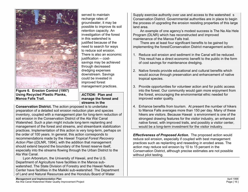
Management and Implementation Plan April 1998 Ala Wai Canal Watershed Water Quality Improvement Project Page [ 16 ]
served to maintain recharge rates of groundwater, it may be possible to improve its soil retention capacity. An investigation of the forest in this watershed is justified because of the need to search for ways to reduce soil erosion. There is also an economic justification -- cost-savings may be achieved through decreased dredging expenses downstream. Savings could be invested in improved forest management practices. ACTION: Plan and manage the forest and streams in the
Conservation District. The action proposed is to undertake preparation of a detailed soil erosion reduction plan and species inventory, coupled with a management plan for long-term reduction of soil erosion in the Conservation District of the Ala Wai Canal Watershed. Such a plan might include long-term replanting and management of the forest and streams, and streambank stabilization practices. Implementation of this action is very long-term, perhaps on the order of 100 years. In general, this action corresponds to recommendations made by the Hawaii Tropical Forest Recovery Action Plan ((DLNR, 1994), with the addition that management should extend beyond the boundary of the forest reserve itself, especially into the streams flowing through the Urban District to the Ala Wai Canal. Lyon Arboretum, the University of Hawaii, and the U.S. Department of Agriculture have facilities in the Manoa sub-watershed. The State Division of Forestry and the Hawaii Nature Center have facilities in the Maikiki sub-watershed. The Department of Land and Natural Resources and the Honolulu Board of Water
Supply exercise authority over use and access to the watershed�s Conservation District. Governmental authorities are in place to begin the process of upgrading the erosion resisting properties of this large land area. An example of one agency’s modest success is The Na Ala Hele Program (DLNR) which has reconstructed and improved maintenance of the Manoa Falls trail. There are at least four significant benefits to be gained by implementing the forest/Conservation District management action: 1. Reduce soil erosion and sediment in the Canal will be reduced.
This result has a direct economic benefit to the public in the form of cost savings for maintenance dredging.
2. Native forests provide educational and cultural benefits which
would accrue through preservation and enhancement of native tropical species.
3. Provide opportunities for volunteer action and for public access
into the forest. Our community would gain more enjoyment from the forest, encouraging the environmental ethic needed for improved water quality.
4. Enhance benefits from tourism. At present the number of hikers
to Manoa Falls averages more than 150 per day. Many of these hikers are visitors. Because Hawaii�s environment is one of the strongest drawing features for the visitor industry, an enhanced native forest, with improved trails, and possibly a visitor center, would be a long-term investment for the visitor industry.
Effectiveness of Proposed Action. The proposed action would reduce soil erosion, especially if coupled with best management practices such as replanting and reseeding in eroded areas. The action may reduce soil erosion by 10 to 15 percent in the Conservation District, although precise estimates are not possible without pilot testing.
Figure 6. Erosion Control (1997) Using Recycled Plastic Planks, Manoa Falls Trail.
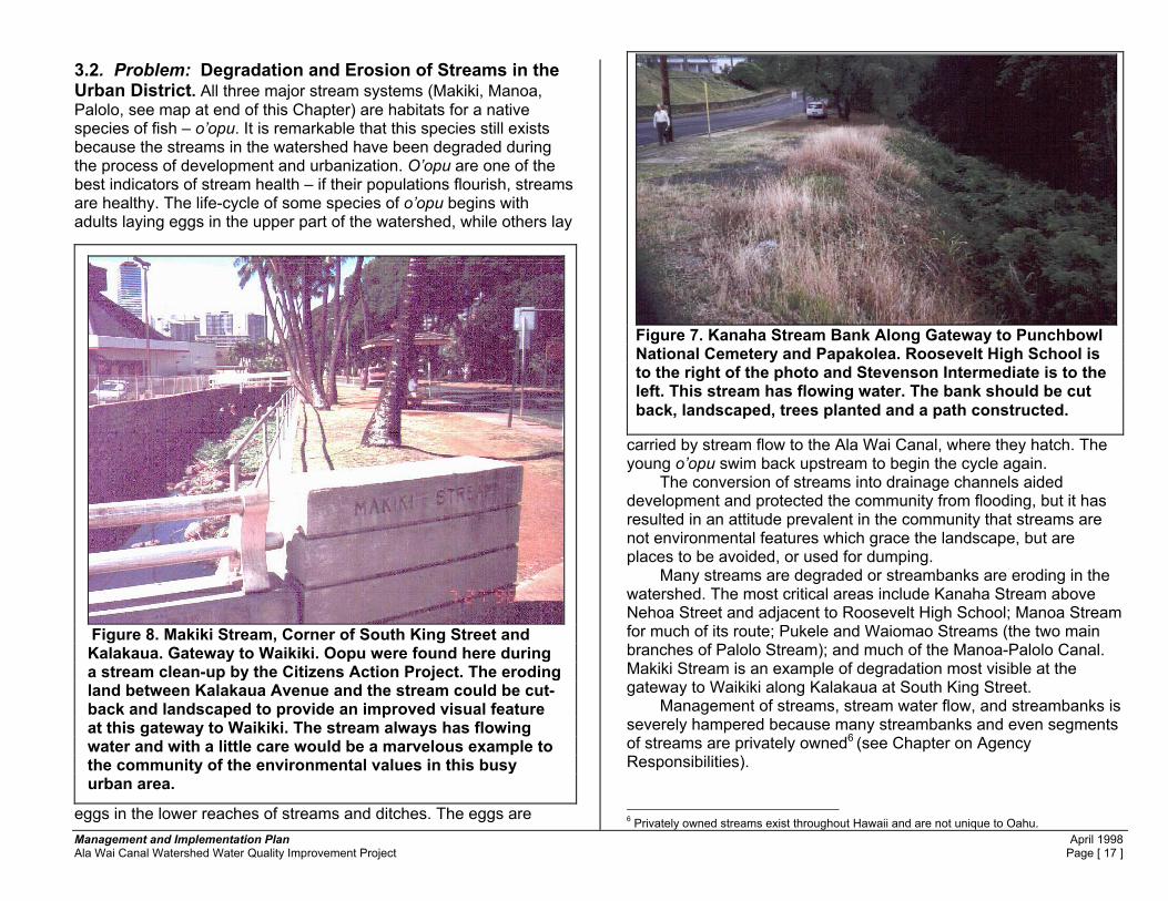
Management and Implementation Plan April 1998 Ala Wai Canal Watershed Water Quality Improvement Project Page [ 17 ]
3.2. Problem: Degradation and Erosion of Streams in the Urban District. All three major stream systems (Makiki, Manoa, Palolo, see map at end of this Chapter) are habitats for a native species of fish – o’opu. It is remarkable that this species still exists because the streams in the watershed have been degraded during the process of development and urbanization. O’opu are one of the best indicators of stream health – if their populations flourish, streams are healthy. The life-cycle of some species of o’opu begins with adults laying eggs in the upper part of the watershed, while others lay
eggs in the lower reaches of streams and ditches. The eggs are
carried by stream flow to the Ala Wai Canal, where they hatch. The young o’opu swim back upstream to begin the cycle again. The conversion of streams into drainage channels aided development and protected the community from flooding, but it has resulted in an attitude prevalent in the community that streams are not environmental features which grace the landscape, but are places to be avoided, or used for dumping. Many streams are degraded or streambanks are eroding in the watershed. The most critical areas include Kanaha Stream above Nehoa Street and adjacent to Roosevelt High School; Manoa Stream for much of its route; Pukele and Waiomao Streams (the two main branches of Palolo Stream); and much of the Manoa-Palolo Canal. Makiki Stream is an example of degradation most visible at the gateway to Waikiki along Kalakaua at South King Street. Management of streams, stream water flow, and streambanks is severely hampered because many streambanks and even segments of streams are privately owned6 (see Chapter on Agency Responsibilities).
6 Privately owned streams exist throughout Hawaii and are not unique to Oahu.
Figure 7. Kanaha Stream Bank Along Gateway to Punchbowl National Cemetery and Papakolea. Roosevelt High School is to the right of the photo and Stevenson Intermediate is to the left. This stream has flowing water. The bank should be cut back, landscaped, trees planted and a path constructed.
Figure 8. Makiki Stream, Corner of South King Street and Kalakaua. Gateway to Waikiki. Oopu were found here during a stream clean-up by the Citizens Action Project. The eroding land between Kalakaua Avenue and the stream could be cut-back and landscaped to provide an improved visual feature at this gateway to Waikiki. The stream always has flowing water and with a little care would be a marvelous example to the community of the environmental values in this busy urban area.

Management and Implementation Plan April 1998 Ala Wai Canal Watershed Water Quality Improvement Project Page [ 18 ]
What is the relationship between the restoration of urban streams and improved water quality? Restoration of streams will prevent streambank erosion. Restored streams will serve as a physical and visual reminder of the environmental value of these natural elements of the urban landscape. The result will be that the community will always be reminded that streams are the linkage between good land use practices and water quality improvements in streams and the Ala Wai Canal. This approach will be the most effective means of improving public stewardship in the watershed and it will help to reduce dumping, littering, and waste disposal into storm drains and into streams. The result will be cleaner waterways, requiring less maintenance and therefore less public expense. There will be benefits from the environmental enhancement. Visitors will remember Honolulu as a City of beautiful stream-ways, and the community will enjoy the results. What does stream restoration involve? Stream restoration involves the community, whose members can do much of the work as volunteers, if they wish. In El Cerrito, California, a group of
AmeriCorps volunteers reconstructed a stream which had been placed in a drainage pipe and buried in an older subdivision for many years. The result will be a landscaped area which will add to property values in the neighborhood.
Stream restoration can take many forms. The El Cerrito project shows what can be done in a difficult situation. In this case, the stream had been encased and confined in a 36-inch diameter drain pipe routed down the middle of a narrow park dividing the left and right lanes in a street in a newly developed residential subdivision. The drain pipe was covered over with dirt for 75 years. In 1996, this project was undertaken, and in a few months, the drain pipe had been broken out of a two-block segment so that the stream could be “day-lighted”. AmeriCorps volunteers are installing biodegradable filter mesh to stabilize raw soil and as preparation for grass-turfing. Vertical sticks along the stream channel are willow shoots buried in the reconstructed stream bank. The willows will take up the flowing water and grow into trees. In Hawaii, Na Ala Hele (DLNR) and the volunteers from Youth for Environmental Service (YES) use ti in similar situations in the rain forest.
What are some of the difficulties of stream restoration? One major issue is that the community depends on urban streams to transport storm water runoff away from the community. Restoration cannot interfere with that vital function. There are a variety of locations in the Ala Wai Canal watershed where restoration can take place, and there are many techniques and methods which can be applied to accommodate the dual functions of drainage and environmental values. What are some potential projects with high visibility? The stream bank next to Kaimuki High School could be landscaped to reduce soil erosion. In the lower reaches of the watershed, the Manoa-Palolo Canal bank, adjacent to Kaimuki High School (between Date Street and Kaimuki Avenue) should be cut back to a milder slope and planted and landscaped. This would reduce erosion from this location. It will provide a natural retreat for school students, along with improved stream access for science projects. A path could be placed within the cutback bank area.
Figure 9. Stream Restoration in El Cerrito, Calif. This stream was in a pipe and paved over. The pipe was recently broken open so that the stream could be restored as an open waterway.

Management and Implementation Plan April 1998 Ala Wai Canal Watershed Water Quality Improvement Project Page [ 19 ]
Restore Manoa Stream bank next to the playground at the Manoa Recreation Center. For years, unwanted vegetation has been sprayed with herbicide from a tanker truck via a fire-hose device. This practice may have been recently halted, but the damaged and eroding Manoa Streambank remains. Moreover, the stream is separated from the park by a chain-link fence thus voiding any chance of the stream being viewed as a natural environment component of human recreation at this location. At a senior citizens
complex adjacent to the park, the stream bank has been landscaped and a trail constructed alongside with benches for sitting. There are no chain link fences, no herbicides used and the project, by virtue of its landscaping and beauty, reduces soil erosion and discourages litter. These practices should be extended to the rest of the stream.
ACTION: Restore Streams and Improve Public Access. Reconstruct streambanks in reaches of streams where the banks are not presently lined with concrete. Include bikeways in the design. Beautify and landscape stream banks. The landscaping and bank reconstruction will serve to reduce erosion and to filter and remove contaminants from overland storm flows draining across the landscaping into the streams. This concept is described below as one specific project which is recommended for Manoa-Palolo Canal and Manoa Stream. Similar landscaping, bank restoration and trails should be constructed along other streams.
Effectiveness of Proposed BMP. The proposed action would reduce soil erosion from stream banks in the Urban District which have not been hardened (lined with concrete or rock). By adding landscaping and a bike bath, the waterways are made more attractive and visible to passers-by, and more accessible to the public. The result is an increase in public use and awareness of these valuable water-courses. Through public ownership and acknowledgment of stream values, community awareness of the need to keep the landscape free of chemicals and debris is enhanced.
A typical concept is described below (Figure 12.). In this case, the basic design concept and routing is for the proposed demonstration stream restoration of the Manoa-Palolo Canal and Manoa Stream. The project would include a bike path from Manoa to the Ala Wai Canal, on public lands.
HIGHLY VISIBLE PROJECT Restore Manoa Stream from Woodlawn Drive, through the University of Hawaii, to Date Street near the Ala Wai canal.
Figure 10. Manoa Playfield at Manoa Recreation Center. The entire length of stream bank along Manoa Stream adjacent to the recreation center is badly eroding. It should be cut back, landscaped and trees planted. A stream should be a key feature of parks. Instead, streams are treated as obstacles or problems and are fenced off from the community. Manoa Elementary School has adopted this area and is planting trees along the bank, with the help of City Parks staff. A memorandum by the Consent Decree Coordinator may have stopped the messy practice of mass herbiciding – which contributed to the erosion problem – but no action has been taken so far on stream bank restoration and erosion control.

Management and Implementation Plan April 1998 Ala Wai Canal Watershed Water Quality Improvement Project Page [ 20 ]
Figure 12. MANOA-PALOLO CANAL & MANOA STREAM
RESTORATION A demonstration project is proposed for the stream corridor between Date Street and Woodlawn Drive. Figures on the following pages show: (1) the potential route of the proposed project, and (2) examples of typical cross-sections of design concepts for stream restoration, low flow channels, maintenance roads and bike paths, stream bank reconfiguration and routing paths under bridges. See also the Chapter on Stream Restoration (end of Chapter 3) for related discussion about design considerations. Low flow channels direct the typically low stream flow into a small channel to provide some water depth for fish habitat. The low flow channel is usually constructed with small dams to create pools, with boulders and riffles, and with meanders. These components create an improved habitat for aquatic species. By constructing a submersible maintenance road/bike path along the low-flow channel, the needs of drainage maintenance crews are met. Designs in the Silver Creek plan typify this approach (NRCS,1994).7 This approach could work well in the Manoa-Palolo Canal, and upstream in Manoa Stream where a more natural stream could be created with available water flows by constructing a low-flow channel with special features such as boulders, pools and riffles. In Manoa Stream itself, the low flow channel should not be lined with concrete. The typical daily low stream flow would be concentrated in this channel and would
7 Recent examples of projects which rehabilitated older drainage canals include those in Los Angles (Los Angles River, L.A. Department of Public Works); Richmond (Wildcat Creek, U.S. Army Corps of Engineers) and San Jose (Lower Silver Creek, National Resources Conservation Service, 1994). The Lower Silver Creek project includes an in-channel bikepath integrated with a maintenance road constructed of porous pavement. The project also includes movable sediment retention barriers (the same concrete structures used for highway barriers). Maintenance crews, working during periods of low-flows and using rubber-tired loaders, can clean accumulated sediment by temporarily moving a barrier to one side, then repositioning it after the work is completed.
provide an improved aquatic habitat. During periods of storm flows, the low-flow channel would overtop,and flow into the overflow channel (the over-flow channel could be constructed of porous paving blocks). Signs would warn bikers and pedestrians to avoid the path if water is seen in the overflow channel or the path is covered with water. Movable sediment barriers would assist to capture some of the material moving downstream from the uplands to the Ala Wai Canal. Periodic sediment removal (annual, or more frequently if needed) would be less costly than less frequent dredging of the Ala Wai Canal itself.
The proposed route is entirely on public land, or beneath public bridges. The path begins at Date Street and can be linked to the existing bike path recently opened by the City along the
Figure 11. Kaimuki High School – Manoa-Palolo Canal. Proposed Start of Streambank Restoration and Bike Path from Date Street to Woodlawn Drive. This is the Manoa-Palolo Canal, next to Kaimuki High School. The bank should be cut back at a lesser slope, a trail/bike path cut into or on top of the bank, and trees and landscaping applied to stop soil erosion.

Management and Implementation Plan April 1998 Ala Wai Canal Watershed Water Quality Improvement Project Page [ 21 ]
Ala Wai Canal and around the Golf Course. From this spot, it would go under the Date Street Bridge, along the Manoa-Palolo Canal bank adjacent to Kaimuki H.S., under the bridge complex (Kalakaua, King Street, H-1,Waialae Avenue) and emerge at both Koali and Kalei Streets. The path would continue into U.H. and also to Kanewai Park where it would make a direct connection to Dole Street. The U.H. path would continue along Manoa Stream adjacent to the Hawaiian Studies Center and under the Dole Street Bridge. It would continue through UH, up Manoa Stream (on either or both sides) to Woodlawn Dr. Saint Francis School (just upstream of U.H.) has already constructed a trail on their Manoa Streambank.
Routings under bridges, while new in Hawaii, have become a part of the landscape in other areas. Questions of liability, safety, and hydraulic capacity can be solved.. For example, extreme liability exists at all beach parks where there is surf, yet warning signs are adequate to overcome the problem of the inexperienced or careless surfer who takes the risks. Why should a stream-side, semi-submergible bike path be subjected to a different policy? In fact the policy should be to encourage individual responsibility – a major goal of the overall watershed steward ship program across the nation.
This route was first suggested in a University of Hawaii plan completed in the late 1970’s prepared by Architects Hawaii under the direction of then-UH Facilities Director, Walter Muraoka.8 The following pages show: some of the typical details to solve the routing under bridges; the proposed route and examples from projects in other places.
8 Architects W. Muraoka and C. Ehrhorn have expressed their willingness to help implement this project.
Figure 13. Manoa-Palolo Canal upstream of the Wailae Avenue Bridge, looking downstream towards Kaimuki High School and the Ala Wai Canal. The four bridges can be seen in the photo. The best maintenance road/bike path route is on the left.
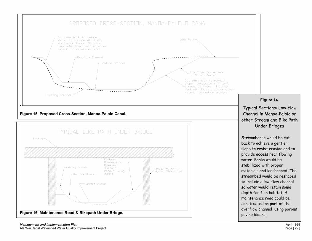
Management and Implementation Plan April 1998 Ala Wai Canal Watershed Water Quality Improvement Project Page [ 22 ]
.
Figure 15. Proposed Cross-Section, Manoa-Palolo Canal.
Figure 16. Maintenance Road & Bikepath Under Bridge.
Figure 14.
Typical Sections: Low-flow Channel in Manoa-Palolo or
other Stream and Bike Path Under Bridges
Streambanks would be cut back to achieve a gentler slope to resist erosion and to provide access near flowing water. Banks would be stablilized with proper materials and landscaped. The streambed would be reshaped to include a low-flow channel so water would retain some depth for fish habitat. A maintenance road could be constructed as part of the overflow channel, using porous paving blocks.

Management and Implementation Plan April 1998 Ala Wai Canal Watershed Water Quality Improvement Project Page [ 23 ]
3.3. Problem: Stream Quality. Stream quality is increasingly important in our high density urban environment where access to natural beauty has become more difficult. A good general precept is that neighborhoods which are surrounded with beauty will foster and maintain that beauty and sense of community pride. This precept is the basis of many of our efforts to bring about improved watershed quality, especially in the broad area of polluted runoff control. In the Ala Wai Canal Watershed, the Urban District evolved to suit efficient residential and business development in Honolulu's early years. In those times, streams were viewed as conduits for storm water runoff, rather than as requisite natural resources for the neighborhoods. Today, our community has become concerned with creation of a more beautiful and nurturing environment -- thus the focus on improved water quality in
the Ala Wai Canal, the streams, and the watershed. Key parameters of stream quality are shown in Table 1(end of this Section), and all streams have good potential for preservation and restoration.
Figure 17 STREAM HIGHLIGHTS
Makiki Stream borders the Kalakaua Avenue and South King Street gateway to Waikiki (and the new Convention Center). Landscaping and restoration in the vicinity of South King Street would enhance the beauty and value of that area.
Palolo Stream provides a habitat for
native species despite its extensive concrete lining. Restoration of it and its major tributaries, Pukele and Waiomao Streams, would contribute to neighborhood beautification.
Manoa Stream is an appropriate
target for pilot stream bank erosion control alternatives and can be part of a magnificent environmental feature of metropolitan Honolulu, if restored.
The Manoa-Palolo Canal has been
partially beautified (and a bike path constructed) by the City between the Ala Wai Canal and Date Street. This treatment should be continued between Date Street, adjacent to Kaimuki High School, and up into Palolo and Manoa Valleys.
Figure 18. A'poha, an o'opu (native fish present in all streams in the watershed) greets visitors at the Consent Decree Project booth, EarthDay 1997. The o’opu are biological indicators of a healthy stream. Periodically counting them is one way to measure stream quality improvement (or decline).

Management and Implementation Plan April 1998 Ala Wai Canal Watershed Water Quality Improvement Project Page [ 24 ]
ACTIONS: Restore streams and enhance their quality, both to improve the environment for people and for aquatic plants and animals. 1. DLNR and DOH should suggest guidelines for restoration of the
streams in this watershed. Restoration proposals will vary depending on the existing parameters of each stream. For example, Palolo Stream has a good water flow, but the concrete lining presents problems. Reconstruction of the channel bottom with a low-flow channel would improve the situation by directing the shallow sheet-like flow of water spread across the channel bottom into a more narrow, but deeper low-flow channel. A low flow channel can be constructed with pools, boulders and riffles. A maintenance road can be placed along side the channel for periodic stream cleaning by use of equipment.
2. Support DPW's adopt-a-stream program. It is a vital component
of the watershed plan process because it can get neighborhoods involved to help reduce littering and to aid in management. But, more attention needs to be paid to varying levels of skill, physical ability and equipment required for different situations. For example, the community-based clean-up of Palolo Stream required people to work in a confined box-channel with risks of flash flooding. This type of channel is best maintained by experienced and trained personnel using heavy equipment. In cases where there are slippery rocks, hazardous materials in the streambed, or heavy lifting is required, volunteers need training, boots, gloves, and appropriate physical conditioning. Perhaps until some of the refinements are worked-out, the Adopt-a Stream program should be restricted to locations with easy public access, and little physical risk.
3. The City and the State need to be encouraged to continue stream
beautification efforts. Makiki Stream in the vicinity of the Ala Wai Canal, and the Convention Center; the Manoa-Palolo Canal, (visible to so many visitors) and Kanaha Stream, at the gateway to Papakolea and Punchbowl are examples where much improvement can be made.
4. The City BWS and the State CRWM may need to address issues of water flow in relation to the need for improved stream and Ala Wai Canal water quality. At present, if other remedial measures such as construction of low-flow channels and stream bottom design features are implemented, there may be adequate base water flow in streams for maintenance of aquatic plants and animals.
5. The City should implement the proposed pilot streambank erosion
control project at the Manoa Recreation Center playground. 6. O’opu are one of the best indicators of environmental health in
streams. If schools and community groups are involved in watershed monitoring, periodic counts of this species could be done much like bird counts are done by the members of the community. There may be other biological indicators of stream quality health which can be monitored and the Division of Aquatic Resources and the DOH should help community groups identify them. Use of expensive and complicated chemical and laborator-based tests are not recommended for monitoring by community school-based groups except in those situations where strong quality control procedures can be placed into practice,
7. Private ownership of streams is a deterrent to good watershed
management because of the problems of access for inspections, and because individual property owners are seldom able to meet the needs of adequate maintenance in a stream channel. The City and the State need to work with private owners to obtain stream easements to reduce dumping and to stabilize streambanks for erosion prevention.
Effectiveness of Proposed Action. The proposed Action would significantly improve the urban environment for people, and the environment for aquatic plants and animals. Figure 19 lists some design considerations for stream channels.

Management and Implementation Plan April 1998 Ala Wai Canal Watershed Water Quality Improvement Project Page [ 25 ]
Table 1
EVALUATION OF AQUATIC HABITAT IN ALA WAI CANAL WATERSHED STREAMS
The quality parameters in the left column express the necessary condition to support aquatic species, especially o�opu Aquatic Habitat Quality Parameter Makiki Stream Manoa Stream Palolo Stream Manoa-Palolo Canal Vegetation along stream banks. Vegetation captures sediment in overland storm runoff reducing the input of surface contaminants to streams.
Some, upstream of Nehoa St. & between So. King & Ala Wai.
Extensive, from St. Louis Hts Rd. to mountains.
Little or none from St. Louis Hts Rd. to Anuenue School, then extensive to mountains.
Extensive from from Ala Wai Canal to Date Street, little to St. Louis Hts. Rd.
Trees along stream banks. Trees provide shade for protective areas and to cool the water for the benefit of aquatic species.
Some, upstream of Nehoa St. & between So. King & Ala Wai.
Extensive, from St. Louis Hts Rd. to mountains.
Little or none from St. Louis Hts Rd. to Anuenue School, then extensive to mountains.
Extensive from from Ala Wai Canal to Date Street, little to St. Louis Hts. Rd.
Vegetation, rocks, boulders, sand, gravel, and other natural objects in the stream. These objects create a variety of environments for the benefit of aquatic species.
Some, upstream of Nehoa St. & between So. King & the Ala Wai Canal.
Extensive, from St. Louis Hts Rd. to mountains.
Little or none from St. Louis Hts Rd. to Anuenue School, then extensive to mountains.
Extensive from from Ala Wai Canal to Date Street, good to St. Louis Hts. Rd.
Clean water. Adequate supply of clean water provides the basic habitat for aquatic species.
Very little, may need more water to support native species
Appears to be good base flow for native species.
Fair, may need more water to support native species.
Fair, may be acceptable for native species

Management and Implementation Plan April 1998 Ala Wai Canal Watershed Water Quality Improvement Project Page [ 26 ]
Figure 19.
DESIGN CONSIDERATIONS FOR STREAM CHANNELS. Following are some considerations for stream restoration regarding channel linings, low-flow channels, channel maintenance and the dual purpose of streams in the Ala Wai Canal watershed to both convey storm waters, and to provide an aquatic habitat for fish and plants.9 1. Concrete-lined Channels. Palolo Stream between the Manoa-
Palolo Canal and Anuenue School is a typical example of a stream lined with concrete and constructed as a box culvert. The channel has a shallow V-shaped bottom in which there is nearly always a low flow of water. Over the years the flow of water has been adequate to support populations of o’opu – of which there are several native species of fish – which lay eggs in the upper, intermediate or lower reaches of streams depending on the species. The eggs are washed downstream to an estuarine area, in this case the Manoa-Palolo and Ala Wai Canal. There, the eggs hatch, and young fish swim back up stream. The fish are found in both major branches (Pukele and Waiomao Streams) of Palolo Stream, upstream of the concrete-lined channel. Apparently the simple V-shaped bottom has served to concentrate the low-flows of water into the center of the channel, thereby creating a slightly greater
9 Design concepts proposed here are not to be considered the final word. Much is not known about the best design to suit native species. For example, construction of pools is sometimes recommended in continental U.S. streams, but recently the U.S. Fish and Wildlife Service and the Division of Aquatic Resources/DLNR are considering the idea that pools may be habitat which benefits exotic (aquarium fish) which push out the native o’opu. It may be that fast-flowing streams, without pools provide the best solution because native species are adapted to this condition and the exotic species may be “flushed” out. See the DLNR letter in Appendix A, Volume I of this Plan.
depth of water which is cool enough10 for the fish to survive the migratory journey. The Palolo channel bottom would be a better design if the V-shaped portion was replaced with a trapezoidal shape, possibly one which meandered back and fourth to simulate the more natural flow of water. Lined, high velocity channels are to be avoided if aquatic habitat objectives are to be met, because there is no habitat for fish in the entire reach of the box culvert in Palolo.
2. Lined Stream Banks with Unlined Bottoms. One stream in
the watershed, Makiki, upstream of Nehoa Street, and downstream of King Street all the way to the Ala Wai Canal, is lined by grouted rock on the sides of the banks. The bottom is not lined. This project is old, and today, the bottom has many boulders, pools and a quality of roughness making it an ideal habitat for fish. Makiki Stream also has cross-channel weirs (steps) every few feet which serve to slow the low-stream flow and to create pools of deeper water, also an excellent habitat. The narrowness of Makiki Stream, and the presence of the weirs, plus the ease which debris can be lifted out of the stream onto the banks, may be the reasons that buldozers have not been put into the bottom of the channel for period cleaning. The advantage is that the bottom is nicely developed as an aquatic habitat. For the purpose of stream habitat, this bottom is an example of one type of solution to the dual problem or providing adequate drainage flow in a confined land area, and also of providing aquatic habitat.
3. Boulder-concrete Bottoms. There are examples of the use of
boulder concrete – large boulders embedded in concrete 10 One problem with concrete channels is that they gain heat from sunlight. Water in such channels can be 20 degrees (f) or more higher because of the heat gain and such temperatures can kill fish.

Management and Implementation Plan April 1998 Ala Wai Canal Watershed Water Quality Improvement Project Page [ 27 ]
bottoms and placed in a pattern inside a low-flow channel. Where a confined and lined channel and channel bottom are needed for high velocity stream flows, a boulder concrete low-flow channel is one option to benefit aquatic habit. In these designs, the bottom is lined, but the low-flow channel is adequately narrow to concentrate low stream flows so that a depth suitable for migrating fish is maintained. Channel bottoms may be constructed of concrete which is textured, moulded and built up to create artificial pools, and riffles. Boulders are added to cause the low flow to fluctuate and to provide physical diversity in the stream. The boulders can be cemented in place if flood flows reach a velocity so high as to destroy non-concreted boulders in these artificial channels.
4. Meanders, pools and riffles in low flow channels and
channel bottoms. To support an aquatic habitat, streams should have meanders, pools and riffles. Artificial channels, and low-flow channels, should be designed with these features included. They can be built-in to concrete bottoms, and they can be allowed to exist in unlined channel bottoms. Maintenance and debris removal is more difficult in a channel where roughness is permitted and use of heavy equipment to bulldoze stream bottoms is not an acceptable technique in the low-flow, or aquatic habitat friendly channel bottom. In these cases, maintenance generally must be done by hand, or with use of equipment operating from the top of the bank, or from a maintenance road built into the channel.
5. Low Flow Channels. Low flow channels should be constructed
in both Palolo Stream and the Manoa-Palolo Canal. The Manoa-Palolo Canal is top priority. There, velocities do not exceed about 10 feet per second which is probably low enough that a non- concrete lined bottom can resist the erosive forces of flood flows (although good sized boulders will be moved down
stream under high flows). Storm flows do not occur annually. The chance of occurrence is expressed as a percentage. For example, severe storm events happen every several years with, perhaps only a 1 percent to 40 percent chance of occurrence in any given year (1% chance of occurrence in any single year is the so-called “100 year flood”). If the low-flow channel is built and washes out, it may have to be repaired periodically. Repairs can be done by volunteers to a great extent.
6. Channel Maintenance. To maintain a stream like the Manoa-
Palolo Canal, or the Palolo Box Channel, crews require a maintenance road in the channel bottom. The maintenance road should be separate from the low-flow channel, and could be part of the over-flow channel. In-stream maintenance roads should be lined with porous paving blocks which can resist the erosion forces of stream channel velocities up to 10 fps or so. If velocities are higher, concrete pavement may be required. The advantage of porous pavers is that groundwater can seep into the channel, and flood flows can help recharge the land along the channel with water which may help tree growth. Tree growth is a plus because shady streams have cooler water which is good for fish.
7. Bikepaths or trails. Where needed, a maintenance road can
serve the dual purpose as a bike path(where the road/bikepath goes under a bridge or in a confined channel) and where the physical situation is appropriate. For example, paths or trails are proposed on all public lands adjacent to streams in the Ala Wai Canal watershed to foster an environmental ethic, as well as to beautify our landscape, and to add to the public access opportunities. One major route proposed is along Manoa-Palolo Canal from Date Street to

Management and Implementation Plan April 1998 Ala Wai Canal Watershed Water Quality Improvement Project Page [ 28 ]
Woodlawn Drive in Manoa. The suggested route for the proposed bike-path is under bridges. Such routings could be part of the in-stream maintenance roads. Note that a bike path may not be suited for some environmental situations because the path requires paving and a wide right-of-way. The objective here is to add to the public access opportunities to and along waterways to foster an environmental ethic in the community and to remind people of the physical beauty here. In some cases bikeways are very appropriate, in others, the simplest of trails may be best suited and the least environmentally intrusive project (See the DLNR letter, Appendix A, Volume I, this Plan). The Na Ala Hele program has been a leader in providing maps and improved trails in the Conservation District. They have the dual role to both protect the natural resources, and to provide public access in non-intrusive ways. However, they have not entered into the “urban” trail process, partly because of funding limitations, but partly because of basic policy choices. This Management and Implementation Plan, however, proposes extensive improvements in public access to and along waterways, in the Urban District as well as in the Conservation District. The reason for this recommendation is to establish a constant physical reminder of the value of waterways in the community. It is the contention of this Plan, that physical projects are the best means to foster this watershed and environmental ethic. In the absence of such projects, the waterway and stream landscape will remain as it is, scarred and debris-laden – a medium for contaminated storm water runoff to reach a polluted Canal.

Management and Implementation Plan April 1998 Ala Wai Canal Watershed Water Quality Improvement Project Page [ 29 ]
3.4. Problem: Ala Wai Canal Sedimentation and Dredging. Sedimentation in the Canal occurs at the rate of about 10,300 cy (cubic yards) per year. The Canal needs to be dredged about every 10 years to prevent shoaling which decreases navigability and is unsightly. The average dredging cost is presently estimated to be about $1.5 million per year.11 The Manoa-Palolo Canal also needs to be periodically dredged because it receives the first flush from storm waters flowing in a major portion of the Ala Wai Canal watershed. -- sedimentation takes place there as well as in the main Canal.
A recent engineering study (DLNR, 1992) noted that if the Manoa-Palolo Canal was "over-dredged" -- that is if it were dredged to make it deeper than the Ala Wai Canal -- silt would deposit first in the Manoa-Palolo Canal. Such depositions could be dredged more
11. Including both principle and interest. Based on a rough cost estimate of $10.0 million for
frequently, perhaps every three years, and possibly at a lesser cost per unit because of the ease of access to this area -- work could be done from the shoreline using available land-based equipment without use of costly barges and water-based equipment. This approach would help keep the Canal free of sediment, and reduce the unsightliness caused by sediment build-up.
The Canal is a State Historic Site, location of the new Convention Center, and the target of extensive landscaping and beautification schemes. It is the site of numerous water-based recreation events enjoyed by residents and visitors. The Canal has a great economic value – a value which has not been fully estimated. Maintenance dredging is one component of the entire set of measures planned by government and the community to preserve, protect and enhance the Canal.
The City and County of Honolulu has started (via contract) to prepare an environmental assessment (EA) for the proposed dredging of the Canal. The EA will evaluate alternatives for dredging and disposal of material (both at sea and on land). If the Canal sediments are too contaminated for ocean disposal, land disposal is required. Land disposal has typically been significantly more costly than ocean disposal, but new technology may change this situation.
each dredging event, with an interest rate of 8 percent.
Figure 20. Small Dredge in Lake Merritt, Oakland, California, 1996. This is an alternative which might work in the Ala Wai Canal. It would need to operate year-round, but it takes up little space and is relatively unobtrusive.
DREDGING • Canal construction started in 1920 and was completed in
1928. • Sedimentation rate is about 1,500 dump truck loads (10,300
cubic yards or 19,000 tons) per year. If not dredged, it could nearly fill in 50 years.
• Maintenance dredging has been done twice (1966 and 1978) and only removed partial amounts of sediment near the mouth of the Manoa-Palolo Canal.
• Sediments are contaminated with vehicle residues (oils and grease, lead, copper, chromium and other metals), termiticides (dieldrin, chlordane), other chemicals, and solid wastes (plastic and glass bottles, cans, park benches, shopping carts and other debris).
• Maintenance dredging may not significantly improve the flood carrying capacity of the Canal, which will overflow its banks when rainstorms greater that a 10-year frequency occur. The last big storm (a 50-year event) occurred in 1968, far enough in the past so that the problems of flooding in the Waikiki and surrounding areas are not high in the public consciousness.
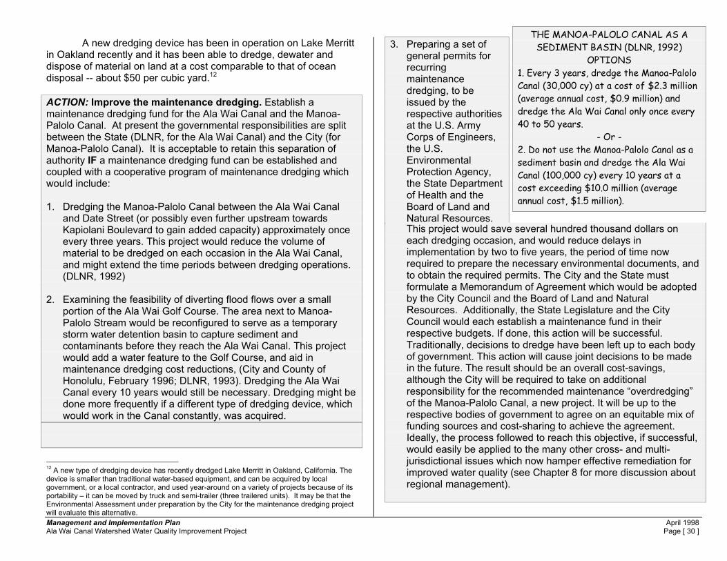
Management and Implementation Plan April 1998 Ala Wai Canal Watershed Water Quality Improvement Project Page [ 30 ]
A new dredging device has been in operation on Lake Merritt in Oakland recently and it has been able to dredge, dewater and dispose of material on land at a cost comparable to that of ocean disposal -- about $50 per cubic yard.12
ACTION: Improve the maintenance dredging. Establish a maintenance dredging fund for the Ala Wai Canal and the Manoa-Palolo Canal. At present the governmental responsibilities are split between the State (DLNR, for the Ala Wai Canal) and the City (for Manoa-Palolo Canal). It is acceptable to retain this separation of authority IF a maintenance dredging fund can be established and coupled with a cooperative program of maintenance dredging which would include: 1. Dredging the Manoa-Palolo Canal between the Ala Wai Canal
and Date Street (or possibly even further upstream towards Kapiolani Boulevard to gain added capacity) approximately once every three years. This project would reduce the volume of material to be dredged on each occasion in the Ala Wai Canal, and might extend the time periods between dredging operations. (DLNR, 1992)
2. Examining the feasibility of diverting flood flows over a small
portion of the Ala Wai Golf Course. The area next to Manoa-Palolo Stream would be reconfigured to serve as a temporary storm water detention basin to capture sediment and contaminants before they reach the Ala Wai Canal. This project would add a water feature to the Golf Course, and aid in maintenance dredging cost reductions, (City and County of Honolulu, February 1996; DLNR, 1993). Dredging the Ala Wai Canal every 10 years would still be necessary. Dredging might be done more frequently if a different type of dredging device, which would work in the Canal constantly, was acquired.
12 A new type of dredging device has recently dredged Lake Merritt in Oakland, California. The device is smaller than traditional water-based equipment, and can be acquired by local government, or a local contractor, and used year-around on a variety of projects because of its portability – it can be moved by truck and semi-trailer (three trailered units). It may be that the Environmental Assessment under preparation by the City for the maintenance dredging project will evaluate this alternative.
3. Preparing a set of general permits for recurring maintenance dredging, to be issued by the respective authorities at the U.S. Army Corps of Engineers, the U.S. Environmental Protection Agency, the State Department of Health and the Board of Land and Natural Resources. This project would save several hundred thousand dollars on each dredging occasion, and would reduce delays in implementation by two to five years, the period of time now required to prepare the necessary environmental documents, and to obtain the required permits. The City and the State must formulate a Memorandum of Agreement which would be adopted by the City Council and the Board of Land and Natural Resources. Additionally, the State Legislature and the City Council would each establish a maintenance fund in their respective budgets. If done, this action will be successful. Traditionally, decisions to dredge have been left up to each body of government. This action will cause joint decisions to be made in the future. The result should be an overall cost-savings, although the City will be required to take on additional responsibility for the recommended maintenance “overdredging” of the Manoa-Palolo Canal, a new project. It will be up to the respective bodies of government to agree on an equitable mix of funding sources and cost-sharing to achieve the agreement. Ideally, the process followed to reach this objective, if successful, would easily be applied to the many other cross- and multi-jurisdictional issues which now hamper effective remediation for improved water quality (see Chapter 8 for more discussion about regional management).
THE MANOA-PALOLO CANAL AS A SEDIMENT BASIN (DLNR, 1992)
OPTIONS 1. Every 3 years, dredge the Manoa-Palolo Canal (30,000 cy) at a cost of $2.3 million (average annual cost, $0.9 million) and dredge the Ala Wai Canal only once every 40 to 50 years.
- Or - 2. Do not use the Manoa-Palolo Canal as a sediment basin and dredge the Ala Wai Canal (100,000 cy) every 10 years at a cost exceeding $10.0 million (average annual cost, $1.5 million).

Management and Implementation Plan April 1998 Ala Wai Canal Watershed Water Quality Improvement Project Page [ 31 ]
Effectiveness of Proposed Action. The proposed action would institute an appropriate level of maintenance dredging which would remediate many of the problems now faced in starting up a new cycle of maintenance dredging each decade. Both cost-savings and a “cleaner” Canal would result.
Figure 21. Sediment from Water Separator. The Separator is mounted on two semi-trailers, part of a Lake Merritt dredge system. One pipe brings dredged sediments, a liquid material, to the Separator and the second pipe returns water (sediments removed) to the Lake. The Separator discharges the sediment removed from the water directly to a dump truck for transport to a landfill.

Management and Implementation Plan April 1998 Ala Wai Canal Watershed Water Quality Improvement Project Page [ 32 ]
3.5. Problem: Flooding. Flood hazards in Waikiki and areas surrounding the Ala Wai Canal are one of the least well-known public health and safety problems. The actual design-capacity of the Canal provides for about a "10-year" storm flow (DLNR, January 26, 1994). This is a very small capacity which does not meet current City drainage standards. A suitable design standard in conformance with City drainage standards in this urban area would be at least a capacity for a “100-year storm”. A "10-year" storm has a 10 percent chance of occurring once in any year. In recent history, the most severe event was a "30 to 40-year" rainfall which occurred in 1968. A 100-year storm has a one percent chance of occurring in any year. (See Figure 22A) To improve the flood carrying capacity of the Ala Wai Canal requires that the cross-sectional areas of the Canal be increased,
especially from the location of the McCully Street Bridge, all the way to the ocean. The problem is that the Canal is 100 yards wide upstream of this bridge, but it narrows to about 75 yards to pass under this and the two bridges downstream - Kalakaua and Ala Moana. In the event of an extremely serious rainstorm, the Canal will overflow its banks, first on the mountain-side, then on the Waikiki side. Water would overflow into Waikiki. Waikiki's storm drains in the area between Kalakaua and the Canal would back-up and overflow because they could not drain the rainwater into the flooding Canal. Basement sump pumps in many of the larger buildings and garages in Waikiki would be flooded and unable to remove water from low-lying areas. In some cases, pumps which move sewage from buildings into the City sewers (or even the City sewage pumping station on Kuhio Avenue) could be flooded and fail. These events would halt the movement of raw, untreated sewage out of Waikiki. All of Waikiki would be covered with a layer of silt, mud and debris. Traffic would be snarled and it would take some time for the area to become passable. Clean-up and return to normalcy would take longer. All the tributary streams to the Ala Wai Canal have less than a
100-storm capacity, even though some of them are hardened channels constructed primarily to drain water from the urban
FLOODING • The Canal has only a 10-year flood capacity, and can
carry a maximum of about 5,200 cubic feet per second (cfs) of water at a velocity of one foot per second.
• The 100-year flood has an estimated peak discharge of 22,400 cfs, more than four times the Canal’s capacity.
• The most recent severe storm recently was in 1968, somewhat less than a 50-year event (19,247 cfs).
• Since 1968 there have been only two rainfall events (1968 and 1971) approximately equal to or exceeding the 10-year event.
• Waikiki storm drains in the area between Kalakaua Avenue and the Canal will not function under higher Canal flows (probably those less that the 10 year flows).
• Maintenance dredging does not significantly improve the flood carrying capacity of the Canal.
• Three types of flooding threaten Waikiki. - tsunami (from the ocean) - hurricane storm waves (from the ocean) - Ala Wai Canal flooding (from rainfall) • The Flood Insurance Rate Map flood elevations and water
flow velocities are higher for non-Ala Wai Canal flooding.
Figure 22. Swollen Ala Wai Canal After Minor Rains.

Management and Implementation Plan April 1998 Ala Wai Canal Watershed Water Quality Improvement Project Page [ 33 ]
landscape. Flooding in Manoa has occurred recently (1992) when Woodlawn Drive and other areas were inundated. There is a potential hazard to life and property from overflowing streams with the relatively high velocities found in the upland areas. In the streams, added flood protection should accompany environmental restoration of streams in keeping with other actions described in this report. Because of the concerns related to private ownership of streams and streambanks in the upper watershed, we recommend combined flood protection, if needed, and environmental restoration of streams on public lands. This process can start in the locations described in the preceding Chapters of this report, where stream restoration to reduce stream bank erosion has been recommended. ACTION: Investigate the feasibility of increasing the flood-carrying capacity of the Ala Wai Canal and its tributary streams. 1. There is a need to evaluate the extent of the flood problem, and
the associated potential damages. In the 1996 session, the State legislature, at the request of DLNR, appropriated $200,000 as the local share for an investigation to be made by the U.S. Army Corps of Engineers of the potential damages which would occur in relation to varying flood elevation levels. When completed, this investigation will provide an economic description of the potential losses from flooding so that the value of flood protective construction can be identified. This project is now awaiting the federal cost share, to be appropriated by the U.S. Congress.
2. Because the flood problem extends up into the watershed, any
flood hazard reduction planning needs to include suitable stream protection and restoration measures in the Manoa-Palolo Canal, and in the streams of Makiki, Manoa and Palolo. It is an objective of the Ala Wai Canal watershed management project to restore urban streams and to not further degrade them with concrete lining. This is a challenge to design engineers who must balance the need to enhance environmental values with the need to protect the urban landscape from flooding. The least costly solutions tend to require less land. Enviromental solutions tend to require a wider stream right of way, and private land owners tend to reject proposals which require them to give up their yards or homes to a wider, more environmentally sound, stream.
3. Private ownership to the center of the streams needs to be
changed. One method is to obtain flowage easements from the private owners. Private stream ownership continues to hamper effective drainage and flood control practices (the City and the State will not maintain private streams). Private owners may be happy to trade the easement in exchange for public agencies’ assuming maintenance responsibilities. The incentive to private owners is that they may cease to be liable for continued streambank erosion, which causes pollution downstream.
4. Jurisdiction over urban streams should be in one agency. City
and State have spilt jurisdictions which, coupled with the private stream ownership problem, further hampers effective stream maintenance for drainage and environmental objectives.
Effectiveness of Proposed Action. The proposed action would assist the evaluation process which must take place before drainage system retrofitting projects can be precisely formulated and cost-estimates prepared.

Management and Implementation Plan April 1998 Ala Wai Canal Watershed Water Quality Improvement Project Page [ 34 ]
3.6. Problem: Vehicles. Most of the metals13 contaminating Ala Wai Canal sediments originate from vehicles (more than 250,000 per day) traveling in the Canal’s watershed. An estimated 1.6 million miles are traveled daily by vehicles, which leave behind a variety of metals and chemicals. Metals released by vehicles include lead, chromium, copper, cadmium, zinc and nickel. Chemicals include PAHs (polynuclear aromatic hyrdocarbons) which are indicators of petroleum products and residues from plastics. Some of these metals and chemicals may also originate in asphalt which is abraded by vehicle tire friction. Asphalt particles also find their way to the Ala Wai
in storm water runoff. These metals and chemicals are deposited on roads (or originate in asphalt roads, which comprise 1,123 acres or 19.1 percent of the Urban District). The contaminants are transported from the roads to the Ala Wai Canal by storm water runoff into storm drains along curbs, thence via underground storm drain pipes and culverts to streams
or directly to the Ala Wai Canal itself. This complex and extensive drainage system has a total of 61.2 lineal miles of pipe and culverts, 1,779 drainage inlets and catch-basins, and 1,106 manholes. (DPW, 1997) 13 Some of the metals originate in natural sources from the Conservation District (DeCarlo and Spencer, 1995). Generally, it is assumed that little can be done to reduce metals from eroding land forms, except as incidental to broad scale erosion reduction measures. 14 About 4.9 mgd (million gallons per day, annual average flow) enters the streams and the Canal via storm drains (DOH, 1993) and this reflects drainage from the entire Urban District. Drainage from roads is less (0.9 mgd)) because the area is only 19.1 percent of the total Urban District. Concentrations are averages from other cities.
Although leaded gasoline was banned in the early 1980’s, lead still is stored in soils and plants from the pre-ban period of use. Such “pre-ban lead” will continue to be discharged to the Ala Wai Canal during the processes of stormwater runoff and soil erosion,but the concentrations from this source should gradually decrease over time. Lead continues to be discharged to the Canal from vehicle brake pads, which also release copper and zinc. Event mean concentrations of these metals found in 26 urban highway sites across the nation have been reported to be copper (0.054 mg/L), lead (0.400 mg/L) and zinc (0.329 mg/L) (Strecker, et al, n.d.). Applying these values to the average storm drain flow to the Ala Wai Canal and streams yields an estimate of quantities of three common metals which originate from vehicles (Table 2). Because the data was collected from watersheds around the nation, prior to 1990, the concentrations may partially reflect the release of lead from
airborne sources during the days of leaded gasoline (banned in the early 1980’s. The estimates in Table 2 represent the order of magnitude of metals released to the Canal from vehicles. Actual data is not available for Honolulu roads. Metals in tires and brakepads are commonly present today and concentrations vary among manufacturers. More needs to be known about these two major sources of contaminants which affect the Ala Wai Canal watershed. Reports from an investigation of copper in a watershed in South San Francisco Bay note that copper levels (in addition to lead and zinc) in brake pads range from 0 to 20 percent of the total weight of the pads. Copper is emerging as a contaminant of concern in storm water runoff and the Ala Wai Canal is no exception. Recent laboratory tests of Canal sediments found high levels.of metals (copper, 84 to 137 mg/kg; lead, 85.3 to 329 mg/kg; zinc, 171 to 267mg/kg) associated with brake pads and vehicles (DTS, 1997).
Table 2.
Estimate of Metals in Road Runoff14 Metal Concentration
(mg/L) Storm Drain Flow (mgd)
Pounds per Year
Copper 0.054 0.9 154 Lead 0.400 0.9 1,140 Zinc 0.329 0.9 938
VEHICLESNumber of Vehicles in Watershed on Average Day
Ala Wai Canal WatershedRest of Oahu
252,000
348,000
Figure 23. The High Number of Vehicles (224 Vehicles per Acre of Urban Streets) Make a Significant Contribution to Canal Contamination.
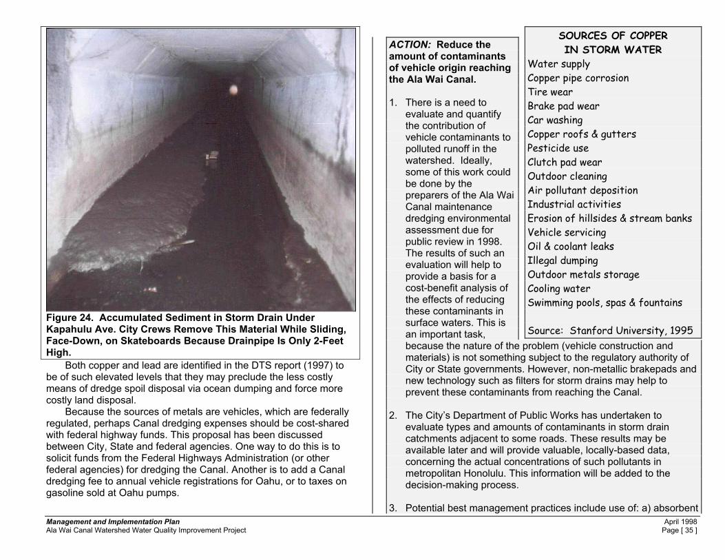
Management and Implementation Plan April 1998 Ala Wai Canal Watershed Water Quality Improvement Project Page [ 35 ]
Both copper and lead are identified in the DTS report (1997) to be of such elevated levels that they may preclude the less costly means of dredge spoil disposal via ocean dumping and force more costly land disposal. Because the sources of metals are vehicles, which are federally regulated, perhaps Canal dredging expenses should be cost-shared with federal highway funds. This proposal has been discussed between City, State and federal agencies. One way to do this is to solicit funds from the Federal Highways Administration (or other federal agencies) for dredging the Canal. Another is to add a Canal dredging fee to annual vehicle registrations for Oahu, or to taxes on gasoline sold at Oahu pumps.
ACTION: Reduce the amount of contaminants of vehicle origin reaching the Ala Wai Canal. 1. There is a need to
evaluate and quantify the contribution of vehicle contaminants to polluted runoff in the watershed. Ideally, some of this work could be done by the preparers of the Ala Wai Canal maintenance dredging environmental assessment due for public review in 1998. The results of such an evaluation will help to provide a basis for a cost-benefit analysis of the effects of reducing these contaminants in surface waters. This is an important task, because the nature of the problem (vehicle construction and materials) is not something subject to the regulatory authority of City or State governments. However, non-metallic brakepads and new technology such as filters for storm drains may help to prevent these contaminants from reaching the Canal.
2. The City’s Department of Public Works has undertaken to
evaluate types and amounts of contaminants in storm drain catchments adjacent to some roads. These results may be available later and will provide valuable, locally-based data, concerning the actual concentrations of such pollutants in metropolitan Honolulu. This information will be added to the decision-making process.
3. Potential best management practices include use of: a) absorbent
SOURCES OF COPPER IN STORM WATER
Water supply Copper pipe corrosion Tire wear Brake pad wear Car washing Copper roofs & gutters Pesticide use Clutch pad wear Outdoor cleaning Air pollutant deposition Industrial activities Erosion of hillsides & stream banks Vehicle servicing Oil & coolant leaks Illegal dumping Outdoor metals storage Cooling water Swimming pools, spas & fountains Source: Stanford University, 1995
Figure 24. Accumulated Sediment in Storm Drain Under Kapahulu Ave. City Crews Remove This Material While Sliding, Face-Down, on Skateboards Because Drainpipe Is Only 2-Feet High.

Management and Implementation Plan April 1998 Ala Wai Canal Watershed Water Quality Improvement Project Page [ 36 ]
mats placed in storm drain catch basins, and b) porous filters placed in various storm drain inlets. The mats and filters function to capture sediment and metals in storm water. The mats and filters would be collected periodically, replaced with new mats and filter material, and tested for concentrations of various contaminants of concern. An evaluation can then be made of the cost-effectiveness of these methods of capturing contaminants and removing them from the storm water runoff flow. A pilot program of this type should be undertaken in order to evaluate both the cost and the efficiency of contaminant removal. This report recommends a pilot project at a level of about $250,000 for funding and implementation (see Appendix A). There are two commercial products which appear to qualify for installation in the proposed pilot program.
Effectiveness of Proposed Action. The proposed BMP would allow evaluation of the full extent of the vehicle-pollutant problem, and it would implement a pilot project to test the effectiveness of at least one method of remediation.
15 Kidwell-Ross, Ranger, “Port of Seattle Commissions Sweeping Study”, American Sweeper, Schwarze Industries, 6:2, 1997, p. 18. Copy of article is in Vol. II, this Plan. 16 Latimer, J.S. and others, “Sources of Petroleum Hydrocarbons in Urban Runoff”, Water, Air, and Soil Pollution, v. 52, p. 1-21. see also: Sadecki, R.W., and others, “An investigation of Water Quality in Runoff from Stockpiles of Salvaged Concrete and Bituminous Paving”, Minnesota Department of Transportation Report MN/PR-96/31, 112p. (Thanks to Dr. K. Spencer of UH-SOEST for this reference, and added information about the possible presence of chromium in petroleum-based products.) Copies of these articles are in Vol. II, this Plan.
Figure 25 ROAD RUNOFF METAL REDUCTION METHODS
• Use non-metallic brakepads as replacements in vehicles on Oahu. • Increase power sweeping frequency and area of roads and parking
lots swept. In a Seattle case, sweeping was found to be as efficient and less costly than expensive “wet vaults” used to capture metals from vehicles.15 Use of “EnviroWhirl” technology improves efficiency of mechanical sweepers. (See Vol. II, Plan)
• Encourage vehicle manufactures to reduce the use of metals in brakepads and tires.
• Investigate the contribution of asphalt pavement to the metals and PAH build-up in Ala Wai Canal sediments.16
• Install metal adsorbing and PAH filters into selected road storm drain catchment basins and in areas where PETs (see below) are feasible (i.e. beneath H-1, next to the Manoa-Palolo Canal.
MODERN METAL ADSORBING AND PAH FILTERS
• The “Fossil Filter” appears easy to install inside the lip of a catchment basin where it will filter all low flows entering a storm drain inlet. Cost of materials is $50 to $75 per unit, including filter material, and excluding labor. Maintenance is required several times yearly. The filter (adsorbing material, amorphous alumina silicate) may have to be replaced at a cost of about $12 when its pores are 50 percent coated with contaminants. (KriStar Enterprises, n.d.)
• Aqua-Treatment Systems has has a “catch-basin insert which can capture oil (PAHs) and sediment. (Aqua Treatment Systems, Inc, 8/97)
• Partial Exfiltration Trench (PET). Devised by research assistant professor, John Sansalone, Department of Civil Engineering, University of Cincinnati (9/97), the PET is a trench filled with sand which has been coated with iron oxide which adsorbs metals from road runoff. Trenchs can be installed along highways to filter runoff.
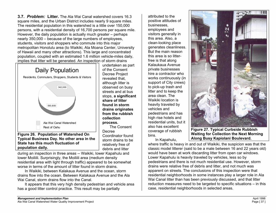
Management and Implementation Plan April 1998 Ala Wai Canal Watershed Water Quality Improvement Project Page [ 37 ]
3.7. Problem: Litter. The Ala Wai Canal watershed covers 16.3 square miles, and the Urban District includes nearly 9 square miles. The residential population in this watershed is a little over 150,000 persons, with a residential density of 16,700 persons per square mile. However, the daily population is actually much greater – perhaps nearly 350,000 – because of the large numbers of employees, students, visitors and shoppers who commute into this major metropolitan Honolulu area (to Waikiki, Ala Moana Center, University of Hawaii and many other attractions). This large and concentrated population, coupled with an estimated 1.6 million vehicle-miles daily, implies that litter will be generated. An inspection of storm drains
undertaken as part of the Consent Decree Project revealed that, although litter is observed on busy streets and at bus stops, a significant share of litter found in storm drains originates from the rubbish collection process. The Consent Decree Coordinator found storm drains to be relatively free of debris and litter
during an inspection in three areas -- Waikiki, lower Kapahulu and lower Moiliili. Surprisingly, the Moiliili area (medium density residential area with light through traffic) appeared to be somewhat worse in terms of the amount of litter found in storm drains. In Waikiki, between Kalakaua Avenue and the ocean, storm drains flow into the ocean. Between Kalakaua Avenue and the Ala Wai Canal, storm drains flow into the Canal. It appears that this very high density pedestrian and vehicle area has a good litter control practice. This result may be partially
attributed to the positive attitudes of businesses, employees and visitors generally in this area. Also, a clean-looking place generates cleanliness. But the main reason this area is so litter-free is that along Kalaukaua Avenue private businesses hire a contractor who works continuously (in support of City crews) to pick-up trash and litter and to keep the area clean. The Waikiki location is heavily traveled by vehicles and pedestrians and has high rise hotels and residential units, but it also has excellent coverage of rubbish bins. In Kapahulu, where traffic is heavy in and out of Waikiki, the suspicion was that the classic model litterer (said to be a male between 16 and 22 years old) would have been at work discarding litter from open car windows. Lower Kapahulu is heavily traveled by vehicles, less so by pedestrians and there is not much residential use. However, storm drains were relative free of debris and litter, and not much was apparent on streets. The conclusions of this inspection were that residential neighborhoods in some instances play a larger role in Ala Wai Canal litter than has been previously discussed, and that litter reduction measures need to be targeted to specific situations – in this case, residential neighborhoods in selected areas.
Daily PopulationResidents, Commuters, Shoppers, Students & Visitors
Ala Wai Canal WatershedRest of Oahu
342,000
593,800
Figure 26. Population of Watershed On Typical Business Day. No other area in the State has this much fluctuation of population daily.
Figure 27. Typical Curbside Rubbish Waiting for Collection the Next Morning Along Busy Kapiolani Boulevard.

Management and Implementation Plan April 1998 Ala Wai Canal Watershed Water Quality Improvement Project Page [ 38 ]
In Honolulu, the City operates a municipal rubbish collection and disposal service at no direct charge to residents, who put their trash out for collection twice a week. In the higher population density residential areas of the Ala Wai Canal watershed it is apparent that residents frequently put out rubbish contained in flimsy plastic bags, open paper bags, open cardboard boxes and even unpackaged at times. Such rubbish is being constantly disturbed and redistributed in the neighborhood and the streets by gusty tradewinds (tradewinds occur up to 85 percent of all days annually in Honolulu), by animals, or by vandals. As part of the Consent Decree Project, the City’s Department of Public Works stepped up inspections and notifications to property owners and tenants to improve their rubbish container methods.
However, in the past 14 months a satisfactory level of
improvement has not appeared. The answer may be to enlist the broader community in the form of organized groups to work directly with property owners, resident managers, owners’ agents and tenants to improve this situation. The City does not have specific rules for rubbish containers and developing rules may be one area for improvement. If owners of the many multi-unit dwellings which make up most of the residential housing in the problem area do not respond, the City Council could be asked to change the rules on rubbish pick-up. The change would be to require the use of on-site disposal bins to be collected by commercial vendors, or by the DPW if that agency should choose to take on the task.
LITTER A significant share of litter found in storm drains originates from the rubbish collection process.
Figure 28. Storm Drain Inlet From Street to Catch Basin. Rain washes rubbish and contaminants from streets. Rubbish and contaminants collect in catch basins. From catch basins, storm water flows via pipes or culverts to streams and then to the Ala Wai Canal.
Figure 29. Typical Amount of Litter in Bottom of Storm Drain Catch Basin Under Kapahulu Avenue. Ladder rungs allow climbing down from manhole cover to remove rubbish shown in lower left corner of photo.

Management and Implementation Plan April 1998 Ala Wai Canal Watershed Water Quality Improvement Project Page [ 39 ]
Figure 30. Volunteers. Waikiki Yacht Club Members, Using Club Barge, Clean Debris from Canal.
ACTION: Reduce the litter reaching the Ala Wai Canal. 1. The City DPW has targeted low-rise residential areas in the
watershed to ensure that appropriate rubbish disposal is taking place. This approach involves education of landlords, tenants, and owners. If the City can switch to the one-man rubbish pick-up system in these areas, that might solve the problem. However, because of the high densities and numbers of cars parked in the area (leaving no space to put the containers out on the street for pick-up), this system may not be workable. An anti-litter strategy needs to better involve community leaders, property owners, tenants and neighborhood improvement groups. The City should be prepared to cite flagrant violators, and as an extreme measure, the Council may need to consider a change in rubbish collection methods in certain areas. Such methods might include the use of large rubbish bins to be kept on site and to void the use of curb-side pick-up services. Either City crews or commercial vendors could then collect the bins and empty them periodically – perhaps through a paid-service similar to that now required in high-rise residential or commercial buildings.
2. The Steering Committee authorized expenditure of funds from the
Consent Decree to purchase floating debris containment booms for installation on tributaries to the Ala Wai Canal. These booms have been installed and will be monitored in the next few months to evaluate their effectiveness is capturing floating trash and restraining it from entering the Canal or the ocean. Volunteers have been identified who will periodically clean debris from behind the booms. If the system proves effective, DPW probably should pick up the maintenance responsibilities. The need for the booms may be reduced in the future if the measures in item 1, above, are implemented.
3. The City Recycling program and the State Department of Health
should renew their efforts to assist by first going to distributors and vendors asking for their assistance to voluntarily establish a bottle refund policy. If a voluntary approach fails, the legislature and the council should be requested by these agencies to enact a bottle and can deposit law.
Figure 31. State Harbor MOG and Crew Performing Debris Cleaning in the Canal.

Management and Implementation Plan April 1998 Ala Wai Canal Watershed Water Quality Improvement Project Page [ 40 ]
Effectiveness of Proposed Action. The proposed action would significantly reduce the unsightly litter which now reaches the Ala Wai Canal, and is carried into coastal water. The figure on the next page shows the locations of the proposed debris booms.
Figure 32. Debris-Catching Boom in Lake Merritt, Oakland, California. The boom captures debris originating on the land and transported via the storm drain outlet (right of photo) into the Lake.

Management and Implementation Plan April 1998 Ala Wai Canal Watershed Water Quality Improvement Project Page [ 41 ]
3.8. Problem: Risks to human health. There are three significant human health issues. The first is related to the effects on people who use the Canal for recreation. These are mostly canoe paddlers and kayakers. Paddlers often complain of skin infections, gastro-intestinal problems or flu-like symptoms. Precise causes of these illnesses are not easily identified. A recent 8-week survey of outrigger canoe paddlers found constant and recurring problems with skin rashes among crews of paddlers at three different locations on the Ala Wai Canal (based on self-reporting by paddlers and conducted by the Consent Decree Project, 1997a). The skin rash problems were found much less frequently in a control group paddler crew which did not use the Canal for practice. This quantitative data set partially verifies the historic set of anecdotal complaints made by paddlers and kayakers over the years, and suggests that a larger study is worth conducting.
Human sewage is not present in the Canal, except during infrequent sewer line breaks or mechanical failures. Almost all residences and businesses are connected to city sewers. There are few cesspool systems17 in the watershed, and very few have been identified near streams where they may potentially discharge into surface waters to stream water and thence to the Canal. Bacterial evidence of human fecal material is not readily identified in the Canal.
However, there can be high concentrations of fecal coliform bacteria in the Canal, especially after rain rinses the watershed 17 The City’s Department of Wastewater Management (DWWM, April 1996) has identified about 40 problem cesspools in the entire Sand Island Wastewater Treatment Plant service area (problem cesspools are those near streams or requiring constant pumping). This service area is far larger in land area and population than the Ala Wai Canal Watershed. That cesspools are significant contributors of nutrients or bacteria to the Ala Wai Canal is unlikely.
surfaces and runs off via storm drains into streams and into the Canal. The types of fecal coliform identified tend to be non-human in origin. They probably originate from animals in the Conservation District (pigs, mongoose, birds, rats) or Urban District (rats, dogs, cats, wild birds). Because of its design, the Canal will always accumulate these wastes and is unlikely to meet water quality standards that would support frequent swimming (especially after rain storms). However, it should be possible for the Canal to continue to serve as a location for recreational canoe paddling, but paddlers may be well advised to take precautions, such as thorough personal hygiene (see following action) and to stay out of the water after rain storms The second health issue could affect people who eat fish or crabs taken from the Canal. A study completed recently by the Consent Decree Project, 1997b) identified 94 persons fishing in the Ala Wai Canal during a two-week period. Of these persons, 42 (45 percent) said they consumed their catch. A memorandum prepared by the State Department of Health (DOH, 1992) concluded that consumption of one serving of fish (Tiliapia) per year may pose an increased risk of cancer in humans. Because the termiticides and lead are residing in the soils and in
dwellings located in the watershed, it will be a long time before such chemicals have leached from their points of origin and no longer pose a problem. The implication is that eating of fish or crabs from the Canal will continue to be an unhealthy practice.
On September 8, 1997, DOH staff, at the request of the Consent Decree Project, collected over 100 fish (Tilapia),and sent them to a laboratory for chemical analysis so that an updated cancer-risk assessment can be made. The laboratory work is funded by the Consent Decree Project. The results have been compared to similar data obtained in 1991 from the Ala Wai Canal and may assist in identifying trends in pesticide and lead levels in fish. One finding is
WELLNESS ISSUES • Canoe paddlers and kayakers complain of
a variety of illnesses, skin infections being one of the most frequent.
• There may be elevated health risks to persons who eat fish or crabs from the Ala Wai Canal. (DOH, 1992)
• The Mamala Bay Study Executive Summary Report concluded that, "...the risks of contracting an infection by bathing, swimming, surfing, or fishing in Mamala Bay waters are low." (p. 39) Also, "At the principal beaches the risk of acquiring an illness from ingestion of contaminated water at the concentrations actually observed in the Study, for example, was found to be little different from the risk for the general population not exposed to Mamala Bay waters." (p. 39)
• Leptospirosis presents a risk to anyone exposed to stream water and wet soil in the watershed.

Management and Implementation Plan April 1998 Ala Wai Canal Watershed Water Quality Improvement Project Page [ 42 ]
that lead levels are high and children should not eat any fish taken from the Canal. Adults should eat few if any. A copy of the report (DOH, B. Brooks) is included in Appendix B, Vol. I, this Plan. The third health issue is Leptospirosis, which presents a risk to anyone exposed to stream water and wet soil in the watershed. The disease is cause by a bacerium, Leptospirosis, which is transmitted by mammal urine (rats, mice, mongoose, wild pigs, cats, dogs, rabbits, people, etc.) The bacterium can persist in wet soil after release to the environment. Symptoms are flu-like with fevers, headaches, nausea and vomiting. The disease responds to anti-biotics. Symptoms appear 7 to 21 days after contact. Leptospirosis tends to enter the body through cuts or abrasions and can also enter any opening (eyes, ears, nose, mouth) and even unbroken skin. (Honolulu Advertiser, 1996). The disease is a universal problem in tropical areas throughout the world. As of July, five cases were reported on Oahu between January and July for 1997. DOH estimates that 10 percent of the animals (rats, mongoose) caught in
their traps are carriers (Honolulu Advertiser, July 24, 1997).18 Pre-treatment may be available to some users of streams. For example, U.S. Army troops, before training in the Republic of Panama, were pre-treated with an antibiotic - doxcycline (a tetracycline compound). The incidence of infection from Leptospirosis was much less than for a control group performing the same series of activities.19 ACTION: Take actions to reduce health risks by reducing exposure to pathogens in water and not eating contaminated fish. 1. Paddlers should bath with soap and water before and after
practicing in the Canal to reduce counts of bacteria or viruses present on the skin. Paddling can cause abrasions and exposure to sun can contribute to increased susceptibility to illness. The first line of defense is individual hygiene.
2. Because paddling should be supported in the Canal, the State Department of Land and Natural Resources (DLNR) and the City Department of Parks and Recreation should work together to provide adequate shower facilities for paddlers. The paddlers health survey done for the Consent Decree Project identifies locations where canoe clubs store canoes and stage practices. Adequate showers, changing areas and toilet facilities should be provided at each of these locations. At present, even though there are minimal facilities at some locations, no club located on the banks of the Ala Wai Canal has adequate facilities with the
18 Active efforts to exterminate wild pigs in the Ala Wai Canal watershed may be appropriate to both reduce the number of hosts for Leptospirosis and to reduce soil erosion in the Conservation District (see DLNR Letter, App. B, Vol. I, this Plan.) 19 Thanks to Councilmember Duke Bainum, M.D. for this referance.
Figure 33. Department of Health/Consent Decree Team Capture Tiliapia for Contaminant Testing, September 1997, Kapahulu End of Ala Wai Canal.
Figure 34. Fishers Taking Large Number of Tilapia, Manoa-Palolo Canal.

Management and Implementation Plan April 1998 Ala Wai Canal Watershed Water Quality Improvement Project Page [ 43 ]
exception of clubs using the Waikiki Yacht Club facility. The number of paddlers using the Canal for practice is several hundred during key seasons and there are many more kayakers. These numbers increase dramatically during special events for outrigger canoes, kayaks or rowing shells.
3. The State Department of Health
(DOH), the City’s Departments of Public Works and Department of Wastewater Management (DWWM) need to be pro-active in providing warnings along the Canal to paddlers. Paddlers watch for notifications of sewage spills or other problems, and choose whether to abide by the warning. DWWM has at times provided warnings about sewage spills, and DOH has posted the Canal with concerns about swimming.
4. Paddlers are best advised to
stay out of the Canal for a day or several days after rainstorms, until bacteria counts decrease.
5. The Steering Committee supports the DLNR report (1992) which
evaluated alternatives (including injecting seawater into the head of the Canal from deep well sources) to reduce phytoplankton blooms, turbidity and odors in the Canal.
6. Persons who catch or eat fish or crabs should be warned not to.
DOH should both post the Canal and warn individuals through other media. It may be that these user groups are small enough that the State DOH or DLNR can do this one-on-one over a period of time. DLNR should be involved because the Ala Wai Canal is a
fishery management area under authority of the Division of Aquatic Resources.
7. DOH should test fish in the
Canal every 5 years for lead, dieldrin and chlordane, and possibly other contaminants. The purpose is to check for trends in levels of concentrations. If the water quality goals for the Canal and streams are to be reached, the incidence of contaminated fish is a parameter which indicates if the system is healthy for humans.
8. DOH and the University of
Hawaii should coordinate with other public health researchers world-wide in a search for methods of controlling Leptospirosis. How can programs such as Adopt-a Stream, student/school based water quality monitoring, or recreational paddling be encouraged in an environment
carrying the pathogen? Government should be a leader in searching for solutions to this problem. In the meantime, it is up to individuals to be self-aware of illness symptoms. DLNR could cooperate with this effort by exploring eradication of wild pigs in the Ala Wai Canal watershed.
Effectiveness of Proposed Action. The proposed action would significantly reduce health risks related to water contact by paddlers in the Canal, fish-consumers and persons in or near streams.
Figure 35. Leptospirosis Warnings Are Posted Throughout the Watershed by DOH. While the warning is needed, the message implies that the waterways are contaminated and have little environmental value.

Management and Implementation Plan April 1998 Ala Wai Canal Watershed Water Quality Improvement Project Page [ 44 ]
The Ala Wai Canal was completed in 1928, nearly 70 years ago. The Canal was constructed to create buildable land where there once were lo’i (wetland taro terraces), rice paddies, ponds, wetlands and marshlands. The Canal functions to divert storm water runoff away from Waikiki, which is built on a low-lying sand bar on top of an ancient coral reef. Without the Ala Wai Canal, development of Waikiki and surrounding flatland neighborhoods including Ala Moana center and many low-lying residential neighborhoods would not have been possible. Originally the Canal was connected to two outlets, a large one (75 yards wide) at the Ala Wai Small Craft Harbor, near Ala Moana, and a small one via the Kapahulu Groin into the ocean next to Kuhio Beach. The 1920 map of the proposed canal route shows a connection via an underground pipe from the Kapahulu end of the Canal to the ocean beneath Kapahulu Avenue (see 1920 map, end of Chapter). Persons familiar with the area will recall that the Kapahulu Groin, a favorite body-surfing site, is constructed around the outlet to the Kapahulu storm drain, which at one time actually connected the Canal to the ocean at this location. In fact the entire area of Kapahulu also drained out from this point. In the 1970’s, the City constructed the Kapahulu Improvement Project, and rerouted storm drains through what is now the Golf Course access road, and directly to the Ala Wai Canal. The
Kapahulu storm drain outlet via the Kapahulu Groin never worked well, it was constantly being blocked up by sand brought in by ocean waves. Also, water pollution problems20 (high coliform counts and odors) within the beach area confined by “walls” (the Kuhio Beach crib walls bordering the Kapahulu Groin which provide a sheltered swimming area) raise concern about permitting storm drainage outlets at
Waikiki Beaches. At present, the Kapahulu Groin storm drain has about 50-acres as its watershed, which is not physically part of the Ala Wai Canal watershed. Rather, this is a very small area in the vicinity of Waikiki and Kapiolani Park. Zoo drainage was redirected some time ago into the City’s sanitary sewers because of past problems with animal waste discharges. When the Canal was built,
the population of Oahu was less than 200,000. Today population is nearly one million – five times greater. Before the Canal was constructed, the low-lying wetlands and lo�i captured soil eroded from the mountains and transported by
20 Contributors to the high bacterial counts within the popular swimming area next to Kuhio Beach, within the crib walls, adjacent to the Kapahulu groin are soil runoff, bird droppings and the bathers themselves. The crib-wall enclosure prevents circulation of seawater, and bacteria levels build-up during the day as use increases.
4. Overview of the Watershed and Existing Water Quality Conditions
Figure 36. 1920, Agricultural Land Uses in Vicinity of Proposed Ala Wai Canal. View from offshore of Waikiki towards the Moana Hotel and Kalakaua Avenue. Stream in center of photo (from top to bottom) on left of Moana, is Apuakehau, which was formed by Manoa and Palolo Streams. (Ala Wai Canal Construction, 1922 to 1928). Photo Credit: 5th Group (OBS.), Bishop Museum.

Management and Implementation Plan April 1998 Ala Wai Canal Watershed Water Quality Improvement Project Page [ 45 ]
storm water to the lowlands. Such soil produced rich and fertile land for cultivation. Completion of the Canal, and the filling in of lowlying areas with the dredge material from excavation caused new problems – flooding and water pollution. Prior to construction of the Canal, the watershed was 100 percent permeable. Today, permeability is 54 percent. This means that much more rainwater than before washes off the paved urban surfaces and into the streams and storm drains. One hundred percent permeability means that the ground can absorb rainfall and allow the water to percolate down to become ground water and to form springs. A table and map (see end of Chapter) describe the present percentage of watershed permeability by sub-watershed area. Urbanization, which occupies 55 percent of the land area, provides very little permeable surface. Rainfall (annual average) varies from a high of 160 inches in the mountainous rainforest of the Conservation District to a low of about 25 inches in Waikiki. Streams are “flashy”, meaning that during intense rainstorms they reach their peak flows in two hours or less. This is a flash flood situation and people using or living near streams are well-advised to attend to the upland weather conditions.
Today, the rate of sedimentation in the Canal is estimated to be more than 10,300 cubic yards (about 1,500 dump-truck loads) annually. The majority of this material is soil eroding from the landscape, and 70 percent or more has been estimated to originate in the “mountains” or undeveloped Conservation District. Much of the
remainder originates from erosion of the stream banks (those not lined with concrete or rock) in the Urban District.
Land use in the watershed is divided into two distinct types – urban and conservation, with a very tiny amount of agriculture. The vast majority of rain falls in the Conservation District and the upper fringe of the Urban District (upper Makiki, Manoa and Palolo Valleys) where slopes are steep and the land tends to be highly erodible (a trait of
Pacific Island volcanic soils), but also highly permeable. The flatter lands receive much less rainfall, and because of the extensive hard-surfacing of the environment, most erosion tends to take place in those portions of urban streams which are not lined with hard surfaces. The urban areas are the most impermeable, only about 15 percent (870 acres) of the urban areas is unpaved, or uncovered by roofs, patios, walkways, driveways and other hard surfaces.
The decrease of permeable surface area has caused shortened the time-to-peak of stream flows. This means that the streams reach their peak flows faster than under natural conditions, and that stream channels must carry more storm water runoff at peak flow periods than in less developed times.
Under natural conditions, rainfall would be stored throughout the low-lying areas which were comprised of taro terraces (lo’i), permeable soil, ditches, gullies, and swales. Today these areas are all paved urban properties. In the past, rainfall would percolate into the ground, replenishing the groundwater aquifers. Under modern conditions, groundwater levels have dropped. Groundwater levels are
OAHU POPULATION GROWTH & DECREASE IN PERMEABILITYALA WAI CANAL WATERSHED
0100,000200,000300,000400,000500,000600,000700,000800,000900,000
1,000,000
1920 1997
Year
024681012141618
Population Permeability
100 % (1920)
55 % (1997)
Figure 37. Decrease in Permeability – 1920 to 1997.
Management and Implementation Plan April 1998 Ala Wai Canal Watershed Water Quality Improvement Project Page [ 46 ]
further lowered by pumping drinking water from wells in the upland areas. The overall effect has been to reduce the water in streams under typical, day-to-day conditions, and this flow reduction has had an adverse impact on wetland plants, fish and other aquatic life.
The land uses (Table 3) are defined through State-designated zones called Land Use Districts. The Urban District is nearly 6,000 acres, or 8.8 square miles, the Conservation District is about 4,700 acres, or 7.5 square miles, and the Agriculture District is slightly over 100 acres or about 0.2 square miles. There is no development or paved surface area in the Conservation District, and little in the Agriculture District. Under State law, the Urban Districts in Hawaii are generally the developable areas; and these areas are administered through a County zoning process. The Urban District has nearly 3,800 acres (5.9 square miles) of residential and commercial zones, a little over 1,100 acres (1.8 square miles) of roads and highways, and about 1,000 acres (1.6 square miles) of schools, parks and military (mostly Fort DeRussy, but also part of Punchbowl National Cemetery and Diamond Head facilities) land uses. During the 70 or more years since completion of the Ala Wai Canal, the Urban District in the watershed has become fully developed as evidenced by the very low area of permeable surface. Moreover, development has gone high-rise, and this watershed is the destination area for more visitors, workers, students and shoppers than any other location in the State. Termiticides are in the watershed’s groundwater. The Board of Water Supply has reported the presence of dieldrin in the Kaimuki well (in the Kapahulu area) at concentrations of between 0.01 and 0.02 parts per billion. Hawaii defers to the federal safe drinking water standards which do not have a specific threshold for dieldrin. However, California’s standard is that drinking water should not exceed 0.05 parts per billion of dieldrin.21 The presence of dieldrin in the well implies that the termiticide has migrated from the point of application (older wood frame structures) into the groundwater. One means of reducing such migration is to require the installation of rain gutters on houses in the watershed. Rain gutters would direct stormwater runoff from roofs away from the “drip” line which is the
21 Honolulu Advertiser, “Water Board Closes Well as Precaution”, 4/12/96.
location where termiticide chemicals are usually placed in the ground surrounding the house to prevent termite infestations.22 While most eroded soil originates in the Conservation District, most contaminants originate in the Urban District. Organic debris, such as tree stumps and branches, originates in the Conservation District, but some eroding urban streambanks can also yield trees and stumps. These cause problems by blocking stream channels, bridge openings, and by creating navigational hazards after arriving in the Ala Wai Canal, or Ala Wai Small Craft Harbor. Birds and other animals (rats, mongoose, wild pigs, dogs, cats) in the watershed may contribute significant amounts of bacteria and nutrients. A worthy project would be to estimate the populations of these animals and their wastes to identify their contribution to the total nutrient load entering the Ala Wai Canal. The reason to do this is to compare nutrient loads from animals and other possible sources (for example, fertilizers and car washings) in order to prioritize management measures. Although management measures to reduce animal populations may be nearly impossible to impose, if these sources
22 This method was suggested by Steve Lau, Ph.D., formerly Director of the University of Hawaii’s Water Resources Research Center.
Table 3: Land Area and Land Use - Ala Wai Canal Watershed Based on Zoning -- State (Agriculture, Conservation & Urban Districts) & County
(Residential, Commercial, Roads, Highways, Schools, Military, Parks) Source: City and County Department of Public Works.
Land Use Acres Sq. Mi. Percent Total Land (16.3 sq. mi.) 10,714 16.3 100 Conservation District (undeveloped uplands, includes Ala Wai Canal)
4,718 7.5 44
Urban District 5,996 8.8 55 Residential & Commercial (Urban District)
3,763 5.9 35
Roads and Highways (Urban District) 1,123 1.8 11 Schools (704 ac.), Parks (263 ac.), Military (38 ac.) (All Urban District)
1,005 1.6 9
Agriculture (Urban District) 105 0.2 <1

Management and Implementation Plan April 1998 Ala Wai Canal Watershed Water Quality Improvement Project Page [ 47 ]
appear to be significantly greater than those from fertilizers or car washing, then extreme controls on the latter many not be justified.
Under direction of the Consent Decree Coordinator a student intern (V. Igawa) prepared a report which provided an inventory, an inspection of a sample of watershed sub-areas, and an estimate of the number of abandoned vehicle batteries. These batteries are alleged to be a significant source of lead in the waters. However, the result of this work (reported in Volume II of this Plan) did not show this to be the case.
Large quantities of fecal coliform bacteria have been counted in the Ala Wai Canal, primarily after rainstorms have flushed the watershed’s surface. As a result, paddlers are advised to avoid the Canal for a few days after rainstorms. Researchers still argue about whether or not fecal coliform is a true indicator of human sewage – in general it appears that it may not be because it reflects the bacteria found in the wastes of animals other than humans, and also reflects soil populations of bacteria.
Cesspools have long been an item of concern, and have been termed a possible source of high fecal and nutrient loadings. At the
request of the Consent Decree Coordinator, the City’s Department of Wastewater Management prepared an updated estimate of the number of cesspool or septic tank systems, including the potential nut rient yield from them to the Ala Wai Canal (DWWM, 1996, responsible for sewage collection and treatment). The Department summarizes the information as follows.
There are about 244 unsewered lots in the watershed. Of these about 214 have cesspools and 30 have septic tank systems. DWWM policy is that all defective cesspools must be replaced with septic tank systems or hooked-up to the sewer system. DWWM believes that many or most of the cesspools and septic systems are in higher elevation areas such as the Tantalus and Roundtop neighborhoods, well away from streams. Perhaps 10 percent of all cesspools may be estimated as possibly
Figure 38. Birds and Other Animals May Contribute Significant Amounts of Bacteria and Nutrients to the Watershed. Location -- Entrance to Ala Wai Municipal Golf Course, at the Kapahulu End of the Canal.
Figure 39. Abandoned Car Battery -- A Source of Lead.

Management and Implementation Plan April 1998 Ala Wai Canal Watershed Water Quality Improvement Project Page [ 48 ]
being sources of nutrients to streams and the Ala Wai Canal. Based on this estimate, the amount of nitrogen would be about 3.1 pounds per day and phosphorous 0.47 pounds per day. DWWM believes that a far more likely source of nutrients is fertilizer applied to individual properties in the watershed.
Recent chemical testing of Ala Wai Canal sediments have revealed the presence of contaminants (copper, chromium, and lead) whose major source of origin are vehicles and possibly asphalt for chromium. While much lead in sediments may have originated from leaded gas use in the past, such use has been banned for more than 10 years. The concentrations of lead should gradually decline in the future because the sources on land are not being replenished.
However, some lead still originates in both brake pads and abandoned car batteries. Lead from these sources is finding its way into the waters. Copper is present in tires, brake pads and brake shoe linings. Chromium is a common automobile plating metal and may also be present in coal or petroleum-based products such as asphalt. Taken together, these materials present a costly clean-up problem for which there are few solutions at present. A crude estimate of vehicle-miles traveled daily in the watershed is approximately 1.6 million.23
New technologies for removal of pollutants from stormwater are available and with testing in this watershed some measures to reduce these metals and chemicals may be adopted. Please see the Appendix for a suggested project designed to test filtration/metal adsorbant materials in storm drain catch basins.
A shift to non-metallic brake pads might solve the problem at little or no cost. Such pads are presently available.
Iron-oxide coated sand can be used as a metal adsorbent in trenches through which road runoff is filtered. At least one suitable location for this method is under the H-1 overpass at the Manoa-Palolo Canal where DOT has land along the Canal.
Asphalt itself may be a source of some metals and more information is needed on its composition. For example, asphalt may contain chromium which naturally appears in crude oil and also in local soils. Because chromium is one of the metals found in high concentrations in Ala Wai Canal sediments we need to look at the possibility that asphalt use in certain heavily traveled roads be changed to concrete, or some other road pavement in order to reduce the costs of disposal of dredged sediments from the Ala Wai Canal.
Table 4 (next page) provides a summary of watershed information including resident population by major neighborhoods, average freshwater and storm water flows, and estimates of sediment volumes which reach the Ala Wai Canal each year. The estimates of sediment volumes are based on a computer model which was calibrated to measured sediment concentrations, mostly from other watersheds on Oahu because there is little detailed sediment data for the Ala Wai Canal Watershed. 23 Vehicle-miles per day is a measure of the number of total miles traveled in the watershed daily. The number of vehicles is estimated to be about 250,000. This is a density of about 44 vehicles per acre of urban land in the watershed, or more than 250 vehicles per acre of roadways.
Table 4: Summary of Information - Ala Wai Canal Item
Amount
Percent
Population, Oahu, Residents and Visitors, Population, Watershed, Residents Population by Neighborhood Kaimuki Diamond Head/Kapahulu Palolo Manoa McCully/Moiliili Waikiki Makiki/Tantalus
836,231 150,419 20,471 17,877 13,465 22,345 28,466 19,768 28,027
100 18 2 2 2 3 3 2 3
Passenger Vehicles, Oahu, 1993 Watershed Pass. Veh. Resident, estimate Watershed Traffic, (1989) vehicles/day24
483,237 86,983 250,000
100 18 52
Fresh water (mgd) average annual flow basis. Storm water flows (mgd) via City Storm Drain System. Base flow ((State of Hi., DLNR, 1992)
21.0 7.9 4.9
Sediment (estimates, tons per year) -- total from Conservation District from Urban District from construction sites (Urban District) from urban lands (Urban District) from agriculture land (Urban District)
18, 739 14,372 4,367 2,116 1,819 432
100 77 23 11 10 2
Note: Pollutant estimates based on computer model results. Source: Revised Total Maximum Daily Load Estimates for Six Water Quality Limited Segments, Island of Oahu, Hawaii, State of Hawaii Department of Health, William Freeman, November 1993. Sediment estimates adapted from above data source. Base flow estimate per Noda report based on USGS measurements – base flow is that flow which occurs about 90 percent of the time – or the typical low stream flow which can be expected most of the time (90 percent of the time). (This table revised by Dashiell, 12.14.00)
Management and Implementation Plan April 1998 Ala Wai Canal Watershed Water Quality Improvement Project Page [ 49 ]
Table 5 (end of chapter) provides a list of the major contaminants found in the Ala Wai Canal waters, sediments and tributary streams. It also lists which Land Use Districts are pollutant sources, and describes points of origin. Traditionally, this is called “non-point” source pollution, because the points of origin are not easily identified, or because the pollutant is somewhat ubiquitous throughout certain areas of the watershed. In contrast, “point” sources are sewer outfalls, industrial discharges, and storm drains.
Table 6 (end of chapter) provides an estimate of the total miles driven daily by vehicles in the watershed. The mileage calculation is based on a crude model of the major traffic destination areas (Waikiki, Ala Moana Shopping Center, schools, the University of Hawaii, through traffic and watershed residents). For simplicity, the model uses the centerpoint of the watershed as a basis to calculate the mileage traveled. For example, a trip by a car from outside the watershed to the University of Hawaii, Ala Moana Center or Waikiki is assumed to be two miles in, and two miles returning.
The watershed extends about four miles from Diamond Head to Punchbowl, the two major physical land marks on either side of the watershed boundary, and the major freeway and through-roads cross the watershed boundaries at approximately these points. The purpose of the traffic model is to demonstrate the magnitude of impact which vehicles have. The total mileage traveled by vehicles is estimated to be about 1.6 million miles per day. This is a density of nearly 44 vehicles per urban acre or 224 cars per acre of roadway. This model was constructed to provide an “order of magnitude” estimate of vehicle-miles per day in the watershed. Although there is a large amount of traffic count data for certain roads and intersections, a composite count of total number of vehicles and miles traveled in the watershed is not the type of calculation for which traffic count data is typically used. Thus, such calculations are not readily available from existing sources.
Table 7 (end of chapter) provides an estimate of the annual load of metals from various automotive sources. The numbers in the table are extrapolated from data assembled for a similar project in Santa Clara Valley by the City of Palo Alto Public Works Department. The number of vehicle-miles traveled daily in that watershed is about 21 times the number traveled in the Ala Wai Canal Watershed. The
Palo Alto study did not cover abandoned batteries, deterioration of vehicle components and metals from asphalt paving.

Management and Implementation Plan April 1998 Ala Wai Canal Watershed Water Quality Improvement Project Page [ 50 ]
Table 5: Sources of Contaminants Found in the Ala Wai Canal and Tributary Streams S = significant source; L = less significant source; N = not significant as a source; R = after rainstorms
Possible Source Location Type of Pollutant Conserv. Dist. Urban District Pollutant Sources Bacteria - Fecal Coliform, Leptospirosis
S S Wld & domestic animal waste. Bird droppings may be a significant source. Occasional sewer spill, little if any from cesspools.
Nutrients - Nitrogen SR SR Rainfall, nitrogen-fixing plants, decaying plants, animal wastes, possible automobile exhausts, chemical fertilizers
Nutrients - Phosphorous
L SR Fertilizers, domestic pet wastes, natural soil (inorganic), groundwater and organic sources.
Heavy Metals - Mercury L L Natural rocks/soils, fluorescent bulbs (streamside dumping), some marine paint (residue of previous hull-cleanings).
Cadmium N L Fertilizers, batteries, paints, plastics, photo-processing, plated iron (nuts, bolts), automobiles.
Lead N S Leaded Gas, brake pads.
Copper L S Natural soil, some marine paint, some pesticides, automobile parts, tires, brake pads.
Zinc L S Natural soil, some marine paint, tires, automobile parts, brake pads.
Arsenic N L Some herbicides, including those for golf course use.
Nickel N N Manoa soils, possible local basalt gravel in paving material, automobile parts.
Chromium N S Automobile parts.
Pesticides - DDT, DDD, DDE
N L Banned by EPA, generally declining, low levels in Ala Wai sediments.
Dieldren N S Use as termicide cancelled in 1987. Low and declining levels, but possible health risk from eating fish caught in the Canal.
Chlordane & Heptaclor N H Use as termicide cancelled in 1988. Low levels, probably decling, but possible health risk from eating fish caught in the Canal. Existing stock can be used by individuals.
PCB N N Transformers. Low levels.
Sediment S L, SR Majority (est. 70 to 75%) of sediment originates "naturally" in higher parts of the watershed, some urban contributions.
Litter L SR Cans, plastic, cigarette butts, shopping carts, about 1/3 organic detritus (leaves, branches) which is partly natural and partly human generated.
Garbage/debrIs/rubbish
N SR Mostly residential household disposal: Fluorescent light bulbs, automobiles and parts, tires, scrap materials, TV sets, refrigerators, couches, furniture, litter.
Sources: Adapted from DOH, 1993 from information provided by DeCarlo and Spencer (see DeCarlo and Spencer, 1995, for original references); metals updated to reflect sediment sample analysis done by DTS, Summer 1997.
Management and Implementation Plan April 1998 Ala Wai Canal Watershed Water Quality Improvement Project Page [ 51 ]
Table 6 Vehicle-Miles per Day (Estimate) & Traffic Destinations Ala Wai Canal Watershed
Note: This table presents an estimate of the total number of miles traveled daily in the Watershed. It is the basis for an estimate of the release of metals from brakepads and brake linings. The table also shows the density of vehicles in the Watershed.
Column* 1 2 3 4 5 6 Traffic Component People People per
Vehicle Vehicles (C1/C2)
Vehicle- Trips per
Day
Miles per Trip
Vehicle- Miles per Day
(C3xC4xC5) Ala Moana Center (Employees and Shoppers) 50,000 1.3 38,462 2 2 153,846Private & Commuter Schools (Students & Staff) 4,000 1.6 2,500 2 2 10,000Through Traffic 75,000 1.3 57,692 2 4 461,538Waikiki Employees 18,000 1.3 13,846 2 2 55,385Waikiki Visitors 40,000 2 20,000 4 2 160,000Watershed Residents, (150,000 in 1995) 100,000 1.3 76,923 4 2 615,385Watershed Employees, Customers, Other 25,000 1.3 19,231 2 2 76,923University of Hawaii (Faculty, Staff and Students) 30,000 1.3 23,077 2 2 92,308Total 342,000 251,731 1,625,385
C=Column
Daily Vehicle Density Watershed Area Sq Mi
Watershed (acres)
Urban District (acres)
Vehicles Vehicles per Acre
Urban District Vehicle Density 16.30 10,432 5,738 251,731 43.87Urban Roads
(acres)
Urban Road Vehicle Density 16.30 10,432 1,123 251,731 224.16
*Notes: 1) This is an estimate of the order of magnitude of the number of miles a vehicle travels daily in the watershed. The number of vehicle trips per day (251,731) is of the order of magnitude of vehicle counts reported in DOH, Nov.1993. 2) People, vehicles, people per vehicle, number of trips, and miles per trip are estimates. 3) Trip distances are estimated from a center-line in the 4-mile wide watershed so through-traffic moves four miles, others 1/2 that. 4) The purpose of this estimate is to provide a basis from which estimates of pollutants which are of vehicle origin can be made. 5) Say, 2/3 (100,000) of all residents will travel by car on an average day.

Management and Implementation Plan April 1998 Ala Wai Canal Watershed Water Quality Improvement Project Page [ 52 ]
Table 7 Annual Load Estimates: Automotive Sources - Ala Wai Canal Watershed
(Extrapolated from estimates for Santa Clara Valley) Load Estimate (Pounds per Year) Source Chromium Copper Nickel Lead Zinc Cadmium Brake Pads* 363 21 147 Tires* 1,322 11 Coolant Leaks* 5 1 <0.5 1 Coolant Illegal Dumping 8 2 1 1 Motor Oil Leaks* 1 Motor Oil Illegal Dumping* <0.5 2 1 123 Abandoned Batteries No data Deterioration of Vehicle Components No data Asphalt Paving Surfaces No data Total (Pounds per Year) No Data 376 5 23 1,595 11 Notes: *Values in these rows are extrapolated from estimates provided in the source document. The watershed mileage traveled estimate shown in the preceding Table 6 was used to estimate the loading values shown above. Total automobile miles estimated for the Santa Clara Valley were about 21-times the Ala Wai Canal Watershed. The Palo Alto report did not include data for abandoned batteries, deterioration of vehicle components, or the contribution of asphalt. The elevated levels of chromium in the Ala Wai Canal sediments are of concern and the local source has yet to be identified or estimated. Source: City of Palo Alto Public Works Department, Table 5-16, February 12, 1997

Management and Implementation Plan April 1998 Ala Wai Canal Watershed Water Quality Improvement Project Page [ 53 ]
The Steering Committee’s25 vision (see Chapter 1) of the future conditions in the Ala Wai Canal includes a strategy to achieve the main goals of the Consent Decree --improved water quality in the Ala Wai Canal, tributary streams, and ground water along with improvements to recreation. Recommendations are numbered and enclosed with a box. GOALS AND STRATEGY It is the intent of the Steering Committee to implement the Project Agreement26 between the City and County of Honolulu and the State of Hawaii Department of Health (September 27, 1995). The goal is to:
Improve the quality of both surface waters and ground waters in the drainage basins for Manoa, Palolo and Makiki Streams, and in the Ala Wai Canal through a long term, community-based, public-private program of non-point source management activities in the watershed.
Water Quality Goal -- Fishing and Recreational Use. The Steering Committee desires that the Ala Wai Canal and its tributary streams eventually attain a level of water quality suitable for recreational use, including fishing. This level of water quality will approximately conform to the federal "Clean Water Act" which established a long-term goal for the nation's waters to be "fishable and swimmable". The Steering Committee recognizes that, because of the presence of bacteria such as Leptospirosis in the watershed, attaining water quality suitable for swimming will be difficult, and may not be possible in the foreseeable future.
25The Steering Committee of the Consent Decree project included groups,
residents, and agencies. It was a large group (over 225 on the mailing list) and 50 or so persons typically attended a meeting.
26The City-DOH Project Agreement is part of a consent decree (Escrow Agreement between U.S.A. and State of Hawaii and Lawrence Miike, M.D. v. City and County of Honolulu, May 29, 1995).
1. The Steering Committee recommends a water quality goal of recreational suitability with limited water contact. This goal is in conformance with current activities (canoe paddling, kayaking, viewing, catch and release fishing). The goal does not preclude these activities in the future, nor does it preclude the use of the Canal by motor-powered vessels, as long as power boats do not change water quality.27
The Steering Committee notes that while some members of the community recall pleasant swimming conditions in the Canal in the 1930s to 1950s, others recall being warned away from swimming in the Canal in the 1930’s. Also, from about 1960 onward, the Canal has not been viewed generally as a suitable location for swimming; there are many alternative swimming locations within convenient distances from the canal (Ala Moana Beach and the Waikiki Beaches, for example). The Steering Committee recognizes the value of canoe paddling, kayaking and rowing to Hawaii in terms of
27 The Convention Center Authority is evaluating the use of motor powered vessels to transport people to and from the Center.
5. Future Water Quality Conditions
Figure 40. One-person Outrigger Canoe Beneath Kapahulu Avenue Bridge - The Canal’s Water Quality Should be Suitable for Recreational Use.

Management and Implementation Plan April 1998 Ala Wai Canal Watershed Water Quality Improvement Project Page [ 54 ]
cultural history, as well as the fact that the Ala Wai Canal is a registered state historic site. Early-action Best Management Practices. The Steering Committee notes that the Ala Wai Canal is the main receptor of the stormwater runoff from a land area of 16.3 square miles. There is a dense population exceeding 200,000 (daily) and the number of vehicles in the watershed exceeds 250,000 daily (nearly one-half the number traveling on Oahu). This complexity of physical and land use features is the direct cause of the Canal’s water quality problems. The tropical climate, domestic pets, wild animals, birds, and soil populations of bacteria all contribute to high bacterial and sediment levels in the Canal after rainstorms. Therefore, in order for the Canal to be a reasonably useful area for partial water contact sports, such as paddling, the Steering Committee recommends the following two actions. 2. Paddlers should avoid water contact right after rainstorms when
bacterial levels are highest. The Steering Committee recommends that the Department of Health should educate paddlers on possible health risks associated with water contact after rainstorms.
3. The City, as manager of the shoreline adjoining the Canal, should
construct additional showers at all locations where paddlers now launch. If this is done, paddlers will be able to bath before and after canoe practice. Construction of showers would facilitate improved health among paddlers because one of the more common causes of infections in this situation is skin-borne pathogens, such as Staphylococcus, which is present at most times in the tropics on the human body. Washing before and after canoe practice would aid in reducing self-infection, as well as in cleaning of any organisms picked up on the skin while paddling.
The Steering Committee notes that one of the most objectional
characteristics of the Ala Wai Canal is the large load of floating debris which occurs during rainstorms which flush the watershed surfaces and its storm drains. Therefore, the Steering Committee recommends that:
4. The Department of Public Works install floating debris catchment booms on the streams and drainage channels which flow into the Ala Wai Canal, and that these debris catching booms be cleaned of captured rubbish on a periodic basis. The Steering Committee believes that this single action will have a strong positive and publically noticeable effect in the campaign to reduce floating rubbish and debris in the Canal. The Steering Committee notes that this action is not a substitute for strengthening the anti-litter programs of the City and the State; rather these actions are complementary.
The Steering Committee recognizes that sediment accumulation
in the Canal is continuing at a high rate; the cost of its removal is presently estimated at $1.5 million annually.28 Therefore the Steering Committee recommends that any and all practical and reasonable measures should be implemented now to start a program of erosion reduction in the watershed. The Steering Committee recommends that the City’s Department of Public Works and the State’s Department of Land and Natural Resources initiate the following projects in the Urban and Conservation Districts:
5. Stabilization of streambanks, revegetation, reseeding, trail
repairs, dredging of a sediment catchment basin in the Palolo-Manoa Channel and other actions to reduce soil erosion and the consequent sedimentation of the Canal.
Fishing. With regard to fishing, the Steering Committee desires that the water of the Ala Wai Canal and tributary streams reach a level of quality capable of supporting aquatic life which could be eaten without risks to human health. The Steering Committee acknowledges the risks to consumers of fish caught in the Ala Wai Canal posed by the presence of termiticides (dieldrin and chlordane) and lead which are known to be present in the flesh of fish (tilapia) and crabs caught in the Canal or its tributaries. The Steering Committee believes that these three elements (dieldrin, chlordane and lead) will eventually leach from the watershed and that ultimately the concentrations now found in sediments and marine organisms
28This cost includes current estimates of the volume of sediment now
present, the cost to remove it, and the cost of interest in calculating an annualized estimate.

Management and Implementation Plan April 1998 Ala Wai Canal Watershed Water Quality Improvement Project Page [ 55 ]
will decrease, to levels which will no longer pose a threat to human health. The decrease will occur because these elements are banned from use for about 10 or more years. However, some lead sources will remain (brake pads for example) unless other actions are taken. The Steering Committee recommends that: 6. The Department of Health monitor marine organisms in the Ala
Wai Canal and tributaries for the presence of termiticides and metals. Monitoring is the primary means of detecting and estimating the rate of decline in contaminant concentrations, and will provide a basis for estimating the year in which the goal of fish consumption may be attained in the Ala Wai Canal.
The Steering Committee notes that water quality in the Canal is very adequate to support fish populations and some species (such as Tilapia) are thriving. Barracuda and papio are also present, but mullet are rare. The lack of a mullet fishery may be due to the extensive sedimentation on the substratum. Sedimentation has degraded the mullet habitat so that the fish cannot survive in the Canal. However, the introduction of Tilapia by the State to Hawaii in the 1960's may also have adversely affected the mullet populations because of the aggressive and omnivorous feeding habits of Tiliapia, which eat both the algae fed on by mullet as well as the mullet eggs.
The Steering Committee recognizes that the practice of fishing also extends into the three major fresh water streams in the watershed, and that the range of fishing activities includes the practice of native Hawaiian rights in these streams, and in estuarine and wetland areas. Native rights include fishing and the collection of a variety of plants and organisms which are dependent on stream habitats. The Steering Committee recommends preservation and enhancement of stream habitat, in order for the full range of species to be present to which Native rights extend.
7. Agencies with stream mandates (DLNR and DPW) and
agencies who own or control stream property (DOE, DPR, DOT) should work together to improve stream habitat. Improvements needed include reduction of streambank erosion through revegetation, bank lining with gabions instead of concrete, and other techniques.
8. The Steering Committee recognizes that the fulfillment of Native rights related to streams is one of the factors which requires flowing water of good quality in the streams. Such consideration also serves to meet the national and Steering Committee goal of provision of suitable aquatic habitat to achieve the water quality needed for fish consumption. At present, native species of fish (o’opu) are present in the three stream systems in the watershed. This implies that there may be adequate streamflows at present. However, much needs to be done to improve the aquatic species populations. Therefore, DLNR should monitor and report annually on the numbers of native species in streams, and the area of suitable habitat in order that improvements can be measured. It is in the best interest of the BWS to work cooperatively with DLNR.29
Flooding, Environmental Values and Storm Water Runoff Quality. The Steering Committee notes that watershed management, especially in the developed urban area, must acknowledge that all the city street storm drains flow to the streams, and that the streams are the conduits for all storm drainage to the Ala Wai Canal. The Canal itself has approximately the capacity for a 10-year storm, and the stream channels can flood occasionally. Proposed water quality improvements, such as stream bank protection, floating debris booms or other measures need to be designed and installed in such a way that the existing flood problems are not made worse. Moreover, the Steering Committee recognizes the threat to human health and safety of flooding and will continue to support the efforts of the State Department of Land and Natural Resources and the City Department of Public Works to decrease the flood threat in the developed areas. The Steering Committee recognizes that, in the past, drainage improvements have taken precedence and priority over environmental values, especially in the urban streams in the Ala Wai Canal watershed. 9. The Steering Committee recommends that in order for the water
quality goals of the Consent Decree Project to be attained in the future, then flood control and drainage project designs should be
29 BWS diverts water from Makiki, Manoa and Palolo Streams via their municipal water wells at stream headwaters. The diversions reduce the base flow in the three streams by 1.0 to 2.0 mgd.

Management and Implementation Plan April 1998 Ala Wai Canal Watershed Water Quality Improvement Project Page [ 56 ]
required to adjust to a broadened set of watershed and water quality objectives. For example, the City has recently required that new developments provide rainfall storage on-site for a storm of a 2-year, 24-hour frequency. The Steering Committee recommends that the concept of on-site storage be explored (as only one of many possible ideas) for application in the built-up areas of the Ala Wai Canal Watershed. For example, property owners with large lots, who may be able to provide stormwater storage, might be candidates for any watershed management tax benefits than might be proposed in the future.
10. The Steering Committee recommends that the Departments of
Public Works (City), Health (State) and Land and Natural Resources (State) adopt watershed management and water quality objectives as part of the conceptual basis of drainage and flood control design.

Management and Implementation Plan April 1998 Ala Wai Canal Watershed Water Quality Improvement Project Page [ 57 ]
Management, maintenance and project implementation. The State DLNR has ownership and management responsibility for the Ala Wai Canal. The City and County of Honolulu has ownership and management responsibility for a major tributary area known as the Manoa-Palolo Canal, and for all storm drains and stream maintenance between the Ala Wai Canal and the Conservation District. The Manoa-Palolo Canal needs to be periodically dredged as well because it receives the first flush from storm waters in a major portion of the Ala Wai Canal watershed and it captures sediment. Failure to maintain it on a frequent and periodic basis perhaps every three years means that it has no capacity to capture eroded soil before the material reaches the Ala Wai Canal. The advantage of capturing sediment in the Manoa-Palolo Canal is that it can be dredged with locally available, City-owned, land-based equipment such as truck and crawler cranes equipped with draglines or clamshell buckets. A suitable staging area for such work is along the bank of the Manoa-Palolo Canal adjacent to the City golf course. More frequent dredging of this area could result in cost-savings from dredging the Ala Wai Canal itself, which cannot be done with less expensive land-based equipment. The dilemma is – how can the City and State work together to effect a cost-savings approach which would be beneficial to all taxpayers? In the Ala Wai Canal Watershed the division of authority between the City and the State, plus private ownership of many stream segments, creates a difficult situation for management of the watershed. How might this situation be improved? The Steering Committee recommends that the legislature authorize and direct DLNR to begin active watershed management. To implement this recommendation, the agency would be funded for two-full-time staff positions for an implementation period of 10 years. Additionally, funding would be provided for projects to be implemented through the efforts of the staff or County, as appropriate. DLNR is the preferred alternative. DLNR has the key
agencies under its administrative authority who are best equipped to plan for and manage the Conservation District and streams. However, DLNR has not had a major role in reducing non-point source pollution, the key water quality problem in the Ala Wai Canal Watershed. With regards to DLNR’s missions, reduction of non-point source pollution is linked to the need to improve DLNR’s land management practices, and to exercise authority over the practices of others, especially in the Urban District streams. The problem is typified in the eroding conditions seen in Pukele and Waiomao Streams which are exposed to dumping and retaining
wall construction-encroachment, and also in Manoa Stream for most of its length. Extensive segments of these streams are on publicly-owned land in the Conservation District (DLNR) and in the Urban District (University of Hawaii, State Department of Education, State Department of Transportation, City Department of Parks and Recreation and others) as well as on private land. In part because of the extensive State ownership of land, but also because of the many key agencies, programs, and policy mandates, DLNR emerges as the principal candidate to integrate and oversee portions of an overall
watershed management strategy with the aid of a Watershed District Board structure. The City’s Role. With regards to the drainage-ways, the City’s role should remain as it is now with responsibility for the storm drain system. Responsibilities for Stream Cleaning, Maintenance and Flood Control Projects. It is in the area of stream cleaning, stream maintenance and flood control projects, that clarification of responsibilities and capabilities needs further sorting out. At present, responsibilities are shared between the City DPW (Department of Public Works) and the State DLNR. This arrangement has evolved along with the urban development of Honolulu which required improved drainage systems to serve new subdivision and road-construction.
6. Agency and Program Issues -- A Proposal for Public Discussion
ACTION-ORIENTED MANAGEMENT PROPOSED
A restructuring of agency programs and responsibilities is proposed to implement an action-oriented strategy of watershed management. DLNR should have a more extensive role and be guided by a Watershed Management Board and District structure.
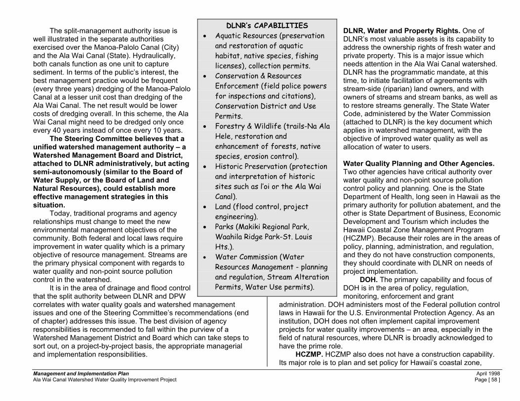
Management and Implementation Plan April 1998 Ala Wai Canal Watershed Water Quality Improvement Project Page [ 58 ]
The split-management authority issue is well illustrated in the separate authorities exercised over the Manoa-Palolo Canal (City) and the Ala Wai Canal (State). Hydraulically, both canals function as one unit to capture sediment. In terms of the public’s interest, the best management practice would be frequent (every three years) dredging of the Manoa-Palolo Canal at a lesser unit cost than dredging of the Ala Wai Canal. The net result would be lower costs of dredging overall. In this scheme, the Ala Wai Canal might need to be dredged only once every 40 years instead of once every 10 years. The Steering Committee believes that a unified watershed management authority – a Watershed Management Board and District, attached to DLNR administratively, but acting semi-autonomously (similar to the Board of Water Supply, or the Board of Land and Natural Resources), could establish more effective management strategies in this situation. Today, traditional programs and agency relationships must change to meet the new environmental management objectives of the community. Both federal and local laws require improvement in water quality which is a primary objective of resource management. Streams are the primary physical component with regards to water quality and non-point source pollution control in the watershed. It is in the area of drainage and flood control that the split authority between DLNR and DPW correlates with water quality goals and watershed management issues and one of the Steering Committee’s recommendations (end of chapter) addresses this issue. The best division of agency responsibilities is recommended to fall within the purview of a Watershed Management District and Board which can take steps to sort out, on a project-by-project basis, the appropriate managerial and implementation responsibilities.
DLNR, Water and Property Rights. One of DLNR’s most valuable assets is its capability to address the ownership rights of fresh water and private property. This is a major issue which needs attention in the Ala Wai Canal watershed. DLNR has the programmatic mandate, at this time, to initiate facilitation of agreements with stream-side (riparian) land owners, and with owners of streams and stream banks, as well as to restore streams generally. The State Water Code, administered by the Water Commission (attached to DLNR) is the key document which applies in watershed management, with the objective of improved water quality as well as allocation of water to users. Water Quality Planning and Other Agencies. Two other agencies have critical authority over water quality and non-point source pollution control policy and planning. One is the State Department of Health, long seen in Hawaii as the primary authority for pollution abatement, and the other is State Department of Business, Economic Development and Tourism which includes the Hawaii Coastal Zone Management Program (HCZMP). Because their roles are in the areas of policy, planning, administration, and regulation, and they do not have construction components, they should coordinate with DLNR on needs of project implementation. DOH. The primary capability and focus of DOH is in the area of policy, regulation, monitoring, enforcement and grant
administration. DOH administers most of the Federal pollution control laws in Hawaii for the U.S. Environmental Protection Agency. As an institution, DOH does not often implement capital improvement projects for water quality improvements – an area, especially in the field of natural resources, where DLNR is broadly acknowledged to have the prime role. HCZMP. HCZMP also does not have a construction capability. Its major role is to plan and set policy for Hawaii’s coastal zone,
DLNR’s CAPABILITIES • Aquatic Resources (preservation
and restoration of aquatic habitat, native species, fishing licenses), collection permits.
• Conservation & Resources Enforcement (field police powers for inspections and citations), Conservation District and Use Permits.
• Forestry & Wildlife (trails-Na Ala Hele, restoration and enhancement of forests, native species, erosion control).
• Historic Preservation (protection and interpretation of historic sites such as l’oi or the Ala Wai Canal).
• Land (flood control, project engineering).
• Parks (Makiki Regional Park, Waahila Ridge Park-St. Louis Hts.).
• Water Commission (Water Resources Management - planning and regulation, Stream Alteration Permits, Water Use permits).

Management and Implementation Plan April 1998 Ala Wai Canal Watershed Water Quality Improvement Project Page [ 59 ]
although it does have responsibility for the Section 6217 (federal Coastal Zone Management Act Amendments). Section 6217 programs are analogous to the DOH federal Clean Water Act (Section 319(h), CWA) programs for water pollution control. Section 6217 is potentially a powerful management tool for reducing non-point source pollution because it fills gaps in the CWA program coverage. These two State Agencies, with their policy-making, planning and regulatory tools for non-point source pollution, make ideal allies with DLNR which could well serve as the construction designer and management agent for watershed water quality improvement projects. Monitoring. At the beginning of the Consent Decree Project, in March 1996, the Coordinator called a meeting of key agency officials who have the authority and responsibility for water quality monitoring in the watershed. These are the State Department of Health and the City Department of Public Works. The first conclusion the group reached was that some remedial implementation actions could be taken in the absence of specific monitoring. For example, accurate data do not exist for soil erosion rates, or for sediment transport in the watershed. No one really knows the differences between sediment yields from the Conservation District versus the Urban District. Studies have been done in other geographic areas, but the Ala Wai Canal watershed is data-short. However, there was consensus that remedial measures to reduce erosion could and should be taken as soon and as much as possible. A similar consensus was reached regarding litter and debris reduction. Streamside dumping was identified as a nagging problem which needed to be addressed. In the summer of 1997, the City Department of Transportation Services released data showing that Ala Wai Canal sediments contained high levels of contaminants which likely originated from vehicles. This “new” problem has taken priority over some other water quality issues because of the high costs of dredging and of land disposal, if required. No monitoring of contaminant yields from vehicles has been done in the watershed. Such work is probably worth doing, and should be coupled with testing of remedial actions. (See Chapters 3 and 4 and Appendix A for a description of projects.) Compliance. During preparations for volunteer clean-ups of Pukele and Waiomao Stream, and for restoration of lo�i on State-owned
land (Department of Education, Anuenue School) apparent illegal dumping of rubbish and concrete rubble on streambanks and into streams, and of construction of retaining walls in stream rights-of-way, was observed. As a result, the Consent Decree Coordinator called together (on two occasions) multi-agency groups of officials to inspect the problem areas.
The conclusion was that although small violations are both expensive and difficult to enforce, the end result is filling in of stream channels and illegal dumping. More interagency discussion is needed to develop compliance strategies for discouraging the observed activities. It may be that more intensive involvement by community groups can help improve this situation
Summary of Non-point Source Planning, Grant-making and Water Quality Improvements. The single major source of government funding for remediation of “non-point” sources of watershed-based water quality problems, at present, is through the Section 319(h) (Clean Water Act) program of the U.S. Environmental Protection Agency. The Congress, often through provisions of the Clean Water Act, but also via omnibus legislation to reduce pollution across the nation, tends to direct such funding through the U.S. EPA, to the states to implement remedial measures. In Hawaii, the EPA, which implements pollution control through the State Department of Health, negotiates workplans with DOH then administers the funds per the workplan agreement.30 This process has been underway with direct funding since 1991, but planning to reduce non-point source pollution actually began in the early 1970’s, after passage of the Clean Water Act. At that time, teams of federal, State and County agencies, environmental groups, land owners and interested citizens engaged in two major planning efforts. These were: 1) The Hawaii Water Resources Regional Plan; 2) The Section 208 (of the Clean Water Act) non-point source
pollution control plans.
30 DOH administers EPA’s Federal pollution control requirements in Hawaii. In the case of non-point source control, the authority is in the Federal CWA, Section 319(h), under which funds are made available by EPA to DOH as a negotiated grant.

Management and Implementation Plan April 1998 Ala Wai Canal Watershed Water Quality Improvement Project Page [ 60 ]
At that time, soil erosion and runoff from vast tracts of pineapple and sugarcane fields were viewed as the major coastal and stream water quality problems. Today, with few large-scale agriculture operations in existence in Hawaii, and with extensive pollution control measures in place in those remaining operations, attention has turned to a more difficult problem to address, stormwater runoff and non-point source pollution from urban areas. The problem is especially critical in two locations on Oahu, Pearl Harbor and Mamala Bay (the Ala Wai Canal, and other streams through metropolitan Honolulu discharge into Mamala Bay). Mamala Bay was the subject of a $9.0 million investigation which begin with allegations that the two major sewage outfalls (into the ocean at Honouliuli and Sand Island) were the cause of major water quality problems. The Mamala Bay study found little evidence to support this contention, but did note that non-point source pollution problems had some adverse impacts on coastal waters. As non-point source pollution abatement knowledge and policy evolved in Hawaii, the major focus shifted from the private land owner as being the key remediator (because of the operation of
sugarcane and pineapple cultivation) to a vast multitude of urbanites in the metropolitan areas. In the present situation, there is no easily identifiable entity who can be charged with a clean-up. Daily, tens of thousands of vehicles, individuals, property owners, employees, commuters, shoppers and visitors have impacts causing non-point source pollution in the Ala Wai Canal watershed. How are they to be asked to pay for water quality improvements? This shift in emphasis from large landowner to individuals or classes of individuals is at the root of the problem of identifying sources of funding for water quality remediation. Agencies have a major responsibility now, perhaps even more than in the past during the days of plantation agriculture, because many of the sources of water
pollution in the Ala Wai Canal originate on government owned property, or are already regulated by government. For example, all roads are owned and regulated by government agencies, as is the storm water runoff from roads which reaches the Ala Wai Canal via streams and drains. Moreover, vehicles and their components are federally regulated – no individual has control over the amount of lead or copper in brakepads.
Figure 41. Retaining Wall. One of Several Retaining Walls in Pukele Stream, Adjacent to State Property (Anuenue School). Walls like this force higher stream flow levels and velocities which cause erosion of the banks on the opposite side of the stream. In this case, public historic properties (taro terraces - lo�I) are endangered. Part of the problem is that stream ownership is split down the middle between property owners on either bank. In this case, government owns one half the stream. Where private property is owned on both sides of the stream, government has no property rights. Agencies need to develop policies to guide compliance because in such cases streams are not kept clean, nor will government maintain the privately held areas.

Management and Implementation Plan April 1998 Ala Wai Canal Watershed Water Quality Improvement Project Page [ 61 ]
Most soil erosion and sedimentation occurs on government lands (the Conservation District), or in streams (government regulated). The major water pollutants which originate on private property appear to be dieldrin and chlordane, two termiticides which were applied to both ground and wood structures prior to 1988 when the U.S. EPA banned the use of these two compounds. Finally, the only major source of water pollution in which the public still has a major role is litter, trash and debris. Yet even here, government and the private sector have not enacted legislation such as bottle deposits for return to a recycling center. The value of small incentives should not be understated. For example, the scrap price of aluminum cans ($0.20 to $0.30 per pound) hardly seems worth the effort, yet our landscape is almost “can-free” because the tireless aluminum can pickers are constantly busy. What if they were similarly as busy picking up plastics, or batteries? The point here is that government must take a pro-active approach to bring about remedies in water quality problems. This is necessary because of the great number of people and the diversity of land uses involved. This watershed is a complex, and large system of drainage networks, land uses and pollutant sources; government must take a fresh approach to implementation. The residents and community can help do this work, and should be called upon to provide their authorization for government to act, and provide their wisdom in terms of the priorities of action. A good way to initiate this process is to broaden the public review of the community grant-making process for environmental management projects.
The steps should include: public notice of the availability of grants for community projects and of the criteria for award. The process should include public workshops and meetings to explain the application procedures and award criteria; public involvement in establishing priorities for projects (this is one of the most difficult assignments because of the competition for funds), and public participation in selecting projects for grant awards. The process proposed is similar to that followed by the federal Department of Housing and Urban Development working with the City’s Department of Housing. Implementation of a more broadly-based public review of the community grant-making process would be a very positive step forward towards working with community groups and in gaining their respect and cooperation.
Similarly, the DOH should be encouraged to use the State DLNR (and possibly the City DPW) as its “implementation agent” or construction agent, for watershed remediation projects. This would seem to be the best solution to the need for adding government implementation capability to the non-point source agency arena. Under this approach, DOH would be spared the need to add construction-capable staff and administrative skills, and agencies which are already structured in the appropriate way could be put to work. It would seem this approach could be accomplished at the lowest level, without new laws, by a coordinated effort between EPA, DOH, DLNR, DPW and citizen groups. The present is the perfect time to begin this process because of the availability of federal funds ear-marked for implementation of water quality improvement projects in the Ala Wai Canal ($650,000 to date, with the possibility of more, if adequate projects can be identified and proposed), and with the start-up of the EPA/DOH Ala Wai Project. How can improved coordination be accomplished? A recent example of cooperative outreach within government can serve as example – school janitors, suffering continued budget cuts, and faced with a set of sometimes unpredictable or unknown maintenance problems on a daily basis, voluntarily set-up a cooperative E-mail network on the Internet to keep in touch and to provide advice to each other. This is a fine model of the type of cooperation sought in watershed management and implementation. Recommendations: 1. Establish a citizen-based panel to work with agencies to identify a
compliance strategy for small but cumulative problems such as in-stream dumping and retaining wall construction. This task should be completed within six months of the start of the process. The way to begin is to take on the two most seriously affected areas, upper Palolo Valley, above the City State flood control project on both Waiomao and Pukele Streams, and also Manoa Stream, including the Manoa-Palolo Canal. There are established citizens groups and active neighborhood boards in these areas. There is also much government-owned land on Manoa Stream,

Management and Implementation Plan April 1998 Ala Wai Canal Watershed Water Quality Improvement Project Page [ 62 ]
and several government-owned parcels on both Waiomao and Pukele Streams.
2. Establish a citizen panel to review community grants for
environmental management projects in the watershed. The panel should be made up of active groups in the Ala Wai Canal watershed (and any other groups interested as well). Meetings should be scheduled by advertisement, criteria established with public input, and awards announced publicly. Priorities for community project grants should not be made without broad-based public participation in establishing criteria. Examples to date include the present project and the Ala Wai EPA project, which also works thorugh an advisory committee.
3. Pass legislation requiring deposit-return or advance-deposit of
any plastic or glass bottles and fast food packaging. 4. Continue to update and revise water quality monitoring protocols.
Use biological indicators such as periodic counts of native species (if counts increase, water quality may be improving; introduced species are a factor in this). Additional monitoring of sediment may be needed if necessary to prove that the Conservation District is a major sediment source, although this work should not be necessary to justify extensive forestry and forest replantings, stream restoration and erosion control. More attention is needed on storm drain constituents originating from vehicles, and monitoring may be needed to justify remedial measures based on new stormwater cleaning technologies.
5. Enable DLNR with more authority, funds and personnel to extend
watershed management into the urban streams, to negotiate property rights exchanges with private land owners regarding streams, and to construct in-stream projects to meet the objectives of watershed management and improved water quality.
6. Assist DLNR and DPW to reach agreement on mutual
responsibility for stream cleaning, maintenance, flood control and stream quality management. These tasks must be accomplished in light of reduced budgets and jurisdictional disagreements. This task can be accomplished through establishing a citizen’s committee, or by creation of a watershed district.
7. DPW should update drainage plans and regulations to include
watershed management practices, especially for the Urban District. The drainage plan should include objectives for water quality improvement, non-point source pollution reduction, and typical design features for best management practices. These revisions would aid in achieving the clean water objectives.
8. The preferred alternative is to establish a Watershed District and
Board to assist in the implementation of the above recommendations. However, implementation of the above recommendations can begin now. Establishment of a watershed board and district will facilitate the implementation of the above recommendations, but there is no need to wait until a watershed management board is established. Agencies and the community should begin the process now because many remedial actions have been clearly identified. See Chapter 8 for more discussion about the concept of the Watershed Management Board and District.

Management and Implementation Plan April 1998 Ala Wai Canal Watershed Water Quality Improvement Project Page [ 63 ]
TABLE 8. SUMMARY OF WATERSHED REGULATORY, ENFORCEMENT & IMPLEMENTATION CAPABILITIES CON = Construction POL = Policy REG = Regulatory
Type of Responsibility and Authority Agency CON POL REG
Clean Water Act Primary federal water pollution control act, as applied to non-point sources. Provides funds for pollution abatement and project implementation.
U.S. Environmental Protection Agency (EPA). One technical staff. Mostly staffed from Headquarters in San Francisco. Day to day authority delegated to State Department of Health, but EPA retains oversight.
No Yes Yes
Clean Water Act, Rivers and Harbors Acts. Regulates and enforces dredge and fill (dumping) and discharges of contaminated sediments to the nation’s waters, and to wetlands. May construct flood control projects.
U.S. Army Corps of Engineers. (ACE). Staffed locally with authority to inspect and enforce. May construct projects under if specifically authorized and funded by Congress. Generally limited to flood control projects in the watershed.
Yes Yes Yes
Watershed Protection and Flood Prevention Act. Soil and Water Conservation Districts, Resource, Conservation and Development Projects. Plans, designs and constructs multi-objective watershed protection and flood prevention projects.
U.S. Natural Resources Conservation Service. Staffed locally. Regulates grading in Soil Conservation Districts on behalf of the City and County. May construct watershed projects if specifically authorized and funded by Congress.
Yes No Yes
State laws against dumping, littering of debris, contaminants and hazardous materials.
State Department of Health (DOH). Functions as a permitting, regulatory, policy-making and funds granting agency. Not a construction agency. Staffed mainly to inspect and enforce.
No Yes Yes
Coastal Zone Management Act (specifically Sec. 6217) State Department of Business and Economic Development & Tourism (DBEDT). Administers the Hawaii Coastal Zone Management Program. Section 6217 includes significant non-point source pollution abatement controls, planning and policy.
No Yes Yes
Conservation District management, Conservation District Use Permits, aquatic resources, management of State land, forestry management, flood control, water supply management, conservation and field enforcement, fishing and hunting licenses, trails, Stream Alteration Permits, Water Use Permits. Can plan, design and construct projects. Responsible to oversee federal Emergency Management Agency programs, including flood hazard maps.
State Department of Land and Natural Resources (DLNR) • Aquatic Resources (preservation and restoration of aquatic habitat,
native species, fishing licenses) • Conservation & Resources Enforcement (field police powers for
inspections and citations) • Forestry & Wildlife (trails-Na Ala Hele, restoration and enhancement of
forests, native species, erosion control) • Historic Preservation (protection and interpretation of historic sites such
as l’oi or the Ala Wai Canal) • Land (flood control, project engineering,) • Parks (Waahila Ridge Park-St. Louis Hts.) • Water Commission (Water Resources Management - planning and
regulation). (Stream Alteration Permits)
Yes Yes Yes
State Highway and Road construction and maintenance. Works with federal Highways Administration to build using federal funds. Develops projects for ISTEA (federal Intermodal Surface Transportation Act) funding. Involved with Ala Wai Canal because of management of high-volume roadways and ISTEA funds may be used for Canal clean-up if pollution comes from vehicles.
State Department of Transportation, Highways Division (DOT-H). Staffed to build projects.
Yes No No
Regulates and enforces grading, filling or dumping. Manages storm drains, roads, cleans public-owned urban streams to reduce flood risk. Constructs projects.
City and County of Honolulu, Department of Public Works. Staffed to enforce and to build projects. Yes Yes Yes
Regulates construction of structures to conform to building code. Structures include retaining walls built in streams.
City and County of Honolulu, Department of Buildings. Staffed to enforce. No No Yes
Regulates construction to conform to Land Use Ordinance, including structures in streams or floodways.
City and County of Honolulu, Department of Land Utilization. Staffed to review and enforce. No Yes Yes

Management and Implementation Plan April 1998 Ala Wai Canal Watershed Water Quality Improvement Project Page [ 64 ]
Honolulu is a city of public-spirited residents who know how to pull together when necessary – a characteristic of Pacific Island communities generally because they are often faced with calamitous events (hurricanes, tsunami, and war are good examples). Because there are no adjacent neighbors to help, island communities become self-reliant. Such behavior is also a part of the concept of aloha. Watershed clean-ups are no exception to this cultural and social behavior. The Honolulu community regularly, and for years, has engaged in street and road clean-up, storm drain stenciling, litter pick-up, and graffiti “busting”. Our community continuously responds to the endless calls for volunteers to kokua - to come and help out.
Volunteerism, unfortunately, will not significantly improve the water quality of the Ala Wai Canal or its tributary streams. Government, including agencies and elected officials will have to work with the community in a cooperative way if the work is to be accomplished. Volunteers can help to identify problems and encourage government to be more responsive in finding solutions. For example, the Ala Wai Watershed Community Network (AWWCN) has started a Report-Card Committee which is meeting regularly to
7. Public and Private Actions – Role of the Public and of Private Interests to Improve Water Quality
Figure 42. Friends of Palolo Stream During a Clean-up of Pukele Stream, a Major Tributary. Volunteers removed choking vegetation from this channel, a job better done by trained workers with heavy equipment.
Figure 43. “Friends of Palolo Stream” at the Consent Decree Project Booth, 1996 Palolo Pride Community Festival. 200 "Friends" cleaned-up Pukele and Waiomao Streams, Tributaries of Palolo Stream in 1997.

Management and Implementation Plan April 1998 Ala Wai Canal Watershed Water Quality Improvement Project Page [ 65 ]
Figure 45. Pukele Stream Flood Control Channel Adjacent to Palolo Valley Homes. Stream clean-ups in flood control channels should be done by trained personnel, fully OSHA equipped and working with heavy equipment. Volunteers should be guided to appropriate work sites suited to their physical capabilities and experience.
PALOLO STREAM FLOOD CONTROL PROJECT: EXAMPLE OF NOT WORKING TOGETHER
The Palolo Stream Channel is a government flood control project. It begins in central Palolo Valley and continues to the junction with Manoa Stream. DPW cleans the main Palolo Channel and the Waiomao Stream branch. HHA is responsible for the Pukele Stream branch of the project. Maintenance of this project seems to be uncoordinated because it requires duplication of equipment and labor. This is a typical City-State jurisdictional problem which signifys the need for a Watershed District and Board – to oversee the various agencies and to effect cost-savings and efficiency in the public interest.
identify legislation, projects and areas where government action is needed to achieve water quality improvements. Friends of Palolo Stream, A Typical Community Group in Honolulu. Volunteers need sustenance and nurturing. They respond best in a somewhat structured framework where they can see that their volunteer work has lasting effect. For example, over 200 people came to help with the major Palolo Stream clean-up. They were not content to just chop out weeds from the over-grown concrete-lined flood control channel through Palolo Valley Homes. As a manual labor project, the work was overwhelming, and it was clearly a project that required heavy equipment. Before the cleaning project, members of the community met with City, State and Federal authorities in an effort to achieve the long overdue maintenance cleaning of the channel.
HHA (State of Hawaii Housing Authority) eventually
Figure 44. Large Stump Blocking Waiomao Stream (April 12, 1997). In 1996, City crews cleaned the channel (right side of photo) up to the debris barrier (posts), but did not remove the stump (left side of photo). It appeared to have been there a long time and has trapped sediment and debris. This channel-blockage may cause accelerated stream flows and erosion of the opposite stream bank. See next Figure also.

Management and Implementation Plan April 1998 Ala Wai Canal Watershed Water Quality Improvement Project Page [ 66 ]
responded and the channel was cleaned in August 1997. It is a job which should be done annually and may not have been done for 5 to 10 years. Yet the City Department of Public Works manages to clean the remaining segments of the same flood control channel every year. The problem is that the two agencies are not working together.
During the clean-up, the group saw that a large tree stump was lodged just upstream of the debris barrier at the entrance to Waiomao Stream flood control channel. The stump was nearly 1/3 of the channel width and impossible to move by hand. Its presence could cause over-banking of high stream flows and defeat the purpose of the channel. Nature eventually moved the stump over the debris barrier, but in its new position it is more likely to be washed
down into the Ala Wai Canal. DPW crews removed the stump on 12.22.97. The group started the clean-up, not as an end in itself, but for the purposes of restoring and growing taro. They want to have a community garden, and have trails along the stream and into the watershed. Moreover, the lo’i restoration project is on State-owned land (DOE), site of Anuenue School – Oahu’s Hawaiian Immersion school. Anuenue School will use the lo’i as part of their curriculum. During the stream walks, evaluations, history searches, inspections and cleaning work, several serious encroachments in the stream channel were observed. The encroachments appeared in the form of apparent illegal dumping or filling of streams (Pukele and Waiomao), and of construction of retaining walls in the Pukele Stream floodway. As a result of these observations, we called together on two occasions multi-agency groups of officials to inspect the problem areas. These problems are an issue remaining to be resolved through coordinated sessions with the agencies involved. (See the Chapter 6 for more discussion on this point.) The same group of volunteers has adopted portions of Palolo Stream, including Pukele and Waiomao tributaries and in so doing has agreed to periodically carry out a stream cleaning. Through a small grant from the Steering Committee of the Consent Decree Project, they have purchased a computer and set up an office to better coordinate an work with their community on watershed projects. There are other groups of volunteers in the watershed, Friends of Palolo Stream is presented here as only one of several. Each has its own story. During the stream clean-up project, the group learned that land which some members are using as a community garden, and upon which debris from Waiomao Stream was placed during the clean-up is actually property of the Deaprtment of Parks and Recreation, City and County of Honolulu. This parcel is adjacent to Palolo Valley Homes, and Waiomao Stream. The group is working with HHA and DPR to resolve a major problem – a chain link fence which blocks public access to the land, and which had to a be torn down by the City’s DPW crews who came to clean up the rubbish from the stream clean-up, a City-authorized Adopt-a-Stream project. Access is necessary to this site if stream clean-ups are to continue because there is no other access to this segment of Waiomao Stream. Also,
Figure 46. Stump Has Moved. In the previous Figure, the stump was on the other side, the upstream side, of the debris barrier. In this photo, the stump is on the down stream side. The stump was moved by high stream flows which occurred on October 11, 1997 and floated the stump up and over the debris barrier. DPW has been notified about this situation.

Management and Implementation Plan April 1998 Ala Wai Canal Watershed Water Quality Improvement Project Page [ 67 ]
this community has a significant need for gardening areas, and the City-owned parcel is ideal, and used. Moreover, it is “land-locked” with no other apparent avenue of public access. The City, HHA and Friends of Palolo Stream are sorting out this problem to the benefit of all concerned and the City DPR has written to HHA with an offer to turn over the site to HHA’s jurisdiction (see DPR letter in Appendix B, Volume I, this Plan). A win-win situation seems possible here, but once again, multi-jurisdictional differences seem to be the obstacle to a relatively simple problem. Moreover, the objective of watershed stewardship is to place responsibility in the hands of the community. This situation appears to provide that opportunity. Manoa Stream Property Owners. Another type of group, not volunteers, but people with co-interests in property are faced with bank erosion of Manoa Stream. Past erosion control measures have failed and structures are now threatened by erosion of the streambank. Their plan, designed with the aid of a civil engineering firm, is to install gabions in the eroding stream bank. We wrote to authorities in support of this technique of bank protection, and it is one recommended in other situations for it is a somewhat environmentally friendly method of controlling streambank erosion in situations where stream flow velocities are greater than 6 or 7 feet per second, and less that 20 or so fps. Gabions are wiremesh baskets which are installed by chopping out a step in the streambank. The basket is then filled with rock. Baskets can be placed end to end, and on top of each other to protect a longer length of bank, or a higher bank. The baskets are wired together for stability. The advantage of gabions is that vegetation can grow over and around them, unlike concrete, and ground water can flow into the stream assisting both drainage of the adjacent property and also contributing to streamflow. Streamside Private Property Owners. The areas least managed, and with the greatest problems in terms of littering, dumping, and erosion are generally those owned privately. In Hawaii, property boundaries go to the middle of the stream. Streams themselves are not owned by the government. The worst problems are in Palolo Valley, on Pukele and Waiomao Streams, upstream of the City-State flood control channel, and all the way up into the Conservation District. However, many problems also exist in Manoa Stream, especially sections not part of government flood control structures.
Federal, State and County agencies have the authority, but rarely enact sanctions against the “little person”, the single family home owner. Perhaps overlapping jurisdictions, agency priorities or other stumbling blocks create the problem, or it may be because the agencies are understaffed, under-funded and prioritize their resources for larger problems. During the agency inspections of Pukele and Waiomao Streams in Palolo Valley, it became apparent that the agencies did not have the capability to identify the problem areas by location, address or tax-map-key. They did not have global positioning systems to use in the field, and were not properly equipped. For example, one staffer who requested rubber boots to wade in the streams was advised by a supervisor to not enter the stream (the only avenue of inspection) because the agency‘s worker’s compensation insurance would not apply.
Figure 47. Failed Attempt at Stream Bank Erosion Control by Residents at Manoa Stream. Concrete foundation pile remnants about 16 inches in diameter and several feet long were used here as a retaining wall. They now appear to be in the floodway. This is the site of the proposed gabion retaining structures.

Management and Implementation Plan April 1998 Ala Wai Canal Watershed Water Quality Improvement Project Page [ 68 ]
At present, neither the City nor the State will clean streams or perform erosion protection measures on private property. In part because of the issue of liability, the agencies are reluctant to engage in actions where property owners may begin to expect more and more in the future, or may blame the agency for some future failure such as continued stream bank erosion. Private property owners also may incur potential liability for cost recovery for water pollution caused by eroding stream banks, illegal dumping, and illegal in-stream construction. There may be a win-win situation. The ideal outcome would seem to be public ownership of streams. This may be the time to begin discussions concerning a trade in property rights -- from private to public, whereby private owners give up certain rights and responsibilities of maintenance in exchange for the public assuming the responsibility of maintenance. Now is the time to begin the exploration of this topic. Recommendations: 1. Encourage volunteers to participate in watershed management,
but protect them from injury or illness. Provide small amounts of funding for community groups willing to adopt streams and actively pursue watershed stewardship.
2. Review the Adopt-a-Stream program and manage it more
intensively so that stream-cleaning projects are best suited for the physical abilities of volunteers. At the moment, the only restriction is that children under 12 should not be working in the streams. This restriction should be expanded to exclude areas where heavy equipment is required –such as flood control channels. Also, Adopt-a-Stream proponents need to have a more “hands-on” approach so that problems with access, and other logistics are handled expeditiously.
3. Initiate a process to transfer certain property rights related to
streams from private to public ownership. These rights could
permit continual use of water by the owners, if they have appurtenant water rights, and they would continue to have the riparian rights they now enjoy. They would no longer have the liability of maintenance or potential damages, and the public would be able to better manage streams for water quality, drainage and environmental purposes.

Management and Implementation Plan April 1998 Ala Wai Canal Watershed Water Quality Improvement Project Page [ 69 ]
This Chapter summarizes the issues of management of the Ala Wai Canal Watershed to achieve improved water quality. Why is management a regional, rather than a local issue? 1) Groundwater from the Ala Wai Canal Watershed supplies
potable water for consumers who live in the southeast Oahu service area including communities inside and outside the watershed boundaries and visitors. These customers of the Board of Water Supply have an interest in maintaining good water quality and rightfully have a voice in maintenance of good surface and groundwater quality.
2) Most persons on Oahu, and many visitors from the neighbor
Islands or other places, commute to or visit destinations (Waikiki, Ala Moana Shopping Center, University of Hawaii, Kapiolani Community College, public and private elementary and secondary schools and colleges) in the watershed. They all contribute to the pollutant load on roads and at the destination facilities.
3) For the State, Waikiki and the Ala Moana Shopping Center
generate 70 to 80 percent of the income from tourism, and this value may increase because of the new convention center. It is of concern to the State that Waikiki and its related environment be attractive, clean and safe. The connection between these needs, and the condition of the overall Ala Wai Canal watershed has not always been part of the understanding and policy of the broader statewide community.
Is it not true that the watershed is already governed by an existing network of laws, rules and government agencies? If so, what is the problem?
Federal, State and County laws and rules apply to clean water and management practices affecting clean water. Federal, state and county agencies are responsible for enforcement of these laws and rules. One problem which has emerged is that there are so many enforcement bodies and laws, that distinct, precise and efficient enforcement, and implementation of remedial actions, does not always result. Agencies are: • Federal - Corps of Engineers, Environmental Protection Agency,
Department of Agriculture, Department of the Interior, Department of Transportation, Department of Commerce—National Oceanic and Atmospheric Administration—Office of Coastal Zone Management, Coast Guard;
• State - Commission on Water Resources Management, Department of Land and Natural Resources, Department of Transportation, Department of Education, Department of Health, Hawaii Housing Authority, University of Hawaii;
• County - Board of Water Supply, Department of Public Works, Department of Parks and Recreation, Department of Transportation Services, Department of Wastewater Management.
Political Boundaries are: • 7 Neighborhood Boards (5, through 11) • 2 City Council Districts (IV, V) • 7 State Representative Districts, (17 through 26) • 5 State Senate Districts (9 through 13) • 1 U.S. Congressional District • 2 U.S. Senate Districts These officials and boards act to approve plans and funding for projects, but their attention tends to focus within the boundaries of their respective jurisdictions, and not on the functioning of the Ala Wai Canal as a single system which cuts across many of the jurisdictional boundaries
8. Management for Improved Water Quality -- The Ala Wai Canal Watershed is a Regional Issue

Management and Implementation Plan April 1998 Ala Wai Canal Watershed Water Quality Improvement Project Page [ 70 ]
Does the watershed need some changes in management? If so, why? The multiplicity of laws, rules, agencies and political jurisdictions hamper rather than facilitate efficient management to obtain improved water quality. Problems are a product of the evolution of laws, agencies and issues, the growth of population and the increasing complexity of managing our environment to obtain a desirable outcome. For example, the drainage system in the watershed has evolved from a set of primitive ditches in a rural area to a system serving a dense major metropolitan community, but the infrastructure has not kept up with population growth and its capacity is inadequate. What form of management is needed, if any? Alternative forms include: A. Watershed Management Board and District similar in structure to
the Board of Water Supply; B. Formation of a Citizen-based group, which would serve as a
planning and implementation body, a watch-dog group and an advocate for improved practices.
Who can best manage the watershed, if some changes are necessary? Because of the complexity of the technical issues, special technical knowledge and capabilities are required to guide the planning, to design, and to maintain the infrastructure systems which are involved, and which need to be rehabilitated. However, technical experts are not necessarily the best managers, the technical group needs to be guided by a Board of Directors of varied interests who will provide oversight to assure that adequate funds are provided, properly expended, and appropriate plans and goals are achieved. To accomplish this, a formal Board should be established with appropriate authority. The Board should be administratively attached to the Department of Land and Natural Resources (preferred alternative) because that agency has the most comprehensive set of programs and staff capabilities with regard to watershed management. Does management cost money? If so, where would funding come from? At present the U.S. Congress has appropriated $650,000 for use by the Federal Environmental Protection Agency (EPA) to implement improved water quality projects in the Ala Wai
Canal Watershed. The Congress is likely to add $500,000 to this appropriation (and possibly more)31. EPA has other water pollution remediation grants that fund State programs, although little if any has been expended on storm water runoff remediation. Also, a large amount of money presently is expended by County and State agencies, for example, maintenance of the storm drainage system and the proposed maintenance dredging of the Ala Wai Canal. These latter funds form a nucleus of a strong budget. Additional funds may be required; there are a variety of potential sources, including user fees, taxes and additional federal sources. See Chapter 9, Costs of Watershed Management, for more details. What alternatives are there for funding? 1) One funding alternative is found in a recommendation of The
Hawaii Tropical Forest Recovery Task Force (DLNR, 1994) which suggested that watershed improvement programs would be funded by a small tax on water used from the watershed. According to the Task Force, this would be done via an addition to the water bill sent out by the Board of Water Supply. However, while this may be an appropriate source of funds, the �user-group� of this watershed is actually much larger than the group who uses only potable water.
2) A second alternative funding mechanism similar to a tax on water
might be a tax on drainage. This tax could be applied to property owners in the watershed. Each property owner could be assessed a small, fee based on the area of the property which is not permeable. Many jurisdictions (San Francisco Bay Area, for example) in other parts of the U.S. have a tax like this and its basis is similar to the tax on sewage discharges.
3) A third alternative is to implement fees which could include a
small charge added to every vehicle registered on Oahu, since most are likely to travel in the watershed or a small fee could be levied on each gasoline purchaser from stations located in the watershed.
31 As of October 8, 1997, a Congressional conference committee approved $500,000 for the Ala Wai Canal watershed improvement project.
Management and Implementation Plan April 1998 Ala Wai Canal Watershed Water Quality Improvement Project Page [ 71 ]
4) A fourth alternative lies in the fact that the beneficiaries of this
watershed are probably in the majority statewide. This implies that funding for management should largely be from State sources. Indeed, it has been the legislature which has funded maintenance dredging of the Canal.
5) A fifth alternative is federal funding. There are a variety of federal
sources from which at least some funds may be sought -- the Inter-modal Surface Transportation Enhancement Act (ISTEA) through the Department of Transportation is one such source and the EPA has some applicable programs. Some federal agencies can provide technical assistance. There is always the recourse to special legislation. For example, the Ala Wai Canal is on the list of the nation�s historic sites. It is inextricably linked to Waikiki, a place famous worldwide and important nationally for many reasons. Pollution of the Canal is directly caused by pesticides (chlordane and dieldrin) once approved but now banned by the federal government, and by pollutants originating largely from vehicles (lead, copper, cadmium, and zinc) and asphalt (chromium). It would seem that the federal government has an obligation to assist in cleaning up and managing this watershed, subject to local control of course.
6) A sixth alternative is to continue business as usual with no
changes in process or procedures. Discussion. Alternative 6 (business as usual) is unsatisfactory. The projected costs of maintaining the Ala Wai Canal, and improving environmental quality, are not normal budget items. If the objectives, for example enhance the quality of the Waikiki environment via State and County plans, and complement the federal Clean Water Act (waters to be both fishable and swimmable) are to be met, it appears likely that a variety of projects will be required. Federal funding should be aggressively sought for several reasons. • ISTEA funds are very appropriate for construction of bikepaths
along streams; these paths are major components of streambank erosion control. ISTEA funds can also be used for clean-up of water pollution caused vehicle pollutants. However, the ISTEA
design requirements for bikepaths (wide right-of-way, perhaps 10-feet and paving) may make this program inappropriate for some more sensitive environmental settings.
• Perhaps monitoring or removal of dieldrin and chlordane -- both
cancer-causing and toxic compounds once approved for use by the federal government – can be federally funded. While it may take time to obtain these funds, they could retroactively be applied to dredging costs. While the Canal sediments are not highly toxic, a stronger federal presence for remediation funding may be appropriate.
• The existing expenditures by State and County agencies may be
more effectively applied if managed under auspices of a Watershed Board and District.
• Not all beneficiaries of the watershed are aware of the costs and
benefits of maintaining the watershed. This is especially apparent in the legislature, and among major Waikiki interests.
Recommendations: 1. Assertively seek federal funds from the full range of potential
sources. The ideal outcome would be for the restoration of the Ala Wai Canal Watershed.

Management and Implementation Plan April 1998 Ala Wai Canal Watershed Water Quality Improvement Project Page [ 72 ]
2. Plan the full scope of required watershed improvements to enable estimates to be made of the total long-term cost of improvements. This task will require preparation of a detailed master plan, including retrofitting and rehabilitating the metropolitan drainage system to facilitate water quality improvements, and to enhance environmental values. The National Resource Conservation Service (U.S. Department of Agriculture) could be offered this assignment. They are experts and are engaged in comprehensive watershed planning in various areas across the country. Their staff have the latest ideas and techniques which are needed in a retrofit urban situation. A plan of this type could cost $1.0 to $2.0 million, and the planning horizon should be for many decades. Products would include detailed plans, engineering, designs, an environmental impact statement, construction specifications and construction management.
3. Consider introducing small fees or additions, earmarked for
watershed management, to water bills, to gasoline taxes, vehicle registrations, property taxes or the transient accommodations tax. One or more of these taxes would be one component of the funding required.
4. Establish a Watershed Board and District. Drainage in this
watershed is an archaic network of antiquated facilities, which have inadequate storm water flow capacity. The problem is made worse because of the high costs of maintaining the system due to the flow of contaminants into the Ala Wai Canal and the recurring need for costly dredging. Single agencies do not have the capability to cope with the problem. It appears that there are adequate legal authorities and agencies are already mandated appropriately, but watershed management is not a high priority in agency budgets. A Watershed District and Board of Directors who will work with State and County agencies on projects and facilities in the watershed deserves a trial. If successful, the watershed-district structure may be a useful model for other areas in the State because similar problems are gradually emerging in other areas (for example, Kaneohe-Kailua-Waimanalo (Oahu), Pearl Harbor (Oahu), West Maui, Kihei-Makena (Maui), and Hilo Bay (Hawaii).

Management and Implementation Plan April 1998 Ala Wai Canal Watershed Water Quality Improvement Project Page [ 73 ]
What is the cost of watershed management? There are two categories of costs. Administrative � staff, office space, equipment, and expenses for
supplies, communications and reporting. Projects � materials, labor, equipment, operations and
maintenance. Administrative Costs: Community-based Group. If a community based group were established, staffing might include two to three persons supported by a typical office set-up. Gross costs for such a situation could be about $200,000 annually, including salaries and overhead.32 Cost of projects or consultants would be extra. One approach could be to establish a program with a limited-life span, say five years. With moderate project funding in addition to the basic administrative costs of $200,000 annually, considerable progress in implementation of remedial measures should take place. Essentially the group should work itself out of business. If there is a need to continue beyond the five-year point, it would be up to the group to find funding to continue. The administrative costs for five years would be about $1.0 million (5 years X $200,000) and special projects and design, planning, engineering and environmental consultants would be at additional cost. Some people argue that a community based approach might be best because it would provide the political will-power to both the legislature (to fund projects) and to the agencies (to change their present priorities). For this approach to be successful, the community group must be relatively independent of governmental agencies. If it is not, it may perpetuate the existing situation. Administrative Costs: Watershed Board and District. An alternative to a non-profit organization is to form an institutionalized board along the lines of the Board of Water Supply. If such a structure were set-up as the Ala Wai Canal Watershed Board and 32 Assume three salaries combined at $100,000 with benefits at 45 percent equals $145,000; office space and utilities at $25,000, equipment (copier, computers, etc) and supplies (postage, supplies and miscellaneous) at $30,000. Cost of supplies will be high because of the requirement for extensive copying and mailings.
District it should also be authorized to levy fees on services, such as provision of drainage via storm drains of storm water from properties, and costs of Canal maintenance dredging and clean-up. The approach might be to administratively assign functions from the Department of Public Works and the Department of Land and Natural Resources to the Watershed Board and District. The concept of the Watershed Board and District has substantial merit. Membership would be comprised of land owners with property interests in the watershed, other taxpayers with interests in the watershed, and beneficiaries in other parts of the State of tax revenues from the watershed: State, nearly 50 percent of the land area including the Canal;
County, owner of small areas such as parks and streets, but with
extensive responsibilities to assure that storm drain discharges meet the Clean Water Act provisions, under the municipal NPDES (National Pollution Discharge Elimination System) permit.
Private owners of smaller land parcels who are protected from
flooding by drainage projects, and who discharge stormwater runoff into City-owned and managed Storm drains, and into the State owned and managed Ala Wai Canal;
Owners of businesses protected from flooding and who discharge
their storm water runoff into drains; Owners of vehicles who use the watershed and who are one of
the most significant polluters in the watershed. The broad base of State residents who may use this area, and
who are beneficiaries of tax revenues (general excise tax, transient accommodation tax, gas taxes, vehicle taxes, income taxes) paid by the business in the area, which provide up to 75 percent of the State gross product.
A Watershed Board and District could develop administrative and technical capability, and provide a means of continual funding for
9. Costs and Benefits of Watershed Management

Management and Implementation Plan April 1998 Ala Wai Canal Watershed Water Quality Improvement Project Page [ 74 ]
selected projects. The centerpiece of those projects is the maintenance dredging of the Ala Wai Canal and, in the future, the demands for cleaner water in the Canal will force more action watershed-wide. Although the short term costs of a Watershed Board and District would be significant, the costs should be offset by long-term cost-savings and improved water quality. As a rule of thumb perhaps 12 percent of annual construction and maintenance costs might be a reasonable estimate of the annual costs of administrative and technical operation. What might those costs be? A total cost for projects might be, say $25.0 million over a ten year period (excluding the costs of major drainage rehabilitation, land purchases, and ignoring the potential costs of vehicle pollutant remediation). For example, using an interest rate of 8 percent per year, over a period of 10 years, the average annual cost of construction and maintenance ($25.0 million total) is a little over $3.7 million per year. Twelve percent of $3.7 million per year is $447,000, a target amount for budgeting adminstrative and technical costs to operate a functional Board of Drainage. Note that this amount is roughly twice the level of the community-based group. A budget of this amount would include added technical personnel, and possibly staff for billing and collecting purposes. Administrative Costs: Existing Agency – DLNR. In the interim, until decision can be made on either of the two alternatives of watershed management, we propose a project of a 10 year duration during which DLNR would be funded two positions to serve as watershed management coordinators in order that the process may begin. Staff in these positions would be required to implement the recommendations of this report. This is one of the projects shown in the Appendix. Project Costs. Approximate costs for watershed water quality improvements ate shown in Table 9 (next page). At present there is no estimate of the total cost of all projects required to attain the water quality goals set in the Vision Statement for the Ala Wai Canal. The necessary conceptual plans, designs or cost-estimates cannot be prepared until the full extent of the sources of contaminants is known, primarily those which have vehicles as their point of origin, but to some extent those bound to soil as well.
Note that the costs for watershed treatment are about 12 percent of total costs when compared to those costs which apply directly to the Canal itself, such as dredging, and sea-water injection. Although a full set of conceptual plans, designs or cost-estimates is not available for all potential projects, much is already known so that some remediation work can begin now, as shown in the proposed project list included in Appendix A. Projects in Appendix A fall generally into two types: Ala Wai Canal – maintenance dredging, sediment pre-treatment
(using the Manoa-Palolo Canal as a sediment basin), and seawater injection. ($19.5 million, 88 percent of the total, most projects already authorized and funded)
Watershed – soil erosion reduction, stream restoration and
streambank stabilization, pilot road-runoff contaminant removal filter program in selected storm drains, public involvement, refocus of agency responsibilities. ($2.5 million, 12 percent of the total, no projects authorized or funded. Note that $1.5 million of this amount would fund DLNR for two positions for 10 years to implement the recommendations of this report)
Table 9 (next page) summarizes these proposed projects. Please see the Appendix for more detail. Note that the costs for watershed treatment shown in Table 9 and in the Appendix do not take into account the cost of a watershed district. Nor does the project list include the long-term projects which will be required to improve the flood carrying capacity of the overall drainage system, and to significantly reduce contamination of the Ala Wai Canal by road-runoff.

Management and Implementation Plan April 1998 Ala Wai Canal Watershed Water Quality Improvement Project Page [ 75 ]
What are the benefits of Watershed Management? There are two general types of benefits: Tangible and intangible. Traditionally, the tangible benefits can be measured in terms of added income, or direct cost-savings. For example, if erosion control measures are implemented in the watershed at a cost of $1.0 million and the result is a savings in dredging cost of greater than $1.0 million, then the benefit of erosion control measures is greater than the cost of dredging. This is a direct cost savings, and one which may be attainable in the Ala Wai Watershed, although the exact value of the benefit has not yet been calculated.
Similarly, if the cost of dredging is doubled because dredged material cannot be disposed of in the ocean (and must be disposed of in a landfill), then the primary component of the added cost – contaminants of vehicle-origin – can be directly targeted for remediation. For example, if dredging costs increase from $11.0 million, to $22.0 million, the “value” of measures to reduce vehicular-origin contaminants is $11.0 million over a 10 year period (the time between dredging cycles). On an annual average basis at 8 percent interest, this amounts to $1.6 million per year which could be spent on other watershed projects instead of on costly and disruptive Canal dredging.
Table 9. Watershed Project Cost Summary (Refer to Appendix for Details)
Type of Project – Ala Wai Canal Capital Cost Comments Dredge Canal, every 10 years. $11,000,000 The legislature has authorized this project (on
a one time basis), the actual source of funding has yet to be identified, and construction is pending completion of an Envr. Assmnt. due in late 1998.
Construct Sediment Basin in Manoa-Palolo Canal.
$2,500,000 This project has been recommended by DLNR, but not authorized by the legislature.
Inject Seawater into Canal. $6,000,000 This project has been recommended by DLNR, but only partially funded ($200,000 for more studies)..
Flood study (depth and damage relationships) $200,000 This project is funded, but the federal cost-share (U.S. Army Corps of Engineers) is still not available to start work.
Subtotal – Ala Wai Canal $19,500,000 88 Percent of Total Type of Project – Watershed Reduce Vehicle Contaminants (Pilot Project) $250,000 Not authorized or funded, Reduce Soil Erosion, Stabilize Banks, Trails/bikepaths
$715,000 Not authorized or funded,
Reduce Litter (Deposit-return, improve trash pick-up)
$30,000 Not authorized or funded,
Improve Compliance with Maintenance Requirements in Privately-owned Streams
$50,000 Not authorized or funded,
Centralize Watershed Water Quality Implementation in DLNR-10 years budget.
$1,500,000 Not authorized or funded,
Subtotal – Watershed $2,545,000 12 Percent of Total Grand Total – Watershed and Canal $22,045,000
Management and Implementation Plan April 1998 Ala Wai Canal Watershed Water Quality Improvement Project Page [ 76 ]
The intangible benefits are more difficult to quantify in financial terms. Intangibles traditionally include benefits such as improved quality of life, environmental enhancement, improved water quality, enhanced recreational opportunities, crime reduction, social cohesion, improved cultural resources and better communities. However, there are ways to quantify these benefits. For example, what is the economic benefit of improved water quality? One way to measure this benefit is to ask State residents, visitors to Waikiki or users of the Ala Wai Canal if they would pay to have an improved Ala Wai Canal experience which includes reduced odor, less turbid water, and activities around the canal. This method is started by asking: “Would you pay $0.25 per visit?” If the answer is yes, then the next question is asked: “Would you pay $0.50 per visit?” and so on until the person will not pay more than a certain amount. The calculation is as follows. For example, if $0.50 per visit is the maximum amount the person is willing to pay, then this value times the number of (residents, visitors or users) per year provides an approximation of the tangible economic value of improved water quality. For example, if the number of visitors is 7.0 million per year, then the value of improvements justifiable for water quality is $3.5 million per year (7.0 million visitors X $0.50). There are varying levels of sophistication in the calculation of benefits, both tangible and intangible. The Consent Decree Coordinator is working with a group of volunteers in a University of Hawaii class on agricultural and natural resource economics. This group has chosen to examine the proposed Ala Wai Canal to Manoa stream restoration, bank stabilization and bike path project to estimate the benefits which may accrue. Table 10 presents a sample evaluation of the economics of the proposed projects. It is simplified and provided as an illustration of the relative order of magnitude of the benefits which may accrue from the proposed projects. If readers of this report would like to be involved in this or similar efforts, please contact the Consent Decree Coordinator. Recommendations: 1. Obtain/provide funding for implementation of proposed
projects. Emphasis should be on watershed projects at this time. Many of these projects can be started now, at small
cost. Over time, their cumulative impact will reduce soil erosion, and the flow of contaminants to the Ala Wai Canal resulting in a cost-savings for maintenance dredging work.
2. Support the creation of a Watershed Board and District (see
previous Chapter) as the preferred option.

Management and Implementation Plan April 1998 Ala Wai Canal Watershed Water Quality Improvement Project Page [ 77 ]
Table 10 Estimated Benefit to Cost Ratios for Proposed Projects - Ala Wai Canal Watershed
Project Project Life
(Years) Project
Cost (mil.)Ann. O & M Cost (mil.)
Avg. Ann. Cost (mil.)
Avg. Annual Benefits
(mil.)Benefit to
Cost Ratio1. Ala Wai Canal Maintenance Dredging 10 $11.0 None $1.64 $1.64 1.02. Sediment Basin, Manoa-Palolo Canal 3 $2.5 $0.3 $1.27 $5.64 4.43. Inject Sea Water into Canal 25 $6.0 $0.6 $1.16 $1.88 1.64. Improve Flood Capacity 25 Unknown 5. Reduce Vehicle & Road Contaminants 25 $3.0 $0.3 $0.58 $0.89 1.56. Reduce Soil Erosion 25 $1.0 $0.1 $0.09 $0.15 1.67. Reduce Litter 25 $1.0 $0.1 $0.19 $0.40 2.18. Improve Compliance 25 $0.5 None $0.05 $0.85 17.09. Centralize Watershed Management 10 $1.5 None $0.22 $1.18 5.4
Notes: This analysis includes only local benefits. It does not include benefits to national economic development, or national environmental objectives. 1. Average Annual Cost is sum of annualized project cost plus annual O&M (operation and maintenance) cost. Annualized project costs are like an annual mortgage
payment. Assume an interest rate of 8 percent for the project life. Average annual benefits are calculated using the same interest rate applied to the overall project life. 2. The benefit to cost ratio (BCR) is the result of dividing the average annual benefit by the average annual cost. A BCR of 1.0 is the break-even point. A number less than
1.0 means that the costs exceed the benefits. A number greater than 1.0 means that the benefits exceed the costs. 3. Maintenance dredging: Project cost estimate based on ocean disposal at $50 per cubic yard. Land disposal is significantly more costly. Benefits accrue to Hawaiian
Rowing Challenge, paddlers, possibly to the Convention Center if it uses boats for transportation. Benefits from removal of contaminants accrue to the community in general. Benefits are assumed to equal costs because of the difficulty of estimating them.
4. Sediment basin costs from DLNR report. Estimate of benefits based on cost-savings for ocean disposal of Ala Wai Canal sediments. Ala Wai Canal would need to be dredged every 40 years instead of every 10 years, thus the benefit is 4 times the average annual benefit from dredging every 10 years (4 X $1.64 million = $6.56 million) because of the dredging cost saving, also, this value must be reduced by a recalculated average annual cost of dredging the Ala Wai Canal every 40 years. The net benefit is: ($6.56 million - $0.92 million = $5.64 million.
5. Inject sea water into the Ala Wai Canal. Cost based on DLNR report. Benefit assumed to be less odor and improved visual appearance (less turbidity). Assume benefits accrue to paddlers, visitors and Canal onlookers totaling 7.5 million persons annually with a value per person of $025. Total benefit equals 7.5 million X $0.25 = $1.88 million.
6. Improve flood capacity: benefit could be estimated by calculating the loss of gross revenues in Waikiki from a major flood – perhaps loss of 10 days total revenues, then gradually decreasing losses for several months until business returns to pre-flood levels.
7. Reduce vehicle and road contaminants: Project cost assumed to be $3.0 as an example. Benefits: a recent estimate of land disposal of Canal sediment is $80 per cubic yard, or $30 more than the cost of ocean disposal. The vehicle contaminants cause the need for land disposal, so if vehicle contaminants are reduced, there would be a benefit (dredging cost savings) of $30 per cubic yard. Say 200,000 cubic yards at $30 equals a total benefit of $6,000,000.
8. Reduce soil erosion: Project cost assumed to be $1.0 million as an example. Benefits: we assume that the proposed measures would reduce soil erosion by 15 percent. The annual rate of deposition in the Canal is about 10,000 cubic yards. The proposed project could reduce this by 3,000 cubic yards. At a dredging cost of $50 per cubic yard, the cost savings annually is roughly 3,000 X $50 or $150,000.
9. Reduce litter: Project costs assumed to be $1.0 million as an example. Benefits accrue to boaters in the Ala Wai Marina who would expend less to clean their boat hulls and berths after major storms, assume an annual benefit of $150,000. Benefits to marine life in the open ocean, assume $100,000 annually. Benefits to tourism and paddlers who have a better visual environment from a cleaner Canal, assume $150,000 annually. Total = $400,000 annually.
10. Improve compliance: The cost is estimated and would be administrative. Benefits accrue to downstream users, and to environmental values generally because of improved stream conditions. Assume a benefit of $0.10 to 1.0 million residents plus 7.5 million visitors. ($0.10 X 8.5 million = 0.85).
11. Centralize watershed management: Costs estimated only for the proposed DLNR project which adds 2 positions for 10 years. Benefits would accrue are largely in terms of improved efficiency which is estimated to be a 10 % improvement over present conditions. Therefore, assume a 10 % share of the total benefits because in addition to new responsibilities, the DLNR team would carry out tasks which would have been done by other personnel in DLNR or other agencies.

Management and Implementation Plan April 1998 Ala Wai Canal Watershed Water Quality Improvement Project Page [ 78 ]
Ala Wai Canal Watershed Water Quality Improvement Project
(Consent Decree Project), Paddlers Health Survey, Kerri Cummins, September 1997a.
Ala Wai Canal Watershed Water Quality Improvement Project
(Consent Decree Project), Fishers Survey, Lisa Chau, August 1997b.
City of Arcata, et al, Western Regional Urban Streams Conference,
Workbook, November 15-17, 1996, Arcata, California. City and County of Honolulu, Waikiki Special District, Proposal for an
Ordinance to Amend, Department of Land Utilization,.1993. City and County of Honolulu, Planning Department, Primary Urban
Center Plan, in preparation, 1997. City and County of Honolulu, Planning Department, Waikiki Planning
& Program Guide, 1996. City and County of Honolulu, Planning Department, First Biennial
Report: On the Condition of the City and General Plan & Development Plans,1995.
City and County of Honolulu, Planning Department, Waikiki Master
Plan, 1992. City and County of Honolulu, Planning Department and Department
of Land Utilization, Primary Urban Center Development Plan Amendments (Ordinance 92-144),1992.
City and County of Honolulu, Department of Public Works, Draft
Preliminary Conceptual Study Manoa-Palolo Drainage Canal Through The Ala Wai Golf Course, February 1996.
City and County of Honolulu, Department of Public Works, Erosion and Sediment Control Workshop, October 1997.
City and County, Department of Public Works, Water Quality Survey of Households and Individuals, August1995.
City and County of Honolulu, Department of Transportation Services,
Bikeway Plan, in preparation,1997. City and County of Honolulu, Department of Transportation Services,
Draft Environmental Assessment for Maintenance Dredging of the Ala Wai Canal, in preparation,1997.
City and County of Honolulu, Department of Wastewater
Management, Memorandum to Consent Decree Coordinator, April 26, 1996.
City and County of Honolulu, Office of Waikiki Development, Ala Wai
Canal Architectural and Planning Charette Project Report, April 24, 1995.
City and County of Honolulu, City Council, Waikiki Special District
(WSD) Ordinance, 1976. City of Palo Alto, California, Department of Public Works, Metals
Control Measures Plan (Volume I) and Evaluation of Nine Metals of Concern (Volume II), Santa Clara Valley Runoff Pollution Prevention Program, February 12, 1997.
De Carlo, Eric H. and Khalil J. Spencer, “Records of Lead and Other
Heavy Metal Inpts to the Sediments of the Ala Wai Canal, Oahu, Hawaii”, Pacific Science, 49:4, October 1995.
Doty, R. D., H. B. Wood, and R. A. Merriam, “Suspended Sediment
Production from Forested Watersheds on Oahu, Hawaii”, in Water Resources Bulletin – American Water Resources Association, Vol. 17, No. 3, June 1981. (Reproduced in Volume II of this Plan)
Hawaii Geographic Alliance, Gobies and Fast-Flowing Waters: The
Story ofHawaii’s Streams: An Activities Workbook, D.W. Woodcock and A. Shier, 1997.
References

Management and Implementation Plan April 1998 Ala Wai Canal Watershed Water Quality Improvement Project Page [ 79 ]
Honolulu Advertiser, “Number of leptospirosis cases triples between 1995, 1996”, April 29, 1996.
Honolulu Advertiser, “Leptospirosis cases reported 3 times more
often than in ‘96”, July 24, 1997. Kidwell-Ross, Ranger, “Port of Seattle Comissions Sweeping Study”,
American Sweeper, 6:2, 1997, p. 18. KriStar Enterprises, Manufacturer’s Literature – Fossil Filter, Includes
Typical Installation Sketches, n.d., KriStar Enterprises, Inc., 422 Larkfield Center, Suite 271, Santa Rosa, CA 95403, (800-579-8819). Reproduced in Vol. II of this Plan.
Malama O Manoa, Manoa Stream Park Planning, 1995. Ogasawara, Troy A., “Waikakalaua Stream Realignment Project”,
Land and Water, pp. 35-37, September/October 1997. [Good example of use of vegetation and filter cloth to stabilize stream banks] Reproduced in Vol. II of this Plan.
Pukui, Mary Kawena and Samuel H. Elbert, Hawaiian Dictionary,
University Press of Hawaii, Honolulu, 1973. Queen Emma Foundation, Vision for Waikiki 2020, 1992. Stanford University, “Summary and Proceedings”, Brake Pad
Informational Forum, June 27, 1996. [Report, courtesy of Dr. J. Miller, Environmental Center, University of Hawaii.].
State of Hawaii, Commission on Water Resources Management,
Hawaii Stream Assessment: A Preliminary Apraisal of Hawaii’s Stream Resources, Report R84, December 1990, Honolulu.
State of Hawaii, Department of Business, Economic Development and Tourism, Recommendations for Hawaii’s Riparian Areas: Functions, Best Management Practices, Approaches, and Implementation Strategy, Hawaii Coastal Zone Management Program, 1996.
State of Hawaii, Department of Business, Economic Development and Tourism, -- Hawaii’s Coastal Nonpoint Pollution Control Program, Hawaii Coastal Zone Management Program, 1995.
State of Hawaii, Department of Planning, Economic Development
and Tourism, Department of Planning City and County of Honolulu, and Waikiki Improvement Association,Waikiki Tomorrow Conference Papers, 1989.
State of Hawaii, Department of Education, The Children's Vision (Ke
Ala Hoku) -- Charting the Course, Benchmarking for Hawai‘i), 1996.
State of Hawaii, Department of Health, An Ecosystem Approach to
Water Quality Standards, Appendix 5, Criteria for Minimum Stream Flow Standards, pp. A-155 – A-158. Report of the Technical Committee on Water Quality Standards Tehcnical Report No. 1, December 1, 1977.
State of Hawaii, Department of Health & City and County of Honolulu,
City -- DOH Project Agreement, 1995. State of Hawaii, Department of Health, “Risk Assessment for
Consumption of Fish Contaminated with Organic Compounds - Manoa Stream and the Ala Wai Canal”, and internal DOH Memorandum from Barbara A. Brooks, Ph.D. to Bruce S. Anderson, Ph.D., September 20, 1992.
State of Hawaii, Department of Health, Revised Total Maximum Daily
Load Estimates for Six Water Quality Limited Segments Island of Oahu, Hawaii, November 1993.
State of Hawaii, Department of Land and Natural Resources, Ala Wai
Canal Improvement Project Feasibility Report, October 1992. State of Hawaii, Department of Land and Natural Resources, A
Management Plan for the Ala Wai Canal Watershed, October 1992.

Management and Implementation Plan April 1998 Ala Wai Canal Watershed Water Quality Improvement Project Page [ 80 ]
State of Hawaii, Department of Land and Natural Resources, Ala Wai Canal Improvement Storm Water Capacity Study, January 26, 1994.
State of Hawaii, Department of Land and Natural Resources, Ala Wai
Canal Improvement Project Well Drilling, Installation and Testing Program Summary Report, July 1995.
State of Hawaii, Department of Land and Natural Resources, Hawaii
Tropical Forest Recovery Plan, July 1994. State of Hawaii, Department of Land and Natural Resources, A Study
to Alleviate Flooding of Manoa Stream (East Manoa Road to Woodlawn Drive: Island of Oahu, January 1995.
State of Hawaii, Department of Land and Natural Resources, General
Flood Control Plan for Hawaii: Volume II, Circular C93, September 1983.
State of Hawaii, Department of Land and Natural Resources,
Conservation District Plan Oahu, (Circa 1975)). State of Hawaii, Office of Environmental Quality Control and the
University of Hawaii, Improvement of the Ala Wai Canal, 1976.
State of Hawaii, University of Hawaii, Manoa Stream Park Conceptual Plan for University of Hawaii Campus, by Architects Hawaii, 1976.
State of Hawaii, Hawaii State Plan, Various Components and
Agencies, Various Dates. Strecker, Eric W., Eugene D. Driscoll, Phillip E. Shelley and David R.
Gaboury, “Characterization of Pollutant Loadings From Highway Runoff in the USA”, Fourth International Conference on Urban Storm Drainage, (n.d.), [Report, courtesy of C&C DPW, Storm Water Quality Section].
Takafuji, Ernest T., et al, “An Efficacy Trial of Doxycycline
Chemoprophylaxis Against Leptospirosis”, The New England Journal of Medicine, 310:8, p. 497, Feb. 23, 1984. [Article provided courtesy of Hon. Duke Bainum, M.D.]
U.S. Department of Agriculture, National Resources Conservation
Service, Lower Silver Creek Watershed Project, Design Alternatives and Plan Update, Report 1 of 3, December 1994.
World Bank, Vetiver Grass for Soil and Water Conservation, Land
Rehabilitation, and Embankment Stabilization, World Bank Technical Paper Number 273, ed. by, Richard G. Grimshaw & Larisa Helfer, Washington, D.C. 1995.

Management and Implementation Plan April 1998 Ala Wai Canal Watershed Water Quality Improvement Project Page [ 81 ]
Adopt-a Stream program, 12, 28 Adsorbant filters placed in storm drain inlets, 9 ahupua�a, vi Ahupua�a, vi Ala Moana, iv, 37, 43, 51, 56, 61, 80 Ala Wai Elementary School, iv Ala Wai Golf Course
Golf Course, 8, 35, 90 Ala Wai Watershed Community Network, iv, 75 AmeriCorps volunteers, 21 anti-litter strategy, 10, 45 Anuenue School, iv, 29, 31, 68, 76 asphalt, 39, 42, 55, 56, 57, 82 base water flow in streams for maintenance of aquatic plants and animals, 12, 28 beautiful stream-ways, 21 bikepaths, 32, 82 biological indicators
of water quality, 13, 14, 27, 28, 71 BMP, vi BMPs, vi, 7, 17 Board of Land and Natural Resources, 8, 35, 66 boulder concrete, 31 brakepads, 9, 40, 41, 42, 70 Building Department, vii BWS, vii, 12, 13, 14, 28, 64, 92 cancer, vi, 3, 48, 82 cesspool, 47, 55 Chlordane, vi Citizens Action Program, iv COE, vii coliform, 3 Consent Decree Project, 1, iv, viii, 3, 11, 27, 43, 44, 47, 48, 49, 64, 67, 74, 76, 90 Conservation District, i, iii, vi, viii, 7, 14, 17, 18, 19, 39, 47, 52, 53, 55, 65, 66, 67, 70,
71, 78 contaminated sediments, 4 contribution of vehicle contaminants to polluted runoff in the watershed, 9, 41 Convention Center, 1, 3, 12, 13, 27, 28, 34, 92 copper, vii, 2, 9, 34, 39, 40, 55, 70, 82 costs, 2, 4, 5, 16, 56, 66, 67, 82, 83, 84, 85, 86 Date Street, 7, 22, 24, 25, 27, 29, 32, 35 Department of Health, 1, iv, vii, 8, 10, 11, 35, 45, 47, 48, 49, 55, 61, 62, 63, 67, 68,
80, 91 Department of Parks and Recreation, vii, 11, 49, 65, 80 Department of Public Works, iv, vii, 9, 24, 41, 44, 62, 64, 66, 67, 80, 84, 90 deposit-return, 10, 14, 71 Dieldrin, vi Division of Aquatic Resources, 11, 13, 28, 50 Division of Forestry, 18
DLNR, iii, vii, 6, 8, 11, 12, 13, 15, 18, 22, 28, 34, 35, 37, 38, 49, 63, 65, 66, 67, 70, 71, 81, 85, 86
DOE, vii, 13, 63, 76 DOH, vii, 11, 12, 13, 17, 28, 39, 47, 48, 49, 50, 67, 68, 70, 91, 92 DOT, vii, 13, 56, 63 DPR, vii, 13, 63, 77 DPW, vii, 10, 12, 13, 15, 28, 39, 45, 63, 66, 70, 71, 76, 77, 91 drainage channels, 20, 62 dredging, 4 DTS, vii, 40 DWWM, vii, 11, 47, 49, 55 EPA, vii, 68, 70, 71, 81, 82, 92 fecal coliform, 47, 54 federal funding, 82 federal government, 10, 82 fish, vi, vii, 1, 3, 10, 11, 13, 14, 20, 24, 27, 31, 32, 47, 48, 49, 50, 53, 63 floating debris containment booms, 10, 45 flood, vii, 8, 9, 14, 15, 32, 34, 35, 37, 38, 52, 64, 66, 71, 75, 76, 78, 86 forest replantings, 14, 71 gabions, 13, 63, 77 gateway to Waikiki, 21 general permits, 8, 35 Hawaii Canoe Racing Association, iv Hawaii Tropical Forest Recovery Task Force, 81 HHA, vii, 76, 77 Improved pavement sweeping, 9 improved stream access for science projects, 22 injecting seawater into the head of the Canal from deep well sources, 11, 49 introduced tree species, 17 ISTEA, 82 Jurisdiction over the urban streams, 9, 38 Kaimuki High School, ii, iv, 22, 24, 25, 27 Kalakaua at South King Street, 20 Kanaha, i, ii, 12, 20, 28 Kapahulu Groin, 51 kayaking, 1, 13, 61 lead, vii, 2, 4, 11, 34, 39, 40, 48, 50, 54, 55, 63, 70, 82 leaded gasoline, 39 Leptospirosis, ii, 3, 11, 47, 48, 49, 50, 61, 90, 91 liability of maintenance or potential damages, 15, 78 lo�i, 3 low-flow channel, viii, 12, 24, 28, 31, 32 maintenance dredging, 1, 4, 7, 8, 9, 18, 35, 36, 41, 81, 82, 84, 85, 88 Makiki, i, ii, iv, 1, 8, 12, 14, 20, 21, 27, 28, 29, 31, 38, 52, 55, 61, 66, 92 Mamala Bay, 47, 69 Manoa, i, ii, iv, vii, 1, 4, 7, 8, 10, 12, 13, 14, 17, 18, 19, 20, 22, 23, 24, 25, 26, 27, 28,
29, 31, 32, 34, 35, 36, 38, 42, 48, 52, 55, 56, 61, 62, 65, 66, 71, 77, 78, 85, 88, 90, 91, 92
Index

Management and Implementation Plan April 1998 Ala Wai Canal Watershed Water Quality Improvement Project Page [ 82 ]
Manoa Recreation Center, i, ii, 23 Manoa Recreation Center playground, 12, 28 Manoa-Palolo Canal, 14, 20, 24, 32, 34, 35, 65, 66, 71 Moiliili-McCully, iv monitor, 13, 63 Na Ala Hele, 18, 22, 66 National Resource Conservation Service, 15, 83 native rights, 13 native species of fish, 13, 63 Nehoa Street, 20, 31 Neighborhood Boards, iv, 5, 80 non-point source pollution reduction, 15, 71 NPS, vii NRCS, vii, 24 o�opu, vii odor, 2, 88 outh for Environmental Services, v paddlers health survey, 11, 49 paddling, 11, 13, 47, 49, 50, 61, 62 PAHs, viii, 39, 42 Palolo, i, ii, iv, vii, 1, 4, 7, 8, 10, 12, 13, 14, 20, 22, 23, 24, 25, 26, 27, 28, 29, 31, 32,
34, 35, 36, 38, 42, 48, 52, 55, 56, 61, 62, 65, 66, 71, 74, 75, 76, 77, 78, 85, 90, 92 Papakolea, 12, 20, 28 pesticides, 3 phytoplankton, 2 Polynesian Culture Club, iv potable water, vii, 80, 82 power boats, 13, 61 Project Agreement, vi, 61, 92 public-private partnership, 12 Pukele, ii, 14, 20, 27, 31, 65, 67, 71, 74, 76, 78 Punchbowl National Cemetery, 12, 20, 53 RE2 Corporation, iv Reduce metals in tires, 10 reduction of streambank erosion, 13, 63 riparian rights, 15, 78 risk of illness, 2 Roosevelt High School, 20 rubbish collection process, 43, 44 Saint Francis School, v, 25 sediment basin, 8, 35, 85 skin rashes, 2, 47 soil erosion, 2, 3, 7, 13, 17, 18, 19, 22, 23, 24, 39, 62, 67, 68, 70, 85, 88 Staphylococcus, 2, 62 Steering Committee, 1, iii, iv, vi, viii, 1, 3, 10, 11, 13, 14, 45, 49, 61, 62, 63, 64, 65,
66, 76, 92 storm drain stenciling, 74 storm drains, viii, 2, 3, 21, 37, 39, 41, 43, 44, 47, 51, 52, 56, 62, 64, 65, 84, 86 storm water, 6 stream ownership, 8, 9, 38
stream restoration, 13, 21, 22, 23, 24, 31, 38, 71, 85, 88 streambank stabilization, 7, 18, 86 termiticides, 4, 34, 48, 63, 70 ti, 22 Tilapia, ii, 48, 63 tires, 2, 10, 40, 42, 55 typical design features, 15, 71 U.S. Army Corps of Engineers, vii, 8, 24, 35, 38 U.S. Environmental Protection Agency, 8, 35, 67, 68 University of Hawaii, v, 2, 6, 11, 18, 22, 25, 43, 50, 56, 65, 80, 88, 90, 91 vehicles, viii, 2, 4, 15, 39, 40, 42, 43, 44, 55, 56, 62, 67, 69, 71, 82, 84, 85, 92 visitor industry, 3, 7, 12, 19 volunteers, 3, 12, 13, 21, 22, 28, 32, 74, 76, 77, 78, 88 Waikiki, ii, iv, viii, 1, 2, 6, 20, 21, 27, 34, 37, 43, 45, 49, 51, 52, 55, 56, 61, 80, 82, 83,
88 Waiomao, ii, 14, 20, 27, 31, 65, 67, 71, 74, 75, 76, 77, 78 Water Commission, vii, 66, 67 water quality monitoring, 11, 50, 67, 71 Watershed District and Board, 15, 16, 72, 83 watershed management, vi, 5, 7, 13, 14, 15, 16, 28, 38, 64, 65, 66, 67, 70, 71, 72,
78, 81, 83, 84, 85 ways to reduce soil erosion, 18 William S. Richardson School of Law, v zinc, vii, 2, 39, 40, 82

Management and Implementation Plan April 1998 Ala Wai Canal Watershed Water Quality Improvement Project Page [ 83 ]