airport system facility and capacity assessment exists to respond to growth, demand and access ... s...
TRANSCRIPT

Long-Term Air Transportation Study (LATS)
Phase I Report:
Airport System Facility and Capacity
Assessment
September 2006

Presentation Overview
What is the State’s Interest in Aviation?
What’s Been Done to Address the Future?
What is LATS?
What Did We Learn in Phase I?
What’s Next?

What is the State’s Interest in Aviation?
State aviation policy recognizes the following as the state’s interest in aviation:
� Preserve aviation facilities and services that provide access to national transportation system and support local economies.
� Transportation by air is safe.
� Capacity exists to respond to growth, demand and access across the state, nation and world.
� Lessen negative environmental impacts of airports on people and nature.

What is the State’s Aviation System?
M
M
M
M
M
M
M
MM
M
M
M
M
M
M
M
M
M
M
M
M
MM
M
M
Boeing Field/ King County Int’l
Moses Lake/Grant County Int’l
EastsoundOrcas Island
Anacortes Airport
Easton State
Lower Granite State
Little Goose Lock & Dam State
Lower Monumental State
Rogersburg State
Bandera State
Skyhomish State
Ranger Creek State
Woodland State
Tieton State
Lake Wenatchee State
Methow Valley
Stehekin State
Avey Field StateSullivan Lake
State
Copalis State
Felts Field
Auburn Municipal
Harvey Field
Snohomish County/ Paine Field
Renton Municipal
P
P
P
P
P
P
P
P
P
P
P
P
P
P
P
P
P
P
P
P
P
P
Lost River Resort
Western Airpark Desert Aire
De Vere Field
Hoskins Field Shady Acres
Sky Harbor
R & K Skyranch
Point Roberts Airpark
Hillcrest
Camano Island Airpark
Cedars North Airpark
Mead Flying Service
Martin Field
Fly For Fun
Crest Airpark
Spanaway
Firstair Field
Sequim Valley
Elma Municipal
Goheen Field
Cross Winds
EphrataMunicipal
Bowers Field
Richland
Grove Field
Westport
Lopez Island
Wes Lupien
Skagit Regional
Whitman County Memorial
Tacoma Narrows
Sunnyside Municipal
Sanderson FieldRosalia Municipal
Quillayute
Pru Field
Prosser
Pierce County/ Thun Field
Pearson Field
Packwood
Toledo-Winlock Ed Carlson Mem.
Othello Municipal
Omak
Olympia
Odessa Municipal
Ocean Shores Municipal
Kelso-Longview
Jefferson County Int’lGrand Coulee Dam
Dorothy Scott Municipal
Dear Park Municipal
Davenport Municipal
Wilbur Municipal
Colville Municipal
Columbia Gorge Reg/ The Dalles
Cle Elum Municipal
Chelan Municipal
Chehalis Centralia
Cashmere Dryden
Bremerton National
Bowerman Field
Blaine Municipal
Arlington MunicipalWhidbey
Airpark
Vashon Municipal
Anderson Field
Ione Municipal
S
S
SS
S
S
S
S
S
S
Port of Ilwaco
Goldendale Municipal
Moses Lake Municipal
Wilson Creek
J-Z
Willard Field
Sand Canyon
Lind Municipal
New Warden
Ferry CountyTonasket Municipal
Concrete Municipal
Mansfield
Waterville
Quincy Municipal
Lynden Municipal
Forks Municipal
Sekiu
Darrington Municipal
Strom Field
Swanson Field
Willapa Harbor
Okanogan LegionTwisp Municipal
Vista Field
Skyline SPB
Seattle Lake Union SPBKenmore Air Harbor, Inc.
Floathaven
Roche Harbor SPBFriday Harbor SPB
Kenmore Air Harbor SPB
Will Rodgers Wiley Post SPB
Rosario SPB
Poulsbo SPB
American Lake SPB
Tri-Cities/Pasco
Yakima/McAllister Field
Port Angeles/Wm. R. Fairchild International
Walla Walla Regional
Pullman/ Moscow Regional
Spokane International
Sea-Tac International
Friday Harbor
Bellingham International
Wenatchee/Pangborn Memorial
Pendleton Municipal
Vancouver International
Portland International
Primary Service
Private Airport
Commercial Service
Reliever Airport
General Aviation (GA)
Municipal Airport
Seaplane Base
State Airport
S
M
P
FAA Airport Designations
• 140 public use airports
• 20 airports with passenger service
• 14 commercial service
• 6 reliever

What’s Been Done to Address the Future?
� PSRC Flight Plan (1992) (EB 9401) Findings:
•3rd runway at Sea-Tac
•Major supplemental airports – Paine Field eliminated as preferred alternative.
•Requested state begin process to address long range airport capacity needs.
� Long-Term Air Transportation Study (LATS) (2005)
• Authorized by Legislature through ESSB 5121 to determine current capacity and what will be needed to meet future demands to 2030.
• Originally sponsored by Senators Keiser, Swecker, Poulsen, Schmidt and Haugen.

What the LATS Legislation Requires . . .
Will commence in July 2007; to be completed by July 2009.
Governor appointed planning council to provide recommendations for future airport strategies and statewide investments.
HOW WE MEET THE NEEDS
PHASE III
Currently underway; to be completed by July 2007.
�25-year activity forecast
�Commercial market analyses
�Air cargo forecast
�High speed passenger rail assessment
�Future capacity analysis
�Summary of system requirements.
WHAT WE NEEDPHASE II
Completed September 2006.
�Assess existing facilities
�Develop a baseline
�Introduce state classifications
WHAT WE HAVEPHASE I

What is Required in Phase I?
� Statewide assessment of existing airport facilities, passenger and air cargo transportation capacity.
� Studies both general aviation and commercial facilities with a primary focus on commercial.
� Includes air side, land side and airport service facilities; existing airport capacity and services and existing airspace capacity.
� Draft report submitted to the legislature, governor, Transportation Commission and RTPOs. (Also made available to the public.)

What is Required in Phase II?
� Statewide needs analysis of airport facilities, passenger and air cargo transportation capacity, and demand forecast over next 25 years. Based on passenger / air cargo operations and demand, airline planning, trends, etc.
� More detailed analysis on four special emphasis regions: Puget Sound, Southwest Washington, Tri-Cities and Spokane.
� Determine when existing commercial airports will reach capacity.
� Determine roles of state, MPOs, RTPOs, FAA and airport sponsors in addressing statewide needs.
� Conduct high-speed passenger rail study.
� Submit analysis to legislature, governor, Transportation Commission and RTPOs. (will also make available to the public)

What is Required in Phase III?
� Governor will appoint ten member aviation planning council after statewide assessment and analysis is completed.
� WSDOT shall provide all administrative staff support for council.
� Using the assessment and analysis, the Council will make recommendations on:
• which regions of the state need airport facility improvements
• long-range capacity needs at airports within the region expected to reach capacity before2030
• placement of future commercial and GA airport facilities designed to meet the need for improved aviation planning in the region.
� Council to submit recommendations to legislature, governor, Transportation Commission and applicable RTPOs by July 1, 2009

Phase III - Planning Council
�WSDOT Aviation Director
�Director of CTED
�Member of Transportation Commission
�Two members of general public
�FAA technical expert
�Commercial airport operator
�Member of GMA hearings board
�WAMA representative
�Airline representative
Legislation calls for council to be comprised of the following members:

Funding
� FAA authorized $900,000 for Phases I and II
� State funding includes $100,000 multi-modal fund
� High-speed passenger rail assessment includes $50,000 multi-modal fund.
What Did We Learn in Phase I?
Capacity Assessment
Facilities and Services Assessment

How Did We Measure Existing Capacity?
• Passenger Capacity
• Air Cargo Capacity
• Aircraft Storage Capacity
• Airport Operations Capacity

Boeing Field/ King County Int’l
Moses Lake/Grant County Int’l
EastsoundOrcas Island
Anacortes Airport
Seattle Lake Union SPBKenmore Air Harbor, Inc.
Tri-Cities/Pasco
Yakima/McAllister Field
Port Angeles/Wm. R. Fairchild International
Walla Walla Regional
Pullman/ Moscow Regional
Spokane International
Sea-Tac International
Friday Harbor
Bellingham International
Wenatchee/Pangborn Memorial
Only Sea-Tac and Tri-Cities found to exceed 60% capacity utilization.
Passenger Capacity

Cargo capacity at Washington State airports mostly underutilized
Exceptions are Sea-Tac (80%) and Boeing Field/King County Int’l (60%)
Air Cargo Capacity
Boeing Field/ King County Int’l
Moses Lake/Grant County Int’l
EastsoundOrcas Island
Anacortes Airport
Seattle Lake Union SPBKenmore Air Harbor, Inc.
Tri-Cities/Pasco
Yakima/McAllister Field
Port Angeles/Wm. R. Fairchild International
Walla Walla Regional
Pullman/ Moscow Regional
Spokane International
Sea-Tac International
Friday Harbor
Bellingham International
Wenatchee/Pangborn Memorial

Aircraft parking and hangar storage has reached 85% statewide.
Several airports are close to reaching maximum utilization levels.
Aircraft Storage Capacity
Boeing Field/ King County Int’l
Moses Lake/Grant County Int’l
EastsoundOrcas Island
Anacortes Airport
Seattle Lake Union SPBKenmore Air Harbor, Inc.
Tri-Cities/Pasco
Yakima/McAllister Field
Port Angeles/Wm. R. Fairchild International
Walla Walla Regional
Pullman/ Moscow Regional
Spokane International
Sea-Tac International
Friday Harbor
Bellingham International
Wenatchee/Pangborn Memorial

Six airports at or approaching 60%
Aircraft
Operations Capacity
0.0% 20.0% 40.0% 60.0% 80.0% 100.0% 120.0%
Anacortes
Bellingham International
Friday Harbor
Kenmore Air Harbor, Inc.
Pangborn Memorial
Pullman/Moscow Regional Serv ice
Sea-Tac International
Spokane International
Tri-Cities
Walla Walla Regional Serv ice
Wm. R. Fairchild International
Yakima A ir Terminal
Grant County International
Orcas Island
Auburn Munic ipal
Boeing Field/King County Int'l
Felts Field
Harvey Field
Renton Munic ipal
Snohomish County/Paine Field
Arlington Munic ipal
Bow erman Field
Bow ers Field
Bremerton National
Columbia Gorge Reg/The Dalles
Deer Park Munic ipal
Kelso-Longview
Olympia
Omak
Richland
Sanderson Field
Skagit Regional
Tacoma Narrow s
Anderson Field
Cashmere Dryden
Chelan Munic ipal
Colville Munic ipal
Davenport Munic ipal
Dorothy Scott Munic ipal
Ephrata Munic ipal
Odessa Munic ipal
Othello Munic ipal
Prosser
Rosalia Munic ipal
Sunnyside Munic ipal
Whitman County Memorial
Wilbur Munic ipal
Blaine Munic ipal
Chehalis Centralia
Grove Field
Jef ferson County International
Lopez Island
Pearson Field
Pierce County/Thun Field
Toledo-Winlock Ed Carlson Mem.
Grand Coulee Dam
Ocean Shores Munic ipal
Pru Field
Cle Elum Munic ipal
Packw ood
Ione Munic ipal
Quillayute
Vashon Munic ipal
Whidbey Airpark
Friday Harbor SPB
Methow Valley
Kenmore Air Harbor SPB/Lake Union
Primary Airports
Commercial Airports
Reliever Airports
General Aviation Airports
Harvey
Sea Tac
Auburn
Boeing Field
Kenmore Air (Lake Washington)
Kenmore Air (Lake Union)

How Do We Measure Facilities and Services Performance?
State Classifications . . .
. . . identify an airport’s role and contribution to the local, regional, statewide and national air transportation system
Performance Objectives . . .
. . . address a variety of facilities and services based on the airport’s function in the system.

Boeing Field/ King County Int’l
Moses Lake/Grant County Int’l
EastsoundOrcas Island
Anacortes Airport
Seattle Lake Union SPBKenmore Air Harbor, Inc.
Tri-Cities/Pasco
Yakima/McAllister Field
Port Angeles/Wm. R. Fairchild International
Walla Walla Regional
Pullman/ Moscow Regional
Spokane International
Sea-Tac International
Friday Harbor
Bellingham International
Wenatchee/Pangborn Memorial
Commercial Service15 Airports

Commercial Service15 Airports
Criteria Explanation
Passenger Terminal Yes
Runway Length 5,500 ft.*
Taxiway Parallel
Runway Lighting HIRL
Approach Precision, or ½ mile visibility minimum
Visual Glide Slope Indicator
Yes
Weather Reporting AWOS or ASOS
Fuel Sales 100LL and Jet A
Maintenance Service Full Service FBO and major maintenance

93%
80%
93%
93%
67%
60%
100%
93%
80%
0% 20% 40% 60% 80% 100%
Maintenance Service
Fuel Sales
Weather Reporting
Vertical Glide Slope
Approach
Runway Lighting
Runway Length
Passenger Terminal
Taxiway
Results:
Commercial Service Airports Show Few Gaps in Facilities and Services
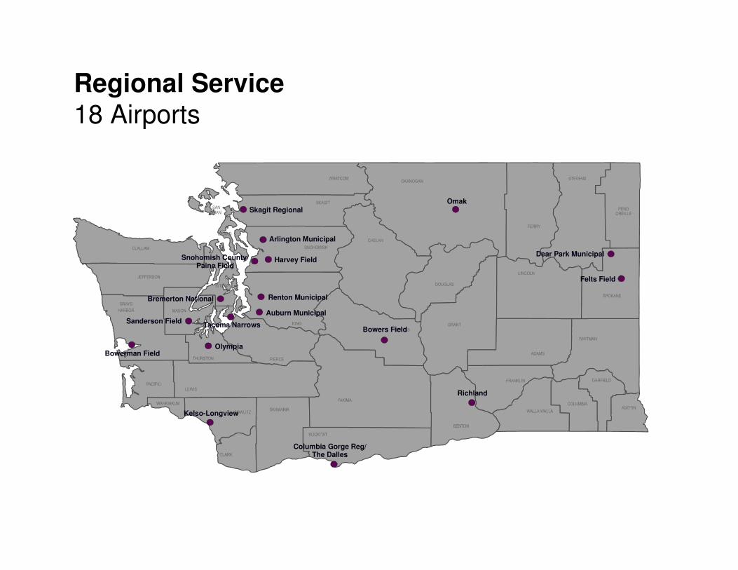
Sanderson Field
Bremerton National
Auburn Municipal
Harvey Field
Felts Field
Snohomish County/ Paine Field
Renton Municipal
Bowers Field
Richland
Skagit Regional
Tacoma Narrows
Omak
Olympia
Kelso-Longview
Dear Park Municipal
Columbia Gorge Reg/ The Dalles
Bowerman Field
Arlington Municipal
Regional Service18 Airports

Regional Service18 Airports
Criteria Explanation
Runway Length 5,000 ft.*
Taxiway Parallel
Runway Lighting HIRL
Approach Precision, or lower than ¾ mile visibility minimum
Vertical Glide Slope Indicator
Yes
Weather Reporting
AWOS or ASOS
Fuel Sales 100LL and Jet A
Maintenance Service
Full Service FBO and Major Maintenance Available

72%
94%
94%
89%
33%
17%
100%
72%
0% 20% 40% 60% 80% 100%
Maintenance Service
Fuel Sales
Weather Reporting
Vertical Glide Slope
Approach
Runway Lighting
Runway Length
Taxiway
Results:
Regional Service Airports Show Gaps in Runway Lighting and Approaches

EphrataMunicipal
Grove Field
Sunnyside Municipal
Rosalia Municipal
Prosser
Pearson Field
Othello Municipal
Odessa Municipal
Goldendale Municipal
Sand Canyon
Okanogan Legion
Whitman County Memorial
Pru Field
Packwood
Grand Coulee Dam
Davenport Municipal
Wilbur Municipal
Colville Municipal
Chelan Municipal
Moses Lake Municipal
Wilson Creek
Willard Field
Lind MunicipalNew Warden
Ferry County
Port of Ilwaco
Tonasket Municipal
MansfieldWaterville
Quincy Municipal
Sekiu
Westport
Lopez Island
Wes Lupien
Pierce County/ Thun Field
Toledo-Winlock Ed Carlson Mem.
Ocean Shores Municipal
Jefferson CountyInternational
Dorothy Scott Municipal
Cle Elum Municipal
Chehalis Centralia
Cashmere Dryden
Blaine Municipal
Anderson Field
Concrete Municipal
Forks Municipal
Darrington Municipal
Strom FieldWillapa Harbor
Twisp Municipal
Vista Field
Local Community51 Airports
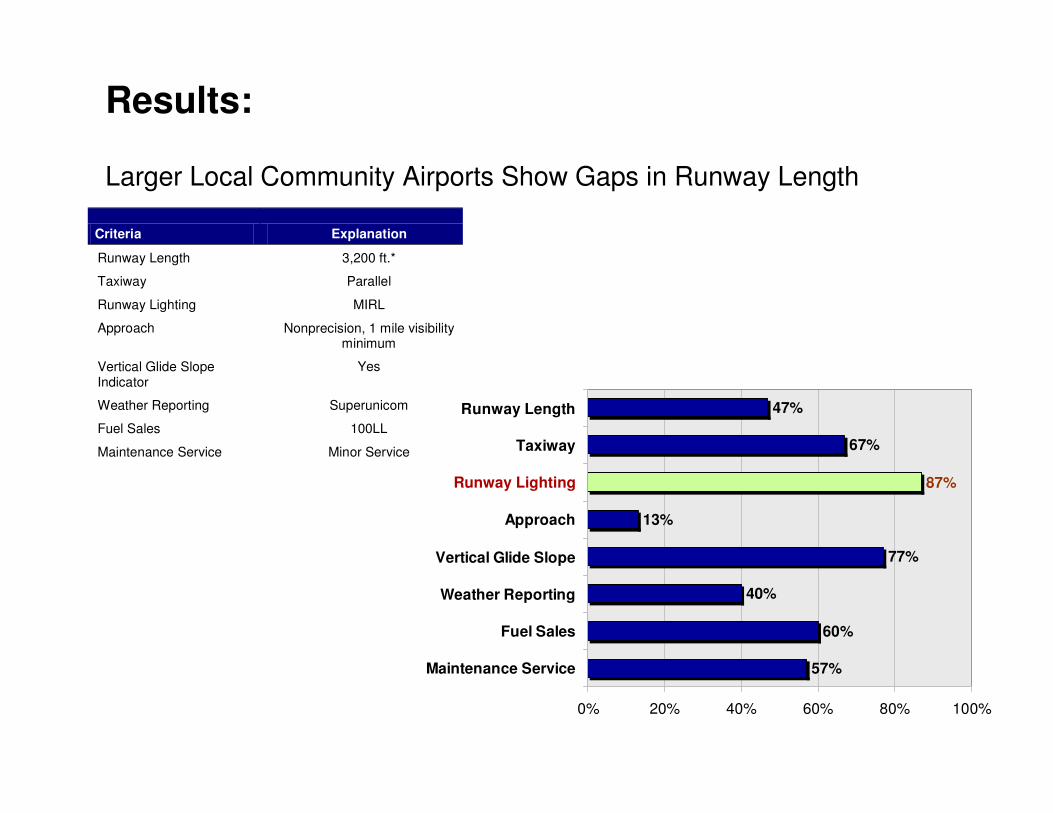
Criteria Explanation
Runway Length 3,200 ft.*
Taxiway Parallel
Runway Lighting MIRL
Approach Nonprecision, 1 mile visibility minimum
Vertical Glide Slope Indicator
Yes
Weather Reporting Superunicom
Fuel Sales 100LL
Maintenance Service Minor Service
57%
60%
40%
77%
13%
67%
87%
47%
0% 20% 40% 60% 80% 100%
Maintenance Service
Fuel Sales
Weather Reporting
Vertical Glide Slope
Approach
Taxiway
Runway Length
Runway Lighting
Results:
Larger Local Community Airports Show Gaps in Runway Length

Criteria Explanation
Runway Length 2,800 ft.*
Taxiway Turnaround at each end
Runway Lighting Reflectors
Approach Visual
Results:
Smaller Local Community Airports Show Gaps in Runway Length and Turnarounds
95%
38%
100%
52%
0% 20% 40% 60% 80% 100%
Runway Lighting
Taxiway
Runway Length
Approach

Lester State
Easton State
Bandera State
Ranger Creek StateSwanson
Field
Crest Airpark
Tieton State
Cedars North Airpark
Evergreen Field
Vashon Municipal
Avey Field State
Sullivan Lake State
Lost River Resort
Lower Granite State
Little Goose Lock & Dam State
Lower Monumental State
Rogersburg State
Skyhomish State
Woodland State
Lake Wenatchee State
Methow ValleyStehekin State
Copalis State
Western Airpark
Desert Aire
De Vere Field
Hoskins Field
Shady Acres
Sky Harbor
R & K Skyranch
Point Roberts Airpark
Hillcrest
Camano Island Airpark
Mead Flying Service
Martin Field
Fly For Fun
Spanaway
Firstair Field
Sequim Valley
Elma Municipal
Goheen Field
Cross WindsQuillayute Whidbey
Airpark
J-Z
Lynden Municipal
Ione Municipal
Recreation or Remote47 Airports

Criteria Explanation
Runway Length 2,400 ft.*
Taxiway Turnaround at each end
Runway Lighting Reflectors
Approach Visual
45%
32%
100%
64%
0% 20% 40% 60% 80% 100%
Runway Lighting
Taxiway
Runway Length
Approach
Results:
Recreation or Remote Airports Show Gaps in Turnarounds and Reflectors

Seaplane Bases9 Airports
Skyline SPB
Floathaven
Roche Harbor SPB
Friday Harbor SPB
Kenmore Air Harbor SPB
Will Rodgers Wiley Post SPB
Rosario SPB
Poulsbo SPB
American Lake SPB
S
S
SS
S
S
S
S
S

Criteria Explanation
Dock Facility Yes
Approach Visual
100%
89%
80% 85% 90% 95% 100%
Dock Facility
Approach
Results:
Seaplane Bases Meet Performance Objectives

What’s Next?
� Phase II currently underway – using Phase I baseline information to determine 25 year future demand.
� Final Phase I and II reports to be released in July 2007.
� LATS presentations/briefings throughout 2007.
� WSDOT to meet with Technical Advisory Committee in 2007 to review draft reports and technical documents.
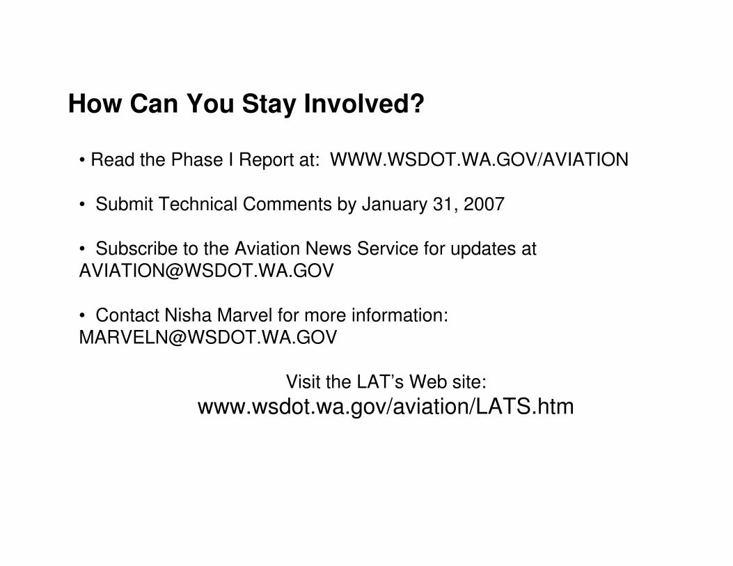
How Can You Stay Involved?
• Read the Phase I Report at: WWW.WSDOT.WA.GOV/AVIATION
• Submit Technical Comments by January 31, 2007
• Subscribe to the Aviation News Service for updates at [email protected]
• Contact Nisha Marvel for more information: [email protected]
Visit the LAT’s Web site:
www.wsdot.wa.gov/aviation/LATS.htm