airport master plan update - jviationsites.jviation.com/harveyfield/documents/s43-20170615-pac... |...
TRANSCRIPT

www.harveyfield.com
Airport Master Plan Update
June 15, 2017
www.harveyfield.com |
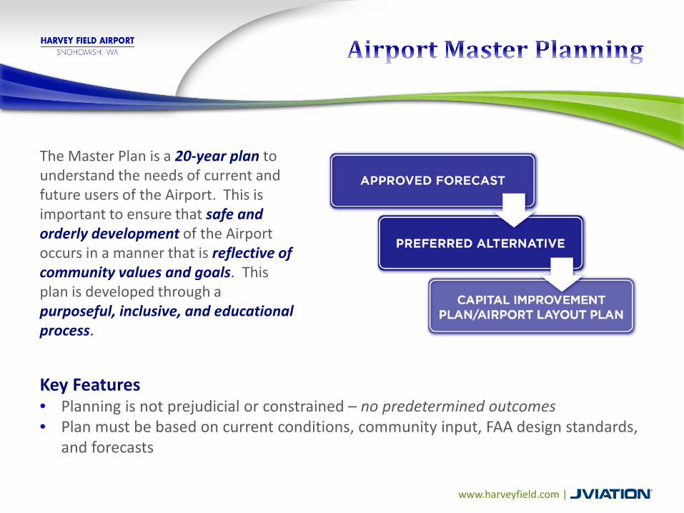
The Master Plan is a 20-year plan to understand the needs of current and future users of the Airport. This is important to ensure that safe and orderly development of the Airport occurs in a manner that is reflective of community values and goals. This plan is developed through a purposeful, inclusive, and educational process.
Key Features• Planning is not prejudicial or constrained – no predetermined outcomes• Plan must be based on current conditions, community input, FAA design standards,
and forecasts

www.harveyfield.com |

www.harveyfield.com |
Harvey Field
Total Employment
243
Airport Business Regional Impact $14.9 M
Visitor Spending
$9.2 M
Paid Taxes $1.0 M
Multiplier Effect: Initial economic impacts from Airport enter economy and re-circulate which generate successive rounds of employment, taxes, spending, and output.
Note: All impacts are shown in 2010 dollars
www.harveyfield.com |
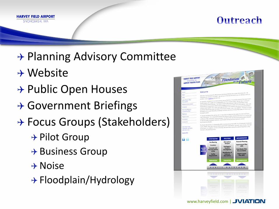
Planning Advisory CommitteeWebsite Public Open HousesGovernment Briefings Focus Groups (Stakeholders)Pilot GroupBusiness GroupNoise Floodplain/Hydrology

www.harveyfield.com |

www.harveyfield.com |
Current Runway Length, Width, & Orientation:• 15L/33R - 2,671 feet x 36 feet• Displaced Thresholds:
• Runway 15 – 452’ to south• Runway 33 – 241’ to north
A displaced threshold is a runway threshold located at a point other than the physical beginning or end of the runway. The portion of the runway so displaced may be used for takeoff but not for landing.

www.harveyfield.com |

Runway 15L Railroad tracks Power Lines Trees
Runway 33R Airport Way Power Lines Trees

www.harveyfield.com |
Snohomish County Code (SCC) regarding Density Fringe have been a driving factor since we last met
Priority has been to resolve safety issues of: Runway Displaced Thresholds
Current 2671’ runway provides useable runway length of 2219’ for landing to the south and 2430’ for landing to the north
Full runway length is available for departures Airport Way
Current roadway alignment is in the runway protection zone and FAA recognizes it as a safety concern

www.harveyfield.com |
To meeting SCC regulations and meet FAA safety standards, our recommendation is a 2400’ x 75’ runway and a relocation of Airport Way
This solution serves Harvey Field’s existing aircraft fleet mix, improves aviation safety and improves roadway safety
Now, how we got here and what it means….


www.harveyfield.com |
Air Quality Coastal Resources Compatible Land Uses Construction Impacts Department of Transportation Act 4(f) Farmlands Fish, Wildlife, and Plants Floodplains Hazardous Material, Pollution Prevention, and Solid Waste Historical, Architectural, Archaeological, and Cultural Resources Light Emissions and Visual Impacts Noise Secondary (Induced) Impacts Socioeconomic Impacts, Environmental Justice, and Children’s Environmental
Health and Safety Risks Wetlands Wild and Scenic Rivers
Prior to the construction of any improvement, projects must undergo required local, state and/or federal environmental review and approval processes

www.harveyfield.com |
www.harveyfield.com |
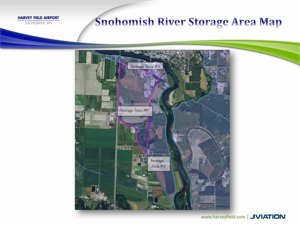
Storage Area #3
Storage Area #9
Storage Area #2

www.harveyfield.com |
• Long-standing procedures in place at Harvey Field
• Ongoing pilot education• Noise Hotline -
• 360-568-1541, ext. 261• Information at
www.harveyfield.com
www.harveyfield.com |

www.harveyfield.com |
Local & FAA standards and regulations Planning and engineering standards Environmental and floodplain regulations
www.harveyfield.com |
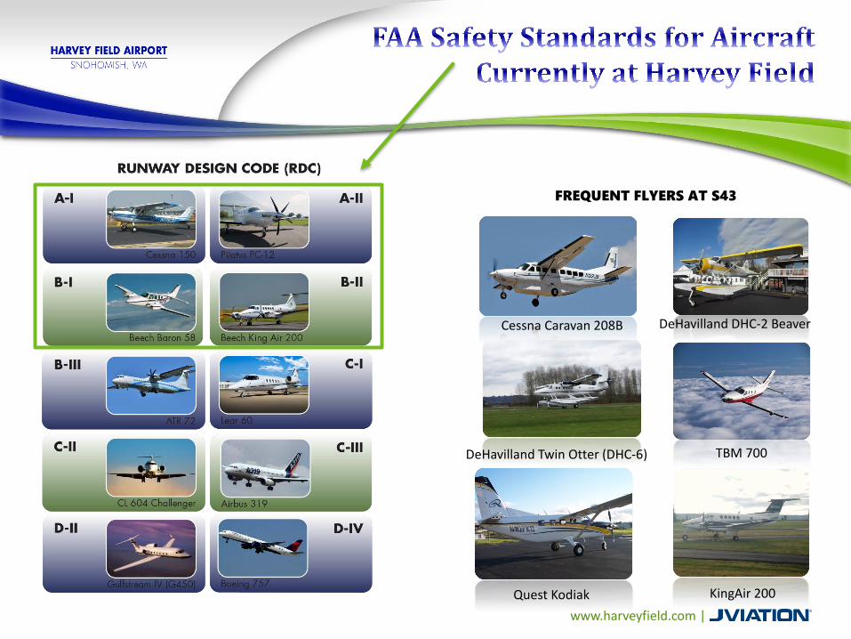
DeHavilland DHC-2 Beaver
KingAir 200Quest Kodiak
TBM 700DeHavilland Twin Otter (DHC-6)
Cessna Caravan 208B
FREQUENT FLYERS AT S43

www.harveyfield.com |
Airport Way Road Improvement Build on Airport Property Build at safe distance from Runway Meet Density Fringe requirements Meet FEMA’s requirement for base flood elevation (BFE)
impact Meet Snohomish County Road Standards Improve substandard curves and shoulder widths Avoid wetlands
Runway Serve same aircraft as now Build at safe distance from Airport Way Meet Density Fringe and FEMA BFE requirements Clear approaches over BNSF, Airport Way, and power lines

www.harveyfield.com |
SAFETY & OPERATIONAL FACTORS
Ability to safely accommodate future demand aircraftSafety for vehicles on Airport WayEvaluated based on anticipated improvements to address:• Operational safety• Capacity and delay• Tenant convenience• Ability to meet FAA design
standards
ENVIRONMENTAL FACTORS
FAA Order 1050.1EPotential physical impacts to surrounding communityAbility to meet County planning and environmental standards
ECONOMIC CONSIDERATIONS
Historic infrastructure investmentRemaining useful life of existing facilitiesAnticipated project costsProperty acquisition requirements Cost-effectiveness evaluationEconomic impact
IMPLEMENTATION FEASIBILITY
Tangible factors•Practicality of implementationIntangible factors•Community values•Political environment

www.harveyfield.com |
The maximum width (sum of widths) of all new construction, substantial improvements or other development shall not exceed 15 percent of the length of a line drawn perpendicular to the known floodwater flow direction at the point where the development(s) is located. The length of said line shall not extend beyond the property boundary or the edge of the density fringe area, whichever is less. The limitations of this section shall not apply to those uses listed in SCC 30.65.260.
o All of Harvey Field property is within the Density Fringeo New construction is Fill – anything that diverts or blocks Flood flowso Sum of Fill widths / Total property width = 15% or less
23

www.harveyfield.com |
Example from County Flood Permit Application:
Determine the general floodplain flow direction
Draw a line perpendicular to the flow direction
Draw the line where it intersects the largest width of new construction as a percentage of property width.
Sum of Fill widths/Total property width must be less than 15%
or fill in our case
900’ property width
70’ new obstruction width
70’/900’ = 7.8% < 15 %
24
Example: Flow Obstruction and Blockage Calculations

www.harveyfield.com |
Section A-A
4098’ property width
571’ new obstruction width571’/4098’ = 13.9% < 15 %
25
www.harveyfield.com |
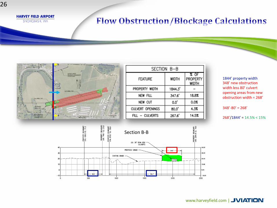
Section B-B
1844’ property width348’ new obstruction width less 80’ culvert opening areas from new obstruction width = 268’
348’-80’ = 268’
268’/1844’ = 14.5% < 15%
26

www.harveyfield.com |
The land area occupied by any use or development permitted by this chapter located in the density fringe area that will displace floodwaters shall not exceed two percent of the land area of that portion of the lot. The limitations of this section shall not apply to those uses listed in SCC 30.65.260.
What does 2% mean with regard to Harvey Field?
o Current flood maps indicate that BFE is 26.63’
o Virtually all of Harvey Field is lower than 26.63’…so SCC applies everywhere
o 2% of 204.48 (Harvey Field property) = 4.090 acres
o 2% Area limit does NOT apply to public uses, such as roads, specifically, Airport Way (SCC 30.65.260)
o However, FEMA’s BFE requirement
27
www.harveyfield.com |
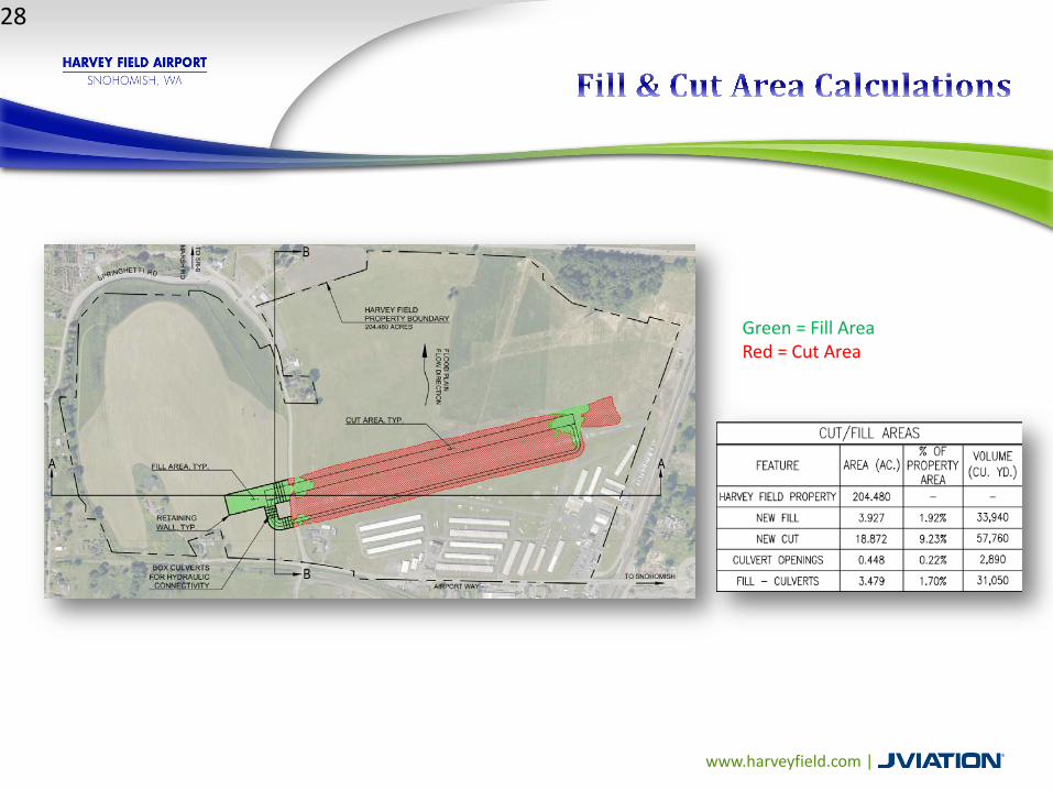
Green = Fill AreaRed = Cut Area
28

www.harveyfield.com |
The following uses shall be exempt from the maximum allowable density and obstruction limitations of SCC 30.65.250 and 30.65.255:
(1) Water-dependent utilities; (2) Dikes; (3) Utility facilities; and (4) Public Works, when the project proponent demonstrates that the floodwater displacement effects of the proposal when considered together with the maximum potential floodwater displacement allowed by SCC 30.65.250 and 30.65.255 shall not cause a cumulative increase in the base flood elevation of more than one foot.
Snohomish County confirmed “Public Works” includes Airport Way as a public road
29
www.harveyfield.com |
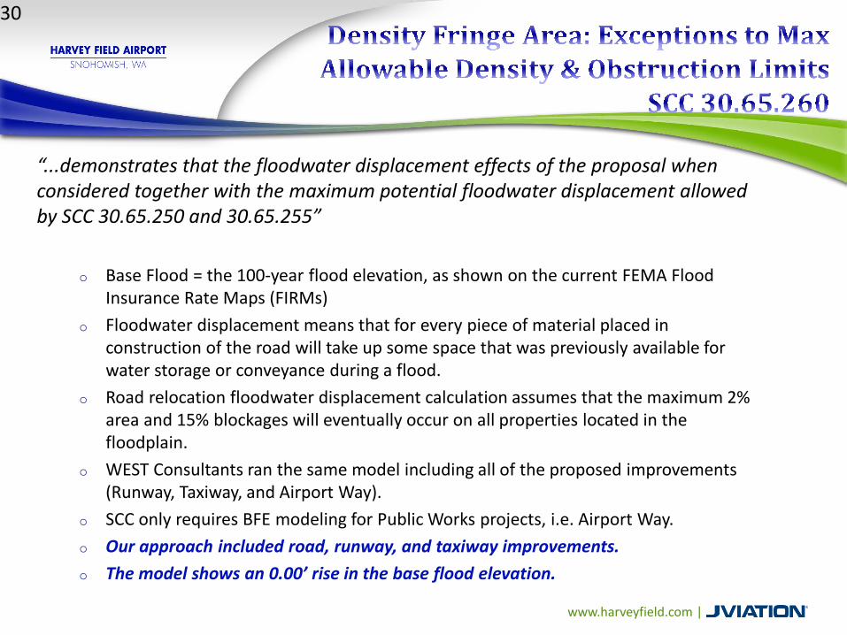
“...demonstrates that the floodwater displacement effects of the proposal when considered together with the maximum potential floodwater displacement allowed by SCC 30.65.250 and 30.65.255”
o Base Flood = the 100-year flood elevation, as shown on the current FEMA Flood Insurance Rate Maps (FIRMs)
o Floodwater displacement means that for every piece of material placed in construction of the road will take up some space that was previously available for water storage or conveyance during a flood.
o Road relocation floodwater displacement calculation assumes that the maximum 2% area and 15% blockages will eventually occur on all properties located in the floodplain.
o WEST Consultants ran the same model including all of the proposed improvements (Runway, Taxiway, and Airport Way).
o SCC only requires BFE modeling for Public Works projects, i.e. Airport Way. o Our approach included road, runway, and taxiway improvements.o The model shows an 0.00’ rise in the base flood elevation.
30

www.harveyfield.com |

www.harveyfield.com |

www.harveyfield.com |

www.harveyfield.com |

www.harveyfield.com |

www.harveyfield.com |

www.harveyfield.com |

www.harveyfield.com |
AND HANAGRS
www.harveyfield.com |
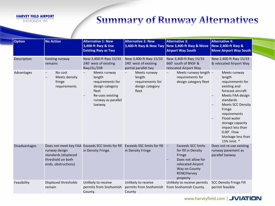
Option No Action Alternative 1: New 3,400-ft Rwy & Use Existing Rwy as Twy
Alternative 2: New 3,400-ft Rwy & New Twy
Alternative 3: New 3,400-ft Rwy & Move Airport Way South
Alternative 4: New 2,400-ft Rwy & Move Airport Way South
Description Existing runway remains
New 3,400-ft Rwy 15/33 240’ west of existing Rwy15L/33R
New 3,400-ft Rwy 15/33 240’ west of existing partial parallel twy
New 3,400-ft Rwy 15/33 660’ south of BNSF & relocated Airport Way
New 2,400-ft Rwy 15/33 & relocated Airport Way
Advantages − No cost− Meets density
fringe requirements
− Meets runway length requirements for design category fleet
− Re-uses existing runway as parallel taxiway
− Meets runway length requirements for design category fleet
− Meets runway length requirements for design category fleet
− Meets runway length requirements for existing and forecast aircraft
− Meets FAA design standards
− Meets SCC Density Fringe requirements
− Flood water storage capacity impact less than 0.00’. Flow blockage less than 15% limit. *
Disadvantages Does not meet key FAA runway design standards (displaced threshold on both ends, obstructions)
Exceeds SCC limits for fill in Density Fringe.
Exceeds SSC limits for fill in Density Fringe
− Exceeds SCC limits for fill in Density Fringe
− Does not allow for relocated Airport Way on County ROW/Harvey property
Does not re-use existing runway pavement as parallel taxiway
Feasibility Displaced thresholds remain
Unlikely to receive permits from Snohomish County.
Unlikely to receive permits from Snohomish County
Unlikely to receive permits from Snohomish County.
SCC Density Fringe Fill permit feasible
www.harveyfield.com |
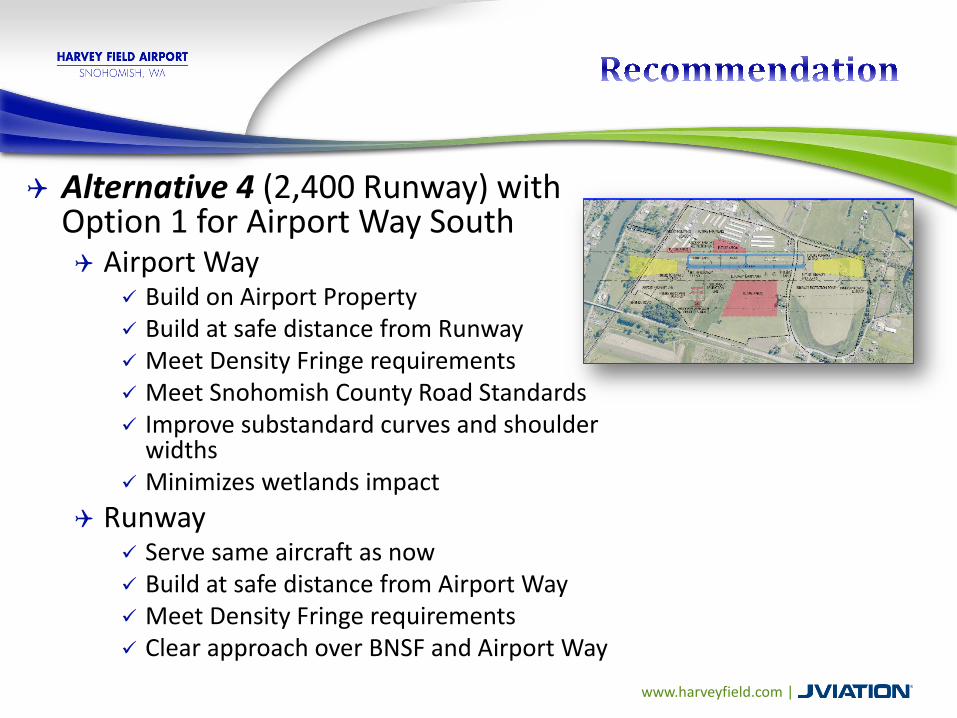
Alternative 4 (2,400 Runway) with Option 1 for Airport Way South Airport Way
Build on Airport Property Build at safe distance from Runway Meet Density Fringe requirements Meet Snohomish County Road Standards Improve substandard curves and shoulder
widths Minimizes wetlands impact
Runway Serve same aircraft as now Build at safe distance from Airport Way Meet Density Fringe requirements Clear approach over BNSF and Airport Way

www.harveyfield.com |
Current Runway Length, Width, & Orientation• 15L/33R - 2,671 feet x 36 feet• Displaced Thresholds:
• Runway 15 – 452’ to south• Runway 33 – 241’ to north
Recommended Alternative 4: Runway Length, Width, & Orientation• 15L/33R - 2,400 feet x 75 feet• Clear approaches

Alternative 4 Contours Current Contours
Per FAA guidance, residences within the 65 dnl are eligible for noise mitigation
www.harveyfield.com |
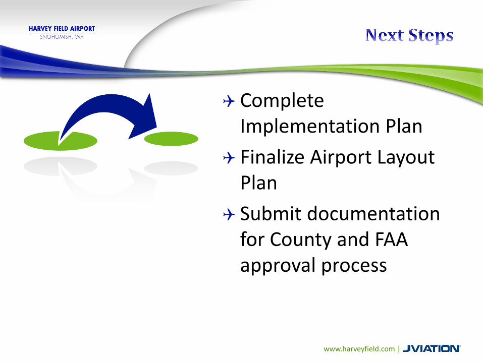
Complete Implementation Plan
Finalize Airport Layout Plan
Submit documentation for County and FAA approval process

www.harveyfield.com |
Airport Way, Runway, &
Taxiway Improvements
FAA GrantsAirport
Improvement Program
State of Washington
Division of Aeronautics, State
Infrastructure Bank, Fuel Tax
Harvey Field Funds
Tie-down fees, land leases, fuel
sales, non-aeronautical
revenues, etc.
• FAA Grants – provide 90% of the total cost of an eligible capital project
• FAA Airport Improvement Program grants come from Aviation Trust Fund-funded by aviation system user fees


Cynthia HendricksonAirport [email protected] x229
Kandace [email protected] x224
Renee Dowlin Project [email protected]