airport launceston airport master plan 2015 · 2017-04-20 · 1.5.1 airports act 1996 22 1.5.2...
TRANSCRIPT
LAUNCESTON AIRPORTMASTER PLAN 2015
LAU
NC
ESTO
N A
IRP
OR
TM
AS
TER P
LA
N 2014
Launceston Airport is managed by Australia Pacific Airports (Launceston) Pty Ltd (APAL), which is a private company limited by shares. The ownership structure of APAL has Australia Pacific Airports Corporation Limited (APAC) as the ultimate holding company of ninety percent of APAL shares with the remaining ten percent held by the Launceston City Council. In this document, the term ‘Launceston Airport’ is used to refer to both the airport site and to APAL as manager of the site (as the case may be). ‘Launceston Airport’ is a trademark of APAL.
This Master Plan was prepared by APAL as part of its internal strategic planning processes and in accordance with the provisions of Part 5 of the Airports Act 1996 (the Airports Act), and the Regulations made under that Act, and should be read in that context only.
This Master Plan is a revision of the previous Master Plan that was approved by the Commonwealth Minister in March 2009. The fundamental philosophies of the previous Master Plan are maintained in this version.
This Master Plan incorporates the 2015 Launceston Airport Environment Strategy and the Launceston Airport Ground Transport Plan in accordance with Part 5, Section 71 of the Airports Act.
Development strategies and scenarios in this Master Plan are based on certain assumptions and forecasts that have been prepared by APAL to assist in the strategic planning process, and to discharge its obligations under the Act. Therefore, the assumptions and forecasts should not be used or relied upon by any person for any other purpose.
This Master Plan is APAL’s statement of intent, based on current data and insights and is subject to change. Accordingly, the development strategies and scenarios detailed in it are indicative only, and their inclusion is not to be read as an assurance that any, or all of them, will occur.
Significant changes to the Master Plan can only be approved by processing a replacement Master Plan or a minor variation. In addition, in accordance with Section 83A of the Airports Act, the airport lessee company must take all reasonable steps to ensure that the Environment Strategy in the final Master Plan is complied with.
PLEASE NOTE
02 03 LAUNCESTON AIRPORT MASTER PLAN 2015
TABLE OF CONTENTSABBREVIATIONS 08
GLOSSARY 10
FOREWORD 13
EXECUTIVE SUMMARY 14
1 INTRODUCTION 171.1 Location 18
1.2 Existing Airport 18
1.3 Land Availability 18
1.4 History 18
1.5 Statutory Framework 221.5.1 Airports Act 1996 221.5.2 Environment Protection and Biodiversity
Conservation Act 1999 221.5.3 State Legislation 221.5.4 Airport Lease 22
1.6 Previous Studies, Strategies and Plans 231.6.1 Launceston Airport Master Plan 1990 231.6.2 Launceston Airport Master Plan 1999 231.6.3 Launceston Airport Master Plan 2004 231.6.4 Launceston Airport Master Plan 2009 23
1.7 Significant Developments since the 2009 Master Plan 23
1.8 Planning Approach 24
1.9 Concept Plans 241.9.1 0 -5 Year Master Plan Concept 241.9.2 20 Year Master Plan Concept 25
1.10 Key Differences from the 2009 Master Plan 25
2 ECONOMIC AND SOCIAL IMPACTS 292.1 Overview 29
2.1.1 Regional context 292.1.2 The role of regional airports
in a regional economy 29
2.2 Economic Impacts 30
2.3 Social Impacts 31
2.4 Conclusion 31
3 MASTER PLAN PROCESS 323.1 Overview 33
3.2 Previous Planning and Consultation 33
3.3 Reviews and Studies 33
3.4 Development of Future Plans, Strategies and Concepts 34
3.5 Community and Stakeholder Consultation 34
3.6 Public Exhibition 34
3.7 Comments and Submissions 35
3.8 Submission to Minister 35
3.9 Publication of Final Master Plan 35
4 PLANNING CONTEXT 364.1 Overview 37
4.2 Policy Framework 374.2.1 National Airports Safeguarding Framework 374.2.2 Northern Midlands Interim
Planning Scheme 2013 384.2.3 Greater Launceston Plan 39
4.3 Development Objectives 39
4.4 Development Drivers 40
4.5 Growth Forecasts 424.5.1 Historical Air Traffic Performance 424.5.2 Passenger Movement Forecast 434.5.3 Aircraft Movement Forecast 434.5.4 Freight 43
4.6 Planning Criteria 444.6.1 Airside 444.6.2 Terminal Facilities 444.6.3 Landside Land Use and Development 454.6.4 Airport Roads 45
TABLE OF CONTENTS
5 AIRPORT LAND-USE PLAN 465.1 Overview and Objectives 47
5.2 Regional Context 47
5.3 Land-Use Strategy 47
5.4 Planning Zones 485.4.1 Airport Specific Area Zone 48
5.5 Land-Use Precincts 485.5.1 Airside Operations Precinct 485.5.2 Terminals Precinct 515.5.3 Landside Main Precinct 515.5.4 Landside Business Precinct 515.5.5 Operational Support and Freight Precinct 52
5.6 Overlays 52
5.7 Particular Provisions 52
5.8 Sensitive Developments 52
5.9 Consistency with Planning Schemes under State Law 53
5.10 Pre-existing Interests 53
5.11 Development Approval Process 53
6 AIRSIDE DEVELOPMENT PLAN 546.1 Overview and Objectives 55
6.2 Runways and Taxiways 586.2.1 North-West / South-East Sealed Runway
(14R/32L) 586.2.2 Grass Runways 18/36 and 14L/32R 58
6.3 Aprons 596.3.1 Terminal RPT Apron 606.3.2 Southern Apron 60
6.4 Summary of Airside Development Proposals 60
7 TERMINALS AND AVIATION SUPPORT FACILITIES DEVELOPMENT PLAN 617.1 Overview and Objectives 62
7.2 Passenger Terminals 627.2.1 Main Terminal 627.2.2 Regional Terminal 627.2.3 Summary of Passenger Terminal
Development Proposals 66
7.3 Freight Terminals 667.3.1 Summary of Proposed Freight Development 66
7.4 General Aviation Facilities 677.4.1 Summary of Proposed General Aviation
Development 67
7.5 Aviation Support Facilities and Services 697.5.1 Aircraft Refuelling Facilities 697.5.2 Air Navigation Facilities and Services 697.5.3 Summary of Proposed Aviation Support
Development 69
8 NON-AVIATION DEVELOPMENT PLAN 708.1 Overview and Objectives 71
8.2 Landside Business Precinct 73
8.3 Landside Main Precinct 73
8.4 Impacts of Non-Aviation Developments 73
9 GROUND TRANSPORT PLAN 749.1 Overview and Objectives 75
9.2 Ground Transport System (Existing) 769.2.1 External Road Network 769.2.2 Internal Road Networks 799.2.3 Parking 799.2.4 Commercial, Bus, Taxi
and Hire Car 799.2.5 Freight 799.2.6 Active Transport 79
9.3 Ground Transport Demand 79
9.4 Delivering Ground Transportation into the Future 82
9.5 Launceston Airport Ground Transport (0-5 years) 829.5.1 Internal Road Networks 829.5.2 Parking 829.5.3 Bus Services 829.5.4 Taxi and Hire Car 829.5.5 Freight 829.5.6 Active Transport 82
9.6 Future Ground Transport Implementation (6-20 years) 83
LAUNCESTON AIRPORT MASTER PLAN 201504 05

TABLE OF CONTENTS
10 INFRASTRUCTURE DEVELOPMENT PLAN 8410.1 Overview and Objectives 85
10.2 Water Supply 8510.2.1 Existing Infrastructure 8510.2.2 System Management and Maintenance 8610.2.3 Risk Mitigation 8610.2.4 Accommodating Growth 8610.2.5 Water Conservation Measures 86
10.3 Sewerage 8610.3.1 Existing Infrastructure 8610.3.2 System Management and Maintenance 8610.3.3 Risk Mitigation 8610.3.4 Accommodating Growth 86
10.4 Stormwater Drainage 8610.4.1 Existing Infrastructure 8610.4.2 System Management and Maintenance 8710.4.3 Risk Mitigation 8710.4.4 Clean Waterways 8710.4.5 Accommodating Growth 87
10.5 Electricity 8910.5.1 Existing Infrastructure 8910.5.2 System Management and Maintenance 8910.5.3 Risk Mitigation 8910.5.4 Accommodating Growth 89
10.6 Telecommunications 8910.6.1 Existing Infrastructure 8910.6.2 System Management and Maintenance 8910.6.3 Risk Mitigation 8910.6.4 Accommodating Growth 89
11 ENVIRONMENT 9011.1 Overview 91
11.1.1 History 9211.1.2 Requirements of the Airports Act 1996 9211.1.3 Legal Basis for Airport
Environment Strategy (AES) 92
11.2 Environment Management 9311.2.1 Overview 9311.2.2 Environmental Legislation 93
11.2.2.1 Airport Acts 1996 9311.2.2.2 Airports (Environmental
Protection) Regulations 1997 9311.2.2.3 Environmental Protection
and Biodiversity Conservation Act 1999 93
11.2.2.4 Applicable State Legislation 9411.2.3 Department of Infrastructure
and Regional Development 9411.2.4 Airport Environment Officer (AEO) 94
11.2.4.1 Airport Building Controller ABC) 94
11.2.5 Environmental Site Registers 9411.2.6 Environmentally Significant Areas 9411.2.7 Launceston Airport
Environment Management 9611.2.7.1 Environment Policy 9611.2.7.2 Environmental Planning –
Setting Objectives & Targets 9611.2.7.3 Environmental
Management Programs 9611.2.8 Implementation and Operation 9711.2.9 Training, Awareness and Competence 9711.2.10 Communication and Documentation 9711.2.11 Emergency Response 9711.2.12 Checking and Corrective Action 9711.2.13 Strategy Actions 97
11.3 Ecologically Sustainable Development 9911.3.1 Overview 9911.3.2 Existing ESD Management 9911.3.3 Potential Issues and Impacts 99
11.4 Energy Management and Climate Change 10011.4.1 Overview 10011.4.2 Energy Use 10011.4.3 Energy Management 10011.4.4 Offsetting Emissions 10011.4.5 Reporting Emissions 10011.4.6 Climate Change 100
TABLE OF CONTENTS
11.5 Water Consumption Management 10211.5.1 Overview 10211.5.2 Major Uses of Potable Water 10211.5.3 Water Management 102
11.6 Water Quality – Stormwater 10411.6.1 Overview 10411.6.2 Surface Water System 10411.6.3 Stormwater Monitoring 10511.6.4 Key Legislation 105
11.7 Water Quality – Groundwater 10611.7.1 Overview 10611.7.2 Potential sources of impact
upon groundwater 10611.7.3 Monitoring of Groundwater 106
11.8 Waste and Resource Management 10711.8.1 Overview 10711.8.2 Waste Management 10711.8.3 Quarantine Risk Material (QRM) 107
11.9 Biodiversity and Conservation Management 10811.9.1 Overview 10811.9.2 Legislative Framework 10811.9.3 Threatened Species and Vegetation
Communities 10811.9.4 Green and Gold Frog
(Litoria raniformus) 10811.9.5 Silky Bush Pea (Pulteneae prostrata) 10811.9.6 Vegetation Management 10911.9.7 Wildlife Management 109
11.10 Land Management 11111.10.1 Overview 11111.10.2 Local Geology and Hydrogeology 11111.10.3 Developments and their Impacts 11111.10.4 Airservices Australia Fire Drill Ground 112
11.11 Air Quality 11311.11.1 Overview 11311.11.2 Fire Fighter Training 113
11.12 Cultural and Historic Heritage 11411.12.1 Overview 11411.12.2 Indigenous Heritage 114
11.13 Ground-based Noise 11611.13.1 Overview 11611.13.2 Ground based Noise 116
11.14 Hazardous Materials 11611.14.1 Overview 11611.14.2 Chemical Use at Launceston Airport 11611.14.3 Measures to Reduce Impact 117
12 AIRPORT SAFEGUARDING STRATEGY 11812.1 Overview and Objectives 119
12.2 National Airports Safeguarding Framework 120
12.3 Aircraft Noise Management 12012.3.1 Use of ANEF System 12012.3.2 Launceston Airport ANEF 12112.3.3 Limitations of the ANEF System 12112.3.4 N-Contours 12612.3.5 Noise Monitoring Systems 12612.3.6 Noise Abatement Procedures 126
12.4 Airspace Protection 12812.4.1 Prescribed Airspace Regulations 12812.4.2 Launceston Airport
Prescribed Airspace 12812.4.3 Potential Changes to Airspace 128
12.5 Other Safeguarding Matters 128
12.6 Airport Safeguarding Planning Controls 132
13 IMPLEMENTATION 13313.1 Overview 134
13.2 Capital Program 134
13.3 Project Delivery 134
13.4 Development Approval Process 134
13.5 Safety Management System 134
13.6 Environmental Management System 135
13.7 Asset Management System 135
13.8 Community and Stakeholder Engagement 13513.8.1 Communications and Information 13513.8.2 Stakeholder Engagement 13513.8.3 Forums 13513.8.4 Community Investment 135
13.9 Periodic Reviews 135
14 CONCLUSION 136
15 REFERENCES 138
LAUNCESTON AIRPORT MASTER PLAN 201506 07
LIST OF TABLES LIST OF GRAPHS
Table 4.1 Total Annual Passenger Movements 42
Table 4.2 Annual Aircraft Movements 43
Table 11.1 Completed Environmental Management Actions from the 2010 Launceston AES 98
Table 11.2 Strategy Objectives 2015 98
Table 11.3 Completed ESD Actions from the 2010 Launceston AES 99
Table 11.4 Strategy Objectives 2015 99
Table 11.5 Completed Energy & Climate Actions from the 2010 Launceston AES 101
Table 11.6 Strategy Objectives 2015 101
Table 11.7 Completed Water Management Actions from the 2010 Launceston AES 102
Table 11 8 Strategy Objectives 2015 102
Table 11.9 Completed Stormwater Quality Actions Items from the 2010 Launceston AES 105
Table 11.10 Strategy Objectives 2015 105
Table 11.11 Completed Groundwater Quality Actions from the 2010 Launceston AES 106
Table 11.12 Strategy Objectives 2015 106
Table 11.13 Completed Waste Management Actions from the 2010 Launceston AES 107
Table 11.14 Strategy Objectives For 2015 107
Table 11.15 Completed Biodiversity And Conservation Actions from the 2010 Launceston AES 110
Table 11.16 Strategy Objectives 2015 110
Table 11.17 Completed Land Management Actions from the 2010 Launceston AES 112
Table 11.18 Strategy Objectives 2015 112
Table 11.19 Completed Air Quality Actions from the 2010 Launceston AES 113
Table 11.20 Strategy Objectives 2015 113
Table 11.21 Completed Cultural & Historic Heritage Actions from the 2010 Launceston AES 115
Table 11.22 Strategy Objectives 2015 115
Table 11.23 Completed Ground Based Noise Actions from the 2010 Launceston AES 116
Table 11.24 Strategy Objectives 2015 116
Table 11.25 Completed Hazard Materials Actions from the 2010 Launceston AES 117
Table 11.26 Strategy Objectives 2015 117
Graph 4.1 Passenger Volumes At Launceston Airport, 1994/95 To 2012/13 42
Graph 4.2 Total Annual Passenger Movements 42
Graph 4.3 Annual Aircraft Movements 43
LIST OF FIGURES
Figure 1.1 Location Plan 19
Figure 1.2 Existing Airport Aerial Photo 20
Figure 1.3 Existing Airport Plan 21
Figure 1.4 Launceston Building Numbers Plan 26
Figure 1.5 Future Airport Development Plan 27
Figure 5.1 Existing Land Use Precincts 49
Figure 5.2 Future Land Use Precincts 50
Figure 6.1 Existing Airside Layout 56
Figure 6.2 Future Airside Development Plan 57
Figure 7.1 Terminal Development Precinct 63
Figure 7.2 Existing Terminal Layout 64
Figure 7.3 Future Terminal Layout 65
Figure 8.1 Non Aviation Development Plan 72
Figure 9.1 Local Freeway & Transport 77
Figure 9.2 Bike Track 78
Figure 9.3 Road Network 80
Figure 9.4 Road Network South 81
Figure 11.1 Existing Airport Environment Plan 95
Figure 11.2 Water Catchment Plan 103
Figure 12.1 Runway 14 Departure and Arrival Tracks 122
Figure 12.2 Runway 32 Departure and Arrival Tracks 123
Figure 12.3 Circuit And Helicopter Tracks 124
Figure 12.4 Long Range Australian Noise Exposure Forecast (ANEF) 125
Figure 12.5 N-Contours 127
Figure 12.6 Prescribed Airspace Pan-Ops Surfaces 129
Figure 12.7 Current Obstacle Limitations Surface 130
Figure 12.8 Future Obstacle Limitations Drawing 131

the Airports Act
Airports Act 1996 (Commonwealth)
the airport Launceston Airport
ABC Airport Building Controller
AEO Airport Environment Officer
AFP Australian Federal Police
AH Act Aboriginal Heritage Act 2006
ANEF Australian Noise Exposure Forecast
ANO Aircraft Noise Ombudsman
APAC Australia Pacific Airport Corporation Pty Ltd
APAL Australia Pacific Airports (Launceston) Pty Ltd
ARFFS Aviation Rescue & Fire Fighting Service
ATC Air Traffic Control
BHR Busy Hour Rate
CACG Community Aviation Consultation Group
CASA Civil Aviation Safety Authority
CEMP Construction Environmental Management Plan
CEO Chief Executive Officer
DIRD Commonwealth Department of Infrastructure and Regional Development
DME Distance Measuring Equipment
DVOR Doppler VHF Omnidirectional Range
EIS Environment Impact Statement
EMS Environmental Management System
EPBC Act Environment Protection and Biodiversity Conservation Act 1999 (Commonwealth)
ESD Ecological Sustainable Development
FAA Federal Aviation Administration
FFG Act Flora and Fauna Guarantee Act 1988
FOD Foreign Object Debris
GDP Gross Domestic Product
GIS Geographic Information System
GPS Global Positioning System
GRP Gross Regional Product
GSE Ground Services Equipment
GSP Gross State Product
GTP Ground Transport Plan 2015
GVA Gross Value Added
HIAL High Intensity Approach Lights
IATA International Air Transport Association
ICAO International Civil Aviation Organization
ILS Instrument Landing System
INM Integrated Noise Model
ISO International Standards Organisation
LCC Low Cost Carrier
LTCP Long Term Car Park
MDP Major Development Plan
MRO Maintenance Repair and Overhaul
NAP Noise Abatement Procedure
NASAG National Airports Safeguarding Advisory Group
NASF National Airports Safeguarding Framework
NGER Act National Greenhouse and Energy Reporting Act 2007
NPI National Pollution Inventory
OLS Obstacle Limitation Surfaces
OEMP Operational Environmental Management Plan
PANS-OPS Procedures for Air Navigation Services – Aircraft Operations
RPAs Rules and Practices for Aerodromes State Planning Policy Framework
SCOTI Standing Council on Transport and Infrastructure
SMS Safety Management System
SWMP Stormwater Management Plan
the Environment Strategy
The Launceston Airport Environment Strategy 2015
the Master Plan
Launceston Airport Master Plan 2015
ABBREVIATIONS
LAUNCESTON AIRPORT MASTER PLAN 201508 09


GLOSSARY
Airport Master Plan The principal planning document required under the Airports Act 1996, setting out a 20-year plan for each leased federal airport.
Aircraft noise contours Contours that display the existing or forecast aircraft noise exposure patterns around an airport. These contours help land use planning authorities decide on acceptable development in close proximity to the airport.
Aircraft throughput Equals aircraft demand.
Airside The movement area of an airport, adjacent land and buildings that is access-controlled.
Airservices Australia The Australian Government agency providing air traffic control management and related airside services to the aviation industry.
Airservices Noise Complaints and Information Service (NCIS)
A toll-free enquiry line operated by Airservices Australia to provide the public with information on noise levels at major airports.
Australian Noise Exposure Concept (ANEC)
A set of contours based on hypothetical aircraft operations at an airport in the future. As ANEC maps are based on hypothetical assumptions and may not have been subject to review or endorsement, they have no official status and cannot be used for land use planning. However, an ANEC can be turned into an ANEF.
Australian Noise Exposure Forecast (ANEF)
A system developed as a land use planning tool aimed at controlling encroachment on airports by noise-sensitive buildings. The system underpins Australian Standard AS2021 ‘Acoustics – Aircraft noise intrusion – Building siting and construction’. The Standard contains advice on the acceptability of building sites based on ANEF zones. ANEFs are the official forecasts of future noise exposure patterns around an airport and they constitute the contours on which land use planning authorities base their controls.
Australian Noise Exposure Index (ANEI)
Contours developed under the ANEF framework showing historic noise exposure patterns used in environmental reporting and benchmarking.
Aircraft apron The part of an airport where aircraft are parked and serviced, enabling passengers to board and disembark and cargo to be loaded and unloaded.
Busy Hour Rate The sliding 60-minute period during which the maximum total traffic load in a given 24-hour period occurs.
Civil Aviation Safety Authority (CASA)
An independent statutory body responsible for regulating aviation safety in Australia and the safety of Australian aircraft overseas.
Code C aircraft An aircraft that has a wingspan of between 24 metres and up to but not including 36 metres. Examples are the Airbus A320 series and Boeing 737-700/800 series.
Contact bay, contact gate, contact stand
Aircraft stand with direct access to and from the terminal building, typically via an aerobridge.
LAUNCESTON AIRPORT MASTER PLAN 201510 11

GLOSSARY
Controlled airspace Airspace of defined dimensions within which air traffic control services are provided in accordance with airspace classifications
Curfews A restriction on certain flights taking off or landing from specified airports at designated times.
Foreign object debris A substance, debris or article alien to a vehicle or system, which would potentially cause damage.
Ground Service Equipment (GSE)
Airport support equipment, for example, aircraft pushback tractors, baggage tugs, ground power units and engine air start units.
Instrument Landing System (ILS)
Instruments capable of providing both directional and glide slope guidance.
International Air Transport Association (IATA)
An international organisation representing and serving the airline industry worldwide.
International Civil Aviation Organisation (ICAO)
An agency of the United Nations which codifies the principles and techniques of international air navigation and fosters the planning and development of international air transport.
Landside The area of an airport and buildings to which the public normally has free access.
Leased federal airports The 21 airports privatised under the Airports Act 1996, where the airport operators lease the airport land from the Australian Government.
Major Development Plan A requirement under the Airports Act 1996 for airport lessee companies to provide information to the Australian Government and the public about significant planned development on leased federal airport sites.
Noise N Contours An alternative metric to the ANEF which reports aircraft noise in the way that a person perceives it – as a number of noise events per day above a certain decibel level.
Non-aeronautical development
Non-aviation commercial developments, such as retail outlets and office buildings, on airport sites.
Obstacle Limitation Surfaces (OLS)
A series of surfaces that define the volume of airspace at and around an aerodrome to be kept free of obstacles, in order to permit the intended aircraft operations to be conducted safely and to prevent the aerodrome from becoming unusable by the growth of obstacles.
Procedures for Air Navigation Services – Aircraft Operations (PAN-OPS)
A set of ICAO rules for designing instrument approach and departure procedures at aerodromes.
Taxiway A path on an airport connecting runways with ramps, hangars, terminals and other facilities.
WebTrak A web-based system established by Airservices to provide the community with information on where and how high aircraft fly around major airports, as well as the noise levels of these operations.

12 13 LAUNCESTON AIRPORT MASTER PLAN 2015

We are pleased to deliver Launceston Airport’s 2015 Master Plan which was approved by the Commonwealth Minister for Infrastructure and Regional Development on 13 May 2015. The plan outlines our vision and strategic intent for Launceston Airport’s future for the next 20 years.
As Launceston and Tasmania grow, so will the demand for air transport. In years to come, Launceston Airport will serve more passengers, new aircraft and more flights, all of which will support the growth of the local and state economies and keep Tasmanians connected with the rest of Australia and the world for business, tourism, education and trade.
Since it was privatised in 1997, Launceston Airport has grown from 550,000 to 1.2 million passengers per year. Forecasts indicate that the number of passengers coming through the airport each year will increase to 2.5 million passengers by 2035. Effective on-airport planning by Launceston Airport and off-airport development planning in collaboration with local and state governments will ensure Launceston Airport can continue to meet the changing needs of airport users, local communities and businesses.
This Master Plan builds on Launceston Airport’s strategic strengths, including 24-hour operations, efficient and reliable transport links, state and local government support through strategic planning and safeguarded capacity to grow in a sustainable way.
The Master Plan also addresses the key issues facing Launceston Airport, including the need to successfully manage interactions between a transport infrastructure hub and our surrounding communities. With the support of our stakeholders, we will operate and grow the airport responsibly. The airport develops a Master Plan every five years, clearly communicating our intentions to the community and our key stakeholders. It is an important part of our ongoing consultation process and we welcome feedback on our plans.
Launceston Airport’s vision for the next 20 years is to strengthen its position as a leading regional airport and the gateway to Northern Tasmania. This Master Plan sets out the steps we will take to achieve that vision.
Chris Woodruff Paul Hodgen
CEO & Managing Director General Manager – Launceston Airport
FOREWORD

Launceston Airport is Tasmania’s second busiest passenger airport and the main airport for the Northern Tasmania Region. More than 1.2 million passengers passed through the airport in 2013/2014. The Operators engaged in the provision of services at the airport currently directly employ 375 people and the airport is a significant component of Tasmania’s infrastructure.
As the gateway to Northern Tasmania, Launceston Airport is a key driver in securing and sustaining employment, development and other services. The airport provides significant direct and indirect employment opportunities to a range of aeronautical and related businesses and the capital employed by the airport represents a significant stimulation to the Tasmanian economy.
Over the next five to 20 years, Launceston Airport will contribute even more to Tasmania. The number of passengers is forecast to grow to 1.55 million by 2020 and to 2.49 million by 2035.
Preparations have already begun to ensure Launceston Airport can accommodate this projected growth. During the past five years, the airport has put in place the facilities and services outlined in the development plans contained within the 2009 Master Plan. In that time, it has finalised the main terminal redevelopment, constructed a new two bay high capacity apron and freight handling facility and replaced the entire airfield lighting system including approach lighting and slope guidance system. The relocation of the regional airline terminal into the main terminal precinct has also provided improved connectivity for intrastate passengers.
EXECUTIVE SUMMARY
14 15 LAUNCESTON AIRPORT MASTER PLAN 2015

The 2015 Launceston Airport Master PlanAs the Greater Launceston Area and Tasmania continue to grow, so will the demand for air travel. To service this demand, Launceston Airport must continue to efficiently and sustainably develop the precinct to overcome airfield and terminal capacity issues as well as any road congestion. It must also ensure its day-to-day operations and proposed developments do not have adverse impacts on the environment and local communities.
As part of the planning and development process, the Airports Act 1996 (the Airports Act) requires Launceston Airport to produce a Master Plan outlining its strategic vision for the site for the next 20 years. This Master Plan presents concept plans for the short term (five years), medium term (five to 20 years) and ultimate term (20 plus years).
The Plan covers the subjects set out in Section 71 of the Airports Act, including development objectives, future use forecasts and environmental impacts. It includes plans for:
land use and development airside development (runways, taxiways, aprons and air navigation facilities)
terminal development non-aviation development infrastructure development (water, sewerage, stormwater drainage, electricity and other utilities)
safeguarding strategies roads (airport roads).
It also provides specific details about ground transport and proposed commercial developments for the first five years of the Plan, and is the first airport Master Plan to incorporate the five year Environment Strategy.
Ground Transport InfrastructureLaunceston Airport is currently significantly improving the ground transport infrastructure within and around the airport precinct. Increases in passenger movements, have boosted demand for public and staff car parking, commercial and public transport holding areas and roadway capacity.
The current works will provide sufficient transport infrastructure capacity beyond the five year horizon of the Ground Transport Plan and will contribute improved safety for vehicles accessing Evandale Road.
Launceston Airport is aware that its transport infrastructure has to be integrated into the wider state and local transport networks and will work actively with all tiers of government to achieve this.
Grass RunwaysThe ongoing maintenance of the grass runway 18/36 has been challenging over the period of the 2009 Master Plan. Wide seasonal variations in soil moisture content have resulted in ground surface irregularities which have been costly to address and, due to the extent of the irregularities the runway has been required to be closed through 2013 and 2014. An independent report on runway system usability indicated that the availability of the runway would only provide around one additional day of airport usability to light aircraft in the average year. Launceston Airport has reached the view that that based on the lack of operational impact experienced while the 18/36 runway has been closed over the last two years, the runway should remain closed until operational demand initiates a review indicating the requirement for it to return to operational status.
EXECUTIVE SUMMARY

EXECUTIVE SUMMARY
Environment StrategyLaunceston Airport knows that what it does today may impact the environment tomorrow. The airport understands it has an environmental responsibility to all Tasmanians to limit, as far as practicable, the impact its operations have on the surrounding environment. For the first time, the airport has incorporated an Environment Strategy in the Master Plan, as required under amendments to the Airports Act.
The Environment Strategy describes the key environmental issues faced by the airport and how it intends to address them. It provides an overview of the environmental management systems, processes and practices in place at the airport, as well as its environmental policies, monitoring and training procedures. The strategy also sets environmental targets for business operators, tenants and retailers.
Among the key topics covered are ecologically sustainable development, climate change, water consumption, waste and resource management, air quality, noise, biodiversity and conservation, and cultural heritage.
Launceston Airport recognises that with expected increases in passenger numbers and expansion over the coming years, commitment to sustainable operations is now more important than ever. The Environment Strategy will underpin the airport’s activities and developments to ensure its future growth is not at the expense of the environment or the area’s cultural heritage.
Air Freight DevelopmentAir freight currently represents around 2 percent of the freight effort for Tasmania. As an island state with a growing reputation for premium produce across the world, Launceston Airport recognises the criticality to the state’s producers of growing the airfreight sector, enabling delivery of high value perishable products in a pristine state and in a timely fashion to their interstate and international destinations. The recent investment in high capacity pavements and freight handling facilities by Launceston Airport is a first step in creating an airfreight hub to capitalise on the airport’s competitive advantages in this space. The proposed consolidation of freight services to the southern apron in the medium term promotes this aim.
Safeguarding the AirportAs the Greater Launceston Area and Tasmania grow, so does the demand for residential land. New communities will continue to encroach on the airport and its surrounds. However, responsible planning by Launceston Airport and both State and local governments will enable the airport to expand without compromising the needs of these new communities.
The Master Plan describes the objectives of the airport’s safeguarding strategy, including suggested improvements to state and local planning policies and controls relating to land use and development around the airport, managing aircraft noise and protecting airspace. These measures will help strengthen Launceston Airport’s role within Tasmania’s economic and transport infrastructure, secure its long-term operations and 24 hour curfew-free status, and facilitate future growth, while balancing the needs of communities surrounding the airport.
Implementation StrategyThe final section in this Master Plan describes the systems, policies and procedures that Launceston Airport will use to implement the proposed vision. An important part of the implementation strategy is engaging with stakeholders and the community.
Community & Stakeholder Engagement Launceston Airport will continue to demonstrate a strong commitment to community consultation and proactive communication about its plans for the future. The airport will continue to communicate with local, state and Commonwealth governments, local businesses, industry partners and the broader community.
Launceston Airport will continue to hold regular briefings, meetings and forums to update all levels of government, airlines, businesses, industry bodies, tourism agencies, residents and employees on its current operations and future projects. The independently chaired Community Aviation Consultation Group (CACG), will be critical to the ongoing engagement process. The airport encourages open, transparent communication and welcomes feedback from all parties.
ConclusionThe developments and improvements proposed in this Master Plan will ensure Launceston Airport can meet the increasing demand on its facilities and services over the next five to 20 years. By acting now in a responsible and sustainable manner, the airport can continue to deliver significant, long-lasting economic and social benefits to Tasmania.
LAUNCESTON AIRPORT MASTER PLAN 201516 17

1.1 Location 18
1.2 Existing Airport 18
1.3 Land Availability 18
1.4 History 18
1.5 Statutory Framework 221.5.1 Airports Act 1996 221.5.2 Environment Protection and Biodiversity Conservation
Act 1999 221.5.3 State Legislation 221.5.4 Airport Lease 22
1.6 Previous Studies, Strategies and Plans 231.6.1 Launceston Airport Master Plan 1990 231.6.2 Launceston Airport Master Plan 1999 231.6.3 Launceston Airport Master Plan 2004 231.6.4 Launceston Airport Master Plan 2009 23
1.7 Significant Developments since the 2009 Master Plan 23
1.8 Planning Approach 24
1.9 Concept Plans 241.9.1 0 -5 Year Master Plan Concept 241.9.2 20 Year Master Plan Concept 25
1.10 Key Differences from the 2009 Master Plan 25
1. INTRODUCTION
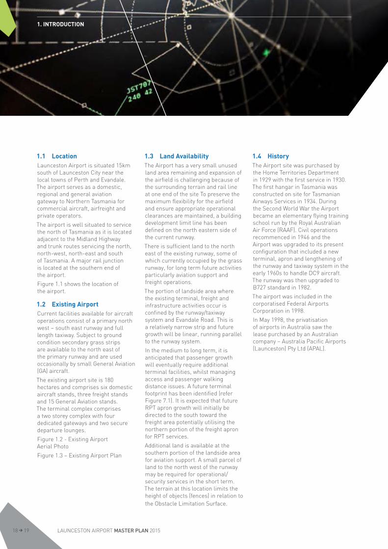
1.1 LocationLaunceston Airport is situated 15km south of Launceston City near the local towns of Perth and Evandale. The airport serves as a domestic, regional and general aviation gateway to Northern Tasmania for commercial aircraft, airfreight and private operators.
The airport is well situated to service the north of Tasmania as it is located adjacent to the Midland Highway and trunk routes servicing the north, north-west, north-east and south of Tasmania. A major rail junction is located at the southern end of the airport.
Figure 1.1 shows the location of the airport.
1.2 Existing AirportCurrent facilities available for aircraft operations consist of a primary north west – south east runway and full length taxiway. Subject to ground condition secondary grass strips are available to the north east of the primary runway and are used occasionally by small General Aviation (GA) aircraft.
The existing airport site is 180 hectares and comprises six domestic aircraft stands, three freight stands and 15 General Aviation stands. The terminal complex comprises a two storey complex with four dedicated gateways and two secure departure lounges.
Figure 1.2 - Existing Airport Aerial Photo
Figure 1.3 – Existing Airport Plan
1.3 Land AvailabilityThe Airport has a very small unused land area remaining and expansion of the airfield is challenging because of the surrounding terrain and rail line at one end of the site To preserve the maximum flexibility for the airfield and ensure appropriate operational clearances are maintained, a building development limit line has been defined on the north eastern side of the current runway.
There is sufficient land to the north east of the existing runway, some of which currently occupied by the grass runway, for long term future activities particularly aviation support and freight operations.
The portion of landside area where the existing terminal, freight and infrastructure activities occur is confined by the runway/taxiway system and Evandale Road. This is a relatively narrow strip and future growth will be linear, running parallel to the runway system.
In the medium to long term, it is anticipated that passenger growth will eventually require additional terminal facilities, whilst managing access and passenger walking distance issues. A future terminal footprint has been identified (refer Figure 7.1). It is expected that future RPT apron growth will initially be directed to the south toward the freight area potentially utilising the northern portion of the freight apron for RPT services.
Additional land is available at the southern portion of the landside area for aviation support. A small parcel of land to the north west of the runway may be required for operational/security services in the short term. The terrain at this location limits the height of objects (fences) in relation to the Obstacle Limitation Surface.
1.4 HistoryThe Airport site was purchased by the Home Territories Department in 1929 with the first service in 1930. The first hangar in Tasmania was constructed on site for Tasmanian Airways Services in 1934. During the Second World War the Airport became an elementary flying training school run by the Royal Australian Air Force (RAAF). Civil operations recommenced in 1946 and the Airport was upgraded to its present configuration that included a new terminal, apron and lengthening of the runway and taxiway system in the early 1960s to handle DC9 aircraft. The runway was then upgraded to B727 standard in 1982.
The airport was included in the corporatised Federal Airports Corporation in 1998.
In May 1998, the privatisation of airports in Australia saw the lease purchased by an Australian company – Australia Pacific Airports (Launceston) Pty Ltd (APAL).
1. INTRODUCTION
LAUNCESTON AIRPORT MASTER PLAN 201518 19

MA
STER
PLA
N 2
015
FIG
UR
E 1.
1LO
CAT
ION
PLA
N
This
pla
n ha
s be
en p
repa
red
to il
lust
rate
the
Mas
ter
Pla
n an
d is
not
inte
nded
to s
erve
any
oth
er p
urpo
se

MA
STER
PLA
N 2
015
FIG
UR
E 1.
2EX
ISTI
NG
AIR
PO
RT
AER
IAL
PH
OTO
This
pla
n ha
s be
en p
repa
red
to il
lust
rate
the
Mas
ter
Pla
n an
d is
not
inte
nded
to s
erve
any
oth
er p
urpo
se
LAUNCESTON AIRPORT MASTER PLAN 201520 21

MA
STER
PLA
N 2
015
FIG
UR
E 1.
3EX
ISTI
NG
AIR
PO
RT
PLA
N
This
pla
n ha
s be
en p
repa
red
to il
lust
rate
the
Mas
ter
Pla
n an
d is
not
inte
nded
to s
erve
any
oth
er p
urpo
se

1.5 Statutory Framework
1.5.1 Airports Act 1996
In preparing this Master Plan, Launceston Airport has addressed the requirements under section 71 of the Airports Act 1996 which requires the Master Plan to provide ‘the airport – lessee company’s assessment of the future needs of civil aviation users of the airport, and other users of the airport, for services and facilities relating to the airport’. A program was established for extensive consultation with a wide range of industry stakeholders and representatives from Federal, State and Local Government.
Launceston Airport is situated on land largely owned by the Commonwealth Government and is subject to Commonwealth legislation to regulate both its own business operations and those of business operators, including airlines, tenants and retailers. The Airports Act 1996 (Airports Act) is the primary legislative instrument governing the airport’s operation, planning and development. The Airports Act and associated regulations are the statutory controls for ongoing regulation of aeronautical and non-aeronautical activities on airport land.
As part of the planning framework, the Airports Act requires APAL, as lessee of the airport, to prepare a Master Plan setting out a 20-year strategic vision for the growth of airport activities and site development every five years.
The Master Plan must include an Environment Strategy and Ground Transport Plan. Section 70 (2) of the Airports Act states that the Master Plan’s purpose is to:
a. establish the strategic direction for efficient and economic development at the airport over the planning period of the plan
b. provide for the development of additional uses of the airport site
c. indicate to the public the intended uses of the airport site
d. reduce potential conflicts between users of the airport site, and to ensure that use of the airport site is compatible with the areas surrounding the airport
e. ensure that all operations at the airport are undertaken in accordance with relevant environmental legislation and standards
f. establish a framework for assessing compliance with relevant environmental legislation and standards
g. promote the continual improvement of environmental management at the airport.
Section 71 of the Airports Act specifies the matters that must be set out in a Master Plan. Among other things, the Master Plan must provide details of future land use plans, proposed developments, noise impacts and environmental management.
This Master Plan has been prepared in accordance with the requirements of the Airports Act.
1.5.2 Environment Protection and Biodiversity Conservation Act 1999
Launceston Airport must comply with the Environment Protection and Biodiversity Conservation Act 1999 (the EPBC Act). This legislation is particularly relevant to airport Master Plans due to its requirements for managing significant flora and fauna species.
1.5.3 State Legislation
Launceston Airport must also comply with state environmental legislation to the extent that its activities impact surrounding Tasmanian land and waterways. The principal legislation is the Environmental Management and Pollution Control Act 1994 (Tasmania). This applies to receiving bodies of stormwater, waste, ground vehicle emissions and hazardous materials.
State planning laws do not apply to the airport site. However, regulations made under the Airports Act require the Master Plan, where possible, to describe proposals for land use planning and zoning in a format consistent with that used by the state or territory in which the airport is located. Where possible, this Master Plan has considered state planning requirements and has used zones, overlays and other planning provisions derived from the Tasmanian Planning Provisions.
1.5.4 Airport Lease
Under the provisions of the Airports Act, APAL is the ‘airport-lessee company’ for Launceston Airport. APAL is responsible for managing the airport for 50 years to 2047, with an option to extend this lease by a further 49 years to 2096. It manages the entire airport site, including the airside, terminal and landside precincts, the road network and associated service infrastructure.
APAL is also required to develop Launceston Airport, taking into account anticipated traffic demand to the quality standards reasonably expected of a major regional airport in Australia and good business practice.
To meet its obligations under the lease, APAL has been responsible for a number of major developments, including a major redevelopment of the terminal building, complete replacement of the airfield lighting system, construction of increased heavy freight aprons and freight handling facilities.
1. INTRODUCTION
LAUNCESTON AIRPORT MASTER PLAN 201522 23

1.6 Previous Studies, Strategies and Plans
1.6.1 Launceston Airport Master Plan 1990
In response to long range traffic forecasts covering the period 1990 to 2011, the airport’s previous owner (the Federal Airports Corporation) and State and Local Government jointly developed a long term strategy for the airport’s development and management.
The Launceston Airport Master Plan 1990 provided a broad framework for orderly airport development, road access and external land use control to protect the 24 hour curfew free operation of the airport. A key feature of the plan was the reservation of land for General Aviation and operational support on the northern section beyond the main runway and reservation of freight to the north western landside area.
1.6.2 Launceston Airport Master Plan 1999
The 1999 Master Plan reviewed the land use zoning plans renaming the previous General Aviation and operational support zones north of the runway to Future Development beyond Planning Horizon.
The North Western freight zone was divided to incorporate the existing Bureau of Meteorology facilities.
The Obstacle Limitation Surface (OLS) and Prescribed Airspace future layouts were introduced to help secure the protected airspace and assist in managing residential development in the approach paths off airport.
The airports land zoning was incorporated into the Northern Midlands Council’s Planning Scheme 1995 model which adopted its format.
1.6.3 Launceston Airport Master Plan 2004
The 2004 Master Plan was consistent with the 1999 Master Plan and included an update of the ANEF Ultimate Capacity model and passenger / movements forecast.
Zoning changes in the 2004 Master Plan included the removal of a future reserve area to the North of the runway and a revision of the freight reserve to encompass the Meteorological facilities.
1.6.4 Launceston Airport Master Plan 2009
The 2009 Master Plan considered and addressed the impacts of significant growth at the airport and the pressures this had placed on existing infrastructure, particularly the terminal facilities. The developments included:
Additional gate lounges; Expansion of ground floor level public lounges;
Additional check-in and Checked Bag Screening facilities;
Provision for a second passenger screening point; and
Upgrade of the terminal infrastructure as demand required
Airside developments included: Provision for future aprons and taxiways to service the growth in aircraft movements and long term freight objectives
A staged upgrade of the southern freight apron to extend the high strength (80,000kg) apron; and a decision to decommission the parallel grass runway.
An airfield capacity study was conducted which informed the production of a Practical Capacity ANEF for the purpose of noise modelling.
1.7 Significant Developments since the 2009 Master Plan
There have been significant development and improvements at Launceston Airport. Around $35 million has been invested in expanding the airport facilities since the 2009 Master Plan. The following list identifies the major items:
Finalisation of the $20 million terminal redevelopment during 2010
Redevelopment of Hangar 14 into a dedicated freight facility
Installation of a new airfield lighting system including approach lighting
Installation of slope guidance system (PAPI) and runway guard lighting
Replacement of ageing concrete pavements on taxiway alpha
Construction of two high strength aircraft parking bays on the southern apron
Commenced construction of a new main entrance exit roadway including new staff and public parking and facilities for commercial vehicles.
1. INTRODUCTION
1.8 Planning ApproachIn preparing this Master Plan, Launceston Airport has reviewed previous plans and reassessed the location and spatial requirements for land use and development needed to cater for the forecast growth in airport activity over the next 20 years. Long-term requirements beyond 20 years have also been reconsidered.
The triggers for each development proposal will depend on actual rates of growth in demand and commercial considerations of Launceston Airport and its customers. All major airport developments will be planned and developed in consultation with relevant stakeholders and, at a minimum with relevant statutory requirements.
For the landside part of the airport, the regulations associated with the Airports Act require that proposals for land use and related planning be described using State legislation planning terminology. Proposals for airport landside use have been set out in a format consistent with the Northern Midlands Interim Planning Scheme 2013.
A key focus of these reviews was to ensure that future development planning adequately accommodates forecast growth projections, safeguards the implementation of infrastructure requirements, and manages environmental and off-site impacts. The safe and efficient integration of the various airside, terminal and landside access and commercial requirements, and maintaining the airport’s 24-hour curfew-free status, remain key considerations.
The planning approach also considered all on-airport interests that existed at the date the lease was granted, including easements, licences and leases. It also considered off-airport land use issues such as local planning schemes.
These reviews were undertaken in consultation with Commonwealth and State Government departments and agencies, local government, industry partners and other external stakeholders.
1.9 Concept PlansThe primary approach of master planning for Launceston Airport is to establish a medium and long term strategy for the Airport site to fully realise the Airport’s potential as the northern gateway for passengers and freight.
This Master Plan presents concepts for developing the airport site for the next five years and up to 20 years. Proposals for land use and development in response to forecast growth during this concept plan periods (refer to Figures 1.4), and are described in more detail below. Note that the future growth in traffic demand levels and the changing commercial needs of Launceston Airport’s customers will determine the exact extent and timing of particular projects.
The key objective is to efficiently use and develop the site for operational purposes and associated commercial activities in an environmentally sustainable manner as outline in the Launceston Airport Environment Strategy, refer to Section 11.
1.9.1 0 -5 Year Master Plan Concept
The short-term Master Plan concept provides the proposed land use and development for the next five years to 2020, within the context of the 20 year vision for Launceston Airport.
The terminal precinct development aims to enhance passenger handling and processing capacity by increasing the public, retail and gate lounge areas of the building. The proposed expansion will not increase the current footprint of the terminal or impact operational areas.
Self-service technology and dynamic signage and way-finding will be progressively rolled out inside the terminal.
Airfield developments include the utilisation of an RPT standoff bay when operations are constrained on the main RPT apron. The grass runways will remain closed until such time as an operational review indicates a change to their status is required. In the short term air freight facilities will continued to be developed on the southern apron.
Completion of the new airport entrance road, car parks and associated ground transport infrastructure will improve ground transport efficiency and safety while ensuring sufficient capacity over the next 5 years.
1. INTRODUCTION
LAUNCESTON AIRPORT MASTER PLAN 201524 25

1.9.2 20 Year Master Plan Concept
The medium- long term concept (refer to Figure 1.5) provides a snapshot of land use and development in 2035, again within the context of the vision for Launceston Airport.
Key features include : Provision for terminal expansion Identification of RPT apron expansion areas
Reservation of land on the east of the airport for freight and operational support
Relocation of G A facilities to the south of the freight apron
Identification of areas available for non-aviation development.
1.10 Key Differences from the 2009 Master Plan
The following list indicates the key differences between the 2009 and the 2015 Master Plans
Ground Transport Plan, for the first time included as a specific element of the Master Plan
Environment Strategy, for the first time incorporated into the Master Plan
Australian Noise Exposure Forecast, an updated Long Range noise forecast and the inclusion of noise N Contours
Terminal Expansion Precinct, the creation of a precinct to protect the requirements of terminal expansion.

MA
STER
PLA
N 2
015
FIG
UR
E 1.
4LA
UN
CES
TON
BU
ILD
ING
NU
MB
ERS
PLA
N
This
pla
n ha
s be
en p
repa
red
to il
lust
rate
the
Mas
ter
Pla
n an
d is
not
inte
nded
to s
erve
any
oth
er p
urpo
se
26 27

MA
STER
PLA
N 2
015
FIG
UR
E 1.
5FU
TUR
E A
IRP
OR
T D
EVEL
OP
MEN
T P
LAN
This
pla
n ha
s be
en p
repa
red
to il
lust
rate
the
Mas
ter
Pla
n an
d is
not
inte
nded
to s
erve
any
oth
er p
urpo
se

2.1 Overview 292.1.1 Regional context 292.1.2 The role of regional airports
in a regional economy 29
2.2 Economic Impacts 30
2.3 Social Impacts 31
2.4 Conclusion 31
2. ECONOMIC AND SOCIAL IMPACTS
28 29 LAUNCESTON AIRPORT MASTER PLAN 2015

2.1 Overview
2.1.1 Regional context
Northern Tasmania is the second largest region in Tasmania. It hosts approximately 28% of the state’s population (143,582 persons in 2012) and produces one third of state’s domestic product. The area of Northern Tasmania aligns with the areas of the eight Northern Tasmanian Councils: Break O’ Day, Dorset, Flinders, George Town, Launceston City, West Tamar, Meander Valley and Northern Midlands.
In terms of value added, Northern Tasmania’s dominant industry sectors include manufacturing; rental, hiring and real estate services; financial and insurance services; health care and social assistance; and wholesale trade. Its highest employing areas are health care and social assistance, retail, construction, education and training, and agriculture, forestry and fishing.
Northern Tasmania boasts an enviable mix of assets, including a deep water port, the largest industrial area in the state, a major regional airport, university, 300-bed public hospital, significant banking and financial services, recognised tourist destination and gateway, sustained population growth (including net growth from interstate migration) and diverse landscapes, coastal areas and tourist products. Beyond the five mainland capital cities, this combination of assets is only held by a handful of Australian regions.
Of all the state’s regions, Northern Tasmania is best placed in terms of location, proximity and infrastructure capacity to link with the rest of Australia. This is particularly advantageous given the region’s proximity to south east Australia, being the source of concentrated skilled employment, residence to two thirds of the Australian population and regarded as the ‘engine room’ of the national economy.
2.1.2 The role of regional airports in a regional economy
Airports play an enabler role for personal, commuting and tourism related movement. Regional airports such as Launceston Airport also provide their catchment areas with access to major cities and other major regional centres for roles as diverse as access to community services, higher-tier health services and the facilitation of mail and time-sensitive freight deliveries. While air freight represents less than one per cent of Australia’s trade by volume, it is generally comprised of high-value and time sensitive exports and imports that make up over 20% of trade (over $100 billion) by value.
Launceston Airport also enables commuting of higher paid professionals to work in Launceston. It also enables Fly-in Fly-out (FIFO) commuter arrangements which have been increasingly popular in the last five years, particularly as the resources boom has necessitated the ‘import’ of workers from urban centres. In 2011, approximately half of the 90,000 people employed in the Western Australian mining industry participated in FIFO arrangements, living in a city and flying to a remote workplace during their work roster.
Launceston Airport also facilitates border protection services where quarantine restrictions apply where passengers are entering key agricultural areas. The Airport provides for the safe disposal of offending materials and the quarantine services to render them safe to bring into the region.
2. ECONOMIC AND SOCIAL IMPACTS
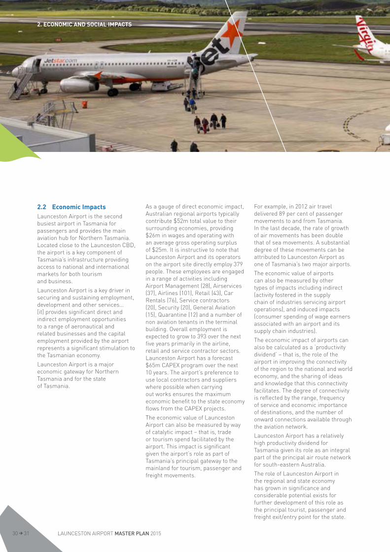
2.2 Economic ImpactsLaunceston Airport is the second busiest airport in Tasmania for passengers and provides the main aviation hub for Northern Tasmania. Located close to the Launceston CBD, the airport is a key component of Tasmania’s infrastructure providing access to national and international markets for both tourism and business.
Launceston Airport is a key driver in securing and sustaining employment, development and other services…[it] provides significant direct and indirect employment opportunities to a range of aeronautical and related businesses and the capital employment provided by the airport represents a significant stimulation to the Tasmanian economy.
Launceston Airport is a major economic gateway for Northern Tasmania and for the state of Tasmania.
As a gauge of direct economic impact, Australian regional airports typically contribute $52m total value to their surrounding economies, providing $26m in wages and operating with an average gross operating surplus of $25m. It is instructive to note that Launceston Airport and its operators on the airport site directly employ 379 people. These employees are engaged in a range of activities including Airport Management (28), Airservices (37), Airlines (101), Retail (43), Car Rentals (76), Service contractors (20), Security (20), General Aviation (15), Quarantine (12) and a number of non aviation tenants in the terminal building. Overall employment is expected to grow to 393 over the next five years primarily in the airline, retail and service contractor sectors. Launceston Airport has a forecast $65m CAPEX program over the next 10 years. The airport’s preference to use local contractors and suppliers where possible when carrying out works ensures the maximum economic benefit to the state economy flows from the CAPEX projects.
The economic value of Launceston Airport can also be measured by way of catalytic impact – that is, trade or tourism spend facilitated by the airport. This impact is significant given the airport’s role as part of Tasmania’s principal gateway to the mainland for tourism, passenger and freight movements.
For example, in 2012 air travel delivered 89 per cent of passenger movements to and from Tasmania. In the last decade, the rate of growth of air movements has been double that of sea movements. A substantial degree of these movements can be attributed to Launceston Airport as one of Tasmania’s two major airports.
The economic value of airports can also be measured by other types of impacts including indirect (activity fostered in the supply chain of industries servicing airport operations), and induced impacts (consumer spending of wage earners associated with an airport and its supply chain industries).
The economic impact of airports can also be calculated as a ‘productivity dividend’ – that is, the role of the airport in improving the connectivity of the region to the national and world economy, and the sharing of ideas and knowledge that this connectivity facilitates. The degree of connectivity is reflected by the range, frequency of service and economic importance of destinations, and the number of onward connections available through the aviation network.
Launceston Airport has a relatively high productivity dividend for Tasmania given its role as an integral part of the principal air route network for south-eastern Australia.
The role of Launceston Airport in the regional and state economy has grown in significance and considerable potential exists for further development of this role as the principal tourist, passenger and freight exit/entry point for the state.
2. ECONOMIC AND SOCIAL IMPACTS
LAUNCESTON AIRPORT MASTER PLAN 201530 31
Tasmanians have identified that tourism is the industry sector offering the greatest opportunity for Tasmania’s future. In 2014, 15700 Tasmanians were directly employed by the tourism industry and another 15,000 were reliant on the economic activity generated by tourism.
In the electorates of Bass and Lyons, surrounding Launceston Airport, 6000 people or around 7 percent of the workforce are directly employed in tourism. Tasmania needs a strong tourism industry and Launceston Airport is a key contributer in maintaining and growing this industry which is vital to both the regional and state economies.
The airport also provides a range of facilities and office accommodation to ancillary businesses which although not directly related to the aviation sector are attracted to the benefits of operating in an environment which has excellent connectivity and logistics links.
Large, flat open sites are available adjacent to the airport with direct access to the Hobart-Launceston Highway and close to rail main lines offering significant development potential as the state’s major air freight gateway and storage-handling facility. Further investment in infrastructure in key locations and into increasing critical capacity will have benefits across the whole region and strengthen the whole Tasmanian economy.
2.3 Social ImpactsLaunceston Airport assists in maintaining the community’s liveability and is important for the productivity, profitability and investment in the region.
[Its] engagement with the community benefits a range of local charitable causes and cultural activities including sponsorship of the Glover Prize, one of Australia’s premier landscape art awards.
Transport is the lifeline of the region, as it is for the whole of Tasmania.
Launceston Airport represents social infrastructure of regional and state significance. It adds to the physical and social capital that makes the region an attractive place to live, work and visit.
Invariably the Airport’s primary social value is that of access. Key access drivers include tourism, freight, business travel, events and conferences, education (student arrivals, family support visits and future tourism), sporting and cultural events, and visiting friends and relatives.
The societal value of access in a regional area such as Northern Tasmania is many and varied; it enhances the region’s liveability in that affordable and easily accessible air access is available to quickly and efficiently make journeys from Tasmania; it broadens residents’ leisure and cultural experience; it affords residents the opportunity to live a regional lifestyle whilst remaining in contact with family and friends outside Tasmania; and it facilitates regular two-way travel for residents to visit inter-state and for friends/family to visit Tasmania.
2.4 ConclusionLaunceston Airport is a significant economic and social contributor to both the Northern Region and the State of Tasmania as a whole. While the inputs from direct employment and capital expenditure are substantial in a local context, the wider contribution in the facilitation of tourism, trade and connection of the community to mainland Australia is vital to the social and economic health and development of the region and the Tasmania as a whole.
2. ECONOMIC AND SOCIAL IMPACTS

3. MASTER PLAN PROCESS
3.1 Overview 33
3.2 Previous Planning and Consultation 33
3.3 Reviews and Studies 33
3.4 Development of Future Plans, Strategies and Concepts 34
3.5 Community and Stakeholder Consultation 34
3.6 Public Exhibition 34
3.7 Comments and Submissions 35
3.8 Submission to Minister 35
3.9 Publication of Final Master Plan 35
3. MASTER PLAN PROCESS
LAUNCESTON AIRPORT MASTER PLAN 201532 33
3. MASTER PLAN PROCESS
3.1 OverviewThis Master Plan establishes the short, medium and long term planning concepts for Launceston Airport to fully realise its potential as a domestic gateway and hub for passengers and freight, and to safeguard its future operations.
One of APAL’s overarching objectives is to efficiently and sustainably use and develop the airport site. This involves balancing the need to maintain and expand aviation facilities safely and effectively with achieving an acceptable commercial return to shareholders. It is also important that future plans continue to consider the interests of stakeholders and the community.
3.2 Previous Planning and Consultation
Early planning and public consultation commenced with the 1990 Master Plan under the FAC. This required extensive consultation with airlines, State and Local Government as well as a full public consultation process.
Further Master Plans were undertaken as part of the requirements of the Regulations associated with the Airports Act. These included the 1999, 2004, 2009 Master Plans. The consultation was conducted in accordance with the provisions of the Airports Act applicable at the time.
Over the period of the 2009 Master Plan, APAL has: Liaised with Commonwealth Government departments and agencies including the Department of Infrastructure and Regional Development, Airservices and the Civil Aviation Safety Authority;
Liaised with State Government including DIER and the Tasmanian Planning Commission
Liaised with Local Government including the Northern Midlands, Launceston City, West Tamar, Meander Valley and Flinders Island Councils;
Consulted with airlines on developing aviation infrastructure; Introduced the Launceston Airport Community Aviation Consultation Group; and
Engaged with Chamber of Commerce and other business and service associations
3.3 Reviews and StudiesThe first stage in the preparation of this Master Plan involved a number of planning reviews and studies to inform the development of the Master Plan concepts.
The Master Plan concepts were developed based on a number of drivers, including passenger, aircraft movement and freight forecasts, and specialist studies examining the airfield, terminals and landside capacity for ongoing growth and development. These studies also informed the timing of the developments and capacity enhancement activities.
Specific planning reviews and studies that informed the Master Plan included a capacity study, aircraft noise forecasts, traffic impact assessment, runway usability study, ecological assessment and heritage management plan.
3. MASTER PLAN PROCESS
3.4 Development of Future Plans, Strategies and Concepts
A series of future land use and facility development plans and management strategies were developed based on the outcomes of the above reviews and studies. Details of these plans and strategies are provided in Sections 5-12 of this Master Plan.
When developing future plans and strategies, a key focus was to ensure that planning for the airport’s future development adequately accommodated forecast growth projections and safeguards the future implementation of related infrastructure requirements, while ensuring that environmental and off-site impacts were minimised where possible.
The key concepts and requirements arising from the plans and strategies were then encapsulated in the concept plan previously outlined in Section 1 and Figure 1.5.
3.5 Community and Stakeholder Consultation
During the preparation of this Master Plan, Launceston Airport established a formal consultation program with a wide range of government, industry and community representatives. This consultation was critical in developing the various Master Plan elements.
The consultation process included initial correspondence to key stakeholders, State and Local Governments, airlines, industry, neighbours and tourist groups advising that the 2009 Master Plan was being reviewed and requesting input into the development process and outlining the review process.
Launceston Airport conducted Customer Service Satisfaction Surveys and held public ground transport focus meetings to inform the planning process.
Launceston Airport held meetings and discussions with the following:
airlines Airport Building Controller Airport Environment Officer Airservices Civil Aviation Safety Authority Commonwealth Government officers
Community Aviation Consultation Group
general community industry groups local government state government.
3.6 Public ExhibitionPrior to releasing the Preliminary Draft Master Plan for public consultation, Launceston Airport is required to advise, in writing, the following persons of the Preliminary Draft Master Plan:
a. the Minister, of the State in which the airport is situated, with responsibility for town planning or use of land;
b. the authority of that State with responsibility for town planning or use of land;
c. each local government body with responsibility for an area surrounding the airport.
In accordance with Section 79 of the Airports Act, the Preliminary Draft Master Plan will be publicly exhibited for 60 business days. Newspaper notices will be published inviting members of the public to make written comments about the proposed Master Plan.
The Preliminary Draft will be available for viewing from October 27, 2014 until January 30, 2015:
The Launceston Airport website www.launcestonairport.com.au
In person at Launceston Airport, 201 Evandale Rd, Western Junction Tasmania
The Northern Midlands Council and Launceston City Council Offices
The public exhibition period runs for 60 business days, commencing October 27, 2014.
Comments can be submitted to Launceston Airport by:
Planning Manager PO Box 1220 Launceston Tasmania, Australia, 7250
3. MASTER PLAN PROCESS
LAUNCESTON AIRPORT MASTER PLAN 201534 35
3.7 Comments and SubmissionsUnder the Airports Act, Launceston Airport must consider any comments received during the public exhibition period. After the public exhibition period, Launceston Airport will review and assess all comments and, if appropriate, changes may be made to the Master Plan to address those comments.
All formal submissions must include a name and address of the submitter.
Comments posted on social media such as Facebook or Twitter will not be tracked as formal submissions.
3.8 Submission to MinisterAfter the comments have been reviewed, the Draft Master Plan will be submitted to the Commonwealth Minister for Infrastructure and Transport for approval.
The submission to the Minister must be accompanied by various documents, including:
Copies of comments received from members of the public;
A written certificate signed on behalf of the airport containing:• A list of names of the people
or organisations that provided written comments to the Preliminary Draft Master Plan
• A summary of the comments received
• Evidence that Launceston Airport has given due to regard to those comments.
3.9 Publication of Final Master Plan
In accordance with Section 86 of the Airports Act, Launceston Airport will undertake the following notifications upon approval of the Draft Master Plan:
Publish newspaper notices advising that the Master Plan has been approved.
Make copies of the plan available for inspection in person at Launceston Airport.
Make a copy of the approved Master Plan available on the Launceston Airport website.
The final Master Plan will also be disseminated to sub-lessees, licensees, other airport users and local communities through a range of stakeholder engagement mechanisms including the Launceston Airport website and Community Aviation Consultation Group.
3. MASTER PLAN PROCESS

3. MASTER PLAN PROCESS
4.1 Overview 37
4.2 Policy Framework 374.2.1 National Airports Safeguarding Framework 374.2.2 Northern Midlands Interim
Planning Scheme 2013 384.2.3 Greater Launceston Plan 39
4.3 Development Objectives 39
4.4 Development Drivers 40
4.5 Growth Forecasts 424.5.1 Historical Air Traffic Performance 424.5.2 Passenger Movement Forecast 434.5.3 Aircraft Movement Forecast 434.5.4 Freight 43
4.6 Planning Criteria 444.6.1 Airside 444.6.2 Terminal Facilities 444.6.3 Landside Land Use and Development 454.6.4 Airport Roads 45
4. PLANNING CONTEXT
36 37 LAUNCESTON AIRPORT MASTER PLAN 2015

4.1 OverviewThis section outlines the planning context for the Master Plan. The planning context comprises a number of aspects that influence and guide future use and development at Launceston Airport. This context also forms the basis of the Master Plan’s strategic directions and concepts. They are:
The policy framework Launceston Airport’s development objectives Global, national and local development drivers Growth forecasts Planning criteria and standards.
In implementing the Master Plan, relevant policies at Commonwealth, State and local levels will be taken into consideration.
4.2 Policy Framework
4.2.1 National Airports Safeguarding Framework
The National Airports Safeguarding Framework (NASF) is a national land use planning framework that aims to:
improve community amenity by minimising aircraft noise-sensitive developments near airports including through the use of additional noise metrics and improved noise-disclosure mechanisms; and
improve safety outcomes by ensuring aviation safety requirements are recognised in land use planning decisions through guidelines being adopted by jurisdictions on various safety-related issues.
The National Airport Safeguarding Advisory Group (NASAG), comprising high-level Commonwealth, State, Territory and local government transport and planning officials, was formed to develop a National Airports Safeguarding Framework.
In February–March 2012, industry, local government and other interested stakeholders were invited to comment on a draft version of the NASF, which comprised several guidelines relating to particular airport safeguarding topics (refer to Section 12.4.1 for details).
Commonwealth, State and Territory ministers subsequently agreed to the NASF at the Standing Council on Transport and Infrastructure meeting on 18 May 2012, noting the Australian Government’s intention to seek a review by Standards Australia of Australian Standard AS2021–2000: Acoustics Noise Intrusion – Building Siting and Construction.
The NASF, when fully implemented, will help ensure that existing and future airport operations and their economic viability are not constrained by incompatible development.
It is the responsibility of each State jurisdiction to implement the NASF in their respective planning systems.
3. MASTER PLAN PROCESS
4. PLANNING CONTEXT
4.2.2 Northern Midlands Interim Planning Scheme 2013
The preparation of this Master Plan has been sensitive to the State of Tasmania planning policies and has used zones, overlays and other planning provisions derived from the Tasmanian Planning provisions in particular the Northern Midlands Planning Scheme 2013 (Interim).
The Northern Midlands Planning Scheme (the Planning Scheme) provides only brief coverage of Launceston Airport, partly because the land is owned by the Commonwealth. In section 2.2.2.7, a stated objective is to:
protect Launceston Airport from encroachment by incompatible uses or developments that compromise its operations in recognition of its importance and contribution to the Launceston Region and State economy.
Further in Scheme there is content in E Codes: E12 Airports Impact Management Code.
The purpose of this code is to:
a. ensure that use or development within identified areas surrounding airports does not unduly restrict the ongoing security, development and use of airport infrastructure; and
b. provide for management of the land use implications of those areas relevant to use and development under the scheme.
The code further stipulates the land use standards, in terms of noise impacts and development standards, in terms of obstacles to aircraft.
The Planning Scheme does detail in Section F 1.4, height requirements of buildings, lighting requirements, and environmental quality protection to ensure the safety of Launceston Airport.
Under the Scheme, the Airport is designated as a Part Eight, Utilities Zone (U). The area immediately surrounding the Airport is zoned either Rural, or to the west beyond Evandale Road, either “Western Junction Industrial and Commercial” or “Industrial” which includes the TRANSlink Industrial Zone.
The strategies set out for each zone under the Northern Midlands Planning Scheme address a range of matters including land use, impact on adjacent zones, landscaping, access and parking and design and these are considered by Launceston Airport, even though they don’t apply to the airport site.
4. PLANNING CONTEXT
38 39 LAUNCESTON AIRPORT MASTER PLAN 2015

4.2.3 Greater Launceston Plan
The Greater Launceston Plan (GLP) is a community, visioning and resource based strategy for a sustainable settlement and transport plan to best guide the greater Launceston area over the next thirty years and beyond. It comprises of a number of component projects. These are set out below with principal outcomes included for each of the projects.
1. Transport projects
2. Greater Launceston Plan – Context and strategic directions
3. Greater Launceston Resource Analysis
4. Greater Launceston Community Statement
5. Greater Launceston Visioning and Community Review
6. Launceston Central Area Development Strategy
7. Kings Meadows Precinct Plan
8. Mowbray Precinct Plan
The GLP reflects the aspirations of the residents for the development of Launceston and the surrounding communities.
Based on the communities input, the draft GLP provides a long-term strategy for sustainable land use planning and management to inform a coordinated approach for municipal planning and investment in the greater Launceston area.
Section 5 of this Master Plan details the linkages between the local planning scheme and the airport land use plans and describes the manner in which a consistent land use planning approach is achieved.
4.3 Development ObjectivesUnder Section 71 (2)(a) of the Airports Act, APAL is required to outline its development objectives for Launceston Airport, which are to:
Ensure future developments provide and maintain a safe, secure, efficient and environmentally sustainable framework;
Deliver economic and social benefits to shareholders, the local community and Tasmania as a whole through sustainable long term growth and investment;
Remain the Northern gateway to Tasmania; Attract a range of investments that maximise the growth in shareholder value commensurate with risk;
Ensure developments meet all regulatory standards, are consistent with the requirements of the Master Plan and, the Airport’s role as a specialised Utility Service under the 2013 Northern Midlands Interim Planning Scheme;
Provide timely, cost-efficient and appropriately financed infrastructure; Seek and be sensitive to the expectations of our industry, Government and community stakeholders in relation to planning and environmental aspects;
Ensure public facilities provide a high level of customer service and minimise disruptions;
Fully integrate environmental considerations into airport facilities and development;
Work with the neighbouring municipalities to optimise Airport development and ensure off-Airport developments impact positively on the Airport’s long term growth;
Provide a business environment which allows our business partners to develop and grow their businesses in accordance with their objectives;
Pursue flexibility in facilities and development to cope with changing circumstances;
Enhance the flow of passengers and freight through the Airport and strive towards achieving a reputation as an efficient, delay free Airport;
Maximise the use of existing infrastructure to ensure new facilities are introduced in an economically effective way; and
Proactively work with airlines to encourage growth and flexibility with scheduling and new routes.
4. PLANNING CONTEXT

4.4 Development DriversLaunceston Airport’s development is underpinned by the current and forecast number of passenger trips, aircraft movements and air freight volumes. These aviation traffic measures are driven by a range of global, national and local drivers.
The aviation traffic forecasts discussed below prepared for this Master Plan are based on econometric modelling techniques that analyse the relationship between multiple development drivers and aviation traffic measures. The development drivers can be summarised in the following areas:
Scenarios are built around different assumptions relating to the passenger traffic drivers. Central scenarios assume:
The Australian economy is expected to recover from its current below-trend levels with growth to average 2.9% over the decade to 2024 and 2.6% for the decade from 2024 to 2034.
Tasmanian GSP is assumed to grow at an average 2.1% per year over the next decade and to average 2.0% each year for the decade to 2034.
Population is expected to average between 0.4% and 0.6% growth per year for both Tasmania and Launceston.
Recent losses announced by Australia’s two main airline groups, Qantas and Virgin Australia suggest that it is likely that capacity growth will slow over the next couple of years. However, as new aircraft arrive and the Australian economy recovers, capacity growth is expected to continue at trend rates.
Continuing high oil prices and an expected fall in value of the Australian dollar are likely to put upwards pressure on air fares into the longer term.
Economic assumptions have been derived from data published by Deloitte Access Economics.
4. PLANNING CONTEXT
LAUNCESTON AIRPORT MASTER PLAN 201540 41


4.5 Growth Forecasts
4.5.1 Historical Air Traffic Performance
The planning for aviation-related facilities (runways, terminals and transport linkages) in the Master Plan is based on a range of factors, including aviation forecast traffic growth.
Graph 4.1 (right) shows the annual changes in passenger volumes for Launceston Airport over the period from 1994/95 to 2012/13. During this period passenger numbers increased from close to 554,000 to 1.2 million (at a compound annual growth rate of 4.5%).
The key drivers of passenger growth include:
Tasmanian and Australian economic performance (measured by Gross State Product, GSP, Gross Domestic Product, GDP);
Population growth; Airline capacity and airfare movements; and
Reduction in airfares and increased airline competition
A number of significant airline/capacity developments influenced the periods of growth and decline shown in Graph 4.1 which can be attributed to:
The period from 1997 through to 2002 represented a period of tight capacity and the collapse of Ansett in 2001.
The introduction of Low Cost Carrier (LCC) capacity into Launceston with Virgin Australia in 2001 was followed by the addition of further LCC capacity with the introduction of Jetstar services in 2004. Tiger Airways also operated between November 2007 and August 2010.
Qantas introduced jet services in May 2004 replacing QantasLink but this position was reversed from August 2006.
Graph 4.1 Passenger Volumes at Launceston Airport, 1994/95 to 2012/13, Source: Based on BITRE data.
Graph 4.2 Total Annual Passenger Movements
Table 4.1 Total Annual Passenger Movements
YEAR ANNUAL PASSENGERS (MILLIONS)
2015 1,293
2020 1,551
2025 1,848
2035 2,493
0
500
1,000
2015
2016
2017
2018
2019
2020
2021
2022
2023
2024
2025
2026
2027
2028
2029
2030
2031
2032
2033
2034
2035
1,500
2,000
2,500
3,000
PASS
ENG
ER M
OVE
MEN
TS (M
ILLI
ON
S)
YEAR
0-5%
0%
5%
10%
15%
20%
25%
30%
200
400
600
800
1,000
1,200
1,300
1995
1996
1997
1998
1999
2000
2001
2002
2003
2004
2005
2006
2007
2008
2009
2010
2011
2012
PASS
ENG
ERS
(TH
OU
SAN
DS)
Domestic Passenger Movements (Left Axis)
% Annual Change (Right Axis)
LEGEND
AN
NU
AL
CH
AN
GE
IN P
ASS
ENG
ER V
OLU
MES
FINANCIAL YEAR
2013
4. PLANNING CONTEXT
LAUNCESTON AIRPORT MASTER PLAN 201542 43
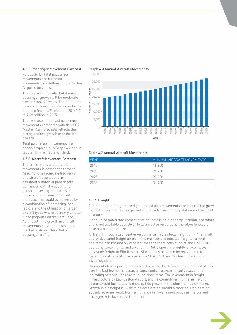
4.5.2 Passenger Movement Forecast
Forecasts for total passenger movements are based on econometric modelling of Launceston Airport’s business.
The forecasts indicate that domestic passenger growth will be moderate over the next 20 years. The number of passenger movements is expected to increase from 1.29 million in 2014/15 to 2.49 million in 2035.
The increase in forecast passenger movements compared with the 2009 Master Plan forecasts reflects the strong positive growth over the last 5 years.
Total passenger movements are shown graphically in Graph 4.2 and in tabular form in Table 4.1 (left).
4.5.3 Aircraft Movement Forecast
The primary driver of aircraft movements is passenger demand. Assumptions regarding frequency and aircraft size lead to an assumed number of passengers per movement. The assumption is that the average numbers of passengers per movement will increase. This could be achieved by a combination of increasing load factors and the utilisation of larger aircraft types where currently smaller turbo propeller aircraft are used. As a result, the growth in aircraft movements serving the passenger market is slower than that of passenger traffic.
Table 4.2 Annual Aircraft Movements
YEAR ANNUAL AIRCRAFT MOVEMENTS
2015 18,800
2020 21,700
2025 27,800
2035 31,400
Graph 4.3 Annual Aircraft Movements
0
5,000
10,000
2015
2016
2017
2018
2019
2020
2021
2022
2023
2024
2025
2026
2027
2028
2029
2030
2031
2032
2033
2034
2035
15,000
20,000
25,000
30,000
35,000
AIR
CR
AFT
MO
VEM
ENTS
YEAR
4. PLANNING CONTEXT
4.5.4 Freight
The numbers of freighter and general aviation movements are assumed to grow modestly over the forecast period in line with growth in population and the local economy.
It should be noted that domestic freight data is held by cargo terminal operators and is not available publicly or to Launceston Airport and therefore forecasts have not been produced.
Airfreight through Launceston Airport is carried as belly freight on RPT aircraft and by dedicated freight aircraft. The number of dedicated freighter aircraft has remained reasonably constant over the years consisting of one B737-300 operating twice nightly and a Fairchild Metro operating nightly on weekdays. Intrastate freight to Flinders and King Islands has been increasing due to the additional capacity provided since Sharp Airlines has been operating into these locations.
Comments from operators indicate that while the demand has remained steady over the last few years, capacity constraints are experienced occasionally indicating potential for growth in the short term. The investment in freight infrastructure by Launceston Airport, and its commitment to the air freight sector should facilitate and develop this growth in the short to medium term. Growth in air freight is likely to be accelerated should a more equitable freight subsidy scheme result from any change in Government policy as the current arrangements favour sea transport.

4.6 Planning CriteriaTo define the Master Plan concepts for the airport’s airside, terminal and landside areas, it was necessary to define and adopt a set of critical planning criteria.
4.6.1 Airside
The term ‘airside’, also referred to as ‘airfield’, covers the runway system, the taxiway/taxilane system, the apron infrastructure and the aircraft parking bays – all areas where operational aircraft movements or handling activities can take place. Airfield infrastructure planning typically incorporates the classification schemes adopted by the International Civil Aviation Organization (ICAO) and the Federal Aviation Administration (FAA). These schemes are based on a two-element reference code for each airport.
The first element of the ICAO code relates to the aircraft reference field length. This is the minimum field length required for a particular aircraft type to take off at its maximum certified take-off weight (MTOW) at sea level, in standard atmospheric conditions, in the absence of wind and using a level runway. The second element of the ICAO code is defined by the most demanding physical characteristics of that particular aircraft type (either its wingspan or the outer main gear wheel span). Noting that the FAA scheme uses different characteristics to define the airport reference code, under both schemes the reference code corresponds to the so-called ‘critical aircraft’ – the most demanding type of aircraft served by a particular airport. Both the ICAO and FAA apply six airframe design group codes. Launceston Airport’s planning criteria is based around the Code C category, which inludes the Airbus A320 and Boeing 737-800.
4.6.2 Terminal Facilities
Terminal facilities planning revolve around two basic principles: design and level of service.
The design of the terminal building aims to balance the often competing interests of different stakeholders, including but not limited to:
passengers, who appreciate efficiency, reliability and convenience;
airlines, which expect the terminal to meet their requirements in terms of product differentiation and cost control;
authorities, which will verify that the facilities comply with all applicable legislative requirements and procedural standards, including building safety, security regulations and border control procedures; and
airport operators, which will need to balance all of the above interests while running the airport business in a commercially viable manner.
In practice, a terminal’s design largely depends on space requirements. The amount of space available for an activity inside the terminal is a good indicator of its level of service. The International Air Transport Association (IATA) has published generally accepted standards that help inform terminal design in two key areas. First, the standards help determine the spatial requirements for several types of passenger areas inside a terminal building.
The standards are specified according to different levels of service. Second, the standards incorporate operational practices, which help define how fast passengers will progress through various areas inside the terminal. It is worth noting that these standards are not prescriptive. They leave considerable room for subjective judgement and will change over time. Furthermore, the standards relate the building design to a theoretical and ‘static’ level of service. In practice, the actual level of service will be influenced by the building design and by another key planning parameter – the peak hour demand or busy hour rate (BHR).
BHR can be defined in several ways. The typical approach is to determine the peak hour of the average day of the busiest month. BHR is typically derived using a combination of airline scheduling data, growth forecasts and econometric modelling. The BHR parameter is a more dynamic measure than the level of service, as it recognises that the number of passengers using the terminal at any particular point in time is not always the same, but ebbs and flows throughout the day, month and year. This better reflects the fact that airports face peak and off-peak times. If the terminal design only reflects a static level of service, there is a risk that the terminal will be overly spacious. This may serve the interests of passengers, but would generate serious concerns for the airport operator and airlines that ultimately have to pay for the terminal, parts of which would be underutilised for prolonged periods. The inclusion of both the IATA level of service standards and other planning parameters, including BHR, help airport operators strike the best balance between various interests.
4. PLANNING CONTEXT
LAUNCESTON AIRPORT MASTER PLAN 201544 45
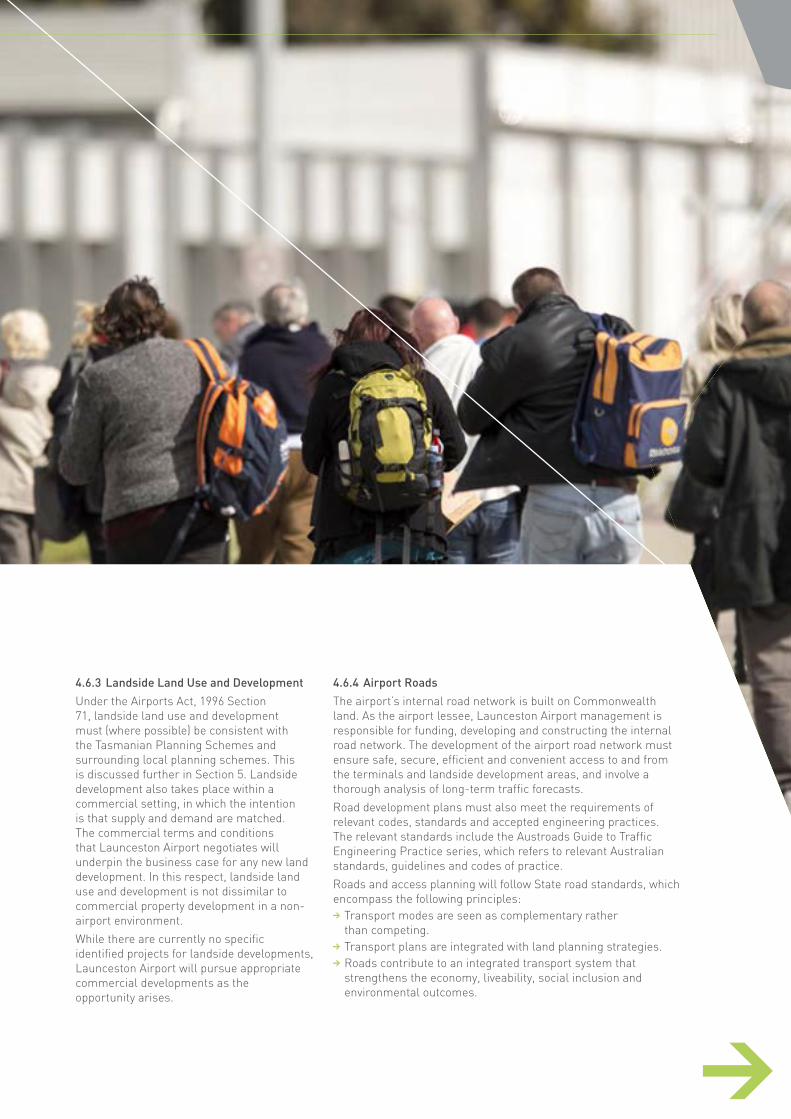
4.6.3 Landside Land Use and Development
Under the Airports Act, 1996 Section 71, landside land use and development must (where possible) be consistent with the Tasmanian Planning Schemes and surrounding local planning schemes. This is discussed further in Section 5. Landside development also takes place within a commercial setting, in which the intention is that supply and demand are matched. The commercial terms and conditions that Launceston Airport negotiates will underpin the business case for any new land development. In this respect, landside land use and development is not dissimilar to commercial property development in a non-airport environment.
While there are currently no specific identified projects for landside developments, Launceston Airport will pursue appropriate commercial developments as the opportunity arises.
4.6.4 Airport Roads
The airport’s internal road network is built on Commonwealth land. As the airport lessee, Launceston Airport management is responsible for funding, developing and constructing the internal road network. The development of the airport road network must ensure safe, secure, efficient and convenient access to and from the terminals and landside development areas, and involve a thorough analysis of long-term traffic forecasts.
Road development plans must also meet the requirements of relevant codes, standards and accepted engineering practices. The relevant standards include the Austroads Guide to Traffic Engineering Practice series, which refers to relevant Australian standards, guidelines and codes of practice.
Roads and access planning will follow State road standards, which encompass the following principles:
Transport modes are seen as complementary rather than competing.
Transport plans are integrated with land planning strategies. Roads contribute to an integrated transport system that strengthens the economy, liveability, social inclusion and environmental outcomes.
4. PLANNING CONTEXT

3. MASTER PLAN PROCESS
5.1 Overview and Objectives 47
5.2 Regional Context 47
5.3 Land-Use Strategy 47
5.4 Planning Zones 485.4.1 Airport Specific Area Zone 48
5.5 Land-Use Precincts 485.5.1 Airside Operations Precinct 485.5.2 Terminals Precinct 515.5.3 Landside Main Precinct 515.5.4 Landside Business Precinct 515.5.5 Operational Support and Freight Precinct 52
5.6 Overlays 52
5.7 Particular Provisions 52
5.8 Sensitive Developments 52
5.9 Consistency with Planning Schemes under State Law 53
5.10 Pre-existing Interests 53
5.11 Development Approval Process 53
5. AIRPORT LAND-USE PLAN
46 47 LAUNCESTON AIRPORT MASTER PLAN 2015
3. MASTER PLAN PROCESS
5.1 Overview and ObjectivesPlanning requirements for the Launceston Airport site are administered under the Airports Act. State planning laws do not apply to the site. However, Regulation 5.02(2) of the Airports Regulations 1997 require the Master Plan to, where possible, describe proposals for land use planning and zoning (in relation to the landside part of the airport) in a manner consistent with that used by the state or territory in which the airport is located.
As required under Section 71 of the Airports Act, this section demonstrates how the land use plan is consistent with planning schemes in force under Tasmanian law. It has considered the Tasmanian State Planning Policy and has used zones, overlays and other planning provisions derived from the Northern Midlands Interim Planning Scheme.
5.2 Regional ContextLaunceston Airport is one of Northern Tasmania’s strategically important sites and a critical piece of transport infrastructure.
The airport is located 15 kilometres from the Launceston central business district and is well situated relative to major transport links. The land adjoining the north, east and south boundaries is rural land supporting primarily grazing and cropping activity. The land to the west forms part of the Northern Midlands Translink Estate. This estate supports a range of commercial and industrial activities. The area has seen significant growth over the last five years and is now a major regional centre for industry, transport and storage.
Under the Northern Midlands Interim Planning Scheme, the Airport is designated as a Utilities Zone. The Translink Estate is contained within a specific area zone and the agricultural areas are designated as a rural resource zone The strategies set out for each zone under the Northern Midlands Planning Scheme address a range of matters including land use, impact on adjacent zones, landscaping, access and parking and design and these are considered by Launceston Airport, even though they don’t apply to the airport site.
5.3 Land-Use StrategyThe land use strategy for Launceston Airport designates five land use precincts that each have a different focus or function. The details of the precincts are set out in Section 5.4. These precincts form the basis of the Airport Specific Area Zone, discussed in Section 5.4.1.
The land use precincts are the primary land use planning tool. The concept plan discussed in Section 1.9 indicate possible land uses within the precincts. However, proposed land uses that are not in strict accordance with the concept plans may still be considered provided they align with the objectives of the precincts. This approach provides an appropriate level of certainty and the flexibility to respond to market opportunities and business expectations.
There have been no major changes to the overall land use direction compared to the 2009 Master Plan, but some amendments have been made in relation to land use designations and the zoning plan has been rationalised. However, the overall allocation of land for airside, terminal and landside (including non-aviation) purposes is essentially the same as the 2009 Master Plan.
The 2009 Master Plan reserved an airside area for Operational Support and long term freight. This area has increased in size due to the area provided by the closure of the grass runway. It does not represent a major change to the land use strategy.
5. AIRPORT LAND-USE PLAN
5.4 Planning ZonesRegulation 5.02(2) of the Airports Regulations 1997 states:
For Section 71 of the Act, an airport Master Plan must, in relation to the landside part of the airport, where possible, describe proposals for land use and related planning, zoning or development in an amount of detail equivalent to that required by, and using terminology (including definitions) consistent with that applying in, land use planning, zoning and development legislation in force in the State or Territory in which the airport is located.
In the 2009 Master Plan, the Tasmanian planning provisions and in particular the Northern Midlands Planning Scheme 1995 was considered in the terminology and general alignment of planning zones.
In 2013, the Northern Midlands Interim Planning Scheme was adopted and Launceston Airport has endeavoured to align with the concepts contained within the Scheme. The utilisation of Specific Area Zones within the scheme, particularly the Translink Estate Specific Area Zone adjacent to the Airport site, which provides for the planning of differing areas within the Zone provides a useful model for the management of land use planning on the airport site.
Given these facts, and after considering a number of zoning options, Launceston Airport has chosen a variation of the Specific Area Zone as the primary zone to apply to the airport site, namely the “Airport Specific Area Zone”.
5.4.1 Airport Specific Area Zone
The Airport Specific Area Zone applies to the entire airport site.
The generic purposes of the Airport Specific Area Zone are to:
facilitate land use and development in accordance with the Launceston Airport Master Plan 2015
advance Launceston Airport as one of Northern Tasmania’s key infrastructure assets
provide for the airport’s long-term growth requirements
support a range of uses, including complementary business and shopping activities, employment, travellers’ accommodation and transport
support sustainable urban outcomes that optimise the use of infrastructure
create an attractive, pleasant, safe, secure and stimulating environment through good urban design
support good environmental practice to minimise the impact on the environment and protect environmentally sensitive heritage areas.
The Land Use Precincts within the Airport Specific Area Zone contain provisions consistent with the purposes of the zone and serve to more closely define the potential land uses in the various parts of the airport.
5.5 Land-Use PrecinctsFigure 5.1 shows the four existing land use precincts. Figure 5.2 shows the five future land use precincts. The precincts are:
Airside Operations Precinct Terminals Precinct Landside Main Precinct Landside Business Precinct Operational Support and Freight Precinct.
5.5.1 Airside Operations Precinct
Situated to the east of the airport terminal, this is a critical precinct and is not accessible to the general public. It accommodates airfield facilities, including the runways, taxiways, aprons and associated navigation aids, and the airport’s fire station.
The role of the Airside Operations Precinct is to:
provide for safe, secure and efficient airfield activities, including aircraft landing, take-off, taxiing, handling and parking
accommodate the provision of aircraft navigation aids, aviation rescue and fire fighting services, and other facilities essential for safe and efficient aircraft operations
provide for 24 hours a day, seven days a week aircraft operations.
This precinct will continue to be used and developed for the aircraft services and facilities described above. It will not be used or developed for any purpose that may interfere or conflict with safe and secure airport and aircraft operations.
5. AIRPORT LAND-USE PLAN
LAUNCESTON AIRPORT MASTER PLAN 201548 49
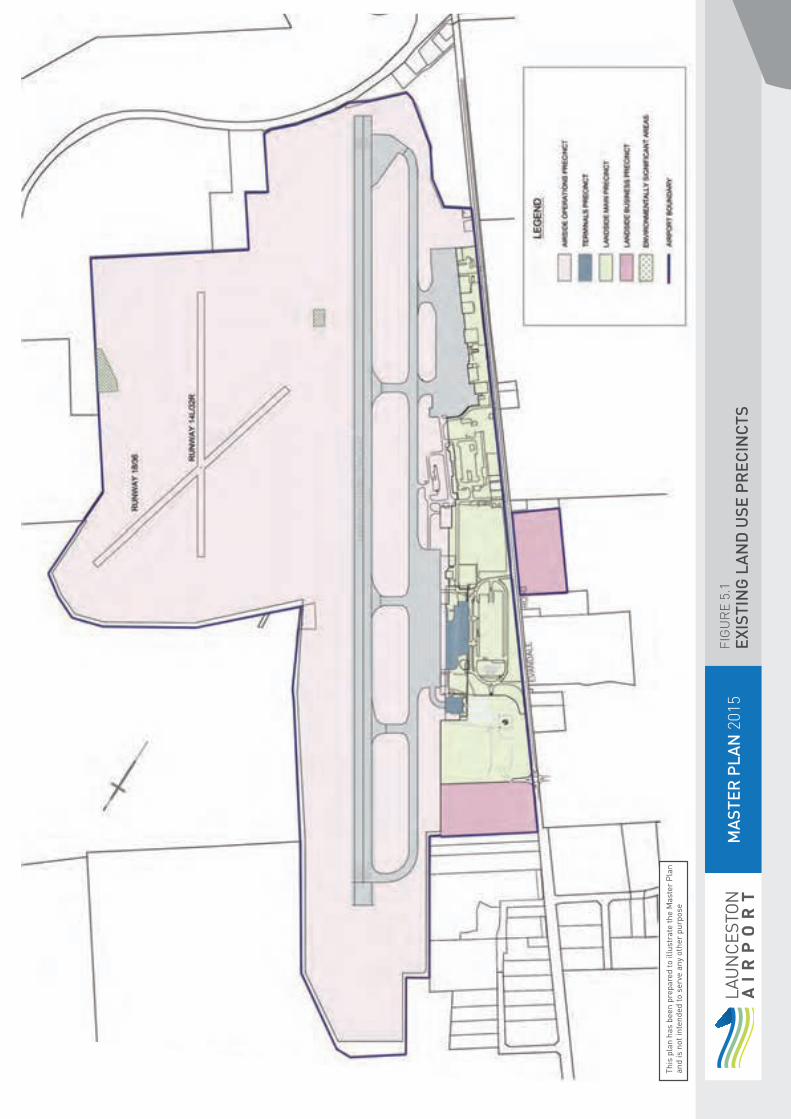
MA
STER
PLA
N 2
015
FIG
UR
E 5.
1EX
ISTI
NG
LA
ND
USE
PR
ECIN
CTS
This
pla
n ha
s be
en p
repa
red
to il
lust
rate
the
Mas
ter
Pla
n an
d is
not
inte
nded
to s
erve
any
oth
er p
urpo
se
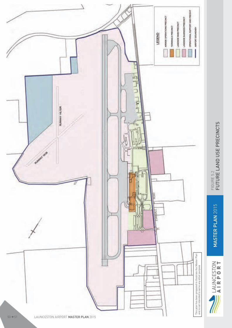
MA
STER
PLA
N 2
015
FIG
UR
E 5.
2FU
TUR
E LA
ND
USE
PR
ECIN
CTS
This
pla
n ha
s be
en p
repa
red
to il
lust
rate
the
Mas
ter
Pla
n an
d is
not
inte
nded
to s
erve
any
oth
er p
urpo
se
LAUNCESTON AIRPORT MASTER PLAN 201550 51
5. AIRPORT LAND-USE PLAN
5.5.2 Terminals Precinct
This precinct encompasses the site of the Main and Sharp passenger terminals and contains land required to expand the passenger terminals in the future. With the exception of the Sharp terminal, the existing terminal is integrated under one roof in a multi-level building combining domestic airline facilities and commercial activities such as restaurants and shops.
This precinct excludes the related landside facilities, such as car parks, which are included in the Landside Main Precinct. The main terminal forecourt is also in the Landside Main Precinct.
The role of the Terminals Precinct is to: provide for the operation, use and development of land for passenger and baggage processing, enabling the terminal facilities to operate safely, securely, efficiently and cost-effectively
provide appropriate facilities for airlines and passengers, including efficient terminal facilities with adequately located and sized commercial areas
provide an integrated terminals facility with ample commercial and retail uses
provide for the flexible expansion of passenger terminal facilities to meet forecast demand.
The precinct’s future use and development will focus on enhancing and expanding the terminal complexes, so it can continue to provide essential passenger and freight handling services.
The Terminals Precinct will not be used or developed for any purpose that may interfere or conflict with safe and secure airport and aircraft operations in the Airside Operations Precinct.
The terminal precinct (refer Figure 7.1) caters initially for the terminal developments identified in Section 7 (refer Figure 7.3) with further capacity for growth once these developments have come to fruition.
5.5.3 Landside Main Precinct
This precinct adjoins the western boundary of the Airside and Terminals Precincts. Its primary purpose is to provide services and facilities relating to these adjoining precincts, including freight, General Aviation, ground transport, car rental facilities and, car parking. The airport’s main entry and exit roads run through this precinct. The role of the Landside Main Precinct is to:
provide a range of airport support activities, services and facilities for use by airlines, passengers, government agencies, freight businesses and transport providers
provide integrated car parking, commercial and retail uses that are an essential support to the airport
provide an attractive and functional gateway to the airport
provide ground transport facilities and services for efficient access to the airport
provide for future expansion of passenger terminal facilities to meet forecast demand.
The precinct’s future use and development will focus on making the most of its prime location, including enhancing passenger drop-off/pick-up facilities, freight transport, car parking, offices, commercial uses and retail premises.
The precinct must provide for safe, secure and efficient ground transport access and a high level of visual amenity.
It will not be used or developed for any purpose that may interfere or conflict with safe and secure airport and aircraft operations in the Airside Operations Precinct or the Terminals Precinct.
5.5.4 Landside Business Precinct
This precinct is situated to the north of the Airside and Landside Main Precincts and includes an area to the west of Evandale Road which was the old village site. The role of the Landside Business Precinct is to:
provide land for a range of aviation and non-aviation uses
provide a range of aviation-related services, including aircraft maintenance and servicing and freight and cargo terminals
provide for a range of non-aviation uses, including industrial, commercial, retail, office, recreational, manufacturing, warehousing and associated activities.
The Landside Business Precinct’s future use and development will remain focused on mixed-use purposes, and will provide for safe and efficient ground transport access and a high level of visual amenity. This precinct will not be used or developed for any purpose that may interfere or conflict with safe and secure airport and aircraft operations in the Airside Operations Precinct or Landside Main Precinct.

5.5.5 Operational Support and Freight Precinct
The Operational Support and Freight Precinct comprises two areas of land to the east of the main runway. The precinct has been developed to cater for the long term requirement for freight and support infrastructure once the existing capacity in the Landside Main Zone has been exhausted.
Currently the designated area is located in an airside area however it is envisigaged that part of this land may become landside in the longer term. The area presently has limited access and infrastructure provision.
The role of the Operational Support and Freight Precinct is to,
provide a range of airport support activities, services and facilities for use by airlines, passengers, government agencies, freight businesses and transport providers
provide for the flexible expansion of freight and operational support facilities to meet forecast demand.
While it is not envisaged that this precinct will be required for freight in the short to medium term, Airservices Australia have indicated a preference to locate a fire training facility in the area possibly within the next 5 years. This use is compatable with the purpose of the precinct and as the facility would need only limited access and infrastructure it could be accommodated on the site.
Access to the precinct in the longer term will involve the upgrading of the existing perimiter road which passes around the northern airport boundary.
5.6 OverlaysLaunceston Airport has applied one overlay to target a single issue or related set of issues. The overlay used is:
Environmental Significance Overlay (including elements of heritage value). Refer to Figure 11.1.
The overlay identifies areas where land may be affected by environmental constraints and ensures development in those areas considers the natural environment and flora and fauna habitats.
Areas identified in the Environmental Significance Overlay are subject to particular attention when being assessed for management or development proposals. Management practices in these areas are guided by the requirements of the Airport Environment Strategy (refer Section 11).
5.7 Particular ProvisionsWhere applicable, the particular provisions (Codes) contained in the Northern Midland Interim Planning Scheme are considered in all airport development proposals. These provisions, which contain requirements for matters such as car parking, signage, and roads, have also been considered when developing the Launceston Master Plan.
5.8 Sensitive DevelopmentsSection 71A of the Airports Act requires a Master Plan to identify any proposed ‘sensitive developments’, defined as development or redevelopment that increases the capacity of the following:
residential dwelling community care facility pre-school primary, secondary, tertiary or other educational institution
hospital.A sensitive development does not
include the following: an aviation educational facility accommodation for students studying at an aviation educational facility at the airport
a facility with the primary purpose of providing emergency medical treatment and which does not have in-patient facilities
a facility with the primary purpose of providing in-house training to staff of an organisation conducting operations at the airport.
Sensitive developments are prohibited except in exceptional circumstances, and require an airport to apply to the Minister for approval to prepare a draft Major Development Plan (MDP) for the proposed development. The Minister may approve the preparation of the draft MDP only if he or she is satisfied that there are exceptional circumstances that support its preparation.
There are no specific proposals for sensitive development in this Master Plan. However, the provisions of the Airport Specific Area Zone enable a sensitive development to be considered subject to the Minister’s approval to prepare a draft MDP.
5. AIRPORT LAND-USE PLAN
LAUNCESTON AIRPORT MASTER PLAN 201552 53

5.9 Consistency with Planning Schemes under State Law
The Airports Act requires a Master Plan to describe the extent to which the proposals contained in the Plan are consistent with planning schemes in force under state law. This includes how the proposed developments fit within the planning schemes for commercial and retail development in the area adjacent to the airport.
Like many airports, non-aviation development occurs on the Launceston Airport site. Non-aviation property development is complementary to the airport’s operations and consistent with general planning arrangements in the Northern Midlands. It provides employment and other economic benefits for the local area. This pattern of development is complementary to Translink Estate near the airport and makes good use of available infrastructure. Section 8 of this Master Plan provides further information regarding Launceston Airport’s non-aviation development plan.
While the Master Plan and Airport Specific Area Zone provide for complementary retail and commercial development to occur on land not required for aviation uses, there are no specific developments proposed in this Master Plan that are likely to conflict with surrounding planning schemes, particularly having regard to the Northern Midlands Interim Planning Scheme.
5.10 Pre-existing InterestsIn developing this Master Plan, all interests existing at the time the airport lease was created were considered, including easements, licences, leases and sub-leases. There are no conflicts or inconsistencies existing between these interests and any proposals in the Master Plan. Launceston Airport will continue to ensure that any airport development contemplated will not interfere with the rights granted under any pre-existing interest.
5.11 Development Approval Process
If a use or development is proposed on Commonwealth land within Launceston Airport, a four-step approval process must be followed:
The proponent must obtain from Launceston Airport a Planning and Design Approval in accordance with the provisions of this Master Plan.
If required, MDP approval from the Minister must be obtained under the provisions of the Airports Act.
Building Activity Consent must be obtained from Launceston Airport under the provisions of the Airports (Building Control) Regulations 1996.
A Building Permit, if required, must be obtained from the Airport Building Controller (ABC) under the provisions of the Airports (Building Control) Regulations 1996. The ABC is advised by the Airport Environment Officer (AEO). Both the ABC and AEO are independent officers employed by the Commonwealth Government.
In assessing a development proposal, Launceston Airport requires proponents to consider matters such as building heights, acoustic treatments, safety and security, use of non-reflective materials, illumination levels, landscaping, signage and environment. The potential impacts of on-airport commercial and industrial developments on neighbouring properties must also be considered, including issues such as privacy, noise levels and building setbacks.
For any major airport development or sensitive development, as defined in the Airports Act, an MDP must be prepared, placed on public exhibition and submitted to the Minister for approval, prior to obtaining Building Activity Consent. Part 5, Division 4 of the Airports Act sets out the MDP requirements.
5. AIRPORT LAND-USE PLAN

3. MASTER PLAN PROCESS
6.1 Overview and Objectives 55
6.2 Runways and Taxiways 586.2.1 North-West / South-East Sealed Runway (14R/32L) 586.2.2 Grass Runways 18/36 and 14L/32R 58
6.3 Aprons 596.3.1 Terminal RPT Apron 606.3.2 Southern Apron 60
6.4 Summary of Airside Development Proposals 60
6. AIRSIDE DEVELOPMENT PLAN
LAUNCESTON AIRPORT MASTER PLAN 201554 55

3. MASTER PLAN PROCESS
6.1 Overview and ObjectivesExisting aircraft movement area facilities include a single north-west/south-east sealed 45m wide runway with a full length 23m wide taxiway servicing the runway and aprons areas. There are two grass runways suitable for light aircraft of 2-4 seat size located to the east of the main runway. The existing airfield layout is shown on the aerodrome drawing Figure 6.1.
As part of the preparation of this Master Plan a number of studies were undertaken to identify weak points in the airfield system that may hinder growth or create unnecessary restriction on operations. In addition, the studies identify early trigger points for airfield facility upgrades.
The Master Plan is based on aircraft movements derived from passenger growth forecasts provided in Section 4. It is based on retaining the current Code C aircraft as the Design Aircraft (as described in Section 4.6) and takes into account the future aircraft mix and potential impacts from the aircraft peaking profile. The peaking profile is the pattern of demand and typically varies through the day. The average busy day currently comprises around 40 RPT aircraft movements with two main peaks between 09:00-11:00 and 16:00-18:00, the current busy hour being 16:00-17:00.
The background studies have highlighted that the runway and taxiway system has significant capacity and is not a limiting factor for projected growth. Rather apron space will become a limiting factor and based on the present forecasts additional apron space is likely to be required around 2016-2017.
The principal objective of the Airside Development Plan is to ensure that appropriate airfield infrastructure is provided to accommodate Launceston Airport’s existing aviation activities and the forecast growth in those activities.
The proposed future airfield layout is shown in Figure 6.2.
6. AIRSIDE DEVELOPMENT PLAN

MA
STER
PLA
N 2
015
FIG
UR
E 6.
1EX
ISTI
NG
AIR
SID
E LA
YOU
T
This
pla
n ha
s be
en p
repa
red
to il
lust
rate
the
Mas
ter
Pla
n an
d is
not
inte
nded
to s
erve
any
oth
er p
urpo
se
LAUNCESTON AIRPORT MASTER PLAN 201556 57
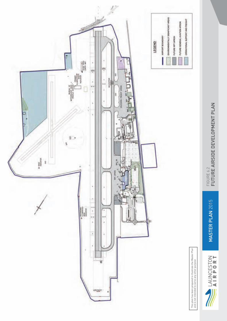
MA
STER
PLA
N 2
015
FIG
UR
E 6.
2FU
TUR
E A
IRSI
DE
DEV
ELO
PM
ENT
PLA
N
This
pla
n ha
s be
en p
repa
red
to il
lust
rate
the
Mas
ter
Pla
n an
d is
not
inte
nded
to s
erve
any
oth
er p
urpo
se

6.2 Runways and Taxiways
6.2.1 North-West / South-East Sealed Runway (14R/32L)
The existing runway 14R/32L is 1,981m long and 45m wide. The runway has sufficient capacity to service the airport and is not a limiting factor to growth. The runway can handle unlimited Code 4C (A320 and B737) and 3D (Dash 8 – 400 series) operations and Code D aircraft to B767 size with restricted operating and airfield conditions in the case of the B767.
The runway direction 32L is equipped with an Instrument Landing System (ILS) and compliant Category 1 high intensity lighting system and there is a medium intensity lighting system on 14L. Visual aids including PAPI (Precision Approach Path Indicator) and lighting facilities to support the runway system are also provided. The airport has a Pilot Activated Airport Lighting Control System (PAALC) which allows pilots to turn on the airport lighting system when operating under Common Traffic Advisory Frequency provisions after tower hours.
A single parallel taxiway (Alpha) services the RPT apron, freight and GA parking areas. This taxiway is 23m wide and capable of handling Code 3D aircraft such as the Dash 8-400 series (by virtue of its main undercarriage width, not wingspan) and occasional ad-hoc Code D operations.
Apart from general maintenance, and a possible runway overlay in the foreseeable future there are no requirements to extend or modify the main runway and taxiway layout in the short term.
There are some historic technical issues relating to the runway strip width and the taxiway separation which APAL is investigating, but these issues do not affect the capacity of the movement area to service the airport and are not a limiting factor to growth.
6.2.2 Grass Runways 18/36 and 14L/32R
Launceston Airport has two unrated grass runways to service light GA aircraft operations. They consist of the north-west / south-east parallel runway 14L/32R and the north / south 18/36 cross runway. They are connected to the main runway taxiway system via a short gravel taxiway.
These runways are only suitable for small 2-4 seater GA aircraft. GA movements at Launceston Airport have decreased significantly over the last 20 years, and the usage of the grass runways over the last 5 years has reduced to an almost negligible amount.
a. Grass Runway 14L/32R
The 14L/32R grass runway runs parallel to the main sealed runway 14R/32L. It is 700m long and has a width of 18m.
The 2009 Master Plan stated that “Launceston Airport intends to decommission within the next three years the 14L/32R grass runway due to maintenance costs, lack of use, and to provide additional space for long term development of aviation based activities in the north east sector”. Whilst this runway has not been decommissioned as yet, it has been closed for the last 5 years.
The separation distance between the 14R/32L sealed runway and the 14L/32R grass runway is insufficient to allow for simultaneous aircraft operations on both the sealed and grass runway; therefore the grass runway does not increase the capacity of the runway system. Furthermore, information gathered from users prior to the closure of the runway indicated that the runway was only used very rarely for training to provide short field and grass landing experience.
6. AIRSIDE DEVELOPMENT PLAN
58 59 LAUNCESTON AIRPORT MASTER PLAN 2015

b. Grass Runway 18/36
The 18/36 grass runway is 690m long and 18m wide. The runway has generally only been open for approximately nine months of the year due to poor surface conditions in the winter months caused by wet weather. Over recent years wide seasonal variations in soil moisture content have resulted in ground surface irregularities and, due to the extent of these irregularities the runway was closed through 2013 and 2014
Runway 18/36 provides a wind based alternative allowing light aircraft to remain operational when the cross wind component of 14R/32L is too great for light aircraft. The runway is operationally independent to the sealed runway 14R/32L enabling simultaneous operations.
While the runway does provide access to the airport for light aircraft when there is excessive cross wind on Runway 14/32, it is also clear that the 18/36 grass runway is used very infrequently having regard to the following:
the runway has no lighting and is therefore only used during the day; the runway is usually closed in winter due to wet weather and often at other times due to poor surface conditions;
the runway is only used by small GA aircraft which do not represent a significant proportion of operations at the airport;
An independent report on runway system usability indicated that the availability of the runway would only provide around one additional day of airport usability to light aircraft in the average year.
Given the above, and the fact that there are alternative airfields such as Devonport and private strips including Cranbourn, Georgetown and Longdown locally available, in the rare event that a light aircraft cannot use Runway 14/32 due to cross wind, it is not considered that there is a strong justification for retaining Runway 18/36.
Launceston Airport has reached the decision that in the absence of a viable economic model for the restoration, retention and ongoing maintenance of a serviceable runway and given its marginal contribution to airport usability, that the runway should remain closed.
Launceston Airport therefore intends to keep the 18/36 grass runway closed until operational demand initiates a review indicating the requirement for it to return to operational status. In the short to medium term the closure of the runways will enhance wildlife hazard management in that the “long grass” policy used to reduce the presence of high risk species, can be adopted on a more widespread basis across the airside grassed areas.
Runway 14R/32L will continue to be available for the General Aviation community wishing to operate at Launceston Airport.
6.3 ApronsThe airport is serviced by two aprons. The main RPT apron with the exception of Bay 1 is a high strength (80,000kg) concrete apron with six dedicated aircraft parking positions and is illustrated in Figure 6.1. The southern apron provides a range of aircraft parking positions for Freight, Commercial and General Aviation aircraft.
Bays 7,8 and 9 have been constructed to cater for B 737 aircraft and are used regularly for freight operations by B 737, BAe 146 and Fairchild Metroliner freight aircraft.
Further to the south parking is available for itinerant commercial aircraft, adjacent to an area in front of the Royal Flying Doctors Service (RFDS) hangar which is reserved for RFDS use.
At the extreme south of the apron there is GA parking on both sealed and gravel areas. Limited parking for approximately 8 to 10 GA aircraft is also provided at the extreme north end of the southern apron.

6.3.1 Terminal RPT Apron
The main RPT apron with the exception of Bay 1 is a security restricted apron servicing RPT passenger aircraft. Bay 1 has a capacity of 10,000 kg and is limited to use by the Sharp Airlines Fairchild Metroliner aircraft or similar sized aircraft. The remainder of the apron has five dedicated aircraft bays capable of handling up to A321 or B737-800 size Code C aircraft in a power in / power out mode. The apron is suitably sized for present operations and peak periods. The apron’s aircraft parking positions were reviewed with the introduction of the B737-800 series aircraft. The present layout is an optimized one for the available space, aircraft types and power in / power out manoeuvring preferred by low cost carriers.
Investigations undertaken for this Master Plan have indicated that the apron size (number of parking bays) will become a limiting factor in approximately 2016-2017 based on the present peaking profile and aircraft size. Changes in the profile may vary the development trigger and improved scheduling may be required leading up to the introduction of further bays.
There are two alternatives to gaining additional apron space:
Provide additional bays to the north and south of the existing apron and terminal; or
Alternatively utilise the high strength portion of the southern apron for RPT traffic providing standalone supporting infrastructure.
Both options have advantages and disadvantages requiring additional supporting infrastructure, equipment and potential relocation of other facilities. In the short to medium term (2016-2017) it is proposed to provide a stand-off bay on the southern apron for RPT traffic (Bay 7). In the longer term, the future apron areas shown in Figure 6.2 may be constructed.
6.3.2 Southern Apron
The southern apron is effectively broken into a number of areas by virtue of the pavement strength. The northern section is sealed high strength to 80,000kg with three aircraft parking positions
The southern medium strength section (50,000kg) was constructed for freight activities servicing building 85 (the old IPEC Freight facility). This area now services the RFDS, GA and some itinerant medium size charter jets and turboprops.
With the apron rationalisation, general GA aircraft parking is contained to the very south of apron previously used by regional airlines activities with additional aircraft parking available on a small gravel area south of the sealed apron and an area to the extreme north of the apron which has tie down points for 8 to 10 aircraft.
It is planned that further provision of apron for GA aircraft will be constructed on the gravel area to the south of the freight apron (refer Figure 1.4 and 6.2)
6.4 Summary of Airside Development Proposals
Airside development proposed over the next 20 years, in response to demand, is likely to comprise:
Utilisation of Bay 7 as a stand-off RPT parking Bay;
Additional RPT apron based on demand;
Closure of the grass cross runway 18/36 until operational demand indicates a return to operational status;
Additional GA sealed apron and parking areas to the south of the current southern freight apron;
Additional apron for ground handling storage adjacent to Hangar 14, which may require removal of Building 47;.
Provision of new fire-fighting training facilities.
6. AIRSIDE DEVELOPMENT PLAN
LAUNCESTON AIRPORT MASTER PLAN 201560 61

7.1 Overview and Objectives 62
7.2 Passenger Terminals 627.2.1 Main Terminal 627.2.2 Regional Terminal 627.2.3 Summary of Passenger Terminal
Development Proposals 66
7.3 Freight Terminals 667.3.1 Summary of Proposed Freight Development 66
7.4 General Aviation Facilities 677.4.1 Summary of Proposed General
Aviation Development 67
7.5 Aviation Support Facilities and Services 697.5.1 Aircraft Refuelling Facilities 697.5.2 Air Navigation Facilities and Services 697.5.3 Summary of Proposed Aviation
Support Development 69
7. TERMINALS AND AVIATION SUPPORT FACILITIES DEVELOPMENT PLAN

7.1 Overview and ObjectivesOver the past 20 years, Launceston Airport has experienced a compound annual growth rate of 4.5 per cent in passenger numbers.
According to the International Air Transport Association (IATA), global passenger numbers will increase by about 5.3 per cent per annum until 2016. The Asia-Pacific region is expected to achieve a compound annual growth rate of 6.7 per cent. Whilst Tasmanian Gross State Product (GSP) and population growth rates over the planning horizon are expected to be low, Launceston Airport still expects to welcome an increasing number of passengers over the next five to ten years, as outlined in Section 4.
To prepare for this expected increase in passenger numbers, during the next five years the airport plans to undertake a number of developments to support aviation growth, much of which will be directed towards upgrading and expanding the existing terminal building. This includes expanding the ground level public lounge / retail area and provision of a new gate lounge on the lower/apron level.
This section outlines how Launceston Airport intends to ensure long-term sustainable growth through its planned development of the terminal infrastructure. Figure 7.1 shows the eventual footprint of the terminals precinct.
7.2 Passenger Terminals
7.2.1 Main Terminal
The main passenger terminal complex caters for domestic traffic in a common use terminal layout, as shown in Figure 7.2. The terminal underwent a major upgrade over the period of 2008-2010 that provided for mandatory Checked Bag Screening (CBS) and the conversion from joint user to common user layout, that is, a terminal split by airline with individual facilities, to one split by arrivals and departures where airlines share some common equipment such as the baggage systems. In addition, new gate lounges were constructed on apron level increasing the number of apron boarding gates capable of simultaneous operation from 2 to 4.
A major component of the design was to allow for flexibility with future expansion (refer to Figure 7.3). The design allows for:
Up to three additional gate lounges complementing the present two; Additional arrivals baggage carousel expansion space with capability of apron loading;
Expansion space for up to 12 additional check-in counters and expanded departures adjacent to the existing;
Provision for further Checked Bag Screening facilities; Provision to expand the public lounge on ground floor level for additional seating and retail as demand requires;
Additional retail facilities in both the gate lounges and existing public lounge.
These developments will be broadly linked to passenger demand.
In addition to the areas of the terminal dedicated to aviation activities on the ground and apron levels the building has a first floor level that has been utilised for airport administration, quarantine and other non aviation related tenants. On this floor there is also a disused area commonly referred to as the Qantas Bar area.
Within the next five years APAL expects to develop: One additional gate lounge complementing the present two; Installation of additional kiosks and automated bag drop facilities to increase check in capacity
Improved baggage make up facilities Install a second security screening lane in the space currently reserved for this purpose
Expand the public lounge on ground floor level for additional seating and retail.
The current expansion plans have been designed to cater for the existing scheduling patterns and future growth. Retail expansion will be based on market demand and relevant commercial considerations.
7.2.2 Regional Terminal
The Regional Terminal is located to the north of the main terminal building and primarily services flights to Flinders and King Islands. The terminal handles approximately 20,000 passengers per year. The building which was originally constructed as a maintenance facility for Qantas provides the current operator, Sharp Airlines with passenger and freight handling facilities as well as capacity to hangar two of their Metroliner aircraft.
7. TERMINALS AND AVIATION SUPPORT FACILITIES DEVELOPMENT PLAN
LAUNCESTON AIRPORT MASTER PLAN 201562 63

MA
STER
PLA
N 2
015
FIG
UR
E 7.
1TE
RM
INA
L D
EVEL
OP
MEN
T P
REC
INCT
This
pla
n ha
s be
en p
repa
red
to il
lust
rate
the
Mas
ter
Pla
n an
d is
not
inte
nded
to s
erve
any
oth
er p
urpo
se

MA
STER
PLA
N 2
015
FIG
UR
E 7.
2EX
ISTI
NG
TER
MIN
AL
LAYO
UT
This
pla
n ha
s be
en p
repa
red
to il
lust
rate
the
Mas
ter
Pla
n an
d is
not
inte
nded
to s
erve
any
oth
er p
urpo
se
LAUNCESTON AIRPORT MASTER PLAN 201564 65

MA
STER
PLA
N 2
015
FIG
UR
E 7.
3FU
TUR
E TE
RM
INA
L LA
YOU
T
This
pla
n ha
s be
en p
repa
red
to il
lust
rate
the
Mas
ter
Pla
n an
d is
not
inte
nded
to s
erve
any
oth
er p
urpo
se

7.2.3 Summary of Passenger Terminal Development Proposals
Passenger terminal development in the next twenty years potentially includes:
Additional gate lounges; Upgrade of arrivals baggage delivery and carousels;
Expanded check-in with CBS baggage processing;
Additional Checked Bag Screening facilities;
Expansion of the ground level public lounge and retail facilities;
Provision of retail facilities to the apron level gate lounges;
Upgrade of the 1st floor bar area and office space to provide additional office space.
Minor changes to external access areas to improve terminal support services such as delivery, garbage removal and loading dock facilities; and
Provision for new and emerging technologies at check in and gates.
7.3 Freight Terminals The existing freight terminals at Launceston Airport are located in Hangar 14 on the Southern apron and Building 89 on the main RPT apron (refer to Figure 1.3).
Hangar 14 is a Bellman hangar relocated after the Second World War. In 2012, the building was substantially redeveloped to provide a modern freight handling facility for Qantas Freight. The redevelopment which maintained the heritage elements of the building has provided for the long term use and maintenance of the building.
The building is located adjacent to the new concrete apron bays 8 and 9 providing optimal operating conditions between the facility and freight aircraft.
Building 89 is located adjacent to the main RPT apron. Originally a small flight kitchen/engineering base, the structure is in good condition, the building is now used by Toll Freight. Toll move the majority of their freight in the belly of RPT aircraft which suits the location of building 89.
Hangar 10 is an all steel Bellman type hangar dating from the early war years. The building is reaching the end of its life span and is only marginal for freight operations due to its poor condition. Substantial refurbishment would be required to bring the building up to a condition where it could become a suitable facility for freight operations, however it has potential for such a use either in situ or in another location.
Building 85 which currently houses a mechanical services business also has the potential to be converted to a freight facility as it is close to the newly upgraded freight apron and has good road access.
Hangar 17 (ex Ansett Freight) has been closed due to very poor structural condition for several years. It lacks the scale to be useful as a freight facility and any development needs to be sensitive to the building’s heritage value.
Land on the north eastern side of the runway will be reserved for any future large freight development requiring additional apron space and facilities but this is considered unlikely within the twenty year planning horizon.
7.3.1 Summary of Proposed Freight Development
The proposed development for the short to medium term will include a rationalisation of the existing freight area on the southern apron and may include:
Possible upgrade of hangar 10 to accommodate freight facilities Reservation of land on the east of the airport for future freight facilities and support
7. TERMINALS AND AVIATION SUPPORT FACILITIES DEVELOPMENT PLAN
LAUNCESTON AIRPORT MASTER PLAN 201566 67

7.4 General Aviation FacilitiesThe general aviation sector is located adjacent to the southern apron intermingled with freight operations, the Royal Flying Doctor Service (RFDS) operation and itinerant commercial operators, illustrated in Figure 6.1 “Existing Airport Layout”. There is a slow but steady increase in large (up to B737 size) charter flights using the apron and these aircraft tend to restrict manoeuvring on the apron to other aircraft to maintain operational clearances.
The upgrading of the low strength apron areas has provided an opportunity to increase parking areas for larger aircraft and required the relocation of GA activities to the very south and north of the apron.
The Tasmanian Aero Club operates from a building situated next to Hangar 14. The building is owned by the Club which has a site lease which will expire in 2020. In the medium to longer term this facility will need to be relocated or removed as its location will in time restrict freight operations.
In the medium to longer term it is desirable that all GA facilities be consolidated at the southern end of the apron. The current dispersion of light and heavy aircraft does not advantage any of the operators, however lack of pavement to the south prevents short term rationalisation.
Initial discussions between Launceston Airport and the Tasmanian Aero Club have canvassed a range of options for the Club’s accommodation following the expiry of their lease. The identification of a final solution will need to consider a number of factors which can only be determined by the Club itself. Launceston Airport will continue to engage with the Club over the remaining period of the lease in an effort to find a resolution which will cater for the Club’s requirements while providing for the medium to long term planning for the area.
There have been occasional approaches by single private operators for hangar space or hangar sites on the Airport. It is Launceston Airport’s experience that these private operators cannot sustain the costs involved in a true commercial arrangement which has led to some operators seeking other options at smaller airfields close by.
There is space for approximately 4-5 hangars south of the RFDS hangar with a small adjacent apron area. The site has potential for future development should there be sufficient interest.
7.4.1 Summary of Proposed General Aviation Development
The proposed changes to the general aviation facilities are subject to further commercial negotiation, but in broad terms are summarised below:
Remove the Tasmanian Aero Club building or relocate to an area south of the RFDS;
Possible GA hangar development and apron on the southern site south of RFDS;
Additional gravel GA parking area can be provided should there be sufficient demand.
7. TERMINALS AND AVIATION SUPPORT FACILITIES DEVELOPMENT PLAN

68 69 LAUNCESTON AIRPORT MASTER PLAN 2015

7.5 Aviation Support Facilities and Services
7.5.1 Aircraft Refuelling Facilities
Aircraft refuelling is currently provided by Mobil using dedicated tankers operating from their dedicated fuel farm adjacent to Gate 3. A small self-serve Avgas bowser is operated by BP on the southern apron.
The current demand for fuel is low due to a number of factors and it appears unlikely that additional facilities will be required in the near future. Changes to the present facilities are likely to be caused by space requirements for expansion by other facilities such as additional apron space (Mobil depot) or aircraft parking changes on the southern apron (BP bowser).
There is space for additional or relocated facilities such as near the southern grounds compound.
7.5.2 Air Navigation Facilities and Services
Air Navigation Facilities and Services on the airport are owned and operated by Airservices Australia. These facilities include;
a. Control Tower
This Air Traffic Management facility provides vital air traffic control services at Launceston Airport and surrounding airspace. Upgrade to existing systems within the control Tower could occur during this Master Plan five year period.
b. Satellite Communication facilities
This facility is sited landside and is critical for communications between Northern Tasmania and Melbourne Air Traffic Management Centre. Its current location is not appropriate for the medium or longer term as it is surrounded by public car park. Airservices Australia holds the long dated lease over the site, however it is Launceston Airport’s intention to engage with Airservices with an aim to develop a plan which would ultimately facilitate the removal or relocation of the facility to a more suitable location.
c. ARFFS Fire Station
There is no plan to relocate this facility during the 2014 Master Plan five year cycle.
d. ARFFS Fire Drill Ground
This site has experienced issues related to the water retention pond which is exacerbated by the presence of the Green and Gold Frog which is a threatened species. The hot fire training ground (HFTG) located at Launceston Airport is in the process of being decommissioned due to environmental issues. This leaves ARFFS Launceston with no hot fire training capability which is a requirement under CASA MOS Part 139H 22.1.6 Training Facilities. Airservices is planning to establish a new ARFFS Fire Drill Ground in consultation with Launceston Airport.
e. Maintenance Facilities
These facilities are currently providing technical services to maintain Aeronautical navigation, surveillance and communication equipment require for safe operation of the Air Traffic Management system throughout Tasmania. There are no plans to relocate this facility over the next five years.
f. Navigational Aids
Airservices maintains several navigational aids on the airfield. These aids are located on sites leased to Airservices for a nominal rental. The aids include the DVOR, DME and ILS.
7.5.3 Summary of Proposed Aviation Support Development upgrade to existing systems within the control Tower develop a plan for the relocation of the satellite facilty to an alternative site establish a new ARFFS Fire Drill Ground
7. TERMINALS AND AVIATION SUPPORT FACILITIES DEVELOPMENT PLAN

8. NON-AVIATION DEVELOPMENT PLAN
8.1 Overview and Objectives 71
8.2 Landside Business Precinct 73
8.3 Landside Main Precinct 73
8.4 Impacts of Non-Aviation Developments 73
8. NON-AVIATION DEVELOPMENT PLAN
LAUNCESTON AIRPORT MASTER PLAN 201570 71

8. NON-AVIATION DEVELOPMENT PLAN
8.1 Overview and ObjectivesNon-aviation development plays an important role in Launceston Airport’s economic vitality and complements its key functions. It supports the airport’s growth, is complementary to the aeronautical business and provides a strong contribution to the local and broader community by stimulating economic activity and employment outcomes.
At Launceston Airport, non-aviation development has existed in harmony with aviation operations since before the airport was privatised in 1997. Launceston Airport sits on only 180 hectares of land, the majority of which is located in airfield areas, limiting the opportunity for commercial developments on the scale that other Commonwealth leased airports may enjoy.
To date non- aviation development has been restricted to some commercial tenancies and retail outlets in the main terminal building, car rental facilities and utilisation of disused hangars for storage or light industrial use.
The objectives regarding non-aviation development are to: protect the long-term viability of the airport plan and make provision for constructing high standard facilities that will benefit all airport stakeholders
encourage developments that achieve the highest standards in sustainable environmental development, safety and security
encourage developments that complement the airport’s key functions and can support aeronautical activities and enhance our passengers’ airport experience
The rest of this section will describe current non-aviation developments and explain the airport’s vision for non-aviation development. The airport has defined a number of areas within the two landside precincts where non-aviation development will be undertaken. Refer Figure 8.1.
8. NON-AVIATION DEVELOPMENT PLAN

MA
STER
PLA
N 2
015
FIG
UR
E 8.
1N
ON
AVI
ATIO
N D
EVEL
OP
MEN
T P
LAN
This
pla
n ha
s be
en p
repa
red
to il
lust
rate
the
Mas
ter
Pla
n an
d is
not
inte
nded
to s
erve
any
oth
er p
urpo
se
LAUNCESTON AIRPORT MASTER PLAN 201572 73

8.2 Landside Business PrecinctThe landside business precinct comprises two areas of land, the 2.8hA old village site to the west of Evandale Road and 4.5hA to the north of the new airport entrance (refer Figure 5.2). This precinct currently comprises vacant land and in the airport’s view will not be required for aviation related development in future years.
The type of development considered appropriate to this precinct would include Commercial premises such as restaurants, take-away/fast food outlets, shops, service station or garage, offices, car rental facilities, car dealership, hotel/motel or other accommodation facility catering to airport customers and light industry.
8.3 Landside Main PrecinctThe landside main precinct is bordered by Evandale Road (refer Figure 5.2). This precinct is currently utilised for a range of both aviation and non-aviation facilities including car parking, maintenance, freight and storage. This precinct can support a range of non-aviation activities which would be considered short to medium term allowing for the longer term utilisation of the precinct as primarily service aviation related uses.
It is important to the economic viability of the airport that a flexible approach be employed to the use of this precinct in the medium term. Existing facilities, which are vacant or in poor condition, may be utilised in a variety of ways which enables the maintenance of the asset, provides an economic return to the airport and allows for reservation for aviation use in the longer term.
Typical non-aviation developments in this precinct would include, freight, warehousing, light industrial, commercial facilities and small scale manufacturing.
8.4 Impacts of Non-Aviation Developments
Non-aviation development on the Launceston Airport site is complementary to the airport’s operations and consistent with general planning arrangements in the Northern Midlands Interim Planning Scheme, in particular the Translink Specific Area Zone which applies immediately to the west of the airport site.
While the Master Plan and Launceston Airport Specific Area Zone provide for complementary retail and commercial development to occur on land not required for aviation uses, there are no specific developments proposed in this Master Plan that are likely to adversely impact on the local or regional economy or conflict with surrounding planning schemes.
8. NON-AVIATION DEVELOPMENT PLAN

9. GROUND TRANSPORT PLAN
9.1 Overview and Objectives 75
9.2 Ground Transport System (Existing) 769.2.1 External Road Network 769.2.2 Internal Road Networks 799.2.3 Parking 799.2.4 Commercial, Bus, Taxi
and Hire Car 799.2.5 Freight 799.2.6 Active Transport 79
9.3 Ground Transport Demand 79
9.4 Delivering Ground Transportation into the Future 82
9.5 Launceston Airport Ground Transport (0-5 years) 829.5.1 Internal Road Networks 829.5.2 Parking 829.5.3 Bus Services 829.5.4 Taxi and Hire Car 829.5.5 Freight 829.5.6 Active Transport 82
9.6 Future Ground Transport Implementation (6-20 years) 83
9. GROUND TRANSPORT PLAN
74 75 LAUNCESTON AIRPORT MASTER PLAN 2015

9. GROUND TRANSPORT PLAN
9. GROUND TRANSPORT PLAN
9.1 Overview and ObjectivesThe Launceston Airport Ground Transport Plan is the first to be incorporated into the Master Plan, in compliance with amendments to the Airports Act 1996, and sets out Launceston Airport’s areas of transport focus over the next five-year period (2015 – 2020).
Access to the airport is currently limited to road based public and private transport. There is currently no public bus transport to the airport.
Travel demand modelling shows that passengers will increase to approximately 2.49 million by 2035. To support this growth the airport requires a transport system that can provide seven days a week access, efficiency, safety, sustainability, customer choice and value for money.
An additional component to the transport mix of the airport is the need to provide economic and efficient access to the almost 400 people who work in airport related jobs and that number is expected to grow to over 800 by 2035.
The objectives of the Ground Transport Plan are to: provide access for any viable mode of transport to the airport provide a transport network capable of meeting projected demand over a 20 year period
provide appropriate facilities to accommodate the needs of the disabled to improve safety and reduce congestion by utilising sound design practice integrate the airport’s ground transport network into the wider local and state wide networks
encourage a range of travel modes to provide equitable travel for the airport’s users
support safe, secure and sustainable transport solutions.

9.2 Ground Transport System (Existing)Launceston Airport relies on both internal and external road systems. These networks are fundamental to the airport’s operation and provide for shuttles, taxis, freight, aviation support vehicles, emergency services and private vehicles.
Figure 9.1 shows the existing local highway and public transport access to the airport and Figure 9.2 shows the existing bike route to the airport.
9.2.1 External Road Network
The access road into the Launceston Airport area is Evandale Road, which has the capacity to meet the foreseeable demand well beyond the planning period. This statement is supported by observations of the status quo and extrapolation of the data held by Department of State Growth. Evandale Road is declared a state controlled road.
Evandale Road is currently constructed to a 2-lane standard with 80km/hr speed zoning. Adequate reserve width appears to be available for any necessary future widening as the corridor has a design capacity of a sub arterial road (6,000-10,000 vehicles per day (vpd)).
Evandale Road facilitates all traffic entering Launceston Airport. This route poses the greatest constraint in terms of increasing the intensity of development on airport land and associated traffic development. (Northern Midlands Interim Planning Scheme). As such, pedestrian and bicycle safety is of major concern to local government and the local community. The Tasmanian Department of State Growth has commissioned a planning study to consider the options for the future development of Evandale Road. The study will take into account the future traffic flows including developments in the Northern Midlands Translink Estate. Launceston Airport has been involved in initial consultations with the Department to help provide the study with considered input from an airport perspective.
The road network around Launceston Airport is dominated by the Midland Highway and Bass Highway which passes around the site to the northwest. These roads are designated as a National Highway and provide a linkage between the major freight and tourist hubs of Tasmania, namely being Devonport, Launceston and Hobart. The quality of these roads vary, however recent work has provided improved driver safety and it is envisaged by the Tasmanian State Government that these works will continue through the life of this plan. In addition the Australian and Tasmanian governments have jointly committed $500 million to upgrading the Midland Highway over the next 10 years, including constructing a Perth bypass and duplicating the section between Perth and Breadalbane. While planning has commenced for these projects a construction timeframe has not yet been defined. Launceston Airport in consultation with the Department of State Growth will assess the impacts of these projects on the airport access and if required will develop a traffic management plan to minimise delays to airport users.
Connection between the Airport and Launceston, for the major part is by a dual lane freeway style of road. It is envisaged that this type of road network will continue to the Airport in the future.
9. GROUND TRANSPORT PLAN
76 77 LAUNCESTON AIRPORT MASTER PLAN 2015

MA
STER
PLA
N 2
015
FIG
UR
E 9.
1LO
CA
L FR
EEW
AY &
TR
AN
SPO
RT
This
pla
n ha
s be
en p
repa
red
to il
lust
rate
the
Mas
ter
Pla
n an
d is
not
inte
nded
to s
erve
any
oth
er p
urpo
se

MA
STER
PLA
N 2
015
FIG
UR
E 9.
2B
IKE
TRA
CK
This
pla
n ha
s be
en p
repa
red
to il
lust
rate
the
Mas
ter
Pla
n an
d is
not
inte
nded
to s
erve
any
oth
er p
urpo
se
LAUNCESTON AIRPORT MASTER PLAN 201578 79
9.3 Ground Transport DemandThe Greater Launceston Plan (GLP) recognises that “…Launceston Airport and the Translink precinct play a significant gateway role for tourism and freight movements in the northern region.”
Consequently, the management of this issue is identified as a Short-Term Strategic Priority for the agency.
An investigation conducted by Northern Midlands Council in March 2014 determined the average traffic on Evandale Road to be approximately 9,220 vpd north of the airport and 3,160 vpd south of the airport, compared to previous counts undertaken in June 2012 in which 5,317 vpd were recorded north of the airport and 2031 south of the airport, and a further count undertaken in December 2011 where 8,036 vpd were recorded north of the airport and 3, 196 south of the airport.
From the above figures it is noted that there has not been a significant increase in the total number of vehicles using the road between 2011 and 2014.
Whilst the industrial park was not fully operating in December 2011 when that count was undertaken, 2014 figures indicate that it has not had significant impact on traffic. As more of this industrial zone is developed, an increase in traffic demand on Evandale Road is expected. Part of the Northern Midland Council’s strategy is to seek funding to duplicate traffic lanes north of the airport which will connect with the Midland Highway. It is noted that this upgrade will directly benefit the safe movement of traffic to the airport and as such the airport fully supports the move by Council to seek this upgrade funding.
9.2.2 Internal Road Networks
During 2013 Launceston Airport recognised the need for an improved primary entry and exit to the airport and completed the design in that year. Construction of this project commenced in March 2014 with an expected duration of 10 months. The project provides a link to Evandale Road via a roundabout at the north western airport boundary. Refer to Figures 9.3 and 9.4.
9.2.3 Parking
Prior to the commencement of the new roadway project the airport had three car parks providing around 1250 public parking bays. This capacity was made up of 385 short term bays, a primary long term park of 675 bays and an overflow long term and staff park of around 150 bays.
As part of the new road project 400 long term car park bays and 125 staff bays are being constructed.
9.2.4 Commercial, Bus, Taxi and Hire Car
Included in the new roadway project is a dedicated commercial holding area to facilitate access to the terminal frontage for taxis, coaches and shuttle buses.
9.2.5 Freight
Freight access to the airport is via direct access to Evandale Road, adjacent to the air freight facilities towards the south of the airport. Current freight traffic to the airport does not have a material impact on Evandale Road due to the relative low percentage of freight in Tasmania generally carried by air.
Currently there is no road facility to access the existing rail network to the south of the airport. Historically there has been discussion between the state and local governments on the possibility of creating a rail freight hub in the area. A project identified in the Greater Launceston Plan (C.2 Launceston Gateway Project) also describes an integrated airport and Translink precinct which would include a rail modal interchange. Northern Midlands Council as the principal stakeholder will be most likely to be the lead agency in the progression of this project. Launceston Airport will engage with the Council and other stakeholders to examine the development options and how the airport may benefit and contribute to the opportunities provided by such a development.
9.2.6 Active Transport
Active transport is an access mode that involves physical activity and typically focuses on walking and cycling networks. Whilst it is recognised that cycle infrastructure exists on some routes, it is yet to be developed on others. Launceston Airport will endeavour to support patrons and employees accessing the airport with appropriate cycle networks. To facilitate this, Launceston Airport will actively support and encourage the Department of State Growth, together with local government representatives, cycling advocacy groups and other community based organisations to undertake a process to identify the highest priority transport oriented cycling routes connecting to the airport as shown through the maps of the Principal Urban Cycling Networks.
Pedestrian access from the public car parking facilities is via dedicated footpaths. Numerous urban studies have identified that the maximum walking distance is in the order of 400 metres and Launceston Airport has been mindful of this when designing pathways to the terminal, ensuring the new carpark facilities do not exceed this distance. Car park facilities for terminal staff is provided with a maximum walking distance of 200 metres.
9. GROUND TRANSPORT PLAN

MA
STER
PLA
N 2
015
FIG
UR
E 9.
3R
OA
D N
ETW
OR
K
This
pla
n ha
s be
en p
repa
red
to il
lust
rate
the
Mas
ter
Pla
n an
d is
not
inte
nded
to s
erve
any
oth
er p
urpo
se
LAUNCESTON AIRPORT MASTER PLAN 201580 81

MA
STER
PLA
N 2
015
FIG
UR
E 9.
4R
OA
D N
ETW
OR
K S
OU
TH
This
pla
n ha
s be
en p
repa
red
to il
lust
rate
the
Mas
ter
Pla
n an
d is
not
inte
nded
to s
erve
any
oth
er p
urpo
se

9.4 Delivering Ground Transportation into the Future
Increased activity at the existing entry point on Evandale Road has led to a new entry for the passenger terminal facility being constructed in 2014. This new entrance has led to a number of beneficial upgrades to internal road networks. While the new entry does not introduce any traffic increase to Evandale Road it greatly improves road safety both for airport traffic and traffic along Evandale Road.
It is envisaged that traffic patterns will alter significantly on the road segment from the Breadalbane roundabout to the airport entrance due to a general increase in traffic volumes along Evandale Road, possible changes on the Midland Highway with the bypassing of the township of Perth, and a future connection from the Bass Highway to Kings Meadows as indicated in the Greater Launceston Plan.
Launceston Airport will monitor engage with the state and local governments during the planning and development stages of the external road network projects referred to in section 9.2.1. The airport will then utilise the Community Aviation Consultative and Stakeholder Committees as fora to inform and consult with airport stakeholders and community on airport related impacts of the projects.
9.5 Launceston Airport Ground Transport (0-5 years)
9.5.1 Internal Road Networks
It is forecast that with the current improvements to the internal road network that capacity will be sufficient for the next five years. The completion of a specific commercial holding area and restricted access to the terminal front of house will provide enhanced security in response to threat mitigation measures advocated by security authorities. Notwithstanding that Launceston Airport will continue to work with State Government and Federal Government to encourage improvements to regional road networks to help facilitate adequate accessibility to the airport.
9.5.2 Parking
The car park facilities as constructed at the end of 2014 will provide sufficient space to cater to the forecast demand for five to seven years. The planned provision of an additional 180 spaces will then extend the timeframe a further three to five years.
9.5.3 Bus Services
It is not expected that demand for a public bus service would be sufficient to support the introduction of a service in the next five years.
9.5.4 Taxi and Hire Car
The provision of a dedicated commercial holding area and taxi rank feeder area provides adequate capacity for these vehicles.
The area of the existing long term car park, where hire cars are accommodated may be expanded should it be required and as the new long term public car park becomes operational.
9.5.5 Freight
The long term strategy of the northern region is to create a regional rail freight hub just south of the airport. This area is relatively flat, has ideal connections between the northwest, south and northeast of the state. The area at present is underutilised and future growth would not directly impact on the airport.
Whilst the airport has some freight activities it is recognised that this is currently a minor component of its operations. Given the proposed future direction of the industrial precinct to become a freight hub, potential growth opportunities exist for the airport to capitalise on this. As Tasmania is an island state freight is a critical component of the state economy. It is Launceston Airport’s aim to encourage and grow the air freight component of the state’s freight capacity at the airport which will provide flow on benefits for the regional and state economies.
9.5.6 Active Transport
To supplement any future state and local government transport initiatives to facilitate safe and efficient transportation to and around the airport precinct, Launceston Airport has identified a need to explore future opportunities in partnership and also as a key stakeholder. These involve additional parking, better access and safer passage for visitors, staff and patrons.
8. NON-AVIATION DEVELOPMENT PLAN
LAUNCESTON AIRPORT MASTER PLAN 201582 83

9.6 Future Ground Transport Implementation (six-20 years)
The sustainable growth of the Airport and the future support of meeting passenger requirements for air travel in the north of Tasmania relies upon direct, safe and efficient access to the site.
Launceston Airport has identified a key opportunity for Evandale Road to be upgraded for existing and projected traffic through widening and intersections. As a key landholder in the locality, Launceston Airport will participate in any sanctioned process by Local or State Government to progress this opportunity, with a view to improve safety and enhance traffic flow in and around the airport.
In addition to this, the airport welcomes any proposal to forward project any future improvements to pedestrian and cycle movements as outlined by the Department of State Growth cycling strategy. Pedestrian and cycle paths along with cycle parking and storage facilities will also be included in any future development opportunities on airport land. Launceston Airport will work collectively with government to deliver these projects.
It is recognised that with the current parking upgrades due for completion in 2014, adequate parking opportunities exist for the next 10 year horizon, however it is recognised with any future development appropriate parking will be required for staff and visitors. Options for shared parking considerations will be explored in any future developments.
8. NON-AVIATION DEVELOPMENT PLAN

10. INFRASTRUCTURE DEVELOPMENT PLAN
10. INFRASTRUCTURE DEVELOPMENT PLAN
10.1 Overview and Objectives 85
10.2 Water Supply 8510.2.1 Existing Infrastructure 8510.2.2 System Management and Maintenance 8610.2.3 Risk Mitigation 8610.2.4 Accommodating Growth 8610.2.5 Water Conservation Measures 86
10.3 Sewerage 8610.3.1 Existing Infrastructure 8610.3.2 System Management and Maintenance 8610.3.3 Risk Mitigation 8610.3.4 Accommodating Growth 86
10.4 Stormwater Drainage 8610.4.1 Existing Infrastructure 8610.4.2 System Management and Maintenance 8710.4.3 Risk Mitigation 8710.4.4 Clean Waterways 8710.4.5 Accommodating Growth 87
10.5 Electricity 8910.5.1 Existing Infrastructure 8910.5.2 System Management and Maintenance 8910.5.3 Risk Mitigation 8910.5.4 Accommodating Growth 89
10.6 Telecommunications 8910.6.1 Existing Infrastructure 8910.6.2 System Management and Maintenance 8910.6.3 Risk Mitigation 8910.6.4 Accommodating Growth 89
84 85 LAUNCESTON AIRPORT MASTER PLAN 2015

10. INFRASTRUCTURE DEVELOPMENT PLAN
10. INFRASTRUCTURE DEVELOPMENT PLAN
10.1 Overview and ObjectivesThe unconstrained development of existing airport infrastructure is paramount to Launceston Airport’s planned long-term growth. Launceston Airport is committed to ensuring the water, sewerage, stormwater drainage and electrical supply infrastructure can support this future growth. Strategic planning for risk management, maintenance, extensions and renewing this infrastructure has been a key focus during this master planning process.
The objectives of the Infrastructure Development Plan is to provide an overview of:
information on existing supplies system management and maintenance risk mitigation measures proposed extensions and works.
10.2 Water Supply
10.2.1 Existing Infrastructure
Water is supplied from the TasWater trunk main on Evandale Road via multiple connection points to three main areas of the airport:
The terminal and maintenance compound which is supplied via a ring main; The ‘Sharp’ Hangar (Building 92); and The buildings along the southern apron which are supplied individually.
The terminal area has a dedicated fire ring main servicing the terminal building and Airservices ARFFS. This supply is backed by a 225kL reserve tank and two 90kL maintenance reserve tanks. Launceston Airport has an ongoing program to separate the fire mains from the domestic supply to improve reliability and compliance with fire safety standards.
A reticulated ring main supplies the terminal area and maintenance compound which includes some remnant fire hydrants not covered by the dedicated fire mains. These will eventually be replaced as the fire mains are extended throughout the built up areas. This necessity has also highlighted a potential lack of capacity from the Northern Midlands supply and discussions have been held to provide a second supply point and upgrade of the single mains feeding the airports and TRANSlink industrial area to form a ring main for the area.

10.2.2 System Management and Maintenance
Launceston Airport has an asset management system in place to maintain the water supply for the airport. This system includes routine inspection, testing and maintenance of water supply infrastructure. Asset condition and usage is used to prioritise infrastructure enhancement or upgrade.
10.2.3 Risk Mitigation
Launceston Airport’s maintenance strategy is risk based and is developed to manage the risk of infrastructure failure.
A secondary domestic water supply tank has recently been constructed on-site to provide a back-up water supply should the supply from TasWater fail.
10.2.4 Accommodating Growth
Separation of the fire main from the domestic supply has identified a potential lack of future capacity of the existing connection to the TasWater trunk main for the terminal and compound. A second connection point will be investigated with TasWater to provide both capacity and security of supply.
10.2.5 Water Conservation Measures
Launceston Airport seeks to be a responsible water user through managing its water resource sensibly and efficiently. While the region is not affected to the extent of other States by water shortage there is a moral responsibility to reduce water wastage.
In the past five years, Launceston Airport has introduced an automated watering system to the main gardens as a water saving initiative.
Ongoing evaluation of water use for general garden and grassed areas minimises the water consumption.
10.3 Sewerage
10.3.1 Existing Infrastructure
The airport system consists of two pump stations and one large gravity system feeding to a sewage transfer station located adjacent to taxiway Alpha. The transfer station delivers raw sewage by rising main to the TasWater sewerage main on Evandale Road. As the current terminal sewer runs at 80 percent capacity during peak usage a new sewer has been designed and will be installed during 2014. This additional capacity will remove some of the load from the existing sewer and provide capacity for future growth.
10.3.2 System Management and Maintenance
Launceston Airport has an asset management system in place to maintain the water supply for the airport. This system includes routine inspection, testing and maintenance of sewerage infrastructure. Asset condition and usage is used to prioritise infrastructure enhancement or upgrade.
10.3.3 Risk Mitigation
Launceston Airport’s maintenance strategy is risk based and is developed to manage the risk of infrastructure failure.
10.3.4 Accommodating Growth
The system has capacity to handle demand for some time and only significant development may require alternative direct connection to the TasWater trunk main.
10.4 Stormwater Drainage
10.4.1 Existing Infrastructure
Stormwater discharge from the airport’s catchment including inflows from the off airport industrial subdivisions, west of Evandale Road, is directed into the adjoining creek systems of:
Kelly’s Creek; and Springvale Creek
Refer Figure 11.2 for catchment areas and drainage systems.
90 percent of the airport’s catchment, including movement areas, discharges to Kelly’s Creek.
The Kelly’s Creek catchment, comprising of three sub catchments covers the approximately 315 hA and includes the following:
The TRANSlink industrial development and land to the crest of Devon Hills west of Evandale Road draining through the airport property to the north of the terminal.
Farmland adjoining the TRANSlink development but draining south of the terminal via Hangar 10 drains
Parts of the airport movement areas including the terminal and southern apron.
Stormwater from off airport catchments enter the airport system via unlined drains along Evandale Road and two main piped inlets onto the airport land north of the terminal where they are transferred via unlined drains to a central collection point to enter the airport trunk system.
The airport drainage system is an extensive series of open lined and unlined drains and hardstand runoff delivered by two trunk pipes running under the runway to the outflow on the airport north eastern boundary creating the headwaters of Kelly’s Creek.
The southern area of the airport including parts of the runway and taxiway runway drains via a single outlet onto open paddocks before entering the Western Junction rail switching yard and ultimately Springvale creek.
10. INFRASTRUCTURE DEVELOPMENT PLAN
LAUNCESTON AIRPORT MASTER PLAN 201586 87
10.4.2 System Management and Maintenance
Launceston Airport has an asset management system in place to maintain the storm water assets for the airport. This system includes routine inspection, testing and maintenance of storm water infrastructure. Asset condition and usage is used to prioritise infrastructure enhancement or upgrade.
10.4.4 Clean Waterways
As part of the new entrance road and car park project, a new litter trap has been installed on the outlet of the drain that flows under the new car park from Evandale Road to airside.
Further information on stormwater quality and management can be found in Section 11.
10.4.5 Accommodating Growth
Due to the off airport utilisation of retention basins, it is not anticipated that the stormwater inflows to the airport will materially increase over time and subject to the considerations in Section 10.4.3 the existing infrastructure will be adequate to cater for future demand.
10.4.3 Risk Mitigation
Launceston Airport’s maintenance strategy is risk based and is developed to manage the risk of infrastructure failure.
A number of studies have identified limitations of the airport’s stormwater drainage system to handle offsite rainfall events greater than 5 year Average Recurrence Interval (ARI). This means that the airport is subject to rare short duration flooding during extreme weather events around the ‘Sharp’ Hangar area, spreading across the apron toward a low point on Taxiway Charlie.
The majority of sites in the TRANSlink industrial development have now been required to fit retention basins to help mitigate the initial flow through to the airport system.
The drains at Hangar 10 are part of the original airport development and have insufficient capacity to handle the storm surge allowing water at times to flood through hangars 10 and 17 and across the southern apron. Minor works are programmed within the next few years to reduce the direct flooding impact on the hangars.
APAL will work with Northern Midlands Council to improve the stormwater quality inflow onto airport property has been undertaken in recent years and has significantly improved the water quality flowing onto the airport site and to Kelly’s Creek.

LAUNCESTON AIRPORT MASTER PLAN 201588 89
10.5 Electricity
10.5.1 Existing Infrastructure
The existing electricity supply for buildings and assets north of building 1 is supplied by a single 22kV feed from TasNetwork’s distribution system. Buildings south of building 1 have individual connection points to the TasNetwork’s feeder.
Launceston Airport operates and maintains its own high voltage electrical distribution infrastructure within the airport site. The network consists of a central switchboard feeding five main sub-circuits.
10.5.2 System Management and Maintenance
Launceston Airport has an asset management system in place to maintain the electricity assets for the airport. This system includes routine inspection, testing and maintenance of electricity infrastructure. Asset condition and usage is used to prioritise infrastructure enhancement or upgrade.
10.5.3 Risk Mitigation
Launceston Airport’s maintenance strategy is risk based and is developed to manage the risk of infrastructure failure.
Four diesel generators are installed at the airport to provide backup power to essential operational areas including the terminal building, airfield lighting, navaids and critical maintenance areas for loss of the 22kV supply.
10.5.4 Accommodating Growth
Presently the main switchboard is being replaced which will improve reliability of supply on site as well as provide additional capacity for future growth. The existing 22kV supply has sufficient capacity to handle expected incremental growth however any significant development on the airport site will require capacity increase. Consideration will be given to installing an additional 22kV supply point should capacity increase to a point where the load could not be sustained by an upgrade to the existing supply point.
10.6 Telecommunications
10.6.1 Existing Infrastructure
In addition to multiple Telstra copper connections between the exchanges and the airport, two independent optical fibre connections are provided by Optus and Telstra to supply communication services to the airport. Onsite, the communications network is utilised for telephone, LAN, security and other services and is regularly extended and upgraded to suit the needs of the airport and its tenants.
10.6.2 System Management and Maintenance
Launceston Airport has an asset management system in place to maintain the communications assets for the airport. This system includes routine inspection, testing and maintenance of communications infrastructure. Asset condition and usage is used to prioritise infrastructure enhancement or upgrade.
10.6.3 Risk Mitigation
Launceston Airport’s maintenance strategy is risk based and is developed to manage the risk of infrastructure failure.
10.6.4 Accommodating Growth
The existing communications network has sufficient capacity to handle potential future growth.
10. INFRASTRUCTURE DEVELOPMENT PLAN

11. ENVIRONMENT11. ENVIRONMENT STRATEGY
11.1 Overview 9111.1.1 History 9211.1.2 RequirementsoftheAirportsAct1996 9211.1.3 LegalBasisforAirport
EnvironmentStrategy(AES) 92
11.2 EnvironmentManagement 9311.2.1 Overview 9311.2.2 EnvironmentalLegislation 93
11.2.2.1 AirportActs1996 9311.2.2.2 Airports(EnvironmentalProtection)
Regulations1997 9311.2.2.3 EnvironmentalProtectionandBiodiversity
ConservationAct1999 9311.2.2.4 ApplicableStateLegislation 94
11.2.3 DepartmentofInfrastructureandRegionalDevelopment 94
11.2.4 AirportEnvironmentOfficer(AEO) 9411.2.4.1 AirportBuilding
ControllerABC) 9411.2.5 EnvironmentalSiteRegisters 9411.2.6 EnvironmentallySignificantAreas 9411.2.7 LauncestonAirport
EnvironmentManagement 9611.2.7.1 EnvironmentPolicy 9611.2.7.2 EnvironmentalPlanning–
SettingObjectives&Targets 9611.2.7.3 Environmental
ManagementPrograms 9611.2.8 ImplementationandOperation 9711.2.9 Training,AwarenessandCompetence 9711.2.10 CommunicationandDocumentation 9711.2.11 EmergencyResponse 9711.2.12 CheckingandCorrectiveAction 9711.2.13 StrategyActions 97
11.3 EcologicallySustainableDevelopment 9911.3.1 Overview 9911.3.2 ExistingESDManagement 9911.3.3 PotentialIssuesandImpacts 99
11.4 EnergyManagementandClimateChange 10011.4.1 Overview 10011.4.2 EnergyUse 10011.4.3 EnergyManagement 10011.4.4 OffsettingEmissions 10011.4.5 ReportingEmissions 10011.4.6 ClimateChange 100
11.5 WaterConsumptionManagement 10211.5.1 Overview 10211.5.2 MajorUsesofPotableWater 10211.5.3 WaterManagement 102
11.6 WaterQuality–Stormwater 10411.6.1 Overview 10411.6.2 SurfaceWaterSystem 10411.6.3 StormwaterMonitoring 10511.6.4 KeyLegislation 105
11.7 WaterQuality–Groundwater 10611.7.1 Overview 10611.7.2 Potentialsourcesofimpact
upongroundwater 10611.7.3 MonitoringofGroundwater 106
11.8 WasteandResourceManagement 10711.8.1 Overview 10711.8.2 WasteManagement 10711.8.3 QuarantineRiskMaterial(QRM) 107
11.9 BiodiversityandConservationManagement 10811.9.1 Overview 10811.9.2 LegislativeFramework 10811.9.3 ThreatenedSpeciesandVegetationCommunities
10811.9.4 GreenandGoldFrog(Litoriaraniformus) 10811.9.5 SilkyBushPea(Pulteneaeprostrata) 10811.9.6 VegetationManagement 10911.9.7 WildlifeManagement 109
11.10LandManagement 11111.10.1 Overview 11111.10.2 LocalGeologyandHydrogeology 11111.10.3 DevelopmentsandtheirImpacts 11111.10.4 AirservicesAustraliaFireDrillGround 112
11.11AirQuality 11311.11.1 Overview 11311.11.2 FireFighterTraining 113
11.12CulturalandHistoricHeritage 11411.12.1 Overview 11411.12.2 IndigenousHeritage 114
11.13Ground-basedNoise 11611.13.1 Overview 11611.13.2 GroundbasedNoise 116
11.14HazardousMaterials 11611.14.1 Overview 11611.14.2 ChemicalUseatLauncestonAirport 11611.14.3 MeasurestoReduceImpact 117
90 91 LAUNCESTON AIRPORT MASTER PLAN 2015

11. ENVIRONMENT11. ENVIRONMENT STRATEGY
11.1 OverviewThe Environment Strategy is the principal document to ensure that the responsible management of environmental risks and resources occur. This section is divided into categories of environmental significance. Within each of these categories, objectives are outlined and measurable actions and targets are identified. Launceston Airport is required and will work towards achieving the objectives and actions identified.
Final responsibility for environmental management at Launceston Airport lies with the Australia Pacific Airport’s Launceston Board (APAL), the Chief Executive Officer and appointed staff. All airport staff and businesses are required to meet the requirements of the Airports Act as part of their daily operations.
The following is a summary of environmental management categories within this in this strategy document:
This Environment Strategy is the fourth plan developed for managing the environment issues arising from the activities and operations at Launceston Airport. The 2015 Strategy will replace the 2010 Strategy developed by Australia Pacific Airports (Launceston) Pty. Ltd. in accordance with the Airports Act 1996 and the Airports (Environment Protection) Regulations 1997 and approved in September 2010.
Whilst Launceston Airport has a legislated and moral responsibility to effectively manage broad environmental issues across Launceston Airport, airport occupiers that sublet sections of the airport land and /or building space from APAL are directly responsible for their organisation’s environmental performance, including their sub-lessees, contractors and subcontractors. Aircraft noise is covered entirely in Section 12 of the Master Plan.

11. ENVIRONMENTAL STRATEGY
11.1.1 History
The original inhabitants of the airport site and surrounds were Indigenous Australians known to belong to the so called North Midlands tribe. This tribe consisted of several bands and ranged from the mouth of the Tamar River in the north to St. Peter’s Pass in the South.
The district was first visited in 1806 and land granted to David Gibson in 1809. The land was primarily used for sheep grazing.
The Home Territories Office purchased the airport site (Western Junction Aerodrome) in 1929 becoming the first official Commonwealth aerodrome in Tasmania. The first commercial flights were by Holyman Bros Ltd in 1932 to Flinders Island.
The aerodrome became a RAAF training base in 1940 and trained more than 1800 personnel until its departure in 1946 after World War II.
A major redevelopment was undertaken by the Commonwealth Government in the early 1960’s that included a new terminal, apron and lengthening of the runway and taxiway system. The works included extensive landscaping of the terminal area that included native plants.
The airport was corporatised in 1988 under The Federal Airports Corporation. In May 1998 with the privatisation of airports in Australia, the lease purchased by an Australian company – APAL.
11.1.2 Requirements of the Airports Act 1996
To comply with the requirements under the Airports Act, the Launceston Airport Environment Strategy must include:
Launceston Airport’s objectives for the environmental management of the airport; and
the areas (if any) within the airport site which the Launceston Airport, in consultation with State and Federal conservation bodies, identifies as environmentally significant; and
the sources of environmental impact associated with airport operations; and the studies, reviews and monitoring to be carried out by Launceston Airport in connection with the environmental impact associated with airport operations; and
the time frames for completion of those studies and reviews and for reporting on that monitoring; and
the specific measures to be carried out by Launceston Airport for the purposes of preventing, controlling or reducing the environmental impact associated with airport operations; and
the time frames for completion of those specific measures; and details of the consultations undertaken in preparing the strategy (including the outcome of the consultations); and
Such other matters (if any) as are specified in the regulations.
The environmental themes addressed in the Environment Strategy are: Environmental Management; Ecological Sustainable Development (ESD); Energy Management and Climate Change; Water Quality – Stormwater; Water Quality – Groundwater; Waste and Resource Management; Land Management; Air Quality; Cultural Heritage; Community Engagement; Ground Noise; and Hazardous Materials.
11.1.3 Legal Basis for Airport Environment Strategy (AES)
Once the AES is approved by the Minister for the Department of Infrastructure and Regional Development, Launceston Airport and all airport based businesses including tenants and contractors are required to take all reasonable steps to meet the requirements outlined in the AES. The Airport Environment Officer (AEO) can enforce these requirements.
A copy of the AES is available for all current business partners once approved by the Minister for Infrastructure and Regional Development and during the Strategy period for all new business partners wishing to operate on Launceston Airport.
LAUNCESTON AIRPORT MASTER PLAN 201592 93

11.2 Environment Management
Key Objective: Launceston Airport will continue to develop and implement an EMS aligned with the general requirements of the international standard ISO 14001:2004-Environmental Management Systems.
This standard helps organisations comply with the relevant environmental legislation, minimise negative environmental impacts and provide for continuous improvement in their environmental performance.
11.2.1 Overview
APAL maintains an Environment Management System (EMS) to manage environmental impacts at Launceston Airport. APAL has been progressively upgrading the EMS to align with the ISO14001:2004. The significant areas of environment management outlined in this section include: corporate governance, EMS, Environment Policy, risk management, contractor management, monitoring, auditing and reporting.
The EMS is reviewed by Launceston Airport biennially using independent environmental consultants.
11.2.2 Environmental Legislation
Launceston Airport is situated on Commonwealth Government land and as such, is subject to Commonwealth environment legislation to regulate both its own business operations and those of its business partners including airlines, tenants and retail concessionaires. The principle Commonwealth Acts and Regulations are the:
Airports Act 1996 – specifically Part 6; Airports (Environment Protection) Regulations 1997; Environment Protection and Biodiversity Conservation Act 1999; and EPBC Regulations.
11.2.2.1 Airports Act 1996
The Airports Act sets up a system for regulating airports and the airport –lessee companies (ALCs) whose business is to run the airports. The ALCs are required to adhere to the requirements of the Airports Act that deal with environmental management and standards at airport sites.
11.2.2.2 Airports (Environmental Protection) Regulations 1997
The Airports (Environmental Protection) Regulations 1997 outline the general duties that must be undertaken by an airport lessee company. Some of the activities undertaken by APAL to meet the regulations include the completion of the Annual Environment Report, adoption of a comprehensive EMS, and monitoring of stormwater, air, soil and groundwater quality.
11.2.2.3 Environment Protection and Biodiversity Conservation Act 1999 (EPBC Act) and Environment Protection and Biodiversity Conservation Regulations 2000
For the purposes of this strategy, the EPBC Act and Regulations are the primary legislation for the protection of environmental matters on Commonwealth Land. They outline the responsibilities and implications for management of significant flora, fauna species and heritage at Launceston Airport. The legislation lists the criterion for species eligibility for inclusion and the plans required for their management.
11. ENVIRONMENTAL STRATEGY

11.2.2.4 Applicable State Legislation
In addition to Commonwealth requirements, Launceston Airport is required to comply with Tasmanian State legislation to the extent its activities impact surrounding Tasmanian, air land and waterways. The principle legislation is the Environment Management and Pollution Control Act 1994. This is applicable for receiving bodies of stormwater, waste, ground-based noise, air quality, ground-based vehicle emissions and hazardous materials.
11.2.3 Department of Infrastructure and Regional Development
The Commonwealth Department of Infrastructure and Regional Development provide policy advice to its Minister and delivers a variety of programs on behalf of the Commonwealth Government. It is the Department’s role to advise the Government on the policy and regulatory framework for federally owned Australian airports and the aviation industry.
The Commonwealth Government has appointed an Airport Environment Officer (AEO) and an Airport Building Controller (ABC) to Launceston Airport. The roles of these position holders are as follows:
11.2.4 Airport Environment Officer (AEO)
The AEO is the statutory officer appointed by the Secretary of the Department of Infrastructure and Regional Development to administer the Airports (Environment Protection) Regulations 1997 and the Regulations. The Department of Infrastructure and Regional Development oversees the AEO and retains overall responsibility for the enforcement of the Airports Act 1996 and the Regulations.
11.2.4.1 Airport Building Controller (ABC)
The role of the ABC is to administer the Airports (Building Control) Regulations 1996, ensure that the National Construction Code is adhered to and advise airport operators on building control issues.
11.2.5 Environmental Site Registers
In accordance with Section 6.02(3) of the Regulations, APAL has developed and is maintaining an Environmental Sites Register. The register comprises a number of tables that include results of water, soil and air monitoring, environmental site assessment details, information on any remedial plans, and any other details on occurrences of environmental significance.
Launceston Airport has developed an Impacts and Aspects register using an external provider. This involved a review of operations and that of tenants and included a risk assessment to determine where site specific EMPs were required.
The actions contained in the register will be monitored and managed within the EMP.
11.2.6 Environmentally Significant Areas
Launceston Airport has four environmentally significant areas. These include:
The Airservices Australia’s ARFFS fire drill ground that is the location of sitings of the Green and Gold frog (Litoria Raniformus);
A small area north east of the main runway that is the site of the Silky Bush Pea (Pulteneae Prostrata);
The northern area of the southern apron that is the location of several hangars and buildings that have historical heritage value;
The terminal gardens are considered to have heritage values as the first formally designed industrial native gardens; and
Refer to Figure 11.1 Airport Environment Plan.
An area of environmental significance is located adjacent to the airport site. The Clairville historic homestead is registered on the Tasmanian Heritage Register.
11. ENVIRONMENTAL STRATEGY
LAUNCESTON AIRPORT MASTER PLAN 201594 95
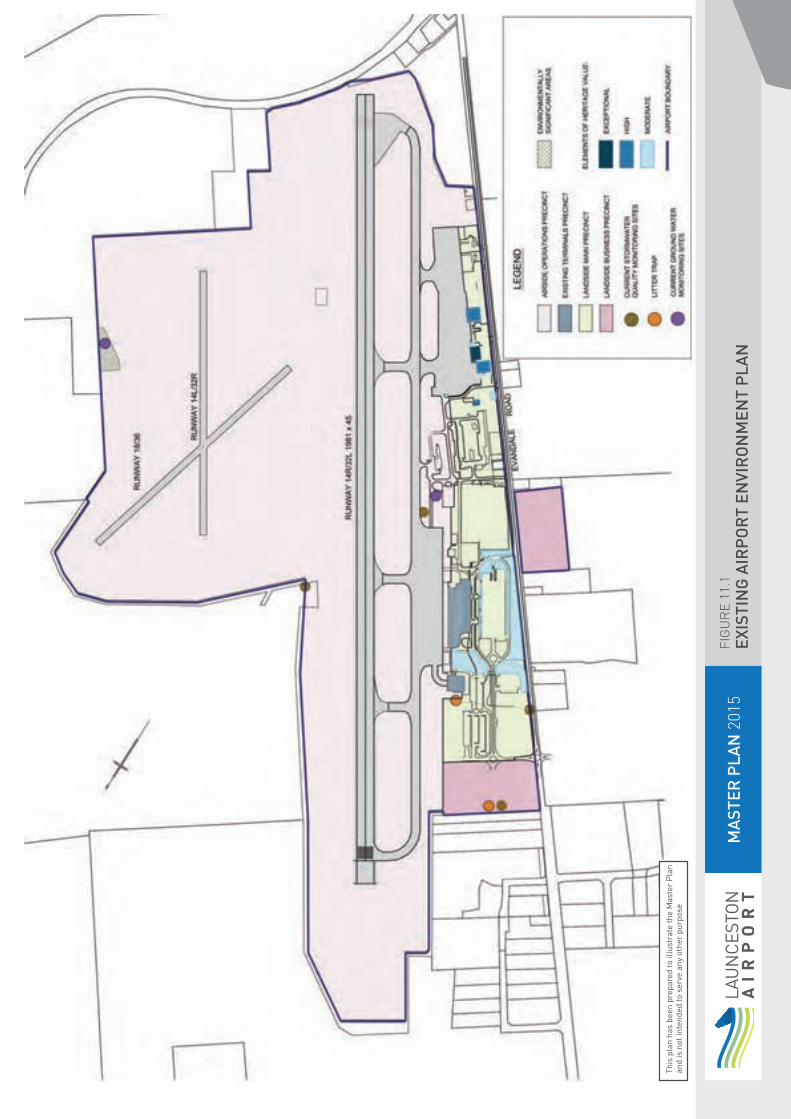
MA
STER
PLA
N 2
015
FIG
UR
E 11
.1EX
ISTI
NG
AIR
PO
RT
ENVI
RO
NM
ENT
PLA
N
This
pla
n ha
s be
en p
repa
red
to il
lust
rate
the
Mas
ter
Pla
n an
d is
not
inte
nded
to s
erve
any
oth
er p
urpo
se

11.2.7 Launceston Airport Environment Management.
The Launceston Airport EMS will continue to be aligned with the ISO14001:2004 system.
The Environment Management System consists of the following elements:
Environment Policy- used as a framework for developing the management system.
Planning- objectives, targets and Environment Management Programs are the fundamental components of the EMS. The planning element identifies issues that need to be managed and the legal framework for management.
Implementation and Operation- this element establishes the system to manage the environmental issues and the network for communication and includes the following aspects.
Organisational structure and responsibility;
Training, awareness and competence;
Communication; Documentation; Internal and external reviews; Operational control; Emergency preparedness and response; and
Checking (Corrective Action) - establishes the process for checking progress against targets and objectives as well as assessing the effectiveness of the system to provide a cycle of continuous improvement.
11.2.7.1 Environment Policy
The Launceston Airport CEO and the Airport Environment Committee, made up of internal management and environmental staff are responsible for periodically reviewing the Environmental Policy. The policy aligns with the APAC environmental philosophy and the most recent policy is dated May 2014.
The APAL Board is responsible for setting policy amendments to the Launceston Airport Environment Policy. All Launceston Airport employees and agents are responsible for compliance with the Environment Policy.
The policy is made available to all tenants and staff and forms part of the Launceston Airport Development Manual.
11.2.7.2 Environmental Planning – Setting Objectives and Targets
Setting objectives and targets enables APAL to meet its environment policy commitments.
The environmental objectives of Launceston Airport are contained in the following sections and linked to the environmental aspects of airport operations, the environmental register and policy. These are supported by Environmental Management Plans (EMPs) for construction and operation across the airport.
Environmental performance, aims and targets are contained in the EMPs. EMPs and targets are subject to management review at frequencies relevant to the project scale and risk profile.
11.2.7.3 Environmental Management Programs
An external review of the aspects and impacts on airport has provided a risk based outcome that identifies operations requiring a level of management or EMPs.
Two tenants require operational EMPs for their activities. These are Mobil and the BP bulk refuelling sites.
Other activities including tenant, APAL maintenance facilities and construction projects may require EMPs to manage and, where necessary, mitigate environmental risks.
11. ENVIRONMENTAL STRATEGY
LAUNCESTON AIRPORT MASTER PLAN 201596 97
11. ENVIRONMENTAL STRATEGY
11.2.8 Implementation and Operation
Implementation of the EMS is the responsibility of the General Manager at Launceston Airport with the management undertaken by the Manager, Planning and Environment. Department managers and staff have clear responsibilities and reporting procedures under the EMS.
Launceston Airport engages contractors to undertake a wide range of services on the airport. It is the responsibility of the departmental managers to ensure that sound environment practices are followed. This is enforced through a work permit system and advice in the form of a booklet “Handout to Contractors” and through the Launceston Airport Development Manual for larger projects. Both documents provide advice on the environmental requirements of the airport, policy, emergency contact numbers and location of spill equipment. The contractor works permit requires the nomination of a responsible officer and filling out of a checklist covering environmental matters including the use of hazardous materials.
For construction projects with a potential for a significant environmental impact, the contractor is required to submit a Construction Environmental Management Plan (CEMP) that satisfies the requirements of Launceston Airport. The CEMP is reviewed by the Manager of Planning and Environment before work begins. The CEMP is the overarching document to manage environmental risk during the life of the project and includes environmental issues listed in the Environment Strategy.
11.2.9 Training, Awareness and Competence
Launceston Airport promotes environmental awareness through staff meetings, the Airport Environment Committee and various handouts including the booklet “Handout to Contractors”, the Environment Annual Report and notification of the latest environmental legislation and websites.
To support the ongoing commitment to the environment an environmental awareness program has been developed and presented to staff and tenants. The program covered issues such as:
Environment and heritage awareness; Environmental legislation; Key environmental issues; Discharge to stormwater and sewer; Hazardous materials and storage; and Reporting requirements.
11.2.10 Communication and Documentation
Launceston Airport has procedures in place to make sure that information is received and responded to by staff and tenants. Environmental progress, emergency procedures and operational changes are made available through mail-outs, web pages and the annual report.
Under the Airports (Environment Protection) Regulations 1997 the Airport Leasing Company is required to report on the environmental performance of the airport on an annual basis. The report is forwarded to the Secretary of Department of Infrastructure and Regional Development for review.
11.2.11 Emergency Response
Launceston Airport has a series of environment specific contingency plans in the airport emergency response procedures for accidents and spills for both on airport grounds and along Evandale Road. The plans are periodically upgraded to ensure they are relevant to the current operating procedures.
The plans have been distributed to relevant staff and tenants.
An Environmental Response Unit consisting of a large towable trailer is fitted out with oil absorbent material, booms, protective clothing and equipment to cater for spills and emergencies.
11.2.12 Checking and Corrective Action
Launceston Airport uses a number of systems to manage and monitor performance, non-conformance and corrective action. These include:
Internal audits of the EMS and EMPs, aims and targets.
Internal audits on tenant operations as part of the property management system.
Biennial external reviews that monitor the progress of the Strategy action items, the effectiveness of the Environment Policy, the EMS, tenants’ environmental performance and compliance with legislation.
Management review of environmental and heritage review reports, reviews and actions.
11.2.13 Strategy Actions
The Five Year Action Plan lists the key environment issues identified in this strategy. The strategy actions provide continuity as required from the previous 2010 Strategy.

11. ENVIRONMENTAL STRATEGY
Table 11.1 Completed environmental management actions from the 2010 Launceston AES
ACHIEVEMENTS IN THE PREVIOUS FIVE YEARS 2010
Environmental management reviews carried out at two-year intervals
APAL circulated copies of its environment strategy to all staff and tenants, and to all those people and agencies involved in the consultation program.
Launceston Airport annually updated the progress of the environment strategy and advised tenants and staff of performance.
Launceston Airport annually reviewed strategy progress against the performance indicators with the AEO, and the progress formed part of the scope for the independent review conducted every two years.
Launceston Airport provided environmental training for staff, which included: Environment and heritage awareness; Environmental legislation; Key environmental issues; Discharge to stormwater and sewer; Hazardous materials and storage; Reporting requirements; and Records of staff environmental training were kept.
Launceston Airport reported the results of environmental testing regimes and unusual events to the AEO on a regular basis.
Launceston Airport continued to hold Airport Environment Committee meetings.
Table 11.2 Strategy Objectives 2015
2015 OBJECTIVE NUMBER PROPOSED ACTIVITY TIMEFRAME
1. Launceston Airport will continue to develop the Environmental Management System to align with ISO 14001:2004.
Ongoing
2. External environmental reviews will be carried out at two year intervals, and improvement items will be agreed with the AEO. As a follow up, internal environmental reviews will be conducted on an annual basis.
Biennial
3. APAL will circulate copies of its master plan (incorporating ES) to all staff and tenants, and to all those people and agencies involved in the consultation program.
Ongoing
4. Launceston Airport will annually review strategy progress against the performance indicators with the AEO, and the progress will form part of the scope for the independent review conducted every two years.
Annual
5. Launceston Airport will include recent changes to environmental legislation and include a list of environmental web sites as part of the scope of the reviews conducted every two years and circulate updates to staff and tenants.
Biennial
6. Where new infrastructure, products or management practices are introduced, Launceston Airport will review the spill contingency plans and provide copies of the amended plans to the AEO and staff.
As required
7. Launceston Airport will provide environmental training for staff, which will include: Awareness training; Incident reporting and spill response procedures; Chemical handling; Progress reports on performance; and Status of environmental and heritage values on airport.
Annual
8. Launceston Airport will continue to hold Airport Environmental Committee meetings. These will be included as a fixed agenda item in a regular stakeholders meeting.
Quarterly
9. New operators or a change of operations that trigger an assessment under the EMS will be required to prepare a list of environmental aspects using the formal Environmental Risk Analysis and register.
As required
LAUNCESTON AIRPORT MASTER PLAN 201598 99

11. ENVIRONMENTAL STRATEGY
11.3 Ecologically Sustainable Development
Key Objective: Increase the adoption of ecologically sustainable development principles in developments and refurbishments at Launceston Airport.
11.3.1 Overview
Principles of ecologically sustainable development (ESD) are becoming increasingly central to airport design, planning and operation.
The Airport recognises this trend and acknowledges the opportunity to minimise environmental impact, maximise commercial returns, and reinforce its social license to operate by incorporating ESD principles into current and planned development.
To this end, the Airport is guided by the consideration of ESD principles through a combination of internal project initiatives, and familiarisation with suitable sector-wide frameworks such as the Green Building Council of Australia’s (GBCA) GreenStar program.
11.3.2 Existing ESD Management
In recent years, ESD principles have been integrated into projects on a case-by-case basis dependent on the specific temporal, commercial, geographic and practical context.
This process is becoming increasingly sophisticated with the development and adoption of the APAC Sustainable Buildings and Infrastructure Guide (the Guide).
The Guide provides structure to encourage the consideration of ESD issues on projects; providing a minimum set of mandatory or discretionary initiatives that can be supplemented by sector-wide ESD frameworks such as GreenStar and ISCA’s Infrastructure Sustainability Rating Tool.
11.3.3 Potential Issues and Impacts
The Guide provides a user-friendly ‘vehicle’ for the consideration of ESD issues however, the Airport must:
Continue to work to ensure its adoption and application by project teams; and Continually revise and update the Guide to incorporate changes to internal documents and industry standards.
Table 11.3 Completed ESD actions from the 2010 Launceston AES
ACHIEVEMENTS IN THE PREVIOUS FIVE YEARS 2010
Expanded the operational area of building management system to obtain efficiencies, improve maintenance procedures and identify problem areas.
Installed LED lighting on selected roadways, car parks and advertising signage
Upgraded airfield lighting systems to improve efficiency and reduce energy consumption.
Table 11.4 Strategy Objectives 2015
2015 OBJECTIVE NUMBER PROPOSED ACTIVITY TIMEFRAME
10 All new developments and refurbishments at Launceston Airport (as defined by the list of project types within the APAC Sustainable Buildings and Infrastructure Guide) will utilise the Guide as the basis for the consideration of ESD initiatives at the project outset, and monitoring & reporting of achievements.
Ongoing

11.4 Energy Management and Climate Change
Key Objective: To reduce energy consumption and greenhouse gas emissions to enable APAL to progress toward carbon neutrality.
11.4.1 Overview
The Launceston Airport site uses a relatively low to medium amount of energy for a site that integrates semi-industrial and transport uses.
Major sources of energy use relate primarily to the amount of electricity and gas used for the operation of the terminal building that is significantly influenced by the relative outside air temperature and number of passengers.
11.4.2 Energy Use
Similar to the last Environment Strategy period, the primary energy uses at Launceston Airport remain:
Airfield operations including lighting;
Baggage handling systems; Car park and street lighting; and Lighting, heating and cooling of buildings and terminals.
Other energy uses include: Fuel usage for APAL vehicles (diesel);
Backup generators (diesel).
11.4.3 Energy Management
APAL maintains an Energy Management Plan using 2009/10 financial year as a baseline.
Despite an ongoing increase in passenger and business activity at Launceston Airport, energy consumption has declined 3.7% from 2009/10 to 2012/13.
Notable over this time, electricity consumption has decreased by 4.9%, and gas consumption has decreased 2.2%.
In the most recent Environment Strategy period APAL has undertaken numerous built environment and operational initiatives to minimise energy use and increase energy efficiency.
This includes measures such as: Installation of automated window shades in the main terminal;
Environmental education and training for staff including an energy management component;
More efficient airfield and approach lighting;
Retrofitting of the Illuminated Wind Indicators with LED light fittings; and
Replacing the Short Term car park and Terminal Road system floodlighting with LED.
The Airport will continue to review its major sources of energy use and undertake relevant initiatives to reduce these amounts.
11.4.4 Offsetting Emissions
Launceston Airport has developed a program to offset emissions associated with its vehicles and staff flights through the support of the Rural China Grouped Small Hydro Project.
The Project is located close to APAC’s Chinese ‘sister airport’, Chengdu International Airport and has been selected due to the positive impact on the local community and environment.
11.4.5 Reporting Emissions
Although Launceston Airport’s associated carbon footprint is less than required by the National Greenhouse and Energy Reporting Act 2007 reporting threshold, it is included as part of the APAC collective corporation performance as per legislative requirements.
11.4.6 Climate Change
As well as managing the Airport’s contribution to climate change, APAL acknowledges that it must adapt to current and future climate change risks, vulnerabilities and likely impacts.
The Airport is committed to working toward a better understanding of climatic events that may potentially impact Airport asset management and operations.
11. ENVIRONMENTAL STRATEGY
LAUNCESTON AIRPORT MASTER PLAN 2015100 101

11. ENVIRONMENTAL STRATEGY
Table 11.5 Completed Energy & Climate actions from the 2010 Launceston AES
ACHIEVEMENTS IN THE PREVIOUS FIVE YEARS 2010
Launceston Airport has reported under the NGERs regime as part of APAC.
The airport lighting upgrade incorporated LED fittings.
Table 11.6 Strategy Objectives 2015
2015 OBJECTIVE NUMBER PROPOSED ACTIVITY TIMEFRAME
11 Maintain and monitor the Launceston Airport Energy Management Plan to identify areas where energy reductions may occur. The plan will incorporate all airport areas including terminal, airfield maintenance and tenant operations and the identification of potential energy saving opportunities. NGERS reporting data is baseline energy use.
Ongoing
12 On the basis of the Energy Management Plan, identify main sources of energy use and investigate measures to reduce consumption compared to the NGERS baseline energy use.
Ongoing
13 Understand APAL’s current and future climate change risks, vulnerabilities and likely impacts to inform the Airport’s need and capacity to adapt operational and management practices in the short to medium term.
Ongoing
11.5.3 Water Management
APAL will develop a Water Management Plan that compares water use to the baseline year. The Water Management Plan will confirm major use areas (e.g. gardens, terminals) and identify opportunities for water reduction and recycling.
The terminal gardens present the greatest challenge as garden watering is traditionally held as the first step in water conservation. However, the gardens have historical significance and require maintenance under provisions in the EPBC Act. The local community also holds them in high regard.
Because the gardens contain exotic species (azaleas, rhododendrons etc) they require a certain amount of watering through the summer months. A water timing system provides greater control of watering times and enables a small reduction in water usage.
The potential for rainwater harvesting to water the gardens has been considered but is extremely difficult on the site due to layout. The issue is compounded by the lack of space, airfield requirements and bird hazard reduction. Any system should ideally be gravity fed to maximise savings and provide a green solution as the costs of pumping water from potential storage sites mitigate any savings from water reduction.
Where identified water saving initiatives are viable they will be implemented.
Table 11.7 Completed Water Management actions from the 2010 Launceston AES
ACHIEVEMENTS IN THE PREVIOUS FIVE YEARS 2010
Launceston Airport continued to monitor and implement water conservation measures.
A replacement program of valves to the water reticulation ring mains is ongoing.
Older sections of the water mains have been replaced.
Table 11 8 Strategy Objectives 2015
2015 OBJECTIVE NUMBER PROPOSED ACTIVITY TIMEFRAME
14 Launceston Airport will investigate ways to optimise water consumption and distribution.
Ongoing
15 Launceston Airport will work collaboratively with tenants to encourage water efficiencies and conservation throughout their operations
Ongoing
16 Launceston Airport will separate the Fire Fighting and Domestic water mains
2016
11. ENVIRONMENTAL STRATEGY
11.5 Water Consumption Mangement
Key Objective: Launceston Airport will develop a Water Management Plan to develop strategies to reduce and manage consumption.
11.5.1 Overview
Launceston Airport seeks to be a responsible water user by managing its water resource sensibly and efficiently. While the region is not affected to the extent of other States by water shortage, there is a moral responsibility to reduce water wastage.
Currently, all water including a fire fighting supply utilised by the airport is delivered by a single metered point at the airport boundary. Water is supplied by a recently created state water authority, Taswater.
Launceston Airport intends to separate the domestic use water from the fire supply to enable an accurate assessment of domestic water use.
11.5.2 Major Uses of Potable Water
The major uses of potable water on Launceston Airport include:
By Airport Garden watering; Washrooms; Cleaning and hygiene; Kitchen facilities; and Construction and maintenance.
By tenants Car rentals and washing; and Fire Training activities.
LAUNCESTON AIRPORT MASTER PLAN 2015102 103
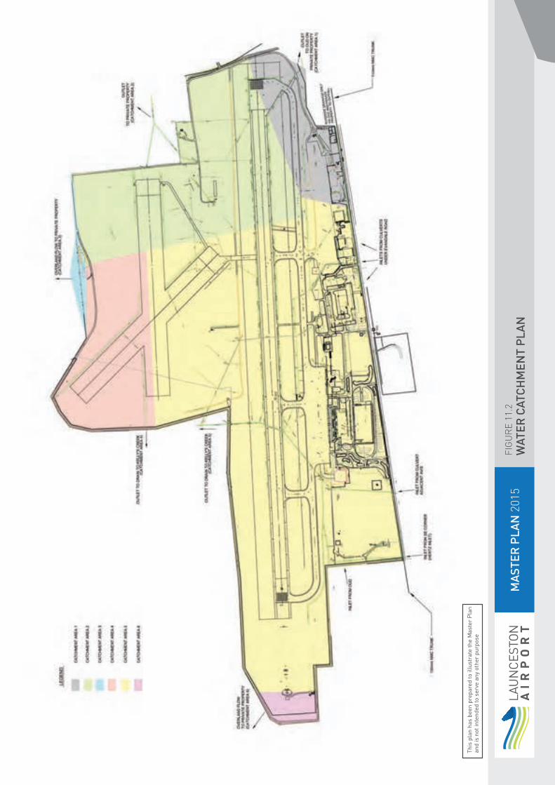
MA
STER
PLA
N 2
015
FIG
UR
E 11
.2W
ATER
CAT
CH
MEN
T P
LAN
This
pla
n ha
s be
en p
repa
red
to il
lust
rate
the
Mas
ter
Pla
n an
d is
not
inte
nded
to s
erve
any
oth
er p
urpo
se

11.6 Water Quality – Stormwater
Key Objective: To minimise the impact of stormwater runoff from airport sources.
11.6.1 Overview
Waterways are an integral part of the natural environment. APAL aims to minimise the impact on both surface and groundwater by ensuring all reasonable and practical measures are undertaken at all times during operations and development activities.
The majority of stormwater exits the airport site into Kelly’s Creek and ultimately to the North Esk via Jingler’s Creek. Both the inflows and outfall are regularly monitored when flows permit.
Work with the Northern Midlands Council has improved the quality of inflows from offsite and litter collection to remove contaminants have been fitted to one inflow drain to improve the water quality and reduce potential impact of pollution to the airport site.
Launceston Airport along with the offsite TRANSlink development to the west of the airport forms the headwaters of Kelly’s Creek, a tributary of the Tamar River. The airport operation therefore has the potential to impact on the water quality flowing through the system.
APAL ensures that staff, contractors and tenants working at the airport are aware of their responsibility to alleviate the risks to stormwater quality arising from their activities and also include mitigation actions in work plans.
11.6.2 Surface Water System
Launceston Airport has two main outfalls that form the headwaters for Kelly’s Creek and to a lesser extent Springvale Creek. Both headwaters are usually dry over summer.
The Kelly’s Creek outfall receives approximately 90% of the airport’s stormwater runoff while Springvale Creek receives the balance via the southern runway outlet and a number of small drains exiting the property from the grass strips to the northeast of the main runway. Both receive runoff from the catchment area rising to Devon Hills.
Runoff from the TRANSlink light industrial estate (not associated with the airport) flows through the airport via two main drains to combine at a single culvert head on airport before flowing beneath the runway system to exit to Kelly’s Creek. Figure 11.2 illustrates the airport stormwater drainage layout.
11. ENVIRONMENTAL STRATEGY
104 105 LAUNCESTON AIRPORT MASTER PLAN 2015

11.6.3 Stormwater Monitoring
Regular monitoring of the stormwater inflows and single outflow to Kelly’s Creek began in 1997.
Staff trained in collection of quality control and representative samples undertake the environmental monitoring of stormwater. These are forwarded to a NATA accredited laboratory for analysis. The sampling frequency and range of anolytes is agreed by the AEO for all monitoring. Typically surface water is tested monthly when there is sufficient flow. The AEO receives copies of all monitoring results.
Work with the Northern Midlands Council (NMC) with offsite drainage controls improved the water quality and reduced the onsite flow for rain events. As the TRANSlink development has grown, the potential to impact stormwater flows has increased and is evident in recent testing of the inflows. An increase in levels of oils and greases in stormwater samples plus water born litter and silt has been noted.
To minimise the impact both on airport and at the main Kelly’s Creek discharge point, APAL has installed a litter trap to one of the main drains inflowing the airport. An additional trap is planned as part of the new entrance development that bridges the second inlet drain.
A larger unit is scheduled for installation on the main outfall.
Figure 11.1 shows the location of the existing stormwater quality monitoring sites and litter traps.
A dedicated covered vehicle wash down bay has been installed in the maintenance compound. This facility treats the waste water to remove oils, greases and surfactants and discharges to sewer. The treatment unit has the capability to be upgraded to fully recycle waste water in the future.
11. ENVIRONMENTAL STRATEGY
11.6.4 Key Legislation
An airport must monitor the quality of stormwater discharged at the airport, as stipulated in Regulation 6.02. of the Airports Act. APAL continues to monitor the inflows and single outflow. The EPA Tasmania is the statutory regulator for receiving waters, which Launceston Airport stormwater is discharged to.
Results from stormwater monitoring of the outflows and inflows consistently indicate that levels of oils, greases and surfactants in discharges from the airport are less than those entering the airport system. The levels rarely exceed the nominal values set by the Northern Midlands Council.
Table 11.9 Completed Stormwater Quality actions items from the 2010 Launceston AES
ACHIEVEMENTS IN THE PREVIOUS FIVE YEARS 2010
Installed new drainage system including flame traps and triple interceptor to new southern apron.
Launceston Airport continued to monitor water quality sampling of the inflow and outflow drains on the airport.
Launceston Airport cooperated with regulatory authorities on water quality objectives.
Table 11.10 Strategy Objectives 2015
2015 OBJECTIVE NUMBER PROPOSED ACTIVITY TIMEFRAME
17 To minimise the impact of stormwater runoff from airport sources.
Ongoing
18 Launceston Airport will continue to monitor water quality of the inflow and outflow drains on the airport and cooperate on water quality objectives with regulatory authorities.
Monthly
19 Launceston Airport will continue to upgrade and maintain the drainage system as necessary, including the installation of additional litter traps. Apron upgrades and new car parks will incorporate drainage treatment at outfalls.
As Required
20 Launceston Airport will report the results of environmental testing regimes and unusual events to the AEO on a regular basis.
Ongoing

11.7 Water Quality – Groundwater
Key Objective: To protect groundwater quality at Launceston Airport.
11.7.1 Overview
Launceston Airport has groundwater, subject to location, ranging from 2m to 12m below the ground surface. The groundwater flow is predominantly to the northeast with a low seepage velocity. The nearest licensed water bore is located 2.4km to the north west of the airport.
11.7.2 Potential sources of impact upon groundwater
The potential activities that could impact upon groundwater include:
Commercial activities; Direct spillage; Hydrocarbon sources –underground storage tanks (USTs), above ground storage tanks (ASTs);
Land management activities; Maintenance activities; Fire Training activities; and Offsite activities.
Launceston Airport has two sites (commercial fuel farms) with USTs; which are not owned by APAL.There are active ASTs on site.
APAL has a management procedure that requires all USTs to be monitored and regularly tested by the respective owners Exxonmobil and Air BP for leakage. A register of all existing and decommissioned tanks on site is maintained.
11.7.3 Monitoring of Groundwater
Monitoring wells have been installed at two sites on Launceston Airport to assess groundwater quality and presence of any contamination. Monitoring events occur annually. The results are provided to APAL and the AEO for review.
Table 11.11 Completed Groundwater Quality actions from the 2010 Launceston AES
ACHIEVEMENTS IN THE PREVIOUS FIVE YEARS 2010
ExxonMobil installed additional ground water monitoring bores to improve monitoring of the plume and provide early warning of plume migration.
Results from groundwater bore monitoring on the ExxonMobil refuelling site and Airservices’ ARFFSS fire drill ground were assessed and results were provided to the AEO for comment.
Removed all known USTs owned by APAL.
APAL has monitored the initiatives taken by Airservices to address contamination issues at the Fire Training Ground and informed the AEO of resultant actions
Table 11.12 Strategy Objectives 2015
2015 OBJECTIVE NUMBER PROPOSED ACTIVITY TIMEFRAME
21 Regular groundwater monitoring will continue to occur at sites of potential groundwater contamination.
Annually
22 Launceston airport will ensure that all quality monitoring results for water, ground bores and soil are reviewed by the AEO and made available to regulatory authorities where required.
Ongoing
23 APAL will maintain and update the site register of groundwater bore locations at Launceston Airport.
Annually
11. ENVIRONMENTAL STRATEGY
LAUNCESTON AIRPORT MASTER PLAN 2015106 107

11.8 Waste and Resource Management
Key Objective: To reduce waste disposed to landfill and optimise recycling at APAL managed facilities.
11.8.1 Overview
There have been a number of recycling programs run on the airport generally centred on terminal operations.
The change to a common user terminal has altered much of the functionality of the tenants and operational systems.
11.8.2 Waste Management
All operators on airport are responsible for the correct storage, handling and disposal of their waste.
The waste types produced at Launceston Airport include: general waste, quarantine risk material (food waste from interstate such as fruit) and recycled material. Demolition waste occurs only occasionally and is the responsibility of the contractor.
APAL has implemented a recycling program to divert waste from landfill. The major contributors to this waste are retail concessionaires and public using the terminal facilities.
Trade waste agreements are being developed with the newly created State Water authority for sewage.
11. ENVIRONMENTAL STRATEGY
11.8.3 Quarantine Risk Material (QRM)
QRM is primarily food waste material discharged from interstate aircraft. It is transported by a registered operator to the Dulverton landfill site operated by the Dulverton Waste Management Authority.
Table 11.13 Completed Waste Management actions from the 2010 Launceston AES
ACHIEVEMENTS IN THE PREVIOUS FIVE YEARS 2010
Maintained a comprehensive recycling program in the terminal and forecourt areas.
Encouraged key APAL tenants to introduce recycling programs.
Installed a consolidated waste management site
Installed new waste recycling bins in the terminal and on the forecourt
Table 11.14 Strategy Objectives for 2015
2015 OBJECTIVE NUMBER PROPOSED ACTIVITY TIMEFRAME
24 Develop a Waste Management Plan to inform future waste reduction initiatives. Note the WMP will incorporate a comprehensive recycling and general waste reduction and minimisation program ensuring QRM does not enter the general waste stream.
2015
25 Implement contractual obligations for construction contractors to segregate and recycle construction and demolition waste and report outcomes to APAL.
2015
26 Continue to reduce the volume of waste to landfill and improve recycling including terminal public areas.
Ongoing

11.9 Biodiversity and Conservation Management
Key Objective: To conserve and actively manage biodiversity values at Launceston Airport.
There are a number of flora and fauna species considered endangered that may visit or be found on the airport site. At present the identified species located on airport are the Green and Gold Frog, and the Silky Bush Pea. There is also a threatened vegetation community dominated by and Silver Tussock Grass.
Ongoing management is required to conserve and protect listed and endangered species and minimise the impact of invasive species.
11.9.1 Overview
Maintaining biodiversity is noted as one of the key environmental issues for Australia. Accounting for ecological factors involves managing the delicate balance between indigenous species, introduced species and the pests that can threaten the ecosystems and can cause harm to people and property.
The key biodiversity and conservation management activities at Launceston Airport are:
Management of sensitive flora and fauna; and
Pest and weed management.
11.9.2 Legislative Framework
Nationally threatened species and ecological communities are listed under the Environment Protection and Biodiversity Conservation Act 1999. In Tasmania, species are listed as threatened under the Threatened Species Protection Act 1995.
11. ENVIRONMENTAL STRATEGY
11.9.3 Threatened Species and Vegetation Communities
In December 2013, APAL had flora and fauna surveys undertaken by external consultants. The report determined that in addition to the previously identified threatened species sighted on airport ground (Green and Gold Frog (Litoria raniformus) and the Silky Bush Pea (Pultenaea prostrata)) an area of highly disturbed native vegetation in the south eastern corner of the airport is likely to have flora values of state and potentially national significance in that the vegetation is consistent with the EPBC Act listed Lowland Native Grasslands of Tasmania – grassland sub-type Lowland Poa labillardierei (Silver Tussock Grass). The report also stated that it is likely that two additional threatened flora species may be present, Curly Sedge and Gentle Rush.
Subsequently Launceston Airport conducted further ecological work on the area concerned to clarify the conservation status and occurrence of grassland vegetation and species on site. The resultant report identified that the Lowland Native Grasslands of Tasmania does not occur on site. Whilst having characteristics of the community, the vegetation present does not have sufficient cover of perennial native grasses or native species richness to meet the listing criteria. No flora or fauna species listed as rare or threatened under either Federal or State legislation were recorded in the study area.
11.9.4 Green and Gold Frog (Litoria raniformus)
The Green and Gold Frog was originally sighted during an upgrade of the Airservices Australia Fire Drill Ground in 1999. There had been no additional sightings until March 2009 when up to 20 were found in grassed areas around a detention pond. All were juveniles ranging from fingernail size to almost fully grown (approximately 60-70mm).
In 2010 Airservices Australia engaged a consultant to perform an initial survey and report on the local Green & Gold Frog population within the airport grounds and surrounding areas. The report concluded that there was a large healthy and viable breeding population utilising the lagoon and surrounding grass areas. As the management arrangements at the time of the survey did not appear to be having an adverse impact on the frog population and were possibly beneficial to the presence and persistence of frogs at the site. It was concluded that a separate management plan was not required, however a number of management measures were identified which Airservices has implemented. As part of these measures Airservices conducts an annual survey of the frog population on the site the most recent being completed in November 2013. The monitoring program initiated by Airservices Australia in February 2011 has formed the base component of the annual monitoring project. The monitoring conducted in November 2013 recorded a lower number of frogs than the previous site surveys conducted in 2011 and 2012. This was most likely as a result of the timing of the 2013 survey as November coincides with the beginning of the breeding season. This would also explain the high number of tadpoles and low number of adults and sub adults identified. Previous surveys have been undertaken in February and it has been recommended that the next survey is conducted in February.
Throughout 2013 there were no incidental observations formally recorded although this is likely to be due to reduced training activity on the site and that Green and Gold frogs have not been recorded in other areas of the airport other than within and adjacent to the fire drill ground.
The Airservices Aviation Rescue and Fire Fighting Service(ARFFS) hold a “Permit to cause incidental injury or death to Litoria raniformis at Launceston Airport” issued under section 201 of the EPBC Act. The permit allows for operational indirect disturbance of the frog habitat. It requires annual reporting of a number of parameters including surveys, water quality monitoring and periods of disturbance.
LAUNCESTON AIRPORT MASTER PLAN 2015108 109
11.9.5 Silky Bush Pea (Pulteneae prostrata)
The Silky Bush Pea (Pultenaea Prostrata) was first located in 1995 adjacent to the main runway strip on airside. The plant has since prospered and grown to cover an area of approximately 12m2. In the last few years the centre has become sparse with the majority of growth at the tips or outer edge. The plant perimeter is marked by high visibility guide posts to protect against grass mowing activities and inadvertent disturbance
The terminal gardens consist of native and exotic species. They are discussed further in Section 12.
11.9.6 Vegetation Management
Launceston Airport has a weed management strategy in place to control the State Declared Weeds which occur on the airport. These weeds are gorse, blackberry, Montpellier Broom, Slender Thistle and fennel. None of these species are identified for eradication in the Northern Midlands.
The plants inhabit areas of airside around the flight strips. The majority are carried in as seeds by birds and other fauna from neighbouring properties.
There has been a program of gorse eradication underway for over 10 years. The location of plants is held on a plan and new and eradicated plants noted. The plants are routinely sprayed with herbicide to control their spread. Blackberries are routinely sprayed during the summer months.
The grassed areas of airside are mown regularly to control grass height as required by CASA Regulations. The length of grass in the flight strips is varied to help control bird species and reduce aircraft bird strike.
The landside areas are generally grass and the landscaped gardens surrounding the terminal area consisting of native and exotic species.
Native plants have been replaced as they die or are removed to improve public safely and maintain the garden. Launceston Airport utilises a specialist arborist to provide advice on the extent of tree maintenance required.
11. ENVIRONMENTAL STRATEGY
11.9.7 Wildlife Management
Launceston Airport actively discourages fauna from the flight strips to discourage bird strike and animals entering the movement areas.
The list of animals found in movement areas from time to time includes rufus wallabies, rabbits, wombats, echidna, feral cats, rats and mice. The majority are herded or caught and appropriately destroyed as required by law.
Launceston Airport maintains a wildlife hazard management plan as part of CASA requirements to reduce the chance of aircraft wildlife strike. Launceston Airport’s annual wildlife strike rate is currently 6.2 strikes per 10,000 aircraft movements. The actual number of strikes per annum has been increasing as air movements increase, but the mass of the birds struck has been decreasing as higher risk larger species have been reduced on the airport through improved management. In particular, the masked lapwing presence on the airport has almost disappeared due to the adoption of a long grass policy. Other birds which have sightings recorded on the airport are:
Richards Pipit; European Goldfinch; Banded lapwing; Common Starling; Common Skylark; Raptors; Ducks; Swallows; Wrens; Magpies; Sparrows; and Black Swans
All these birds have been recorded in the strike statistics in past years.
An external consultant ornithologist undertakes seasonal surveys of wildlife hazards and conducts an annual review of the wildlife hazard management plan providing recommendations on controlling risk species and the methods of deterrent. The decision to adopt a particular control strategy, whether habitat modification, attractant source removal or more direct eradication strategies is made by Launceston Airport after consideration of the reports and advice provided by the ornithologist. Strategies adopted may be time specific (seasonal) or in response to recent incidents or hazard identification through routine wildlife monitoring and surveys. Methods employed in the past have included:
Harassment by vehicles; Placement of orchard gas cannon; Cracker shells; Broadcasting equipment issuing bird distress calls; Mowing grassed areas to varying lengths; Removing water sources (ponds) from airport grounds; and Culling as an action of last resort
Note: Launceston Airport has permits issued by the Tasmanian Parks and Wildlife Service to harass or destroy particular species.
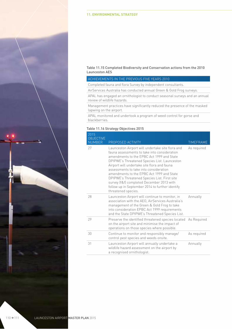
Table 11.15 Completed Biodiversity and Conservation actions from the 2010 Launceston AES
ACHIEVEMENTS IN THE PREVIOUS FIVE YEARS 2010
Completed fauna and flora Survey by independent consultants.
AirServices Australia has conducted annual Green & Gold Frog surveys.
APAL has engaged an ornithologist to conduct seasonal surveys and an annual review of wildlife hazards.
Management practices have significantly reduced the presence of the masked lapwing on the airport.
APAL monitored and undertook a program of weed control for gorse and blackberries.
Table 11.16 Strategy Objectives 2015
2015 OBJECTIVE NUMBER PROPOSED ACTIVITY TIMEFRAME
27 Launceston Airport will undertake site flora and fauna assessments to take into consideration amendments to the EPBC Act 1999 and State DPIPWE’s Threatened Species List. Launceston Airport will undertake site flora and fauna assessments to take into consideration amendments to the EPBC Act 1999 and State DPIPWE’s Threatened Species List. First site survey (f&f) completed December 2013 with follow up in September 2014 to further identify threatened species.
As required
28 Launceston Airport will continue to monitor, in association with the AEO, AirServices Australia’s management of the Green & Gold Frog to take into consideration EPBC Act 1999 requirements and the State DPIPWE’s Threatened Species List.
Annually
29 Preserve the identified threatened species located on the airport site and minimise the impact of operations on those species where possible.
As Required
30 Continue to monitor and responsibly manage/control pest species and weeds onsite.
As required
31 Launceston Airport will annually undertake a wildlife hazard assessment on the airport by a recognised ornithologist.
Annually
11. ENVIRONMENTAL STRATEGY
110 111 LAUNCESTON AIRPORT MASTER PLAN 2015

11.10.2 Local Geology and Hydrogeology
The geological landforms of Launceston Airport are described as a thin layer of clay loam top soil of varying thicknesses overlaying very stiff clay, grey to yellow brown and riddled with small stones. This overlies decomposed basalt that varies to rock at depth.
The soil is known to contain elevated levels of manganese, zinc, chromium and lead. In the north east corner adjacent to the grass runways, a bank of residual soil containing quartzose and basalt pieces similar to river wash gravel is located. Similar banks are located on nearby properties either side of the airport.
The site and surrounding land is highly modified rural land and has been used for farming since the mid 1800s. There is no known significant geology on site.
APAL has a responsibility to ensure geological and hydro geological features within the grounds of Launceston Airport are not polluted.
All construction and demolition projects are assessed for their impact on soil and surrounding surface water.
The sources of potential soil and groundwater pollution include: Airservices Australia fire training activities; Car parks; Chemical storage; Demolition and construction works; Grounds management; Aircraft maintenance and washing Aircraft and maintenance refuelling; USTs and ASTs; and Vehicle maintenance and washing.
11.10.3 Developments and their Impacts
Construction activities have the potential to impact on soil quality at Launceston Airport. The Airport (Environment Protection) Regulations 1997 require expert examination of contaminated sites if there is a possibility of adverse impacts. With this in mind APAL has several control measures in place to ensure soil and groundwater pollution and erosion is managed and minimised. These measures include:
Construction site controls (silt control and erosion control for example); Fuel storage and handling procedures; Surface water quality control; and Spillage management and management of contaminated sites
11.10 Land Management
Key Objective: Undertake reasonable and practical measures to ensure land and any existing contamination is managed appropriately and new contamination does not occur at Launceston Airport.
11.10.1 Overview
Land management in this context refers to soil management and protection of any significant geological sites within the airport site.
11. ENVIRONMENTAL STRATEGY
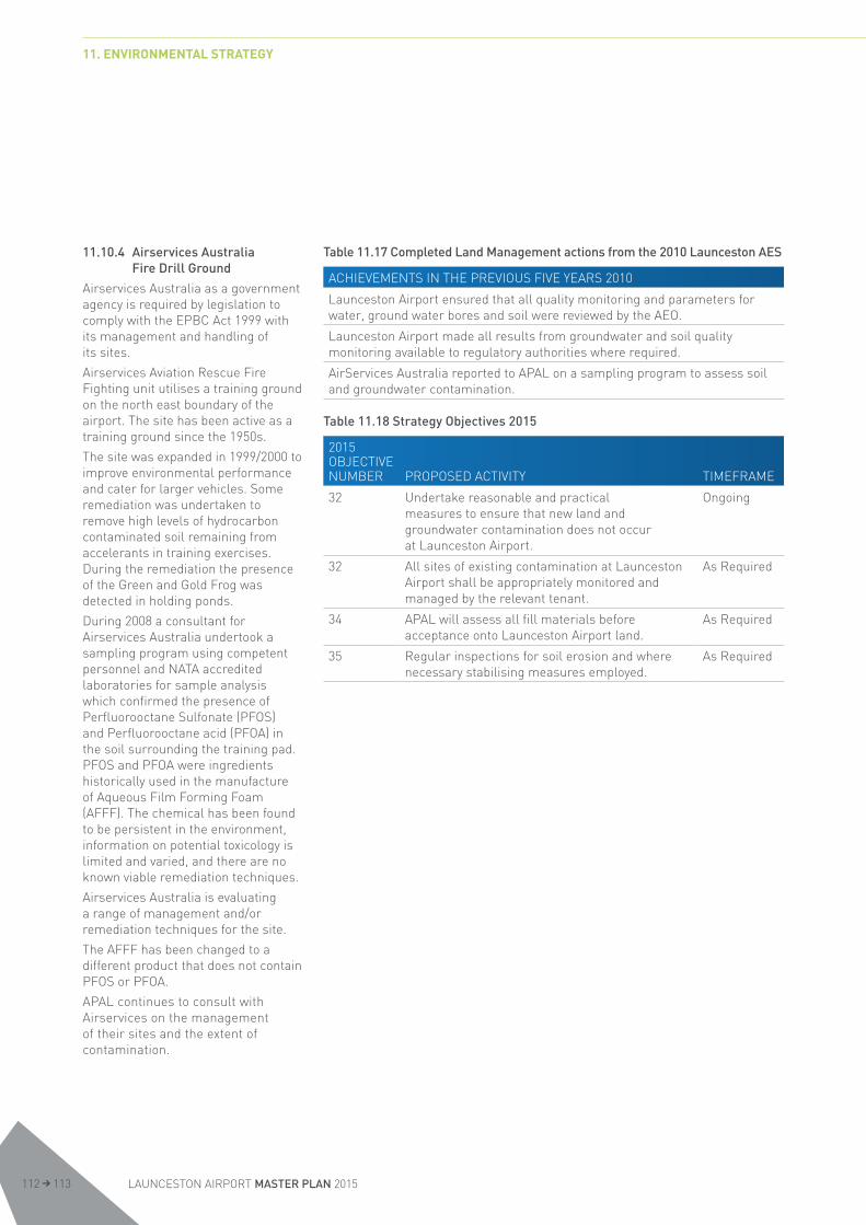
11.10.4 Airservices Australia Fire Drill Ground
Airservices Australia as a government agency is required by legislation to comply with the EPBC Act 1999 with its management and handling of its sites.
Airservices Aviation Rescue Fire Fighting unit utilises a training ground on the north east boundary of the airport. The site has been active as a training ground since the 1950s.
The site was expanded in 1999/2000 to improve environmental performance and cater for larger vehicles. Some remediation was undertaken to remove high levels of hydrocarbon contaminated soil remaining from accelerants in training exercises. During the remediation the presence of the Green and Gold Frog was detected in holding ponds.
During 2008 a consultant for Airservices Australia undertook a sampling program using competent personnel and NATA accredited laboratories for sample analysis which confirmed the presence of Perfluorooctane Sulfonate (PFOS) and Perfluorooctane acid (PFOA) in the soil surrounding the training pad. PFOS and PFOA were ingredients historically used in the manufacture of Aqueous Film Forming Foam (AFFF). The chemical has been found to be persistent in the environment, information on potential toxicology is limited and varied, and there are no known viable remediation techniques.
Airservices Australia is evaluating a range of management and/or remediation techniques for the site.
The AFFF has been changed to a different product that does not contain PFOS or PFOA.
APAL continues to consult with Airservices on the management of their sites and the extent of contamination.
Table 11.17 Completed Land Management actions from the 2010 Launceston AES
ACHIEVEMENTS IN THE PREVIOUS FIVE YEARS 2010
Launceston Airport ensured that all quality monitoring and parameters for water, ground water bores and soil were reviewed by the AEO.
Launceston Airport made all results from groundwater and soil quality monitoring available to regulatory authorities where required.
AirServices Australia reported to APAL on a sampling program to assess soil and groundwater contamination.
Table 11.18 Strategy Objectives 2015
2015 OBJECTIVE NUMBER PROPOSED ACTIVITY TIMEFRAME
32 Undertake reasonable and practical measures to ensure that new land and groundwater contamination does not occur at Launceston Airport.
Ongoing
32 All sites of existing contamination at Launceston Airport shall be appropriately monitored and managed by the relevant tenant.
As Required
34 APAL will assess all fill materials before acceptance onto Launceston Airport land.
As Required
35 Regular inspections for soil erosion and where necessary stabilising measures employed.
As Required
11. ENVIRONMENTAL STRATEGY
LAUNCESTON AIRPORT MASTER PLAN 2015112 113

11.11 Air Quality
Key Objective: To meet both Commonwealth and State air quality standards.
11.11.1 Overview
Good ambient air quality is critical for maintaining community and ecological health. Launceston Airport is situated in the Tamar Valley in a largely rural aspect with a small light industrial subdivision adjacent to the airport. Ambient air quality in the Tamar Valley is impacted by particle emissions from domestic heating. The townships of Perth and Evandale are situated within 5kms of the airport.
Good air quality is also fundamental to the health of the community and surrounding flora and fauna. Emission sources on airport include:
LPG ( boiler and cooking); Diesel generators; Fire Training exercises; Airside Vehicles; Landside vehicles; and Fuel storage/aircraft refuelling.
11.11.2 Fire Fighter Training
Aviation Rescue and Fire Fighting (ARFFS) staff are required to undertake regular training activities for fire rescue, ensuring firefighting crews are fully prepared to deal with any airport based emergency. The production of dark smoke may mean that emissions exceed the air quality requirements of the Regulations.
To allow for this activity, the Regulations make provision for a Dark Smoke Agreement which is jointly signed between Airservices Australia and the regulator on 7 November 2008. The agreement allows Airservices ARFFS to emit dark smoke when undertaking fire fighter training.
Table 11.19 Completed Air Quality actions from the 2010 Launceston AES
ACHIEVEMENTS IN THE PREVIOUS FIVE YEARS 2010
AirServices Australia complied with the Dark Smoke Agreement and maintained records of fire training events.
Dust suppression was used where necessary on all sites where it could impact on the local environment (for example construction projects).
Table 11.20 Strategy Objectives 2015
2015 OBJECTIVE NUMBER PROPOSED ACTIVITY TIMEFRAME
36 To meet both Commonwealth and State air quality standards.
Ongoing
37 APAL will collate data from fire training events conducted under the Dark Smoke Agreement by Airservices and provide to the AEO.
Annually
38 Launceston Airport will continue to monitor and record any complaints regarding air quality on the airport, and investigate them in liaison with the AEO.
As Required
39 If required engage with the State EPA to consider ambient air quality issues at Launceston Airport.
As Required
11. ENVIRONMENTAL STRATEGY

11.12 Cultural and Historic Heritage
Key Objective: To ensure sites of cultural and historic heritage significance are preserved in accordance with Commonwealth and State requirements.
11.12.1 Overview
Historic Heritage
Godden Mackay Logan Pty Ltd (GML) was commissioned by APAL to prepare a Heritage Management Plan (HMP) for Launceston Airport. The HMP was completed in March 2013. The HMP provides,
An assessment of the potential Commonwealth Heritage values of the site, including assessment of the Indigenous cultural heritage values, landscape values and archaeological potential of the airport;
A review of constraints and opportunities arising from the potential Commonwealth Heritage values of the site, day to day operation of the airport and the future plans for the airport; and
Policies for managing and conserving the Commonwealth Heritage values of the airport.
The assessment found that the values of Launceston are embodied in six elements of moderate and above heritage value within the airport land – hangars 10,14 and 17, buildings 26 (air traffic control tower), 105 and the terminal gardens, as well as two areas of historical archaeological sensitivity.
The HMP concluded that since only a number of separate elements embody its heritage values, it is appropriate to define a smaller area or group within the airport which should be conserved. The creation of a ‘heritage precinct’ which would define an area of elements of heritage value would not be appropriate as the elements are scattered across the airport land and it would be more appropriate to describe the six elements and the two areas of historical archaeological significance as the ‘Launceston Airport Group’ with appropriate policies for protecting the setting of the different elements.
The HMP policies for managing and conserving the heritage values have been developed with the ongoing operational requirements of a busy regional airport in mind. The main pressure on the significant hangars on the site is their location and the restrictions this may place on possible future uses.
While the significant hangars must be conserved, if moving the hangars to a new location within the airport would ensure their survival and, provided there are appropriate settings, the policies acknowledge that this approach would be acceptable.
The HMP also provides an implementation plan to provide a framework for the application of the policies. Launceston Airport intends to act on the implementation plan over the next five years.
11.12.2 Indigenous Heritage
The Launceston Airport site is relatively small with very little undeveloped land available for expansion. The majority of grassed areas are located airside with the movement areas that includes the paved runway and taxiway system and grass runways and movement areas. The majority of landside is developed or has had some form of significant disruption.
In 1995, the Federal Airports Corporation conducted a survey using external consultants and Heritage Officers from the Tasmanian Aboriginal Lands Council to undertake a survey of the grounds in an attempt to determine if aboriginal sites may have been present. No sites were detected during the survey.
The EMS contains a trigger that requires a survey of the site for Indigenous Heritage artefacts to be undertaken prior to major development in areas of cultural heritage sensitivity.
The HMP contains an Indigenous heritage assessment. This assessment involved a search of the Tasmanian Aboriginal Site Index (TASI), indigenous consultation using the Commonwealth ‘ask first’ guidelines, a review of relevant heritage reports. An Aboriginal site survey was unable to be carried out due to the current imposition of a community ban of heritage fieldwork in Tasmania.
A search of the TASI identified there were no previously recorded Aboriginal sites located at Launceston Airport. Aboriginal Heritage Tasmania (AHT) stated in correspondence to GML that in their opinion there was a low probability of Aboriginal heritage being present. The HMP concluded that while there may be cultural heritage values attached to the airport, this could only be determined by the Indigenous community and recommended a site survey be conducted once the community ban has been lifted.
11. ENVIRONMENTAL STRATEGY
LAUNCESTON AIRPORT MASTER PLAN 2015114 115

Table 11.21 Completed Cultural & Historic Heritage actions from the 2010 Launceston AES
ACHIEVEMENTS IN THE PREVIOUS FIVE YEARS 2010
Completion of a heritage management plan of the airport site by consultants Godden Mackay Logan (March 2013).
Table 11.22 Strategy Objectives 2015
2015 OBJECTIVE NUMBER PROPOSED ACTIVITY TIMEFRAME
40 To actively preserve sites of cultural and historic heritage significance in accordance with Commonwealth and State legislative requirements, including consultation with cultural heritage stakeholders.
As Required
41 Implement the policies of the heritage management plan developed by GML (March 2013).
2019
42 Provide training and awareness for relevant Launceston Airport employees and contractors on cultural and historic heritage issues.
Ongoing
43 Complete a site survey once the Indigenous community ban has been lifted
Ongoing
11. ENVIRONMENTAL STRATEGY

11.13 Ground-based Noise
Key Objective: To manage and minimise ground based noise emissions associated with the operation of the airport.
11.13.1 Overview
Airports can be a significant contributor to noise levels to the surrounding environment. While Launceston Airport is remote from urban development the quiet ambient background and weather inversions can allow noise to travel significant distance from the airport. It is therefore important to minimise noise a impacts from ground-based activities to the extent practicable.
11.13.2 Ground based Noise
Ground based aviation noise activities are regulated by Commonwealth Department of Infrastructure and Regional Development under the Airports (Environment Protection) Regulations1997.
The potential sources of ground based noise on Launceston Airport are aircraft manoeuvring and take-off run. There is no permanent aircraft maintenance facility on airport and engine running for testing purposes is infrequent and confined to apron areas. Sources of non-aviation noise include:
Road traffic; Construction and demolition activities; Tenant activities; Noise from plant and equipment; Ground service equipment; and Freight operations.
All major construction projects require EMPs which require the noise to be managed according to Launceston Airport’s Development Manual and the Airports (Environment Protection) Regulations1997.
Table 11.23 Completed Ground Based Noise actions from the 2010 Launceston AES
ACHIEVEMENTS IN THE PREVIOUS FIVE YEARS 2010
APAL had no recorded ground based noise complaints during the five year period.
Table 11.24 Strategy Objectives 2015
2015 OBJECTIVE NUMBER PROPOSED ACTIVITY TIMEFRAME
42 APAL will, to the extent practicable, minimise ground based noise levels related to the operation of the airport.
Ongoing
43 Monitor and record any complaints from ground -based noise and investigate complaints in liaison with the AEO.
As Required
11.14 Hazardous Materials
Key Objective: To ensure all hazardous materials are stored, handled, used and disposed of in accordance with Australian Standards and applicable regulations.
11.14.1 Overview
The Airports (Environment Protection) Regulations 1997 declares that State legislation applies to hazardous materials, as this is primarily an occupational health and safety matter. Inappropriate management of hazardous materials can have adverse impacts on the environment.
11.14.2 Chemical Use at Launceston Airport
Launceston Airport’s operations involve the use of hazardous materials, including fuel, oil and chemicals. Procedures are in place to manage hazardous materials and include leak detection, storage of chemicals and standard operating procedures (SOPs). The major uses of chemicals on site include:
Bulk aviation fuel storage (above and below ground) and handling;
Fire training, storage and use of firefighting foam (Solberg);
Airside refuelling activities; and Tenant operated maintenance facilities for vehicles and ground equipment.
Liquid hydrocarbons have the largest bulk use at the airport. These include aviation fuels, diesel, unleaded fuel and oils. Airport operations, construction, maintenance and landscaping all require use of hazardous chemicals. Some of which include:
Pesticides and herbicides; Solvents and paints; Batteries; Some asbestos containing materials exist in buildings; and
Cleaning chemicals.
11. ENVIRONMENTAL STRATEGY
LAUNCESTON AIRPORT MASTER PLAN 2015116 117

11.14.3 Measures to Reduce Impact
Current policies operated at Launceston Airport include UST monitoring procedures which require annual tank tightness testing to be undertaken, leak detection equipment on commercial facilities and correct storage of chemicals.
The storage and quantities of hazardous materials are reviewed every two years by an external consultant. The review also ensures that Material Data Safety Sheets are kept current and displayed according to Workplace Standards.
APAL maintains a hazardous materials risk register, an asbestos register and a manifest of hazardous materials on site. Known sites of asbestos are monitored and where possible removed.
Table 11.25 Completed Hazard Materials actions from the 2010 Launceston AES
ACHIEVEMENTS IN THE PREVIOUS FIVE YEARS 2010
Launceston Airport conducted a hazardous materials risk assessment and maintained a hazardous materials risk register and a manifest of hazardous materials on site.
Staff, tenants and contractors reported any major chemical spills and report minor spills greater than 2 litres within 24 hours.
Launceston Airport and its tenants continued to monitor known sites of asbestos for signs of deterioration and reported their condition.
Launceston Airport and its tenants reported and removed deteriorating asbestos products where possible.
Launceston Airport removed all remaining equipment known to contain PCBs.
Launceston Airport removed all known Underground Storage Tanks owned by APAL
Launceston airport monitored and ensured that all hazardous materials were stored in accordance with Australian Standards and applicable regulations.
Launceston Airport ensured that Material Safety Data Sheets (MSDS) were available for hazardous materials stored in all work places. A review of tenants formed part of the bi-annual review.
Table 11.26 Strategy Objectives 2015
2015 OBJECTIVE NUMBER PROPOSED ACTIVITY TIMEFRAME
44 Launceston airport will monitor and ensure that all hazardous materials are stored and handled in accordance with Australian Standards and applicable regulations.
Ongoing
45 Launceston Airport will require its staff, tenants and contractors to report immediately any major chemical spills and report minor spills greater than five litres within 24 hours.
Ongoing
46 Launceston Airport will record all soil or groundwater pollution incidents and will investigate and address any incidents in liaison with the AEO.
Ongoing
47 Launceston Airport will review and update the list of hazardous materials held on the airport and ensure that they are stored correctly with Material Safety Data Sheets provided.
Annually
48 Launceston Airport and its tenants will continue to maintain and update an Asbestos Register inclusive of annual inspection. Monitor known sites of asbestos and remove deteriorating product if found or reported.
Annually
49 Require tenants to inspect and monitor USTs and ASTs to ensure that contamination of surrounding areas is not occurring.
Ongoing
11. ENVIRONMENTAL STRATEGY
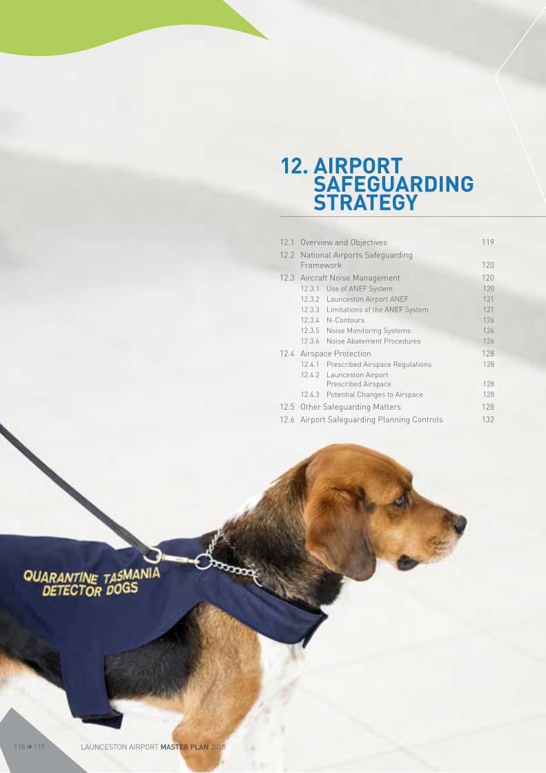
12. AIRPORT SAFEGUARDING STRATEGY
12.1 Overview and Objectives 119
12.2 National Airports Safeguarding Framework 120
12.3 Aircraft Noise Management 12012.3.1 Use of ANEF System 12012.3.2 Launceston Airport ANEF 12112.3.3 Limitations of the ANEF System 12112.3.4 N-Contours 12612.3.5 Noise Monitoring Systems 12612.3.6 Noise Abatement Procedures 126
12.4 Airspace Protection 12812.4.1 Prescribed Airspace Regulations 12812.4.2 Launceston Airport
Prescribed Airspace 12812.4.3 Potential Changes to Airspace 128
12.5 Other Safeguarding Matters 128
12.6 Airport Safeguarding Planning Controls 132
LAUNCESTON AIRPORT MASTER PLAN 2015118 119

12. AIRPORT SAFEGUARDING STRATEGY
12.1 Overview and ObjectivesThe ongoing operation and future growth of Launceston Airport is supported and protected by a range of legislation, planning controls, strategies and other measures. These include:
National Airports Safeguarding Framework; Aircraft noise management measures such as the Australian Noise Exposure Forecast and Australian Standard AS2021-2000;
Airspace protection measures, particularly the Airports (Protection of Airspace) Regulations 1996 which ensure that off-airport development does not infringe protected airspace;
Development referral through the Northern Midlands Interim Planning Scheme 2013 to review the potential impact of adjacent development on protected airspace and operations;
Measures to deal with other hazards to aircraft such as birdstrikes, external lighting and reflectivity of building materials including glass, intrusion by vegetation into operational surfaces and interference to navaids.
These measures combined form a land use framework which aims to maintain, protect and support the ongoing operation of the Airport for the benefit of all users.

12.2 National Airports Safeguarding FrameworkThe National Airports Safeguarding Framework (NASF) comprises:
Principles for National Airports Safeguarding Framework Guideline A: Measures for Managing Impacts of Aircraft Noise Guideline B: Managing the Risk of Building Generated Windshear and Turbulence at Airports
Guideline C: Managing the Risk of Wildlife Strikes in the Vicinity of Airports
Guideline D: Managing the Risk of Wind Turbine Farms as Physical Obstacles to Air Navigation
Guideline E: Managing the Risk of Distractions to Pilots from Lighting in the Vicinity of Airports
Guideline F: Managing the Risk of Intrusions into the Protected Airspace of Airports.
Commonwealth, State and Territory Ministers considered the Framework at the Standing Council on Transport and Infrastructure meeting on 18 May 2012. The Framework was agreed at that meeting, but was subject to the Commonwealth Government’s intention to seek a review of AS2021 by Standards Australia.
Launceston Airport supports the NASF guidelines and has already started using them to guide the consideration of on-airport developments and as the basis of responses to off-airport development proposals. For these guidelines to be fully effective, Launceston Airport believes they should be incorporated into the Tasmanian planning system.
It is the responsibility of each jurisdiction to implement the Framework into their respective planning systems. However, it is acknowledged that statutory implementation of Guideline A should not proceed until the review of AS2021 is completed.
The following sections describe how the NASF guidelines are addressed relative to Launceston Airport.
Two key cornerstones of the Airport protection framework are aircraft noise and airspace protection measures, which are discussed in more detail below.
12.3 Aircraft Noise ManagementAs noted in NASF Guideline A, aircraft noise is one of the most important issues for all airports in terms of land use protection. Aircraft noise is an unavoidable by-product of an airport’s operation, and whilst modern commercial jet aircraft are quieter now than when first introduced, this is still an issue that requires considerable planning focus.
The Launceston Airport site context is largely rural in nature with nearby development confined to the townships of Perth, Evandale and suburbs of Youngtown some 5 to 8 km away respectively.
Referral of planning applications to Launceston Airport from the Northern Midlands Council within the ANEF footprint is critical to the management of aircraft noise into the future. Processes are in place through the Northern Midlands Interim Planning Scheme ensure that Launceston Airport has an opportunity to assess proposed developments and advise the Council of applicable standards and impact on airport operations. The council planning scheme through the provisions the Airport Impact Management Code ensures relevant Australian Standards are applied to all land use development proposals within the vicinity of the airport.
12.3.1 Use of ANEF System
Commonwealth Government policy requires the adoption of the Australian Noise Exposure Forecast system for determining likely noise exposure around Australian Airports. A description of the ANEF system and associated land use compatibility advice for areas in the vicinity of Airports is contained in Australian Standards AS2021-2000 “Acoustics – Aircraft Noise Intrusion – Building Siting and Construction”.
The ANEF chart includes the cumulative noise effect of a full year’s operations so that the seasonal changes in weather patterns and airline schedules are included.
The resulting contours are therefore a measure of the total noise exposure over a full 12 month period divided by 365 to give a daily average. They do not represent the maximum exposure caused by a single noise event (an aircraft over flight).
The ANEF is required to be endorsed for technical accuracy by Airservices Australia in the manner approved by the Minister.
12. AIRPORT SAFEGUARDING STRATEGY
LAUNCESTON AIRPORT MASTER PLAN 2015120 121

12.3.2 Launceston Airport ANEF
The earliest Launceston Airport noise exposure forecast was produced in 1975. The first produced and published publically was in 1990 by the Federal Airports Corporation and since then updated. ANEF’s were produced in 1999, 2004 and 2009.
A new ANEF was produced in conjunction with the preparation of this Master Plan and a copy is included at Figure 12.4.
As with the previous ANEF’s, the 2014 ANEF contours represent the long term forecast for noise impact, after taking into account the long range practical airfield capacity operations level of 67,890 movements. This section sets out the base parameters and assumptions used to prepare the ANEF contours.
The ANEF has been derived by computer simulation using the Integrated Noise Model (INM) Software Version 7.0d. The INM calculates aircraft noise impacts by applying standard or user defined aircraft flight profiles, performance data and noise-power-distance (NPD) curves to the runway configuration and flight tracks specific to Launceston Airport.
All aircraft tracks and operating procedures have been derived from a combination of published information from the Aeronautical Information Publications (AIP), ADS-B images provided by Airservices as well as consultation with Airservices staff. The modelled data has been confirmed as being a realistic representation of aircraft track usage and are considered operationally feasible for the airport by Airservices local ATC. Figures 12.1 and 12.2 indicate jet arrival and departure tracks. In addition, Helicopter and Touch and Go Training Tracks have been included in Figure 12.3. These tracks have been adopted for the 14R/32L runway. In practice, aircraft tracks can vary either side of the theoretical flight paths due to effects such as weather, aircraft type and payload. The computer modelling process has included an allowance for track dispersal to accommodate these variations.
Airport traffic movements for the ANEF have been based on a capacity study that was performed during the development of the 2008 ANEF, which is considered to remain valid. The resultant annual forecast is 67,890 movements which could be expected to occur between 2070 and 2075. The aircraft fleet mix is based on the current aircraft utilisation together with an allowance for next generation aircraft such as the Boeing 737 MAX and the A320 NEO which are expected to be in service at Launceston during the course of the forecast.
Runway utilisation was determined after analysing meteorological data and consultation with local air traffic control as 30% for runway 14 and 70% for runway 32.
The traffic pattern over the course of a 24 hour period is based on the current situation modified to reflect a generally more balanced pattern during the day as peaking is reduced due to capacity constraints as aircraft movements increase.
The area affected by the 2014 ANEF contours has changed when compared with the previous ANEF (2009).
The contour is shorter on both the northern and southern ends. This is mainly due to aircraft turning earlier on departure, partly caused by better climb performance of modern aircraft. This results in the contour being further away from the town of Launceston (to the northwest of the airport).
The contour is wider on the northern end due to changes in departure tracks.
Figure 12.4 illustrates the ANEF and provides a table for recommended land uses derived from AS 2021. The changed contour shape of the 20 and 25 ANEF Zones does not cause any additional urban dwellings to be affected and the critical ANEF Zone 30 and greater has likewise not expanded to encompass any dwelling beyond that already affected. The dwellings within the ANEF Zone 30 are located south of the 32L approach and have been in place for over 40 years.
The plans of the tracks used in the development of the ANEF have been provided in Figures 12.1 to12.3 to indicate to the public where they may expect aircraft to transit during regular operations. The frequency of use of the tracks is subject to prevailing weather conditions.
12.3.3 Limitations of the ANEF System
The ANEF system forms the basis for the airport’s current published noise contours. However, experience has shown that aircraft noise is not confined to areas inside the ANEF noise contours, nor does the noise stop at a line on a map. In fact, most complaints relating to aircraft noise at Australian airports come from people who live outside the published ANEF noise contours (that is, outside the 20 ANEF contour).
It is now generally recognised that basing land use planning decisions solely on ANEF noise contours, without reference to other information, is likely to lead to a less than optimal outcome for airports and the community. At best, the ANEF and AS2021 system sets minimums and, in the end, the system is only intended to mitigate noise effects within buildings. Additional or supplementary noise planning tools are required to better support the airport’s ongoing operation and protect surrounding communities.
12. AIRPORT SAFEGUARDING STRATEGY

MA
STER
PLA
N 2
015
FIG
UR
E 12
.1R
UN
WAY
14
DEP
AR
TUR
E A
ND
AR
RIV
AL
TRA
CK
S
This
pla
n ha
s be
en p
repa
red
to il
lust
rate
the
Mas
ter
Pla
n an
d is
not
inte
nded
to s
erve
any
oth
er p
urpo
se
122 123
LAUNCESTON AIRPORT MASTER PLAN 2015

MA
STER
PLA
N 2
015
FIG
UR
E 12
.2R
UN
WAY
32
DEP
AR
TUR
E A
ND
AR
RIV
AL
TRA
CK
S
This
pla
n ha
s be
en p
repa
red
to il
lust
rate
the
Mas
ter
Pla
n an
d is
not
inte
nded
to s
erve
any
oth
er p
urpo
se

MA
STER
PLA
N 2
015
FIG
UR
E 12
.3C
IRC
UIT
AN
D H
ELIC
OP
TER
TR
AC
KS
This
pla
n ha
s be
en p
repa
red
to il
lust
rate
the
Mas
ter
Pla
n an
d is
not
inte
nded
to s
erve
any
oth
er p
urpo
se
124 125LAUNCESTON AIRPORT MASTER PLAN 2015

MA
STER
PLA
N 2
015
FIG
UR
E 12
.4LO
NG
RA
NG
E A
UST
RA
LIA
N N
OIS
E EX
PO
SUR
E FO
REC
AST
(AN
EF)

12.3.4 N-Contours
Having regard to the recognised limitations of the ANEF system, the National Airports Safeguarding Framework (NASF) Guideline A: Measures for Managing Impacts of Aircraft Noise recommends using the N60/N65/N70 noise contour system to supplement the ANEF contours.
The N60/N65/N70 system is a complementary aircraft noise contour system which produces contours showing the potential number of aircraft noise events above 60dB(A), 65dB(A) or 70dB(A). These contours, sometimes called ‘number above’ or just ‘N contours’, have several advantages over the ANEF system:
N contours report noise by the number of single events, which is how individuals generally experience and perceive aircraft noise.
The information can be relatively easily verified – for example, by cross-comparing with a measured N70 chart.
N contours are useful for showing noise exposure in a meaningful way for short time periods, for example, evenings, as it takes information beyond the ‘average day’.
The N70 system reports aircraft noise in the way that a person perceives it – as a number of noise events per day above a certain decibel level.
This system is not a new concept, but contours derived from it have never been published for Launceston Airport. As recommended in NASF Guideline A, N contours have been produced in parallel with this Master Plan to provide an additional level of noise information. The N contours are shown in Figure 12.5. Like the ANEF, the N contours reflect modelling of long range runway capacity and are not intended to represent actual runway utilisation at a specific point in time.
12.3.5 Noise Monitoring Systems
Aircraft noise complaint monitoring for Launceston Airport is undertaken by Airservices Australia’s Noise Enquiry Unit. Noise complaints are received, logged and investigated. These complaints are investigated as appropriate. The noise complaints are monitored by Launceston Airport on a quarterly basis to determine whether there are any particular trends or issues evident.
Airservices provides aircraft noise complaints data to Launceston Airport each quarter. These are noted in the Airports annual environment reports and regularly reviewed for trends or changes to enable local action where possible.
Since the replacement of the B727 freighter aircraft with more modern types the number of jet aircraft complaints have virtually ceased. Complaints recorded by Airservices for the 12 months to December 2013 numbered only six. It would appear from the relatively scant detail provided by the reports that none of these complaints related to Jet aircraft operations. It is likely that the complaints of helicopter activity in Launceston and propeller aircraft in Perth are not related to Launceston Airport but in fact are attributable to off airport based rural and charter operations.
12.3.6 Noise Abatement Procedures
Launceston Airport’s noise abatement procedures (NAPs) are designed and implemented by Airservices to reduce the impact of aircraft noise on the community. They include procedures for runway use and flight paths to reduce flights over residential areas. Air traffic control implements these procedures but they are not mandatory, and their use depends on weather conditions and aircraft requirements.
When possible, departures are directed away from the Launceston urban area to the north-west of the airport. The preferred runway for departures is Runway 14R. The least preferred runway for departures is Runway 32L (jet noise abatement climb procedures apply). When conducting circuit training flights, aircraft will avoid overflying the township of Evandale to the sout-east of the airport.
Further details of these NAPs are available on the Airservices website.
Airservices conducts regular reviews to check the effectiveness of noise abatement procedures and to seek improvements. At major airports, it consults with community forums on the terms of reference for reviewing the procedures and publishes reports on its website.
12. AIRPORT SAFEGUARDING STRATEGY
LAUNCESTON AIRPORT MASTER PLAN 2015126 127

MA
STER
PLA
N 2
015
FIG
UR
E 12
.5N
-CO
NTO
UR
S
This
pla
n ha
s be
en p
repa
red
to il
lust
rate
the
Mas
ter
Pla
n an
d is
not
inte
nded
to s
erve
any
oth
er p
urpo
se

12.4 Airspace ProtectionAfter the issue of noise protection, the other most significant form of protection necessary for the immediate and long term operation and future growth of the airport is the protection of its surrounding airspace from physical intrusions such as tall buildings or towers and non-physical intrusions such as industrial chimney discharges and bright lights. These matters are controlled by the Airports (Protection of Airspace) Regulations and are administered by Launceston Airport and the Commonwealth Department of Infrastructure and Regional Development (DIRD). These matters are also addressed in NASF Guideline F.
12.4.1 Prescribed Airspace Regulations
Under the provisions of the Airports Act 1996 and the Airports (Protection of Airspace) Regulations 1996, the airspace around specific airports may be declared as Prescribed Airspace to protect the airspace for the safe arrival and departure of aircraft using the Airport.
Prescribed Airspace is the airspace above any part of either an Obstacle Limitation Surface (OLS) or the surfaces set by Procedures for Air Navigational Services – Aircraft Operations (PANS-OPS) Surface, which is defined as:
Obstacle Limitation Surface (OLS): this surface is usually the lowest of the two surfaces that make up Prescribed Airspace, and is designed to provide protection for visual flying, or VFR (ie. When the pilot is flying by sight); and
Procedures for Air Navigational Services - Aircraft Operations (PANS-OPS): This surface is usually higher than the OLS and is designed to provide protection for instrument flying, or IFR (ie. when the pilot is flying by instruments). The PANS-OPS may also protect airspace around the network of navigational aids that are critical for instrument flying.
Under Section 182 of the Airports Act 1996, activities that result in intrusions into an Airport’s Prescribed Airspace are called “controlled activities”. Controlled Activities cannot be carried out without approval. The Regulations provide for the Commonwealth DIRD or the Airport Operator to approve applications to carry out controlled activities, and to impose conditions on approval.
12.4.2 Launceston Airport Prescribed Airspace
Airport operators are required to prepare plans of the Prescribed Airspace surfaces relating to their Airport and have those surfaces declared under Airspace Regulations by the Commonwealth DIRD.
Launceston Airport’s Prescribed Airspace is shown on Figures 12.6 and 12.7. Figure 12.7 shows the Obstacle Limitation Surfaces (OLS) based on runway 14R/32L and 18/36, 14L/32R grassed runways. Figure 12.6 shows Procedures for Air Navigational Services – Aircraft Operations (PANS-OPS) for the main runway.
It is important to note that distances covered by the Prescribed Airspace. In some areas the Prescribed Airspace extends beyond 30 kilometres from the Airport and four municipalities (Northern Midlands, Meander Valley, Launceston & West Tamar) are affected by Launceston Airport’s Prescribed Airspace to varying degrees.
Launceston Airport is currently undertaking a process of formally declaring its future airspace under the Airports (Protection of Airspace) Regulations. Once this process is completed the approvals process for developments in the affected areas will be applied by the airport.
12.4.3 Potential Changes to Airspace
The continued closure of the grass runways 14L/32R and 18/36 may eventually impact Launceston Airport’s protected airspace. The change would be minor and limited to the approach/departure surfaces of these two runways. These changes are limited to the removal of the protection of approach/departure surfaces below the inner horizontal surface 211.5m AHD (the controlling surface of 14R/32L main runway). Figure 12.8 illustrates the changes.
12.5 Other Safeguarding MattersNASF Guidelines B, C, D and E recommend measures to control hazards to aircraft operations caused by:
Building generated windshear; Wildlife strikes; Wind turbine farms; and Distractions to pilots from lighting
On the airport site, APAL has various policies and procedures to manage these matters, particularly through the on-airport development approval process. Off-airport there should be appropriate planning controls in place to address these matters.
12. AIRPORT SAFEGUARDING STRATEGY
LAUNCESTON AIRPORT MASTER PLAN 2015128 129

MA
STER
PLA
N 2
015
FIG
UR
E 12
.6P
RES
CR
IBED
AIR
SPA
CE
PAN
-OP
S SU
RFA
CES
This
pla
n ha
s be
en p
repa
red
to il
lust
rate
the
Mas
ter
Pla
n an
d is
not
inte
nded
to s
erve
any
oth
er p
urpo
se

MA
STER
PLA
N 2
015
FIG
UR
E 12
.7C
UR
REN
T O
BST
AC
LE L
IMIT
ATIO
NS
SUR
FAC
E
This
pla
n ha
s be
en p
repa
red
to il
lust
rate
the
Mas
ter
Pla
n an
d is
not
inte
nded
to s
erve
any
oth
er p
urpo
se
LAUNCESTON AIRPORT MASTER PLAN 2015130 131

MA
STER
PLA
N 2
015
FIG
UR
E 12
.8FU
TUR
E O
BST
AC
LE L
IMIT
ATIO
NS
DR
AWIN
G
This
pla
n ha
s be
en p
repa
red
to il
lust
rate
the
Mas
ter
Pla
n an
d is
not
inte
nded
to s
erve
any
oth
er p
urpo
se

12.6 Airport Safeguarding Planning ControlsGiven Launceston Airport’s social and economic importance to the local region and the state, planners and the planning system should adopt a precautionary approach to protecting this significant asset. This is essential when looking back at the development of Australia’s cities and their airports over the last 80 years, which has seen many airports’ operations restricted by encroaching urban development. Such an approach would be consistent with the policy direction in the National Airports Safeguarding Framework, which recognises the need to complement existing safeguarding measures with other tools.
The Northern Midlands Interim Planning Scheme 2013 contains the following objective:
Protect Launceston Airport from encroachment by incompatible uses or developments that compromise its operations in recognition of its importance and contribution to the Launceston Region and State economy.
This objective is supported and is considered to be consistent with the principles of NASF.
The Scheme also contains an Airports Impact Management Code (E12). The purpose of this provision is to:
a. ensure that use or development within identified areas surrounding airports does not unduly restrict the ongoing security, development and use of airport infrastructure; and
b. provide for management of the land use implications of those areas relevant to use and development under the scheme.
The specific provisions of the Code ensure that land use complies with the ANEF and AS2021 and that development complies with the Prescribed Airspace provisions of the Airports Act 1996 and the Airports (Protection of Airspace) Regulations.
Whilst the Airports Impact Management Code within the planning scheme is supported, Launceston Airport believes that some additional statewide planning provisions to enable improved protection of airports aligned with NASF would be beneficial. They are:
A reference to the N-contours in addition to the ANEF contours in accordance with NASF Guideline A.
The standards relating to Prescribed Airspace need to clearly articulate that non-physical intrusions such as industrial chimney discharges are also potentially a controlled action.
Provisions to control hazards to aircraft operations through building generated windshear, wildlife strikes, wind turbine farms or lighting in accordance with NASF Guidelines B, C, D and E.
With the addition of these provisions, the objective of safeguarding Launceston Airport would be fully addressed in accordance with NASF.
Launceston Airport will continue to liaise with the State Planning Commission and Northern Tasmania Development (NTD) to promote the implementation of the NASF in Tasmania and its eventual inclusion in the planning schemes.
12. AIRPORT SAFEGUARDING STRATEGY
LAUNCESTON AIRPORT MASTER PLAN 2015132 133

13.1 Overview 134
13.2 Capital Program 134
13.3 Project Delivery 134
13.4 Development Approval Process 134
13.5 Safety Management System 134
13.6 Environmental Management System 135
13.7 Asset Management System 135
13.8 Community and Stakeholder Engagement 13513.8.1 Communications and Information 13513.8.2 Stakeholder Engagement 13513.8.3 Forums 13513.8.4 Community Investment 135
13.9 Periodic Reviews 135
13. IMPLEMENTATION
13.1 OverviewThis Master Plan represents the current view of airport development expected to be realised over the next 20 years, largely as a result of increased passenger and aircraft demand.
The implementation of the Master Plan and future projects will be in logical stages to match demand, with continuous monitoring using a range of processes and analysis to ensure the timely delivery of required infrastructure and facilities. The review of the Master Plan every five years further enables Launceston Airport to reassess the project timeframes, validate the accuracy of the forecasts and planning assumptions, incorporate progressive insights and learnings from the past, and refine concept scenarios.
The implementation of the Master Plan is also supported by a range of other systems and procedures that ensure project implementation is undertaken in an efficient, safe, secure and sustainable manner, and the airport’s development is properly managed.
13.2 Capital ProgramLargely underwritten by commercial agreements with airline customers, tenants and other business operators, the capital program underpins the capital works planned across the airport’s four precincts. The capital program is aligned with Launceston Airport’s precinct strategies (20 year) and capital plan (10 years).
13.3 Project DeliveryThe Launceston Airport project management process guides projects from inception through to operational handover. The process for projects focuses on the clarity of project scope, cost, time and risks. A Project Working Group(PWG) is established for all significant projects. The PWG monitors and directs all aspects of the project and comprises a range senior management from across the business to enhance the breadth of expertise within the group. The primary aims of Launceston Airport’s project delivery are to:
manage the expectations of all project and business stakeholders provide a transparent process to those affected by the project establish a governance process so that those delivering the project understand what is required, by whom and by when
increase clarity to ensure the project provides the best outcome for the business
increase consistency and quality of information for efficient and effective communication
increase stakeholder buy-in and align project objectives to strategic goals ensure projects progress seamlessy through the funding and design approval stages
increase the business’ ability to plan and evaluate workload increase the business’ ability to prioritise projects. Identify, assess and manage associated risk?
Following completion, a post implementation review of projects is conducted by the senior management team
13. IMPLEMENTATION
13.4 Development Approval Process
Development approval requirements for the Launceston Airport site are administered under the Airports Act. The details of the approval process for on-airport developments were discussed in Section 5.11. Before they reach the delivery stage, all projects progress through this consent process. This includes MDP approval (if required) and approval by the Airport Building Controller.
13.5 Safety Management SystemThe Safety Management System (SMS) aims to ensure compliance with current work health and safety legislation and safety system accreditation requirements. It outlines safety management at airports owned by Australia Pacific Airports Corporation Limited (APAC) and is a reference point for workers to clarify the safety processes and systems and best practice safety standards and principles.
Launceston Airport’s SMS is an accredited AS/NZS 4801:2001 Occupational Health and Safety Management System. It is audited by an accredited external body annually, and is recertified every three years.
The safety systems and processes outlined in the SMS are designed to achieve business safety objectives and support Launceston Airport’s Work Health & Safety Policy. Twelve safety elements divide the system into points of reference to make navigation and reference easier and simpler for the end-user. No one element is more important than another and all safety elements align to support ‘big picture’ safety requirements and obligations.
Contractors, tenants, property occupiers, temporary workers, concessionaires and other airport business operators are required to cooperate with and, where applicable, demonstrate an approach to safety management equivalent to the SMS.
LAUNCESTON AIRPORT MASTER PLAN 2015134 135

13.6 Environmental Management System
Launceston Airport’s Environmental Management System (EMS) is discussed in Section 11.
This system provides a structured approach to planning and implementing environmental protection measures. The EMS monitors environmental performance and integrates environmental management into the airport’s operations, planning and other quality management systems. It records the findings of various environmental reviews and assessments to ensure action items arising from reviews are followed up.
13.7 Asset Management SystemLaunceston Airport is currently developing an integrated Asset Management System that will provide detail and process for managing airport assets. An integrated Asset Management Plan will be prepared which will outline the specific actions required to manage the assets and include demand forecasts, condition and risk information as well as long term financial forecasts.
13.8 Community and Stakeholder Engagement
Launceston Airport has a strong commitment to community and stakeholder consultation and will continue to take a proactive approach to communicating with the community, including governments at all levels, businesses, industry, employees and other key stakeholders. This approach will be fundamental when implementing the Master Plan.
The airport’s communications and engagement activities involve four main streams, outlined below. To monitor the progress of these activities, Launceston Airport monitors its stakeholder and communications performance through stakeholder surveys which provide a measure of stakeholder satisfaction levels.
13.8.1 Communications and Information
Launceston Airport will continue to use a range of communication channels, including its website, media releases, community meetings and social media, to provide timely and accurate information about airport operations, projects and future plans.
13.8.2 Stakeholder Engagement
Launceston Airport holds regular briefings, meetings and updates to keep stakeholders informed and engaged on airport-related issues. These stakeholders include local, State and Commonwealth Governments and relevant government departments; agencies and statutory authorities; the local community; airlines; industry; business and tourism bodies; and employees.
13.8.3 Forums
Launceston Airport has established a Community Aviation Consultation Group which focuses on community-related airport issues. The group provides an opportunity for the community to discuss and express opinions regarding Launceston Airport, particularly with regard to planning, development and operations, and disseminates information regarding the airport. Members include community, government and industry. The group is independent of the airport and has an independent Chair.
13.8.4 Community Investment
Launceston Airport supports a variety of community development programs to enhance the Launceston community’s economic prosperity and social and cultural life.
13.9 Periodic ReviewsThe Airports Act provides for a final Master Plan to remain in force for five years. In addition, there is provision for the Minister, by written notice, to direct the airport lessee company to replace the original plan.
The Airports Act makes similar provisions for reviewing and replacing the Environment Strategy which has been incorporated into this Master Plan.
In addition to the statutory review requirements, Launceston Airport management processes provide for annual review of the development proposals that are included in this Master Plan based on updated annual forecasts.
Airspace surfaces are reviewed periodically following significant flight track changes, and declaration of the new surfaces is then sought from the Commonwealth Department of Infrastructure and Regional Development under the Airports (Protection of Airspace) Regulations 1996.
13. IMPLEMENTATION

14. CONCLUSION14. CONCLUSION
136 137 LAUNCESTON AIRPORT MASTER PLAN 2015

14. CONCLUSION
This Master Plan provides the community, business operators, government and other key stakeholders with an understanding of Launceston Airport, what it does, and the values and aspirations by which it defines itself. It articulates the growth requirements it must meet to achieve these aspirations, and an assessment of where the airport stands today.
This document expresses the airport’s continued commitment to develop as a leading regional airport and become Tasmanias port of choice, implementing the highest industry standards and reflecting best practice in airport management, both now and in the future.
The Master Plan will not be successful unless Launceston Airport continues to widely communicate these strategic goals and incorporate them into its day-to-day business and planning activities, with direct links to its capital works program and stakeholder engagement plans. The airport will also continue to monitor its performance throughout the year and make adjustments as needed to achieve the desired results.
This Master Plan will guide Launceston Airport as it works on promoting sustainable long-term growth and delivering excellence in customer service. The airport will update the Master Plan every five years to cover a new planning period.
Despite its comprehensive nature, this Master Plan does not intend to outline a fixed set of directives; in Launceston Airport’s view, the planning process should be dynamic and adaptable to adequately respond to evolving stakeholder requirements and external circumstances beyond the airport’s reasonable control. It will, however, serve as Launceston Airport’s strategic planning framework, against which the airport will make infrastructure-related decisions and focus its resources, thus accommodating future growth and consolidating its position as the gateway to the heart of Tasmania.
14. CONCLUSION

15. REFERENCES
138 139 LAUNCESTON AIRPORT MASTER PLAN 2015

Airports Act 1996
Airports (Environment Protection) Regulations 1997
Australian Standard AS2021-2000 Acoustics – Aircraft Noise Intrusion – Building Siting and Construction
Austroads Guide to Traffic Engineering Practice
Civil Aviation Act 1988
Environment Protection and Biodiversity Conservation Act 1999
Environmental Management and Pollution Control Act 1994
International Air Transport Association – Guidelines for Airport Capacity/Demand Management
International Standard for Environmental Management Systems ISO14001 (2004)
National Airports Safeguarding Framework
Northern Midlands Interim Planning Scheme
Greater Launceston Plan
Deloitte Access Economics; The Economic and Social Contribution of Australia’s Airports: May 2012
International Air Transport Association; Aviation Economic Benefits: IATA Economics Briefing No. 8, July 2007.
Launceston Airport Heritage Management Plan 2013
Launceston Airport Technical Paper – Runway System Usability 2014
Launceston Airport Ecological Assessment and Recommendations December 2013
Launceston Airport Terminal Capacity Study December 2013
Launceston Airport Master Plans 2009, 2004, 1999
15. REFERENCES

AUSTRALIA PACIFIC AIRPORTS (LAUNCESTON) PTY LTDACN 081 578 903