agricultural reserve workshop - palm … agricultural reserve workshop executive summary overview...
TRANSCRIPT

1
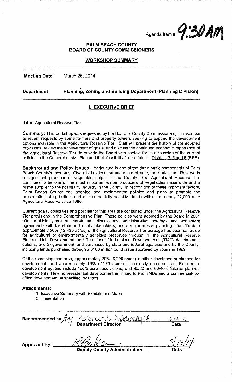
AGRICULTURAL RESERVE WORKSHOP EXECUTIVE SUMMARY
Overview and History
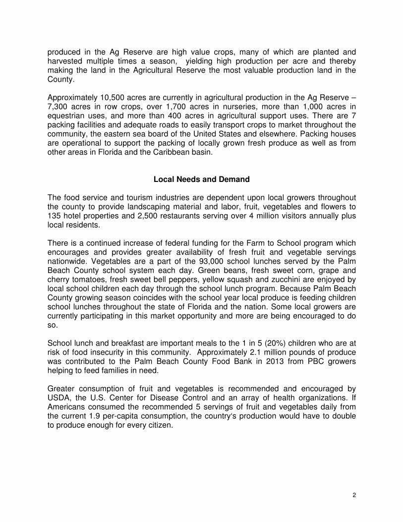
The Agricultural Reserve covers more than 22,000 acres of unincorporated land west of the Turnpike and north of the Broward County Line. This location’s micro-climate, unique in Florida, creates optimal conditions for year-round agricultural cultivation. (Map 1- Location) The Agricultural Reserve is one of the largest producers of winter vegetables in the nation and the prime supplier of local fresh vegetables to the hospitality and restaurant industries. This highlights its continued economic value and contribution to the County’s economy.
Regulating policies have evolved through years of a development moratorium (1989-1995), challenges and settlement agreements with stakeholders (1994-1995), studies and planning efforts with extensive public participation and development of a Master Plan (1999), and $100 million bond issue approved by voters in 1999, used to purchase approximately 2,500 acres. (Exh. 1 - Chronology)
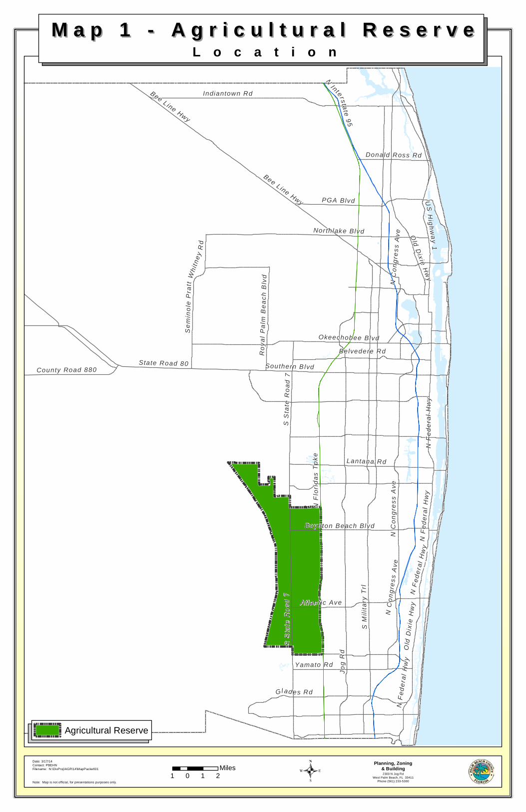
The Board of County Commissioners implemented the Master Plan by adopting the policies under the Agricultural Reserve Tier of the Comprehensive Plan in 2001. These policies are intended to preserve agriculture and environmentally sensitive lands, while allowing for limited development options. (Exh. 2- Policies) To date, development in the Agricultural Reserve is occurring essentially as anticipated in the master plan created in 2001. (Map 2- Master Plan).
Ag Reserve Land Use Snapshot 2014
Existing Land Use Total Acres
Development Areas
1Preserve
2 No Approval Other Uses
Agriculture & Equestrian 10,491 1,788 6,168 2,535 -
Conservation 6,229 - 6,229 - -
Built 3,941 3,804 33 104 -
Vacant 746 630 - 117 -
R.O.W., Canals, Gov. Use 645 68 - 20 556
Total Land Area 22,052 6,290 12,430 2,776 556
Agriculture
The Agricultural Reserve is the warmest winter vegetable area along the US eastern seaboard. Locally-farmed produce feeds much of United States in winter months. Approximately 10,500 acres, or nearly half of the Agricultural Reserve, is in agricultural use: 7,300 acres in row crops, over 1,700 acres in nurseries, more than 1,000 acres in equestrian uses, and more than 400 acres in agricultural- related uses. This agricultural activity occurs on nearly 6,200 acres set aside as agricultural preserves, on over 2,500 acres with no development approvals, and on nearly 1,800 acres of unbuilt land with current residential development approvals. (Map 3 – Existing Land Use)
2
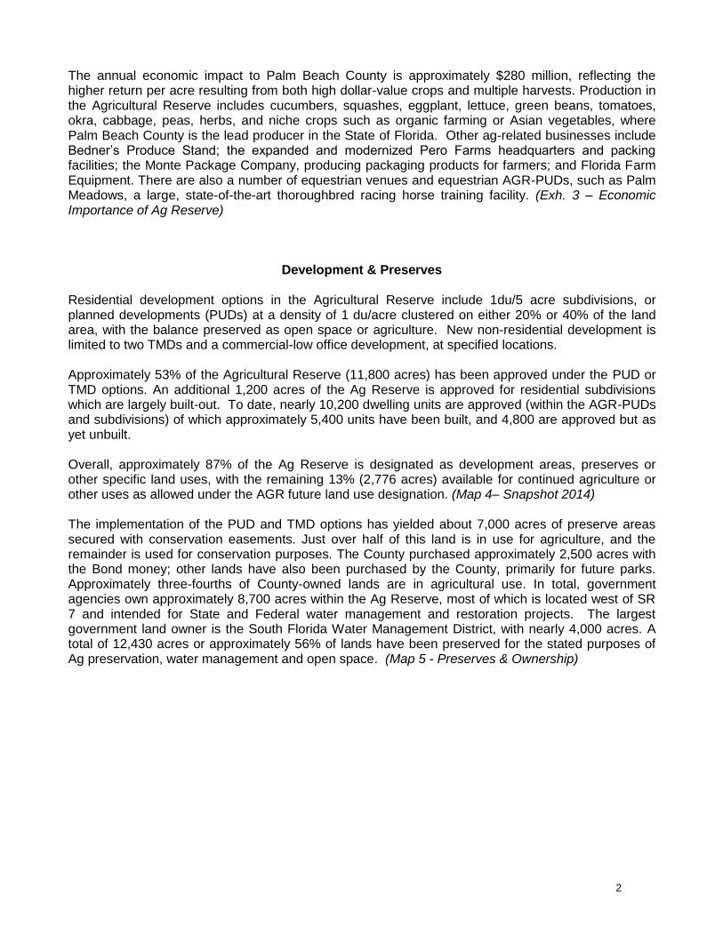
The annual economic impact to Palm Beach County is approximately $280 million, reflecting the higher return per acre resulting from both high dollar-value crops and multiple harvests. Production in the Agricultural Reserve includes cucumbers, squashes, eggplant, lettuce, green beans, tomatoes, okra, cabbage, peas, herbs, and niche crops such as organic farming or Asian vegetables, where Palm Beach County is the lead producer in the State of Florida. Other ag-related businesses include Bedner’s Produce Stand; the expanded and modernized Pero Farms headquarters and packing facilities; the Monte Package Company, producing packaging products for farmers; and Florida Farm Equipment. There are also a number of equestrian venues and equestrian AGR-PUDs, such as Palm Meadows, a large, state-of-the-art thoroughbred racing horse training facility. (Exh. 3 – Economic Importance of Ag Reserve)
Development & Preserves
Residential development options in the Agricultural Reserve include 1du/5 acre subdivisions, or planned developments (PUDs) at a density of 1 du/acre clustered on either 20% or 40% of the land area, with the balance preserved as open space or agriculture. New non-residential development is limited to two TMDs and a commercial-low office development, at specified locations.
Approximately 53% of the Agricultural Reserve (11,800 acres) has been approved under the PUD or TMD options. An additional 1,200 acres of the Ag Reserve is approved for residential subdivisions which are largely built-out. To date, nearly 10,200 dwelling units are approved (within the AGR-PUDs and subdivisions) of which approximately 5,400 units have been built, and 4,800 are approved but as yet unbuilt.
Overall, approximately 87% of the Ag Reserve is designated as development areas, preserves or other specific land uses, with the remaining 13% (2,776 acres) available for continued agriculture or other uses as allowed under the AGR future land use designation. (Map 4– Snapshot 2014)
The implementation of the PUD and TMD options has yielded about 7,000 acres of preserve areas secured with conservation easements. Just over half of this land is in use for agriculture, and the remainder is used for conservation purposes. The County purchased approximately 2,500 acres with the Bond money; other lands have also been purchased by the County, primarily for future parks. Approximately three-fourths of County-owned lands are in agricultural use. In total, government agencies own approximately 8,700 acres within the Ag Reserve, most of which is located west of SR 7 and intended for State and Federal water management and restoration projects. The largest government land owner is the South Florida Water Management District, with nearly 4,000 acres. A total of 12,430 acres or approximately 56% of lands have been preserved for the stated purposes of Ag preservation, water management and open space. (Map 5 - Preserves & Ownership)
1
EXHIBIT 1 AG RESERVE WORKSHOP
March 25, 2014
CHRONOLOGY OF EVENTS
Origins- 1970 & 1980 Comprehensive Plans
Starting with Palm Beach County’s 1972 Land Use Plan, the area now known as the Ag Reserve was designated from a larger area as “Residential Estates” with densities ranging from 1 dwelling unit (DU) per acre to 1 DU per 2.5 acres. In 1980, the County’s Comprehensive Plan formally created the reserve area and defined its boundaries. The emphasis was preservation of agriculture and densities, which were reduced to 1 unit per 5 acres. It also allowed “80/20 Planned Unit Developments (PUDs)” with 1 unit per acre clustered on 20 percent of the land with a minimum of 40 acres, and established provisions for Transfer of Development Rights (TDRs) outside of the Ag Reserve.
The 1989 Comprehensive Plan – Moratorium declared
In 1989 the County’s Comprehensive Plan revised the area’s boundaries to remove non-contiguous portions and reflect land use changes made during the 1980s. These revisions reduced the area by more than 5,000 acres resulting in its current boundaries encompassing 21,981 acres. Also, a moratorium was enacted until a study could be completed to evaluate the long-term viability of agriculture. TDR options were still permitted, but the 80/20 PUD option and 1 DU per 5 acres provision were suspended.
1990 Ag Reserve Study
In 1990, the County hired Dames and Moore to conduct a phased study of the Ag Reserve, which included two initial phases:
Phase I: An economic impact analysis and an analysis of agricultural determinants (Feb 1991)
Phase II: A land use suitability analysis (October 1991) and development of alternative scenarios, related strategies, and impact assessment (February and March 1992)
Alternative scenarios ranged from maintaining agriculture (TDRs, Purchase of Development Rights, and Agricultural Districts), through an “anti-sprawl” development option with protection of natural resources and environmental sensitive lands, to expansion of development with no effort to preserve agriculture.
1993 Purchase of Agricultural Conservation Easements (PACE) Program
In May 1993, the County Planning Division staff completed a preliminary report as part of Phase III of the work to be originally completed by Dames and Moore. The report made recommendations for establishing a Purchase of Agricultural Conservation Easements (PACE) program. The study concluded that as much as $100 to $200 million would be needed to fund the PACE program.
2
1994-1995 New Ag Reserve Provisions & Lifting of Moratorium
The BCC adopted in 1994 new provisions for the Ag Reserve, based in some of the recommendations of the previous studies. These new provisions were found “Not In Compliance” by DCA. Subsequently in 1995, after an administrative hearing process, the Board adopted a Remedial Plan Amendment, which included an additional 60/40 development option with a minimum of 150 acres of preserve area and development clustered in 40% of the land. Preserve areas under this option were not required to be contiguous to the development area, and development was limited to areas east of SR7. The moratorium was lifted in 1995 allowing all the development options to proceed.
1996-1999 Ag Reserve Bond Issue
A PACE committee was established in 1996 with very little success, which led to exploring a bond issue to fund the PACE program. This resulted in a 1998 recommendation to utilize a Bond Issue to preserve agriculture in the Ag Reserve. In 1999 Palm Beach County voters approved a referendum authorizing a $150 million bond issue to purchase agricultural and environmental sensitive lands. The PACE program was officially repealed in 2001 and its committee replaced with the then existing Conservation Land Acquisition Selection Committee (CLASC), which carried through the purchase of agricultural and environmental sensitive lands. Close to 2,400 acres were purchased with Bond moneys to date. The County has subsequently sold 167 acres with no development rights and deed restrictions to the SWA and farmers.
1998-1999 Master Plan for the Ag Reserve
In July 1998, the Palm Beach County Board of County Commissioners (BCC) authorized CH2M HILL to proceed with the development of a Master Plan for the Agricultural Reserve in south-central Palm Beach County. The master planning effort was a cooperatively funded agreement between the County and the South Florida Water Management District. Phase I Report was completed by the end of 1998 and Phase II (Development of the Master Plan) was completed by mid 1999 with the collaboration of Dover, Kohl, and Partners.
2000-2001 Managed Growth Tier System – Ag Reserve Tier
The County adopted in 1999 the Managed Growth Tier System (MGTS) which identified different development tiers. One of the Tiers created was the Ag Reserve Tier. In 2001, there was a re-writing of the Ag Reserve provisions to convert them into the Ag Reserve Tier. This effort included incorporating the Ag Reserve Master Plan into the Comprehensive Plan. These are the current provisions in the Comprehensive Plan to date.
Post 2001 Managed Growth Tier System – Ag Reserve Tier Developments
Several developments utilizing the 60/40 development option and one utilizing the 80/20 option had already been approved by the time the Ag Reserve provisions were re-written in 2001. Subsequent to 2001, several more 60/40 planned unit developments were approved including two commercial developments utilizing the 60/40 Traditional Market Place Development (TMD) option adopted in 2001. The TMD developments were restricted by the Comprehensive Plan policies to just two intersections in the Ag Reserve.
3
Post 2001 Managed Growth Tier System –Unanticipated Events
A few events occurred in the Ag Reserve that were not anticipated by the Ag Reserve Master Plan or its incorporation into the Ag Reserve Tier provisions:
The first was associated with the approval of the Appolonia Farms 60/40 AGR-PUD in 2004. This development approval included over 1,500 acres of which 610 acres were proposed as the development area and 918 acres, owned by the South Florida Water Management District, proposed as offsite preserve area. The utilization of SFWMD lands to meet preserve area requirement of AGR-PUD’s was not contemplated. Those SFWMD lands were in fact excluded during the formulation of the Master Plan with respect to the potential units that could be built in the Ag Reserve. However, the inclusion of the Strazzula tract as preserve was associated with the County’s acceptance of 547 acres of land in north County for conservation purposes. The BCC therefore determined that there was a greater good served by allowing the Strazzula tract to be approved as preserve area only for the Appolonia Farms AGR-PUD.
The second event was in 2005 when the County sold a 40 acre property that was previously purchased with the voter approved Bond money, to the Solid Waste Authority (SWA) for the purpose of locating a Waste Transfer Station in the Ag Reserve. The absence of a facility in the area was contributing to capacity overloads at other facilities. The BCC adopted an amendment in 2005 to change the Future Land Use designation on the property from Agricultural Reserve with a Preserve Note (AGR-PR) to Transportation and Utilities Facilities (U/T) to allow the transfer station to develop.
The third event was the adoption of a land use amendment in 2005 on a 63 acre site to allow for the development of the Bethesda West Community Hospital. Such a facility along with associated medical office development on the campus was not envisioned in the Ag Reserve Master Plan or policies adopted in the Comprehensive Plan. Although Institutional uses are allowed east of State Road 7, those uses were not envisioned to serve the needs of a population beyond the farm workers and residents of the Tier. The locating of a major hospital campus in the Ag Reserve has also increased development pressure on some surrounding properties resulting in property owners near the hospital campus submitting applications to change their land use designations in order to accommodate additional medical office.
Late in 2005 and then in 2006, several GL homes projects included several hundred acres of SFWMD lands again to meet the preserve requirements without utilizing any units associated with those preserve areas. This concept of allowing the inclusion of SFWMD lands, and not the units, had been done before with the approval of Appolonia Farms PUD. For the new approvals, the SFWMD reached a roughly 20 million dollar agreement with GL homes. The County was supportive given the intent of the SFWMD was to then obtain a flowage/conservation easement over 335 acres of property near the Bee Line Hwy, known as the Gentle Ben property.
Subsequent to the 2005 and 2006 approvals, based on another agreement between GL Homes and the SFWMD wherein the district received additional money, roughly 10 million, the district then agreed to allow GL Homes to utilize any units associated with those same district owned lands approved as preserve in 2005 and 2006 and some additional lands, a total of over 1,300 acres. The agreement did not include the 2004 approved Strazzula tract. Since the agreement, nearly all of those lands,

4
and the units associated with them, have been included in GL Homes AGR-PUD approvals to not only meet the preserve requirements but also to utilize the units associated with the preserve areas to increase densities in the development areas.
The result of the unanticipated events above related to AGR-PUD approvals have, in effect, increased the units above what was originally anticipated to be built in the Ag Reserve by roughly 1,300 units. Additionally, the inclusion of SFWMD lands as preserve area has, in effect, decreased the amount of land that would have been preserved for agriculture since those developments were not forced to seek out other alternate preserve areas, areas other than publicly owned lands, to meet their preserve requirements. The location of a hospital in the Ag Reserve has resulted in significant development pressure to develop properties proximate to the Hospital with commercial medical office development.
January 2012 BCC Direction
In 2012, at the Board's request, staff coordinated tours and workshops to provide the Board with information and status report on each of the tiers of the MGTS. Following a workshop in January 2012, the Board re-affirmed support for the continuation of Ag Reserve policies and directed staff to enhance agriculture and support for farmers by allowing packing plants and green markets in preserve areas. These changes have been implemented. The Board also heard from several property owners and agents during that workshop regarding specific requests for development in ag reserve, but the Board did not direct staff to make any additional changes
EXHIBIT 2 AG RESERVE WORKSHOP
March 25, 2014
COMPREHENSIVE PLAN AG RESERVE POLICY
OBJECTIVE 1.5 The Agricultural Reserve Tier
General: The Agricultural Reserve area is a portion of the County that encompasses unique farmland and wetlands. Based on policy direction adopted by the Board of County Commissioners in 1995, it is to be preserved primarily for agriculture. To preserve the area for agricultural use, several programs are offered, including unique development options targeted to achieve the goal of farmland protection and agricultural perpetuation. It is through this combination of public action and private development that a viable program for the protection of farmlands and the perpetuation of agriculture will occur.
Objective: Palm Beach County shall preserve the unique farmland and wetlands in order to preserve and enhance agricultural activity, environmental and water resources, and open space within the Agricultural Reserve Tier. This shall be accomplished by limiting uses to agriculture and conservation with residential development restricted to low densities and non-residential development limited to uses serving the needs of farmworkers and residents of the Tier. The Agricultural Reserve Tier shall be preserved primarily for agricultural use, reflecting the unique farmlands and wetlands within it.
Policy 1.5-a: Deleted in Amendment Round 08-2
Existing Uses
Policy 1.5-b: Within the Agricultural Reserve Tier there are existing land uses which are benign to the purposes of the Tier and/or which provide essential services for farmworkers and residents of the Tier. The uses below are to be accommodated as a part of the continuation of the Tier.
1. Eternal Light Cemetery;2. Faith Farms;3. 4 Points Market;4. 3 Amigos Convenience Store;4. Fina Gas Station-Hey 4 U Trucking;6. Churches, farm worker quarters, and social service facilities.
In the event that any of these existing uses, or those that legally existed along Boynton Beach Boulevard, Atlantic Avenue and S.R. 7/441 prior to the August 27, 2001 adoption of the Agricultural Reserve Master Plan provisions into the Comprehensive Plan, are eliminated due to Right-of-Way Acquisition or Eminent Domain, and relocation of the use on the current site is infeasible, then the use may be relocated to an adjacent site upon approval of the Board of County Commissioners. Any expansion of the current use (with no new uses) will be subject to the requirements of the Unified Land Development Code, Comprehensive Plan, and approval shall be at the discretion of the Board of County Commissioners.
Policy 1.5-c: Residential subdivisions and Planned Development Districts (PDDs) located in the Agricultural Reserve Tier and approved by the Board of County Commissioners prior to January 1, 1990 shall be exempt from the Agricultural Reserve Tier provisions and shall be governed by the terms and conditions of their existing approvals. Any modifications to an approved Agricultural Reserve Planned Development District (AgR-PDD) shall comply with the
terms of this section. A residential development approved prior to 1990 shall have the ability to develop a residual parcel that is contiguous to the subdivision and that would serve to square off the residential development under the AGR land use designation at a density that is consistent with the existing subdivision, thus exempting it from the terms of this section.
Agriculture
Policy 1.5-d: The Board of County Commissioners, through the Cooperative Extension Service and the Office of Economic Development, shall establish economic development programs for agriculture that promote development of alternative and niche crops and programs that provide opportunities for cost sharing for improvements in farming practices.
Policy 1.5-e: The Board of County Commissioners shall develop and implement a land acquisition and/or development rights acquisition program, utilizing the Conservation Land Acquisition Selection Committee with staffing from County departments. This program will address obstacles to the future sustainability of agriculture. This program shall incorporate mechanisms that permit lands acquired by the County within the Agricultural Reserve Tier to be leased to farmers interested in continuing farm practices. Other methods of acquiring development rights in the Agricultural Reserve, such as the less than fee simple conservation easements may also be considered by the County.
Policy 1.5-f: The Agricultural Reserve Tier shall be designated as a sending area for the Transfer of Development Rights (TDR) program established under Future Land Use Objective 2.4. TDR credits shall be assigned to lands within the Agricultural Reserve Tier at a transfer rate of one (1) du/acre.
Policy 1.5-g: Farm worker quarters and grooms quarters shall be accommodated within the Agricultural Reserve Tier, provided the property proposed for such purpose has density assigned to it. Farm worker quarters and grooms quarters shall not be located on property on which no residential density is assigned by the Future Land Use Atlas.
Policy 1.5-h: High-value added agricultural uses (such as packing houses, canneries, specialty food processing, etc), which are buffered to address compatibility with other permitted uses, will be permitted in the Agricultural Reserve Tier, except on land designated as the preserve area of a planned development designated pursuant to Future Land Use Sub-Objective 1.5.1. Packing plants may be permitted in AgR-PDD preserve areas provided the preserve area meets the following:
1. located on a roadway classified as an arterial road on Map TE 3.1 – FunctionalClassification of Roads; and
2. located on or adjacent to active agricultural crop production.
Residential
Policy 1.5-i: Residential uses shall be permitted within the Agricultural Reserve Tier under the Agricultural Reserve land use designation as further regulated by the Unified Land Development Code. Consistent with the provisions of Future Land Use Policy 2.1-b and Table III.C.1, the land shall be allowed to develop at a density of one dwelling unit per five acres(1DU/5AC), unless the property meets the requirements for an Agricultural Reserve Planned Development (AgR-PDD) or an Agricultural Reserve Traditional Marketplace Development (AgR-TMD) as described in Future Land Use Sub-Objective 1.5.1, in which case the land may be developed at a density of one dwelling unit per acre.
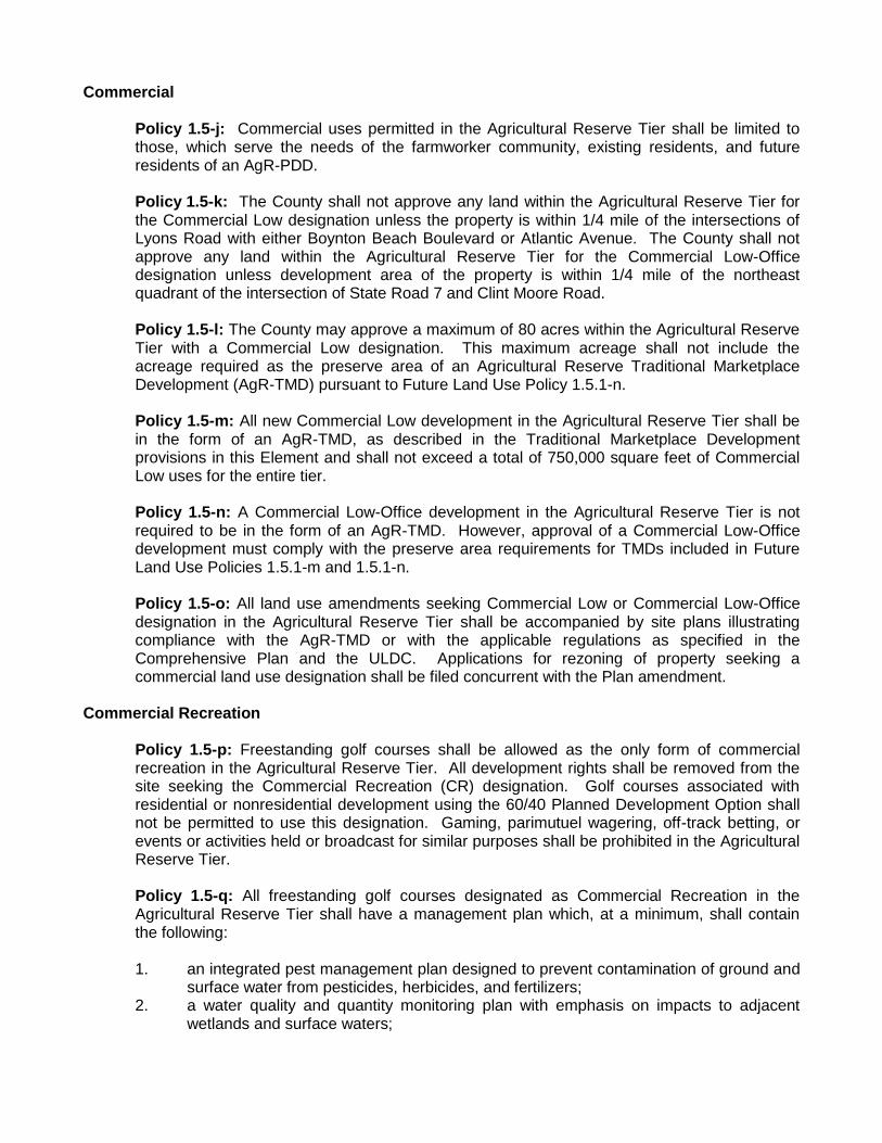
Commercial
Policy 1.5-j: Commercial uses permitted in the Agricultural Reserve Tier shall be limited to those, which serve the needs of the farmworker community, existing residents, and future residents of an AgR-PDD.
Policy 1.5-k: The County shall not approve any land within the Agricultural Reserve Tier for the Commercial Low designation unless the property is within 1/4 mile of the intersections of Lyons Road with either Boynton Beach Boulevard or Atlantic Avenue. The County shall not approve any land within the Agricultural Reserve Tier for the Commercial Low-Office designation unless development area of the property is within 1/4 mile of the northeast quadrant of the intersection of State Road 7 and Clint Moore Road.
Policy 1.5-l: The County may approve a maximum of 80 acres within the Agricultural Reserve Tier with a Commercial Low designation. This maximum acreage shall not include the acreage required as the preserve area of an Agricultural Reserve Traditional Marketplace Development (AgR-TMD) pursuant to Future Land Use Policy 1.5.1-n.
Policy 1.5-m: All new Commercial Low development in the Agricultural Reserve Tier shall be in the form of an AgR-TMD, as described in the Traditional Marketplace Development provisions in this Element and shall not exceed a total of 750,000 square feet of Commercial Low uses for the entire tier.
Policy 1.5-n: A Commercial Low-Office development in the Agricultural Reserve Tier is not required to be in the form of an AgR-TMD. However, approval of a Commercial Low-Office development must comply with the preserve area requirements for TMDs included in Future Land Use Policies 1.5.1-m and 1.5.1-n.
Policy 1.5-o: All land use amendments seeking Commercial Low or Commercial Low-Office designation in the Agricultural Reserve Tier shall be accompanied by site plans illustrating compliance with the AgR-TMD or with the applicable regulations as specified in the Comprehensive Plan and the ULDC. Applications for rezoning of property seeking a commercial land use designation shall be filed concurrent with the Plan amendment.
Commercial Recreation
Policy 1.5-p: Freestanding golf courses shall be allowed as the only form of commercial recreation in the Agricultural Reserve Tier. All development rights shall be removed from the site seeking the Commercial Recreation (CR) designation. Golf courses associated with residential or nonresidential development using the 60/40 Planned Development Option shall not be permitted to use this designation. Gaming, parimutuel wagering, off-track betting, or events or activities held or broadcast for similar purposes shall be prohibited in the Agricultural Reserve Tier.
Policy 1.5-q: All freestanding golf courses designated as Commercial Recreation in the Agricultural Reserve Tier shall have a management plan which, at a minimum, shall contain the following:
1. an integrated pest management plan designed to prevent contamination of ground andsurface water from pesticides, herbicides, and fertilizers;
2. a water quality and quantity monitoring plan with emphasis on impacts to adjacentwetlands and surface waters;

3. best management practices which, at a minimum, identify procedures to be followed forthe construction, irrigation, operation, and maintenance of the golf course; and
4. a landscape plan utilizing only native or drought tolerant species for all landscaperequirements.
Institutional
Policy 1.5-r: Institutional and Public Facilities uses shall be allowed in the Agricultural Reserve Tier. Such uses shall not be permitted west of State Road 7.
SUB-OBJECTIVE 1.5.1 Planned Developments
To achieve the goal of farmland protection and agricultural perpetuation, unique planned development options, which ensure the preservation of significant open space may be permitted and may be developed at a density of one dwelling unit per acre.
Policy 1.5.1-a: Three planned development options may be permitted in the Agricultural Reserve Tier:
1. the 80/20 AgR-PDD;2. the 60/40 AgR-PDD; and3. the AgR-TMD.
Policy 1.5.1-b: An AgR-PDD shall require the following:
1. that the development area be compact, contiguous, and arranged as a unified wholeand appropriately buffered so as not to interfere with the continued or future function ofthe protected area. For this purpose, a meandering or intrusion of the developmentarea into the protected area would only be considered in an equestrian community;
2. that the development area of any AgR-PDD be situated adjacent to other existing,planned, or projected development areas. The protected areas shall be situated so asto provide for a common boundary with other agricultural lands, fallow land, or landwhich is projected to otherwise be in an open space land use;
3. that the development area provide an appropriate buffer between non-agricultural usesand adjacent agricultural uses to ensure that new non-agricultural uses do notadversely affect agricultural uses. When golf courses and similar amenities areprovided in the development area, they shall be situated to serve as a buffer betweennon-agricultural uses and agricultural uses, though water features in an AgR-PDD shallnot have to be located adjacent to the buffers of the development;
4. that AgR-PDD preserve areas not be regarded as part of any development lot;5. that AgR-PDD preserve areas be used only for agriculture or open space uses;6. that any structures built within preserve areas be for agricultural uses only (as further
specified in the ULDC), and shall be considered common resources of the AgR-PDDresidents or agricultural users;
7. that dedication requirements (e.g. civic use) and calculations for land uses (e.g. non-residential pods) are based only upon the development portion of the AgR-PDD; and
8. that the development area shall use native or drought tolerant species for, at least,60% of any landscape requirement.
Policy 1.5.1-c: At least one stub street in each of the four cardinal directions may be required in all AgR-PDDs unless the property is adjacent to a designated preserve area or lies west of State Road 7 or lies adjacent to the Ronald Reagan Turnpike.
Policy 1.5.1-d: Utilization of these planned development options may result in a maximum density for an AgR-PDD of 1 du/ac for a residential AgR-PDD except that the maximum number of units shall be reduced to reflect the number of farm worker quarters and/or grooms quarters located in the preserve area. For a residential AgR-PDD or an AgR-TMD, the preserve area requirement shall be established as:
1. a 80/20 development, 75 percent of the total land area;2. a 60/40 development, 60 percent of the total land area; and3. a TMD, 60 percent of the total land area.
Policy 1.5.1-e: Property owners located along a designated rural parkway in the Agricultural Reserve Tier shall receive credit for the parkway easement as a portion of their required preserve area as described in Future Land Use Policy 1.5.1-d without regard to the minimum contiguous acreage requirement for the preserve area of an AgR-PDD established in Future Land Use Policies 1.5.1-i and 1.5.1-l.
Policy 1.5.1-f: Nonresidential land uses, limited to those uses, which the County allows in residential developments within the Urban/Suburban Tier, may be allowed as a pod within the development area of a residential AgR-PDD master plan, provided that the nonresidential uses are situated to serve the residents of the AgR-PDD as opposed to the general public. If the nonresidential land uses are government uses, such as fire stations, libraries, etc., they are not required to be situated to serve only the residents of the AgR-PDD.
Policy 1.5.1-g: The County Planning Division shall administratively identify the preserve areas of all AgR-PDDs on the Future Land Use Atlas as an Agricultural Reserve Preserve after approval of the AgR-PDD if the preserve area is not contiguous to the buildable area. The County has the authority to administratively designate the areas purchased by the County with bond funds for Ag Preserve purposes as an Agricultural Reserve Preserve once the Planning Division has been notified by the Department of Environmental Resources Management (ERM) to place a preserve note on a property. If development rights are retained on the preserve area, for purposes of providing farm worker quarters consistent with Future Land Use Policy 1.5.1-k and Housing Policy 1.4-d or grooms quarters consistent with Future Land Use Policy 1.5.1-k, the number of farm worker quarters or grooms quarters which may be located on the preserve area shall also be administratively identified on the Future Land Use Atlas.
80/20 Planned Development Option
Policy 1.5.1-h: An 80/20 AgR-PDD shall require the following
1. a minimum of 40 contiguous acres;2. that the buildable area be contained in one compact area and not exceed 20 percent of
the gross acreage. Land dedicated as rights-of-way for the County’s ThoroughfareSystem, land allocated for the internal street system, and water areas required for on-site drainage retention may be deducted from the 80 percent; however, in no eventshall the buildable area be increased to greater than 25 percent of the gross acreage;
3. that the remainder of the gross acreage be maintained in agriculture, passiverecreation or other open space use, except that water features may only be consideredwithin the preserve area if the feature is designated by the South Florida WaterManagement District as a Water Preserve Area (WPA). No other open space orrecreational use that is intensive in nature, such as a golf course; or, which wouldinterfere with the future practice of agriculture on the subject property; or continuedpractice of agriculture on adjacent properties shall be permitted; and
4. that the preserve area be held in common ownership and control by an HOA or otherparty for access by, and on behalf of, residents of the AgR-PDD or agricultural users,and operate under common management of an HOA or third party.
60/40 Planned Development Option
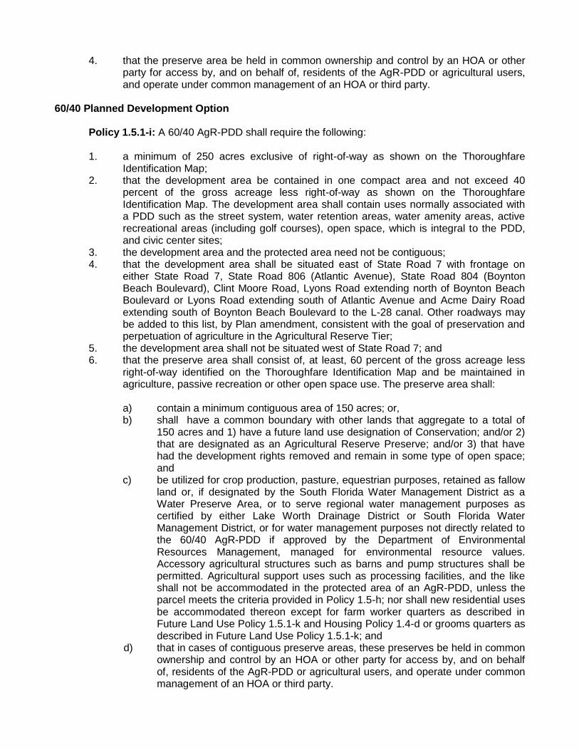
Policy 1.5.1-i: A 60/40 AgR-PDD shall require the following:
1. a minimum of 250 acres exclusive of right-of-way as shown on the ThoroughfareIdentification Map;
2. that the development area be contained in one compact area and not exceed 40percent of the gross acreage less right-of-way as shown on the ThoroughfareIdentification Map. The development area shall contain uses normally associated witha PDD such as the street system, water retention areas, water amenity areas, activerecreational areas (including golf courses), open space, which is integral to the PDD,and civic center sites;
3. the development area and the protected area need not be contiguous;4. that the development area shall be situated east of State Road 7 with frontage on
either State Road 7, State Road 806 (Atlantic Avenue), State Road 804 (BoyntonBeach Boulevard), Clint Moore Road, Lyons Road extending north of Boynton BeachBoulevard or Lyons Road extending south of Atlantic Avenue and Acme Dairy Roadextending south of Boynton Beach Boulevard to the L-28 canal. Other roadways maybe added to this list, by Plan amendment, consistent with the goal of preservation andperpetuation of agriculture in the Agricultural Reserve Tier;
5. the development area shall not be situated west of State Road 7; and6. that the preserve area shall consist of, at least, 60 percent of the gross acreage less
right-of-way identified on the Thoroughfare Identification Map and be maintained inagriculture, passive recreation or other open space use. The preserve area shall:
a) contain a minimum contiguous area of 150 acres; or,b) shall have a common boundary with other lands that aggregate to a total of
150 acres and 1) have a future land use designation of Conservation; and/or 2)that are designated as an Agricultural Reserve Preserve; and/or 3) that havehad the development rights removed and remain in some type of open space;and
c) be utilized for crop production, pasture, equestrian purposes, retained as fallowland or, if designated by the South Florida Water Management District as aWater Preserve Area, or to serve regional water management purposes ascertified by either Lake Worth Drainage District or South Florida WaterManagement District, or for water management purposes not directly related tothe 60/40 AgR-PDD if approved by the Department of EnvironmentalResources Management, managed for environmental resource values.Accessory agricultural structures such as barns and pump structures shall bepermitted. Agricultural support uses such as processing facilities, and the likeshall not be accommodated in the protected area of an AgR-PDD, unless theparcel meets the criteria provided in Policy 1.5-h; nor shall new residential usesbe accommodated thereon except for farm worker quarters as described inFuture Land Use Policy 1.5.1-k and Housing Policy 1.4-d or grooms quarters asdescribed in Future Land Use Policy 1.5.1-k; and
d) that in cases of contiguous preserve areas, these preserves be held in commonownership and control by an HOA or other party for access by, and on behalfof, residents of the AgR-PDD or agricultural users, and operate under commonmanagement of an HOA or third party.
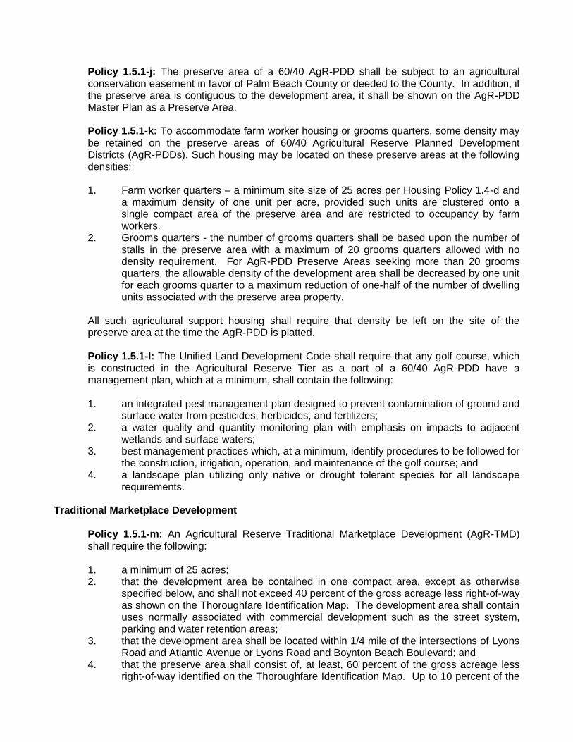
Policy 1.5.1-j: The preserve area of a 60/40 AgR-PDD shall be subject to an agricultural conservation easement in favor of Palm Beach County or deeded to the County. In addition, if the preserve area is contiguous to the development area, it shall be shown on the AgR-PDD Master Plan as a Preserve Area.
Policy 1.5.1-k: To accommodate farm worker housing or grooms quarters, some density may be retained on the preserve areas of 60/40 Agricultural Reserve Planned Development Districts (AgR-PDDs). Such housing may be located on these preserve areas at the following densities:
1. Farm worker quarters – a minimum site size of 25 acres per Housing Policy 1.4-d anda maximum density of one unit per acre, provided such units are clustered onto asingle compact area of the preserve area and are restricted to occupancy by farmworkers.
2. Grooms quarters - the number of grooms quarters shall be based upon the number ofstalls in the preserve area with a maximum of 20 grooms quarters allowed with nodensity requirement. For AgR-PDD Preserve Areas seeking more than 20 groomsquarters, the allowable density of the development area shall be decreased by one unitfor each grooms quarter to a maximum reduction of one-half of the number of dwellingunits associated with the preserve area property.
All such agricultural support housing shall require that density be left on the site of the preserve area at the time the AgR-PDD is platted.
Policy 1.5.1-l: The Unified Land Development Code shall require that any golf course, which is constructed in the Agricultural Reserve Tier as a part of a 60/40 AgR-PDD have a management plan, which at a minimum, shall contain the following:
1. an integrated pest management plan designed to prevent contamination of ground andsurface water from pesticides, herbicides, and fertilizers;
2. a water quality and quantity monitoring plan with emphasis on impacts to adjacentwetlands and surface waters;
3. best management practices which, at a minimum, identify procedures to be followed forthe construction, irrigation, operation, and maintenance of the golf course; and
4. a landscape plan utilizing only native or drought tolerant species for all landscaperequirements.
Traditional Marketplace Development
Policy 1.5.1-m: An Agricultural Reserve Traditional Marketplace Development (AgR-TMD) shall require the following:
1. a minimum of 25 acres;2. that the development area be contained in one compact area, except as otherwise
specified below, and shall not exceed 40 percent of the gross acreage less right-of-wayas shown on the Thoroughfare Identification Map. The development area shall containuses normally associated with commercial development such as the street system,parking and water retention areas;
3. that the development area shall be located within 1/4 mile of the intersections of LyonsRoad and Atlantic Avenue or Lyons Road and Boynton Beach Boulevard; and
4. that the preserve area shall consist of, at least, 60 percent of the gross acreage lessright-of-way identified on the Thoroughfare Identification Map. Up to 10 percent of the

preserve area may be located within the development area for use as open space or public greenspace. Any portion of the preserve area not located within the development area:
a) may be contiguous with the developed area; and/or it may be noncontiguouswith the developed area, in which case it shall have a common boundary withother lands that aggregate to a total of 150 acres and 1) have a future land usedesignation of Conservation; and/or 2) that are designated as an AgriculturalReserve Preserve; and/or 3) that have had the development rights removedand remain in some type of open space.
b) shall be utilized for crop production; pasture; equestrian purposes; if designatedby the South Florida Water Management District as a Water Preserve Area, orto serve regional water management purposes as certified by either Lake WorthDrainage District or South Florida Water Management District, or for watermanagement purposes not directly related to the AgR-TMD; or, if approved bythe Department of Environmental Resources Management, managed forenvironmental resource values. Accessory agricultural structures such asbarns and pump structures shall be permitted. Agricultural support uses suchas processing facilities, and the like shall not be accommodated in theprotected area of an AgR-TMD; nor shall new residential uses beaccommodated thereon except for farm worker quarters or grooms quarters asdescribed in Future Land Use Policy 1.5.1-o or, if located east of State Road 7,for civic purposes such as schools, libraries, or fire stations.
Policy 1.5.1-n: The preserve area of a 60/40 AgR-TMD shall be subject to an agricultural conservation easement in favor of Palm Beach County or deeded to the County. In addition, if the preserve area is contiguous to the development area, it shall be shown on the AgR-TMD Master Plan as a Preserve Area.
Policy 1.5.1-o: To accommodate farm worker housing or grooms quarters, some density may be retained on the preserve areas of Agricultural Reserve Traditional Marketplace Development (AgR-TMD). Such housing may be located on these preserve areas at the following densities:
1. Farm worker quarters - one unit per acre, provided such units are clustered onto asingle compact area of the preserve area and are restricted to occupancy byfarmworkers
2. Grooms quarters - the number of grooms quarters shall be based upon the number ofstalls in the preserve area with a maximum of 20 grooms quarters allowed with nodensity requirement. For AgR-TMD Preserve Areas seeking more than 20 groomsquarters, the allowable density of the development area shall be decreased by one unitfor each grooms quarter to a maximum reduction of one-half of the number of dwellingunits associated with the preserve area property.
All such agricultural support housing shall require that density be left on the site of the preserve area at the time the AgR-TMD is platted.

1
EXHIBIT 3 AG RESERVE WORKSHOP
March 25, 2014
ECONOMIC IMPORTANCE OF AGRICULTURE IN PALM BEACH COUNTY
Countywide Agriculture The agricultural industry is one of the largest industries in the County, with 460,000 acres in production countywide. The estimated total annual economic impact to the County from the agricultural industry is $2.6 billion. This includes agricultural row crops such as sugarcane, rice, sod, vegetables, specialty crops, nursery crops, equestrian and other livestock animals. Also included are packing houses, sugarcane mills, the co-generation plant and other ancillary businesses which support agronomic endeavors. The industry employs a range of between 9,000 – 13,000 workers in Palm Beach County, with agricultural wages reaching $350 million. These employees are full time as well as seasonal, both highly skilled professionals and technicians and minimally skilled laborers. Most agricultural workers reside in the area, with little migrant labor used. Palm Beach County is a unique agricultural environment in that it has some of the most fertile organic soil in the world in the Everglades Agricultural Area west of 20 mile bend, and also has areas of mineral sand lands, such as the Agricultural Reserve, warmed by the gulfstream winds. The unique muck lands and sand lands allow a great variety of produce to be grown. Palm Beach County is among the top ten agricultural counties in the nation, and the largest agricultural county east of the Mississippi River. The County leads the state in agricultural sales, and in the production of sweet bell peppers, rice, lettuce, radishes, Asian vegetables, specialty leaf produce and celery. Palm Beach County primarily only provides fresh produce, not canned, frozen or processed.
Importance of the Agricultural Reserve The sand lands of the Agricultural Reserve are the warmest growing area on the eastern seaboard of the United States.
o In January of this year, 3,700 acres of produce were damaged in the EAA; but due to the few degree differential of warmth in the Agricultural Reserve, not one acre in the Ag Reserve was damaged by cold temperatures.
o During very cold winters such as this one, locally grown fresh vegetables feed much of the country. Droughts, freezes and other adverse weather events elsewhere in the country and the world increase the importance of production in the Agricultural Reserve.
The estimated annual economic impact of agriculture (row crops, nursery, equestrian and ancillary businesses) from the Ag Reserve is $280 million. Although the acreage is a small percentage of the total county agricultural land, its value is significant. It has a higher return per acre, which can be twice the value of acreage in the EAA. The crops
2
produced in the Ag Reserve are high value crops, many of which are planted and harvested multiple times a season, yielding high production per acre and thereby making the land in the Agricultural Reserve the most valuable production land in the County. Approximately 10,500 acres are currently in agricultural production in the Ag Reserve – 7,300 acres in row crops, over 1,700 acres in nurseries, more than 1,000 acres in equestrian uses, and more than 400 acres in agricultural support uses. There are 7 packing facilities and adequate roads to easily transport crops to market throughout the community, the eastern sea board of the United States and elsewhere. Packing houses are operational to support the packing of locally grown fresh produce as well as from other areas in Florida and the Caribbean basin.
Local Needs and Demand
The food service and tourism industries are dependent upon local growers throughout the county to provide landscaping material and labor, fruit, vegetables and flowers to 135 hotel properties and 2,500 restaurants serving over 4 million visitors annually plus local residents. There is a continued increase of federal funding for the Farm to School program which encourages and provides greater availability of fresh fruit and vegetable servings nationwide. Vegetables are a part of the 93,000 school lunches served by the Palm Beach County school system each day. Green beans, fresh sweet corn, grape and cherry tomatoes, fresh sweet bell peppers, yellow squash and zucchini are enjoyed by local school children each day through the school lunch program. Because Palm Beach County growing season coincides with the school year local produce is feeding children school lunches throughout the state of Florida and the nation. Some local growers are currently participating in this market opportunity and more are being encouraged to do so. School lunch and breakfast are important meals to the 1 in 5 (20%) children who are at risk of food insecurity in this community. Approximately 2.1 million pounds of produce was contributed to the Palm Beach County Food Bank in 2013 from PBC growers helping to feed families in need. Greater consumption of fruit and vegetables is recommended and encouraged by USDA, the U.S. Center for Disease Control and an array of health organizations. If Americans consumed the recommended 5 servings of fruit and vegetables daily from the current 1.9 per-capita consumption, the country‘s production would have to double to produce enough for every citizen.
N Inte rstate95
N Fl
orid
as T
pke
S St
ate
Road
7
Southern B lvd
Northlake Blvd
Indiantown Rd
Okeechobee Blvd
State Road 80
Lantana Rd
Belvedere Rd
PGA Blvd
Glad es Rd
Bee Line Hwy
USHi ghway
1
Semi
n ole
P rat
t Whit
ney R
d
At lantic Ave
Yamato Rd
County Road 880
Boynton Beach Blvd
Donald Ross Rd
Roya
l Pal
m Be
ach
Blvd
N Co
ngre
ss A
ve
Jog
Rd
S Mi
litar
y Tr
l
O ld
Dix ie
Hwy
N Fe
dera
l Hwy
N Fe
dera
l Hwy
Old Dix ie Hwy
N Co
ngre
ss A
veN
Fede
ral H
wyN
Cong
ress
Ave
Bee Line Hwy
S St
ate
Road
7
N Fe
dera
l Hwy
.1 0 1 2Miles
Date: 3/17/14Contact: PBEHNFilename: N:\DivProj\AGR\14\MapPacket\01
Note: Map is not official, for presentations purposes only.
Planning, Zoning& Building2300 N Jog Rd
West Palm Beach, FL 33411Phone (561) 233-5300
M a p 1 - A g r i c u l t u r a l R e s e r v eM a p 1 - A g r i c u l t u r a l R e s e r v eL o c a t i o n
Agricultural Reserve
.0.5 0 0.5 1Miles
Date: 3/17/14Contact: PBEHNFilename: N:\DivProj\AGR\14\MapPacket\02
Note: Map is not official, for presentations purposes only.
Planning, Zoning& Building2300 N Jog Rd
West Palm Beach, FL 33411Phone (561) 233-5300
M a p 2 - A g r i c u l t u r a l R e s e r v eM a p 2 - A g r i c u l t u r a l R e s e r v eM a s t e r P l a n

S St
ate
Road
7
N Fl
orid
as T
pke
Lantana Rd
Atlantic Ave
Boynton Beach Blvd
.0.5 0 0.5 1Miles
Date: 3/17/14Contact: PBEHNFilename: N:\DivProj\AGR\14\MapPacket\03
Note: Map is not official, for presentations purposes only.
Planning, Zoning& Building2300 N Jog Rd
West Palm Beach, FL 33411Phone (561) 233-5300
M a p 3 - A g r i c u l t u r a l R e s e r v eM a p 3 - A g r i c u l t u r a l R e s e r v eE x i s t i n g L a n d U s e 2 0 1 4
Agricultural ReserveExisting Land Use 2014
AgricultureConservationResidentialVacantBuilt Non ResROW/Canals/Gov

S St
ate
Road
7
N Fl
orid
as T
pke
Lantana Rd
Atlantic Ave
Boynton Beach Blvd
.0.5 0 0.5 1Miles
Date: 3/17/14Contact: PBEHNFilename: N:\DivProj\AGR\14\MapPacket\04
Note: Map is not official, for presentations purposes only.
Planning, Zoning& Building2300 N Jog Rd
West Palm Beach, FL 33411Phone (561) 233-5300
M a p 4 - A g r i c u l t u r a l R e s e r v eM a p 4 - A g r i c u l t u r a l R e s e r v eS n a p s h o t 2 0 1 4
Agricultural ReserveApproval Status 2014
PDDs/ResidentialTMDsNon Res/Non AgPreservePreserve ConservationUtilityOther Remaining

S St
ate
Road
7
N Fl
orid
as T
pke
Lantana Rd
Atlantic Ave
Boynton Beach Blvd
.0.5 0 0.5 1Miles
Date: 3/17/14Contact: PBEHNFilename: N:\DivProj\AGR\14\MapPacket\05
Note: Map is not official, for presentations purposes only.
Planning, Zoning& Building2300 N Jog Rd
West Palm Beach, FL 33411Phone (561) 233-5300
M a p 5 - A g r i c u l t u r a l R e s e r v eM a p 5 - A g r i c u l t u r a l R e s e r v eP r e s e r v e s & O w n e r s h i p 2 0 1 4
Agricultural ReserveU.S. GovernmentSFWMDPBCPBC Bond PurchasedAGR-PUD Preserves
Agricultural
Reserve Tier
Policy Workshop
Board of County
Commissioners
March 25, 2014
The Tier System
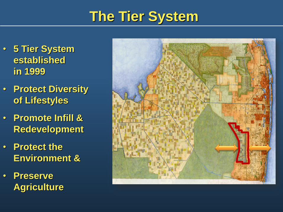
• 5 Tier System
established
in 1999
• Protect Diversity
of Lifestyles
• Promote Infill &
Redevelopment
• Protect the
Environment &
• Preserve
Agriculture
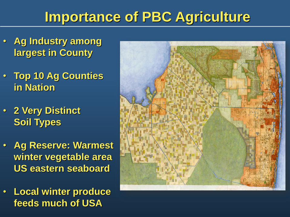
• Ag Industry among
largest in County
• Top 10 Ag Counties
in Nation
• 2 Very Distinct
Soil Types
• Ag Reserve: Warmest
winter vegetable area
US eastern seaboard
• Local winter produce
feeds much of USA
Importance of PBC Agriculture
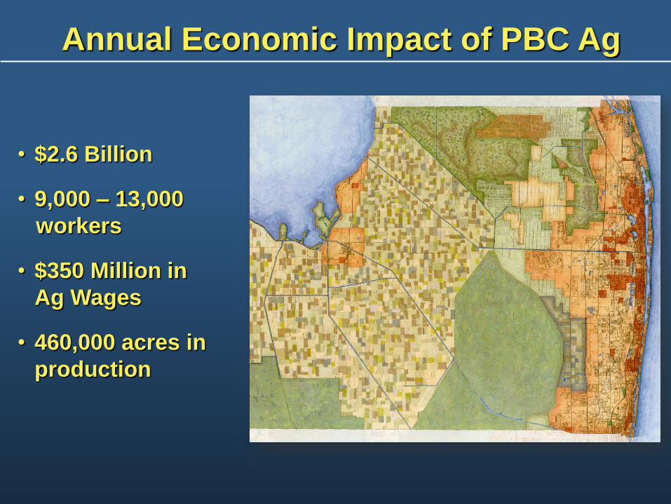
• $2.6 Billion
• 9,000 – 13,000
workers
• $350 Million in
Ag Wages
• 460,000 acres in
production
Annual Economic Impact of PBC Ag

Importance of the Ag Reserve
• 12% of ag revenue on 2% of
farmland
• Higher return per acre: Multiple
harvests of Higher $ value crops
• $280 M annual economic impact
• 10,500 acres in production, including
7,300 crops; 1,000 equestrian; 1,700
nurseries
• Severe droughts, other weather
events in US increase importance of
Ag Reserve
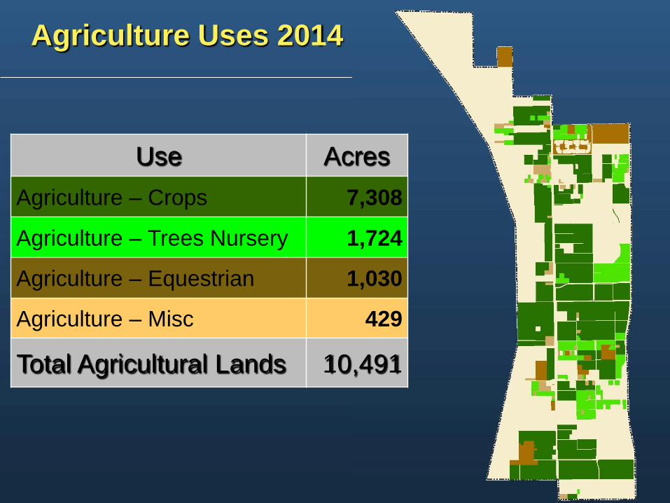
Agriculture Uses 2014
Use Acres
Agriculture – Crops 7,308
Agriculture – Trees Nursery 1,724
Agriculture – Equestrian 1,030
Agriculture – Misc 429
Total Agricultural Lands 10,491
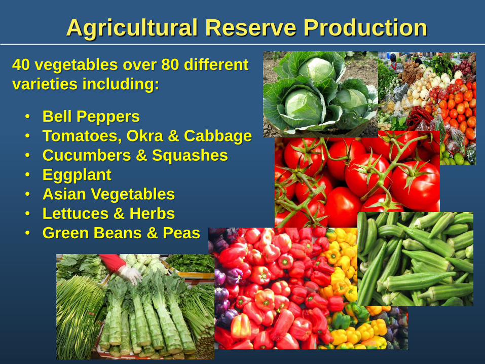
Agricultural Reserve Production
40 vegetables over 80 different
varieties including:
• Bell Peppers
• Tomatoes, Okra & Cabbage
• Cucumbers & Squashes
• Eggplant
• Asian Vegetables
• Lettuces & Herbs
• Green Beans & Peas

Agricultural Infrastructure in Place
• Seven Packing Houses: Local
produce for the region and
nation
• Largest “Buy Local” County in
FL
• Best Management Practices
(BMP)s and Good Ag Practices
(GAP)s for food and water
safety
Consumer Market
• Greater consumption
of fruit & vegetables
• Farm to School
produce from PBC
Agriculture
• Local food bank
donations
• Food Service/
Tourism reliance on
PBC agriculture
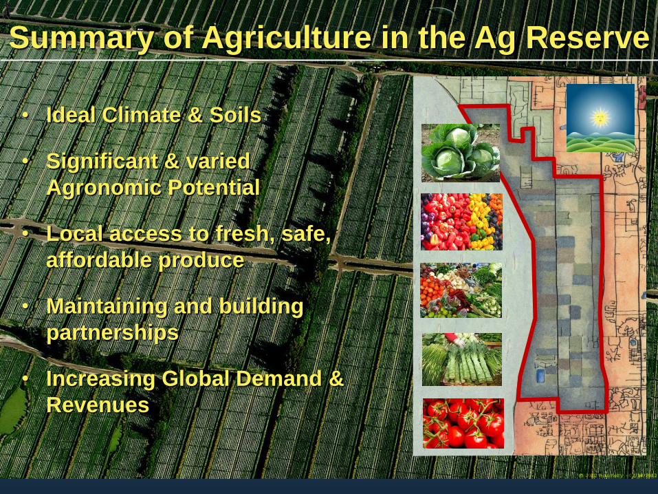
• Ideal Climate & Soils
• Significant & varied
Agronomic Potential
• Local access to fresh, safe,
affordable produce
• Maintaining and building
partnerships
• Increasing Global Demand &
Revenues
Summary of Agriculture in the Ag Reserve
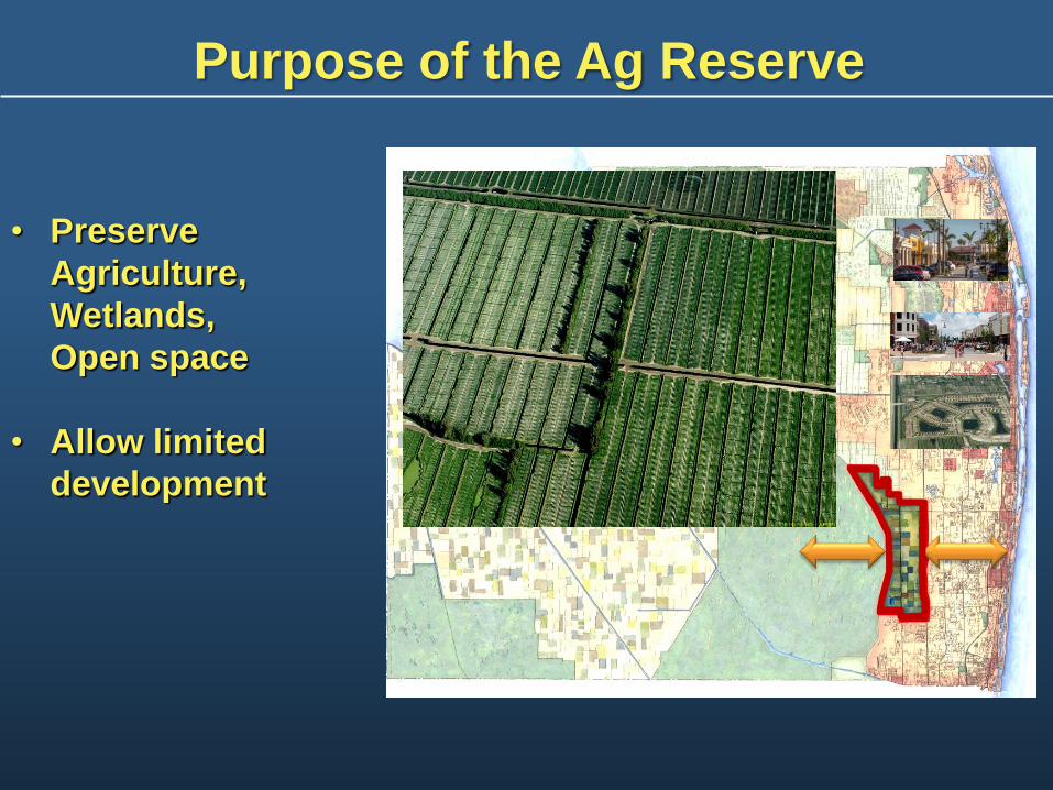
• Preserve
Agriculture,
Wetlands,
Open space
• Allow limited
development
Purpose of the Ag Reserve
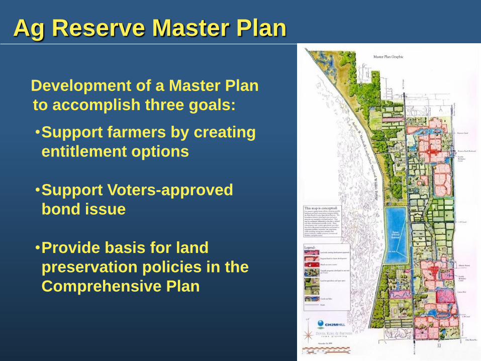
Ag Reserve Master Plan
Development of a Master Plan
to accomplish three goals:
•Support farmers by creating
entitlement options
•Support Voters-approved
bond issue
•Provide basis for land
preservation policies in the
Comprehensive Plan

Ag Reserve Tier Provisions
RESIDENTIAL DEVELOPMENT:
• 1 unit/5 acres, or
• 1 unit/acre for clustered
development in exchange for
preserved area dedication
COMMERCIAL DEVELOPMENT:
• Limited acreage and size for
two TMD locations with
preserves and one office
location.
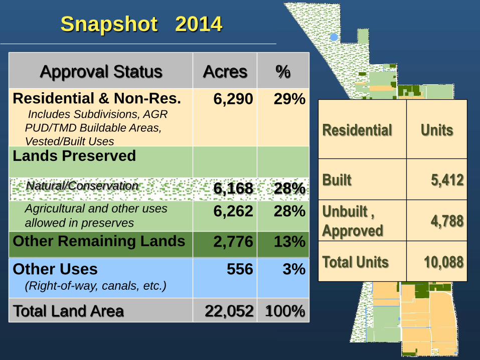
Snapshot 2014
Other Remaining Lands 2,776 13%
Approval Status Acres %
Residential & Non-Res. Includes Subdivisions, AGR
PUD/TMD Buildable Areas,
Vested/Built Uses
6,290 29%
Lands Preserved
Natural/Conservation 6,168 28%
Agricultural and other uses
allowed in preserves 6,262 28%
Other Uses (Right-of-way, canals, etc.)
556 3%
Total Land Area 22,052 100%
Residential
Units
Built 5,412
Unbuilt ,
Approved 4,788
Total Units 10,088
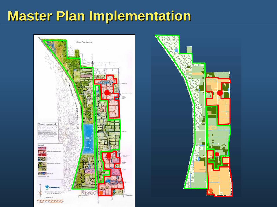
Master Plan Implementation

Agriculture 2014
Location Acres
PUD/TMD Unbuilt Development
Areas 1,788
Total Agricultural Lands 10,491
Publicly Owned (Non-PUD Preserve) 2,382
PUD & TMD Preserve Areas 3,785
Other Remaining Lands 2,536
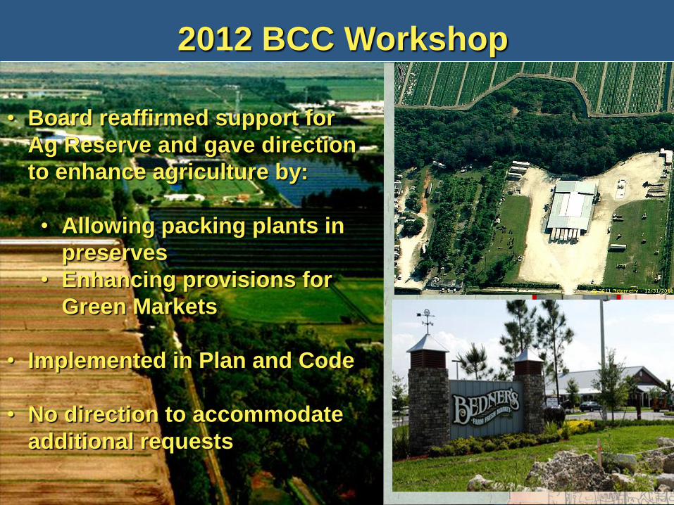
2012 BCC Workshop
• Board reaffirmed support for
Ag Reserve and gave direction
to enhance agriculture by:
• Allowing packing plants in
preserves
• Enhancing provisions for
Green Markets
• Implemented in Plan and Code
• No direction to accommodate
additional requests
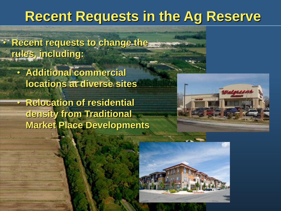
Recent Requests in the Ag Reserve
• Recent requests to change the
rules, including:
• Additional commercial
locations at diverse sites
• Relocation of residential
density from Traditional
Market Place Developments
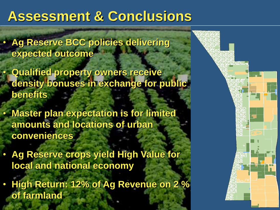
Assessment & Conclusions
• Ag Reserve BCC policies delivering
expected outcome
• Qualified property owners receive
density bonuses in exchange for public
benefits
• Master plan expectation is for limited
amounts and locations of urban
conveniences
• Ag Reserve crops yield High Value for
local and national economy
• High Return: 12% of Ag Revenue on 2 %
of farmland