agricultural heritage systems and landscape perception
TRANSCRIPT

sustainability
Article
Agricultural Heritage Systems and LandscapePerception among Tourists. The Case of Lamole,Chianti (Italy)
Antonio Santoro * , Martina Venturi and Mauro Agnoletti
Department of Agriculture, Food, Environment and Forestry (DAGRI), University of Florence,via San Bonaventura 13, 50145 Florence, Italy; [email protected] (M.V.); [email protected] (M.A.)* Correspondence: [email protected]
Received: 2 April 2020; Accepted: 21 April 2020; Published: 25 April 2020�����������������
Abstract: The Globally Important Agricultural Heritage Systems (GIAHS) program, promoted by theFood and Agriculture Organization (FAO), recognizes the multifunctional role of agricultural heritagesystems. Traditional terraced landscapes represent important touristic destinations, and Chianti isone of the most well-known areas of Italy for rural tourism. The high-quality landscape of Lamole,consisting of forests and terraced agricultural areas, is included in the Italian National Register ofHistorical Rural Landscapes thanks to local farmers who recently restored the traditional landscape,considering it important both for tourism and product quality. The main aim of this research was toinvestigate, using anonymous questionnaires, whether tourists are aware of the characteristics ofthe Lamole landscape in comparison with other parts of Chianti. Results show that tourists clearlyexpress their preference for the traditional landscape, which is comprised of a mosaic of agriculturalpatches with dry-stone terraces and forests, and that the level of landscape diversification is similarto 180 years ago. As tourism is a major resource, public institutions should support farmers inpreserving the traditional landscape, investing in paths and information, as requested by tourists.The methodology has proved to be useful for addressing local planning, and to help farmers toachieve sustainable development in well-known touristic rural areas.
Keywords: terraced landscape; agricultural heritage; GIAHS; landscape perception; ruraltourism; Tuscany
1. Introduction
The multifunctional role of agricultural heritage systems is today widely recognized, and it refersto different sectors including the preservation of traditional landscapes characterized by great aestheticand cultural significance, traditional agricultural practices, family farming and production of highquality food, protection from hydrogeological risk, connection to climate change, conservation ofagrobiodiversity and soil, and resources for tourism [1].
Despite the great importance of historical terraced landscapes, they represent a big challengefor conservation and management [2,3], mostly because these heritage systems have largely beenabandoned all over the world, especially in Europe [4–7]. At the international level, programssuch as the Globally Important Agricultural Heritage Systems (GIAHS), launched by the Food andAgriculture Organization (FAO), is of particular interest as regards traditional landscapes, as it isfirmly connected to the different topics listed previously and to the concepts of multifunctionality anddynamic conservation [8].
Sustainability 2020, 12, 3509; doi:10.3390/su12093509 www.mdpi.com/journal/sustainability

Sustainability 2020, 12, 3509 2 of 15
The preservation of agricultural heritage systems of great aesthetic and cultural significance,and of the associated traditional agricultural practices, is therefore fundamental for different reasons.The first one is the production of high quality food as well as the role of small farmers. Usually,traditional landscapes are characterized by small proprietorships or family farming, and the attachmentthat local communities show for their territories and traditions is fundamental, both in the preservationof these landscapes and for shaping local identity [9,10]. Traditional agricultural practices in theMediterranean areas are also characterized by high energy and nutritional efficiency, and by theadaptation of production cycles to the natural ones according to local environmental conditions [11].The outcome of traditional practices, especially traditional cultivations, is the production of highquality products, which is greatly appreciated by consumers who are ready to pay a higher price forhigher quality products that preserve a tight connection with the territory they come from. This addedvalue, made up of aesthetics, knowledge, history, culture, and traditions, cannot be reproduced byother competitors, and it therefore becomes a central element on which it is necessary to focus inorder to keep traditional landscapes productive, vital, and profitable [12,13]. If this is not done,these landscapes are doomed to disappear, as has happened to many cultural landscapes throughoutEurope because agricultural production was no longer economically viable, especially in terracedlandscapes [14]. Therefore, landscape certification, being similar to other types of certifications, wouldallow the strengthening of the relationship between the quality of the product and the quality of thelandscape [15].
One of the most widespread type of agricultural heritage systems in the Mediterranean basinis the one related to terraced systems, and it is of great importance for its multifunctional role. Thereduction of hydrogeological risk and soil conservation are probably the main ecosystem servicesprovided by this system because terraced historical landscapes represent agricultural systems thatshape steep slopes and strongly modify runoff and soil erosion processes [16–25].
Traditional terraced landscapes are also strictly connected to agrobiodiversity and bioculturaldiversity conservation [26], which are two important concepts related to international initiatives.Agrobiodiversity is defined by the FAO, inside the GIAHS program, as “the variety of animals,plants, and micro-organisms that are used directly or indirectly for food and agriculture,including crops, livestock, forestry, and fisheries. It comprises the diversity of genetic resources(varieties and breeds) and species used for food, fodder, fiber, fuel, and pharmaceuticals. It alsoincludes the diversity of non-harvested species that support production (soil micro-organisms,predators, and pollinators) and those in the wider environment that support agro-ecosystems(agricultural, pastoral, forest, and aquatic) as well as the diversity of the agro-ecosystems”(http://www.fao.org/fileadmin/templates/giahs_assets/GIAHS_test/04_Become_a_GIAHS/02_Features_and_criteria/Criteria_and_Action_Plan_for_home_page_for_Home_Page_Jan_1_2017.pdf).The concept of cultural biodiversity is the subject of a joint program between UNESCO and theConvention on Biological Diversity [27]. In 2014, these two entities released a common declaration(Florence Declaration) stating that “the European landscape is mainly a biocultural multifunctionallandscape, since it is the result of historical and on-going processes that involve environment, landuses, and cultural heritage” and that “landscapes rich in biocultural diversity are often those resultingfrom small-scale farmers and traditional practices” [28]. Finally, it is important to remember that theimportance of dry-stone walls is also testified by the inclusion in 2018 of the “Art of dry-stone walling,knowledge, and techniques” in the UNESCO Intangible Heritage List.
Moreover, historical terraced landscapes can represent an important element of attractiveness forrural areas that are important touristic destinations, in Europe as well as in the rest of the world [29].In fact, rural tourism is often an alternative and economic diversification, capable of guaranteeing ahigher income to the local population than sole traditional agricultural and pastoral activities [30–32].This is particularly true for Tuscany because the number of occupancies in farmhouses has continuouslyincreased in the last few decades and, in 2018, a +9.4% increase in occupancies was registered, comparedto 2017 [33].

Sustainability 2020, 12, 3509 3 of 15
At the national level, it is important to remember that the recent institutional initiatives takenby the Italian Ministry of Agricultural Policies follow the concept of multifunctionality and promotetraditional rural landscapes. In particular, in 2012, the Ministry established the National Register ofHistorical Rural Landscapes and Traditional Agricultural Practices, with the aim of identifying andcataloguing traditional rural landscapes or landscapes of historical interest connected to traditionalpractices and knowledges, where farmers play the central role of landscape managers. Moreover, recentmodifications to the National Forest Law 227 of 2001, allows the restoration of previously cultivatedland that has been colonized by shrubs or forests after its abandonment [34].
The study area is located in Lamole, a village in Chianti (Tuscany, Italy) that perfectly representsthe multifunctional role of historical landscapes. Here, the landscape is characterized by the alternationof forest and agricultural areas, which are often terraced; in fact, in the past, the relationship betweenagriculture and forests was particularly important. Chianti is well known for the quality of its productsand as an international destination for rural tourism. In Lamole, the historical landscape is particularlywell preserved and it has also been restored by local farmers in recent years. The quality of its landscapewas also testified by its inclusion in the National Register of Historical Rural Landscapes in 2018.
The main aim of the research is to investigate if the tourists are aware of the peculiar characteristicsof the historic landscape of Lamole or if it looks similar to the landscape of other parts of Chiantiwhere the traditional landscape has undergone many changes, mostly due to the spread of large vinemonocultures. How do tourists perceive the landscape in Lamole? Do they recognize the historicalfeatures as something peculiar? What are they looking for? Furthermore, there is an interest toanalyze the main landscape changes in an area that is today considered as a good example of historicallandscape features maintenance thanks to national ministerial programs. In fact, public participationand perception in landscape planning and management has received increased attention across Europesince the European Landscape Convention (ELC) came into force [35]. Moreover, for those whostudy landscape transformations, it is an effective tool for verifying the relationship between scientificresearch and the views and needs of local populations and tourists [36,37]. With this in mind, theresults could be of particular interest for local planning policies because they have to deal with touristicflow management, and for local farmers because a large part of their income comes from tourists asthey offer accommodation, direct sales, and the tastings of local products.
2. Materials and Methods
2.1. The Study Area
The study area of Lamole covers an area of about 710 hectares in the municipality of Grevein Chianti, between the cities of Florence and Siena (Figure 1). The traditional landscape has beenpreserved, despite some minor unavoidable changes, and it is presently characterized by the presenceof terraced vineyards around the villages, interrupted by small woods and olive orchards, and woodedareas in the outermost parts of the site. The land is privately owned. The geological substratum isformed of lorbiditic quartziferous-feldspathic sandstone with calcite, phyllosilicate, and silt schist.In the southern area is yellowish marl from the Oligocene. The fact that its historical landscape isconsidered of particular interest is testified by the inclusion of Lamole in the National Register ofHistorical Rural Landscapes, which was established in 2012 by the Italian Ministry for AgriculturalPolicies. In Lamole, traditional high-quality wines and olive oil are produced and are recognized byofficial labels such as the Controlled Designation of Origin (DOC) or the Controlled and GuaranteedDesignation of Origin (DOCG) for Chianti wines, and the Protected Designation of Origin (PDO) forolive oil.

Sustainability 2020, 12, 3509 4 of 15
Sustainability 2020, 12, x FOR PEER REVIEW 4 of 15
Figure 1. Lamole extends for about 700 hectares in the Municipality of Greve in Chianti, in the heart of Tuscany.
The origin of the name Lamole is uncertain. It apparently derives from the Latin word lamulae, meaning “small blades” or “strips of earth”. In 1835, Emanuele Repetti wrote in his Dizionario geografico fisico storico della Toscana that Lamole “lies on the northern slope of the Poggio delle Stinche” and “the vineyards that yield the good and much praised wine of Lamole are planted among the rocks of this hill” [38], attesting that Lamole was already known for its wine quality.
Differently to other parts of Chianti, here the cultivation is still mainly carried out by smallholder farmers, who have also founded an association (I profumi di Lamole) to promote the territory and their products. In fact, tourism is a major resource of income for local farmers, and Lamole is in the heart of one of the most important areas for rural tourism in Italy (Chianti). Official numbers referring to the overall municipality of Greve in Chianti can give an idea of how tourism is locally important. According to the National Statistical Agency of 2017, there are 1286 beds available for tourists in farmhouses (51.5% of the total number), distributed in 81 farmhouses. According to the official data of the Tuscan Region relating to 2017, the Municipality of Greve in Chianti has 13,886 residents, and the number of total arrivals (tourists registered in the accommodation facilities, i.e., they have spent at least one night in Greve) is equal to 50,051 (81.6% of which are foreigners). From these numbers, without considering day-trips, it is clear that tourism is a very important resource for the local economy, particularly for farmers.
However, this territory also suffered depopulation after WWII, when local farmers abandoned cultivations and silvicultural activities and moved to the cities to find better life conditions and more work opportunities. In the 1970s, when the wine market modernized and demand for high quality Italian wines increased, many traditional cultivations were replaced by big vines monocultures, removing dry-stone terraces and planting rows of vines uphill. The removal of terraces and forest cultivation abandonment have increased soil erosion and landslides so that the hydrogeological risk is a significant issue today. According to the data of the official National Landslides Inventory, 7.7% of the entire Chianti territory is affected by landslides. This percentage rises to 12% if we consider only the vineyards and to 11% if we consider only the olive groves (National Landslides Inventory). According to research carried out in Chianti, soil erosion in the period 1954–1976 has increased by 900%, and in the uphill vineyards can reach up to 230 t/ha, while values normally considered acceptable are between 2 and 12 t/ha [39].
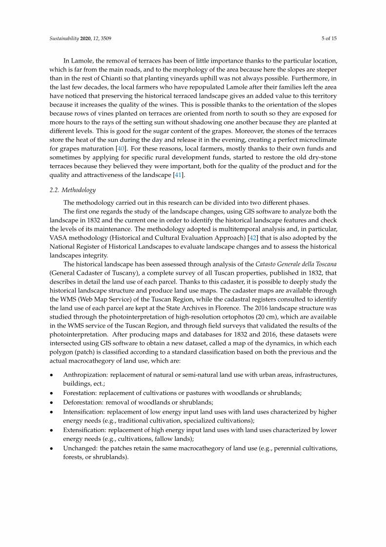
In Lamole, the removal of terraces has been of little importance thanks to the particular location, which is far from the main roads, and to the morphology of the area because here the slopes are steeper than in the rest of Chianti so that planting vineyards uphill was not always possible. Furthermore, in the last few decades, the local farmers who have repopulated Lamole after their families left the area have noticed that preserving the historical terraced landscape gives an added value to this territory because it increases the quality of the wines. This is possible thanks to the orientation of the slopes because rows of vines planted on terraces are oriented from north to south
Figure 1. Lamole extends for about 700 hectares in the Municipality of Greve in Chianti, in the heartof Tuscany.
The origin of the name Lamole is uncertain. It apparently derives from the Latin word lamulae,meaning “small blades” or “strips of earth”. In 1835, Emanuele Repetti wrote in his Dizionario geograficofisico storico della Toscana that Lamole “lies on the northern slope of the Poggio delle Stinche” and “thevineyards that yield the good and much praised wine of Lamole are planted among the rocks of thishill” [38], attesting that Lamole was already known for its wine quality.
Differently to other parts of Chianti, here the cultivation is still mainly carried out by smallholderfarmers, who have also founded an association (I profumi di Lamole) to promote the territory and theirproducts. In fact, tourism is a major resource of income for local farmers, and Lamole is in the heartof one of the most important areas for rural tourism in Italy (Chianti). Official numbers referring tothe overall municipality of Greve in Chianti can give an idea of how tourism is locally important.According to the National Statistical Agency of 2017, there are 1286 beds available for tourists infarmhouses (51.5% of the total number), distributed in 81 farmhouses. According to the official dataof the Tuscan Region relating to 2017, the Municipality of Greve in Chianti has 13,886 residents, andthe number of total arrivals (tourists registered in the accommodation facilities, i.e., they have spentat least one night in Greve) is equal to 50,051 (81.6% of which are foreigners). From these numbers,without considering day-trips, it is clear that tourism is a very important resource for the local economy,particularly for farmers.
However, this territory also suffered depopulation after WWII, when local farmers abandonedcultivations and silvicultural activities and moved to the cities to find better life conditions andmore work opportunities. In the 1970s, when the wine market modernized and demand for highquality Italian wines increased, many traditional cultivations were replaced by big vines monocultures,removing dry-stone terraces and planting rows of vines uphill. The removal of terraces and forestcultivation abandonment have increased soil erosion and landslides so that the hydrogeological risk isa significant issue today. According to the data of the official National Landslides Inventory, 7.7% of theentire Chianti territory is affected by landslides. This percentage rises to 12% if we consider only thevineyards and to 11% if we consider only the olive groves (National Landslides Inventory). Accordingto research carried out in Chianti, soil erosion in the period 1954–1976 has increased by 900%, and inthe uphill vineyards can reach up to 230 t/ha, while values normally considered acceptable are between2 and 12 t/ha [39].
Sustainability 2020, 12, 3509 5 of 15
In Lamole, the removal of terraces has been of little importance thanks to the particular location,which is far from the main roads, and to the morphology of the area because here the slopes are steeperthan in the rest of Chianti so that planting vineyards uphill was not always possible. Furthermore, inthe last few decades, the local farmers who have repopulated Lamole after their families left the areahave noticed that preserving the historical terraced landscape gives an added value to this territorybecause it increases the quality of the wines. This is possible thanks to the orientation of the slopesbecause rows of vines planted on terraces are oriented from north to south so they are exposed formore hours to the rays of the setting sun without shadowing one another because they are planted atdifferent levels. This is good for the sugar content of the grapes. Moreover, the stones of the terracesstore the heat of the sun during the day and release it in the evening, creating a perfect microclimatefor grapes maturation [40]. For these reasons, local farmers, mostly thanks to their own funds andsometimes by applying for specific rural development funds, started to restore the old dry-stoneterraces because they believed they were important, both for the quality of the product and for thequality and attractiveness of the landscape [41].
2.2. Methodology
The methodology carried out in this research can be divided into two different phases.The first one regards the study of the landscape changes, using GIS software to analyze both the
landscape in 1832 and the current one in order to identify the historical landscape features and checkthe levels of its maintenance. The methodology adopted is multitemporal analysis and, in particular,VASA methodology (Historical and Cultural Evaluation Approach) [42] that is also adopted by theNational Register of Historical Landscapes to evaluate landscape changes and to assess the historicallandscapes integrity.
The historical landscape has been assessed through analysis of the Catasto Generale della Toscana(General Cadaster of Tuscany), a complete survey of all Tuscan properties, published in 1832, thatdescribes in detail the land use of each parcel. Thanks to this cadaster, it is possible to deeply study thehistorical landscape structure and produce land use maps. The cadaster maps are available throughthe WMS (Web Map Service) of the Tuscan Region, while the cadastral registers consulted to identifythe land use of each parcel are kept at the State Archives in Florence. The 2016 landscape structure wasstudied through the photointerpretation of high-resolution ortophotos (20 cm), which are availablein the WMS service of the Tuscan Region, and through field surveys that validated the results of thephotointerpretation. After producing maps and databases for 1832 and 2016, these datasets wereintersected using GIS software to obtain a new dataset, called a map of the dynamics, in which eachpolygon (patch) is classified according to a standard classification based on both the previous and theactual macrocathegory of land use, which are:
• Anthropization: replacement of natural or semi-natural land use with urban areas, infrastructures,buildings, ect.;
• Forestation: replacement of cultivations or pastures with woodlands or shrublands;• Deforestation: removal of woodlands or shrublands;• Intensification: replacement of low energy input land uses with land uses characterized by higher
energy needs (e.g., traditional cultivation, specialized cultivations);• Extensification: replacement of high energy input land uses with land uses characterized by lower
energy needs (e.g., cultivations, fallow lands);• Unchanged: the patches retain the same macrocathegory of land use (e.g., perennial cultivations,
forests, or shrublands).
Sustainability 2020, 12, 3509 6 of 15
The historical landscape and landscape changes study covering the last 184 years has allowedboth the identification of peculiar features and the comprehension of the level of their maintenance.
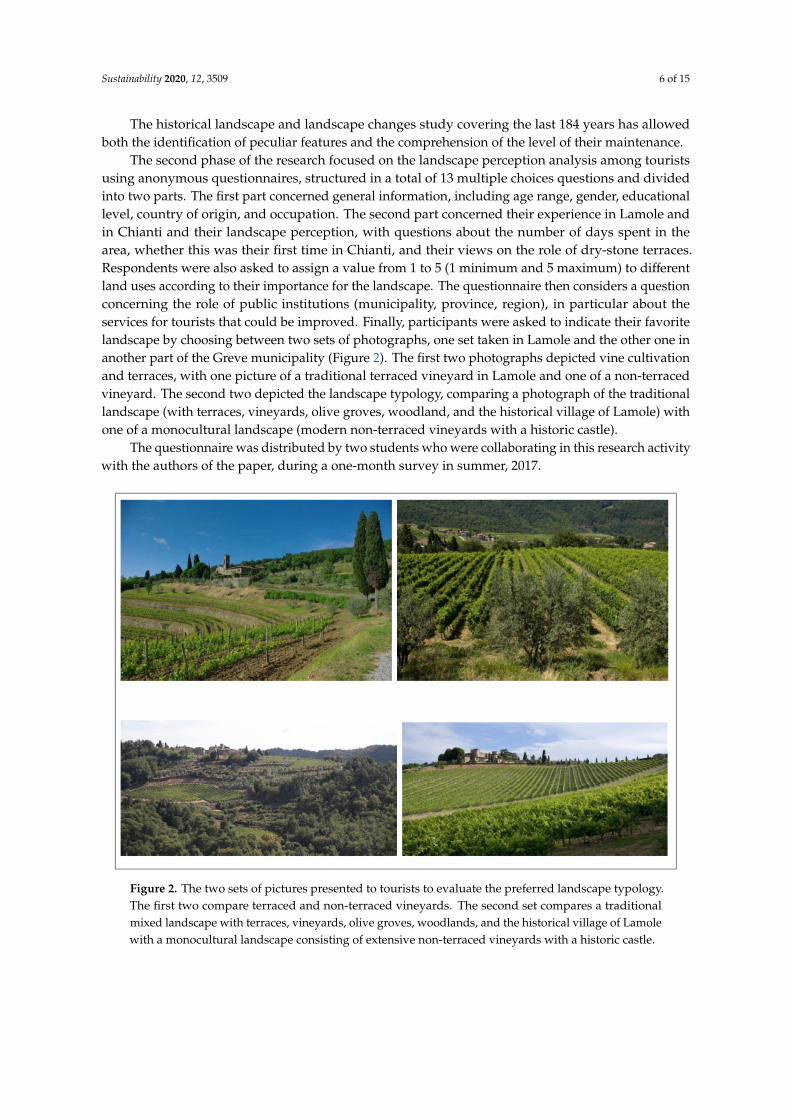
The second phase of the research focused on the landscape perception analysis among touristsusing anonymous questionnaires, structured in a total of 13 multiple choices questions and dividedinto two parts. The first part concerned general information, including age range, gender, educationallevel, country of origin, and occupation. The second part concerned their experience in Lamole andin Chianti and their landscape perception, with questions about the number of days spent in thearea, whether this was their first time in Chianti, and their views on the role of dry-stone terraces.Respondents were also asked to assign a value from 1 to 5 (1 minimum and 5 maximum) to differentland uses according to their importance for the landscape. The questionnaire then considers a questionconcerning the role of public institutions (municipality, province, region), in particular about theservices for tourists that could be improved. Finally, participants were asked to indicate their favoritelandscape by choosing between two sets of photographs, one set taken in Lamole and the other one inanother part of the Greve municipality (Figure 2). The first two photographs depicted vine cultivationand terraces, with one picture of a traditional terraced vineyard in Lamole and one of a non-terracedvineyard. The second two depicted the landscape typology, comparing a photograph of the traditionallandscape (with terraces, vineyards, olive groves, woodland, and the historical village of Lamole) withone of a monocultural landscape (modern non-terraced vineyards with a historic castle).
The questionnaire was distributed by two students who were collaborating in this research activitywith the authors of the paper, during a one-month survey in summer, 2017.
Sustainability 2020, 12, x FOR PEER REVIEW 6 of 15
the other one in another part of the Greve municipality (Figure 2). The first two photographs depicted vine cultivation and terraces, with one picture of a traditional terraced vineyard in Lamole and one of a non-terraced vineyard. The second two depicted the landscape typology, comparing a photograph of the traditional landscape (with terraces, vineyards, olive groves, woodland, and the historical village of Lamole) with one of a monocultural landscape (modern non-terraced vineyards with a historic castle).
The questionnaire was distributed by two students who were collaborating in this research activity with the authors of the paper, during a one-month survey in summer, 2017.
Figure 2. The two sets of pictures presented to tourists to evaluate the preferred landscape typology. The first two compare terraced and non-terraced vineyards. The second set compares a traditional mixed landscape with terraces, vineyards, olive groves, woodlands, and the historical village of Lamole with a monocultural landscape consisting of extensive non-terraced vineyards with a historic castle.
3. Results
3.1. Landscape Changes in Lamole in the Last Two Centuries
The landscape in 1832 was composed of a mixture of woodlands and agricultural areas; woodlands and shrublands accounted for 58% of the total area, while mixed cultivations occupied 26% and pastures and meadows 14%. Mixed cultivations were the main feature of the Lamole landscape, as was the case in most of the rural areas of central Italy until the end of the WWII, and they were mainly composed of olive trees, vines, and herbaceous cultivations. There were no monocultures of olive trees or vines, only mixed cultivations linked to sharecropping (mezzadria), traditional management of rural territories, which favored the simultaneous cultivation of different plants in the same field. As can be seen from the map of 1832 (Figure 3a), the landscape was particularly complex, with a very high level of agricultural fragmentation, and the forests were diversified. Forests occupied about 410 ha, of which 160 ha was generally classified as woodland, 109 ha as coppice wood, 75 ha as chestnut wood, 33 ha as grazed wood, 21 ha as oak wood, and 11 as grazed coppice wood. The different types of forest management testify to the fact that there was a high level of integration between silvicultural and agricultural activities. Forests were important both for
Figure 2. The two sets of pictures presented to tourists to evaluate the preferred landscape typology.The first two compare terraced and non-terraced vineyards. The second set compares a traditionalmixed landscape with terraces, vineyards, olive groves, woodlands, and the historical village of Lamolewith a monocultural landscape consisting of extensive non-terraced vineyards with a historic castle.

Sustainability 2020, 12, 3509 7 of 15
3. Results
3.1. Landscape Changes in Lamole in the Last Two Centuries
The landscape in 1832 was composed of a mixture of woodlands and agricultural areas; woodlandsand shrublands accounted for 58% of the total area, while mixed cultivations occupied 26% and pasturesand meadows 14%. Mixed cultivations were the main feature of the Lamole landscape, as was the casein most of the rural areas of central Italy until the end of the WWII, and they were mainly composed ofolive trees, vines, and herbaceous cultivations. There were no monocultures of olive trees or vines, onlymixed cultivations linked to sharecropping (mezzadria), traditional management of rural territories,which favored the simultaneous cultivation of different plants in the same field. As can be seen from themap of 1832 (Figure 3a), the landscape was particularly complex, with a very high level of agriculturalfragmentation, and the forests were diversified. Forests occupied about 410 ha, of which 160 ha wasgenerally classified as woodland, 109 ha as coppice wood, 75 ha as chestnut wood, 33 ha as grazed wood,21 ha as oak wood, and 11 as grazed coppice wood. The different types of forest management testify to thefact that there was a high level of integration between silvicultural and agricultural activities. Forestswere important both for grazing and for obtaining poles and firewood. Wooden poles, mainly fromchestnut coppices, were used for vines cultivation. In Lamole, in fact, vines were trained according tothe local alberello lamolese technique, with vines not regularly planted in rows but simply planted near awooden pole for each vine, so that the vine shoots could grow climbing the pole.
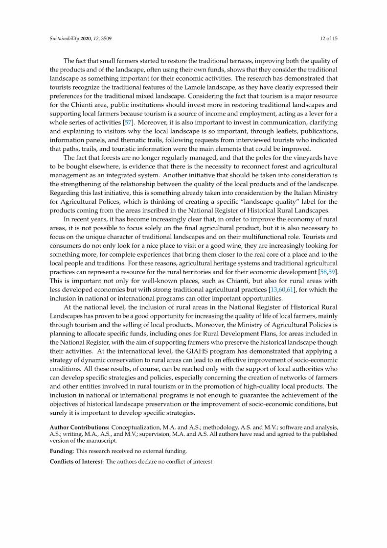
The landscape of 2016 (Figure 3b) is, in certain aspects, different from the historical one. Inparticular, 69% of the total surface is occupied by woodlands and shrublands, while agriculturalactivities can be found in 26% of the area. Agricultural activities are different from the past, mainlybecause most of the traditional mixed cultivations have been replaced by monocultures; today, 15% ofthe total surface is occupied by vineyards, 5% by olive groves, 3% by mixed cultivations, and 2% byarable crops.
The analysis of the landscape transformation dynamics and the application of some simplelandscape evaluation indexes highlight that fact that the Lamole landscape has undergone someimportant changes but still preserves the most important features. According to the analysis of thedynamics, 56% of the surface has not undergone landscape transformation, while the most widespreaddynamic is the intensification (17%). This change is related to the replacement of the traditional mixedcultivations with monocultures of olive trees and vines. Concerning the presence of the vines, in 1832they were cultivated (always as mixed cultivations) in 185 ha, while today they can be found in 112 ha.Regarding this transformation, it is important to mention the fact that, unlike the rest of the Chiantiarea, in Lamole most of the dry-stone terraces have been preserved and that the new monoculturesstill have a small average surface; the average size of vineyards is equal to 0.72 ha, and the wider onesare less than 5 ha.
What is clear is that the dynamic with the most negative impact on the historical landscape isthe forestation that affects 16% of the territory and is mainly due to the abandonment of meadowsand pastures once used for animal grazing. Animal husbandry is, in fact, no longer practiced inLamole so that meadows and pastures have been colonized by shrubs and trees. Moreover, woods aremainly non-managed; only a few woods are regularly coppiced and the strong integration betweensilvicultural and agricultural activities, as in most of the central part of Italy, has almost been completelylost. In 2016, in Lamole, apart from 29 ha occupied by shrublands, about 454 ha are occupied by woods,of which 358 ha are broadleaved woods, 50 ha are mixed conifer-broadleaved woods and 47 ha areconifer woods. The reforestation interventions carried out during the 20th century in most of theApennines have strongly modified the specific composition of woodlands as well as the landscape,introducing a non-typical feature.

Sustainability 2020, 12, 3509 8 of 15Sustainability 2020, 12, x FOR PEER REVIEW 8 of 15
(a)
(b)
Figure 3. Land use maps for 1832 (a) and 2016 (b). Even though, in 1832, main crops such as vines and olive trees were cultivated as mixed cultivations and nowadays they are monocultures, the main landscape characteristics are still well preserved.
Figure 3. Land use maps for 1832 (a) and 2016 (b). Even though, in 1832, main crops such as vinesand olive trees were cultivated as mixed cultivations and nowadays they are monocultures, the mainlandscape characteristics are still well preserved.

Sustainability 2020, 12, 3509 9 of 15
3.2. Landscape Perception among Tourists
A total of 110 tourists answered the questionnaire during their stay in Chianti; the number oftourists that refused to answer the questionnaire was not significant (5 people), as the questionnairewas fast and easy to fill in (less than 5 min).
The sample appears homogeneous in terms of age class (20.5% range, 16–30 years; 19.2% range,31–44 years; 28.8% range, 45–60 years; 41.5%, more than 60 years), while most of the respondentswere men (55%). The average level of education was high; 67% had an academic degree or a PhDand 27% had finished the secondary level of education. More than 85% of the tourists were fromEuropean countries, while the others were mainly from North America. Among the Europeans, themost represented countries were Germany (38%), Poland (12%), the UK (12%), and the Netherlands(9%). The rest were from other European countries, including Italy. These data about the provenienceof tourists are in line with the official statistics about tourism in Chianti. The situation regardingoccupation is articulated; most were self-employed (28%) or office workers (20%), but there were alsoretirees (18%), students (12%), housewives (7%), and business owner (4%).
As to their experience in Chianti, for 64% it was the first time visiting Chianti, while the rest ofthem had previously visited the area between 2 and 11 times. Forty one percent of them planned tospend 2–3 days in the area while 25% planned to spend 4–7 days. For 20% of them it was just a daytrip,and 14% planned to stay more than a week.
Results concerning the importance assigned to the different land uses are particularly interesting(Figure 4). The highest values have been assigned to terraced vineyards (average assigned value equalto 4.6) and to terraced olive groves (4.4), while non-terraced vineyards (3.4), vegetable gardens (3.1),and arable land (3) have lower values. As well as the average values, the quartile disposition alsoshows that terraced cultivations are considered to be of higher importance. Mixed cultivations of vinesand olive trees, once the typical cultivation of Chianti and nowadays almost disappeared, reach anaverage value equal to 3.8; some tourists had probably noticed these particular cultivations, but mostof those interviewed did not perceive them as characteristic. The values assigned to woodlands arerather high, especially for oak forests (4.2), a sign that the typical landscape made of the alternationand integration between small woods and cultivations is particularly appreciated.
Sustainability 2020, 12, x FOR PEER REVIEW 9 of 15
3.2. Landscape Perception among Tourists
A total of 110 tourists answered the questionnaire during their stay in Chianti; the number of tourists that refused to answer the questionnaire was not significant (5 people), as the questionnaire was fast and easy to fill in (less than 5 minutes).
The sample appears homogeneous in terms of age class (20.5% range, 16–30 years; 19.2% range, 31–44 years; 28.8% range, 45–60 years; 41.5%, more than 60 years), while most of the respondents were men (55%). The average level of education was high; 67% had an academic degree or a PhD and 27% had finished the secondary level of education. More than 85% of the tourists were from European countries, while the others were mainly from North America. Among the Europeans, the most represented countries were Germany (38%), Poland (12%), the UK (12%), and the Netherlands (9%). The rest were from other European countries, including Italy. These data about the provenience of tourists are in line with the official statistics about tourism in Chianti. The situation regarding occupation is articulated; most were self-employed (28%) or office workers (20%), but there were also retirees (18%), students (12%), housewives (7%), and business owner (4%).
As to their experience in Chianti, for 64% it was the first time visiting Chianti, while the rest of them had previously visited the area between 2 and 11 times. Forty one percent of them planned to spend 2–3 days in the area while 25% planned to spend 4–7 days. For 20% of them it was just a daytrip, and 14% planned to stay more than a week.
Results concerning the importance assigned to the different land uses are particularly interesting (Figure 4). The highest values have been assigned to terraced vineyards (average assigned value equal to 4.6) and to terraced olive groves (4.4), while non-terraced vineyards (3.4), vegetable gardens (3.1), and arable land (3) have lower values. As well as the average values, the quartile disposition also shows that terraced cultivations are considered to be of higher importance. Mixed cultivations of vines and olive trees, once the typical cultivation of Chianti and nowadays almost disappeared, reach an average value equal to 3.8; some tourists had probably noticed these particular cultivations, but most of those interviewed did not perceive them as characteristic. The values assigned to woodlands are rather high, especially for oak forests (4.2), a sign that the typical landscape made of the alternation and integration between small woods and cultivations is particularly appreciated.
Figure 4. The graph summarizes the results of the values assigned by tourists to the importance of each land use. The numbers refer to the average values. Beside the expected result of terraced vineyards and olive groves, forests also have high values, testifying to the fact that the traditional landscape made of the alternation between small woods and cultivations is particularly appreciated.
Figure 4. The graph summarizes the results of the values assigned by tourists to the importance of eachland use. The numbers refer to the average values. Beside the expected result of terraced vineyards andolive groves, forests also have high values, testifying to the fact that the traditional landscape made ofthe alternation between small woods and cultivations is particularly appreciated.

Sustainability 2020, 12, 3509 10 of 15
The choices concerning the proposed photographs confirms the previous results. Even though,for the first set of photographs, there was not a clear majority (in both cases, 55% of the interviewedpreferred the terraced landscape of Lamole), for the second set of photographs, 77% chose the traditionalcomposite landscape of Lamole and not the monocultural landscape.
Concerning the role of public institutions and the services for tourists that needed to beimplemented, “paths and trails” was the answer chosen by 37% of the interviewed, followed by publictransports (17%), touristic information (15%), and reception (14%).
4. Discussion
The results of the research are particularly interesting for different reasons. Lamole is actually awell-preserved historical landscape, mainly because of the main traditional features being maintainedand restored by local farmers, such as terraced cultivations on small parcels, alternation betweendifferent types of cultivations (vineyards and olive groves), and forests. The landscape is todaydiversified as it was in the past. The number of land uses is almost the same; 19 different land uses in1832 and 17 in 2016. On the other hand, important changes have occurred in the last two centuriesdue to the abandonment of some marginal areas once used mainly as pastures, the replacement ofmixed cultivations with monocultures (even if it is important to highlight that small mixed cultivationsof different types are still present), and the abandonment of integration between silvicultural andagricultural activities. Moreover, among the historical cultivations, it is necessary to mention thecultivation of iris (Iris germanica L.), locally called giaggiolo, once a traditional cultivation in the Provinceof Florence, used for producing essence for the cosmetic industry [43]. Today, Lamole iris is no longerused for producing essence, but farmers still plant it at the end of the vine rows or along the terraces.
The landscape of Chianti is particularly appreciated by tourists, and the profile of the touristsvisiting Chianti corresponds to couples who are more than 45 years old, with a high education level,who have visiting the area more than once. Tourists prefer the composite landscape made of smalldifferent cultivations and woodlands, compared to a vineyard monocultural landscape. Regardingthe type of forests (broadleaved or conifer), there is not a clear preference, even if conifer woods arenot characteristic of the area. The fact that conifer woods have never been managed has caused theevolution in recent years of these forests towards mixed forests, as natural broadleaved reforestationis ongoing.
Tourists also recognize the fact that some features, in particular dry-stone terraces, are veryimportant for the place identity. Some other typical characteristics, historically important for thelocal landscape and now almost disappeared, such as mixed cultivations or pastures, are no longerperceived as something characteristic. The results seem to highlight the fact that tourists are aware ofthe characteristics of the landscape they are visiting, as they ask public institutions to implement thepath and trails in order to deeply experience the local countryside. A correlation analysis has beencarried out in order to investigate differences of landscape perception according to different age range,gender, country of origin, and education level. It seems that there is no significant correlation betweenthe landscape perception results and the profile of the tourists, as has been confirmed by some similarstudies [44].
The main threat for agricultural heritage systems like the ones in Lamole is the abandonmentof traditional agricultural practices. Recent studies at the European level found that the risk ofabandonment at the farm level is strictly related to low income, low dynamism, an ageing population,and the small size of the farms [45]. In this regard, Lamole agricultural systems seems to have a highrisk of abandonment, as farm sizes are small, the average age of farmers is high, and the costs ofproducing on terraces are higher. The positive features that distinguish Lamole are instead related tothe high quality of local products, the attractiveness of the place, and the sense of belonging to thisplace demonstrated by local farmers. These characteristics, which are common to other Europeantraditional landscapes [46], represent the driving forces that sector policies should invest in in order topromote their preservation and valorization.

Sustainability 2020, 12, 3509 11 of 15
The economic importance of tourism in rural areas of Tuscany is the main reason that led publicinstitution to preserve traditional landscapes. In Chianti, 2018 registered a 3.3% rise in the number oftourists (+5.5% for foreigners) compared to 2017, and in all of the Tuscany region farmhouses are themost common type of accommodation, followed by 5 stars hotels, with a most significant increase interms of presences and in terms of number of available beds (Figure 5) [33].
Sustainability 2020, 12, x FOR PEER REVIEW 11 of 15
The economic importance of tourism in rural areas of Tuscany is the main reason that led public institution to preserve traditional landscapes. In Chianti, 2018 registered a 3.3% rise in the number of tourists (+5.5% for foreigners) compared to 2017, and in all of the Tuscany region farmhouses are the most common type of accommodation, followed by 5 stars hotels, with a most significant increase in terms of presences and in terms of number of available beds (Figure 5) [33].
Figure 5. Variation in percentages in the number of tourists in Tuscany for different accommodation typologies for the years 2016–2017 and 2017–2018 (IRPET 2019 data). Farmhouses make up the main typology, with a continuous increase in the last decade.
In this sense, the fact that small farmers have decided to restore the ancient dry-stone terraces proves that they have recognized and felt what could be important for their own activities. Even before public institutions, farmers understood that the quality of the landscape is as important as the quality of products, in order to offer tourists a complete experience of their territories. The well-preserved historical landscape lends added value to the local products. According to different researches [47–50], external attributes are fundamental for the appreciation and purchase of wine by consumers. This is also confirmed for other typologies of local food products in other European countries [51], as Cvijanović et al. [52] recently demonstrated for Serbia. In fact, it is possible to find high quality wines in many places of the world, but associating the wine with a beautiful landscape or with personal experiences, such as being hosted in the farm where a wine is produced, automatically leads to an increase in the appreciation of that wine.
5. Conclusions
The majority of the landscape changes that have affected European agricultural heritage systems in the last 70 years are mainly due to two opposite dynamics; agricultural intensification in areas more easily cultivable, and the abandonment of cultivations in the marginal ones [53,54]. These processes occurred with greater intensity in the Mediterranean basin [11], and the result is the simplification of traditional landscapes and the loss of traditional activities and agrobiodiversity.
The results of this research prove that the landscape of Lamole can still be considered an agricultural heritage system, even if the landscape is not totally the same as it was two hundred years ago. These kinds of transformations are inevitable, due to changes in productive systems and in the market, and are part of the concept of dynamic conservation, one of the main pillar of the GIAHS program, according to which it is necessary to emphasize the balance between conservation, adaptation, and socio-economic development [55,56].
The fact that small farmers started to restore the traditional terraces, improving both the quality of the products and of the landscape, often using their own funds, shows that they consider the
Figure 5. Variation in percentages in the number of tourists in Tuscany for different accommodationtypologies for the years 2016–2017 and 2017–2018 (IRPET 2019 data). Farmhouses make up the maintypology, with a continuous increase in the last decade.
In this sense, the fact that small farmers have decided to restore the ancient dry-stone terracesproves that they have recognized and felt what could be important for their own activities. Even beforepublic institutions, farmers understood that the quality of the landscape is as important as the qualityof products, in order to offer tourists a complete experience of their territories. The well-preservedhistorical landscape lends added value to the local products. According to different researches [47–50],external attributes are fundamental for the appreciation and purchase of wine by consumers. This is alsoconfirmed for other typologies of local food products in other European countries [51], as Cvijanovicet al. [52] recently demonstrated for Serbia. In fact, it is possible to find high quality wines in manyplaces of the world, but associating the wine with a beautiful landscape or with personal experiences,such as being hosted in the farm where a wine is produced, automatically leads to an increase in theappreciation of that wine.
5. Conclusions
The majority of the landscape changes that have affected European agricultural heritage systemsin the last 70 years are mainly due to two opposite dynamics; agricultural intensification in areas moreeasily cultivable, and the abandonment of cultivations in the marginal ones [53,54]. These processesoccurred with greater intensity in the Mediterranean basin [11], and the result is the simplification oftraditional landscapes and the loss of traditional activities and agrobiodiversity.
The results of this research prove that the landscape of Lamole can still be considered anagricultural heritage system, even if the landscape is not totally the same as it was two hundred yearsago. These kinds of transformations are inevitable, due to changes in productive systems and in themarket, and are part of the concept of dynamic conservation, one of the main pillar of the GIAHSprogram, according to which it is necessary to emphasize the balance between conservation, adaptation,and socio-economic development [55,56].
Sustainability 2020, 12, 3509 12 of 15
The fact that small farmers started to restore the traditional terraces, improving both the quality ofthe products and of the landscape, often using their own funds, shows that they consider the traditionallandscape as something important for their economic activities. The research has demonstrated thattourists recognize the traditional features of the Lamole landscape, as they have clearly expressed theirpreferences for the traditional mixed landscape. Considering the fact that tourism is a major resourcefor the Chianti area, public institutions should invest more in restoring traditional landscapes andsupporting local farmers because tourism is a source of income and employment, acting as a lever for awhole series of activities [57]. Moreover, it is also important to invest in communication, clarifyingand explaining to visitors why the local landscape is so important, through leaflets, publications,information panels, and thematic trails, following requests from interviewed tourists who indicatedthat paths, trails, and touristic information were the main elements that could be improved.
The fact that forests are no longer regularly managed, and that the poles for the vineyards haveto be bought elsewhere, is evidence that there is the necessity to reconnect forest and agriculturalmanagement as an integrated system. Another initiative that should be taken into consideration isthe strengthening of the relationship between the quality of the local products and of the landscape.Regarding this last initiative, this is something already taken into consideration by the Italian Ministryfor Agricultural Polices, which is thinking of creating a specific “landscape quality” label for theproducts coming from the areas inscribed in the National Register of Historical Rural Landscapes.
In recent years, it has become increasingly clear that, in order to improve the economy of ruralareas, it is not possible to focus solely on the final agricultural product, but it is also necessary tofocus on the unique character of traditional landscapes and on their multifunctional role. Tourists andconsumers do not only look for a nice place to visit or a good wine, they are increasingly looking forsomething more, for complete experiences that bring them closer to the real core of a place and to thelocal people and traditions. For these reasons, agricultural heritage systems and traditional agriculturalpractices can represent a resource for the rural territories and for their economic development [58,59].This is important not only for well-known places, such as Chianti, but also for rural areas withless developed economies but with strong traditional agricultural practices [13,60,61], for which theinclusion in national or international programs can offer important opportunities.
At the national level, the inclusion of rural areas in the National Register of Historical RuralLandscapes has proven to be a good opportunity for increasing the quality of life of local farmers, mainlythrough tourism and the selling of local products. Moreover, the Ministry of Agricultural Policies isplanning to allocate specific funds, including ones for Rural Development Plans, for areas included inthe National Register, with the aim of supporting farmers who preserve the historical landscape thoughtheir activities. At the international level, the GIAHS program has demonstrated that applying astrategy of dynamic conservation to rural areas can lead to an effective improvement of socio-economicconditions. All these results, of course, can be reached only with the support of local authorities whocan develop specific strategies and policies, especially concerning the creation of networks of farmersand other entities involved in rural tourism or in the promotion of high-quality local products. Theinclusion in national or international programs is not enough to guarantee the achievement of theobjectives of historical landscape preservation or the improvement of socio-economic conditions, butsurely it is important to develop specific strategies.
Author Contributions: Conceptualization, M.A. and A.S.; methodology, A.S. and M.V.; software and analysis,A.S.; writing, M.A., A.S., and M.V.; supervision, M.A. and A.S. All authors have read and agreed to the publishedversion of the manuscript.
Funding: This research received no external funding.
Conflicts of Interest: The authors declare no conflict of interest.

Sustainability 2020, 12, 3509 13 of 15
References
1. Wei, W.; Chen, D.; Wang, L.; Daryanto, S.; Chen, L.; Yu, Y.; Lu, Y.; Sun, G.; Feng, T. Global synthesis of theclassifications, distributions, benefits and issues of terracing. Earth Sci. Rev. 2016, 159, 388–403. [CrossRef]
2. Stanchi, S.; Freppaz, M.; Agnelli, A.; Reinsch, T.; Zanini, E. Properties, best management practices andconservation of terraced soils in Southern Europe (from Mediterranean areas to the Alps): A review. Quat.Int. 2012, 265, 90–100. [CrossRef]
3. Antrop, M. Why landscapes of the past are important for the future. Landsc. Urban Plan. 2005, 70, 21–34.[CrossRef]
4. Walther, P. Land Abandonment in the Swiss Alps: A New Understanding of a Land-Use Problem. Mt. Res.Dev. 1986, 6, 305. [CrossRef]
5. Macdonald, D.; Crabtree, J.; Wiesinger, G.; Dax, T.; Stamou, N.; Fleury, P.; Lazpita, J.G.; Gibon, A. Agriculturalabandonment in mountain areas of Europe: Environmental consequences and policy response. J. Environ.Manag. 2000, 59, 47–69. [CrossRef]
6. Kamada, M.; Nakagoshi, N. Influence of cultural factors on landscapes of mountainous farm villages inwestern Japan. Landsc. Urban Plan. 1997, 37, 85–90. [CrossRef]
7. Romero-Calcerrada, R.; Perry, G. The role of land abandonment in landscape dynamics in the SPA ‘Encinaresdel río Alberche y Cofio, Central Spain, 1984–1999. Landsc. Urban Plan. 2004, 66, 217–232. [CrossRef]
8. Koohafkan, P.; Altieri, M.A. Globally Important Agricultural Heritage Systems: A Legacy for the Future; Food andAgriculture Organization of the United Nations: Rome, Italy, 2011.
9. Kizos, T.; Dalaka, A.; Petanidou, T. Farmers’ attitudes and landscape change: Evidence from the abandonmentof terraced cultivations on Lesvos, Greece. Agric. Hum. Values 2009, 27, 199–212. [CrossRef]
10. Sooväli, H.; Palang, H.; Külvik, M. The role of rural landscapes in shaping Estonian national identity. InEuropean Landscapes: From Mountain to Sea, Proceedings of the Permanent European Conference for the Study of theRural Landscape, London and Aberystwyth, UK, 10–17 September 2000; Unwin, T., Spek, T., Eds.; Huma: Tallinn,Estonia, 2003; pp. 114–121.
11. De Aranzabal, I.; Schmitz, M.; Aguilera, P.A.; Pineda, F.D. Modelling of landscape changes derived from thedynamics of socio-ecological systems. Ecol. Indic. 2008, 8, 672–685. [CrossRef]
12. Bessière, J. Local Development and Heritage: Traditional Food and Cuisine as Tourist Attractions in RuralAreas. Sociol. Rural. 1998, 38, 21–34. [CrossRef]
13. Libery, B.; Kneafsey, M.; Maskell, P. Product and Place. Eur. Urban Reg. Stud. 1998, 5, 329–341. [CrossRef]14. Vos, W.; Meekes, H. Trends in European cultural landscape development: Perspectives for a sustainable
future. Landsc. Urban Plan. 1999, 46, 3–14. [CrossRef]15. Vanslembrouck, I.; Van Huylenbroeck, G. Landscape Amenities: Economic Assessment of Agricultural Landscapes;
Springer: Dordrecht, The Netherlands, 2005.16. Llorens, P.; Latron, J.; Gallart, F. Analysis of the role of agricultural abandoned terraces on the hydrology
and sediment dynamics in a small mountainous basin (High Llobregat, Eastern Pyrenees). Pirineos 1992,139, 27–46. [CrossRef]
17. Gallart, F.; Llorens, P.; Latron, J. Studying the role of old agricultural terraces on runoff generation in a smallMediterranean mountainous basin. J. Hydrol. 1994, 159, 291–303. [CrossRef]
18. Romero-Díaz, A.; Sanleandro, P.M.; Soriano, A.S.; Belmonte-Serrato, F.; Faulkner, H. The causes of piping ina set of abandoned agricultural terraces in southeast Spain. Catena 2007, 69, 282–293. [CrossRef]
19. Bellin, N.; Van Wesemael, B.; Meerkerk, A.; Vanacker, V.; Barberá, G.G. Abandonment of soil and waterconservation structures in Mediterranean ecosystems. Catena 2009, 76, 114–121. [CrossRef]
20. Camera, C.; Apuani, T.; Masetti, M. Mechanisms of failure on terraced slopes: The Valtellina case (NorthernItaly). Landslides 2012, 11, 43–54. [CrossRef]
21. Arnáez, J.; Lana-Renault, N.; Lasanta, T.; Ruiz-Flaño, P.; Castroviejo, J.; Ruiz, P. Effects of farming terraces onhydrological and geomorphological processes. A review. Catena 2015, 128, 122–134. [CrossRef]
22. Tarolli, P.; Preti, F.; Romano, N. Terraced landscapes: From an old best practice to a potential hazard for soildegradation due to land abandonment. Anthropocene 2014, 6, 10–25. [CrossRef]
23. Agnoletti, M.; Conti, L.; Frezza, L.; Santoro, A. Territorial Analysis of the Agricultural Terraced Landscapesof Tuscany (Italy): Preliminary Results. Sustainability 2015, 7, 4564–4581. [CrossRef]

Sustainability 2020, 12, 3509 14 of 15
24. Galve, J.P.; Cevasco, A.; Brandolini, P.; Soldati, M. Assessment of shallow landslide risk mitigation measuresbased on land use planning through probabilistic modelling. Landslides 2014, 12, 101–114. [CrossRef]
25. Preti, F.; Guastini, E.; Penna, D.; Dani, A.; Cassiani, G.; Boaga, J.; Deiana, R.; Romano, N.; Nasta, P.;Palladino, M.; et al. Conceptualization of Water Flow Pathways in Agricultural Terraced Landscapes. LandDegrad. Dev. 2017, 29, 651–662. [CrossRef]
26. Mitchell, N.; Rössler, M.; Tricaud, P.M. World Heritage Cultural Landscapes. A Handbook for Conservation andManagement; World Heritage Papers 26; UNESCO World Heritage Centre: Paris, France, 2009.
27. UNESCO, sCBD. UNESCO–CBD Joint Program between Biological and Cultural Diversity; UNESCO: Paris,France, 2010.
28. UNESCO, sCBD. Florence Declaration on the Links between Biological and Cultural Diversity. Florence,Italy, 2014. Available online: https://www.google.com/url?sa=t&rct=j&q=&esrc=s&source=web&cd=1&cad=rja&uact=8&ved=2ahUKEwiUhKTxgP7oAhVQfZoKHU9OAOoQFjAAegQIBRAB&url=https%3A%2F%2Fwww.cbd.int%2Fportals%2Fculturaldiversity%2Fdocs%2F21040410-declaration-florence-en.pdf&usg=AOvVaw1Vc6WNrfl_ur7g7dSeXGl3 (accessed on 23 April 2020).
29. Lu, H.; Qingwen, M. The Role of Multi-functionality of Agriculture in Sustainable Tourism Development inGlobally Important Agricultural Heritage Systems (GIAHS) Sites in China. J. Resour. Ecol. 2013, 4, 250–257.[CrossRef]
30. Butler, R.; Hall, C.; Jenkins, J. (Eds.) Tourism and Recreation in Rural Areas; Wiley: Chichester, UK, 1998.31. Daugstad, K. Negotiating landscape in rural tourism. Ann. Tour. Res. 2008, 35, 402–426. [CrossRef]32. Kneafsey, M. Tourism, Place Identities and Social Relations in the European Rural Periphery. Eur. Urban Reg.
Stud. 2000, 7, 35–50. [CrossRef]33. IRPET. Rapporto Sul Turismo in Toscana. La Congiuntura 2018; Regione Toscana: Florence, Italy, 2019; Available
online: http://www.irpet.it/wp-content/uploads/2019/06/rapporto_turismo_toscana_2019-1.pdf (accessed on20 April 2020).
34. Agnoletti, M.; Santoro, A. Rural Landscape Planning and Forest Management in Tuscany (Italy). Forests2018, 9, 473. [CrossRef]
35. Eiter, S.; Vik, M.L. Public participation in landscape planning: Effective methods for implementing theEuropean Landscape Convention in Norway. Land Use Policy 2015, 44, 44–53. [CrossRef]
36. Bruns, D. Cultural Landscape: All That People Give Value to in Their Surroundings. In Basic and ClinicalEnvironmental Approaches in Landscape Planning; Springer: New York, NY, USA, 2014; pp. 3–13.
37. Paavola, J.; Hubacek, K. Ecosystem Services, Governance, and Stakeholder Participation: An Introduction.Ecol. Soc. 2013, 18. [CrossRef]
38. Repetti, E. Dizionario Geografico Fisico Storico Della Toscana; Tipi di A. Tofani: Florence, Italy, 1835.39. Zanchi, B.; Zanchi, C. Le sistemazioni idraulico agrarie collinari quale fondamento della sostenibilità
produttiva e della tutela paesaggistica ed ambientale. In Paesaggio e sostenibilità. Studi e progetti; Marinai, V.,Ed.; Edizioni ETS: Pisa, Italy, 2008.
40. Tucci, G.; Parisi, E.; Castelli, G.; Errico, A.; Corongiu, M.; Sona, G.; Viviani, E.; Bresci, E.; Preti, F. Multi-SensorUAV Application for Thermal Analysis on a Dry-Stone Terraced Vineyard in Rural Tuscany Landscape.ISPRS Int. J. Geo Inf. 2019, 8, 87. [CrossRef]
41. Socci, P.; Errico, A.; Castelli, G.; Penna, D.; Preti, F. Terracing: From Agriculture to Multiple EcosystemServices. Oxf. Res. Encycl. Environ. Sci. 2019. [CrossRef]
42. Agnoletti, M. The degradation of traditional landscape in a mountain area of Tuscany during the 19th and20th centuries: Implications for biodiversity and sustainable management. For. Ecol. Manag. 2007, 249, 5–17.[CrossRef]
43. Angelini, F. Coltivazioni Erbacee.; Società Grafica Romana: Rome, Italy, 1965; Volume 2.44. Frank, S.; Fürst, C.; Koschke, L.; Witt, A.; Makeschin, F. Assessment of landscape aesthetics—Validation of a
landscape metrics-based assessment by visual estimation of the scenic beauty. Ecol. Indic. 2013, 32, 222–231.[CrossRef]
45. Terres, J.-M.; Scacchiafichi, L.N.; Wania, A.; Ambar, M.; Anguiano, E.; Buckwell, A.; Coppola, A.; Gocht, A.;Källström, H.N.; Pointereau, P.; et al. Farmland abandonment in Europe: Identification of drivers andindicators, and development of a composite indicator of risk. Land Use Policy 2015, 49, 20–34. [CrossRef]
46. Špulerová, J.; Bezák, P.; Dobrovodská, M.; Lieskovský, J.; Štefunková, D. Traditional agricultural landscapesin Slovakia: Why should we preserve them? Landsc. Res. 2017, 42, 891–903. [CrossRef]

Sustainability 2020, 12, 3509 15 of 15
47. Tempesta, T.; Giancristofaro, R.A.; Corain, L.; Salmaso, L.; Tomasi, D.; Boatto, V. The importance oflandscape in wine quality perception: An integrated approach using choice-based conjoint analysis andcombination-based permutation tests. Food Qual. Prefer. 2010, 21, 827–836. [CrossRef]
48. Bruwer, J.; Pratt, M.; Saliba, A.; Hirche, M. Regional destination image perception of tourists within awinescape context. Curr. Issues Tour. 2014, 20, 1–21. [CrossRef]
49. Corduas, M.; Cinquanta, L.; Ievoli, C. The importance of wine attributes for purchase decisions: A study ofItalian consumers’ perception. Food Qual. Prefer. 2013, 28, 407–418. [CrossRef]
50. Mitchell, R.; Charters, S.; Albrecht, J.N. Cultural systems and the wine tourism product. Ann. Tour. Res.2012, 39, 311–335. [CrossRef]
51. Mirosa, M.; Lawson, R. Revealing the lifestyles of local food consumers. Br. Food J. 2012, 114, 816–825.[CrossRef]
52. Cvijanovic, D.; Ignjatijevic, S.; Tankosic, J.V.; Cvijanovic, V. Do Local Food Products Contribute to SustainableEconomic Development? Sustainability 2020, 12, 2847. [CrossRef]
53. Agnoletti, M.; Errico, A.; Santoro, A.; Dani, A.; Preti, F. Terraced Landscapes and Hydrogeological Risk.Effects of Land Abandonment in Cinque Terre (Italy) during Severe Rainfall Events. Sustainability 2019,11, 235. [CrossRef]
54. Farina, A. (Ed.) Principles and Methods in Landscape Ecology; Chapman & Hall: London, UK, 1998.55. Koohafkan, P.; Cruz, M.J.D. Conservation and adaptive management of globally important agricultural
heritage systems (GIAHS). J. Resour. Ecol. 2011, 2, 22–29.56. Min, Q.-W.; He, L.; Sun, Y.-H.; Zhang, D.; Yuan, Z.; Xu, Y.-T.; Bai, Y.-Y. On the value, conservation and
sustainable development of GIAHS pilot sites in China. Chin. J. Eco-Agric. 2012, 20, 668–673. [CrossRef]57. Greffe, X. Is rural tourism a lever for economic and social development? J. Sustain. Tour. 1994, 2, 22–40.
[CrossRef]58. Urry, J. Consuming Places; Routledge: London, UK, 1995.59. Ilbery, B.; Bowler, I.; Clark, G.; Crockett, A.; Shaw, A. Farm-based tourism as an alternative farm enterprise:
A case study from the Northern Pennines, England. Reg. Stud. 1998, 32, 355–364. [CrossRef]60. Fairclough, G. Landscape and heritage: Ideas from Europe for culturally based solutions in rural environments.
J. Environ. Plan. Manag. 2018, 62, 1149–1165. [CrossRef]61. García, M.A.; Yagüe, J.L.; De Nicolás, V.L.; Díaz-Puente, J.M. Characterization of Globally Important
Agricultural Heritage Systems (GIAHS) in Europe. Sustainability 2020, 12, 1611. [CrossRef]
© 2020 by the authors. Licensee MDPI, Basel, Switzerland. This article is an open accessarticle distributed under the terms and conditions of the Creative Commons Attribution(CC BY) license (http://creativecommons.org/licenses/by/4.0/).