agenda of planning & development committee meeting - … 3-3-11.pdf · agenda for planning...
TRANSCRIPT

Contents
AGENDA FOR PLANNING & DEVELOPMENT COMMITTEE MEETING
TO BE HELD IN COMMITTEE ROOM, BUNDABERG
ON THURSDAY 03 MARCH 2011, COMMENCING AT 9.00 AM
Page 1 Apologies 2 Confirmation of Minutes
B1 Planning & Development Committee Meeting - 17/02/11
3 Planning M1 Proposed Street Names – Residential Subdivision Country Calm Estate Stage 4 - Childers 3 4 Development N1 123A Bargara Road, Bundaberg East - Material Change of Use - Impact Assessment for Warehouse
and Showroom (Commercial Activity "B") 7 N2 17 School Lane, Yandaran - Reconfiguring a Lot - One (1) Lot into Four (4) Lots 38 N3 743 Rosedale Road, Meadowvale - Material Change of Use - Farm Gate Sales 50 N4 4 Avondale Road, Avondale - Material Change of Use - Extension of time request 83 N5 14 Finemore Crescent, Qunaba - Material Change of Use - Dual Occupancy 104
- 1 -

- 2 -
5 Development (Cont.) N6 39 Wearing Road, Bargara - Material Change of Use for a Residential Retirement Resort
(incorporating 228 dwelling units, clubhouse and ancillary structures) and an Aged Care Facility (incorporating 32 serviced apartments and 94 bed nursing home) - Request to change conditions 126
6 General Business 7 Meeting Close

Agenda for Planning & Development Committee Meeting Page 3
Planning M1 Proposed Street Names – Residential Subdivision Country Calm Estate Stage 4 - Childers
Item 03 March 2011
Item Number:
M1
File Number:
-
Part:
PLANNING
Portfolio:
Planning & Development Services
Subject:
Proposed Street Names
– Residential Subdivision Country Calm Estate Stage 4 - Childers
Report Author:
Frank Nastasi, Manager Sustainable Development
Authorised by:
Frank Nastasi, Manager Sustainable Development
Link to Corporate Plan:
Environment - 4.2.3 The provision of quality infrastructure that meets the region’s current and future needs
Background:
Empire Engineering have submitted proposed road names for stage 4 Country Calm Estate in Childers The proposed names, in order of preference, are as follows; Bloodwood Court Stringybark Court Bandicoot Court All the above names are unique to the Bundaberg Regional Council Area and reflect the theme of previous stages of the development.
Associated Person/Organization:
Empire Engineering
Consultation:
None Required
Legal Implications:
There appear to be no legal implications.
Policy Implications:
There appear to be no policy implications.
Financial and Resource Implications:
There appear to be no financial or resource implications.
Meeting held: 03 March 2011

Agenda for Planning & Development Committee Meeting Page 4
Meeting held: 03 March 2011
Attachments:
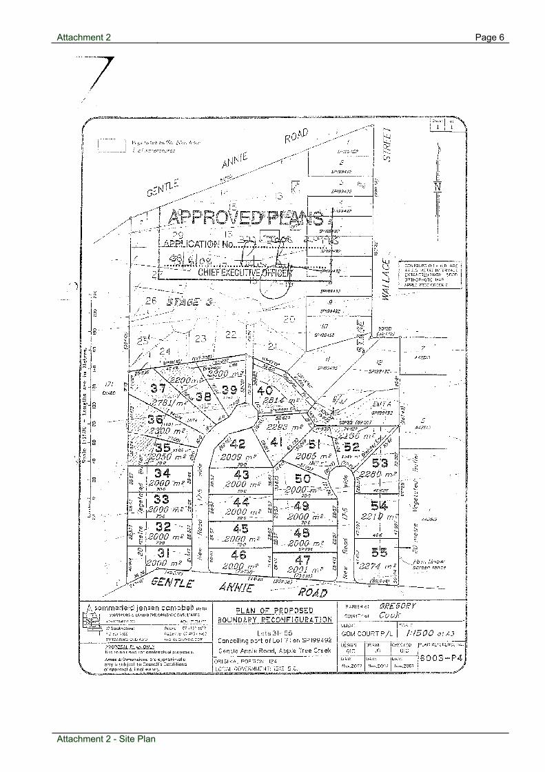
1 Location Plan2 Site Plan
Recommendation: That Council approve Bloodwood Court as the new road name for stage 4 of the Country Calm estate in Childers.

Attachment 1 Page 5
Location
Plan
Attachment 1 - Location Plan
Attachment 2 Page 6
Site Plan
Attachment 2 - Site Plan

Agenda for Planning & Development Committee Meeting Page 7
Development N1 123A Bargara Road, Bundaberg East - Material Change of Use - Impact Assessment for Warehouse and Showroom (Commercial Activity "B")
Item 03 March 2011
Item Number:
N1
File Number:
322.2010.30415.1
Part:
DEVELOPMENT
Portfolio:
Planning & Development Services
Subject:
123A Bargara Road, Bundaberg East
- Material Change of Use - Impact Assessment for Warehouse and Showroom (Commercial Activity "B")
Report Author:
Aaron Kelly, Planning Officer
Authorised by:
Rob Thompson, Manager Planning (City & Hinterland)
Link to Corporate Plan:
Nil -
Applicant:
Sommerfeld Jensen Campbell Pty Ltd
Owner:
BKAG Properties Pty Ltd
RPD:
Lot 1 on RP115915 and Lot 1 on RP133067, County Cook, Parish Kalkie
Area:
943 m2
Land Designation:
Low Impact Industry (Local Area 7)
Planning Scheme:
Planning Scheme for Bundaberg City
Meeting held: 03 March 2011

Agenda for Planning & Development Committee Meeting Page 8
Proposal:
This is an Application seeking a Development Permit for a Material Change of use to remove all existing buildings from the site and erect a two (2) storey pre-cast concrete warehouse and showroom building. Plans submitted with the Application illustrate a ground floor consisting of 130 square metres of showroom area and 239 square metres of warehouse area. On the upper floor of the building, the mezzanine to the ground floor showroom, is a 155 square metre warehouse area. The total area dedicated to showroom and warehouse purposes in therefore 524 square metres. The total floor area of the entire building is 613 square metres, 89 square metres of which comprises amenities, lunchrooms and the like. Access to the building of which the primary orientation contains aluminium glazed windows is via a double roller door. Vehicular access to the site is achieved from Bargara Road to a heavy rigid vehicular servicing arrangement and a customer and employee car parking area catering for a total of ten (10) spaces. The building is more or less sited hard against boundaries where it adjoins commercial premises and three (3) metres from properties which are residential in nature. The site comprises two (2) existing “Low Impact Industry” allotments, the rear of which is landlocked, and the front allotment located on the northern side of Bargara Road, Bundaberg East. Currently on the site are a single dwelling, swimming pool and ancillary outbuildings. Surrounding land uses predominantly comprise a variety of industrial and commercial uses. Warehouses, a veterinary clinic and storage sheds all occur in the immediate area and the Millaquin markets shopping centre and Bundaberg Brewed Drinks are in the same city block further to the east. Adjacent to the west of the site is the Vast Interior complex also containing a dental clinic. Low density residential is prevalent on the opposite side of Bargara Road and also in Morrison Street for which the rear allotment directly adjoins. Considerations
1. Planning Scheme
The site is located in a “Low Impact Industry” Precinct for Local Area 7 under the provisions of the Planning Scheme for Bundaberg City. The proposed development sought as part of this Application is largely aimed at a showroom, bulky goods retail and warehouse type use more associated with Commercial activities. Therefore, the proposed use, with a total use area of under 750 square metres is defined as a Commercial Activity “A” in the Planning Scheme. In Local Area 7, a Commercial Activity “A” use on a “Low Impact Industry” Precinct allotment represents Impact Assessable Development that is otherwise inconsistent with the Local Area Planning Intent, and City Planning Strategies.
Meeting held: 03 March 2011

Agenda for Planning & Development Committee Meeting Page 9
Therefore, the subject Application will be assessed against the entire Planning Scheme. It would also be relevant to assess the Application against the provisions of the Commercial Activity Code, Infrastructure Services Code, Signs Code, Landscaping Code and Vehicle Parking and Access Code. 2. Local Area 7 – Eastern Industrial
Located along the corridor of Bargara Road within the Eastern Industrial Planning Scheme Local Area are several existing industrial parcels which are semi-commercial in nature, or have ancillary commercial uses subsidiary to the primary industrial operations. Such uses in the area include building supply showrooms, a tourist facility for Bundaberg Brewed Drinks, a Veterinary Clinic and a car sales yard. While commercial strip ribbon development along primary roads are not generally encouraged outside of Commercial Precincts it considered that in this instance the proposed use of a warehouse and showroom is of a suitable industrial nature to be consistent with the Planning Intent for the Local Area. Development is encouraged to be of a suitable amenity along such gateways and it is seen that the design and incorporated landscaping of the proposed development will contribute to the streetscape and overall industrial character of the local area. 3. Commercial Activity Code
The purpose of the Commercial Activity Code is to: “To facilitate new commercial development that makes a positive contribution to streetscape through building design, siting and scale while ensuring that adverse off-site impacts are within limits acceptable to the local community.” It is considered that the proposed Warehouse and Showroom building are generally in accord with the purpose of the Commercial Activity Code. A three (3) metre wide landscaped interface has been provided where the site adjoins premises located in Residential “A” Precincts (in Morrison Street) and there will otherwise be minimal off-site impacts. 4. Engineering or Internal Referral
4.1 Water
The site has access to Council’s reticulated water supply via a 150mm uPVC Class 12 water main within the northern alignment of Bargara Road. 4.2 Sewerage
The site is not traversed by any existing Council sewerage infrastructure. As a result of the commercial development at 123 Bargara Road and 2 Morrison Street an alteration was required to re-route the house drainage line servicing the existing dwelling on the site. This alteration was completed by Baldwin Plumbing in September 2007 and connects into the access chamber located within this commercial premise.
Meeting held: 03 March 2011
Agenda for Planning & Development Committee Meeting Page 10
This current arrangement is considered acceptable. Since this line only services the subject site no upgrade is considered necessary to this line. 4.3 Stormwater Drainage
Council’s underground drainage exists in Bargara Road. The kerb and channel will be the designated discharge point. 4.4 Roadworks & Car Parking
Bargara Road contains as asphalt sealed main carriageway, an unsealed road shoulder and grassed footpath. Asphalt pavement widening is therefore required. The required concrete pedestrian footpath between the kerb and frontage is near ideal and can be graded to suit and connect into the existing footpath on the adjacent property. Standard Conditions will apply for the developments access and car parking requirements. An assessment against the Vehicle Parking and Access Code and the required number of customer and employee car parking spaces results in there being sufficient car parking spaces provided for the proposed use. The Department of Transport and Main Roads Conditions will also apply in this regard. 5. Referral Agencies
The Queensland Government – Department of Transport and Main Roads is a Concurrence Agency in relation to the subject Application in relation to State Controlled Road Matters. The Department has provided a Concurrence Agency response dated 20 January, 2011 advising it has no objections to the proposed showroom and warehouse development. The response includes Conditions relating to access, lighting, advertising signage and car parking. 6. Grounds of Submissions
As a result of Public Notification of the subject Application no (nil) submissions were received. 7. Infrastructure Charges
Infrastructure charges contributions are required as per the attached calculation sheet.
Attachments:
1 Locality Plan 2 Site Photo 3 Infrastructure Charges 4 Concurrence Agn Response5 Approved Plans
Meeting held: 03 March 2011
Agenda for Planning & Development Committee Meeting Page 11
Recommendation:
That application (Council Reference Number 322.2010.30415.1) for Material Change of Use – Impact Assessment – for Warehouse and Showroom (Commercial Activity “B”) at 123A Bargara Road, Bundaberg East; land described as Lot 1 on RP115915 and Lot 1 on RP133067, County Cook, Parish Kalkie, be approved with conditions
- and Council (the Assessment Manager) issue a Decision Notice detailing the following conditions:-
Material Change of Use – Impact Assessment – for Warehouse and Showroom (Commercial Activity “B”) at 123A Bargara Road, Bundaberg East; land described as Lot 1 on RP115915 and Lot 1 on RP133067, County Cook, Parish Kalkie – Conditions of Approval Part 1. Conditions Imposed by the Assessment Manager
General
1. All works are to be undertaken at the Developer’s expense;
2. All Conditions contained in this Decision Notice are to be completed/complied with before the use hereby approved commences, unless otherwise stated within this notice;
Approved Plans
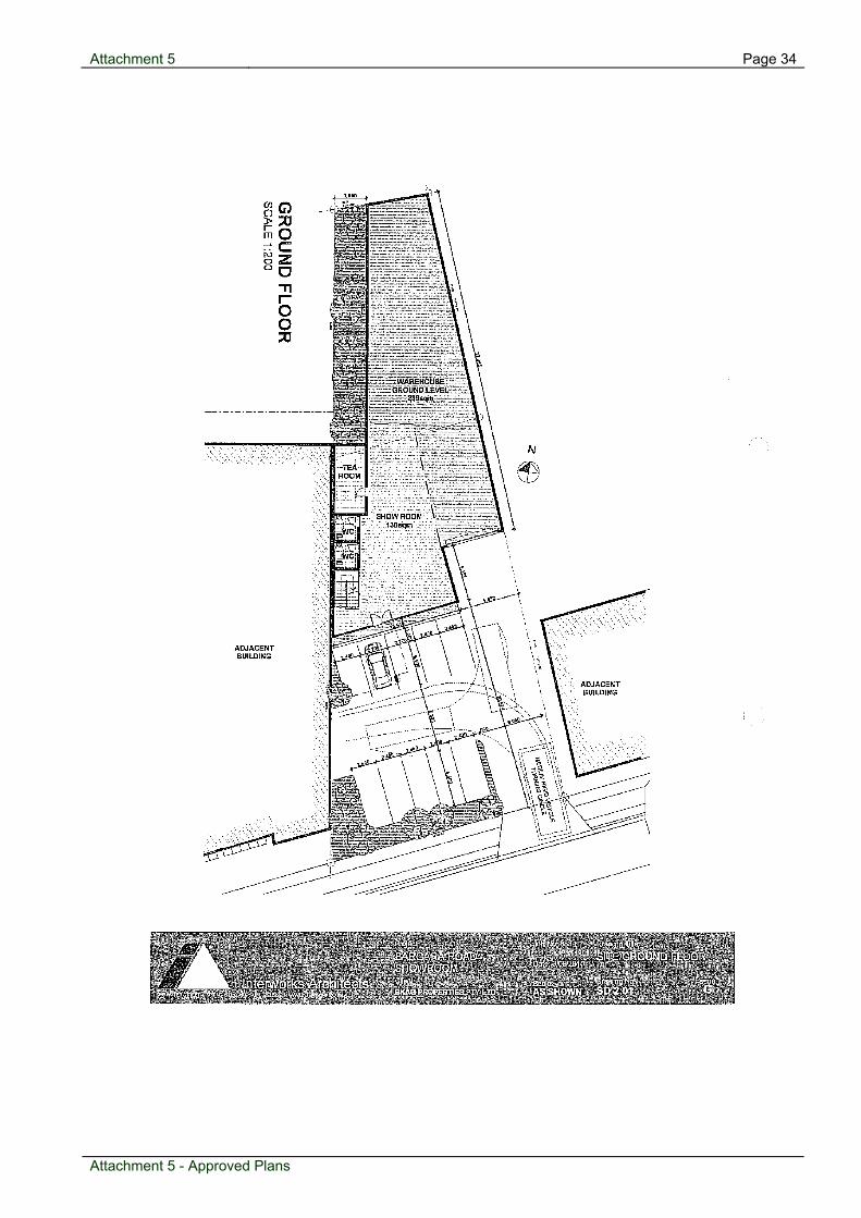
3. The proposed development is to be generally constructed in accordance with Conditions contained within this notice and the following Approved Plans;
Drawing No. Drawing Title Prepared By Date
SD 2.01 Site/Ground Floor Interworks Architects 3 September, 2010
SD 2.02 Level One Interworks Architects
3 September, 2010
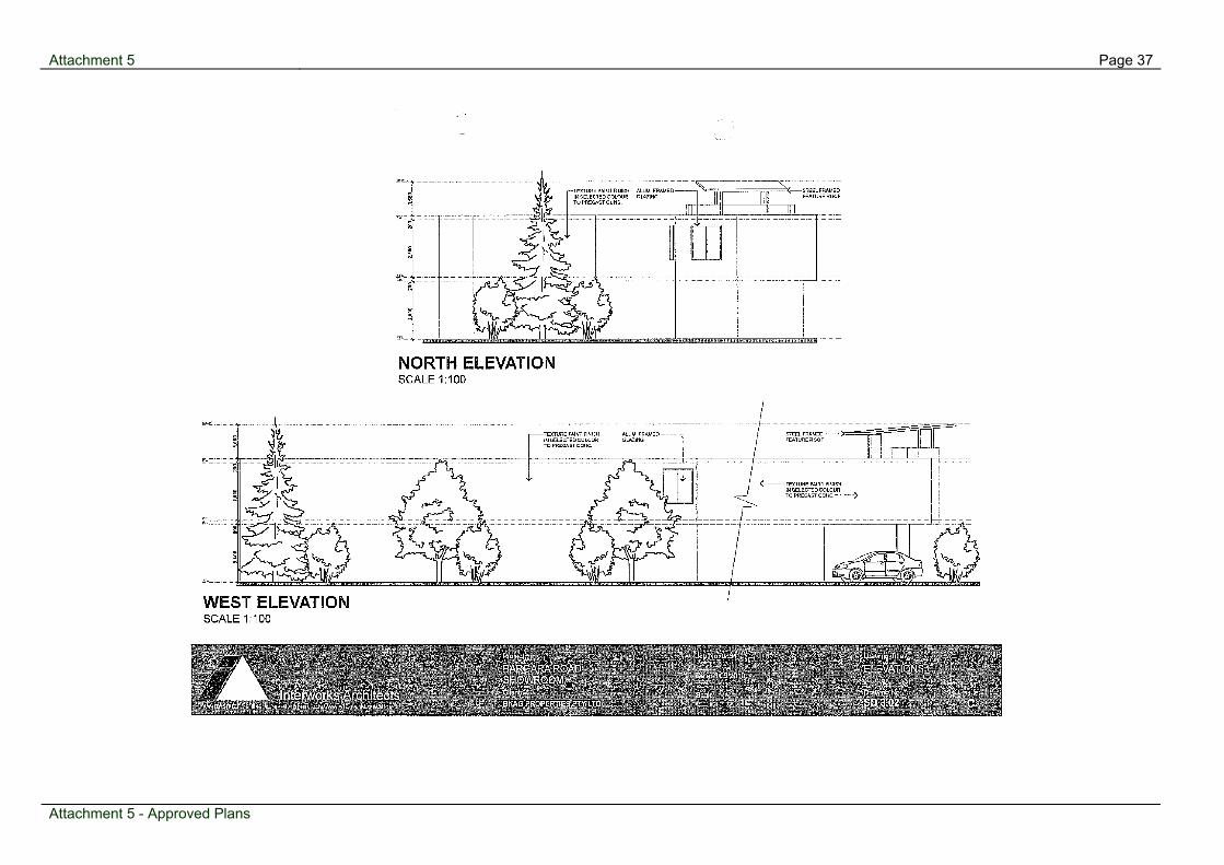
SD 3.01 Elevations Interworks Architects
3 September, 2010
SD 3.02 Elevations Interworks Architects
3 September, 2010
Meeting held: 03 March 2011
Agenda for Planning & Development Committee Meeting Page 12
Infrastructure Contributions
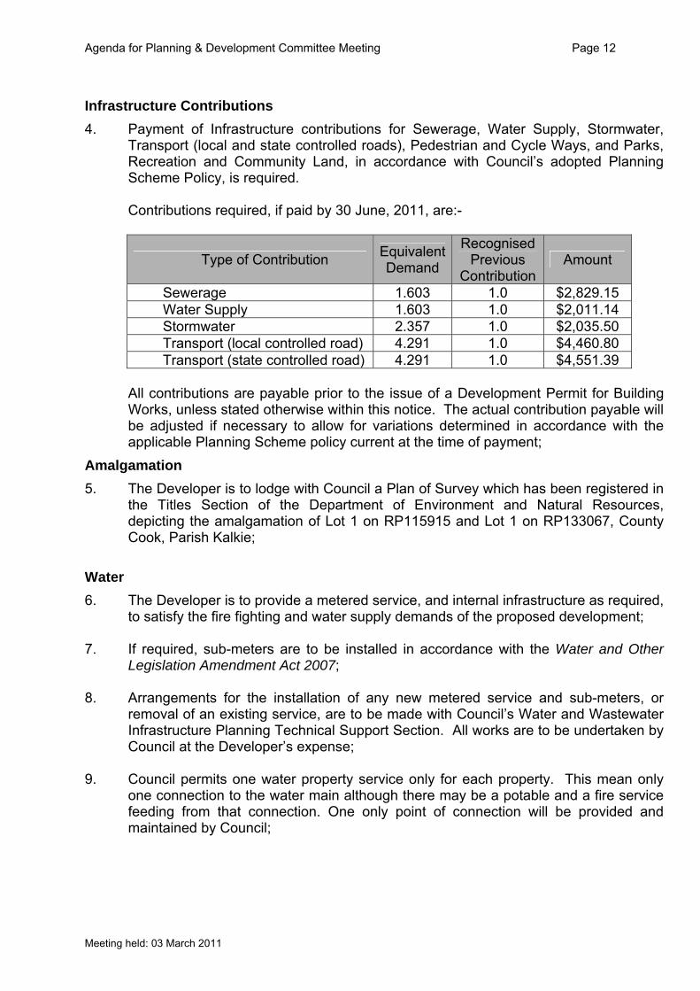
4. Payment of Infrastructure contributions for Sewerage, Water Supply, Stormwater, Transport (local and state controlled roads), Pedestrian and Cycle Ways, and Parks, Recreation and Community Land, in accordance with Council’s adopted Planning Scheme Policy, is required. Contributions required, if paid by 30 June, 2011, are:-
Type of Contribution EquivalentDemand
Recognised Previous
Contribution Amount
Sewerage 1.603 1.0 $2,829.15 Water Supply 1.603 1.0 $2,011.14 Stormwater 2.357 1.0 $2,035.50 Transport (local controlled road) 4.291 1.0 $4,460.80 Transport (state controlled road) 4.291 1.0 $4,551.39
All contributions are payable prior to the issue of a Development Permit for Building Works, unless stated otherwise within this notice. The actual contribution payable will be adjusted if necessary to allow for variations determined in accordance with the applicable Planning Scheme policy current at the time of payment;
Amalgamation
5. The Developer is to lodge with Council a Plan of Survey which has been registered in the Titles Section of the Department of Environment and Natural Resources, depicting the amalgamation of Lot 1 on RP115915 and Lot 1 on RP133067, County Cook, Parish Kalkie;
Water
6. The Developer is to provide a metered service, and internal infrastructure as required, to satisfy the fire fighting and water supply demands of the proposed development;
7. If required, sub-meters are to be installed in accordance with the Water and Other
Legislation Amendment Act 2007; 8. Arrangements for the installation of any new metered service and sub-meters, or
removal of an existing service, are to be made with Council’s Water and Wastewater Infrastructure Planning Technical Support Section. All works are to be undertaken by Council at the Developer’s expense;
9. Council permits one water property service only for each property. This mean only
one connection to the water main although there may be a potable and a fire service feeding from that connection. One only point of connection will be provided and maintained by Council;
Meeting held: 03 March 2011

Agenda for Planning & Development Committee Meeting Page 13
10. All water services and sewer points of connection are to be removed/sealed by
Council as a condition of Removal or Demolition Permit. These are to be paid for by the applicant before permits are issued;
Sewerage
11. All live sewer work, including any new sewer point of connection, is to be undertaken by Council at the Developer’s expense;
12. The Developer shall:-
12.1 locate the proposed buildings clear of the existing site sewerage reticulation as detailed in Council’s Policy for the ‘Construction of Buildings over Existing Sewer Lines’; and
12.2 provide appropriate footings to the structures such that no extra loading is
exerted on the Council sewerage infrastructure prior to what was exerted before construction of the Building;
Stormwater Drainage
13. Stormwater drainage shall be designed and constructed in accordance with the requirements of the Queensland Urban Drainage Manual, AS3500 and Bundaberg Regional Council, i.e. piped system is to be provided with a capacity to cater for Q10 ARI flows with overland flowpaths to be provided for a capacity of Q100 ARI less piped flow. Post-development flows shall be limited to pre-development flows;
14. The point of discharge for site stormwater shall be the kerb and channel in Bargara
Road; 15. The design for the site drainage system, fill, car parking and access shall be
undertaken such that flows from adjacent properties will not be impeded by the proposed development.
Roadworks and Car Parking
16. The Developer shall comply with all Conditions contained within the Department of Transport and Main Road’s letter to Bundaberg Regional Council dated 20 January 2011. (Main Roads Ref 830/1093(1) P120947 E108016).
17. Pavement construction and asphaltic concrete (AC) sealing is to be provided to the
full site frontage of Bargara Road from the existing kerb and channelling to the edge of the existing pavement. The pavement is to be designed in accordance with Main Roads Design Manual and Main Roads approved ESA values. The pavement specifics shall be determined at the Operational Works Stage.
18. The Developer must replace the frontage length of the 150 mm PVC water main in
Bargara Street where the sub grade level of the approved pavement (associated with road widening ) is within 200 mm of the top of the water main;
Meeting held: 03 March 2011

Agenda for Planning & Development Committee Meeting Page 14
19. Removal of obsolete kerb crossings, kerb drainage outlets and footpath crossovers.
Works shall include the reinstatement of frontage kerb and channelling and footpath profile to suit;
20. Provision of an off-street car parking and vehicle manoeuvring area for ten (10)
employee and customer parking spaces, including 1 designated for disabled parking, in accordance with Council’s requirements. Such car parking, access and manoeuvring areas shall be:-
20.1 constructed and sealed with bitumen, asphalt, concrete or approved pavers; 20.2 line-marked into parking bays; 20.3 designed to include a manoeuvring area to allow vehicles to leave the site in a
forward gear; 20.4 designed to include the provision of fill and/or boundary retaining walls to allow
for the containment and management of site stormwater drainage as required; 20.5 sign posted to indicate entry / exit points, in addition to line marking, to indicate
the traffic flow through the site; 20.6 drained to the relevant site discharge point; 20.7 designed in accordance with AS/NZS2890.1-2004: ‘Parking Facilities Part 1:
Off-street Car Parking’; 21. Provision of a 1.5 metre wide concrete ribbon footpath for the full length of the site
frontage in accordance with Council’s Drawing 13977. Works shall include re-grading of the grassed area to suit the new footpath, with topsoiling and grass seeding to disturbed path areas as well as fill material to the footpath to remove trip hazards;
Landscaping
22. Landscaping of the site is to:-
22.1 consist of the construction of permanent garden beds planted with trees and shrubs, with particular attention to the street frontages of the site. Landscaping is to be completed prior to the premises being occupied and is to be maintained while the use of the premises for the ‘approved use’ continues;
22.2 include species recognised for their low water requirements and are to be provided with an approved controlled underground or drip watering system. Any such system is to be fitted with an approved testable backflow prevention device at the Developer’s expense. Please liaise with Council’s Building Services, and Water and Wastewater Infrastructure Planning Technical Support Sections in this regard;
Meeting held: 03 March 2011

Agenda for Planning & Development Committee Meeting Page 15
Fencing
23. The provision of a 1.8 metre high solid screen fence along the side and rear boundaries of the site, commencing from the front boundary of the subject property, where such fencing does not currently exist and where the site adjoins a residential use. From the front building line of the structure to the front boundary of the site such fencing may be reduced to a height of 1.2 metres with exception of any private open space areas between the main building line and Bargara Road. The total cost of this new fencing is to be met by the Developer;
24. Screen fencing must contain no gaps so that the privacy of adjoining residents is
protected. Where timber paling fences are proposed, the palings are to be overlapped to allow for the natural shrinkage of the timber;
25. The erection of a second boundary line fence parallel to any existing boundary fence,
is prohibited, thereby preventing the creation of an unmaintainable area between two fences that may attract or harbour vermin or pests;
26. Should any existing fence provide insufficient screening then the Developer may, by
agreement with the owner/s of the neighbouring property, replace the existing fence wholly at the Developer’s expense. Any replacement fence must comply with the requirements of this approval;
27. Should any existing fence not comply with the requirements of this approval then the
Developer must replace said fencing in accordance with the requirements of this approval;
Signage
28. The size and dimensions of all signage proposed as part of the new industrial/commercial development will need to comply with the Signs Code contained within the Planning Scheme for Bundaberg City. Any signage that does not comply with the Code shall require a Development Application for the Planning Approval of Operational Works (involving placing an advertising device on premises);
Noise
29. Any noise produced by the use is not to exceed the background noise level plus 5db(A) (6am-6pm) or background noise level plus 3db(A) (6pm-10pm) or background noise level (10pm-6am) measured as the adjusted maximum sound pressure level at any noise sensitive place;
Lighting
30. External lighting is to be designed in accordance with AS4282-1997: ‘Control of the Obtrusive Effects of Outdoor Lighting’ so as not to cause nuisance to nearby residents or passing motorists;
Meeting held: 03 March 2011

Agenda for Planning & Development Committee Meeting Page 16
Meeting held: 03 March 2011
Other
31. Any damage occasioned to the kerb and channelling and / or footpath is to be repaired / reinstated at the completion of all works;
32. A sufficient area is to be provided for the storage of all waste bins. This area is to be
sealed, screen fenced and designed so as to prevent the release of contaminants to the environment;
33. Any placement of fill material within the subject land is to comply with the Planning
Scheme for Bundaberg City’s ‘Filling and Excavation Code’. All fill material to be placed on the subject allotment is to be tested and structurally certified in accordance with the Code;
Part 2. Concurrence Agency’s Conditions The Queensland Government – Department of Transport and Main Roads, by letter dated 20 January 2011 (copy letter attached for information).

Attachment 1 Page 17
Locality
Plan
Attachment 1 - Locality Plan

Attachment 2 Page 18
Site Photo
Attachment 2 - Site Photo

Attachment 3 Page 19
Infrastructure Charges
Infrastructure Charges Contribution Sheet (07 February 2011) COUNCIL REFERENCE: 322.2010.30415.1 APPLICANT: SOMMERFELD JENSEN CAMPBELL PTY LTD REAL PROPERTY DESCRIPTION:
LOT: 1 RP: 115915, LOT: 1 RP: 133067, COUNTY COOK, PARISH KALKIE
LOCATION: 123A BARGARA ROAD BUNDABERG EAST AREA: 943 SQUARE METRES PROPOSAL: DEVELOPMENT APPLICATION FOR MATERIAL
CHANGE OF USE – IMPACT ASSESSMENT – WAREHOUSE (COMMERCIAL ACTIVITY B)
Planning Scheme for Bundaberg City, Planning Scheme Policy 5.10 Sewerage, Water Supply, Stormwater, Transport & Parks, Recreation and Community Land Infrastructure
Acronyms
SIC = Sewerage Infrastructure Contribution WSIC = Water Supply Infrastructure Contribution SWIC = Stormwater Infrastructure Contribution TRIC = Transport Infrastructure Contribution PCIC = Pedestrian & Cycle Way Infrastructure Contribution PRCLIC = Parks, Recreation & Community Land Infrastructure
Contribution ED = Equivalent Demand PC = recognised Previous Contribution CR = Contribution Rate I = Indexed by the Infrastructure Indexation Unit Rate 1 + (Consumer Price Index + Producer Price Index) 2 = I
Sewerage Infrastructure Contribution
SIC = ([ED – PC] x CR) x I Where: ED = 17/Ha = 0.0943 x 17 = 1.603 PC = 1.00 CR = $4,261.00 I = 1.1011 ([1.603 – 1.00] x $4,261.00) x 1.1011 = $ 2,829.15
Water
WCIS = ([ED – PC] x CR) x I
Attachment 3 - Infrastructure Charges

Attachment 3 Page 20
Attachment 3 - Infrastructure Charges
Where: ED = 17/Ha = 0.0943 x 17 = 1.603 PC = 1.00 CR = $3,029.00 I = 1.1011 ([1.603 – 1.00] x $3,029.00) x 1.1011 = $ 2,011.14
Stormwater
SWIC = (ED - PC) x CR Where: ED = 1 x (site area/400m2) = 1 x 943 / 400 = 2.357 PC = 1.00 CR = $1,500.00 (2.357 – 1.00) x $1,500.00 = $ 2,035.50
Transport
TRIC = ([ED – PC] x CR) x I Where: ED = 0.7 per 100sqm GFA = 6.13 x 0.7 = 4.291 PC = 1.00 CR = $1,231.00 (Council) = $1,256.00 (DMR) I = 1.1011 (4.291 – 1.00 x $1,231.00) x 1.1011 = $ 4,460.80 (Council) (4.291 – 1.00 x $1,256.00) x 1.1011 = $ 4,551.39 (DMR)
Attachment 5 Page 34
Approved Plans
Attachment 5 - Approved Plans

Attachment 5 Page 35
Attachment 5 - Approved Plans

Page 36 Attachment 5
Attachment 5 - Approved Plans
Attachment 5 Page 37
Attachment 5 - Approved Plans

Agenda for Planning & Development Committee Meeting Page 38
N2 17 School Lane, Yandaran - Reconfiguring a Lot - One (1) Lot into Four (4) Lots
Item 03 March 2011
Item Number:
N2
File Number:
321.2010.30394.1
Part:
DEVELOPMENT
Portfolio:
Planning & Development Services
Subject:
17 School Lane, Yandaran
- Reconfiguring a Lot - One (1) Lot into Four (4) Lots
Report Author:
Scott Irwin, Planning Officer
Authorised by:
Wayne Phillips, Manager Planning (Coastal)
Link to Corporate Plan:
Nil -
Applicant:
PK Outzen & KR Outzen
Owner:
PK Outzen & KR Outzen
RPD:
Lot 6 on Y5777, County Cook, Parish Yandaran
Area:
2.471 ha
Land Designation:
Hinterland Residential
Planning Scheme:
Planning Scheme for Burnett Shire 2006
Proposal:
The application seeks to reconfigure one (1) existing lot into four (4) new lots. The following tabulation illustrates the area of the existing and proposed lots:
Meeting held: 03 March 2011

Agenda for Planning & Development Committee Meeting Page 39
Existing Lot Descriptions Area of existing lot
Lot 6 on Y5777 2.471 ha
Proposed Lot Descriptions
Area of proposed lots
Lot 14 3081m2
Lot 15 3076m2
Lot 16 3070m2
Lot 17 1.54ha All the proposed lots will have frontages and access to School Lane. The existing tree seed plantation, dwelling and associated sheds will be located on proposed Lot 17 with proposed Lots 15 and 16 to be unimproved and proposed Lot 14 to contain and existing small shed. Subject Site & Surrounding Land Uses
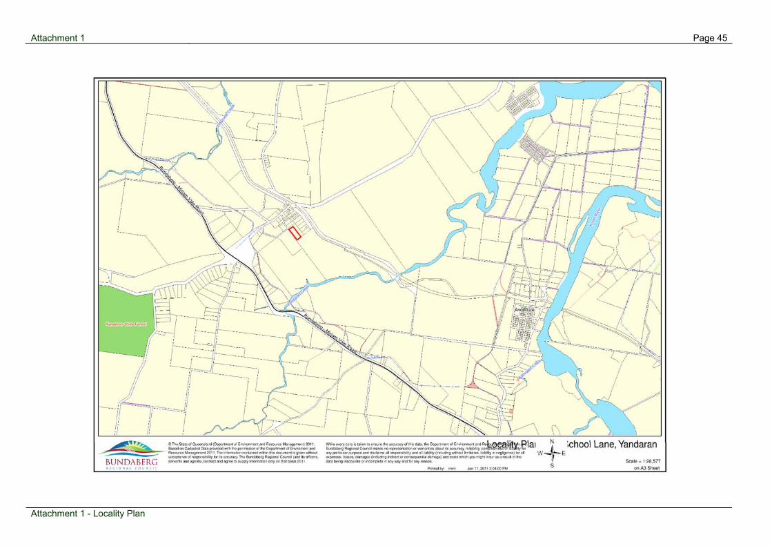
The subject site is located within the township of Yandaran and situated sixty (60) metres south of the Yandaran State School. Sixty (60) percent of the subject site currently consists of a tree plantation which is used for the purposes of growing endangered and near extinct native plants for cropping seeds to reproduce these species. The dwelling, tree plantation and associated sheds are located predominately within the south eastern half of the site with the proposed new lots to be located within the north western portion of the site. The surrounding properties to the north and east of the site consist of Hinterland Residential zone properties that consist of a mixture of lot sizes ranging from 700 m2 to 1.2 hectares with the average size being approximately 2000 m2. The surrounding properties to the south and west of the site consist of large rural zoned properties. Planning History
There is no history relevant to the current application. Considerations
1. Planning Scheme Burnett Shire 2006
In the Burnett Shire Planning Scheme 2006, reconfiguring a lot within the Hinterland Residential zone attracts a Code Assessable application. The applicable codes include:
Rural Planning Area Code;
Hinterland Residential Zone Code;
Reconfiguring a Lot Code;
Development Infrastructure and Works Code; and
Natural Features or Resource Overlay Code (Medium Bushfire Risk)
Meeting held: 03 March 2011

Agenda for Planning & Development Committee Meeting Page 40
The Development Application’s compliance with the relevant Codes is addressed in the following sections.
1.1 Rural Planning Area Code
The proposal is consistent with the provisions of the Rural Planning Area Code. Specifically the proposal is consistent with the character of the locality. Additionally, the proposal is not considered to have a negative impact on the environmental values of the locality.
1.2 Hinterland Residential Zone Code
The proposed reconfiguration does not conflict with the intent of the Hinterland Residential Zone Code. The proposed lots generally comply with the specific outcomes of the code by creating lots that reflect a low density setting. The proposed lots have ample room to accommodate a dwelling, waste water disposal system, potable water supply, vehicle access and parking.
1.3 Reconfiguring a Lot Code
The minimum lot size in Area 1 of the Hinterland Residential Zone is 1500m2
with a 25 metre frontage, average minimum width of 18 metres. The proposed lots comply with the minimum lot size for the Hinterland Residential Zone. The lots also generally comply with the specific outcomes of the code by reflecting the prevailing Hinterland Residential character of rural living on large residential lots in a rural setting with ample space to accommodate a dwelling and associated infrastructure.
1.4 Development Infrastructure and Works Code
The Development Infrastructure and Works Code seek to ensure that infrastructure is provided to development in a cost effective and coordinated manner that creates no adverse environmental effects. In accordance with the Code, each new lot is required to be serviced with a potable water supply, a wastewater treatment and disposal system and a standard vehicular access. Conditions and advice regarding infrastructure items are incorporated into the recommended conditions of approval.
1.5 Natural Features or Resources Overlay Code
The site has the following features that make the development assessable against the overlay code: Medium Bushfire Risk The subject site only contains a small section of approximately 600m2 located in the southern corner of the site which is located in the Medium Bushfire Risk area. The new proposed lots are located over 130 metres from the Medium Bushfire Risk area. Additionally, it is noted that the majority of the area where the new lots are proposed is clear of vegetation.
Meeting held: 03 March 2011
Agenda for Planning & Development Committee Meeting Page 41
2. Engineering
Engineering issues relate primarily to upgrading the existing unconstructed road reserve fronting the subject land to a Rural Road – Single Lane standard and providing accesses to proposed lots and ensuring that the wastewater treatment and disposal areas function appropriately. Conditions and advice regarding roadwork, accesses and wastewater treatment and disposal have been included in the recommended conditions of approval. 3. State Planning Policies
There are no State Planning Policies which are not appropriately reflected in the Burnett Shire Planning Scheme 2006 which require consideration for this proposal. 4. Referral Agencies
The application did not trigger referral to any State Government Agencies. 5. Grounds of Submissions
The application is code assessable and therefore not subject to public notification. 6. Infrastructure Charges
Infrastructure charges contributions are required as per the attached calculation sheet. Conclusions
The proposed development involves the reconfiguration of one (1) lot to create four (4) new lots. The proposal has been assessed against the Planning Scheme and generally complies with the relevant codes. The application is therefore recommended for approval subject to conditions.
Attachments:
1 Locality Plan 2 Aerial Plan 3 Infrastructure Charges 4 Proposal Plans 5 Zoning Map
Recommendation:
That application (Council Reference Number 321.2010.30394.1) for Reconfiguring a Lot - one (1) lot into four (4) lots at 17 School Lane Yandaran; land described as Lot 6 on Plan Y5777, County Cook, Parish Yandaran, be approved with conditions
- and Council (the Assessment Manager) issue a Decision Notice detailing the following conditions:-
Meeting held: 03 March 2011

Agenda for Planning & Development Committee Meeting Page 42
Reconfiguring a Lot - one (1) lot into four (4) lots at 17 School Lane Yandaran; land described as Lot 6 on Plan Y5777, County Cook, Parish Yandaran – Conditions of Approval
Part 1(a). Conditions Imposed by the Assessment Manager Plan of Development 1. The reconfiguration is to be generally in accordance with Drawing No 4864pc prepared
by Straughair & Bent Surveyors and dated 28 November 2010, except as modified by the conditions contained hereunder.
Infrastructure Contributions
2. Payment of Infrastructure Contributions for Sewerage, Water Supply, Stormwater,
Transport (local and state controlled roads), Pedestrian and Cycle Ways, and Parks, Recreation and Community Land in accordance with Council's adopted Policy, is required prior to commencement of the development.
At current rates the contributions are:
Infrastructure Contributions current as at the date on this Decision Notice
Type of Contribution Equivalent Demand
Recognised Previous
Contributions
Infrastructure Contribution
Amount Sewerage 0 0 Not Applicable Water Supply 0 0 Not Applicable Stormwater 4 1 $13,962.82 Transport (local controlled road) 4 1 $10,640.47
Transport (state controlled road) 4 1 $2,254.59
Pedestrian and Cycle Ways 4 1 $4,500.00
Parks, Recreation and Community Land 4 1 $14,856.49
All contributions are payable prior to commencement of the use. The actual contribution payable will be adjusted if necessary to allow for variations in the Consumer Price Index determined in accordance with Council’s policy current at the time of payment.
Wastewater Treatment and Disposal
3. The Developer must provide an onsite sewerage disposal site serving each habitable building/s on their respective allotments. The disposal sites must be wholly contained within respective boundaries of each lot.
Meeting held: 03 March 2011

Agenda for Planning & Development Committee Meeting Page 43
4. The boundaries for proposed Lot 17 are to be located to comply with the setbacks
specified by the Department of Infrastructure and Planning - Queensland Plumbing and Wastewater Code (QPW code)- 1 January 2008, and Australian Standards (AS) 1547.2000, under the Plumbing and Drainage Act 2002.
Roadworks
5. School Lane shall be upgraded to a 4.0 metre bitumen (two-coat) seal generally in accordance with “Rural Road – Single Lane” standard as shown on Council’s standard drawing R102 from the chainage of the existing seal in School Lane to a point not less than 120 metres past the western corner of Lot 14 on Drawing Number 4864pc. Road alignment, pavement design and any works necessary to join the new works to the existing construction must be further detailed in a Development Application for Operational Works.
6. A vehicular access to each proposed lot must be constructed or upgraded to comply
with Council’s Standard Drawing R113-1 or where there is insufficient depth for a culvert crossing then an invert access in accordance with Council Standard Drawing R113-2.
Electricity and Telecommunications 7. Evidence that a supply of electricity is available to the proposed lots or that the
applicant has entered into a suitable agreement with Ergon Energy for the supply of electricity to the proposed lots is to be provided prior to the Plan of Survey being endorsed by Council.
8. The Developer is to make arrangements for the provision of underground
telecommunications to the proposed Lots within the subdivision. Evidence is to be submitted that an agreement has been reached with an authorised supplier of such services, prior to the Plan of Survey being endorsed by Council.
Declared Plants 9. The developer must eradicate / control all declared plants existing on the property.
Council will not endorse the plan of survey until it is satisfied all declared plants have been treated as required by the provisions of the Land Protection (Pest and Stock Route Management) Act 2002.
Alteration/Damage to Services and Utilities 10. Alterations to public utilities, mains and services made necessary in connection with
any of the works arising from this approval including works to restore and reinstate all roads are to be completed at no cost to Council.
Rates 11. In accordance with Schedule 19 Table 1 Part 2 of the Sustainable Planning Regulation
2009 all rates or charges levied by the Local Government or expenses that are a charge over the land under any Act must be paid prior to the plan of survey being endorsed by Council.
Meeting held: 03 March 2011

Agenda for Planning & Development Committee Meeting Page 44
Meeting held: 03 March 2011
Survey 12. Prior to Council endorsement of the Plan of Survey, lodge a certificate signed by a
licensed surveyor stating that after the completion of all works associated with the subdivision, survey marks were reinstated where necessary and all survey marks are in their correct position in accordance with the plan of survey as of a particular date.
Part 2. Property Notes Imposed by the Assessment Manager
1. Proposed Lots 14, 15 and 16 created from this reconfiguration shall have the following
property notes:
� At the time of final Building Approval for a residential dwelling an On Site Sewerage Facility shall have been designed and constructed in accordance with the Department of Infrastructure and Planning “Queensland Plumbing and Waste Water Code and associated Guidelines for Vertical and Horizontal Separation Distances and Guidelines for Effluent Quality, and Australian Standards (AS) 1547.2000, under the Plumbing and Drainage Act 2002. A report in accordance with the Code and Council’s Planning Scheme Policy No.7 shall be submitted to Council for assessment and approval prior to the installation of any system.
� Any future dwelling to be constructed on the subject land shall be designed and
sited to reduce any possible impacts from the adjacent rural activity. The use of landscaping treatments should also be included to help mitigate any possible impacts.
� At the time of final Building Approval for a residential dwelling, the owner is to
provide a potable water supply by either a 45,000 litre rainwater storage tank, or other means satisfactory to Council.
� All future purchasers of the subject land should note that there is a rural activity
adjacent to the land and such activity may conflict with the residential usage of the subject land.
2. Proposed Lot 17 created from this reconfiguration shall have the following property
note:
� Prospective purchasers should be aware that the subject allotment has an onsite
sewerage facility and that in the case where the existing installation is defective, a source of pollution or nuisance, or of concern from a public health aspect, Council may at any time issue a notice under the Plumbing and Drainage Act 2002 directing an owner to perform appropriate remedial work.
Page 45 Attachment 1
Attachment 1 - Locality Plan
Locality Plan

Page 46 Attachment 2
Attachment 2 - Aerial Plan
Aerial Plan

Page 47 Attachment 3
Attachment 3 - Infrastructure Charges
Infrastructure Charges

Page 48 Attachment 4
Attachment 4 - Proposal Plans
Proposal Plans

Page 49 Attachment 5
Attachment 5 - Zoning Map
Zoning Map

Agenda for Planning & Development Committee Meeting Page 50
N3 743 Rosedale Road, Meadowvale - Material Change of Use - Farm Gate Sales
Item 03 March 2011
Item Number:
N3
File Number:
322.2010.30027.1
Part:
DEVELOPMENT
Portfolio:
Planning & Development Services
Subject:
743 Rosedale Road, Meadowvale
- Material Change of Use - Farm Gate Sales
Report Author:
Hamish McIntosh, Planning Officer
Authorised by:
Wayne Phillips, Manager Planning (Coastal)
Link to Corporate Plan:
Nil -
Applicant:
Insite Strategies Pty Ltd
Owner:
AM Prichard
RPD:
Lot 71 on CK905, County Cook, Parish Tantitha
Area:
60.42 Hectares
Land Designation:
Rural Planning Area (Rural Zone)
Planning Scheme:
Planning Scheme for Burnett Shire 2006
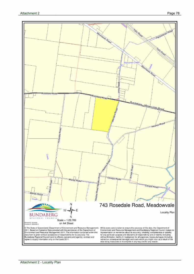
Proposal: The proposal is to establish and operate a low-scale business involving the sale of products produced on the premises and on other farms in the locality to the public.
Meeting held: 03 March 2011

Agenda for Planning & Development Committee Meeting Page 51
The low-scale business is limited to a total use area of eighty (80) square metres. It is proposed to operate on weekdays between 7.30 am and 5.30 pm and on Saturdays between 7.30 am – 4.30 pm. A total of two (2) staff will be employed to operate the proposed use. Customer and traffic generation data indicate that the activity will attract between twenty (20) and thirty (30) customers per day. A new six (6) metre by twelve (12) metre skillion extension is proposed to locate the proposed low-scale business in the vicinity of the existing packing / sorting shed on the land. The Applicant has not provided full details of signage associated with the proposed use. Six (6) formalised car-parking spaces and an on-site manoeuvring area suitable for small and medium rigid vehicles are proposed with a total of eighteen (18) spaces available onsite. Landscaping is proposed to screen the car parking and manoeuvring areas from view from Rosedale Road. Roadwork in Rosedale Road, including a formalised access is required to accommodate the new development. Subject Site & Surrounding Land Uses The subject site is located on the southern side of Rosedale Road some 250 metres west of the Rosedale Road / Witts Road / Mercers Road intersection. It has an area of 60.42 hectares including 700 metres of frontage to Rosedale Road and 1,680 metres of frontage to Mercers Road. The land is currently used for agriculture and has an existing dwelling, machinery / farm shed, packing shed and large dam. All existing buildings are located mid-way along the sites Rosedale Road frontage. Surrounding land is predominantly used for agricultural production or consists of small rural holdings with dwellings and improvements. The nearest dwelling is located on the northern side of Rosedale Road approximately 110 metres from the proposed low-scale business. Cane rail lines exist along Rosedale Road, Witts Road and Mercers Road. A number of historic rural industry land uses exist in the locality and along Rosedale Road. These are primarily concerned with processing and packaging of produce or rural services / supplies. Road-side stalls are limited or infrequent along Rosedale Road between the Gin Gin / Rosedale Road intersection and the Hinterland Town of Avondale. Planning History There are no prior planning approvals that would influence the proposed development or decision. Considerations Planning Scheme Rural Planning Area Code The proposed development is largely compliant with the schemes specific outcomes for the effects of uses and works in the Rural Planning Area.
Meeting held: 03 March 2011

Agenda for Planning & Development Committee Meeting Page 52
The development will not impact the existing rural character present in the locale with proposed additions being limited to the existing footprint of improvements on the lot and appropriately screened from view from Rosedale Road. The proposed development will not affect the intensity or operation of existing rural activities. The proposed development does not comply with SO.133 which states: SO.133. Community and business activities in the Rural Planning Area locate in Hinterland Towns of Avondale, Yandaran and South Kolan where there is a community need for the service or business. The nature and scale of the development is such that the proposed activity will not have a significant impact on current or future business activities elsewhere in the Rural Planning Area. The new use will be limited to a total use area of eighty (80) square metres and restricted in terms of the type of the products that can be sold from the premises. Essentially, only the sale of rural produce will be permitted with convenience grocery items and other non-produce related goods prohibited. These constraints are considered to address the potential commercial impacts of the proposed use. The low-scale business does not present as a significant departure from current or future planned arrangements for business uses in the Rural Planning Area. Its rural nature, scale and location will ensure that the role of the identified Hinterland towns is not compromised. The proposed development is considered to comply with the purpose of the Rural Planning Area Code. Rural Zone Code Business uses other than Home-based business are nominated as inconsistent (SO. 4.6.4(1) b.) where proposed to be located in the Rural Zone. However, the proposed development is considered to be in keeping with the purpose of the Rural Zone Code. Specifically, the development will service existing agricultural activities by providing a point of sale for ‘farm fresh’ produce grown in the locality. This is considered to enhance the economic potential of the rural zone and is consistent with the schemes emphasis on promoting the establishment of value adding enterprises. The proposed low-sale business also provides an opportunity for local producers to consolidate roadside stall sales. A community benefit is evident in the formalised and direct access to farm produce resulting from the development. The developments location is also considered to represent a promotional point for displaying and selling rural produce to motoring tourists. Development Infrastructure and Works Code Provisions under the Development Infrastructure and Works Code aim to ensure that infrastructure is provided to service new development in a sustainable manner. Standards for the provision of infrastructure (water, sewerage, stormwater and transport infrastructure) are nominated under the Development Infrastructure and Works Code.
Meeting held: 03 March 2011

Agenda for Planning & Development Committee Meeting Page 53
Conditions of the development approval reflect compliance with the Development Infrastructure and Works Code. Vehicle Parking and Access Code The purpose of the Vehicle Parking and Access Code is to ensure that new uses provide adequate onsite carparking, safe, efficient and convenient vehicle access and sufficient onsite movement. The code also allows the off-site impacts of the development to be tested to ensure traffic impacts are within acceptable limits. Six (6) additional gravel car-parking spaces and on-site manoeuvring areas for small and medium rigid vehicles are proposed. A total of eighteen (18) car-parking spaces are available on-site. Car parking and onsite manoeuvring areas are considered to be adequate given that a rate of 1 space per 30 square metres of total use area is ordinarily required. The impact of the development on the State Controlled Road has been assessed by the Department of Transport and Main Roads (DTMR). The conditional framework provided by DTMR is considered to address the traffic safety and efficiency outcomes of the code. Natural Features or Resources Overlays Code The subject land is identified as Good Quality Agricultural Land (GQAL) – Class A and within a Declared Ground Water Area. Specific outcomes, SO. 179 and SO. 190 of the code are relevant to the present application. SO. 179 promote the retention of Class A and Class B Good Quality Agricultural Land for cropping and requires consideration of the influence other uses introduce on the productive capacity of such land. In this regard, the proposed development is consistent and complimentary to the existing agricultural use of the land. It will not result in a significant loss of productive land or introduce the potential for land use conflicts. SO. 190 require consideration of the impact of new development on the quality of groundwater. The proposed use will not involve significant discharges to groundwater or the commercial extraction of groundwater. In view of this, the proposed development can be regarded as compliant with the Natural Features or Resources Code. Infrastructure Overlays Code Assessment against the Infrastructure Overlays Code is triggered due to the status of Rosedale Road (State Controlled) and the proximity of the development to cane rail infrastructure.
Meeting held: 03 March 2011

Agenda for Planning & Development Committee Meeting Page 54
The impact of the development on the State Controlled Road has been assessed by the Department of Transport and Main Roads (DTMR). A conditional framework provided by DTMR is considered to address the traffic safety and efficiency outcomes of the Infrastructure Overlays Code. The proposed activity will not be impacted by the existence or operation of cane rail lines in the vicinity. Sufficient separation exists between new buildings and works and the cane rail infrastructure. The new use is not residential in nature. In view of this, the proposed development can be regarded as compliant with the Infrastructure Overlays Code. Engineering or Internal Referral Water A potable water supply will be required to service the development. This matter can be conditioned. Sewerage An onsite wastewater treatment and disposal system will be required to service the development. The site has sufficient land area to accommodate this. Roadworks & Car Parking Roadworks and car parking matters have been addressed under the Vehicle Parking and Access Code and Infrastructure Overlays Code. State Planning Policies The following State Planning Policies are appropriately reflected in the Burnett Shire Planning Scheme 2006: State Planning Policy 1/92: Development and the Conservation of Agricultural
Land; State Planning Policy 2/02: Planning and Managing Development involving Acid
Sulfate Soils; State Planning Policy 1/02: Development in the Vicinity of Certain Airports and
Aviation Facilities; and State Planning Policy 1/03: Mitigating the Adverse Impacts of Flood, Bushfire and
Landslide (for Bushfire, Flood and Landslide). State Planning Policy 2/07: Protection of Extractive Resources is not applicable in this instance.
Meeting held: 03 March 2011

Agenda for Planning & Development Committee Meeting Page 55
Referral Agencies The application triggered referral to the Department of Transport and Main Roads (DTMR) due to the developments proximity to Bargara Road – State Controlled Road. In its role as a concurrence agency DTMR has imposed conditions relating to access design and works on Rosedale Road. There is also a requirement for the developer to remove the lots second access. Grounds of Submissions The Application was advertised for fifteen (15) business days in accordance with the Sustainable Planning Act 2009; the advertising period was between 29 November and 17 December 2010. Public Notification was carried out correctly. There were no submissions received during Public Notification. Infrastructure Charges Infrastructure charges contributions are required as per the attached calculation sheet. Conclusions The proposal conflicts with the Rural Planning Area Code and the Rural Zone Code of the Burnett Shire Planning Scheme 2006. Namely, the proposal does not comply with Specific Outcomes – SO.133 of the Rural Planning Area Code and Specific Outcome – 4.6.4 (1) b. of the Rural Zone Code. However, the proposed development is considered to advance the purpose of each code and achieves compliance with the balance of the Planning Scheme. Importantly, the decision will not compromise achievement of the desired environmental outcomes for the planning scheme area. A number of grounds are also considered to be sufficient grounds to justify the decision despite the conflict. Specifically, the nature and scale and location of the proposed low-scale business is such that it will not have a significant impact on current or future business activities elsewhere in the Rural Planning Area. Furthermore, the low-scale business provides an opportunity for local producers to consolidate roadside stall sales in the locality and is consistent with the schemes emphasis on promoting the establishment of value adding enterprises.
Attachments:
1 Referral response 2 Locality Plan 3 Approved Plans 4 Infrastructure Charges
Meeting held: 03 March 2011

Agenda for Planning & Development Committee Meeting Page 56
Recommendation:
That application (Council Reference Number 322.2010.30027.1) for a Material Change of Use for a Low Scale Business, at 743 Rosedale Road, Meadowvale; land described as Lot 71 on CK905, County Cook, Parish Tantitha, be approved with conditions
- and Council (the Assessment Manager) issue a Decision Notice detailing the following conditions:-
Material Change of Use for a Low Scale Business, at 743 Rosedale Road, Meadowvale; land described as Lot 71 on CK905, County Cook, Parish Tantitha – Conditions of Approval
Part 1(a). Conditions Imposed by the Assessment Manager Approved Plans 1. The proposed development is to be constructed and carried out in accordance with
Conditions contained within this notice and the following Approved Plans;
Plan/Document number Plan/Document name Date
Drawing 2010.1 Site Plan 20 July 2010
Drawing 2010.2 Site Plan 20 July 2010
General 2. All works are to be undertaken at the Developer’s expense;
3. All Conditions contained in this Decision Notice including necessary works to achieve
compliance are to be complied with / completed prior to the commencement of the use unless otherwise stated;
4. Where there is any conflict between Conditions of this Decision Notice and details
shown on the Approved Plans, the Conditions must prevail; 5. Alterations to public utilities, mains and services made necessary in connection with any
of the works arising from this approval including works to restore and reinstate all roads are to be completed at no cost to Council;
Infrastructure Charges 6. Payment of Infrastructure contributions in accordance with Council’s adopted Planning
Scheme Policy is required. All contributions are payable prior to prior to the building being occupied for its intended use, unless stated otherwise within this notice. The actual contribution payable will be adjusted if necessary to allow for variations determined in accordance with the applicable Planning Scheme policy current at the time of payment Contributions required, if paid by 30 June, 2011, are:-
Meeting held: 03 March 2011

Agenda for Planning & Development Committee Meeting Page 57
Land Use Specific 7. The low-scale business is limited to eighty (80) square metres total use area and to
products that:
i. have been grown on-site; and, ii. have been grown on other farms in the locality.
8. Convenience grocery items, bottled / canned produce and other non-perishable items
must not be sold from the premises; 9. The hours of operation for the low-scale business are limited to:
i. 7:30am to 5:30pm Monday to Friday; ii. 7:30am to 4:30pm Saturday; and, iii. the low-scale business must not operate on Sundays or Public Holidays;
10. The maximum number of staff for the low-scale business use must not exceed three (3)
persons; 11. The person/s responsible for the management of the premise is/are to take all
necessary, reasonable and practical measures to ensure that activities associated with the land use/s do not cause any unreasonable interference with the amenity of the surrounding area and provide an acceptable level of amenity for users of the site;
12. The premises must be maintained in a safe and tidy manner at all times; Landscaping 13. The developer is to construct / plant the landscaping buffers shown on the Approved
Plans. The landscaping buffers are to include:
i. a combination of trees and shrubs with varying growth habits and mature heights; and,
Infrastructure Contributions current as at the date on this Decision Notice
Type of Contribution Equivalent Demand
Recognised Previous Contributions
Infrastructure Contribution
Water 0 0 $- Sewerage 0 0 $- Transport - Sectoral 3.375 0 $15,550.51 Transport - Regional 3.375 0 $11,850.37 Transport - Pedestrian 0 0 $- Stormwater 0 0 $- Parks 0 0 $- $27,400.88
Meeting held: 03 March 2011

Agenda for Planning & Development Committee Meeting Page 58
ii. species capable of providing effective screening within two (2) years of the
development commencing;
14. Landscaping works are to be designed to maintain sightlines between the driveway and Rosedale Road;
15. Landscaping works and supporting documents are subject to Compliance Assessment
in accordance with the Sustainable Planning Act 2009 and subordinate legislation and are to be assessed by the Local Government or the nominated entity applicable at the time of lodgement, against the following:
i. Burnett Shire Planning Scheme 2006 – Landscaping and Landscaping Plans Policy
(PSP 4); and, ii. The conditions of this approval;
The request for Compliance Assessment is to be made prior to the commencement of any landscaping works on the site;
16. Landscaping must be maintained periodically to control growth; preserve visual amenity
and enhance plant health and nutrition, to the satisfaction of Council; Signage 17. Signage is limited to a single 1.8 metre by 1.2 metre free standing sign, to advertise the
low-scale business and direct vehicles to the designated access and parking area. The sign must be sited to maintain sightlines between the driveway and Rosedale Road. The sign may include the business name and details of the operational farm and low-scale business;
18. All existing signage positioned along the lots Rosedale Road frontage is to be removed; 19. No other signage is permitted without prior consent of the Council; Vehicle Parking and Access
20. The developer is to construct an off-street car parking and vehicle manoeuvring area,
generally in accordance with the Approved Plans, including provision of six (6) parking spaces and on-site manoeuvring areas sufficient to accommodate small and medium rigid vehicles;
21. Carparking spaces are to be clearly delineated; 22. Internal vehicle parking and manoeuvring areas are to be constructed to a minimum
gravel / road base pavement (100 millimetres thick) and compacted and drained, to the satisfaction of Council;
23. Internal vehicle parking and manoeuvring areas must be maintained periodically or as
required by the local authority to prevent dust nuisance, sediment runoff, erosion and to maintain the condition and function of such areas;
Meeting held: 03 March 2011

Agenda for Planning & Development Committee Meeting Page 59
Meeting held: 03 March 2011
24. Car parking and manoeuvring areas must be maintained in a safe and tidy manner at all times;
Water Supply & Onsite Sewerage Facilities 25. The low-scale business must be provided with a sustainable supply of water and water
storage/s that is adequate to meet the needs of the use, including for potable water and fire fighting purposes;
26. A supply of potable water is to be made available for staff. The water supply must
satisfy the Australian Drinking Water Guidelines or relevant standard applicable at the time. Council does not recommend that tank (rain) water be used for drinking purposes unless an approved filtration system and a disinfection/ ultra violet ray system is installed. The source of any potable water supply is to be approved by Council prior to the commencement of the use;
27. The development is to connect to an on-site sewerage facility that is designed, operated,
constructed and maintained in accordance with the Queensland Plumbing and Wastewater Code and Australian Standard AS 1547 - 2000 under the Plumbing and Drainage Act 2002 (and Councils Planning Scheme Policy PSP7 On-site Sewerage Facilities). Wastewater must be treated to a minimum secondary standard;
Part 1(b). Assessment Manager’s Advices Referral Agency Responses A. Please note all referral agency conditions and advices attached to this Decision Notice; Compliance B. The person/s responsible for the management of the premise is/are to ensure ongoing
compliance with conditions of this Development Permit including Conditions relating to the ongoing use of the premise, and the design and layout of the development;
Total Use Area C. Total use area means the gross floor area of a building together with any outdoor part of
the premises used or intended for use as part of a particular development in a manner likely to generate car parking demand. The term does not include plant or equipment rooms, toilets, stairwell or any area used for the access, parking or manoeuvring of motor vehicles.
Part 2. Concurrence Agency’s Conditions The Department of Transport and Main Roads, by letter dated 6 December 2010 (copy letter attached for information).
Attachment 2 Page 78
Locality Plan
Attachment 2 - Locality Plan

Page 79 Attachment 3
Attachment 3 - Approved Plans
Approved Plans

Attachment 3 Page 80
Attachment 3 - Approved Plans

Attachment 4 Page 81
Infrastructure Charges
Development Contributions Summary - Infrastructure Contributions Planning Scheme Policy TOTAL: $27,400.88
File: 322.2010.30027.1 Transport (Roads - Regional - DTMR) Applicant: Insite Strategies PU1 (EDU) = 3.3750 Development type: MCU PU2 (EDU) = Portion: Full development Total PU (EDU) = 3.3750 Address: 743 Rosedale Road, MEADOWVALE CR = $2,860 Burnett Shire (TR1) DTMR Defined Use in PSP: Rural PC (EDU) = 0.0000 Council & Zone: BSC RPA I = 1.2277 Date: 21/02/2011 Contribution = $11,850.37
Water Supply Transport (Pedestrian Paths & Bikeways) PU1 (EDU) = 0.0000 PU1 (EDU) = 0.0000 PU2 (EDU) = PU2 (EDU) = Total PU (EDU) = 0.0000 Total PU (EDU) = 0.0000 CR = $0 #N/A CR = $606 Burnett Shire (PBW1) PC (EDU) = 0.0000 PC (EDU) = 0.0000 I = 1.0906 I = 1.2277 Contribution = $0.00 Contribution = $0.00
Sewerage Drainage & Stormwater PU1 (EDU) = 0.0000 PU1 (EDU) = 0.0000 PU2 (EDU) = PU2 (EDU) = Total PU (EDU) = 0.0000 Total PU (EDU) = 0.0000 CR = $0 #N/A CR = $1,500 Burnett (DSW1) & BuCC PC (EDU) = 0.0000 PC (EDU) = 0.0000 . I = 1.0906 I = 1.0000 Contribution = $0.00 Contribution = $0.00
Transport (Roads - Sectoral - BRC) Public Parks & Community Land PU1 (EDU) = 3.3750 PU1 (EDU) = 0.0000 PU2 (EDU) = PU2 (EDU) = Total PU (EDU) = 3.3750 Total PU (EDU) = 0.0000 CR = $3,753 Burnett Shire (TR1) BRC CR = $4,495 Bal of Shire - Nth River (PCL10) PC (EDU) = 0.0000 PC (EDU) = 0.0000 I = 1.2277 I = 1.0906 Contribution = $15,550.51 Contribution = $0.00
Contribution = [(ED-PC) x CR] x I (except for 'Drainage & Stormwater' where Indexation does not apply as a Regulated Infrastructure Charge is applied)
Attachment 4 - Infrastructure Charges

Agenda for Planning & Development Committee Meeting Page 83
N4 4 Avondale Road, Avondale - Material Change of Use - Extension of time request
Item 03 March 2011
Item Number:
N4
File Number:
322.2005.51826.2
Part:
DEVELOPMENT
Portfolio:
Planning & Development Services
Subject:
4 Avondale Road, Avondale
- Material Change of Use - Extension of time request
Report Author:
Alicia Otto, Planning Officer
Authorised by:
Wayne Phillips, Manager Planning (Coastal)
Link to Corporate Plan:
Nil -
Applicant:
Avondale Homestead Tavern Pty Ltd
Owner:
M V Rose
RPD:
Lot 159 on CK2977, County Cook, Parish Yandaran
Area:
9.671ha
Land Designation:
Rural Zone
Planning Scheme:
Planning Scheme for Burnett Shire Council 2006
Proposal:
The former Burnett Shire Council, at its General Meeting held on 13 December 2006 resolved to issue a Negotiated Decision Notice for a Material Change of Use application for ten (10) Accommodation Cabins on the subject site. A Development Permit was issued by Negotiated Decision Notice dated 14 December 2006.
Meeting held: 03 March 2011

Agenda for Planning & Development Committee Meeting Page 84
A Request to Change the Existing Approval has been made under letter received by Council on 8 December 2010. The request proposes to change the existing approval to the extent detailed below:
Extend the Relevant Period for the Approval.
o Additional five (5) years. It is Council’s assertion that the permit expired on 14 December 2010 as per section 341 of the Sustainable Planning Act 2009. Noting that the request to extend the relevant period has been lodged before the expiry of the permit, the approval does not lapse on this date if Council agrees to extend the period. The applicant is seeking an extension of five (5) years to the relevant period and provides the following representations in requesting the extension of time:
The applicant would like the additional time to finalise the project.
The applicant has financial concerns with completing the project on time.
Considerations
Sections 386, 387 and 388 of the Sustainable Planning Act 2009 provide the legislative framework for considering a request to extend the period before an approval lapses. The Assessment and Decision of this application is in accordance with these provisions. Request to Extend the Relevant Period for an Approval
Consideration of the request against the criteria provided under 387 of the Sustainable Planning Act 2009 is tabulated below:
SPA provision Comment
(a) the consistency of the approval, including its conditions, with the current laws and policies applying to the development, including, for example, the amount and type of infrastructure contributions, or infrastructure charges payable under an infrastructure charges schedule; and
Council’s Burnett Shire Planning Scheme 2006 commenced on 30 May 2006. Despite the application being assessed under the superseded planning scheme, the proposal could again be applied for under the Burnett Shire Planning Scheme 2006; however the current infrastructure charges are substantially different to those conditioned in the approval issued 17 December 2006. Therefore, as the applicant has not requested a change to conditions, nor applied to pay the new infrastructure charges, Council’s Planning Services believe an extension of six (6) months only is appropriate in this instance.
Meeting held: 03 March 2011

Agenda for Planning & Development Committee Meeting Page 85
SPA provision Comment
(b) the community’s current awareness of the development approval; and
The development approval was subject to public notification and received submissions. The submitters concerns were address and appropriate conditions were imposed. No submitter appealed the decision.
(c) whether, if the request were refused—
(i) further rights to make a submission may be available for a further development application; and
(ii) the likely extent to which those rights may be exercised; and
Opportunities would still exist for an application to be made under the current planning scheme.
(d) the views of any concurrence agency for the approval.
The Department of Transport and Main Roads were a concurrence agency for the previous application. Council referred the documents to TMR on the applicant’s behalf on the 9/2/2011.
TMR replied on the 14 February 2011 with no requirements.
The applicant has advised that they do not wish to pay additional contributions at this stage nor the fee to change the condition to update the Road Infrastructure charges outlined in Condition 12. Accordingly Council’s Planning Services consider it appropriate to grant a six (6) month only extension of time from the date of Council’s Decision, on the basis that no previous extensions have been granted for this development. Conclusions
The planning provisions and policies applying to the development have not changed significantly under the current Planning Scheme from the approval granted under the superseded planning scheme, with the exception of infrastructure charges. Condition 12 of the Development Permit requires a contribution of $459.00 per cabin (total $4,590.00) for upgrading of roads in the locality. The current infrastructure charges are $56,799.36. The applicant has not agreed to pay the new charges and therefore the request for a five (5) year extension to the approval is not supported. As no previous extensions have been granted to this approval it is recommended that Council grant a six (6) month extension from the date of this decision, with the Development Permit now expiring on 3 September 2011.
Attachments:
1 Approved Plans 2 ICS Fees 3 Referral 4 Representation 5 Locality Map
Meeting held: 03 March 2011

Agenda for Planning & Development Committee Meeting Page 86
Meeting held: 03 March 2011
Recommendation:
That Council grant an extension of six (6) months for the existing development approval for Material Change of Use Application for Ten (10) Accommodation Cabins on land described as Lot 159 on CK2977, County Cook, Parish Yandaran, situated at 4 Avondale Road, Avondale (approved by the former Burnett Shire Council by Negotiated Decision Notice dated 14 December 2006) - resulting in the relevant period expiry date being 3 September 2011
- and Council (the Assessment Manager) issue a Notice to Change an Existing Approval.
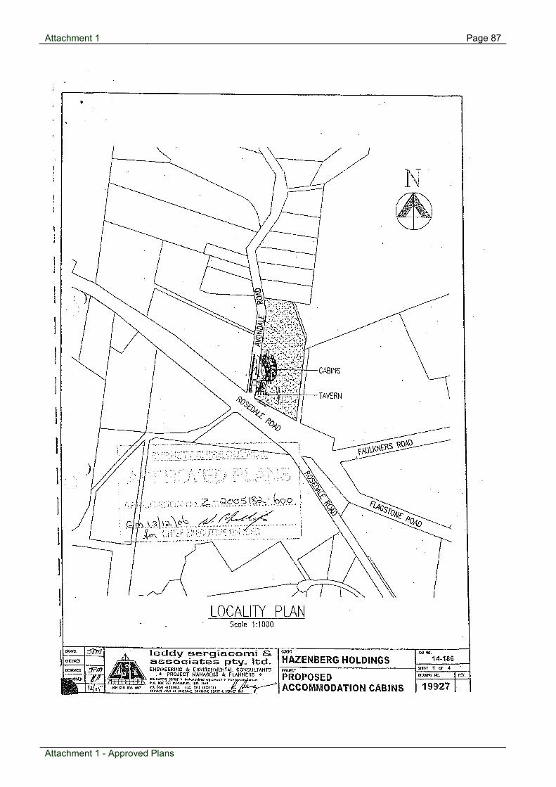
Attachment 1 Page 87
Approved Plans
Attachment 1 - Approved Plans

Page 88 Attachment 1
Attachment 1 - Approved Plans

Page 89 Attachment 1
Attachment 1 - Approved Plans

Attachment 1 Page 90
Attachment 1 - Approved Plans

Attachment 2 Page 91
ICS Fees
Development Contributions Summary - Infrastructure Contributions Planning Scheme Policy TOTAL: $56,799.36
File: 322.2005.51826.2 Transport (Roads - Regional - DTMR) Applicant: Avondale Homestead Tavern PU1 (EDU) = 59.5000 Development type: MCU (10 Cabins/Caravans) PU2 (EDU) = Portion: All Total PU (EDU) = 59.5000 Address: 4 Avondale Road, AVONDALE CR = $2,860 Burnett Shire (TR1) DTMR Defined Use in PSP: Rural Zone PC (EDU) = 57.0000 Council & Zone: BSC RPA I = 1.2277 Date: 22/12/2010 Contribution = $8,778.06
Water Supply Transport (Pedestrian Paths & Bikeways) PU1 (EDU) = 20.0000 PU1 (EDU) = 6.0000 PU2 (EDU) = PU2 (EDU) = Total PU (EDU) = 20.0000 Total PU (EDU) = 6.0000 CR = $0 N/A CR = $606 Burnett Shire (PBW1) PC (EDU) = 15.0000 PC (EDU) = 0.0000 I = 1.0906 I = 1.2277 Contribution = $0.00 Contribution = $4,463.92
Sewerage Drainage & Stormwater PU1 (EDU) = 20.0000 PU1 (EDU) = 24.2500 PU2 (EDU) = PU2 (EDU) = Total PU (EDU) = 20.0000 Total PU (EDU) = 24.2500 CR = $0 N/A CR = $1,500 Burnett (DSW1) & BuCC PC (EDU) = 15.0000 PC (EDU) = 22.5000 . I = 1.0906 I = 1.0000 Contribution = $0.00 Contribution = $2,625.00
Transport (Roads - Sectoral - BRC) Public Parks & Community Land PU1 (EDU) = 59.5000 PU1 (EDU) = 6.0000 PU2 (EDU) = PU2 (EDU) = Total PU (EDU) = 59.5000 Total PU (EDU) = 6.0000 CR = $3,753 Burnett Shire (TR1) BRC CR = $4,495 Bal of Shire - Nth River (PCL10) PC (EDU) = 57.0000 PC (EDU) = 0.0000 I = 1.2277 I = 1.0906 Contribution = $11,518.90 Contribution = $29,413.48
Contribution = [(ED-PC) x CR] x I (except for 'Drainage & Stormwater' where Indexation does not apply as a Regulated Infrastructure Charge is applied)
Attachment 2 - ICS Fees

Page 103 Attachment 5
Attachment 5 - Locality Map
Locality Map

Agenda for Planning & Development Committee Meeting Page 104
N5 14 Finemore Crescent, Qunaba - Material Change of Use - Dual Occupancy
Item 03 March 2011
Item Number:
N5
File Number:
322.2009.27525.1
Part:
DEVELOPMENT
Portfolio:
Planning & Development Services
Subject:
14 Finemore Crescent, Qunaba
- Material Change of Use - Dual Occupancy
Report Author:
Alicia Otto, Planning Officer
Authorised by:
Wayne Phillips, Manager Planning (Coastal)
Link to Corporate Plan:
Nil -
Applicant:
M J Brennan
Owner:
M J Brennan & S L Brennan
RPD:
Lot 22 on RP809157, County Cook, Parish Kalkie
Area:
2018m2
Land Designation:
Urban Residential
Planning Scheme:
Planning Scheme for Burnett Shire Council 2006
Proposal: The proposal is for a Dual Occupancy development comprising two (2) detached double storey three-bedroom dwelling units.
Meeting held: 03 March 2011

Agenda for Planning & Development Committee Meeting Page 105
Unit one is has an internal floor area of 215.11 square metres and has 167.2 square metres of private open space. This building is setback between 21.5 metres and 22.5 metres from Finemore Crescent and a minimum of 2.5 metres from the sites southern boundary. The second dwelling unit also has an internal floor area of 215.11 square metres and is provided with 108.7 square metres of private open space. It is separated from the first building by 8.5 metres (to the eaves) and is setback between six (6) and ten (10) metres from the sites rear boundary. A 2.5 metre setback from the sites northern boundary is proposed for the second dwelling. Vehicle access to the development is proposed from Finemore Crescent via a 4.5 metre driveway. This driveway widens to eight (8) metres where it passes unit one. Onsite vehicle parking and manoeuvring consists of a double garage per dwelling unit and one (1) visitor space located in front of each dwelling. A 1.8m high privacy fence will be constructed along all boundaries. Subject Site & Surrounding Land Uses The subject site is located on the eastern side of Finemore Crescent on the Hummock. The site has an east-west orientation, is generally regular in shape and has a general dimension of thirty (30) metres by sixty (60) metres. The site rises from 75m AHD at the front of the site to 84.5m AHD to the rear of the block and currently contains a two bay garage. The site is located within the Urban Residential zone. The nearest multiple dwelling development is located at 38 Rehbein Avenue and approximately 350 metres to the north east of the subject site. Finemore Crescent is constructed to an urban standard for the sites full frontage. Reticulated water infrastructure is located in proximity to the site. Planning History There is no planning history relevant to the assessment of the application. Considerations Burnett Shire Council Planning Scheme 2006 Coastal Towns Planning Area Code The Coastal Towns Planning Area Code introduces a number of broad planning and development design outcomes for localities within the Coastal Towns Planning Area. Generally, the code seeks to ensure that new uses and subsequent works do not adversely impact upon the scenic, environmental and coastal values and character of the Planning Area. In this regard, the code encourages preservation and protection of natural and environmental features. Furthermore, the code recognises
Meeting held: 03 March 2011

Agenda for Planning & Development Committee Meeting Page 106
the importance of maintaining the low-scale coastal character present in the existing urban fabric of the regions coastal towns. Specific regard is given to the locality of Qunaba (the Sloping Hummock) within the framework of the code. The Hummock is identified under the Coastal Towns Planning Area Code and has been described as having a ‘predominant character of detached dwellings combined with steep vegetated slopes being a visually dominant element of the landscape that is to be protected.’ Any development in this locality is not to compromise the profile or natural landform of the Sloping Hummock. Planning Services notes that the proposed development site is in a prominent location and in close proximity to the Hummock Lookout. In this regard, caution must be exercised to ensure the built form of the development does not impact adversely on the land form of the Sloping Hummock or residential properties in proximity to the site. On balance, the proposed development is considered to be of a residential scale and suitable to the sloping nature of the subject site. The proposal is regarded as consistent with the Coastal Town Planning Area Code. Conditions have been imposed to reinforce compliance with certain outcomes of the code. Urban Residential Zone Code The Urban Residential Zone Code encourages the development of the Urban Residential Zone (i.e. those areas not zoned for medium or high density development) with detached dwellings up to two storeys in height. This code also provides base parameters for site coverage, building height and density. In this regard, the code provides for maximum site coverage of forty (40) percent, a maximum building height of six (6) metres and a dwelling density of one (1) dwelling unit per 500 square metres of site area. Whilst the proposed dual occupancy is not typical of development on the Sloping Hummock, the site is considered to be unusually large for an Urban Residential lot (2018m2). The predominant character of the locality will remain single detached dwellings and the look and feel of this development from the street, due to the large block size, will not create an uncharacteristic streetscape presentation. Established (and conditioned landscaping) will screen a significant component of the development when viewed from the Hummock Lookout. Therefore, it is considered that the proposed development complies with the broader outcomes of the code as well as complying with the aforementioned criteria. Dual Occupancy Code As discussed above, the Dual Occupancy Code guides development of dual occupancy proposals in the Urban Residential Zone. For sites not connected to sewer, the minimum lot size needs to be 1500sqm with a minimum frontage of not less than 20m. The subject site is 2018m2 with a frontage of 35 metres and complies with the minimum requirements in this regard.
Meeting held: 03 March 2011

Agenda for Planning & Development Committee Meeting Page 107
The nearest multi dwelling development is approximately 350m to the north east of the subject site and therefore the site also meets the density requirements of the Dual Occupancy Code. The scale and siting of the works is considered to be generally consistent with the Dual Occupancy Code. The maximum building height (measured to the internal ceiling) for a dual occupancy is 6.0 metres. The current proposal is advocating a height of 5-7m from Natural Ground Level to ceiling height for Unit 1 with an overall maximum building height of 8 metres and 3.5-6m for Unit 2 with an overall building height of 7.8 metres. The Applicants have proposed an increased height due to the sloping nature of the site which varies from 77 to 85m AHD. This additional height is proposed to be ameliorated in part by the large site area and adequate setbacks from boundaries, as the building setbacks from the rear and side boundaries exceed the minimums required by the Probable Solutions outlined in the Dual Occupancy Code. A detailed assessment of the site has been undertaken by Planning Services due to the sites proximity to the Hummock Lookout on Turners Way and the topography and elevation of the subject site. Council’s Planning Services department consider that the site does not have the extreme slope characteristics that would support a discretional approval for additional height and raises a concern that the proposed maximum building height is close to the elevation of the lookout area, which is within 60m of the subject site. This is also taking into consideration that the Dual Occupancy doubles the density of the development regularly anticipated on an Urban Residential lot. Therefore, to reduce the visual impact of this proposal, Council’s Planning Services recommend conditioning the internal height (measured from Natural Ground Level to ceiling height) to be a maximum of 6.0m and a maximum overall building height of 7.0 metres. This will ensure the development complies with the relevant provisions and has a reduced impact on the outlook from the Turner’s Way Lookout or surrounding residential properties. On balance, the proposed dual occupancy is considered to be generally in accordance with the Dual Occupancy Code. Development Infrastructure and Works Code Provisions under the Development Infrastructure and Works Code aim to ensure that infrastructure is provided to service new development in a sustainable manner. Standards for the provision of infrastructure (water, sewerage, stormwater and transport infrastructure) are nominated under the Development Infrastructure and Works Code. The proposed development does not warrant standards dissimilar to the requirements of the code. Conditions of the development approval reflect compliance with the Development Infrastructure and Works Code.
Meeting held: 03 March 2011
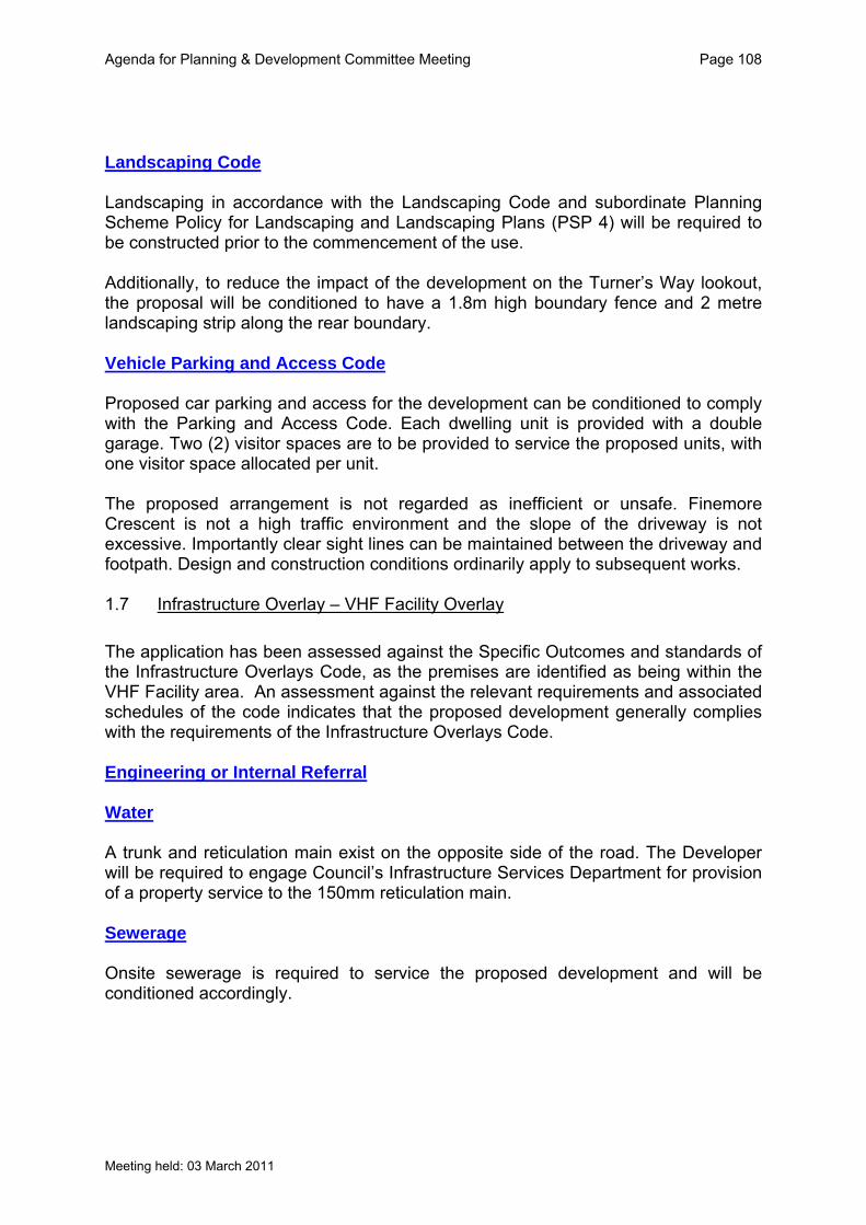
Agenda for Planning & Development Committee Meeting Page 108
Landscaping Code Landscaping in accordance with the Landscaping Code and subordinate Planning Scheme Policy for Landscaping and Landscaping Plans (PSP 4) will be required to be constructed prior to the commencement of the use. Additionally, to reduce the impact of the development on the Turner’s Way lookout, the proposal will be conditioned to have a 1.8m high boundary fence and 2 metre landscaping strip along the rear boundary. Vehicle Parking and Access Code Proposed car parking and access for the development can be conditioned to comply with the Parking and Access Code. Each dwelling unit is provided with a double garage. Two (2) visitor spaces are to be provided to service the proposed units, with one visitor space allocated per unit. The proposed arrangement is not regarded as inefficient or unsafe. Finemore Crescent is not a high traffic environment and the slope of the driveway is not excessive. Importantly clear sight lines can be maintained between the driveway and footpath. Design and construction conditions ordinarily apply to subsequent works. 1.7 Infrastructure Overlay – VHF Facility Overlay
The application has been assessed against the Specific Outcomes and standards of the Infrastructure Overlays Code, as the premises are identified as being within the VHF Facility area. An assessment against the relevant requirements and associated schedules of the code indicates that the proposed development generally complies with the requirements of the Infrastructure Overlays Code. Engineering or Internal Referral Water A trunk and reticulation main exist on the opposite side of the road. The Developer will be required to engage Council’s Infrastructure Services Department for provision of a property service to the 150mm reticulation main. Sewerage Onsite sewerage is required to service the proposed development and will be conditioned accordingly.
Meeting held: 03 March 2011

Agenda for Planning & Development Committee Meeting Page 109
Roadworks & Car Parking The only roadwork applicable is a new driveway to the allotment, which will be conditioned to be constructed in accordance with Burnett Shire Council Standard Drawing R111E; 2.4 Stormwater Stormwater discharge for the development is nominated to be the kerb and channel within Finemore Crescent. The Developer shall provide a minimum of one (1) kerb adaptor from each unit into the kerb. State Planning Policies There are no State Planning Policies relevant to the assessment of this application. Referral Agencies There are no referral agencies relevant to the assessment of this application. Grounds of Submissions The application was Code Assessable and therefore not subject to public notification. Infrastructure Charges Infrastructure charges contributions are required as per the attached calculation sheet. Conclusions Assessment of the proposed dual occupancy against the relevant components of the planning scheme, codes and policies revealed that the development is generally consistent with desired planning and built form outcomes for the Urban Residential Zone and the Dual Occupancy Code. Ordinarily, conditions reinforce compliance with certain elements of the applicable codes. By ensuring compliance with the relevant codes and policies the impact of the proposed development is reduced. The proposed development is regarded as consistent with the Planning Schemes broader intents for the Sloping Hummock locality. In conditioning the internal height (measured from Natural Ground Level to ceiling height) to be a maximum of 6.0m and a maximum overall building height of 7.0 metres), Planning Services consider that this will mitigate the impact of the proposal on the locality as well as reduce the potential for impact on the views from the Turner’s Way Lookout or surrounding residential properties. There are no perceived adverse social, environmental or economic consequences resulting from the development. Furthermore, approval of the proposed development will not conflict with the current planning direction for the area. Accordingly, the development is recommended for approval subject to reasonable and relevant conditions.
Meeting held: 03 March 2011

Agenda for Planning & Development Committee Meeting Page 110
Attachments:
1 Locality Plan 2 Approved Plans 3 Infrastructure
Recommendation:
That application (Council Reference Number 322.2009.27525.1) for Material Change of Use for a Dual Occupancy at 14 Finemore Crescent, Qunaba; land described as Lot 22 on RP 809157, County Cook, Parish Kalkie, be approved with conditions
- and Council (the Assessment Manager) issue the attached Decision Notice (including attachments):- Material Change of Use for a Dual Occupancy at 14 Finemore Crescent, Qunaba; land described as Lot 22 on RP 809157, County Cook, Parish Kalkie – Conditions of Approval Development Conditions Approved Plans 1. The proposed development is to be generally constructed in accordance with
Conditions contained within this notice and the following Approved Plans:-
Plan/ Document Number
Plan/Document Name Prepared By Date
0265-01 Site Plan John Gatley Building Design
Nov 2010
0265-02 Upper Floor Plan – Unit 1 John Gatley Building Design
Nov 2010
0265-03 Lower Floor Plan – Unit 2 John Gatley Building Design
Nov 2010
0265-04 Upper Floor Plan – Unit 2 John Gatley Building Design
Nov 2010
0265-05 Lower Floor Plan – Unit 2 John Gatley Building Design
Nov 2010
0265-06 Front and Side Elevations – Unit 1
John Gatley Building Design
Nov 2010
0265-07 Rear and Side Elevations – Unit 1
John Gatley Building Design
Nov 2010
0265-08 Front and Side Elevations – Unit 2
John Gatley Building Design
Nov 2010
0265-09 Rear and Side Elevations – Unit 2
John Gatley Building Design
Nov 2010
Standard Plan No. 1
Onsite Disposal Area Ray Walsh 2010
Meeting held: 03 March 2011

Agenda for Planning & Development Committee Meeting Page 111
2. Approved plans 0265-06, 0265-07, 0265-08 and 0265-09 are subject to the following modifications:-
(i) Internal height (measured from Natural Ground Level to ceiling height)
to be maximum of 6.0m and a maximum overall building height of 7.0 metres.
Building 3. External building finishes including fixtures such as down pipes are to consist
of muted tones such as greys, browns, greens or dark blue and incorporate compatible textures or colours in the façade.
4. All air conditioning units must be totally enclosed or screened using landscaping or materials consistent with that elsewhere in the building. 5. Noise from air-conditioning units must not exceed 5dB (A) between 7:00AM and 10:00PM and 3dB (A) between 10:00PM and 7:00AM, above the background ambient noise level, measured at the boundaries of the subject site. 6. Night and outdoor lighting must be designed, constructed and operated in
accordance with Australian Standard AS4282 – Control of the obtrusive effects of outdoor lighting.
7. Rubbish bin storage areas are to be fully screened from view at the property boundary. 8. External clothes drying facilities (fixed or free standing) must be provided for each dwelling prior to the commencement of the use. 9. Clothes drying facilities must be fully screened from view at the front property boundary and located within each dwellings private open space area. 10. Sheds, lawn lockers, swimming pools and ancillary parking areas for vehicles
or boats must not be erected on or within the Onsite Disposal Area as outlined on Standard Plan No. 1 drawn by Ray Walsh 2011. Additions or alterations to the approved plans constitute a change to the existing approval.
11. Each unit is to be numbered so that it is clearly visible from the access
driveway. Numbering is to be visible at night with positioning having regard to exterior lighting of unit entries.
12. One letter box is to be provided for each unit, and one additional letter box for the body corporate.
Meeting held: 03 March 2011

Agenda for Planning & Development Committee Meeting Page 112
Fencing 13. Screen fencing (manufactured timber) is to provided and is to have the
following dimensions:
i. 1.8 metres for the full length of the sites rear boundary; ii. 1.2 metre for the first six metres of the sites side boundaries increasing
to 1.5 metres for 7.5 metres from the front building line and continuing at a height of 1.8 metres for the remaining length of each side boundary; and
iii. 1.8 metre internal fencing shall be provided to divide individual unit private open space.
14. Details of fencing, including materials and location plan are to be submitted with landscaping plans. 15. All fencing must be completed prior to the commencement of the use. Landscaping 16. Please provide the following for assessment at Operational Works:
a. Detailed landscape plans outlining internal and road reserve landscape treatments for the proposed development including pavement and other hardscape details, in accordance with Burnett Shire Council Planning Scheme Policy 4.
b. Plans are to be prepared by a suitably qualified Landscape Design Consultant and in accordance with the aforementioned Planning Scheme Policy.
Carparking 17. One (1) sealed (consistent with driveway construction) visitor space is to be
provided per unit in accordance with Drawing No. 0265-01 Site Plan drawn by John Gatley Building Design dated Nov 2010.
18. The visitor space is to be constructed, marked and dimensioned in
accordance with a standard car park under Australian Standard 2890. 19. The visitor space is to be constructed to drain to Finemore Crescent. Access 20. A vehicular crossing is to be provided, designed and constructed in
accordance with Burnett Shire Council Standard Drawing R111E. 21. The footpath fronting the site is to be regraded, top soiled and turfed upon completion of access works and prior to the commencement of the use.
Meeting held: 03 March 2011

Agenda for Planning & Development Committee Meeting Page 113
22. All access works must be completed to the satisfaction of the Council prior to the commencement of the use. Water Infrastructure 23. Sub-meters shall be installed in accordance with the Water and Other
Legislation Amendment Act 2007;
24. Arrangements for the installation of any new metered service and sub-meters, or removal of an existing service, are to be made with Council’s Water and Wastewater Infrastructure Planning Technical Support Section. All works are to be undertaken by Council at the Developer’s expense;
25. Sub-meters should be located so that if the proposed development is to be
subdivided by Community Title they will located within a Common Property area;
26. Any alteration or upgrade to Council’s water infrastructure servicing the
development and necessary to connect the development is to be at no cost to Council.
Sewerage Infrastructure 27. Onsite sewerage facilities are to be designed in accordance with the
Queensland Plumbing and Wastewater Code and AS1547-2000. Details of the above are to be provided in further Development Applications required for Operational Works and Plumbing and Drainage Works.
Stormwater Drainage 28. The nominated point of discharge for the development is the kerb and channel
within Finemore Crescent. The Developer shall provide a minimum of one (1) kerb adaptor from each unit into the kerb.
29. The development must be provided with a Stormwater Drainage System
designed and constructed in accordance with an Operational Works Permit for the work, and the Queensland Urban Drainage Manual with the following inclusions:
i) Roof water must be collected in two 3000L tanks (one per unit) and the
overflow be internally piped to the legal point of discharge in Finemore Crescent;
ii) Development incorporates stormwater, erosion and siltation management systems that protect and enhance catchment and riverine water quality to the standards commensurate with the Australian and New Zealand Guidelines for fresh and Marine Water Quality (ANZECC 2000) or the Queensland Water Quality Guidelines.
30. All necessary external works to facilitate stormwater drainage are to be
completed by the developer at no cost to Council.
Meeting held: 03 March 2011

Agenda for Planning & Development Committee Meeting Page 114
Meeting held: 03 March 2011
Site Works 31. Provision of erosion and sediment control measures in accordance with the Soil Erosion and Sediment Control Guidelines for Queensland is to be made prior to the commencement of any works. Telecommunications And Electricity Infrastructure 32. The multiple dwelling is to be provided with underground subscriber
connections to electricity and telecommunications infrastructure, in accordance with the requirements of the relevant service providers, prior to occupation of the building.
Contributions 33. Contributions towards water supply and sewerage headworks in accordance with the following are to be paid: Water Supply: $13, 002.13 Transport – Roads – Sectoral (BRC) $ 5, 188.11 Transport – Roads – Regional (DTMR) $ 3, 953.64 Transport – Pedestrian Paths and Bikeways $ 1, 487.97 Drainage and Stormwater $ 3, 000.00 The headworks are to be paid prior to commencement of the use. If payment
is not effected within six (6) months from the day this approval takes effect the contributions will be recalculated in accordance with Council’s Policy, including adjustments in consumer price index (CPI), current at the time of payment.
Alteration / Damage 34. The applicant shall meet the cost of alterations to public utilities, mains and
services necessary in connection with any of the works arising from this approval and shall restore and reinstate all roads to the satisfaction of the Council when such works have been carried out.
Site Development 35. Construction work on the site is not to commence on any day before 7.00am,
or continue any such work after 6.00pm. No construction work is to be undertaken on a Sunday or Public Holiday.
36. Adequate precautions are to be taken to ensure dust does not cause
annoyance to adjacent sites or dwellings during construction on the site. This may mean the cessation of work during periods of adverse climatic conditions, if directed by Council.
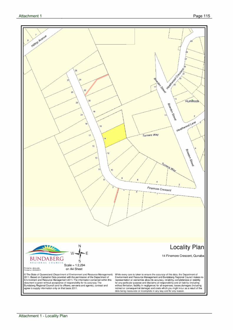
Attachment 1 Page 115
Locality Plan
Attachment 1 - Locality Plan

Attachment 2 Page 116
Approved Plans
Attachment 2 - Approved Plans
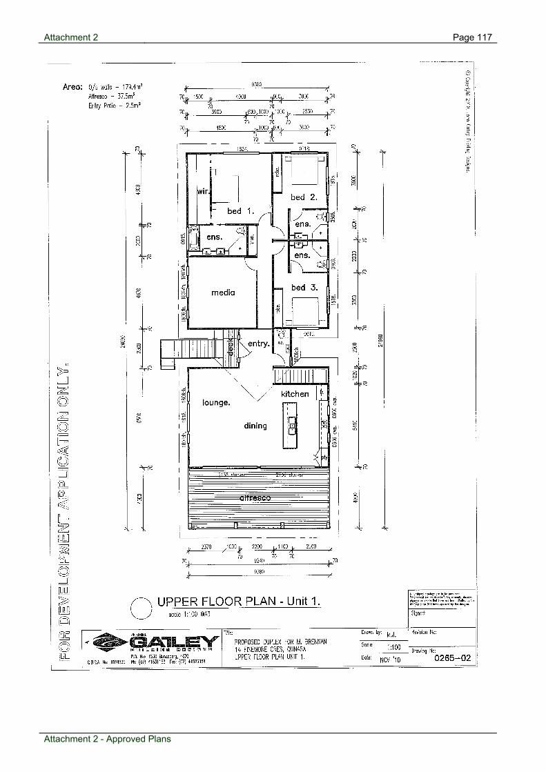
Attachment 2 Page 117
Attachment 2 - Approved Plans

Attachment 2 Page 118
Attachment 2 - Approved Plans

Attachment 2 Page 119
Attachment 2 - Approved Plans

Attachment 2 Page 120
Attachment 2 - Approved Plans

Page 121 Attachment 2
Attachment 2 - Approved Plans
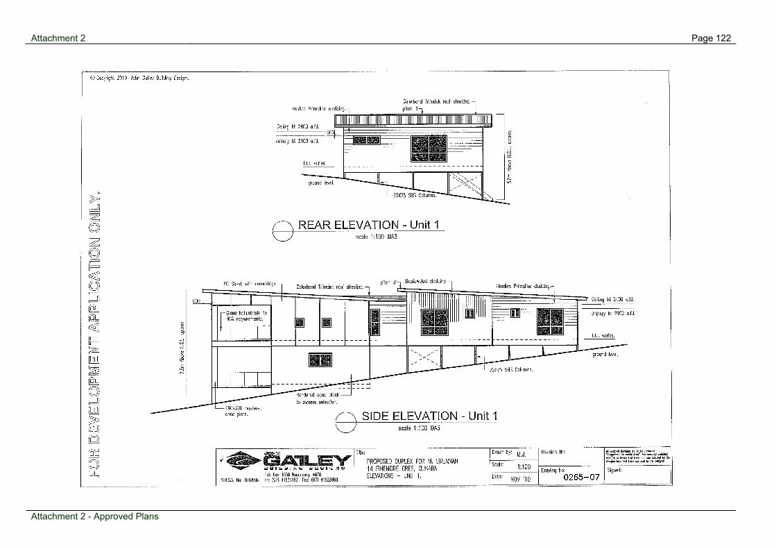
Page 122 Attachment 2
Attachment 2 - Approved Plans

Page 123 Attachment 2
Attachment 2 - Approved Plans

Attachment 2 Page 124
Attachment 2 - Approved Plans

Page 125 Attachment 3
Attachment 3 - Infrastructure
Infrastructure

Agenda for Planning & Development Committee Meeting Page 126
N6 39 Wearing Road, Bargara - Material Change of Use for a Residential Retirement Resort (incorporating 228 dwelling units, clubhouse and ancillary structures) and an Aged Care Facility (incorporating 32 serviced apartments and 94 bed nursing home) - Requ
Item 03 March 2011
Item Number:
N6
File Number:
325.2004.51248.3
Part:
DEVELOPMENT
Portfolio:
Planning & Development Services
Subject:
39 Wearing Road, Bargara
- Material Change of Use for a Residential Retirement Resort (incorporating 228 dwelling units, clubhouse and ancillary structures) and an Aged Care Facility (incorporating 32 serviced apartments and 94 bed nursing home) - Request to change conditions
Report Author:
Scott Irwin, Planning Officer
Authorised by:
Wayne Phillips, Manager Planning (Coastal)
Link to Corporate Plan:
Nil -
Previous Items:
N2 - 39 Wearing Road, Bargara - Request to Change Conditions of Approval - Ordinary Meeting - 1 February 2011
Applicant:
Walter Elliott Holdings Pty Ltd
Owner:
Walter Elliott Holdings Pty Ltd
RPD:
Lot 15 on RP7229, County Cook, Parish Barolin
Area:
10.17 ha
Land Designation:
Urban Residential
Planning Scheme:
Planning Scheme for Burnett Shire 2006
Meeting held: 03 March 2011

Agenda for Planning & Development Committee Meeting Page 127
Recent History
Council previously considered this matter at its meeting held on 1 February 2011. Council resolved to defer the application to a future round of meetings pending receipt of advices from the Building Company and Building Certifier. The attached letter was issued to the applicant on 9 February 2011 seeking the Building Company and Building Certifier to provide supporting information to justify the use of Council’s discretion to support a change of condition relating to the relaxation of an internal road frontage setback for four dwellings. The applicant provided a response dated 11 February 2011 and received by Council on 14 February 2011. The applicant advised they endeavoured to contact Acegrange Pty Ltd, the builder of the subject dwellings and also previously part owner of the property. However, the applicant advises the builder was not forth coming in providing information as they no longer own the property and believed the building works were carried out legally and referred the applicant to the building certifier. The Building Certifier GMA Certification Group Pty Ltd provided a response by letter dated 10 February 2011 which states that they investigated the possible non compliance of the setbacks between the house and edge of the internal road for the subject sites. They advised at the time they considered the internal road to be the edge of bitumen and because the paved edge (kerb) is approximately 600mm wide this has bought about the alleged non-compliance. Additionally, they advise as the condition is not explicit as to what constitutes an internal road, they believe the houses on sites 98,104, 109 and 139 comply with this condition. The applicant and current owners Walter Elliott Holdings Pty Ltd in their letter state it appears the problem has arisen from the wording and ambiguity of condition A4.(d) (iv) and despite feeling the condition did not require changing, lodged the request to “put thing rights”. Additionally, they advise they have instructed that all new homes are setback from the back of kerb.
Proposal
Council is in receipt of an application to Change the Development Approval for a Material Change of Use for a Residential Retirement Resort (incorporating 228 dwelling units, clubhouse and ancillary structures) and an Aged Care Facility (incorporating 32 serviced apartments and 94 bed nursing home) at 39 Wearing Road, Bargara more accurately described as Lot 15 on RP7229. The Applicant requests to Change the Development Approval with respect to conditions A.4 (d) iv. & v. of the original approval. The request to change in regard to condition A.4 (d) iv is sort to rectify the road frontage setbacks of four (4) existing dwellings which have been constructed within the required two (2) metre internal road setback. The other request to change relates to reducing the internal lot frontages from 13 metres to 12 metres to provide greater choice of housing for future residents and an improved streetscape by adding more variety.
Meeting held: 03 March 2011

Agenda for Planning & Development Committee Meeting Page 128
Background
An application for Material Change of Use for a Residential Retirement Resort (incorporating 228 dwelling units, clubhouse and ancillary structures) and an Aged Care Facility (incorporating 32 serviced apartments and 94 bed nursing home) was approved through a Court Consent between Monace Pty Ltd and the former Burnett Shire Council on 2 May 2007.
Considerations
Sections 374, 375 and 376 of the Sustainable Planning Act 2009 provide the legislative framework for considering a request to change a development approval. The Assessment and Decision relating to this application is in accordance with these provisions.
Request to Change Development Approval The Applicant has requested to change conditions A.4 (d) iv. and v. of the original approval to rectify the road setbacks of four (4) existing dwellings which have been constructed within the required two (2) metre setback from the internal road and also seeks to reduce the site frontages from 13 metres to 12 metres to provide greater choice, variety and flexibility of housing for future residents. The relevant conditions are detailed below:
A.4 The Residential Retirement Resort shall be designed to comply with the following criteria:
(d) Plots shall not be less than 1.5 times the area of the dwelling house and associated structure or carport/garage, and not be less than 200 square metres. All dwelling units shall meet the following minimum requirements: - iv. a setback of 2.0 metre to internal roads - v. a frontage of 13 metres.
The existing dwellings located on sites 98, 104, 109 and 139 have all been constructed within the two (2) metre setback from the internal road. The applicant states they were alerted to these issues through a Full Town Planning certificate obtained through Council at the time of purchasing the site. They advise they are comfortable with complying with the existing conditions for all future dwellings (i.e. 2m setback to internal roads) to be constructed on the premises and are presently seeking to rectify this identified non compliance.
A review of the building approvals for sites 98, 104, 109 and 139 indicates that GMA Certification Group Pty Ltd issued building approvals for these sites in accordance with the required frontage setbacks of the Consent Order. However, the construction of the dwellings have not been built in accordance with the approved plans by the builder Acegrange Constructions Pty Ltd and these siting encroachments were not identified during the construction phase by the private building certifier prior to issuing the final building certificates for these sites.
Meeting held: 03 March 2011
Agenda for Planning & Development Committee Meeting Page 129
Considerations concerning this non compliance include possible traffic safety and amenity impacts. It is considered that the reduced setbacks could cause safety issues for occupants of the existing dwellings given the garage of the dwellings sited on 104, 109 and 139 are the closest part of the building to the road, therefore sight distance is limited when reversing out of the garages. Not withstanding this consideration the existing required setback for dwelling in this development is a minimum of 2 metres and in relative terms occupants would only have slightly less visibility while exiting their garage than occupants of other compliant dwellings within the development. It is also considered the amenity of the internal streetscape is not significantly impacted by the existing front setback encroachments due to the meandering road design and setback of the other surrounding dwellings. A further relevant consideration relates to the fact that the dwellings are now constructed and would require partial or completed demolition to rectify the identified setback non-compliance. In regard to the minimum frontages for the internal lots it is considered that a reduction from 13 metres to 12 metres will allow for a greater range of dwelling types to be used, allowing for more affordable dwellings and more luxury and larger dwellings to be incorporated within the development. The reduction in size will not change the density of the overall development as it is restricted by the number of dwelling units that can be built and the applicant does not seek to reduce the required minimum lot size of 200 square metres. Furthermore, it is considered that allowing a greater mixture of internal lot sizes is likely to improve the internal streetscape of the complex. To ensure a mixture of lot sizes is provided it is recommended the number of internal lots with a frontage of 12 metres to 13 metres should be restricted to a maximum of 30 percent or 68 of all the internal dwelling lot sites.
Submissions about the Original Application The submissions relating to the original development application referred mainly to impacts on trunk infrastructure and the residential amenity of the area. The proposed changes do not change the density or overall layout of the existing development approval. Therefore, no additional impacts are expected on trunk infrastructure or any considerable change to what would have been anticipated under the terms of the existing approval.
Referral Agencies A copy of the request to change the conditions was submitted to the Department of Transport and Main Roads (DTMR) by the applicant in accordance with section 372 of the Sustainable Planning Act 2009. DTMR provided a letter of response dated 25 November 2010 advising they have no objection to the request.
Meeting held: 03 March 2011

Agenda for Planning & Development Committee Meeting Page 130
Meeting held: 03 March 2011
Conclusions As related in the discussion above, on balance, it is considered that the request to change conditions of approval is reasonable and the existing conditions may be modified to meet the applicant’s request while maintaining the integrity of the base conditions of approval. The request to change conditions A.4 (d) iv and v of the consent order is recommended for approval as detailed in the above assessment.
Attachments:
1 Locality Plan 2 Letter to Council 3 DTMR Response 4 Aerial Photo 5 Applicant's Representation6 Court Consent
Recommendation:
That application (Council Reference Number 325.2004.51248.3) for a Request to Change Conditions of Approval Z-2004124-800 at 39 Wearing Road, Bargara; land described as Lot 15 on RP7229, County Cook, Parish Barolin, be approved with the following amendments:- Request to Change a Development Approval
Condition A.4 (d) iv and v (Building Siting and Design) – amended as follows;
iv. a setback of 2.0 metres to internal roads, except for sites 98, 104, 109
and 139 which unless removed or altered must maintain a setback to internal roads in accordance with site plan, drawing number WEH/BAR/08, dated 15/12/10 and prepared by Walter Elliott Holdings PTY LTD.
v. a frontage of not less than 12 metres with not more than 30 percent or 68 internal sites having a minimum frontage of less than 13 metres.

Page 131 Attachment 1
Attachment 1 - Locality Plan
Locality Plan

Page 135 Attachment 4
Attachment 4 - Aerial Photo
Aerial Photo