age, correlation, and lithostratigraphic revision of the upper...
TRANSCRIPT

Age, Correlation, and Lithostratigraphic Revision of the UpperCretaceous (Campanian) Judith River Formation in Its Type
Area (North-Central Montana), with a Comparison ofLow- and High-Accommodation Alluvial Records
Raymond R. Rogers,1,* Susan M. Kidwell,2 Alan L. Deino,3
James P. Mitchell,4 Kenneth Nelson,1 and Jeffrey T. Thole1
1. Geology Department, Macalester College, 1600 Grand Avenue, Saint Paul, Minnesota 55105, USA; 2. Departmentof the Geophysical Sciences, University of Chicago, 5734 South Ellis Avenue, Chicago, Illinois 60637, USA;3. Berkeley Geochronology Center, 2455 Ridge Road, Berkeley, California 94709, USA; 4. Bureau of Land
Management, Lewistown Field Office, 920 NE Main Street, Lewistown, Montana 59457, USA
AB STRACT
Despite long-standing significance in the annals of North American stratigraphy and paleontology, key aspects of the Upper Cre-taceous Judith River Formation remain poorly understood. We re-evaluate Judith River stratigraphy and propose new referencesections that both document the range of lithologies present in the type area in north-central Montana and reveal dramatic changesin facies architecture, fossil content, and rock accumulation rates that can be mapped throughout the type area and into the plains ofsouthern Alberta and Saskatchewan. One section spans the basal contact of the Judith River Formation with marine shales of theunderlying Claggett Formation. This contact, which lies along the base of the Parkman Sandstone Member of the Judith RiverFormation, is erosional and consistent with an episode of forced regression, contrary to previous descriptions. A second referencesection spans the entire Judith River Formation. This complete section hosts a lithologic discontinuity, herein referred to as the mid-Judith discontinuity, that reflects a regional reorganization of terrestrial and marine depositional systems associated with a turn-around from regressive to transgressive deposition. The mid-Judith discontinuity correlates with the base of three backsteppingmarine sequences in the eastern sector of the type area and is thus interpreted as the terrestrial expression of a maximum regressivesurface. This mid-Judith discontinuity defines the boundary between the new McClelland Ferry and overlying Coal Ridge Membersof the Judith River Formation. The shallow marine sandstones that form the backstepping sequences represent the leading edge ofthe Bearpaw transgression in this region and are formalized as the new Woodhawk Member of the Judith River Formation in a thirdreference section. New 40Ar/39Ar ages indicate (1) that the mid-Judith discontinuity formed ∼76.2 Ma, coincident with the onset ofthe Bearpaw transgression in central Montana; and (2) that the Bearpaw Sea had advanced westward beyond the Judith River typearea by ∼75.2 Ma, on the basis of the dating of a bentonite bed at the base of the Bearpaw Formation. These new ages also providemore confident age control for important vertebrate fossil occurrences in the Judith River Formation. Facies analysis across the mid-Judith discontinuity reveals how alluvial systems respond to regional base-level rise, which is implicit with the increase in rockaccumulation rates and marine transgression. With the increase in accommodation signaled by the mid-Judith discontinuity, thealluvial system shifted in dominance from fluvial channel to overbank deposits, with greater tidal influence in channel sands, morehydromorphic and carbonaceous overbank deposits, and a higher frequency of bentonites and skeletal concentrations, suggestinghigher preservation rates. These features, along with the appearance of extraformational pebbles above the discontinuity, areconsistent with an upstream tectonic explanation for the addition of accommodation.
Online enhancements: supplementary table.
Introduction
The Upper Cretaceous (Campanian) Judith RiverFormation is widely exposed in Montana and con-
stitutes the distal part of one of the major eastward-thinning clastic tongues of the Cretaceous sectionin the Western Interior Foreland Basin (Weimer 1960;Gill and Cobban 1973; Kauffman 1977; figs. 1, 2). Thetype area of the Judith River Formation lies in theUpper Missouri River Breaks National Monument(UMRBNM), a vast region of sparsely vegetated cou-
Manuscript received February 16, 2015; accepted Septem-ber 18, 2015; electronically published February 17, 2016.
* Author for correspondence; e-mail: [email protected].
99
[The Journal of Geology, 2016, volume 124, p. 99–135] q 2016 by The University of Chicago.All rights reserved. 0022-1376/2016/12401-0005$15.00. DOI: 10.1086/684289

lees and badlands in the Missouri River drainage innorth-central Montana. Government-sponsored ex-peditions made frequent forays into the type areaduring the mid- to late nineteenth and early twen-tieth centuries, and stratigraphic research on the ageand correlation of the formation was instrumen-tal in resolving the basic stratigraphy of the West-ern Interior Cretaceous section (e.g., Meek and Hay-den 1856, 1857; Hayden 1857, 1871; Dawson 1875;Meek 1876; Hatcher 1903a,1903b; Hatcher and
Stanton 1903; Stanton and Hatcher 1905; Bowen1915; reviewed in Waage 1975). The Judith RiverFormation is also significant to the history of verte-brate paleontology, with some of the first skeletalremains of dinosaurs described fromNorth Americarecovered from it near the confluence of the Judithand Missouri Rivers (Leidy 1856, 1860; Cope 1876,1877; Sternberg 1914). The formation has continuedto be amajor source of paleobiological data to the pres-ent day (e.g., Cope 1871, 1877; Sahni 1972; Tschudy
Figure 1. Judith River Formation study area. A, Map of north-central Montana showing boundaries of UpperMissouri River Breaks National Monument (UMRBNM; gray). Dotted box delimits region that includes the JudithRiver Formation type area. B, Satellite image of Judith River Formation type area along drainage of Missouri River inUMRBNM. Locations of three new reference sections (92-JRT-15, 91-JRT-8, 91-JRT-12) are indicated. Modified fromGoogle Earth. A color version of this figure is available online.
100 R . R . R OG E R S E T A L .

Figure 2. Schematic cross section of Upper Cretaceous strata in Montana (modified from Gill and Cobban 1973). TheJudith River Formation correlates to the west with terrestrial deposits of the middle and upper Two Medicine For-mation and is bounded above and below by marine shales of the Bearpaw and Claggett Formations. Regional re-gressive (R7, R8, R9) and transgressive (T8, T9) phases of deposition are from Kauffman (1977). The type area of theJudith River Formation is located in the Upper Missouri River Breaks National Monument (UMRBNM). The newWoodhawk Member crops out in the eastern sector of the type area and consists of three backstepping fourth-ordersequences that accumulated during the Bearpaw transgression. The mid-Judith discontinuity (MJD) correlates withthe base of the Woodhawk Member and separates the new McClelland Ferry Member below from the new Coal RidgeMember above. The erosional base of the Parkman Sandstone Member of the Judith River Formation in theUMRBNM reflects an episode of forced regression (FR), capping the normal regressive (NR) deposits of the upperClaggett Formation. The downward trajectory of the Parkman Sandstone Member at the eastern edge of the diagramis based on the original facies reconstruction of Gill and Cobban (1973) but is here interpreted as tracking a basalsurface of forced regression (BSFR). The sandstone-rich alluvial McClelland Ferry Member was deposited duringnormal regression under conditions of low positive accommodation, and the mid-Judith discontinuity is a maximumregressive surface (MRS), marking a change to the mud-rich alluvial and paralic Coal Ridge Member, a shift to sig-nificantly higher rates of sediment accumulation, and marine transgression (T) by shoreface sands of the WoodhawkMember. New 40Ar/39Ar ages presented in this report are shown in italics. One legacy 40Ar/39Ar age of 77.52 5 0.19 Ma(sanidine) from a bentonite ∼265 m above the base of the Two Medicine Formation (Foreman et al. 2008) wasrecalculated to 78.02 5 0.19 Ma. Rogers (1998) provisionally correlated the mid-Judith discontinuity with a wide-spread lacustrine carbonate interval (LCI) that overlies the aforementioned bentonite, ∼330 m above the base of theTwo Medicine Formation. Positions of Santonian-Campanian and Campanian-Maastrichtian boundaries (Ogg andHinnov 2012) are approximated. SGA p Sweetgrass arch, across which Campanian/Maastrichtian strata have beeneroded.

1973; Case 1978; Horner 1988; Fiorillo and Currie1994; Prieto-Marquez 2005; Fricke et al. 2008, 2009;Tweet et al. 2008; Ryan et al. 2014).
Despite this long-standing significance, key as-pects of the unit remain underdescribed and poorlyunderstood. For example, most descriptions of theJudith River Formation in Montana characterize itas predominantly, if not wholly, terrestrial in ori-gin, with only minor evidence of marine or brackishinfluence, whereas approximately half of the for-mation in the eastern half of the type area consistsof shallow marine deposits (Stanton and Hatcher1905; Rogers 1993, 1998; Rogers and Kidwell 2000).The existing composite type section of the forma-tion, located in the western part of the type area(Sahni 1972), thus captures only part of the range oflithologies present in the formation. Moreover, al-though regional correlations are understood at a gen-eral level (fig. 2), precise correlations of the JudithRiver Formation with richly fossiliferous equivalentsin western Montana (e.g., Two Medicine Formation)and Canada (e.g., Belly River Group) have remainedelusive, in part because of a lack of published radio-isotopic ages from the type area.
In this report, we re-examine the sedimentologyof the Judith River Formation in its type area in theUMRBNM and propose three new reference sectionsthat illustrate the full range of lithologies developedin the unit. One new reference section (92-JRT-15;figs. 1, 3) from the western edge of the type area spansthe transition from the underlying Claggett Forma-tion to the Judith River Formation. A second new ref-erence section (91-JRT-8;figs. 1, 3), located in themid-dle of the type area, spans the entire formation fromits basal contact with the Claggett Formation to itsupper contactwith the Bearpaw Formation. This com-plete section hosts a lithologic discontinuity, hereinreferred toas themid-Judithdiscontinuity, that reflectsa regional reorganization of terrestrial and marine de-positional systems associated with a turnaround incorrelativemarine units from regressive to transgres-sive deposition (Rogers 1998).We present new data onmineralogical and facies shifts across this disconti-nuity—which is now recognized as extending north-ward into southern Alberta and Saskatchewan—anduse it to subdivide the terrestrial part of the JudithRiver Formation into two newmembers. A third ref-erence section (91-JRT-12; figs. 1, 3), located in theeasternportionof the type area, intersects themarineportion of the Judith River Formation, and a thirdformal member is erected to designate these distinc-tive marine-shoreface sandstones. New 40Ar/39Ar agesare reported for bentonite beds in two of the refer-ence sections, and a third 40Ar/39Ar age is reportedfrom a bentonite bed present ∼5 m above the Judith
River Formation–BearpawFormation contact. Thesenew ages are the first from the type area of the Ju-dith River Formation. On the basis of these newlitho- and chronostratigraphic data, we subdividethe Judith River Formation into regionally traceablestratigraphic packages that accumulated under dis-tinct accommodation regimes that are best explainedby upstream tectonic controls (e.g., Catuneanu 2006;Eberth and Braman 2012).
Methods
Forty-eight surface sections were measured in theoutcrop belt of the Judith River Formation innorth-central Montana. They provide a frameworkfor sampling, a basis for stratigraphic analysis, andare integrated with raster image well logs (MJ Sys-tems) to extend stratigraphic coverage to the plainsof southern Canada. Well logs were ground truthedusing nearby surface sections to confirm subsur-face stratal signatures. Samples systematically col-lected from surface sections were used to assesscompositional trends in framework and clayminer-alogy. Standard 30-mm-thin sections were preparedand stained for the identification of K-feldspar. Fourhundred grain counts were performed on amotorizedPetrog Lite MicroStepper stage coupled to a NikonEclipse E600 petrographicmicroscope. All sand-sizedgrains in thefine to coarse size fractionwere counted,with most falling in the fine to medium size range.Additional mineralogical information was gatheredusing scanning electronmicroscopy–energy-dispersivespectrometry, and backscatter electron images werecollected to illustrate key compositional features.The clay fraction was recovered via centrifugation,and oriented mounts solvated with ethylene glycolwere scanned on a PANalytical X’Pert PRO X-raydiffractometer with a Cu anode (45 kV, 40 mA) andgoniometer radius of 240 mm. Sample scans werecontinuous and ranged from 37 to 407 2v, spanning a20-min scan interval. A semiquantitative approxi-mation of clay mineral abundance in each samplewas determined, using the reference intensity ratiomethod (Hillier 2003).
Bentonite samples for 40Ar/39Ar analysis were dis-aggregated with warm tap water and repeated agi-tation and sieved through 20-, 40-, 60-, and 100-meshscreens. Feldspar was separated from the residualcoarse fraction with a Frantz isodynamic separator.Sanidine was isolated from plagioclase by densityseparations using heavy liquids. Sanidine concen-trates (1300 mm fraction) were placed into wells inan aluminum disk before irradiation. The arrange-ment consisted of 12 wells (3.2 mm deep # 2.5 mmdiameter) in an 18-mm-diameter circular configu-
102 R . R . R OG E R S E T A L .

ration, with the standards at the cardinal points andunknowns in remaining pits (Best et al. 1995). Afteradditional protective packaging, the samples wereirradiated for 90 h in the Cd-lined, in-core CLICITfacility of the Oregon State University TRIGA reac-tor. Sanidine from the Fish Canyon Tuff of Coloradowas used as a mineral standard, with a reference ageof 28.2015 0.046 Ma (Kuiper et al. 2008). The total40K decay constant used in the age calculations was5.463 5 0.214 # 10210/yr (Min et al. 2000), and theatmospheric 40Ar/36Ar ratio was 298.56 5 0.31 (Leeet al. 2006). Reactor-induced isotopic production ra-tios for this irradiation were as follows: (36Ar/37Ar)Ca p2.6550.02#1024, (38Ar/37Ar)Cap1.9650.08#1025,(39Ar/37Ar)Cap6.9550.09#1024, (37Ar/39Ar)Kp2.2450.16 # 1024, (38Ar/39Ar)K p 1.220 5 0.003 # 1022,(40Ar/39Ar)K p 2.5 5 0.9 # 1024. The 40Ar/39Arextractions were performed at the Berkeley Geo-chronology Center; a focused CO2 laser was used tofuse and rapidly liberate trapped argon from indi-vidual sanidine crystals. Gasses were scrubbed withSAES getters for several minutes to remove impuri-ties (CO, CO2, N2, O2, and H2), followed immediatelyby measurement of the purified noble gases for fiveargon isotopes on a MAP 215-50 mass spectrometerfor ∼30min.
Geologic Background
Original reference to the Judith River beds exposedalong the Missouri River in north-central Montanais found in the study by Meek and Hayden (1856).Hayden (1871) subsequently proposed the term “Ju-dith group” to refer to strata near the confluence ofthe Judith and Missouri rivers (fig. 1), and shortlythereafter Meek (1876) introduced the term “JudithRiver group” for strata at the mouth of the JudithRiver. Stanton and Hatcher (1903, 1905) defined theJudith River group to lie between the underlyingClaggett Formation and overlying Bearpaw Forma-tion. The term “Judith River formation” began toappear in the literature in the early 1900s (Lambe1907; Knowlton 1911; Peale 1912; Stebinger 1914;Bowen 1915, 1920) and has been employed for amore than a century since to refer to strata betweenthe Claggett and Bearpaw Formations in Montanaand the Pakowki and Bearpaw Formations in Canada(e.g., Weimer 1960, 1963; Ostrom 1964; McLean1971; Sahni 1972; Case 1978; Wood et al. 1988;Wood 1989; Brinkman 1990; Eberth 1990; Thomaset al. 1990). In the early 1990s, Eberth and Hamblin(1993) proposed that the formation be elevated togroup rank in both Canada and Montana and thatthe revised Judith River Group include the Foremost,
Oldman, and Dinosaur Park Formations. Extendingthis nomenclature across the international borderwas complicated by the traditional inclusion of theJudith River Formation within the Montana Groupof Eldridge (1888, 1889). Moreover, the petroleumindustry in western Canada declined to adopt theelevation in rank of the Judith River Formation,opting instead to maintain reference to the long-standing Belly River series, which was formalized togroup status by Jerzykiewicz and Norris (1994). As aresult, Hamblin and Abrahamson (1996) concludedthat the term “Judith River Group” should beabandoned and that “Belly River Group” should beused throughout the plains of southern Alberta andSaskatchewan to refer to strata bound by the Pakowkiand Bearpaw Formations.Rocks of the Judith River Formation constitute the
distal part of an eastward-thinning clastic tongue ofterrestrial and shallow marine strata (fig. 2) that ac-cumulated during regression of the Claggett Sea andsubsequent transgression of the Bearpaw Sea (R8 andT9 of Kauffman 1977). Within Montana, the JudithRiver Formation correlates to the west with terres-trial deposits of the middle and upper Two Medi-cine Formation (Lorenz 1981; Rogers 1995, 1998)and is intercalated between open marine deposits ofthe Claggett and Bearpaw Formations (Stanton andHatcher 1905; Gill and Cobban 1973; fig. 2). To theeast, where the Judith River clastic tongue pinchesout, the Claggett and Bearpaw Formations coalesceto form the Pierre Formation. To the north, in theplains of Alberta and Saskatchewan, the Judith RiverFormation correlates with the Foremost, Oldman,and Dinosaur Park Formations of the Belly RiverGroup (Eberth and Hamblin 1993; Jerzykiewicz andNorris 1994; Hamblin and Abrahamson 1996; Eberth2005). To the south, the Judith River Formation isrecognized as part of the Mesaverde Group in the BigHorn Basin of Wyoming and correlates, at least inpart, with theWahweap and Kaiparowits Formationsin southern Utah, the Fruitland Formation in NewMexico, and the Aguja Formation in West Texas(Weimer 1960, 1963; Lawton 1986; Klug 1993; Rob-erts et al. 2005, 2013; Jinnah et al. 2009).Radioisotopic ages from the Judith River For-
mation in northern Montana (Goodwin and Deino1989) and correlative Two Medicine Formation innorthwestern Montana (Rogers et al. 1993; Foremanet al. 2008) indicate that the Judith River Formationin the plains of central Montana accumulated dur-ing the mid- to late Campanian (Ogg and Hinnov2012; Cohen et al. 2013). Radioisotopic dating ofbentonite beds within the Belly River Group in Al-berta also yields Campanian ages (Eberth et al. 1992;Eberth 2005). Biostratigraphic data derived from
Journal of Geology 103S T R A T I G RA P H Y O F TH E J UD I T H R I V E R F O RMAT I ON

Figure 3. Three newly proposed reference sections of the Judith River Formation. Section 92-JRT-15 on the JudithRiver near Dog Creek spans the basal 30 m of the Judith River Formation and several tens of meters of the underlyingClaggett Formation and clarifies the disconformable nature of the lower contact. Section 91-JRT-8 on the left bank ofthe mainstem Missouri River spans the entire Judith River Formation from the basal contact with the ClaggettFormation to the upper contact with the Bearpaw Formation. This section affords a complete bottom-to-top per-

marine invertebrates (Gill and Cobban 1973) andpalynomorphs (Tschudy 1973) are consistent with aCampanian age.
New Lithologic Observationsand Reference Sections
In the first comprehensive treatment of the JudithRiver Formation, Stanton and Hatcher (1905) de-limited the type area, defined and described lowerand upper contacts, and published descriptions ofstratigraphic sections measured on Birch Creek,Dog Creek, and Cow Creek (fig. 1). One of the no-table observations of Stanton and Hatcher (1905,p. 42) was the apparent inclusion of a “strictly ma-rine horizon” within the upper half of the Forma-tion. This interpretation was based on paleontologicevidence, specifically the occurrence of mosasaurbones, shark teeth, and marine invertebrates in asection measured along the east side of Cow Creek(fig. 1).The type section of the Judith River Formation
was established by Sahni (1972) as part of a studydevoted to the formation’s vertebrate fauna. Hecould not locate a complete section of the forma-tion in the western part of the type area where theformation is thickest and thus proposed a compos-ite stratotype in the vicinity of Birch Creek (fig. 1).Both lower and upper contacts were interpreted asgradational, and the total thickness was estimatedto be 168 m. Sahni (1972) published graphic logs ofhis composite type section but scant lithologicdetail. He interpreted the formation to be predom-inantly terrestrial or brackish and noted that ver-tebrate fossils were particularly abundant in theupper half of the unit.The new reference sections described here (fig. 3)
supplement the original composite type section ofSahni (1972) in three important ways. First, theyinclude more detailed information relating to lithol-ogy, fossil content, and formation contacts relevantto paleoenvironmental and sequence stratigraphicinterpretation. Second, one of the new reference sec-tions (91-JRT-8) spans the entire Judith River sec-tion and thus provides a complete bottom-to-top
record of the unit’s lithology and depositional his-tory. Last, together the three reference sections illus-trate previously unrecognized lithologic heteroge-neity developed both in vertical section and parallelto depositional dip, and they exemplify the full spec-trum of lithologies that characterize the Judith RiverFormation in the type area. They provide the docu-mentary basis for the formal lithostratigraphic sub-division of the formation into new subunits at mem-ber rank. The three new members of the Judith RiverFormation proposed below areworthy of formal litho-stratigraphic recognition because they are (1) distinc-tive in lithology from surrounding beds; (2) readilyidentified in outcrop, on aerial photographs, and insatellite imagery; and (3) significant to geological his-tory, particularly in relation to evidence for regionalbase level change in both terrestrial and marine de-positionalsystemsduringtheBearpawtransgression.They are also (4) mappable over 1100 km2 (at a1∶24,000 scale), although member rank units neednotmeet this criterion (NACSN 2005).
New Reference Section 92-JRT-15, Basal Contact ofJudith River Formation. This section is located onthe western edge of the type area on the right bankof a large east-west trending coulee that intersectsthe Judith River floodplain approximately 5 km up-stream from the confluence of the Judith and Mis-souri Rivers (47741′29.8″N, 109737′25.2″W; NE 1/4SE 1/4 S11, T22N, R16E; fig. 1). It is readily acces-sible from PN Bridge Road (Montana Highway 236)that connects the town of Winifred to Judith Land-ing. The section spans the basal 30 m of the JudithRiver Formation and several tens of meters of theunderlying Claggett Formation (figs. 3, 4A).Interbedded gray shales, tan siltstones, and sub-
sidiary pale yellow fine-grained sandstones of themarine Claggett Formation compose the lower 43 mof the section (figs. 3, 4A). Shale beds are micro-laminated and include thin (millimeter-scale) wavylaminae and lenses of siltstone and dispersedcentimeter-scale carbonate concretions. Beddingplanes are occasionally draped with millimeter-scale fragments of carbonaceous plant debris. Inter-bedded siltstones to fine sandstones are thinly bed-ded, exhibit both planar lamination and swaley crosslamination, and—especially in the lower part of the
spective on lithology, contacts, and depositional history and serves as the stratotype for the new McClelland Ferry(MFM) and Coal Ridge (CRM) Members of the Judith River Formation. MJD p mid-Judith discontinuity, LCZ pLethbridge coal zone equivalent. Section 91-JRT-12 on the right bank of the mainstem Missouri River just below CowCreek spans the upper 110 m of the Formation and serves as the stratotype for the new Woodhawk Member of theJudith River Formation. Bentonite beds ST1-03 (76.24 5 0.18 Ma) and WHB1-11 (76.17 5 0.07 Ma) are indicated insections 91-JRT-8 and 91-JRT-12, respectively. Note that the vertical scale varies among sections.
Journal of Geology 105S T R A T I G RA P H Y O F TH E J UD I T H R I V E R F O RMAT I ON

section—host localized concentrations of vertebrateand invertebrate bioclastic debris, including bonesand.
The boundary between the Claggett Formationand the overlying Judith River Formation, as posi-tioned by previous workers and here, is a sharp con-tact with 2 m of erosional relief over lateral scalesof ∼5 m (fig. 4B, 4C). This disconformity is overlainby a widespread, ∼16-m-thick, massively parted cliffof tan and light gray, fine- to medium-grained sand-stone (fig. 4A). It exhibits swaley cross-bedding,small-scale low-angle trough cross-bedding, planarlamination, and limonite-stained burrow casts ofTeichichnus, Ophiomorpha, and, at its top, Skoli-thos. Ironstone concretions and thin carbonaceousdrapes are developed in the upper few meters of thisbasal sandstone sheet, which has been interpretedto represent prograding shoreface and foreshore de-posits (Rogers 1993, 1998). Previous reports havereferred to this basal sandstone as the Tancredia
Sandstone (Lindvall 1962; Sahni 1972) and the Park-man SandstoneMember (e.g., Knechtel and Patterson1956; Gill and Cobban 1973; Fiorillo 1991; Rogers1998). We follow existing practice and refer to theextensive basal sandstone unit of the Judith RiverFormation as the Parkman Sandstone Member. Al-though previous reports (e.g., Sahni 1972; Fiorillo1991) have characterized the contact between theParkman Sandstone Member and underlying Clag-gett Formation as gradational and conformable, ourwork indicates that the boundary is erosional at aregional scale, consistent with the onset of forcedregression.
Lignite beds, carbonaceousmudstones, andmuddy,fine-grained sandstones overlie the Parkman Sand-stone Member and indicate a shift to coastal terres-trial sedimentation (fig. 4D).The7.5-m-thick, lignite-rich interval of paralic facies is sharply overlain byan ∼6-m-thick, fine- tomedium-grained fluvial sand-stone body characterized by 20–50-cm sets of tabular
Figure 4. Outcrop views of 92-JRT-15 reference section. A, View of section locality, showing sharp contact of theParkman Sandstone Member (PSM) of the Judith River Formation (JRF) on shales of the Claggett Formation (CF), baseof the lignite-rich zone (L) within the JRF, and fluvial sandstone bodies (F) low in JRF section. B, Sharp contactseparating Parkman Sandstone Member from shales of Claggett Formation. C, Erosional relief of up to 2 m is de-veloped at contact. D, A lignite-rich interval of paralic facies caps the Parkman Sandstone Member throughout theJudith River Formation type area.
106 R . R . R OG E R S E T A L .

and high-angle trough cross-bedding and intraclastlag deposits. This sandstone body signals an abruptshift from coastal mire facies to fluvial depositionconsistent with more inland settings and lies at thetop of the local section (figs. 3, 4A).
New Reference Section 91-JRT-8, Complete Section ofJudith River Formation. This section is located onthe left bank of the Missouri River at the southerntip of Coal Ridge (47745′34.7″N, 109719′56.8″W;SW 1/4 SE 1/4 S18, T23N, R19E; fig. 1), approxi-mately 23 km northeast of section 92-JRT-15. It isreadily accessible from Lloyd Road, which connectsStafford/McClelland Ferry to ranches and commu-nities to the north of the Missouri River. At thislocality, the entire Judith River Formation section isexposed, with a total thickness of 177 m (figs. 3, 5A).Shales and siltstones of the underlying Claggett
Formation are poorly exposed but can be exhumedvia trenching. Exposure of the Parkman SandstoneMember of the Judith River Formation is alsorather limited, but its outcrop belt is effectivelydelimited by ledges of fine sandstone with swaleybedding and by ponderosa pine trees that havegained a foothold in weathered slopes of these sandystrata (fig. 5A). As in section 92-JRT-15, the contactbetween the Parkman Sandstone Member of theJudith River Formation and the underlying ClaggettFormation is sharp and presumably disconformable,although limited outcrop prohibits the identifica-tion of erosional relief (fig. 5B). The Parkman Sand-stone Member is overlain by a 13-m-thick zone oflignite and carbonaceous mudstone (fig. 3) inter-bedded with fine-grained sandstone bodies charac-terized by recessive weathering and clay and carbondrapes, signaling coastal mire sedimentation. Theseparalic beds are capped sharply by ∼55 m of moreresistant fine- to medium-grained sandstone bodieswith medium- to large-scale, high-angle trough andtabular cross-bedding (fig. 5A, 5C). These resistantsandstone sheets of fluvial origin, some of whichare multistory, render the lower portion of the Ju-dith River section decidedly blocky and stairstep-like in appearance and support only sparse modernvegetation.Finer-grained facies, including thinner and finer-
grained fluvial sandstone bodies, predominate inthe upper ∼90 m of the Judith River section withinthe 91-JRT-8 reference section (fig. 5A, 5C, 5D).These fine-grained facies produce steeper, smootherslopes and are more sparsely vegetated. Concomitantwith the shift to finer-grained strata is an increasein the abundance of carbonaceous deposits, includ-ing lignite beds, organic-rich mudstones (fig. 5E ),and carbon drapes in cross-bedded sandstone facies;the latter includes well-developed inclined hetero-
lithic stratification in nearby exposures (fig. 5F ).Several discrete bentonite beds are also preserved inthis upper 90 m of 91-JRT-8 (fig. 3). The abruptchange in the nature of the Judith River alluvialrecord evident in 91-JRT-8 was identified by Rogers(1993, 1998) throughout the type area and inter-preted as a widespread lithologic discontinuity linkedto a subsidence-driven reorganization of alluvial de-positional systems. New insights into compositionalchanges across this discontinuity and new data thatpertain to its diagenesis and regional extent are pre-sented in detail below.The upper contact of the Judith River Formation
with the Bearpaw Formation in reference section 91-JRT-8 is marked by a deposit of disarticulated oystershells that ranges from a single valve pavement to a20-cm-thick bed of packed shell debris. This shellbed, which can be traced widely throughout the typearea, separates massive carbonaceous mudstone ofthe Judith River Formation from marine siltstonesand silty to fissile shales of the overlying BearpawFormation (fig. 3).
New Reference Section 91-JRT-12, Upper Marine Unitof Judith River Formation. This section is locatedat the mouth of Woodhawk Creek in the easternportion of the Judith River Formation type area(47744′48.9″N, 108757′2.9″W; NE1/4 NW1/4 S19,T23N, R22E; figs. 1, 6A), approximately 28 km tothe east of section 91-JRT-8. At this locality, ex-posures span the upper ∼110 m of the Judith RiverFormation and the contact with the overlying Bear-paw Formation (fig. 3). The lithology of the JudithRiver Formation here is markedly distinct fromwestern reaches of the type area (compare with 91-JRT-8). Access is afforded by Woodhawk BottomRoad.The lowest 48 m of reference section 91-JRT-12
consist of interbedded mudstones (dominant), lig-nites, and thin- to thick-bedded siltstones and sand-stones (fig. 6B, 6C). Beds of mudstone preserve smallroot traces andabundant carbonaceousdebris andareinterstratifiedwith numerous beds of brown to blackfissile lignite. Siltstone interbeds are typically mas-sive and also yield abundant plant debris. Fine- tomedium-grained gray sandstone bodies at the baseof section 91-JRT-12 are characterized by medium-scale trough and tabular cross-bedding with localcarbon drapes. This terrestrial succession is over-lain by a distinctly more cliff-forming, 62-m-thickinterval dominatedbymassivelyparted, tan toyellow,fine- tomedium-grainedsandstonesof shallowmarineand deltaic origin, described in more detail below(Rogers 1995, 1998; Rogers and Kidwell 2000). Thecontact between the terrestrial and overlying marinefacies is sharp andmantled by a thin, patchy veneer of
Journal of Geology 107S T R A T I G RA P H Y O F TH E J UD I T H R I V E R F O RMAT I ON

Figure 5. Outcrop views of 91-JRT-8 reference section. A, View of entire section, showing basal contact betweenJudith River Formation (JRF) and Claggett Formation (CF) and position of mid-Judith discontinuity (MJD; dashed line).B, Close-up view of sharp basal contact of the Parkman Sandstone Member of Judith River Formation on the un-derlying Claggett Formation. C, Sandstone-dominated exposures of lower Judith River Formation below the mid-Judith discontinuity (MJD). Ponderosa pines in this view and in A are rooted in the Parkman Sandstone Member.D, Mudstone-dominated exposures of the upper Judith River Formation above the mid-Judith discontinuity. Arrowpoints to person for scale. E, Carbonaceous facies characteristic of upper Judith River Formation. A distinctive lignite-rich interval within the upper ∼20 m of the formation correlates lithologically with the Lethbridge Coal Zone knownfrom core and outcrop in the Dinosaur Park Formation in Canada. Arrow marks position of this prominent lignitezone on distant south (right) bank of Missouri River. Position of MJD indicated. F, Inclined heterolithic stratificationdeveloped near top of the Judith River Formation in exposures near reference section 91-JRT-8. Arrow points to 85-cm-tall dog for scale.

lignite rip-ups, claystone intraclasts, bivalve shell de-bris, and fossil bone fragments (fig. 6D).The marine sandstone-dominated interval forming
the upper part of 91-JRT-12 can be traced through-out the eastern portion of the Judith River Forma-tion type area, from outcrops in the vicinity ofSturgeon Island to Fred Robinson Bridge (fig. 7A).Upstream from Grand Island, the sandstone litho-some caps ridges along the mainstemMissouri Rivervalley and major tributaries; it weathers orange-tanand is marked by stands of ponderosa pine (fig. 6).Downstream of Grand Island, this sandstone litho-some crops out at or near river level, where it createssteep exposures of gray sandstone capped by theBearpaw Formation (fig. 7B).In reference section 91-JRT-12, this sandstone
lithosome consists in detail of a series of massivefine- tomedium-grained sandstone bodies with thin-ner intervals of recessive laminated fines and skel-etal or other fragmental lags. The basal 5 m of thesandstone lithosome consists of deeply weatheredmuddy sandstone with faint low-angle trough toswaley cross-laminations and a basal lag of mud-stone rip-ups and mollusk shells. This basal sand-stone is capped by a 1.3-m-thick recessive interval
of interbedded shale and laminated siltstone thatrepresents a thin tongue of the Bearpaw Formation(figs. 3, 8A). The next major sandstone ledge is char-acterized by swaley cross-bedding and a trace fossilassemblage that includes Teichichnus, Ophiomor-pha,Cylindrichnus, and Skolithos (fig. 8B–8D). Thesepredominantly fine-grained sandstones, interpretedaswave-influencedshorefacedeposits, coarsenupwardover a span of ∼15 m to a cemented ledge that can betraced throughout Woodhawk Creek drainage andinto surrounding areas (fig. 8E). This distinctive or-ange ledge is cemented by ferroan dolomite (fig. 8F,8G) and capped by localized scours with concentra-tions of shark teeth, fish and marine reptile bones,shell debris, siderite pebbles, and reworked cementedburrow fills (fig. 8H). The succession of shallowma-rine facies overlying this ledge is similar to the under-lying sequence, although the interbedded shale/silt-stone package (Bearpaw Formation) is thicker (∼4 m),and the shoreface sandstones coarsen up-section toa package of medium-grained sandstone character-ized by bidirectional cross-bedding (fig. 9A, 9B); sig-moidal cross-bedding (fig. 9C); localized zones in-tensely bioturbated byMacaronichnus (fig. 9D); and,in its uppermost part, carbon drapes, silicifed wood,
Figure 6. Outcrop views of the new Woodhawk Member. A, Panorama upstream (left) to downstream (right) ofWoodhawk Creek drainage (Missouri River on far right edge) looking north from Woodhawk Bottom Road (47744′24.9″N, 108757′19.7″W), showing lateral expanse of shallow marine sandstones that form the Woodhawk Member(WM), its basal contact midway through the badland exposures of the Judith River Formation, and its upper contactwith the overlying Bearpaw Formation (BF). WMS denotes the top of the stratotype section of the WoodhawkMember, which is on the left bank of Woodhawk Creek closest to its junction with the Missouri River. B, Outcropalong Woodhawk Creek in vicinity of stratotype, with contact marked between Woodhawk Member and underlyingparalic facies. C, Interbedded mudstones, siltstones, sandstones, and lignites of terrestrial origin below the WoodhawkMember along Woodhawk Creek. D, Contact of Woodhawk Member on underlying bed of carbonaceous mudstone. Athin, patchy layer of mudstone rip-ups, bivalve shell debris, and fossil bone fragments mantles this contact.
Journal of Geology 109S T R A T I G RA P H Y O F TH E J UD I T H R I V E R F O RMAT I ON

Figure 7. Outcrop belt of Woodhawk Member. A, Satellite image of eastern portion of Judith River Formation typearea in Upper Missouri River Breaks National Monument. The Woodhawk Member can be traced on outcropthroughout this eastern portion of the type area, from the vicinity of Sturgeon Island to a few kilometers downstreamof Fred Robinson Bridge. Numbered localities refer to sections in figure 10. WMS p Woodhawk Member stratotype.Modified from Google Earth. B, Downstream from Grand Island, the basal sequence (above D1; see fig. 10) of theWoodhawk Member crops out at river level, where it assumes steep exposures of gray sandstone. White line marksthe contact with superjacent silty shales of the Bearpaw Formation. Arrow points to mountain sheep for scale. C, Topof the same basal sequence (above D1) of the Woodhawk Member along Montana Highway 191 immediately south ofFred Robinson Bridge, with two beds of carbonaceous mudstone (arrows) visible immediately below the contact withBearpaw Formation.
110

Figure 8. Sedimentary features of the Woodhawk Member. A, An interval of interbedded shale and laminated silt-stone, representing maximum flooding, crops out a few meters above the base of each of the three high-frequencydepositional sequences within the Woodhawk Member. B, Swaley cross-bedded sandstone is characteristic of theWoodhawk Member. C, Teichichnus is relatively common in exposures of the Woodhawk Member. D, Ophiomorphais present in exposures of the Woodhawk Member and particularly abundant in the upper meter of the unit. E, Adistinctive orange-weathering ledge (arrow) cemented by ferroan dolomite can be traced throughout WoodhawkCreek drainage and into surrounding areas. The top of this ledge marks the contact between the middle (above D2)and upper (above D3) depositional sequences of the Woodhawk Member. F, G, Plane- and polarized-light photo-micrographs of ferroan dolomite cement from ledge in E (scale bars p 200 mm; Qtz p quartz, Pl p plagioclase, Rf prock fragment, Fd p ferroan dolomite). H, The distinctive orange ledge is capped by localized scours marked byconcentrations of shark teeth, fish and marine reptile bones, shell debris, siderite pebbles, and reworked cementedburrow casts.
111

and oyster shell pavements (fig. 9E). Themeter-scalebeds within this upper sandstone facies (fig. 9A)constitutea12-m-thicksetof southeastward-dippingclinoforms (fig. 9F, 9G) and are interpreted to repre-sent tidally influenced delta front deposits that pro-graded into shallow marine environments of theBearpaw Sea. A thin bed of carbonaceous mudstoneand a poorly exposed bed of massive sandstone cul-minate the Judith River Formation in this referencesection. The carbonaceousmudstone bed is overlainbyapavementof disarticulatedoyster valves (fig. 9E),which in turn is overlain by the marine-shelf clay-rich siltstones and silty shales of the superjacentBearpaw Formation.
Formal Changes to Judith River Lithostratigraphy
Woodhawk Member of the Judith River Formation.Reference section 91-JRT-12 is herein proposed asthe stratotype of the new Woodhawk Member ofthe Judith River Formation (fig. 3). Formally nam-ing this unit will facilitate reference to the rela-tively thick and widespread tongues of distinctiveshallow marine sandstones that exist between thefluvial channel and overbank deposits of the Ju-dith River Formation and the offshore (below fair-weather wave base) marine shales of the BearpawFormation in the eastern portion of the Judith Rivertype area. A schematic cross section illustrating thedip-parallel expression of the Woodhawk Memberis provided in figure 10. In outcrops and well logs,sandstones of the member can be tracked ∼35 kmparallel to depositional dip along theMissouri Rivercorridor and for approximately 35 km parallel todepositional strike (north-south) in tributary drain-ages, including Cow Creek, Woodhawk Creek, Suc-tion Creek, and Two Calf Creek (fig. 7).
Strata constituting the Woodhawk Member inthe Judith River type area have been interpretedpreviously as three shallow-marine high-frequencysequences linked to the onset of the Bearpaw trans-gression in central Montana (Rogers 1993, 1998;Rogers and Kidwell 2000; fig. 2). Each sequence is∼30 m thick and includes a basal transgressive com-ponent of fine-grained sandstone spanning a fewmeters, with maximum water depth (labeled max-imum flooding interval [MFI] in fig. 10) corre-sponding to an interval of interbedded shale andlaminated siltstone (figs. 3, 8A). Above each MFI,wave-influenced shoreface strata generally coarsenand shallow upward to deltaic and paralic facies,including carbonaceous deposits of coastal miresand tidally influenced fluvial facies. Disconformitieswith evidence of conspicuous deepening (D1–D4,fig. 10) bound each of the three sequences, and these
surfaces have been interpreted as composite in na-ture, representing transgressive surfaces coalescedonto sequence boundaries (Rogers and Kidwell 2000).Each deepening phase was considered to be suffi-ciently appreciable to categorize the cyclic units ashigh-frequency sequences (sensuMitchum and Van-Wagoner 1991) rather than as parasequences. Eachsuccessively younger sequence backsteps progres-sively more landward (westward) in this retrograda-tional composite sequence set. The two upper se-quences (above D2 and D3) are represented in full inthe stratotype section at the mouth of WoodhawkCreek (figs. 3, 6, 8–10) and form the distinctive orange-tan sandstone outcrops that stretch from BullwhackerCreek (47748′31.9″N, 108759′41.9″W) to the vicin-ity of Grand Island (47741′53.5″N, 108748′5.9″W).The D3 sequence boundary separating these two se-quences is positioned at the top of the conspicuousorange ledge (fig. 8E) that can be tracked throughoutWoodhawk Creek drainage and beyond. It is a sand-on-sand erosional contact marked by a shift to finer-grained sandstone above the boundary, distinctivediagenesis in the form of ferroan dolomite cement be-neath the boundary (sensu McKay et al. 1995; Tayloret al. 1995; Taylor and Gawthorpe 2003; Taylor andMachent 2010), and associated localized lags of bio-clastic debris, including shark teeth and marine rep-tile bones (fig. 8F–8H). These strata almost certainlyyielded the marine fossils that prompted Stanton andHatcher (1905, p. 42) to conclude that “strictly ma-rine” facies were present in the upper 30 m of theJudith River Formation on nearby Cow Creek (fig. 7).DownstreamofGrand Island (fig. 7), sandstones of theWoodhawkMember pinch out within marine shalesof the Bearpaw Formation. The basal (above D1) de-positional sequence of the Woodhawk Member canbe observed in outcrop in the vicinity of Grand Islandand can be traced downstream for several kilometersbelow Robinson Bridge, where it crops out at riverlevel and eventually dives to the subsurface (figs. 7,10).
McClelland Ferry and Coal Ridge Members of theJudith River Formation. Reference section 91-JRT-8is proposed as the stratotype for two new membersin the terrestrial portion of the Judith River Forma-tion: the McClelland Ferry Member and superjacentCoal Ridge Member (figs. 3, 11). Formally namingthese two units enhances understanding of cur-rently undifferentiated terrestrial strata that rep-resent most of the formation and promotes a moreregional perspective on nonmarine sedimentationpatterns. The sandstone-dominated McClelland FerryMember can be traced from the western limits ofthe type area, where it is exposed in its entirety, toWoodhawk Bottom, where only the upper few me-
112 R . R . R OG E R S E T A L .

Figure 9. Top of Woodhawk Member. A, Woodhawk Member is capped by an ∼12-m-thick interval of thick (meter-scale) bedded medium-grained sandstone with tidal indicators. B, Bidirectional cross-bed sets. C, Sigmoidal bedding.D, The trace fossil Macaronichnus is locally abundant. E, A thin, patchy, oyster-shell pavement locally caps theWoodhawk Member along Woodhawk Creek. F, G, Views of southeastward-dipping (to the right in these photos)clinoforms capping the Woodhawk Member. These beds are interpreted to represent tide-influenced delta frontdeposits that prograded into the Bearpaw Sea. View in F caps a ridge immediately to the northeast of the WoodhawkMember stratotype. View in G caps the ridge that includes the Woodhawk Member stratotype section.

ters are exposed (fig. 1). Complete exposures of theMcClelland Ferry Member can be readily accessedalong south-facing ridges bordering the left bank ofthe Missouri River from McClelland Ferry to CoalRidge. Shallow reverse faults carry blocks of themember to the surface near Powerplant Ferry Road(47743′40.5″N, 108755′6.8″W) and Heller Bottom(47744′8.48″N, 108752′13.7″W). The mudstone-dominated Coal Ridge Member can be traced insurface exposures from the western edge of the typearea, where the base of the unit caps ridges along DogCreek and Birch Creek (fig. 1), downstream to the vi-cinity of Grand Island (47741′53.5″N, 108748′5.9″W),where the upper ∼10 m of the unit crops out at river
level (fig. 1). Complete sections of the Coal RidgeMember extend from Coal Ridge downstream toWoodhawk Bottom. Both members are readily iden-tified in spontaneous potential and resistivity logsthroughout north-central Montana (Rogers 1998;fig. 12).
Strata of the ∼70-m-thick McClelland Ferry Mem-ber have been interpreted previously as fluvial, flood-plain, and coastal mire facies that accumulated land-ward of the prograding Parkman Sandstone Memberduring regression of the Claggett Sea (Rogers 1998;Rogers and Kidwell 2000). The basal contact is theboundary between the Parkman Sandstone Memberand overlying paralic facies (figs. 3, 4). A bed of lig-
Figure 10. Dip-parallel cross section illustrating the three high-frequency depositional sequences that constitute theWoodhawk Member (stippled) in the Judith River Formation type area. Each sequence includes a basal transgressivepackage of fine-grained marine sandstone spanning a few meters, with maximum water depth (maximum floodinginterval [MFI] 1–3) corresponding to packages of interbedded shale and laminated siltstone of the Bearpaw Formation(see figs. 3, 8). Shoreface strata overlying the MFI coarsen and shallow upward into deltaic and paralic facies. Thedisconformities (D1–D4) that bound each sequence show evidence of conspicuous deepening and are composite innature, representing transgressive surfaces coalesced onto sequence boundaries (Rogers and Kidwell 2000). See figure 7for locations of sections 1–6. The mid-Judith discontinuity (MJD) correlates with the base of the Woodhawk Member.
114 R . R . R OG E R S E T A L .

nite overlies the contact in reference section 92-JRT-15, and a bed of fluvial sandstone with tidalindicators caps the Parkman Sandstone Member in91-JRT-8. The basal contact shows no evidence ofsignificant erosion or prolonged hiatus. The contactseparating the McClelland Ferry Member from theoverlying Coal Ridge Member coincides with theaforementioned lithologic discontinuity that effec-tively bisects the 91-JRT-8 stratotype. This discon-tinuity corresponds with an abrupt up-section shiftfrom sandstone-dominated (McClelland Ferry) tomudstone-dominated (Coal Ridge) strata. Additionaldistinctions developed across the McClelland Ferry-Coal Ridge contact are detailed below.Strata of the ∼90-m-thick Coal Ridge Member
have been interpreted previously as a coastal plainalluvial succession that accumulated landward ofbackstepping shorelines during transgression of theBearpaw Sea (Rogers 1994, 1998; Rogers and Kidwell2000). The Coal Ridge Member thins eastward byinterfingering with shallow marine sandstones ofthe Woodhawk Member (fig. 10). The upper con-tact of the Coal Ridge Member in 91-JRT-8 separatesmassive carbonaceous mudstone below from over-lying marine siltstones and shales of the BearpawFormation. A thin (!1 m) layer of disarticulatedoyster shells marks the contact. Downstream fromSturgeon Island (47748′12.7″N, 10974′55.3″W), the
Coal Ridge Member interfingers with marine sand-stones of the Woodhawk Member.
The Mid-Judith Discontinuity Revisited
General Considerations and Distinctions. Referencesection 91-JRT-8 includes a distinctive lithologic dis-continuity in facies architecture from a sandstone-dominated to a mudstone-dominated alluvial record,herein referred to as the mid-Judith discontinuity,positioned approximately mid-unit within the JudithRiver Formation (figs. 3, 5A, 5C). This widespreaddiscontinuity separates the newly recognized Mc-Clelland Ferry Member (below) from the Coal Ridgeand Woodhawk Members (above) throughout theJudith River Formation type area (fig. 11). Rogers(1993, 1995, 1998) initially identified this disconti-nuity and explored many of its distinguishing char-acteristics in a regional study of the stratigraphyand taphonomy of the Campanian clastic wedgewithin Montana. The transition can be closely ap-proximated in many surface exposures, as in refer-ence section 91-JRT-8 (fig. 5), but is best expressedand most readily mapped in subsurface data sets,where it is identified by an abrupt shift to the shalebaseline in spontaneous potential logs and a coin-cident drop in resistivity. The transition is evident
Figure 11. Comparison of new McClelland Ferry (MFM) and Coal Ridge (CRM) Members of the Judith River For-mation at reference section 91-JRT-8 (fig. 3). Position of mid-Judith discontinuity is marked by black dashed line.Contacts separating the Parkman Sandstone Member (PSM) from underlying Claggett Formation (CF) and overlyingMcClelland Ferry Member are obscured by vegetation and weathered slopes and are thus approximated (white dashedlines). Arrow points to person for scale.
Journal of Geology 115S T R A T I G RA P H Y O F TH E J UD I T H R I V E R F O RMAT I ON
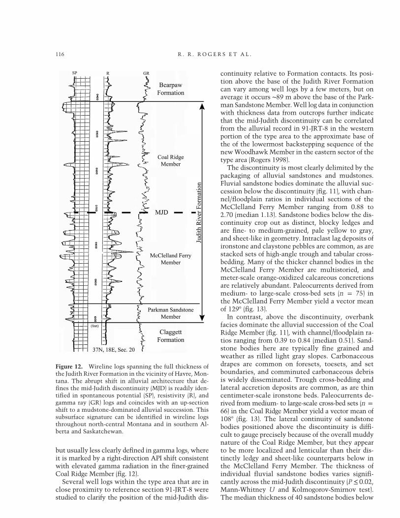
but usually less clearly defined in gamma logs, whereit is marked by a right-direction API shift consistentwith elevated gamma radiation in the finer-grainedCoal Ridge Member (fig. 12).
Several well logs within the type area that are inclose proximity to reference section 91-JRT-8 werestudied to clarify the position of the mid-Judith dis-
continuity relative to Formation contacts. Its posi-tion above the base of the Judith River Formationcan vary among well logs by a few meters, but onaverage it occurs ∼89 m above the base of the Park-man SandstoneMember.Well log data in conjunctionwith thickness data from outcrops further indicatethat the mid-Judith discontinuity can be correlatedfrom the alluvial record in 91-JRT-8 in the westernportion of the type area to the approximate base ofthe of the lowermost backstepping sequence of thenewWoodhawkMember in the eastern sector of thetype area (Rogers 1998).
The discontinuity is most clearly delimited by thepackaging of alluvial sandstones and mudstones.Fluvial sandstone bodies dominate the alluvial suc-cession below the discontinuity (fig. 11), with chan-nel/floodplain ratios in individual sections of theMcClelland Ferry Member ranging from 0.88 to2.70 (median 1.13). Sandstone bodies below the dis-continuity crop out as distinct, blocky ledges andare fine- to medium-grained, pale yellow to gray,and sheet-like in geometry. Intraclast lag deposits ofironstone and claystone pebbles are common, as arestacked sets of high-angle trough and tabular cross-bedding. Many of the thicker channel bodies in theMcClelland Ferry Member are multistoried, andmeter-scale orange-oxidized calcareous concretionsare relatively abundant. Paleocurrents derived frommedium- to large-scale cross-bed sets (n p 75) inthe McClelland Ferry Member yield a vector meanof 1297 (fig. 13).
In contrast, above the discontinuity, overbankfacies dominate the alluvial succession of the CoalRidge Member (fig. 11), with channel/floodplain ra-tios ranging from 0.39 to 0.84 (median 0.51). Sand-stone bodies here are typically fine grained andweather as rilled light gray slopes. Carbonaceousdrapes are common on foresets, toesets, and setboundaries, and comminuted carbonaceous debrisis widely disseminated. Trough cross-bedding andlateral accretion deposits are common, as are thincentimeter-scale ironstone beds. Paleocurrents de-rived from medium- to large-scale cross-bed sets (n p66) in the Coal Ridge Member yield a vector mean of1087 (fig. 13). The lateral continuity of sandstonebodies positioned above the discontinuity is diffi-cult to gauge precisely because of the overall muddynature of the Coal Ridge Member, but they appearto be more localized and lenticular than their dis-tinctly ledgy and sheet-like counterparts below inthe McClelland Ferry Member. The thickness ofindividual fluvial sandstone bodies varies signifi-cantly across the mid-Judith discontinuity (P ≤ 0.02,Mann-Whitney U and Kolmogorov-Smirnov test).The median thickness of 40 sandstone bodies below
Figure 12. Wireline logs spanning the full thickness ofthe Judith River Formation in the vicinity of Havre, Mon-tana. The abrupt shift in alluvial architecture that de-fines the mid-Judith discontinuity (MJD) is readily iden-tified in spontaneous potential (SP), resistivity (R), andgamma ray (GR) logs and coincides with an up-sectionshift to a mudstone-dominated alluvial succession. Thissubsurface signature can be identified in wireline logsthroughout north-central Montana and in southern Al-berta and Saskatchewan.
116 R . R . R OG E R S E T A L .

the discontinuity is 5.3 m, contrasted with 3.35 mabove (43 sandstone bodies; fig. 13).The nature of overbank facies also varies across
the discontinuity. Overbank facies in the Mc-Clelland Ferry Member, lying between the basalparalic deposits and the discontinuity, are gener-ally gray-green to tan mudstones and siltstonesand show abundant evidence of rooting and pedo-genesis. In contrast, overbank facies arrayed abovethe discontinuity in the Coal Ridge Member aregenerally dark gray to olive green in color and areenriched in carbonaceous debris. Evidence of pe-dogenesis is still common above the discontinuity,but soils are hydromorphic and interspersed withnumerous beds of dark gray to black lignite andorange-brown ironstone (Rogers 1998).Several additional lithologic and paleontologic
attributes distinguish facies above and below themid-Judith discontinuity, as noted in earlier reports(Rogers 1993, 1998; Rogers and Kidwell 2000; Rog-ers and Brady 2010). Above the discontinuity in the
Coal Ridge Member, these include (1) localized con-centrations of extraformational pebbles in sandstonebodies; (2) evidence of a shallow water table and tidalinfluence in paralic facies; (3) a higher frequency ofbentonite beds; and (4) a dramatic increase in bothinvertebrate (freshwatermollusks) and vertebrate fos-sil occurrences, in particular vertebrate microfossilbonebeds. Sahni (1972) also recognized the shift inthe relative abundance of fossils in the Judith RiverFormation, noting that the upper part of the Forma-tionwasmore fossiliferous. The dominant lithologiesamong extraformational clasts are chert, quartzite,hornfels, and vein quartz, all occurring as well-rounded pebbles. Rounded pebbles of felsic plutonicand volcanic rock are also present. The occurrenceof these extraformational pebbles is limited to basallag deposits in fluvial sandstone bodies positionedapproximately 10–15 m above the discontinuity.Evidence of a shallow water table and tidal in-
fluence is widespread above the discontinuity in theCoal Ridge Member (Rogers 1998). Hydromorphic
Figure 13. The thickness of individual fluvial sandstone bodies varies significantly across the mid-Judith disconti-nuity (MJD; dashed line; P ≤ 0.02, Mann-Whitney U-test and Kolmogorov-Smirnov test). The median thickness of 40sandstone bodies below the discontinuity in the McClelland Ferry Member (MFM) is 5.3 m, and that of 43 sandstonebodies above in the Coal Ridge Member (CRM) is 3.35 m; the channel/floodplain ratio declines from 1.13 below to0.51 above. Fluvial paleocurrents have a general southeast flow direction on both sides of the MJD.
Journal of Geology 117S T R A T I G RA P H Y O F TH E J UD I T H R I V E R F O RMAT I ON
conditions are consistent with the overall abundanceof carbonaceous debris in both floodplain and chan-nel deposits, including numerous discrete beds of lig-nite. With the exception of the uppermost intervalof lignite deposits in the Coal Ridge Member, whichcan be tracked along the same horizon throughoutthe available outcrop belt, sulfur-bearing lignite bedsabove the discontinuity appear to track coastal en-vironments that were situated up to 10 km inlandof the advancing shorelines of the Woodhawk Mem-ber and thus are a diachronous facies linked to thewestward transgression of shallow marine facies(fig. 10). Wetland facies with shells of freshwatermollusks (freshwater lakes) are also notably abundantabove the discontinuity. Fluvial facies immediatelyinland of the transgressing Woodhawk Member con-tain tidal indicators, such as clay- and carbon-drapedforesets (sometimes distinctly paired), inclined het-erolithic stratification, and rare brackish fauna, in-cluding fossil logs with Teredolites borings (Rogers1998).
Beds of altered volcanic ash also show a distinctdistribution across the discontinuity. Only one ben-tonite bed has been identified in the McClellandFerry Member, in contrast to four above in the CoalRidge Member (see fig. 3, section 91-JRT-8). Theincreased frequency of bentonite beds above the dis-continuity might reflect more frequent explosivevolcanic activity in the region, but preferential pres-ervation under the more aggrading conditions inthe Coal Ridge Member cannot be ruled out, giventhe greater preservation of low-energy overbank de-posits.
Fossils of vertebrates, invertebrates, and plantsare well represented throughout the Judith RiverFormation, including the marine WoodhawkMem-ber, but fossils of all types are most abundant interrestrial strata of the Coal Ridge Member. Thedistinct increase in fossil occurrences, particularlyof vertebrate microfossil bonebeds, probably reflectsthe fortuitous combination of highly productivecoastal wetland ecosystems and favorable chemis-try in the burial environment (Rogers and Kidwell2000; Rogers and Brady 2010). Vertebrate micro-fossil bonebeds are multi-individual accumulationsof disarticulated and dissociated vertebrate hard-parts dominated by elements in the millimeter tocentimeter size range (≥75% of bioclasts ≤5 cmmaximum dimension; Eberth et al. 2007). Conserva-tive reconstructions suggest that microfossil bone-beds in the Judith River Formation may preservemany tens of thousands of vertebrate fossils, al-though the majority are unidentifiable millimeter-scale fragments. Taphonomic and sedimentologicdata are consistent with the in situ accumulation of
skeletal debris via attritional mortality in long-livedaquatic ecosystems. Vast quantities of resilient ver-tebrate hardparts, invertebrate shell debris, and plantmaterial accumulated in these wetland facies, in-dicating the diversity and abundance of life in thelush coastal plain environments represented by fa-cies of the Coal Ridge Member. Mobile channelbelts apparently reworked and locally redeposited pre-existing concentrations of fossil debris from flood-plains, generating channel-hosted vertebrate micro-fossil assemblages (Rogers and Kidwell 2000; Rogersand Brady 2010). Geochemical data indicate that someof the reworked fossil concentrations may have al-ready been stabilized by early diagenetic infillingand replacement before exhumation (Rogers and Kid-well 2000; Rogers et al. 2010).
Mineralogical Trends. Petrographic examinationof 12 fluvial sandstone bodies spanning the mid-Judith discontinuity in reference section 91-JRT-8reveals framework grain composition and cemen-tation histories. Sandstones are composed primar-ily of quartz (24%–63%), volcanic rock fragments(16%–46%), feldspar (4%–20%), and chert (2%–
25%), and most can be categorized as litharenite orfeldspathic litharenite, using McBride’s (1963) clas-sification (fig. 14). Trace framework constituents in-clude biotite, mucscovite, apatite, monazite, zircon,and detrital carbonate grains. Sandstones from 91-JRT-8 are also texturally submature, with grain sizeranging from fine to medium and grain shape rang-ing from angular to subrounded. Volcanically de-rived lithic grains are present in all samples andtend to be larger and more rounded than mono-mineralic counterparts. Rare grains of well-roundedquartz exhibiting dust lines and quartz overgrowthsare present both above and below the discontinuity.Foliated metamorphic and sedimentary rock frag-ments are also represented.
Overall, few differences are evident across themid-Judith discontinuity in the sand-sized frac-tion. Sandstones in the McClelland Ferry Memberare somewhat more enriched in quartz (fig. 15A,15B), and sandstones in the Coal Ridge Memberabove the discontinuity are in general more en-riched in mafic volcanic rock fragments (fig. 15C).Sandstones above the discontinuity are also notablyenriched in plagioclase, with some showing a four-fold increase in the abundance of albite (fig. 15D).The sandstone body that coincides most closely withthe discontinuity in 91-JRT-8 (see fig. 3) is relativelyrich in quartz (but not the most quartzose sand-stone encountered) and contains abundant grains ofauthigenic dolomite (fig. 15E, 15F) that are oftenrhombohedral and almost always rimmed with ironoxide cement.
118 R . R . R OG E R S E T A L .

Matrix and cement composition were also ex-amined. Two sandstone samples present below thediscontinuity and four above it are cemented bycalcite. There is widespread replacement of min-eral grains and lithic fragments by calcite, espe-cially where calcite is the predominant cementingagent, andmany of these grains exhibit etchedmar-gins with clear evidence of corrosion. Sandstoneslacking calcite cement typically have a grungy ma-trix of crushed and deformed lithic clasts (fig. 15C),and this pseudomatrix (Dickinson 1970) makes itdifficult to identify individual lithic clasts. Intersti-tial spaces are also filled locally with microcrys-talline silica cement, clay, and, more rarely, fluoritecement (fig. 15F). Most significantly, the quartz-rich sandstone body most closely associated withthe discontinuity in reference section 91-JRT-8 hasa unique petrologic signature, with abundant authi-genic dolomite and pervasive iron oxide cement
(fig. 15E, 15F). Primary porosity is also notably devel-oped in this particular sandstone, perhaps indicat-ing early cementation by authigenic iron oxide andcarbonate and the persistence of primary void space.Clay content was also determined for 86 samples
that span the mid-Judith discontinuity in referencesection 91-JRT-8 (fig. 16). X-ray diffraction analysesindicate that four clay minerals are consistentlyrepresented in the section: kaolinite, smectite, il-lite, and chlorite. Numerous nonclay minerals werealso identified in the clay-sized fraction, includinggoethite, quartz, orthoclase, albite, anorthite, calcite,and dolomite. The weight-percent abundances ofclay minerals are plotted in figure 16. Kaolinite andsmectite are abundant throughout reference section91-JRT-8 and together comprise up to 75 wt% ofmost samples. Kaolinite is most abundant withinsandstones. Smectite, illite, and chlorite clays tendto be more abundant in finer-grained siltstones and
Figure 14. Most fluvial sandstones in the Judith River Formation can be categorized as litharenite/feldspathiclitharenite (McBride 1963), containing mixtures of quartz (24%–63%), volcanic rock fragments (16%–46%), feldspar(4%–20%), and chert (2%–25%). Sandstones below the discontinuity (circles) are somewhat more enriched in quartz.Sandstones above the discontinuity (triangles) are on average more enriched in mafic volcanic rock fragments andplagioclase, with some showing a four-fold increase in the abundance of albite. The sandstone body that intersects themid-Judith discontinuity in 91-JRT-8 (star) is relatively rich in quartz and contains abundant authigenic dolomite.Ternary diagram constructed with Delta Plot (John 2004).
Journal of Geology 119S T R A T I G RA P H Y O F TH E J UD I T H R I V E R F O RMAT I ON

Figure 15. Photomicrographs of Judith River Formation fluvial sandstones, showing trends in sandstone petrologyand cement content across the mid-Judith discontinuity (MJD). A, Quartz-rich (Qtz) sandstone ∼60 m below the MJD,with relatively few rock fragments (Rf) and abundant sericite alteration rims; crossed polars. B, Sandstone ∼50 mbelow MJD, characterized by felsitic rock fragments, biotite grains (Bt), potassium feldspar grains (K), and patchycalcite cement (Cem); crossed polars. C, Sandstone ∼10 m above MJD exhibiting pseudomatrix of crushed mafic andfelsitic rock fragments and plagioclase (Pl), potassium feldspar (K), and quartz (Qtz) grains; crossed polars. D, Calcite-cemented sandstone ∼40 m above MJD with abundant plagioclase grains associated with quartz grains and rockfragments; crossed polars. E, Sandstone positioned at the level of MJD characterized by pervasive iron oxide cementand abundant coated detrital dolomite grains (Dol). F, Backscatter electron image illustrating occurrence of patchyfluorite cement (Fl) in same sandstone body in association with quartz, dolomite, potassium feldspar, and weatheredrock fragments. Thin bright bands coating grains represent iron oxides (arrows).
120
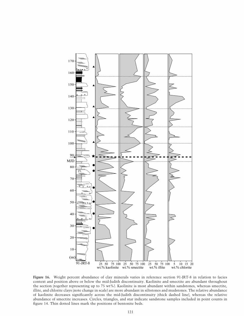
Figure 16. Weight percent abundance of clay minerals varies in reference section 91-JRT-8 in relation to faciescontext and position above or below the mid-Judith discontinuity. Kaolinite and smectite are abundant throughoutthe section (together representing up to 75 wt%). Kaolinite is most abundant within sandstones, whereas smectite,illite, and chlorite clays (note change in scale) are more abundant in siltstones and mudstones. The relative abundanceof kaolinite decreases significantly across the mid-Judith discontinuity (thick dashed line), whereas the relativeabundance of smectite increases. Circles, triangles, and star indicate sandstone samples included in point counts infigure 14. Thin dotted lines mark the positions of bentonite beds.
121

mudstones. The relative abundance of kaolinite de-creases significantly across the discontinuity,whereasthe relative abundance of smectite increases. Nochange in the average relative abundances of illiteand chlorite are evident (fig. 16). When all samplesfrom all lithofacies are compared across the discon-tinuity (43 below, 44 above), significant distinctionsin both kaolinite and smectite content are well sup-ported at the 99% confidence interval (kaolinite,P ≤ 0.009; smectite, P ≤ 0.01; Mann-Whitney U-test). Controlling for lithofacies context, kaolinite issignificantly more abundant in sandstones belowthe discontinuity (n p 14) than in sandstones aboveit (n p 14; P ≤ 0.002: Mann-Whitney U-test). Theprevalence of kaolinite below the discontinuity im-parts a decidedly pale cast to the McClelland FerryMember, with exposures characterized by shades oflight gray and pale yellow. In contrast, smectite-richalluvial facies above the discontinuity in the CoalRidge Member are generally a somber gray and olive-green color, augmented with the dark gray and blackbanding of abundant carbonaceous mudstones andlignite beds.
New 40Ar/39Ar Ages from the Judith RiverFormation Type Area
Bentonite Stratigraphy. Altered volcanic ash beds(bentonites) are relatively common throughout theUpper Cretaceous section in the Montana portionof the Western Interior Basin. Nearby volcanic cen-ters in Montana linked to explosive events and air-fall ash during the Late Cretaceous include theElkhorn Mountains Volcanics and the Adel Moun-tains Volcanics (Viele and Harris 1965; Smedes 1966;Tilling et al. 1968; Thomas et al. 1990; Rogers et al.1993; Roberts and Hendrix 2000; Foreman et al.2008). The new radioisotopic ages reported here arethe first derived from bentonites collected withinthe confines of the Judith River Formation typearea. The only previously published radioisotopicages for the Judith River Formation within Mon-tana were derived from two bentonite beds col-lected from low in the formation far to the north inKennedy Coulee, near Rudyard, Montana (Goodwinand Deino 1989).
New ages are reported here from three bentonitebeds (figs. 3, 10). Bentonite bed ST1-03 (47745′37.2″N, 109719′46.9″W) occurs 84.5 m above thebase of the Judith River Formation in referencesection 91-JRT-8 in alluvial sediments of the Mc-Clelland Ferry Member, immediately below themid-Judith discontinuity. Bentonite bed WHB1-11(47744′57.9″N, 108756′42.6″W) occurs 108 m be-
low the top of the Judith River Formation in thevicinity of reference section 91-JRT-12 in alluvialsediments of the McClelland Ferry Member, ∼10 mbelow the mid-Judith discontinuity. Bentonite bedPPF1-03 (47743′28.7″N, 108756′37.3″W) is at thebase of the Bearpaw Formation, approximately 5 mabove the top of the Judith River Formation, andwas sampled at the top of a ridge 2.5 km to thesoutheast of reference section 91-JRT-12 (fig. 10).All three bentonite beds exhibit popcorn weather-ing in outcrop, indicating significant smectite claycontent, and all three preserve euhedral grains ofsanidine, biotite, and other volcanogenic crystals attheir base. ST1-03 and WHB1-11 are only locallyexposed and are thin (≤15 cm thick) compared withPPF1-03, which is a prominent bed up to 30 cm thickthat can be traced throughout much of the type area.The stratigraphic positions of ST1-03, WHB1-11, andPPF1-03 are indicated in figures 3 and 10.
40Ar/ 39Ar Results. Summary 40Ar/39Ar analyticaldata are presented in figure 17 (related data in ta-ble S1, available online or from the Journal of Ge-ology office). Ten sanidine phenocrysts from sampleST1-03 yielded a weighted-mean 40Ar/39Ar age of76.245 0.18 Ma (1j internal error;50.22 Ma 1j fullexternal error), 12 sanidine phenocrysts from sam-ple PPF1-03 yielded 75.21 5 0.12 Ma (5 0.17 Ma),and 30 sanidine phenocrysts from sample WHB1-11yielded 76.17 5 0.07 Ma (5 0.14 Ma).
Recent astronomical recalibration of the age ofFish Canyon sanidine standard by Kuiper et al.(2008), used herein, requires recalculation of priorreported 40Ar/39Ar ages (e.g., Roberts et al. 2013).With regard to legacy ages in the Judith River For-mation, the original 40Ar/39Ar analyses of the Ken-nedy Coulee bentonites yielded ages of 78.55 0.2Mafor sanidine in the lower bentonite and 78.25 0.2Mafor sanidine in the upper bentonite (Goodwin andDeino 1989), which after recalculation are 79.5 50.2 and 79.1 5 0.2 Ma, respectively. Note that cal-ibrationwork on the Fish Canyon sanidine standardcontinues (e.g., Phillips and Matchan 2013; Renne2013), but the changes are likely to be less than a fewtenths of a percent, and 40Ar/39Ar ages can always berecalculated if a consensus is reached within thegeochronological community as to the canonical ageof this standard.
Discussion
Age and Correlation of the Mid-Judith Discontinu-ity. New radioisotopic ages reported here (fig. 17)indicate that the mid-Judith discontinuity formedat approximately 76.2 Ma, shortly after or roughly
122 R . R . R OG E R S E T A L .

coincident with emplacement of the ST1-03 (76.2450.18 Ma) and WHB1-11 (76.175 0.07 Ma) bentonites.Rock accumulation rates of Judith River strata be-neath the discontinuity can be approximated byconsidering the recalibrated legacy ages from Ken-nedy Coulee with new radioisotopic age data from
ST1-03 and WHB1-11. Basal exposures of the JudithRiver Formation in Kennedy Coulee range in agefrom ∼79.5 to 79.1 Ma. As a clastic tongue, the Ju-dith River Formation thickens westward from thetype area toward Kennedy Coulee, and well logs inthat general vicinity indicate that Judith River strata
Figure 17. Age probability density plots for single-crystal sanidine 40Ar/39Ar age determinations from bentonite bedsST1-03, PPF1-03, and WHB1-11 (see figs. 3, 10) sampled from the type area of the Judith River Formation in north-central Montana (Upper Missouri River Breaks National Monument). Weighted mean ages of the three populationsare indicated, with errors reported at 1j.
Journal of Geology 123S T R A T I G RA P H Y O F TH E J UD I T H R I V E R F O RMAT I ON

beneath the discontinuity span at least 125 m. Agedata and thickness estimates for the lower JudithRiver section (Parkman Sandstone and McClellandFerry Members combined) thus suggest rock accu-mulation rates on the order of ∼3.8 cm/1000 yr.
Deposition of the Judith River Formation ceasedin north-central Montana before 75.21 5 0.12 Ma,which is the age of the PPF103 bentonite at the baseof the overlying Bearpaw Formation. On the basisof this new age and the ∼76.2 Ma age of the mid-Judith discontinuity, the ∼90-m section betweenthe discontinuity and the Bearpaw Formation (thealluvial Coal Ridge Member and laterally equiva-lent marine Woodhawk Member) accumulated overroughly 1.0 Ma, with an average rock accumula-tion rate of ∼9 cm/1000 yr. Rock accumulation ratesthus more than double across the discontinuity, andthe three high-frequency sequences that composethe Woodhawk Member each have cycle durationson the order of 0.3–0.4 Ma, making them fourth-order packages.
Correlation of the mid-Judith discontinuity north-ward provides a means of establishing stratigraphicage control for several important fossil localities,assuming that this turnaround from regressive, pro-grading sedimentation to transgressive and stronglyaggradational sedimentation provides a reasonabletime plane. Exposures of the Judith River Formationin the Havre region preserve abundant vertebrate mi-crofossil bonebeds and have yielded well-preserveddinosaur egg clutches (Clouse and Horner 1993; Hor-ner 1999). The Havre badlands are approximately duenorth along strike of the western edge of the JudithRiver Formation type area, and the strata exposednear Havre readily compare with the stratigraphicsuccession in the type area. The JudithRiver sectionin the Havre region spans ∼180 m, and the disconti-nuity iswell expressed approximatelymidunit in sub-surface logs (figs. 11, 18).The lowerpartof thesectionis dominated by fluvial sandstone sheets, and mostdocumented fossil occurrences—including the dino-saur egg clutches—occur in strata above the discon-tinuity. These are thus between 76.2 and 75.2 Main age and lie within the new Coal Ridge Member ofthe Judith River Formation.
Vertebrate fossil localities ∼60 km farther to thewest, in the vicinity of Rudyard (Kennedy Coulee),can also be contextualized relative to the mid-Judith discontinuity. Outcrop and subsurface datain that area indicate that only the lower portion ofthe Judith River Formation is exposed (ParkmanSandstone Member and new McClelland FerryMember). The discontinuity is discernible in sub-surface logs north of the border in southern Alberta,where more expansive subsurface sections of equiv-
alent strata (Belly River Group) are readily available.All fossil occurrences in the Kennedy Coulee studyarea (e.g., Clemens and Goodwin 1985; Montellano1991; Schott et al. 2010) can thus be confidentlyplaced below the mid-Judith discontinuity in rocksolder than ∼76.2 Ma but probably younger than∼79.5 Ma.
Origin and Significance of the Mid-Judith Discontinu-ity: A Maximum Regressive Surface. The mid-Judithdiscontinuity is an apparently conformable, readilymapped break in lithology embedded approximatelymid-unit within the Judith River Formation. It is awidespread, readily recognized abrupt change in thenature of the alluvial record, from sandstone- tomudstone-dominated facies suites that contain moreabundant fossil vertebrates, more plagioclase andmafic rock fragments in framework sands, more hy-dromorphic features, with smectitic rather than kao-linitic clays, and that accumulated at ratesmore thantwice as fast. The discontinuity marks a major ad-justment of alluvial systems within the basin, fromregressive and predominantly progradational depo-sition below the discontinuity to transgressive andstrongly aggradational deposition above it.
Rogers (1998) originally proposed that the mid-Judith discontinuity separated terrestrial depositsthat accumulated landward of shorelines that pro-graded eastward during the Claggett regression fromterrestrial facies that accumulated landward of back-stepping shorelines during the subsequent Bearpawtransgression, of which the new Woodhawk Mem-ber of the Judith River Formation is the leading ma-rine edge. He further suggested that the disconti-nuity formed in response to a change in the rate ofpositive accommodation in the Montana portionof the Western Interior foreland basin, presumablyin response to tectonic loading of the basin margin.Here we reevaluate this reconstruction of base-level change and bring new data to bear on thequestion.
With the resolution afforded by subsurface data, themid-Judith discontinuity can be correlated through-out the Judith River Formation type area in north-central Montana, from fully terrestrial rocks in thewestern portion of the type area to the approximatebase of themarineWoodhawkMember in the easternsector. This correlation is illustrated by dip-parallelcross section A–A′ in figure 18, which spans approx-imately 70 km across the full expanse of the typearea. The regional resistivity kick that marks theEagle/Milk River shoulder, which was previouslyinterpreted as a transgressive surface of erosion (Pa-yenberg et al. 2003), is used here as a subcrop da-tum throughout north-central Montana and in thesouthern plains of western Canada. The mid-Judith
124 R . R . R OG E R S E T A L .

Figure 18. Subsurface correlation of the mid-Judith discontinuity (MJD; dashed line), with terrestrial and sandyshallow marine strata below the discontinuity shaded gray. The discontinuity can be correlated across north-centralMontana (A–A′) and northward into southern Alberta and Saskatchewan, Canada (B–B′, C–C′), using electric logs (MJSystems). The regional resistivity kick that marks the Eagle/Milk River shoulder (transgressive surface at top of EagleFormation [EF] in Montana and Milk River Formation [MRF] and equivalent units in Canada; Payenberg et al. 2003) isused as a subcrop datum in all three cross sections. A–A′, The MJD can be traced from fully terrestrial rocks in thewestern portion of the type area to the base of the marine Woodhawk Member in the eastern portion in this dip-parallel section, which spans approximately 70 km across the entire type area. New 40Ar/39Ar ages from the JudithRiver Formation (JRF) type area are shown in their approximate stratigraphic and geographic positions. B–B′, In thisdip-parallel section situated approximately 35 km to the north of the international border, strata below the discon-tinuity exhibit wireline responses consistent with alluvial deposits dominated by thick and closely spaced sandstonebodies, and those above the discontinuity exhibit responses consistent with fine-grained deposits containing fewerand thinner sandstone bodies. This 115-km-long transect from southeastern Alberta to southwestern Saskatchewandoes not extend far enough to the east to intersect rocks equivalent to the Woodhawk Member (WM). C–C′, Strike-parallel section extending 240 km from the type area of the JRF in north-central Montana to approximately 15 kmnorth of Cyprus Hills Interprovincial Park in southwestern Saskatchewan. The stratal architecture that typifies theJRF in its type area can be correlated with surprisingly little variation in thickness. PSM p Parkman SandstoneMember; MFM p McClelland Ferry Member; CRM p Coal Ridge Member; CF p Claggett Formation; BF p BearpawFormation; D1, D2, D3 p disconformities marking bases of depositional sequences of Woodhawk Member (fig. 10);BRG p Belly River Group; LPF p Lea Park Formation (Pakowki Formation equivalent); RCM p Ribstone CreekMember of BRG.

discontinuity essentially parallels this datum, show-ing remarkably little variation in thickness of in-tervening strata across this clastic wedge.
A second dip-parallel cross section (B–B′) situ-ated approximately 35 km to the north of theinternational border and based entirely on welllogs exhibits the same basic pattern (fig. 18). Stratabelow the discontinuity exhibit wireline responsesconsistent with a record dominated by thick andclosely spaced sandstone bodies, and strata abovethe discontinuity are consistent with a finer-grainedsection typified by fewer and thinner sandstonebodies. This B–B′ cross section extends for approx-imately 115 km across the plains of southeasternAlberta and southwestern Saskatchewan. Terrestrialand shallow marine strata below the discontinuitythicken to the west, as would be expected of a clasticwedge prograding eastward (basinward) from westernsource areas. This cross section does not extend farenough to the east to intersect marine strata correla-tive with the Woodhawk Member. Here again themid-Judith discontinuity essentially parallels the sub-surface datum, showing general continuity in thick-ness of the intervening stratigraphic package.
The mid-Judith discontinuity can also be tracedfor considerable distance along depositional strike,as exemplified by cross section C–C′ in figure 18.This cross section extends from the type area ofthe Judith River Formation in north-central Mon-tana to approximately 15 km north of Cyprus HillsInterprovincial Park in southwestern Saskatche-wan, a distance of ∼240 km. The only gap in thecorrelation occurs across the Bears Paw Mountains,which were emplaced as part of the Central Mon-tana Alkalic Province during the Eocene (Diehl et al.1983). The same basic stratal architecture that typ-ifies the Judith River Formation in its type area canbe correlated northward for at least 240 km withsurprisingly little variation in thickness. The ∼25-mstep-up away from the datum across the Montana-Saskatchewan border coincides with the subsurfaceexpression of the Ribstone Creek Member of theCampanian Belly River Group and likely reflectsthe impact of this sandstone tongue on compactionof strata between the Eagle/Milk River shoulder andthe base of Judith River equivalent strata.
Thus, on the basis of subsurface data sets innorth-central Montana and the southern plains ofwestern Canada, the mid-Judith discontinuity spansat least 27,000 km2. The widespread nature of thediscontinuity and the strong change in accumula-tion rates and in facies architecture across it suggestthat it reflects a major base level–related adjust-ment within the foreland basin across north-centralMontana and into the southern plains of Canada
rather than a local event or a change in sedimentsupply alone, such as from climate change. Givenits spatial extent, the discontinuity is also unlikelyto reflect autogenic processes, such as variable avul-sion frequency: intrinsic processes of fluvial sys-tems generally operate on more local scales, and theirsignature would be expected to be both more clus-tered from a stratigraphic perspective and morediachronous in nature (e.g., Hajek and Heller 2012;Hajek et al. 2012). There is evidence for climatechange in correlative strata of the Belly River Groupto the north in Canada (Eberth et al. 2013), withconditions evolving from a warm and seasonally drypaleoclimate in the Oldman Formation (approxi-mate age equivalent to the McClelland Ferry Mem-ber) to a warm and more consistently wet climaticregime in the overlying Dinosaur Park Formation(approximate age equivalent to theCoal RidgeMem-ber). A comparable shift in rainfall patterns likelyaffected contiguous regions of Montana during theCampanian. However, a regional shift to wetter con-ditions is compatible with only a few of the featuresthat change across themid-Judith discontinuity, suchas the up-section shift to hydromorphic facies. Theobserved shifts in channel scale, clay mineralogy,framework mineralogy, and increased rate of aggra-dation would not be predicted by an increase inrainfall alone. Some different or additional form ofexternal forcing of the alluvial system, such as fromtectonic subsidence and/or eustasy (specifically arise), thus seems required.
Correlation of the mid-Judith discontinuity tothe base of the Woodhawk Member provides a keyconstraint for the origin of the discontinuity. Shal-low marine sandstones of the Woodhawk Memberare juxtaposed upon alluvial facies of the McClellandFerry Member. This abrupt deepening signals signif-icant addition of accommodation and marine trans-gression, which then persisted for the duration ofWoodhawk Member deposition, as evidenced by theretrogradational pattern of the three high-frequencydepositional sequences that form the WoodhawkMember. Terrestrial strata of the Coal Ridge Mem-ber above the discontinuity and below the BearpawFormation accumulated during deposition of theWoodhawk Member and thus accumulated duringthe same episode of underfilled accommodationthat prompted regional marine transgression. Tidalindicators in Coal Ridge Member facies are furtherevidence that these strata accumulated synchronouswith marine transgression. The pervasive hydro-morphic character of this member is also consistentwith rising base level in the coastal complex inlandof the Woodhawk Member (Wright and Marriott1993; McCarthy et al. 1999; Plint et al. 2001).
126 R . R . R OG E R S E T A L .

The tectonic context of the Judith River Forma-tion, within the foredeep of an active foreland ba-sin, guides interpretation of the driver of the geo-logically sudden addition of accommodation. TheCampanian was a time of slip along major thrustsystems in the fold and thrust belt in northwesternMontana (Sears 2001; Fuentes et al. 2011), and theBearpaw transgression was the last large-scale flood-ing event within the basin. Tectonic loading and re-lated flexural subsidence have been argued to be themajor driving force behind transgressive-regressivecycles within the Bearpaw Formation in adjacent re-gions of southern Alberta and Saskatchewan (Catu-neanu et al. 1997), and a similar tectonic responsewould be expected in the Montana portion of thesame basin.An upstream tectonic explanation for the addition
of accommodation (sensu Aitken and Flint 1995;Miall 1997; Catuneanu 2006; Eberth and Braman2012) is consistent with several aspects of the al-luvial record spanning the discontinuity. First andforemost, this clastic tongue representing the prox-imal Two Medicine and more distal Judith RiverFormations thickens dramatically to the west to-ward the orogen, as would be predicted in an asym-metrically subsiding foredeep (fig. 2). The geometryof the wedge is consistent with flexural subsidenceas a first-order control on accommodation and sed-imentation patterns during the Campanian. In ad-dition, petrologic data indicate that the delivery ofclastic detritus evolved across the discontinuity,with an increase in extraformational lithic clasts,which is consistent with the tectonic reorganiza-tion of source areas and sedimentary delivery sys-tems. A pulse of extraformational pebbles appears inthe basin fill shortly after formation of the discon-tinuity, and an increased flux of mafic volcanic rockfragments and plagioclase is evident in sandstonesabove the discontinuity (fig. 15). The increased fre-quency of bentonite beds above the discontinuity isalso consistent with a tectonic link to subsidenceand the addition of accommodation, assuming mag-matic activity accompanied diastrophic events inthe hinterland, but their increase might also be anepiphenomenon of higher preservation potentiallinked to overall higher rates of aggradation.Finally, there is the question of how to categorize
this regional stratigraphic discontinuity in terms ofbase-level cycles and sequence stratigraphic models(Rogers 1998; Rogers and Kidwell 2000). One fea-ture absent from the mid-Judith discontinuity is ev-idence of significant erosion of underlying strata,such as channel incisions of exceptional depth orlow-angle beveling that might be detected at thescale of our large badland-type outcrops. There is
also no regional evidence of erosion or distal down-stepping, at least such as can be recognized in avail-able outcrop and subsurface data: stacking patternsup to this point are apparently simply prograda-tional. The mid-Judith discontinuity also showsno particularly strong evidence of sediment bypass(sensu Holbrook and Bhattacharya 2012). The mostclosely associated sandstone body exhibits distinc-tive diagenesis in the form of abundant authigenicdolomite and iron oxide cement, but this could re-flect overprinting by the hydromorphic deposits thatsucceed it. Sandstones along the discontinuity arenot especially amalgamated or rich in pebbly debris,such as would suggest a thin, residual record of by-pass. Instead, the discontinuity simply marks a pro-nounced change in facies architecture, specifically astrong reduction in the sandstone/mudstone ratioof alluvial facies, and a shift in detrital compositionand authigenic clay composition, coincident with achange in shoreline trajectories from regressive totransgressive and a sharp increase in rates of rockaccumulation. These changes are consistent with achange to backstepping.The discontinuity thus has features that would be
expected of the upstream, terrestrial extension of amaximum regressive surface, marking a shift fromnormal regression to transgression (sensu Helland-Hansen and Gjelberg 1994; Helland-Hansen andMartinsen 1996; Catuneanu 2006; Catuneanu et al.2011). The mid-Judith discontinuity would corre-spond to the surface of initial transgression (sensuPosamentier and Vail 1988) further seaward in thebasin; in the eastern sector of the Judith River typearea, the stratigraphically lowest transgressive sur-face at the base of the Woodhawk Member (D1;figs. 10, 18) coincides with the mid-Judith disconti-nuity. Stratigraphic discontinuities with some of theabove-mentioned features would also satisfy the def-inition of a cryptic sequence boundary (sensu Mialland Arush 2001).
Comparing Low- and High-Accommodation Terres-trial Records across theMid-Judith Discontinuity. Rockaccumulation rates show a more than two-fold in-crease across themid-Judith discontinuity. This dou-bling of rock accumulation rates arguably translatesto a comparable increase in floodplain aggradationrates in the Coal Ridge Member of the upper JudithRiver Formation. Classic models of alluvial archi-tecture (e.g., Leeder 1978; Bridge and Leeder 1979; Al-exander and Leeder 1987) contend that an increasein aggradation rates in a positive accommodationsetting would compel the alluvial record toward(1) enhanced preservation of floodplain fines, (2) di-minished channel stacking density, and (3) dimin-ished channel amalgamation and connectivity.
Journal of Geology 127S T R A T I G RA P H Y O F TH E J UD I T H R I V E R F O RMAT I ON

All of these expectations are borne out on a re-gional scale in alluvial Coal Ridge Member strataabove the mid-Judith discontinuity, landward of theshoreface Woodhawk Member (fig. 18). The systemresponded rapidly and regionally to flexural subsi-dence in ways predicted both by early models of al-luvial architecture and by more recent consider-ations of terrestrial sequence stratigraphy (Wrightand Marriott 1993; Leckie and Boyd 2003; Catu-neanu 2006; Tedesco et al. 2010; Colombera et al.2015). That is not to say that other controls onalluvial architecture, such as climate and variousautogenic processes, were not in play. However, itis difficult to downplay the links between the shiftin accommodation regimes, marine transgression,and changes in channel stacking patterns in thealluvial Judith River record.
The dramatic increase in floodplain aggradationrate above themid-Judith discontinuity can also ac-count for the distinct pattern of clay mineral dis-tribution across the discontinuity. The shift froma kaolinite-dominated record below to a smectite-dominated record above is consistent with the ex-pected intensity of weathering in the near-surfaceburial environment. Diagenesis and the early authi-genic formation of clay minerals such as kaolinitewould proceed more effectively under conditionsof relatively low addition of accommodation andslow net aggradation, because meteoric waters wouldhave more time to effectively flush cations from thesystem (Chamley 1989; Birkeland 1999; Ketzer et al.2003; Khidir and Catuneanu 2009). Under this samepremise, and with other controls on weathering heldrelatively constant, the early diagenetic productionof kaolinite would be inhibited by the more thantwo-fold increase in floodplain aggradation rate inthe upper Judith River record, especially when cou-pled with a rising water table, which would impedethe flushing of cations. Importantly, the pattern ofclay mineral distribution in the Judith River recordparallels a significant shift in the channel/floodplainratio, and so early diagenetic processes would be ex-pected to proceed fastest within permeable sedi-ments such as sandstones (Huggett 1986). Thus, tosome degree, the abundance of kaolinite in theMcClelland Ferry Member might simply be a func-tion of the abundance of sandstone in the samerecord. On the other hand, the shift in clay miner-alogy is evident in both sandstones and mudstones(fig. 16); thus, facies-specificweathering trendscanex-plain only part of thepattern.Abroader control linkedto the shift from a low- to a high-accommodationsetting and the overall duration of weathering inalluvial sediments thus seems to have been operat-ing, with important implications for the recognition
of significant surfaces and stratigraphic intervals instudies of terrestrial sequence stratigraphy, espe-cially those of a cryptic nature (e.g., Miall and Arush2001; Khidir and Catuneanu 2009).
The abrupt shift in accommodation and alluvialarchitecture that punctuates the Judith River rec-ord is thus marked by a change in clay signatures,which characterize expansive intervals of alluvialstrata that accumulated under distinct accommo-dation regimes on opposite sides of the mid-Judithdiscontinuity: there is no clay signature of a par-ticular surface or thin (presumably hiatal) intervalwithin this part of the succession. The mid-Judithdiscontinuity does nonetheless correspond with oneunique and localized diagenetic signature: the sand-stone body that most closely coincides with thediscontinuity in reference section 91-JRT-8 is char-acterized by abundant authigenic dolomite and dis-tinctive iron oxide cementation (fig. 15E, 15F). Noother sandstone in the section shows comparableprecipitation of secondary dolomite and iron oxide,and the early emplacement of authigenic cement issuggested by the retention of primary porosity. Theexact time frame of diagenesis is not yet resolved,but it seems reasonable to propose that some degreeof subaerial hiatus would have promoted the in situweathering of magnesium- and iron-bearing miner-als and afforded time for the circulation of oxidizingmeteoric fluids. In any case, this unique diageneticsignature coincides precisely with a change fromprolonged regression to a pulse of marine trans-gression and a change in the rate of addition of ac-commodation.
Last, the relative richness of the bioclastic recordpreserved in the high-accommodation Coal RidgeMember parallels previous observations in other ba-sins and other depositional settings that compare as-pects of fossil preservation and accommodation (e.g.,Kidwell 1988, 1993a, 1993b; Eberth et al. 2001).The shift in the nature of the Judith River fossilrecord can be explained by several accommodation-related factors. From a purely architectural per-spective, the stacking and amalgamation of high-energy fluvial sandstones in the sub-discontinuity,low-accommodation McClelland Member would po-tentially destroy or disperse organic remains. Asubsidence-related facies bias may have inhibitedthe concentration of vertebrate and invertebrate re-mains into readily discoverable bonebeds or shellbeds in the sandstone-dominated lower Judith RiverFormation in the type area. Patterning in the JudithRiver fossil record may also reflect differential dia-genesis and the impact of near-surface weatheringon the long-term preservation of organic remains.The more intense weathering regime of the low-
128 R . R . R OG E R S E T A L .

accommodation phase may have selectively culledmost bones and shells from the burial environmentor at least degraded their quality, while the shift tohigh accommodation and accelerated aggradationpresumably limited near-surface weathering whileencouraging burial and eventual fossilization. Re-gardless of the exact mix of positive preservationalparameters, there is no question that the shift to arelatively high-accommodation regimen in the CoalRidge Member of the upper Judith River Formationcreated ideal conditions for fossil preservation.
Conclusions
Stratigraphic analysis of the Judith River Formationin its type area confirms the presence of widespreadshallow marine deposits both at the base of theFormation (Parkman Sandstone Member) and, moresignificantly, in its upper reaches. The new Wood-hawk Member includes the distinctive shallow ma-rine sandstones in the upper half of the formation inthe eastern portion of the type area. These marinesandstones form a backstepping composite sequenceset of three high-frequency sequences with cycledurations on the order of 0.3–0.4 Ma. Recognition ofthe Woodhawk Member advances understanding ofregional geology in north-central Montana duringthe Campanian, especially in relation to sedimen-tation trends and shoreline stacking patterns duringthe early history of the Bearpaw transgression. Newsanidine phenocryst 40Ar/39Ar ages from two ben-tonite beds positioned in the Judith River Forma-tion at the approximate base of theWoodhawkMem-ber indicate that transgression commenced ∼76.2 Main north-central Montana. A new 40Ar/39Ar age froma bentonite ∼5 m above the Woodhawk Member-Bearpaw Formation contact further indicates thatsandy shorelines had advanced westward beyondnorth-central Montana by ∼75.2 Ma.The base of the Woodhawk Member correlates
inland and updip with a pronounced break in thecontinuity of terrestrial sedimentation positionedapproximately mid-unit in the Judith River For-mation. This stratigraphic discontinuity is readilydiscernible in outcrop and can be traced in welllogs for more than 27,000 km2 beneath the plainsof north-central Montana and southern Alberta andSaskatchewan. Terrestrial strata disposed on eitherside of the mid-Judith discontinuity are character-ized by distinctive facies architecture, mineralogy,and fossil content. The newMcClelland FerryMem-ber encompasses the sandstone-dominated suite offluvial and floodplain strata below the discontinu-ity, whereas the new Coal Ridge Member encom-
passes the mudstone-dominated succession of allu-vial strata above the discontinuity. These two newmembers can be distinguished in outcrop and sub-crop throughout the type area and beyond. Their rec-ognition promotes a more detailed regional perspec-tive of previously undifferentiated terrestrial stratathat represent most of the Judith River Formation.New 40Ar/39Ar age data indicate that the mid-
Judith discontinuity formed ∼76.2 Ma, coincidentwith the onset of marine transgression. New agedata, in combination with recalculated legacy ages,further indicate that rock accumulation rates morethan doubled across the discontinuity, shifting from∼3.8 cm/1000 yr in the subjacent McClelland FerryMember to ∼9.0 cm/1000 yr in the superjacent CoalRidge Member. With this shift from relatively low-to high-accommodation channel/floodplain ratiosplummeted, channel sandstone thickness dimin-ished significantly, and provenance of clastic detri-tus evolved as indicated by an increase in mafic vol-canic clasts and plagioclase grains and the deliveryof extraformational pebbles. The preservation po-tential of fossils in the Judith River Formation alsoincreased dramatically, as reflected by the excep-tionally rich fossil record in the Coal Ridge Memberabove the discontinuity.Recognition of the mid-Judith discontinuity fa-
cilitates correlation and affords an outstanding op-portunity to document the evolution of an alluvialdepositional system during basin-scale geomorphicadjustment, which in this case corresponds withflexural subsidence and marine transgression. Cor-relation with the base of the Woodhawk Memberindicates that the pulse of accommodation thatdrove transgression also forced major adjustmentsin the terrestrial realm that relate to key aspects ofalluvial architecture, floodplain drainage and dia-genesis, sediment sourcing, and fossil richness. Cor-relation with the base of the Woodhawk Memberalso helps contextualize the discontinuity in rela-tion to sequence stratigraphy. The discontinuity isa major bounding surface, namely the proximal ter-restrial extension of a maximum regressive sur-face, marking the shift from normal regression totransgression (fig. 2). The next step is to correlatemore precisely between terrestrial and contempo-raneous shallow marine deposits in order to de-termine how far key surfaces can be tracked inland(e.g., the flooding surfaces of the Woodhawk se-quences). To this end, petrographic analyses tar-geting the abundant lignite beds in the Coal RidgeMember positioned landward of the WoodhawkMember are underway, with the goal of discerningmaceral and mineral composition (e.g., Banerjee et al.1996; Davies et al. 2006; Jerrett et al. 2011) in order
Journal of Geology 129S T R A T I G RA P H Y O F TH E J UD I T H R I V E R F O RMAT I ON

to better establish a high-frequency accommoda-tion history in the terrestrial Judith River record.
ACKNOWL EDGMENT S
We thank K. Curry Rogers, D. Eberth, B. Foreman,E. Hajek, S. Holland, and M. Patzkowsky for sug-gestions, observations, insights, and helpwithfield-work and D. Eberth and E. Roberts for careful re-views of the manuscript and great suggestions. Wealso thank colleagues at the Bureau of Land Man-agement (Lewistown Field Office, Billings State
Office)—including Z. Fulbright, G. Liggett, C. Rye,G. Slagel, M. Schaefer, G. Smith, L. Anderson, J.Harkson, and L. Eichhorn—for their help over theyears facilitating work in the Upper Missouri RiverBreaks National Monument. Friends in and aroundWinifred, Montana, are also acknowledged for theirhelp and for allowing access to their land. Fundingfor this project was provided by the PetroleumResearch Fund of the American Chemical Society,the National Science Foundation (EAR-1052673),the Bureau of Land Management, and MacalesterCollege.
R E F E R EN C E S C I T E D
Aitken, J. F., and Flint, S. S. 1995. The application ofhigh-resolution sequence stratigraphy to fluvial sys-tems: a case study from the Breathitt Group, easternKentucky, USA. Sedimentology 42:3–30.
Alexander, J., and Leeder, M. R. 1987. Active tectoniccontrol on alluvial architecture. Spec. Publ. Soc. Econ.Paleontol. Mineral. 39:243–252.
Banerjee, I.; Kalkreuth, W.; and Davies, E. H. 1996.Coal seam splits and transgressive-regressive coalcouplets: a key to stratigraphy of high frequencysequences. Geology 24:1001–1004.
Best, M. G.; Christiansen, E. H.; Deino, A. L.; Gromme,C. S.; and Tingey, D. G. 1995. Correlation andemplacement of a large, zoned, discontinuously ex-posed ash-flow sheet: 40Ar/39Ar chronology, paleomag-netism, and petrology of the Pahrangat Formation,Nevada. J. Geophys. Res. 100:24593–24609.
Birkeland, P. W. 1999. Soils and geomorphology. 3rd ed.New York, Oxford University Press, 448 p.
Bowen, C. F. 1915. The stratigraphy of the Montanagroup with special reference to the position and ageof the Judith River formation in north-central Mon-tana. U.S. Geol. Surv. Prof. Pap. 90:95–153.
———. 1920. Gradations from continental to marineconditions of deposition in central Montana duringthe Eagle and Judith River epochs. U.S. Geol. Surv.Prof. Pap. 125:11–21.
Bridge, J. S., and Leeder, M. R. 1979. A simulation modelof alluvial stratigraphy. Sedimentology 26:617–644.
Brinkman, D. B. 1990. Paleoecology of the Judith RiverFormation (Campanian) of Dinosaur Provincial Park,Alberta, Canada: evidence from vertebrate microfossillocalities. Palaeogeogr. Palaeoclimatol. Palaeoecol. 78:37–54.
Case, G. R. 1978. A new selachian fauna from the Ju-dith River Formation (Campanian) of Montana. Pa-laeontogr. Abt. A 160:176–205.
Catuneanu, O. 2006. Principles of sequence stratigra-phy. Amsterdam, Elsevier, 375 p.
Catuneanu, O.; Galloway, W. E.; Kendall, C. G. St. C.;Miall, A. D.; Posamentier, H. W.; Strasser, A.; andTucker, M. E. 2011. Sequence stratigraphy: method-ology and nomenclature. Newsl. Stratigr. 44:173–245.
Catuneanu, O.; Miall, A. D.; and Sweet, A. R. 1997.Reciprocal architecture of Bearpaw T-R sequences,uppermost Cretaceous, Western Canada SedimentaryBasin. Bull. Can. Pet. Geol. 45:75–94.
Chamley, H. 1989. Clay sedimentology. Berlin, Springer,623 p.
Clemens, W. A., and Goodwin, M. B. 1985. Vertebratepaleontology of the Judith River Formation, Montana.Res. Rep. Natl. Geogr. Soc. 21:71–78.
Clouse, V. R., and Horner, J. R. 1993. Eggs and embryosfrom the late Cretaceous Judith River Formation northcentral Montana. J. Vertebr. Paleontol. 13(suppl. 3):31A.
Cohen, K. M.; Finney, S. C.; Gibbard, P. L.; and Fan, J.-X.2013. The ICS international chronostratigraphic chart.Episodes 36:199–204.
Colombera, L.; Mountney, N. P.; and McCaffrey, W. D.2015. A meta-study of relationships between channel-body stacking pattern and aggradation rate: impli-cations for sequence stratigraphy. Geology 43:283–286.
Cope, E. D. 1871. Synopsis of the extinct Batrachia, Rep-tilia, and Aves of North America. Trans. Am. Philos.Soc. 14:1–252.
———. 1876. On some extinct reptiles and Batrachiafrom the Judith River and Fox Hills beds of Mon-tana. Proc. Acad. Nat. Sci. Phila. 28:340–359.
———. 1877. Report on the geology of the region of theJudith River, Montana and on vertebrate fossils ob-tained on or near the Missouri River. Bull. U.S. Geol.Geogr. Surv. Terr. 3:565–597.
Davies, R.; Howell, J.; Boyd, R.; Flint, S.; and Diessel,C. 2006. High-resolution sequence-stratigraphic cor-relation between shallow-marine and terrestrial strata:examples from the Sunnyside Member of the Creta-
130 R . R . R OG E R S E T A L .

ceous Blackhawk Formation, BookCliffs, eastern Utah.Am. Assoc. Pet. Geol. Bull. 90:1121–1140.
Dawson, G. M. 1875. Report on the geology and re-sources of the region in the vicinity of the forty-ninth parallel from the Lake of the Woods to theRocky Mountains. Brit. N. Am. Bound. Comm., 379 p.,pl. 1–18, 2 maps.
Dickinson, W. R. 1970. Interpreting detrital modes of gray-wacke and arkose. J. Sediment Petrol. 40:695–707.
Diehl, J. F.; Beck, M. E., Jr.; Beske-Diehl, S.; Jacobsen,D.; and Jearn, B. C., Jr. 1983. Paleomagnetism of theLate Cretaceous-Early Tertiary north-central MontanaAlkalic Province. J. Geophys Res. 88:10593–10609.
Eberth, D. A. 1990. Stratigraphy and sedimentology ofvertebrate microfossil sites in the uppermost JudithRiver Formation (Campanian), Dinosaur ProvincialPark, Alberta, Canada. Palaeogeogr. Palaeoclimatol.Palaeoecol. 78:1–36.
———. 2005. The geology. In Currie, P. J., and Koppel-hus, E. B., eds. Dinosaur Provincial Park: a spectacularancient ecosystem revealed. Bloomington, IndianaUniversity Press, p. 54–82.
Eberth, D. A., and Braman, D. R. 2012. A revisedstratigraphy and depositional history for the Horse-shoe Canyon Formation (Upper Cretaceous), south-ern Alberta Plains. Can. J. Earth Sci. 49:1053–1086.
Eberth, D. A.; Brinkman, D. B.; Chen, P.-J.; Yuan, F. T.;Wu, S.-Z.; Li, G.; and Cheng, X.-S. 2001. Sequence stra-tigraphy, paleoclimate patterns, and vertebrate fossilpreservation in Jurassic-Cretaceous strata of the JunggarBasin, Xinjiang Autonomous Region, People’s Republicof China. Can. J. Earth Sci. 38:1627–1644.
Eberth, D. A.; Evans, D. C.; Brinkman, D. B.; Therrien,F.; Tanke, D. H.; and Russell, L. S. 2013. Dinosaurbiostratigraphy of the Edmonton Group (Upper Cre-taceous), Alberta, Canada: evidence of climate influ-ence. Can. J. Earth Sci. 50:701–726.
Eberth, D. A., and Hamblin, A. P. 1993. Tectonic, strat-igraphic, and sedimentologic significance of a regionaldiscontinuity in the upper Judith River Group (BellyRiver wedge) of southern Alberta, Saskatchewan, andnorthern Montana. Can. J. Earth Sci. 30:174–200.
Eberth, D. A.; Shannon, M.; and Noland, B. G. 2007.A bonebeds database: classification, biases and pat-terns of occurrence. In Rogers, R. R.; Eberth, D. A.;and Fiorillo, A. R., eds. Bonebeds: genesis, analysis,and paleobiological significance. Chicago, Universityof Chicago Press, p. 103–219.
Eberth, D. A.; Thomas, R. G.; and Deino, A. L. 1992.Preliminary K-Ar dates from bentonites in the JudithRiver and Bearpaw formations (Upper Cretaceous) atDinosaur Provincial Park, southern Alberta, Canada.In Mateer, N. J., and Chen, P. J., eds. Aspects of non-marine Cretaceous geology. Beijing, China Ocean,p. 296–304.
Eldridge, G. H. 1888. On some stratigraphical and struc-tural features of the country about Denver, Colo-rado. Proc. Colo. Sci. Soc. 3:86–118.
———. 1889. Some suggestions upon the methods ofgrouping the formations of the middle Cretaceous andthe employment of an additional term in its nomen-clature. Am. J. Sci. 146:723–732.
Fiorillo, A. R. 1991. Taphonomy and depositional set-ting of Careless Creek Quarry (Judith River Forma-tion),WheatlandCounty,Montana. U.S.A. Palaeogeogr.Palaeoclimatol. Palaeoecol. 81:281–311.
Fiorillo, A. R., and Currie, P. J. 1994. Theropod teethfrom the Judith River Formation (Upper Cretaceous) ofsouth-central Montana. J. Vertebr. Paleontol. 14:74–80.
Foreman, B. Z.; Rogers, R. R.; Deino, A. L.; Wirth, K. R.;and Thole, J. T. 2008. Geochemical characterizationof bentonite beds in the TwoMedicine Formation (Cam-panian, Montana), including a new 40Ar/39Ar age. Creta-ceous Res. 29:373–385.
Fricke, H. C.; Rogers, R. R.; Backlund, R.; Dwyer, C. N.;and Echt, S. 2008. Preservation of primary stable iso-tope signals in dinosaur remains, and environmentalgradients of the Late Cretaceous of Montana and Al-berta. Palaeogeogr. Palaeoclimatol. Palaeoecol. 266:13–27.
Fricke, H. C.; Rogers, R. R.; and Gates, T. A. 2009.Hadrosaurid migration: inferences based on stable iso-tope comparisons among Late Cretaceous dinosaur lo-calities. Paleobiology 35:270–288.
Fuentes, F.; DeCelles, P. G.; Constenuis, K. N.; andGehrels, G. E. 2011. Evolution of the Cordilleran fore-land basin system in northwestern Montana, U.S.A.Geol. Soc. Am. Bull. 123:507–533.
Gill, J. R., and Cobban, W. A. 1973. Stratigraphy and geo-logic history of theMontana group and equivalent rocks,Montana, Wyoming, and North and South Dakota. U.S.Geol. Surv. Prof. Pap. 776, 37 p.
Goodwin, M. B., and Deino, A. L. 1989. The first ra-diometric ages from the Judith River Formation (LateCretaceous), Hill County, Montana. Can. J. Earth Sci.26:1384–1391.
Hajek, E. A., and Heller, P. L. 2012. Flow-depth scalingin alluvial architecture and nonmarine sequence stra-tigraphy: example from the Castlegate Sandstone,central Utah, U.S.A. J. Sediment Res. 82:121–130.
Hajek, E. A.; Heller, P. L.; and Schur, E. L. 2012. Fieldtest of autogenic control on alluvial stratigraphy (Fer-ris Formation, Upper Cretaceous–Paleogene, Wyoming).Geol. Soc. Am. Bull. 124:1898–1912.
Hamblin, A. P., and Abramson, B. W. 1996. Strati-graphic architecture of “basal Belly River” cycles, Fore-most Formation, Belly River Group, subsurface of south-ern Alberta and southwestern Saskatchewan. Bull. Can.Pet. Geol. 44:654–673.
Hatcher, J. B. 1903a. The Judith River beds. Science17:471–472.
———. 1903b. Relative age of the Lance Creek (Cera-tops) beds of Converse County, Wyoming, the JudithRiver beds of Montana, and the Belly River beds ofCanada. Am. Geol. 31:369–375.
Journal of Geology 131S T R A T I G RA P H Y O F TH E J UD I T H R I V E R F O RMAT I ON

Hatcher, J. B., and Stanton, T. W. 1903. The stratigraphicposition of the Judith River beds and their correlationwith the Belly River beds. Science 18:211–212.
Hayden, F. V. 1857. Notes explanatory of a map andsection illustrating the geologic structure of the coun-try bordering the Missouri River from the mouth ofthe Platte River to Fort Benton. Proc. Acad. Nat. Sci.Phila. 9:109–116.
———. 1871. Geology of the Missouri River Valley.U.S. Geol. Surv. Terr. (Fourth Annual). PreliminaryRep., pt. 2, chap. 7, p. 85–98.
Helland-Hansen, W., and Gjelberg, J. G. 1994. Concep-tual basis and variability in sequence stratigraphy:a different perspective. Sediment. Geol. 92:31–52.
Helland-Hansen, W., and Martinsen, O. J. 1996. Shore-line trajectories and sequences: description of var-iable depositional-dip scenarios. J. Sediment Res. 66:670–688.
Hillier, S. 2003. Quantitative analysis of clay and otherminerals in sandstones by X-ray powder diffraction(XRPD). In Worden, R. H., and Morad, S., eds. Claymineral cements in sandstones. Spec. Publ. Int. Assoc.Sediment. 34:213–251.
Holbrook, J. M., and Bhattacharya, J. P. 2012. Reap-praisal of the sequence boundary in time and space:case and considerations for an SU (subaerial uncon-formity) that is not a sediment bypass surface, atime barrier, or an unconformity. Earth-Sci. Rev. 113:271–302.
Horner, J. R. 1988. A new hadrosaur (Reptilia: Or-nithischia) from the Upper Cretaceous Judith RiverFormation ofMontana. J. Vertebr. Paleontol. 8:314–321.
———. 1999. Egg clutches and embryos of two hadro-saurian dinosaurs. J. Vertebr. Paleontol. 19:607–611.
Huggett, J. M. 1986. An SEM study of phyllosilicatediagenesis in sandstones and mudstones in the West-phalian Coal Measures using back-scattered electronmicroscopy. Clay Miner. 21:603–616.
Jerrett, R. M.; Flint, S. S.; Davies, R. C.; and Hodgson,D. M. 2011. Sequence stratigraphic interpretationof a Pennsylvanian (Upper Carboniferous) coal fromthe central Appalachian Basin, USA. Sedimentology58:1180–1207.
Jerzykiewicz, T., and Norris, D. K. 1994. Stratigraphy,structure and syntectonic sedimentation of the Cam-panian “Belly River” clastic wedge in the southernCanadian Cordillera. Cretaceous Res. 15:367–399.
Jinnah, Z. A.; Roberts, E. M.; Deino, A. L.; Larsen, J. S.;Link, P. K.; and Fanning, C. M. 2009. New 40Ar-39Arand detrital zircon U-Pb ages for the Upper Creta-ceous Wahweap and Kaiparowits formations on theKaiparowits Plateau, Utah: implications for regional cor-relation, provenance, and biostratigraphy. CretaceousRes. 30:287–299.
John, C. M. 2004. Plotting and analyzing data trendsin ternary diagrams made easy. Eos 85:158.
Kauffman, E. G. 1977. Geological and biological over-view: Western Interior Cretaceous basin. MountainGeol. 14:75–99.
Ketzer, J. M.; Morad, S.; and Amorosi. A. 2003. Pre-dictive diagenetic clay-mineral distribution in silici-clastic rocks within a sequence stratigraphic frame-work. In Worden, R. H., and Morad, S., eds. Claymineral cements in sandstones. Spec. Publ. Int. Assoc.Sediment. 34:43–61.
Khidir, A., and Catuneanu, O. 2009. Predictive diage-netic clay-mineral distribution in siliciclastic rocksas a tool for identifying sequence boundaries in non-marine successions: the Coalspur Formation, west-central Alberta. Geologos 15:169–180.
Kidwell, S. M. 1988. Taphonomic comparison of pas-sive and active continental margins: Neogene shellbeds of the Atlantic coastal plain and Northern Gulfof California. Palaeogeogr. Palaeoclimatol. Palaeoecol.63:201–223.
———. 1993a. Influence of subsidence on the anatomyof marine siliciclastic sequences and on the distri-bution of shell and bone beds. J. Geol. Soc. Lond.150:165–167.
———. 1993b. Taphonomic expressions of sedimentaryhiatuses: field observations on bioclastic concentra-tions and sequence anatomy in low, moderate and highsubsidence settings. Geol. Rundsch. 82:189–202.
Klug, B. 1993. Cyclic facies architecture as a key todepositional controls in a distal foredeep: CampanianMesaverde Group, Wyoming, USA. Geol. Rundsch.82:306–326.
Knechtel, M. M., and Patterson, S. H. 1956. Bentonitedeposits in marine Cretaceous formations of the Hardindistrict, Montana and Wyoming. U.S. Geol. Surv. Bull.1023, 116 p.
Knowlton, F. H. 1911. Remarks on the fossil turtles ac-credited to the JudithRiverFormation.Proc.Wash.Acad.Sci. 13:51–65.
Kuiper, K. F.; Deino, A.; Hilgen, F. J.; Krijgsman, W.;Renne, P. R.; and Wijbrans, J. R. 2008. Synchroniz-ing the rock clocks of Earth history. Science 320:500–504.
Lambe, L. M. 1907. On a new crocodilian genus andspecies from the Judith River Formation of Alberta.Trans. R. Soc. Can. 3:219–244.
Lawton, T. F. 1986. Fluvial systems of the Upper Cre-taceous Mesaverde Formation, Central Utah: a recordof transition from thin-skinned to thick-skinned de-formation in the foreland region. In Peterson, J. A.,ed. Paleotectonics and sedimentation in the RockyMountain region. Am. Assoc. Pet. Geol. Mem. 41:423–442.
Leckie, D. A., and Boyd, R. 2003. Towards a nonma-rine sequence stratigraphic model. Salt Lake City,UT, Am. Assoc. Pet. Geol. Annual Convention, Of-ficial Program 12:A101.
Lee, J.-Y.; Marti, K.; Severinghaus, J. P.; Kawamura, K.;Yoo, H.-S.; Lee, J. B.; and Kim, J. S. 2006. A redeter-mination of the isotopic abundances of atmosphericAr. Geochim. Cosmochim. Acta 70:4507–4512.
Leeder, M. R. 1978. A quantitative stratigraphic modelfor alluvium, with special reference to channel de-
132 R . R . R OG E R S E T A L .

posit density and interconnectedness. Mem. Can. Soc.Pet. Geol. 5:587–596.
Leidy, J. 1856. Notices of the remains of extinct rep-tiles and fishes discovered by Dr. F. V. Hayden inthe badlands of the Judith River, Nebraska Terri-tory. Proc. Acad. Nat. Sci. Phila. 8:72–73.
———. 1860. Extinct vertebrata from the Judith Riverand Great Lignite formations of Nebraska. Trans. Am.Philos. Soc. 11:139–154.
Lindvall, R. M., 1962. Geology of the Eskay Quadran-gle, Chouteau and Blaine Counties,Montana. U.S. Geol.Surv. Misc. Geol. Invest. Map I-353.
Lorenz, J. C. 1981. Sedimentary and tectonic historyof the TwoMedicine Formation, Late Cretaceous (Cam-panian), northwestern Montana. PhD dissertation,Princeton University, Princeton, NJ.
McBride, E. F. 1963. A classification of common sand-stones. J. Sediment. Petrol. 33:664–669.
McCarthy, P. J.; Faccini, U. F.; and Plint, A. G. 1999.Evolution of an ancient coastal plain: paleosols, inter-fluves and alluvial architecture in a sequence strati-graphic framework, Cenomanian Dunvegan Forma-tion, NE British Columbia, Canada. Sedimentology46:861–891.
McKay, J. L.; Longstaffe, F. J.; and Plint, A. G. 1995.Early diagenesis and its relationship to depositionalenvironment and relative sea-level fluctuations (Up-per Cretaceous Marshybank Formation, Alberta andBritish Columbia). Sedimentology 42:161–190.
McLean, J. R. 1971. Stratigraphy of the Upper Creta-ceous Judith River Formation in the Canadian GreatPlains. Sask. Res. Counc. Geol. Div. Rep. 11, 97 p.
Meek, F. B. 1876. A report on the invertebrate Creta-ceous and Tertiary fossils of the upper Missouri coun-try. Rep. U.S. Geog. Surv. Terr. 9, 629 p.
Meek, F. B., and Hayden, F. V. 1856. Descriptions ofa new species of Acephala and Gastropoda from theTertiary formations of Nebraska Territory, with somegeneral remarks on the geology of the country about thesources of the Missouri River. Proc. Acad. Nat. Sci.Phila. 8:111–126.
———. 1857. Descriptions of new species and generaof fossils, collected by Dr. F. V. Hayden in Ne-braska Territory; with some remarks on the Ter-tiary and Cretaceous formations of the northwest.Proc. Acad. Nat. Sci. Phila. 9:117–148.
Miall, A. D. 1997. The geology of stratigraphic se-quences. Berlin, Springer, 433 p.
Miall, A. D., and Arush, M. 2001. Cryptic sequenceboundaries in braided fluvial successions. Sedimen-tology 48:971–985.
Min, K.; Mundil, R.; Renne, P. R.; and Ludwig, K. R. 2000A test for systematic errors in 40Ar/39Ar geochronologythrough comparison with U/Pb analysis of a 1.1-Garhyolite. Geochim. Cosmochim. Acta. 64:73–96.
Mitchum, R. M., and Van Wagoner, J. C. 1991. High-frequency sequences and their stacking patterns:sequence-stratigraphic evidence of high-frequency eu-static cycles. Sediment. Geol. 70:131–160.
Montellano, M. 1991. Mammalian fauna of the JudithRiver Formation (Late Cretaceous, Judithian) northcentral Montana. Univ. Calif. Publ. Geol. Sci. 136,115 p.
North American Code on Stratigraphic Nomenclature.2005. North American stratigraphic code. Am. Assoc.Pet. Geol. Bull. 89:1547–1591.
Ogg, J. G., and Hinnov, L. A. 2012. Chapter 27: Cre-taceous. In Gradstein, F. M.; Ogg, J. G.; Schmitz,M. D.; and Ogg, G. M., eds. The geological timescale. Elsevier, Amsterdam, p. 793–853.
Ostrom, J. H. 1964. The systematic position of Hadro-saurus (Ceratops) paucidens Marsh. J. Paleontol. 38:130–134.
Payenberg, T. H. D.; Braman, D. R.; and Miall, A. D.2003. Depositional environments and stratigraphicarchitecture of the Late Cretaceous Milk River andEagle formations, southern Alberta and north-centralMontana: relationships to shallow biogenic gas. Bull.Can. Petrol. Geol. 51:155–176.
Peale, A. C. 1912. On the stratigraphic position andage of the Judith River Formation. J. Geol. 20:530–549.
Phillips, D., and Matchan, E. L. 2013. Ultra-highprecision 40Ar/39Ar ages for Fish Canyon Tuff andAlder Creek Rhyolite sanidine: new dating standardsrequired? Geochim. Cosmochim. Acta 121:229–239.
Plint, A. G.; McCarthy, P. J.; and Faccini, U. 2001.Nonmarine sequence stratigraphy: updip expressionof sequence boundaries and systems tracts in a high-resolution framework, Cenomanian Dunvegan For-mation, Alberta foreland basin, Canada. Am. Assoc.Pet. Geol. Bull. 85:1967–2001.
Posamentier, H. W., and Vail, P. R. 1988. Eustaticcontrols on clastic deposition. II. Sequence and sys-tems tract models. In Wilgus, C. K.; Hastings, B. S.;Kendall, C. G. St. C.; Posamentier, H. W.; Ross, C. A.;and Van Wagoner, J. C., eds. Sea level changes: an inte-grated approach. SEPM Spec. Publ. 42:125–154.
Prieto-Marquez, A. 2005. New information on the cra-nium of Brachylophosaurus canadensis (Dinosauria,Hadrosauridae); with a revision of its phylogeneticposition. J. Vertebr. Paleontol. 25:144–156.
Renne, P. R. 2013. Some footnotes to the optimization-based calibrations of the 40Ar/39Ar system. In Jourdan,F.; Mark, D. F.; and Verati, C., eds. Advances in40Ar/39Ar dating: from archaeology to planetary sci-ences. Geol. Soc. Lond. Spec. Pub. 378:21–31.
Roberts, E. M.; Deino, A. L.; and Chan, M. A. 2005.40Ar/39Ar age of the Kaiparowits Formation, southernUtah, and correlation of contemporaneous Campa-nian strata and vertebrate faunas along the margin ofthe Western Interior Basin. Cretaceous Res. 26:307–318.
Roberts, E. M., and Hendrix, M. S. 2000. Taphonomyof a petrified forest in the Two Medicine Formation(Campanian), northwest Montana: implications for pa-linspastic restoration of the Boulder Batholith and Elk-horn Mountains Volcanics. Palaios 15:476–482.
Journal of Geology 133S T R A T I G RA P H Y O F TH E J UD I T H R I V E R F O RMAT I ON

Roberts, E. M.; Sampson, S. D.; Deino, A. L.; Bowring,S. A.; and Buchwaldt, R. 2013. The KapairowitsFormation: a remarkable record of Late Cretaceousenvironments, ecosystems, and evolution in west-ern North America. InTitus, A. L., and Loewen, M. E.,eds. At the top of the grand staircase: the Late Creta-ceous of southern Utah. Bloomington, Indiana Uni-versity Press, p. 85–106.
Rogers, R. R. 1993. Systematic patterns of time aver-aging in the terrestrial vertebrate record: a Creta-ceous case study. In Kidwell, S. K., and Behrens-meyer, A. K., eds. Taphonomic approaches to timeresolution in fossil assemblages. Short Course Pa-leontol. 6:228–249.
———. 1994. Nature and origin of through-going dis-continuities in nonmarine foreland basin deposits,Upper Cretaceous, Montana: implications for se-quence analysis. Geology 22:1119–1122.
———. 1995. Sequence stratigraphy and vertebrate ta-phonomy of the Upper Cretaceous Two Medicineand Judith River Formations, Montana. PhD disser-tation, University of Chicago.
———. 1998. Sequence analysis of the upper CretaceousTwoMedicine and Judith River formations, Montana:nonmarine response to the Claggett and Bearpawmarine cycles. J. Sediment Res. 68:615–631.
Rogers, R. R., and Brady, M. E. 2010. Origins of micro-fossil bonebeds: insights from the Upper CretaceousJudith River Formation of north-central Montana.Paleobiology 36:80–112.
Rogers, R. R.; Fricke, H. C.; Addona, V.; Canavan, R. R.;Dwyer, C. N.; Harwood, C. L.; Koenig, A. E.; Murray,R.; Thole, J. T.; and Williams, J. 2010. Using laserablation–inductively coupled plasma–mass spectrom-etry (LA-ICP-MS) to explore geochemical taphonomyof vertebrate fossils in the Upper Cretaceous TwoMedicine and Judith River Formations of Montana.Palaios 25:183–195.
Rogers, R. R., and Kidwell, S. M. 2000. Associationsof vertebrate skeletal concentrations and disconti-nuity surfaces in terrestrial and shallow marine rec-ords: a test in the Cretaceous of Montana. J. Geol.108:131–154.
Rogers, R. R.; Swisher, C. C.; and Horner, J. R. 1993.40Ar/39Ar age and correlation of the non-marine TwoMedicine Formation (Upper Cretaceous), northwest-ern Montana: Can. J. Earth Sci. 30:1066–1075.
Ryan, M. J.; Evans, D. C.; Currie, P. J.; and Loewen, M. A.2014. A new chasmosaurine from northern Laramidiaexpands frill disparity in ceratopsid dinosaurs. Natur-wissenschaften 101:505–512.
Sahni, A. 1972. The vertebrate fauna of the Judith RiverFormation, Montana. Bull. Am. Mus. Nat. Hist. 147:321–412.
Schott, R. K.; Evans, D. C.; Williamson, T. E.; Carr,T. D.; and Goodwin, M. B. 2010. The anatomy andsystematics of Colepiocephale lambei (Dinosauria:Pachycephalosauridae). J. Vertebr. Paleontol. 29:771–786.
Sears, J. W. 2001. Emplacement and denudation his-tory of the Lewis-Eldorado-Hoadley thrust slab inthe northern Montana Cordillera, USA: implicationsfor steady-state orogeny processes. Am. J. Sci. 301:359–373.
Smedes, H. W. 1966. Geology and igneous petrology ofthe northern Elkhorn mountains, Jefferson and Broad-water counties, Montana. U.S. Geol. Surv. Prof. Pap.510.
Stanton, T. W., and Hatcher, J. B. 1903. The strati-graphic position of the Judith River beds and theircorrelation with the Belly River beds. Science 16:1031–1032.
———. 1905. Geology and paleontology of the JudithRiver beds. U.S. Geol. Surv. Bull. 257:1–128.
Stebinger, E. 1914. The Montana Group of northwest-ern Montana. U.S. Geol. Surv. Prof. Pap. 90-G:60–68.
Sternberg, C. H. 1914. Notes on the fossil vertebratescollected on the Cope expedition to the Judith Riverand Cow Island beds, Montana, in 1876. Science40:134–135.
Taylor, K. G., and Gawthorpe, R. L. 2003. Basin-scaledolomite cementation of shoreface sandstones in re-sponse to sea level fall. Geol. Soc. Am. Bull. 115:1218–1229.
Taylor, K. G.; Gawthorpe, R. L.; and Van Wagoner, J. C.1995. Stratigraphic control on laterally persistent ce-mentation, Book Cliffs, Utah. J. Geol. Soc. Lond.152:225–228.
Taylor, K. G., and Machent, P. G. 2010. Systematicsequence-scale controls on carbonate cementationin a siliciclastic sedimentary basin: examples fromUpper Cretaceous shallow marine deposits of Utahand Colorado, USA. Mar. Petrol. Geol. 27:1297–1310.
Tedesco, A.; Cicciolo, P.; Suriano, J.; and Limarino, C. O.2010. Changes in the architecture of fluvial depositsin the Paganzo Basin (Upper Paleozoic of San JuanProvince): an example of sea level and climatic con-trols on the development of coastal fluvial environ-ments. Geol. Acta 8:463–482.
Thomas, R. G.; Eberth, D. A.; Deino, A. L.; and Rob-inson, D. 1990. Composition, radioisotopic ages, andpotential significance of an altered volcanic ash (ben-tonite) from the Upper Cretaceous Judith River For-mation, Dinosaur Provincial Park, southern Alberta,Canada. Cretaceous Res. 11:126–162.
Tilling, R. I.; Klepper, M. R.; and Obradovich, J. D.1968. K-Ar ages and time span of emplacement ofthe Boulder Batholith, Montana. Am. J. Sci. 266:671–689.
Tschudy, B. D. 1973. Palynology of theUpper Campanian(Cretaceous) Judith River Formation, north-centralMontana. U.S. Geol. Surv. Prof. Pap. 770, 42 p.
Tweet, J. S.; Chin, K.; Bramen, D. R.; and Murphy, N. L.2008. Probable gut contents within a specimen ofBrachylophosaurus canadensis (Dinosauria, Hadro-sauridae) from the Upper Cretaceous Judith RiverFormation of Montana. Palaios 23:624–635.
134 R . R . R OG E R S E T A L .

Viele, G. W., and Harris, F. G. II. 1965. Montana Groupstratigraphy, Lewis and Clark County, Montana. Am.Assoc. Pet. Geol. Bull. 39:379–417.
Waage, K. M. 1975. Deciphering the basic sedimentarystructure of the Cretaceous System in the WesternInterior. Geol. Assoc. Can. Spec. Pap. 13:55–81.
Weimer, R. J. 1960. Upper Cretaceous stratigraphy,Rocky Mountain area. Am. Assoc. Pet. Geol. Bull.44:1–20.
———. 1963. Stratigraphy of the upper Judith RiverFormation (Late Cretaceous), central and southeastMontana. Wyoming Geol. Assoc. Billings Geol.Soc. 1963 Joint Field Conf., p. 108–111.
Wood, J. M. 1989. Alluvial architecture of the UpperCretaceous Judith River Formation, Dinosaur Pro-vincial Park, Alberta, Canada. Bull. Can. Petrol. Geol.37:169–181.
Wood, J. M.; Thomas, R. G.; and Visser, J. 1988. Flu-vial processes and vertebrate taphonomy: the UpperCretaceous Judith River Formation, south centralDinosaur Provincial Park, Alberta, Canada. Palaeo-geogr. Palaeoclimatol. Palaeoecol. 66:127–143.
Wright, V. P., and Marriott, S. B. 1993. The sequencestratigraphy of fluvial depositional systems: the role offloodplain sediment storage. Sediment. Geol. 86:203–210.
Journal of Geology 135S T R A T I G RA P H Y O F TH E J UD I T H R I V E R F O RMAT I ON