advances in immersive virtual worlds for science education
TRANSCRIPT
Advances in Immersive Virtual Worlds for Science Education
Otto Borchert, Aaron Bergstrom, Lisa Brandt, Rob Brantsig, Wade Burns, Jeffrey T. Clark, Bob Cosmano, Lisa Daniels, Ben Dischinger, Josh Dorothy, Joe Duncan, Derrick Eichele, Kellie Erickson, Shawn Fisher, Richard Frovarp, Elisa
Goldade, Christina Grimsrud, Justin Hawley, Curt Hill, Guy Hokanson, Bill Jockheck, Christina Johnson, Eunice Johnston, Paul Juell, Ryan Kranitz, James Landrum, Mei Li, Jessica Mack, Atif Majeed, Kellie Martindale, Phil McClean, Dale Muchow, John Opgrande, Ganesh Padmanabhan, Patrick Regan, Carson Rittel, Roxanne Rogers, Bernhardt Saini-Eidukat, Donald P. Schwert, Brian M.
Slator, Daniel Small, Doug Snider, Shannon Tomac, Liess Vantine, Bradley Vender, Karen Cassie Curtis Vorthmann, Alan R. White, Shanhong Wu, and Melissa Zuroff
Principal Contact: Otto Borchert 258 IACC
Computer Science Department Fargo, ND 58105
[email protected] Daytime Phone: 701-261-7633
Abstract The World Wide Web Instructional Committee at North Dakota State University guides an interdisciplinary group of students, faculty, and staff members in the creation of immersive virtual worlds for education. These environments provide a rich set of tools for students to learn about science and the scientific method in many different disciplines. These worlds include the Geology Explorer for geology education, Vcell for cell biology, Like-A-Fishhook/Fort Berthold village for anthropology, Dollar Bay for economics, the Digital Archive Network for Anthropology for anthropology, and Native Dancer for diabetes prevention and education. Though not all of these projects are immersive virtual worlds, they each provide a unique method for teaching students about the sciences. We have added a number of features to our projects recently. This paper provides an introduction to each of the WWWIC projects, outlining their function and purpose, then discusses the recent advances each have made in the last year. Introduction The World Wide Web Instructional Committee (WWWIC) is a multidisciplinary group of faculty, staff, and students committed to the creation of immersive virtual environments. These environments provide a realistic experience for students to learn various scientific concepts. Each WWWIC environment is guided by a number of principles that guide their creation. These principles include role-based, goal-oriented, learn by doing, spatially oriented, immersive, exploratory, game-like, highly interactive, and multi-user/multi-player.

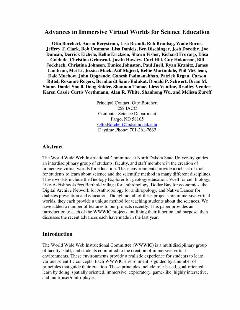
Each WWWIC project provides insight into its own branch of scientific exploration, including geology, cell biology, anthropology, archeology, diabetes prevention, Native American studies, economics, and history. This paper provides a quick overview of each of these projects and how each of them has advanced in recent years. The WWWIC projects that will be covered by this paper include the Geology Explorer, Virtual Cell, Like-A-Fishhook/Fort Berthold village, Dollar Bay, the Digital Archive Network for Anthropology, and Native Dancer projects. We have added a number of features to our projects recently including: advanced client development in both 2-dimensional and 3-dimensional world building, teacher assistance web pages for module development, interactive interview systems for students, and the inclusion of many new modules for teaching students a broader range of topics within each of the virtual worlds. Our 3D worlds provide a LambdaMOO server coupled with a client developed for each particular environment. The clients have been developed mainly in Java and VRML for easy use on the Internet. There has also been much work in the way of module building. It has long been known that the best way to learn a new language is to be immersed in an environment where that language is spoken natively. Our environments harness this hypothesis by immersing students in environments where the language of science, including experimentation and the scientific method are spoken. This paper will provide an insight into our worlds and how they help students and teachers achieve the goal of learning in today’s classrooms. Geology Explorer The Geology Explorer is an immersive virtual environment for geology education. A virtual world has been created, called Planet Oit, where students are given a series of modules and goals implemented to teach important geologic concepts. Students are able to buy standard geology equipment to perform scientific experiments, thus learning how to act like a geologist. Java Client Development Geology Explorer has undergone several important client-side changes in recent months. The most important, but perhaps least visible change is the total conversion from the Java Abstract Windowing Toolkit to Swing. This makes the client code cleaner and more portable to all systems, while providing even more GUI power to the programmer. Last fall also marked the debut of the Interpretive Module in which students must create a simple geologic map of a region. This is possible through the Interpretive Module Map: a single frame that tracks identified rocks in the region and their location as well as allowing the student to paint a geologic map at their own pace. These maps are then
scored against an array of school solutions, accounting for several different interpretations of the geologic features.
Figure 1: SuperDuperMap screenshot
The coming year will see more additions to the client's arsenal of specialized panels (a timeline goal/panel combination is currently nearing completion) as well as a possible jump to a 3D Interpretive Module, explained later in this paper. Also in development is a Java based version of tkMOO, named JTeakMOO. JTeakMOO is a run-anywhere Java applet with a graphical tree browser of all LambdaMOO objects, supported by a small number of server-side verbs..

Figure 2: JTeakMOO screenshot
3D Client Development The Java3D version of the Geology Explorer game provides a new three dimensional, interactive experience for students. By using Java 3D we are able to harness the advantages of that platform. Java 3D accomplishes a high-level, object-oriented view of 3D graphics by using a scene graph-based 3D graphics model. This approach is beneficial for programmers without much graphics or multimedia programming experience to use 3D in their applications. Java 3D hides rendering-pipeline details and does not need to use the Swing system environment, so the final 3D scene graph will not render pane, button, menu, text window, scroll-bar, or other swing components. A large and growing number of 3D loaders are available to import content into the Java 3D runtime. In Java 3D API, a VRML97 file loader and browser is freely available with code. For example, in the Geology Explorer Java 3D program we use a VRML Loader to load large data files into Java 3D and build a complex 3D scenes. The Java 3D API is a hierarchy of Java classes which serve as the interface to a sophisticated three dimensional graphics rendering system. A Java 3D program creates instances of Java 3D objects and places them into a scene graph data structure. The scene graph is an arrangement of 3D objects in a tree structure that completely specifies the content of a virtual universe and how it is to be rendered. For worlds to be both interesting and useful, Interaction is required for students in our virtual world. Java 3D provides both keyboard and mouse navigation that allows the viewer to zoom, rotate and transform in response to user’s actions. A program has been created using these Java 3D functionalities to model a realistic dike terrain. Presently

users are able to fly through the dike scene and at the same time he or she may look at two persons standing on the Dike scene.
Figure 3: Prototype of the Geology Explorer 3D environment
Interactive Interview System The integration and refinement of a Subjective Learner Assessment Support Technology (SLATE) [7] into the Geology Explorer system that will facilitate the assessment of student learning trends resulting from the completion of assigned tasks in the Geology Explorer virtual world, or other active learning environment. This interview based learner assessment support system will help in performing qualitative assessments of the learning and problem solving skills of students. The Geology Explorer virtual world provides a learn-by-doing experience to students and has been built to enhance the learning process of geology students. SLATE assigns a pre-experience and a post-experience problem-solving scenario to a student. Each of these scenarios has a solution and a set of associated questions and answers. The student is allowed to ask natural language questions relevant to the problem in the scenario. The system will search existing questions for semantic similarity and present appropriate matches. After completing the pre-experience scenario using SLATE, the student is asked to complete an assigned task. Following completion of the task, the student will again use SLATE to provide a solution to the post-experience problem-solving scenario. An independent set of graders will compare the student’s responses to the pre-stored scenario-solutions and assign a score.

This assessment will help in measuring and improving the effectiveness of immersive worlds in imparting an understanding of complex science systems. Additional Graphic Additions Besides computer science and geology oriented tasks, the Geology Explorer provides a vast amount of professional quality artwork. The two main projects of our artists are the implementation of the interpretive module and the illustration of a comic book as a graphical help reference. The interpretive module has many elements of visual art. Work on the interpretive module spanned several years and involved in-depth collaboration with the team geologists. The players move through the 2-D renders in the game module, identifying rocks and minerals, and their final goal is to create a geologic map of the entire area. This occurs in the game as a paint program, where the players can virtually paint rock layers on an aerial view map (See Figure 1). Since the data from the testable outcrops in the 2-D landscape can be interpreted in slightly different ways, the 4 geologists with Geology Explorer physically created geologic maps considered as “school solutions.” The group published the “Geology Explorer Version 2.0” game on CD-ROM in the summer of 2002. The game is supplemented by a comic book as a graphical resource, both in digital format on the CD and the Web and in print format. A comic book has been envisioned since the conception of the project—work to make it a reality finally began last winter. The plot revealed in the comic illustrations is a “how to play” manual and the history of the game. The comic creatively depicts the scenario that a Geology Explorer player encounters—a new planet is discovered, and seven student geologists volunteer to explorer it and identify its rocks and minerals. The comic book world has many parallels to the game, introducing players to the appearance of the game interface, the tools they use, the landscapes they visit and the tutors they may encounter. Episode III is in progress, along with a comprehensive help series for on-line viewing where each of the seven comic characters narrates and explains a specific aspect of the game. To visit the Geology Explorer, go to http://oit.ndsu.edu

Figure 4: Planet Oit Comic Cover

Vcell The Virtual Cell project, as the name suggests, has created a virtual cell for cell biology exploration. Players explore the internals of a virtual cell, performing identification and experimentation tasks to learn biological concepts. To visit the Virtual Cell go to http://vcell.ndsu.edu Module Development The electron transport chain module has undergone a considerable revision. The students learn the ETC principle step by step through playing the game that simulates experiments. There are four levels in the new ETC module. Level 0. Establishing an electron transport chain
• In this level, students will establish a functional ETC by putting components into their proper positions.
Level 1. Artificial H+ ion pump. • In this level, with the help of the artificial H+ Pump, students will see how an H+
gradient and the ATP Synthase complex work together to make ATP. Level 2. Interactive ETC Demonstration
• This level demonstrates the different events that occur once different substrates are added to the ETC system.
Level 3. Damaged ETC • In this level, students use the knowledge they have learned previously to diagnose
four damaged ETC systems. Once students feel they have figured out which component is damaged in each system, they need to replace it with a new functional component to the system to testify their assumptions.
Tutoring Advances During the past year, the Vcell tutor in the first module, the Identification of Organelles has been refined. Previous work and design was done by Ganesh Padmanabhan whose work was based on the structure of Geology Explorer tutoring system.. After modifications of the first module, the tutors were expanded to teach the second module the Electron Transport Chain module explained earlier as well. Since the design in the Vcell tutor was modular, it was trivial to use the basic structure and modify it to fit the ETC levels. Currently, there is work being done on a simulation for the Lac Operon for future purposes of Lac Operon module.

Like-A-Fishhook/Fort Berthold village We are developing an Internet-hosted immersive virtual environment that teaches the methods and logic of archaeology at an introductory level. This environment will be a “learn by doing” simulation based on a 3D reconstruction of the archeologically important Like-a-Fishhook Village/Fort Berthold site in central North Dakota that was flooded in the 1950s as a result of the Garrison Dam. Over the past two years, we have been working to re-create, in virtual space, the Like-A-Fishhook/Fort Berthold site in as accurately a manner as possible. In doing the virtual reconstruction, we are sensitive and respectful to the native culture that we are depicting, but we have taken some artistic license when re-producing the objects and structures that would have been found at the site in the 19th century. The Three Affiliated Tribes of North Dakota—the Mandan, Arikara and Hidatsa—who are descendants of the site occupants, have been supportive of our efforts to create this virtual world. We currently have several aspects of the village modeled. The vernacular architecture, called earth lodges, has been built using Alias/Wavefront’s Maya software. Also, many of the artifacts, such as tools, pottery, clothing, beds, baskets, and weapons, have been modeled using the same software. The aforementioned objects populate the interior space of the lodges as well as village grounds surrounding them. Dollar Bay In the Dollar Bay virtual environment, students are placed in charge of a virtual store. In running this store, students are exposed to economy and retail business strategies. In order to maximize the learning potential of each individual student, an ideal environment needs to provide customized lessons to that student based on his or her individual performance. One method to address this requirement is the use of case-based reasoning which is used to monitor student performance, track progress throughout an environment, compare the student to other students in the same environment, and create customized tutor dialogs to communicate this information to the student in the form of individual tutor lessons. An example of case-based lesson building software that meets the above requirements can be observed in the current DollarBay retailing environment at NDSU (6). Although several of the virtual education environments at NDSU provide tutoring functionality to students, none had implemented a completely functional case-based system except DollarBay. This system provides complete analysis of student behavior based on selected attributes and a message delivery mechanism. This system provides the means to generate personalized lessons for each student participating in the DollarBay environment. In addition, it provides a framework that may be used to implement similar functionality in the other virtual education environments at NDSU with a minimum of coding. For further information on Dollar Bay, see Jessica Mack’s paper in these proceedings.

Digital Archive Network for Anthropology (DANA) Since last reported at the MICS 2001 conference, the Digital Archive Network for Anthropology (DANA) has been upgraded considerably. These include a new project web site and expanded project name, an improved client (end-user) and Web interface, a broader range of search capabilities, incorporation of a new 2D image viewer and 3D model viewer with enhanced measurement tools and options for changing background, new archaeological content (text and multimedia) from Polynesia (Samoan stone, coral, and shell tools), Melanesia (Fijian ceramics and stone tools), India (ceramics typology), and North Dakota, USA (Mandan, Hidatsa, and Arikara material culture from Like-A-Fishhook Village and Fort Berthold archaeological site complex and archaic projectile points from the Rustad Site), new collaborations, and the participation of DANA in the National Science Foundation’s National SMETE (Science, Mathematics, Engineering, and Technology for Education) Digital Library (NSDL) program. Background Update: The DANA project was first initiated in 1999 by a multidisciplinary team of archaeologists, anthropologists, and computer scientists at the Archaeology Technologies Laboratory (ATL), North Dakota State University (NDSU). The project team has reported on DANA project activities in various publications and conferences in the US, Europe, and India [1, 2, 3, 4, 5]. DANA is a distributed server-client network that connects remote database/multimedia archives systems from around the globe, providing Internet access to a range of anthropological and cultural heritage resources. In the fall of 2001, major funding for DANA was provided by the National Science Foundation’s (NSF), National Science, Mathematics, Engineering, Technology for Education Digital Libraries (NSDL) program. DANA is a model digital library collection for anthropology and world cultural heritage. . Upgrades to DANA: A new web site entitled, The Digital Archive Network for Anthropology and World Heritage (DANA-WH) has been established (see http://www.dana-wh.net). The new web site and project name have been established to better serve the broader anthropology and cultural heritage community, and to address concerns by potential collaborators at other institutions regarding the seemingly proprietary aspect of the DANA access point through the NDSU domain (http://atl.ndsu.edu/archive). By establishing a .net domain, the team hopes to attract new collaborators from a wider variety of fields within the world heritage community, such as cultural heritage resources management, history and classics (e.g., classical archaeology and western history), world prehistory, paleoanthropology and the related fields of biological anthropology and paleontology. Effective March 31, 2003, the DANA-WH web site and the DANA-WH Java Client are also accessible through the NSDL web portal (visit http://nsdl.org).

A new 2D viewer has been built into the Java client. The new viewer provides multiple 2D image views of artifacts with metric scales, and where appropriate, scientific drawings of the objects. For example, six views of each Samoan stone or shell adze (individual views of front, back, both side profiles, cutting edge, and poll)., both interior and exterior views of decorated and undecorated pottery sherds from Fiji, and pottery profiles of ceramic types from India are now displayed in the DANA client. Although not implemented yet, the 2D image viewer will soon also have measurement tools. A new 3D model viewer has been added to the Java client. The new viewer has expanded capabilities and tools. In addition to viewing and using virtual calipers for accurately measuring the 3D models of artifacts, end-users can record still image screenshot (JPEG format) views of the objects, including the plot points for the measurements taken by researchers. These images can be saved to a local hard drive to maintain a record of the location of measurement plot points, and can be emailed to colleagues for further study. New search capabilities have been added to the DANA client. End-users may now search by geographical/geo-political location, by Site_Code (Site_Name), by Material_Class, Material_Type, Artifact_Class, and Artifact_Type. Use of the Extensible Markup Language (XML) facilitates faster search and retrieval of data. XML is used to archive and display the associated metadata for 2D images and 3D models in the archive. An expanded range of Samoan stone and shell adzes has been added through collaboration with the Cultural Resources Division, Bishop Museum, Honolulu. Additional Native American (Mandan, Hidatsa, and Arikara) and Euro-American (Fur Traders and Trappers) artifacts from the Like-A-Fishhook Village and Fort Berthold archaeological site, North Dakota are included through collaboration with the State Historical Society and Heritage Center Museum in Bismarck, ND. A typological inventory of pottery profiles from India has been added in collaboration with Dr. Vinod Nautiyal, HNB Garhwal University, Srinigar, India. An archaic projectile point archive, based on a small assemblage from the Rustad Site, North Dakota, developed in collaboration with Dr. Michael Michlovic, University of Minnesota, Moorhead, MN, has been added. In addition, a small selection of Paleolithic materials (e.g., acheulean handaxes), and Paleoindian projectile points (Clovis and Fulsom points) have been added. Summary: The new enhancements (web site, expanded name and target audience, additional content and collaborations) exemplify the real and future potential benefits available to scholarly researchers, faculty, students and the general public (e.g., life-long learners) through DANA-WH. Persons interested in participation in the DANA-WH project are invited to contact the authors.
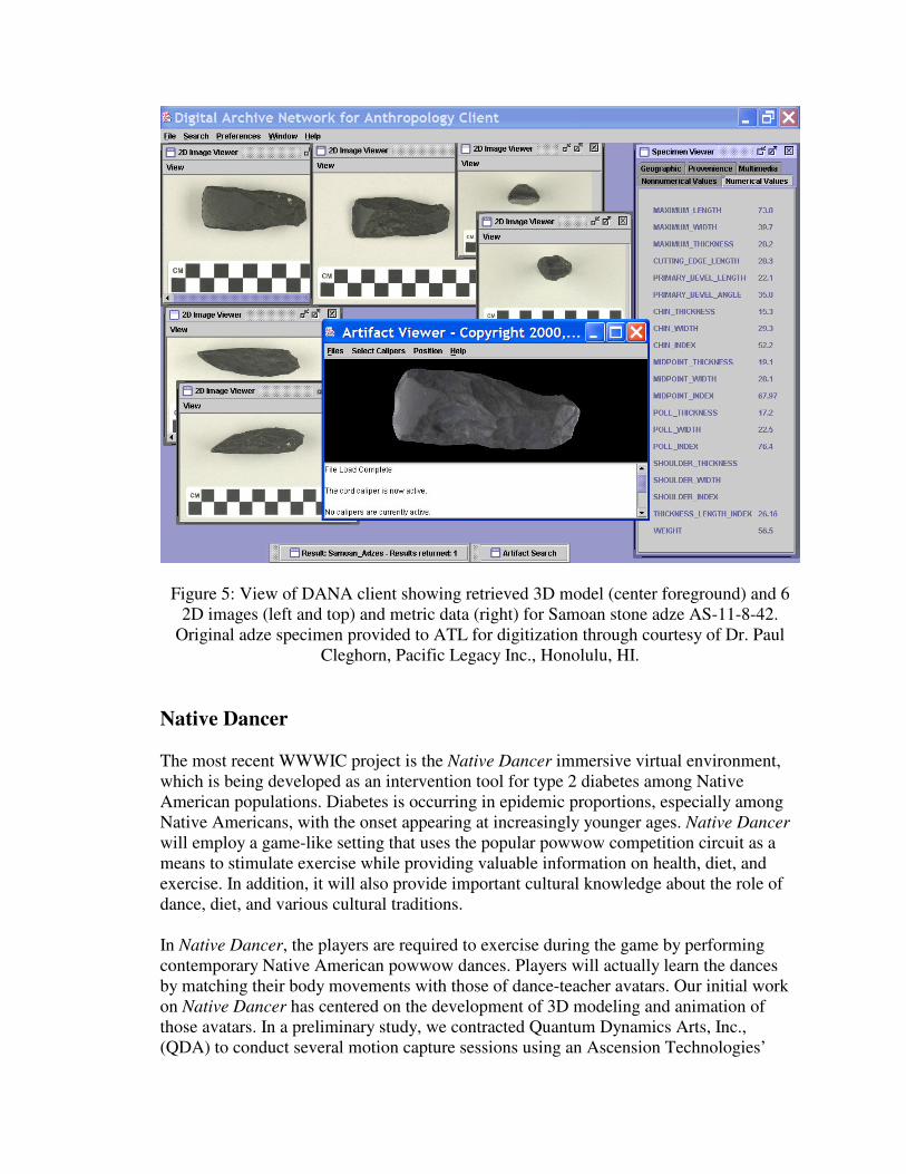
Figure 5: View of DANA client showing retrieved 3D model (center foreground) and 6 2D images (left and top) and metric data (right) for Samoan stone adze AS-11-8-42.
Original adze specimen provided to ATL for digitization through courtesy of Dr. Paul Cleghorn, Pacific Legacy Inc., Honolulu, HI.
Native Dancer The most recent WWWIC project is the Native Dancer immersive virtual environment, which is being developed as an intervention tool for type 2 diabetes among Native American populations. Diabetes is occurring in epidemic proportions, especially among Native Americans, with the onset appearing at increasingly younger ages. Native Dancer will employ a game-like setting that uses the popular powwow competition circuit as a means to stimulate exercise while providing valuable information on health, diet, and exercise. In addition, it will also provide important cultural knowledge about the role of dance, diet, and various cultural traditions. In Native Dancer, the players are required to exercise during the game by performing contemporary Native American powwow dances. Players will actually learn the dances by matching their body movements with those of dance-teacher avatars. Our initial work on Native Dancer has centered on the development of 3D modeling and animation of those avatars. In a preliminary study, we contracted Quantum Dynamics Arts, Inc., (QDA) to conduct several motion capture sessions using an Ascension Technologies’

Gypsy 3 tethered, magnetic suit to capture baseline bio-mechanical dance movements of professional dancers. These digital motion data were mapped onto 3D dancer models created by artists to create an experimental 3D dance animation. Anomalies were discovered in this first-round of motion-capture dancers, but we believe that we can address the problems in future efforts through the use of an optical motion capture system. Associated with this research and development project will be a detailed study of the actual physiological benefits of the dance-based exercise. Consequently, we are involving MDs, nurses, exercise physiologists, and others in the total project. We are also working closely with the White Earth Reservation Tribal Council (WERTC) of Minnesota to make the game culturally sensitive and engaging to the Native American youth, while still providing valuable health-related information.
Figure 6: Native Dancer Screenshot
Conclusion The World Wide Web Instructional Committee was created to build a number of virtual worlds for science education. Over the past year, many strides have been made to increase the effectiveness of these worlds, including new modules, new delivery paradigms, and new tutoring strategies. These advances will set the stage for new and exciting developments that will extend the virtual world experience for many students for years to come.

Acknowledgements We would like to thank the National Science Foundation and the US Department of Education FIPSE program for their continued support of the various WWWIC programs. References: [1] Clark, J. T., A. Bergstrom, J. Landrum, III, F. Larson, and B. Slator. (2002). Digital
Archiving Network for Anthropology. In Virtual Archaeology Proceedings of the VAST Euroconference. Arezzo, 24-25 November 2000. Edited by F. Niccolucci. Oxford: British Anthropological Records (BAR) International Series 1075. Pp. 71-76.
[2] Clark, Jeffrey T, Brian M. Slator, William Perrizo, James E. Landrum, III, Richard F Frovarp, Aaron Bergstrom, Sanjay Ramaswamy and William Jockheck. (2002). Digital Archive Network for Anthropology. In Journal of Digital Information, Volume 4 Issue 2. Special Issue on Interactivity in Digital Libraries. ISSN 1368- 7506 May 2002. British Computer Society and Oxford University Press. http://jodi.ecs.soton.ac.uk/Articles/v02/i04/Clark/.
[3] Clark, J. T., Brian M. Slator, Aaron Bergstrom, Francis Larson, Richard Frovarp, James E. Landrum III, William Perrizo, William Jockheck. (2002). DANA (Digital Archive Network for Anthropology): A Model For Digital Archiving. Pp. 483-87 In Symposium on Applied Computing, at the 17th Association of Computing Machinery Conference, Mar. 10-14, 2002, Madrid, Spain.
[4] Clark, J. T., Brian M. Slator, Aaron Bergstrom, Francis Larson, Richard Frovarp, James E. Landrum III, William Perrizo. (2001). “Preservation and Access of Cultural Heritage Objects Through a Digital Archive Network for Anthropology.” Pp. 28-36 In Proceedings of the 7th International Conference on Virtual Systems and MultiMedia, in Berkeley California, USA, 25-27 October 2001. IEEE. Computer Society: Los Alamitos, California.
[5] Borchert, Otto, A. Bergstrom, J. Hockemeyer, J. Clark, P. Juell, P. McClean, B. S Saini-Eidukat, D. P. Schwert, B. M. Slator, A. R. White, C. Hill, J. Bauer, F. Larson, B. Vender, B. Bandli, B. Chen, M. Dean, R. Frovarp, G. Hokanson, C. Johnson, J. Kittleson, N. Kruger, J. Landrum, M. Li, B. Nichols, J. Opgrande, R. Potter, P. Regan, L-O. Teo, A. Tokhi, S. Tomac, J. Turnbull, J. Willenbring, Q. Xioo, X. Ye, M. Zuroff. (2001, Apr). “Recent Advances in Immersive Virtual W Worlds For Education.” In Proceedings of the 34th Annual Midwest Instruction and Computing Symposium (MICS-01), Cedar Falls, IA. April 5-7. (Refereed Proceedings)
[6] Regan, Patrick M. and Brian M. Slator (2002, Oct). Case-based Tutoring in Virtual Education Environments. ACM Collaborative Virtual Environments. Bonn, Germany

[7] Majeed, Atif, M.S. (2002). Subjective Learner Assessment Support Technology. Department of Computer Science and Operations Research, College of Science and Mathematics, North Dakota State University, June 2002.