advances in applications and methodology for aerial
TRANSCRIPT
1
Advances in Applications and Methodology for Aerial
Infrared Thermography
Gregory R. Stockton AITscan (Aerial Infrared Thermographers)
A division of Stockton Infrared Thermographic Services, Inc.
8472 Adams Farm Road Randleman, NC 27317
(800) AIT-SCAN Cell Phone: (336) 689-3658
http://www.AITscan.com
Abstract Aerial infrared applications can be divided into two types; those where a straight-down view and/or a large area view is needed and those where long distances must be covered in a limited amount of time. Selection of aircraft, aircrew, navigational aids, infrared imaging system, data acquisition and image processing system are all important to a successful survey. This paper discusses the ongoing advances in methodology, platform and equipment required to produce high quality usable data for the end-user.
Author Biography
Gregory R. Stockton is President of Stockton Infrared Thermographic Services, Inc. The company’s AITscan (Aerial Infrared Thermographers) division operates nine fixed-wing aircraft and one rotor-wing aircraft, performing many different aerial infrared services in the US, Canada, Central and South America. Greg has twenty-four years experience in the construction industry, specializing in facilities construction, maintenance and energy-related technologies. He has been performing infrared surveys since 1989.

2
Keywords Aerial, infrared, thermography, environmental impact, pollution, stormwater, animal counts, geothermal, forest fires, subsurface fires, structural fires, landfill fires, peat, coal and wood chip piles, Indian trails, high voltage electrical transmission lines, high voltage electrical distribution lines, pipelines, search and rescue (SAR), roof moisture surveys, steam lines, high temperature hot water system (HTHW), computer aided design & drafting (CADD), global positioning system (GPS), geographical information system (GIS).
Introduction Aerial Infrared (IR) Thermography has its roots in military applications. Almost all aerial IR is performed by the military, but there are many commercial uses. These non-military applications are the focus of this paper. In order to produce an easy to understand, high quality and useable report, the data must be acquired, recorded and processed in an efficient and e ffective way. The farther away one can get from the subject of an infrared survey, while maintaining the needed spatial resolution and thermal sensitivity, the more usable the data. This is the aerial advantage.
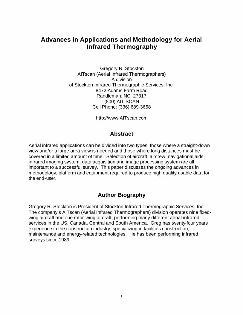
Equipment & Crew Both helicopters and light airplanes can be used to perform aerial infrared surveys. A helicopter is best used if the number of targets or distance between targets is low because there are inherent problems with vibrations, slower ferry speeds and higher operating costs. These problems can be offset by being able to use relatively inexpensive small format (~65,000 pixels) focal plane array imagers. If a light airplane is used, the imager must have a higher spatial resolution (~262,000 pixels or more), because it must operate at higher altitudes and therefore farther away from the target, allowing the same resolution from four times the distance. The advantage of using a large format imager is that the field of view (FOV) is larger, making report preparation much easier and the report product superior. Larger lenses can improve the needed ground resolution element (GRE), or the size of one pixel on the ground, if some signal strength degradation is acceptable, but the FOV suffers as a result. One might mosaic or ‘paste’ many images together but this is very labor-intensive and often cannot be accomplished without greatly distorting the imagery. It is always better to have more pixels. It is nearly impossible to get professional results with hand-held imagers. The imager should be fixed-mounted solid (see Figure 1), turret-mounted or fixed-manually articulated. In any case, a well maintained aircraft, experienced aircrew and an imager capable of the resolution required for the intended task should be used.
3
Figure 1) Large format infrared imager, fixed-mounted.
The type of infrared imager used will dictate how images are recorded and saved. Modern infrared cameras have a variety of storage media, but must be within reach and/or have remote controls so that the camera can be moved, lenses adjusted and the images stored. Since the pilot and thermographer are extremely busy during the flight, one or both may not see every possible anomaly, so no matter what type of imager or storage medium, a videotaped record of all the ‘raw’ infrared imaging should always be made. Precise navigation is important in any aircraft, and particularly so in nighttime aerial infrared operations. A global positioning system (GPS) is a necessity. Combining the GPS with a mobile mapping program on a computer and a video encoder-decoder (VED) is very useful, especially when multiple targets need to be imaged. The VED encodes the videotape with a continuous stream of GPS derived data (latitude/ longitude, altitude, date, time and speed, etc.) and displays the information through the video signal (see Figure 2). All equipment in the aircraft must be secured with wires labeled, shielded from electromagnetic interference and out of the way.

4
Figure 2) Video encoder-decoder (VED) annotation guide.
Most aerial infrared imaging is performed at night because reflected and direct daylight solar radiation usually adversely affects the imagery. Nighttime infrared imaging is NOT a job for amateur pilots or airsick-prone infrared equipment operators. The professional pilot should be specifically trained and experienced in aerial IR operations. He/she will be flying low, slow and maneuvering without much room for recovery...in the dark. Upon returning from the mission, the report must be prepared. The office equipment needed to analyze imagery and produce reports is the same as that used by ground-based infrared thermographers. This includes a computer workstation complete with digital photographic and thermographic imaging peripherals for handling infrared images, daylight photographs and capable of producing high quality reports in a popular format. Also needed are specialized video capture, image processing, computer aided design & drafting (CADD) software and mapping software necessary for producing drawings and specialized parts of the final report product. A high quality printer is required for printing the report with photographic quality.
5
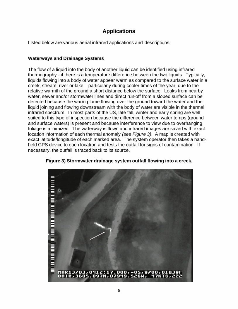
Applications Listed below are various aerial infrared applications and descriptions. Waterways and Drainage Systems The flow of a liquid into the body of another liquid can be identified using infrared thermography - if there is a temperature difference between the two liquids. Typically, liquids flowing into a body of water appear warm as compared to the surface water in a creek, stream, river or lake – particularly during cooler times of the year, due to the relative warmth of the ground a short distance below the surface. Leaks from nearby water, sewer and/or stormwater lines and direct run-off from a sloped surface can be detected because the warm plume flowing over the ground toward the water and the liquid joining and flowing downstream with the body of water are visible in the thermal infrared spectrum. In most parts of the US, late fall, winter and early spring are well suited to this type of inspection because the difference between water temps (ground and surface waters) is present and because interference to view due to overhanging foliage is minimized. The waterway is flown and infrared images are saved with exact location information of each thermal anomaly (see Figure 3). A map is created with exact latitude/longitude of each marked area. The system operator then takes a hand-held GPS device to each location and tests the outfall for signs of contamination. If necessary, the outfall is traced back to its source.
Figure 3) Stormwater drainage system outfall flowing into a creek.

6
Aerial IR can also be used to detect illegal dumping and/or discharges, track pollution such as waste spills or oil spills, monitor sewage treatment plant discharges, manage heated water from power plant cooling towers, monitor ground water seepage into rivers, streams and lakes and measure the amount of fresh water from ground sources that are introduced into an estuary. Animal Census Many warm-blooded animals can be found and counted from the air. Aerial IR is far more accurate than any other method and primarily used by government agencies. Animals such as deer (see Figure 4), moose and large migratory birds are among the most popular counted. Population density information is used to monitor and control the population of these animals on city, county, state and federal lands.
Figure 4) Deer in a forested area - three in one group (left and slightly below image center) and two in another group (right bottom edge).
Geothermal

7
When a road or building complex is planned, the site can be flown over with aerial IR to determine if any geothermal activity is present at the surface. This allows the planner to route the road around the activity or decide the site is unsuitable for the intended purpose. Pipes and Pipelines Pipes and pipelines are usually difficult to survey. Trees, shrubs, brush, water and man-made structures like bridges, roads, sidewalks and buildings often cover pipes. If a liquid is leaking from a pipe and the location of the leak is unknown, an aerial IR survey can be used to find the leak. Even if the pipe itself cannot be seen on the surface, it may be possible to see the leaking liquid and narrow the search to a relatively small area. The best results are found when the pipe is not buried deeply, has a high flow and when the difference in temperature between the liquid and the ground above is high. We have flown over known leaks on natural gas pipelines and not been able to measure any temperature difference on the pipe or the surrounding surfaces. Usually, color IR (CIR) and not thermal IR is more effective. CIR is used to look at the damage to vegetation around the natural gas pipeline leak. Forest Fires The U.S. Forest Service uses aerial infrared imaging to monitor forest fires. Very accurate mosaic infrared maps o f active fires can be made to help with fire management and suppression efforts. This information can be sent immediately to those in charge of controlling fire lines. Thermal intensity is resolved to classify the hottest sections of the active fire, therefore pinpointing the areas of most intense thermal energy. These digital aerial maps are loaded to hand-held GPS devices to enable ground teams to navigate directly to the hot spots rapidly, either by walking, driving or flying in a helicopter. Thermal IR provides an important visual reference locator by identifying the hot spots with respect to terrain features in the thermal imagery. Positive identification of hot spots is rapid even through dense smoke. Structural Fires Aerial infrared can be helpful to the firefighters of structural fires especially on large, single story buildings. Often the smoke escapes the building from a different location than the hottest part of the fire. These areas can be imaged and the firefighters informed as to the location of the hottest areas.
8
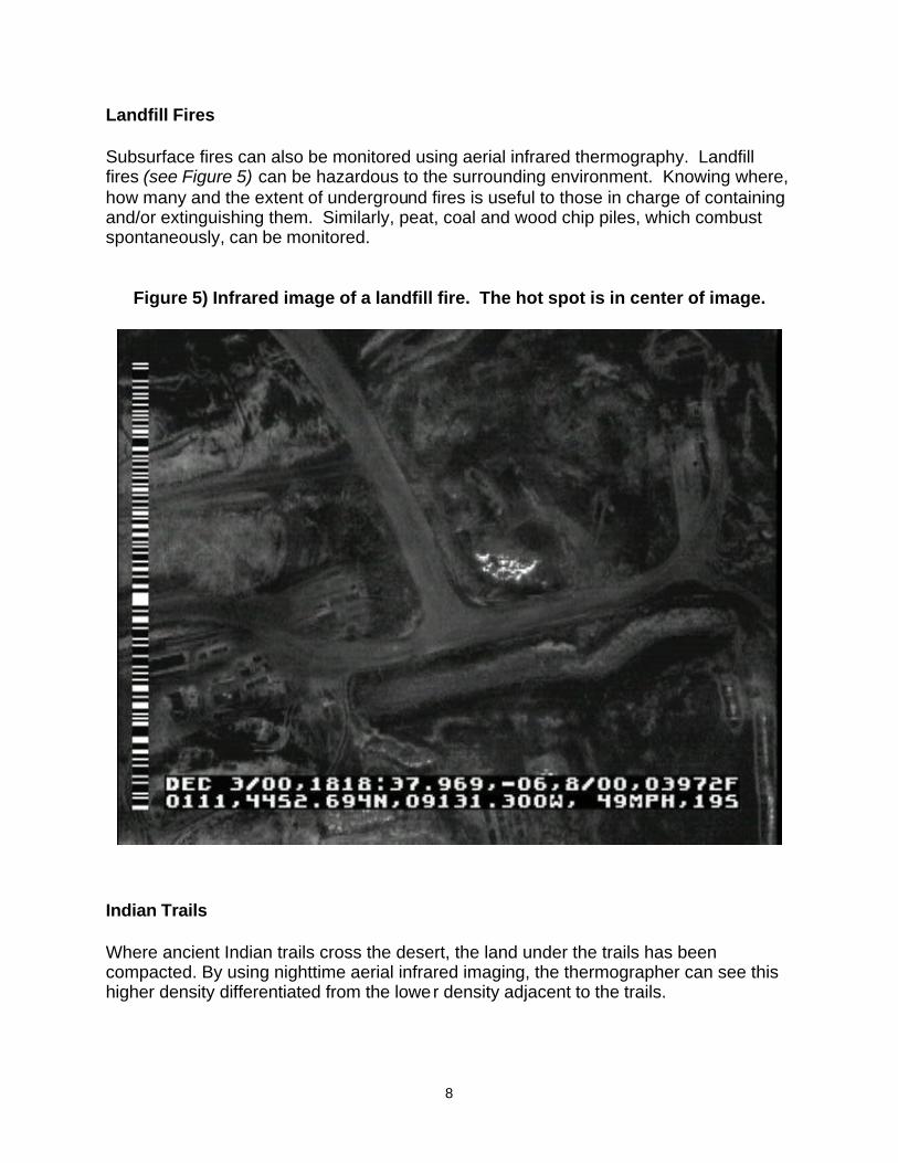
Landfill Fires Subsurface fires can also be monitored using aerial infrared thermography. Landfill fires (see Figure 5) can be hazardous to the surrounding environment. Knowing where, how many and the extent of underground fires is useful to those in charge of containing and/or extinguishing them. Similarly, peat, coal and wood chip piles, which combust spontaneously, can be monitored.
Figure 5) Infrared image of a landfill fire. The hot spot is in center of image.
Indian Trails Where ancient Indian trails cross the desert, the land under the trails has been compacted. By using nighttime aerial infrared imaging, the thermographer can see this higher density differentiated from the lower density adjacent to the trails.

9
Search and Rescue (SAR) SAR operations are often ‘rush’ jobs where conditions are less than ideal. Aerial infrared SAR is better than ground-based SAR in most instances, however it is still very overrated. People targets either do not want to be seen, are disabled and unable to move to an area where they can be seen, or are trying to keep the warmth of their body close by insulating themselves, so they cannot be seen. Steam and High Temperature Hot Water (HTHW) Systems Commonly referred to as district heating systems, steam (see Figure 6) and HTHW systems can be imaged to find leaks and other thermal anomalies. Even from high altitudes, steam line inspections are one of the easiest applications for the aerial infrared thermographer. Thermal contrast between active underground steam lines (especially leaks) and the surrounding ground are usually good. HTHW loops, while not as brilliant as steam systems, can be flown in the same manner. Sometimes leaks appear as cool spots because the water has come to the surface and is being cooled by evaporation. In both cases, the systems can be flown and problem areas pinpointed and documented. Along with other data sets, geographical information system (GIS) maps can be produced for the system operator.
Figure 6) Infrared image of a university steam system. A leak is evident slightly above the center of the image.
10
High Voltage Electric Utility Transmission and Distribution Lines Detecting electrical faults on high voltage electrical transmission lines is fairly easy and can be accomplished rapidly from a light aircraft. However, even from short distances, accurate temperatures of electrical faults are impossible to measure (quantify). There are several problems associated with temperature measurement from the air. These include spot size to target distance ratios, reflection of the objects surveyed, and having a sufficient load on the line at the time of the survey, among others. The spot size to target distance ratio is the number one problem with respect to temperature measurement. Specification writers have not yet realized the seriousness of this problem and continue to ask for quantitative data on fault areas. The fact is that infrared cameras in general commercial use today cannot measure accurate temperatures on small objects from distances of 50 feet...much less from reliably safe flying distances. A one-inch (relative size of a transmission line splice) target cannot be measured from that distance, plain and simple, although it can be detected. These spot sizes are unmanageable and inaccurate on any target that does not have a large homogeneous heat signature. The GRE is critical to the measure of spatial resolution in aerial infrared thermography. Nyquist's frequency theorem states that an object less than two times the size of a sensor's GRE cannot be resolved for measurement, so a 3x3 pixel or GRE spot is needed for reliably obtaining measurements. This shortcoming may be addressed by using a more powerful lens to reduce the GRE for a given distance, but then the sensor's FOV is reduced, limiting the area covered over a given period of time. So, if one is using a small format IR camera (256 x 256 pixels) in a helicopter only 50 feet away from a 1 inch hot spot, it is impossible to obtain accurate temperatures using a standard lens. The smallest hot spot that could be accurately measured with one of these imagers is over 2", even at that extremely short distance. Also, from the air, using a more powerful lens does not work well because vibration is more evident in the form of image 'shaking'. Image 'smearing' may also occur due to an increase in the apparent speed of the sensor's view across the ground. In the air, there are few substitutes for a large pixel array, but even using large format detectors, one cannot and should not profess to measure temperatures on very small objects. These anomalies can be seen, and by comparing them to similarly loaded phases or equipment, potential problem areas can be identified, saved and marked on a map. For ‘good’ measurements, a ground verification team should be used to inspect suspect hot spots from the ground (cloudy nights are best) and verify the findings of the aerial IR survey. They will be closer to the target and with a powerful lens on a stable surface, much more accurate. Because they are smaller, lower to the ground and often run through populated areas, high voltage electrical distribution lines are much more difficult to see against all the thermal clutter on the ground such as trees, street lights, people, animals, etc., than transmission lines. Therefore, they are best left to ground-based infrared thermographers.

11
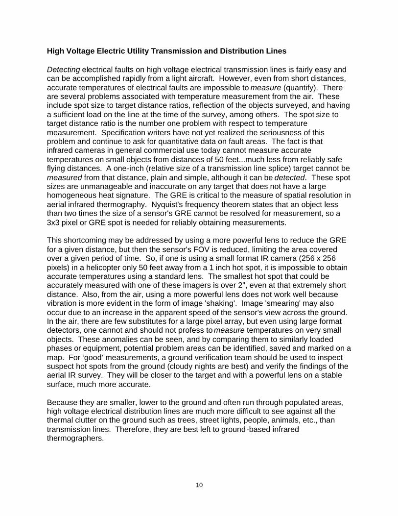
Roof Moisture Surveys No other application better illustrates the advantage of aerial infrared thermography over ground-based infrared, than infrared roof moisture surveys. Regularly scheduled infrared surveys quantify areas of moisture (water) contamination in insulated flat or low-sloped building roofs (see Figure 7). This helps the building owner assess the roof’s general condition at all stages of its service life and make repair decisions based on actual data instead of biased opinions. Straight down aerial imagery is much more useful to the owner than on-roof imagery because aerial infrared images are plan view and because large areas can be seen in one image, allowing the slightest temperature differences to be noted. Aerial is the best platform for performing infrared roof moisture surveys for these reasons:
• Straight down, high-resolution aerial imagery captures large areas at once, making the report easier (less expensive) to produce, while lessening reflection and perspective problems and eliminating all of on-roof infrared’s logistical evils, such as access to multiple levels and dealing with security, manpower and safety issues.
• The data collection process is fast. Aerial infrared thermographers can survey many roofs in one night while conditions are very good. Processing the data is done not in a hurry at night on a roof, but under comfortable conditions at a consistent pace in an office setting.
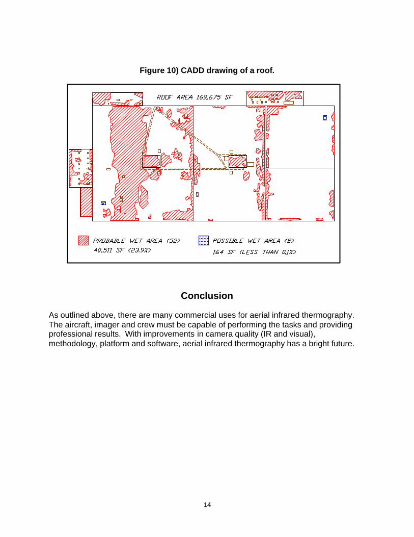
• Plan view imaging allows for the precise, accurate marking of areas of suspect roof moisture contamination. Infrared images, visual images and AutoCAD™ drawings (see Figures 8, 9, 10) can be reconciled closely, making the report accurate, clear, concise and easy to understand. AutoCAD™ drawings are made by ‘drawing over’ the captured visual and infrared images. The infrared, visual and AutoCAD™ components can then be separated. Accurate scaled drawings of roof moisture allow the owner to produce a bid document so that surgical removal of wet insulation and repairs can be accomplished.
• The report can be provided at various levels of completeness, detail and complexity. These different levels are unedited videotape, edited videotape, printed thermographs, aerial photographs, AutoCAD™ drawings, database creation, or any combination. The buyer has the advantage of obtaining any one or all of these report components, with the costs determined by the report level needed.
• Trending roof infrared imagery is only possible using aerial imagery. Proportional images can be digitally overlaid and compared to future surveys of the same roof at a later date. Drawings are easily updated with the new data.
12
Figure 7) Illustration of how roof moisture is detected using infrared thermography.
Perhaps the biggest advantage of aerial infrared is not its use on roofs that have well-defined areas of moisture at all, but on those roofs that are the most difficult to image from any distance or angle. I am referring to the roofs that, for instance, have a lot of ballast, are covered with reflective coatings, have multiple layers or that for whatever reason are impossible to image while standing on the roof. With high-resolution aerial imagery, slight nuances of temperature differences can be seen from far enough away to actually trace the patterns of heat. There are two advantages to on-roof infrared. First, it can be cost-prohibitive to fly a small roof far away from the aerial infrared thermographer’s operational area. Second, since on-roof verification does have to take place at some point by a qualified professional, if a roof consultant is on the roof with the thermographer and helper on the night of the survey, areas that exhibit suspect heat patterns can be tested right then, so that only verified wet areas are marked. In the United States, for many different reasons, roofers and roof consultants – not infrared thermographers, perform most of the on-roof infrared surveys.

13
Figure 8) Visual photograph of a roof.
Figure 9) Infrared thermograph of a roof.
14
Figure 10) CADD drawing of a roof.
Conclusion As outlined above, there are many commercial uses for aerial infrared thermography. The aircraft, imager and crew must be capable of performing the tasks and providing professional results. With improvements in camera quality (IR and visual), methodology, platform and software, aerial infrared thermography has a bright future.