adopted may 2006 1 - medway.gov.uk · 2.0 methodology 6 ... • as a manual of information and...
TRANSCRIPT

Adopted May 2006 1

Adopted May 2006 2

Adopted May 2006 3
1.0 Introduction 4 2.0 Methodology 6 3.0 Urban Environment – Regeneration Areas 7 The Central Core 9
University and College Quarter 11 Waterfront Communities 14 Urban Environment – Conservation Areas 15
4.0 Transport and Movement 17 5.0 Topography 18 6.0 Open Space - Green Spaces 19 7.0 Visual Analysis 21
8.0 Locations suitable for higher buildings 23
Strood Centre 26
Strood Riverside 27 Strood Waterfront 30 The Esplanade 31 Historic Rochester 32
Rochester Riverside 33 Star Hill to Sun Pier 35 Chatham Centre & Waterfront 36 Upper & Lower Upnor 40 Chatham Historic Dockyard 41 Chatham Maritime 43 Brompton, Fort Amherst & The Lines 45 Chatham Port 46 Gillingham Waterfront 47
Appendix A Strategic Views - see separate document
Contents

Adopted May 2006 4
Introduction 1.1 Part 1 of ‘A Building Height Policy for Medway’ contains general guidance on the design
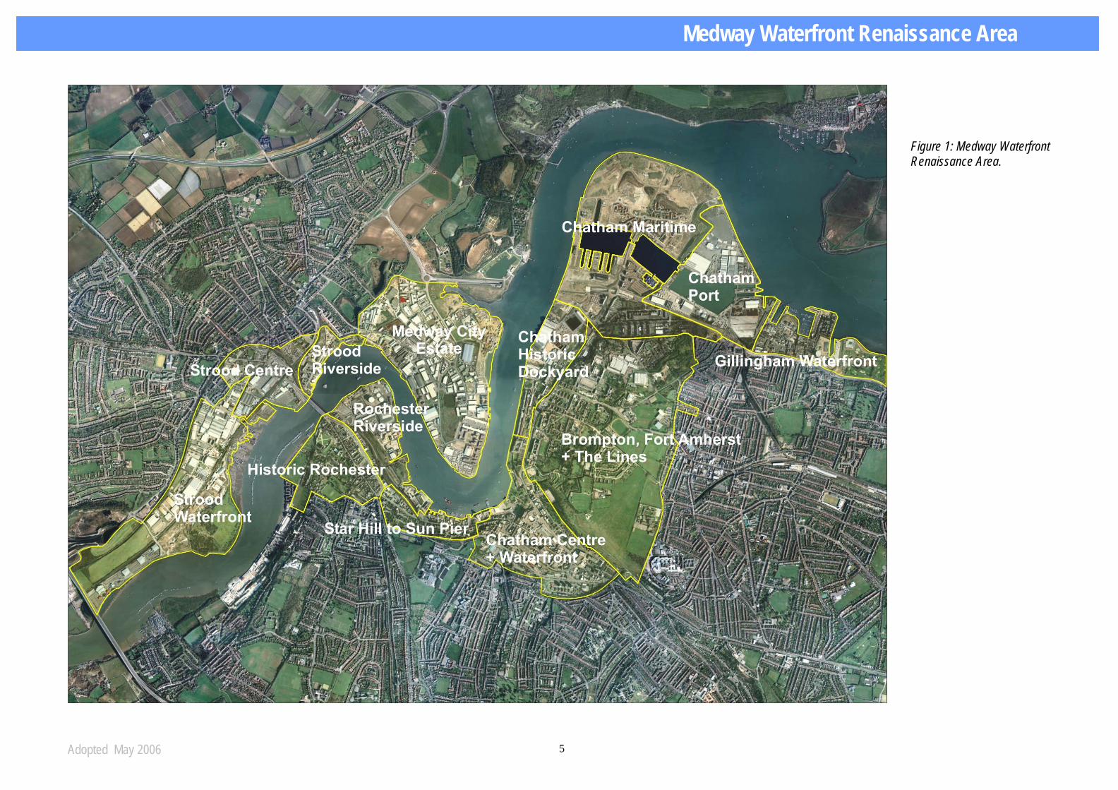
and location of high buildings within Medway. This document, Part Two of ‘A Building Height Policy for Medway’, contains specific guidance on appropriate locations for higher buildings within the Medway Waterfront Renaissance Strategy area (figure 1). This is where the major centres and regeneration sites are located and is the area that will see the most change over the next few years. It identifies:
• areas where higher buildings (6 storeys or over) will not be encouraged
• selected parts of the following areas as defined by Medway Waterfront Renaissance
Strategy where the Council will encourage the provision of higher buildings:
- Strood Centre - Strood Riverside - Rochester Riverside - Chatham Centre and Waterfront - Rochester Riverside - Chatham Maritime - Gillingham Pier
1.2 The above does not necessarily mean that higher buildings are precluded elsewhere within
the waterfront area. However, the onus will be on the promoters of higher building proposals to prove that higher buildings are appropriate in other locations and to prove adherence to the guidance in part 1 of this document.
1.3 This document should be used in two ways:
• To provide an initial indication of the acceptability of higher buildings (6 storeys, 20m, or greater in height) within each part of the Medway Waterfront regeneration area;
• As a manual of information and advice on the key criteria of urban environment, existing character, transport, topography, open space and key views. Designers are required to use the information on these aspects to shape and inform their development proposals.
1.4 Part 2 concludes with outline urban design guidance for specific areas identified as suitable for higher
buildings.
1.5 Developers and designers who want a quick overview of potential locations for higher buildings should turn to Section 8 of this document.
A Building Height Policy for Medway- Part 2
Introduction
Adopted May 2006 5
Figure 1: Medway Waterfront Renaissance Area.
Medway Waterfront Renaissance Area
Adopted May 2006 6
Urban environment
Character areas
(Conservation and Regeneration areas)
Transport
Topography
Open space
Visual analysis
Opportunities and
constraints (summary tables)
Appropriate locations for
higher buildings
Vision for Medway
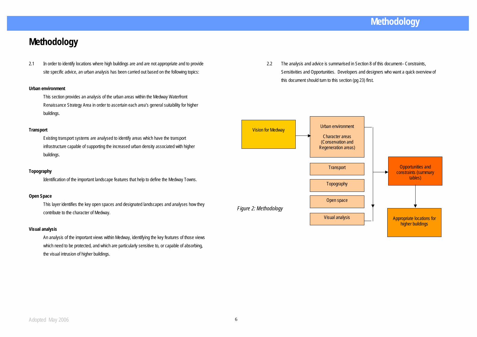
Methodology 2.1 In order to identify locations where high buildings are and are not appropriate and to provide
site specific advice, an urban analysis has been carried out based on the following topics: Urban environment
This section provides an analysis of the urban areas within the Medway Waterfront Renaissance Strategy Area in order to ascertain each area’s general suitability for higher buildings.
Transport
Existing transport systems are analysed to identify areas which have the transport infrastructure capable of supporting the increased urban density associated with higher buildings.
Topography
Identification of the important landscape features that help to define the Medway Towns. Open Space
This layer identifies the key open spaces and designated landscapes and analyses how they contribute to the character of Medway.
Visual analysis
An analysis of the important views within Medway, identifying the key features of those views which need to be protected, and which are particularly sensitive to, or capable of absorbing, the visual intrusion of higher buildings.
2.2 The analysis and advice is summarised in Section 8 of this document– Constraints,
Sensitivities and Opportunities. Developers and designers who want a quick overview of this document should turn to this section (pg 23) first.
Figure 2: Methodology
Methodology
Adopted May 2006 7
Urban Environment- Regeneration Areas 3.1 The Medway Waterfront Renaissance Strategy (Medway Council, 2004) divides the waterfront
into four clusters of regeneration sites with distinct characteristics and potential, as follows:
• The Central Core - Chatham, Rochester Riverside, Star Hill - Sun Pier, Historic Rochester, Medway City Estate
• University and College Quarter - Brompton, Fort Amherst and the Lines, Chatham Maritime and St Mary’s Island, Chatham Historic Dockyard and the ‘Interface’ land, the Upnors
• Waterfront Communities and Centre - Strood Riverside, Strood Centre, Strood (Temple) Waterfront, the Esplanade.
• Gillingham Waterfront- Gillingham Pier, Marina and Esplanade. This section provides an overview of the regeneration opportunities within each cluster and the
future plans for each area. It identifies those areas whose characters are sensitive to higher buildings, which are conservation areas, and important features - the settings of which must be protected. This gives an initial indication of general locations where higher buildings are appropriate, and areas where higher buildings will not be acceptable.
Urban Environment – Regeneration Areas Urban Environment- Regeneration Areas

Adopted May 2006 8
Fig. 3 Waterfront Character Areas- from Medway Waterfront Renaissance Strategy

Adopted May 2006 9
The Central Core 3.2 Chatham Centre and Waterfront- commercial, cultural and civic centre. Chatham is Medway’s
largest centre, is the principal focus for retail and business activity and the most accessible by public transport. Chatham will become the civic and cultural heart of Medway and it is therefore the major focus for physical regeneration. Higher buildings will have a role to play in achieving this regeneration.
3.3 The key project areas, as identified in the adopted “Chatham Centre and Waterfront Framework
(Medway Council, 2004)” are:
• The Brook and Upper High Street. Opportunities are for residential development and small scale mixed uses. As a key valley bottom, regeneration site in immediate proximity to the large Pentagon buildings, the Brook can accommodate modest high townscape buildings with mixed uses at ground floor level. The Upper High Street area (the east of the project area) has a complex topography. It may therefore be able to absorb further high building development without detriment to its character or undue effect on the surrounding area.
• St Johns/ High Street and Shopping Heart. Whilst there is some opportunity for backland development, the main focus is on reinforcing the area’s traditional character. This, plus the importance of key views across the valley from New Road to the SW to the Great Lines on the NE and vice-versa, means that there is limited scope for new higher buildings in this area. An
exception to this is the Pentagon Centre and Mountbatten House which will be subject to some redevelopment.
• The Waterfront. This area between the Pentagon Centre and the river is earmarked for major regeneration with a range of civic and other buildings. This and its key central and waterfront location means that scope exists for higher townscape and landmark buildings
within this area (subject to sensitivities such as key views) in order to provide a strong and distinctive symbol of regeneration.
Central Chatham – The backdrop of The Great Lines (together with the war memorial) is prominent on the left. Mountbatten House and the waterfront area are prominent in the foreground.
War memorial
Mountbatten House
Figure 4: The Chatham Centre and Waterfront Framework (Medway Council, 2004) divides central Chatham into key project areas.

Adopted May 2006 10
• The northern part of the waterfront, Old Gun Wharf - part of Brompton Lines Conservation Area, is sensitive to change in itself. It forms an important foreground to Fort Amherst and the Lines. Higher buildings will not therefore be appropriate in this location. The area includes the 1970’s Lloyds Building between Gun Wharf and the Historic Dockyard.
• Station Gateway: The area round the railway station is currently underdeveloped, will be another focus of regeneration and is on an axis with the principle waterfront area. Higher
buildings may therefore be appropriate in this location.
• Best Street: Parts of the north side of New Road which back onto North Best Street feature attractive historic buildings which contribute to the character of the area. This, plus the fact that the area is slightly remote from the shopping heart and that it forms a foreground to the Georgian architectural set piece of New Road Conservation Area, means that higher buildings will be inappropriate in this location.
3.4 Rochester Riverside- new riverside community: Its location by a prominent river meander
lends itself to a possible landmark building at the apex of the river bend at Gas House point. The site’s proximity to historic Rochester and views of the Castle and Cathedral means that the positioning of higher buildings will require some care.
3.5 Star Hill to Sun Pier – creative and cultural industries quarter. Star Hill to Sun Pier
Conservation Area lies between Chatham and Rochester. In general higher buildings will be
inappropriate in this location, although it may be possible to integrate minor landmark buildings along the waterfront with the existing industrial townscape.
3.6 Rochester City Centre- balancing conservation with tourism: Rochester City Centre and
surrounding Conservation Areas 7 to 11 (see Conservation Area map) are not generally appropriate for high buildings. The setting of the Castle and Cathedral, and their roles as distant and local landmarks, are of key importance.
3.7 Medway City Estate- industrial and employment role. The 1980’s Enterprise Zone has
resulted in an unplanned townscape of industrial sheds and low-rise office blocks. Higher buildings may be acceptable but only within the context of a comprehensive masterplan.
Urban Form and Strategic Views - diagram from Rochester Riverside Development Brief, July 2004
Skyline of central Rochester – this historic built environment retains a sense of order and cohesion. The Castle and Cathedral provide the main townscape focus and landmark.

Adopted May 2006 11
University and Leisure Quarter 3.8 Brompton, Fort Amherst and the Lines - Housing, education and mixed uses with
enhanced greenspace. Brompton and the Lines occupy a prominent hilltop which forms a key backdrop to Chatham Centre and the Historic Dockyard. Defensive ditches and ramparts (the Lines) zig-zag across the hillside and terminate with the bastion of Fort Amherst overlooking Chatham. Other military installations of historic importance include Brompton Barracks and the former naval barracks at Pembroke - both now Conservation Areas. Collectively the Dockyard, Brompton and the Lines form the most complete example of a Georgian Dockyard with its defences. This survival is of world significance and the area is the subject of a bid for World Heritage Site status.
3.9 The re-use of the former naval barracks means that the Universities of Greenwich and Kent
have a major presence in the area. The future disposal of further MoD landholdings offer the opportunity to further reinforce the area’s role as a university quarter . However, the historic importance of the area as a surviving military landscape and its further importance as a backdrop to the Dockyard means that higher buildings will not normally be appropriate. The Brompton Lines Conservation Area Appraisal (Medway Council, 2006) provides further information on the significance and character of the area.
3.10 Chatham Historic Dockyard- housing, leisure and special uses. The Dockyard is the most
complete Georgian and Victorian former Royal Dockyard in Britain. It is a successful tourist attraction and is the location of thriving business and residential community. It exhibits a fine Georgian townscape. Larger historic industrial buildings - in particular the massive covered slipways - form extremely significant landmarks from many viewpoints.
3.11 The area immediately to the north of the Historic Dockyard is known as the ‘Interface Land’. It is largely redundant at present. However, It has the potential to be major new leisure and tourism destination. Distinctive landmark buildings could help reinforce this role. This may justify carefully designed and placed higher buildings. However, it is important that the covered slips at Chatham Historic Dockyard remain a key focal point of riverside views and that the backdrop of the Brompton and the Lines remains prominent as a key part of the setting of the Dockyard. This will be an important factor in shaping design proposals for the area.
View from Fort Pitt towards the Historic Dockyard. Central Chatham is just off the picture to the right. The Lloyds building), the Georgian warehouses of Anchor Wharf and the covered slips line the riverside from right to left.
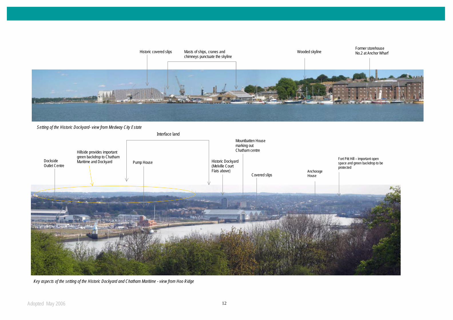
Adopted May 2006 12
Historic covered slips Masts of ships, cranes and
chimneys punctuate the skyline Wooded skyline
Former storehouse No.2 at Anchor Wharf
Dockside Outlet Centre
Pump House
Covered slips
Historic Dockyard (Melville Court Flats above)
Mountbatten House marking out Chatham centre
Anchorage House
Hillside provides important green backdrop to Chatham Maritime and Dockyard
Fort Pitt Hill – important open space and green backdrop to be protected
Interface land Setting of the Historic Dockyard- view from Medway City Estate
Key aspects of the setting of the Historic Dockyard and Chatham Maritime - view from Hoo Ridge

Adopted May 2006 13
3.12 Chatham Maritime- major leisure developments. Chatham Maritime consists of various urban character areas, including Basin 1 (now a marina), the low to mid-rise new housing developments of St Mary’s Island to the north of Basin 1 (largely developed) and the land south of Basin 1.
3.13 SEEDA (South east England development Agency) has established a way forward for the area
south of basin 1 in its ‘Master Plan Strategy for land south of Basin 1 – Chatham Maritime
2001’. This area includes dock basins and refurbished former industrial maritime buildings, such as the Dockside Outlet Centre.
3.14 The area already has permission for two residential towers (of 15 and 19 storeys) situated on
the dock fingers of J5 and J6. These have the potential to provide high quality landmarks. Together with the massive shed of the Dockside Outlet Centre and the leisure attraction of Dickens World, these will form a carefully considered composition. The opportunity to add to
this composition with further high buildings is therefore limited.
3.15 The Upnors small-scale sensitive village expansion. The Upnors are two small villages
separated by nationally important Upnor Castle (dating from 1559) and the mid Victorian ordnance depot. Upper Upnor is of 17th century origin with an attractive and historic High Street leading down to the river and the Castle. The river, together with the rural backdrop of the woods of Tower Hill and Beacon ridge, provides an idyllic setting, visible from many parts of Medway. This is a key characteristic, which rules out any prospect of high buildings in this
location.
15 and 19 storey towers on the dock fingers at Chatham Maritime- Dockside Outlet Centre prominent in the background.
A Building Height Policy for Medway- Part 2
Adopted May 2006 14
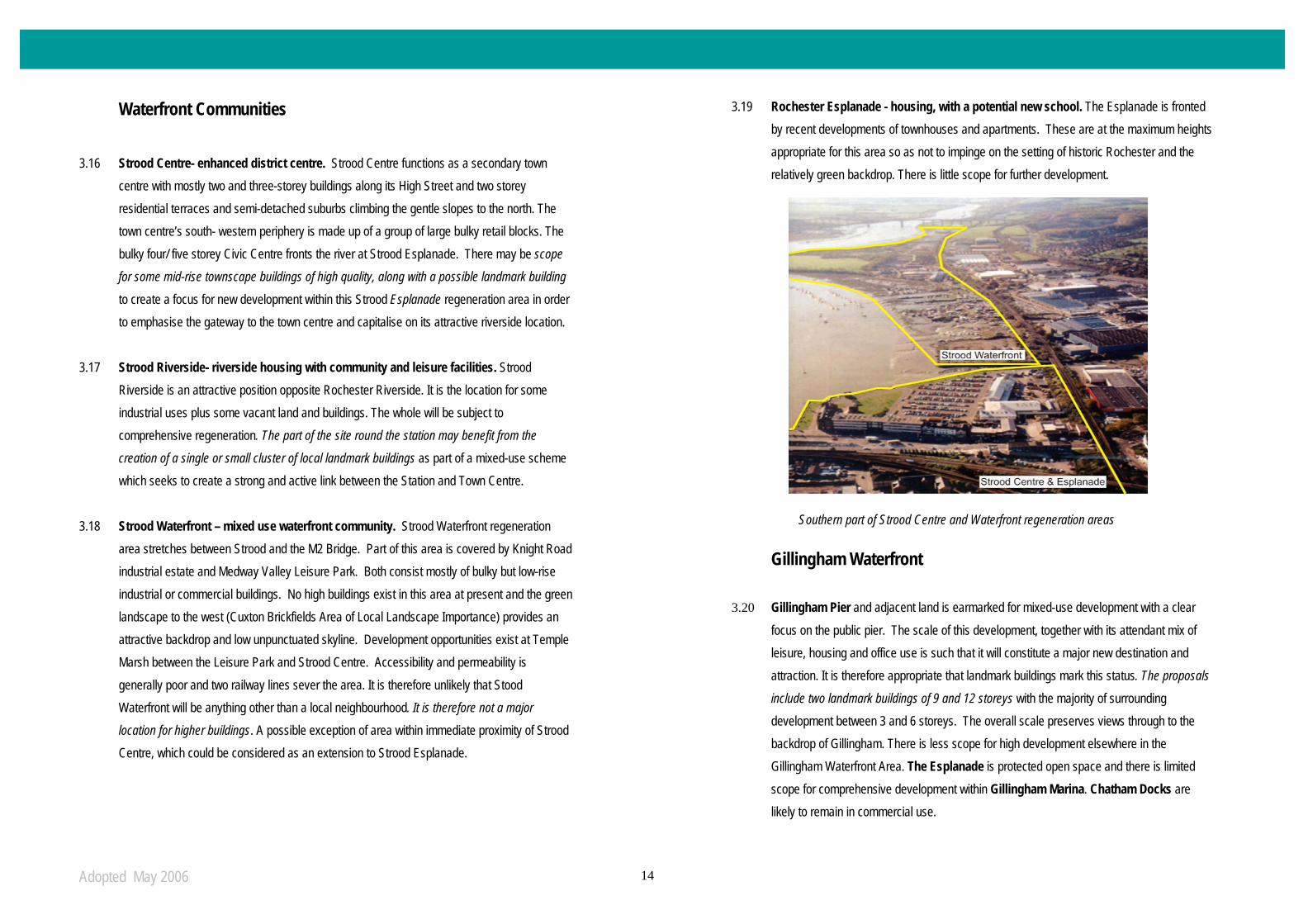
Waterfront Communities 3.16 Strood Centre- enhanced district centre. Strood Centre functions as a secondary town
centre with mostly two and three-storey buildings along its High Street and two storey residential terraces and semi-detached suburbs climbing the gentle slopes to the north. The town centre’s south- western periphery is made up of a group of large bulky retail blocks. The bulky four/ five storey Civic Centre fronts the river at Strood Esplanade. There may be scope
for some mid-rise townscape buildings of high quality, along with a possible landmark building to create a focus for new development within this Strood Esplanade regeneration area in order to emphasise the gateway to the town centre and capitalise on its attractive riverside location.
3.17 Strood Riverside- riverside housing with community and leisure facilities. Strood
Riverside is an attractive position opposite Rochester Riverside. It is the location for some industrial uses plus some vacant land and buildings. The whole will be subject to comprehensive regeneration. The part of the site round the station may benefit from the
creation of a single or small cluster of local landmark buildings as part of a mixed-use scheme which seeks to create a strong and active link between the Station and Town Centre.
3.18 Strood Waterfront – mixed use waterfront community. Strood Waterfront regeneration area stretches between Strood and the M2 Bridge. Part of this area is covered by Knight Road industrial estate and Medway Valley Leisure Park. Both consist mostly of bulky but low-rise industrial or commercial buildings. No high buildings exist in this area at present and the green landscape to the west (Cuxton Brickfields Area of Local Landscape Importance) provides an attractive backdrop and low unpunctuated skyline. Development opportunities exist at Temple Marsh between the Leisure Park and Strood Centre. Accessibility and permeability is generally poor and two railway lines sever the area. It is therefore unlikely that Stood Waterfront will be anything other than a local neighbourhood. It is therefore not a major location for higher buildings. A possible exception of area within immediate proximity of Strood Centre, which could be considered as an extension to Strood Esplanade.
3.19 Rochester Esplanade - housing, with a potential new school. The Esplanade is fronted by recent developments of townhouses and apartments. These are at the maximum heights appropriate for this area so as not to impinge on the setting of historic Rochester and the relatively green backdrop. There is little scope for further development.
Gillingham Waterfront
3.20 Gillingham Pier and adjacent land is earmarked for mixed-use development with a clear focus on the public pier. The scale of this development, together with its attendant mix of leisure, housing and office use is such that it will constitute a major new destination and attraction. It is therefore appropriate that landmark buildings mark this status. The proposals
include two landmark buildings of 9 and 12 storeys with the majority of surrounding development between 3 and 6 storeys. The overall scale preserves views through to the backdrop of Gillingham. There is less scope for high development elsewhere in the Gillingham Waterfront Area. The Esplanade is protected open space and there is limited scope for comprehensive development within Gillingham Marina. Chatham Docks are likely to remain in commercial use.
Southern part of Strood Centre and Waterfront regeneration areas

Adopted May 2006 15
Conservation Areas
Conservation Areas
1. Chatham Historic Dockyard*
2. Brompton Lines*
3. Pembroke
4. New Road, Chatham*
5. Star Hill to Sun Pier*
6. New Road, Rochester
7. Star Hill, Rochester
8. Victoria Street
9. Rochester City Centre
10. Watts Avenue/ Roebuck Road*
11. Churchfields
12. Frindsbury + Manor Farm
13. Upper Upnor*
* indicates Conservation Area Appraisal
or Design Guide available.
- - - Proposed World Heritage Site
Fig. 6: Conservation Areas within the Medway Waterfront area.
Urban Environment- Conservation Areas
Adopted May 2006 16
Conservation Areas
3.21 In general higher buildings will not be appropriate within Conservation Areas. However, in some cases Conservation Area status overlaps with areas which will be subject to regeneration.
3.22 The Council is committed to carrying out Conservation Area Appraisals or producing Design
Guides for Conservation Areas. These will provide further guidance on key characteristics to be preserved or enhanced, and on appropriate development.
3.23 The settings of Conservation Areas go beyond the boundaries of the Conservation Areas
themselves and will be a key consideration on whether higher buildings in a particular location are acceptable. Key aspects of views, including these that take in Conservation Areas are summarised in Appendix A – Strategic views.
3.24 The above does not preclude proposals for higher buildings which may affect the setting of
Conservation Areas, but it does mean that designers will be expected to consider the effect of proposals on these areas. The Council will expect full analysis and information on this as a part of any planning application - as indicated in part 1 of this guidance.
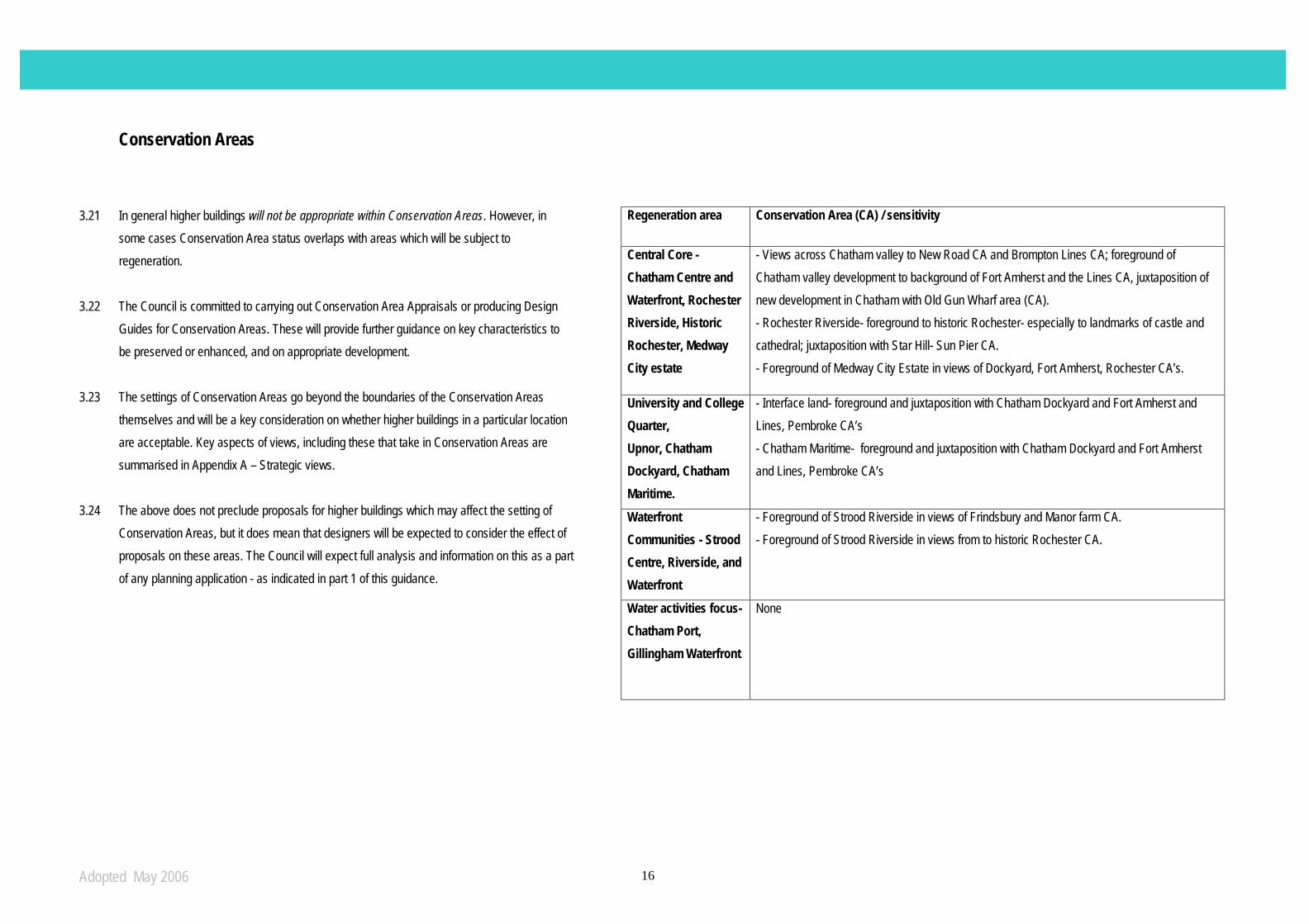
Regeneration area Conservation Area (CA) / sensitivity
Central Core - Chatham Centre and Waterfront, Rochester Riverside, Historic Rochester, Medway City estate
- Views across Chatham valley to New Road CA and Brompton Lines CA; foreground of Chatham valley development to background of Fort Amherst and the Lines CA, juxtaposition of new development in Chatham with Old Gun Wharf area (CA). - Rochester Riverside- foreground to historic Rochester- especially to landmarks of castle and cathedral; juxtaposition with Star Hill- Sun Pier CA. - Foreground of Medway City Estate in views of Dockyard, Fort Amherst, Rochester CA’s.
University and College Quarter, Upnor, Chatham Dockyard, Chatham Maritime.
- Interface land- foreground and juxtaposition with Chatham Dockyard and Fort Amherst and Lines, Pembroke CA’s - Chatham Maritime- foreground and juxtaposition with Chatham Dockyard and Fort Amherst and Lines, Pembroke CA’s
Waterfront Communities - Strood Centre, Riverside, and Waterfront
- Foreground of Strood Riverside in views of Frindsbury and Manor farm CA. - Foreground of Strood Riverside in views from to historic Rochester CA.
Water activities focus- Chatham Port, Gillingham Waterfront
None
A Building Height Policy for Medway- Part 2

Adopted May 2006 17
Transport and Movement 4.1 Medway Council encourages sustainable forms of development that reduce the need to travel
and the length of journeys. The development of tall buildings and the resulting increase in urban density can place considerable pressure on existing transport systems. The obverse is also true- higher buildings can, by intensification of land use, bolster the viability of public transport in central locations.
4.2 The aim of this section is to identify which areas which have the transport infrastructure to
support increased density. Location close to an existing or proposed transport hub will be an important factor in judging the acceptability of proposals for higher buildings.
4.3 Figure 7 summarises the major transport systems in Medway.
- Rail stations: The four rail stations within the study area provide residents with increased transportation choices and access, as well as reducing traffic congestion, air pollution and energy consumption. Figure 7 shows the location of those rail stations and associated circular catchment areas of 400 metres (equivalent to a 5 minute walk).
- Bus routes: The study area is well served by regular bus services, which provide residents with good access in and around the Medway Towns. The major and most frequent bus routes follow the major roads, linking centres and connecting with the rail stations.
- Major vehicular routes: Major vehicular routes (motorways, A and B roads) are indicated on figure 7. These routes are the most common means of accessing and moving around the urban area.
- Cycle routes: There are a number of cycle routes within the Medway Towns, including part of National Cycle Route 1. These form part of the Council’s planned network of strategic cycle routes linking the principal district and local centres.
4.4 In line with best practice, and in the interests of achieving an efficient urban form, taller
development should generally be focussed in urban centres (with good amenities that can be reached by foot), with high public transport and road accessibility (within reasonable walking distance of rail stations and bus services, and with good cycle links).
A Building Height Policy for Medway- Part 2 Fig. 7: Major transport nodes and routes
Transport and Movement

Adopted May 2006 18
Topography 5.1 The town centres of Strood, Rochester and Chatham are located on the river plain at a
prominent meander, and the surrounding steep hill sides/ridges create a natural bowl formation. This bowl and extensive green hill-sides/ridges are important components of the Medway landscape. This has been given further emphasis by the area’s military history which has resulted in hill-top and hill-side fortifications together with their surrounding cleared ‘Fields of Fire’. Today these remain as important and distinctive green backdrops to valley bottom development. It is also no coincidence that many of these green ridges/hilltops also provide some of the most spectacular and important views of the Medway Towns e.g. Great Lines, Fort Pitt.
5.2 In order to retain a strong landscape structure and distinctive historic and green character,
proposals for higher buildings will be expected to be:
• Located away from key ridge lines and hill tops
• Continue to allow key views through to the key backdrops.
A Building Height Policy for Medway- Part 2
10 metre interval contours
Important green ridge
Topography
Fig. 8 & 9: topographical map and sections

Adopted May 2006 19
Green Spaces
Figure 10. Key Green Spaces
Areas of local landscape importance or protected open space which form important green backdrops or from which strategic views are provided
A. Broom Hill B. Frindsbury Recreation Ground C. Hogmarsh Valley D. Hoo Common E. Brompton Lines area F. Jackson Heights / Fort Pitt G. Churchfields H. Esplanade Rochester I. Temple Marsh J. Borstal Recreation Ground
Greenspaces

Adopted May 2006 20
Green Spaces 6.1 Major green spaces and landscapes provide important green backdrops to development, form
significant components of view compositions and/or provide the setting from which strategic views over the core urban area and river corridor can be enjoyed.
6.2 The key green spaces described below are also designated ‘areas of local landscape
importance.’ A) Broom Hill
• High level panoramic views east - incorporating Rochester Castle and Cathedral, Chatham centre and waterfront, and as far north as the covered slips of the Historic Dockyard
• Tree-framed views of the whole of the eastern side of the topographic ‘bowl’ of the Medway Valley
B) Church Green
• Stands above chalk cliffs which form the background to Medway City Estate and Strood station area
• A prominent physical feature of the river corridor
• All Saints Church stands at the end of this promontory
• Uninterrupted views of the river valley stretch from the southern end of the Historic Dockyard as far as the Medway (M2) Bridge and beyond.
C) Hogmarsh Valley Despite being outside of the study area this valley provides a green / rural foreground to the
urban river corridor environment. It provides panoramic views of the Medway Towns.
D) Hoo Common
• A significant ‘node’ along the Saxon Shore Way public footpath
• Provides wide panoramic views of the Medway area
E) Brompton Lines
• This is the most significant green backdrop to the built fabric along the river corridor
• Both long and short views to this and other key green spaces identified merit careful consideration.
F) Jackson Height / Fort Pitt
• This green backdrop draws attention to the varying and attractive skyline and roofscape along the built stretch between New Road and Rochester High Street and this should be protected.
G) Churchfields
• This green space offers a distinctive break in the built-up character of Rochester as viewed from the opposite side of the river.
H) Rochester Esplanade
• This provides an attractive setting for Rochester Castle and Cathedral in both long and short distance views from the west, for example from the Medway (M2) Bridge and along the river from the south.
Conclusion 6.3 All development proposals, especially those for higher buildings, should seek to protect and / or
enhance the positive qualities attributed to these spaces, as described above. They are important components of the character in both short and long-range views. Designers will have to carefully assess the effect of proposals on these spaces and on views to these spaces. The Council will expect full analysis and information on this as part of any planning application.
Open Space – Green Spaces

Adopted May 2006 21
Views and Landmarks 7.1 Views are key elements of the urban experience which define our towns. They can have
immense cultural and historical importance, as well as a more local, personal value. The aim of this section is therefore to identify which areas are particularly sensitive to the visual intrusion of higher buildings and which views need retaining and enhancing. This section should be read in conjunction with Appendix A
7.2 To facilitate this analysis, three view types have been identified:
• strategic
• approach experiences
• local
The visual experience of Medway 7.3 The varied topography and urban development of the Medway area has created a series of
spectacular views into and across the Medway Towns. These views take in the majestic sweep of the River Medway with the dramatic combination of Rochester Castle & Cathedral, through to wooded hillsides and the striking architecture of the Historic Dockyard. The River Medway is the major component of the setting of many of the strategic views, landmarks and skylines within the urban centres. It forms a vital linear view corridor from which fine middle and long distance views can be obtained. The River emphasises the visual and historical associations between landmarks. Without these the cultural significance of the core urban centres would be eroded.
7.4 Many of the key vantage points are located around the ‘Medway Bowl’ (see Topography
section). It is no coincidence that many of Medway’s popular open spaces occupy historic hill-top locations. It is these same open spaces which form the back-drop to many of the most important views.
Strategic and approach views 7.5 Strategic views are generally panoramic views from key vantage points and are important in
the interpretation of the Medway Towns. They:
• include important focal point(s) or landmark(s), or other features of visual interest or distinctiveness such as backdrops;
• include approach experiences associated mainly with road approaches into and through the urban area. They feature constantly evolving views with numerous focal points;
• and are from well used or well known locations where the view is an important feature of the location.
Local views 7.6 There are also distinctive views that are important in their local context. These can include
glimpses of landmarks along local streets, which can form a strong, memorable part of residents and visitors visual experience. These views are too numerous to be detailed in this document. However, an analysis of local views should form part of the urban design statement and visual impact assessment for specific higher building proposals.
Strategic views and landmarks- a managed approach to change 7.7 The unique setting and visual character are important aspects of the Medway Towns which
should be protected and enhanced. New higher buildings should not block the features of views and visual experiences that have been identified as important and should seek to add to the distinctiveness of the urban skyline and form. Appendix A illustrates strategic views and approach experiences and identifies key features within each view. The significance of each viewpoint and each view is outlined together with an outline of the how the Council will seek to manage change in the areas encompassed by each view.
A Building Height Policy for Medway- Part 2
Visual Analysis Visual analysis- Panoramas and Views
Views and Landmarks
Adopted May 2006 22
Locations suitable for higher buildings

Adopted May 2006 23
Constraints, sensitivities and opportunities 8.1 This section summarises the criteria explained in the earlier sections of this document in order
to provide a broad conclusion on locations considered appropriate for higher buildings within the Medway Waterfront Area. Summary tables take the information provided earlier in this document and assess each development site against the criteria of: 1) urban environment- existing character and future role, 2) transport, 3) topography, 4) open space and 5) visual analysis. Sensitivities – such as the prominence of each site in key views - are also noted.
8.2 Further details are given in a series of area sheets for each area identified as suitable for
higher buildings. Each sheet provides an outline of the general character of the area, the main design and location principles (including whether townscape or landmark buildings are appropriate) and the development opportunities and constraints.
8.3 The Council will expect all higher building proposals with these areas identified as suitable for
higher buildings to be guided by a masterplan which outlines a vision for each area and provides a three-dimensional framework for buildings and spaces (see Part One).
8.4 This does not mean that individual proposals for higher buildings will necessarily be
unacceptable, although the Council will not seek or encourage such proposals. The onus is on developers and architects to prove the acceptability of higher buildings. Design statements, setting out impact on the wider area, integration into local areas, and compliance with the criteria set out in this document, together with full supporting visual information (as laid out in Part One of this guidance) will be an important part of justifying such proposals.
Adopted May 2006 24
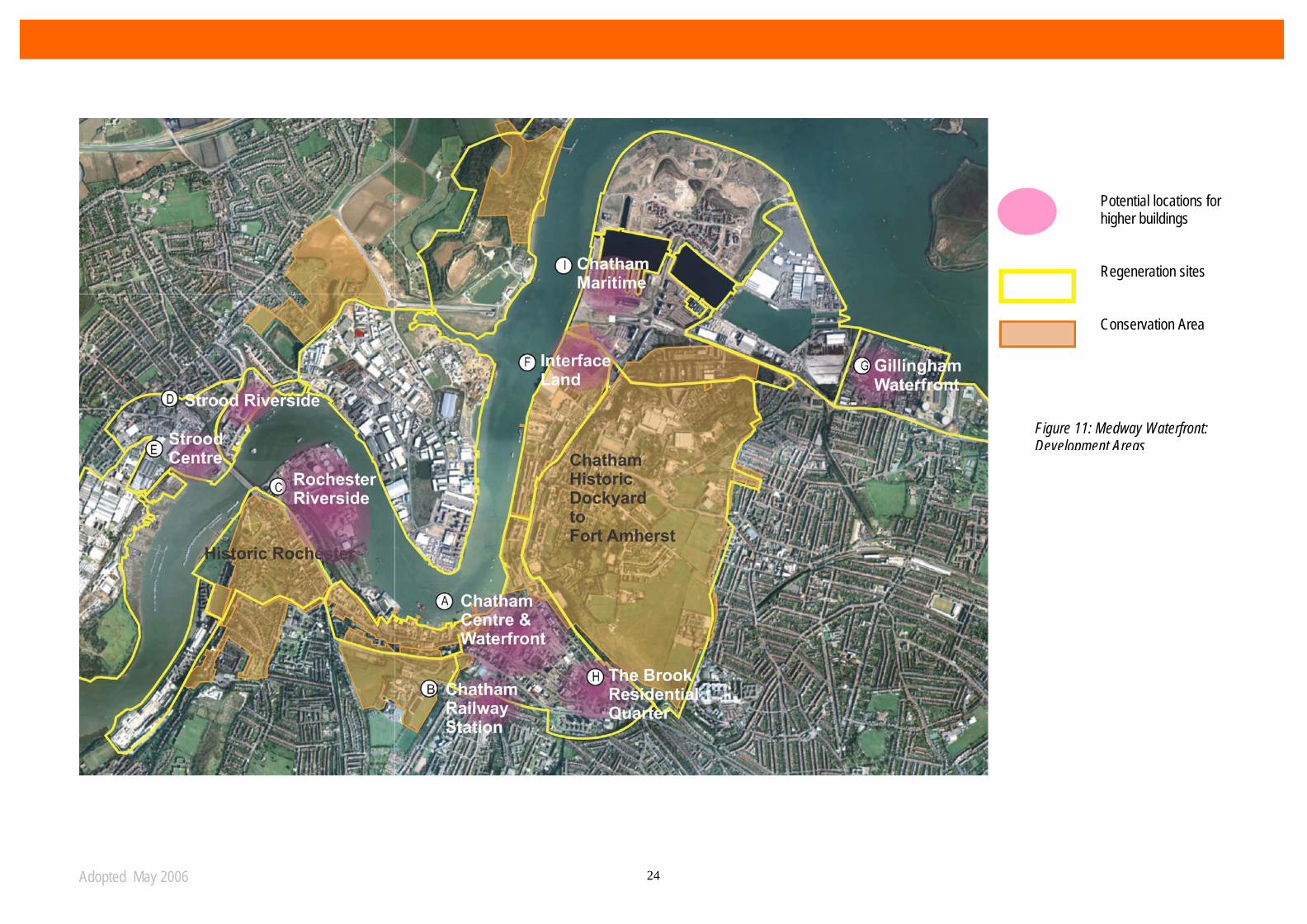
Figure 11: Medway Waterfront: Development Areas
Potential locations for higher buildings Regeneration sites Conservation Area

Adopted May 2006 25
A WELL ESTABLISHED LOCAL CENTRE, CHARACTERISED BY POOR, TRAFFIC RIDDEN ENVIRONMENT Urban environment Focal point for regeneration? Potential future destination?
Yes – particularly along the waterfront. The prominent riverside location of this means that it will be perceived as a key gateway to this part of Medwayt
Affect on character/amenity? No conservation areas or historic landmarks within the site, but development would need to respect important nearby landmarks – All Saints Church, Rochester Bridge and Rochester Castle/Cathedral
Existing cluster? No existing tall buildings. Any development significantly higher than the current low skyline would have a high impact Transport Existing urban centre? Yes - established local district centre with good amenities Good public transport? Yes - within 5 minute catchment area of Strood train station and well served by bus routes Topography Effect on important topographical features? On low-lying ground within the Medway Bowl, but development would need to respect important features – Frindsbury Chalk Cliffs, Broom Hill and Rede
Common Open space Effect on key green spaces? No key green spaces within the area. Nearest key green spaces are Broom Hill, Frindsbury recreation ground and Esplanade Rochester. Higher buildings are
unlikely to have an adverse affect. Visual analysis Effect on important views?
Strategic views 1,2,3,7,11,15,16 and approach experience A could be affected (strategic views 7 and 16 are particularly sensitive to higher buildings in this area) and would need in-depth visual analysis..
APPROPRIATE LOCATION FOR HIGHER BUILDINGS?
YES – modest higher buildings, mainly townscape, could be sited near the waterfront and in the Civic Centre area as a means of reinforcing the mixed use role of the town centre and capitalising on its proximity to the waterfront. Development will require to be sensitive to topography and key landmarks.
Strood Centre
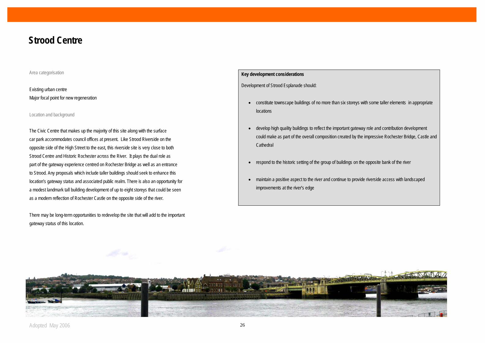
Adopted May 2006 26
Area categorisation Existing urban centre Major focal point for new regeneration Location and background
The Civic Centre that makes up the majority of this site along with the surface car park accommodates council offices at present. Like Strood Riverside on the opposite side of the High Street to the east, this riverside site is very close to both Strood Centre and Historic Rochester across the River. It plays the dual role as part of the gateway experience centred on Rochester Bridge as well as an entrance to Strood. Any proposals which include taller buildings should seek to enhance this location’s gateway status and associated public realm. There is also an opportunity for a modest landmark tall building development of up to eight storeys that could be seen as a modern reflection of Rochester Castle on the opposite side of the river. There may be long-term opportunities to redevelop the site that will add to the important gateway status of this location.
Key development considerations Development of Strood Esplanade should:
• constitute townscape buildings of no more than six storeys with some taller elements in appropriate locations
• develop high quality buildings to reflect the important gateway role and contribution development could make as part of the overall composition created by the impressive Rochester Bridge, Castle and Cathedral
• respond to the historic setting of the group of buildings on the opposite bank of the river
• maintain a positive aspect to the river and continue to provide riverside access with landscaped improvements at the river’s edge
Strood Centre
Adopted May 2006 27
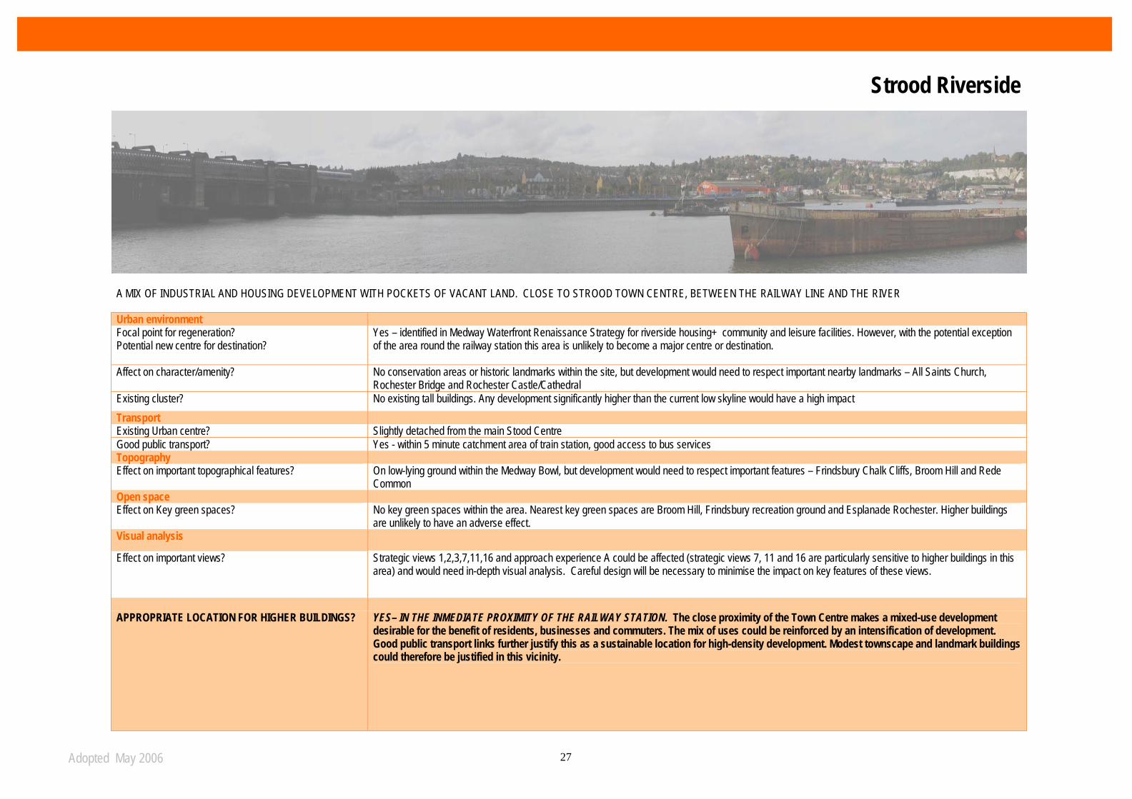
A MIX OF INDUSTRIAL AND HOUSING DEVELOPMENT WITH POCKETS OF VACANT LAND. CLOSE TO STROOD TOWN CENTRE, BETWEEN THE RAILWAY LINE AND THE RIVER
Urban environment Focal point for regeneration? Potential new centre for destination?
Yes – identified in Medway Waterfront Renaissance Strategy for riverside housing+ community and leisure facilities. However, with the potential exception of the area round the railway station this area is unlikely to become a major centre or destination.
Affect on character/amenity? No conservation areas or historic landmarks within the site, but development would need to respect important nearby landmarks – All Saints Church, Rochester Bridge and Rochester Castle/Cathedral
Existing cluster? No existing tall buildings. Any development significantly higher than the current low skyline would have a high impact Transport Existing Urban centre? Slightly detached from the main Stood Centre Good public transport? Yes - within 5 minute catchment area of train station, good access to bus services Topography Effect on important topographical features? On low-lying ground within the Medway Bowl, but development would need to respect important features – Frindsbury Chalk Cliffs, Broom Hill and Rede
Common Open space Effect on Key green spaces? No key green spaces within the area. Nearest key green spaces are Broom Hill, Frindsbury recreation ground and Esplanade Rochester. Higher buildings
are unlikely to have an adverse effect. Visual analysis
Effect on important views? Strategic views 1,2,3,7,11,16 and approach experience A could be affected (strategic views 7, 11 and 16 are particularly sensitive to higher buildings in this area) and would need in-depth visual analysis. Careful design will be necessary to minimise the impact on key features of these views.
APPROPRIATE LOCATION FOR HIGHER BUILDINGS? YES– IN THE INMEDIATE PROXIMITY OF THE RAILWAY STATION. The close proximity of the Town Centre makes a mixed-use development
desirable for the benefit of residents, businesses and commuters. The mix of uses could be reinforced by an intensification of development. Good public transport links further justify this as a sustainable location for high-density development. Modest townscape and landmark buildings could therefore be justified in this vicinity.
Strood Riverside

Adopted May 2006 28
Categorisation: Public Transport Node
Location and Background Strood Station is within the Strood Riverside urban quarter as set out in the Medway Waterfront Renaissance Strategy 2004 and is located to the east of Strood Town Centre. It can be approached via Station Road to the north or Canal Road to the south. It is disconnected from Strood Town Centre both physically and visually. Strood Station and its immediate environs contain dramatically varying uses (main station and car park site, the waterfront, commercial and residential developments to the south and east and residential uses to the north and west) all of a relatively small scale. Development in this location should not over-dominate the small scale development to the north and west but should be tall enough to announce the station’s location in the street scene and make a positive statement about this important arrival point for the town.
Key development considerations Development of Strood Station should:
• Provide improved access and enhancement of entrance to the railway station
• Take account of surrounding topography and this location in the “Medway Bowl” (see page 14 of this document)
• The lack of “important areas of sensitivity” nearby allows for taller buildings but not to the detriment of the existing urban form
• Take full account of Strood’s position in the local hierarchy behind Chatham and Rochester. New build should therefore be restricted to 6-8 storeys unless material considerations dictate otherwise
Only a train at the platform gives away the location of the station from Station Road
The entrance to the station from Station Road is uninviting and the station is completely hidden from view.
Strood Riverside

Adopted May 2006 29
PREDOMINATELY INDUSTRIAL SITE STRETCHING FROM STROOD CENTRE TO THE M2. MODERN INDUSTRIAL UNITS AND LEISURE PARK IN THE SOUTHERN PART OF THE SITE, BUT THERE ARE ALSO A NUMBER OF EXISTING EMPLOYMENT PREMISES OF LOW QUALITY. INCLUDES SIGNIFICANT AREA OF RIVERSIDE OPEN SPACE Focal point for regeneration? Potential new centre or destination?
Yes – identified in the Medway Waterfront Renaissance Strategy as a mixed use waterfront community with a range of employment activities and enhanced greenspace In general the centre is not close enough to other centre or transport links to become a new centre that attracts people from the rest of the Medway area and elsewhere.
Effect on character/amenity? No conservation areas or historic landmarks within the site, but development would need to respect important nearby landmarks – All Saints Church, Rochester Bridge and Rochester Castle/Cathedral
Existing cluster? No existing tall buildings. Any development significantly higher than the current low skyline would have a high impact
Transport Existing urban centre? Northern part of the site is close to established local district centre with good amenities, but majority of area is well outside centre
Good public transport? Some bus routes cross the area, but outside the 5 minute catchment area for Strood train station
Topography Effect on important topographical features? Part of the area is on low-lying ground within the Medway Bowl, but development would need to respect important features – Frindsbury Chalk Cliffs, Broom Hill, Rede Common
and Cobham Woods. Higher buildings would not be appropriate on the higher ground of the valley sides. Open space Effect on key green spaces? Cuxton Brickfields and Temple Marsh may be affected by higher buildings and would need to be carefully considered. Visual analysis Effect on important views? Strategic views 1,2,7,11,14 and 16 and approach experience A could be affected (strategic views 7,14 and 16 are particularly sensitive to higher buildings in this area) and would
need in-depth visual analysis APPROPRIATE LOCATION FOR HIGHER BUILDINGS?
Modest higher buildings may be suitable in the northern part of the site as a means of reinforcing Strood Town Centre’s role and status. Due to their remoteness from the Town Centre and from major transport nodes, other parts of the area are less suitable for higher buildings.
Strood Waterfront

Adopted May 2006 30
A DEVLOPMENT OF MODERN WATERFRONT HOUSING SET AMONG ATTRACTIVE RIVERSIDE PARKS, SOUTH-WEST OF ROCHESTER CENTRE Urban environment Focal point for regeneration? Not a key regeneration site in the Medway Waterfront Renaissance Strategy – modern housing development is complete Effect on character/amenity? No conservation areas or historic landmarks within the area but development would need to respect adjacent conservation areas
(Churchfields & Watts Avenue/Roebuck Road) and landmarks (Rochester Castle & Cathedral and Rochester Bridge) Existing cluster? No existing tall buildings. Any development significantly higher than the current low skyline would have a high impact Transport Existing urban centre? No, but on the edge of Rochester City Centre Good public transport? On bus route, but well outside 5 minute catchment area for Rochester or Strood train stations Topography Effect on important topographical features? The green ridgeline along the Esplanade is an important topographical feature which could be affected by higher building development Open space Effect on key green spaces? No key green spaces within the area, but development would need to respect adjacent key green spaces (Borstal Recreation Ground,
Churchfields and Esplanade) Visual analysis Effect on important views? Strategic views 7,10,11 and approach experience A could be affected and would need in-depth visual analysis APPROPRIATE LOCATION FOR HIGHER BUILDINGS?
NO – development in this vicinity would adversely affect important topographical features and views to Rochester conservation areas. Not a major regeneration area.
The Esplanade
Adopted May 2006 31
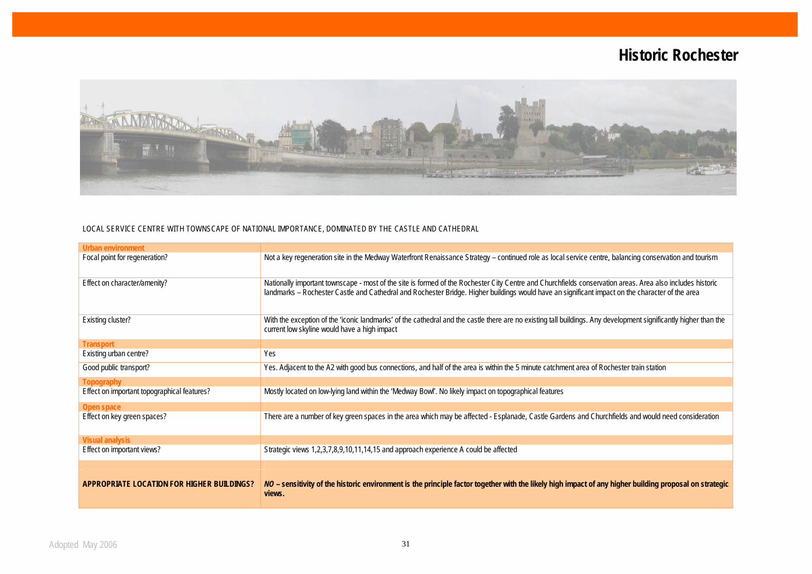
LOCAL SERVICE CENTRE WITH TOWNSCAPE OF NATIONAL IMPORTANCE, DOMINATED BY THE CASTLE AND CATHEDRAL Urban environment Focal point for regeneration? Not a key regeneration site in the Medway Waterfront Renaissance Strategy – continued role as local service centre, balancing conservation and tourism
Effect on character/amenity? Nationally important townscape - most of the site is formed of the Rochester City Centre and Churchfields conservation areas. Area also includes historic landmarks – Rochester Castle and Cathedral and Rochester Bridge. Higher buildings would have an significant impact on the character of the area
Existing cluster? With the exception of the ‘iconic landmarks’ of the cathedral and the castle there are no existing tall buildings. Any development significantly higher than the current low skyline would have a high impact
Transport Existing urban centre? Yes Good public transport? Yes. Adjacent to the A2 with good bus connections, and half of the area is within the 5 minute catchment area of Rochester train station
Topography Effect on important topographical features? Mostly located on low-lying land within the ‘Medway Bowl’. No likely impact on topographical features
Open space Effect on key green spaces? There are a number of key green spaces in the area which may be affected - Esplanade, Castle Gardens and Churchfields and would need consideration
Visual analysis Effect on important views? Strategic views 1,2,3,7,8,9,10,11,14,15 and approach experience A could be affected
APPROPRIATE LOCATION FOR HIGHER BUILDINGS?
NO – sensitivity of the historic environment is the principle factor together with the likely high impact of any higher building proposal on strategic views.
Historic Rochester
Adopted May 2006 32
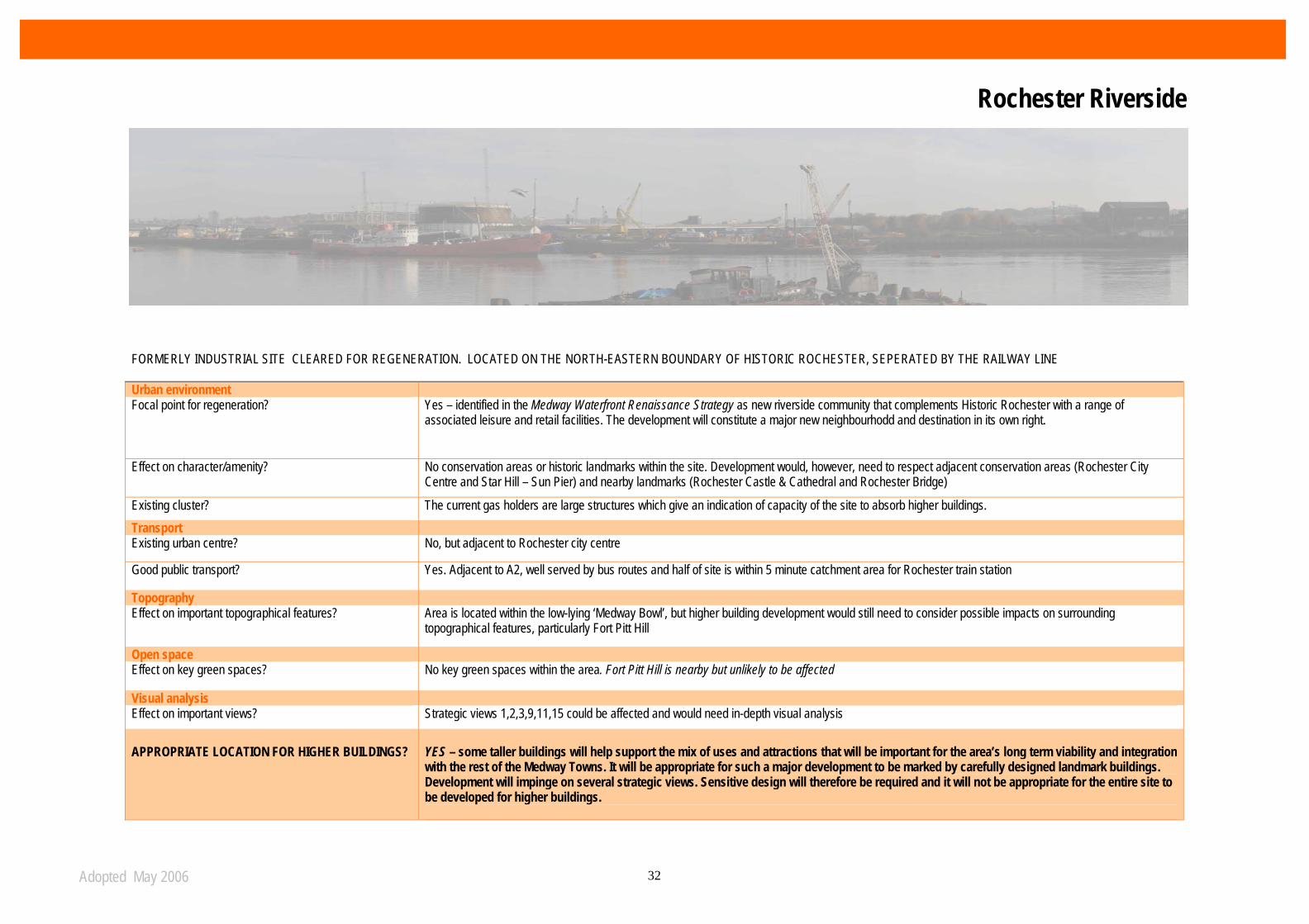
FORMERLY INDUSTRIAL SITE CLEARED FOR REGENERATION. LOCATED ON THE NORTH-EASTERN BOUNDARY OF HISTORIC ROCHESTER, SEPERATED BY THE RAILWAY LINE Urban environment Focal point for regeneration? Yes – identified in the Medway Waterfront Renaissance Strategy as new riverside community that complements Historic Rochester with a range of
associated leisure and retail facilities. The development will constitute a major new neighbourhodd and destination in its own right.
Effect on character/amenity? No conservation areas or historic landmarks within the site. Development would, however, need to respect adjacent conservation areas (Rochester City Centre and Star Hill – Sun Pier) and nearby landmarks (Rochester Castle & Cathedral and Rochester Bridge)
Existing cluster? The current gas holders are large structures which give an indication of capacity of the site to absorb higher buildings. Transport Existing urban centre? No, but adjacent to Rochester city centre
Good public transport? Yes. Adjacent to A2, well served by bus routes and half of site is within 5 minute catchment area for Rochester train station
Topography Effect on important topographical features? Area is located within the low-lying ‘Medway Bowl’, but higher building development would still need to consider possible impacts on surrounding
topographical features, particularly Fort Pitt Hill
Open space Effect on key green spaces? No key green spaces within the area. Fort Pitt Hill is nearby but unlikely to be affected
Visual analysis Effect on important views? Strategic views 1,2,3,9,11,15 could be affected and would need in-depth visual analysis
APPROPRIATE LOCATION FOR HIGHER BUILDINGS?
YES – some taller buildings will help support the mix of uses and attractions that will be important for the area’s long term viability and integration with the rest of the Medway Towns. It will be appropriate for such a major development to be marked by carefully designed landmark buildings. Development will impinge on several strategic views. Sensitive design will therefore be required and it will not be appropriate for the entire site to be developed for higher buildings.
Rochester Riverside

Adopted May 2006 33
Area Categorisation – Major focal point for regeneration Location and background A major new urban development for riverside site of some 32 hectares
This site was formerly in industrial use but is now largely vacant and offers mixed-use development opportunities, predominantly housing use. Rochester's original town gas works was located here. A development brief for the area was adopted by the Council in 2004. Immediately to the west is Rochester Centre which, with the exception of the two centre- wide landmarks of Rochester Castle and Rochester Cathedral has a largely domestic scale and character. The railway viaduct and associated embankment that run parallel to Corporation Street acts as a wall that largely cuts off the site and defines the scale and height of development along the western boundary. It will be important to ensure that development at Acorn Wharf and Gashouse Point is of a scale and height that defers to the Castle and Cathedral, avoids developing a riverside ‘wall’ of development.
Key development considerations Development of Rochester Riverside should:
• acknowledge the prominent location on this bend in the River and gateway experience from Rochester Bridge with the creation of high quality development of sufficient scale and height to act as a focal point
• address the high profile corner of Gashouse Point
• Safeguard key short, middle and long distance views of Rochester Castle and Cathedral as seen from Strood, Chatham and Historic Dockyard and Medway bridge
• create a skyline that introduces variety, focus and interest that complements the centre-wide landmarks of Rochester Castle and Cathedral
• avoid creating an uninteresting and monotonous riverside ‘wall’ of development
• establish the frequency of entrances and view corridors through development blocks to allow for movement and views from land side that promote waterfront context and setting
• investigate open space, landscaping and riverside walk to promote access along the full extent of the waterfront
Rochester Riverside
Adopted May 2006 34
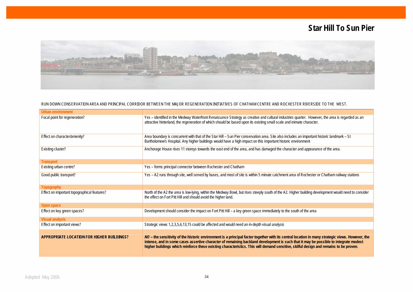
RUN DOWN CONSERVATION AREA AND PRINCIPAL CORRIDOR BETWEEN THE MAJOR REGENERATION INITIATIVES OF CHATHAM CENTRE AND ROCHESTER RIVERSIDE TO THE WEST.
Urban environment Focal point for regeneration? Yes – identified in the Medway Waterfront Renaissance Strategy as creative and cultural industries quarter. However, the area is regarded as an
attractive hinterland, the regeneration of which should be based upon its existing small scale and inimate character.
Effect on character/amenity? Area boundary is concurrent with that of the Star Hill – Sun Pier conservation area. Site also includes an important historic landmark – St Bartholomew’s Hospital. Any higher buildings would have a high impact on this important historic environment
Existing cluster? Anchorage House rises 11 storeys towards the east end of the area, and has damaged the character and appearance of the area.
Transport Existing urban centre? Yes – forms principal connector between Rochester and Chatham
Good public transport? Yes – A2 runs through site, well served by buses, and most of site is within 5 minute catchment area of Rochester or Chatham railway stations
Topography Effect on important topographical features? North of the A2 the area is low-lying, within the Medway Bowl, but rises steeply south of the A2. Higher building development would need to consider
the effect on Fort Pitt Hill and should avoid the higher land.
Open space Effect on key green spaces? Development should consider the impact on Fort Pitt Hill – a key green space immediately to the south of the area
Visual analysis Effect on important views? Strategic views 1,2,3,5,6,13,15 could be affected and would need an in-depth visual analysis
APPROPRIATE LOCATION FOR HIGHER BUILDINGS? NO – the sensitivity of the historic environment is a principal factor together with its central location in many strategic views. However, the
intense, and in some cases assertive character of remaining backland development is such that it may be possible to integrate modest higher buildings which reinforce these existing characteristics. This will demand sensitive, skilful design and remains to be proven.
Star Hill To Sun Pier
Adopted May 2006 35
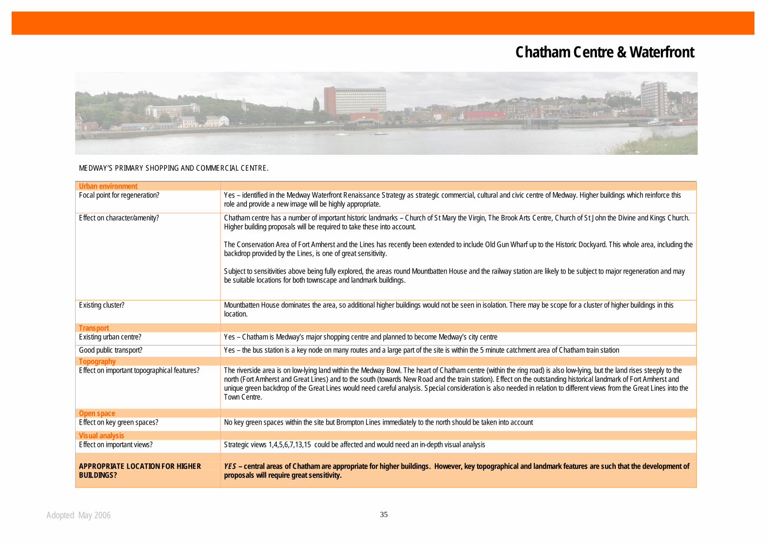
MEDWAY’S PRIMARY SHOPPING AND COMMERCIAL CENTRE. Urban environment Focal point for regeneration? Yes – identified in the Medway Waterfront Renaissance Strategy as strategic commercial, cultural and civic centre of Medway. Higher buildings which reinforce this
role and provide a new image will be highly appropriate.
Effect on character/amenity? Chatham centre has a number of important historic landmarks – Church of St Mary the Virgin, The Brook Arts Centre, Church of St John the Divine and Kings Church. Higher building proposals will be required to take these into account. The Conservation Area of Fort Amherst and the Lines has recently been extended to include Old Gun Wharf up to the Historic Dockyard. This whole area, including the backdrop provided by the Lines, is one of great sensitivity. Subject to sensitivities above being fully explored, the areas round Mountbatten House and the railway station are likely to be subject to major regeneration and may be suitable locations for both townscape and landmark buildings.
Existing cluster? Mountbatten House dominates the area, so additional higher buildings would not be seen in isolation. There may be scope for a cluster of higher buildings in this location.
Transport Existing urban centre? Yes – Chatham is Medway’s major shopping centre and planned to become Medway’s city centre Good public transport? Yes – the bus station is a key node on many routes and a large part of the site is within the 5 minute catchment area of Chatham train station Topography Effect on important topographical features? The riverside area is on low-lying land within the Medway Bowl. The heart of Chatham centre (within the ring road) is also low-lying, but the land rises steeply to the
north (Fort Amherst and Great Lines) and to the south (towards New Road and the train station). Effect on the outstanding historical landmark of Fort Amherst and unique green backdrop of the Great Lines would need careful analysis. Special consideration is also needed in relation to different views from the Great Lines into the Town Centre.
Open space Effect on key green spaces? No key green spaces within the site but Brompton Lines immediately to the north should be taken into account Visual analysis Effect on important views? Strategic views 1,4,5,6,7,13,15 could be affected and would need an in-depth visual analysis APPROPRIATE LOCATION FOR HIGHER BUILDINGS?
YES – central areas of Chatham are appropriate for higher buildings. However, key topographical and landmark features are such that the development of proposals will require great sensitivity.
Chatham Centre & Waterfront
Adopted May 2006 36
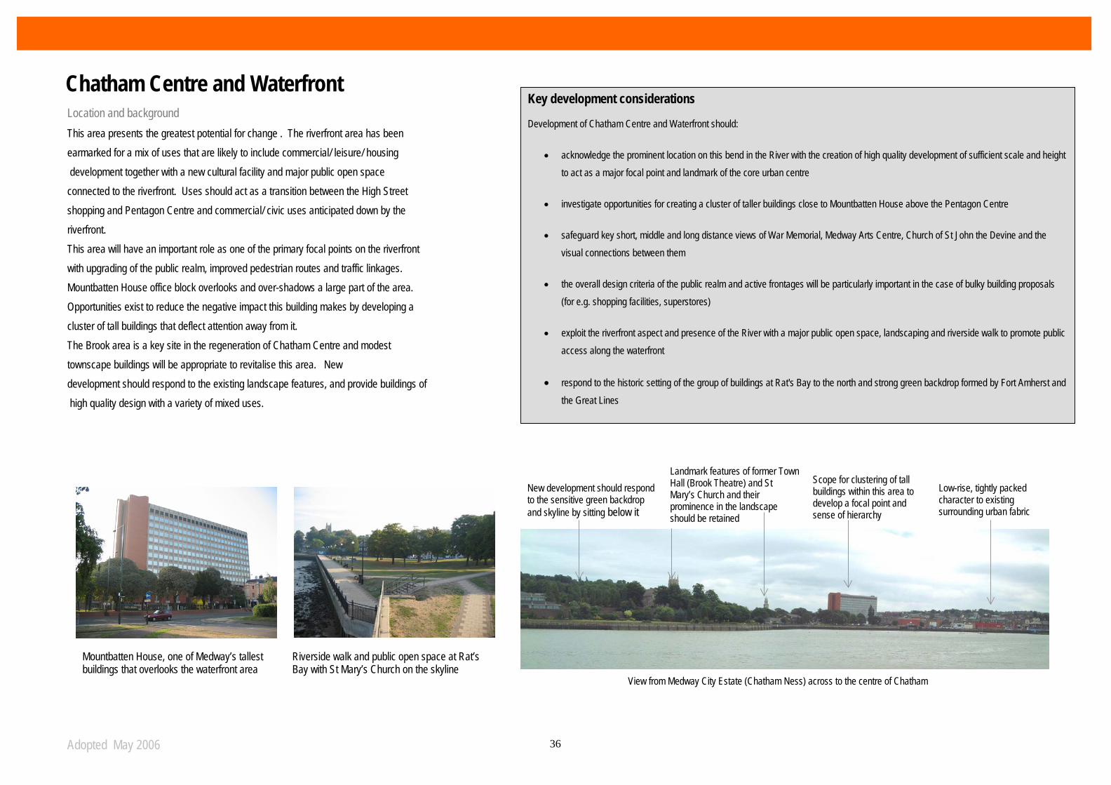
Location and background This area presents the greatest potential for change . The riverfront area has been earmarked for a mix of uses that are likely to include commercial/ leisure/ housing development together with a new cultural facility and major public open space connected to the riverfront. Uses should act as a transition between the High Street shopping and Pentagon Centre and commercial/ civic uses anticipated down by the riverfront. This area will have an important role as one of the primary focal points on the riverfront with upgrading of the public realm, improved pedestrian routes and traffic linkages. Mountbatten House office block overlooks and over-shadows a large part of the area. Opportunities exist to reduce the negative impact this building makes by developing a cluster of tall buildings that deflect attention away from it. The Brook area is a key site in the regeneration of Chatham Centre and modest townscape buildings will be appropriate to revitalise this area. New development should respond to the existing landscape features, and provide buildings of high quality design with a variety of mixed uses.
Key development considerations Development of Chatham Centre and Waterfront should:
• acknowledge the prominent location on this bend in the River with the creation of high quality development of sufficient scale and height to act as a major focal point and landmark of the core urban centre
• investigate opportunities for creating a cluster of taller buildings close to Mountbatten House above the Pentagon Centre
• safeguard key short, middle and long distance views of War Memorial, Medway Arts Centre, Church of St John the Devine and the visual connections between them
• the overall design criteria of the public realm and active frontages will be particularly important in the case of bulky building proposals (for e.g. shopping facilities, superstores)
• exploit the riverfront aspect and presence of the River with a major public open space, landscaping and riverside walk to promote public access along the waterfront
• respond to the historic setting of the group of buildings at Rat's Bay to the north and strong green backdrop formed by Fort Amherst and the Great Lines
Mountbatten House, one of Medway’s tallest buildings that overlooks the waterfront area
Riverside walk and public open space at Rat’s Bay with St Mary’s Church on the skyline
View from Medway City Estate (Chatham Ness) across to the centre of Chatham
New development should respond to the sensitive green backdrop and skyline by sitting below it
Landmark features of former Town Hall (Brook Theatre) and St Mary’s Church and their prominence in the landscape should be retained
Scope for clustering of tall buildings within this area to develop a focal point and sense of hierarchy
Low-rise, tightly packed character to existing surrounding urban fabric
Chatham Centre and Waterfront

Adopted May 2006 37
Area Categorisation Public transport Location and background This gateway location, which forms part of the area covered by the Chatham Centre and Waterfront Development Framework, within the existing urban centre of Chatham has good access to public transport links via the bus and railway stations and range of facilities offered by Chatham High Street being within only 5 minutes (350 metres) walking distance to the north. The railway station is somewhat disjointed and isolated from the main urban centre at present. This is due to a combination of factors that include poor quality routes, lack of visual connectivity and traffic. The opportunity exists, particularly on the approach to the Station and west of Railway Street, to improve both the quality of this important entrance to the urban centre and key routes with development that announces the railway station and provides a memorable feature.
Key development considerations Development of the Chatham Railway Station should:
• be carried out in a comprehensive manner covering the area between the railway station and Chatham centre and only after a thorough masterplanning process.
• acknowledge the gateway role of this site within the main urban centre that includes Chatham Railway Station with the creation of high quality development of sufficient scale and height to act as a focal point
• clearly respond to the changes in level around the Station, considering a taller building directly associated with the Station and the scope for more modest development to the west.
• seek to terminate views along Railway Street, particularly from the railway viaduct on New Road Avenue adding to the sequence of reference points along this key route to the urban centre (Church of St John the Devine acting as a halfway-point between the urban centre and Railway Station)
Chatham Railway Station, which is a key transport interchange and gateway into the core
View from the Bus interchange looking west to the King’s Church
View from the railway station across Railway St. where the bulky building of Wickes site somewhat out of place at this location
View from the top of Railway Street looking south towards Chatham Centre
Chatham Centre and Waterfront: Railway Station
Adopted May 2006 38
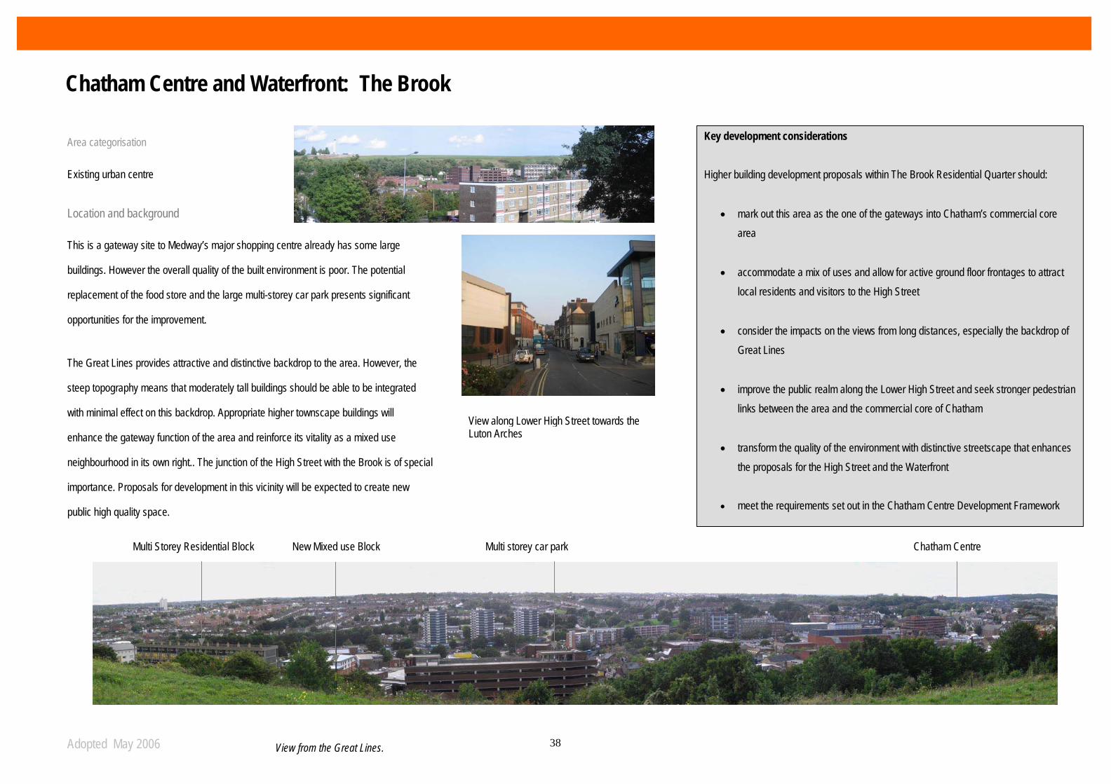
Area categorisation Existing urban centre Location and background This is a gateway site to Medway’s major shopping centre already has some large
buildings. However the overall quality of the built environment is poor. The potential
replacement of the food store and the large multi-storey car park presents significant
opportunities for the improvement.
The Great Lines provides attractive and distinctive backdrop to the area. However, the
steep topography means that moderately tall buildings should be able to be integrated
with minimal effect on this backdrop. Appropriate higher townscape buildings will
enhance the gateway function of the area and reinforce its vitality as a mixed use
neighbourhood in its own right.. The junction of the High Street with the Brook is of special
importance. Proposals for development in this vicinity will be expected to create new
public high quality space.
Multi Storey Residential Block
View along Lower High Street towards the Luton Arches
New Mixed use Block Multi storey car park
View from the Great Lines.
Key development considerations Higher building development proposals within The Brook Residential Quarter should:
• mark out this area as the one of the gateways into Chatham’s commercial core area
• accommodate a mix of uses and allow for active ground floor frontages to attract local residents and visitors to the High Street
• consider the impacts on the views from long distances, especially the backdrop of Great Lines
• improve the public realm along the Lower High Street and seek stronger pedestrian links between the area and the commercial core of Chatham
• transform the quality of the environment with distinctive streetscape that enhances the proposals for the High Street and the Waterfront
• meet the requirements set out in the Chatham Centre Development Framework
Chatham Centre
The Brook Quarter
Chatham Centre and Waterfront: The Brook
Adopted May 2006 39
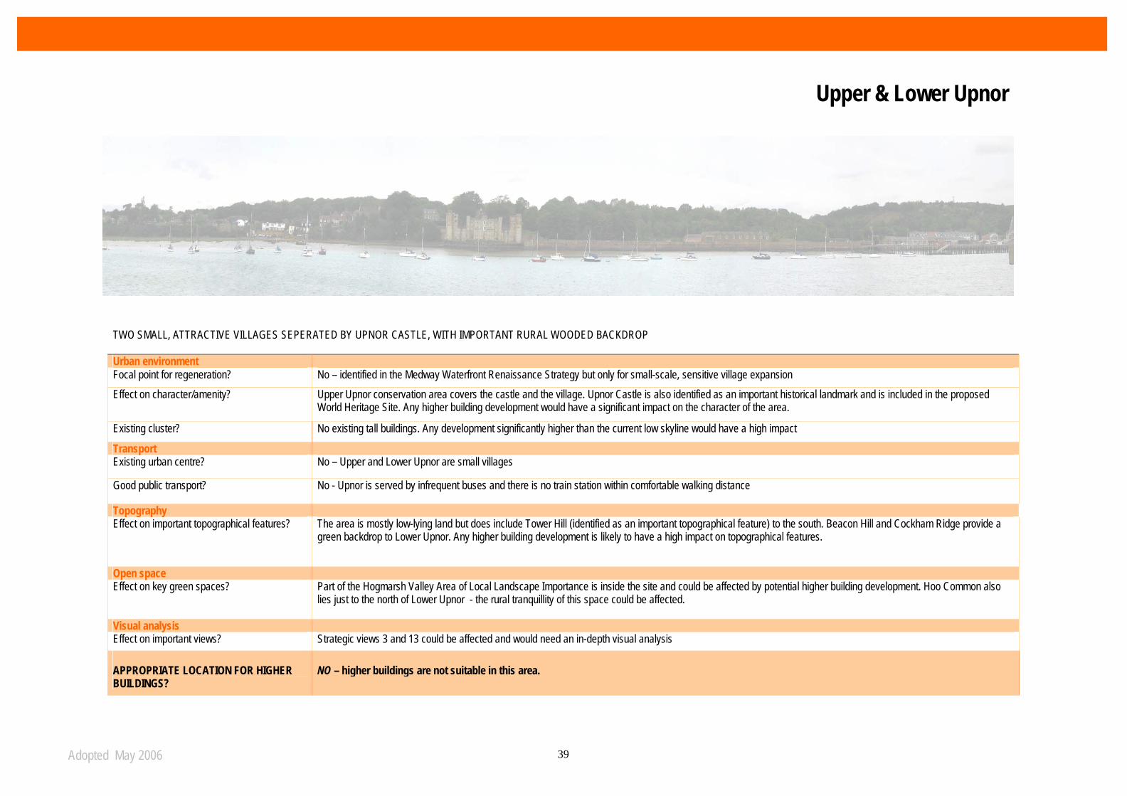
TWO SMALL, ATTRACTIVE VILLAGES SEPERATED BY UPNOR CASTLE, WITH IMPORTANT RURAL WOODED BACKDROP Urban environment Focal point for regeneration? No – identified in the Medway Waterfront Renaissance Strategy but only for small-scale, sensitive village expansion Effect on character/amenity? Upper Upnor conservation area covers the castle and the village. Upnor Castle is also identified as an important historical landmark and is included in the proposed
World Heritage Site. Any higher building development would have a significant impact on the character of the area.
Existing cluster? No existing tall buildings. Any development significantly higher than the current low skyline would have a high impact
Transport Existing urban centre? No – Upper and Lower Upnor are small villages
Good public transport? No - Upnor is served by infrequent buses and there is no train station within comfortable walking distance
Topography Effect on important topographical features? The area is mostly low-lying land but does include Tower Hill (identified as an important topographical feature) to the south. Beacon Hill and Cockham Ridge provide a
green backdrop to Lower Upnor. Any higher building development is likely to have a high impact on topographical features.
Open space Effect on key green spaces? Part of the Hogmarsh Valley Area of Local Landscape Importance is inside the site and could be affected by potential higher building development. Hoo Common also
lies just to the north of Lower Upnor - the rural tranquillity of this space could be affected.
Visual analysis Effect on important views? Strategic views 3 and 13 could be affected and would need an in-depth visual analysis APPROPRIATE LOCATION FOR HIGHER BUILDINGS?
NO – higher buildings are not suitable in this area.
Upper & Lower Upnor
Adopted May 2006 40
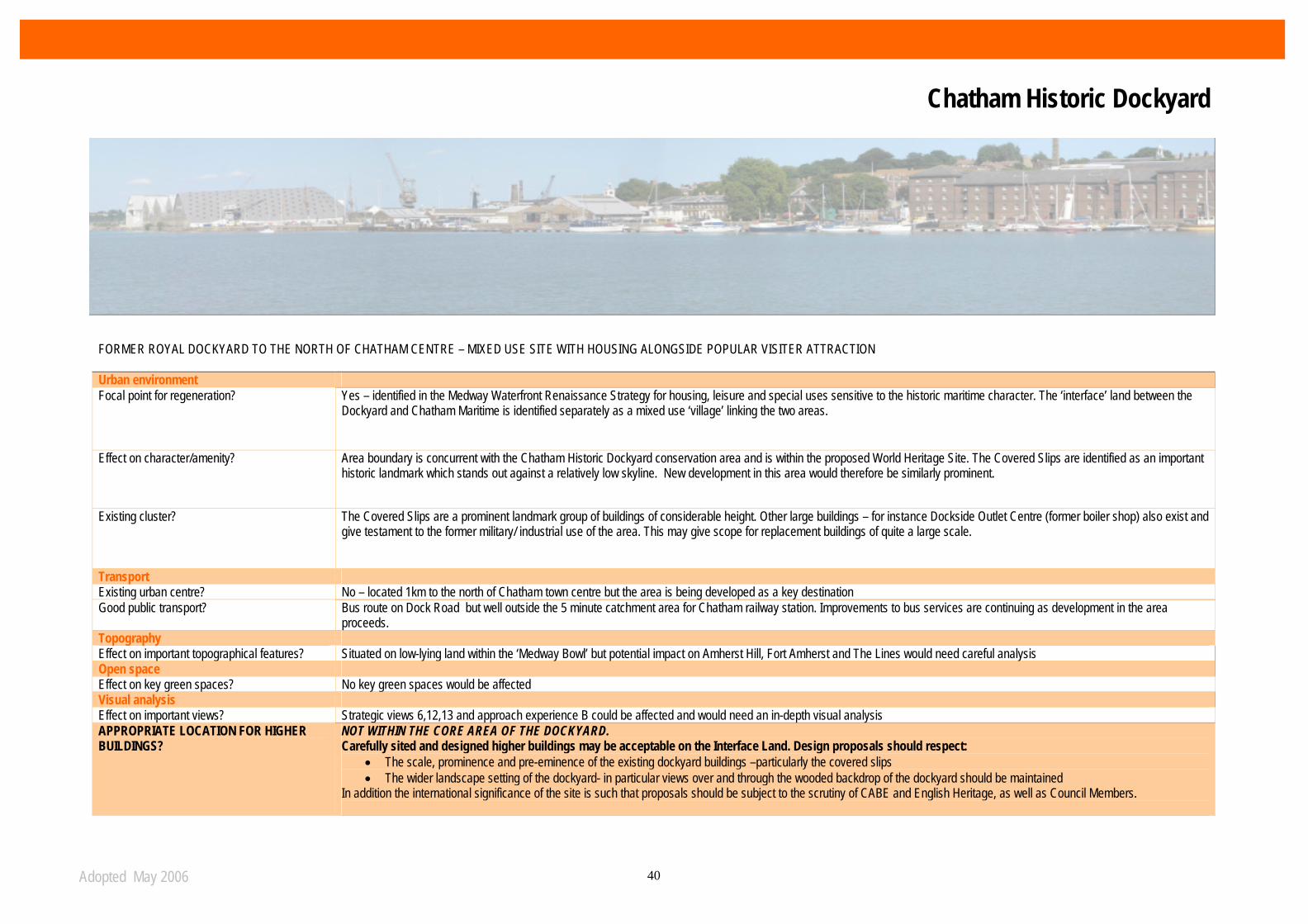
FORMER ROYAL DOCKYARD TO THE NORTH OF CHATHAM CENTRE – MIXED USE SITE WITH HOUSING ALONGSIDE POPULAR VISITER ATTRACTION Urban environment Focal point for regeneration? Yes – identified in the Medway Waterfront Renaissance Strategy for housing, leisure and special uses sensitive to the historic maritime character. The ‘interface’ land between the
Dockyard and Chatham Maritime is identified separately as a mixed use ‘village’ linking the two areas.
Effect on character/amenity? Area boundary is concurrent with the Chatham Historic Dockyard conservation area and is within the proposed World Heritage Site. The Covered Slips are identified as an important historic landmark which stands out against a relatively low skyline. New development in this area would therefore be similarly prominent.
Existing cluster? The Covered Slips are a prominent landmark group of buildings of considerable height. Other large buildings – for instance Dockside Outlet Centre (former boiler shop) also exist and give testament to the former military/ industrial use of the area. This may give scope for replacement buildings of quite a large scale.
Transport Existing urban centre? No – located 1km to the north of Chatham town centre but the area is being developed as a key destination Good public transport? Bus route on Dock Road but well outside the 5 minute catchment area for Chatham railway station. Improvements to bus services are continuing as development in the area
proceeds. Topography Effect on important topographical features? Situated on low-lying land within the ‘Medway Bowl’ but potential impact on Amherst Hill, Fort Amherst and The Lines would need careful analysis Open space Effect on key green spaces? No key green spaces would be affected Visual analysis Effect on important views? Strategic views 6,12,13 and approach experience B could be affected and would need an in-depth visual analysis APPROPRIATE LOCATION FOR HIGHER BUILDINGS?
NOT WITHIN THE CORE AREA OF THE DOCKYARD. Carefully sited and designed higher buildings may be acceptable on the Interface Land. Design proposals should respect:
• The scale, prominence and pre-eminence of the existing dockyard buildings –particularly the covered slips • The wider landscape setting of the dockyard- in particular views over and through the wooded backdrop of the dockyard should be maintained
In addition the international significance of the site is such that proposals should be subject to the scrutiny of CABE and English Heritage, as well as Council Members.
Chatham Historic Dockyard
Adopted May 2006 41
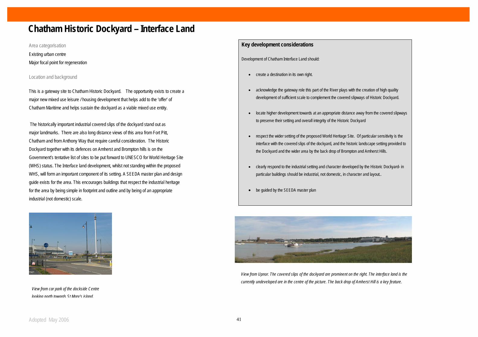
Area categorisation Existing urban centre Major focal point for regeneration
Location and background This is a gateway site to Chatham Historic Dockyard. The opportunity exists to create a major new mixed use leisure / housing development that helps add to the ‘offer’ of Chatham Maritime and helps sustain the dockyard as a viable mixed use entity. The historically important industrial covered slips of the dockyard stand out as major landmarks. There are also long distance views of this area from Fort Pitt, Chatham and from Anthony Way that require careful consideration. The Historic Dockyard together with its defences on Amherst and Brompton hills is on the Government’s tentative list of sites to be put forward to UNESCO for World Heritage Site (WHS) status. The Interface land development, whilst not standing within the proposed WHS, will form an important component of its setting. A SEEDA master plan and design guide exists for the area. This encourages buildings that respect the industrial heritage for the area by being simple in footprint and outline and by being of an appropriate industrial (not domestic) scale.
Key development considerations
Development of Chatham Interface Land should:
• create a destination in its own right.
• acknowledge the gateway role this part of the River plays with the creation of high quality development of sufficient scale to complement the covered slipways of Historic Dockyard.
• locate higher development towards at an appropriate distance away from the covered slipways to preserve their setting and overall integrity of the Historic Dockyard
• respect the wider setting of the proposed World Heritage Site. Of particular sensitivity is the interface with the covered slips of the dockyard, and the historic landscape setting provided to the Dockyard and the wider area by the back drop of Brompton and Amherst Hills.
• clearly respond to the industrial setting and character developed by the Historic Dockyard- in particular buildings should be industrial, not domestic, in character and layout..
• be guided by the SEEDA master plan
View from Upnor. The covered slips of the dockyard are prominent on the right. The interface land is the
currently undeveloped are in the centre of the picture. The back drop of Amherst Hill is a key feature. View from car park of the dockside Centre
looking north towards St Mary’s island.
Chatham Historic Dockyard – Interface Land

Adopted May 2006 42
PART OF THE FORMER ROYAL NAVAL BASE SITUATED TO THE NORTH OF THE HISTORIC DOCKYARD AT THE BEND OF THE RIVER MEDWAY. HIGH QUALITY ENVIRONMENT WITH RETAIL, OFFICE AND EDUCATIONAL DEVELOPMENT TO THE SOUTH AND RESIDENTIAL TO THE NORTH ON ST MARY’S ISLAND Urban environment Focal point for regeneration? Yes – identified in the Medway Waterfront Renaissance Strategy for major leisure and retail developments to complement housing at St Mary’s Island. The site is likely to be a major
detination attracting people from beyond Medway’s boundaries.
Effect on character/amenity? A small part of the area is located within the Pembroke conservation area, where higher building development would not be appropriate. Elsewhere development should still consider the impact on Pembroke and Chatham Historic Dockyard conservation areas. The Covered Slips are a positive historic landmark just to the south in the Historic Dockyard and need to be considered.
Existing cluster? The existing listed boilershop, now converted to a factory outlet centre, gives testament to the scale of former industrial buildings in the area. Two residential towers (15 and 19 storeys) have been granted consent and will form a landmark cluster with boilershop.
Transport Existing urban centre? No – located 2km to the north of Chatham town centre but this area will become a key destination Good public transport? Improvements to bus services are continuing as development in the area proceeds
Topography
Effect on important topographical features? Located on low-lying land within the Medway valley. Fort Amherst & The Lines form a component of the backdrop to the western most parts of the area. Open space Effect on key green spaces? No key green spaces would be affected
Visual analysis Effect on important views? Strategic views 12,13 and approach experience B could be significantly affected and would need an in-depth visual analysis. APPROPRIATE LOCATION FOR HIGHER BUILDINGS?
The site’s status as a major new leisure/ retail destination justifies higher buildings. However, the current proposal for two landmark towers together with the existing boiler shop constitutes a fine composition. There is limited scope for further tall buildings.
Chatham Maritime

Adopted May 2006 43
Area categorisation Major focal point for regeneration Location and background Chatham Maritime is SEEDA’s biggest development project is the South East. With a total area of 136 hectares and a strategic location with direct access to both junction 1 and 4 of the M2, Chatham Maritime is a world-class living and working environment in the Thames Gateway area. The site is composed of historic buildings now occupied by University of Greenwich and Kent University, modern office buildings and enterprise zones and the new mixed-use development in Chatham Quays where twin towers will form a major new landmark. The recent permission granted by the Council for the residential towers (15 and 19 storeys) in the Quays limits the opportunity for additional higher buildings development within the site.
Brompton, Fort Amherst & The Lines
Key development considerations
Higher building development proposals within Chatham Maritime Waterfront should:
• enhance the existing living and working environment created with the recentdevelopments within the area
• acknowledge the key role this part of Medway plays with the existing atmospherecreated by the new University campus and the enterprise developments.
• accommodate a mix of uses and allow for active ground floor frontages to attract localresidents and visitors to the waterfront
• clearly respond to the new developments proposed across the site in terms ofarchitecture and urban design
• meet the requirements set out in the SEEDA’s masterplan for the area
Chatham Maritime
Adopted May 2006 44
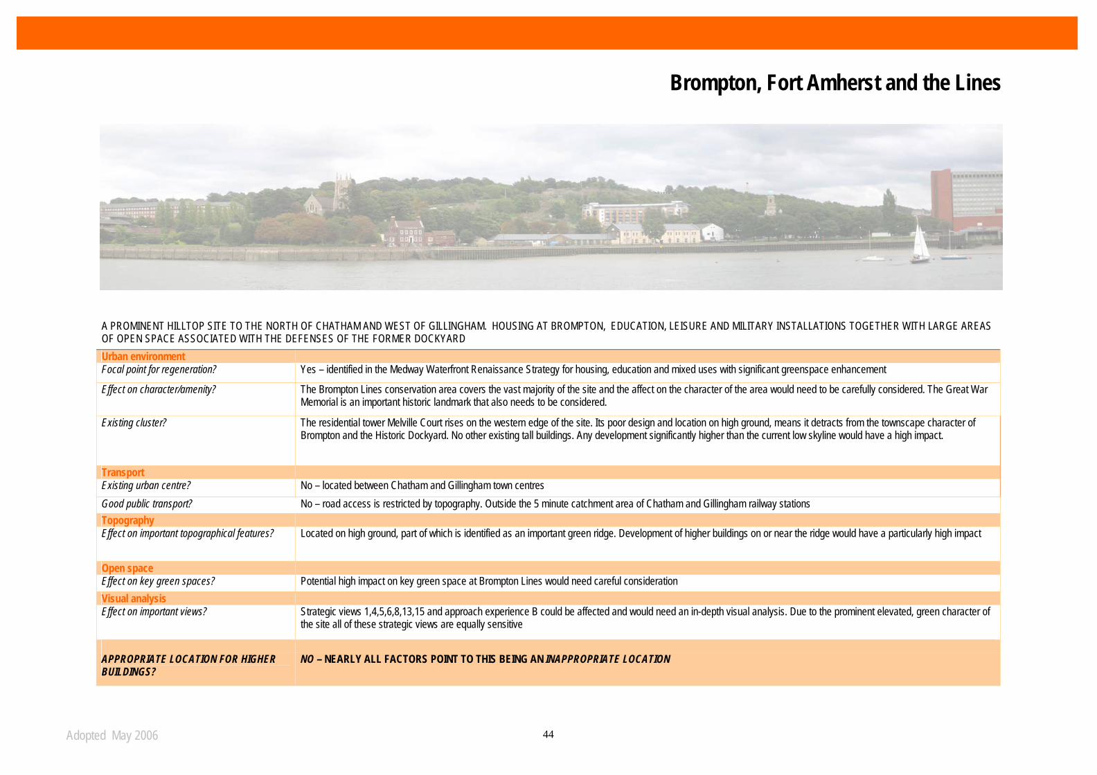
A PROMINENT HILLTOP SITE TO THE NORTH OF CHATHAM AND WEST OF GILLINGHAM. HOUSING AT BROMPTON, EDUCATION, LEISURE AND MILITARY INSTALLATIONS TOGETHER WITH LARGE AREAS OF OPEN SPACE ASSOCIATED WITH THE DEFENSES OF THE FORMER DOCKYARD Urban environment Focal point for regeneration? Yes – identified in the Medway Waterfront Renaissance Strategy for housing, education and mixed uses with significant greenspace enhancement
Effect on character/amenity? The Brompton Lines conservation area covers the vast majority of the site and the affect on the character of the area would need to be carefully considered. The Great War Memorial is an important historic landmark that also needs to be considered.
Existing cluster? The residential tower Melville Court rises on the western edge of the site. Its poor design and location on high ground, means it detracts from the townscape character of Brompton and the Historic Dockyard. No other existing tall buildings. Any development significantly higher than the current low skyline would have a high impact.
Transport Existing urban centre? No – located between Chatham and Gillingham town centres Good public transport? No – road access is restricted by topography. Outside the 5 minute catchment area of Chatham and Gillingham railway stations Topography Effect on important topographical features? Located on high ground, part of which is identified as an important green ridge. Development of higher buildings on or near the ridge would have a particularly high impact
Open space Effect on key green spaces? Potential high impact on key green space at Brompton Lines would need careful consideration Visual analysis Effect on important views? Strategic views 1,4,5,6,8,13,15 and approach experience B could be affected and would need an in-depth visual analysis. Due to the prominent elevated, green character of
the site all of these strategic views are equally sensitive
APPROPRIATE LOCATION FOR HIGHER BUILDINGS?
NO – NEARLY ALL FACTORS POINT TO THIS BEING AN INAPPROPRIATE LOCATION
Brompton, Fort Amherst and the Lines
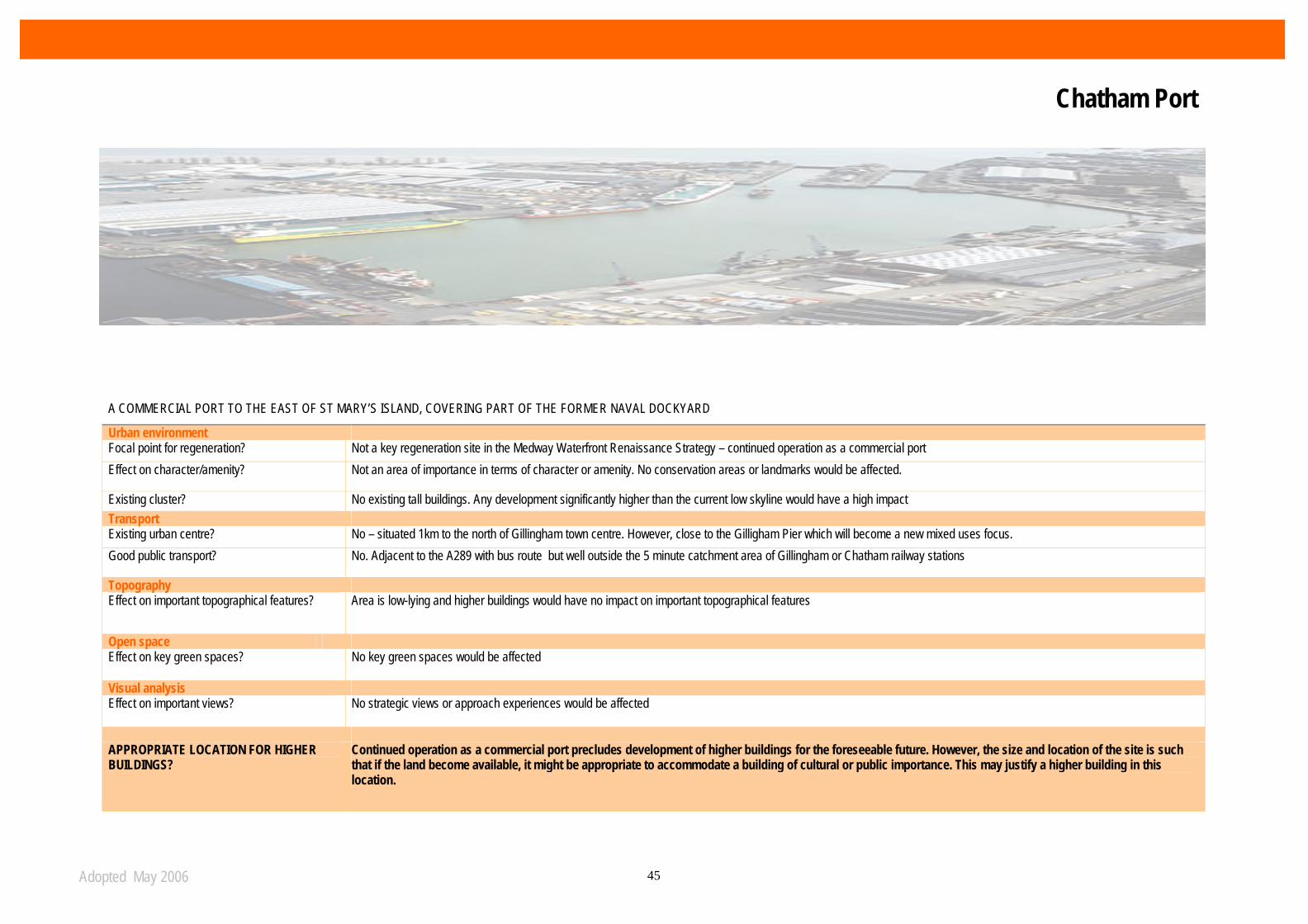
Adopted May 2006 45
A COMMERCIAL PORT TO THE EAST OF ST MARY’S ISLAND, COVERING PART OF THE FORMER NAVAL DOCKYARD
Urban environment Focal point for regeneration? Not a key regeneration site in the Medway Waterfront Renaissance Strategy – continued operation as a commercial port Effect on character/amenity? Not an area of importance in terms of character or amenity. No conservation areas or landmarks would be affected.
Existing cluster? No existing tall buildings. Any development significantly higher than the current low skyline would have a high impact Transport Existing urban centre? No – situated 1km to the north of Gillingham town centre. However, close to the Gilligham Pier which will become a new mixed uses focus. Good public transport? No. Adjacent to the A289 with bus route but well outside the 5 minute catchment area of Gillingham or Chatham railway stations
Topography Effect on important topographical features? Area is low-lying and higher buildings would have no impact on important topographical features
Open space Effect on key green spaces? No key green spaces would be affected
Visual analysis Effect on important views? No strategic views or approach experiences would be affected
APPROPRIATE LOCATION FOR HIGHER BUILDINGS?
Continued operation as a commercial port precludes development of higher buildings for the foreseeable future. However, the size and location of the site is such that if the land become available, it might be appropriate to accommodate a building of cultural or public importance. This may justify a higher building in this location.
Chatham Port

Adopted May 2006 46
MIXED USE AREA TO THE NORTH OF GILLINGHAM AND EAST OF CHATHAM DOCKS. INCORPORTAES LEISURE FACILITIES, COMMERCIAL PROPERTIES AND A LARGE FORMER INDUSTRIAL SITE BEING DEVELOPED FOR WATERFRONT HOUSING
Urban environment Focal point for regeneration? Yes – identified in the Medway Waterfront Renaissance Strategy for mixed-use development with water based activities. Planning permission
has just been given for a major new mixed housing/ leisure destination centred round Gillingham Pier. This focal point is marked by twin landmark towers.
Effect on character/amenity? No conservation areas or landmarks would be affected
Existing cluster? No existing tall buildings. Although the current gasholders form large structures these will be removed in due course. Any development significantly higher than the current low skyline would have a high impact
Transport Existing urban centre? No. Site is adjacent to the Gillingham North residential area but Gillingham centre is 1km to south. However, with planned regeneration this
will become a destination that attracts people from the wider area.
Good public transport? No. Bus route along southern boundary but site is outside the 5 minute catchment area for Gillingham train station. Improvements to the bus service are planned as part of the regeneration of the area
Topography Effect on important topographical features? Area is low-lying. However distant ridges proved a distinctive backdrop to this low lying area as viewed from various point across the estuary.
This means that uniformly high development will not be appropriate.
Open space Effect on key green spaces? No key green spaces would be affected Visual analysis Effect on important views? No strategic views or approach experiences would be affected APPROPRIATE LOCATION FOR HIGHER BUILDINGS? Higher buildings are appropriate as the centrepiece of regeneration of Gillingham waterfront, capitalising on the focal point and
attraction of Gillingham Pier. Uniform high development elsewhere is less justifiable.
Gillingham Waterfront
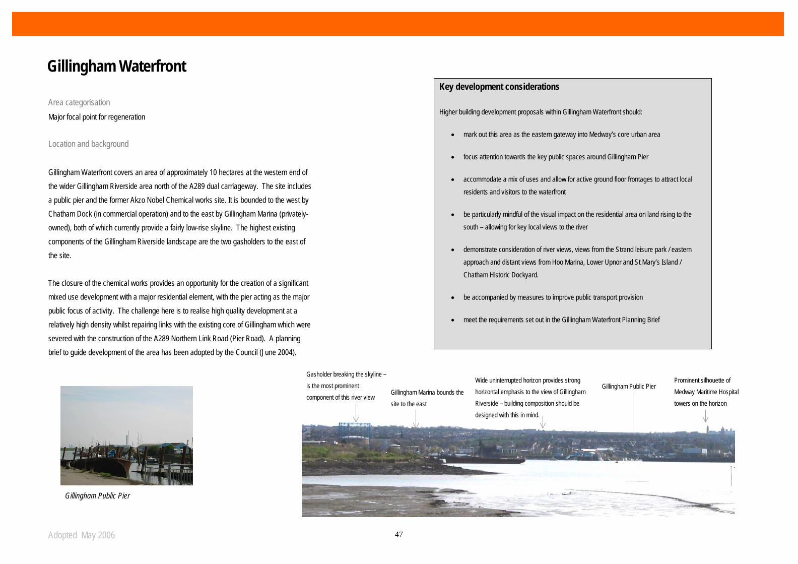
Adopted May 2006 47
Area categorisation Major focal point for regeneration
Location and background Gillingham Waterfront covers an area of approximately 10 hectares at the western end of the wider Gillingham Riverside area north of the A289 dual carriageway. The site includes a public pier and the former Akzo Nobel Chemical works site. It is bounded to the west by Chatham Dock (in commercial operation) and to the east by Gillingham Marina (privately-owned), both of which currently provide a fairly low-rise skyline. The highest existing components of the Gillingham Riverside landscape are the two gasholders to the east of the site. The closure of the chemical works provides an opportunity for the creation of a significant mixed use development with a major residential element, with the pier acting as the major public focus of activity. The challenge here is to realise high quality development at a relatively high density whilst repairing links with the existing core of Gillingham which were severed with the construction of the A289 Northern Link Road (Pier Road). A planning brief to guide development of the area has been adopted by the Council (June 2004).
Key development considerations
Higher building development proposals within Gillingham Waterfront should:
• mark out this area as the eastern gateway into Medway’s core urban area
• focus attention towards the key public spaces around Gillingham Pier
• accommodate a mix of uses and allow for active ground floor frontages to attract local residents and visitors to the waterfront
• be particularly mindful of the visual impact on the residential area on land rising to the south – allowing for key local views to the river
• demonstrate consideration of river views, views from the Strand leisure park / eastern approach and distant views from Hoo Marina, Lower Upnor and St Mary’s Island / Chatham Historic Dockyard.
• be accompanied by measures to improve public transport provision
• meet the requirements set out in the Gillingham Waterfront Planning Brief
Gasholder breaking the skyline – is the most prominent component of this river view
Gillingham Marina bounds the site to the east
Gillingham Public Pier Prominent silhouette of Medway Maritime Hospital towers on the horizon
Wide uninterrupted horizon provides strong horizontal emphasis to the view of Gillingham Riverside – building composition should be designed with this in mind.
Gillingham Public Pier
Gillingham Waterfront

Adopted May 2006 48

Adopted May 2006 49
REFERENCES CABE/English Heritage (2007) Guidance on Tall Buildings CABE ODPM PPS1 (2005) Delivering Sustainable Development HMSO Transport 2000 (1999) Living Streets Transport 2000 DTLR (2001) By Design Better Places to Live - a companion guide to PPG3 Thomas Telford Publishing DETR/CABE (2000) By Design – Urban design in the planning system: towards better practice Thomas Telford Publishing Llewelyn-Davies (2000) Urban Design Compendium English Partnerships/The Housing Corporation South East England Development Agency (SEEDA). (2003) Sustainability Checklist SEEDA
Medway Council (2003) Medway Local Plan, Adopted Version 2003 Medway Medway Council (2004) Medway Waterfront Renaissance Strategy Medway Medway Council (2004) Chatham Centre Waterfront Development Framework Medway Medway Council (2004) Rochester Riverside Development Brief Mdway CONTACTS Martin McKay Design & Conservation Manager Medway Council Civic HQ Dock Road Chatham Kent ME4 4TR Tel: 01634 331721 Fax: 01634 331725 E-mail: [email protected]

Adopted May 2006 50