adobe pdf - chapel st. leonards walk...
TRANSCRIPT
Lincolnshire WalksBe a responsible walker
Chapel St Leonards
Walk Location: Chapel St Leonards is situatedon the coast 8km (5 miles) north of Skegness.
Starting point: Outside the Parish Counciloffices, Sea Road. Grid Reference : TF 560 722.
Parking: Public car parks on Sea Road and Well Vale Drive.
Public Transport: The area is well served by buses. For times call the Traveline on 0870 6082608 or visitwww.lincolnshire.gov.uk/busrailtravel.
Ordnance Survey maps for the area: Explorer 274 Skegness,Alford & Spilsby. Landranger 122 Skegness & Horncastle.
Walk length: Walk One: 9 or 5 km (51/2 or 3 miles).Walk Two: 6 km (33/4 miles).Walk Three: 4 km (21/2 miles).
At a leisurely pace the walks will take these approximate timesto complete: Walk One: 23/4 or 11/2 hours. Walk Two: 2 hours.
Walk Three: 11/4 hours.
Type of walk: These walks use village paths, field paths, tracks,dunes and the promenade. All the walks are level but may beuneven and muddy in places.
Refreshments: There is a good selection of shops and pubs inChapel St Leonards and several cafes along the route at WollaBank, Chapel Point and Trunch Lane (opening may be seasonal).
Public Toilets: Sea Road, Chapel St Leonards, Chapel Point andTrunch Lane (opening may be seasonal).
These walks and leaflet have been put together with assistance from the
Chapel St Leonards Parish Path Partnership Group and Parish Council.
Please remember the countryside is a place where people liveand work and where wildlife makes its home. To protect theLincolnshire countryside for other visitors please respect it andon every visit follow the Countryside Code. Thank you.
• Be safe - plan ahead and follow any signs• Leave gates and property as you find them• Protect plants and animals, and take litter home• Keep dogs under close control• Consider other people
Most of all enjoy your visit to the Lincolnshire countryside
This leaflet is one in a series of walk leaflets produced byLincolnshire County Council’s Conservation ServicesSection to help you explore and enjoy the County’scountryside. If you have enjoyed these walks andwould like information on other walking routes inLincolnshire then please visit our website.
If you encounter any problems whilst on these walks, suchas an overgrown path or a broken sign post, please let usknow so they can be corrected.
We would also welcome your comments and suggestions on thewalk and leaflet to help improve future editions.
Lincolnshire County CouncilConservation Services
Tel: 01522 782070 Minicom: 01522 552055Email: [email protected]
Website: www.lincolnshire.gov.uk/countryside
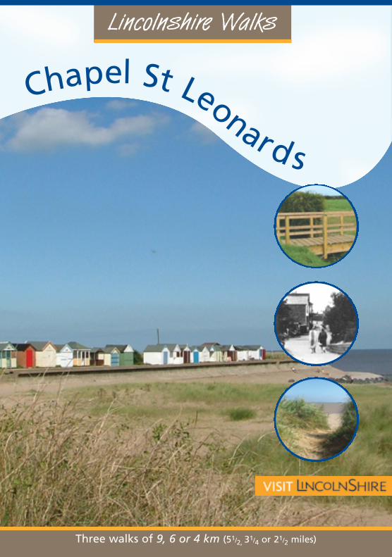
Three walks of 9, 6 or 4 km (51/2, 31/4 or 21/2 miles)Chapel St Leonards Village centre in the 1920s.
These walks are set around Chapel StLeonards, the farm land to the west of thevillage and along the coast. Located withinthe Lincolnshire coast and marsheslandscape character area the village lies inthe shadow of the sea defences.
In the 16th century thevillage was known asMumby Chapel.
The originalmedieval chapelwas engulfed by thesea in 1571. It wasrestored and useduntil the presentchurch was built in thelate 18th century. Thecurrent west tower was builtin 1901 in the Arts & Crafts style byWilliam Scorer at a cost of £600.
Between Chapel Point and Ingoldmells anumber of Iron Age and Roman saltmaking sites have been discovered on thebeach and pottery discovered there hasbeen dated to the 1400s.
Before the chalets were built inthe 1930s visitors to Chapel
Point pitched their tentson the beach. This areaand Chapel Marshwere devastated bythe floods of 1953after which the localsea defences werestrengthened.
Now a popular holidaycentre, there are miles of
sandy beaches and a widerange of facilities.
IntroductionWalk Information
Published June 2006
If this leaflet is not in a format that meets your needsplease contact Conservation Services
Chapel 18/7/06 15:16 Page 1

Lincolnshire WalksBe a responsible walker
Chapel St Leonards
Walk Location: Chapel St Leonards is situatedon the coast 8km (5 miles) north of Skegness.
Starting point: Outside the Parish Counciloffices, Sea Road. Grid Reference : TF 560 722.
Parking: Public car parks on Sea Road and Well Vale Drive.
Public Transport: The area is well served by buses. For times call the Traveline on 0870 6082608 or visitwww.lincolnshire.gov.uk/busrailtravel.
Ordnance Survey maps for the area: Explorer 274 Skegness,Alford & Spilsby. Landranger 122 Skegness & Horncastle.
Walk length: Walk One: 9 or 5 km (51/2 or 3 miles).Walk Two: 6 km (33/4 miles).Walk Three: 4 km (21/2 miles).
At a leisurely pace the walks will take these approximate timesto complete: Walk One: 23/4 or 11/2 hours. Walk Two: 2 hours.
Walk Three: 11/4 hours.
Type of walk: These walks use village paths, field paths, tracks,dunes and the promenade. All the walks are level but may beuneven and muddy in places.
Refreshments: There is a good selection of shops and pubs inChapel St Leonards and several cafes along the route at WollaBank, Chapel Point and Trunch Lane (opening may be seasonal).
Public Toilets: Sea Road, Chapel St Leonards, Chapel Point andTrunch Lane (opening may be seasonal).
These walks and leaflet have been put together with assistance from the
Chapel St Leonards Parish Path Partnership Group and Parish Council.
Please remember the countryside is a place where people liveand work and where wildlife makes its home. To protect theLincolnshire countryside for other visitors please respect it andon every visit follow the Countryside Code. Thank you.
• Be safe - plan ahead and follow any signs• Leave gates and property as you find them• Protect plants and animals, and take litter home• Keep dogs under close control• Consider other people
Most of all enjoy your visit to the Lincolnshire countryside
This leaflet is one in a series of walk leaflets produced byLincolnshire County Council’s Conservation ServicesSection to help you explore and enjoy the County’scountryside. If you have enjoyed these walks andwould like information on other walking routes inLincolnshire then please visit our website.
If you encounter any problems whilst on these walks, suchas an overgrown path or a broken sign post, please let usknow so they can be corrected.
We would also welcome your comments and suggestions on thewalk and leaflet to help improve future editions.
Lincolnshire County CouncilConservation Services
Tel: 01522 782070 Minicom: 01522 552055Email: [email protected]
Website: www.lincolnshire.gov.uk/countryside
Three walks of 9, 6 or 4 km (51/2, 31/4 or 21/2 miles)Chapel St Leonards Village centre in the 1920s.
These walks are set around Chapel StLeonards, the farm land to the west of thevillage and along the coast. Located withinthe Lincolnshire coast and marsheslandscape character area the village lies inthe shadow of the sea defences.
In the 16th century thevillage was known asMumby Chapel.
The originalmedieval chapelwas engulfed by thesea in 1571. It wasrestored and useduntil the presentchurch was built in thelate 18th century. Thecurrent west tower was builtin 1901 in the Arts & Crafts style byWilliam Scorer at a cost of £600.
Between Chapel Point and Ingoldmells anumber of Iron Age and Roman saltmaking sites have been discovered on thebeach and pottery discovered there hasbeen dated to the 1400s.
Before the chalets were built inthe 1930s visitors to Chapel
Point pitched their tentson the beach. This areaand Chapel Marshwere devastated bythe floods of 1953after which the localsea defences werestrengthened.
Now a popular holidaycentre, there are miles of
sandy beaches and a widerange of facilities.
IntroductionWalk Information
Published June 2006
If this leaflet is not in a format that meets your needsplease contact Conservation Services
Chapel 18/7/06 15:16 Page 1

The Walk The Walk The Walk
WALK ONE
1 Starting from the Parish Counciloffices walk along South Roadtowards The Vine Hotel for ashort distance and turn rightalong a public footpath at theside of the shops opposite TheVine Hotel car park.
2 Turn right to join Skegness Road.Cross the road and footbridgeand turn left and follow the roadinto St Leonard’s church yard.
Follow the path to the right ofthe church and then out into afield. Turn left and follow thepublic footpath along the edgeof the field.
At the end of the field turn rightand follow the path betweentwo fences, to join Sea Road bythe side of the Ship Inn. Turn leftand cross the bridge.
3 Turn right to follow the road andthen path along the side of theWilloughby drain to join StLeonards Drive. Turn left andcontinue along the main road.
4 Turn left along Wigg Lane.Follow the lane forapproximately 800m (1/2 mile) toa junction.
5 For the SHORTER walk turn rightand follow the lane.
6 Enter Nelson Villa Caravan Parkand at the side of the house bearright across the grass to afootpath sign.
Cross the field by bearing right,heading for the middle of theholiday chalets and a footbridge.
The Vine Hotel was the first in the village,the original building being converted from afarmhouse. This was replaced in 1937 bythe existing hotel.
Walk between the chalets to theroad. Turn left and at the nextjunction turn right to leave theholiday park.
Turn left and at Chapel Pointclimb the dunes and turn right.Rejoin the directions at point 9 .
For the LONGER route turn leftand after 200m turn right alongStones Lane, a no through road.
At the junction of tracks walkstraight ahead along the edge ofthe drain, and along a hedge-lined track.
8 Turn left and where the roadbends, turn right along the tracksignposted Wolla Bank. Walkthrough the car park and overthe dunes to the beach.
Turn right and walk along thebeach for 2 km (11/2 miles) toChapel Point.
9 At Chapel Point you cancontinue along the beach orwalk along the promenade pastthe beach huts to Chapel StLeonards where there is a cafeand pub on the sea front. Turnright here to return to the villageand the starting point.
WALK TWO
Follow the directions in pointsand for WALK ONE.
Then...
Turn left after the bridge andalmost immediately take thepublic footpath on the rightbetween two houses. Cross thebridge and walk straight acrossthe field to a footpath sign andthen onto a bridge.
At the hedge and a junction ofpaths turn left along a hedge-lined track, known as Blind WellLane, for approximately 400m toa lane.
Turn left and after approximately60m take the public footpath onthe right. Walk across the fieldby bearing diagonally left headingto the far corner. Cross into thenext field and walk straightacross to a bridge and road.
Turn right and follow the road.After approximately 800m(1/2 mile)leave the road, as it bends to theright, and continue straight onalong the lane to the caravanpark. Now follow the directionsfor WALK ONE from point .
Map & Walk
“Map drawn from aerial photography copyright Lincolnshire County Council and Getmapping PLC.Lincolnshire County Council reproduced from OS mapping with permission of the controller of Her
Majesty’s Stationery Office (C) Crown Copyright and Unauthorised reproduction infringes Crown Copyright and may lead to civil proceedings. OS Licence I00025370”
6
7
3
2
1
8
95
4
Chapel Point
WALK ONE
WALK TWO
WALK THREE
Chapel St Leonards
1112
13
14
10
1/4mile
(400m)
N
WollaBank
These arable fields are the idealplace to see and hear skylarks.This small brown bird prefers openfarmland and avoids trees andhedges. It has a continuous warbling songwhich it can sing while hovering.
Hedges like these are important for wildlife,especially in an agricultural landscape. Theyprovide nesting sites, shelter and food forbirds, and a corridor for movement for smallmammals.
7 At the end of the field turn rightand continue alongside thedrain, and along a hedge-linedtrack to the road.
Listen out for the distinctive call of the cuckooduring the spring and summer. They lay theireggs in the nest of other birds, and then thenewly hatched cuckoos push the host’s eggsout of the nest!
10
11
12
13
14
1 2
6
WALK THREE
Follow the directions in point for WALK ONE. Then...
2 Turn left and follow the roadsidepath.
After approximately 150mfollow the right hand hedge,beside a drain, around the fieldto a bridge. Cross the bridge,turn right and follow the patharound the field to anotherbridge.
Continue straight on in the samedirection between a fence andhedge. Follow the waymarkersbetween the caravans to a road.
Turn left and then right,following the footpath sign, towalk between two fences.Follow the path to South Road.
Turn right and as the road bendsright turn left along Trunch Laneto the sea front and toilets.
Turn left and follow thebridleway for approximately 11/4km (3/4 mile) along the bottom ofthe dunes to return to the villagecentre.
1
At Well Vale Close turn right atthe junction following the publicfootpath sign. Turn first left intoAndrew Avenue and walk to theend.
Continue straight ahead andfollow the public footpaththrough a new housing area andalong the back of the schoolplaying field.
Follow the path around theplaying field and onto West ViewCrescent. Cross the road andcontinue in the same directionheading towards the gap andfootpath between the terracedhouses and bungalow. Followthe footpath to the road.
Chapel 18/7/06 15:16 Page 2

Lincolnshire WalksBe a responsible walker
Chapel St Leonards
Walk Location: Chapel St Leonards is situatedon the coast 8km (5 miles) north of Skegness.
Starting point: Outside the Parish Counciloffices, Sea Road. Grid Reference : TF 560 722.
Parking: Public car parks on Sea Road and Well Vale Drive.
Public Transport: The area is well served by buses. For times call the Traveline on 0870 6082608 or visitwww.lincolnshire.gov.uk/busrailtravel.
Ordnance Survey maps for the area: Explorer 274 Skegness,Alford & Spilsby. Landranger 122 Skegness & Horncastle.
Walk length: Walk One: 9 or 5 km (51/2 or 3 miles).Walk Two: 6 km (33/4 miles).Walk Three: 4 km (21/2 miles).
At a leisurely pace the walks will take these approximate timesto complete: Walk One: 23/4 or 11/2 hours. Walk Two: 2 hours.
Walk Three: 11/4 hours.
Type of walk: These walks use village paths, field paths, tracks,dunes and the promenade. All the walks are level but may beuneven and muddy in places.
Refreshments: There is a good selection of shops and pubs inChapel St Leonards and several cafes along the route at WollaBank, Chapel Point and Trunch Lane (opening may be seasonal).
Public Toilets: Sea Road, Chapel St Leonards, Chapel Point andTrunch Lane (opening may be seasonal).
These walks and leaflet have been put together with assistance from the
Chapel St Leonards Parish Path Partnership Group and Parish Council.
Please remember the countryside is a place where people liveand work and where wildlife makes its home. To protect theLincolnshire countryside for other visitors please respect it andon every visit follow the Countryside Code. Thank you.
• Be safe - plan ahead and follow any signs• Leave gates and property as you find them• Protect plants and animals, and take litter home• Keep dogs under close control• Consider other people
Most of all enjoy your visit to the Lincolnshire countryside
This leaflet is one in a series of walk leaflets produced byLincolnshire County Council’s Conservation ServicesSection to help you explore and enjoy the County’scountryside. If you have enjoyed these walks andwould like information on other walking routes inLincolnshire then please visit our website.
If you encounter any problems whilst on these walks, suchas an overgrown path or a broken sign post, please let usknow so they can be corrected.
We would also welcome your comments and suggestions on thewalk and leaflet to help improve future editions.
Lincolnshire County CouncilConservation Services
Tel: 01522 782070 Minicom: 01522 552055Email: [email protected]
Website: www.lincolnshire.gov.uk/countryside
Three walks of 9, 6 or 4 km (51/2, 31/4 or 21/2 miles)Chapel St Leonards Village centre in the 1920s.
These walks are set around Chapel StLeonards, the farm land to the west of thevillage and along the coast. Located withinthe Lincolnshire coast and marsheslandscape character area the village lies inthe shadow of the sea defences.
In the 16th century thevillage was known asMumby Chapel.
The originalmedieval chapelwas engulfed by thesea in 1571. It wasrestored and useduntil the presentchurch was built in thelate 18th century. Thecurrent west tower was builtin 1901 in the Arts & Crafts style byWilliam Scorer at a cost of £600.
Between Chapel Point and Ingoldmells anumber of Iron Age and Roman saltmaking sites have been discovered on thebeach and pottery discovered there hasbeen dated to the 1400s.
Before the chalets were built inthe 1930s visitors to Chapel
Point pitched their tentson the beach. This areaand Chapel Marshwere devastated bythe floods of 1953after which the localsea defences werestrengthened.
Now a popular holidaycentre, there are miles of
sandy beaches and a widerange of facilities.
IntroductionWalk Information
Published June 2006
If this leaflet is not in a format that meets your needsplease contact Conservation Services
Chapel 18/7/06 15:16 Page 1