accuracy with gnss what are you getting? - surveyor · accuracy with gnss what are you getting?...
TRANSCRIPT

9/26/2016
1
Accuracy with GNSSWhat are you getting?
Presented ByTom Bryant PLS
Kelly Harris PLSSeiler Instrument
9/26/2016
2
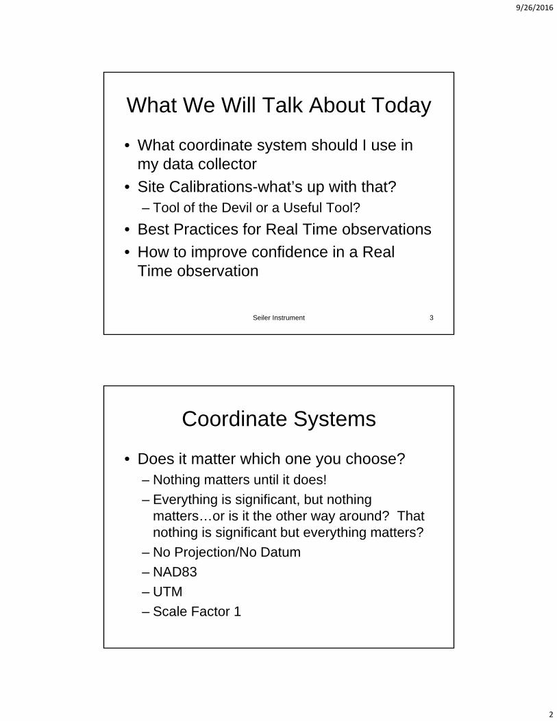
What We Will Talk About Today
• What coordinate system should I use in d t ll tmy data collector
• Site Calibrations-what’s up with that?– Tool of the Devil or a Useful Tool?
• Best Practices for Real Time observations
H t i fid i R l• How to improve confidence in a Real Time observation
Seiler Instrument 3
Coordinate Systems
• Does it matter which one you choose?– Nothing matters until it does!
– Everything is significant, but nothing matters…or is it the other way around? That nothing is significant but everything matters?
– No Projection/No Datum
– NAD83
– UTM
– Scale Factor 1

9/26/2016
3

9/26/2016
4
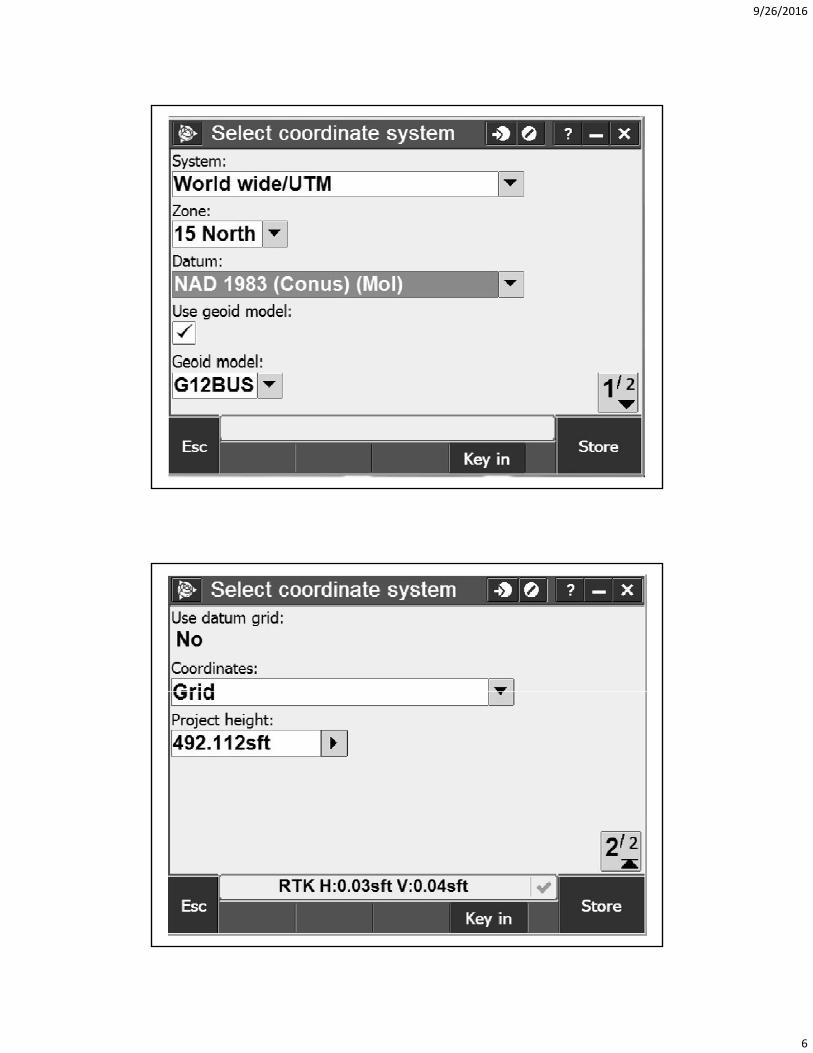
Series of slides showing
• Screen shots from collector of different di t t h icoordinate system choices
• Discuss each one

9/26/2016
5
9/26/2016
6

9/26/2016
7
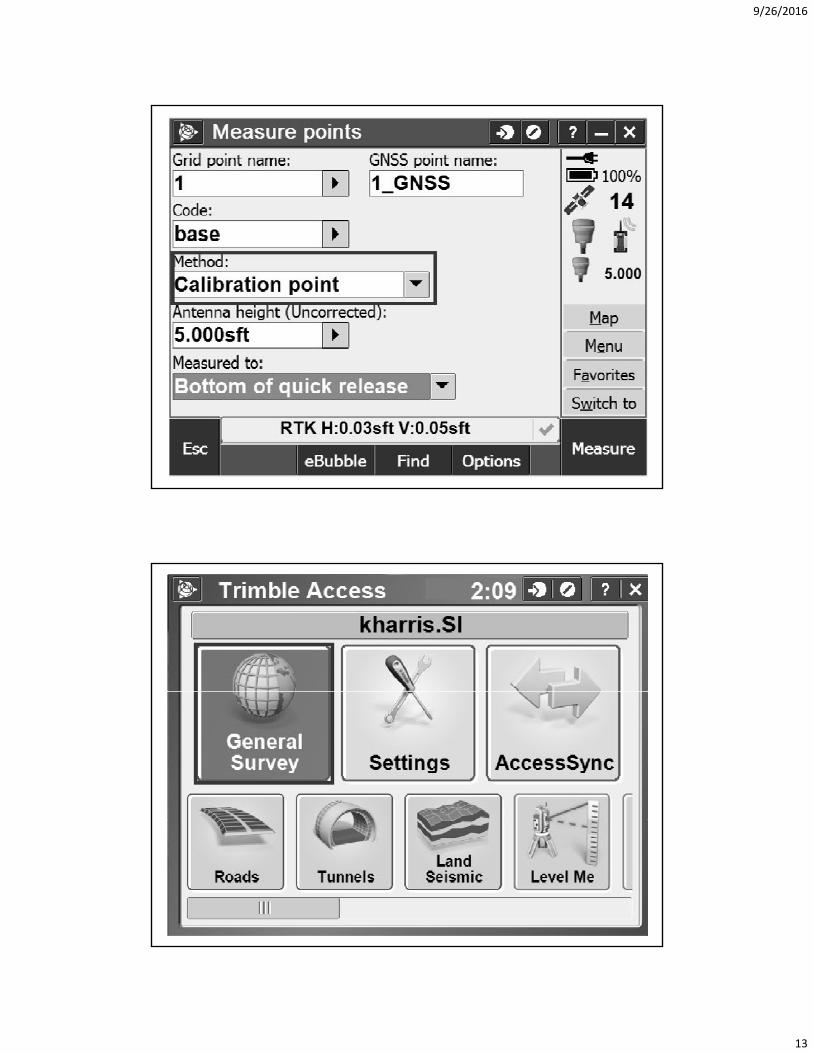
Site Calibrations
Purpose of a site calibrationLLe to NEE• LLe to NEE
• Transformation
• Rotation
• Scale
• Best fit
• Set Scale Factor to 1?Set Scale Factor to 1?
Site Calibrations
• What coordinate system to start in– What difference it makes
– No Projection/No Datum
– NAD83
– UTM
– Scale Factor 1Scale Factor 1

9/26/2016
8
Constraining to PassiveConstraining to Passive Monuments
• Calibrations
• Localizations
Seiler Instrument 15
Orthometric elevations (heights)• Use four Benchmarks surrounding site
PLUS th id d lPLUS the geoid model• Use one Benchmark, use geoid model,
check to another Benchmark• Just use what comes out of the RTN
– Why are my elevations off by 100 feet?y y y– Probably should check at least one
Benchmark if possible
Seiler Instrument 16
9/26/2016
9

9/26/2016
10

9/26/2016
11
9/26/2016
12
9/26/2016
13

9/26/2016
14

9/26/2016
15

9/26/2016
16
Datum Used by MoDOT RTN
• NAD83 2011Old datum NAD83 CORS96 ended 15• Old datum NAD83 CORS96 ended 15 October 2015
• Network broadcasts Latitude, Longitude and Ellipsoid heights– You choose your coordinate system in your data
collectorcollector– Site Calibration– NOT tied to any vertical control (Checks very well
with high quality Benchmarks)
Limitations of Classical RTK Survey
• Limited range from single reference station
P t ti l i t bli hi f t ti• Potential gross error in establishing reference station
• Dependency on single reference station
• No integrity monitoring
• Productivity loss
• Security
• CommunicationsCommunications
• Power supply
Seiler Instrument 32
9/26/2016
17
Benefits of a Reference Station Network
• Eliminate the need for local base stations
• Only GPS rover receivers are needed• Only GPS rover receivers are needed
• Less initial GPS expense because it doubles the number of GPS systems you have now
• No surveyor required to “watch” the base station
• Consistent known datum and coordinate system
Seiler Instrument 33
Correction Streams (Mount Points)
• RTCM– VRS_RTCM21
VRS RTCM23– VRS_RTCM23– VRS_RTCM31– VRS_CMRplus– RTCM3Net_autocell
• VRS– VRS_CMRplus– VRS_CMRX– BOOTHEEL_CMRplus– BOOTHEEL_CMRx
9/26/2016
18
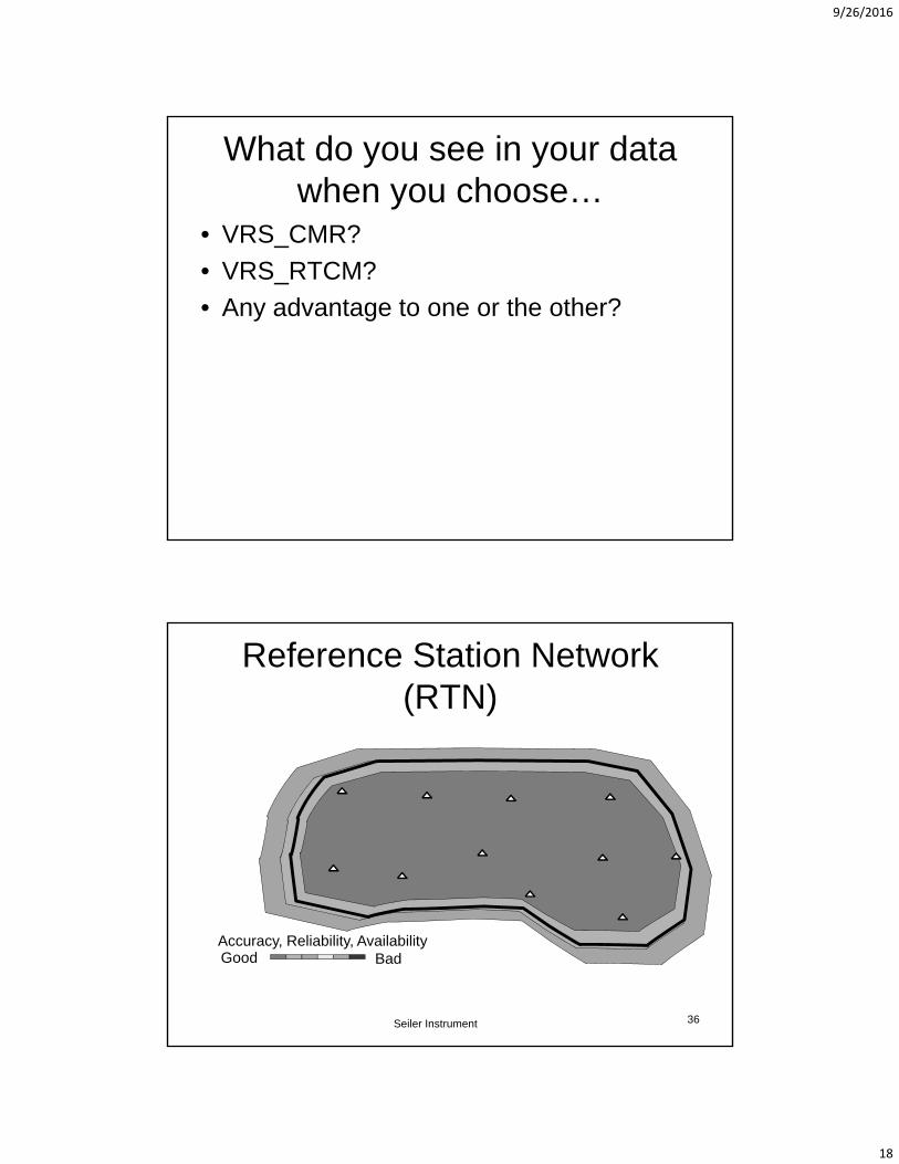
What do you see in your data when you choose…
• VRS_CMR?
• VRS_RTCM?
• Any advantage to one or the other?
Reference Station Network (RTN)
Accuracy, Reliability, AvailabilityGood Bad
Seiler Instrument 36

9/26/2016
19
RTN Equipment Needed
• Dual frequency GNSS rover receiver
• Data collector
• Communications device to access the internet
• Appropriate accessories
Seiler Instrument 37
Communication is the Key
• Cell phone…. Bluetooth or old school blcable
• Internal modem in receiver
• Internal modem in data collector
Seiler Instrument 38

9/26/2016
20
Communication is the Key (2)
• Intuicom RTK Bridge
• WiFi Hotspots• WiFi Hotspots
– MiFi devices
– Phones
– Other WiFi’s• Without the communication link…VRS is not possible
Seiler Instrument 39
Choose Your Wireless Provider
• Pick whoever has the best coverage in your area
• Maps are VERY generalized
• Only way to really know which carrier has best coverage is to test it yourself…
Seiler Instrument 40

9/26/2016
21
How Much Data Does a VRS Connection Use?
• Here is approximately what you could expect using CMR+ with 14 SVs for 8hrs straight:using CMR+ with 14 SVs for 8hrs straight:
• 1 sec: 310bytes
• 1 min: (310bytes x 60) = 18.6KB
• 1 hour: (18.6KB x 60) = 1.11MB
• 8 hrs: (1 11MB x 8) = 8 93MB• 8 hrs: (1.11MB x 8) = 8.93MB
• 5GB (typical plan amount): 24/7 for 30 days
Seiler Instrument 41
Best Methods for RTN Users
• Check Equipment, Data Collector Parameters & Site informationParameters & Site information
• Conditions• Coordinates• Communication• Constraining to passive monuments (a.k.a.
C lib ti L li ti )Calibrations or Localizations)• Collection• Confidence
Seiler Instrument 42
9/26/2016
22
Check Equipment and Parameters
• Measure the actual height of the antenna reference point (ARP) on the rover polereference point (ARP) on the rover pole
• Ensure that all necessary and correct projection parameters are in the data collector
• Ensure that all project data are in the data ll tcollector
• Adjust the rover pole bubble before every campaign
Seiler Instrument 43
Check Equipment (cont)
• Test wireless data communications (cell/CDMA/SIM card/etc ) for Internet(cell/CDMA/SIM card/etc.) for Internet connectivity at the project site.
• Make sure the GNSS unit and the communication device batteries are fully charged and that there are backups.F th t i h i ht b t• For orthometric heights, be sure to preload the current geoid model supplied by the NGS
Seiler Instrument 44
9/26/2016
23
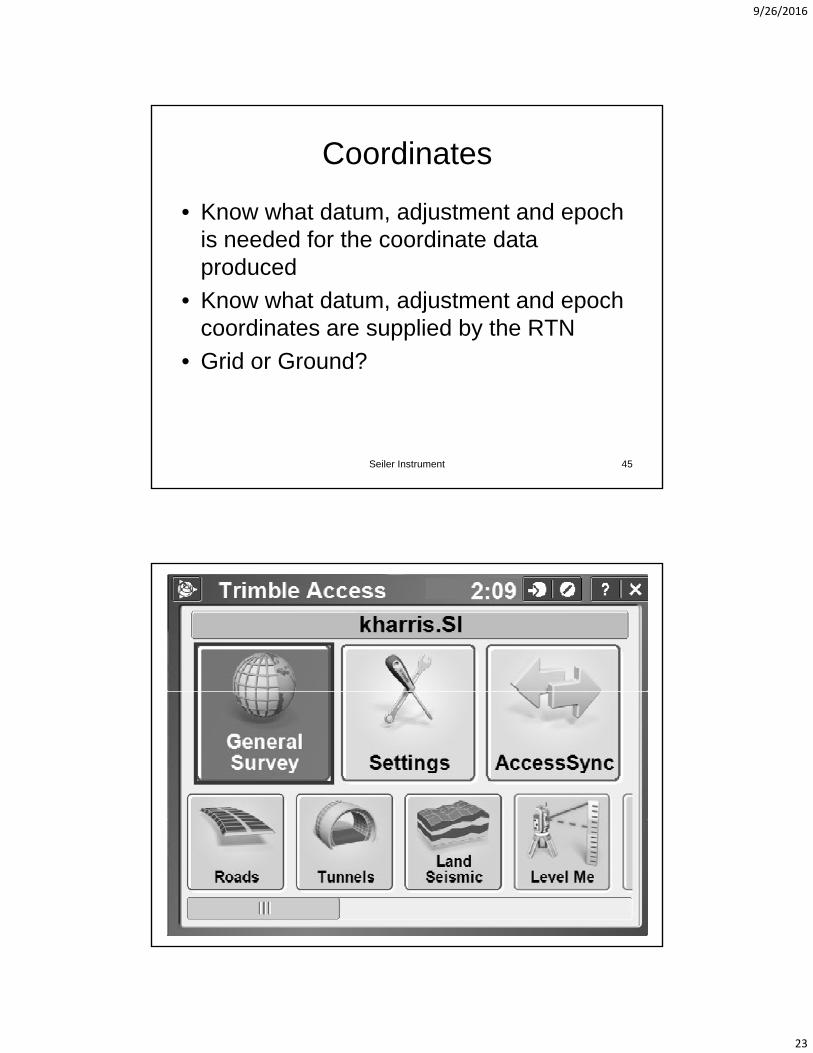
Coordinates
• Know what datum, adjustment and epoch i d d f th di t d tis needed for the coordinate data produced
• Know what datum, adjustment and epoch coordinates are supplied by the RTN
• Grid or Ground?• Grid or Ground?
Seiler Instrument 45

9/26/2016
24

9/26/2016
25

9/26/2016
26
Communication
• Robust communication is the key to an effective RTNeffective RTN
• Wireless internet from a variety of sources lets you roam anywhere within an RTN
• Many options • The GNSS solution at a point of interest p
should become fixed in a “normal” amount of time and should remain fixed for the duration of the actual data collection
Seiler Instrument 52
9/26/2016
27
Communication
• Robust communication is the key to an effective RTNeffective RTN
• Wireless internet from a variety of sources lets you roam anywhere within an RTN
• Many options • The GNSS solution at a point of interest p
should become fixed in a “normal” amount of time and should remain fixed for the duration of the actual data collection
Seiler Instrument 53
Confidence
• Redundancy is the king of RT GNSS positioningpositioning– Redundancy gives confidence and refines the
precision of the data• Robust wireless Internet connectivity
– Coordinate accuracy will suffer if• Latencies rise above 2 seconds• Communication is intermittent during data captureg p
• Checks on known points– Before, During, After
• Obvious Multipath…avoid it
Seiler Instrument 54

9/26/2016
28
Best Methods for RTN Users -Summary
• Four basic elements to achieve reliability– Communication
– Checks
– Redundancy
– Multipath
• Good GNSS gear good field conditions• Good GNSS gear, good field conditions and good field procedures will yield good Real Time positions
Seiler Instrument 55
How to Ensure Accuracyin Real Time Solutions
• What is a real time (RTN) shot?
• How can you add redundancy to your work?
Seiler Instrument 56

9/26/2016
29
An RTK Shot is a Radial Sideshot
• Need to measure it more than once to k f th t it i i htknow for sure that it is right…
• How do we achieve redundancy using RTK?– Measure it more than once
– Measurements separated by time– Measurements separated by time
– Change in the satellite constellation
Seiler Instrument 57
Redundancy
• Store raw data at selected locations– Submit to OPUS
• If setting two points for control– Measuring between them with a total station
(or tape) is an excellent check
• You can store more than one observation• You can store more than one observation, and post process and adjust in office software.
Seiler Instrument 58

9/26/2016
30
How Much Time Between Observations?
• Ideally…four hours
• How big is your budget on the job?• How big is your budget on the job?
• Studies have shown– For precise work where the height component is important,
observe for three minutes and then another three minutes
– A separation of 20 minutes gives a 10-20% improvement in coordinate accuracy
45 minute separation gives a 15 30% improvement over a– 45 minute separation gives a 15-30% improvement over a single epoch solution
Seiler Instrument 59
If You Do Not Have Time…
• Measure your pointMeasure your point• “Dump” the antenna• Let it reinitialize• Measure again
– Store as same number and look at differences– Store as a different number and inverse
• More of a “warm and fuzzy” check than• More of a warm and fuzzy check than anything…
Seiler Instrument 60
9/26/2016
31
Or…
• For practical reasons, most users cannot wait four hours between RTNwait four hours between RTN observations due to cost and logistics.
• Record your first point measurement• Force receiver to lose initialization
– Raise elevation mask to 90 degrees– Change antenna height by 0.3 meters
(0.98 feet - Longer than one wavelength of the GPS signal)
Seiler Instrument 61
Or…
• Change antenna mask back to 10 ddegrees
• Do a “Known Point” initialization on the point you stored– If it does not succeed, the first shot probably
wasn’t any goodwasn t any good
– Then measure again after 20 minutes to allow change in constellation
Seiler Instrument 62

9/26/2016
32
RTN Initialization
For example, on newer Trimble GNSS receiversreceivers• Built in routine for RTN Initialization
– Resets Satellite Tracking– Closes elevation mask to 90°– Lose all SVs– Reset mask to 10°
R i SV R i i iti li ti– Regain SVs…Regain initialization– Can be added to a hot key
• Can be done manually on any receiver
Seiler Instrument63
A Best Practice
• Two “observed control” measurements for ALL SURVEY POINTSALL SURVEY POINTS
• 1st observation – 60 seconds• Re-initialize 10 m from last initialization• Change antenna height by 0.30 m• 2nd observation – 30 seconds• If H & V deltas within 0.025 & 0.035 (m),If H & V deltas within 0.025 & 0.035 (m),
“store as check”• Time between observations is recommended
– but not mandatory
Seiler Instrument 64

9/26/2016
33
In Summary…
• Takes longer to get to most points than it does to shoot themdoes to shoot them
• Longer observation is better• Redundancy is better than longer
observation• I would rather see two 60 second shots than
one 180 second shotone 180 second shot• NO single shots on important points
– Just too many variables…
Seiler Instrument65