abstract - c-change | coastal climate adaptation...
TRANSCRIPT

i
ABSTRACT
Increasing rates of sea level rise caused by global warming are expected to lead to
permanent inundation, episodic flooding, beach erosion and saline intrusion in low-lying
coastal areas around the world. Sea level rise is perceived as a significant and growing
threat to the coastal communities, especially in Small Island Developing States (SIDS) in
the Caribbean since the coastal zone is a major focus of human habitation and economic
activity, as well as being important ecologically. As one SIDS, Trinidad is vulnerable to
the impacts of climate change and sea level rise. This study presents an assessment of the
expected impacts of sea level rise on one of the coastal communities of Trinidad, Grande
Riviere.
Sea level rise scenarios based on present measurements and global scenarios are
projected in the future for the next 100 years and applied to digital elevation models to
produce maps in order to illustrate the potential socio-economic impact of sea level rise
on Grande Riviere. Semi-structured interviews and collected demographic data, land use
datasets, property values, visitor statistics, occupancy rates and revenue values are used
to determine the current socio-economic conditions of Grande Riviere. The analysis uses
socio-economic conditions drawn from these surveys to inform the evaluation. In this
report the focus is on sea level rise on tourism, agriculture and fisheries sectors, all of
which are major economic drivers typical of SIDS.
The results of this research suggest that both the livelihood of Grande Riviere community
and the natural environment of the coastal zone are likely to be significantly affected by
the anticipated sea level rise. Tourism operations which are the centre of many of the
economic activities in the community may be affected the most by the projected sea level
rise. The results of this study are important because it informs the level of vulnerability of
Grande Riviere to effects of sea level. These findings strongly suggest the need to

ii
develop optimum adaptation strategies so as to minimize the impact of sea level rise has
on the coastal resources of the area, in terms of, social disruption, economic costs and
environmental impacts.

iii
ACKNOWLEDGEMENTS
Firstly, I would like to thank my heavenly father for allowing me to complete this project,
for his knowledge and wisdom, and guidance through this semester. Thank you for life
and for giving me an opportunity to gain tertiary level education.
I express my deepest gratitude to my supervisor Dr. Sutherland, for guiding me through
this project. Thank you for your time and support throughout the duration of this project.
I also express my deepest gratitude to Dr. Neale who has guided step by step through this
project and has been of the most help to me. Thank you for giving of your time, patience,
support and encouragement and for this I am indebted to him.
I would like to thank the community of Grande Riviere for participating in the interview
process, for providing me with data needed for the analysis of the project and for
welcoming my classmates and I into their community.
Last but certainly not least I would like to thank my family and friends for supporting me
in all my endeavors. For being there for me in my time of need and in all the ways they
helped me. Thank you for being an inspiration for me to strive to always to be better and
to perform to the best of my ability.

iv
Table of Contents
ABSTRACT......................................................................................................................... i
ACKNOWLEDGEMENTS ............................................................................................... iii
LIST OF FIGURES ......................................................................................................... viii
LIST OF TABLES ............................................................................................................. ix
CHAPTER 1 ....................................................................................................................... 1
INTRODUCTION .......................................................................................................... 1
1.1 Background ........................................................................................................... 1
1.2 Study Area ............................................................................................................ 5
1.4 Problem Statement ................................................................................................ 8
1.5 Research Question ................................................................................................ 8
1.2 Aim ....................................................................................................................... 8
1.3 Objectives ............................................................................................................. 9
1.6 General Methodology ........................................................................................... 9
1.7 Structure of Report .............................................................................................. 10

v
CHAPTER 2 ..................................................................................................................... 11
LITERATURE REVIEW ............................................................................................. 11
2.1 Introduction ......................................................................................................... 11
2.2 Climate Change ................................................................................................... 11
2.3 Sea level rise and the social and economic impact ............................................. 12
2.4 Vulnerability of coastal communities ................................................................. 14
2.5 Global and Regional Impact (Caribbean Small Island Developing States) ........ 14
2.6 Uncertainty of the impacts of climate Change and sea level rise and the impacts
.................................................................................................................................. 16
2.7 Conclusion .......................................................................................................... 17
CHAPTER 3 ..................................................................................................................... 19
METHODOLOGY ....................................................................................................... 19
3.1 Methodology Approach ................................................................................ 19
3.2 Approach to Data Collection .............................................................................. 20
3.3 Survey of key stakeholders ................................................................................. 21

vi
3.4 Compilation of data on socio-economics, demography, land use and property
values ........................................................................................................................ 23
3.5 The manipulation of the data collected ............................................................... 24
3.6 Evaluation of the potential impacts of sea level rise scenarios ........................... 25
3.7 Limitations .......................................................................................................... 25
CHAPTER 4 ..................................................................................................................... 27
RESULTS ..................................................................................................................... 27
4.1 Introduction ......................................................................................................... 27
4.2 Fishing ................................................................................................................ 28
4.3 Coastal Tourism .................................................................................................. 29
4.3 Coastal conservation ........................................................................................... 36
4.4 Local coastline recreation ................................................................................... 38
CHAPTER 5 ..................................................................................................................... 45
ANALYSIS ................................................................................................................... 45
5.1 Introduction ......................................................................................................... 45

vii
5.2: 1 m sea level rise scenario ................................................................................. 46
5.3: 2.4m sea level rise scenario: .............................................................................. 47
5.4: 3.7m sea level rise scenario ............................................................................... 49
CHAPTER 6 ..................................................................................................................... 53
CONCLUSION AND RECOMMENDATIONS ......................................................... 53
6.1 Conclusion .......................................................................................................... 53
6.2 Conclusions regarding the profile of the present socio-economic environment of
Grande Riviere specific to coastal resources ............................................................ 54
6.3 Conclusions regarding the relationship (in terms of dependency on coastal
resources) between the sea level rise and the socio-economic status-quo of the
Grande Riviere. ......................................................................................................... 54
6.4 Conclusion regarding the evaluation of the potential impact of sea level rise
scenarios on Grande Riviere. .................................................................................... 55
6.2 Recommendations ............................................................................................... 56
REFERENCES ................................................................................................................. 58
APPENDIX ....................................................................................................................... 61
viii
LIST OF FIGURES
Figure 1.1 - Global temperature record……………………………………..….3
Figure 1.2 - Global carbon dioxide emissions……………………………….…4
Figure 1.3- Sea level rise record…………………………………….…………..4
Figure 1.4 -Leather back turtle (Dermochelys Coriacea)………………………6
Figure 1.5 - Map of Trinidad and Tobago showing location of study area...…7
Figure 4.1- Percentage of hotel employees living in Grande Riviere………...30
Figure 4.2- Grande Riviere beach socio-economic use……………………….32
Figure 4.3- Grande Riviere Beach social use………………………....………39
Figure 4.4- Purposes for visiting Grande Rivier…………………...…………..40
Figure 4.5- Land use Map of Grande Riviere…………………………….……41
Figure 4.6- Land use Map of Grande Riviere showing 1 meter sea level rise..42
Figure 4.7- Land use Map of Grande Riviere showing 2.4 meters sea level rise..43
Figure 4.8- Land use Map of Grande Riviere showing 3.7 meters of sea level rise..44

ix
LIST OF TABLES
Table 4.1- Total number of visitors to Grande Riviere Annually………..…31
Table 4.2- Annual revenue generated by the Mount Plaisir Hotel………….33
Table 4.3- Number of guest at Mount Plaisir Hotel………………………….34
Table 4.4- Estimate of property values of the beach front hotel……………35.
Table 4.5- Occupancy rate of the hotels on the beachfront……………...…35
Table 4.6- Number of permits sold annually………………………………..37
Table 5.1- Potential Impacts of sea level rise scenarios………………...…..50

1
CHAPTER 1
INTRODUCTION
1.1 Background
The earth's climate is dynamic and ever changing through a natural cycle (Francisco et
al.,2009). Climate change is caused by both natural and anthropogenic factors
(International Panel for Climate Change (IPCC) 2007). Within recent years, the earth’s
temperature has increased significantly in the twentieth century and there have been
extremities in weather patterns, both of which have become a concern to scientists
(Institute for Global Climate and Ecology, Russia 2004). In the late 19th century,
worldwide the average temperature has been increasing between 0.4 to 0.8º C (Yoskowitz
et al.,2009) (refer to Figure 1.1). The last two decades are the warmest on record. Eleven
of the last twelve years were in the top twelve warmest global surface temperatures.
Global warming is on the rise and this is due an anthropogenic induced green house gas
concentration trapped in the atmosphere (IPCC 2007). The natural green house effect is
necessary to sustain life on the earth, however human activities including: burning of
fossil fuels (coal, oil and natural gas) and deforestation have caused an imbalance in the
natural cycle of the greenhouse effect (L. Sorenson 2007). Since the mid 1800s the
emissions of carbon dioxide increased drastically (Serreze et al. 2006), (refer to
Figure1.2). Carbon dioxide, though not the most potent of greenhouse gases, is the most
significant one (Unger et al. 2009). The burning of fossil fuel alone accounts for about
75% of the increase in CO2. Deforestation: the cutting and burning of forests accounts for
another 20% of the increase in CO2 in the atmosphere. (L. Sorenson 2007; Yoskowitz et
al., 2009).

2
One of the consequences climate change is sea level rise (US Global Change Research
Program 2003). Global warming leads to thermal expansion, which causes sea level rise.
The increases in sea level are consistent with warming (Climate Institute 2008). Sea level
rise is on a more gradual scale, the effects of sea level rise take a longer period of time to
realize (IPCC 2007). IPCC has high confidence that the rate of global mean sea level rise
increased between the mid-19th and 20th centuries. IPCC states "The average rate was 1.7
± 0.5 mm/ yr for the 20th century, 1.8 ± 0.5 mm/yr for 1961–2003, and 3.1 ± 0.7 mm/yr
for 1993–2003", (refer to Figure 1.3). Sea level is expected to rise 56 cm by 2100 (Patz
2000). IPCC (2007) stated that sea levels will rise between 0.18 and 0.59 meters as a
result of Global Warming. Coastal zones are particularly vulnerable to climate variability
and change. Currently, an estimated 23 percent of the world’s population (1.2 billion
people) lives within 100 kilometers (km) of a shoreline and 100 meters (m) of sea level
(Small and Nicholls 2003). Especially Small island developing states (SIDS) such as the
Caribbean are highly vulnerable to the impacts of sea level rise (World Meteorological
Organisation 2005). The impacts of sea level rise include: loss of land and property, loss
of infrastructure, loss of wetlands and ecosystems, erosion of beaches, intensified
flooding (storm surges), and increase in salinity of rivers, bays and groundwater tables.
(United States Environmental Protection Agency).

3
\
Figure 1.1: Global temperature Record

4
Figure 1.2: Global CO2 emissions 1751–2006
Figure 1.3: Records of sea level rise in the 20th Century

5
1.2 Study Area
Case Study (Study Area): Grande Riviere
Grande Riviere is a coastal community located along the north coast of Trinidad, (refer to
Figure 1.4) it is a popular tourist attraction known for the turtle nesting on the beach
which takes place during the season March to August. Grande Riviere’s beach is home to
the leatherback turtle (Dermochelys Coriacea). The community has developed from
having their economy based on fishing and agriculture to being more tourism oriented
(Information from respondents in interviews). Despite the village’s small size and
population the area is visited by thousands every year (Information obtained by Charmine
Bishop, personnel at the visitor centre). Visitors are both local and international. Tourism
is the major source of revenue and economic activity in the area (Information from
respondents in interviews). As with many coastal communities around the world, Grande
Riviere is particularly vulnerable to the effects of climate change and sea level rise. The
main effects of climate change include coastal flooding, intensification of storms, salt
water intrusion, loss of wetlands and ecosystems, inundation, loss of infrastructure
(roads, buildings), loss of property and dwelling units. Climate change is likely to have
significant potential social and economic impact on the community.

6
Figure 1.4: Leatherback turtle (Dermochelys coriacea)

7
Figure 1.5: Map showing location of Case Study Grande Riviere

8
1.4 Problem Statement
Coastal communities around the world are highly vulnerable to the impacts of sea level
rise, especially those in Small Island Developing States. Grande Riviere in Trinidad is the
case study used to illustrate the impacts that sea level rise has on coastal communities in
Small Island Developing States. Sea level rise physical effects includes: coastal
inundation, beach erosion, intensified frequent storm surges, saline intrusion of coastal
wetlands (ecosystems). These physical effects of sea level rise have social and economic
implications for coastal communities. It is difficult to quantify the impacts of projected
sea level rise using data based on present day socio-economic conditions. Understanding
the coastal community level of vulnerability is important for informing and educating the
coastal populations of the risks of sea level rise and for developing adaptation strategies
to minimize the risk.
1.5 Research Question
1. Given the current estimates of sea level rise scenarios from IPCC predictions,
what is the potential impact of these sea level rise scenarios on the economic and
social aspects of the community at Grande Riviere?
1.2 Aim
This research project aims to assess the potential social and economic impact of sea level
rise on the coastal community of Grande Riviere, by examining the level of vulnerability
of the community to different sea level rise scenario predictions.

9
1.3 Objectives
1. To generate a generalised profile of the present economic and social environment
of Grande Riviere with specific reference to coastal resources.
2. To describe the relationship (in terms of dependency on coastal resources)
between the sea level rise and the socio-economic status-quo of the Grande
Riviere.
3. Given items 1 and 2 above, to evaluate the potential impact of sea level rise
scenarios on Grande Riviere.
1.6 General Methodology
A series of semi- structured interviews were conducted with key stake holders in the
community such as villagers, beach users, hotel management and hotel employees. The
interviews were designed based on the general topics that were important to the socio-
economic conditions of the Grande Riviere. These interviews were used in order to
develop a profile or description of Grande Riviere’s socio-economic aspects. Data from
the interviews were tabulated and graphs, pie charts and tables were produced to
represent the data in a graphical format.
Information on demography, property values and Hotel revenues, visitor statistics,
permits sold for turtle watching were obtained for the area and tabulated. Land use data
sets for the GIS data base were received from secondary data sources and land use maps
illustrating the sea lelvel rise scenarios based on IPCC predictions were created using
ArcGIS, (ArcMap software).

10
1.7 Structure of Report
This research project would have the following structure:
Chapter 2 discusses the literature of some the key topics associated with the effects
of sea level rise and its impacts on coastal communities. The review is aimed at
providing a brief background to the research topic.
Chapter 3 addresses the methodology performed in the project in order to achieve
objectives of the study.
Chapter 4 describes the results obtained from the data collection for the
methodology. Results are shown in tables, bar graphs and pie charts.
An analysis of the results based on information gathered, to assess the potential
impact of sea level rise on the coast community of Grande Riviere is presented in
Chapter 5.
Chapter 6 discusses the conclusion and summary of findings of the report. This
chapter answers the objectives of the study.

11
CHAPTER 2
LITERATURE REVIEW
2.1 Introduction
This chapter addresses the literature of key topics: Climate Change, Sea level rise,
vulnerability of coastal communities, social and economic impact of sea level rise, Global
and Regional Impact (specific to Small Island Developing States) and Uncertainty of
measurements of climate change and sea level rise. The literature reviewed is guided by
the basis of the research focus. These subject areas are critical to the understanding of this
research paper. The topics listed above were discussed in previous articles, referred
papers and journals. The methodology of these articles, referred papers and journals will
be analysed, compared and patterned for the purpose of conducting this research paper.
2.2 Climate Change
‘Climate change’ refers to a change in the state of the climate that can be identified (e.g.,
using statistical tests) by changes in the mean and/or the variability of its properties, and
that persists for an extended period, typically decades or longer (IPCC 2007). The science
and impacts of climate change do little to motivate action if individuals cannot relate to
them on a personal level (Yoskowitz et al., 2009). Climate change is a grave problem that
holistically affects countries globally and regionally. While climate impacts will vary on
a regional scale, it is at the state and local levels where critical policy and investment
decisions are made for the very systems most likely to be affected by climate change –
water, energy, transportation and public health systems, as well as important economic
sectors such as agriculture, fisheries, forestry, manufacturing, and tourism. (The Centre
for Integrative Environment Research University of Maryland 2008).

12
There is a wide range of potential impacts, including changes in: seasonal weather
patterns (drought); the amount and type of precipitation; intensified storm surges, sea
level rise and increased risk of flooding; regular climate fluctuations; ocean acidity;
ecosystems and biodiversity (saline intrusion of coastal wetlands and ecosystems, coastal/
beach erosion; agriculture, forestry, and fishing; water supply (shortage of water supply)
and other infrastructure; and human health. Secondary effects of climate impacts can
include higher prices, reduced income and job losses. (Ramon et al.,2008)
The Centre for Integrative Environment Research University of Maryland 2008 identifies
key economic sectors in North Carolina, which are likely affected by climate change, and
the main impacts to be expected for these sectors. In their report their methodology
involves providing examples of the direct economic impacts that could be experienced in
the state and presents calculations of indirect effects that are triggered as impacts on
individual sectors in the economy ripple through to affect others. Direct impacts are those
impacts (jobs and output) generated directly by the project. Indirect economic impacts
occur as the project (or business owners) purchase local goods and services. Both direct
and indirect job creation increases area household income and results in increased local
spending on the part of area households. The jobs, wages, output and tax revenues
created by increased household spending are referred to as induced economic
impacts. ( The Centre for Integrative Research, University of Maryland)
2.3 Sea level rise and the social and economic impact
Relative sea-level change occurs where the local level of the ocean relative to land is
changed, due to ocean rise and/or land subsidence or due to rapid land-level uplift.
Impact researchers focus on this relative sea-level change which is measured by tide
gauges with respect to the land on which they are located. Mean sea level is defined as
the average relative sea level over a period long enough to average the wave and tide
transients (typically a month or year). (Thurman and Burton 2000; IPCC 2007; Baede
2007).

13
According to Lam et al. (2009), although studies on climate change impacts on the coast
have been conducted and impact scenarios have been generated, very few of them have
focused on the socio-economic impacts. Lam et al. 2009 uses population directly
affected by sea level rise as a fundamental social- economic measure of climate
change impacts on coastal regions.Yoskowitz et al. 2009 research paper on
Galveston Bay uses the method of two scenarios of relative sea level rise for 100
years: 1) 0.69 meters and, 2) 1.5 meters, based on IPCC predictions. Land use
maps and digital elevation terrain models (Geographical Information Systems
Software) were produced in order to apply sea level rise scenarios for sea level
rise models. For each scenario an estimation of the impact on the following
variables were analysed: 1) displaced population (number of households); 2)
expected number of buildings impacted, 3) building related economic loss, 4)
industrial, hazardous, superfund, solid waste sites, and 5) water treatment plants.
This method encompasses a wide range of variables for suitable analysis. This
research paper focuses on three scenarios of sea level rise and the associated
socio-economic impact. (Lam et al., 2009; Yoskowitz et al. 2009)
Cooper et al. (2005), in his study of New Jersey also uses relative sea level rise
scenarios, 0.66m and 1.22m based on IPCC predictions to analyse the potential
impact of sea level rise. The sea level rise was applied to the digital terrain models
produced by a Geographical Information Systems program/software, so as to
produce sea level rise models. Land use data was also applied to the digital terrain
models. Land use maps with sea level rise models were created. Copper et al.,
(2005) used present day data on the properties of the coast to evaluate the impact
of the each sea level rise scenario. (Cooper et al., 2005)

14
2.4 Vulnerability of coastal communities
The increased vulnerability of coastal communities to potential hazards is partly due to
the constantly increasing coastal population (Adger et al., 2005). Vulnerability is defined
as the degree to which a natural or social system is at risk to damages or losses due to
natural phenomenon (Cooper et al.,2005). Coastal communities and environments are
particularly vulnerable to climate change due to the potential for permanent coastal
inundation and increasing coastal hazards associated with changing weather patterns and
extreme weather events (Department of Environment, Climate Change and Water, New
South Wales Government 2009). The IPCC has a very high confidence that coastal
communities and habitats will be progressively stressed due to the climate change
impacts combined with development and pollution. (Adger et al., 2005)
There is a need to assess the overall vulnerability to climate change in coastal regions,
and there is a need to develop a useful methodology to assess vulnerability that is
applicable to most regions in the world (Field et al., 2007; Parry et al., 2007; Yusuf and
Francisco, 2009). Adger 1999 in his study of the social vulnerability of climate change in
Coastal Vietnam collects data on individual-level and collective-level vulnerability
indicators to determine the vulnerability of the study area. He gathers information such
as: household income and size, remittances and diversity. His method of collecting data is
via quantitative and qualitative surveys, interviews with commune and district officials
and from secondary data sources such as census survey data. This interviewing method is
similar to data collection in this research paper however, Adger methodology differs
because in his study he does not evaluate sea level rise as part of methodology.
2.5 Global and Regional Impact (Caribbean Small Island Developing
States)
Global and regional vulnerability studies have provided quantitative assessments of
potential impacts of sea-level rise at global and regional scales (e.g., Gornitz et al., 1994;
Hoozemans, Marchand, and Pennekamp, 1993; Mimura, 2000; Thieler and Hammar-

15
Klose, 1999). The impacts of and possible responses to sea-level rise vary at the local and
regional scale due to variation in local and regional factors (Nicholls et al., 1998). Small
island states such as those in the Pacific and the Caribbean are particularly vulnerable to
sea level rise because of their small physical size, high population density and reliance of
coastal resources (IPCC 2007).
In many cases, the majority of settlement, economic activity, infrastructure and services
are located at or near the coast, and local economies are reliant on just a few sectors, such
as tourism and agriculture (Nicholls et al., 1998). Small islands lack reliable demographic
and socio-economic scenarios and projection, which results in socio-economic conditions
of small islands not being presented well in existing assessments (Yoskowitz et al 2009).
Sea level rise will have a range of physical impacts on small islands, including increased
likelihood of coastal wetlands, aquifers, and increased beach erosion and coastal land loss
(Klein& Nicholls 1999).
Loss of beach habitat has both economic and environmental consequences in the
Caribbean (Fish et al. 2005). Tourism is the main source of revenue for many Caribbean
islands and the loss of beaches threatens this sector both indirectly by the loss of revenue
and directly by the loss of buildings (Potter 1996). Aside from the direct loss of nesting
habitat, other factors associated with development, including artificial lighting, beach
compaction, beach nourishment, noise and activity, pollution, and coastal defences such
as sea walls (Witherington 1992; Crain et al. 1995; Bouchard et al. 1998; Katselidis &
Dimopoulos 1998) influence nesting success. This combination of factors compounds the
threat of projected sea level rise to nesting turtle populations. Fish et al. (2005) in his
study uses three scenarios of sea level rise (0.2, 0.5 and 0.9 meters) based on IPCC
predictions for the study analysis. He uses a digital terrain model and applies the sea level
rise scenarios to produce sea level rise models for the analysis. This methodology is
similar to that used by Cooper et al.(2009) and Yoskowitz et al., (2009) in their studies.

16
2.6 Uncertainty of the impacts of climate Change and sea level rise and
the impacts
There is extensive uncertainty about the future growth of green house gas emissions and
resulting climate-related developments, and the implications of that uncertainty for
climate policy. Uncertainty arises from several sources, including limitations in current
data, imperfect understanding of physical processes, and the inherent unpredictability of
economic activity, technological innovation, and many aspects of the interacting
components (land, air, water and ice, and life) that make up the Earth’s climate system.
(Congress of the United States, Congressional Budget Office 2009)
Uncertainty does not imply that nothing is known about future developments, but rather
that projections of future changes in climate and of the resulting impacts should be
considered in terms of ranges or probability distributions. For example, some recent
research suggests that the median increase in average global temperature during the 21st
century will be in the vicinity of 9° Fahrenheit (F) if no actions are taken to reduce the
growth of greenhouse-gas emissions. However, warming could be much less or much
greater than that median level, depending on the growth of emissions and the response of
the climate system to those emissions. (Congress of the United States, Congressional
Budget Office 2009)
The uncertainties surrounding the extent of climate change and its effects on human
welfare complicate policy choices because any given emissions scenario could result in
much more or much less dramatic changes in climate (and consequent impacts) than are
expected. A full evaluation of any policy requires an assessment not only of its most
likely effect on climate impacts but also of how it might shift the probabilities of impacts
that are unlikely but would be very severe if they occurred. Because of that uncertainty,
policymakers might wish to consider taking more action as a hedge against those severe
outcomes than they would just to address the expected or most likely outcome. (Congress
of the United States, Congressional Budget Office 2009)

17
Most of the currently available elevation data do not provide the degree of confidence
that is needed for making quantitative assessments of the effects of sea-level rise for local
planning and decision making (Anderson et al.,2009). However, the scope of these
studies has been limited by the available data in terms of resolution, coverage, parameter
availability, and dated sources: this is a generic problem for broad-scale coastal analysis
(National Research Council Staff, 2004). In addition to these limitations, data quality and
integration constitute further problems; even in those cases where data and tools are
available to coastal scientists for the analysis and modelling of coastal processes, these
usually exist in fragmented forms (Vafeidis et al.,2007).
In the last two decades, the availability of digital spatial data for the world’s biomes has
vastly increased as a result of advancements in data capture and input techniques.
Nevertheless, collections of data are not necessarily adequate for the needs of global-
scale analysis, as merging data from various sources may raise several questions. Since
the early 1990s, and especially during the 21st century, significant progress has
been made in understanding the impacts of climate change at national, regional,
and local scales. (Flewelling and Egenhofer, 1999)
2.7 Conclusion
The following is a summary of the key statements of the literature reviewed in the
chapter, which presents the basis of the research topic:
Climate change has a wide range of physical impacts: such as coastal erosion,
extremities of weather pattern, loss of coastal wetlands or ecosystems. These
physical impacts have socio-economic implications on the way of life for people
living in coastal communities. To address these socio-economic implications
critical policy and investment decisions are made locally for the very systems
most likely to be affected by climate change – water, energy, transportation and

18
public health systems, as well as important economic sectors such as agriculture,
fisheries, forestry, manufacturing, and tourism.
Sea level rise impacts include: inundation, intensified frequent storm surges, and
coastal flooding and salinity intrusion of coastal wetlands and ecosystems just to
name a few. Coastal communities are the highly vulnerable to the impacts of
climate change and sea level rise.
The uncertainty of climate change and sea level rise models are important to
understand when quantifying the impact and formulating policies for mitigation
and adaptation strategies.
The common methodology employed in assessing the socio-economic impact of sea level
rise is using sea level rise scenarios based on IPCC predictions and applying the sea level
rise to a digital terrain model of the study area to produce sea level rise models. Maps are
produced from these models to illustrate the areas that the sea level rise will
cover/inundate. The potential impact of sea level rise is evaluated by using present day
social or economic conditions of the coastal areas. This methodology has been widely
used and proven to be successful in this type of study and is applicable to future studies.
The methodology outlined above will be used for this project. The rationale for using this
method is that it has been tested and accepted by many previous authors, that is, the
professionals in the field of study.

19
CHAPTER 3
METHODOLOGY
3.1 Methodology Approach
The methodology used in this research is focused around the following data
collection/data analysis approaches:
1) The conduct of a limited survey of key stakeholders
2) Compilation of data on socio-economics, demography, land use, property values from
existing data sources from other sources including Government records, hotel book
keeping records, tourist centre information
3) The manipulation of the data collected in items 1 an 2 above using graphs,
spreadsheets and statistics to produce profiles of community dependency of coastal
resources.
4) Evaluation of the potential impacts of sea level rise scenarios as stated in the literature
on the community dependencies established in item 3 above.
The specific methodology associated with each of the items 1-4 above are described in
sections 3.2 to 3.6 below

20
3.2 Approach to Data Collection
Several sources of data were collected to assess to the socio-economic impact of sea level
rise on Grande Riviere. The following key approaches to data collection in order to
perform the study were:
1. Survey of the key socio-economic variables in Grande Riviere. This
anecdotal data was the only source of primary data in this research
project.
2. Demographic data of Grande Riviere obtained from the Central
Statisitical Office. This demography data is a scientific measurement
from a secondary data source.
3. A description of land use in the form of a land use map. The land use
map was produced using ArcGIS 9 (ArcMap 9.3), the datasets for the
GIS data base to produce the maps were received from a secondary data
source.
4. Sea level rise scenarios were obtained from reports published by The
International Panel for Climate Change. These scenarios are scientific
measurements derived from research conducted by scientists.
5. Property Values were retrieved from The Registrar General Office. It is
scientific data from a secondary data source.
6. Occupancy Rate of the hotels is a secondary data source which was
recorded from the book keeping records of the guest house Le Grande
Almandier Hotel. For Mount Plaisir Hotel the occupancy rates were
obtained via Hotel Manager respondent information.

21
7. Statistics of visitors to Grande Riviere. This data was obtained by
Charmine Bishop (employee at The Visitor Centre in Grande Riviere). It
is a secondary source of data and a scientific measurement.
3.3 Survey of key stakeholders
A series of semi- structured interviews were conducted with key stakeholders from the
time period of 29th January, 2010 to 31
st January, 2010. The sample size of the survey
was ten percent of the population of Grande Riviere. Thirty seven interviews were
conducted with villagers, fishermen, hotel staff and management, district nurse, personnel
at the visitor centre and visitors to the area.
Semi structured interviews were deemed to be the most appropriate approach for
performing the survey of the socio- economic variables of sea level rise of Grande
Riviere because they are the most useful format for obtaining specific quantitative and
qualitative information from a sample of the population. It is flexible and designed in
such a way to allow two way communications by creating a situation that gives the
respondents the ability to express their ideas and opinions on a particular subject area.
3.3.1 Designing the interview
In order to perform the interviews essential steps are followed to conduct the interviews
in the suitable format:
1) Understanding the overall purpose of the interviews, that is, the intended use
of the information from the interview. The purpose of the interviews is to
perform the survey of the current status quo of the socio-economic variables
of Grande Riviere. The information obtained from the interviews was used to
assess the social and economic impact of sea level rise on Grande Riviere

22
community. The interviews focused on how the visitors and villagers use the
coastal space location economically and socially.
2) An interview guide was prepared in the office prior to conducting the
interviews in the field. The interview guide is list of general topics and
questions that was used as a guide in actual interviews. The list of general
topics was derived from the information necessary for the assessment of the
research project. The general topics for the interview guide include: Fishing,
Coastal Tourism, Coastal Conservation and Local Coastline/Beach
Recreation;
3) Based on the topic/interview guide open ended questions were constructed in
different ways and the final interview sheet was prepared to perform the
interviews in the field.
3.3.2 Selecting interviewees (Key stakeholders)
The key stakeholders were chosen based on the interview guide developed to collect
information for the assessment of the research paper:
Villagers live in the area of Grande Riviere and use the coastal resources therefore an
understanding of how the coastal resources are used (for employment and socially) and
their level of dependency is important in achieving objective 1
Visitors to Grande Riviere come for various purposes, understanding how
visitors use the coastal resources is key in the achieving objective 1: generating a
generalized profile of the present socio-economic
23
The district nurse was interviewed to develop an understanding of how the health
centre is used by the villagers and visitors and the services offered. This gives us
a measurement of the importance of the existence of the health centre.
Fishermen are key stakeholders because they use the coastal resources like the
beach and the river for their employment and the loss of this beach space as a
result of sea level rise will have an economic impact.
Hotel staff and management are interviewed to deduce how the value and profits
of the hotels and to find the percent of the employees that are villagers. Gathering
the economic and social importance of the presence of the hotel is essential
because their location along the coast. This helps to achieve objective 1
3.4 Compilation of data on socio-economics, demography, land use and
property values
The following are the secondary sources of data collected:
1. Population and housing statistics of Grande Riviere were collected at the Central
Statistical office in Port-of Spain. The population numbers were derived from the
2000 Population and housing census Trinidad and Tobago. Population and
housing data were collected because method has been used in previous studies as
a direct measurement of impact and deemed to be very useful in the assessing the
social and economic impact.
2. A map representing focusing on the coastal features of the community produced
using ArcGIS, Arc ArcMap. This land use map is essential for mapping of the
impact of sea level rise when using the sea level rise scenarios. This mapping is a

24
main idea of the project it is a representation of the assessment of the different
sea level rise scenarios. In previous and most studies similar to this one research
a map is used to illustrate the impact of the social and economic impact based on
the current socio-economic data collected for the area.
3. Property values of the parcels along the coast were sourced from a computer data
base designed by the Registrar General Office. Searches were conducted based
on the proprietor’s name and address. The method of property values are used in
the most previous studies as a direct quantitative measure of the economic impact
of sea level rise on coastal properties. This method has deemed to be successful
in the assessment of socio-economic impact.
4. Sea level rise scenarios based on reports from The International Panel for
Climate Change were used. These specific sea level rise scenarios were chosen
because the study is focusing on the impact along the coast and coastal resources.
3.5 The manipulation of the data collected
The data collected in the interviews was first tabulated, coded and entered into a
spreadsheet. Standard spreadsheet routines were used to produce a variety of pie charts
and bar graphs in order to illustrate the data from the interviews to describe the economic
and social structure of the community.

25
3.6 Evaluation of the potential impacts of sea level rise scenarios
The sea level rise scenarios of 1 meter, 2.4 meters and 3.7 meters were chosen from IPCC
predictions. The impacts were evaluated by understanding the use and value of the
inundated or cover areas of the coast as illustrated on the land sue maps. The impact was
then stated or assessed based on the use, value and effect it will have the community.
3.7 Limitations
Method of Recording
Since semi-structured interviews contain open-ended questions the questions asked may
have been vague the discussions may diverge from the interview guide. It is generally
best to tape-record interviews and later transcript these tapes for analysis. While it is
possible to try to jot notes to capture respondents' answers, it is difficult to focus on
conducting an interview while jotting notes. The actual semi structured interviews
conducted in the field were not tape recorded, the recording was note taking. This
approach may have results in poor notes and detract for the development of rapport
between interviewer and interviewee resulting in poor quality data collection of the
anecdotal data. Development of rapport and dialogue is essential in unstructured
interviews. Another limitation was the short time period given to collect this interview
data some essential information for analysis may have been omitted.

26
Interviewer Skills
As an interviewer some skills are needed, however the semi-structured interviews were
conducted by a first timer interviewer. Some common problems that may have occurred
in the interviews are: failure to listen closely; repeating questions that have already been
asked; failure to probe when necessary; failure to judge the answers.
Property Value Data
There were limitations with the property valuation data. The property values retrieved are
not true representations of the present value of the property to make an analysis. The
valuation for the entire Mount Plaisir Hotel estate was not available. The value for a
given area of part of the property was available therefore the value of the entire property
had to be estimated by knowing the area of the entire property. The property value of the
Le Grande Almandier available is for 2005, five years ago. The hotel properties present
day values will be more than what it was years ago.
Demographic data
The limitation of the population and housing statistics is that this population and housing
survey data is outdated. This survey data is based on the conditions of Grande Riviere ten
years ago. The population may have decrease or increase since 2000.
Data Sets in Arc GIS
The data sets received from other secondary data sources, the accuracies of the data sets
are unknown.

27
CHAPTER 4
RESULTS
4.1 Introduction
This chapter will present all the data from the methodology. Results from the interviews
will be represented in a graphical format, that is, on pie charts, bar graphs and line
graphs. Hotel Revenues, Property Values, annual number of guests in hotels, annual
number of permits sold for turtle watching and visitor statistics will be represented in
tables. The land use maps with the different sea level rise scenarios will be shown.
One of the primary objectives of this study is to provide a description of the social and
economic structure of the Grande Riviere community. In particular the research aims to
describe those aspects of the structure that are directly or indirectly with the coastal area
that is contagious to the community. Ultimately the study is focused on the inference of
the potential impacts that sea level rise will have on the social and economic structure of
the village.
This chapter relies on the social and economic data as well as the information collected
from the semi-structured interviews to provide a brief description of the following aspects
of the community as livelihood sources:
a) Fishing;
b) Coastal Tourism;
c) Coastal Conservation;

28
d) Local coastline recreation;
While these items are not exhaustive, they can be considered key indicators and, thus
provide a useful insight to the Grande Riviere coastal community and the larger
relationship between the sea and the coastal community.
4.2 Fishing
The stakeholders interviews responses suggests, fishing in Grande Riviere is not as active
as it used to be however it is still important to the community, this is evident because
33% percent of the respondents fish as a form of livelihood. The majority of fishing
activity is performed by the elderly of the community. It was observed that there is an
abandon fishing depot on the eastern end of the beach and that the river houses many
fishing boats, this suggests that in the past fishing was a major source of economic
activity for the community. The villagers fish both in the sea and in the river. The fisher
men sell their catch to the hotels on the beach front and to the villagers. They also use
some of their catch to cook for themselves and their families. The fishermen in the village
have described their fishing activity during the turtle season to be more difficult out in the
sea because the turtles destroy the fishing net; therefore they have to use trolling
(technique of fishing) to fish. On average the fishermen have stated they fish a few times
for the week. The elder in the in the community have expressed their desire and efforts to
revive/ redevelop the fishing activity in the village.

29
4.3 Coastal Tourism
The findings of the interviews have concluded that the community of Grande Riviere
depends heavily on tourism for their livelihood. Tourism is strongly based on the
community’s coastal resources. The leatherback turtle comes to the shores of Grande
Riviere beach to nest their eggs from March to August annually. Based on the
information gathered from the Visitor Centre, thousands of local and international people
come every year to visit Grande Riviere, (refer to Figure 4.2). Tourism is a major source
of economic activity for the community. The presence of the two hotels on the beach
front is major source of income because thousands of people stay at the hotels annually
(refer to Figure 4.1), including visitors who come to see the turtle nesting. A substantial
amount of income is generated annually from the hotels, (refer to Table 4.2).
83% of the hotels employees are resident of Grande Riviere villagers. From the
interviews the villagers have shared how they use tourism as a livelihood, another way
the villagers have found to generate income from the visitors is by giving tours up hike
trails along the river to the waterfall and selling craft and handmade jewelry to the
visitors, (refer to figure 4.3). The hotel managers buy fish from the fishermen to prepare
meals for the visitors. Tourism has had a social impact on the community, by exposing
the villagers to different cultures, religion, races and different ways of life from all over
the world visitors who come to Grande Riviere. 90% of the villagers and hotel employees
interviewed have become friends or familiar with visitors who come frequently.

30
Figure 4.1: Percent of hotel employeees living in Grande Riviere
Figure 4.1 shows that the majority of hotel employees are residents of Grande Rivere,
the number of hotel employees who are residents of Grande Riviere is almost five times
the hotel employees not resident of Grande Riviere.

31
YEAR LOCAL VISITORS INTERNATIONAL
VISITORS
2007 23000 14000
2008 17000 12000
Table 4.1: Total number of visitors to Grande Riviere Annually
Table 4.1 shows that local visitor numbers are more than the international visitors,
generally there has been a decrease in the visitors from 2007 to 2008.

32
Figure 4.2: Grande Riviere beach socio-economic use
Figure 4.2 shows the number of villagers selling craft and fishing are equal where as less
people sell agricultural produce.
33
Year Revenue (Trinidad and Tobago Dollars
TTD)
1995 $358,497
1996 $636,219
1997 $696,599
1998 $871,507
1999 $1,225,716
2000 $1,494,892
2001 $1,618,718
2002 $1,591,699
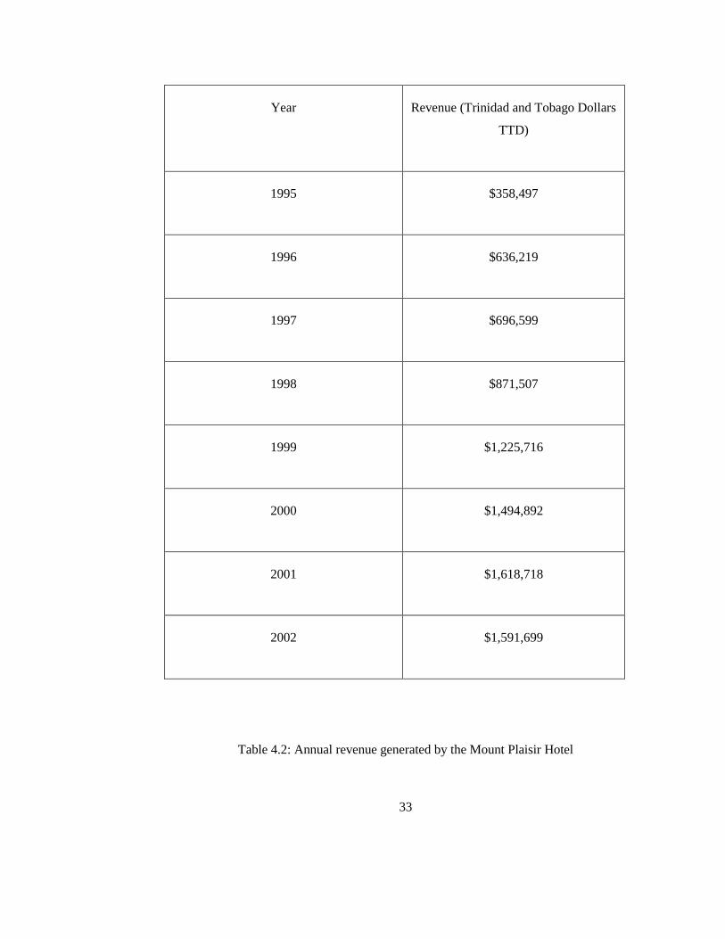
Table 4.2: Annual revenue generated by the Mount Plaisir Hotel

34
In Table 4.2 above it is that from 1995 to 2002, the annual revenue generated by Mount
Plaisir Hotel over the seven year period has increased drastically. The annual revenue
generated in 2002 increased more than four times than that generated in 1995.
Year Number of Guests
2005 4790
2006 5270
Table 4.3: Total number of guest at Mount Plaisir Hotel
Table 4.3 above shows the total number of guest in 2006 increased by 10% from the
previous year. The revenue figures (Table 4.2) and visitors’ numbers to Mount Plaisir
Hotel (Table 4.3) is an indication of the growth of tourism in the Grande Riviere.

35
Hotel Estimated Property Values (TTD)
Mount Plaisir $ 16,000,000 (2009)
Le Grande Almandier $ 2,000,000 (2005)
Table 4.4: Estimated property values of the beach front hotels
Hotel Le Grande Almandier Mount Plaisir Hotel
Occupancy Rate 40% 50%
Table 4.5: Occupancy rate of the hotels on the beachfront
With reference to Table 4.5 the occupancy rate indicates that the hotels are occupied
seasonally; the hotels have peak periods and slower period during the year. From the
book keeping records it was observed that the peak times coincide with the turtle nesting
season which is from the month March to August.

36
4.3 Coastal conservation
Based on the information interpreted from the interviews it can be stated that Grande
Riviere is eco-tourist destination which appeals to nature seekers. From the respondent
answers the villagers take pride to express that their village is one of beautiful nature and
how tourism has positively impacted on their community. From observation of the area
and information retrieved from the Visitor Centre Grande Riviere natural
environment/areas have been relatively undisturbed by man. Grande Riviere beach has
one of the highest densities in the world for turtle nesting. From the data collected from
the interviews with the Visitor Centre personnel, hundreds of leatherback turtles Grande
Riviere beach is their nesting habitat annually, the turtle’s nesting is the primary
attraction for community.
Thousands of people purchase permits, at $36 per permit, annually to go see the turtles
nesting on the beach, refer to figure 4.8.This money from purchase of the permits is used
for developing the community, managing the visitor centre facility and providing jobs. In
addition there are tours of hikes trails to the waterfall and eco-lodges. The community
benefits socially and economically from tourism. From information obtained interviewees
and observation it is noted that Grande Riviere is visited by thousands every year, the
community is low impact from the negative effects of tourism and the tourist activities
are on a smaller scale. The fragile ecosystems along the coast such as the river, other
wetlands, the beach and the forest are carefully managed by the visitor/ tourist personnel
to ensure that tourism is sustainable. One of the hotels on the beach front, Mount Plaisir
Hotel, is an eco-resort. Visiting Grande Riviere to see the turtles nesting offer tourists
insight to how the natural environment functions and it fosters a greater appreciation of
our natural habitats.
37
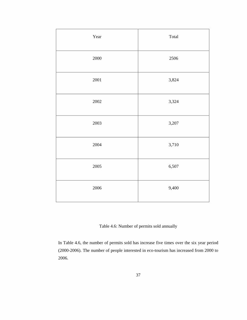
Year Total
2000 2506
2001 3,824
2002 3,324
2003 3,207
2004 3,710
2005 6,507
2006 9,400
Table 4.6: Number of permits sold annually
In Table 4.6, the number of permits sold has increase five times over the six year period
(2000-2006). The number of people interested in eco-tourism has increased from 2000 to
2006.

38
4.4 Local coastline recreation
Grande Riviere beach is used in a variety of ways for recreation: Surfing, Bathing and
socialising/relaxation. The beach is used by both villagers and locals. The beach site is
important to the villagers’ heritage, it provides a place for residents and tourist to relax
and enjoy the coastal environment. Many locals outside of Grande Riviere come to
Grande Riviere beach to surf, 90% of the local visitors came to Grande Riviere to surf.
Some of the adult villagers come to bathe in the sea; however most of the children in the
village bathe in the sea more regularly. The adult villagers more use the beach to
socialize with fellow villagers, more than 50 % of the villagers interviewed use the beach
to relax and as a form of socialization refer to figure 4.9. The community of Grande
Riviere is a close knit community and the beach is one of the places which facilitate the
socializing of the community, which in turn fosters the close relationship that the
villagers share with one another. The majority of the visitors to Grande Riviere both local
and international, 73% of the visitors came for purposes of recreation on the beach.

39
Figure 4.3: Grande Riviere Beach social use
Figure 4.3 shows that the beach is mostly used for purposes socialising and relaxation by
both visitors and villagers. Surfing is the second most prominent activity on the beach.
Number of
Households
Total Population Male Female
116 334 184 150
Figure 4.3: Table showing population Statistics for Grande Riviere

40
Figure 4.4: Purposes for visiting Grande Riviere
Referring Figure 4.4, the majority of visitors to Grande Riviere come for purposes of
recreation, Grande Riviere is visited more favourably for recreation.

41
Figure 4.5: Land use Map of Grande Riviere

42
Figure 4.6: Land use Map showing one meter sea level rise

43
Figure 4.7: Land use map showing 2.4 meters sea level rise

44
Figure 4.8: Land Use Map showing 3.7 meters of sea level rise

45
CHAPTER 5
ANALYSIS
5.1 Introduction
This chapter addresses the third objective of the study: analysing the potential socio-
economic impact of sea level rise on Grande Riviere based on the data collected. The
socio-economic impact for each sea level rise scenario is systematically analysed.
Projecting the socio-economic impact of sea level rise on Grande Riviere 100 hundreds
years into the future is challenging. Socio-economic variables are not simply and very
accurately quantified or described especially with limited resources such as: access to
updated information, time and funding. However, it is possible to illustrate what the
impact would be if today’s socio-economic characteristics were transcended 100 years
into the future.
A substantial portion of the villagers’ activities takes place directly adjacent to the coastal
waters, thus putting the village at risk to sea level rise. Fishing, Agriculture and tourism
are the main economic activities in Grande Riviere. The potential loss estimates include
physical damage of residential and commercial buildings, institutional facilities and
infrastructure, economic loss from business interruptions and reconstruction, and the
social impacts including shelter, displaced households, and population exposure to
hazards.

46
5.2: 1 m sea level rise scenario
5.2.1: Disrupt of Coastal Ecosystem
One meter sea level rise will inundate the river estuary and coastal agricultural lands, that
is, the direct environmental impacts. Sea level rise would change the location of the river
estuary, causing a great change in fish habitat and breeding ground. This influx of saline
water from sea level rise to estuarine would increase the salinity of the river’s habitat.
The offset will disrupt the ecosystem of the river resulting in alterations of trophic levels
and food web. This may tend to displace or extinct some existing plant and animal
communities that are tolerable to certain salinity levels and thus alter the functioning in
these ecosystems in the river’s habitat.
5.2.2: Loss of Fishing Grounds/ Loss of Income
With this disruption of the ecosystem some of the species of fish or aquatic animals
which the fishermen would have caught may die causing a decrease in the fishermen
catch. The fishermen will have less catch to sell to the hotels and villagers. This
inundation will affect 33% of the villagers who fish as a form of livelihood, by
decreasing their income revenue and spending incomes. The fishermen will have to find
another location to house the boats.
5.2.3: Degradation of Agricultural Lands
The intrusion of sea water on to the coastal agricultural lands will degrade the quality of
the lands, decrease crop yields due to the increase in the salinity of the soil. Salinity
intrusion due to sea level rise will decrease agricultural production by unavailability of
fresh water and soil degradation. The 14% of the villagers produce will be affected (refer
to Figure 4.2). There will be a decrease in produce which will in turn decrease their
revenue and spending income for their living.

47
5.3: 2.4m sea level rise scenario:
At 2.4 meters sea level rise the beach will be inundated. Beaches respond to rising sea
levels by re-positioning themselves further inland. The loss of the beach space will
impact coastal tourism, coastal conservation and local beach recreation with direct and
indirect effects.
5.3.1: Local Beach Recreation
The beach is the primary attraction for tourism; it is the nesting habitat for the
leatherback turtles and it is used for bathing, surfing, relaxing and socialising by both
villagers and visitors (refer to Figure 4.3). The beach site is important to the villagers’
heritage, it provides a place for residents and tourist to relax and enjoy the coastal
environment. This will have a social effect on the community because more than 75% of
the villagers use the beach to socialize (refer to Figure 4.3). The beach space facilitates
the community’s familiarity and close knit relationships.
5.3.2: Coastal Tourism
Direct Impacts
The visitor statistics (local and international) in Grande Riviere tallies on average 33000
annually, which is more than a hundred times the population of the community (refer to
Figure 4.2). The majority of the visitors come to see the turtle nesting, others come to
bathe, surf or relax on the beach (refer to Figure 4.3), and 73% of the visitors to Grande
Riviere come for recreational purposes (refer to figure 4.10).
Loss of the beach space will result in loss of the turtle nesting habitat and space for
recreation for both the villagers and visitors. Grande Riviere visitors total may drastically
decrease. Tourism operations may not be a major activity in the community.
48
Indirect Impacts
Since tourism is presently the main source of livelihood for the community, the
inundation of the beach will have rippling effects on the economy sectors of the village.
The indirect effects will include: the hotels on the beach front occupancy rates may
reduce from current occupancy rates: 40% and 50% (refer to Table 4.5). The hotels will
also suffer setbacks in revenue generation. The average present revenue annually is 1.6
million TTD (2002) generated by Mount Plaisir Hotel (refer to Table 4.2), the revenues
will decrease.
Other businesses such as food places that opened within recent years because of tourist
activity may close down or also suffer setbacks in revenue and income generation due to
less people visiting the community. Some of the employees at hotels may lose their jobs.
The villagers selling craft and agricultural produce will have less sales and may have to
find other ways of support themselves and their families, more than 90% of the villagers
interviewed on beach sold agricultural produce and craft to visitors (refer to Figure 4.2).
This will have a social effect on the community, because 100% of the villagers had
dependents.
5.3.3: Coastal Conservation
There are direct environmental impacts of sea level rise. The major attraction of the eco-
tourism will be destroyed, with the loss of the turtle’s nesting habitat, Grande Riviere
beach shore. The community may not be considered an eco-tourist place when the beach
is inundated. Tourism may not be an important activity in the community with the impact
of sea level rise. The income generated from the permits sold to view the turtles nesting
(refer to Table 4.6) may not be available to help develop the community or to provide
jobs, this income generated annually is approximately 332 000 TTD.
49
5.4: 3.7m sea level rise scenario
5.4.1: Real Estate Loss
In addition to the previous impacts of sea level rise scenarios: 2.4m and 1m, the sea level
rise of 3.7m will inundate the beachfront hotels. These coastal properties are of high
value. The direct impact will be loss of real estate properties worth in total approximately
18 million TTD for the hotel owners. The present day value of both hotels will be greater
than that represented in Table 4.4.
5.4.2: Socio-Economic displacement
Another direct impact will be displacement of jobs for villagers. This will have a social
impact on the community because the majority of the villagers are employed at the
hotels, 83% of the hotel employees are villagers (refer to Figure 4.1). The Health Centre
(Institutional Centre on the Land use maps) will have to be relocated. This will be loss in
property and convenience of location, this will have a socio-economic impact on the
community especially the elderly of the community because they frequently use the
health facility.
With the sea level rise scenario 3.7 meters the waves will break beyond the Hosang Street
Storm surges and flooding will occur along the Paria Main road. Paria Main road and
infrastructure will be directly exposed to coastal erosion. This scenario will may possibly
cause the village or community to evacuate, thus displacing a population of
approximately 340.

50
Sea level rise Areas Permanently
Inundated
Potential Impact
1 meter River estuary
Coastal Agricultural
Lands
Loss of Fishing
Grounds may result in
income revenue
decrease and socio-
economic impact
displacement.
Destruction of Coastal
Wetlands and
Ecosystems,
destruction of the
environment.
Deterioration of
Agriculture Lands
may result in the
socio-economic
displacement of
villagers due to
decrease in income
generation.
2.4 meters Beach Loss of coastal
nesting habitat for
turtles. Concern for
Coastal Conservation.
Coastal Tourism: Less
Visitors in the village,
thus less income
generation for
livelihood. Alternative

51
measures for income
generation for
villagers. Economic
setback for the entire
community.
Loss of beach Space
for the social aspect of
the community where
villagers meet and
relax and socialize.
3.7 meters Beachfront Hotels Loss of high value
Real Estate for
property owners
Loss of Governmental
Institutional facilities
(Health Centre)
Socio-economic
displacement of entire
community population
because of the high
risk exposure.
Buildings, Dwelling
units and
Infrastructure exposed
to coastal erosion
Table 5.1: Potential Impacts of sea level rise scenarios
52
Minimizing the impacts of sea-level rise can be achieved through mitigation and
implementing adaptation strategies. The results from this analysis should not be
interpreted literally, as they are estimates based on the best available information. They
can be used as indicators and estimates of magnitude to educate and raise awareness.
They can also be applied to local decision-making processes concerning governance,
coastal zone management, mitigation and adaptation.

53
CHAPTER 6
CONCLUSION AND RECOMMENDATIONS
6.1 Conclusion
In this chapter we discuss the key conclusions from the research conducted. It has been
shown that the community of Grande Riviere’s livelihood will be adversely affect by the
potential impacts of the projected sea level rise. Sea level rise will impose a grave threat
to Grande Riviere by inundation of the beach space, agricultural grounds, fishing grounds
(coastal estuaries) and beach front hotels.
Sea level rise will impact activities such as: Coastal Tourism, Local Beach Recreation,
Coastal Conservation and Fishing. Coastal Tourism is most affected by sea level rise
inundation because tourism is the center of their economic activities, thus this may cause
serious rippling effects on the livelihood of the community. While this study only looked
at the impact of sea level rise 100 years in the future based on the present day socio-
economic conditions of Grande Riviere and did not account for any adaptation,
mitigation or resiliency measures, the results of the analysis provide support for decision
making about sustainable management, community resilience and the development of
adaptation strategies for the long term impact of sea level rise on Grande Riviere.
The use of Geomatics methods such as generation land use maps using Geographical
Information systems to produce sea level rise models in order to obtain maps to illustrate
areas inundated by the projected sea level rise scenarios is a useful method to determine
the potential impact of sea level rise on communities.

54
6.2 Conclusions regarding the profile of the present socio-economic
environment of Grande Riviere specific to coastal resources
How Grande Riviere uses its coastal resources socio-economically
The beach space facilitates both economic and social activity in the community. Grande
Riviere’s beach is a nesting habitat for the leatherback turtle. The turtle nesting is the
main attraction for tourism in Grande Riviere. Many of the villagers sell craft and
agricultural produce on the beach to the visitors and fish as a form of livelihood. The
majority of the hotel employees are residents of Grande Riviere. Within recent years
many businesses in Grande Riviere has opened for business because of the large number
of tourists visiting Grande Riviere. The community is a close knit one, this familiarity is
partly facilitated by the beach space, the villagers use the beach to relax and socialize
with each other.
6.3 Conclusions regarding the relationship (in terms of dependency on
coastal resources) between the sea level rise and the socio-economic
status-quo of the Grande Riviere.
Presently the community of Grande Riviere’s economic sector is heavily dependent on
tourism operations. Fishing is no longer a major economic activity in Grande Riviere.
The community is greatly dependent on tourism for jobs and generation income. The
majority of the villagers have jobs based in Grande Riviere which are supported by
tourism. Most of the hotel employees are residents of Grande Riviere. Sea level rise has
its impact on the livelihood of the coastal community through its physical effects on the
coastal line because the community is heavily dependent on its coastal resources. The
beach is very important to the economic activity of the area because it is the nesting
habitat of the leatherback turtle, which is the major attraction for the tourism.

55
6.4 Conclusion regarding the evaluation of the potential impact of sea
level rise scenarios on Grande Riviere.
Grande Riviere is highly vulnerable to the sea level rise effects. The effect of sea level
rise will have adverse impacts on the livelihood of the community. Sea level rise will
affect Coastal Tourism, Coastal Conservation, Local Beach Recreation and Fishing. The
inundation of the beach will result will in job loss, loss of property, displacement of
households.

56
6.2 Recommendations
The results from the assessment of the impact of sea level rise on Grande Riviere can be
used by the government and local councils to develop adaptations strategies. Strategies
and initiatives which address coastal management at the local and national level are vital.
At the national level the government can implement regulation and planning strategies in
order to address the impacts of climate change in the community. The results can be used
to inform / educate the community about the risks and what role they can play in
minimizing the impact. At the local level the villagers can come together as community
to discuss the risks involved and how they will be affected by this increase in sea level
rise.
Recommendations for Government (Policy Makers/Planning Authority):
Further research for the study of the community of Grande Riviere is recommended. In
order to develop suitable and effective adaptation strategies it is required to understand
Grande Riviere socio-economic in detail: the people, local culture and the structure of the
area. Since the findings of my work are inconclusive I suggest a comprehensive survey of
the community be performed for complete census. Perhaps, a larger sample size of the
community to obtain more detailed and accurate data for the assessment will be more. A
comprehensive understanding of how the community functions is essential in planning
and implementing strategies for sustainable development and minimizing the impact of
sea level rise.
Recommendations for Villagers (Local community/Local Village Council):
The community should understand the severity of the risks involved with the impacts of
sea level rise and how it affects their daily lives. The local council should form a group to
develop research specific to the coastal area of Grande Riviere for climate change and sea
level rise impacts on coastal communities. In addition the community be educated and
57
informed about practices for sustainable development of coast so as to help in minimising
the impact of destruction of the coast.

58
REFERENCES
1. Adger, W. Neil. 1999. Social Vulnerability to Climate Change and Extremes in
Coastal Vietnam. World Development 27, no. 2: pg 249-269.
2. Bueno, R., Herzfelt C. 2008. The Caribbean and Climate Change Costs of
Inaction. Tufts University.
3. Carbon Dioxide Information Analysis Centre (CDIAC). 2006. Carbon Dioxide
Emissions. http://cdiac.ornl.gov/ftp/ndp030/global.1751_2006.ems. (accessed
April 2010).
4. Climate Institute. 2008. Climate Change http://www.climate.org/topics/sea-
level/index.html (accessed March 2010).
5. Climate Research Unit. 2009. Global Temperature Record.
http://www.cru.uea.ac.uk/cru/info/warming/. (accessed April 2010).
6. Congress of United States, Congressional Budget Office. 2009. Potential Impacts
of Climate Change in the United States www.cbo.gov. (accessed April 2010)
7. Cooper, M., Beevers M. 2005. Future sea level rise and the New Jersey coast
Assessing potential impacts and opportunities. Woodrow Wilson School of
Public and International Affairs Princeton University.

59
8. Department of Environment, Climate Change and Water, New South Wales.
2009. www.environment.nsw.gov.au. (accessed March 2010).
9. Fish M.R., Cote I.M., Gill J.A, Jones A.P, Renshoff S, and Watkinson
A.R, 2005. Predicting the Impact of Sea Level Rise on Caribbean Sea
Turtle Nesting Habitat. Conservation Biology, 19 (2): 481-491.
10. IPCC. (Intergovernmental Panel on Climate Change).2007. Climate
Change 2007: Synthesis Report. Contribution of Working Group II to the
third assessment report of the Intergovernmental Panel on Climate
Change. Cambridge University Press, Cambridge, United Kingdom.
11. Klein, J.T.; Nicholls, R.J. (1999). Assessment of coastal vulnerability to
climate change: A Journal of the Human Environment, 28 (2):182-187.
12. MSNBC. 2010. www.msnbc.msn.com/id/22898135/. (accessed April 2010)

60
13. Potter, B. 1996. Tourism and coastal resources degradation in the wider
Caribbean. Island Resources Foundation, St. Thomas, Virgin Islands.
Available from http://www.irf.org/irtourdg.html (assessed February 2010).
14. Sarwar, G. 2005. The Impact of sea level rise on the coastal zone of Bangladesh.
Md., Lund University, Sweden. http . (accessed March 2010).
15. Sorenson, L. 2007. Society of Conservation and Study of Caribbean Birds
(SCSCB).
16. The Center for Integrative Environmental Research, University of Maryland.
2008. Economic Impacts of Climate Change on New Jersey.
17. The Center for Integrative Environmental Research, University of Maryland.
2008. Economic Impacts of Climate Change on North Carolina.
18. United States Environmental Protection Agency. 2009. Coastal Sensitivity to Sea
level rise: A Focus on the Mid Atlantic Region.
http://www.epa.gov/climatechange/effects/coastal/. (accessed March 2010)
19. Yoskowitz, David W., Gibeaut, James, et al. 2009. The socio-economic Impact
of Sea Level Rise in Galveston Bay Region. Heart Research Institute Gulf of
Mexico Studies.

61
APPENDIX

62
SAMPLE OF QUESTIONNAIRE FOR INTERVIEW WITH A VILLAGER
LOCATION: Beach
Interviewee: Villager
How old are you? 29
TOPIC:
Employment in the village
Do you work in Grande Riviere?
Yes
What is nature of your job/employment?
Craftsman, I make cravings and design bamboo vases to sell to the visitors and to the
Mount Plaisir Hotel. Sometimes the hotel hires me directly to make craft for their visitors
and for interior design of the hotel.
How many dependents do you have? Two children
TOPIC:
Purposes of using the beach space
Why do you come to the beach other than work purposes?

63
I come down to the beach to bathe and surf in the sea and to spend time with my family
and friends.
TOPIC: Sea Level rise, tides, features along the beach shoreline or river activity,
Have you noticed any significant and constant changes in the location of the shoreline, in
the river activity, along the beach or the sea tide coming into the land?
Sometimes the tide reaches as far into the land as up to the gate by the hotel Le Grande
Almandier. I have noticed that the sea level has changed its position permanently over the
years; there is a rock along the beach that is called Buntoon rock which used to be
surrounded by land on the beach years ago however the rock is now surrounded by water.
Is there a lot of fishing activity in the community?
Not many fisher men in the village however people in the village owns boats.