about the asian development bank integrating flood …...this publication describes the principles...
TRANSCRIPT

ASIAN DEVELOPMENT BANK
ASIAN DEVELOPMENT BANK6 ADB Avenue, Mandaluyong City1550 Metro Manila, Philippineswww.adb.org
INTEGRATING FLOOD AND ENVIRONMENTAL RISK MANAGEMENTPRINCIPLES AND PRACTICESRabindra P. Osti
ADB EAST ASIAWORKING PAPER SERIES
NO. 15
October 2018
Integrating Flood and Environmental Risk ManagementPrinciples and Practices
This publication describes the principles of flood and environmental risk management, and presents the challenges of integrating the system into policy making and project planning in the People’s Republic of China. Flood and environmental risk management is a new concept that recognizes the connection between managing flood risk and managing risks to the environment and ecosystems. It addresses the flood–waste–ecosystem nexus through structural and nonstructural solutions, taking into account urban–rural and upstream–downstream linkages in project planning and design.
About the Asian Development Bank
ADB is committed to achieving a prosperous, inclusive, resilient, and sustainable Asia and the Pacific, while sustaining its e�orts to eradicate extreme poverty. Established in 1966, it is owned by 67 members— 48 from the region. Its main instruments for helping its developing member countries are policy dialogue, loans, equity investments, guarantees, grants, and technical assistance.


Rabindra P. Osti
No. 15 | October 2018
Rabindra Osti is a senior water resources specialist at the Asian Development Bank.
ADB East Asia Working Paper Series
Integrating Flood and Environmental Risk Management: Principles and Practices
ASIAN DEVELOPMENT BANK

Printed on recycled paper
Creative Commons Attribution 3.0 IGO license (CC BY 3.0 IGO)
© 2018 Asian Development Bank6 ADB Avenue, Mandaluyong City, 1550 Metro Manila, PhilippinesTel +63 2 632 4444; Fax +63 2 636 2444www.adb.org
Some rights reserved. Published in 2018.Printed in the Philippines.
Publication Stock No. WPS189607-2DOI: http://dx.doi.org/10.22617/WPS189607-2
The views expressed in this publication are those of the authors and do not necessarily reflect the views and policies of the Asian Development Bank (ADB) or its Board of Governors or the governments they represent.
ADB does not guarantee the accuracy of the data included in this publication and accepts no responsibility for any consequence of their use. The mention of specific companies or products of manufacturers does not imply that they are endorsed or recommended by ADB in preference to others of a similar nature that are not mentioned.
By making any designation of or reference to a particular territory or geographic area, or by using the term “country” in this document, ADB does not intend to make any judgments as to the legal or other status of any territory or area.
This work is available under the Creative Commons Attribution 3.0 IGO license (CC BY 3.0 IGO) https://creativecommons.org/licenses/by/3.0/igo/. By using the content of this publication, you agree to be bound by the terms of this license. For attribution, translations, adaptations, and permissions, please read the provisions and terms of use at https://www.adb.org/terms-use#openaccess.
This CC license does not apply to non-ADB copyright materials in this publication. If the material is attributed to another source, please contact the copyright owner or publisher of that source for permission to reproduce it. ADB cannot be held liable for any claims that arise as a result of your use of the material.
Please contact [email protected] if you have questions or comments with respect to content, or if you wish to obtain copyright permission for your intended use that does not fall within these terms, or for permission to use the ADB logo.
Notes:In this report, “$” refers to United States dollars.ADB recognizes “China” as the People’s Republic of China.Corrigenda to ADB publications may be found at http://www.adb.org/publications/corrigenda.
The ADB East Asia Working Paper Series is a forum for stimulating discussion and eliciting feedback on ongoing and recently completed research and policy studies undertaken by the East Asia Department of the Asian Development Bank (ADB) sta«, consultants, or resource persons. The series deals with key economic and development problems, as well as conceptual, analytical, or methodological issues relating to project/program economic analysis, and statistical data and measurement. The series aims to enhance the knowledge on Asia’s development and policy challenges; strengthen analytical rigor and quality of ADB’s country partnership strategies, and its subregional and country operations; and improve the quality and availability of statistical data and development indicators for monitoring development e«ectiveness.
The ADB East Asia Working Paper Series is a quick-disseminating, informal publication whose titles could subsequently be revised for publication as articles in professional journals or chapters in books. The series is maintained by the East Asia Department.

CONTENTS
FIGURES AND BOXES iv
ACKNOWLEDGMENTS v
ABBREVIATIONS vi
EXECUTIVE SUMMARY vii
I. INTRODUCTION 1
II. PRINCIPLES OF INTEGRATING FLOOD AND ENVIRONMENTAL RISK MANAGEMENT 5
A. Spatial Integration 5 B. Urban−Rural Integration 6 C. Low-Impact Urban Development 6 D. Partnerships between Government Agencies 7 E. Appropriate Framework, Approach, and Process for Implementation 7 F. Monitoring, Evaluation, and Adaptive Management 8 G. The Link with Land-Use Management 8 H. Maintenance of Useful Natural Systems 8 I. The Application of Nonstructural Measures and “Green” Structural Measures 9 J. Considering Both Water Quantity and Water Quality 10 K. Resilience of Society and Nature (Including the Implications of Climate Change) 10 L. Stakeholder Participation 11
III. POLICIES AND PRACTICES 12
A. National Flash Flood Disaster Prevention Plan 14 B. Rural Vitalization 14 C. Ecological Red Lines 15 D. The Yangtze River Economic Belt Development Strategy 15 E. The Sponge City Concept 15 F. The River Chief System 16 G. The 13th Five-Year Plan (2016–2020) 16 H. Institutional Reform 16
IV. CASE STUDIES 17
A. Qingdao Water Resources and Wetland Protection Project, Shandong Province 17 B. Jiangxi Xinyu Kongmu River Watershed Flood Control and Environmental 19
Improvement Project, Jiangxi Province C. Chongqing Longxi River Basin Integrated Flood and Environmental 23
Risk Management Project, Chongqing Municipality
V. FRAMEWORK AND APPROACH FOR IMPLEMENTATION 25
REFERENCES 29
APPENDIX: THE JIAOZHOU WATERWAYS PROJECT 31

FIGURES AND BOXES
Figures1 Flood and Environmental Risk Management Approach for Integrated Water Resources 2
Management on a River Basin Scale 2 Flood–Water Quality–Ecosystem Nexus to be Addressed by the Flood and Environmental 4
Risk Management Approach, and Potential Solutions3 Components of the Jiangxi Xinyu Kongmu River Watershed Flood Control 20
and Environmental Improvement Project 4 Flood Risk Management Planning and Appraisal Procedure 27
Boxes1 Summary of the Project Outcomes of the Qingdao Water Resources and Wetland 19
Protection Project, Shandong Province 2 Summary of Project Outcomes of the Xinyu Kongmu River Watershed Flood Control 22
and Environmental Improvement Project, Jiangxi Province

ACKNOWLEDGMENTS
The author, Rabindra P. Osti, would like to thank the East Asia Department (EARD) of the Asian Development Bank (ADB), particularly Qingfeng Zhang, director of EARD’s Environment, Natural Resources and Agriculture Division (EAER), for his supervision; M. Teresa Kho, deputy director general, EARD, for her valuable guidance; and Amy S. P. Leung, director general, EARD, for her endorsement of this publication.
The overall knowledge management support and guidance of Akiko Terada-Hagiwara, principal economist, and Sophia Castillo-Plaza from the O·ce of the Director General, EARD, are also highly appreciated.
This knowledge product has benefited from the insightful comments and suggestions of the following peer reviewers: Xiaotao Cheng, professor at the China Institute of Water Resources and Hydropower Research; and John William Porter, senior water resources engineer and former ADB consultant. Porter also provided exhaustive support in terms of background research and updating of relevant data and information.
Joy Quitazol-Gonzalez reviewed the final draft and facilitated the production process from the initial editing, proofreading, engagement of service providers, and through to final publication. The author also acknowledges the assistance of Margaret Clare Anosan and Erika Joy Arcillas, EAER.

ABBREVIATIONS
ADB – Asian Development BankFERM – flood and environmental risk managementkm – kilometerO&M – operation and maintenancePRC – People’s Republic of ChinaYREB – Yangtze River Economic Belt

EXECUTIVE SUMMARY
Flood and environmental risk management (FERM) is a new concept recognizing the close connection between managing flood risk and managing risks to the physical environment and biological ecosystems. The concept aims to address the nexus between flood, waste, and biological ecosystems by applying both structural and nonstructural solutions, and taking into consideration urban−rural and upstream−downstream linkages, in development planning and project implementation. This nexus approach assimilates multisector targets, provides more economical and cost-e·cient development goals, and lessens the risk of applied interventions undermining one another. In other words, FERM promotes spatial (local and river-basin scales), functional, and organizational integration.
Especially important is the fact that FERM also recognizes that other interventions to improve the economic prosperity and social well-being of communities can have an impact on flood risk, the environment, and the sustainability of ecosystems. It is therefore proposed that, during the formulation of a development plan or project with potential impacts on flood risk and on the environment, there should be an assessment to determine those impacts within the targeted area. A development project (including any flood and environmental risk mitigation measures) that physically modifies the environment or changes land use will have a potential FERM footprint in the project location, and could possibly cause upstream and downstream impacts. FERM assessment is not just a responsible course of action during project formulation, it often helps identify opportunities for cross-sectoral synergies that can improve e·ciencies in investments for social betterment. The inherent interconnectedness of interventions and the inevitable chain of repeating cause and e«ect mean that cross-sector projects with multiple objectives generally produce improved outcomes that are more sustainable and enduring.
FERM recognizes the existence of the flood (water)–waste (environment)–biological ecosystem; synergizes the inextricable linkages between flood mitigation, waste management, and ecological conservation; and works with what nature has to o«er. “Water” in this nexus relates to the timing and quantity of available water, and particularly the risk of floods. “Environment” refers to the physical form and condition of waterways, particularly the quality of natural (or modified) systems like rivers, lakes, wetlands, and estuaries. “Biological ecosystem” or “biosystem” refers to the elaborate ecosystem sustained by the physical environment. All the elements of the nexus depend on each other, so it is more appropriate to use an integrated approach, rather than treating each element separately or in isolation.
To promote the mainstreaming of the FERM approach into the formulation of development projects and investment programs, this paper presents the principles underlying FERM and briefly discusses current policies and practices. It also presents three Asian Development Bank case studies from the People’s Republic of China to illustrate what is being advocated. Finally, it also discusses other matters relevant to the integration of FERM into a framework for project appraisal and formulation.


I.�INTRODUCTION
Flood risk management often entails the modification of natural systems to achieve improved social and economic outcomes. It aims to reduce the danger to human life and personal well-being caused by exposure to flood hazard, and to reduce damage to assets, including private property and public infrastructure.1 Natural systems modified by flood risk management—for instance, rivers, floodplains, lakes, wetlands, estuaries, and their associated ecosystems—are vital for human welfare. Modern technological and industrial societies may have progressed well beyond a simple dependence on nature, but they remain critically dependent on natural resources for the production of food and fibers, as well as for renewable sources of water, energy, and a wide variety of essential raw materials. Flood risk management focuses on the direct and consequential impacts that may arise from floods. But because of the intricate web of life in which we are enmeshed, it should also consider how the services that ecosystems provide will be a«ected by flood risk management interventions; this is what is referred to as the “environmental footprint” of flood risk management. The flood risk management practices being promoted by many countries to address flood hazards, exposure, and vulnerability tend to focus too much on flood mitigation, and too little on the long-run consequences for local and regional natural environments. The sole focus on flooding by risk-management approaches may have good short-term results, but they may not always generate sustainable outcomes, unless the flood risk and environmental footprints of each development activity (including flood risk management) are accounted for.
Intervening in natural systems to manage flood risk may have consequences other than flood risk reduction. Water quality may be degraded. Sediment loads or flow velocities may be altered in such ways as to cause changes in the morphology of waterways (e.g., river bed aggradation, bank erosion, flow distribution within deltas, etc.). Any such changes will influence instream and river ecology, and may adversely a«ect the biodiversity of associated ecosystems. Everyone has a custodial responsibility to support the sustainability of natural ecosystems. In many cases, however, there are people who exploit the natural resources provided by these ecosystems for their sustenance—resources such as fisheries, natural fibers, building materials, and soils vital for agricultural productivity. Water may become unsuitable for human use. The management of flood and environmental risk, therefore, will have a footprint on downstream ecosystems and water quality.
Similarly, the upstream management of land and water resources a«ects flood and environmental risks downstream. Examples include deforestation, which reduces moisture retention in soils and accelerates soil erosion, resulting in river bed aggradation; unsustainable farming practices that not only trigger soil erosion, but also are sources of nonpoint water pollution; the conversion of land use that reduces the storage capacity of floodplains and wetlands; urbanization, which increases the volumes and rates of runo«s from impervious surfaces and stormwater drainage; the accumulation of solid wastes, which exacerbates flooding and pollutes waterways; and combined sewer systems surcharged by stormwater runo« that contaminates water and can cause epidemics. Flood risk management or environmental risk management should not be practiced just to remedy geographically isolated flooding or environmental problems.
1 “Flood risk management” is a new concept in the People’s Republic of China (PRC). Traditionally, the PRC used the terms “flood control” and “flood defence” to refer to activities that seek to reduce the danger to human life and damage to assets resulting from exposure to flood hazards. With the onset of the new century, Chinese authorities realized the limitations of flood control; hence, a new strategy was promoted—a shift from flood control to flood management—to emphasize nonstructural flood-prevention measures. In recent years, “flood management” has been upgraded further to “flood risk management,” and now aims to prevent increases in flood risk or risk transfer downstream due to upstream development activities, and to turn flood risk into opportunities in the development process.

2 | ADB East Asia Working Paper Series No. 15
In recognition of the nexus between flood, water quality, and ecosystem sustainability, an infrastructure development plan that addresses any of these three elements should be integrated with the other elements on di«erent spatial scales, such as within a particular locality or region (Figure 1). Also, other sectoral infrastructure development plans that require a modification of the physical environment should, during its formulation and design, establish the impacts that project implementation will have on flood risk and the ecological environment in that particular locality or in the entire river basin. Of special concern are projects or programs for the development of urban utilities (sewerage, stormwater drainage, etc.) or infrastructure (roads, bridges, rail corridors, etc.). These are projects that can change flood risk and/or water quality, and can adversely a«ect the river morphology and sustainability of freshwater
Figure 1: Flood and Environmental Risk Management Approach for Integrated Water Resources Management on a River Basin Scale
a A “sponge city” is one that mainstreams urban water management into urban planning policies and designs.Source: Asian Development Bank.
Integrated River Basin Planning(Infrastructure Development Plan, Climate Change Adaptation)
Wetlands retain water, purify water, and provide good
habitats for aquaticlives.
Wastewater management
reduces flood water volume, improves river water quality,
and prevents epidemics during
flooding.
Water retention facilities reduce flood magnitude, improve
biofiltration, and recharge the groundwater.
Rural (soil and water conservation) and urban (sponge city provision) water
management reduces runo�, pollutants, and
sediment yields.aFarmland
management and good farming
practices reduce soil erosion and
nutrient leaching.
Solid waste management improves river
conveyance and both surface waterand groundwater
quality.Bioshields
(vegetative layer) along the edge of farmlands prevent
soil and nutrient leaching.

Integrating Flood and Environmental Risk Management | 3
and marine ecosystems dependent on the conditions of the water supply and water quality. Project formulation requires an awareness of these cross-sector issues, as well as the need for accountability regarding the consequences of project interventions. Projects or programs—and, therefore, river basin development plans—should be formulated to address multiple objectives. A more holistic vision is called for, one that better recognizes the sector and cross-sector dependencies and the spatial integration of cause and e«ect in natural systems.
As a result of this development, the term “flood and environmental risk management” (FERM) was coined. In FERM, emphasis is given not only to the management of flood risk, but also to the management of risk to the wider environment resulting from the implementation of risk-management measures. In other words, neither flood risk mitigation measures nor other environmental or ecological conservation measures should be treated in isolation, no matter what particular sector is being prioritized. A development plan can best be optimized by integrating flood risk management measures with environment and ecological protection measures, and vice versa (Figure 2). The inherent interconnectedness of interventions and the inevitable chain of repeating cause and e«ect mean that cross-sector projects with multiple objectives generally produce improved outcomes that are more sustainable and enduring. In a broader context, FERM also requires that, during project formulation, there should be an awareness of and accountability for the aggravation of flood and/or environmental risks within the project locality, upstream, downstream, or elsewhere in the river basin that could result from project implementation. In particular, each development plan a«ecting a watershed should go through a screening process to check if it would have a flood or environmental risk footprint anywhere in the river basin. Also, an accountability system needs to be enforced to improve upstream−downstream integration. This suggests the need of FERM, as part of integrated water resources management, to integrate solutions vertically (i.e., at the institutional and policy levels), as well as horizontally (i.e., at the sector and multisector levels).
Di«ering environmental and social circumstances under which flood risk management and associated cross-sector projects are conducted mean that each situation is potentially unique. Generic principles and guidelines can be useful in many situations, but they should not be considered universally definitive. Stated another way, there are common principles, but not common solutions.
The objective of this paper is to introduce the FERM concept, which has recently been embedded in water operations of the Asian Development Bank (ADB) in the People’s Republic of China (PRC). As a part of integrated water resources management, the FERM approach addresses the nexus between flood, water quality, and ecosystems. The paper proposes to o«er a framework for management strategies, project formulation, and for the development of investment road maps that should be useful for policy makers and practitioners (i.e., a framework within which FERM can be e«ectively implemented). After discussing key principles and closely related international policy and practices, the paper presents three ADB case studies from the PRC, highlighting the adoption of an integrated FERM approach in development planning and project design. To conclude, flood and environmental risks should not be viewed separately, but rather as an integrated problem. Hence, integrated solutions at a river basin scale are required, with due consideration of upstream−downstream and urban−rural linkages alongside the flood and environmental risk footprint and accountability mechanism. Investments that aim to support more economical and cost-e·cient development goals, and to lessen the risk of multiple interventions undermining one another, should adhere to the FERM approach during the strategy development stage, and during the project planning and design stage.

4 | ADB East Asia Working Paper Series No. 15
Figu
re 2
: Flo
od–W
ater
Qua
lity–
Ecos
yste
m N
exus
to b
e A
ddre
ssed
by
the
Floo
d an
d En
viro
nmen
tal R
isk M
anag
emen
t App
roac
h,
and
Pote
ntia
l Sol
utio
ns
FERM
= fl
ood
and
envi
ronm
enta
l risk
man
agem
ent.
a “P
oint
sour
ce” r
efer
s to
pollu
tion
that
com
es fr
om a
sing
le id
entifi
able
loca
tion.
Sour
ce: A
sian
Dev
elop
men
t Ban
k.
Mai
nstr
eam
FE
RM
Nex
us
Elem
ents
M
easu
res
(E
xam
ples
)
Proc
esse
s Im
pact
s Regional Development Plan
River Basin Development Plan Local Development Plans
Flood Risk Management
Rete
ntio
n A
rea
Redu
ce ru
no�
volu
me
Fl
ood
Prom
ote
biofi
ltrat
ion,
disi
nfec
tion
and
dese
dim
enta
tion
Wat
er Q
ualit
y
Rech
arge
grou
ndw
ater
Ec
osys
tem
Ecol
ogic
al D
ike
Cont
rol fl
ood
Floo
d
Inte
rcep
t rai
nfal
l and
urb
an a
nd ru
ral r
uno�
Wat
er Q
ualit
y
Impr
ove
livin
g env
ironm
ent a
nd
river
front
dev
elop
men
t Ec
osys
tem
Rive
r Dre
dgin
g In
crea
se ri
ver c
onve
yanc
e
Floo
d
Rem
ove
toxi
c sub
stan
ces
Wat
er Q
ualit
y
Impr
ove
aqua
tic h
abita
tsEc
osys
tem
Water Quality Improvement
Ecosystem Conservation
Was
tew
ater
M
anag
emen
t
Solid
Was
te
Man
agem
ent
Bios
hiel
d (V
eget
ativ
e La
yer)
Wet
land
s Re
duce
runo
�, m
itiga
te e
pide
mic
s
Redu
ce p
oint
sour
ce p
ollu
tiona
Impr
ove
river
hea
lth
Incr
ease
rive
r con
veya
nce
Redu
ce p
ollu
tant
s in
surfa
ce w
ater
and
grou
ndw
ater
Impr
ove
terre
stria
l and
rive
r eco
syst
em
Redu
ce se
dim
ent l
each
ing,
abso
rb w
ater
Redu
ce n
utrie
nts l
each
ing f
rom
farm
land
s
Prov
ide
shel
ter f
or m
igra
nt b
irds a
nd in
sect
s
Reta
in w
ater
Purif
y wat
er
Supp
ort a
quat
ic liv
es
Wat
er Q
ualit
y
Floo
d
Floo
d
Wat
er Q
ualit
y
Ecos
yste
m
Ecos
yste
m
Wat
er Q
ualit
y
Floo
d
Floo
d
Wat
er Q
ualit
y
Ecos
yste
m
Ecos
yste
m

Integrating Flood and Environmental Risk Management | 5
II.�PRINCIPLES OF INTEGRATING FLOOD AND ENVIRONMENTAL RISK MANAGEMENT
The principles enumerated below are proposed as a guide to integrating FERM into policy making and project planning, and to making management interventions more accountable for their environmental consequences. They are not mutually exclusive; actually, there is considerable overlap.
A. Spatial Integration
The key to e«ective FERM is to broaden the spatial planning scale beyond the immediate dimensions of the problem to be addressed, so that linkages between management interventions and ecosystems can be properly observed, considered, and accounted for.
Planning on a river basin scale ensures that this will occur. In hydrology, the natural spatial unit is the catchment, or river basin, and the hydrologic processes involved in runo« and flooding are continuous and interrelated throughout a basin. Ideally, strategies and management plans should be devised on the river basin scale, taking into account upstream and downstream linkages. Solutions to specific problems within a river basin can then be developed holistically, within the river basin scale perspective. However, it may not always be practicable to prepare management plans on the river basin scale; and it is certainly more di·cult in very large river basins (such as the Yangtze River Basin) or in river basins encompassing multiple jurisdictions (such as the Mekong River Basin). These two river basins demonstrate that, although more di·cult, it is still possible; the reason is that, in both cases, river basin commissions have been set up for that particular purpose. But where there are large river basins that do not have river basin commissions or management plans encompassing the whole river basin, it may be enough to consider spatial management planning on a subbasin scale. Ultimately, there may be a hierarchy of spatial management plans, with increasing levels of detail for the smaller scales, albeit with consistency among management plans corresponding to di«erent spatial scales.
Regardless of whether or not water resources plans exist on a river basin scale, administrative areas rarely match the natural boundaries of river basin areas. Generally, local and provincial governments will have their own infrastructure development plans. These plans may directly target other sectors of development (e.g., transport, urban utilities, etc.), but they often have consequences for flood risk and/or environmental sustainability in a river basin, particularly downstream. Awareness of and accountability for displaced risks such as these is a significant challenge for the e«ective spatial integration of government planning. If it could be introduced and enforced, a formal mechanism to include relevant plans at all tiers of government in a unified register would enhance spatially integrated planning. For the purposes of registration, it may be required to determine and specify indirect or displaced risks with respect to flooding and ecosystem sustainability—such information on the FERM footprint and accountability system should be readily available, in theory, if adequate environmental impact assessments have been undertaken during project appraisals.
Many past projects that relied on the hard engineering of structural measures have had adverse environmental impacts—degrading water quality, damaging ecosystems, and casting a dirty footprint both at the locality and in upstream and/or downstream areas. These cases are regrettable, not just for the harm done to biodiversity and to the delicate links of interdependence within natural ecosystems, but also because they jeopardize the sustenance and resilience of downstream communities that benefit from the resources or services these ecosystems provide. This has generally occurred when engineering projects were too narrowly focused on local or immediate causes and e«ects, without a su·ciently broad vision to appreciate the likely modifications of natural systems that could be caused by their interventions, or to see the potential cross-sector benefits of a more holistic approach.

6 | ADB East Asia Working Paper Series No. 15
B. Urban−Rural Integration
E«ective FERM considers addressing the potential linkages between urban and rural, as well as upstream and downstream, developments.
Poor farming practices (aquaculture, intensive animal husbandry, etc.) usually result in higher concentrations of sediments and pollutants in receiving water bodies. Improved farming practices such as terracing, e·cient irrigation methods, and the provision of bioshields (e.g., vegetated bu«er strips) along the edge of farmlands that limit soil erosion and absorb nutrients can protect river water quality and maintain a river’s conveyance capacity.
Investments in soil and water conservation in rural areas, including retention or diversion of excess water for reuse, can significantly reduce the volume of flood infrastructure investment necessary in urban areas downstream. They may also provide multiple benefits to local communities, such as improved water resources management, including groundwater recharge, better water services for households in the project areas, and enhanced ecosystem services throughout the entire river basin.
C. Low-Impact Urban Development
Urbanization increases the percentage of impervious surfaces and modifies both the quantity and quality of runo«. A large range of measures are available to planners and developers to reduce the adverse e«ects and minimize the downstream footprint of urbanization.
Increases in the quantity of runo« can be limited by retaining as much green space as feasible, for instance by using stormwater detention ponds in urban drainage networks, increasing the permeability of surfaces (e.g., through the construction of pervious pavements and green roofs), and improving access for infiltration in parks, gardens, and roadside swales.
Water quality, both within an urban environment and downstream, can be protected by procedures that filter or capture pollutants, contaminants, or nutrients. These could include the retention, recovery, or creation of wetlands; or the use of vegetated filter strips, sediment traps, and devices designed to capture gross pollutants (e.g., litter). At the same time, these water quality improvement measures have implications for flood risk management. Wetlands, for example, are good for temporary stormwater runo« retention. Good solid waste management benefits flood risk management by reducing the volume of waste, which can otherwise obstruct stormwater drains. The best option would be an integrated urban management approach in which urban stormwater management is supported by the management of other urban utilities, such as sewerage collection and treatment and solid waste collection and disposal.
Urban flood risk management requires the implementation of an e«ective stormwater drainage system. In fact, many of the measures noted above should be features of any urban drainage network. They could be comprehensively incorporated into new drainage systems in urbanizing areas quite readily. There are generally more constraints in existing urban settings, but also opportunities for retrofitting old drainage networks.
Low-impact urban development minimizes the footprint on the downstream environment and ecosystems. Moreover, many of these measures, such as landscaping along river banks, enhance the urban environment and improve local amenities for citizens (e.g., for recreation and relaxation), making cities more livable and enjoyable and, in turn, increasing urban property values.

Integrating Flood and Environmental Risk Management | 7
D. Partnerships between Government Agencies
The successful application of FERM depends on the e«ective integration of multiple sectors, and thus of multiple line agencies.
To maximize the potential cross-sector benefits that can be attained through FERM, it is necessary to bring together di«erent policy sectors in an integrated and cooperative way, so that social, land-use, and environmental priorities can be determined at a strategic level. Multiple government agencies may play important roles in project implementation. Information sharing is, therefore, best initiated at a very early stage of planning, to inform relevant agencies, encourage their engagement in the planning process, exploit cross-sector synergies, and generate e«ective partnerships and joint uses of limited resources in pursuit of policy goals in multiple sectors.
There may be opportunities to merge projects under di«erent agencies to achieve win-win outcomes. For example, flood risk management projects should often be combined with projects involving urban sewerage and solid waste disposal, in order to enhance water quality outcomes. Or a flood risk management project might be complemented by a rail or road project; as a result, an embankment could fulfill a dual duty as transport corridor and flood-protection levee, or a road–railway alignment could also serve as an inland dike to prevent certain areas from flooding or pollutants from entering a river.
E. Appropriate Framework, Approach, and Process for Implementation
To e«ectively address the nexus linking flood management, water quality, and ecosystems, FERM requires an appropriate framework, methodological approach, and process for project formulation and implementation.
Because of FERM’s cross-sector implications, its concept and principles should be enunciated in policy statements, which should, in turn, emphasize environmental objectives as well as social and economic objectives. Planning should be required to consider the causes and e«ects on an adequate spatial scale, preferably on the river basin scale. Policy coordination among various government departments and agencies may be di·cult, but it is highly desirable, as it can ensure that their policies are mutually supportive, and that there are no barriers to constructive collaboration or joint planning.
Institutional arrangements must include mechanisms that secure working relationships between relevant agencies, so they can share information, collaborate in project planning, and cooperate in project implementation and subsequent operation and maintenance (O&M), including equitable cost sharing.
Multidisciplinary teams are essential for bringing together a broad scope of technical and scientific expertise and experience during project planning and design.
The formulation of an appropriate framework at the beginning of the development-planning and project-design stages will not only accommodate the needed interventions that fit within the nexus, but will also omit those interventions that would likely worsen the flood and environmental risk.
An inclusive process is required for engaging stakeholders at appropriate stages throughout the planning and design of a project. To secure the commitment and constructive participation of stakeholders, it is better to initiate engagement earlier, rather than later, and to facilitate opportunities for ongoing contributions by stakeholders. To these ends, a consultation and communication plan should be prepared at the inception of project planning, then activated and regularly reviewed.
8 | ADB East Asia Working Paper Series No. 15
F. Monitoring, Evaluation, and Adaptive Management
Following project implementation, monitoring and evaluation are essential for verifying that social and environmental outcomes are as intended. If unintended or undesirable consequences are identified, remedial actions can then be undertaken.
Programs for monitoring and evaluation should be linked to adaptive management procedures. During project development, adaptive management can be especially important for projects that have significant uncertainty concerning the environmental (or social) impacts of their implementation. As a project proceeds, the formulation of its components or measures may need to be adapted as new information becomes available or unforeseen issues emerge.
Besides remedying deficiencies or adverse impacts, monitoring and evaluation can also identify ways in which benefits and outcomes could be improved.
G. The Link with Land-Use Management
The natural resources of land and water are closely interrelated. Hydrology depends not only on topography and climate, but also on land use and the vegetative cover of land surfaces. Because of this essential interdependence between land and water, the management of land use is closely linked to water resources management, including under FERM.
Upstream land use, such as nature conservation, forestry, agriculture, industry, and human settlement, influences the quantity of runo« and sediments conveyed in rivers and streams, as well as the concentrations and types of pollutants and nutrients. A conversion of land use will change the downstream hydrology and environment, including the characteristics of floods. These changes can be managed through the planning and regulation of land use, for example, by implementing river-basin land-use management plans.
The conversion of land from rural to urban uses produces major changes in the timing and quantity of runo« and its water quality. Land-use management is particularly important in urban settings, and is clearly related to the principle of low-impact urban development, which was noted above.
Inappropriate land-use planning in urban design may lead to negative consequences during flood and environmental risk situations. Therefore, robust urban planning is critical for FERM.
The ecosystems potentially a«ected by flood risk management are natural systems that are highly dependent on both land and water resources. Hence, land-use management plays a fundamental role in this aspect of environmental risk management under FERM.
H. Maintenance of Useful Natural Systems
Flood risk management interventions should aspire to maintain ecosystem functions and the sustainable use of ecosystem services. The livelihoods, health, and well-being of those who benefit from the resources provided by ecosystems most likely to be a«ected by flood risk management measures should

Integrating Flood and Environmental Risk Management | 9
not be jeopardized.2 FERM aims to retain or restore temporary storage, promote the natural cleaning or purification of water, and restore the ecosystem generated by floodplains and wetlands.
An example of this can be seen in urban flood risk management, when stormwater drainage is used to manage flood risk. The e·cient delivery of urban stormwater to receiving streams or water bodies can degrade the water quality of these natural systems. However, a sustainable ecosystem-based approach would include measures that utilize or promote runo« retention, green spaces, pervious surfaces, wetlands that can filter nutrients, and devices that capture gross pollutants.
In some cases, there may be opportunities to recover ecosystem functions or enhance the services provided by ecosystems. This is likely where past interventions have modified ecosystems and impaired their functions. As an example, past implementation of many flood management plans has aggravated flooding downstream by forfeiting the water storage function of floodplains and wetlands. Floodplains have been isolated from rivers by flood-protection levees, and wetlands have been drained. Works like these can provide some local social and economic benefits, for instance by enabling the conversion of land use to productive agriculture or permitting more intensive land use. However, these local benefits are won at the expense of flood-mitigation advantages elsewhere due to the loss of temporary storage when future floods occur. Equitable sharing of flood risk must be carefully considered. Also, an appropriate balance must be sought between social and economic benefits locally and the costs and benefits to society on a broader scale. Restoring or retaining floodplains and wetlands may be a more cost-e«ective approach to flood risk management.
The local benefits may also be short-lived. Floodplains separated from their rivers are cut o« from the sources of sediments and nutrients that revitalize the soil, possibly resulting in the eventual loss of soil fertility. If constructed levees encourage closer human settlement or higher-value agricultural production—as they are often designed to do—the damage will be much greater if the levees fail or are overwhelmed by floods higher than their standard of design.
The loss of a wetland will cause a reduction in biodiversity and the loss of useful natural resources and services that the ecosystem provided. Typically, the ecosystem is irreparably damaged or destroyed. On the national and international scale, a cumulative loss of wetlands will endanger the survival of various species. Already, some wetland-dependent species have become extinct.
There are usually conflicts to be resolved or managed—for example, between use of floodplains for agriculture and for the temporary storage of floodwaters—but the key to a sustainable ecosystem-based approach is to properly consider the functions of ecosystems and the services they provide, and how they could be compromised by management interventions. It is generally better to work with what nature has to o«er. Floodplains and wetlands perform useful flood-mitigation functions that can be preserved if we work with nature instead of combating it. The loss of their hydrologic functions inevitably involves an environmental cost.
I. The Application of Nonstructural Measures and “Green” Structural Measures
Structural measures have a valid and important role in flood risk management, particularly when embedded in built environments. But nonstructural measures are often more cost-e«ective for
2 ADB, Greater Mekong Subregion (GMS) Environment Operations Center. 2015. Ecosystem-Based Approaches to Address Climate Change Challenges in the Greater Mekong Subregion. Bangkok: Greater Mekong Subregion Core Environment Program. https://www.adb.org/sites/default/files/publication/158165/ecosystem-based-approaches-gms.pdf.

10 | ADB East Asia Working Paper Series No. 15
managing flood and environmental risks. And there are usually opportunities for the inclusion of green structural measures, which utilize what nature can o«er—for example, measures that recover or retain floodwater storage and promote natural water purification in floodplains or wetlands, or measures that utilize vegetation for trapping sediments and filter runo« or for absorbing nutrients.
Project implementation with this type of broader vision will require a more multidisciplinary team to formulate a FERM plan that applies nonstructural and green structural measures, as well as appropriate structural, hard-engineering measures.
J. Considering Both Water Quantity and Water Quality
The sustainability of ecosystems can be quite sensitive to water quality, just as it is to the quantity and timing of available water. Traditional flood risk management has generally been aware of the changes for which it is responsible in the quantity and seasonal availability of water, though it has not always been accountable for its footprint on the environment or for the consequences in downstream areas. Water quality is generally more a«ected by other upstream activities, including nonpoint sources of pollution from agricultural districts, or point sources of pollution from industrial and urban drainage outfalls. Any project involving earthworks, major structural works, or changes in land use needs to be accountable for the role its interventions may play in modifying water quality and impairing ecosystem functions downstream.
Flood-mitigation measures that decrease the volumes of water downstream, such as flood-mitigation storage or flood-diversion works, may actually degrade water quality because a decrease in the volumes of flow would increase the concentrations of pollutants. Contaminants that were previously diluted adequately may become more toxic; or contaminants may accumulate in stream beds, and then be flushed through waterways when higher flows occur. These developments will elevate public health hazards and the risks to downstream ecosystems. The best way to deal with this problem is to optimize the runo« volume so as to minimize flood impact and, at the same time, improve the river-cleansing function of floods.
If projects are planned with a broader vision, risk-management measures could be conceived that will mitigate the deterioration of downstream water quality and lower the risk to water-dependent ecosystems. Perhaps the clearest example is in urban flood risk management, where the design of stormwater drainage networks can integrate various measures that treat both the quantity and quality of urban runo« (low-impact urban development).
More generally, the application of nonstructural measures and green structural measures also accounts for the nexus between water quantity and water quality, leads to more positive outcomes for natural or modified ecosystems, and moderates the environmental footprint of management interventions.
K. Resilience of Society and Nature (Including the Implications of Climate Change)
“Resilience” refers to the capacity to recover or bounce back from a setback, such as a natural disaster like flooding, as well as the capacity to tolerate such disasters.
Resilience is one of the primary objectives of flood risk management, so that communities can quickly restore their well-being and prosperity after a flood. Resilience also applies to natural systems, such as rivers and lakes; and to ecosystems, which need the capacity to recover, not only from natural disasters, but also from the impacts of human interventions, including measures aimed at managing flood risk.

Integrating Flood and Environmental Risk Management | 11
The resilience of human society and the resilience of natural ecosystems are interlinked. Ecosystems are able to cushion the impact of floods, so their preservation contributes to resilience of communities exposed to flood hazard. They cushion flood impacts, for example, by retaining moisture in the soil and in aquifers, and by containing water that does run o« by means of vegetation and temporary storage in floodplains and wetlands. Conversely, when planning management interventions involve structural engineering improvements in any sector, care must be taken not to compromise the resilience of ecosystems that are likely to be a«ected.
The resilience of communities exposed to flood hazard is threatened by future climate change, which is predicted to increase the magnitude and frequency of extreme rainfalls (and, hence, the severity of storms and floods), but decrease the flow of water during dry weather, thus triggering the loss of ecosystems. FERM is also one of the most e«ective methods of climate change adaptation, and green ecosystems have a natural role in both mitigation and adaptation. Because of the role of natural ecosystems and green habitats in cushioning the impacts of floods, their preservation is highly relevant to the future resilience of communities subject to changing climate and flood risks. The preservation of natural green ecosystems will contribute to the mitigation of climate change—for example, by sequestering carbon in forests, floodplains, and wetlands. In coastal areas, mangroves provide natural protection for low-lying communities from the impacts of storm surges.
L. Stakeholder Participation
Inclusion of a comprehensive selection of stakeholders in the planning process would improve project outcomes and minimize the risk of inadvertent negative consequences.3
Stakeholders include all those who may be a«ected or who have an interest in a project’s outcomes. They are not limited to government agencies or institutions, although these are clearly very important. Stakeholders also include all members of the community who reside or undertake activities (commercial or otherwise) within the spatial impact footprint of a proposed project. In general, not all community members will wish to be involved, but it is essential that all are properly informed of a project’s scope and objectives, and given an adequate chance to make their views and concerns known to project planners and proponents. Their feedback and local knowledge can make positive contributions to the project’s planning and design, and may prevent undesirable impacts that otherwise might not have been foreseen. Furthermore, stakeholders include enterprises with commercial activities that may be a«ected, as well as organized groups within society such as nongovernment organizations, special interest groups, and professional or industry associations. The appropriate extent and timing of engagement with di«erent stakeholders may vary depending on the project context and on the specific interests di«erent stakeholders may have in the project outcomes.
Community participation may be streamlined by the voluntary involvement of community representatives in planning deliberations. Nonetheless, it is still essential to complement that with a public program to make the community aware of the project’s scope and objectives, and with a campaign to raise public awareness of flood risk.
3 ADB. 2013. Investing in Resilience: Ensuring a Disaster-Resistant Future. Manila. https://www.adb.org/sites/default/files/publication/30119/investing-resilience.pdf.

12 | ADB East Asia Working Paper Series No. 15
III.�POLICIES AND PRACTICES
FERM utilizes a nexus approach to the inextricably intertwined issues of floods (water), waste (environment), and ecosystems that entails integrating structural and nonstructural measures. This approach is supported by a footprint and accountability system that take into consideration urban–rural integration, upstream−downstream linkages, and cumulative e«orts (rather than fragmented interventions) in the a«ected basin.4 It aims to mainstream sector project planning and design into river basin projects to mitigate damage and reduce risk.5 In other words, if FERM can be integrated into cross-sector project planning, investments may be more cost-e«ective and could even enhance social and environmental outcomes.
Although rarely identified as such, FERM is being partly practiced in many developed countries, and in the People’s Republic of China (PRC). However, their approaches are still based on traditional flood management, with some principles of FERM thrown in here and there. In support of the European Union’s Floods Directive,6 with which all member countries are expected to comply, the European Commission’s Directorate-General for Environment issued a policy note that directly links environmental management to flood risk management. The policy note states that “flood risk management should work with nature, rather than against it,”7 and advocates the use of green infrastructure and the coordination of measures on the river basin scale. As an example of green infrastructure, it cites the Natura 2000 network in the Danube River Basin (footnote 7).8 The more than 3,000 Natura 2000 marine sites include ecosystems such as rivers, floodplain forests, wet meadows, and marshes, in which human activity is strictly curtailed to preserve ecosystems and their flood-mitigation function; and these are supplemented by nature reserves in which most of the land remains under private ownership, but where cooperative land management is sustainable, both ecologically and economically.
Other examples of FERM in Europe include the Ruemte voor der Rivier (Room for the River) program, in the Netherlands (Rhine River); Espace de Liberté (Free Space for Rivers), in France (Loire and Allier rivers); and a program for the Tisza River in Hungary that focuses on the restoration and conservation of floodplains via flood risk management.9 Throughout Europe and the United Kingdom, projects are being undertaken to coordinate the management of floodplains and wetlands, so that their flood mitigation functions are restored or enhanced. In urban flood risk management, the orthodox hard-
4 The nexus approach holds that flood, waste, and ecosystem management are so closely linked, they cannot be treated independently. A “footprint” is a measure of human impact in a basin that leads to an increase or decrease of flood and environmental risk. Under the flood footprinting and accountability system, all infrastructure development plans will be validated for their impacts on flood risk in the a«ected river basin.
5 As an example, in road planning and construction, alignment and elevation are designed to mitigate flood damage and facilitate emergency response.
6 European Parliament and the Council of the European Union. 2007. Directive on the Assessment and Management of Flood Risks. O�cial Journal of the European Union. L288. pp. 27–34. https://eur-lex.europa.eu/legal-content/EN/TXT/PDF/?uri=CELEX:32007L0060&from=EN.
7 European Commission, Directorate-General for Environment. 2011b. Note by DG Environment—Subject: Towards Better Environmental Options for Flood Risk Management. Brussels. p. 1. http://ec.europa.eu/environment/water/flood_risk/pdf/Note%20-%20Better%20environmental%20options.pdf.
8 Known as the world’s biggest managed network of protected areas, Natura 2000 provides breeding and resting hubs for Europe’s rare and threatened species and natural habitats. It stretches across the 28 European Union countries, covering approximately 18% of the European Union’s total land area and 6% of its marine zones. See: European Commission. Natura 2000. http://ec.europa.eu/environment/nature/natura2000/index_en.htm.
9 European Commission, Directorate-General for Environment. 2011a. Annex: Towards Better Environmental Options for Flood Risk Management. Brussels. http://ec.europa.eu/environment/water/flood_risk/pdf/Better%20Environmental%20Options%20for%20Flood%20risk%20management%20ANNEXE.pdf.

Integrating Flood and Environmental Risk Management | 13
stormwater-drainage approach has been supplanted by the application of such concepts as Sustainable Urban Drainage Systems in Ireland and the United Kingdom, Water Sensitive Urban Design in Australia, and Low Impact Development in the United States—all of which employ such methods as the utilization of green spaces and the temporary detention of stormwater runo« to jointly manage flood risk and water quality, while producing publicly amenable urban environments. Numerous projects using these approaches have already been implemented, and guidelines have been prepared to mainstream these approaches into future practices.10
In developing countries, FERM is receiving increasing attention, but is generally not yet in the mainstream of strategies and practices of flood risk management. There are still some developing countries where investment in structural measures to modify flood hazard dominates the thinking about flood risk management, and the nexus between flood risk management, water quality, and ecosystems (as well as the linkages between upstream and downstream impacts) gets scant recognition. As observed, the degree to which traditional flood control has progressed towards flood risk management that is accountable for potential risks to the environment parallels the national transition from an underdeveloped to a developed status.
10 For example, see: CIRIA. 2015. The SuDS Manual (C753). London. https://www.ciria.org/Resources/Free_publications/SuDS_manual_C753.aspx; and the Joint Steering Committee for Water Sensitive Cities (JSCWSC). 2009. Evaluating Options for Water Sensitive Urban Design: A National Guide. Canberra. http://observatoriaigua.uib.es/repositori/suds_australia_options.pdf.
Rain-triggered flash flood disaster. The county of Zhouqu, in Gansu Province, People’s Republic of China, su«ered a tragic disaster in the early morning of 8 August 2010, when heavy rainfall and flooding triggered a massive mudslide that swept through and submerged the county, leaving death and destruction in its path (photo by the China Institute of Water Resources and Hydropower Research).
14 | ADB East Asia Working Paper Series No. 15
The PRC may be regarded as a country transitioning from a developing into a developed nation. The country’s new Environmental Protection Law, which took e«ect in January 2015, aims to strengthen environmental risk management by making industries and local governments more accountable: industries for their emissions and waste pollution, local governments for their enforcement of regulations. The law expands the scope of liability and enforcement and enables the imposition of much sti«er penalties for transgressions. The PRC’s State Council followed up in April 2015 with the Water Pollution Prevention and Control Action Plan (or “Water Ten Plan”), which includes ten measures for improving water quality risk management. The plan specifies future targets and assigns responsibilities to multiple government institutions. By making agencies accountable for meeting future targets, the plan pressures them into engaging in cross-sector coordination, with the intention of breaking down the silo mentality that has impeded coordinated action and e«ective management in the past. Other recent Chinese initiatives that demonstrate a serious intention of holding agencies more accountable for their environmental footprint include a pilot river chief system,11 environmental red lines, and an environment protection plan for the Yangtze River Economic Belt (YREB).
ADB is now supporting the PRC government in its e«ort to promote the application of FERM, particularly in the YREB. ADB-financed projects in the YREB are integrating a range of sector and subsector components in accordance with the FERM principles. The new national policies, strategies, and plans discussed just below will play a pivotal role in facilitating the establishment of the FERM principles and practices in the PRC.
A. National Flash Flood Disaster Prevention Plan
Reflecting the lessons learned from the 2016–2017 flood events in the PRC, the Ministry of Water Resources issued the National Flash Flood Disaster Prevention Project Implementation Plan (2017–2020) in December 2017. The plan prioritizes nationwide disaster risk mitigation for flash floods. It is a continuation of the previous plan, which was e«ective during 1990–2015. In 2006, the State Council introduced the National Flash Flood Control Planning, which encompassed di«erent objectives, such as strengthening monitoring and early-warning systems and enhancing preparedness and emergency-response capacity at the national and local levels. During 2006–2015, a total of 22.5 billion yuan (CNY) was invested by the government in national flash flood disaster prevention and mitigation projects. As a result, the average annual fatalities due to flash floods dropped from 1,100 persons to 400 during 1990–2015.12 The PRC’s e«orts to further reduce human casualties and economic losses due to flash floods should consider a variety of factors, such as land-use changes, flood exposures, climate change, and the uncertainty of the temporal and spatial distribution of flash floods. The implementation of the new plan can therefore adopt the FERM principles.
B. Rural Vitalization
The PRC’s goal of constructing a harmonious and prosperous society through sustainable environmental development is in line with the decision of the Third Plenary Session of the 19th Central Committee of the Communist Party of China, held in Beijing in February 2018. The decision focuses on natural resources and environmental management in conjunction with public service management. A policy on
11 L. Hou. 2017. River Chief System Established to Push Anti-Pollution E«orts. China Daily. 23 January. http://www.chinadaily.com.cn/china/2017-01/23/content_28030352.htm. The heads of local governments have been designated as “river chiefs.” As such, they are accountable for water and environmental management within their jurisdictions. The river chief system supports the PRC’s e«ort to combat water pollution.
12 China Institute of Water Resources and Hydropower Research. 2017. IWHR 2017 Annual Report. Beijing.

Integrating Flood and Environmental Risk Management | 15
rural vitalization was likewise disclosed by the State Council in February 2018 as a driver for the PRC’s modernization e«orts and as a guide for the construction of a moderately prosperous society. The policy targets include the establishment of an institutional framework by 2020, the modernization of rural areas by 2035, and the beautification of the countryside by 2050. Local governments have been tasked with formulating and starting the implementation of their plans during 2018–2022, with a view to improving public services and promoting environmental protection.13
C. Ecological Red Lines
To resolve the current environmental management problems arising from the PRC’s rapid urbanization and industrialization growth, a new ecological red line policy (which sets the boundaries of areas slated for ecological protection) was proposed and then incorporated into the PRC’s Environmental Protection Law; it is currently being implemented nationwide.14 The policy aims to protect key ecological function zones, promote socioeconomic development, support ecologically fragile sites and human habitats, and secure natural living environments for various species. Provinces and municipalities in the Beijing–Tianjin–Hebei region and in the YREB were specifically delegated to set their red lines by the end of 2017. Other districts are expected to define their red lines by the end of 2018. The implementation of the ecological red line policy, which will help secure the PRC’s ecosystem services, is scheduled for completion by 2020.
D. The Yangtze River Economic Belt Development Strategy
To promote sustainable and inclusive growth along the Yangtze River, the PRC made the development of the YREB a national strategy in 2014, in order to boost concerted development in riverside regions and provide new stimuli for economic growth. The YREB covers approximately one-fifth of the PRC’s land area, and comprises nine provinces and two municipalities. It is home to about 600 million people and produces over 40% of the country’s gross domestic product. The YREB development strategy is expected to be completed by 2020; it aims to increase forest coverage of the PRC’s land area to 23%, and have more than 75% of the country’s water qualify for at least a Level III standard classification.15
E. The Sponge City Concept
Many cities in the PRC faced severe water-related and environmental problems due to the rapid rate of urbanization. To address these problems, the PRC’s Ministry of Finance, Ministry of Housing and Urban-Rural Development, and Ministry of Water Resources jointly sponsored a program to implement the “sponge city” concept in 2015.16 Technical guidelines for promoting the construction of sponge city infrastructure were issued by the Ministry of Housing and Urban-Rural Development in 2014 and by the State Council in 2015. The sponge city concept focuses on the adoption of sustainable and ecologically
13 State Council of the People’s Republic of China. 2018. China Unveils Action Plan for Improving Rural Living Environment. News release. 6 February. http://english.gov.cn/policies/latest_releases/2018/02/06/content_281476037813748.htm.
14 Y. Bai et al. 2016. New Ecological Redline Policy (ERP) to Secure Ecosystem Services in China. Land Use Policy. 55. pp. 348–351.
15 As per the PRC’s Environmental Water Quality Standard (GB 3838-2002), water quality is classified based on six levels—Level I is the highest water quality classification, indicating suitability for drinking after minimal treatment; and Level VI is the lowest quality classification, described as severely contaminated.
16 A “sponge city” is a sustainable urban planning and design approach aimed at reducing stormwater (urban flood) and polluted runo«, and at reusing water in ecologically friendly ways. It builds a water system infrastructure that acts like a sponge to absorb excess rainfall and surface runo«, store and purify rainwater, and release it for reuse. Design techniques include permeable surfaces, gardens, rainwater harvesting, green spaces, and lakes, among others.

16 | ADB East Asia Working Paper Series No. 15
friendly measures to address flood risk and water management issues in urban areas. Among these measures are (i) the implementation of low-impact urban development initiatives to mitigate urban peak runo«, and to collect, purify, and reuse stormwater; (ii) the construction of more flood-resilient water system infrastructure, such as underground storage reservoirs and channels, to improve the design and capacity of current drainage facilities; and (iii) the integration of natural water bodies (e.g., wetlands and lakes) into the drainage design to enhance natural ecosystem services and provide additional blue (i.e., artificial water bodies) and green spaces, which will upgrade urban habitats both for humans and other organisms.
F. The River Chief System
In December 2016, the State Council announced that the river chief mechanism would be fully established nationwide by 2018, whereby local government heads are appointed as river chiefs, and thus made primarily responsible for water and environmental management in their respective jurisdictions. Water resource protection, pollution prevention and control, and ecological restoration are among the responsibilities of the river chiefs. The State Council also issued the guidelines for the river chief system, which outline six main tasks: (i) strengthening the protection of water bodies and water resources, (ii) enhancing riverbank management, (iii) reinforcing measures for water pollution control, (iv) improving capacity for water environment governance, (v) promoting water ecological rehabilitation, and (vi) enhancing law enforcement and supervision. About a million river chiefs have already been designated at each level of government across the country.
G. The 13th Five-Year Plan (2016–2020)
The National People’s Congress of the PRC approved the framework of the 13th Five-Year Plan on Economic and Social Development (2016-2020) in March 2016. The plan requires the comprehensive application and promotion of innovative, coordinated, green, open, and shared development, as well as targets to achieve a moderately prosperous society in the PRC by 2020.17 There are 32 cross-sector proposals in the plan that build on the 11th and 12th five-year development plans to improve the quality of life of the PRC’s citizens through the escalation of environmental protection e«orts. The State Council issued guidelines on the implementation of the plan.
H. Institutional Reform
A series of constitutional amendments establishing new ministries with environmental mandates were formally passed by the National People’s Congress in March 2018. The newly established Ministry of Natural Resources and Ministry of Ecology and Environment will have enhanced powers to fulfill their new missions. The Ministry of Ecology and Environment, for example, will shoulder responsibilities that spread across six government departments, all related to pollution control. Likewise, the creation of the Ministry of Natural Resources has paved the way for the holistic planning and management of the nation’s forests, grasslands, wetlands, deserts, and wildlife. Work safety issues and natural disasters (fires, floods, droughts, earthquakes, etc.) will now be handled by the new Ministry of Emergency Management, which is also tasked with streamlining preparations for natural disasters—a cause of increasing concern in the PRC, as climate change has intensified the severity and frequency of floods and droughts.
17 Central Committee of the Communist Party of China. 2016. The 13th Five-Year Plan for Economic and Social Development of the People’s Republic of China (2016–2020). Beijing: Central Compilation & Translation Press. http://en.ndrc.gov.cn/policyrelease/201612/P020161207645766966662.pdf.

Integrating Flood and Environmental Risk Management | 17
IV.�CASE STUDIES
ADB investment strategies encourage and assist flood risk management that is accountable for potential risks to water quality and ecosystems, and they support projects that genuinely consider their flood and environmental impact footprints, or that seek to enhance social and environmental outcomes through cross-sector integration. The case studies discussed below present recent or ongoing projects in the PRC that exemplify ADB’s promotion of FERM.
A. Qingdao Water Resources and Wetland Protection Project, Shandong Province
Qingdao is a major port city on the Yellow Sea coast, situated at the entrance to Jiaozhou Bay, near the tip of Shandong Peninsula. Jiaozhou Bay and the wetlands around its shores are the most important marine ecosystem in the region, acting as nurseries for shellfish and other marine life, and used as stopover sanctuaries by migratory birds. Rapid economic development under poorly integrated management planning has allowed a 30% reduction in these wetlands since 1950, and much of the remainder has been converted for commercial uses, including salt harvesting and aquaculture. The wetlands have also been degraded by polluted runo« due to development around the bay.
Jiaozhou is a county-level city within the larger administrative municipality of Qingdao. It is in the western part of the municipality, on the northwestern shore of Jiaozhou Bay. Several small rivers drain the urban districts, discharging into Shaohai Lake, which overflows into the Dagu River. This river is the largest one flowing into Jiaozhou Bay, and its estuarine wetland on the shore of the bay is a key part of the coastal wetlands.
Water quality degradation is detrimental not only to the sustainability of wetlands, but also to public health in Jiaozhou city. The rate of waterborne diseases has markedly increased, becoming much higher than the national average, with outbreaks noticeable after flood events.18 In addition, rapid economic development has a«ected the intensity of flooding, which has also become more frequent. The Qingdao Water Resources and Wetland Protection Project, approved by ADB in 2008 and completed in 2017, was designed to address these problems through both structural and nonstructural methods, including a range of remedial measures, as well as measures to facilitate a more e«ective integration of management planning by relevant line agencies.19
One element of the project was the improvement of flood management and stormwater drainage. Nearly 20 kilometers (km) of urban streams were rehabilitated; and channel excavation removed sediment, urban sludge, and solid waste, thereby increasing flow conveyance and improving ecological conditions. Riverbanks and riparian strips were treated to stabilize the banks, and adjoining reserves were landscaped to create a more attractive urban environment. Over 11 km of subsurface pipe drains were installed to increase the e·ciency of stormwater drainage into the waterways. To contribute to the sustainability of the waterway rehabilitation, (i) public consultations were conducted to empower the local community and raise FERM awareness, (ii) solid waste disposal and treatment facilities were
18 In 2003, the incidence rate of hepatitis per 100,000 residents was 774 in Jiaozhou, compared with the national average of 102. For dysentery, the incidence rate per 100,000 residents was 1,297 in Jiaozhou, compared with the national average of 35. Statistics show that these rates continued to increase in Jiaozhou in succeeding years. The data are indicative of poor sanitation and public hygiene. See: Jiaozhou City Government. 2015. Initial Environmental Examination: Qingdao Water Resources and Wetland Protection Project in the People’s Republic of China (prepared for ADB).
19 ADB. People’s Republic of China: Qingdao Water Resources and Wetland Protection Project. https://www.adb.org/projects/40017-013/main.

18 | ADB East Asia Working Paper Series No. 15
installed, (iii) a wastewater tari« structure was recommended, and (iv) provisions for operation and maintenance (O&M) were made.
The upstream Erli flood detention area was modified to improve its functioning, including an excavation to increase its capacity and reduce downstream flooding, the provision of outlets to improve dry-season flows and ecological conditions in waterways downstream, and the enhancement of the aquatic environment within the storage area. Technical assistance was given to the local government to improve the environmental management of Shaohai Lake (and wetlands), the downstream receiving water body. Shaohai Lake captures much of the flow from the urban areas; improves the quality of water overflowing into the Dagu River and its estuary; and provides a visual focal point in the urban landscape, as well as leisure opportunities for urban residents. Three wetland parks were created: in the Erli flood detention basin, at Shaohai Lake, and near the lower Yunxi River (one of the rehabilitated urban waterways).
Another element of the project was the improvement of the urban wastewater system, which used to rely on a combined sewerage and stormwater drainage network. Over 27 km of sewers were installed to expand the existing network and intercept untreated wastewater, which had been discharging directly into the urban waterways. The result was an improvement in the quality of instream water. With private sector involvement, the project increased the capacity of the existing wastewater treatment plant. Erli and Yunxi rivers (tributaries of Dagu River) sometimes cease to flow during the dry periods, so treated wastewater is now being pumped and discharged into the upstream reaches to maintain a minimum river flow, which will help sustain the river ecology.
The project has enabled the residents of Jiaozhou city to enjoy better living conditions due to a reduction in the pollution of Jiaozhou Bay, an improved drainage system that provides flood protection and eliminates associated hazards, and a decreased prevalence of waterborne diseases. In the wider Jiaozhou Bay area, inhabitants likewise benefit from a cleaner Jiaozhou Bay, as well as from upgraded amenities, lowered health risks from shellfish consumption, and a reduction in algal blooms in the bay and along the shorelines.
Some photographs illustrating the transformation achieved by the project are included in the Appendix. Box 1 presents a summary of the project outcomes.
Since 2008, when project implementation began, industrial development and population growth in Jiaozhou city have exceeded project forecasts. Growth is likely to accelerate, as a new international airport to service Qingdao is currently under construction immediately north of Jiaozhou city (the Qingdao Jiaodong International Airport). Due for completion at the end of 2019, it will generate many new business opportunities, but it will also increase pressure on existing services, including water supplies. The works initiated by this project have performed to expectations so far, but unless adequate provisions are made to augment water supplies, the viability of the project’s improvements in local waterways and wetlands may be jeopardized. Dry season flows are already quite low. In addition, the accomplishments of the project may not be sustainable unless there is persistent O&M of the facilities. Existing local government agencies have resources for general O&M, but may not be able to satisfactorily cope with these extra maintenance requirements. A dedicated O&M unit for the improved waterways and wetlands has been recommended to ensure that they are properly maintained.
The concept of FERM is new in the PRC, so it was not adequately grasped during the project design. Hence, focus was given to Jiaozhou city without su·cient consideration of the flood−waste−ecosystem nexus or to the linkages between upstream and downstream areas. Nevertheless, the project still delivered relatively beneficial outcomes and provided a good foundation for the inception of the FERM approach.

Integrating Flood and Environmental Risk Management | 19
B. Jiangxi Xinyu Kongmu River Watershed Flood Control and Environmental Improvement Project, Jiangxi Province
Xinyu is a small industrial city in Jiangxi Province with a population of around 1 million. Situated on the Kongmu River, it is near the confluence of the Yuan River in the major subbasin of the Gan River, which discharges via Poyang Lake into the Yangtze River. The area of the Kongmu River watershed is 531 square kilometers.
Like other cities in the PRC, Xinyu has experienced rapid urbanization. But since it is nestled between mountains, there was little space left for expansion. To accommodate Xinyu’s fast-growing population, a new commercial and residential district is being developed about 10 km north of the existing city center (in an upstream area in the Kongmu River watershed), with a planned population of 130,000 by 2030. The city government’s decision to build a new urban district within the Kongmu River watershed, upstream of the old city precincts, may have some implications in terms of flooding and water quality in the existing city.
The Jiangxi Xinyu Kongmu River Watershed Flood Control and Environmental Improvement Project, supported by ADB and approved for lending in 2016, will mitigate flooding in the new district and counter some of the impacts of the new urban district on the older urban districts downstream.20 The innovative design of the urban stormwater system for the new district will protect the new district from floods and water pollution; it will also capture about 75% of the runo« and reduce stormwater pollutants by about 40%, thereby mitigating downstream impacts on flooding and instream water quality.
20 ADB. People’s Republic of China: Jiangxi Xinyu Kongmu River Watershed Flood Control and Environmental Improvement Project. https://www.adb.org/projects/48055-002/main#project-overview.
Box 1: Summary of the Project Outcomes of the Qingdao Water Resources and Wetland Protection Project, Shandong Province
By taking a broader perspective with regard to its objectives, the Asian Development Bank (ADB) implemented works under the Qingdao Water Resources and Wetland Protection Project, in Shandong Province, People’s Republic of China, that have achieved multiple beneficial outcomes. These include:
• improvement of flood risk management and water quality within the urban district;
• enhancement of the urban environment and public amenities in the vicinity of the waterways;
• reduction of harm to downstream ecosystems, including Shaohai Lake, the Dagu River estuary wetlands, and Jiaozhou Bay; and
• at least a doubling in the value of properties adjacent to the rehabilitated waterways right after project completion (a bonus benefit of the project).
Source: ADB. People’s Republic of China: Qingdao Water Resources and Wetland Protection Project. https://www.adb.org/projects/40017-013/main.
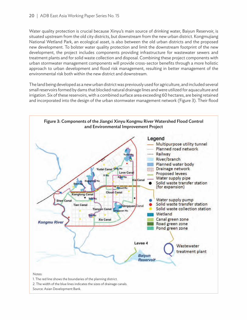
20 | ADB East Asia Working Paper Series No. 15
Water quality protection is crucial because Xinyu’s main source of drinking water, Baiyun Reservoir, is situated upstream from the old city districts, but downstream from the new urban district. Kongmujiang National Wetland Park, an ecological asset, is also between the old urban districts and the proposed new development. To bolster water quality protection and limit the downstream footprint of the new development, the project includes components providing infrastructure for wastewater sewers and treatment plants and for solid waste collection and disposal. Combining these project components with urban stormwater management components will provide cross-sector benefi ts through a more holistic approach to urban development and fl ood risk management, resulting in better management of the environmental risk both within the new district and downstream.
The land being developed as a new urban district was previously used for agriculture, and included several small reservoirs formed by dams that blocked natural drainage lines and were utilized for aquaculture and irrigation. Six of these reservoirs, with a combined surface area exceeding 60 hectares, are being retained and incorporated into the design of the urban stormwater management network (Figure 3). Their fl ood
Notes:1. The red line shows the boundaries of the planning district.2. The width of the blue lines indicates the sizes of drainage canals.Source: Asian Development Bank.
Figure 3: Components of the Jiangxi Xinyu Kongmu River Watershed Flood Control and Environmental Improvement Project

Integrating Flood and Environmental Risk Management | 21
storage capacity will be enlarged by the removal of past sediment deposits through dredging, and two wetlands will be developed within these small lakes. These storage areas will capture the runo« from the urban district, and canals constructed to connect the lakes will increase temporary storage capacity and facilitate the regulation of the runo« . There will also be limited temporary storage of stormwater in an underground chamber, to be incorporated into the design of a utility tunnel beneath a main thoroughfare. The temporary retention chamber will also aim to improve water quality through biofi ltration. Some of the lakes will feature wetlands, which will fi lter runo« before it enters the lakes, while also capturing nutrients. Green strips fl anking the canals will serve a similar purpose. Meanwhile, green spaces will be created around the lakes and beside the canals for citizens to enjoy.
The separation of urban wastewater and stormwater drainage systems is another feature of the project that will protect downstream water quality. Overfl ows from combined sewer and stormwater systems during storms are a major cause of water contamination in cities that combine these services. Wastewater treatment plants included in the project design will not be overloaded when storms occur. The inclusion of facilities for solid waste collection and disposal is another important aspect of the project, not only for its benefi ts to water quality, but also because the informal disposal of rubbish and waste materials is too often a major cause of ine· ciency in stormwater drainage systems where urban solid waste services are inadequate. In the absence of assiduous and costly maintenance, the accumulation of solid waste obstructs drains and impairs the functioning of detention storage facilities and wetlands. Under this project, the integration of these components will produce much improved outcomes.
Urban planning and the design of the stormwater drainage system for the new district will apply the sponge city concept, for which national guidelines were published in 2014. The sponge city is the PRC’s adaptation of the Water Sensitive Urban Design, Sustainable Urban Drainage Systems, and Low Impact Development concepts, which are used elsewhere, as noted above. The primary objective of the sponge city concept is to reduce the volume of runo« from an urban area. Measures used will include temporary storage in lakes and wetlands; methods to enhance infi ltration, such as permeable paving and drainage swales; and the retention of green spaces. This approach also delivers benefi ts with respect to the water quality of stormwater runo« .
Although the new urban district will only occupy about 3% of the river basin of the Kongmu River, the project maintains a basin-wide approach to FERM, as shown in the following examples:
(i) In order to protect downstream city districts, a river basin model was prepared to assist future land-use planning, the detention of fl ood runo« , and the management of pollution sources in upstream areas.
(ii) Flood risk management includes the development of a basin-wide early warning system based on a network of rainfall- and river-gauging stations now being installed.
(iii) Wastewater management services are being implemented in the new district.(iv) Solid waste and wastewater management services are being extended to two existing townships
that are within or adjoining the river fl oodplain.(v) Vegetation bu« er strips will be created along the river banks.
The project works in the new district will include the construction of over 50 hectares of new lakes and wetlands; an additional 19.3 hectares of green spaces in parks and roadsides; over 16 km of canals; approximately 6 km of main sewer pipelines, with two pump stations connecting to allocated wastewater treatment plants; and two solid waste transfer stations with leachate control. The green spaces will be maintained with irrigation systems, which will also serve to recycle and reuse stormwater. The operational performance of the stormwater management system will be monitored by a network of water quality monitoring sites, and will be maintained according to an environmental management plan. The project
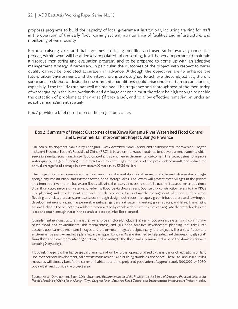
22 | ADB East Asia Working Paper Series No. 15
proposes programs to build the capacity of local government institutions, including training for sta« in the operation of the early flood warning system, maintenance of facilities and infrastructure, and monitoring of water quality.
Because existing lakes and drainage lines are being modified and used so innovatively under this project, within what will be a densely populated urban setting, it will be very important to maintain a rigorous monitoring and evaluation program, and to be prepared to come up with an adaptive management strategy, if necessary. In particular, the outcomes of the project with respect to water quality cannot be predicted accurately in advance. Although the objectives are to enhance the future urban environment, and the interventions are designed to achieve those objectives, there is some small risk that undesirable environmental conditions could arise under certain circumstances, especially if the facilities are not well maintained. The frequency and thoroughness of the monitoring of water quality in the lakes, wetlands, and drainage channels must therefore be high enough to enable the detection of problems as they arise (if they arise), and to allow e«ective remediation under an adaptive management strategy.
Box 2 provides a brief description of the project outcomes.
Box 2: Summary of Project Outcomes of the Xinyu Kongmu River Watershed Flood Control and Environmental Improvement Project, Jiangxi Province
The Asian Development Bank’s Xinyu Kongmu River Watershed Flood Control and Environmental Improvement Project, in Jiangxi Province, People’s Republic of China (PRC), is based on integrated flood-resilient development planning, which seeks to simultaneously maximize flood control and strengthen environmental outcomes. The project aims to improve water quality, mitigate flooding in the target area by capturing almost 75% of the peak surface runo«, and reduce the annual average flood damage in downstream Xinyu city by $5.36 million.
The project includes innovative structural measures like multifunctional levees, underground stormwater storage, sponge city construction, and interconnected flood-storage lakes. The levees will protect three villages in the project area from both riverine and backwater floods, allowing the reservoir to operate at full capacity (i.e., securing an additional 3.5 million cubic meters of water) and reducing flood peaks downstream. Sponge city construction refers to the PRC’s city planning and development approach, which promotes the sustainable management of urban surface-water flooding and related urban water-use issues through design techniques that apply green infrastructure and low-impact development measures, such as permeable surfaces, gardens, rainwater harvesting, green spaces, and lakes. The existing six small lakes in the project area will be interconnected by canals with structures that can regulate the water levels in the lakes and retain enough water in the canals to best optimize flood control.
Complementary nonstructural measures will also be employed, including (i) early flood warning systems, (ii) community-based flood and environmental risk management, and (iii) flood-sensitive development planning that takes into account upstream–downstream linkages and urban–rural integration. Specifically, the project will promote flood- and environment-sensitive land-use planning in the upper Kongmu River watershed to help safeguard the area (mostly rural) from floods and environmental degradation, and to mitigate the flood and environmental risks in the downstream area (existing Xinyu city).
Flood risk mapping will enhance spatial planning, and will be further operationalized by the issuance of regulations on land use, river corridor development, solid waste management, and building standards and codes. These life- and asset-saving measures will directly benefit the current inhabitants and the projected population of approximately 300,000 by 2030, both within and outside the project area.
Source: Asian Development Bank. 2016. Report and Recommendation of the President to the Board of Directors: Proposed Loan to the People’s Republic of China for the Jiangxi Xinyu Kongmu River Watershed Flood Control and Environmental Improvement Project. Manila.

Integrating Flood and Environmental Risk Management | 23
C. Chongqing Longxi River Basin Integrated Flood and Environmental Risk Management Project, Chongqing Municipality
Longxi River is in the Chongqing municipality, one of three specially administered municipalities in the PRC (the others are Beijing and Shanghai). It flows directly into the Yangtze River, which is downstream from Chongqing. The river basin is mountainous and extends over an area of 3,280 square kilometers. It has been subject to chronic flooding problems that are getting worse due to a number of factors. One of them is the poor land-use regulation during past development schemes; another is old and inadequate flood-protection infrastructure, including places where dikes are in poor condition. These problems are common in small and moderate-sized river subbasins, which su«er the most from flood and environmental problems in the Yangtze River Economic Belt (YREB).21
Initially, the key objective of the Chongqing Longxi River Basin Integrated Flood and Environmental Risk Management Project is to improve flood risk management in the Longxi River Basin, including the main stream and tributaries. Approved by ADB in September 2018, it is a FERM-based, integrated project that will seek to manage water resources on a basin-wide scale, with equal emphasis on flood risk and environmental risk management (water quality and ecosystems).22 Throughout the river basin, water quality is degraded due to point and nonpoint sources of pollution. Moreover, eutrophication problems have become increasingly common in the Changshou Reservoir, the largest water-storage facility in the river basin, located on the lower reaches of the Longxi River. In addition to taking a basin-wide approach, the project will seek to promote coordination among the three local government districts involved.
The project will formulate a comprehensive FERM plan for the river basin, featuring a “promote environment first” approach, that will serve as a prototype for other development plans throughout the YREB. It will demonstrate an integrated approach to managing the nexus between flood, waste, and biological ecosystems, including the development of a FERM footprint and an accountability system that considers urban−rural integration, upstream−downstream linkages, and cumulative interventions. The project will include a range of structural and nonstructural measures to address flooding and water-quality issues and to restore aquatic and riparian ecosystems.
Flood-protection embankments will be discontinuous, situated to protect higher-value land, mainly in townships, and will retain natural floodplain storage in other places. In general, embankments will feature moderate side slopes and will be landscaped with plantings to provide
21 R.P. Osti. 2017. Strengthening Flood Risk Management Policy and Practice in the People’s Republic of China: Lessons Learned from the 2016 Yangtze River Floods. ADB East Asia Working Paper Series. No. 11. Manila: ADB. https://www.adb.org/sites/default/files/publication/391621/eawp-011.pdf.
22 ADB. People’s Republic of China: Chongqing Longxi River Basin Integrated Flood and Environmental Risk Management Project. https://www.adb.org/projects/51005-002/main.
Longxi River (middle reaches). River bank erosion, landslides, and mining activities in upstream areas of the river have resulted in sedimentation, reduced water flows, water contamination, and increased flooding (photo by the Chongqing Municipal Government).
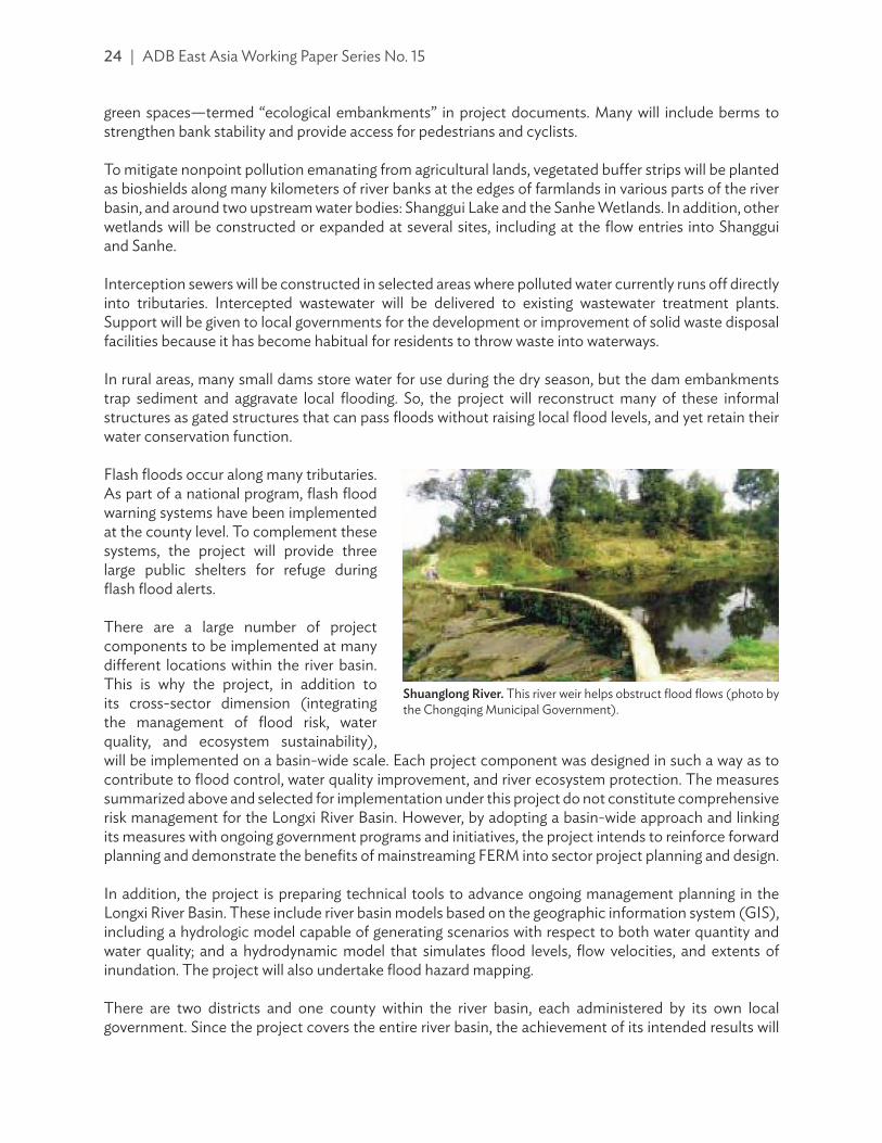
24 | ADB East Asia Working Paper Series No. 15
green spaces—termed “ecological embankments” in project documents. Many will include berms to strengthen bank stability and provide access for pedestrians and cyclists.
To mitigate nonpoint pollution emanating from agricultural lands, vegetated bu«er strips will be planted as bioshields along many kilometers of river banks at the edges of farmlands in various parts of the river basin, and around two upstream water bodies: Shanggui Lake and the Sanhe Wetlands. In addition, other wetlands will be constructed or expanded at several sites, including at the flow entries into Shanggui and Sanhe.
Interception sewers will be constructed in selected areas where polluted water currently runs o« directly into tributaries. Intercepted wastewater will be delivered to existing wastewater treatment plants. Support will be given to local governments for the development or improvement of solid waste disposal facilities because it has become habitual for residents to throw waste into waterways.
In rural areas, many small dams store water for use during the dry season, but the dam embankments trap sediment and aggravate local flooding. So, the project will reconstruct many of these informal structures as gated structures that can pass floods without raising local flood levels, and yet retain their water conservation function.
Flash floods occur along many tributaries. As part of a national program, flash flood warning systems have been implemented at the county level. To complement these systems, the project will provide three large public shelters for refuge during flash flood alerts.
There are a large number of project components to be implemented at many di«erent locations within the river basin. This is why the project, in addition to its cross-sector dimension (integrating the management of flood risk, water quality, and ecosystem sustainability), will be implemented on a basin-wide scale. Each project component was designed in such a way as to contribute to flood control, water quality improvement, and river ecosystem protection. The measures summarized above and selected for implementation under this project do not constitute comprehensive risk management for the Longxi River Basin. However, by adopting a basin-wide approach and linking its measures with ongoing government programs and initiatives, the project intends to reinforce forward planning and demonstrate the benefits of mainstreaming FERM into sector project planning and design.
In addition, the project is preparing technical tools to advance ongoing management planning in the Longxi River Basin. These include river basin models based on the geographic information system (GIS), including a hydrologic model capable of generating scenarios with respect to both water quantity and water quality; and a hydrodynamic model that simulates flood levels, flow velocities, and extents of inundation. The project will also undertake flood hazard mapping.
There are two districts and one county within the river basin, each administered by its own local government. Since the project covers the entire river basin, the achievement of its intended results will
Shuanglong River. This river weir helps obstruct flood flows (photo by the Chongqing Municipal Government).

Integrating Flood and Environmental Risk Management | 25
necessitate a long-run collaboration among these local governments. As mentioned above, under the national river chief system, initiated by the State Council, the heads of local governments have been nominated as “river chiefs.” In these new roles, they will be accountable to higher tiers of government for coordinating actions to improve water quality within their jurisdictions. The water quality model, a GIS-based real-time river health monitoring system (along with the flood footprint and accountability system planned under the project) will support the local governments’ planning functions. In addition, the project will promote the establishment of a Longxi River coordination body at the Chongqing municipality to manage the development of the Longxi River Basin; the body can be led either by the Chongqing Municipal Government or by the basin authority.
The e«ective application of FERM will require development coordination within a river basin context for the successful replication of the monitoring, footprint, and accountability mechanisms across several other, similar river basins in the municipality. The project will likewise help revive the eco-compensation mechanism that was already established in the river basin, but not functional due to a poor understanding of upstream and downstream linkages.
A framework for future management planning for the river basin will be supported by project activities such as the preparation of a FERM plan for the Longxi River Basin and an investment road map to guide the implementation of that plan. Additional guidance for future river basin management will be provided by consultations on and the preparation of draft recommendations concerning land use, and by the updating of reservoir operation guidelines. The project will fund further development of the hydrometeorological network for data acquisition and a river health monitoring network, both linked to the application of the river basin model currently under preparation, which is intended to inform future management decisions.
The project will build the institutional capacity of responsible agencies through technical training and other initiatives. Also, programs will be undertaken to raise community awareness with respect to flood and environmental risk. The communities at risk need to be part of the solution, as project investments in early warning systems and solid waste management will yield better outcomes when communities are informed and empowered to play their part in mitigating future risks and strengthening social resilience.
Although the three case studies discussed above are quite distinct from each other, in their di«erent ways, they all exemplify most or all of the principles enunciated earlier under FERM: spatial integration; low-impact urban development; cross-sector partnership; an appropriate framework for project planning and formulation; monitoring, evaluation, and adaptive management; links to land-use management; application of nonstructural measures; joint consideration of water quantity and water quality issues; resilience; retaining natural systems and working with nature; and stakeholder participation.
V.�FRAMEWORK AND APPROACH FOR IMPLEMENTATION
At the institutional level, fragmented policies and poor coordination between government agencies have often led to the poor provision of services and ine«ective use of available resources and capacity (footnote 21). In practice, a framework is required to bridge the distance between the identification of a flood-risk problem and the formulation of a well-considered FERM project that embraces the nexus between flood risk and environmental risk, and realizes the gains to be captured from cross-sector synergies. In addition, any project with a potential imprint on flood risk and the environment should undertake an assessment to determine those impacts for which it is accountable. In particular, infrastructure projects such as development of urban utilities and services or major transport projects often have a potential FERM

26 | ADB East Asia Working Paper Series No. 15
footprint, typically translated downstream. FERM assessment is not just a responsible course of action during project formulation, it also often serves to identify opportunities for cross-sector synergies that lead to e·ciencies in investments in socioeconomic development. The inherent interconnectedness of interventions and the inevitable chain of repeating cause and e«ect mean that cross-sector projects with multiple objectives generally produce improved outcomes that are more sustainable and enduring.
The desired framework should extend beyond the scope of single projects to the development of a risk-management strategy with an investment road map on a river basin scale. The framework can be based on the understanding of risk as a combination of three factors: hazard, exposure, and vulnerability,23 and this understanding of risk can be applied equally well to flood and environmental risks. Each one of the risk factors can be treated or managed by a distinct set of management measures or interventions.
For a FERM project, the initial stimulus is likely to be the identification of a specific flood-risk problem—as distinct from an environmental problem—that is either brought to the attention of management planners by a community or local government concerned about its adverse social and/or economic consequences, or identified through formal risk assessment analysis. Once it is determined that intervention is required in the form of flood risk management, a comprehensive planning procedure should be followed to establish the appropriate management response (Figure 4).
Given the link between flood risk and environmental risk, one of the key steps in the planning process is to investigate the interactions involved—that is, how the environment and environmental management can modify flood risk, and how floods and flood risk management can modify the environment and river ecosystem on a basin scale. To give due recognition to the nexus (flood−waste−ecosystem) and the associated upstream−downstream and urban−rural linkages, the flood risk management planning and appraisal procedure presented in Figure 4 needs to be updated accordingly.
During project formulation, the functions of the di«erent elements of the natural environment, including their potential flood-mitigation features, should be examined. It may also be more practical and constructive to retain the services of these natural functions and work with nature (green measures) rather than against it (grey measures) to achieve more resilient outcomes for both society and the natural ecosystems. Realistically, both types of measures are generally required for flood risk management. In particular, grey measures (structural engineering measures) are often required where the environment is no longer natural due to more intensive human land use or urbanization. However, the planning and design of these measures greatly rely on the flood risk and environmental risk footprints of development plans involving any of the three key elements of the nexus for a FERM project, both at the local and river basin-wide levels.
Consultation with stakeholders is crucial; it should commence at a very early stage of the project planning process, and continue as the formulation of the project continues. The application of di«erent, albeit non-mutually exclusive, consultation approaches with institutional and noninstitutional stakeholders (i.e., the beneficiaries) will ensure that all relevant parties are adequately informed and given the opportunity to contribute. Initial consultations should not only inform participants about project objectives and proposed planning procedure, but should also discuss issues that participants may perceive to arise from project implementation. For a FERM project, discussions should include social and environmental concerns that may either be linked to flooding or benefit from joint treatment within the
23 Y. Kobayashi and J.W. Porter. 2012. Flood Risk Management in the People’s Republic of China: Learning to Live with Flood Risk. Manila: ADB. https://www.adb.org/sites/default/files/publication/29717/flood-risk-management-prc.pdf.

Integrating Flood and Environmental Risk Management | 27
project framework. Institutional stakeholders can be asked about public health and community welfare issues, while community members and their representatives can be queried about issues a«ecting their livelihoods and quality of life. Likewise, the e«ects of flooding and environmental problems on the viability and prospects of commercial enterprises can be explored. Holding discussions that are open to multiple issues, including noneconomic issues, can help maximize project benefits to the community and achieve synergies in the e·cient use of resources available for management improvements.
At the policy level, the vision needs to be broad enough to preclude the silo mentality, which interprets mandates too rigidly and sets boundaries on institutional roles and responsibilities. The di·culty of embracing institutional partnership, welcoming coordinated e«ort, and sharing resources should
Figure 4: Flood Risk Management Planning and Appraisal Procedure
Source: Y. Kobayashi and J.W. Porter. 2012. Flood Risk Management in the People’s Republic of China: Learning to Live with Flood Risk. Manila: ADB. p.49. https://www.adb.org/sites/default/files/publication/29717/flood-risk-management-prc.pdf.
CON
SULT
ATI
ON
PRO
CESS
PRELIMINARY
PHASE
Identify and Quantify Flood Risk - estimation of hydrologic risk - hydraulic model analysis - mapping of existing flood hazard and land uses
TECHNICAL ANALYSIS PHASE
Identify Alternative Flood Management Options
- combinations of structural and nonstructural measures
- evaluation of future risk - consideration of how to manage residual risk
Appraise the Impacts - economic analysis - tangible and intangible social benefits and
disbenefits - environment (adverse impacts and opportunities) - robustness, resilience to future uncertainty
APPRAISALPHASE
Recommend Preferred Option - refinement of analysis - examination of assumptions - documentation of plan
FLOODMANAGEMENT
PLAN
Define Management Objectives - collection of data
Understand Planning Context - population characteristics - property and infrastructure - institutional arrangements - planning instruments
APPROVAL AND IMPLEMENTATION

28 | ADB East Asia Working Paper Series No. 15
not be underestimated. Institutions need to be adequately sta«ed to a«ord the time and energy that e«ective coordination demands—understa«ed agencies tend to define their activities more narrowly. Policy should aim to strengthen synergies among sectors and address potential conflicts of interest. Policy statements need to emphasize the positive benefits that cross-sector coordination and joint risk management can generate. Often, too many policies and strategic directions, though all with good views and platforms, may inadvertently bring confusion and cause some setbacks to the FERM approach. Procedural mechanisms to facilitate information sharing and consultation with other agencies should be developed to empower human resources, rather than constrain them.
At the strategy level, flood risk management and environmental risk management need to be integrated into sustainable development. River basins are the natural units in which hydrologic processes are integrated. Ecological processes that are water-related should also be integrated into river-basin planning, so that the FERM strategies can ideally be developed on a river basin scale. Strategies for sustainable development involving FERM will typically entail numerous interventions throughout a river basin. The Longxi River Basin case study is an example of such a strategy. The lack of capacity and a«ordability are the usual problems in strategy implementation, so an investment road map is required to prioritize projects and schedule them to accommodate funding programs and other constraints.
The FERM approach is the proposal to promote integrated flood, water environment, and ecosystem management and involves the correlation of di«erent principles. Hence, an integrated planning process that is focused on the FERM approach in a river basin context is much beneficial over sector-based and localized planning processes, which are currently being practiced in di«erent countries.

REFERENCES
Asian Development Bank (ADB). People’s Republic of China: Chongqing Longxi River Basin Integrated Flood and Environmental Risk Management Project. https://www.adb.org/projects/51005-002/main.
———. People’s Republic of China: Jiangxi Xinyu Kongmu River Watershed Flood Control and Environmental Improvement Project. https://www.adb.org/projects/48055-002/main#project-overview.
———. People’s Republic of China: Qingdao Water Resources and Wetland Protection Project. https://www.adb.org/projects/40017-013/main.
———. 2008. Report and Recommendation of the President to the Board of Directors: Proposed Loan to the People’s Republic of China for the Qingdao Water Resources and Wetland Protection Project. Manila.
———. 2013. Investing in Resilience: Ensuring a Disaster-Resistant Future. Manila. https://www.adb.org/sites/default/files/publication/30119/investing-resilience.pdf.
———. 2016. Report and Recommendation of the President to the Board of Directors: Proposed Loan to the People’s Republic of China for the Jiangxi Xinyu Kongmu River Watershed Flood Control and Environmental Improvement Project. Manila.
———. 2018. Preparing Yangtze River Economic Belt Projects: Chongqing Longxi River Basin Integrated Flood and Environmental Risk Management. Transaction technical assistance consultant’s report. Manila (TA 9311-PRC).
ADB, Greater Mekong Subregion (GMS) Environment Operations Center. 2015. Ecosystem-Based Approaches to Address Climate Change Challenges in the Greater Mekong Subregion. Bangkok: Greater Mekong Subregion Core Environment Program. https://www.adb.org/sites/default/files/publication/158165/ecosystem-based-approaches-gms.pdf.
Bai, Yang, Bo Jiang, Min Wang, Hui Li, Juha M. Alatalo, and Shenfa Huang. 2016. New Ecological Redline Policy (ERP) to Secure Ecosystem Services in China. Land Use Policy. 55. pp. 348–351.
Central Committee of the Communist Party of China. 2016. The 13th Five-Year Plan for Economic and Social Development of the People’s Republic of China (2016–2020). Beijing: Central Compilation & Translation Press. http://en.ndrc.gov.cn/policyrelease/201612/P020161207645766966662.pdf.
China Institute of Water Resources and Hydropower Research. 2017. IWHR 2017 Annual Report. Beijing.
Chongqing Municipal Government. 2018. People’s Republic of China: Chongqing Longxi River Environment Comprehensive Treatment and Ecological Protection Demonstration Project. Environmental impact assessment (draft). Manila: ADB.
CIRIA. 2015. The SuDS Manual (C753). London. https://www.ciria.org/Resources/Free_publications/SuDS_manual_C753.aspx.
European Commission. Natura 2000. http://ec.europa.eu/environment/nature/natura2000/index_en.htm.
European Commission, Directorate-General for Environment. 2011a. Annex: Towards Better Environmental Options for Flood Risk Management. Brussels. http://ec.europa.eu/environment/water/flood_risk/pdf/Better%20Environmental%20Options%20for%20Flood%20risk%20management%20ANNEXE.pdf.

30 | References
——— 2011b. Note by DG Environment—Subject: Towards Better Environmental Options for Flood Risk Management. Brussels. http://ec.europa.eu/environment/water/flood_risk/pdf/Note%20-%20Better%20environmental%20options.pdf.
European Parliament and the Council of the European Union. 2007. Directive on the Assessment and Management of Flood Risks. O�cial Journal of the European Union. L288. pp. 27−34. https://eur-lex.europa.eu/legal-content/EN/TXT/PDF/?uri=CELEX:32007L0060&from=EN.
Hou, Liqiang. 2017. River Chief System Established to Push Anti-Pollution E«orts. China Daily. 23 January. http://www.chinadaily.com.cn/china/2017-01/23/content_28030352.htm.
Jiaozhou City Government. 2015. Initial Environmental Examination: Qingdao Water Resources and Wetland Protection Project in the People’s Republic of China (prepared for ADB). https://www.adb.org/sites/default/files/project-document/177623/40017-013-iee-02.pdf.
Joint Steering Committee for Water Sensitive Cities (JSCWSC). 2009. Evaluating Options for Water Sensitive Urban Design: A National Guide. Canberra. http://observatoriaigua.uib.es/repositori/ suds_australia_options.pdf.
Kobayashi, Yoshiaki and John W. Porter. 2012. Flood Risk Management in the People’s Republic of China: Learning to Live with Flood Risk. Manila: ADB. https://www.adb.org/sites/default/files/publication/29717/flood-risk-management-prc.pdf.
Osti, Rabindra P. 2016. Framework, Approach and Process for Investment Road Mapping: A Tool to Bridge the Theory and Practices of Flood Risk Management. Water Policy. 18 (2). pp. 419–444.
———. 2017. Strengthening Flood Risk Management Policy and Practice in the People’s Republic of China: Lessons Learned from the 2016 Yangtze River Floods. ADB East Asia Working Paper Series. No. 11. Manila: ADB. https://www.adb.org/sites/default/files/publication/391621/eawp-011.pdf.
State Council of the People’s Republic of China. 2018. China Unveils Action Plan for Improving Rural Living Environment. News release. 6 February. http://english.gov.cn/policies/latest_releases/2018/ 02/06/content_281476037813748.htm.
Zuo, Mandy. 2017. How China’s “River Chiefs” Are Cleaning Up the Country’s Polluted Waterways. South China Morning Post. 20 September. http://www.scmp.com/news/china/society/article/ 2111824/how-cleaning-chinas-polluted-rivers-got-personal.

APPENDIX: THE JIAOZHOU WATERWAYS PROJECT
These project photos illustrate the transformation of waterways in Jiaozhou city, in the municipality of Qingdao, Shandong Province (photos by the Jiaozhou Project Management O·ce).
BEFORE
AFTER
1. Branch of the Hucheng River at Wuzhou Road Bridge

32 | Appendix
BEFORE
AFTER
2. Branch of the Hucheng River at Yangzhou Road Bridge

Appendix | 33
BEFORE
AFTER
3. Erli River at North Area Bridge

34 | Appendix
BEFORE
AFTER
4. Erli River in South Area

Appendix | 35
BEFORE
AFTER
5. Haier Avenue in East Area

36 | Appendix
BEFORE
AFTER
6. Hucheng River Roads

Appendix | 37
BEFORE
AFTER
7. Hucheng River, Upstream

38 | Appendix
BEFORE
AFTER
8. Jiashuyuan Area

Appendix | 39
BEFORE
AFTER
9. Shidong River

40 | Appendix
BEFORE
AFTER
10. Yunxi River, Downstream

ASIAN DEVELOPMENT BANK
ASIAN DEVELOPMENT BANK6 ADB Avenue, Mandaluyong City1550 Metro Manila, Philippineswww.adb.org
INTEGRATING FLOOD AND ENVIRONMENTAL RISK MANAGEMENTPRINCIPLES AND PRACTICESRabindra P. Osti
ADB EAST ASIAWORKING PAPER SERIES
NO. 15
October 2018
Integrating Flood and Environmental Risk ManagementPrinciples and Practices
This publication describes the principles of flood and environmental risk management, and presents the challenges of integrating the system into policy making and project planning in the People’s Republic of China. Flood and environmental risk management is a new concept that recognizes the connection between managing flood risk and managing risks to the environment and ecosystems. It addresses the flood–waste–ecosystem nexus through structural and nonstructural solutions, taking into account urban–rural and upstream–downstream linkages in project planning and design.
About the Asian Development Bank
ADB is committed to achieving a prosperous, inclusive, resilient, and sustainable Asia and the Pacific, while sustaining its e�orts to eradicate extreme poverty. Established in 1966, it is owned by 67 members— 48 from the region. Its main instruments for helping its developing member countries are policy dialogue, loans, equity investments, guarantees, grants, and technical assistance.