about olive oil and pendolino
TRANSCRIPT
225
MATURE INTERMEDIATE-SCALE SURFACE KARST LANDFORMS IN NW ENGLAND AND THEIR RELATIONS TO GLACIAL EROSION
HELEN S. GOLDIE27
Abstract: Landform-derived limestone surface lowering rates in Northern England have been re-assessed from conventional rates of 50 cm of surface lowering in 15 ka; rates of 5 to 15 cm in 15 ka are seen as more sensible. These revised, lower, rates allow clearer understanding of surface landforms in these and other British limestone areas. It has been thought that larger karst landforms, e.g. larger surface closed depressions of 20 m+ plan scale, are considerably older than the Late Devensian, possibly with pre-Quaternary aspects However, it is hard to demonstrate the same for smaller landforms, of the scale of c 1-3 m, as the conventional rates of solution supported their formation since the Devensian. The lower rates of solution, applicable to dry interfluve areas, allow these intermediate-sized karst landforms to contain survival components, and to be considerably older than post-Devensian. This paper examines sites with these mature karst landforms, and considers their common characteristics and influencing factors, including their relationship to ice scour patterns. The sites range from near sea-level to above 400 m altitude.
INTRODUCTION
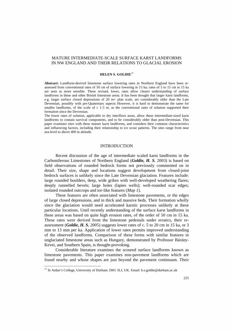
Recent discussion of the age of intermediate scaled karst landforms in the Carboniferous Limestones of Northern England (Goldie, H. S. 2003) is based on field observations of rounded bedrock forms not previously commented on in detail. Their size, shape and locations suggest development from closed-joint bedrock surfaces is unlikely since the Late Devensian glaciation. Features include: large rounded boulders, deep, wide grikes with well-developed weathering flares; deeply runnelled bevels; large holes (lapies wells); well-rounded scar edges; isolated rounded outcrops and tor-like features (Map 1).
These features are often associated with limestone pavements, or the edges of large closed depressions, and in thick and massive beds. Their formation wholly since the glaciation would need accelerated karstic processes unlikely at these particular locations. Until recently understanding of the surface karst landforms in these areas was based on quite high erosion rates, of the order of 50 cm in 15 ka. These rates were derived from the limestone pedestals under erratics, their re-assessment (Goldie, H. S. 2005) suggests lower rates of c. 5 to 20 cm in 15 ka, or 3 mm to 13 mm per ka. Application of lower rates permits improved understanding of the observed landforms. Comparison of these forms with similar features in unglaciated limestone areas such as Hungary, demonstrated by Professor Bárány-Kevei, and Southern Spain, is thought-provoking.
Considerable literature examines the scoured surface landforms known as limestone pavements. This paper examines non-pavement landforms which are found nearby and whose shapes are just beyond the pavement continuum. Their 27 St Aidan’s College, University of Durham. DH1 3LJ, UK. Email: [email protected]
Helen S. Goldie
226
scale, a few metres, is relatively neglected in British karst studies where forms of a few mm or cm (karren) scale or of 10s of metres and more (dolines and other surface karst depressions) have been studied. These well-known karst landforms deserve study, but reality shows a continuum and the scale of a few metres of the boulders and limestone blocks on which karren are found and which themselves compose larger features, merits consideration. The shapes and interrelationships of these intermediate scale forms provide another level of information in attempts to understand present-day karst landscapes. Ideas from varied sources need discussion, including on Quaternary history, palaeokarstic studies, glacio-karstic relationships, the effects of rock resistance, and on solutional lowering rates.
Map 1 Location map of NW England showing the main sites mentioned in the text
Quaternary history and ideas on palaeokarst
The general pattern of Quaternary glaciation effects in NW England is well established (Huddart, D. – Glasser, N. 2002). Waltham et al. (1997) summarize knowledge of glacial erosion and deposition in the Carboniferous Limestone areas
Mature intermediate-scale surface karst landforms in NW England and their relations to glacial erosion
227
of Northern England, areas, which have been labelled ‘glaciokarst’. Numerous authors (Sweeting, M. M. 1966, Clayton, K. 1981, Goldie, H. S. 1981, 1995, 2005, Rose, L. – Vincent, P. J. 1986, Gunn, J. 1985, Gale, S. J. 2000, Marker, 2003, Vanstone, S. D. 1998; Vincent, P. J. 1995, Walkden, G. M. 1979, Wright, V. P. 1984) refer to glaciated limestone landscapes containing older elements than those simply resulting from recent Devensian glacial activity and subsequent karstic action. There has been landform survival, in part at least as a result of protection from glacial scour. Ideas on persistence and inheritance of landforms are discussed in Goudie, A. S. (1990) and Brunsden, D. (1993), and developed in Migon, P. and Goudie, A. S. (2001). Brunsden, D. (1993) quotes Twidale concerning landscapes being composed of ”segments of different ages and origins, some of them of considerable antiquity”. There has, however, been little detailed study of these older landforms in Northern England, whatever their scale. Current research is examining the larger pre-glacial karst depressions (Goldie, H. S. – Marker, M. E. 2001) and general explanations of older forms are being developed. Speleothem research provides another perspective, supporting the idea of considerable karstification in Northern England during interglacials and for elements of cave systems to be very old (Gascoyne, M. et al. 1983, Gordon, D. et al. 1989, Murphy, P. J. – Lord, T. 2003).
Most British palaeokarst sites are further south than the study area, often beyond the limits of the Last Glaciation (Ford, D. C. 1977, Wright, V. P. 1982, Walkden, G. M. 1987, Vanstone, S. D. 1998, Marker, M. E. 2003). The present paper discusses the possibility that outcrops, or certain elements of outcrops, within the limits of the Last Glaciation have survived glacial scour. In NW England Corbel, J. (1957) controversially interpreted isolated limestone hills around Morecambe Bay as remnant Tertiary cone karst. This idea was dismissed since structural factors could explain the forms (Douglas, I. 1987). However, this dismissal of a palaeokarst explanation for that scale of landform should not be taken to imply that there are no old karst forms in this and neighbouring areas. Work on palaeokarst forms naturally tends to dwell on larger forms, which clearly take lengthy periods of karstification to develop. The large closed depressions are too large to have formed since the Devensian. Some may have been truncated by glacial scour but others have not. Numerous examples of untruncated depressions are found in high areas north-east of Malham, Yorkshire. In addition, there are smaller limestone outcrops in NW England of ‘mature’ appearance which up till very recently it was argued could have formed in 15 ka because surface solution rates of 50 cm in 15 ka over extensive areas could be applied to explain them. It was also thought that glacial erosion was highly likely to have stripped away considerable depths of limestone. Re-assessment of numerous erratic-pedestal sources of the high solution rates has produced lower solution rates for dry interfluve locations, the type of location where many mature outcrops are found. Lower solution rates support the suggestion that these smaller mature-looking landforms have survived Devensian glacial scour, at least in part, and are older
Helen S. Goldie
228
than previously thought. They could have been karstified in an earlier interglacial, possibly very early, which comes back to Corbel’s suggestion of Tertiary age. It is also thought that at certain sites some karstic characteristics may be partly inherited from the Late Carboniferous (Vincent, P. J. 1995, 2004), having been protected and then exhumed. Great Asby Scar is one such site. Not all limestone bedding surfaces have palaeokarst features however. Arthurton, R. S. et al. (1988) illustrate significant ones identified in the geological successions in the Yorkshire Dales.
Relationships between glaciation and karstification
Explanation of how these smaller landforms have survived glaciation in a region known to have been glaciated in the Devensian involves several situations; for example: location in areas i) where ice was cold-based (non-erosive); ii) above ice; iii) sheltered from ice flow; or iv) where ice flow became diffused, ie diffluent, due to local topographic effects, thereby allowing ice to spread out and loose erosive power. Ford, D. C. (1987) identified numerous possibilities part or full survival from glacial scour by karst forms and overall emphasized the complexity of relationships between karst and glaciation, ideas applicable to Northern England.
Rock resistance
Rock resistance is involved in any explanation of landform survival (Migon, P. – Goudie, A. S. 2001). Most intermediate scale features under discussion are in the strong, thick and massive upper beds of the Lower Carboniferous limestones. Guidance of glacial scour by pre-existing topography and geology is an important possibility; rock type also influences both limestone pavement formation and detailed pavement characteristics. Thus geology may not merely explain why certain beds, or certain locations, have particular features, but also why some pre-glacial landforms have not been erased by the ice, and have survived to provide the basis of contemporary mature landforms. Goldie, H. S. and Cox, N. J. (2000) show diagrammatically how various possible combinations of landform depend on how far down pre-glacial outcrops the ice scoured.
Pre-glacial landscape survival in other rock types and regions
The idea of pre-glacial outcrop forms surviving glacial erosion on interfluves, divides, and other high land between the concentrated ice flows within ice fields is well-established. There have been detailed studies in areas not specifically underlain by limestones (Linton, D. L. 1964, Hall, A. M. – Sugden, D. E. 1987, Hättestrand, C. – Stroeven, A. P. 2002) diverse areas, e.g. Northern England, Scotland, Scandinavia and Antarctica. Hättestrand and Stroeven (2002) describe a low-lying relict landscape in NE Sweden with evidence of minimal Quaternary glacial erosion at the centre of the Fennoscandian ice. The landforms are relatively small-scale, and tor-like in character, apparently a similar scale to those being discussed here from Northern England.
Mature intermediate-scale surface karst landforms in NW England and their relations to glacial erosion
229
Intermediate scale surface karst morphology
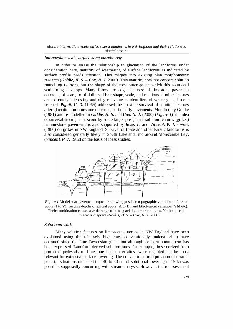
In order to assess the relationship to glaciation of the landforms under consideration here, maturity of weathering of surface landforms as indicated by surface profile needs attention. This merges into existing plan morphometric research (Goldie, H. S. – Cox, N. J. 2000). This maturity does not concern solution runnelling (karren), but the shape of the rock outcrops on which this solutional sculpturing develops. Many forms are edge features: of limestone pavement outcrops, of scars, or of dolines. Their shape, scale, and relations to other features are extremely interesting and of great value as identifiers of where glacial scour reached. Pigott, C. D. (1965) addressed the possible survival of solution features after glaciation on limestone outcrops, particularly pavements. Modified by Goldie (1981) and re-modelled in Goldie, H. S. and Cox, N. J. (2000) (Figure 1), the idea of survival from glacial scour by some larger pre-glacial solution features (grikes) in limestone pavements is also supported by Rose, L. and Vincent, P. J.’s work (1986) on grikes in NW England. Survival of these and other karstic landforms is also considered generally likely in South Lakeland, and around Morecambe Bay, (Vincent, P. J. 1982) on the basis of loess studies.
Figure 1 Model scar-pavement sequence showing possible topographic variation before ice scour (I to V), varying depths of glacial scour (A to E), and lithological variation (VM etc).
Their combination causes a wide range of post-glacial geomorphologies. Notional scale 10 m across diagram (Goldie, H. S. – Cox, N. J. 2000)
Solutional work
Many solution features on limestone outcrops in NW England have been explained using the relatively high rates conventionally understood to have operated since the Late Devensian glaciation although concern about them has been expressed. Landform-derived solution rates, for example, those derived from protected pedestals of limestone beneath erratics, were regarded as the most relevant for extensive surface lowering. The conventional interpretation of erratic-pedestal situations indicated that 40 to 50 cm of solutional lowering in 15 ka was possible, supposedly concurring with stream analysis. However, the re-assessment
Helen S. Goldie
230
found pedestal heights of 5 to 20 cm (Goldie, H. S. 2004, 2005) and that the previous higher figures were based on misinterpretations. The new observations indicate lower rates of 3-13 mm/ka of surface lowering. Thus it is far less likely for erosional features wider than a few tens of cm to have developed in 15 ka, especially on drier interfluve surfaces and outcrops such as pavements, without considerable acid water flow for a lengthy period. This would have been possible in only limited locations for limited time periods as, even if water is available, contact with the limestone cannot be sustained for long over large planar surfaces unless held in place by a soil and vegetation cover. The high pedestal figures are explained either as being from highly mechanically weatherable rocks; or they result from surrounding solution from below – not from boulder protection effects; or they result from structural effects. That is, they are accounted for by exceptional local conditions, not of general application. The so-called ‘pedestals’ at Norber, for example, are either steps or outliers of steps (Goldie, H. S. 2004, 2005).
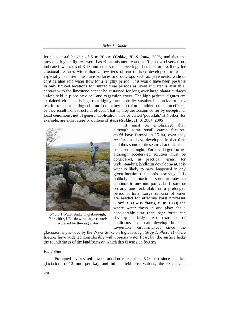
It must be emphasized that, although some small karren features, could have formed in 15 ka, even they need not all have developed in that time and thus some of these are also older than has been thought. For the larger forms, although accelerated solution must be considered, in practical terms, for understanding landform development, it is what is likely to have happened in any given location that needs assessing. It is unlikely for maximal solution rates to continue in any one particular fissure or on any one rock slab for a prolonged period of time. Large amounts of water are needed for effective karst processes (Ford, T. D. – Williams, P. W. 1989) and where water flows in one place for a considerable time then large forms can develop quickly. An example of landforms that can develop in such favourable circumstances since the
glaciation is provided by the Water Sinks on Ingleborough (Map 1, Photo 1) where fissures have widened considerably with copious water flow, but the surface lacks the roundedness of the landforms on which this discussion focuses.
Field Sites
Prompted by revised lower solution rates of c. 5-20 cm since the last glaciation, (3-13 mm per ka), and initial field observations, the extent and
Photo 1 Water Sinks, Ingleborough,
Yorkshire, UK, showing large runnels widened by flowing water
Mature intermediate-scale surface karst landforms in NW England and their relations to glacial erosion
231
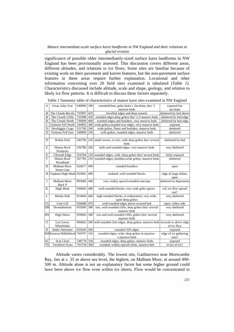
significance of possible older intermediately-sized surface karst landforms in NW England has been provisionally assessed. This discussion covers different areas, different altitudes, and relations to ice flows. Some sites are familiar because of existing work on their pavement and karren features, but the non-pavement surface features in these areas require further explanation. Locational and other information concerning over 20 field sites examined is tabulated (Table 1). Characteristics discussed include altitude, scale and shape, geology, and relation to likely ice flow patterns. It is difficult to discuss these factors separately.
Table 1 Summary table of characteristics of mature karst sites examined in NW England A Great Asby Scar 649096 390 roundedclints, grike holes c 2m diam, thro' 2
massive beds exposed but
up-slope B The Clouds Bevels 735997 410 bevelled edges and deep runnels sheltered by bed above B The Clouds Cliffs 735998 430 rounded edges,deep grikes thro' 2-3 massive beds sheltered by bed edge B The Clouds North 736999 400 rounded edges and boulders, very massive beds sheltered by bed edge C Farleton Fell North 544803 300 wide grikes,rounded scar edges, very massive beds exposed D Newbiggin Crags 551796 240 wide grikes, flares and boulders, massive beds sheltered D Farleton Fell East 548800 250 wide grikes, rounded edges, massive beds sheltered
D Holme Park 542796 220 small towers, or tors, wide deep grikes thro' several beds
sheltered by bed
E Hutton Roof Potslacks
556780 260 balls and rounded edges, very massive beds very sheltered
E Uberash Edge 554784 220 rounded edges, wide ,deep grikes thro' several beds fairly exposed F Hutton Roof
Woodland 567785 210 rounded edges, boulders,wide grikes, massive beds sheltered
H Malham Moor Street Gate
924677 490 rounded boulders open
H Clapham High Mark 923681 490 isolated, well-rounded blocks edge of large doline, open
J Malham Moor Back P
893684 440 very widely spaced rounded outcrops sheltered in depression
K High Mark 930683 480 well-rounded blocks, very wide grike spaces col, ice flow spread out?
L Monks Path 914694 460 high rounded blocks, in embayment, very wide, quite deep grikes
very sheltered
CG Cote Gill 926688 470 well-rounded edges above scoured bed open, valley side DB Dowkabottom 953690 380 tors, well-rounded cliffs, deep grikes thro' several
massive beds very sheltered
HS High Sleets 959683 380 tors and well-rounded cliffs, grikes thro' several massive beds
very sheltered
O Lea Green, Wharfedale
994663 280 well-rounded clint edges, deep grikes, massive beds towards or above edge of ice flow
R Settle-Attermire 835645 500 rounded cliff edges exposed RH Runscar-Ribblehead 764797 310 rounded edges; wide, deep grikes in massive-
v.massive beds edge of ice gathering
area? SC Scar Close 748778 330 rounded edges, deep grikes, massive beds exposed TS Twisleton Scars 703758 300 rounded, widely-spaced clints, massive bed in lea of ice?
Altitude varies considerably. The lowest site, Gaitbarrows near Morecambe
Bay, lies at c. 35 m above sea level, the highest, on Malham Moor, at around 490-500 m. Altitude alone is not an explanatory factor but some higher ground could have been above ice flow even within ice sheets. Flow would be concentrated in
Helen S. Goldie
232
valleys, with intervening areas experiencing static ice. At Farleton Fell, (c. 240 m asl) ice flowing southwards would have spread out after plucking at the north end of the hill, influenced by the shape of the hill and the south-southwest-ward dip of a strong limestone bed. The power of the ice must have suddenly decreased as evidenced by numerous large boulders plucked off this north end and deposited just downslope of their source. Structural dip allowed ice flow away from eastern and central parts, as evidenced by mature karstic features here. Well-scoured limestone pavement is found on the south and west sides, as expected. Many of the glacially-deposited boulders at Farleton Fell lack protection pedestals beneath them, supporting the theory of low solution rates since they were deposited.
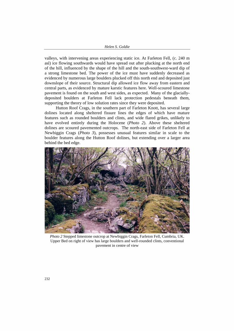
Hutton Roof Crags, in the southern part of Farleton Knott, has several large dolines located along sheltered fissure lines the edges of which have mature features such as rounded boulders and clints, and wide flared grikes, unlikely to have evolved entirely during the Holocene (Photo 2). Above these sheltered dolines are scoured pavemented outcrops. The north-east side of Farleton Fell at Newbiggin Crags (Photo 3), possesses unusual features similar in scale to the boulder features along the Hutton Roof dolines, but extending over a larger area behind the bed edge.
Photo 2 Stepped limestone outcrop at Newbiggin Crags, Farleton Fell, Cumbria, UK. Upper Bed on right of view has large boulders and well-rounded clints, conventional
pavement in centre of view
Mature intermediate-scale surface karst landforms in NW England and their relations to glacial erosion
233
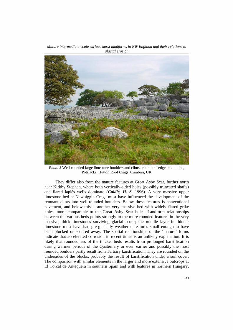
Photo 3 Well-rounded large limestone boulders and clints around the edge of a doline,
Potslacks, Hutton Roof Crags, Cumbria, UK They differ also from the mature features at Great Asby Scar, further north
near Kirkby Stephen, where both vertically-sided holes (possibly truncated shafts) and flared lapiés wells dominate (Goldie, H. S. 1996). A very massive upper limestone bed at Newbiggin Crags must have influenced the development of the remnant clints into well-rounded boulders. Below these features is conventional pavement, and below this is another very massive bed with widely flared grike holes, more comparable to the Great Asby Scar holes. Landform relationships between the various beds points strongly to the more rounded features in the very massive, thick limestones surviving glacial scour; the middle layer in thinner limestone must have had pre-glacially weathered features small enough to have been plucked or scoured away. The spatial relationships of the ‘mature’ forms indicate that accelerated corrosion in recent times is an unlikely explanation. It is likely that roundedness of the thicker beds results from prolonged karstification during warmer periods of the Quaternary or even earlier and possibly the most rounded boulders partly result from Tertiary karstification. They are rounded on the undersides of the blocks, probably the result of karstification under a soil cover. The comparison with similar elements in the larger and more extensive outcrops at El Torcal de Antequera in southern Spain and with features in northern Hungary,
Helen S. Goldie
234
neither of which has been glaciated, is thought-provoking. Measurements at Newbiggin indicate about 8 cm of solution has occurred since bedding plane stripping, at the low end of the range of figures obtained from erratic-pedestal sites in NW England.
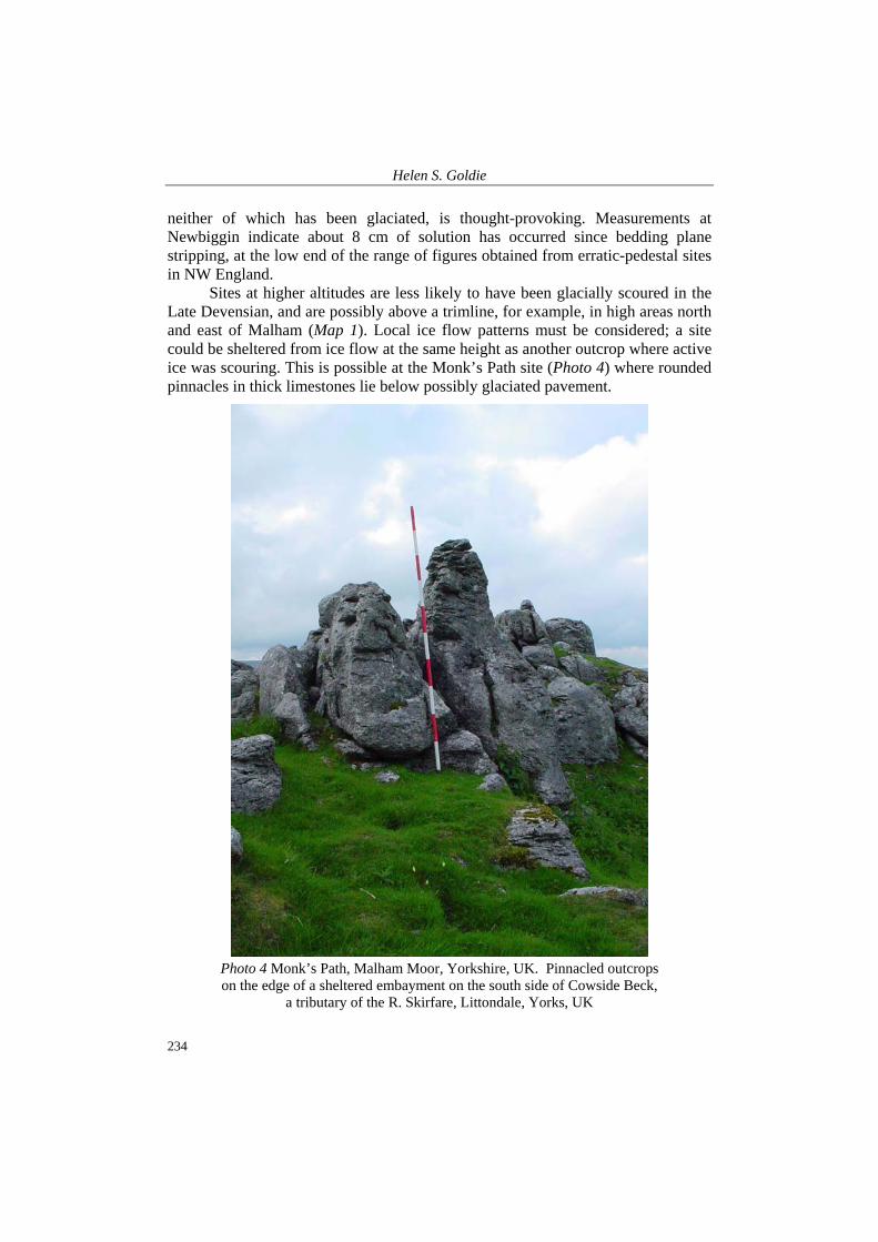
Sites at higher altitudes are less likely to have been glacially scoured in the Late Devensian, and are possibly above a trimline, for example, in high areas north and east of Malham (Map 1). Local ice flow patterns must be considered; a site could be sheltered from ice flow at the same height as another outcrop where active ice was scouring. This is possible at the Monk’s Path site (Photo 4) where rounded pinnacles in thick limestones lie below possibly glaciated pavement.
Photo 4 Monk’s Path, Malham Moor, Yorkshire, UK. Pinnacled outcrops on the edge of a sheltered embayment on the south side of Cowside Beck,
a tributary of the R. Skirfare, Littondale, Yorks, UK
Mature intermediate-scale surface karst landforms in NW England and their relations to glacial erosion
235
The pinnacles are found around a sheltered embayment off Cowside Beck, whereas the pavements are more exposed. The pavements may of course have been scoured in an earlier glaciation than the Late Devensian, a suggestion supported by their relatively well-advanced grike development. However, the pinnacles must certainly have survived any recent ice scour, possibly earlier periods too. Several of the pinnacled clints protrude well above any notional level, unlike the general level of the pavement areas, and grike gaps are very wide, e.g. 2 m or more, between pinnacles. Although the pavement nearby has a general surface linking the tops of clints the individual clints are quite rounded. The assemblage of features suggests ice scour at some point but not in the most recent glaciation. However, they could also simply be survivors of non-glacial erosion of overlying beds above the very strong limestones that compose the ‘pinnacles’, retreating back along this bedding plane. It would be interesting to obtain accurate dating of these surfaces.
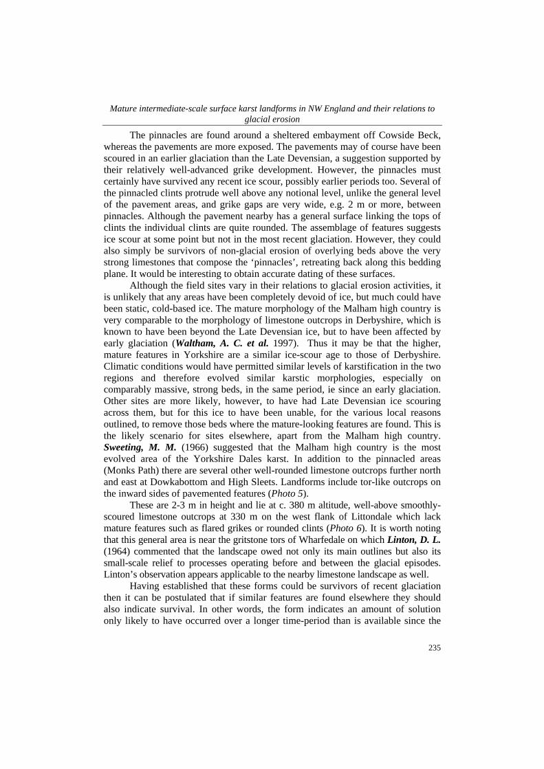
Although the field sites vary in their relations to glacial erosion activities, it is unlikely that any areas have been completely devoid of ice, but much could have been static, cold-based ice. The mature morphology of the Malham high country is very comparable to the morphology of limestone outcrops in Derbyshire, which is known to have been beyond the Late Devensian ice, but to have been affected by early glaciation (Waltham, A. C. et al. 1997). Thus it may be that the higher, mature features in Yorkshire are a similar ice-scour age to those of Derbyshire. Climatic conditions would have permitted similar levels of karstification in the two regions and therefore evolved similar karstic morphologies, especially on comparably massive, strong beds, in the same period, ie since an early glaciation. Other sites are more likely, however, to have had Late Devensian ice scouring across them, but for this ice to have been unable, for the various local reasons outlined, to remove those beds where the mature-looking features are found. This is the likely scenario for sites elsewhere, apart from the Malham high country. Sweeting, M. M. (1966) suggested that the Malham high country is the most evolved area of the Yorkshire Dales karst. In addition to the pinnacled areas (Monks Path) there are several other well-rounded limestone outcrops further north and east at Dowkabottom and High Sleets. Landforms include tor-like outcrops on the inward sides of pavemented features (Photo 5).
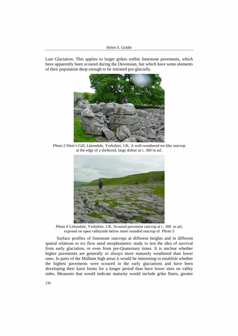
These are 2-3 m in height and lie at c. 380 m altitude, well-above smoothly-scoured limestone outcrops at 330 m on the west flank of Littondale which lack mature features such as flared grikes or rounded clints (Photo 6). It is worth noting that this general area is near the gritstone tors of Wharfedale on which Linton, D. L. (1964) commented that the landscape owed not only its main outlines but also its small-scale relief to processes operating before and between the glacial episodes. Linton’s observation appears applicable to the nearby limestone landscape as well.
Having established that these forms could be survivors of recent glaciation then it can be postulated that if similar features are found elsewhere they should also indicate survival. In other words, the form indicates an amount of solution only likely to have occurred over a longer time-period than is available since the
Helen S. Goldie
236
Last Glaciation. This applies to larger grikes within limestone pavements, which have apparently been scoured during the Devensian, but which have some elements of their population deep enough to be initiated pre-glacially.
Photo 5 Sleet’s Gill, Littondale, Yorkshire, UK. A well-weathered tor-like outcrop
at the edge of a sheltered, large doline at c. 360 m asl.
Photo 6 Littondale, Yorkshire, UK. Scoured pavement outcrop at c. 300 m asl,
exposed on open valleyside below more rounded outcrop of Photo 5
Surface profiles of limestone outcrops at different heights and in different spatial relations to ice flow need morphometric study to test the idea of survival from early glaciation, or even from pre-Quaternary times. It is unclear whether higher pavements are generally or always more maturely weathered than lower ones. In parts of the Malham high areas it would be interesting to establish whether the highest pavements were scoured in the early glaciations and have been developing their karst forms for a longer period than have lower sites on valley sides. Measures that would indicate maturity would include grike flares, greater
Mature intermediate-scale surface karst landforms in NW England and their relations to glacial erosion
237
grike width, and surface roundedness. Field sites could be graded by being related to the Goldie and Cox model. A further suggestion would be to calculate loss of limestone from the theoretical original block, using a percentage of volume removed. Careful field assessment would be required to allow for local geological and other conditions.
CONCLUSIONS
This preliminary work has identified neglected karst landforms in the otherwise well-known karst areas of NW England. Clearly the surface limestone landforms here still pose interesting questions. Re-assessment of solutional lowering rates in drier areas has opened up discussion of ages of surface outcrops. The various features discussed are very attractive and interesting and deserve far more attention. Cosmogenic dating of the outcrops would be very welcome and could clarify landform development, which has produced a wide variety of mature-looking intermediate-scale surface landforms in what has always been deemed to be a well-glaciated area. This work has benefited considerably from comparisons with non-glaciated limestone areas.
BIBLIOGRAPHY
Arthurton, R. S. – Johnson, E. W. – Mundy, D. J. C. 1988. Geology of the country around Settle. Mem. Br. Geol. Surv., Sheet 60 (England and Wales). H.M.S.O, London. 148 p.
Brunsden, D. 1993. The persistence of landforms. Z. Geomorph. N.F., Suppl.-Bd. 93. pp. 13-28. Clayton, K. 1981. Explanatory description of the landforms of the Malham area. Field Studies 5.
pp. 389-423. Corbel, J. 1957. Les Karsts du Nord Ouest de l’Europe. Institute Etudes Rhodaniènes, Universitaire
de Lyons, Memoirs et Documents 12. Douglas, I. 1987. Plate tectonics, palaeoenvironments and limestone geomorphology in west-central
England. Earth Surface Processes and Landforms 12. pp. 481-495. Ford, D. C. 1987. Effects of glaciations and permafrost upon the development of karst in Canada.
Earth surface Processes and Landforms 12. pp. 507-521. Ford, D. C. – Williams, P. W. 1988. Karst geomorphology and hydrology. Unwin Hyman, London.
601 p. Ford, T. D. 1977. Limestones and Caves of the Peak District. Geobooks, Norwich. Gale, S. J. 2000. Classic landforms of Morecambe Bay. Geographical Association. 47 p. Gascoyne, M. – Ford, D. C. – Schwarz, H. P. 1983. Rates of cave and landform development in the
Yorkshire Dales from speleothem age data. Earth Surface Processes and Landforms 8. pp. 557-568.
Goldie, H. S. 1981. Morphometry of the limestone pavements of Farleton Knott, Cumbria. Transactions of the Cave Research Association 8. pp. 207-222.
Goldie, H. S. 1996. The limestone pavements of Great Asby Scar. Cumbria, UK. Environmental Geology 28. pp. 128-136.
Goldie, H. S. 2003. Mature small to medium scale surface karst landforms in N.W.England. Abstracts BGRG Conference, September 2003, Oxford.
Helen S. Goldie
238
Goldie, H. S. 2004. Erratic Judgments: a new interpretation of the Norber erratics and a re-assessment of landform-based limestone erosion rates. In: Life in a Limestone Landscape (The Malham Tarn Research Seminar 2003) Field Studies Council, Malham, Yorkshire. pp. 22-23.
Goldie, H. S. 2005. Erratic Judgements: re-evaluating solutional erosion rates of limestones using erratic-pedestal sites, including Norber, Yorkshire. Area 37/4. pp. 433-442.
Goldie, H. S. – Cox, N. J. 2000. Comparative morphometry of limestone pavements in Britain, Eire and Switzerland. Zeitschrift für Geomorphologie Spbd. 122. p.
Goldie, H. S. – Marker, M. E. 2001. Pre-devensian dolines in Crummackdale. Cave & Karst Science 28/2. pp. 53-58.
Gordon, D. – Smart, P. L. – Ford, D. C. et al. 1989. Dating of the late Pleistocene interglacial and interstadial periods in the United Kingdom from speleothem growth frequency. Quaternary Research 31. pp. 14-26.
Goudie, A. 1990. The Landforms of England and Wales. Blackwell, Oxford. 394 p. Gunn, J. 1985. Pennine karst areas and their Quaternary history. Ch.14. In: Johnson, R. H. (ed.). The
geomorphology of North-west England. University Press, Manchester. 421 p. Hall, A. M. – Sugden, D. E. 1987. Limited modification of mid-latitude landscapes by ice sheets: the
case of northeast Scotland. Earth Surface Processes and Landforms 12. pp. 531-542. Hättestrand, C. – Stroeven, A. P. 2002. A relict landscape in the centre of Fennoscandian glaciation:
Geomorphological evidence of minimal Quaternary glacial erosion. Geomorphology 44. pp. 127-143.
Huddart, D. – Glasser, N. 2002. Quaternary of Northern England. Geological Conservation Review. JNCC, Peterborough. 679 p.
Linton, D. L. 1964. The origin of Pennine tors – An essay in analysis. Zeitschrift fur geomorphologie Special Vol. pp. 5-24.
Migon, P. – Goudie, A. S. 2001. Inherited landscapes of Britain – Possible reasons for survival. Z. Geomorph. N.F. 45/4. pp. 417-441.
Murphy, P. J. – Lord, T. 2003. Victoria Cave, Yorkshire, UK: new thoughts on an old site. Cave & Karst Science 30/2. pp. 83-88.
Pigott, C. D. 1965. The structure of limestone surfaces in Derbyshire. Geographical Journal 131. pp. 41-44.
Rose, L. – Vincent, P. J. 1986. Some aspects of the morphometry of grikes – a mixture model approach. In: Paterson, K. – Sweeting, M. M. (eds.). New Directions in Karst. Geobooks, Norwich. pp. 497-514.
Sweeting, M. M. 1966. The weathering of limestones. In: Dury, G. H. (ed.). Essays in Geomorphology. Heinemann, London. pp. 177-210.
Vanstone, S. D. 1998. Late Dinantian Palaeokarst of England and Wales: implications for exposure surface development. Sedimentology 45. pp. 19-37.
Vincent, P. J. 1982. Some observations on the so-called relict karst of the Morecambe Bay region, north-west England. Revue Géologie Dynamique et Géographie Physique 23. pp. 143-150.
Vincent, P. J. 1995. Limestone Pavements in the British Isles: A Review. The Geographical Journal 161/3. pp. 265-274.
Vincent, P. J. 2004. Re-thinking the origin of limestone pavements. In: Life in a Limestone Landscape. Field Studies Council, Malham. 28.
Walkden, G. M. 1974. Palaeokarstic surfaces in Upper Visean (Carboniferous) Limestones of the Derbyshire Block, England. Journal of Sedimentary Petrology 44. pp. 1232-1247.
Waltham, A. C. – Simms, M. J. – Farrant, A. R. – Goldie, H. S. 1997. Karst and Caves of Great Britain. Geological Conservation Review. JNCC, Chapman–Hall, London. 358 p.
Williams, P. W. 1970. Limestone morphology in Ireland. Ch. VII. In: Stephens, N. – Glasscock, R. E. (eds.). Irish Geographical Studies in Honour of E. Estyn Evans. Department of Geography, Queen’s University Belfast. 403 p.
Wright, V. P. 1982. The recognition and interpretation of palaeokarsts: two examples from the Lower Carboniferous of South Wales. Journal of Sedimentary Petrology 52. pp. 83-94.