aalborg universitet land administration and...
TRANSCRIPT
Aalborg Universitet
Land Administration and Cadastral Systems in support ofSustainable LandGovernanceEnemark, Stig
Published in:Re-Engineering the Cadastre to Support E-Government
Publication date:2009
Document VersionPublisher's PDF, also known as Version of record
Link to publication from Aalborg University
Citation for published version (APA):Enemark, S. (2009). Land Administration and Cadastral Systems in support ofSustainable Land Governance: aglobal approach. In Re-Engineering the Cadastre to Support E-Government (pp. 53-71)
General rightsCopyright and moral rights for the publications made accessible in the public portal are retained by the authors and/or other copyright ownersand it is a condition of accessing publications that users recognise and abide by the legal requirements associated with these rights.
? Users may download and print one copy of any publication from the public portal for the purpose of private study or research. ? You may not further distribute the material or use it for any profit-making activity or commercial gain ? You may freely distribute the URL identifying the publication in the public portal ?
Take down policyIf you believe that this document breaches copyright please contact us at [email protected] providing details, and we will remove access tothe work immediately and investigate your claim.
Downloaded from vbn.aau.dk on: september 06, 2018

Working Group 3
Permanent Committee on GIS Infrastructure for Asia and the Pacific (PCGIAP)
3rd UN sponsored Land Administration Forum
for Asia and the Pacific Region
““RRee--EEnnggiinneeeerriinngg tthhee CCaaddaassttrree ttoo SSuuppppoorrtt EE--GGoovveerrnnmmeenntt””
24-26 May 2009 Tehran, IRAN
Facilitated by Centre for Spatial Data Infrastructures and Land Administration
Department of Geomatics, University of Melbourne

Re-Engineering the Cadastre to Support E-Government
Third PCGIAP Forum on Land Administration
2

Re-Engineering the Cadastre to Support E-Government
Third PCGIAP Forum on Land Administration
3
Content Content ...................................................................................................................................... 3 Forum Program .......................................................................................................................... 4 Introduction and Background ...................................................................................................14 Forum Aims and Objectives .....................................................................................................16 Position Paper-Re-engineering the cadastre to support e-government ................................. 18 Vision Paper- Cadastre and Spatially Enabling Society ...........................................................43 Land Administration and Cadastral Systems in support of Sustainable Land Governance .....53 Modern Land Administration; Characteristics for e-Governments ..........................................85
Re-Engineering the Cadastre to Support E-Government
Third PCGIAP Forum on Land Administration
4
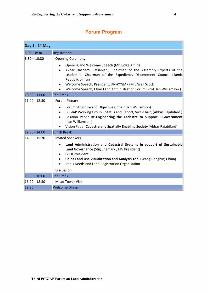
Forum Program
Day 1 ‐ 24 May
8:00 – 8:30 Registration
8:30 – 10:30
Opening Ceremony
• Opening and Welcome Speech (Mr Judge Amiri) • Akbar Hashemi Rafsanjani, Chairman of the Assembly Experts of the
Leadership Chairman of the Expediency Discernment Council IslamicRepublic of Iran
• Welcome Speech, President, UN‐PCGIAP (Mr. Greg Scott) • Welcome Speech, Chair Land Administration Forum (Prof. Ian Williamson )
10:30 ‐ 11:00 Tea Break
11:00 ‐ 12:30
Forum Plenary
• Forum Structure and Objectives, Chair (Ian Williamson) • PCGIAP Working Group 3 Status and Report, Vice‐Chair, (Abbas Rajabifard ) • Position Paper Re‐Engineering the Cadastre to Support E‐Government
( Ian Williamson ) • Vision Paper Cadastre and Spatially Enabling Society (Abbas Rajabifard)
12:30 ‐ 14:00 Lunch Break
14:00 ‐ 15:30 Invited Speakers
• Land Administration and Cadastral Systems in support of SustainableLand Governance (Stig Enemark ; FIG President)
• GSDI President • China Land Use Visualization and Analysis Tool (Wang Rongbin; China) • Iran’s Deeds and Land Registration Organisation
Discussion
15:30 ‐ 16:00 Tea Break
16:00 ‐ 18:30 Milad Tower Visit
19:30 Welcome Dinner

Re-Engineering the Cadastre to Support E-Government
Third PCGIAP Forum on Land Administration
5
Day 2 ‐ 25 May
9.00 – 10:30
Invited Speakers
• E‐government in Asia and the Pacific: implications for the cadastre (Peter Holland, Australia)
• Malaysia • Singapore • Mongolia • Professor Harlan Onsrud, USA
Discussion
10:30 ‐ 11:00 Tea Break
11:00 ‐ 12:30 Invited Speakers
• Using Cadastre to Spatial Enable Government (Jude Wallace, Australia ) • The Netherlands • Pakistan • Azerbaijan
Discussion
12:30 – 14:00 Lunch Break
14:00 ‐ 15:00 Invited Speakers
• Cadastral Activities in Europe (Daniel Steudler, Switzerland) • India • Representative from Iranian Parliament
Discussion
15:30 ‐ 18:00 Technical Visit / Exhibition
Day 3 ‐ 26 May
9.00 – 10:30
Invited Speakers
• Land Governance Assessment Framework (Tony Burns, Australia) • Brunei Darussalam • U.A.E • Modern Land Administration; Characteristics for e‐Governments (Mohsen Kalantari, University of Melbourne)
Discussion
10:30 ‐ 11:00 Tea Break
11:00 ‐ 12:00
Round Table Strategic Discussion‐ Cadastre and Spatially Enabled Society
Prof Ian Williamson, Prof Stig Enemark, Mr Peter Holland, Ms Jude Wallace, Dr Daniel Steudler, Mr Tony Burns, Mr Nasrollah Jahangard, Associate Prof Abbas Rajabifard
12:00 ‐ 14:00 Lunch Break
14:00 ‐ 15:30 Final Remarks and Future Direction Closing Ceremony

6
IN THE NAME OF GOD THE BENEFICIENT, THE MERCIFULL
Welcome Message from Head of Judiciary of I.R. of Iran Honorable, Ayatollah Hashemi Shahroodi
Honorable Guests and Observers It is a real honor and privilege for me, to welcome you to Tehran for the 3rd Land Administration Forum of the Permanent Committee on GIS Infrastructure for Asia and the Pacific (PCGIAP). I would like to particularly welcome all delegates and participants from other countries as well as participants from Universities and higher education institutions.
It was a great pleasure that the PCGIAP committee accepted the offer from Islamic Republic of Iran to host this important forum. There is no doubt that having an ongoing and regular land administration forum in Asia and the Pacific region will strengthen cooperation among participating countries and can help solving regional problems.
The main theme of this forum is “Re‐Engineering the Cadastre to Support e‐Government”. I truly believe this important meeting will provide an ideal platform to share the ideas between all stakeholders in the field of cadastre and land administration in Asia and the Pacific region.
I would like to thank all members and the organizing committee for their determinations and efforts toward the success of such important forum.
In this spirit, let me wish you all an informative and fruitful exchange of ideas.
Hashemi Shahroodi
Head of Judiciary of I.R. of Iran

7
IN THE NAME OF GOD THE BENEFICIENT, THE MERCIFULL
Welcome Message from Head of Host Organization and Head of Iran's Deeds and Land Registration Organization Mr. Hosseinali Amiri
Dearest Guests I would like to extend a warm welcome to all participants at the 3rd Regional PCGIAP Land Administration Forum. It is very interesting that representatives of many different nations are assembled in Tehran to share their ideas and experiments and discuss various aspects of cadastre and land administration issues and challenges in Asia and the Pacific Region.
The objectives of this forum in Tehran are:
• To discuss the role of cadastre to support e‐Government strategies
• To share land administration experiences in the Asia and Pacific region with a focus on re‐engineering cadastre to support e‐government
• To discuss wide ranging land administration issues including access to land and security of tenure, the role of land administration in supporting sustainable development, the promotion of effective land markets, poverty reduction, protection of vulnerable groups, e‐land administration, land registration, cadastral surveying and mapping etc.
• To continue discussion on the need for an ongoing land administration forum in the Asia and the Pacific region that was commenced at the Mongolian and Malaysian forums with a view to preparing a proposal and resolution to be put before the UN Cartographic Conference for Asia and the Pacific in Bangkok 26‐29 October, 2009.
The forum is being coordinated through the PCGIAP Working Group on Spatially Enabled Government and Professor Rajabifard (Vice‐chair of Working Group) is forum Vice‐chair and forum coordinator. This initiative is the result of a Resolution passed by the 14th

8
PCGIAP meeting in Malaysia in 2008 and a desire by many countries in the Asia and the Pacific region to have a forum to discuss and share land administration issues, best practice and experiences, in a similar manner to the Working Party on Land Administration (WPLA) for European countries, organized by the UN Economic Commission for Europe (UNECE).
The main focus of this forum was developed both by the PCGIAP and the 2nd Land Administration Forum for Asia and the Pacific hosted by the Malaysian Government in 2008. It was also influenced by the first Land Administration Forum organized by the Mongolian Government in 2007 that was also supported by UNDP, UNECE (WPLA), GSDI Association, FIG, the Asian Development Bank, German Technical Assistance (GTZ), Eurogeographics and the National Land Survey of Sweden.
I hope you enjoy your stay in Tehran and have a successful and enjoyable Forum.
Hosseinali AMIRI
Deputy Head of Judiciary and
Head of Iran's Deeds and Land
Registration Organization

9
3rd UN-Sponsored PCGIAP Land Administration Forum (Re-Engineering the Cadastre to Support E-Government) 24-26 May 2009, Tehran, Iran
Welcome message from the President of the Permanent Committee on GIS Infrastructure for Asia and the Pacific Mr. Greg Scott
Honorable Guests and Observers
As the President of the Permanent Committee on GIS Infrastructure for Asia and the Pacific (PCGIAP) it is my great pleasure to welcome you to the 3rd PCGIAP‐United Nations sponsored Land Administration Forum being held in Tehran, the Islamic Republic of Iran, between 24 and 26 May 2009.
The theme of this Forum is Re‐Engineering the Cadastre to Support E‐Government.
This Forum is being supported by the UN sponsored PCGIAP together with the Government of the Islamic Republic of Iran, the Deeds and Properties Registration Organization of Iran, the International Federation of Surveyors (FIG), the Global Spatial Data Infrastructure Association (GSDI) and the Centre for Spatial Data Infrastructures and Land Administration, the University of Melbourne, and to these organizations I extend my thanks.
I would particularly like to thank the distinguished guests, international experts, Iranian government officials, and the ladies and gentlemen who have taken the time to join us in Tehran for this important event.
My special gratitude is extended to the Government of the Islamic Republic of Iran for hosting this Forum.
I would like to make special mention of the staff of the Deeds and Properties Registration Organization of Iran, and the Centre for Spatial Data Infrastructures and Land Administration, the University of Melbourne, for their efforts behind the scenes in organizing the Forum.

10
This is the second time a PCGIAP meeting has been held in Tehran. The 4th meeting of PCGIAP was convened in the Iranian Centre for International Conferences in March 1998.
PCGIAP has come a long way over the last 10 years or so since this meeting. One of the important milestones reached by PCGIAP during this time has been the opportunity to sponsor and support the initial meetings of land administration officials in the Asia and Pacific region. The inaugural forum was a Round Table Meeting in Ulaanbaatar, Mongolia, on 29 June 2007. The second forum was an International Seminar on Land Administration Trends and Issues in Kuala Lumpur, Malaysia, between 19 and 20 August 2008. Both of these meetings were notable in terms of the level of support they received from land administration officials in the region and from international experts, the significance of the land administration policy and technical matters discussed, and the unanimous view expressed that a regular Forum on Land Administration in the Asia and Pacific region should be convened under the auspices of the United Nations and in conjunction with PCGIAP.
This, the 3rd Land Administration Forum in Tehran is equally as important. It provides an opportunity to consider the important topic of Re‐Engineering the Cadastre to Support E‐Government, and to give further thought to the form and operation of a regular Forum on Land Administration in the region.
The relevance of the latter point should not be glossed over for as we speak preparations are being made for the triennial and 18th United Nations Regional Cartographic Conference for Asia and the Pacific to be held in Bangkok, Thailand, 26‐30 October 2009. This is the forum at which PCGIAP reports to the United Nations, and the forum where resolutions are ratified and recognized by the United Nations. These resolutions become the work plan of PCGIAP for the next three years.
In conclusion, I wish you the very best in your discussions over the next three days of the Forum and during your stay in Iran. This is a beautiful country with a history and a culture that extends back in time for thousands of years. It has much to offer and please the visitor.
Greg Scott
PCGIAP President

11
Welcome message from Chair of the land Administration Forum and Chair, Working Group 3 (Land Administration), UN sponsored Permanent Committee on GIS Infrastructure for Asia and the Pacific Professor Ian Williamson
As Chair of the 3rd Land Administration Forum organized under the authority of the UN sponsored Permanent Committee for GIS Infrastructure for Asia and the Pacific (PCGIAP), and Chair of Working Group 3 (Land Administration) I am delighted to welcome all delegates to this important Forum. This is the third land administration forum organized under the authority of the PCGIAP with the first being held in Mongolia in 2007 and the second in Malaysia in 2008. These forums are in response to the needs of the countries in the region to have an opportunity to discuss land administration issues and share experiences on this important topic.
Each forum has had a specific focus with this forum concentrating on the re‐engineering the cadastre to support e‐government. This is a vitally important topic for all countries in the region and I am sure all delegates will benefit from the many presentations and open discussions on challenges and issues as all countries to full advantage of e‐government initiatives.
This forum has another important objective. That is to debate the needs of the Asia and Pacific region to have a regular opportunity for countries in the region to discuss and share land administration matters. The outcome of these deliberation and any resulting resolutions will be taken to the 18th United Nations Regional Cartographic Conference for Asia and the Pacific to be held in Bangkok, Thailand 26‐30 October, 2009.
I want to express my sincere thanks for the excellent organization for this forum by our Iranian colleagues in the Government of the Islamic republic of Iran and particularly the Deeds and Properties Registration Organization of Iran. I also wish to thank the PCGIAP for their support and the other organizations that have supported the Forum including the International Federation of Surveyors, the Global Spatial Data Infrastructure

12
Association and particularly the Centre for Spatial Data Infrastructures and Land Administration, the University Of Melbourne, Australia and its Director Associate Professor Abbas Rajabifard. The tireless efforts of many people to organize the forum as sincerely appreciated.
I look forward to meeting all the delegates, having many discussions and enjoying and sharing in the warm hospitality from our Iranian colleagues.
Ian Williamson
Forum Chair,
Chair, WG3‐PCGIAP

13
IN THE NAME OF GOD THE BENEFICIENT, THE MERCIFULL
Welcome message from the Forum Secretary Dr. Ghasem Soleimani
Dear Participants,
On behalf of the local organizing committee and Iran’s Deeds and Properties Registration Organization I would like to warmly welcome participants and presenters to the 3rd UN sponsored PCGIAP Land Administration Forum in Tehran. It is our great pleasure and privilege to play host for such important Forum in the Asia and Pacific region.
This Forum, the third of these series, will provide a great opportunity for all participants to discuss the land administration issues and challenges in the region. There is no doubt that presentations from specialists, researchers, cadastre and land administration managers from several countries in the Asia Pacific region and from around the world will bring together the latest knowledge and experiments in this field. This three day event offers an opportunity for delegates to share their ideas with some of the best minds in the field of land administration.
I wish to extend my gratitude to all members of participating organizations and countries for making this meeting possible. Your participation and contribution is greatly appreciated.
I hope you have a wonderful and productive time at this Forum and enjoy your stay in Tehran.
Ghasem Soleimani
Deputy Head,
Information Technology Planning and Development
Iran’s Deeds and Properties Registration Organization

14
Introduction and Background Permanent Committee on GIS Infrastructure for Asia and the Pacific (PCGIAP) has made significant achievements since its inception in 1995. It has provided a focus for spatial data infrastructure initiatives across Asia and the Pacific region and for sharing experiences about designing, building and managing regional SDIs. The national mapping agencies in member states have shown leadership in these initiatives, suited to the evolving nature of SDIs with their traditional focus on small scale national initiatives. However, several members of PCGIAP have expressed a desire to have a better mechanism for sharing experiences about not only mapping and SDIs but also in land administration in the region in a similar manner to the European system under the UNECE Working Party on Land Administration (WPLA). While PCGIAP actively supported sharing of experiences through its previous Working Group 3 (Cadastre), countries such as Mongolia now view this as insufficient. These countries need a much more focused and institutionalized arrangement, desirably under a UN mandate. This situation presents an opportunity for PCGIAP to widen its mandate, to continue to remain relevant to member countries and to assist national governments to seize opportunities created by the newest spatial technologies that increasingly integrate all spatial, geocoded information. This initiative would also strengthen PCGIAP and ensure a stronger attendance at meetings. It has been suggested, that unless it broadens its scope to include land administration activities (and all core land information), PCGIAP risks encouraging countries, by necessity to create a parallel organisation responsible for national large scale land information as an integral component of a national SDI. Duplication would inevitably weaken PCGIAP over time as the authoritative manager of spatial information in the region. As a result of this, there was a recommendation as part of a White Paper titled “A vision for PCGIAP in a spatially enabled world” (Attachment 1) presented at the PCGIAP meeting in Korea 13-15 June, 2007 that PCGIAP explore possibilities and structures to ensure that national mapping and geographic information agencies as well as cadastral and land administration agencies are represented for each country in the Asia and Pacific region. This would mean that countries where the national mapping and land administration/cadastral activities are combined (such as Malaysia, Cambodia, Laos, Singapore, Mongolia, Fiji, New Zealand, Fiji, etc) would normally be represented by one person even though they may wish to have two representatives representing each broad area of national mapping and land administration. Where the functions are split between two agencies then two representatives would attend PCGIAP. PCGIAP technical sessions could typically have two parallel sessions, one for national mapping and NSDI initiatives and one for land administration matters. There would also

15
be plenary sessions to integrate activities in support of the common vision of spatially enabling governments and society. The organisational model would provide an innovative approach to functional and seamless treatment of land information, and assist countries in the region to position themselves for world leadership in take up of new technologies and delivery of government services that depend on a fully integrated approach to managing spatial information. In response to this, at the PCGIAP meeting in Korea, the PCGIAP discussed the proposal by the Mongolian member regarding the need to establish a better mechanism to discuss and share land administration experiences in the Asia and Pacific region. While welcoming discussion on this matter and appreciating the need for better mechanisms to share land administration experiences in the region, the initial response from the PCGIAP members at the meeting was that more time is needed to discuss the matter and that it is important for PCGIAP to maintain a dialogue with member countries on this issue. Further, in the short term PCGIAP asked Professor Ian Williamson, Chair of PCGIAP WG3 to represent PCGIAP at a Roundtable in Mongolia to discuss this issue on Friday 29 June, 2007. The Roundtable was part of the Mongolia Workshop on “Good Land Administration – Its role in Economic Development”. Professor Williamson advised the Roundtable that PCGIAP was pleased to consider all suggestions and recommendations that arise from this Roundtable at its next PCGIAP Board Meeting in Canberra, Australia in April, 2008. PCGIAP welcomed the dialogue on this matter and as a result agreed to facilitate a special seminar (this seminar) be held on “Land administration issues in the Asia and Pacific Region” at the 14th PCGIAP meeting in August 2008 in Malaysia. Details of the Seminar were communicated to the Roundtable. Options and implications arising from that workshop could be considered by PCGIAP and if all parties agree any new arrangements could possibly be presented for consideration to the next United Nations Regional Cartographic Conference for Asia and the Pacific scheduled for 2009. As a result of this arrangement therefore this seminar has been organized and conducted. 3rd PCGIAP UN sponsored Land Administration Forum (Re-Engineering the Cadastre to Support E-Goverment) is the continuation of the forum series.

16
Forum Aims and Objectives As part of the WG3 workplan, PCGIAP together with Iran’s Deeds and Properties Registration Organization, the International Federation of Surveyors (FIG), the Global Spatial Data Infrastructure Association (GSDI) and the Centre for Spatial Data Infrastructures and Land Administration, University of Melbourne, are organizing a three day Forum in Tehran as part of PCGIAP-WG3 activities to discuss land administration issues and the role of cadastre to support e-government in the Asia and Pacific region. The forum is the result of a Resolution passed by the 14th PCGIAP meeting in Malaysia in 2008 and a desire by many countries in the Asia and the Pacific region to continue to have a forum to discuss and share land administration issues, best practice and experiences, in a similar manner to the Working Party on Land Administration (WPLA) for European countries, organized by the UN Economic Commission for Europe (UNECE). The focus of the forum was developed both by the PCGIAP and the 2nd Land Administration Forum for Asia and the Pacific hosted by the Malaysian Government in 2008. It was also influenced by the first Land Administration Forum organized by the Mongolian Government in 2007 that was also supported by UNDP, UNECE (WPLA), GSDI Association, FIG, the Asian Development Bank, German Technical Assistance (GTZ), Eurogeographics and the National Land Survey of Sweden. The objectives of the forum in Tehran are:
• To discuss the role of cadastre to support e-Government strategies
• To share land administration experiences in the Asia and Pacific region with a focus on re-engineering cadastre to support e-government
• To discuss wide ranging land administration issues including access to land and security of tenure, the role of land administration in supporting sustainable development, the promotion of effective land markets, poverty reduction, protection of vulnerable groups, e-land administration, land registration, cadastral surveying and mapping etc.
• To continue discussion on the need for an ongoing land administration forum in the Asia and the Pacific region that was commenced at the Mongolian and Malaysian forums with a view to preparing a proposal and resolution to be put before the UN Cartographic Conference for Asia and the Pacific in Bangkok 26-29 October, 2009.
The 3rd Forum is coordinated through the WG3 Prof Williamson (Working Group Chair) chairing the Forum and Professor Rajabifard (Vice-chair of Working Group) as forum Vice-chair and forum coordinator. In preparation of this forum, the organizing team met in Tehran in February with the Iranian counterpart who will organise the Iranian logistics. As a result of this activity, the forum program was finalised. As part of the program, there will be more than 20 presentations. The forum will be conducted in seven sessions including an opening

17
session (4 presentations), five invited speaker sessions (20 presentations) and panel discussion. Each session and presentation will follow with a discussion. Further information about the Forum (background documents, aims and objectives, seminar outcomes, etc.) and other related materials can be found at the dedicated forum website: http://www.csdila.unimelb.edu.au/projects/tehran/index.html All of the outcomes of the Forum will be available on this website which will be continuously updated. After the Forum a full report will be presented at the next UNRCC-AP Conference and PCGIAP meeting in Bangkok in October 2009.
18
POSITION PAPER Re-engineering the cadastre to support e-government Ian Williamson Professor of Surveying and Land Information Department of Geomatics Centre for Spatial Data Infrastructures and Land Administration The University of Melbourne, Parkville, Victoria, Australia 3010 [email protected] http://www.geom.unimelb.edu.au/people/ipw.html
Abstract An important government activity for all nation states is building and maintaining a land administration system (LAS) with the primary objective of supporting an efficient and effective land market. This usually includes cadastral surveys to identify and subdivide land, land registry systems to support simple land trading (buying, selling, mortgaging and leasing land) and land information systems to facilitate access to the relevant information, increasingly through an Internet enabled e-government environment. For most countries a cadastre is at the core of the LAS providing spatial integrity and unique land parcel identification in support of security of tenure and effective land trading. For many cadastral and land administration officials and for much of society, these are the primary, and in many cases the only roles of the cadastre and LAS. However the role, and particularly the potential of LAS and their core cadastres, have rapidly expanded over the last couple of decades and will continue to change in the future. Cadastres provide the location or place for many activities in the built environment through the cadastral map. This in turn provides the spatial enablement of the broader land administration system. Cadastres permit geocoding of property identifiers and particularly street addresses that then facilitate spatial enablement of government and wider society within an e-government environment. While the land market function of cadastres is essential, the ability to spatially enable society is proving to be just as important as or even more important than the land market function. In particular spatial enablement allows governments to more easily deliver sustainable development (economic, environmental, social and governance dimensions), increasingly the over-arching objectives of government. This paper describes the role that cadastres play in land administration systems and also the provision of the spatial dimension of the built environment in national spatial data infrastructures (NSDI). The paper then explores how the cadastre supports spatial enablement of government and wider society to pursue sustainable development goals as part of an e-government environment. It concludes by challenging land administration officials to capitalize on the potential of LAS and cadastres to achieve these goals. Acknowledgements
19
This article draws on previous articles presented by the author on the role of the cadastre to support sustainable development. It also draws upon the collegiate creative efforts of colleagues in the Centre for Spatial Data Infrastructures and Land Administration, Department of Geomatics, University of Melbourne, Australia and particularly joint research with Associate Professor Abbas Rajabifard and Ms Jude Wallace. However any errors are entirely the author’s responsibility. The paper also draws on a soon to be released book titled “Land Administration to support Sustainable Development” by Ian Williamson, Stig Enemark, Jude Wallace and Abbas Rajabifard to be published later in 2009 by ESRI Press, USA.
Introduction Land surveyors, lawyers and land administrators are experts in designing, building and managing cadastral systems as core components of our land administration systems (LAS). They are experienced in creating, describing and defining land parcels and associated rights. Historically, society required these skills to support an efficient and effective land market in which these rights in land are traded to promote economic development. By the mid nineteenth century, trading involved buying, selling, mortgaging and leasing of rights in land. By the mid twentieth century, land administration and cadastral officials, and associated legal and surveying professionals, assumed that they understood land markets, and that they had developed appropriate professional skills to serve the needs of those markets. Unfortunately these professionals were involved in supporting the land trading activities, not designing them. Simply there is little documentation in the literature on how to design and build a land market or even on the development and growth of land markets (however, see Wallace and Williamson, 2006a and Williamson et al, 2009). It is ironic that surveyors, for example, pride themselves on working from the “whole to the part”, yet they gave little effort to designing land markets, and then designing the cadastre, a LAS, and supporting technical and administrative skills to support them. Historically, as professionals we went the other way round: we often designed LAS and then hoped that they would support efficient and effective land markets. Experience around the world shows that the results in many countries are less than satisfactory. In general existing land administration (LA) skills are appropriate for simple land markets which focus on traditional land development and simple land trading; however land markets have evolved dramatically in the last 50 years and have become very complicated, with the major wealth creation mechanisms in the most developed countries focused on the trading of complex commodities. While the expansion of our LAS to support the trading of complex commodities offers many opportunities for LA administrators, one particular commodity - land information and particularly its spatial dimension – has the potential to significantly change the way societies operate, and how governments and the private sector do business. Importantly governments can capitalise upon the potential of land information as part of their e-government initiatives however the cadastre in particular has to be focused on the wider

20
role of supporting the spatial enablement of society rather than the traditional role of supporting simple land trading. The growth of markets in complex commodities is a logical evolution of our people to land relationships, and our evolving cadastral and LAS. The changing people to land relationships, the need to pursue sustainable development and the increasing need to administer complex commodities within an ICT (information and communications technologies) enabled virtual world, offer new opportunities for our land administration systems as they increasingly play a key role in spatially enabling governments and wider society. However many challenges need to be overcome before these opportunities can be achieved. For an overview of trends in spatially enabling government and society see Rajabifard (2007), PCGIAP (2007) and OSDM (2007). Research aimed at understanding and meeting these challenges is undertaken within the Centre for Spatial Data Infrastructures and Land Administration, Department of Geomatics, University of Melbourne (http://www.csdila.unimelb.edu.au/). The over arching focus of these projects is on spatially enabling government in support of sustainable development. The Centre’s initiatives involve developing a new vision for managing land information called iLand as part of e-government. The components of the vision include:
• a collaborative whole of government approach to managing spatial information using spatial data infrastructure (SDI) principles,
• better understanding of the role that LAS plays in integrated land management (land markets, land use planning, land taxation etc),
• seamless integration of built and environmental spatial data in order to deliver sustainable development objectives,
• improved interoperability between our land information silos through e-land administration and e-government,
• more flexible technology and models to support cadastres, especially to introduce a third dimension of height, and a forth dimension of time,
• better management of the complex issues in our expanding multi-unit developments and vertical villages,
• better management of the ever increasing restrictions and responsibilities relating to land,
• better support for the creation and trading in complex commodities, and • incorporation of a marine dimension into both our cadastres and land
administration systems. • The fundamental idea is to re-engineer LAS and the core cadastre to support
emerging needs of government, business and society to deliver more integrated and effective information, and to use this information throughout government and non-government processes as part of e-government initiatives by organizing technical systems in the virtual environment around place or location.

21
Cadastres and their role in Land Administration Systems An understanding of LAS and the core cadastral component, and their evolution can help predict how they will develop. The Importance of the Cadastre Digital information about land is central to the policy framework of modern land administration and sustainability accounting (Williamson, Enemark and Wallace, 2006a). The cadastre, or the large scale, land parcel map related to parcel indices, is the vital information layer of an integrated land management system, and, in future, will underpin information systems of modern governments and facilitate the spatial enablement of government as part of an overall e-government strategy. While some developed countries do without a formal “cadastre”, most generate digital parcel maps (or digital cadastral data base or DCDB) reflecting land allocation patterns, uses and subdivision patterns, and even addresses and photographs. A country’s DCDB is its core information layer that reflects the use and occupation of land by society – the built environment. Critically it provides the spatial component for LAS and more particularly the location and place dimension with the most useful output being a geocoded street address of each property. Simply the cadastre is the central component in spatially enabling government. It is destined for a much broader role as fundamental government infrastructure equivalent to a major highway or railway, though it was originally created on behalf of taxpayers merely for better internal administration of taxation, and, more recently, titling of land in support of more efficient and effective land markets. Without these digital facilities, modern governments cannot understand the built environment of cities, manage land competently, utilise computer capacity to assist policy making, or retrieve significant value out of land. The greatest potential of the DCDB lies with the information industry at large, as the principal means of translating geographic coordinates and spatial descriptors of land parcels into meaningful descriptions of places that everybody can understand. Land parcels describe the way people physically use and think about their land. The familiar configuration of parcel based descriptions in the DCDB ensures people-friendly identification of precise locations of impact of private ownership and, more vitally, of government, business and community policies, regulations and actions. In cadastres
Figure 1: The Cadastral Concept (FIG, 1995)

22
supported by professional surveyors, the descriptions have the added advantage of being legally authoritative. While re-engineering the cadastre is required to fully capitalize upon its potential, it is only part of the story. Equally important and arguably more important, is building the capacity of a government to understand the changing role of the cadastre and then to re-engineer the environment as part of a wider e-government strategy. While having a cadastre is not mandatory for a LAS, all modern economies recognize its importance, and either incorporate a cadastre or its key components in their LAS. For example, Australian LAS did not evolve from a traditional cadastral focus as did many of their European counterparts, but their cadastres are equal to, and sometimes improve upon, the classic European approach. The cadastral concept shown in Figure 1 (FIG, 1995) is simple and clearly shows the textual and spatial components, which are the focus of land surveyors, land registry and cadastral officials. The cadastre provides a spatial integrity and unique identification for land parcels within LAS. However, while the cadastral concept is simple, implementation is difficult and complex. After ten years, the model still remains a useful depiction of a cadastre. However it needs to be extended to incorporate the evolving and complex rights, restrictions and responsibilities operating in a modern society concerned with delivering sustainable development as well as the social context of people to land relationships. It also does not show the important roles for the cadastre in supporting integrated land management, or in providing critically important land information to enable the creation of a virtual environment, and, at a more practical level, e-government. However, other initiatives of the International Federation of Surveyors (FIG) do highlight the changing roles of the cadastre, such as CADASTRE 2014 (FIG, 1998) and the UN-FIG Bathurst Declaration on Land Administration for Sustainable Development (FIG, 1999). The Evolution of Land Administration Systems The evolution of LAS and the core cadastre is influenced by the changing people to land relationships over the centuries. Even though Figure 2 depicts a Western example of this
Figure 2: Evolution of people to land relationship (Ting and others, 1999)

23
evolving relationship, a similar evolution can be plotted for most societies. This diagram highlights the evolution from feudal tenures, to individual ownership, the growth of land markets driven by the Industrial Revolution, the impact of a greater consciousness about managing land with land use planning being a key outcome, and, in recent times, the environmental dimension and the social dimension in land (Ting and others, 1999). Historically, an economic paradigm drove land markets; however this has now been significantly tempered by environmental and more recently social paradigms. Simply, the people to land relationships in any society are not stable, but are continually evolving with the result that the LAS and core cadastre must also continually evolve. In turn most civilisations developed a land administration or cadastral response to these evolving people to land relationships. Figure 3 depicts the evolution of these responses over the last 300 years or so in a Western context. The original focus on land taxation expanded to support land markets, then land use planning, and, over the last decade or so, to provide a multi-purpose role supporting sustainable development objectives (Ting and Williamson, 1999). Even within this evolution, current LAS must continue to service the 19th century economic paradigm by defining simple land commodities and supporting simple trading patterns (buying, selling, leasing and mortgaging), particularly by providing a remarkably secure parcel titling system, an easy and relatively cheap land transfer system, and reliable parcel definition through attainable surveying standards.
Arguably, Australia was a world leader in adapting its LASs to support land parcel marketing. Major innovations of the Torrens system of land registration and strata titles are copied in many other countries. However, because of the pace of change, the capacity of LAS to meet market needs has diminished. The land market of say 1940, is
Figure 3: The Land Administration Response (Ting and Williamson, 1999)
24
unrecognisable in today’s modern market. After WW II, new trading opportunities and new products were invented. Vertical villages, time shares, mortgage backed certificates used in the secondary mortgage market, insurance based products (including deposit bonds), land information, property and unit trusts, and many more commodities, now offer investment and participation opportunities to millions, either directly or through investment or superannuation schemes. The controls and restrictions over land have become multi-purpose, and aim at ensuring safety standards, durable building structures, adequate service provision, business standards, social and land use planning, and sustainable development. The replication of land related systems in resource and water contexts is demanding new flexibilities in our approaches to land administration (Wallace and Williamson, 2006a). In Australia the combination of new management styles, computerization of activities, creation of data bases containing a wealth of land information, and improved interoperability of valuation, planning, address, spatial and registration information, all part of a wider e-government strategy, allowed much more flexibility. However, Australian LASs remain creatures of their history of state and territory formation. They do not service national level trading and are especially inept in servicing trading in new commodities. Moreover, modern societies, which are responding to the needs of sustainable development, are now required to administer a complex system of overlapping rights, restrictions and responsibilities relating to land – our current land administration and cadastral systems do not service this need. A diagrammatic representation of the development of land administration (and cadastral) systems from a policy focus is shown in Figure 4. Unfortunately many Australian LAS still do not appreciate the central role they play in spatially enabling government and as such are not achieving their full potential.

25
Figure 4: Development of Land Administration (after Wallace and Williamson, 2005) The Formalization of Tenures Modern societies are also now realising that many rights, restrictions and responsibilities relating to land exist without formalisation by governments for various policy or political reasons. This does not mean these rights, restrictions and responsibilities do not exist, but that they have not been formalized in recognizable land administration or equivalent frameworks. A good example is the recognition of indigenous aboriginal rights in land in Australia in the 1980s. Prior to the Mabo and Wik High Court decisions and the resulting legislation in Australia, indigenous rights did not formally exist. Their existence was informal but strongly evidenced by song lines, cultural norms and other
Figure 5: Formalisation of tenures (Dalrymple, Wallace and Williamson, 2004)
Land Admin
ImplementLand Policy Framework
InfluenceLand
Tenure Arrange’m
Represented by
DYNAMIC Informal Formal -
RRR
People to land
relationship
Underpinning Drivers -
Sustainable Development
Selectively Formalize
Tenure Arrangements
SOCIAL CONTEXT FORMAL PROCESS

26
indigenous systems, a situation still familiar in the developing world where indigenous titles await more formal construction. The process of formalising tenure and rights, restrictions and responsibilities in land is depicted in Figure 5 (Dalrymple and others, 2004 and 2005; Dalrymple, 2006). An understanding of both formal and informal rights is important as we move to develop land administration and cadastral systems that are sensitive to sustainable development objectives. Additionally, we need to recognize that change management processes and adaptation of formal systems always lag behind reality: all mature systems will simultaneously sustain both informal and highly formalized rights because the systems are not yet ready for emerging interests. Frequently, some rights will be deliberately held in informal systems: one of the largest and most significant management tools in Australia, the trust, remains beyond the land administration infrastructure and involves utilization of paperwork generated by lawyers and accountants and held in their filing drawers. Other rights involve minimal formalization for different reasons. Residential leases, too common and too short term to warrant much administrative action, are traditionally organized outside LAS. These land rent-based distribution systems nevertheless remain potentially within the purview of modern LAS, policy makers and administrators, as illustrated by Australia’s development of a geo-referenced national address file (GNAF) produced by PSMA Australia (PSMA, 2007). Indeed the development of spatial, as distinct from survey, information provides the timeliest reminder that information about land is potentially one of the most remarkable commodities in the modern land market. Certainly this commodity of information is of core interest to LA administrators. Implementing and Understanding Regulations and Restrictions While many rights, restrictions and responsibilities in land have not been formalized, many are established by statute or regulation but are not recorded in land registries, or any other form of register. Land uses over time must be managed to mitigate long term deleterious impacts and support sustainable development. As an example, Australian problems of erosion, salinity and acidity are well documented. Over time, attempts to manage these shared impacts by regulating tree clearance, water access, chemical use, building standards, and more, led to very great increases in the number of laws, regulations and standards applying to land based activities. The lack of coherent management of restrictions and the information they generate is now apparent. The problem of increasing complexity of social and environmental restrictions over land is now straining our systems, and in some cases failing. For example, the State of Victoria, Australia now has over 600 pieces of legislation that relate to land, and the national Australian Government has a similar amount. Most of these are administered outside our land administration systems. This is a world wide experience. Calls for inclusion of restrictions on land in traditionally organised LAS are common and international.
27
The idea of including “all restrictions in the land register” was a first-grab solution that is now recognized as impractical. Society needs a more transparent and consistent approach in dealing with these restrictions. While modern registries are adapting to manage those restrictions compatible with their traditional functions, spatial enablement of governments and businesses offer different solutions (Bennett and others, 2005, 2008a and 2008b). The management of these many rights, restrictions and responsibilities (RRR) has introduced the concept of adding RRR either “above or below” the land register. That is if it is “above the register”, it is included on the register with all the government guarantees and controls that are associated with registered interests. If it is “below the register” the RRR are not included on the register but use the integrity of the register or information flowing from the register such as a geocoded street address to reference the information. The Changing Nature of Ownership The rapid growth of restrictions on land in modern societies is paralleled by a change in the nature of land ownership. Nations are building genuine partnerships between communities and land owners, so that environmental and business controls are more mutual endeavors. Rather than approach controls as restrictions, the nature of ownership is redesigned to define opportunities of owners within a framework of responsible land uses for delivery of environmental and other gains. This stewardship concept is familiar to many Europeans long used to the historical, social and environmental importance of land. For these Europeans, the social responsibilities of land owners have a much longer heritage, with the exemplar provision in the German Constitution insisting on the land owner’s social role. The nature of land use in The Netherlands, given much of the land mass is below sea level, presupposes high levels of community cooperation, and integrates land ownership responsibilities into the broader common good. The long history of rural villages in Denmark and public support for the Danes who live in rural areas also encourages collaboration. (Williamson and others, 2006b) The Australian mining industry provides typical examples of collaborative engagement of local people, aboriginal owners and the broader public. The Australian National Water Initiative and the National Land and Water Resources Audit reinforce the realisation that activities of one land owner affect others. The development of market based instruments (MBI), such as EcoTenders and BushTenders, is an Australian attempt to build environmental consequences into land management. Australia’s initiatives in “unbundling” of land to create separate, tradable commodities, including water titles, are now established and are built into existing land administration systems as far as possible. As yet a comprehensive analysis of the impact of unbundling land interests on property theory and comprehensive land management is not available. Whatever the mechanism, modern land ownership has taken on social and environmental consequences, at odds with the idea of an absolute property owner. Australia and European approaches to land management are inherently different. While Europe is generally approaching land management as a comprehensive and holistic challenge

28
requiring strong government information and administration systems, Australia is creating layers of separate commodities out of land and adapting existing LAS as much as possible to accommodate this trading without a national approach. In these varying national contexts, the one commonality, the need for land information to drive land management in support of sustainable development, will remain the universal land administration driver of the future. (Williamson and others, 2006b)
Land Markets As previously stated, the land market of 1940 is unrecognisable in today’s modern market (Figure 6). Modern land markets evolved from systems for simple land trading to trading complex commodities. New trading opportunities and new products were, and continue
to be, invented. The controls and restrictions over land became multi-purpose with an increasing focus on achieving sustainable development objectives. As with simple commodities such as land parcels, all commodities require quantification and precise definition (de Soto, 2000). While LAS have not yet incorporated the administration of complex commodities to a significant degree, these modern complex land markets offer many opportunities for LA administrators and associated professionals, if they are prepared to think laterally and capitalise on their traditional measurement, legal, technical and land management skills. This complexity is compounded by the “unbundling of rights in land” (ie water, biota etc) thereby adding to the range of complex commodities available for trading. For
Figure 7: Complex commodities
Figure 6: Evolution of Land Markets

29
example, the replication of land related systems in resource and water contexts is demanding new flexibilities in our approaches to land administration (Wallace and Williamson, 2006a). These emerging demands will stimulate different approaches to using cadastral information. Our understanding of the evolution of land markets is limited, but it must be developed if LA administrators are going to maximise the potential of trading in complex commodities by developing appropriate land administration systems (Wallace and Williamson, 2006a). Figure 6 shows the various stages in the evolution of land markets from simple land trading to markets in complex commodities. The growth of a complex commodities market showing examples of complex commodities is presented diagrammatically in Figure 7The Importance of Spatial Data Infrastructures All LAS require some form of spatil data infrastructure (SDI) to provide the spatial integrity for rights, restrictions and responsibilities relating to land, and the resulting land information. However SDI is an evolving concept. In simple terms, it is as an enabling platform linking data producers, providers and value adders to data users. SDIs are crucial tools in facilitating use of spatial data and spatial information systems. They allow the sharing of data, which enables users to save resources, time and effort when acquiring new datasets. Many nations and jurisdictions are investing in developing these platforms and infrastructures to enable their stakeholders to adopt compatible approaches to creation of distributed virtual systems to support better decision-making. The success of these systems depends on collaboration between all parties and their design to support efficient access, retrieval and delivery of spatial information (Williamson and others, 2003). The steps to develop an SDI model vary, depending on a country’s background and needs. However, it is important that countries develop and follow a roadmap for SDI implementation. Aspects identified in the roadmap include the development of an SDI vision, the required improvements in national capacity, integration of different spatial datasets, the establishment of partnerships, and the financial support for an SDI. A vision within the SDI initiative is essential for sectors involved within an SDI project and for the general public. The SDI vision helps people to understand the government’s objectives and work towards them. Unfortunately many land administrators under-estimate the importance of SDIs in building efficient and effective LAS. They focus on the immediate administrative needs and tasks to provide security of tenure and the support for simple land trading, a narrow focus that restricts the ability of LAS organizations to contribute to the whole of government and wider society through spatial enablement. SDI as an enabling platform Effective use of spatial information requires the optimisation of SDIs to support spatial information system design and applications, and subsequent business uses. Initially SDIs were implemented as a mechanism to facilitate access and sharing of spatial data hosted in distributed GISs. Users, however, now require precise spatial information in real time about real world objects, and the ability to develop and implement cross-jurisdictional
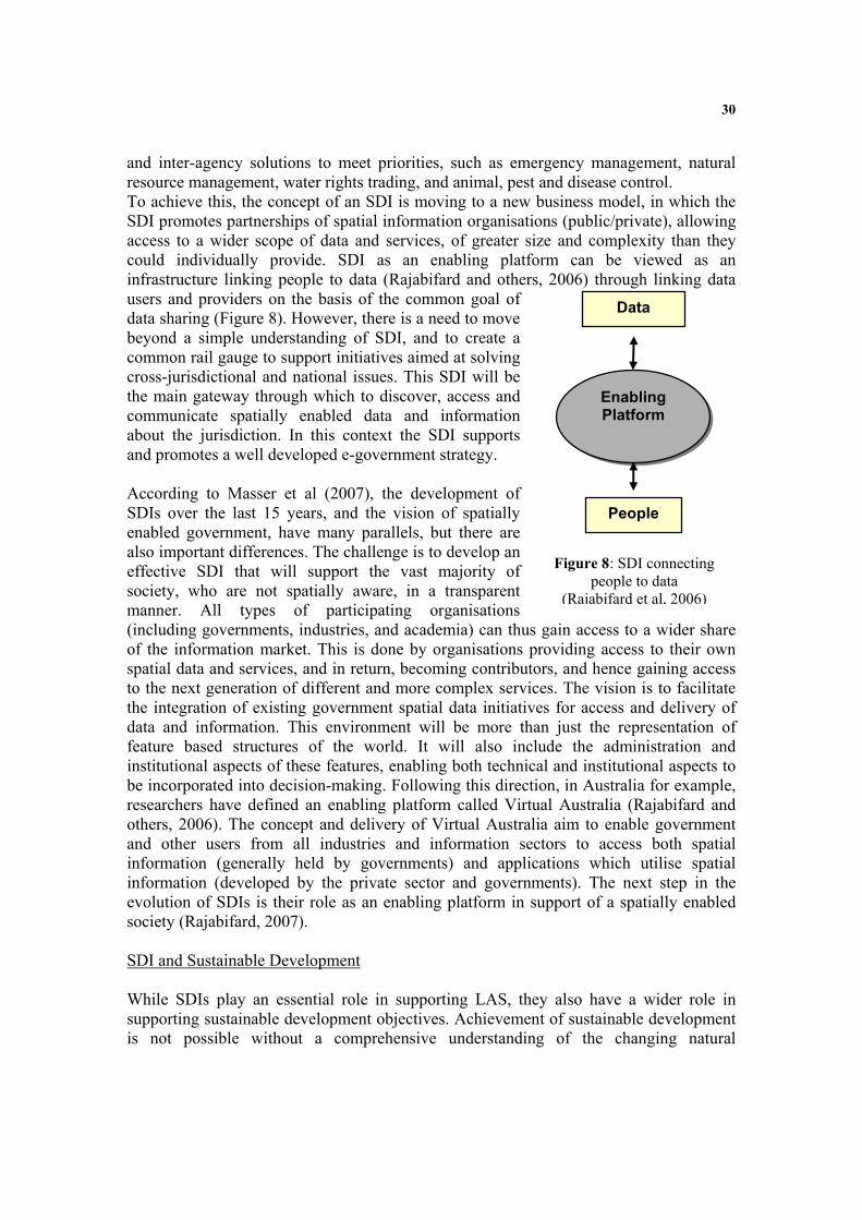
30
and inter-agency solutions to meet priorities, such as emergency management, natural resource management, water rights trading, and animal, pest and disease control. To achieve this, the concept of an SDI is moving to a new business model, in which the SDI promotes partnerships of spatial information organisations (public/private), allowing access to a wider scope of data and services, of greater size and complexity than they could individually provide. SDI as an enabling platform can be viewed as an infrastructure linking people to data (Rajabifard and others, 2006) through linking data users and providers on the basis of the common goal of data sharing (Figure 8). However, there is a need to move beyond a simple understanding of SDI, and to create a common rail gauge to support initiatives aimed at solving cross-jurisdictional and national issues. This SDI will be the main gateway through which to discover, access and communicate spatially enabled data and information about the jurisdiction. In this context the SDI supports and promotes a well developed e-government strategy. According to Masser et al (2007), the development of SDIs over the last 15 years, and the vision of spatially enabled government, have many parallels, but there are also important differences. The challenge is to develop an effective SDI that will support the vast majority of society, who are not spatially aware, in a transparent manner. All types of participating organisations (including governments, industries, and academia) can thus gain access to a wider share of the information market. This is done by organisations providing access to their own spatial data and services, and in return, becoming contributors, and hence gaining access to the next generation of different and more complex services. The vision is to facilitate the integration of existing government spatial data initiatives for access and delivery of data and information. This environment will be more than just the representation of feature based structures of the world. It will also include the administration and institutional aspects of these features, enabling both technical and institutional aspects to be incorporated into decision-making. Following this direction, in Australia for example, researchers have defined an enabling platform called Virtual Australia (Rajabifard and others, 2006). The concept and delivery of Virtual Australia aim to enable government and other users from all industries and information sectors to access both spatial information (generally held by governments) and applications which utilise spatial information (developed by the private sector and governments). The next step in the evolution of SDIs is their role as an enabling platform in support of a spatially enabled society (Rajabifard, 2007). SDI and Sustainable Development While SDIs play an essential role in supporting LAS, they also have a wider role in supporting sustainable development objectives. Achievement of sustainable development is not possible without a comprehensive understanding of the changing natural
Data
EEnnaabblliinngg PPllaattffoorrmm
People
Figure 8: SDI connecting people to data
(Rajabifard et al, 2006)
31
environment, and monitoring the impact of human activities by integrating both the virtual representations of the built and natural environments. Despite the significance of data integration however, many jurisdictions have fragmented institutional arrangements and data custodianship in the built and natural information areas. For example, the land administration, cadastral or land titles office (which has a key role in providing built environment, people relevant, data) is often separated from state or national mapping organizations which have the responsibility of managing the natural environment data. This fragmentation among data custodians has brought about a diversity of approaches in data acquisition, data models, maintenance and sharing. Many countries are attempting to address these inconsistencies through development of national SDIs. However, further steps of a framework and associated tools to facilitate integration of multi-sourced data, are also needed. (Mohammadi and others, 2006 and 2007). An SDI can provide the institutional, administrative, and technical basis to ensure the national consistency of content to meet user needs in the context of sustainable development.
The Contribution of Land Administration Systems to iLand This brief review of the evolution of cadastres, land administration systems, SDIs and land markets shows that the traditional concept of cadastral parcels representing the built environmental landscape is being replaced by a complex arrangement of over-lapping tenures reflecting a wide range of rights, restrictions and responsibilities, and that a new range of complex commodities, building on this trend, has emerged. To a large extent these developments are driven by the desire of societies to better meet sustainable development objectives. There is no reason to believe that this trend will not continue as all societies better appreciate the needs to manage the environment for future generations and deliver stable tenure and equity in land distribution. While the growth of complex commodities offers huge potential for cadastral systems to play a greater role in delivering sustainable development objectives and supporting the trading of these complex commodities in particular, one complex commodity, land information, is capable of transforming the way government and the private sector do business. The potential offered by land information in a virtual world in spatially enabling government is so large, it is difficult to contemplate. We are starting to glimpse this potential in such initiatives as Google Earth and Microsoft’s Virtual Earth, but this is barely a start. These predictions of the importance of spatial information are also recognized in many influential forums including in the prestigious journal NATURE, and in the Australian Prime Minister’s statement on frontier technologies for building and transforming Australia’s industries (December, 2002) – both these examples place the growth and importance of the geosciences alongside nanotechnology and biotechnology as transformational technologies in the decade ahead. With regard to the importance and growth in land administration and its cadastral core as shown in Figure 4, Figure 9 (Williamson, 2006) uses a a technology focus to show the transformation of land administration and cadastral systems over the last three decades or so. The figure shows five stages in the evolution of our cadastral systems from a

32
technology perspective. The first stage recognizes that historically cadastral systems were manually operated with all maps and indexes hard copy. At this stage, the cadastre focused on security of tenure and simple land trading. The 1980s saw the computersiation of these cadastral records with the creation of digital cadastral data bases (DCDBs) and computerized indexes. While this computerization did not change the role of the land registry or cadastre, it was a catalyst felt world wide, initiating institutional change to start bringing the traditionally separate functions of surveying and mapping, cadastre and land registration together.
Computerization
DCDB and Indexes
Manual Systems
Hardcopy Maps and Indexes
Online LandAdministration
Web enablement
eLandAdministration
Interoperability
1970 1980 1990 2005 2010
iLandiLandSpatially EnabledGovernment and
Private Sector
Figure 9: Technical evolution of land administration With the growth of the Internet, the 1990s saw governments start to web enable their land administration systems as they became more service oriented. As a result, access over the Internet to cadastral maps and data was possible. This facilitated digital lodgment of cadastral data and opened up the era of e-conveyancing. However, the focus on security of tenure and simple land trading within separate institutional data silos still continued. At the same time, this era also saw the establishment of the spatial data infrastructure (SDI) concept (see Williamson and others, 2003 and Rajabifard and others, 2005). The SDI concept, together with web enablement, stimulated the integration of different data sets (and particularly the natural and built environmental data sets) with these integrated data sets now considered critical infrastructure for any nation state. Now a significant refinement of web enabled land administration systems aims to achieve interoperability between disparate data sets, facilitated by the partnership business model. This marks the start of an era where basic land, property and cadastral information can form an integrating technology between many different businesses in government, such as planning, taxation, land development and local government. An example is the new Shared Land Information Platform (SLIP) being developed by the state Government of Western Australia (Searle and Britton, 2005). A key catalyst for interoperability is also the development of high integrity geocoded national street address files, such as the Australian GNAF (Paull and Marwick, 2005 and PSMA, 2007). Similarly, “mesh blocks”, small aggregations of land parcels, are revolutionizing the way census and demographic data is collected, managed and used (Toole and Blanchfield, 2005). These refinements potentially extend to better management of the complex arrangement of rights, restrictions and responsibilities relating to land that are essential to achieving sustainable development objectives (Bennett and others, 2005, 2008a and 2008b). They also stimulate re-engineering of cadastral data models to facilitate interoperability between the cadastre, land use planning and land taxation for example (Kalantari and others, 2005, 2006 and 2008). All these initiatives can be considered part of the overall strategy to re-engineer the cadastre to support e-government.
33
The future focus will be on realising the potential of land and cadastral information. The use and potential of cadastral data as an enabling technology or infrastructure will outweigh its value to government from supporting simple land trading and security of tenure. Cadastres will not stop at the water’s edge; they will include a marine dimension where there is a continuum between the land and marine environments. Without this basic infrastructure the management of the exceptionally sensitive coastal zone is very difficult, if not impossible (Strain et al, 2006; Wallace and Williamson, 2006b, Vaez and others, 2007). However this is not the end of the story – researchers, practitioners, big business and government see the potential from linking “location” or the “where” to most activities, polices and strategies, just over the horizon. Companies like Google and Microsoft are actively negotiating to gain access to the world’s large scale built and natural environmental data bases. In Australia, they are negotiating to get access to the national cadastral and property maps as well as to GNAF. At the same time, new technologies are being built on top of these enabling infrastructures such as the Spatial Smart Tag which is a joint initiative in Australia between government, the private sector and Microsoft (McKenzie, 2005). We are starting to realise that cadastral and land related information will dramatically spatially enable both government and the private sectors, and society in general. In the near future, spatially enabled systems will underpin health delivery, all forms of taxation, counter-terrorism, environmental management, most business processes, elections and emergency response, for example (see for example and Rajabifard, 2007 and OSDM, 2007). In the future, cadastral data will be seen as information and a new concept called iLand will become the paradigm for the next decade. iLand is a vision of integrated, spatially enabled, land information available on the Internet. iLand enables the “where” in government policies and information. The vision as shown diagrammatically in Figure 10 is based on the engineering paradigm where hard questions receive “design, construct, implement and manage” solutions. In iLand all major government information systems are spatially enabled, and the “where” or location provided by spatial information is regarded as a common good made available to citizens and businesses to encourage creativity, efficiency and product development. The LAS and cadastre is even more significant in iLand. Modern land administration demands LA infrastructure as fundamental if land information is to be capable of supporting those “relative” information attributes about people, interests, prices, and transactions, so vital for land registries and taxation. All these initiatives come together to support a new vision for managing land information - iLand. (Williamson, Wallace and Rajabifard, 2006)

34
Figure 10 : The iLand Vision (Williamson and Wallace, 2006) While future markets of complex commodities will continue to rely on the underlying cadastre and land administration system, will LA administrators embrace the definition and management of complex commodities that do not rely on traditional cadastral boundaries and that require merging of value, building purpose, land use and personal owner information? How many LA administrators are capable of seeing the international context of land information and its importance to their national government in presentation of its investment face to the world? Will they embrace iLand? The Role of Cadastres and Land Administration in Spatially Enabling Government Governments can be regarded as spatially enabled when they treat location and spatial information as common goods made available to citizens and businesses to encourage creativity and product development. The vision of a spatially enabled government involves establishing an enabling infrastructure as part of e-government to facilitate use of place or location to organise information about activities of people and businesses, and about government actions, decisions and polices. Once the infrastructure is built, spatial enablement allows government information and services, business transactions and community activities to be linked to places or locations. Given the potential of new technologies, use of place or location will facilitate the evaluation and analysis of both spatial and non-spatial relationships between people, business transactions and

35
government. (Williamson and Wallace, 2006; Rajabifard, 2007; OSDM, 2007; and PCGIAP, 2007) Most governments already have considerable infrastructure and administrative systems for better management of land and resources. Basic information creating processes are cadastral surveying that identifies land; its supporting digital cadastral database (DCDB) that provides the spatial integrity and unique land parcel identification; registering land that supports simple land trading (buying, selling, mortgaging and leasing land); running land information systems (LIS) for land development, valuation and land use planning; and geographic information systems (GIS) that provide mapping and resource information. For modern governments at all stages of development, one question is how best to integrate these processes, especially to offer them in an Internet enabled e-government environment. Twenty years ago, each process and collection of information, was distinct and separate. Two changes in the world at large challenged this silo approach. First, thanks to improvements in technology, the infrastructure available to support modern land and resource management now spans three distinct environments: the natural, the built and the virtual environments. Second, the pressures on managers created by increased populations, environmental degradation, water scarcity and climate change, require governments to have more accurate and comprehensive information than ever before. How governments treat their land information will define their transformation of internal and external processes. The eLand administration concept as part of e-government initiatives is now moving to a wider use of spatially enabled land information, expressed in the concept of iLand - integrated, interactive spatial information available on the Internet. The conversion of processes to spatially enabled systems will increase useability, access and visualisation of information.
The Role of the Cadastre in Supporting Sustainable Development These developments and drivers will introduce complexity into the design of LAS as they adapt to assist delivery of a broader range of public policy and economic goals, the most important of which is sustainable development. However re-engineering land administration systems and their core cadastres to support sustainable development objectives is a major change in direction for traditional LAS and is a significant challenge (Enemark and others, 2005). In the proceeding sections this paper has described how cadastres, SDIs and LAS interact to spatially enable government and wider society in pursuit of sustainable development objectives. These relationships are shown diagrammatically in Figure 11 below. The diagram shows the critical role that the cadastre plays in providing built environmental data in a national SDI and how the integrated SDI can then contribute to a LAS that supports effective land management. It is only by bringing together the SDI and the LAS that an integrated land policy can be implemented to support sustainable development.

36
This integration also provides the key role of spatial enablement of the LAS, as well as government and wider society. Ironically only a relatively small number of countries, the “developed countries” have the ability at the present of achieving this objective. However the model does provide a road map for less developed countries to move down this path.
Figure 11: The role of the cadastre in building land administration infrastructures
(Williamson, Rajabifard and Wallace, 2007)

37
These global trends to move LAS down this path, and the national and historical methods used to incorporate sustainable development objectives into national LAS were examined in an Expert Group Meeting (EGM) in Melbourne in December, 2006 with leading stakeholders and land policy experts from Australia and Europe. (Williamson and others, 2006a). Distinctions between approaches used in modern European democracies and in Australia were identified. The European approach showed more integration between the standard LAS activities and measures of sustainability. Australian policy was more fractured, partly due to federation and the constitutional distribution of powers. In contrast, pioneering in Australian LAS lay in incorporating market based instruments (MBI) and complex commodities into LAS, and revitalization of land information through inventive Web based initiatives.
Figure 12: Land management vision (Williamson and others, 2006b) The EGM developed a vision for future LAS sufficiently flexible to adapt to this changing world of new technology, novel market demands, and sustainable development, as shown in Figure 12. This vision incorporates and builds upon the above vision of iLand and can be considered an infrastructure or enabling platform to support spatial enablement of government. (Wallace and others, 2006; Williamson and others, 2006a and 2006b). This vision is explained at a more practical level in Figure 11 above.
Conclusion People to land relationships are dynamic. The land administration and cadastral responses to managing these relationships are also dynamic and continually evolving. A
Services to Business &
Citizens
Country ContextInstitutional Arrangements
Capacity Building Education & Research
Facilitating Sustainable Development
Economic, Social, Environmental, Governance Enhancing Quality of Life
Land Policy Framework
SSppaattiiaallllyy EEnnaabblleedd LLaanndd AAddmmiinniissttrraattiioonn
((iinnccoorrppoorraattiinngg iiLLaanndd)) Land Tenure, Land Value, Land Use ,Land Development
SSoocciiaall CCoonntteexxtt
38
central objective of the resulting land administration systems is to serve efficient and effective land markets. Because of sustainable development and technology drivers, modern land markets now trade in complex commodities, however our current land administration systems and the majority of the skills of land surveyors, lawyers and LA administrators are focused on the more traditional processes supporting simple land trading. The growth in complex commodities offers many opportunities for LA administrators if they are prepared to think laterally and more strategically. Land information has grown in importance over the last few decades, and is considered by many to be more important and useful to government than in its traditional role of supporting security of tenure and simple land trading. Land administration systems and their core cadastral components are evolving into a new vision and essential infrastructure called iLand that spatially enables government as part of a wider e-government strategy and provides the “where” for all government decisions, polices and implementation strategies. This vision requires a clear understanding and institutional and legal structures that link the cadastre to the SDI and the wider LAS. Without this understanding and interaction delivering the vision is very difficult if not impossible. Ultimately, spatially enabled land information will provide the essential link between land administration and sustainable development. This brief account of the future delivers a challenge to land administration officials to re-engineer traditional cadastres and build modern land administration and cadastral systems capable of supporting the creation, administration and trading of complex commodities, and particularly to use land information to spatially enable government and society in general as part of a wider e-government initiative. Unfortunately, unless land administration systems and their core cadastres are re-engineered to deliver transparent and vital land information and enabling platforms, modern economies will have difficulty meeting sustainable development objectives and achieving their economic potential.
REFERENCES NOTE: Most referenced articles that have been authored or co-authored by the author (Ian Williamson) are available at http://www.csdila.unimelb.edu.au/ Bennett, R., Wallace, J. and Williamson, I.P. 2005. Integrated land administration in Australia.
Proceedings of the Spatial Sciences Institute Biennial Conference, Melbourne, Australia, 12-16 September, 2005. CD ROM.
Bennett, R., Wallace J. and Williamson, I.P.2008a, Organising property information for sustainable land administration. Journal of Land Use Policy, Vol. 25, No. 1, 126-138.
Bennett, R., Wallace, J. and I. P. Williamson 2008b. A toolbox for mapping and managing new interests over land. The Survey Review, 40, 307 pp.43-53 (January 2008)
Dalrymple, K, Wallace, J. and Williamson, I.P., 2004. Innovations in Land Policy and Rural Tenures. 3rd FIG Regional Conference, Jakarata, Indonesia, October 4-7. http://www.fig.net/pub/jakarta/papers/ts_10/ts_10_1_dalrymple_etal.pdf

39
Dalrymple, K, Wallace, J. and Williamson, I.P. 2005. Transferring our knowledge and systems – tenure formalisation. Proceedings of the Spatial Sciences Institute Biennial Conference, Melbourne, Australia, 12-16 September, 2005. CD ROM.
Dalrymple, K. 2006. Expanding rural land tenures to alleviate poverty. PhD thesis. University of Melbourne. See http://www.geom.unimelb.edu.au/research/SDI_research/publications/Dalrymple%20PhD%20Thesis.pdf Accessed 15 December, 2007.
De Soto, Hernando, 2000, The Mystery of Capital: Why Capitalism Triumphs in the West and Fails Everywhere Else, Bantam Press, London, 235 pp
Enemark, S, Williamson, I.P and J. Wallace, 2005, Building modern land administration systems in developed economies, Spatial Science Journal, 2/50, 51-68
FIG, 1995. The FIG Statement on the Cadastre. International Federation of Surveyors, FIG Publication No 11. http://www.fig7.org.uk/publications/cadastre/statement_on_cadastre.html
FIG, 1998. CADASTRE 2014. International Federation of Surveyors. (http://www.fig.net/commission7/reports/cad2014/)
FIG, 1999. Bathurst Declaration on Land Administration for Sustainable Development. International Federation of Surveyors (http://www.fig.net/pub/figpub/pub21/figpub21.htm)
Kalantari, M., Rajabifard, A., Wallace, J. and Williamson, I.P. 2005. Towards e-land Administration – Australian on-line land information services. Proceedings of the Spatial Sciences Institute Biennial Conference, Melbourne, Australia, 12-16 September, 2005. CD ROM.
Kalantari, M., Rajabifard, A., Wallace, J. and Williamson, I.P. 2006. A new vision on cadastral data models. FIG Congress Proceedings, Munich, Germany, 8-13 October, 2006. See http://www.fig.net/pub/fig2006/index.htm Accessed 14 December, 2007.
Kalantari, M. , Rajabifard, A., Wallace, J. & Williamson, I., 2008. Spatially Referenced Legal Property Objects, Journal of Land Use Policy (in press). See http://dx.doi.org/10.1016/j.landusepol.2007.04.004. Accessed 14 December, 2007.
Masser, I., Rajabifard, A., Binns, A., and Williamson, I. 2007, Spatially Enabling Governments through SDI implementation, International Journal of Geographical Information Science Vol. 21, July, 1-16.
Mohammadi, H., Rajabifard, A., Binns, A. and Williamson, I.P. 2006, Bridging SDI Design Gaps with Facilitating Multi-source Data Integration, Coordinates, Vol II, Issue 5, May 2006.
Mohammadi, H., Rajabifard, A., Binns, A. and Williamson, I.P. 2007, Spatial Data Integration Challenges: Australian Case Studies, Proceedings of SSC 2007, The national biennial Conference of the Spatial Sciences Institute, 14-18 May, Hobart, Australia.
McKenzie, D. 2005. Victorian Spatial Smart Tag – How to bring spatial information to government’s non technical users. Proceedings of the Spatial Sciences Institute Biennial Conference, Melbourne, Australia, 12-16 September, 2005. CD ROM.
OSDM, 2007. Spatially Enabling Government. Office of Spatial Data Management (OSDM), Australian Government. http://www.osdm.gov.au/seg/ Accessed 14 December, 2007.
PSMA, 2007. GNAF. PSMA Australia, http://www.psma.com.au/ Accessed 14 December, 2007

40
PCGIAP, 2007. Working Group 3 (Spatially Enabling Government). Permanent Committee for GIS Infrastructure for Asia and the Pacific (PCGIAP). See http://219.238.166.217/pcgiap/98wg/wg3_index.htm Accessed 14 December, 2007.
Paull, D. and Marwick, B. 2005. Maintaining Australia’s Geocoded National Address File (GNAF). Proceedings of the Spatial Sciences Institute Biennial Conference, Melbourne, Australia, 12-16 September, 2005. CD ROM.
Rajabifard, A., Binns, A. and Williamson, I. 2005, Development of a Virtual Australia Utilising an SDI Enabled Platform, Global Spatial Data Infrastructure 8 and FIG Working Week Conference, 14-18 April, Cairo Egypt.
Rajabifard, A., Binns, A. and Williamson, I. 2006, Virtual Australia – an enabling platform to improve opportunities in the spatial information industry, Journal of Spatial Science, Special Edition, Vol. 51, No. 1.
Rajabifard, A. (Editor) 2007, Towards a spatially enabled society. Department of Geomatics, University of Melbourne, Australia, 399 pages. (also see http://www.ianwilliamson.net/SEG_flash.htm Accessed 14 December, 2007)
Searle, G. and Britton, DM. 2005. Government working together through a shared land information platform (SLIP). Proceedings of the Spatial Sciences Institute Biennial Conference, Melbourne, Australia, 12-16 September, 2005. CD ROM.
Strain, L., Rajabifard, A. and Williamson, I.P. 2006. Marine Administration and Spatial Data Infrastructures. Marine Policy. 30 (2006):431-441.
Ting, L., Williamson, I.P. Grant, D. and Parker, J. 1999. Understanding the Evolution of Land Administration Systems in Some Common Law Countries. The Survey Review Vol. 35, No. 272, 83-102.
Ting, L. and Williamson, I.P. 1999. Cadastral trends: A synthesis. The Australian Surveyor Vol. 4, No. 1, 46-54.
Toole, M and Blanchfield, F. 2005. Mesh blocks – from theory to practice. Proceedings of the Spatial Sciences Institute Biennial Conference, Melbourne, Australia, 12-16 September, 2005. CD ROM.
Vaez, S., Rajabifard, A., Binns, A. & Williamson, I. (2007), Seamless SDI Model to Facilitate Spatially Enabled Land Sea Interface, Proceedings of SSC 2007 ,The national biennial Conference of the Spatial Sciences Institute, May, Hobart, Australia. See http://www.geom.unimelb.edu.au/research/SDI_research/publications/ianpubli.htm Accessed 15 December, 2007.
Wallace, J. and Williamson, I.P. 2005. A vision for spatially informed land administration in Australia. Proceedings of the Spatial Sciences Institute Biennial Conference, Melbourne, Australia, 12-16 September, 2005. CD ROM.
Wallace, J. and I.P. Williamson, 2006a. “Building Land Markets”, Journal of Land Use Policy, Vol 23/2 pp 123-135
Wallace, J. and Williamson, I.P. 2006b. Registration of Marine Interests in Asia-Pacific Region. Marine Policy. 30(3):207-219.
Wallace, J., Williamson, I.P. and S. Enemark, 2006. “Building a national vision for spatially enabled land administration in Australia”, In Sustainability and Land Administration Systems, Department of Geomatics, Melbourne, 237-250.
41
Williamson, I.P. 2006. A Land Administration Vision. In Sustainability and Land Administration Systems, Department of Geomatics, Melbourne, 3-16.
Williamson, I.P., Rajabifard, A. and Feeney, M-E.F. (Editors). 2003. Developing Spatial Data Infrastructures – From concept to reality. Taylor and Francis. 316p.
Williamson, I.P., Enemark, S. and J.Wallace (eds), 2006a. Sustainability and Land Administration Systems, Department of Geomatics, Melbourne, 271p.
Williamson, I.P., Enemark, S. and J. Wallace, 2006b, “Incorporating sustainable development objectives into land administration”, Proceedings of the XXIII FIG Congress, Shaping the Change, TS 22. Munich, Germany, October 8-13, 2006.
Williamson, I.P. and J. Wallace, 2006, “Spatially enabling governments: A new direction for land administration systems”, Proceedings of the XXIII FIG Congress, Shaping the Change, TS 23. Munich, Germany, October 8-13, 2006.
Williamson, I.P., Wallace, J. and A. Rajabifard, 2006. Spatially enabling governments: A new vision for spatial information. 17th UNRCC-AP Conference and 12th Meeting of the PCGIAP, Bangkok, Thailand. 18-22 September 2006.
Williamson, I.P., Rajabifard, A. and J. Wallace, 2007. Spatially enabling government – an international challenge. International Workshop on “Spatial Enablement of Government and NSDI – Policy Implications. Permanent Committee for GIS Infrastructure for Asia and the Pacific, Seoul, Korea, 12 June 2007.
Williamson, I.P., Enemark, S., Wallace, J. and Rajabifard, A. 2009. “Land Administration to support Sustainable Development” Forthcoming ESRI Press, USA.

42

43
Vision Paper- Cadastre and Spatially Enabling Society
Abbas RAJABIFARD Vice Chair-PCGIAP-Working Group 3 Email: [email protected] Centre for Spatial Data Infrastructures and Land Administration Department of Geomatics, University of Melbourne, Victoria 3010, Australia
Abstract Sustainable decision-making requires access to accurate information (in particular, land and spatial information which are considered as an infrastructure), and tools to analyse and present it. Within this environment, the capacity to meet user needs and deliver services and tools within the spatial information market has gone well beyond the ability of single organisations or government agencies. Users require precise spatial information in real-time about real-world objects. This requires governments and industry to work together to create such products and services.
However, the ability to gain access to information and services has moved well beyond the domain of single organisations, and governments now require an enabling platform to support the chaining of services across participating organisations. This is to support the new vision on spatially enabled government and society. With this in mind, all countries have to deal with the management of land. They have to deal with the four functions of land tenure, land value, land use and land development in some way or another. Land management encompasses all activities associated with the management of land and natural resources that are required for the achievement of sustainable development.
The design of a land administration system, either to improve an existing system or develop a new one, can benefit from improvements in technology. Making the right decisions about the use of technology is obviously important. Most countries approach bridge building between the silo agencies and their respective information and technical systems by adopting a spatial data infrastructure (SDI) strategy.
Internationally SDI concept has focussed on national SDIs. However SDIs are increasingly focussing on large-scale people relevant data (land parcel based data or build environmental data) with the result that today it is suggested most SDI activity worldwide is at this level. A central aspect in understanding these developments is the evolution of mapping, and the growth of land administration systems and national mapping initiatives in different countries.
This paper aims to introduce a concept called spatially enabling society as a future vision. The paper discusses the SDI requirements of land administration and the importance and issues surrounding the creation of an SDI as an enabling platform linking governments

44
spatial information initiatives and in particular the private sector within a land administration paradigm. It then highlights the role of cadastre and a key component of land administration in achieving spatially enabled society. This will help to identify the goals and structures for national land administration to help nations articulate coordination needs, technological reforms and capacity building in order to become spatially enabled.
Introduction Sustainable development is about creating a process that will allow dialogue and engage people with information about their land and resources; such processes support sustainable decision-making by enabling governments, the private sector and the community to discuss how their land and resources are to be used (Ting-Chan 2007). Having said that, as highlighted by Magel and Franke (2007), sustainable development is not attainable without land administration and good governance. Just as land administration and land management are no end in themselves and must always serve society and sustainable development, spatial Information and Spatial Data Infrastructure (SDI) must meet and fulfil political and societal needs and expectations for a good or even better life.
With this in mind, all countries have to deal with the management of land. They have to deal with the four functions of land tenure, land value, land use and land development in some way or another. Land management encompasses all activities associated with the management of land and natural resources that are required for the achievement of sustainable development. Land management was identified to guide decision makers through the complicated processes of building modern systems and justifying their decisions and expenditures according to one ultimate aim: delivery of sustainable development.
In this regard, design of a land administration system, either to improve an existing system or develop a new one, can benefit from improvements in technology. Making the right decisions about the use of technology is obviously important. We can no longer build support systems that limit opportunities to manage land holistically. Nor can we approach technology as if it is just about the use of computers. In this emerging modern context, professional tools and systems, particularly the cadastre and the SDI, continue to evolve.
Most countries approach bridge building between the silo agencies and their respective information and technical systems by adopting an SDI strategy. The significance of the SDI is more than most people realize. As can be seen from Figure 1, the organizational structures for land management must take the ever changing local cultural and judicial settings and institutional arrangements into account to support implementation of land policy and good governance. Within each individual country context, the land management activities needed to support sustainable development may be described by the three components of land policy, land information infrastructure, and land administration functions. In this regard the SDI plays a central role in facilitating a country’s land information infrastructure. Increasingly, large-scale “people relevant” data derived from LAS drives the development of SDIs.
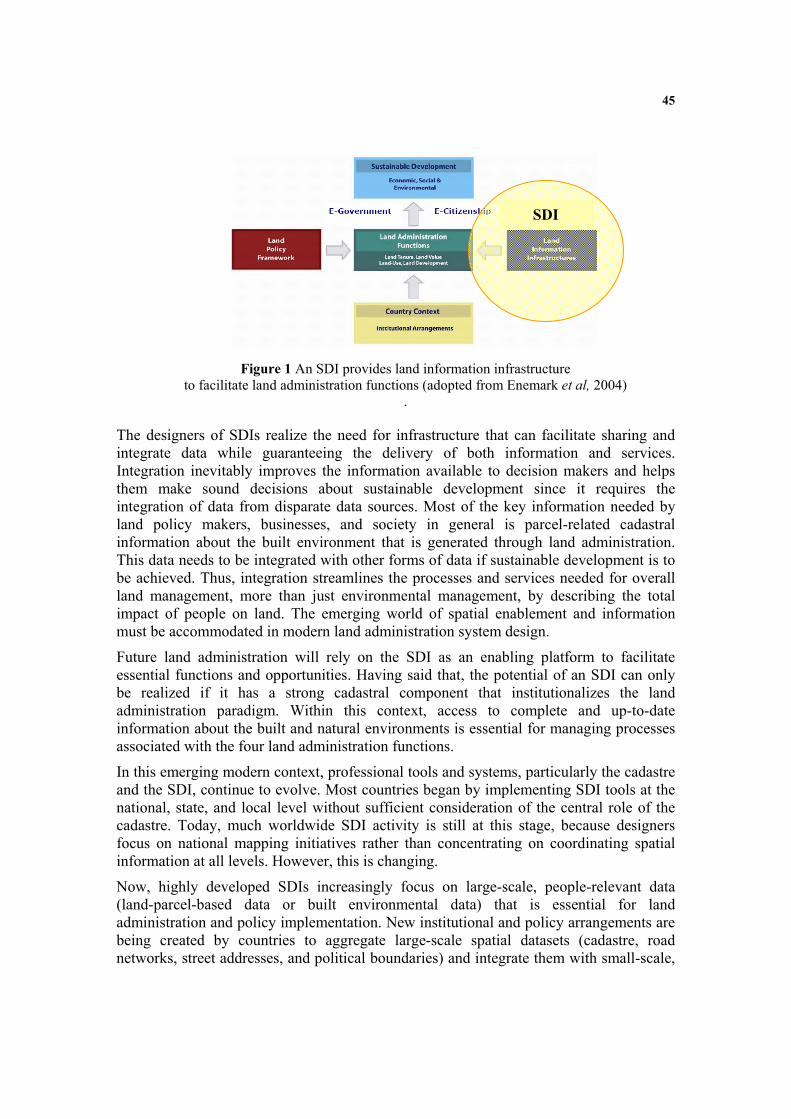
45
Figure 1 An SDI provides land information infrastructure to facilitate land administration functions (adopted from Enemark et al, 2004)
.
The designers of SDIs realize the need for infrastructure that can facilitate sharing and integrate data while guaranteeing the delivery of both information and services. Integration inevitably improves the information available to decision makers and helps them make sound decisions about sustainable development since it requires the integration of data from disparate data sources. Most of the key information needed by land policy makers, businesses, and society in general is parcel-related cadastral information about the built environment that is generated through land administration. This data needs to be integrated with other forms of data if sustainable development is to be achieved. Thus, integration streamlines the processes and services needed for overall land management, more than just environmental management, by describing the total impact of people on land. The emerging world of spatial enablement and information must be accommodated in modern land administration system design.
Future land administration will rely on the SDI as an enabling platform to facilitate essential functions and opportunities. Having said that, the potential of an SDI can only be realized if it has a strong cadastral component that institutionalizes the land administration paradigm. Within this context, access to complete and up-to-date information about the built and natural environments is essential for managing processes associated with the four land administration functions.
In this emerging modern context, professional tools and systems, particularly the cadastre and the SDI, continue to evolve. Most countries began by implementing SDI tools at the national, state, and local level without sufficient consideration of the central role of the cadastre. Today, much worldwide SDI activity is still at this stage, because designers focus on national mapping initiatives rather than concentrating on coordinating spatial information at all levels. However, this is changing.
Now, highly developed SDIs increasingly focus on large-scale, people-relevant data (land-parcel-based data or built environmental data) that is essential for land administration and policy implementation. New institutional and policy arrangements are being created by countries to aggregate large-scale spatial datasets (cadastre, road networks, street addresses, and political boundaries) and integrate them with small-scale,
SDI

46
national, natural resource, and topographic datasets. As a result, the historic roles of traditional national mapping agencies and land registries are especially challenged by the evolution of the SDI concept and the need to share spatial information throughout government, not merely in those agencies that use GIS technology. Without a strong cadastral component, an SDI cannot support the land management paradigm, and governments cannot capitalise upon the opportunities offered by the new spatial technologies.
The emerging vision for SDI is an enabling platform that links services across jurisdictions, organizations, and disciplines. This cross-jurisdictional approach aims to provide users with access to and use of information related to both the built and natural environments in real time - something that nonintegrated silo organizations cannot deliver (Gore 1998). This information is then used to enhance decision making and in turn supports the achievement of economic, environmental, social and governance objectives of sustainable development.
Spatial Enablement and SDI Vision
The creation of economic wealth, social stability and environmental protection can be achieved through the development of products and services based on spatial information collected by all levels of government. These objectives can be facilitated through the development of a spatially enabled government and society, where location and spatial information are regarded as common goods made available to citizens and businesses to encourage creativity and product development. This requires data and services to be accessible and accurate, well-maintained and sufficiently reliable for use by the majority of society which is not spatially aware.
In this regard, in modern society, spatial information (SI) is an enabling technology or an infrastructure to facilitate decision making. Spatial information describes the location of objects in the real world and the relationships between objects. SI can be a unifying medium in which linking solutions to location. According to Victorian Spatial Information Strategy (VSIS 2008), user demand has shifted to seeking improved services and delivery tools. This will be achieved by creating an environment so that we can locate, connect and deliver as illustrated in Figure 2.
Figure 2: Locate, connect and deliver spatial information
Based on this, ready and timely access to spatial information – knowing where people and assets are – is essential for the creation of wealth in any jurisdiction. It is therefore a
DDeelliivveerr
people, places, services, businesses and points of interest
systems, services, businesses, partnerships and link with other industries
quality services, standards, frameworks and what users want.
CCoonnnneecctt
LLooccaattee
47
critical tool for making informed decisions on key economic, environmental and social issues. With this in mind and in order to better manage and utilise spatial data assets, many countries around the world are developing SDI as a way to facilitate data management and data sharing and utilise their spatial data assets as this information is one of the most critical elements underpinning decision making for many disciplines.
As a result of this, these days we are hearing more and more terms link ‘spatially enabled government’, ‘spatially enabled society’, ‘spatially enabled’, etc. In particular, we now see more dedicated events on these topics in different part of the world. But what is spatial enablement? A society or a government can be regarded as spatially enabled when location and spatial information are regarded as common goods made available to citizens and businesses to encourage creativity and product development. Spatial enablement uses the concept of place and location to organise information and processes and is now a ubiquitous part of eGovernment and broader government ICT strategies. It is also defined as an innovator and enabler across society and a promoter of eDemocracy. As a result of this, we are potentially on the verge of the most dramatic change in the use of SI in our lifetime.
According to the results of a survey on Spatial Enablement of Australian Government (SEG) conducted by Geoscience Australia in 2007, the vision for spatial enablement leads to improved decision making; reduction of administrative costs; whole of government outcomes; and enhanced industry development opportunities. However, this requires data and services to be accessible and accurate, well-maintained and sufficiently reliable for use by the majority of a society which is not spatially aware.
The aim to develop spatially enabled governments was a key outcome of the 17th United Nations Cartographic Conference for Asia and the Pacific (UNRCC-AP) and the 12th meeting of the UN supported Permanent Committee for GIS Infrastructure for Asia and the Pacific (PCGIAP) in September 2006 in Bangkok, Thailand. These movements prompted Working Group 3 (formerly Cadastre) of the PCGIAP to refocus its activities on Spatially Enabled Government as part of developing national Spatial Data Infrastructures (SDI). In conjunction with the GSDI Association, WG3 (Spatially Enabled Government) of the PCGIAP held a dedicated workshop on “Spatial enablement of government and NSDI – policy implications” during the 13th PCGIAP meeting in Seoul, Korea on 12th June 2007.
According to the outcomes and report of this workshop, Spatially Enabled Government (SEG) is where “…data, information and related business services with spatial content become ubiquitous in the daily conduct of government agency business and in the efficient and effective delivery of government services...”. A spatially enabled government is one that has ready access to the spatial or geographic or location based information and associated technologies that it requires and is applying these productively to government decision making, including developing policy and supporting its own business processes.
SEG increasingly operates in a virtual world. However, we still have a long way to go. Key initiatives include building authoritative registers within the European Union and using a legislative framework for SEG (for example, as in the EU, Japan and Korea). These trends are coupled with institutional and structural reforms in the use of SI and SDI
48
as an enabling platform. Most uses of SI still focus on coloured maps, and do not use the full potential of SI to re-engineer the activities of government, though SEG is starting to be used to improve business processes in some non-traditional areas. In the next few years the world will have to re-position spatial information to unlock knowledge.
SEG is now part of the objectives of countries in the Asia Pacific, Europe and North America. Australian governments have moved in a similar direction. The Australian Government released its e-Government strategy, “Responsive Government: A New Service Agenda”, in March 2006. In announcing its release, the Special Minister of State, the Hon. Gary Nairn MP, stated that a spatially enabled government was likely to be an important contributor to the e-Government strategic outcome. Thus the Australian Government conducted a conference on SEG in August 2007 in Canberra to highlight the importance of spatial information and promote spatial strategies and information as a vital tool for policy development and public sector decision making. The combination of strategies in the spatial enablement of government and mainstream e-Government are now an emerging trend in Australia and many other parts of the world. The SEG Conference in Canberra made it clear that the “where” is precious, and that “place” is a “magic joiner” – a boon in the past, now and in the future. It was declared that SEG promotes innovation. Further, the key message from the Conference was that SEG is here to stay and is rapidly offering new opportunities to government and wider society.
Spatial enablement is ultimately a transformational technology to assist efficient organisation of government and its administrative systems, such as land administration.
SDI and Land Administration The ability to meet the range of land administration functions in the areas of land tenure (securing and transferring rights in land and natural resources); land value (valuation and taxation of land and properties); land use (planning and control of the use of land and natural resources); and land development (implementing utilities, infrastructure and construction planning) require access to complete and up-to-date information about the built and natural environments. This is facilitated through the creation and implementation of effective SDIs at all jurisdictional levels, creating the need for a strong relationship between land administration and SDIs.
The organisational structures for land management must take into account local cultural and judicial settings with institutional arrangements possibly changing over time to better support the implementation of land policies and good governance. Within this country context, the land management activities needed to support Sustainable Development may be described by the three components of Land Policies, Land Information Infrastructures and Land Administration Functions. The development of SDIs play a central role in facilitating a country’s land information infrastructure.
The key lesson from this discussion is that this large scale “people relevant data” is driving many SDI developments. As illustrated in Figure 1 earlier, SDI is an enabling platform that can facilitate the land infrastructure functions and in particular it is facilitating land information infrastructures.

49
While small to medium scale national activities, local government (and particularly its role as a custodian for planning and street address data) and regional SDI initiatives (such as in the Asia and Pacific region promoted by PCGIAP) are making positive contributions to the SDI vision, it is the large scale land administration initiatives (often at a state or provincial level) where most of the SDI activity is occurring in many countries. This is where most of the current challenges in SDI development are being faced at inter- and intra-jurisdictional levels.
SDI is an evolving concept and can be viewed as an enabling platform linking data producers, providers and value adders to data users. The development of SDI as an enabling platform for a country or a jurisdiction will enhance the capability of government, the private sector and the general community in engaging in systems based, integrated and holistic decision making about the future of that jurisdiction. Applications, tools, and different sorts of information would be available through the platform to build a view of, query and allow decisions to be based on, both the built and natural environments. Having said that, however, there is a need to move beyond a simple understanding of SDI, and to create a common rail gauge to support initiatives aimed at solving cross-jurisdictional and national issues.
This SDI will be the main gateway through which to discover, access and communicate spatially enabled data and information about the jurisdiction. Such an entity can be enhanced so that it is possible to share in addition to data, business goals, strategies, processes, operations and value-added products. In this environment all types of organisations participating (including governments, industries, and academic) can gain access to a wider share of the information market. This is done through organisations providing access to their own spatial data and services, and in return, becoming a contributor and hence gaining access to the next generation of different and complex services. The vision is to facilitate the integration of existing government spatial data initiatives for access and delivery of data/information.
Spatially Enabled Society Societies can be regarded as spatially enabled ‘where location and spatial information are regarded as common goods made available to citizens and businesses to encourage creativity and product development’ (Wallace et al. 2006). In this regard, the vast majority of the public are users, either knowingly or unknowingly, of spatial information. With these considerations in mind Masser et al. (2007) highlighted the challenges that must be overcome to make existing SDIs more appropriate for spatially enabling government and society. It addresses four strategic challenges arising out of this new environment.
The first of these is the need for more inclusive models of governance given that SDI formulation and implementation involves a very large number of stakeholders from all levels of government as well as the private sector and academia. The second concerns the promotion of data sharing between different kinds of organisation. In some cases this may require new forms of organisation to carry out these tasks. The third challenge relates to the establishment of enabling platforms to facilitate access to spatial data and

50
the delivery of data related services. The fourth challenge arises from the changes that are taking place in the nature of the users of spatial information in recent years. In place of the spatial professionals who have pioneered these developments an increasing number of end users will need some training in spatial thinking to make them more literate users. Consequently there are a number of new capacity building tasks to be undertaken in order to create a fully spatially enabled government.
Further, a spatial enabled government is one that plans to achieve three broad goals:
• More effective and more transparent coordination, where voters are able to access the spatial information they require to evaluate the choices made by elected decision makers;
• The creation of economic wealth through the development of products and services based on spatial information collected by all levels of government; and
• The maintenance of environmental sustainability through the regular and repeated monitoring of a wide range of spatial indicators distributed throughout the country as a whole.
Realising this vision of spatially enabled society is dependent on the development of appropriate mechanisms to facilitate the delivery of data and services. These mechanisms should embody the following principles that are the foundation of the INSPIRE initiative (CEC 2004).
Conclusions and Future Directions Spatial enablement is ultimately a transformational technology to assist efficient organisation of government and its administrative systems, such as land administration. The ability to meet the functions of land administration requires appropriate land information infrastructures that include cadastral and topographic datasets and provide access to complete and up-to-date information. SDIs play a central role in facilitating such a land information infrastructure.
There is also now a move within the spatial information industry as a whole on the delivery of a virtual world which facilitates decision making at a community level within a national context. This also requires integration of the natural and built environmental data sets and the need for a spatial data infrastructure that facilitates this integration. The ability to implement spatial enablement requires a range of activities and processes to be created across all jurisdictional levels. In order to facilitate the realisation of spatially enabled society and governments, there is a need for a service-oriented infrastructure on which citizens and organizations can rely for the provision of required services, going beyond what has been described as the first and second generation of SDI development of a data discovery and retrieval nature. This includes a focus for spatial information managers on the delivery of a virtual world which facilitates decision making at a community level within a national context.
There is also the need to develop institutional practices to make existing and future technology more effective. Research has found that very few jurisdictions have developed a framework for establishing a spatial infrastructure that addresses

51
comprehensively operational, organisational and legal issues. It is these processes that will enable the infrastructure to be readily useable and available to all stakeholders.
This translates into the future focus for spatial information managers on the delivery of a virtual world which facilitates decision making at a community level within a national context. This requires integration of the natural and built environmental data sets and the need for a spatial data infrastructure that facilitates this integration. The technology exists to create this virtual world but this is not enough in itself without the sustained input from both data producers and users.
The benefits of a virtual world will include the representation of feature-based structures of the world as well as the administration and institutional aspects of such features, enabling both technical and institutional (eg. policies) aspects to be incorporated into decision-making. It is this aspect of research that is often identified as more challenging than complex technical issues. The vision of a virtual world however is overly simplistic and presents many challenges, with one of the major challenges being the creation of an SDI to support the vision. Whilst most SDI authorities will agree that SDIs should be user driven, there is little discussion on the spatial information vision for each country or what sort of ICT enabled society we wish to be. However unless an agreement on a spatial information vision for each country (or jurisdiction) is made, it is almost impossible to create an appropriate SDI vision. Therefore the first challenge is to clearly describe and articulate the type of society an SDI should support. Some other challenging questions for future SDI development are posed by the need for a high level of multilevel stakeholder participation in SDI implementation.
Further, the development of SDI initiatives driven more by sub-national governments differ from the top-down approach that is implied by the development of national led SDIs, implicit in much of the current SDI literature. This new bottom-up sub-national view is important as it highlights the importance of diversity and heterogeneity given the different aspirations of various stakeholders. Consequently, the challenge to those involved in SDI development is to find ways of ensuring some measure of standardisation and uniformity while recognising the diversity and heterogeneity of various stakeholders. The use of open standards and an interoperable enabling platform will allow functions and services that meet business needs to be brought together at a sub-national and application level, reducing duplication of effort and furthering the development of a spatially enabled society.
References Commission of the European Communities, (CEC), (2004), Proposal for a Directive of the
European Parliament and the Council establishing an infrastructure for spatial information in the Community (INSPIRE), COM (2004) 516 final, Brussels: Commission of the European Communities.
Gore, A. 1998. The Digital Earth: Understanding Our Planet in the 21st Century. Los Angeles: California Science Centre.
GSDI, (1997), Global Spatial Data Infrastructure conference findings and resolutions, Chapel Hill, North Carolina (http://www.gsdi.org/docs1997/97_gsdi97r.html)

52
Magel, H. and Frake. (2007), Good Governance – What Does It Mean for Surveyor’s Profession and Contributions?, in A. Rajabifard (ed.), Towards a Spatially Enabled Society, ISBN 978-0-7325-1620-8, The University of Melbourne. 29-43pp.
Masser, I. (2005), GIS worlds: creating spatial data infrastructures, Redlands CA ESRI Press.
Masser, I., Rajabifard, A., and Williamson, I.P. (2007), Spatially Enabling Governments through SDI implementation, International Journal of GIS, Vol. 21, July, 1-16.
Rajabifard, A. (Eds), 2007, ‘Towards a Spatially Enabled Society’ ISBN 978-0-7325-1620-8, The University of Melbourne. 400 pp.
Rajabifard, A., Binns, A., Masser, I., and Williamson, I.P. (2006a), The Role of Sub-national Government and the Private Sector in Future SDIs, Vol 20, No 7, International Journal of GIS, 727-741.
Rajabifard, A., Binns, A. and Williamson, I. (2006b), Virtual Australia – an enabling platform to improve opportunities in the spatial information industry, Journal of Spatial Science Special Edition, Vol. 51, No. 1, June 2006.
Rajabifard, A, Feeney, M.E.F., Williamson, I.P., and Masser, I., (2003), National SDI Initiatives, Chapter6, Development of Spatial Data Infrastructures: from Concept to Reality, ISBN 0-415-30265-X, Taylor & Francis, U.K.
Ting-Chan, L. (2007), Land Administration and Sustainable Development: Informed for Engagement, in A. Rajabifard (ed.), Towards a Spatially Enabled Society, ISBN 978-0-7325-1620-8, The University of Melbourne. 146-151pp.
VSIS (2008), Victorian Spatial Information Strategy 2008-2010, Victorian Spatial Council, Victoria, Australia.
Wallace, J., Rajabifard, A., and Williamson, I. (2006), Spatial information opportunities for Government, Journal of Spatial Science, Vol. 51, No. 1, June 2006.

53
Land Administration and Cadastral Systems in support of Sustainable Land Governance- a Global Approach
Prof. Stig Enemark FIG President Aalborg University, Denmark Email [email protected]
1. INTRODUCTION All countries have to deal with the management of land. They have to deal with the four functions of land tenure, land value, land use, and land development in some way or another. National capacity may be advanced and combine the activities in one conceptual framework supported by sophisticated ICT models. More likely, capacity will involve very fragmented and basically analogue approaches. Different countries will also put varying emphasis on each of the four functions, depending on their cultural basis and level of economic development. Today the accepted theoretical framework for all land administration systems is delivery of sustainable development – the triple bottom line of economic, social, and environmental development, together with the fourth requirement of good governance. Land Administration Systems are the basis for conceptualizing rights, restrictions and responsibilities related to people, policies and places. Property rights are normally concerned with ownership and tenure whereas restrictions usually control use and activities on land. Responsibilities relate more to a social, ethical commitment or attitude to environmental sustainability and good husbandry. This paper provides an overall understanding of the concept of land administration systems for dealing with rights, restrictions and responsibilities in future spatially enabled government. Finally the paper presents the role of FIG – the International Federation of Surveyors - with regard to building the capacity in this area and responding to the global agenda. 2 LAND ADMINISTRATION SYSTEMS Land Administration Systems (LAS) are an important infrastructure, which facilitate the implementation of land policies in both developed and developing countries. LAS are concerned with the social, legal, economic and technical framework within which land managers and administrators must operate. These systems support efficient land markets and are, at the same time, concerned with the administration of land as a natural resource

54
to ensure its sustainable development. This global approach to modern land administration systems is shown in Figure 1.
Figure 1. A global land administration perspective (after Enemark 2004)
The four land administration functions (land tenure, land value, land use, land development) are different in their professional focus, and are normally undertaken by a mix of professions, including surveyors, engineers, lawyers, valuers, land economists, planners, and developers. Furthermore, the actual processes of land valuation and taxation, as well as the actual land use planning processes, are often not considered to be part of the land administration activities. However, even if land administration is traditionally centred on the cadastral activities in relation to land tenure and land information management, modern LAS designed as described in Figure 1 delivers an essential infrastructure and encourages integration of the four functions: Land tenure: the processes and institutions related to securing access to land and
inventing commodities in land, and their allocation, recording and security; cadastral mapping and legal surveys to determine parcel boundaries; creating new properties or altering existing properties; the transfer of property or use from one party to another through sale, lease or credit security; and the management and adjudication of doubts and disputes regarding land rights and parcel boundaries.
Land value: the processes and institutions related to assessment of the value of land and properties; the calculation and gathering of revenues through taxation; and the management and adjudication of land valuation and taxation disputes.
Land use: the processes and institutions related to control of land use through adoption of planning policies and land use regulations at national, regional and local levels; the enforcement of land use regulations; and the management and adjudication of land use conflicts.
Land development: the processes and institutions related to building of new physical infrastructure and utilities; the implementation of construction planning; public acquisition of land; expropriation; change of land use through granting of

55
planning permissions, and building and land use permits; and the distribution of development costs.
Inevitably, all the functions are interrelated. The interrelations appear through the fact that the actual conceptual, economic and physical uses of land and properties influence land values. Land values are also influenced by the possible future use of land determined through zoning, land use planning regulations, and permit granting processes. And the land use planning and policies will, of course, determine and regulate future land development. Land information should be organised to combine cadastral and topographic data, and to link the built environment (including legal and social land rights) with the natural environment (including topographical, environmental and natural resource issues). Land information should, this way, be organised through an SDI at national, regional, federal, and local levels, based on relevant policies for data sharing, cost recovery, access to data, data models, and standards. Ultimately, the design of adequate systems of land tenure and land value should support efficient land markets capable of supporting trading in simple and complex commodities. The design of adequate systems to deliver land use control and land development should lead to effective land use management. The combination of efficient land markets and effective land use management should support economic, social and environmental sustainable development. From this global perspective, LAS act within adopted land policies that define the legal regulatory pattern for dealing with land issues. They also act within an institutional framework that imposes mandates and responsibilities on the various agencies and organisations. They should service the needs of individuals, businesses, and the community at large. Benefits arise through LAS guarantee of ownership, security of tenure and credit; facilitating efficient land transfers and land markets; supporting management of assets; and providing basic information and efficient administrative processes in valuation, land use planning, land development and environmental protection. LAS designed in this way forms a backbone for society and is essential for good governance because it delivers detailed information and reliable administration of land from the basic foundational level of individual land parcels to the national level of policy implementation. 3 PROPERTY RIGHTS In the Western cultures it would be hard to imagine a society without having property rights as a basic driver for development and economic growth. Property is not only economic asset. Secure property rights provide a sense of identity and belonging that goes far beyond and underpins the values of democracy and human freedom. Historically, however, land rights evolved to give incentives for maintaining soil fertility, making land-related investments, and managing natural resources sustainably.
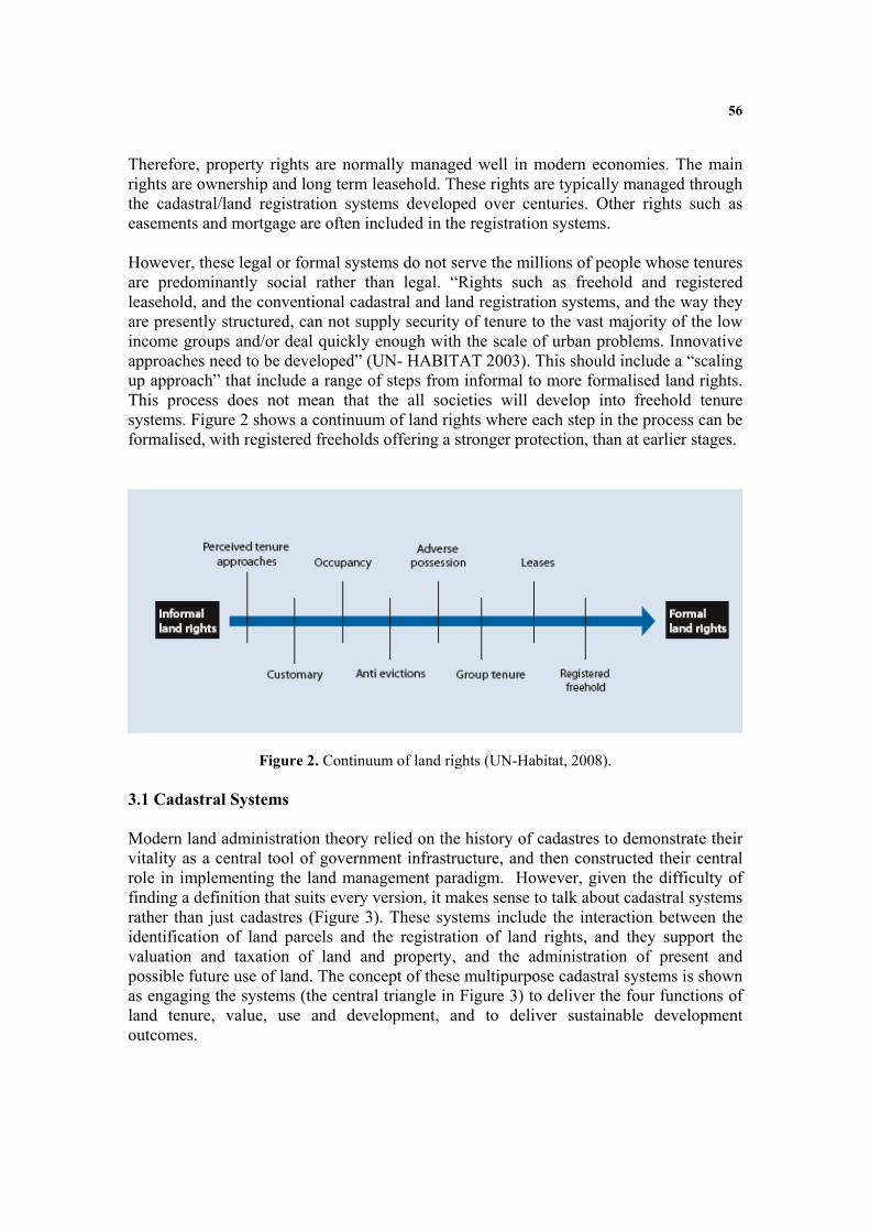
56
Therefore, property rights are normally managed well in modern economies. The main rights are ownership and long term leasehold. These rights are typically managed through the cadastral/land registration systems developed over centuries. Other rights such as easements and mortgage are often included in the registration systems. However, these legal or formal systems do not serve the millions of people whose tenures are predominantly social rather than legal. “Rights such as freehold and registered leasehold, and the conventional cadastral and land registration systems, and the way they are presently structured, can not supply security of tenure to the vast majority of the low income groups and/or deal quickly enough with the scale of urban problems. Innovative approaches need to be developed” (UN- HABITAT 2003). This should include a “scaling up approach” that include a range of steps from informal to more formalised land rights. This process does not mean that the all societies will develop into freehold tenure systems. Figure 2 shows a continuum of land rights where each step in the process can be formalised, with registered freeholds offering a stronger protection, than at earlier stages.
Figure 2. Continuum of land rights (UN-Habitat, 2008). 3.1 Cadastral Systems Modern land administration theory relied on the history of cadastres to demonstrate their vitality as a central tool of government infrastructure, and then constructed their central role in implementing the land management paradigm. However, given the difficulty of finding a definition that suits every version, it makes sense to talk about cadastral systems rather than just cadastres (Figure 3). These systems include the interaction between the identification of land parcels and the registration of land rights, and they support the valuation and taxation of land and property, and the administration of present and possible future use of land. The concept of these multipurpose cadastral systems is shown as engaging the systems (the central triangle in Figure 3) to deliver the four functions of land tenure, value, use and development, and to deliver sustainable development outcomes.

57
By 2000, cadastral systems were seen as a multipurpose engine of government operating best when they served administration functions in land tenure, value, use and development, and focused on delivering sustainable land management. A mature multipurpose cadastral system could even be considered as LAS in itself. This multipurpose design was the touchstone of best practice, sought by many LAS designers and managers. Achieving this however is another story because each unique existing system needs a different group of strategies to implement the proposed multipurpose design.
Figure 3. The concept of multipurpose cadastral systems (Enemark 2005) 3.2 Comparing Cadastral Systems A website has been established http://www.cadastraltemplate.org to compare cadastral systems on a worldwide basis. About 40 countries are currently included (August 2007) and the number is still increasing. The web site is established as a result of one of the objectives of Working Group 3 “Cadastre” of the PCGIAP (Permanent Committee on GIS Infrastructure for Asia and the Pacific). The cadastral template is basically a standard form to be filled out by cadastral organizations presenting their national cadastral system. The aims are to understand the role that a cadastre plays in a state or a National Spatial Data Infrastructure (NSDI), and to compare best practice as a basis for improving cadastres as a key component of NSDIs. The Cadastral template project is carried out in collaboration with Commission 7 “Cadastre and Land Management” of the International

58
Federation of Surveyors (FIG), which has extensive experience in comparative cadastral studies. (Steudler, et.al. 2004). It is generally accepted that a good property system is a system where people in general can participate in the land market having a widespread ownership where everybody can make transactions and have access to registration. The infrastructure supporting transactions must be simple, fast, cheap, reliable, and free of corruption. And the system must provide safety for housing and business, and for capital formation. It is estimated that only 25-30 countries in the world apply to these criteria.
4 PROPERTY RESTRICTIONS Ownership and long term leasehold are the most important rights in land. The actual content of these rights may vary between countries and jurisdictions, but in general the content is well understood. Rights to land also include the rights of use. This right may be limited through public land use regulations and restrictions, sectoral land use provisions, and also various kind of private land use regulations such as easements, covenants, etc. Many land-use rights are therefore in fact restrictions that control the possible future use of the land. Land-use planning and restrictions are becoming increasingly important as a means to ensure effective management of land-use, provide infrastructure and services, protect and improve the urban and rural environment, prevent pollution, and pursue sustainable development. Planning and regulation of land activities cross-cut tenures and the land rights they support. How these intersect is best explained by describing two conflicting points of view – the free market approach and the central planning approach. 4.1 The free market versus the central planning approach The property rights activists, most of them influenced by private ownership viewpoints, argue that land owners should be obligated to no one and should have complete domain over their land. In this extreme position, the government opportunity to take land (eminent domain), or restrict its use (by planning systems), or even regulate how it is used (building controls) should be non-existent or highly limited. Proponents argue that planning restrictions should only be imposed after compensation for lost land development opportunities is paid (Jacobs 2007). Throughout the European territory, another view appeared. In this, the role of a democratic government includes planning and regulating land systematically for public good purposes. Regulated planning is theoretically separated from taking private land with compensation and using it for public purposes. In these jurisdictions the historical assumption that a land owner could do anything than was not expressly forbidden by planning regulations changed into the different principle that land owners could do only what was expressly allowed, everything else being forbidden.

59
The tension between these two points of view is especially felt by nations seeking economic security. The question however is how to balance owners’ rights with the necessity and capacity of the government to regulate land use and development for the best of the society. The answer to this is found in a country’s land policy which should set a reasonable balance between the ability of land owners to manage their land and the ability of the government to provide services and regulate growth for sustainable development. 4.2 Environmental concerns Environmental policies should emphasise that economic growth can be achieved simultaneously with improvements to the environment. Industries must be able to absorb - constructively and economically - environmental considerations into their development. Policies may be based on the "polluter pays principle" which is internationally recognized. Enterprises should be located at a site causing least possible pollution and should adopt the measures necessary to prevent pollution to the greatest possible extent. These principles are the basis of recent global/national carbon trading initiatives.
Environmental policies normally include provisions to prevent and control pollution of air, earth and water, as well as provisions for noise and waste treatment. Requirements for use of the least pollution technology should also be included. These requirements can be made operational through a statutory system of prior approval/authorization applying for the establishment of all kinds of plants or activities considered as potential sources of pollution. This approval should ensure that all enterprises meet a number of environmental and technological standards and so pollute soil, air and water as little as possible. Environmental policies may also include provisions for waste water treatment to be managed through the guidelines that safeguard the quality of watercourses.
4.3 Informal development
Informal development may occur in various forms such as squatting where vacant state-owned or private land is occupied and used illegally for housing or any construction works without having formal permission from the planning or building authorities.
There is no simple solution to the problems of preventing and legalising informal development. The problems relate mainly to the national level of economic wealth in combination with the level of social and economic equity in society, while the solutions relate to the level of consistent land policies, good governance, and well established institutions. Guidance for solutions can be found in the concept of integrated land-use management as presented below with a focus on the means of decentralisation, comprehensive planning, and public participation.
Although some occurrences of illegal development, such as in post conflict situations, may be difficult to stop, many other forms of illegal development could be significantly reduced through government interventions supported by the citizens. (Enemark and McLaren, 2008).

60
4.4 Integrated Land-Use Management Integrated land-use management is based on land policies laid down in the overall land policy laws including the cadastral and land registration legislation and planning and building legislation. These laws identify the institutional principles and procedures for the areas of land and property registration, land-use panning, and land development. More specific land policies are laid down in the sectoral land laws within areas such as agriculture, forestry, housing, natural resources, environmental protection, water supply, heritage, and so on. These laws identify the objectives within the various areas and the institutional arrangements to achieve these objectives through permit procedures, information policies, dispute handling, and so on. The various areas produce sectoral programmes that feed into the comprehensive spatial planning carried out at national, state/regional and local levels.
Importantly, a mature system of comprehensive planning control needs to be based on appropriate and updated land use data systems, especially the cadastral register, the land book, the property valuation register, the building and dwelling register, etc. These registers need to be organized to form a network of integrated subsystems connected to the cadastral and topographic maps to form a national spatial data infrastructure for the natural and built environment.
In the land-use management system (the planning control system) the various sectoral interests should be balanced against the overall development objectives for a given location and thereby form the basis for regulation of future land-use through planning permissions, building permits and sectoral land use permits according to the various land-use laws. These decisions are based on the relevant land use data and thereby reflect the spatial consequences for the land as well as society. In principle it can then be ensured that implementation will happen in support of sustainable development.
Figure 4. Integrated land-use management for sustainable development
(Enemark, 2004).

61
5. PROPERTY RESPONSIBILITIES Property responsibilities relate to a more social, ethical commitment or attitude to environmental sustainability and good husbandry. Individuals and other actors are supposed to treat land and property in a way that conform to cultural traditions and ways of good ethical behaviour. This relates to what is accepted both legally and socially. Therefore, the systems for managing the use of land vary throughout the world according to historical development and cultural traditions. More generally, the human kind to relationship is to some extent determined by the cultural and administrative development of the country or jurisdiction. This relates to cultural dimensions as described by the Dutch scientist Gert Hofstede, especially the dimensions of: Uncertainty avoidance, that is the preference of structured situations over unstructured or flexible ones; and Power distance, that is the degree of inequality among people accepted by the population (Gert Hofstede, 2001). These cultural dimensions determine the social and ethical behaviour of people also in relation to the way land can be hold and used within a given culture. Systems of land tenure and land-use control therefore vary throughout the world according to such cultural differences. Social responsibilities of land owners have a long heritage in Europe. In Germany, for example, the Constitution is insisting on the land owner´s social role. In general Europe is taking a comprehensive and holistic approach to land management by building integrated information and administration systems. Other regions in the world such as Australia creates separate commodities out of land, using the concept of “unbundling land rights”, and is then adapting the land administration systems to accommodate this trading of rights without any national approach (Williamson and Wallace, 2007). 6. LAND GOVERNANCE Arguably sound land governance is the key to achieve sustainable development and to support the global agenda set by adoption of the Millennium Development Goals (MDGs). Land governance is about the policies, processes and institutions by which land, property and natural resources are managed. This includes decisions on access to land, land rights, land use, and land development. Land governance is basically about determining and implementing sustainable land policies. Land governance underpins distribution and management of a key asset of any society namely its land. For western democracies, with their highly geared economies, land management is a key activity of both government and the private sector. Land management, and especially the central land administration component, aim to deliver efficient land markets and effective management of the use of t land in support of economic, social, and environmental sustainability.
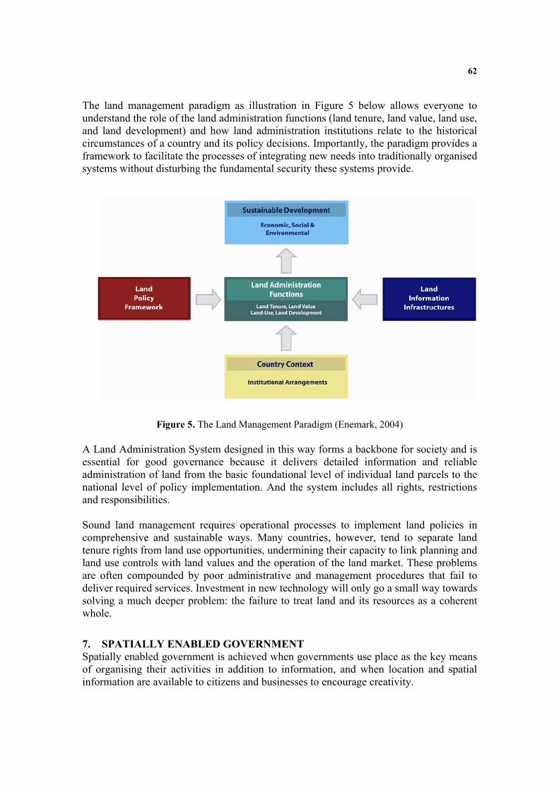
62
The land management paradigm as illustration in Figure 5 below allows everyone to understand the role of the land administration functions (land tenure, land value, land use, and land development) and how land administration institutions relate to the historical circumstances of a country and its policy decisions. Importantly, the paradigm provides a framework to facilitate the processes of integrating new needs into traditionally organised systems without disturbing the fundamental security these systems provide.
Figure 4. The land management paradigm (Enemark, 2004)
Figure 5. The Land Management Paradigm (Enemark, 2004)
A Land Administration System designed in this way forms a backbone for society and is essential for good governance because it delivers detailed information and reliable administration of land from the basic foundational level of individual land parcels to the national level of policy implementation. And the system includes all rights, restrictions and responsibilities. Sound land management requires operational processes to implement land policies in comprehensive and sustainable ways. Many countries, however, tend to separate land tenure rights from land use opportunities, undermining their capacity to link planning and land use controls with land values and the operation of the land market. These problems are often compounded by poor administrative and management procedures that fail to deliver required services. Investment in new technology will only go a small way towards solving a much deeper problem: the failure to treat land and its resources as a coherent whole.
7. SPATIALLY ENABLED GOVERNMENT Spatially enabled government is achieved when governments use place as the key means of organising their activities in addition to information, and when location and spatial information are available to citizens and businesses to encourage creativity.
63
Google Earth is good example of providing user friendly information in a very accessible way. We should consider the option where spatial data from Google Earth are merged with built and natural environment data. This unleashes the power of both technologies in relation to emergency response, taxation assessment, environmental monitoring and conservation, economic planning and assessment, social services planning, infrastructure planning, etc. This also include designing and implementing a suitable service oriented IT-architecture for organising spatial information that can improve the communication between administrative systems and also establish more reliable data based on the use of the original data instead of copies. Spatial enablement offers opportunities for visualisation, scalability, and user functionalities: This is related to institutional challenges with a range of stakeholder interests. This includes Ministries/Departments such as: Justice; Taxation; Planning; Environment; Transport; Agriculture; Housing; Interior (regional and local authorities); Utilities; and civil society interests such as businesses and citizens. Creating awareness of the benefits of developing a shared platform for Integrated Land Information Management takes time and patience. The Mapping/Cadastral Agencies have a key role to play in this regard. The technical core of Spatially Enabling Government is the spatially enabled cadastre. 7.1 Significance of the Cadastre The land management paradigm makes a national cadastre the engine of the entire LAS, underpinning the country’s capacity to deliver sustainable development. The role of the cadastre as the engine of LAS is neutral in terms of the historical development of any national system, though systems based on the German and Torrens approaches, are much more easily focused on land management than systems based on the French/Latin approach.
The cadastre as an engine of LAS is shown diagrammatically in Figure 6. The diagram highlights the usefulness of the large scale cadastral map as a tool by exposing its power as the representation of the human scale of land use and how people are connected to their land. The digital cadastral representation of the human scale of the built environment, and the cognitive understanding of land use patterns in peoples’ farms, businesses, homes, and other developments, then form the core information sets that facilitate a country building an overall administrative framework to deliver sustainable development in a country.

64
1. Multipurpose Cadastre(German style)
1. Multipurpose Cadastre(German style)
2. Title or deedstenure styleCadastres(Torrens/English style)
2. Title or deedstenure styleCadastres(Torrens/English style)
3. Taxation driven cadastre(French/Latin/USA style)
3. Taxation driven cadastre(French/Latin/USA style)
Tenure
Value
Use
Development
Incorporating:
Land policy
SpatiallyenabledLAS
Services tobusinessandpublic
Countrycontext
Sustainabledevelopment
- Economic- Environmental- Social- Governance
Cadastralengines…
Land management
paradigm
Spatially enabled
government
ParcelsPropertiesBuildingsRoads
Inte
gra
ted f
un
ctio
ns
SDIMapping agencies
and other data providers
Better decision making
Figure 6. Significance of the Cadastre (Williamson and Wallace, 2007)
The diagram demonstrates that the cadastral information layer cannot be replaced by a different spatial information layer derived from geographic information systems (GIS). The unique cadastral capacity is to identify a parcel of land both on the ground and in the system in terms that all stakeholders can relate to, typically an address plus a systematically generated identifier (given addresses are often duplicated or are otherwise imprecise). The core cadastral information of parcels, properties and buildings, and in many cases legal roads, thus becomes the core of SDI information, feeding into utility infrastructure, hydrological, vegetation, topographical, images, and dozens of other datasets.
7.2 Good governance Governance refers to the manner in which power is exercised by governments in managing a country’s social, economic, and spatial recourses. It simply means: the process of decision-making and the process by which decisions are implemented. This indicates that government is just one of the actors in governance. The concept of governance includes formal as well as informal actors involved in decision-making and implementation of decisions made, and the formal and informal structures that have been set in place to arrive at and implement the decision. Good governance is a qualitative term or an ideal which may be difficult to achieve. The term includes a number of characteristics e.g. as identified in the UN-Habitat Global Campaign on Urban Governance. The characteristics or norms are as follows (adapted from FAO, 2007):

65
Sustainable and locally responsive: It balances the economic, social, and
environmental needs of present and future generations, and locates its service provision at the closest level to citizens.
Legitimate and equitable: It has been endorsed by society through democratic processes and deals fairly and impartially with individuals and groups providing non-discriminatory access to services.
Efficient, effective and competent: It formulates policy and implements it efficiently by delivering services of high quality Transparent, accountable and predictable: It is open and demonstrates stewardship
by responding to questioning and providing decisions in accordance with rules and regulations.
Participatory and providing security and stability: It enables citizens to participate in government and provides security of livelihoods, freedom from crime and
intolerance. Dedicated to integrity: Officials perform their duties without bribe and give
independent advice and judgements, and respects confidentiality. There is a clear separation between private interests of officials and politicians and the affairs of government.
Once the adjective “good” is added, a normative debate begins. In any case, almost all kind of government includes a spatial component. In other words: Good governance and sustainable development is not attainable without sound land administration or - more broadly – sound land management.
7.3 Good e-Government “E-Government” refers to the use by government agencies of information technologies (such as Wide Area Networks, the Internet, and mobile computing) that have the ability to transform relations with citizens, businesses, and other arms of government (World Bank website). These technologies can serve a variety of different ends: better delivery of government services to citizens, improved interactions with business and industry, citizen empowerment through access to information, or more efficient government management. The resulting benefits can be less corruption, increased transparency, greater convenience, revenue growth, and/or cost reductions. E-government is about changing how governments work, share information, and deliver services to external and internal clients. It harnesses information and communications technology to transform relationships with citizens and businesses, and between arms of government. Benefits can include reduced corruption, increased transparency, greater convenience, higher revenues, and lower costs. But these benefits do not result solely from the use of information and communications technology. Instead, e-government initiatives should be part of broader reforms to improve public sector performance in: Delivering services to citizens. E-government can benefit citizens by reducing delays, consolidating multiple services under one roof, eliminating the need for frequent visits to

66
government offices, and containing corruption. In addition, publishing rules and procedures online can increase transparency. Delivering services to businesses. Businesses often face significant administrative roadblocks when interacting with government. Rules can be made transparent and consistent across departments. Transaction costs for both businesses and government can be reduced. And government can benefit from more efficient revenue collection. Increasing efficiency. E-government can lead to higher productivity. Governments can cut staff or redeploy workers in more productive tasks. Data captured by an electronic system often enables more frequent and accurate data sharing across departments, closer monitoring of employee productivity, easier identification of pressure points for delay and corruption, and improved compilation of historical data that can be mined for policy analysis (World Bank, 2004) . 7.4 Knowledge management in e-Government The concept of Knowledge Management is about optimising the use of the basic asset of any organisation namely knowledge. Knowledge Management is basically an integrated approach to managing the information assets of an organisation/enterprise. These information assets may include databases, documents, policies, procedures, or just knowledge stored in the individual’s heads. Knowledge Management, this way, is just common sense. However, in reality, the state of knowing or having access to the right knowledge at the right time is a real and important business advantage. Knowledge management is about organising and sharing of knowledge just like spatial information management is about organising and sharing of spatial data. This is of course a simplification since knowledge management is a broader concept. However, in relation to e-Government knowledge management is then basically about designing and implementing suitable spatial data infrastructures or, more particularly, it is about designing and implementing a suitable IT-architecture for organising spatial information that can improve the communication between administrative systems and also establish more reliable data due to the use the original data instead of copies. In Denmark, such governmental guidelines for service-oriented architecture e-government are recently adopted.

67
Figure 7. The Danish concept for service-oriented IT-architecture
The key elements are: (i) Flexibility and accessibility which facilitates decision-making at all levels, (ii) Quality, authenticity and actuality due to direct access for reading and updating in the basic databases, and (iii) Standardisation through homogeneously selection of communications and exchange standards such as XML etc. This is currently being applied in the area of land administration through close cooperation between the agencies and stakeholders involved. 8. THE ROLE OF FIG FIG is an UN recognised NGO representing the surveying profession in about 100 countries throughout the world. FIG has adopted an overall theme for the next period of office (2007-2010) entitled “Building the Capacity”. This theme applies to the need for capacity building in developing countries to meet the challenges of fighting poverty and developing a basis for a sustainable future, and, at the same time, capacity is needed in developed countries to meet the challenges of the future in terms of institutional and organisational development in the areas of surveying and land administration. In general, FIG will strive to enhance the global standing of the profession through both education and practice, increase political relations both at national and international level, help eradicating poverty, promote democratisation, and facilitate economic, social and environmental sustainability.
Users: All kind User services: Self services collect and organise data from different sources for specific purposes Case systems design and support the processes in government administration Common services: Information services support the distribution of data Administrative services secure the process of access to and updating of the data

68
FIG can facilitate support of capacity development in three ways: • Professional development: FIG provides a global forum for discussion and exchange of experiences and new developments between member countries and between individual professionals in the broad areas of surveying and mapping, spatial information management, and land management. This relates to the FIG annual conferences, the FIG regional conferences, and the work of the ten technical commissions within their working groups and commission seminars. This global forum offers opportunities to take part in the development of many aspects of surveying practice and the various disciplines including ethics, standards, education and training, and a whole range of professional areas. • Institutional development: FIG supports building the capacity of national mapping and cadastral agencies, national surveying associations and survey companies to meet the challenges of the future. FIG also provides institutional support to individual member countries or regions with regard to developing the basic capacity in terms of educational programs and professional organisations. The professional organisations must include the basic mechanisms for professional development including standards, ethics and professional code of conduct for serving the clients. • Global development: FIG also provides a global forum for institutional development through cooperation with international NGO´s such as the United Nations Agencies (UNDP, UNEP, FAO, HABITAT), the World Bank, and sister organisations (GSDI, IAG, ICA, IHO, and ISPRS). The cooperation includes a whole range of activities such as joint projects (e.g. The Bathurst Declaration, The Aguascalientes Statement), and joint policy making e.g. through round tables. This should lead to joint efforts of addressing topical issues on the international political agenda, such as reduction of poverty and enforcement of sustainable development. FIG, this way, plays a strong role in improving the capacity to design, build and manage surveying and land administration systems that incorporate sustainable land policies and efficient spatial data infrastructures.
8.1 The Global Agenda FIG is strongly committed to the global agenda as presented in the Millennium Development Goals (MDGs) (UN, 2000). The surveyors throughout the world play a key role in attaining the MDGs through their professional functions in support of an efficient land market and effective land-use management. These functions underpin development and innovation for social justice, economic growth, and environmental sustainability. FIG is also committed to the UN-Habitat agenda around the Global Land Tool Network (GLTN) that aims to facilitate the attainment of the MDGs through improved land management and tenure tools for poverty alleviation and the improvement of the livelihoods for the poor (UN-Habitat, 2006).

69
The eight Millennium Development Goals (MDGs) form a blueprint agreed to by all the world’s countries and the world’s leading development institutions. The first seven goals are mutually reinforcing and are directed at reducing poverty in all its forms. The last goal - global partnership for development - is about the means to achieve the first seven. The MDGs represent a wider concept or a vision for the future, where the contribution of the global surveying community is central and vital. This relates to the areas of providing the relevant geographic information in terms of mapping and databases of the built and natural environment, and also providing secure tenure systems, systems for land valuation, land use management and land development. The work of the surveyors forms a kind of “backbone” in society that supports social justice, economic growth, and environmental sustainability. These aspects are all key components within the MDGs. The global challenge can be displayed through a map of the world (Figure 8) using the Gross Domestic Product as the scale of showing the territory size, In surveying terms, the real challenge of the global agenda is about bringing this map back to scale.
Figure 8. Map of the world where the territory size is shown based on the Gross Domestic Product. (Source: UNEP).
In a global perspective the areas of surveying and land administration are basically about people, politics, and places. It is about people in terms human rights, engagement and dignity; it is about politics in terms of land policies and good government; and it is about places in terms of shelter, land and natural resources. In facing the global agenda the role of FIG – the global surveying community - is threefold: (i) to explain the role of the surveying profession and the surveying disciplines

70
in terms of their contribution to the MDGs. Such statements should also make the importance of the surveying profession disciplines better understood in a wider political context; (ii) to develop and disseminate knowledge, policies and methods towards achieving and implementing the MDGs - a number of FIG publications have already made significant contributions in this regard; and (iii) to work closely with the UN agencies and the World Bank in contributing to the implementation of the MDGs. An outcome of these efforts relates to cooperation with UN-Habitat in developing a model for providing secure social tenure for the poorest.
9. FINAL REMARKS No nation can build land management institutions without thinking about integration of activities, policies, and approaches. Technology opportunities provide additional motivation. Careful management of land related activities on the ground are crucial for delivery of sustainability. Land administration systems, in principle, reflect the social relationship between people and land recognized by any particular jurisdiction or state. Such a system is not just a GIS. On the other hand, Land Administration Systems are not an end in itself but facilitate the implementation of the land policies within the context of a wider national land management framework. Land administration activities are, not just about technical or administrative processes. The activities are basically political and reflect the accepted social concepts concerning people, rights, and land objects with regard to land tenure, land markets, land taxation, land-use control, land development, and environmental management. Land administration systems therefore need high-level political support and recognition. REFERENCES
Enemark, S. (2004): Building Land Information Policies. Proceedings of Special Forum on
Building Land Information Policies in the Americas. Aguascalientes, Mexico, 26-27 October 2004. http://www.fig.net/pub/mexico/papers_eng/ts2_enemark_eng.pdf
Enemark, S. (2005): A Cadastral Tale. Proceedings of Week of Geomatics, Bogota, Columbia, 8-13 August 2005.
http://www.fig.net/news/news_2005/colombia_2005/enemark_cadastral_tale_colombia_2005.pdf
Enemark, S. and McLaren, R. (2008): Preventing Informal Development – through Means of Sustainable Land Use Control. Proceedings of FIG Working Week, Stockholm, 14-19 June 2008. http://www.fig.net/pub/fig2008/papers/ts08a/ts08a_01_enemark_mclaren_2734.pdf
FAO (2007), Good Governance in Land Tenure and Administration, FAO Land Tenure Series no 9. Rome. ftp://ftp.fao.org/docrep/fao/010/a1179e/a1179e00.pdf
Hofstede, G. (2001): Culture's Consequences: Comparing Values, Behaviours, Institutions and Organizations Across Nations, 2nd Edition, Thousand Oaks CA: Sage Publications.

71
Jacobs, H.M. 2007, Social Conflict Over Property Rights, Land Lines, Lincoln Institute of Land Policy, April, pp.14-19. https://www.lincolninst.edu/pubs/dl/1222_LLA070404%20Social%20Conflict%20Over%20Property%20Rights.pdf
Steudler, D., Williamson, I., Rajabifard, A., and Enemark, S.(2004): The Cadastral Template Project. Proceedings of FIG Working Week 2004, Athens, 22-27 May. 15 p. http://www.fig.net/pub/athens/papers/ts01/ts01_2_steudler_et_al.pdf
Williamson, I.P. and Wallace, J. (2007) New Roles of Land Administration Systems. Proceedings of International Workshop, Ulaanbaatar, Mongolia, 27-29 June, 2007.
http://www.geom.unimelb.edu.au/research/SDI_research/publications/files/New%20Roles%20of%20Land%20Administration%20Systems.pdf
UN (2000): United Nations Millennium Declaration. Millennium Summit, New York, 6-8 September 2000. UN, New York. http://www.un.org/millennium/declaration/ares552e.pdf
UN-Habitat (2003): Handbook on Best practices, Security of Tenure and Access to Land. ISBN: 92-1-131446-1. UN-Habitat, Nairobi.
http://www.unhabitat.org/pmss/getPage.asp?page=bookView&book=1587
UN- Habitat (2008): Secure Land Rights for all. UN Habitat, Global Land Tools Network. http://www.gltn.net/en/e-library/land-rights-and-records/secure-land-rights-for-all/details.html
World Bank (2004): Building blocks of e-government: lessons from developing copuntries.
http://siteresources.worldbank.org/EXTEGOVERNMENT/Resources/premnote91.pdf?resourceurlname=premnote91.pdf
BIOGRAPHICAL NOTES Stig Enemark is President of the International Federation of Surveyors, FIG 2007-2010. He is Professor in Land Management at Aalborg University, Denmark, where he was Head of School of Surveying and Planning 1991-2005. He is a well known international expert in the areas of land administration systems, land management and spatial planning, and related educational and capacity building issues. He has undertaken consultancies for the World Bank and the European Union especially in Eastern Europe, Sub Saharan Africa. He has about 300 publications to his credit, and he has presented invited papers to a wide range of international conferences. For further information see http://www.land.aau.dk/~enemark

72
E-government in Asia and the Pacific: implications for the cadastre
Peter Holland1, Abbas Rajabifard2 and Ian Williamson3
Centre for SDIs and Land Administration, University of Melbourne
Abstract This paper describes the state of e-government readiness in the Asia and Pacific region based on the UN survey conducted on the topic in 2008; describes how Permanent Committee on GIS Infrastructure for Asia and the Pacific is facilitating discussion on regional land administration issues; analyses how the cadastre and cadastral organisations might be re-engineered to better meet the needs of e-government, whole of government and society; and draws conclusions on what this means for the creation of a regional land administration organisation.
1 Introduction E-Government (short for electronic government, also known as e-gov, digital government, online government or transformational government) is used to refer to the use of information and communication technology (ICT) to provide and improve government services, transactions and interactions with citizens, businesses, and other arms of government4.
The United Nations is viewing e-government in the following way “...A trend towards reforming the public sector has emerged in many countries in recent years spurred, primarily by the aspirations of citizens around the world, who are placing new demands on governments...These ‘clients’ of government demand top performance and efficiency, proper accountability and public trust, and a renewed focus on delivering better service and results. Several countries around the world are attempting to revitalize their public administration and make it more proactive, efficient, transparent and especially more service oriented. To accomplish this transformation, governments are introducing innovations in their organizational structure, practices, capacities, and in the ways they mobilize, deploy and utilize the human capital and ICT and financial resources for service delivery to citizens. In this context, the appropriate use of ICT plays a crucial role in advancing the goals of the public sector and in contributing towards an enabling
1 Centre for SDIs and Land Administration, University of Melbourne, [email protected]
2 Centre for SDIs and Land Administration, University of Melbourne, [email protected]
3 Centre for SDIs and Land Administration, University of Melbourne, [email protected]
4 http://en.wikipedia.org/wiki/E-Government
73
environment for social and economic growth...However, the real benefit of e-government lies not in the use of technology per se, but in its application to processes of transformation...”. This view is being informed by the UN e-government survey of its member countries (United Nations, 2008).
At the same time as e-government is emerging as a significant enabler of organisational transformation and performance improvement; spatial researchers, product developers and managers are looking at ways of enhancing e-government outcomes through the use of spatial technology. In this regard particular attention is being given to the role of spatial infrastructures in e-government. These spatial infrastructures include SDI, and underpinning elements like land administration and cadastral systems. Conversely, the requirements of e-government are causing questions to be asked about the present effectiveness of these spatial infrastructures (Williamson, 2008). The use of spatial infrastructure to support government, in its broadest sense, is starting to be referred to as spatially enabling government (Masser et al, 2007; Rajabifard, 2007).
This paper describes the state of e-government in the Asia and Pacific region, presents background information on the Permanent Committee on GIS Infrastructure for Asia and the Pacific (PCGIAP) and its facilitation of forums to address regional land administration issues, and analyses how the cadastre and cadastral organisations might be re-engineered to better meet the needs of e-government. The paper concludes with a statement the issues arising from e-government implementation. The paper concludes with discussion on re-engineering in a strategic, whole of government, whole of country, and regional context;, and how this might inform consideration of a regional land administration forum.
The purpose of this paper is not to highlight the circumstances of a particular country in the region but rather draw some general conclusion that might be relevant within countries and across the Asia Pacific region as a whole.
2 E-government in the Asia and Pacific region The United Nations e-Government Survey 2008 provides a comparative assessment of the application of ICT by governments of the 192 United Nations Member States. It is the fourth edition of the survey, the first survey having been conducted in 2002. The survey seeks to provide governments with a measuring tool that shows their respective areas of strengths and weaknesses within the e-government readiness domain. It also outlines the benefits and challenges ahead in implementing e-government services and provides policymakers with examples of successful e-government services and products, and lessons learned that could be adopted to enhance service delivery.
Member States are at different phases of delivering e-government services. Some of the developed countries are beginning to migrate beyond e-government to i-government, or ‘connected government’, which provides the basis for the transformation from a bureaucratic government to a people-centred one. Some States are in the transactional phase of e- government and still other States are at the initial phase of e-government, where very few services are delivered online.

74
The conceptual framework of the survey is based on a holistic view of development that incorporates human capacity, infrastructure development and access to information and knowledge.
The overall results of the survey for each country are presented as a single number, the e-government readiness index. This is a composite index comprising a web measure index, telecommunication infrastructure index and human capital index. As countries move upwards towards the stage of connected government they pass through five stages – emerging, enhanced, interactive, transactional and connected . The web measure index provides Member States with a comparative ranking on their ability to deliver online services to their citizens. The telecommunication infrastructure index is a composite index of five primary indices relating to a country’s infrastructure capacity as they relate to the delivery of e-government services. These are: Internet users /100 persons; PCs /100 persons; main telephones lines /100 persons; cellular telephones /100 persons and broad banding /100 persons. The human capital index is a composite of the adult literacy rate and the combined primary, secondary and tertiary gross enrolment ratio.
The world average of the global e-government index continues to increase as more countries invest resources in developing websites that are informative. Most countries have e-information on policies, laws and an archive section on their portals/websites. The gap between e-information, e-consultation and e-decision-making is still wide for developing and developed countries.
Some of the UN survey data for 40 member countries of the PCGIAP is shown in Table 1, Table 2, Table 3, Table 4, Table 5 and Table 6.
3 PCGIAP and regional land administration At present there is no contemporary or comprehensive picture of land administration across the Asia and Pacific region, nor is there a regional body responsible for regional land administration. The regional body that comes closest is the PCGIAP. PCGIAP was created by a resolution of the United Nations Regional Cartographic Conference for Asia and the Pacific (UNRCC-AP) in 1994. Its purpose is to provide a forum on spatial data infrastructures and associated matters for the 56 countries of the region, and to provide a standing committee to act on resolutions arising at triennial UNRCC-APs. It has met each year since 1995 and on 4 of these occasions in conjunction with the UNRCC-AP. PCGIAP has a strong governance framework: statutes, an executive board, and working groups. One of its 4 working groups has always dealt with matters related to land administration (in the past the cadastre, and presently spatially enabled government). This has led to PCGIAP being asked to sponsor a series of land administration workshops at regional level in order to identify regional needs in land administration. The activities of PCGIAP are well described in Holland (2003), Holland et al (2005) and the PCGIAP (2009); and details of the PCGIAP sponsored land administration forums can be found at CSDILA (2008a).

75
4 Re-engineering the cadastre and cadastral organisations The discussion that follows takes a problem-centric approach to address the theme of the 3rd UN Sponsored Land Administration Forum for Asia and the Pacific - “re-engineering the cadastre to support e-government”. That is, what are the problems in e-government in Asia and the Pacific and how can a cadastre help resolve these problems? Asking the question another way, how does the cadastre need to be re-engineered to help resolve these problems. Taking this problem-centric approach requires answers to the following two questions:
Q1. What are the problems causing low levels of take-up of e-government in countries in the region?; and
Q2. What are the characteristics of a cadastre and a cadastral organisation that would be best placed to address these problems?
This would help to identify elements of the cadastre and cadastral organisations in the region that might be candidates for re-engineering. Given that the 3rd UN Sponsored Land Administration Forum has another objective, to determine the nature of a regional land administration forum that operates under the auspices of the UN and potentially in conjunction with PCGIAP, a further question should be asked:
Q3. What do the answers to the first two questions tell us about the nature of a regional land administration forum that operates under the auspices of the UN and potentially in conjunction with PCGIAP?
An analysis of the UN survey data in some of the enclosed tables shows a large variation in the e-government readiness of countries. At one end of the scale 6 countries are in the top 35 globally and 2 of these are in the top 10. However most (75%) of countries have an index below 0.5 and the average index for the region is no different to the global average of 0.45. These figures indicate that, from a regional perspective, e-government needs will be different from country to country, and in turn the nature of the spatial support that could be used to enhance e-government will need to be assessed on a case by case basis. Put another way, there will not be a single spatial solution for the region as a whole. Although a statistical analysis of the UN survey data has not been undertaken, low e-government readiness appears to correspond to problems of:
• Relatively low online presence of a national website and ministry web sites, and relatively low numbers of integrated portals and sub-web sites;
• Relatively low levels of use of the Internet, PC's, and broadband, and, relatively low numbers of cell phone users and telephone lines; and
• Relatively low levels of adult literacy and combined primary, secondary and tertiary institution enrolment.
There also appear to be groups of countries in the region that exhibit similar e-government readiness characteristics. These group might provide opportunities for collective intervention.

76
The characteristics of a cadastre and cadastral organisations that would potentially address some of these problems are: • Creating digital cadastral databases;
• Making the digital cadastral database visible on the web site of the cadastral agency in a meaningful way to users;
• Geocoding digital cadastral parcels and allocating a unique and authoritative street address each cadastral parcel;
• Providing a geocoding service to government agencies that would allow agencies to validate and geocode their own digital databases that carry street addresses;
• Facilitating partnerships between government agencies whose digital databases contain geocoded street address data with the objective of integrating their web portals using geocoded street addresses as the linking mechanism;
• Developing capacity within cadastral agencies in web deployment, geocoded street addresses, geocoding services, and deployment of integrated web portals; and
• Providing training services to government agencies on deployment of integrated web portals that use geocoded street address as the linking mechanism.
An analysis of the characteristics of e-government in countries that exhibit high levels of e-government readiness is also potentially instructive. These characteristics include:
• E-government being viewed as an enabler of organizational and democratic renewal rather than primarily a cost-savings technique;
• A move from static websites to integrative portals where the perspective of government operations is based less on organizational charts and more on citizen usage and outcomes, and where integrated service offerings hide, simplify or transcend the traditional machinery of government;
• A move to governance of ICT where there is greater centralization of ICT management and functions, and a strong emphasis on collaboration across sectors to create networked government;
• A re-framing of electronic and digital systems from being viewed primarily as back office support functions to a strategic and enabling architecture for most aspects of organizational performance;
• Creating an information infrastructure both within the public sector and across society at large based upon reliable and affordable Internet connectivity for citizens, businesses and all stakeholders in a given jurisdiction;
77
• Leveraging this new infrastructure within the public sector in order to better share information (internally and externally) and bundle, integrate and deliver services through more efficient and citizen-centric governance models encompassing multiple delivery channels;
• Pursuing service innovation and e-government across a broader prism of community and democratic development through more networked governance patterns within government, across various government levels and amongst all sectors in a particular jurisdiction;
• Fostering inter-jurisdictional partnering to the end that national reforms shaped by innovations benefiting from the flexibility and nimbleness of smaller, subnational governments;
• Taking the opportunity to reinvent government organisations in order to be able to adapt to a new era of openness and networking in terms of ideas, information and people;
• Re-engineering the back office to achieve vertical and horizontal integration and operational and strategic integration.
• One of the most important lessons to be derived from the experiences of developed countries is the importance of collaboration between governments, that is adopting federalism as a key design principle. Even in unitary government systems, where central governments can more easily impose decisions on other, ‘subordinate’ public sector levels, leading e-government countries have demonstrated that collaboration provides a better path. In more formal federalist structures, collaboration is essential in overcoming constitutional and jurisdictional boundaries that are not so different than borders between countries. The lesson here is that in a federated architecture model – where power and decision-making authority must be shared across different governance layers, the willingness and the ability to collaborate are essential for positive transformation to occur;
• Noting that in the developed world, when speaking of e-government’s transformative potential from within the public sector, the agenda is most often less about changing the nature of democracy and more about improving the business of government via better customer relations. In contrast, much of the focus in developing countries has been on leveraging e-government as a means to overcome traditional governance weaknesses, notably an absence of openness, excessive corruption and weak accountability to citizenries as a result; and
• Considering e-government as a global project because after nearly two decades of growing Internet connectivity and e-government there can be little doubt of a persistent digital divide. In other words the emergence of e-government alone may provide limited opportunities to close the digital divide and accelerating the developmental prospects for the poorest regions of the world. Global action may be necessary.
78
The characteristics of a cadastral organisation that would potentially help accelerate a countries' move to high-end e-government readiness characteristics might include:
• Providing leadership in e-government and deploying exemplars of e-government implementation;
• Supporting centralisation of important ICT management functions;
• Facilitating collaboration and partnering between sectors and government jurisdictions;
• Having back office systems that are a strategic and enabling architecture in the organisation and integrating back-office systems;
• Having policies for sharing of information, particularly information needed to facilitate e-government outcomes;
• Viewing service to clients as an important organisational objective; and
• Considering inter-country or regional approaches to cadastral reform that supports e-government.
5 Conclusion The research literature and operational experience from developed economies indicates that in order to re-engineer the cadastre to best support the needs of government and society, for example, addressing e-government readiness problems described in sectionError! Reference source not found., requires taking a holistic approach. This means that a cadastre should be viewed as a strategic government and societal asset, able to be used meet both traditional and emerging needs; and containing information that does not exist alone, but is part of a countries' spatial information infrastructure. In turn, this infrastructure needs to operate ways that facilitate spatial enablement in order help address major issues confronting government and society.
Related to this point, in terms of the consideration of a regional land administration forum and its relationship to the PCGIAP, there would be a strong argument to keep regional SDI and regional land administration activities in the same regional structure.
In terms of a cadastral organisation taking some of the actions described in section 4.3, the outcome is likely to be that the organisation is well positioned to support their countries' e-government readiness and help address other government and societal issues. Under these circumstances the organisation would likely become a strategically important organisation in government and broader society.
Related to this point, by taking these actions, given that they derive principally from a UN view of e-government readiness, would probably mean that a country and a region would be viewed favourably by the UN, particularly in the context of creating a regional land administration forum within the ambit of the UN.

79
References CSDILA (2008a), Background and program for the International Seminar on Land
Administration Trends and Issues in the Asia and Pacific Region, supported by UNFAO, working group 3 of PCGIAP, and the Centre for SDIs and Land Administration, University of Melbourne, 19-20 August 2008, Kuala Lumpur, Malaysia, http://www.csdila.unimelb.edu.au/projects/PCGIAPLASeminar/index.html (accessed 11 May 2009).
CSDILA (2008b), Presentations at the International Seminar on Land Administration Trends and Issues in the Asia and Pacific Region, supported by UNFAO, working group 3 of PCGIAP, and the Centre for SDIs and Land Administration, University of Melbourne, 19-20 August 2008, Kuala Lumpur, Malaysia, http://www.csdila.unimelb.edu.au/projects/PCGIAPLASeminar/reports/presnetations/ (accessed 11 May 2009).
Holland, P. (2003), The Permanent Committee on GIS Infrastructure for Asia and the Pacific, Chapter 4.3 in Spatial Data Infrastructures: From Concept to Reality, edited by Williamson, I., Rajabifard A. and Feeney, M., CRC Press, 2003, ISBN 978-0-4153-0265-4
Holland P., Williamson I., Rajabifard A., Manning J. (2005), Making the SDI concept relevant to Asia Pacific countries – the PCGIAP experience, Proceedings of the Joint FIG-GSDI Conference, Cairo Egypt, 16-21 April 2005, http://www.fig.net/pub/cairo/papers/ts_50/ts50_03_holland_etal.pdf (accessed 11 May 2009).
Masser, I., Rajabifard, A. and Williamson, I. (2007), Spatially enabling governments through SDI implementation, International Journal of Geographical Information Science, 22:1,5-20, http://www.sli.unimelb.edu.au/research/SDI_research/publications/files/Spatially%20Enabling%20Governments%20through%20SDI%20Implementation.pdf (accessed 6 May 2009).
PCGIAP (2009), PCGIAP web page, http://www.pcgiap.org/ (accessed 11 May 2009).
Rajabifard A., (2007), Towards a Spatially Enabled Society, Edited book, Rajabifard (Ed), Published by the Centre for SDIs and Land Administration, Department of Geomatics, University of Melbourne, 2007. ISBN 978-0-7325-1620-8
United Nations (2008), UN E-Government Survey 2008: From E-Government to Connected Governance, United Nations, New York, 2008, ISBN 978-92-1-123174-8, http://unpan1.un.org/intradoc/groups/public/documents/UN/UNPAN028607.pdf (accessed 8 May 2009).
Williamson, I. (2008), Using Cadastres to Support Sustainable Development, Spanish IX National Congress of Surveying Engineers TOP-CART 2008, Valencia, Spain, 18-21 February 2008, http://www.fig.net/pub/monthly_articles/april_2008/april_2008_williamson.html (accessed 6 May 2009).

80
CountryAfghanistan 0.27 0.02 0.33 0.20Armenia 0.27 0.09 0.90 0.42Australia 0.75 0.69 0.99 0.81Azerbaijan 0.39 0.11 0.88 0.46Bangladesh 0.35 0.02 0.50 0.29Bhutan 0.41 0.02 0.49 0.31Brunei Darussalam 0.26 0.27 0.88 0.47Cambodia 0.20 0.01 0.69 0.30China 0.51 0.16 0.84 0.50Fiji 0.27 0.10 0.88 0.42India 0.48 0.04 0.62 0.38Indonesia 0.33 0.07 0.83 0.41Iran 0.26 0.17 0.79 0.41Japan 0.74 0.62 0.95 0.77Kazakhstan 0.32 0.13 0.98 0.47Kiribati 0.07 0.02Korea North 0.02 0.01Korea South 0.82 0.69 0.98 0.83Kyrgyzstan 0.30 0.05 0.92 0.42Lao 0.04 0.02 0.66 0.24Malaysia 0.68 0.30 0.84 0.61Maldives 0.29 0.20 0.86 0.45Marshall Islands 0.07 0.05Micronesia 0.08 0.08Mongolia 0.42 0.09 0.91 0.47Myanmar 0.11 0.00 0.76 0.29Nauru 0.01 0.06Nepal 0.29 0.01 0.52 0.27New Zealand 0.64 0.59 0.99 0.74Pakistan 0.42 0.05 0.47 0.32Palau 0.18Papua New Guinea 0.09 0.02 0.52 0.21Philippines 0.51 0.10 0.89 0.50Russian Federation 0.33 0.25 0.96 0.51Samoa 0.18 0.05 0.90 0.38Singapore 0.61 0.59 0.91 0.70Solomon Islands 0.14 0.02 0.67 0.27Sri Lanka 0.39 0.07 0.81 0.42Tajikistan 0.04 0.02 0.90 0.32Thailand 0.51 0.15 0.85 0.50Timor-Leste 0.16 0.01 0.57 0.25Tonga 0.17 0.09 0.93 0.40Turkmenistan 0.05 0.04 0.90 0.33Tuvalu 0.04 0.09Uzbekistan 0.27 0.04 0.91 0.41Vanuatu 0.03 0.02 0.70 0.25Vietnam 0.44 0.11 0.82 0.46
Web measure index
Infrastructure index
Human capital index
E-government readiness index
Table 1: E-government readiness index for PCGIAP member countries
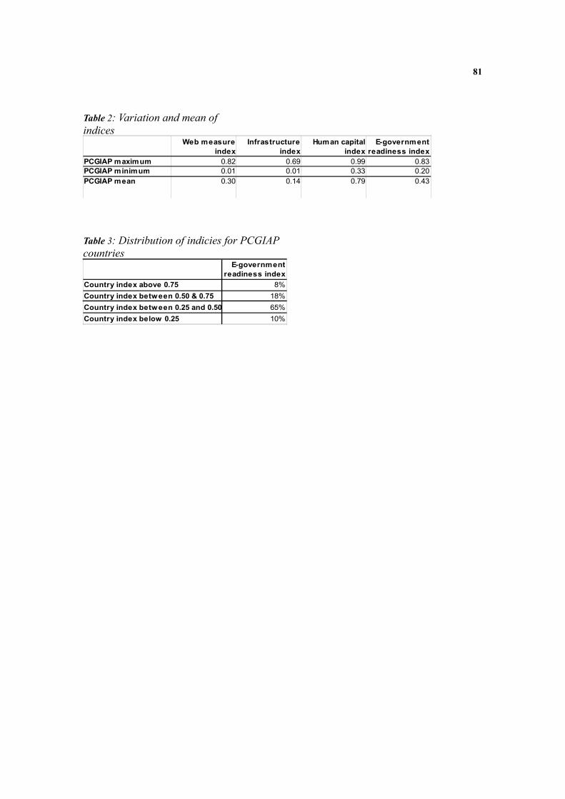
81
Table 2: Variation and mean of indices
PCGIAP maximum 0.82 0.69 0.99 0.83PCGIAP minimum 0.01 0.01 0.33 0.20PCGIAP mean 0.30 0.14 0.79 0.43
Web measure index
Infrastructure index
Human capital index
E-government readiness index
Table 3: Distribution of indicies for PCGIAP countries
Country index above 0.75 8% Country index between 0.50 & 0.75 18% Country index between 0.25 and 0.50 65% Country index below 0.25 10%
E-government readiness index

82
Country PC indexAfghanistan 0.02 0.00 0.05 0.01 0.00 0.02Armenia 0.07 0.11 0.07 0.20 0.00 0.09Australia 0.85 0.85 0.64 0.51 0.60 0.69Azerbaijan 0.11 0.03 0.26 0.15 0.00 0.11Bangladesh 0.00 0.03 0.09 0.01 0.00 0.02Bhutan 0.04 0.02 0.03 0.04 … 0.02Brunei Darussalam 0.49 0.10 0.44 0.22 0.09 0.27Cambodia 0.00 0.00 0.05 0.00 0.00 0.01China 0.12 0.05 0.23 0.29 0.12 0.16Fiji 0.11 0.07 0.16 0.14 0.03 0.10India 0.06 0.02 0.10 0.04 0.01 0.04Indonesia 0.08 0.02 0.18 0.07 0.00 0.07Iran 0.29 0.12 0.13 0.32 0.02 0.17Japan 0.77 0.75 0.52 0.45 0.63 0.62Kazakhstan 0.10 … 0.35 0.21 0.01 0.13Kiribati 0.02 0.01 0.00 0.05 0.00 0.02Korea North 0.00 … … 0.05 0.00 0.01Korea South 0.80 0.59 0.55 0.58 0.92 0.69Kyrgyzstan 0.06 0.02 0.07 0.09 0.00 0.05Lao 0.01 0.02 0.07 0.01 0.00 0.02Malaysia 0.49 0.24 0.50 0.17 0.11 0.30Maldives 0.08 0.16 0.58 0.11 0.05 0.20Marshall Islands 0.04 0.10 0.01 0.09 0.00 0.05Micronesia 0.16 0.06 0.08 0.12 0.00 0.08Mongolia 0.11 0.14 0.14 0.06 0.00 0.09Myanmar 0.00 0.01 0.00 0.01 0.00 0.00Nauru 0.03 … 0.08 0.17 … 0.06Nepal 0.01 0.01 0.02 0.02 0.00 0.01New Zealand 0.89 0.57 0.58 0.45 0.45 0.59Pakistan 0.09 0.01 0.14 0.03 0.00 0.05Palau … … … … … …Papua New Guinea 0.02 0.07 0.01 0.01 0.00 0.02Philippines 0.06 0.06 0.33 0.04 0.01 0.10Russian Federation 0.20 0.13 0.55 0.29 0.06 0.25Samoa 0.05 0.02 0.09 0.11 0.00 0.05Singapore 0.44 0.75 0.72 0.44 0.57 0.59Solomon Islands 0.02 0.05 0.01 0.02 0.00 0.02Sri Lanka 0.02 0.04 0.17 0.09 0.00 0.07Tajikistan 0.00 0.01 0.02 0.05 0.00 0.02Thailand 0.15 0.08 0.41 0.11 0.01 0.15Timor-Leste 0.00 … 0.03 0.00 … 0.01Tonga 0.03 0.07 0.20 0.14 0.02 0.09Turkmenistan 0.02 0.08 0.01 0.09 0.00 0.04Tuvalu 0.18 0.09 0.08 0.09 0.01 0.09Uzbekistan 0.07 0.03 0.02 0.07 0.00 0.04Vanuatu 0.04 0.02 0.04 0.03 0.00 0.02Vietnam 0.19 0.02 0.12 0.20 0.02 0.11
Internet index
Cellular index
Main telephone
lines indexBroadband
indexInfrastructure
index
Table 4: Infrastructure index for PCGIAP member countries

83
CountryAfghanistan 1.72 0.32 8.11 0.53 0.00Armenia 5.75 9.85 10.54 19.71 0.07Australia 75.12 76.61 97.02 48.81 19.15Azerbaijan 9.79 2.31 39.23 14.03 0.03Bangladesh 0.31 2.42 13.25 0.79 0.00Bhutan 3.09 1.60 4.67 4.04 …Brunei Darussalam 43.35 8.82 66.51 20.99 2.74Cambodia 0.31 0.31 7.94 0.23 0.01China 10.35 4.22 34.83 27.79 3.85Fiji 9.36 5.90 24.17 13.27 0.83India 5.44 1.54 14.83 3.64 0.21Indonesia 7.18 1.47 28.30 6.57 0.05Iran 25.54 10.53 19.38 31.19 0.66Japan 68.27 67.45 79.32 43.02 20.09Kazakhstan 8.42 ... 52.86 19.77 0.21Kiribati 2.15 1.18 0.68 5.11 0.00Korea North 0.00 ... … 4.40 0.00Korea South 71.11 53.18 83.77 55.99 29.27Kyrgyzstan 5.60 1.90 10.29 8.37 0.05Lao 0.42 1.69 10.77 1.27 0.00Malaysia 43.77 21.54 75.45 16.83 3.48Maldives 6.64 14.86 87.88 10.88 1.57Marshall Islands 3.51 8.77 1.13 8.27 0.00Micronesia 14.39 5.41 12.70 11.22 0.04Mongolia 10.14 12.84 21.05 5.90 0.07Myanmar 0.18 0.74 0.42 0.93 0.00Nauru 2.59 … 12.97 16.00 …Nepal 0.90 0.49 3.76 2.15 0.00New Zealand 78.77 51.55 87.61 42.91 14.18Pakistan 7.64 0.52 21.98 3.34 0.04Palau … ... … … …Papua New Guinea 1.83 6.64 1.27 1.08 0.00Philippines 5.48 5.37 50.75 4.30 0.15Russian Federation 18.02 12.13 83.62 27.94 2.03Samoa 4.46 1.96 13.41 10.89 0.04Singapore 39.21 68.02 109.34 42.32 18.19Solomon Islands 1.63 4.60 1.26 1.55 0.09Sri Lanka 2.05 3.54 25.88 9.01 0.14Tajikistan 0.30 1.30 4.07 4.31 0.00Thailand 13.07 6.86 63.02 10.92 0.16Timor-Leste 0.12 … 4.88 0.25 …Tonga 3.02 5.99 29.84 13.73 0.64Turkmenistan 1.32 7.20 2.17 8.24 0.00Tuvalu 16.19 8.00 12.38 8.48 0.29Uzbekistan 6.30 3.08 2.71 6.74 0.03Vanuatu 3.46 1.38 5.85 3.21 0.03Vietnam 17.21 1.39 18.17 18.81 0.61
Internet per 100 users
PC per 100 users
Cellular subscribers
per 100 users
Main Telephone
lines per 100 users
Broadband per 100 users
Table 5: Infrastructure index for PCGIAP member countries

84
Country Adult literacyAfghanistan 28.00 42.77 0.33Armenia 99.40 70.85 0.90Australia 99.00 100.00 0.99Azerbaijan 98.80 67.08 0.88Bangladesh 47.50 56.01 0.50Bhutan 47.00 52.00 0.49
92.70 77.72 0.88Cambodia 73.60 59.99 0.69China 90.90 69.13 0.84Fiji 94.40 74.79 0.88India 61.00 63.82 0.62Indonesia 90.40 68.21 0.83Iran 82.40 72.81 0.79Japan 99.00 85.85 0.95Kazakhstan 99.50 93.77 0.98Kiribati ... 75.05 …Korea North … … …Korea South 99.00 97.24 0.98Kyrgyzstan 98.70 77.73 0.92Lao 68.70 61.50 0.66Malaysia 88.70 74.33 0.84Maldives 96.30 65.84 0.86Marshall Islands … 71.13 …Micronesia … … …Mongolia 97.80 77.36 0.91Myanmar 89.90 49.54 0.76Nauru … 50.63 …Nepal 48.60 58.09 0.52New Zealand 99.00 100.00 0.99Pakistan 49.90 40.01 0.47
… 96.92 …57.30 40.72 0.52
Philippines 92.60 81.13 0.89Russian Federation 99.40 88.87 0.96Samoa 98.60 73.73 0.90Singapore 92.50 87.30 0.91Solomon Islands 76.60 47.64 0.67
90.70 62.75 0.81Tajikistan 99.50 70.80 0.90Thailand 92.60 70.76 0.85
50.10 72.03 0.57Tonga 98.90 80.08 0.93Turkmenistan 98.80 73.00 0.90Tuvalu … 69.23 …Uzbekistan 99.40 73.85 0.91Vanuatu 74.00 63.43 0.70Vietnam 90.30 63.94 0.82
Gross enrolment
Education index
Brunei Darussalam
PalauPapua New Guinea
Sri Lanka
Timor-Leste
Table 6: Education index for PCGIAP member countries

85
Modern Land Administration; Characteristics for e-Governments
Mohsen Kalantari1, Abbas Rajabifard2
1Research Fellow, [email protected] , 2Director, [email protected] Centre for SDI and Land Administration Department of Geomatics the University of Melbourne
Abstract The way land is used is driven by the interplay of social, economic, and environmental factors. To manage land as a precious resource, land management systems are expected to maximise social, economic and environmental benefits for people. Within this framework, land administration plays a critical role in the regulation of land management policies. Land administration systems have historically existed to gather revenue, protect people’s rights to land, regulate the land market and control land use. However, land administration systems are now evolving from a focus on the core functions of regulating land use, land tenure and land valuation to an integrated land management paradigm designed to support sustainable development. In addition, it is expected land administration will play a greater social role by contributing to good governance, serving the business sector and enhancing quality of life. This article aims to explain the objectives, functions and characteristics of future land administration systems. A detailed comparison of current and future land administration systems is presented in this article to identify the characteristics of modern land administration.
Introduction The way land is used is driven by the interplay of social, economic, and environmental factors (Williamson et al., 2005). To manage land as a precious resource, land management systems are expected to maximise social, economic and environmental benefits for people. Within this framework, land administration plays a critical role in the regulation of land management policies (Enemark, 2005a). Land administration consists of three types of functions: juridical, regulatory, and fiscal, with land information management integral to all three (Dale and McLaughlin, 1988; Dale and McLaughlin, 1999). Definitions of land administration make it very clear that land administration activity is not an end in itself but facilitates the achievement of other goals (Molen, 2006). According to its functions, the objectives of land administration can generally be classified according to security of tenure, creation of wealth and regulation of land use (Dale and McLaughlin, 1999; Enemark et al., 2005). Land administration systems have historically existed to gather revenue, protect people’s rights to land, regulate the land market and control land use.

86
However, land administration systems are now evolving from a focus on the core functions of regulating land use, land tenure and land valuation to an integrated land management paradigm designed to support sustainable development (Enemark et al., 2005). In addition, it is expected land administration will play a greater social role by contributing to good governance (Ting, 2002), serving the business sector (Steudler, 2004a) and enhancing quality of life. Changing the role of land administration in a society is not simple. This shift involves many issues relating to the historical, cultural, social, technical and economic situation of the society (Ting and Williamson, 2000; Williamson, 2001). These issues reveal that current land administration systems are unable to deliver new objectives unless their characteristics are changed. This article aims to explain the objectives, functions and characteristics of future land administration systems. A detailed comparison of current and future land administration systems is presented in this article to identify the characteristics of modern land administration.
Land According to the Food and Agricultural Organisation (FAO and UNEP) of the United Nations (UN), land is the most valuable asset that people hold (FAO and UNEP, 1999a; FAO, 2007). Mankind has diverse interests in land: it is a place to build homes, grow crops and pasture animals for food; a source of raw materials and mineral wealth, and a place for leisure activities. Land is not simply regarded in terms of soils and surface topography, but encompasses features such as underlying deposits, climate and water resources, and supports plant and animal communities. Furthermore, the results of human activities, reflected by changes in vegetative cover or structures, are also regarded as features of land (FAO and UNEP, 1999b). The interplay of social, economic, and environmental factors determines the way in which land is used (Williamson, 2006). For instance, global competition puts pressure on land to produce higher financial returns as an economic interest, whilst climate change is adding further pressure as an environmental interest in land. Thus, producers face a significant challenge if they wish to stay in business whilst at the same time protecting the natural environment. The social impact of land interests includes change in the size and composition of rural and town populations, shifting employment opportunities, and cultural changes, amongst others. Environmentally, all living creatures are dependent upon the land for natural resources, food and water. From an economic point of view, building materials and energy resources like oil, coal and gas, are all derived from land. More importantly, land is a commodity to which a value can be assigned and which can be traded through land markets. It is also a commodity that can be taxed to produce revenues that support good governance (Wallace and Williamson, 2004; Wallace and Williamson, 2006; Williamson and Wallace, 2007).

87
To manage land as a precious but complicated resource, land management systems are expected to maximise social, economic and environmental interests, not damaging the land and, where possible, contributing to its enhancement. Land management is about finding the right balance of these triple, often competing, factors that allow sustainable land use (World Bank, 2006). Therefore, to ensure the optimum use of land to enable societies to achieve sustainable development there must be a framework of sustainable land management. Within this framework, land administration plays a critical role to implement the policies adopted in land management (Enemark, 2005b). For further discussion, land administration is defined in the next section.
Land Administration The key to understanding land administration is to recognise the relationship between people and land. In the early stages of human settlement, land was undisputedly the primary source of wealth and power. In that context, land administration’s primary function was to record ownership interests and serve as a fiscal tool for managing the taxing system (Larsson, 1991). The usurping of land’s position as the primary source of wealth for people began with the Industrial Revolution and the rise of capital. This in turn created a further important function of land administration as a tool to support the growth of land markets and land transfers (Ting and Williamson, 1999a) to develop economic interests in land. The post WWII reconstruction period and subsequent population boom saw the need for better spatial planning, particularly in urban areas. There was an increased need for land administration laws and systems to address broad acre subdivisions(Ting and Williamson, 1999a; Ting and Williamson, 1999b; Ting et al., 1999; Williamson et al., 1999; Ting and Williamson, 2000; Ting, 2002). As today’s society faces continuing land shortages and resource scarcity, the imperative exists to better manage and plan land use. The concerns about sustainable development and the environment are evident from such international instruments as Agenda 21 and the Habitat II Agenda. There are also concerns for social equity such as indigenous and women’s rights (Ting and Williamson, 1999a; Ting and Williamson, 1999b; Ting et al., 1999; Williamson et al., 1999; Ting and Williamson, 2000; Ting, 2002), taking into account the new social interests in land. Today, thinking has moved beyond giving more people the possibility of having interest in the space over and underneath the same parcel of land through land administration (Figure 1). Traditionally, land administration referred to the processes of determining, recording and disseminating information about the ownership, value and use of land, when implementing land management policies (UNECE, 1996; UNECE, 2005). Within this context, a land administration system is an infrastructure that supports the management of land. The processes of land administration include regulation of land and property development to control the creation of new interests in land, the use and

88
conversion of the land, the gathering of revenue from the land through sales, leasing, and taxation, and the resolution of conflicts concerning the social interests, ownership and use of the land (Dale and McLaughlin, 1988).
Figure 1: Evolution of land administration systems (Ting and Williamson, 1999a) Land administration facilitates all transaction concerning land, such as land development, and makes such transactions easier and more secure. One consequence of land administration is the stimulation of economic interests in land and land markets. Administrating land provides security and protection for the rightful claimant as well as preserving the interests of society. This security stimulates investment and development, particularly through its contributions to the banking system. Land administration reduces disputes and litigation over land resulting in better social and people relationship (Larsson, 1991). Having defined land administration and its role, the next two sections identify the key attributes of land administration together with the processes in which these attributes are brought into play.
Attributes of Land Administration In land administration the three key attributes of land are ownership, value and use:
Ownership Ownership usually means the exclusive right to use the parcel, enjoy its produce and make improvements (Larsson, 1991). In a market based system it also includes the right to transfer the parcel to another person, to mortgage the property and to lease it. All of these rights may be more or less restricted by legislation. It is common today that the legal rights of the land owner are restricted to using the parcel of land in a manner that is beneficial and appropriate from a community perspective. Restrictions may also include measures to protect the environment. Ownership of the land usually includes ownership of any buildings on the land, but in some jurisdictions land and buildings may be owned separately (FIG, 1995).
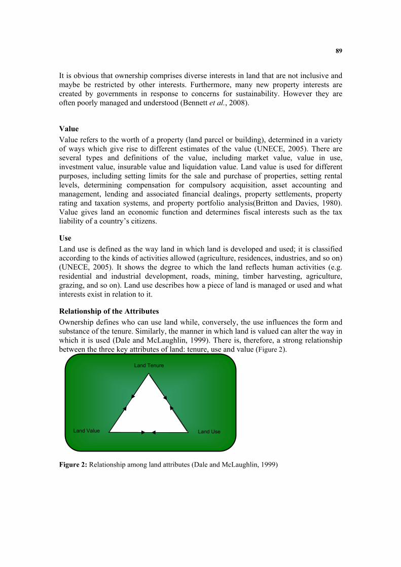
89
It is obvious that ownership comprises diverse interests in land that are not inclusive and maybe be restricted by other interests. Furthermore, many new property interests are created by governments in response to concerns for sustainability. However they are often poorly managed and understood (Bennett et al., 2008).
Value Value refers to the worth of a property (land parcel or building), determined in a variety of ways which give rise to different estimates of the value (UNECE, 2005). There are several types and definitions of the value, including market value, value in use, investment value, insurable value and liquidation value. Land value is used for different purposes, including setting limits for the sale and purchase of properties, setting rental levels, determining compensation for compulsory acquisition, asset accounting and management, lending and associated financial dealings, property settlements, property rating and taxation systems, and property portfolio analysis(Britton and Davies, 1980). Value gives land an economic function and determines fiscal interests such as the tax liability of a country’s citizens.
Use Land use is defined as the way land in which land is developed and used; it is classified according to the kinds of activities allowed (agriculture, residences, industries, and so on) (UNECE, 2005). It shows the degree to which the land reflects human activities (e.g. residential and industrial development, roads, mining, timber harvesting, agriculture, grazing, and so on). Land use describes how a piece of land is managed or used and what interests exist in relation to it.
Relationship of the Attributes Ownership defines who can use land while, conversely, the use influences the form and substance of the tenure. Similarly, the manner in which land is valued can alter the way in which it is used (Dale and McLaughlin, 1999). There is, therefore, a strong relationship between the three key attributes of land: tenure, use and value (Figure 2).
Figure 2: Relationship among land attributes (Dale and McLaughlin, 1999)
Land Tenure
Land Value Land Use

90
The strong relationship between the attributes should be considered when determining future land administration requirements. This also applies when designing e-land administration and developing associated tools. The silo based data model of managing land attributes according to particular interests in land interferes with the proper communication, data exchange and interoperability of land administration systems. It also prevents the integrated management of increasing land interests by keeping them separate..
Processes of Land Administration An examination of the definition of land administration reveals three sub-processes: determination, recording and dissemination.
Determination The determination sub-process is the identification of an interest in land, the demarcation, measuring and mapping of the interest’s boundaries or spatial extent (Larsson, 1991), and the assessment of its value. Cadastral surveys, for instance, are one of the tasks in the determination sub- process that may be carried out by governmental officials and private surveyors or a combination of the two(Larsson, 1991; Dale and McLaughlin, 1999). Land valuation is another practice undertaken in the determination sub-process to develop the value of land.
Recording The recording sub-process includes the checking or examination of the results of the determination sub-process and the entry of the information in land information systems. For instance, after determining boundaries of a land parcel, a unique parcel identifier is allocated in the physical data model and databases. There follows an examination of land policy matters- for instance, does the subdivision contribute to a suitable land use?; legal matters, such as the right of the applicant to conduct certain land activities; and technical matters- have the survey regulations been obeyed? (FIG, 1996). Finally, the land parcel and associated information including interests, value and use are recorded.
Dissemination The dissemination sub process includes providing the key attributes of land to the public and private users. This process requires an infrastructure, including institutional and technical arrangements, to effectively distribute land information. For instance, spatial data infrastructures which aim at facilitating data collection, integration and sharing can be used as an enabling platform for the disseminating sub-process (Kalantari et al., 2005a). The way in which main attributes of land (ownership value and use) are determined directly influences how they are recorded in the land administration data models and, consequently, their manner of disseminated. The strong relation between the attributes,

91
therefore, will also show itself in the processes and consequently affect the way e-land administration operates and a cadastral data model is designed. Table 7 summarises the definition of traditional land administration explaining its characteristics and features. Following land administration attributes and elements, the next section elaborates upon the functions of land administration. Land administration Main data elements Main processes
Traditional Ownership Use Value
Determination Recording Disseminating
Table 7: Traditional land administration, data elements and processes
Functions of Land Administration According to the definition of land administration and the key attributes of land, land administration consists of three functions: juridical (for land tenure), regulatory (for land use), fiscal (for land value) with land information management integral to the three functions (Dale and McLaughlin, 1999).
Land Tenure The way in which rights in land are held is called tenure. It is defined by a broad set of rules, some of which are formally defined through law, others determined by custom (Dale and McLaughlin, 1999). There are four main areas of the law that particularly affect the land administrator: (a) The law of “real” property that affects dealings in land; (b) The laws on land reform such as the privatization of State-owned land, the restitution of former private land, and land consolidation; (c) The laws that govern the conduct of land administration such as the regulations that control the operation of the cadastre; and (d) The laws on “intellectual” property that affect such matters as the ownership of information and ideas, the protection of data and personal privacy (UNECE, 1996; UNECE, 2005). In the future, however, land tenure will also describe the manner in which interest (rights, restriction, responsibilities) are held (Bennett et al., 2008).
Land Valuation Land valuation is the process of estimating the value of any land or property for the purpose of buying, selling, leasing or taxation. It is also used to calculate the assets held by an individual or business for the purposes of inheritance, bankruptcy or collateral (Dale and McLaughlin, 1999). Valuation involves the classification of each property in accordance with an agreed set of characteristics relating to its use, interests attached, size, type of construction and improvements; market data including data on sales prices, the rental market and building maintenance costs (UNECE, 2005).

92
Land Use Regulation In order to make the best use of national resources and regulate interests in land, every country implements strategies for land-use planning and development so as to improve the physical infrastructure and create a better environment. Land-use regulation is the process of allocating resources, especially rights, restrictions, and responsibilities to use land in particular ways, in order to achieve maximum efficiency while respecting the environment and the welfare of the community (UNECE, 2005).
Land Information Management The ability to meet the range of land administration functions in the areas of land tenure, land value and land use requires access to complete and up-to-date land information. A key function of land administration is the management of land and property related data through a land information system with the cadastral data model at its centre. For instance, a primary requirement for efficient and effective land valuation is land data that provides an index for compiling and maintaining valuation information. Access to inclusive and integrated information on the interests in land, value and use via a comprehensive data model helps to facilitate achieving the e-land administration (Kalantari et al., 2005a). Table 8 summarises land administration functions together with main data elements and processes. Land Administration Main data elements Main processes Functions
Traditional Ownership Use Value
Determination Recording Disseminating
Land tenure Land value Land use regulation Land Information management
Table 8: Traditional land administration, data elements and processes and functions Various components communicate to each other, exchanging information in order for the land administration system to perform the functionalities described. The next section explains what the components are and how they relate to each other.
Components of Land Administration The diversity of functionalities requires land administration to have various kinds of components to deal with land. For example, the land tenure function requires placing emphasis on the holding and the registration of interests in land. On-ground identification is provided by surveyors through development plans to assist in the regulation of use. At the same time, the land use function is also concerned with use restrictions imposed through the regulatory planning mechanisms. The land value function focuses on the economic utility of land. The taxation office requires the change of land use to calculate the revenue and tax for specific purposes.
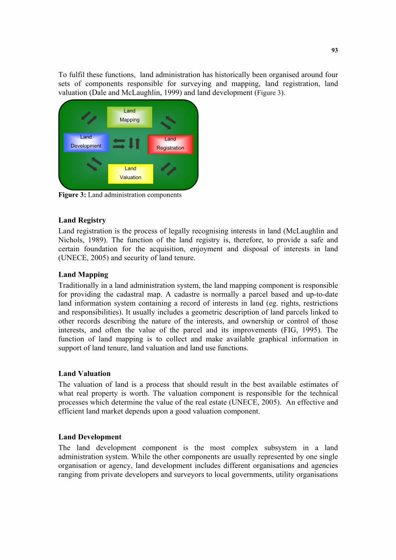
93
To fulfil these functions, land administration has historically been organised around four sets of components responsible for surveying and mapping, land registration, land valuation (Dale and McLaughlin, 1999) and land development (Figure 3).
Figure 3: Land administration components
Land Registry Land registration is the process of legally recognising interests in land (McLaughlin and Nichols, 1989). The function of the land registry is, therefore, to provide a safe and certain foundation for the acquisition, enjoyment and disposal of interests in land (UNECE, 2005) and security of land tenure.
Land Mapping Traditionally in a land administration system, the land mapping component is responsible for providing the cadastral map. A cadastre is normally a parcel based and up-to-date land information system containing a record of interests in land (eg. rights, restrictions and responsibilities). It usually includes a geometric description of land parcels linked to other records describing the nature of the interests, and ownership or control of those interests, and often the value of the parcel and its improvements (FIG, 1995). The function of land mapping is to collect and make available graphical information in support of land tenure, land valuation and land use functions.
Land Valuation The valuation of land is a process that should result in the best available estimates of what real property is worth. The valuation component is responsible for the technical processes which determine the value of the real estate (UNECE, 2005). An effective and efficient land market depends upon a good valuation component.
Land Development The land development component is the most complex subsystem in a land administration system. While the other components are usually represented by one single organisation or agency, land development includes different organisations and agencies ranging from private developers and surveyors to local governments, utility organisations
Land
Development Land
Registration
Land
Valuation
Land
Mapping

94
and planning authorities. A land subdivision process for instance, contains several stages with each organisation responsible for a specific stage. Each subsystem has specific functions and services. These specific functions or services directly impact upon the way in which data is modelled, stored, accessed, shared and exchanged. The unique perspective of each agency causes it to implement specific functionalities to deliver their services and to develop different data modelling methods and communication regimes from the other subsystems. Having reviewed, the attributes, functions and components of land administration, the next section explores the land administration objectives.
Objectives of Land Administration Functions and definitions of land administration make it very clear that land administration activity is not an end in itself but facilitates other goals (Molen, 2006). Land administration systems have historically contributed to gathering revenue, protecting people’s rights in land, regulating the land market and controlling land use. According to the functions and attributes of land administration, its objectives can be generally classified according to security of tenure, creation of wealth and the regulation of use.
Security of Tenure The main objective of a land administration system through the land tenure function is to ensure security of tenure. Securing land rights is particularly relevant to vulnerable groups such as the poor, women and indigenous groups. In most societies, there are many competing interests in land including development, agriculture, pasture, forestry, industry, infrastructure, urbanisation, biodiversity, customary rights, and ecological and environmental protection interests. Many countries have great difficulty in balancing the needs of these competing demands. Land has been a cause of social, ethnic, cultural and religious conflict, and revolutions have been fought over rights to land. Throughout history, virtually all civilisations have devoted considerable effort to defining interests in land and establishing institutions to administer this increasing number of interests through land administration systems (Bell, 2005).
Creation of Wealth Creation of wealth is an important foundation for economic development. Land administration systems have contributed to this through the land valuation function. In a land market, fees and taxes on land are often a significant source of revenue. Many of the interests in land, such as land use rights, development rights, right of way, water rights, mineral and extractive resource rights, carbon rights, timber rights, air rights, view rights, aquaculture rights, marine rights, trade waste rights are now being seen as tradable commodities (Wallace and Williamson, 2004). An efficient system of valuation has always had a significant impact on an efficient land and land related commodities market systems.

95
Furthermore, recognizing that land is a source of wealth lies at the heart of good government and effective public administration. States that prosper promote widespread and secured private ownership of land as a foundation of social and economic policy. "Modern market economies generate growth because widespread formal property rights, registered in a system governed by legal rules, afford indisputable proof of ownership and protection from uncertainty and fraud so permitting massive low cost exchange, fostering specialization and greater productivity. It is law that defines the relationship of rights to people. Civilized living in market economies is not simply due to greater prosperity but to the order that formalized property rights bring." (Hernando de Soto 2000). "Land is the place of all shelter, in the city, the town, the village and the home. It is the source of food, of materials for construction and manufacture, of coal, gas and oil, of springs and rivers and other essentials for life. Indestructible, immovable, it is the foundation of all human activity. Houses and factories, forests and farms, rivers, roads and railways, mines, quarries and reservoirs are all fashioned from the land. It offers endless opportunities for development and discovery. It is the ultimate source of wealth." (based on Sir Charles Fortescue Brickdale 1914).
Regulatory of Use Land is an asset that is immovable: it is at a fixed location. It is also an asset of both a public and a private nature. The land use regulatory function of land administration aims at optimizing the productive uses of the land. These uses include agriculture, pastures, and the provision of space for housing, commercial and industrial enterprises. Land administration helps to determine how these interests are created and regulated. While the land resource of a country is finite and cannot be expanded, the resource base can be improved upon or it can be degraded. It is in countries’ interests to have their land resources used in a sustainable manner to ensure that the land will remain productive for future generations. Having explored traditional land administration systems in term of objectives, key attributes and functionalities (Table 9), next section looks at the new land administration paradigm and observes whether any change has occurred within attributes, functions, components and objectives. Land Administration data elements processes Functions Components
Traditional Ownership Use Value
Determination Recording Disseminating
Land tenure Land value Land use regulatory
Land registry Land valuation Land mapping Land development
Table 9: Traditional land administration, data elements and processes, functions and components
The New Land Administration Paradigm Land administration systems are now evolving from a focus on the core functions of regulating land use, land tenure and land valuation to an integrated land management
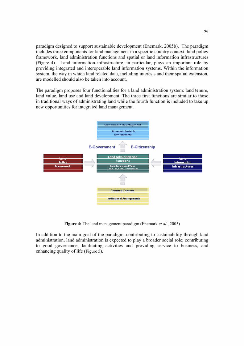
96
paradigm designed to support sustainable development (Enemark, 2005b). The paradigm includes three components for land management in a specific country context: land policy framework, land administration functions and spatial or land information infrastructures (Figure 4). Land information infrastructure, in particular, plays an important role by providing integrated and interoperable land information systems. Within the information system, the way in which land related data, including interests and their spatial extension, are modelled should also be taken into account. The paradigm proposes four functionalities for a land administration system: land tenure, land value, land use and land development. The three first functions are similar to those in traditional ways of administrating land while the fourth function is included to take up new opportunities for integrated land management.
E-Government E-Citizenship
Figure 4: The land management paradigm (Enemark et al., 2005)
In addition to the main goal of the paradigm, contributing to sustainability through land administration, land administration is expected to play a broader social role; contributing to good governance, facilitating activities and providing service to business, and enhancing quality of life (Figure 5).

97
Figure 5: New roles for land administration Land Administration and Good governance Good governance has 8 major characteristics (ESCAP et al., 2007). It is participatory, consensus oriented, accountable, transparent, responsive, effective and efficient, equitable and inclusive, and follows the rule of law. It assures that corruption is minimised, the views of minorities are taken into account and that the voices of the most vulnerable in society are heard in decision-making. It is also responsive to the present and future needs of society. A consensus oriented land administration can enhance the participation of all members of a society through securing both women’s and men’s interests in land. For instance, given women's centrality to diversified livelihoods, and their increasing political agency, their interests in land (both as wives/daughters within male–dominated households and as members of vulnerable social classes and communities that face the risk of land alienation) are more politicised today as well as being more contested (Razavi, 2003). With the deceleration of more formal forms of employment, the diversification of rural livelihoods, and the intensification of casual labour in agriculture and the informal sector, the land question has taken on a new urgency and needs to be answered in land administration. A transparent land administration system can enforce the rule of law and accountability. Responsive land development can increase efficiency and effectiveness of governance. In an integrated and interoperable environment like e-land administration, with a proper data arrangement land administration subsystems can contribute to better governance in a society. Land administration and Service to Business Land administration has not traditionally offered many services for businesses, but the land information management function and spatial data infrastructures and their relationship with land administration is changing the field. Private and public businesses, such as building inspection, transportation planning and management, emergency response, waste management and disposal, protected area designation, monitoring of parks and open space, infrastructure management, and public
Tenure Use
Value Development
Spatial Data
Infrastructure
Good Governance
Sustainable Development
Enhancing
Quality of
Life
Service to
Businesses

98
utilities can be assisted by the provision of comprehensive land related data and interoperable communication among the land administration agencies. Forest fires, foot-and-mouth disease devastating livestock, the outbreak of severe acute respiratory syndrome (SARS) — all of these disasters have at least one thing in common: the role played by land information to help authorities make crucial decisions. The US Department of Labour identified land information technology as one of the three most important emerging and evolving fields, along with nanotechnology and biotechnology. Job opportunities are growing and diversifying as geospatial technologies prove their value in ever more areas (Gewin, 2004). Land administration and Quality of Life Quality of life is an elusive concept approachable at varying levels of generality from the assessment of societal or community wellbeing to the specific evaluation of the situations of individuals or groups (Felce and Perry, 1995). Quality of life is defined basically as a constellation of components which can consist of objective living conditions and/or of subjectively perceived wellbeing. The objective living conditions are usually monitored by experts from the social and natural sciences; these objective conditions exist independent of the awareness of the population exposed to them. Their range may vary from personal conditions through the community domain to the world’s environmental conditions (Glatzer and Mohr, 1987). Quality of life, by almost any definition, is important to people. In land administration context it is applied to the relationship between people and public land management (Razavi, 2003). Land administration systems, therefore, are a tool of great inherent potential for better living management. For instance, the attributes of land offered by land administration are directly applicable to an understanding of the spatial variation of disease and its relationship to environmental factors and the health care system. In summary, the largest benefit of a land administration system is the availability of comprehensive land information to the citizens through integrated land information systems and data models, and the ease by which they can access this information through e-land administration. Parents sending their children to universities can access crime statistics about a specific area where they are thinking of leasing or purchasing property. Developers and engineers can access zoning type, building setbacks, minimum lot areas, and property ownership, through the Internet. Real estate agencies can access appraised value information on properties they are looking to list, or investors can get ownership information on properties they want to purchase. Citizens can see what precinct they need to vote in as well as their polling location, what amenities a certain park has, or find a dearly departed relative in the city cemetery. They can find out when their rubbish pickup or recycling day is or what year the historic home across the street was built.

99
It can be seen from above, that the evolution of land administration system follows its changing role in societies rather than its change of functionalities (Figure 5). The functionalities described for land administration remain with the addition of extra roles. Land tenure, land use, land value and land development, together with land information management, can contribute to good governance. An open land registry, for instance, means that land information is freely available and directly accessible to the participants of the society. It also means that comprehensive and integrated information is provided by the land information management and that it is provided in interoperable forms and media. Good governance also requires that land administration institutions and processes try to serve all clients within a reasonable timeframe primarily through all time available media such as internet based land administration systems. Land administration also requires a broad and long-term perspective of what is needed for businesses and how to provide appropriate services. This can only result from an understanding of the historical, cultural and social contexts of a given society or community. Land information management, with cadastral data modelling at its core, can enhance institutional and technical arrangements, enable better communication among the land administration functions, and thus provide better service to business. Furthermore, wellbeing in a society depends on ensuring that all its members feel that they have a stake in access to land, can have interests in, and do not feel excluded from the mainstream of society. This requires that all groups, but particularly the most vulnerable, have opportunities to improve or maintain individual well being by access to land administration services such as e-conveyancing, e-plan of subdivisions and e-land taxation. The above discussion demonstrates how a land administration system can potentially contribute to good governance, service to business and quality of life. Very few countries and societies have come close to using the potential of land administration in this way. However the new roles for land administration are challenging tasks. The next section identifies these issues.
Changing Role of Land Administration and Issues Changing the role of land administration in a society is not straightforward. Many issues are involved in this shift relating to historical, cultural, social, technical and economic conditions. Different societies face different issues. For instance, countries with informal and customary rules will face different issues to those in post conflict situations. The technical requirements of a changing land administration system for developed countries are different to those of developing countries. However, this section investigates the issues within the scope of the research. Interoperability Land administration systems in developed countries and in some of the developing countries have utilised ICT in order to achieve e-land administration. Many implemented

100
their electronic and computerised systems between ten and twenty years ago. Those systems are now outdated, and the maintenance is complex and expensive. (Blaikie, 2003; Bruggemann, 2003; Dijkstra T. and Booij A.S., 2003; Hawerk, 2003; Hoffmann, 2003; Ljunggren, 2003; Meadows and Formby, 2003; Mladenovic, 2003; Molen and Lemmen, 2003; Onsrud, 2003; Sanz, 2003; Selleri and Fabrizi, 2003; SuchanekI and Jirman, 2003; Vahala, 2003) The land administration systems are increasingly being confronted with rapid development in technology, internet, databases, modelling standards, open systems as well as growing demands for new services, enhanced user requirements, e- governance. e-Land administration systems, including the information system and data models they use, should be able to adapt themselves with the fast pacing innovations. This in particular requires a proper maintenance regime for e-land administration components such as cadastral data models when designing and developing. In addition, because enablement of land administration with ICT was undertaken so long ago, it has happened individually by subsystems or even departments in a subsystem without considering other subsystems. Existing initiatives include providing land information on line, electronic conveyancing, and electronic subdivisions. Thus far, the implementation of these initiatives is isolated in their specific components without reference to the broader land administration system or its core policy. Communication among the components needs interoperability. Without interoperability between the components, e-land administration, and e-government cannot be achieved (Kalantari et al., 2005b). Different components of land administration have developed their own computerised system without paying enough attention to the objectives of the entire land administration system. Consequently, one of the big problems in ICT enablement, computerising and having interoperability in e-land administration, is the lack of standards. The need for standardisation has been discussed in various literature (Astke et al., 2004; Bjornsson, 2004; Hecht, 2004; Kaufmann, 2004; Oosterom et al., 2004; Ottens, 2004; Paasch, 2004; Steudler, 2004b; Stubkjaer, 2004; Wallace and Williamson, 2004; Zevenbergen, 2004). International standardisation could resolve many of these communication and interoperability problems. There are several motivations for interoperability, such as meaningful exchange of information between organisations, and efficient component-based system development through applying standardised models. Interoperability is now becoming a serious issue as most land administration activities have been computerised. Competition among technology providers presents new challenges. A variety of solutions for the same problem bring diversity in the technologies that are used. This issue in particular can be observed within different organisations. Interoperability is not a big issue until the need for communication, data exchange, data sharing become of interest. Increasing Number of Interests in Land Property rights are managed well by modern economies. They are supported both theoretically and administratively by a framework of legal and economic theory and

101
sophisticated registration systems. But the current literature on cadastral and land administration issues replaces rights with the three R’s of Rights, Restrictions and Responsibilities (Lemmen et al., 2005). In contrast to the rights, the restrictions and responsibilities imposed on land users in support of sustainable development are not well managed (Bennett et al., 2008). They lack theoretical support, administrative coherence and basic information systems. Land administration literature now suggests that all rights, restrictions and responsibilities (RRRs) should be included in the land administration system (Bennett et al., 2006). In a modern context the key questions then are how new interests and RRRs might be incorporated into a cadastral fabric, especially when they are remote from physical objects or even spatial identification (Wallace and Williamson, 2004). RRRs or interests in land have historically been organised through land parcels as the basic building block of land administration systems. As a result, governments are trying to manage new commodities and interests in land through this traditional basic building block. However, land parcels are not sufficiently flexible to accommodate or support the growing number of complex commodities (e.g. water, biota, mining rights, and carbon credits) and other interests (e.g. environmental, heritage, use restrictions) in land(Kalantari et al., 2008). For instance, the increasing complexity of modern cities suggests that modern land administration systems need an improved capacity to manage the third dimension of height (Zlatanova and Stoter, 2006). From a land resource management perspective, the definition and identification of land parcels remains fundamentally important, however, the parcel is not the only unit essential for effective land management. Spatial identification of interests requires more flexible objects. Having explored the changing role of land administration and the issues future land administration systems face, the characteristics of future land administration systems will now be summarised and compared with current land administration.
Future Land Administration Future land administration involves processes of contributing to sustainable development as a primary aim and also helping with good governance, service to business and enhancement of quality of life through the land tenure, land value, land use and land development functions. While land administration systems were traditionally designed to provide security of tenure, to create wealth and control land use, today they are expected to contribute far more. Issues described in previous section clarify the inability of current land administration systems to deliver new objectives unless their characteristics are changed. Most land administration systems do not recognise the new interests in land such as informal and customary rights, water rights, biota rights, and noise restrictions. This

102
hinders the equity and inclusiveness in good governance. Modern land administration is expected to bring more interests into play. In a modern context the key questions are how new unbundled interests in land imposed by governments might be incorporated into cadastral information systems. In future, the parcel based organisation of interests in land must be refined as new interests such as biota, carbon, and water have different technical characteristics. Parcel based indexing of interests in land cannot accommodate interests that are not necessarily equivalent to the extent of land parcels. Consequently, land information management will play a greater role in modern land administration systems by utilising the powered spatially enablement and using potential of information and communication technologies. However, many ICT based land administration systems are now outdated, and the maintenance of these systems is complex and expensive. Modern land administration requires a comprehensive view on the utilisation of ICT. ICT should not be used in an isolated manner in each of the components and should be holistically and dynamically instilled into land administration components, so that they can communicate with each other in an efficient and cost effective manner and remain up to date. Standardisation and interoperability are therefore serious issues to be considered when establishing an e-land administration system in the context of modern land administration. In this way ICT is central to development of e-land administration. Table 10 juxtaposes the characteristics of future land administration against those of current land administration. Current Land Administration Future Land Administration
Objectives Tenure Security Wealth Creation Use Regularity
Good Governance (Tenure Security, …) Support Sustainable Development (Wealth Creation, Use Regularity, …) Enhancing Quality of Life Service to Businesses
Characteristics
Parcel Based Limited Bundled Interest ICT Enabled Isolated Processes Parcel Based Indexing Private Interests
Object Based Broader Independent Interests e-Land Administration Spatially Enabled Land Administration Public and Private Interests
Table 10: a comparison between current land administration and modern land administration
Conclusion This article began with an introduction to the importance of land for sustainability and validated the key and important role that land plays in societies. It then proceeded with the objectives, functionalities and characteristics of land administration systems as well as subsystems that are involved in the functions. Land administration systems are faced with change, and are now expected to contribute not only to the sustainable development of a society, but also to good governance, enhanced quality of life and service to business. It further revealed that the evolution of land administration systems is more

103
about changing the roles they play in a society rather than changing the functions they perform. The article identified the issues associated with the change and classified them according to interoperability and increasing number of interests in land. This article concluded that the changing role of land administration is revolutionising its technical characteristics. In light of ICT, future land administration should be object based not parcel based, spatially enabled and inclusive in terms of both public and private interests. More importantly isolated ICT enablement should be replaced by the interoperable e-land administration.
Reference Astke, H., G. Mulholland and R. Nyarady (2004). Profile Definition for a Standardized Cadastral
Model. Joint FIG Commission 7 and COST Action G9 Workshop on Standardization in the Cadastral Domain, Bamberg, Germany.
Bell, K. C. (2005). Land Administration and Management: The Need for Innovative Approaches to Land Policy and Tenure Security. Expert Group Meeting on secure land tenure:new legal framework and tool , UNESCAP in Bangkok, Thailand
Bennett, R., J. Wallace and I. Williamson (2006). Managing rights, restrictions and responsibilities affecting land. Combined 5th Trans Tasman Survey Conference & 2nd Queensland Spatial Industry Conference 2006 ,Land and Sea Spatially Connected, In A Tropical Hub, Cairns.
Bennett, R., I. Williamson and J. Wallace (2008).Organising land information for sustainable land administration. Land Use Policy 25(1): 126-138.
Bjornsson, C. (2004). Cadastre 2014, From vision to GIS. Joint FIG Commission 7 and COST Action G9 Workshop on Standardization in the Cadastral Domain, Bamberg, Germany.
Blaikie, D. (2003). IT strategy and vision in registers of Scotland- Delivering the enabling technology. Strategies for Renewal of Information Systems and Information Technology for Land Registry and Cadastre, Symposium held by FIG Commission 7 ITC, The Netherlands.
Britton, W. and K. Davies (1980). Modern Methods of Valuation of Land, Houses and Buildings, Estates Gazette.
Bruggemann, H. (2003). GEOBASIS.NRW and GDI NRW- Interoperable e-government and e-business solution with basic geo-data. Strategies for Renewal of Information Systems and Information Technology for Land Registry and Cadastre, Symposium held by FIG Commission 7 ITC, The Netherlands.
Dale, P. F. and J. D. McLaughlin (1988). Land information management : an introduction with special reference to cadastral problems in Third World countries. Oxford [England]
Oxford ; New York, Clarendon Press ; Oxford University Press. Dale, P. F. and J. D. McLaughlin (1999). Land administration. New York, Oxford University
Press. Dijkstra T. and Booij A.S. (2003). Renewal of automated information systems at the Netherlands
cadastre and land registry agency. Strategies for Renewal of Information Systems and Information Technology for Land Registry and Cadastre, Symposium held by FIG Commission 7 ITC, The Netherlands.
Enemark, S. (2005a). The Land Management Paradigm for Institutional Development. the Expert Group Meeting, Melbourne, Australia, , Department of Geomatics, The University of Melbourne.
Enemark, S. (2005b). The Land Management Paradigm for Institutional Development. Expert group meeting on incorporating sustainable development objectives into ICT enabled land administration systems, Melbourne, Australia.
Enemark, S., I. Williamson and J. Wallace (2005).Building Modern Land Administration Systems in Developed Economies. Journal of Spatial Science, 2005 50(2): 51-68.
104
ESCAP, UNDP and ADB (2007). Access to basic services, the impotance of good governance United Nations Economic and Social Commission for Asia and the Pacific (ESCAP), United Nations Development Programme (UNDP), Asian Development Bank (ADB).
FAO (2007). Good governance in land tenure and administration. Rome, FOOD AND AGRICULTURE ORGANIZATION OF THE UNITED NATIONS.
FAO and UNEP (1999a). The Future of Our Land, Facing the Challenge. Rome, Food and Agriculture Organization.
FAO and UNEP (1999b). The Future of Our Land, Facing the Challenge, Guidelines for Integrated Planning for Sustainable Management of Land Resources. Rome, FAO.
Felce, D. and J. Perry (1995).Quality of life: Its definition and measurement. Research in development disabilities 16(1): 51-74.
FIG. (1995). "FIG statement on cadastre." Retrieved July, 2005, from http://www.fig7.org.uk/publications/cadastre/statement_on_cadastre.html.
FIG (1996). The Bogor Declaration, United Nations Interregional Meeting of Experts on the Cadastre, UN-FIG.
Gewin, V. (2004).Mapping opportunities. Nature, International weekly journal of science opportunities(427): 376-377.
Glatzer, W. and H.-M. Mohr (1987).Quality of life: concepts and measurement. Social Indicator research 15.
Hawerk, W. (2003). IT renewal startegy for land registry and cadastre in Europe. Strategies for renewal of information systems and information technology for land registry and cadastre, ITC, The Netherlands, FIG.
Hecht, L. (2004). Observations on the Proposed Standardized Cadastre Domain Model, Where Do We Go From Here? Joint FIG Commission 7 and COST Action G9 Workshop on Standardization in the Cadastral Domain, Bamberg, Germany.
Hoffmann, W. (2003). Going digital to fulfil customer needs BEVs efforts streamlining the supply chan with information technology. Strategies for Renewal of Information Systems and Information Technology for Land Registry and Cadastre, Symposium held by FIG Commission 7 ITC, The Netherlands.
Kalantari, M., A. Rajabifard, J. Wallace and I. Williamson (2005a).The Role of Cadastral Data Modeling in e-Land Administration. Coordinates 1(4): 26-29.
Kalantari, M., A. Rajabifard, J. Wallace and I. Williamson (2008).Spatially referenced legal property objects. land Use policy 25: 173-183.
Kalantari, M., A. Rajabifard, J. Wallas and I. Williamson (2005b). Toward e-Land Administration: Evaluating Australian Online Services. SSC 2005 Spatial Intelligence, Innovation and Praxis: The national biennial Conference of the Spatial Sciences Institute, Melbourne.
Kaufmann, J. (2004). Assessment of the Core Cadastral Domain Model from a Cadastre 2014 point of view. Joint FIG Commission 7 and COST Action G9 Workshop on Standardization in the Cadastral Domain, Bamberg, Germany.
Larsson, G. (1991). Land registration and cadastral systems. Edinburg, England, Addison Wesley Longman Limited.
Lemmen, C., P. V. Oosterom, J. Zevenbergen, W. Quak and P. V. D. Molen (2005). Further Progress in the Development of the Core Cadastral Domain Model. FIG Working Week 2005 and GSDI-8, Cairo, Egypt
Ljunggren, T. (2003). IT-renewal strategy Lantmateriet (National Land Survey of Sweden). Strategies for Renewal of Information Systems and Information Technology for Land Registry and Cadastre, Symposium held by FIG Commission 7 ITC, The Netherlands.
McLaughlin, J. and S. Nichols (1989).Resource management: the land administration andcadastral systems component. Surveying and Mapping 2: 77-85.
105
Meadows, J. and J. Formby (2003). The experience of HM land registry England and Wales..., IT renewal during a period of unprecendented change. Strategies for Renewal of Information Systems and Information Technology for Land Registry and Cadastre, Symposium held by FIG Commission 7 ITC, The Netherlands.
Mladenovic, U. (2003). Slovenian surveying and mapping authority from the IT perpective. Strategies for Renewal of Information Systems and Information Technology for Land Registry and Cadastre, Symposium held by FIG Commission 7 ITC, The Netherlands.
Molen, P. v. d. (2006). Unconventional approaches to land administration. Sessions ITC lustrum conference, spatial information for civil society, Enschede, The Netherlands, ITC.
Molen, P. v. d. and C. Lemmen (2003). Strategies for Renewal of Information Systems and Information Technology for Land Registry and Cadastre. Strategies for Renewal of Information Systems and Information Technology for Land Registry and Cadastre, Symposium held by FIG Commission 7 ITC, The Netherlands.
Onsrud, H. (2003). Renewing the IT systems for cadastre and the land register in Norway. Strategies for Renewal of Information Systems and Information Technology for Land Registry and Cadastre, Symposium held by FIG Commission 7 ITC, The Netherlands.
Oosterom, P. v., C. Lemmen and P. V. D. Molen (2004). Remarks and Observations related to the further development of the Core Cadastral Domain Model. Joint FIG Commission 7 and COST Action G9 Workshop on Standardisation in the Cadastral Domain, Bamberg, Germany.
Ottens, M. (2004). The Cadastral System as a Socio-Technical System. Joint FIG Commission 7 and COST Action G9 Workshop on Standardization in the Cadastral Domain, Bamberg, Germany.
Paasch, J. M. (2004). A Legal Cadastral Domain Model. Joint FIG Commission 7 and COST Action G9 Workshop on Standardization in the Cadastral Domain, Bamberg, Germany.
Razavi, S. (2003). Agrarian Change, Gender and Land Rights Oxford, UK, Wiley-Blackwell Sanz, P. P. (2003). Spanish cadastral information system- Current status and IT renovation
strategy. Strategies for Renewal of Information Systems and Information Technology for Land Registry and Cadastre, Symposium held by FIG Commission 7 ITC, The Netherlands.
Selleri, M. and C. Fabrizi (2003). The role of ICT in the devolution of cadastral service. Strategies for Renewal of Information Systems and Information Technology for Land Registry and Cadastre, Symposium held by FIG Commission 7 ITC, The Netherlands.
Steudler, D. (2004a). Modern Trends in Land Administration. International FIG seminar Innsbruck Austria.
Steudler, D. (2004b). Swiss Cadastral Core Data Model- Experience of the last 15 years. Joint FIG Commission 7 and COST Action G9 Workshop on Standardisation in the Cadastral Domain, Bamberg, Germany.
Stubkjaer, E. (2004). Cadastral Modeling - Grasping the objectives. Joint FIG Commission 7 and COST Action G9 Workshop on Standardization in the Cadastral Domain, Bamberg, Germany.
SuchanekI, V. and J. Jirman (2003). Information system of the cadastre of real estate of the Czech Republic. Strategies for Renewal of Information Systems and Information Technology for Land Registry and Cadastre, Symposium held by FIG Commission 7 ITC, The Netherlands.
Ting, L. (2002). Principles for an Integrated Land Administration System to Support Sustainable Development Dept of Geomatics, Uni of Melbourne.PhD
Ting, L. and I. Williamson (1999a).Cadastral Trends: A Synthesis. The Australian Surveyor 4(1): 46-54.
Ting, L. and I. Williamson (1999b). Land Administration and Cadastral Trends: The Impact of the Changing Humankind-Land Relationship and Major Global Drivers. Technical Papers of UN-FIG International Conference on Land Tenure and Cadastral Infrastructures for Sustainable Development, Melbourne, Australia.

106
Ting, L. and I. Williamson (2000). Spatial Data Infrastructures and Good Governance: Frameworks for Land Administration Reform to support Sustainable Development. 4th Global Spatial Data Infrastructure Conference, Cape Town, South Africa.
Ting, L., I. Williamson, D. Garnt and M. Park (1999).Understanding the Evolution of Land Administration Systems in Some Common Law Countries Survey Review 35(272): 83-102.
UNECE (1996). Land Administration Guidlines with Special Reference to Countries in Transition. E. C. F. EUROPE. Geneva, United Nations Economic Commission for Europe: 112.
UNECE (2005). Land administration in the UNECE region, development trends and main principles U. I. Service. Geneva, United Nations Economic Commission for Europe: 112.
Vahala, M. (2003). The Finish developing strategy for land registry and cadastre. Strategies for Renewal of Information Systems and Information Technology for Land Registry and Cadastre, Symposium held by FIG Commission 7 ITC, The Netherlands.
Wallace, J. and I. Williamson (2004). Developing Cadastres to Service Complex Property Markets. Joint FIG Commission 7 and COST Action G9 Workshop on Standardisation in the Cadastral Domain, Bamberg, Germany.
Wallace, J. and I. Williamson (2006).Building Land Markets. Land Use Policy 23(2): 123-135. Williamson, I. (2006). Global Challenges for Land Administration and Sustainable Development
Invited paper for Towards a 2015 Vision of Land' Conference Taipei,Taiwan. Williamson, I., S. Enemark and J. Wallace (2005). Sustainability and Land Administration
Systems. Melbourne, Australia, Department of Geomatics, The University of Melbourne. Williamson, I., L. Ting and D. Grant (1999).The Evolving Role of Land Administration in
Support of Sustainable Development., The Australian Surveyor 4(2): 126-135. Williamson, I. and J. Wallace (2007). Building New Markets in the Asia Pacific Region.
International Workshop on Good Land Administration and its Role in Economic Development,, Ulaanbaatar, Mongolia.
Williamson, I. P. (2001). The Evolution of Modern Cadastres. New Technology for a New Century Conference, FWW2001 CD-ROM Seoul, South Korea.
World Bank (2006). Sustainable land management Washington, The international bank for reconstruction and development.
Zevenbergen, J. (2004). Expanding the Legal/Administrative Package of the Cadastral Domain Model from Grey to Yellow? Joint FIG Commission 7 and COST Action G9 Workshop on Standardisation in the Cadastral Domain, Bamberg, Germany.
Zlatanova, S. and J. Stoter (2006). The role of DBMS in the new generation GIS architecture. Frontiers of geographic information technology. S. Rana and J. Sharma. Berlin, Springer: 329.