a walking tour through old south yarmouth and bass river village
TRANSCRIPT
A WALKING TOUR THROUGH OLD SOUTH YARMOUTH AND BASS RIVER VILLAGE
By Priscilla D. Gregory (Originally published for the Barnstable County Tercentenary in 1985; updated in 2009) Printed by the Historical Society of Old Yarmouth
The Historical Society of Old Yarmouth is pleased to publish this walking tour for all of those who would like to know more about our historic town. A WALKING TOUR THROUGH OLD SOUTH YARMOUTH AND BASS RIVER VILLAGE by Priscilla D. Gregory Driving east today in South Yarmouth along busy, commercial Route 28, it is hard to imagine that once this was the home of the last surviving Indians in Yarmouth. Records show that in 1713 the Town of Yarmouth set aside the land from Long Pond to the Bass River for “Ye Indian inhabitants to live upon.” And there they lived, hunting and fishing along the river until the smallpox epidemic in the 1770s wiped out most of them. At that time, the land was reclaimed by the town except for a tract just south of present Route 28 which was given to Indian Thomas Greenough, the last surviving Pawkannawkut Indian, these being a part of the Wampanog Indian Federation. Sometime around 1790, a Quaker, Mr. David Kelley, arrived in South Yarmouth from the East side of Bass River and acquired a tract of land from Thomas Greenough. Mr. Kelley’s holdings after 1790 were on both sides of what is now known as Bridge Street, running north and south for some distance. It is this land which came to be known as Quaker Village. Let us begin our journey at the intersection of Route 28 and Old Main Street and let our minds wander back in time. No gas stations, no restaurants, not even a bridge before 1833! The Quakers who came here were mostly drawn from the towns of Dennis and Sandwich and they were, as a rule, seafaring folk, either owners or part-owners of vessels, fishermen, rope-makers, and shopkeepers. Later their salt works along Bass River would become one of the biggest industries in the town. Our journey takes us up North Main Street to the Quaker Meeting House on our right. This simple structure was built on land given to the Friends in 1808 by David Kelley. Completed in 1809, it is of typical Meeting House style with doors on either side at the front. The men entered on the right side, the women on the left, and both groups sat on simple pews separated by a wooden partition. In the cemetery nearby, lie buried the Kelleys, Akins, Wings, Woods, Crowells, Jenkins, and many others who settled in the Quaker Village. You will hear their names over and over again through the early history of this area. A little further north on the south west corner of Wood Road and North Main Street is the unmarked site of the
Kelley Chapel, a seaman’s bethel built by a later David Kelley in 1873 to solace his daughter Rosa Parker for the early death of her son. To preserve it forever, in 1960 the chapel was moved to the Nature Trails in Yarmouth Port, where it is owned and maintained by the Historical Society of Old Yarmouth, and open for seasonal services and weddings. The benches in it are from the original Quaker Meeting House. Tucked in behind the Quaker cemetery is a simple structure with a sign over its front façade: “The Aaron and Dorothy Davis School House.” This building was moved here in 1954. Before that, it was an antique shop near the Bass River Bridge and prior to that had been a schoolhouse for all of the children of Quaker Village! It was erected in the 1820s and supplied the teachers for the entire community. The five-light transom above the door speaks of its earliest time. With only one room inside, it is used as a Sunday school classroom. Leave the schoolhouse and walk towards the river, down Kelley Road to Highland and jog left. Here we have a beautiful full Cape, #24 Highland, facing south with a center entrance, massive off-center chimney and low six over six windows. Traditionally called The Kelley House, it was built about 1830 and stands as a monument to restoration and good care. Across the street on the corner of Highland and Bellevue, is a lovely Gothic Victorian, built by David Dudley Kelley about 1874. Notice the typical Victorian porch overhang on the second floor with a view of the river. Proceed south down Bellevue Avenue towards Route 28, observing old houses on both sides. Of particular note is the imposing Greek Revival house at #15 Bellevue. It was built by Capt. Fessenden Crowell who bought the land from David Kelley. He was one of sixteen Crowell captains to sail out of South Yarmouth in the 19th century. As we come to Bridge Street (Route 28), observe the late Victorian building #1368, of Italianate style on the corner on your left. In 1874, the Bass River Savings Bank was incorporated and this building served as its old headquarters until the bank built a new building on Old Main Street in 1930. The bank’s first president was the later David Kelley and its first treasurer was Peleg Akin. Now let’s cross Route 28 (carefully at the lights) and pause for a moment at the Bridge Street Gallery. This old house was restored by artist Ann Sullivan and her husband. Inside reveals many of the original features of the original house. Built by Abiel Akin about 1800, it was a boarding house and inn when summer visitors began coming to South Yarmouth. A little farther down Pleasant Street on your left is the way leading to Packet Landing. Here stood the wharf where David Kelley once built small sailing vessels and ran a

ferry across to Dennis. On the way to the wharf on the left, the Cellar House once stood. Desolate and unsafe, it was demolished by the town in 2007. The area is being rehabilitated into a park and a building for the harbormaster. Back on Pleasant Street, look for #10, a center entrance Cape (c. 1800) with central chimney and twelve over twelve windows. At one time owned by the Homers, its most famous resident was Conrad Aiken (no relation to the Akins) who lived here from 1919 to 1929. Aiken was internationally known for both his poetry and writing, and he won the Pulitzer and Bollingen prizes for poetry. In the 1950s, he held the post of what would later be called Poet Laureate of the United States. Entering Union Street, we see #23 on our left, another Cape with Federal influences (c. 1810) owned for many years by seafaring families, including Capt. Joshua Baker and his son, Hiram. Next to this house, sitting close to the road on the corner, is #12, said by many to be one of the older houses in Yarmouth, having been built by Zeno Kelley, the elder David Kelley’s son. Edward Gifford purchased this house and spent his summers in the “Grapevine Cottage” with his wife and children. He is buried in Friends Cemetery. Now we turn and look at one of the loveliest houses in the area, #15 Pleasant Street. Facing south, this brickender is the only one of its kind in Yarmouth. A beautiful Federal house, it was built (c.1810) by Zeno Kelley who purchased the land from his father. This house was later owned by Peleg Akin who was postmaster, ran a general store and was also a vice president of the Bass River Savings Bank. The small clapboard building on the property to the rear was the first library in the area. As we start down Pleasant Street from here, let us remember that in the middle of the 19th century the trains came to Yarmouth and this area started to become a summer community. Florence Baker, in her book “Yesterday’s Tide,” wrote, “The toilers have departed; the players and vacationists have taken possession.” On our left at #28 Pleasant Street is the Bass River Lodge (c. 1865) and across the street at #33 is the Captain Isaiah House bed and breakfast. Both these buildings have long histories as boarding houses for summer visitors. The latter house was built in the early 1800s by Captain Isaiah Crowell and is now beautifully restored. At #44 Pleasant Street is an especially nice Federal home (c. 1820) once owned by David Akin. David Akin was a prominent Quaker businessman and a founder of the Bass River Savings Bank. Next to it at #49 Pleasant Street is a half-Cape with an ell (c. 1830). The original owner, Elisha L. Jenkins, had a cobbler’s shop on Old Main Street.
Jenkins’ son, E. Lawrence, wrote many plays and musicals and, in 1915, a walking tour of the Quaker village. At #50 Pleasant Street we have the house George Wing built in 1830. He was the owner of the saltworks which stretched south along the river from about this point. Pleasant Street, from here south to River Street and north to the old County Road (now called Old Main Street), was filled with large wooden salt vats. Windmills along the river pumped sea water into wooden chutes and then into wooden vats where the water evaporated leaving crude salt. An early use of solar power! At one time, thousands of bushels of salt were produced here every year. The house at #50 Pleasant Street was later to become the summer place of Bainbridge Crist, prolific composer of choral works, piano pieces, and art and concert songs. Crist met Conrad Aiken, whose home we saw earlier on Pleasant Street, in London prior to World War I and set to music several of Aiken’s poems. What is now Wing Avenue was once little more than an alley between the salt vats. This explains in part the sign on the house at #57 Pleasant Street which says “Cat Alley.” This full Cape (c. 1775) was built by a Crowell but became the homestead of Orlando Baker in 1839. Unlike many of his neighbors, Baker was a Methodist and one of those responsible for the building of the Methodist Church on Old Main Street in 1852. We leave Pleasant Street and head down Wing Avenue, observing #9 (c. 1885) which was a barber shop during the 1920s and 30s. On the corner of Main Street to your left is #279 Main, a lovely Gothic Victorian. Directly across the street at #280 is a half Cape with an addition to its left. It too was built by a Crowell. Next to it at #286 Main is one of Bass River’s oldest homes. It was built about 1780 and was owned by Crowells and Bakers for many years. Laban Baker sold groceries and repaired shoes from this house in the mid 1900s. This house is a full Cape with a three quarter Cape extension and an ell. Across the street at #285 Main is a fine example of French Second Empire architecture, built by Stephen Wing about 1870. Next to it at #289 Main is another house built and occupied by Bakers for many years. #290 Main is a beautiful full Cape (c. 1835) and #294 is an old half Cape once owned by Crowells. Further up on this side of Old Main Street is #308 (c. 1855), the Farris Bed and Breakfast. The Farris Mill once stood on this site and an old millstone is now used as the front doorstep. At #310 Main is a small French Second Empire building, once a shoe shop owned by Elisha Jenkins. In front of the South Yarmouth Library stands an old horse watering trough dated 1885. This library is the old Zenas Wood homestead. The history of the South Yarmouth Library Association extends back to the 1860s
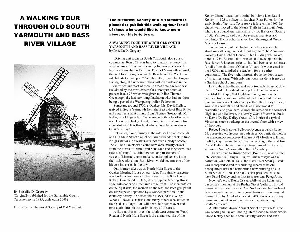
when it originated as the Ladies Library Association. This group of energetic and devoted ladies started the library in a one room shed on the Akin property at #15 Pleasant Street. After a number of moves (four), the library was finally established in the present building in 1935. Diagonally across the street is the old Bass River Savings Bank building, now the beautifully restored Cultural Center. Very active, it stands as testimony to what efforts of private citizens and Community Preservation Funds can do with the adaptive reuse of buildings. Our last stop is the Methodist Church. This structure was built in 1852 and today stands essentially the same. An early photo shows it with two front entrances, one on each side, but this was later changed. The foundation is of fitted rough stone and the clocks in the steeple still call together worshippers for Sunday service. The members can be justly proud of he fine old-fashioned New England look of their church! For the more stout-hearted walkers (or a car for those who are not), I suggest a stroll further south down Old Main Street to River Street, just past the old Bass River Community Baptist Church, built in 1826. Along the roads you are traveling lived nearly 200 or more “master mariners” in the houses you are seeing. As we turn left onto River Street from Main we are in the Lower Village or “Matthews Country” as it was called, due to the many families with that name that settled here in the 19th century. Where River and Pleasant Street meet is the Rotary. It is called the first traffic circle in America and was also used as a watering trough by residents of the Lower Village. Traveling south on River Street along the river, in a short distance you come to Willow Street. On the river side is the Judah Baker Windmill, built in 1791 and moved many times. Its origins go back to Dennis. It was restored by the Town of Yarmouth in 1999 with Preservation Funds and is on the National Register of Historic Places. Today, it stands as part of a small recreational park and is open seasonally for tours. From here one can get magnificent views of Bass River both north and south! Across the river is West Dennis Beach, a beautiful vista any time of the year.