a walk on the clouds - walk eden - home · a walk on the clouds ... other plants you will see among...
TRANSCRIPT

A Walk on The Clouds
In Fell End, Ravenstonedale, Cumbria
An introduction to their geology, naturalhistory, land use, and value for nature
conservation.
1
Advisory note:Parts of the route followed by the walk are on rough orrocky ground; elsewhere there are steep, grassy slopes,
which, when wet, can be slippery. Accordingly, stoutfootwear with a good tread on the soles is essential.
Dogs should be kept on leads to avoid frighteninggrazing sheep and ponies.
The distance covered by the main walk is about3.5km, with the Stennerskeugh Loop covering an
additional 2.0km.
The route is shown on the map.
N.B.The location of patches of limestone pavementshown on the map is not strictly accurate
Acknowledgements:I am most grateful to Dr Nigel Woodcock for much
geological information, and to Mrs Margaret Albon andSir Martin Holdgate for valuable comments on the draft
text, and Mr Trevor Clarke (Principal of the BendriggTrust) for valuable comments on the draft text and for
supplying the photographs.
If you would like to obtain a copy of this leaflet, copies are available at Fell End bunkhouse and from Cumbria Wildlife Trust (Tel: 01539 816300).
2
1. IntroductionAt the foot of Wildboar Fell, in theParish of Ravenstonedale, Cumbria,there is a prominent, rocky outcropknown as The Clouds (grid ref. NY742002). It is a striking feature with itswhite limestone crags and limestonepavements overlooking the valleybetween Wildboar to the east andHarter Fell to the West.
The name ‘Clouds’ is generally thoughtto be derived from an Anglo-Saxon rootmeaning ‘clods’ which could describethe knobbly appearance of the ground.However, it is also possible that ‘Clouds’may originate in a Celtic root related tomining activity since there are many,small mineral workings on the site,some of which may be very ancient.
Throughout the walk we shall be onCommon Land, part of RavenstonedaleCommon. The route described in thesenotes aims to give an idea of thegeology, land formation, natural historyand land use of the area.
As we go, keep a look out for birds andmammals. There may be buzzards(Buteo buteo) sailing overhead on broadwings. Their mewing calls are in sharpcontrast to the deep-throated, harsh
croaking of ravens (Corvus corax) as theytumble and play across the sky, often inpairs. Small mammals are much lesseasy to spot, but there will be fieldvoles (Microtus agrestis) scurryingthrough their hidden pathways in longergrass. Rabbits (Oryctolagus cuniculus)dash for the safety of their burrows,their white ‘scuts’ conspicuous, at thefirst hint of disturbance. Hares (Lepuseuropaeus), on the other hand, sit tight,unobserved in their grassy ‘forms’ (theironly shelter), leaping away with long-striding bounds only at the lastmoment, no white showing on theirtails. Mole hills indicate the presence ofmoles (Talpa europaea).These smallmounds comprise the excavated soilpushed up from the subterraneantunnels, which are patrolled by the mole(Talpa europaea), ready to seize anyinvertebrate which falls into a tunnel.
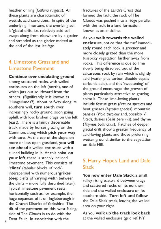
2.The Start: Fell End Quarry(grid ref. NY 734006)The A683 road (once a turnpike road)is joined close to Fell End Quarry byThe Street (The name indicating itsorigin as a Roman road.) close to theQuarry. Cars can be parked on the
3
A Walk On The Clouds
An introduction to its Geology, Natural History, Land Use, andValue for Nature Conservation

road side and approach to the Quarry.This is where the walk starts.
The rock exposed in the quarry face,and everywhere else on The Clouds, iscarboniferous limestone (Calciumcarbonate). The depth of solidlimestone underlying The Clouds can be
estimated by the height of the quarryface. However, allowance has to bemade for the old quarry floor havingbeen raised considerably when tons ofsurplus soil from the construction ofthe Appleby by-pass were dumpedthere. Carboniferous limestone is
4
composed of the calcareous shells ofminute marine animals which sank tothe bottom of what was, some 350million years ago, a tropical sea.
3. Bale Hill and the Dent FaultWalk up the left-hand (north) sideof the quarry on to Bale Hill (grid ref.NY 736005). From the top of thisrounded bank, there is a good view tonorth and south. The name, ‘Bale Hill’means ‘beacon or fire hill’, whichsuggests that it may have been used as aplace to light signal fires. A chain ofsuch fires could transmit messages overlong distances.
From Bale Hill, looking across the valleybelow, it is obvious that the generalappearance of The Clouds is verydifferent from Harter Fell opposite. Thelatter is rounded in shape and the onlyrock showing is shaley scree here andthere. This formation was laid down inmuddy seas during the Silurian Era longbefore the Carboniferous Era. How is
it, then that we see the two formationsside by side and level with one another?The answer lies in the north-southrunning valley bottom below us; it is theline of the Dent Fault. A ‘fault’ is acrack in the Earth’s crust. In this case,the fracture has allowed the Siluriansheet of rock (which extends underthe Carboniferous formation to theeast) to rise up, relative to theCarboniferous formation, along the faultline. Uplift of this part of the Earth’scrust over millions of years followingtheir sub-marine deposition left theseancient rocks far above sea level andthey have since been ground down anderoded by the glaciers of successive IceAges, producing the topography we seetoday.
The main grass species on the slopes ofBale Hill is mat grass (Nardus stricta).Other plants you will see among thegrass include mosses and sedges andmore conspicuous, a little yellow flower,tormentil (Potentilla erecta). Also,although almost grazed down out ofexistence, there are a few tiny sprigs of
5
The quarry at the start of the walk
heather or ling (Calluna vulgaris). Allthese plants are characteristic ofwettish, acid conditions. In spite of theunderlying limestone, the overlying soilis ‘glacial drift’, i.e. relatively acid soilswept along from elsewhere by a glacierand stranded as the glacier melted atthe end of the last Ice Age.
4. Limestone Grassland andLimestone PavementContinue over undulating groundamong scattered rocks, with walledenclosures on the left (north), one ofwhich juts out southward from theothers. (Significantly, it is known as‘Hungerlands’!) About halfway along itssouthern wall, turn south overincreasingly rocky ground, soon goinguphill, with low, broken crags on the left(east). There is a faintly discernabletrack, made by horses grazing on theCommon, along which pick your waywith care. At the top of the slope, onmore or less open grassland, you willsee ahead a walled enclosure with aruined building in it. At this point, onyour left, there is steeply inclinedlimestone pavement. This consists of‘clints’ (tabular blocks of rock)interspersed with numerous ‘grikes’(deep clefts of varying width betweenthe clints – more fully described later).Typical limestone pavement restshorizontally, such as, for example, thehuge expanses of it on Ingleborough inthe Craven District of Yorkshire. Thetilt of the pavement on this, west-facing,side of The Clouds is to do with theDent Fault. In association with the
fractures of the Earth’s Crust thatformed the fault, the rock of TheClouds was pushed into a ridge parallelwith the fault in a land formationknown as an anticline.
As you walk towards the walledenclosure, notice that the turf immedi-ately round each rock is greener andmore closely grazed than the moretussocky vegetation further away fromrocks. This difference is due to limeslowly being dissolved out of thecalcareous rock by rain which is slightlyacid (water plus carbon dioxide equalscarbonic acid), and this ‘sweetening’ ofthe ground encourages the growth ofplants particularly attractive to grazinganimals. These lime-loving plantsinclude fescue grass (Festuca species) andbent grasses (Agrostis species), mountainpansies (Viola tricolour and, possibly V.lutea), daisies (Bellis perennis), and thyme(Thymus politrichus). Patches of deeperglacial drift show a greater frequency ofacid-loving plants and those preferringwetter ground, similar to the vegetationon Bale Hill.
5. Harry Hope’s Land and DaleSlackYou now enter Dale Slack, a smallvalley rising eastward between cragsand scattered rocks on its northernside and the walled enclosure on itssouthern side. Turn left and followthe Dale Slack track, leaving the walledarea on your right.
As you walk up the track look backat the walled enclosure (grid ref. NY
6

738001). It is called Harry Hope’sLand, named after the last occupant ofthe rudimentary, and now ruined, house.(Please view it from the gate only). Heis said to have lived there and farmedthe land until 1820. This particular areawould have been chosen for enclosurefor its sheltered position, deep soil, andrelative freedom from rock outcrops.The walls of the patchwork of littlefields within the external boundary, nowreduced to their foundations, wouldhave been built largely from stone lyingabout, thus combining clearance of stonefrom the ground with dividing the landinto separate fields as meadows (whichwould have been mown for hay with ascythe) and pastures. The marked differ-ence between species composition andluxuriance of the vegetation within theenclosed land and the surroundingCommon is, of course, due to regulated,lighter grazing on Harry Hope’s Land ascompared with the unregulated, heaviergrazing outside. The coarse, tussockygrass, now dominating much of the levelground is tufted hair grass (Deschampsiacaespitosa). The steep ground, which
would have been pasture, has much lessdepth of soil. This means that grassescannot stifle the lower growing smallflowers which include daises, pansies,and possibly mountain pansies andthyme. Between the gate and thehouse, there is a well, optimisticallydriven into the limestone, where waterused to be hauled up in a bucket fromonly a few feet below ground level. Atthe house itself, a small lean-to, two-stallcow byre doubles as a porch to a singleroom, over which there would havebeen a wooden-floored loft for thestorage of hay. The hay would have beenforked in on to the loft through a large‘fork hole’ still to be seen in the eastwall of the house. Like the byre, the hayloft would serve two purposes – tostore hay and to insulate the ceiling ofthe room below. Just outside the gate,there are the ruined remains of a small,rectangular enclosure. This wasprobably used as a fold to hold stockotherwise grazing on the surroundingCommon, perhaps overnight or whilesome routine farming operation wasbeing carried out.
7
Harry Hope’s house looking across Dale Slack
6.The Dale Slack FaultLeaving Harry Hope’s Land behind, thetrack emerges on to a patch of levelground (Grid ref. NY 740002). Fromhere, there is a good view of the higherPennines to the north and down intoRavenstonedale to the north west. Turnright (east). Ahead of you Dale Slacknarrows between rocks and thenwidens somewhat. This point gives thefirst good view of the long, north-southorientated, craggy crests of theStennerskeugh Clouds to the left(north) and slightly setback eastward, ofthe Fell End Clouds to the right(south). This displacement is the key tothe origin of Dale Slack; it is a minorfault at a right angle to the line of theDent Fault. However, unlike the DentFault with its vertical displacement ofthe cracked Earth’s crust, the DaleSlack Fault presents a horizontaldisplacement along the crack. Hence,the crests of Stennerskeugh and FellEnd Clouds respectively have beenshifted horizontally out of alignment.
7.The Stennerskeugh CloudsLoopAt this point in Dale Slack (grid ref. NY742002) you have a choice. For arather longer walk do as suggestedin this section, or, if you prefer, gostraight to Section 8.
The Stennerskeugh Clouds Looptakes you round the crest of theStennerskeugh Clouds. Turn left(northward) up a slight bank out of
Dale Slack and follow a grassy ‘ride’between two limestone ‘scars’ (craggyground with broken limestonepavement). Between these scars, glacialdrift has been left behind by the meltingglacier and so, once again, we find theground is more acid and there is somecoarse grassland with Mat Grass.
At the northern end of theStennerskeugh Clouds, the land suddenlyplunges downward towards the enclosedland and farmstead of HighStennerskeugh (Grid ref. NY 748014).Beyond the green pattern of smallmeadows and pastures, there are largerenclosures, almost black with denseheather – also called ling. These largerenclosures are ‘allotments’, mostly datingfrom the 18th to 19th Century whenmuch common land was awarded – or‘allotted’ to individuals (who became thefreeholders) by Parliamentary Act. Thus,on allotments, grazing can be regulatedby the individual farmer concerned. Lingis a very valuable winter feed for sheepand is the staple diet of red grouse(Lagopus scoticus). Accordingly, fell sheepfarming and moor management forgrouse shooting are compatible, providedthere is give and take on both sides.Heather moor is also an importanthabitat for many forms of wildlife, frombirds to butterflies. At one time much ofthe Common Land would have had asimilar good cover of this dwarf shrub.However, in the last half century or so,excessively heavy grazing, dictated byshort term economic advantage, has allbut eliminated ling from many northernCommons, including Wildboar Fell, at thefoot of which lie The Clouds. Since ling
8

favours acid ground, it will never havebeen prevalent on The Cloudsthemselves. This lack of ling on Wildboarwill be apparent as you continue thewalk along the back (eastern side) ofthe Stennerskeugh Clouds and return toDale Slack Head (Grid ref. NY 743002).Now go down into Dale Slack andreturn to the point where theStennerskeugh Clouds Loop started. Onyour left at the top of Dale Slack, thereis a shallow trough down which waterseeps from an indeterminate source. Itis one of the very few places on TheClouds where ground water comes tothe surface; one may even disturb a snipe(Gallinago gallinago) hunting for smallsnails and other prey in the soggyground.
As an alternative to dropping down intoDale Slack (described in Section 8), youcan maintain your height and walksouth along the crest of the FellEnd Clouds from where you havemagnificent views across the LakeDistrict fells and down to theMorecambe Bay area. You can rejoin
the main route by making yourway westward down betweenrocks to the southern top cornerof Harry Hope’s Land.As you do so,you will have an almost aerial view ofthe limestone pavement amphitheatrebelow you.
8. Dale Slack to The Miners’TrackThe main walk now turns right(south) out of Dale Slack over a slightrise leading to the northern top cornerof Harry Hope’s Land. On this rise,evidence of a deposit of glacial drift isagain shown by the dominance of matgrass in the turf. Walk along outsidethe top wall of Harry Hope’s Landand examine the boulders that havefallen from the crags of the Fell EndClouds above you on your left. Much ofwhat looks like a bare rock surface is infact covered by encrusting growths oflichen. (Most of the rocks on TheClouds are similarly clad, but this is a
9
Skennerskeugh Clouds - the start of the loop
convenient place to examine them.)These remarkable organisms comprisetwo entirely different life forms – fungiand algae – living permanently in closealliance in what appear to be extremelyinhospitable conditions. Some are‘foliose’ – frilly growths, but many do notproject at all from the rock surface.They grow very slowly from a centralpoint and thus are more or less circularin shape. Lichens are abundant ongravestones, which is convenient forlichenologists because the dates on thegravestones document the length of timefrom the earliest possible colonisationdate and, hence, how long a patch oflichen has had to reach its present size.
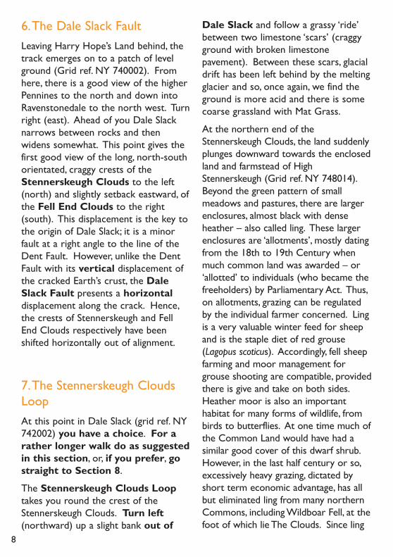
9.The Limestone PavementAt the southern top corner of HarryHope’s Land, bear somewhat leftsteeply uphill on an unpromisinglooking, boulder-strewn track. Note theamount of moss of several differentspecies growing on any shaded, andtherefore moist, rocks. This trackbecomes better defined as you continuesouthward; it is The Miners’ Track.
Following this track, soon on the left,we have the first convenient opportunityto examine limestone pavement, thebest known and most characteristicfeature of Carboniferous Limestoneexposures. Huge expanses of thisformation occur on, for example,Ingleborough, and there are substantialareas, more locally, above Orton. Thepavement consists of more or less level-topped blocks of bare rock intersectedby fissures of varying width and depth.The blocks are called ‘clints’ and thefissures are known as ‘grikes’. Thesmoothing of the rock surfaces is due toslow solution over long periods of therock surfaces by slightly acid rain, initiallyunder a cover of soil, and once erosionhad removed the soil, by direct action ofrain on the rock. The sale of this‘waterworn limestone’ for making rockgardens was devastating large areas ofpavement, but now, thankfully, it is illegalto remove it from the best sites. Turnleft off the Miners’ Track and walkalong the grassy track between thepavement and a low wall of crag on yourright. From here, you can get a goodview along some of the grikes and plantsin them. More is to be seen if you
10
The limestone pavement
venture onto the pavement itself, but ifyou do, be very careful; it is easy tolose one’s balance.
It is immediately apparent that the grikeflora is totally different from what wehave seen so far. Mosses and ferns arecommon. The larger ferns include malefern (Dryopteris felix-mas), andhartstongue (Phyllitis scolopendrium).Thesmaller ones include brittle bladder fern(Cystopteris fragilis) and green spleen-wort (Asplenium viride). Amongflowering plants are wood anemone(Anemone nemorosa), dog’s mercury(Mercurialis perenne), wood sorrel(Oxalis acetosella), barren strawberry(Potentilla sterilis) and harebell(Campanula rotundifolia). There is littlegrass, but blue moor grass (Sesleriacaerulea) - a species confined tolimestone - grows on the upper edgesof the grikes. Surely this flora suggestswoodland, or at least hedge bottoms,rather than open ground? Sure enough,there is a gnarled and closely sheep-browsed hawthorn ‘bush’ (Crataegusmonogyna) in one of the grikes. Indeed,before sheep grazing dominated theCommon,The Clouds would have beenlightly wooded with ash (Fraxinusexcelsior) and an understorey ofhawthorn, etc. This supposition issupported by the Westmorland dialect-based ‘Stennerskeugh’ – ‘Staener’ (stonyground) and skogr (wood). Thiswoodland type flora has been able topersist after the demise of the treecanopy because of the moisture-retaining shade and shelter of the grikeswhere sheep cannot graze. As always,evidence of animal life is less easy to
spot than plant life. However, if youlook along the wider grikes, you maywell see a spider’s web strung acrossthe grike from side to side. Clearly, it iswell placed to catch any insect blowninto the web by the draught funnellingalong the grike. You may also seestrikingly banded snail shells, if not snailsthemselves. Snail shells are composedof calcium carbonate which accountsfor the preference for lime-rich habitatsshown by shelled molluscs.
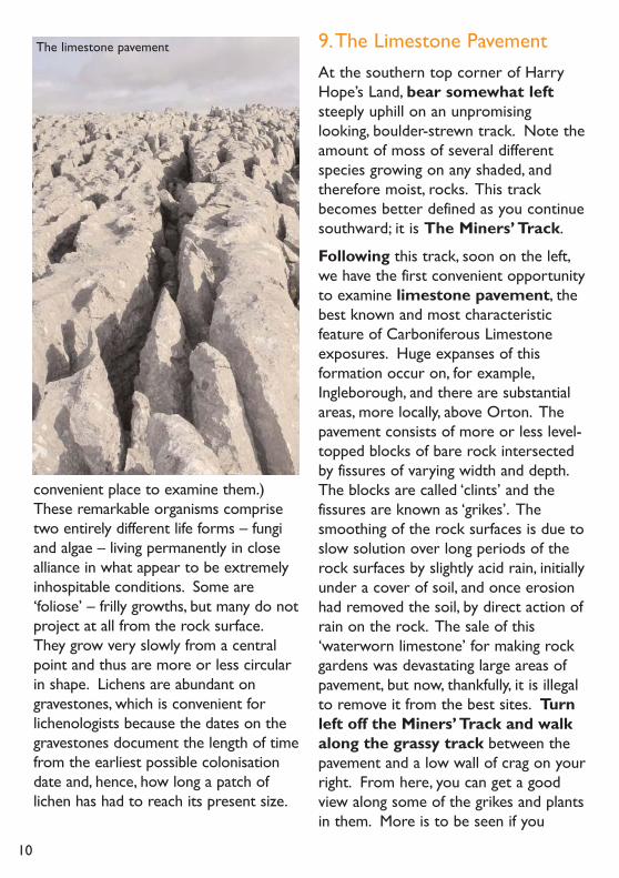
10. The Miners’ Track andMineral WorkingsReturn to the point at which youmade the diversion to see the limestonepavement and follow southward theincreasingly well-defined Miners’Track. Coming over a crest on thetrack, ahead there are several narrow,north-south orientated trenches, someseveral feet deep.These trenches areevidence of past mineral working. Thesesurface mines follow veins of variousmineral ores, which have been forced upin a hot liquid state through cracks in theEarth’s crust and then cooled into a solidstate. You will see that the rubble roundthe workings includes broken samples ofvarious minerals, quite different from theprevailing limestone. Some are muchheavier than you would expect fromtheir size; these heavy stones are barytes(a barium ore). Others, blue in colour,are malachite (a copper ore). Thecommonest mineral present is galena (alead ore) and this would have been themain product of the workings. A
11

mineralogist would probably spot other,less common, ores in this area. Lead istoxic to most plants, but here theregrows a notable exception; springsandwort (Minuartia verna) flourisheswithout competition from common andmore vigorous plants which cannottolerate the lead. The sandwort growson lead ore debris in little cushions withwhite flowers in spring.
Follow the mineral workings down towhere the exposed Limestone rockbegins to be covered thinly by highlycalcareous soil – conditions favouringblue moor grass (Sesleria caerulea) andalso carline thistle (Carlina vulgaris).Unlike other thistles, this one has nostem, the flower resting directly on theground, its strap-like golden-brown petalsradiating from the centre.An impressivelone sycamore tree has thrust its way
through some tumbled rocks, whichwould have protected it until it was tallenough to be out of reach of browsingsheep.
11.The Clouds Anticline andClouds GillAhead (to the south), there is a steep-sided gill carrying a small beck flowingfrom left to right (east to west). This isClouds Gill and it marks the southernend of the Limestone outcrop whichforms The Clouds. On the south sideof this gill, there begins an expanse ofrough vegetation sweeping up eastwardsto the long, level top of Wildboar Fell.Clearly this abrupt change fromlimestone and dry, short, turf to peaty,rough grazing across the gill must
12
The spectacular view at the startof the Miners’ Track

indicate some dramatic happening in thedistant past. What first springs to mindis another geological fault disengagingthe Carboniferous Limestone from adifferent formation beyond. However,this is not the explanation. Along itsnorth to south axis, the originally levellimestone deposit has been compressedagainst the line of the Dent Fault sothat it has buckled upwards to form thelong, north-south orientated crest ofThe Clouds. This type of ridge isknown, as already mentioned, as ananticline (as opposed to downwardbuckling, known as a syncline). Supportfor this view is seen in the tilt of theexposed rocks on the west-facing sideof The Clouds. At the southern end ofThe Clouds, the ‘snout’ of the Anticlineplunges under younger rocks on theother side of Clouds Gill, hence thesudden landscape change. Theseyounger (but still within theCarboniferous Era) rocks were laiddown as sediments by alternating risingand falling of sea level. This left coarsesand (sandstone) where there werestrong currents, muddy silts (shales) insluggish conditions, and limestone inclear, still waters, as in the case of themain limestone of the CarboniferousEra (already described in Section 2.)These repeated layers of rock areknown as the Yoredale Series. Theyaccount for the stepped sides and long,level, tops of most of the Pennine Fells,Wildboar being but one example. Theoriginal topography has, of course, beenmuch eroded and ground down bysubsequent glacial action.
12.The Return to the Start viaa Badger Sett and a Limekiln
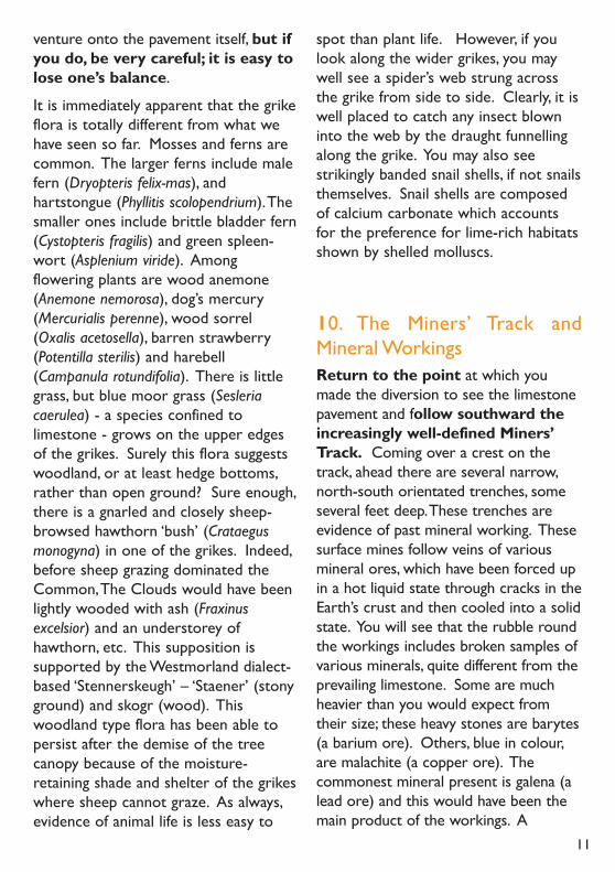
At the foot of the exposed Limestone, afaint track runs to the right (north-west), slanting across the face of the FellEnd Clouds. Follow this track downtowards, then parallel with, thewall on your left.Turn right (north)away from the wall along a stretchof level ground overlooking theroad below you. Soon you will see apatch of ground with soil scratched outfrom the entrances to large burrows.This is a badger sett (‘sett’ is abadger’s burrow) (grid ref. NY 732998).Look carefully and you may seerecently disturbed soil in the entrancesand, possibly the imprint of a badger’spaw (Meles meles). If all five toes pointforward, you can be certain it wasmade by a badger. Badgers haveincreased in numbers considerably sincelegislation protecting them wasintroduced, which is welcome, but thereare disadvantages. They prey onhedgehogs (Erinaceus europaeus), whichseem to be decreasing, and they do takepoultry and perhaps some lambs,although foxes (Vulpes vulpes) areresponsible for most of these losses.The most contentious issue, so farunresolved, is the part played bybadgers in the spread of bovinetuberculosis, especially in cattle in S.W.England.
Ahead, beyond the badger sett, there isa disused lime kiln, a tower-like stoneconstruction set into the hillside. Onthe low side there is a substantialarchway leading into a vaulted space,
13
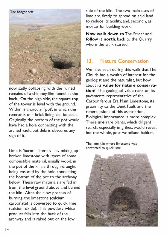
now, sadly, collapsing, with the ruinedremains of a chimney-like funnel at theback. On the high side, the square topof the tower is level with the ground.Within is a circular 'pot', in which theremnants of a brick lining can be seen.Originally, the bottom of the pot wouldhave had a hole connecting with thearched vault, but debris obscures anysign of it.
Lime is 'burnt' - literally - by mixing upbroken limestone with layers of somecombustible material, usually wood, inthe pot of the kiln, a through-draughtbeing ensured by the hole connectingthe bottom of the pot to the archwaybelow. These raw materials are fed infrom the level ground above and behindthe kiln. After the slow process ofburning, the limestone (calciumcarbonate) is converted to quick lime(calcium oxide). This powdery whiteproduct falls into the back of thearchway and is raked out on the low
side of the kiln. The two main uses oflime are, firstly, to spread on acid landto reduce its acidity, and, secondly, asmortar for building work.
Now walk down to The Street andfollow it north, back to the Quarrywhere the walk started.
13. Nature ConservationWe have seen during this walk that TheClouds has a wealth of interest for thegeologist and the naturalist, but howabout its value for nature conserva-tion? The geological value rests on itspavements, representative of theCarboniferous Era Main Limestone, itsproximity to the Dent Fault, and therepercussions of this association.Biological importance is more complex.There are rare plants, which diligentsearch, especially in grikes, would reveal,but the whole, post-woodland habitat,
14
The badger sett
The lime kiln where limestone wasconverted to quick lime
with its mosaic of lime-loving and acid-loving plant and associated animalcommunities, is more important, since itis scarce in the country as a whole andis representative of its type.
Accordingly, it is up to us to ensure itsprotection from damaging exploitationand so far as possible, to manage theland so that its wildlife (in the broadestsense) flourishes. To this end,TheClouds has been notified as a statutorySite of Special Scientific Interest.This means that development requiringplanning permission cannot be under-taken without consultation of theofficial, nature conservation body(originally The Nature Conservancy,now Natural England). Voluntarybodies, especially Cumbria WildlifeTrust, can also comment. If objectionsare strong, the matter may be referredto a public inquiry. Indeed, years ago,after a public inquiry, an application to'win' limestone on The Clouds wasrejected. Limestone, has, of course,been 'won' on The Clouds over theages - for walling stone and lime-burning. This historic use did damagethe pavement and its associated flora,but not on the scale that commercialextraction for rockery stone does.
14. ConclusionDuring this walk we have consideredthe geology of the area, its naturalhistory and ecology, conditioned as theyare by its land-holding status, past andpresent land uses, its value for natureconservation, and how all these factorsare inter-dependent.
I hope that what we have seen will haveenhanced your enjoyment of this partic-ular walk and will enable you to get themost out of any walk by approachingeach one with an enquiring spirit andcareful observation.
Helga Frankland, 2008
On behalf of Cumbria Wildlife Trust
Note: Scientific names of plants followsusage in M. Blamey, R. Fitter,A. Fitter,Wildflowers of Britain & Ireland (London,A.C. Black, ) DidbeenTrust
donatingusing Text70070 Many thanks
can. you if it aid gift also please - to 20 or £1,2,3,5,10 WILD20
account. phone mobile your this do can You Trust. the to
by appreciation your show please - Wildlife Cumbria the by produced
has This leaflet? this reading enjoy you
2003
15