a uide for teachersfiles.dnr.state.mn.us/lands_minerals/geologyhandbook.pdf · a uide for teachers...
TRANSCRIPT
L....L..LL...
I •
\,L.. L...L....
A uide for Teachers
G.B.l\lore,·Uni~'ersit" or Minnesota,
MinnesotaGeological Sun'(')St. Paul. Minnesota
Henk Dahlber;Minnesota Department or
Natural Resources.Di"ision or MineralsHibbing, Minnesota

Table of ContentsPreface ]
Introduction. . ...••••............•........... 11
The Big Picture of Minnesota Landforms I
Basic Geology; Processes, Rocks, and Geologic Time 3
ABrief Geologic History 10
Mineral Industry of Minnesota 27
Glossary 29
Acknowledgments , inside back cover

Preface
THIS BOOK WAS WRllTEN TO provide an up-to-date understanding of the geology of Minnesota to Eanh Science
teachers and others who have some background in geology. It isnot intended to stand alone, for there are already in print manygood books about rocks and other geologic phenomena in thestate. These include Minnesota's Rocks and Waters by George M.Schwartz and George A. Thiel, first published by the Universityof Minnesota Press in 1954 as well as Minnesota's Geology byRichard W. Ojakangas and Charles L. Matsch also publishedby the University of Minnesota Press in 1982. A third excellentdiscussion is Minnesota Undelfoot by Constance J. Sansomepublished by Voyager Press in 1983. Even though they are allmore than 20 years old, these books, and especially the latter,remain the best guides to many of the state's outstanding geologicfeatures.
These volumes remain useful today because the rocks at thelocalities described in them remain unchanged. However, researchover the past decade has considerably changed our understandingof the geologic processes responsible for those geologic phenomena and their place in geologic history. Consequently many of theideas held true in the 1980s are no longer believed today. Especially important have been the ideas of plate tectonics processesand the role they play in earth history.
Because much of the information developed recently is relatively new, it has not yet worked its way into the general literatureof the state. Our goal is to summarize what geologists thinktoday about how the rocks in Minnesota formed and their place ingeologic history. We believe that if the Earth Science teachers ofthe state have a better understanding of the processes responsiblefor the major geologic phenomena, they will stimulate an interestin their students in that history and an appreciation of the variednatural surroundings.
Preface

Introduction
THE MINNF.sOTA WE KNOW TODAY. with its IhOUSiJnds of lakes.
fertile farmlnnds. rolling southern hills. and roc).." northland. started its developmcnI billions of years ago when the Earthwas a new planet. Almost all aspects of our landscape-rocks. hills.valleys. ri\'ers. lakes. peat bogs. and waterfalls-attcSI to Ihm longhislory.
During those prehislOric times. the face: of Minnesota \\'cnlthrough many drastic changes. The rocks formed during this enormous span ohime in Minnesota record a comphcated history thatinvolved volcanoes. oct-an islands. mountain chains. and othergeologic conditions that were very different from the MinneSQIaof l003Y. Early Minnesota resembled the islands of modem-<1ayIndonesia for a while. latef it resembled the seashore of modern-dayCalifornia. and still later it resembled pans of the Middle East andthe rifl·zone of eastern Afric", Subsequently shallow seas submergedthe land and then retreated Lime and time ag"in, Primitive life form",appeared. then fish. reptiles, birds. and mammals. each leaving theirremains preserved in the rocks as fossils.
At time... Minnesota's climate was mild or tropical. Finally the"Creat Ice Age" came-about two million yean. ago. only yesterdayby geologic time. Great glaciers advanced and retreated acrossMinnesota. and when the last ice had finally melted. the face of thel3Ild looked very mueh 3S it does lOda}.

The Big Picture ofMinnesota Landforms
!he Pr3.iriCS"-5lands. A second conspicuous highlandcalled the Giants Range forms a more or less continuousridge-or narrow highland-nearly 100 miles long.extending from a few miles north of Grand Rapids inItasca County to beyond Birch l:aIte in easlern 51. LouisCounty and .....eslern Lake County. The ridge itself risesfrom .50 to.500 feet abo\'e the general level of the region.
,,,,
'~'CANAOIAN .:,'... HIELO', .", ..j ... ' '.j". ,
,,,,
,,,,
,,,
,,"--
Figure l-$ketch map showing the location of Mmne:sotanear tie center of the North Alnerican Craton. The aatonis that part of the North American conlinenI underlain by
rocks moe! !han 545 miIion years old. Those rocks arereferred b:J as Precambrian. Minnesota is also located nearthe soulhwestefn margin of the canatian Shield or lhal panof the craton wllere Precarrbian rocks are elCpOS8d on Ih8
Pl'esent land Slriace.
MIN....ESOT.... UES "'"EAR the geographic center ofNorth America (Figure 1). As such it contains
w source of~ great ri,'cr systems. Water floy,snorth to Hudson Bay by me Red River of the North.south to the Gulf of Mexico by the Minnesota andMississippi ri\ers. and east lO the Atlantic Ocean by the51. Louis River. Lake Superior. and !he St. LawrenceSeaway.
A large pan of the suriace of Minn~ta is Ic\·e1 orgently rolling and elevations lie between 1.000 and1.500 feci above the sea. Yel some areas haveconsidcrnble relief-the geographic term for abruptups and downs. The distribution of lhese ups anddowns along with srreams, rivers, lakes, and Otherphysical features of the landscape all taken together.make up what is called the topography of Minnesota(Figure 2).
Both lhe highest and lowest places arc in thenortheastern pan of the stale. There the surface ofLake Superior is 602 feet above sea level. but placesn fcw miles inland from the lake reach an e1evalionof ncarly 2,300 feet; of these, Eagle Mountain isthe highest place in the state with an elevation of2.301 feet. High ground also occurs in southwesternMinnesota and adjoining parts of South Dakota andIowa where the Coteau des Prairies~"Highlal\dsof

Topographically, the most rugged parts of the state arenorth of Lake Superior in Lake and Cook counties andin the southeast Corner of the state in Houston. Fillmore.and Winona counties. Some of the prominent rock ridgesalong the North Shore of Lake Superior rise abruptlyfrom 500 to 900 feet above the lake. In the southeasterncounties. relief is due to an intricate natural drainage
system. where streams and rivers have steep-walled/W'~lleys and ravines several hundred feet deep.
Other parts of Minnesota have very little reliefand have elevations considerably less than 1,000 feet.The largest and most prominent of these is in thenorthwestern part of the state where some elevations inthe Red River Lowland are only 760 feet above sea level.
Figure 2--Colored shaded relief map of elevationof Minnesota. Illumination is from the east (so thatthe north shore of Lake Superior isn't in shadow).Purple shows the lowest elevation and red shows thehighest. Source: Constructed from statewide USGSDigital Elevation Model based on USGS 7.5 minutetopographic maps.
2 The Big Picture Clf MinneSClta !.an~fClfms
Basic Geology; Processes, Rocks,and Geologic TimeTHE MAJOR UJ'LA,'''' and lowland areas of
Minnc-sota. like all land regions. are the resultof many different geological processes. Rocks areimponant because they record processes and conditionslhal exi.sted beneath landscapes long since remo\edby erosion. Rocks arc made of minerals ::and rock
frngmcnts. and minerals arc made of smaller units ofmaltcr-::tloms---thal :.Ire arranged in a regular, repetitivemanner. Geologists usc rocks :lnd l1lincra1.~ 10 n~con·
st1'llct geologic processes that once existed in the past.There arc many kinds of geologic processes. For
example. the compQsition of the rocks tells us aboutthe chemical processes that created the rocks and thenchanged them. Similarly. fossils contained in the rockslell us abol,l\ pa5( bio!ogi ...al ....llJO..l:1>!>C1> allll pa1>1 ClI\ i
rollmenls. However, for the broad picture. physical ormechanical proces~ are the most significanl.
Of the various mechanical processes. the ones mostobvious to all of us involve weathering and erosionby wind. water. and temperJture changes. Erosionconstantly attacks our land ~urface. continually making~mall rocks out of big ones and constantly moving themdown the slope of the land toward ,m ocean basin. Thedust we sec in the air, the gully fonned on the hillsidcs.thc muddy waters in the streams, and even the potholesin our strccLS. are all evidence that the land is being
weathered and erode<! away. Ero!>ion aclS to 1c\"C~lthe
surface of the globe b) eroding the highlands and fillingup the ocean basins.
Other physical pTOC'eSSCS work to m<XIify the landseape from below. These processes. that operate over amuch longer time scale, are collectively referred 10
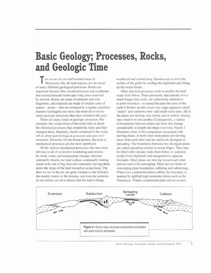
as plate teelOnies-so llamed because the crust of theearth is broken up into seven very large !>egments called"plates" and numerous mid- and small·sized ones. All ofthe plates arc moving very slowly and at widely varyingrJ.tes relative 10 onc another. Consequently. a varictyof boundaries between plates can fonn that changeconsiderJ.bly in length and shape o..er time. Figure 3illustrates some of lhe components associated", ithmoving plates. It shows that some plates are mOvingaway from each other and are said to be di\'ergent orspreading. The boundaries between t.... o di\eq;ent platesare called spreading-CClllers or ocean ridges. They maybe filled with volcanic rocks from belov. or M:dimenteroded from highlands and tl1lnsponed to adjacentlowlands. Olher plates arc moving toward each otherand are s,lid to be com'crging. Thcre arc twO kinds ofconverging plate boundarics: colliding and subducting.Where two continental plates collide, the boundary ismarked by uplifted high mountain chains such 'l!> theHim,\layas. Where a continental plate and an oceanic
ExtenSIon Subduction /..\.Spreading
Collisioncenter. . . . .".... . .~r" ~...-:,~-~./ .......,. . . ... ..-"'--::-::.---
~- - - -. . . ....., "so-........:. •• • • • •••. . .,. .....
Figure 3-Some major structural components associatedwith plate tectonic processes.
Bu;~ GcoloCJ. Proto ..... loch. _,,,I GooIOli•• l TI... 3
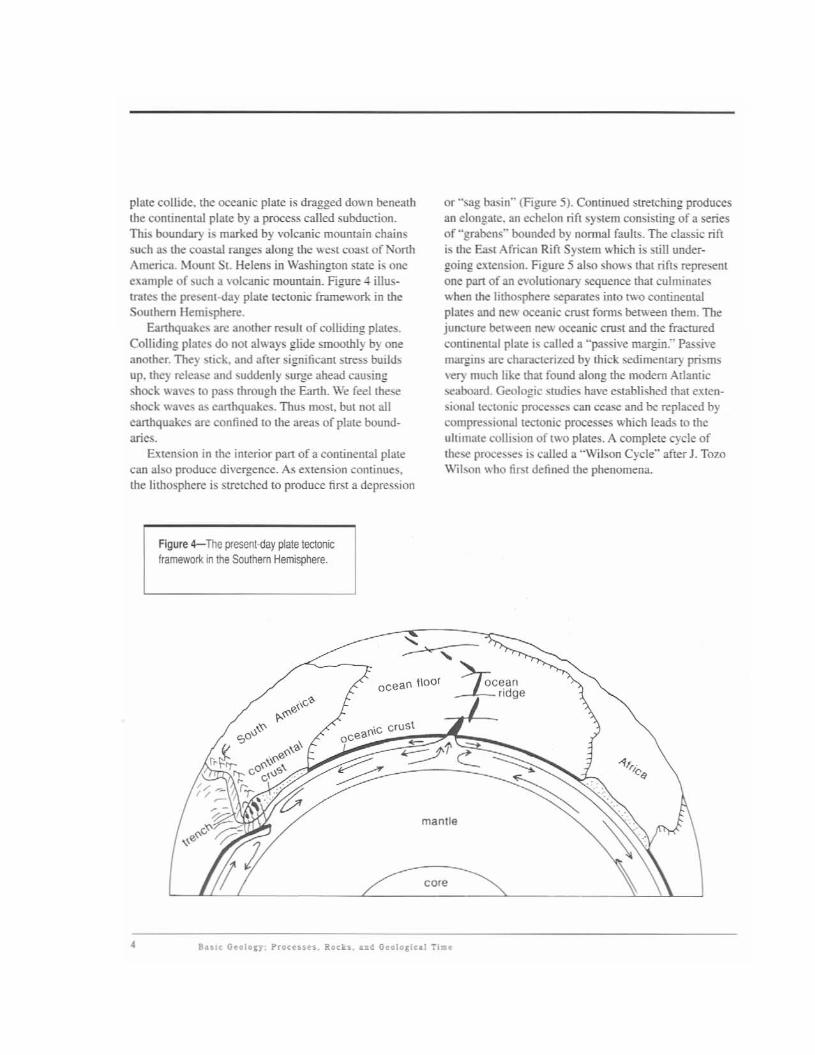
plate collide. the oceanic plale is dragged do~ n benealhIhe continental plale by a process called subduction.This boundary is marked by volcanic mountain chainssuch as the coastal ranges along me west coast of NonhAmerica. Mount St. Helens in Washington state is oneexalllple of )uch a \'olcanic mountain. Figure 4 iIluslrates the present-day plate tectonic framework in IheSouthern Hemisphere.
Eanhquakes are anolher result of colliding plates.Colliding plates do nOI always glide smoomly by oneanother. They stick, and after significant stres~ buildsup. they release and suddenly surge ahead causingshock waves 10 pass through the Eanh. We feel theseshock waves as eanhqutlkes. Thus most. but not alleanhquakes arc confined to the areas of plate boundaries.
Exten<;ion in the interior pan of a continental platecan abo produce divergence. As extension conlinues,the lithosphere is strelched to produce first a depression
FIgure 4-The present-day plate tectonictrameworl<. in the Southern Hemisphere.
or "sug basin" (Figure 5). Continued stretching producesan elongate. an echelon rift system consisting of a seriesof "grabens" bounded by nonnal faults. The classic riftis the Ea:.t African Rift System which is slill undergoing extension. Figure 5 also shows that rifts representone pan of an evolulionary sequence Ihat culminateswhen the lithosphere separates into IWO continentalplates and new oceanic cruSt fonus belween them. Thejuncture between new oceanic crust and me fraeluredcontinental plate is called a "passive margin."' PassivelIIaPdin) an: char,l.cterizcd by Ihick sedimenta!) prismsvery much like mat found along me modem Atlanticseaboard. Geologic studie.<; ha\'e eslablished Ihat eXlensionalleclonic processes can cease and be replaced byt:om~ionallectonic processes which leads to theultimale collbio" of two plates. A complete cycle ofthese proce!>~~ is called a "Wilson Cycle" after J. TomWilson who first defined the phenomena.
~ocean 1\001 ~cean
~Iidge
.. ;e;mantle
• Bu,c GeolOlr; Prot ...... Roct.... ~ Geololical Tl ••

/Pre-rilt sediments
Rift sediments
<<<-: .>>>:. :'0':V:. ;// •• : •: . : •: •: •: •: •· . . . . . . . . .,.v. . . . . . . . . .· .. .
B
c
Figure 5-A series of sketches showing howcontinental crust is transformed into a newoceanic crust by the continued applicationof extensional stresses. Note that the crust{crosshatched pattern} is thinned as stretchingis initiated.A. As extension begins, asag basin typicallydevelops and is filled with sedimentary rockseroded from the edges of the sag.B. As extension continues, the crust isultimately broken by a series of faults toproduce asedimenHilled rill basin or graben.C. Because the crust is considerably thinner,partially melted mantle material is brought tothe surface and is the source of volcanic rockstypically assodated with rifts.D. Volcanism ultimately ceases and the riftbasin is filled with sedimentary rocks derivedfrom beyond the edges of the rift system.E. Extension ulfimately causes the crust tototally fracture and separafe into two plates.Separation leads fo the development of newoceanic crust having acomposition like that ofthe upper manlle. The juncture between thenew oceanic crust and the fractured continentalplates is marned by passive margin depositsderived from the confinent.
· . . . . . .· \-\ ~· ,~.:"., .
oOcean crust
/
;Passive margin sediments.......-----'-,· ~· . . . . . . . . x'./'
E
Buic GeoIOKY; Proc ..... , Rocks, and G.oln~icol TIm. 5
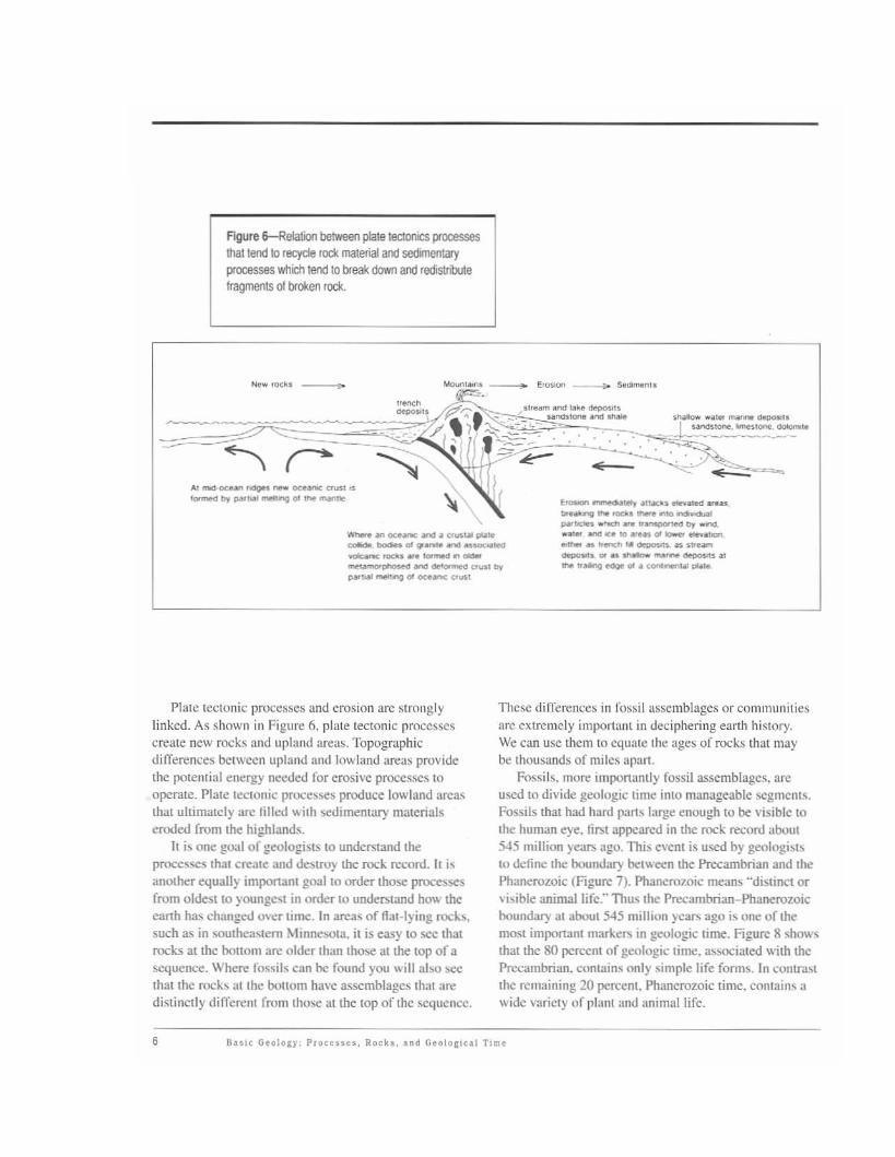
Figure 6--Relalion between plate tectonICS processesthat tend 10 recycle m material and sedimentaryprocesses which tend to break down and redistrilutefragments 01 broken rock.
-.
.... mod ocean 'odO" ..... _ UU<U. ..
...._ by~" _'"'0 (ll1IW 1Io
_ an oce..-.: ana a cruslal paM~-(IIgr--_ ......."""--_......_..~ptI<lU<I ana __ \>'''''' by
~.. -'"'0 (II oceanc aus1
r.- onmeo.~ a1tac1ls _led ....aslnal<ro;l .... __~ .....~pao- _ ,,_,.., l)J_..".. ana oc. 10 (II __lien.
_ .... I<encn 'oil _s ,rtal'lloopos.l_ .... ...- _. al1IW1<aM>Qt<!ge"' ••__
Plate tectonic processes and erosion arc stronglylinked. As shown in Figure 6, pilite tectonic proccssescreate new rocks and upland areas. TopogTllphicdifferences between upland and lowland areilS providethe pOiemial energy needed for erosivc processes (0
operale. Plate tcetonic processes produce lowland areasthat ultimately arc tilled with ~dimentary malerialseroded from the hi1!;hlands.
It is one goal of geologists to understand theprocesses Ihat creale and d~troy the rock record. It i~
another equally important goal 10 order those pRx:essesfrom oldest to yOllngc." in order 10 undeThtand how theearth has eh:lnged o\er time. In area., offlal-Iying roc"s.such as in soulheastem Minnesota. it is easy to sec thatrocks at the bollom arc older than those at the top of asequence. Where fossils can be found )'ou will abo seethat the roc"s ilt the bottom have assemblages thaI aredistinclly differenl from those at the top of thc sequcncc.
These differences in fossil assemblages or communit iesarc extrcmely important in det·iphering earth hi.~tory.
We can use them 10 equate the ages uf rocks that may~ thuusands of miles apan.
Fossils. Illore import,mtly fossil assemblages. areused to divide geologic time into manageable segments.Fossils thaI had hard pan~ large ~nough to be visible tothe human eye. fin;t appearcd in the rock record "bout545 million yeat:> ago. This event is used by geologi~1s
to define the boundary between the Precambrian and thePhanerozoic (Figure 7). Phanerozoic melln~ "distinct orvisible animallife'-· Thus the Precambrian-PhanerozoicboundaJ) at about 5-15 million years ago is one of themost important mar"en. in geologic time. Figure 8 showsthat the 80 percent of geologic time. associated with thePrecambrian. contains only simple life forms. In contr,c,tthe remaining 20 percent. Phanerozoic time. eontain~ awidc variety of plant and animal life.
6

•,•f"'''---_...J
••~SO.OOO.OOOVeiI.s ago
Archean,••
Early PfOl@lOJ'OOC
•o•,•
•
Figure 7---f1ie diagramshowing the relativeproportions 01 various timeunils in earth history.
No .ecord 01 ~t\!
FIgure &-Pie diagramshowing changes in the tossilrecord over geologic time.
Basic Geolarr; Praceuu. Racks•••4 Geala,ieal Ti.e 7

On the basis of thnt plant and animal life. thePhanerozoic hns been divided into three eras: thePaleozoic Era. the Mesozoic Era. and the CenozoicEra (Figure 9). The eras in tum are divided into sevemlperiods. or smaller intervals of time called Cambrian.Ordovician. Silurian. Devonian, elc. Ea<;h interval isdefined by its own unique fossil assemblage.'>.
At the beginning of Paleozoic tillle animals lived inshallow seas; they were simple invertebrates suchas trilobites. brachiopods. and crinoids-all animalswithout backbones. Consequently the early Paleozoicalso is known as the "Age of Invertebrates:' However,by about 500 million years ago-al the beginning ofDevonian time. vertebrates or animals with backbones.such as fish. populated the seas. and plants grew onthe land. By Ihe end of Devonian lime amphibians hadevohed, and by the end of the Permian. air-breathingrcptiles and insects were abundant. The Mesozoic Era isbener known as the "Age of the Dinosaurs:' These. andother reptiles. came in all sizes and dominated theEanh for 175 m.illion years. They became extinct about66 million years ago. long before early humans appearedon the Eanh. During the Cenozoic Era. mammalssuch as horses. camels, and elephants became imponant.and finally humans appeared approx.imately 1.8 millionyears ago.
Evidence of life is contained in rocks that are a:. oldas 3.800 million years in Greenland. However life inthe Archean and Proterozoic consists mainly of verysimple fanns such as bacteria and blue-green algae untilncar the Precambrian-Phanerozoic boundary wheremore complex fomls such as jellyfish first appear.Some of these organisms arc still living today. Becausethese fossils have simple morphologies, they can nOIbe used to subdivide the Precambrian pan of geologictime. Other methods. thereforc. havc been devised todetennine the age of rocks that lack fossils with hardpans. Figure 7 shows that the Precambrian is dividedfor convenience into two major intcrvals-Archean andProterozoic-by a time boundary at 2.500 million yearsago. 'The Proterozoic is funher divided inlO threesegmentS by time boundaries at 1.600 and 900 millionyears. Thus geologists say rocks which formed betwecnabout 4.550 million and 2,500 million years ago arcArchean in age, whereas. those that formed between2,500 million and 545 million years ago are Proterozoic
in agl:. The ages ofthc rocks in question are determinedby radioacti\'C decay schemes mcasuring the minuteamounts of cenain naturally occurring radioacli\eeleme.nts they contain. Thus. geologic lime is measuredin two ways. Geochronometric or absolute time isbased on mdioanivc decay. whereas. geochronologic orrelative time is based on fossil evidence. Correlationsbelween the twO ways arc constantly changing a.~ newdata occur, but presently held beliefs arc summari7.cdalong the left side of Figure 9.
8

Age Geologic Time Units Rocks in Minnesota Events in Minnesota Characteristic Life
Several intervals ofcontinental glaciation
No record in Minnesota
Peat.moraines, outwash,glacial lake sediments
Tertiary
Quaternary".2''0No c:c: Ql
Ql "O~
1,6-
1----0+--,------,----+--------t----------1-------=:::--1
~Age of Mammals
Sea enters Minnesota
from the south and west
Sea enters Minnesotafrom the south
Sea enters Minnesota
from the west
No record in Minnesota
No record In Minnesota
Sandstone, shale,glauconitic sandstone;some dolomite
Limestone and dolomite
Chalk, dark shale.varicolored clay,sandstone, conglomerate
Silurian
Devonian
Cambrian
Cretaceous
Mississippian
Pennsylvanian
~~"'~ )1'
f-------+---L-im-e-s-'o-n-e-,-d-o-Io-m-'-'e-'--.-------------1 .c~ ~ Corals~Ordovician some sandstone and Seas cover Minnesota ~
shale at intervals ! Cephalopods
~ Trilobites ~~
Animals with hard parts
'" '"Ql c:ro·~ ~.
f-------f------------,,.------------j D :Q ~~li~ E~<{
" ,....-~'0No c:Ql Ql«i '0Cl. c:~
".2'oN Ql0'0'" u~E
66-
545-1--
410-
435-
138-
500-
360
205-
~\C" Dinosaurs
,--_J_u_r_a_s_s_iC__+-__R_e_d_'C_O_lo_,_e_d_s_a_n_d_S_'O_n_e_,--,__H_;9_h_l_an_d_C_"_'_b_Y
--1 Age of RePtile~,- shale, gypsum west-flowing streams
Triassic No record in Minnesota
() Plesiosaurs240- 0 f---+-----+-------------------+--"'------'-==::::..=..j
N ~ ~'Permian .-o U
290- a: ~wZ<{
330- ICl.
oQ)
'"~
'"Ql>-
-0
'"c:
~E
Animals without hard parts
~Midcontinent rift system
Penokean orogen
Greenstone belts
Lava flows, gabbroand sandstone
Iron-formationVolcanic rocks,graywacke, granite
PrecambrianProterozoic
andArchean First record of life
,,~ 6"- 4,550-'----.L....-----'---------L----------'------'--'---------'
Figure 9--General stratigraphic column for
Phanerozoic time emphasizing the geologic record inMinnesota,
Basic Geology: Processes, Rocks, and Geological Time 9

ABrief GeologicHistory
IN MINNGSOTA. the bcdrock---or the solid rock
mass th::ll lies:11 or below the land surface-is the record of a geologic hislory that extends fromthe middle part of Archeml time to Ihe later pan ofCretaceous lime. The rock record. however, is interrupted by large gaps of time called unconfonnitics whenapparemly no rocks fOfmed or when rocks that fonnedduring an earlier lime were laler eroded.
Pre-Phancrozoic or Precambrian rocks underlie all ofMinnesOla and comprise pan of whal is called theNonh Amcric:m Cr.uon (Figure I). Except on the north.adjacenllo Canada. the Precambrian rocks arc overlapped by scdimcmary rocks of Phanerozoic age. whichconstitute a thin cover of relatively undiSlurbed rock:.that thicken to the west, soulh. and east. That part of thecrdlon where Precambrian rocks are eXl>Osed is calledthe Canadian Shield (Figure I).
Although Precambrian roch occur throughoutmuch of Minnesota. they ;Ire covered by a mantIc ofQuaternary debris except in relatively few places.Consequemly, 10 make a bedrock geologic map requireslIsing techniques involving geologic mapping. drill corelogging, and geophysical interpretation. An exampleof geophysical data used is illustrated in Figure 10.Combined ~eological and geophysical interpret:lIiorlsshow thai the Precambrian rocks can be divided intofive broad subdivisions. or telT:J.nes. Ofthosc.two areArchean. two arc Early Proterozoic, and one is MiddleProterozoic in age.
10 A Bri~t OoolociG ttistory
In somhcastern and northwestern Minnesota. thePrecambrian rocks are overlain by sedimentary rocksthat arc early Paleozoic in age. In the western third ofMinnesota. the Paleo7.0ic and Precambrian rocks arepartly covered by rocks of Mesozoic age (Figure I I). Inthe following descriptions of Archean, Early Proterozoic.Middle Proterowic, and Phanerozoic rocks. referenceshould be. made also to Figure II.
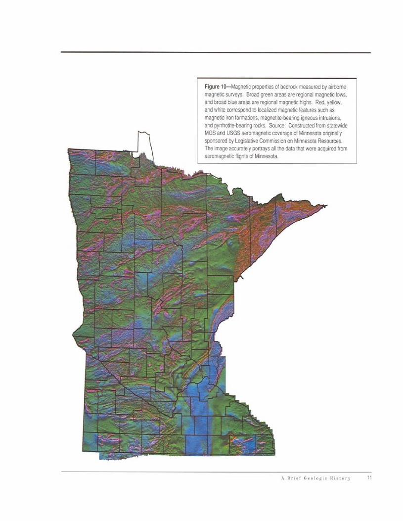
Figure lG-Magrle:JC prope~1eS of bedtod< measured by airbornem8(pellC $ur.eys Broad green areas are reglO/1al ~netK: lows,arld broad blue areas are regiooal magnetic higlls, Red. yelklw,arld whJte oorreSjX)lld 10 kIca'zed magJ1etlc featlJres st!Ch asmagneliC iron formations. magnetite·bearing iglleOUS intrusions,aod pyrthotite·beartng rocts. SourC<1: ConstlOCled hom stafewideMGS and USGS aero~oetiC CO'Je1"age 01 Minnesota OIigiilallysponsored by Legislative Commission on Minnesola Resources.The >mage aceurat€1y portrays al the data IIlaI were acqui'ed IromaeromagnetiC flights of MlI1l'leSOla,

H;l1/>..p fool,
o 6ll,',,,I ' ," io .~
co,uta"no~OfMIIHJmS
."'"""" ) I.,....."" ,
.~
)J.~c_..~::;::"" }, !• ~!.'- ,I• _._..
"-.MilI<U<,!; j--...~ I• •
Figure l1-Bedrock geOOgK: map c4 t..Iinneso:a, nils map portrays 11leinferrlld distr'bJtion ol rock types at the beGrock su~ace. 10 northeaslemand soul1leas:em t..I M€SOla and a lew olher places (5* FiglJle 21) tllebedrock os exposed a! land SlJ'laces, EIsewhe<e the bedroci may be asmIlCh as aoo loot be40w t1le land surtace.
G<~..'ao:k<. sihstoDt. shale
I__ ~""',,,,,,--Qw<u 0«11<1<. ..__
~;do...ro<_rtd~...
~ "'" ''''"""""""'"',""",,,, ""'" of~ .,..,]oti<
"'~""""""''''---_.S<Mt..... uon>to-r>:h ""_,F"""""", "Xl> of ...r" ., r,ba:;«JIIlP"!,_~,~
""'" "'" d<o'>.ou,,< lIT"!...._.o-t.o/.lol>po<Io<_,~"
"'" """ hiV-lOod< """"""'" ""'"
DESCRlPT!O:>! OF ~\AP Ul'ilTS
• I_,,<"""'of~1""'"0< __"""'-
!!!l
••••••
ShaIe ....__
.,.....l,," ""'IU"" otmn<E.""",,< rncl..of~"",r",_1,""",,< """ of dominon<I)""ro<<<lmIX"""""
••••••••
Archean RocksArchean rocks include an older, middle to late
Archean gneiss terrane in southwestern Minnesota and amuch younger, late Archean greenstone-granite terrane
in northern Minnesota. Both terranes contain largevolumes of igneous and metamorphic rocks. TheArchean gneiss terrane---colored orange on
Figure II-is best exposed along the MinnesotaRiver Valley at Morton, Redwood Falls, Sacred Heart,and Ortonville. It also is exposed at a few places inSteams, Mille Lacs, and Pine counties. The rocksare different kinds of gneiss-pronounced "nice"-afamily of coarse-grained, banded metamorphic rocks.The origin of gneiss is not easily related to commonexperience. They formed miles below the surface ofa craton between 3,600 and 3,000 million years ago.The gneisses were folded and faulted several timesand intruded at depth by large volumes of granite andrelated igneous rocks--{;olored red on Figure I I~at3,000 million years and again at 2,600 million yearsago. Upper parts of the resulting craton were strippedaway by erosional processes, ultimately exposing theonce deeply buried rocks.
Components of the gneiss terrane are about600 million years older than the Archean rocks innorthern Minnesota. As such, the outcrops alongthe Minnesota River Valley contain the oldest rockin Minnesota as well as some of the oldest rocks inthe Canadian Shield. Archean gneiss and granite arequarried for dimension stone at several localities alongthe Minnesota River Valley including the quarry atMorton where the world-famous "rainbow granite" isworked.
In northern Minnesota, younger Archean rocksare built of: (I) greenstone belts of relatively lowmetamorphic grade,-dark green on Figure 11separated by large plutons of granite and other relatedcoarse-grained igneous rocks;-red on Figure II-and(2) metasedimentary belts which typically containstrongly deformed units of migmatite as well as a largeproportion of granite-pink on Figure II.
According to recent hypotheses that have beendeveloped mainly in Canada, the greenstone belts areisland arcs that represent assemblages of metavolcanicand related rocks. In contrast the metasedimentary beltsare the remains of bodies of sediments formed betweentwo island arcs or between an island arc and a craton.The greenstone and metasedimentary belts were mergedby compressive tectonic processes similar to' thoseoccurring along the western margin of the Pacific Oceantoday. Consequently, the several belts in Minnesota aretypically bounded by regional strike-slip (shear) faults.Radiometric ages imply that individual greenstone beltsformed between 2,700 and 2,750 million years but fusedtogether to form a large craton at 2,670 to 2,710 millionyears ago.
A Brief Geologic History 13

The hypothetical evolution of a single greenstonebelt is illustrated in Figure 12. It is based on the ideasthat greenstone belts in northern Minnesota are similarto parts of subduction zone-related volcanic islandsthat now make up Indonesia or Japan in the westernPacific Ocean. As such, they are made up of basalt.a dark greenish gray, fine-grained igneous rock thalformed from magma that flowed out onto a sea floor
(Figure 12 A). During times when volcanic activilYwas minimal, silica and iron-rich minerals such ashematite (an iron oxide), siderite (an iron carbonate),or pyrite (an iron sulfide) accumulated on the seafloor to fornl bodies of what we call "iron-formation"(Figure 12 A). In places on the sea floor volcaniccenters composed mainly of dacite, a white to lightgray volcanic rock, fornled by explosive volcan'ic
. . .Dacite + + +• •
s
..... - " ,
Iron-formation
Sedimentary rocks consistingmostly of eroded dacitic material
.. ti .
,,
o
c
B
Figure 12-Schematic depic·tion showing the evolution ofan Archean greenstone belt innorthern Minnesota.A. Deposition started with theaccumulation of basalt andiron·formation generally belowsea level. A felsic volcaniccenter consisting mostly ofdacite accumulated to aheightabove the wave base. Erosionsupplied felsic volcanic detritus(rock tragments) to a deposi·tional basin formed on top ofthe mafic rocks.B. Southward·directedcompression produces adepositional basin bordered onthe north by upthrust blocks 01basalt that contributed detritusto the depositional basin form·ing graywacke.C. Compression continuesand sedimentation ceases asuplifted blocks of basalt werethrust over sedimentary deposits.D. The last event in the evolution of this greenstone belt involves theemplacement of large granite batholiths and folding of all the rocks aboutvertical fold axes.
A-~~-~~---~-- ShaleBasalt
N
14 A Brief Geologic History

~-- --- A"""' .. D• ...,--
"'<'S'''''on '"'"'}<+
C""......on '""II"----.-1
,~ ..
.. ~ '1· ... ·.
Figure 13-Gcocrolizcd =:;cction through the Penoke8florogen showing how it can be divided into an older fold-and·thrust be~ 10 tile south and a younger foredeep basin to thenorth.
processes. Dacilic volcanism typically lead to islandsthat grew to near sea Ic\'el where they could be subjectedto erosi\t: processes. Sandstone. consisting mostly oferoded dacite fragments and interbedded shale wen::deposited as fringes surrounding the \olcanic centen;(Figure 12 A). Volcanism and associated sedimentation"ere interrupted by comprcssionallcctonic proces~
involving the uplift of previou~[y funned rocks alongthrust fauhs to positions well above ~ea 18\'el. As aconsequence. well-defined hasins formed and rer.:t:ivcd
thick accumulations of detritus from both basaltic anddacitic sources (Figure 12 (3). Continued compressionand thrust faulting terminated ~dimemation and in manyC~ re-folded already complexly folded <;edimentaryaccumulations into large o\'erturned folds (Figure 12 C).TO'A'ard Ihe end of Archean time the folded and faultedrocks were intruded by large batholiths of gr.tnite that:.houldered aside the rocks by refolding Ihem about nearvertical axes (Figure 12 D). Subsequent erosion removedmuch of the folded material to expose alternating belts ofgranite and greenSlOne.
Rock:. of the green.stone bells are particularly wellexposed in the western p:trt of the Boundary WatersCanoc Area and in the Vermilion Iron Range betweenTower-Soudan and Ely. Thc laller contain:. impres:.ive exposures of iron·fornlation. especially at SoudanUnderground Mine State Park.
Early Proterozoic RocksEarly Proter01.Oic rocks in east-central and northern
Minnesota form p3rt of wh:n is called the Penoleanorogen. a mountain-building e\,cnlmat culminatedaround 1.85 billion years ago. These rocks are pan of amuch larger fealUre that extended from the centml partof South Dakota to Lake Huron and perhaps farther tothe cast. The eroded remnant:; of the Penokean orogenhave geologic similaritie:. 10 the roots of modem mountain belts along the west coa~t of North Americll. andgeologbts infer that moulllai ns comparable to th01>e inwe~tem California existed long ago in MinnesOla.
TIIC Penokean orogen can be divided into IWO distinctbelts of ditlercnt age and geologic history (Fi1!ure 13).An older fold-and-thrust belt defines the soUlhern :.ideof Ihe orogen..... hereas Ihe foredeep basin. called theAnimij.;ie basin defines lhe nonhern half of the orogen.The fold·and-mrust bclt--colored dart grey on FigureII-i:. poorly exposed in the general \lcinit) of Denhamto Moose Lake in Carlton County southwesl of Duluthand include~ the Cu)una Iron Range. It consists of avariety of mctasedimentary rocks Ihm were depositedthrough time successively as extensional proccssesstretched th~ Arch~an basement rocks through sag andritt stages to ultimately produce a passive margin. NewlXeanic crust. including an island arc formed well 10 thesouth In what is now Iowa. Sedimentary rocl~. including

N
A
Sandstone/siltstone
Sandstone/siltstone/shale
Mafic volcanic rocks
Iron-formationLimestone and dolomite
s
Figure 14 A-E-Schematic depiction ot theevolution of Early Proterozoic rocks in thePenokean orogen.A. Archean crust is extended to producea small basin filled with various kinds ofsedimentary and volcanic rocks.B. Continued extension leads to an enlargedrift basin segmented in places into smallerbasins.C. Ultimately the Archean basementis thinned leading to passive marginsedimentation. At this time new oceanic crustformed outboard of the passive margin.D. Extensional tectonic forces are replacedby compressional tectonic forces, causing thedevelopment of avolcanic arc to the south.E. As compression continues, the arc movestoward the cratons and south-dipping thrustfaults are formed. The upper plates of thesefaults were thrust to the norlh over theArchean basement. This fold-and-thrust beltformed the southern margin of the Animikiebasin.
Shale
./.
~VOlcaniCarc-related
rocks. .'
.. :~:'::::::: •. ':::.<;/'.,., ....
Turbiditicsandstone/shale
Oceanic crust
o
l.......----..-Animikie basin-----.l Fold-and-thrust belt
Northwardtransport
J Zone 01northward-directedthrust -faulting
I ',
16 A Brief Geologic History

iron·fonnation. were derived from northern sources(Figure 14 A B. C). Ultimalely the tectonic regim~
changed from that of extension to that of compre.~sion.As the newly fanncd ocean closed upon ilself and thevolcanic arc moved toward the craton (Figure 14 D).the passive margin deposits were folded and faulted upand over the older Archcan basement on large thrustfault:. (Figure 14 E). Thc up-faulted rocks fonned ahighland that bordered a :.edimentary basin---callcd aforedeep-located to thc nonh. Sediments in this basin""ere derived from bolh nonhem and SOUthern sources.This became the repository for a younger group ofrock---colored light gray on Figure II~now e~po:.ed
along the Mesabi Iron Range in nonhern Minnesota andncar Cloquet and Thomson in Carlton County southwestof Duluth. The Carlton County exposures include mostlygraywacke and shale, but iron-fomlation and underlyingquanzite---collcctivcly colored red-brown on Figurell~are exposed on the Mesabi Iron Rangc.
In addition to being complexly defonned andmetamorphosed. the oldcr fold-and-thrust belt is
Figure 15-Sketch shOwingthe braided stream system thatdeposited sediments of the Sioux
Ouartzite. The stream systemsate contained in two lault
bounded vaDeys or grabenorienfed in anorthwestertylireeoon and separated
by a horsl The shaded ateaswithin the main channels are barSand islands thaI are separaledby sub-ehannels within!he mainchannels. At limes of h;gh water,the main channels are floodedfrom bank to bank and the islandsare eroded away. As the waterreceded. new bars and islandsformed and are covered with thindeposits or clay.
penneated by large bodies of granite-colored purple onFigure ll--emplaced between 1.820 and 1.770 millionyears ago. In contrast. the foredeep deposits are relatively undisturbed except for regional tilling :Ind localfaulting.
In southwestcrn MinnesOia. lhe Sioux Qu;lnzite~
colored dark yellow on Figure II-tonns a second EarlyProterozoic Icrrane. It consists mostly of a quanz areniteth:lt accumulated as sand-size malerial that wa:. carriedby rivers Rowing through a series of small. nonh\\esttrending. fauh~bordered rift basins set into Archean rocks.Two such basins separated by a small horst are illustratedin Figure 15. A well.<fefined erosional surface involvingmillions of years of erosion separates the Archean rocksfrom the Sioux Quanzile. Latcr. mctamorphism recrystallized thc sandstone imo lhe hard quartzite seen todayin the bluffs of Bluc Mounds Slate Park. Thin beds ofreddish-brown mudslone (cmlinitc or pipestonc) in lhequartzite at Pipestone National MOllument are still beingquarried and carved today. following a custum thatstaned as early as A.D. 900-1200.
A B.,.I Geolo~i( Hiuorr 17
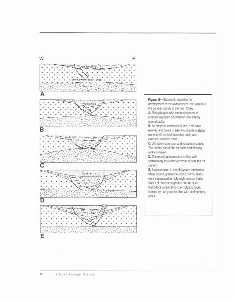
w E
.. - •,:;seciiments·~ • : ••••- ••
•
: <\;~.~ ' ..:'.. ....pre·KeWeenilWan clusl
••
AFlgure 16-$chemabC depiction lordevelopment of !he Midcontinent Rift System i1the general YionIty 01 the Twil Cities.A. RifMg begins with the development 01a broad sag basin boooded on one side bynormal fau!ts.B. As the O'USI conlu".JeS to thin, a ritI basilevolves and grows in size. Hoi mantle malerialworks 10 fia the fault.()ounded basin withextrusive volcanic rocks.C. Ultimately extension and volcanism cease.The central pan of the rift basin and flankingrodl.s collapse,O. The resulting depression is filled withsedimentary rOCks derived from outside the riftsystem.E. Sedimentation in the rift system terminateswhen original graben·bounding normal faultswere transposed to high·angle fel/erse faults.ROCks 01 the central graben are thrust upto produce acentral horst of volcanic rocksflanked by half-grabens filled with sedimentaryrOCks.
•
•
•••
•
•
••
••
:"SedlmenIS • •.-:......
~.- ...., · • • •~ 4"";" • • • •'- • .- ••_".0· .~ .. . . • •....~. • • • •• • • • • • • •
•
..... .. .. .. ..
- •....:.... "-.:....L .:-.
•
••
.l.- .~. _" -:-"-ro ..L- • •~ ..." '.• • " • ...0...-. • • • • •• • •• ' ••""':".~W • • •
• • • 0-.1.' •
• •••
• •• •
0• • ." .,...., ~
• • • ~ •• • • • • •
•• • • •• • • • • •
• • •
c• • -• • •• • •• • •• • •• • • • • •
E
" A Brltl G.oloci. Hiuor,
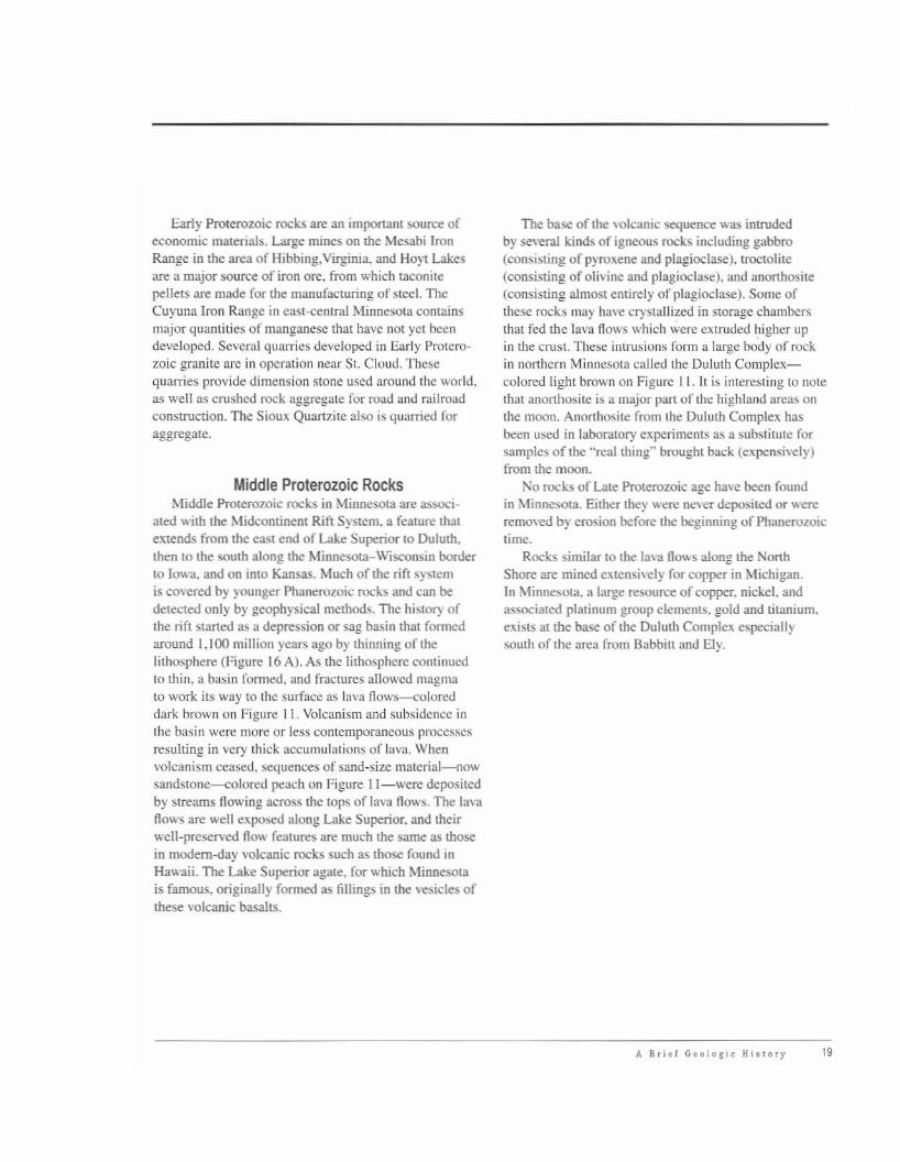
Early Proterozoic rocks are an imponant source ofeconomic materials. Large mines on me Mesabi IronRange in the area of Hibbing,Virginia, and Hoyt Lakesare a major source of iron ore. from which taconitepellets are made for the manufacturing of steel. TheCuyuna Iron R:mge in east-centrJ.1 Minnesota containsmajor quantities of manganese that have not yet beendeveloped. Several quarries developed in Early Proterozoic granite are in operation ncar Sl. Cloud. Thesequarries provide dimension stone used around the world,as well as cnlshed rock aggregate for road and railroadconstruction. Thc Sioult Quartzite also is quarried foraggregate.
Middle Prolerozoic RocksMiddle Pro((~ro7..0ic rocks in Minnesota are a::.sod
ated wim the Midcontinent Rift System. a feature thatelttends from the east end of Lake Superior to Duluth.then to the south along the MinneS013.-Wisconsin borderto Iowa, and on into Kansas. Much of the rift sySlemis co\'ered by younger Phanerozoic rocks and can bedetected only by geophysical methods. The history ofthe rift slarted as a depression or sag basin that formedaround 1.100 million years ago by thinning of thelithosphere (Figure 16 A). As the lithosphere continuedto thin. a basin fonned, and fractures allowed magmato work its way to the surface as lava !lows--coloreddark brown on Figure II. Volcanism and subsidence inthe basin were more or less contemporaneous processesresulting in very thick accumulations of lav:l. Whenvolcanism ce:lsed, sequences of sand-size matcrial-nowsand~(Qne--coloredpe:lch on Figure II-were depositedby streams flowing across the lOpS of lava !lows. The lavaflows are well eltposed along Lake Superior. and theirwell-preserved flow features are much me same as thosein modem-day volcanic rocks such as those found inHawaii. The Lake Superior agate. for which Minnesotais famous. originally fomled as fillings in the vesicles ofthese volcanic basalts.
The ba...e of the volcanic sequence was intrudedby ge\'eral kinds of igncous rocks including gabbro(consisting of pyroxene and plagioclase). troctolite(consisting of olivine and plagioclase), and anorthosite(consisting almost entirely of plagioclase). Some ofthese rocks nmy have crystallized in storage chambersthat fed the lava flows which were extruded higher upin the crust. The~e illlrusions form a large body of rockin nOlthcrn Minnesota called the Duluth Complcxcolored light brown on Figure I I. It is interesting to notethat anorthosite is a major part of the highland are3S onthe moon. Anorthosite from the Duluth Complelt hasbeen used in laboratory experiments as a substitute forsamples of the "real thins" brought back (cltpcnsi\"c1y)from the moon.
No rocks of Late Proterozoic age have been foundin Minnesota. Either they were never depositcd or wcreremO\'ed by erosion before the beginning of Phanerozoictime.
Rocks similar to the lava flows along the NorthShore are mined extensh'CIy for copper in Michigan,In Minnesota, a large resouree of copper. nickel. andassociated platinum group elements. gold and titanium.exists at the base of the Duluth Complelt especiallySOUlh of (he ;)rea from Dabbitt and Ely.
It. \lriel Geolo~ic HlIlory 19

Phanerozoic RocksThe Phanerozoic spans the nexl eon of earth history.
During thai 545 million years of geologic lime, Minne~sola was part of a stable continent that was inundated byseveral advances, called "transgressions," and retreats.called "regressions:' of the oceans. TIlOse advances andretreats are illustrated in Figure 17. During Cambriantime. a continent of wCflthcrcd rock (Figure 17 A) wasgradually covered by shallow seas from the northwestand the southeast (Figure 17 B). This transgressionphase continued through Late Cambrian lime. Quanzrich sandstone interlaycrcd with thin beds of shale weredeposited in near shore areas, while chemiclIlly precipitated limestone and dolomite were also deposited inoffshore areas. The sea withdrew or regressed at the endof Cambrian time (Figure 17 C). but again readvanced inEarly Ordovician time. During that readvancc (Figurc 17D-F), the sea transgressed over more and more land sothat by Late Ordovician time the sea ulTimately coveredmuch of Minnesota including a northeast-trendinglandmass called the Transcontinental Arch. The arch wasfringed by shaly deposits. but as it was submerged, theclastic rocks were replaced by limestone and dolomitc.The sea withdrew from Minnesota mainly to the westtoward the end of Lute Ordovician time (Figure 17 G).Consequently, much of Minnesota was exposed toerosive processes that removed considerable amounts ofthese earlier deposited sediments. The sea readvancedduring Middle Devonian time. depositing dominantlyshallow-water limeslOne and dolomitic limestone.(Figure 17 H). The sea retreated again. this time 10 thewest of Minnesota during the interval between MiddleDevonian and Middle 1urassic times (Figure 17 I).During Late Jurassic time. a sea again readvanced to thecast. but the only 1urassic rocks in Minnesota are streamdeposits along the boundary with North Dakota (Figure171). During that time, Minnesota was subjected tointense tropical weathering, 3n event that extended wellinto Cretaceous time. Thick bycrs of kaolin cby weredeveloped that are very much like laterite and bauxitedeposits fonned in modern tropic3! regions. The seacontinued to udvance from the west to the cast 3nd inLate Cretaceous times coastal and shallow marine sediments were deposited over much of western Minnesota(Figure 17 K). Channels of west-flowing streams werefilled with mixtures of shale, organic·rich day, and
20 A Briel Geologic Hi >lOry
lignite. As the sea continued to progress from the wCSt to
the east, the Stream deposits were progressively covcredby youngcr deposits of marine sandstone, siltstone, andshale.
Much of Minnesota \\las once covered by Cretaceousrocks. but significant quanrities \\Iere eroded prior toQuaternary time. Consequently. the Cretaceous rocksnow occur as an erosionally dissected patchy blanke,tin southwestern Minnesota. and 3S small outliersor remnants in other parts of the state. An outlier ofCrctaccous rock at the Hill Annex Mine. 011 the MesabiIron Range in nOl1hern Minncsot3. is noted for its fossilsinduding the shells of squid-like ammonites and sharkteeth.
In general. the erosional proccsscs that removedCretaceous strala also removed variable amounts of thepre-Cretaceous bascmcnt. Much of the erosion occurredprior to the onset of glaciation in Quatcrnary timc. Theresulting distribution of eroded preglacial highlands andlowlands had a profound cffcct 011 the distribution ofvarious ice lobes that covered Minnesota in Pleistocenetimc.

Figure 17A-K
Pre-Late Cambrian time.
D
Early Ordovician lime.
Very Late Ordovician lime \0 Early MiddleDevonian time.
Late Cambrian time.
E
Middle Ordovician time.
H
Middle Devonian time.
Very Late Cambrian lime to very EanyOrdovician time.
F
Late Ordoviciarl time.
Late Devonial1 time to Ear1y Jurassic lime.
J
Middle Jurassic lime.
K
Late Cretaceous time.
o
Figure 17A-K-Generalizedpaleogeographic maps throughvarious intervals of Phanerozoictime.
~.::~;J Persistent land
D Persistent water
A Brid G~ologic History 21

KeewatinDome
EB
Laurentide
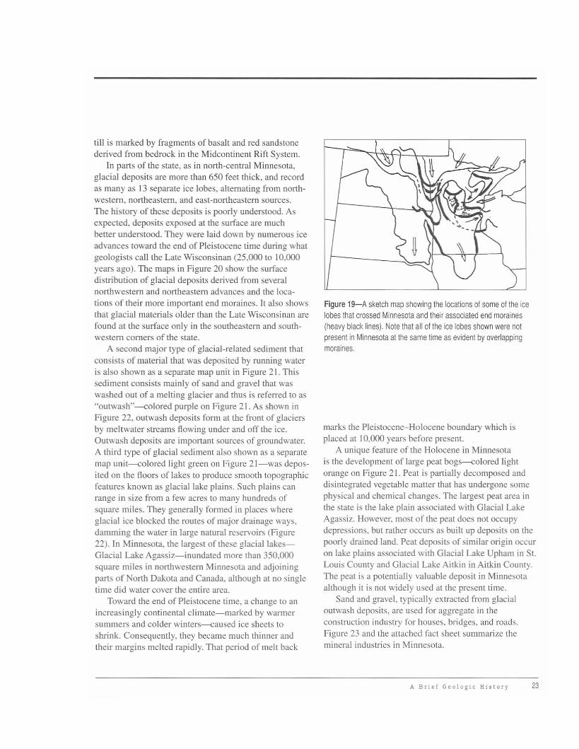
The locations of the more prominent end moraines inMinnesota are shown on Figure 19.
The composition of the glacial sediments depositedin Minnesota is indicative of the type of bed material inthe flow path of the ice lobes. The most common kind ofglacial deposit is called till-material deposited by andbeneath the ice that is generally a mixture of clay, sand,gravel, and boulders. Lobes that entered Minnesota fromthe Keewatin Dome to the north and northwest depositedtill that contain equal amounts of carbonates (derivedfrom Paleozoic bedrock) and igneous and metamorphicrocks (derived from Archean bedrock), and abundantshale fragments (derived from Cretaceous bedrock). Incontrast, till deposited by lobes that entered Minnesotafrom the Labradorean Dome to the northeast containpredominantly igneous and metamorphic rock fragments of Precambrian parentage, variable amounts ofcarbonate, and few, if any, shale fragments. One Labradorean lobe entered Minnesota from the northeast alongthe axis of the Lake Superior basin and the resulting
Approximate maximumextent of LateWisconsinan glaciers
CordilleranEBDome
Figure 18-Distribution01 Late Wisconsinanice and the positionsof various ice domes inCanada and Greenland.
Quaternary GeologyThe tenn Quaternary refers to the last 5 million
years of geologic time. Geologists subdivide it into thePleistocene or the "Great Ice Age," when nearly all ofMinnesota was covered by glacial ice, and the Holoceneor Recent, a time since the end of the Great Ice Age.
In Pleistocene time, glacial ice that flowed south intoMinnesota came from an ice sheet that covered much ofCanada (Figure 18). In some places that ice was morethan a mile thick. Glacial ice was much thicker in areaswhere precipitation was heavy and the climate cold. Theareas of thicker ice are called ice domes or ice centers.
Ice in the domes flowed in response to the pressureand gravity on thick masses of ice. The direction ormovement was away from the ice centers. Ice streamsor ice lobes advanced southward from the Keewatin andLabradorean Domes. As climatic conditions waxed andwaned over time, the strength of the flow away fromthose ice centers also changed over time. Thus, as the icelobes flowed south, they battled one another for spaceas their masses and relative veloci-ties changed. When a milder climateand other factors reduced the thickness of glacial ice, a lobe ceased toflow and it stagnated and ultimatelymelted back to a more northern location. Places where the ice stoppedand stagnated are marked by endmoraines or complicated landformshaving a rugged topography andnumerous small lakes and swamps.
22 A Brief Geologic History
till is marked by fragments of basalt and red sandstonederived from bedrock in the Midcontinent Rift System.
[n parts of the state, as in north-central Minnesota,glacial deposits are more than 650 feet thick, and recordas many as 13 separate ice lobes, alternating from northwestern, northeastern. and east-northeastern sources.The history of these deposits is poorly understood. Asexpected, deposits exposed at the surface are muchbener understood. They were laid down by numerous iceadvances toward the end of Pleistocene time during whatgeologists call the Late Wisconsinan (25,000 to 10.000years ago). The maps in Figure 20 show the surfacedistribution of glacial deposits derived from severalnorthwestern and northeastern advances and the locations of their more impOltant end moraines. It also showsthat glacial materials older than the Late Wisconsinan arefound at the surface only in the southeastern and southwestern corners of the state.
A second major type of glacial-related sediment thatconsists of material that was deposited by running wateris also shown as a separate map unit in Figure 21. Thissediment consists mainly of sand and gravel that waswashed out of a melting glacier and thus is referred to as"outwash"--<oolored purple on Figure 2 [. As shown inFigure 22, outwash deposits fonn at the front of glaciersby meltwater streams flowing under and off the ice.Outwash deposits are impoltant sources of groundwater.A third type of glacial sediment also shown as a separatemap unit--<oolored light green on Figure 21-was deposited on the floors of lakes to produce smooth topographicfeatures known as glacial lake plains. Such plains canrange in size from a few acres to many hundreds ofsquare miles. They generally formed in places whereglacial ice blocked the routes of major drainage ways.damming the water in large natural reservoirs (Figure22). In Minnesota. the largest of these glacial lakesGlacial Lake Agassiz-inundated more than 350.000square miles in northwestern Minnesota and adjoiningparts of North Dakota and Canada, although at no singletime did water cover the entire area.
Toward the end of Pleistocene time. a change to anincreasingly continental climate-marked by warmersummers and colder winters--<oaused ice sheets toshrink. Consequently, they became much thinner andtheir margins melted rapidly. That period of melt back
Figure 19-A sketch map showing the locations of some of the icelobes that crossed Minnesota and their associated end moraines(heavy black lines). Note that all of the ice lobes shown were notpresent in Minnesota at the same time as evident by overlappingmoraines.
marks the Pleistocene-Holocene boundary which isplaced at 10,000 years before present.
A unique feature of the Holocene in Minnesotais the development of large peat bogs--<oolored lightorange on Figure 21. Peat is paltially decomposed anddisintegrated vegetable matter that has undergone somephysical and chemical changes. The largest peat area inthe state is the lake plain associated with Glacial LakeAgassiz. However, most of the peat does not occupydepressions. but rather occurs as built up deposits on thepoorly drained land. Peat deposits of similar origin occuron lake plains associated with Glacial Lake Upham in St.Louis County and Glacial Lake Aitkin in Aitkin County.The peat is a potentially valuable deposit in Minnesotaalthough it is not widely used at the present time.
Sand and gravel, typically extracted from glacialoutwash deposits, are used for aggregate in theconstruction industry for houses, bridges, and roads.Figure 23 and the attached fact sheet summarize themineral industries in Minnesota.
A Brief Geologic History 23

A
o
24
Figure 20 A-H
B
E
H
F
Figure 2(l-Summary diagram showingthe several ice advances and theirassociated end moraines that affectedMinnesota in Late Wisconsinan time.Ice advances are arranged from oldest(A) to youngest (H). It is assumed thateach advance is separated from thenext advance by aperiod when the iceretreated to aposition beyond the stateboundaries.
A Brief Geologic History

HOLOCENE
.~,
O"poi;\> A"<d,,,.d wi1l1 d>e W.~"" lob<
Tin of!he IIa". rnoroi""
..flU"!",,, ,,1<>.. ,..1<.. mot,i"e
L=:J Ou""..h.
001""'" """d.ltd _ the $up'rio< lol>t
.. Til of"'" N><k.""" mora ...._
T1"of ..... CIoq~'.ndM~ l.cd'll9h1.1nd ""'"i"",
c=J TilI"f .... SLCroi:<mor.,"".
c=J OUfW.,h
Oep<>lil> A' ,<><ialtd V¥l,;, lhe R."'~ lobe_
TI.oI ..... V"mtilO>n.f>dN••h""uk mor.ine'
11II Til 01 the StCrol. mot.ine
c=J Dutw•• k
CORRELATION OF MAP UNITS
DE SCR IPflON OF MAP UNITS
o 60mi
I 'i I' i !
o 80 km
Old til
.. n1loftheP .... ClfymoJ.I""
.. Till of the B"nt< mo,.,,,,,.
c=J Outw.,h.
c=J Glad.,lak. Hdimenl5
"penc=:J Alluv,um.M"ft.,e~POl;u
"CoAuVim"<
Oep<><in A"o<ia"'d WItt> the 0 •• Me.... ' LGbe.
..TinoftME"kmemorolr>e.
CJI Tiliolthe8;gS"'""mor.1ne
~ Uoftt>e(u.......ndL...:I Suga, HiR. mor.i"",
QUATERNARY GEOLOGYOF MINNESOTA
Figure 21-This simplified geologic map shows the general distribution ofsurficial sediments in Minnesota. During the Pleistocene Epoch (2 miliion-l0,OOOyears ago), glaciers advanced into Minnesota several times from differentdirections-the most recent include: the Superior lobe from the northeast; theRainy lobe from the north-northeast; the Wadena lobe from the north; and theDes Moines lobe from the northwest. This map is modified from Hobbs, H.C.,and Goebel. J.E., 1982, Geologic map of Minnesota, Quaternary Geology: MGSState Map Series S-l, 1:500,000. Digital compilation by B.A. Lusardi.
A Brief Geologic HiHory 25

oIde< topography
~
della
1(:8 margin~'~'''''--C::::'~~~'"-,.
/'
/
/'/'
'----'~.'?pol'r..!..<!9
e···.·
/
--
Figure 22-5kelct1 diagramIIustraling the evolution of themore important glacial depositsand landforms. The twer diagramilustraies cond"rtions as they mayhave been jus! alter an ice kbeceased 10 actvance. The lOwerciagram shows the landscape thatresulted after that ice lobe hadmelted back 10 aposition outsidethe fimits of the diagram.
2fl A Brit! Geololic HlItery

Mineral Industry of Minnesota
This map does not indude construction sand andgravel or mineral exploration.
/ IRON BEARING FORMATION
Quarrying• Dimensional Granite• Dimensional Limestone
Crushed Stone
Mining• Iron Ore & Taconite
• Clay• Horticultural Peat• Industrial Silica Sand
Figure 23-Mineral industry of Minnesota map and fact sheetexplaining where particular geologic materials are found ormined, what they are used for, and other related facts.
. ..
•
Copyright 2004, State ot Minnesota, Department of Natural Resources. May be reproduced for educational purposes.
Mineral Industry of Minnesota 27

Mineral Industry of Minnesota Fact Sheet
MN Ore Operations-Keewatin Taconite Keewatin, MN
Industrial Minerals• Clay is a loose and extremely fine-grained soft rock. Some of
ifs uses include tiles, bricks, and porcelain. The higher gradekaolin clay is used to add the gloss to paper. Companiesare currently exploring Minnesota for the higher grade kaolinclay; the principal source in the U.S. is Georgia.
• Silica sand has a high percentage of silica (quartz). It is a rawmaterial for glass and is asource of silicon. Deposits of verywell rounded and sorted silica sand grains found in the southeastern part of the state are used in oil drilling to improve theflow of oil to the well.
• Granite and limestone are rocks used in the construction ofhomes, buildings, and roads. When granite and limestone
Iron OrefTaconite• Minnesota leads the nation in the production of iron ore/taco
nite. About 75 percent of the nation's production is fromMinnesota. (Most of the remaining production is from Michigan.) In 2006, 39 million tons of pellets were shipped from thestate.
• Iron ore is probably the single most important nonfuel mineral.Almost all of the higher grade natural iron ore has been minedfrom Minnesota. Taconite, which is a low-grade iron ore, ismined, crushed, and treated to increase its iron content. Limestone is frequently added. The powdery iron ore concentrate isthen processed into hard, marble-sized pellets and shipped tosteel mills. The pellets are melted in blast furnaces and thenblown with oxygen to make steel.
• Minnesota's tirst century of iron ore mining has taken placeon the Cuyuna, Mesabi, and Vermilion iron ranges, and inFillmore County. As of 2007, Minnesota iron ore mining is onlyoccurring on the Mesabi Range.
• There are six taconite plants operating in Minnesota:
Mining Company
Hibbing Taconite Company
Mittal Steel USA-Minorca Mine
Northshore Mining Company
Minnesota Ore Operations-Minntac
United Taconite LLC
Plant Location
Hibbing, MN
Virginia, MN
Silver Bay, MN
Mt.lron, MN
Eveleth, MN
are shaped into blocks and shipped from aquarry, they arereferred to as dimension stone.
• Sand and gravel found in outwash deposits everywhere inthe state are used for construction of homes, buildings, androads.
Peat• Peat is organic matter formed by the partial decomposition
of plant material under saturated conditions. Peat formationoccurs only in environments such as bogs and fens, wherethe rate of production of organic material exceeds the rateof decomposition. The peat mined in Minnesota is primarilyused in the horticulture industry, although it is also beingused as compost, turkey litter, oil sorbent, and in the removalof base metals from mine seepage.
Impacts of Mining• Minnesota's mining industries directly employ about 7,700
people. The taconite industry alone contributes over $1 billion annually to the state's economy. Over 1,280 Minnesotacompanies, which are located in the Twin Cities, Duluth, andthe mining areas, supply the taconite industry.
• Recycling is an important part of the minerals industry. The"minimills" use scrap iron to produce steel in electric arcfurnaces. Although the amounts of recycling are increasing,mining will continue to be needed due to increased demand,limitations of collection, and impurities in the products available for recycling.
• Environmental protection and compliance with environmentallaws are apart of any mining operation. Before there isany new metallic minerals (base or precious metal) mine inMinnesota, there would be an environmental impact statement. This environmental review covers environmental andsocioeconomic impacts and alternatives to reduce impacts.The environmental review process invites public participationand comment.
• Statewide reclamation laws govern any metallic mineralsoperation in Minnesota. Before opening amine, the companymust specify design and operation standards necessary forthe protection of human health and the environment and aplan to restore the land after mining is completed. Monetaryguarantees, to ensure mine site cleanup and reclamation, arerequired for all metallic minerals mines.
28 Mineral Industry of Minnesota

Glossary of TermsAgate-Lake Superior agate: Rounded
masses of translucent, cryptocrystallinequartz characterized by individual bandshaving shades of white, gray-orange,brown, or red. Formed in vesicles developed in the tops of lava flow exposedalong the shores of Lake Superior butwidely distributed in glacial depositsderived from eroded lava flows.
Aggregate: Crushed rock, sand, and gravel,used to mix with cement or bituminousmaterial or for other special constructionand manufacturing uses.
Anorthosite: Light-colored, medium- tocoarse-grained igneous rock formed atdepth and composed mostly of plagioclase.
Anticline: Ageologic structure, a fold convexupward whose core contains stratigraphically older rocks.
Asthenosphere: The zone in the earthdirectly beneath the lithosphere from 70to 200 km below the surface. The material of the asthenosphere is believed to besoft and yielding to plastic flow.
Atom: The smallest part of an element thatcan exist alone.
Augite: Acommon green, brown, or blackmineral of the clino-pyroxene family withthe general formula (Ca, Na) (Mg, Fe, AI)(Sip,).
Basalt: Adark-colored, fine-grained igneousrock commonly found in lava flows. Basaltcontains calcic plagioclase and pyroxene(commonlyaugife).
Batholith: Amass of igneous rocks> 100km' in surface exposure and composedpredominantly of granite or other plutonicrocks.
Bauxite: Amixture ot various aluminumoxides and hydroxides commonly found
as residual clay deposits in fropicaland subtropical regions. The principalcommercial source ot aluminum.
Biotite: "Black mica: An important rockforming ferromagnesian silicate having asheetlike structure.
Callinite (Pipestone): Aspecial namegiven to red mudstone quarried atPipestone National Monument. Catliniteused to produce pipes and other objectsby American Indians is commonly calledpipestone.
Chert: Chemical sedimentary rock,consisting predominantly of cryptocrystalline to very fine-grained silica (SiO,).
Clastic: Refers to rocks consisting ofbroken fragments of older rocks.
Conglomerate: Aclastic sedimentaryrock consisting of rounded water-wornpebbles cemented together.
Continental crust: The type of crust underlying the continents including continentalshelves composed predominantly ofgranite and related igneous rocks. Onaverage it is about 35 km thick, butmaximum thicknesses of 60 km arefound beneath mountain ranges.
Convergent plates: Two tectonic platescharacterized by movement towardeach other.
Craton: Astable relatively immobile area ofthe earth's crust lhat forms the nuclearmass of acontinent.
Crust: The outermost layer, or shell, otthe earth. The earth's crust is generallydefined as that part of the earth abovethe Mohorovicic discontinuity.
Crystal structure: Orderly arrangement ofatoms in a crystal.
Dacite: A light-colored, fine-grained, igneousrock commonly found in lava flows orfragmental bodies formed by explosivevolcanic processes. Dacite containssodic plagioclase, hornblende, and somequartz.
Detritus: Acollective term for fragmentalmineral and rock material (e.g., sand, silt,clay) produced by physical weathering ormechanical erosion.
Dimension stone: Building stone that isquarried and prepared as regularlyshaped blocks according to specifications.
Dip: The maximum inclination of strata orother planar features to the horizontal.
Divergent plates: Two tectonic platescharacterized by movement away fromeach other.
Dolomite: Achemically-precipitated,sedimentary rock consisting chiefly ofcalciullHT1agnesium carbonate.
Drift: An old term for glacial deposits andespecially boulder tills. The term wasderived from the belief that boulder tillswere deposited by drifting icebergs.
Earthquake: A series at elastic waves propagated in the earth, initiated where stressalong a fault exceeds the elastic limitof the rock so that a sudden movementoccurs along the fault.
Element: Asubstance that consists of atomsof only one kind.
End moraine: Aridge of till that accumulatesat the terminal margin of a glacier.
En echelon: Geologic features that have astaggered or overlapping arrangement.Strikes of the features individually areoblique to that of the feature as awhole.
Glossary 29

Epiclaslic rocks: Asedimentary rock inwhich the fragments are derived byweathering and erosion.
Erosion: Mechanical processes involvingchanges in wind, water, and temperaturethat reduce rocks to smaller sizes andflatten topographic reliet.
Fault: A fracture or break along which therehas been displacement of the two sidesrelative to one another.
Feldspar: An abundant rock-forming mineralof the general formula (K, Na, Cal Al(AI, Si),O, composed of compounds ofsilicates 01 calcium, sodium, and potassium. The main types are orthoclase andmicrocline (potassium aluminum silicate)and the plagioclases albite (sodiumaluminum silicate) and labradorite(calcium aluminum silicate).
Fluvial deposit: Asedimentary depositconsisting of material transported and laiddown by a stream or river.
Fotd: Abend of rock strata or bedding planesreSUlting from tectonic deformation.
Fossil: The remains of plants or animalspreserved in the earth's crust by naturalmeans.
Gabbro: Afamily of generally dark-colored,medium- to coarse-grained igneous rocksformed at depth and consisting mostly ofpyroxene and calcic plagioclase.
Gneiss: Acoarse-grained metamorphic rock,mainly granitic in composition, with layersof granular minerals alternating withlayers of platy minerals. Some gneissesare marked by alfernating light- and darkcolored layers, respectively rich in quartzand feldspar and in dark minerals such asbiotite and hornblende.
Graben: Adepressed segment of the earth'scrust bounded on at least two sides byfaults.
Granite: Afamily of generally light-colored,medium- to coarse-grained, igneousrocks, formed at depth and consisting
30 Glossary
mostly of quartz and orthoclase ormicrocline and albitic plagioclase, apotassic/sodic feldspar.
Granitoid: Granitelike in composition.
Graywacke: A loosely defined term referringto adark sandstone or grit with angularfragments of quartz, feldspar and darkcolored rock, and mineral grains in amore fine-grained 'clay" matrix.
Greenstone: An old, but commonly usedfield term for a dark, fine-grained, basicigneous rock affected by low-grademetamorphism.
Grit: Acoarse sandstone. Asedimentaryrock consisting of grains 0.5 to 1.0 mm indiameter derived by mechanical erosionfrom pre-existing rocks.
Ground moraine: Glacial deposits that coveran area formerly occupied by a glacier.They typically produce a landscape oflow, gently rolling hills.
Hematite: Amineral consisting of ferric ironand oxygen (Fe,o,).
Hornblende: Amember of the amphibolefamily of minerals commonly found asdark-colored crystals in igneous andmetamorphic rocks with the generalformula (Ca, Na), (Mg, Fe), (AI, Fe, Ti)(AI, Si), 022 (0, OH),
Hypabyssal rocks: Igneous rocks formed atintermediate depths beneath the earth'ssurtace. They generally occur as tabularshaped bodies that cuf across strata(dikes) or are parallel with strata (sills).
Ice Dome: Local parts of an ice sheet wherethe ice is especially thick.
fee lobe: Arestricted flow of ice away froman ice sheet.
Ice sheet: Athick exfensive body of glacialice that is not confined to valleys.
Igneous rock: Arock formed by solidificationfrom a molten or partly molten state.
Intrusion: Abody of igneous material thatinvades older rock.
Iron-formation: Achemically-precipitated,sedimentary rock consisting of silica andmore than 15 percent total iron.
Island arcs: Achain of volcanic islands.Islands arcs are generally convex towardfhe open sea.
Isotope: One of two or more, radioactivelystable or unstable, atomic species of achemical element, namely, a speciesof an element having the same numberof protons in the nucleus but having adifferent number of neufrons.
Kaolin clay: A fine, usually white, clayconsisting mostly of alumina and silica.
K-feldspar: Ageneral term for the threediflerent structural types (microcline,orthoclase, and sanidine) of potassiumfeldspar.
Laterite: Asoil that is rich in oxides at ironand aluminum formed by deep weathering in tropical and subtropical areas.
Lava: Magma that reaches the earth'ssurtace. Synonymous with extrusive rock.
Limestone: Achemically-precipitated, sedimentary rock consisting chiefly of calciumcarbonate.
Lithosphere: The relatively rigid, outer zoneof the earth including the continentalcrust, the oceanic crust, and the upperpart of the mantle.
Magma: Molten rock generated within thelithosphere or subjacent mantle; theparent of all hypabyssal and plutonicrocks.
Mafic rock: Ageneral term for an igneousrock mostly composed of dark-coloredminerals.
Mantle: The zone at the earth's interiorbetween the base of the crust and thecore.
Metamorphic rock: Arock formed by the

actions ot heat and pressure. The alteration of an earlier formed rock generally bythe formation of new minerals, but withoutthe occurrence of melting.
Mica: A mineral group composed of phyllosilicates (i.e., silicates with sheetlikesubstrucfures) with the general formula,(K, Na, Cal (Mg, Fe, AI),,, (AI, Si), 0"(OH, F),.
Migmatite: Mixed rock, composed of twodistinct components-a darker and olderof metamorphic materials and a lighterand younger of igneous or igneouslooking materials.
Mineral: Naturally-occurring, inorganic, crystalline solid whose physical and chemicalproperties vary within established limits.
Mohorovicic discontinuity: The boundarysurtace that separates the earth's crustfrom the subjacent mantle; its depthvaries from about 5-15 km beneaththe ocean floor to about 30 to 50 kmbelow the continents or as much as 70km beneath some mountain ranges.Commonly referred to as the Moho.
Mudstone: Asedimentary rock consistingmostly of clay-size grains that lack lamination or layering.
Muscovite: 'White mica." An importantrock-forming mineral thaf has a sheetlikestructure. Apredominantly potassiumaluminum silicate.
Normal fault: Asteeply dipping fault wherethe displacement of sfrata is downwardon fhe fault plane.
Oceanic crust: The type of crusf that underlies the ocean basin. It is about 5 km thickand composed predominantly of basalt.
Outwash: Stratified sediment washed outfrom a glacier by meltwater streams anddeposited in front of an end moraine.
Passive margin: A lithospheric plate marginwhere crust is neither created nordestroyed.
Pillow basalt: Igneous, extrusive volcanicrock, solidified in a subaqueous environment to form discontinuous pillow-shapedmasses generally 30 to 60 em across.
Pluton: Adeep-seated, igneous intrusiverock mass.
Plutonic rock: An igneous rock formed deepbeneath the earth's surtace.
Pyroxene: Afamily of ignecus and metamorphic minerals having the general formula(Ca, Na, Mg, Fe) (Mg, Fe, AI) (Si, AI),06' Acommon pyroxene is the mineralaugite.
Quartz: The commonest naturally-occurringvariety of silica (silicon dioxide). Quartz isan essential component of many igneousand metamorphic rocks and sand grainsare commonly fragments of the mineral.
Quartzite: Either ametamorphic rock inwhich the quartz grains of a sandstonehave recrystallized under heat andpressure to form an interlocking mass(metaquart-zife) or a quartz-rich sandstone that has been cemenfed by silica(orthoquartzife).
Regression: Converse of transgression. Achange thaf shifts the boundary betweenmarine and non-marine deposition or theboundary between marine deposition anderosion inward toward the center ot adepositional basin. The gradual emergence ot land due to the withdrawal ofseawater.
Relief: Changes in the elevations of a landsurtace. Abrupt changes in relief are mostnotable.
Reverse fault: Asteeply dipping fault wherethe displacement of strata is upward onthe fault plane.
Rift system: Asystem of elongate, faultbounded basins having a en echelonarrangement and resulting lrom extension. Synonymous with graben.
Rock: An aggregate of minerals that formsan appreciable part of the lithosphere.
Sag basin: Abroad, shallow depression inwhich sedimentary material can accumulate.
Sandstone: Asedimentary rock consistingof sand-size (1116-2 mm) grains derivedby mechanical erosion from pre-existingrocks.
Schist: Medium- to coarse-grained metamorphic rock with a strong foliation definedby the preferred direction of orientedmineral grains such as biotite, muscovite,and hornblende, making up 50 percent ormore of the rock.
Sedimentary rocks: Aclass of rocks lorrnedeither by the weathering, erosion, anddeposition of earlier formed rocks or bychemical precipitation.
Shale: A laminated, sedimentary rockconsisting mostly of clay-size grains.
Siderite: Amineral consisting of ferrous ironand the carbonate radical (FeCO,).
Spreading ridge: Suboceanic zone wheremagma rises between two crustal platesas they separate.
Strike-slip fault: Asteeply-dipping faultwhere the displacement of strata isparallel to the fault plane. Synonymouswith sheer fault.
Subduction zone: Zone where one crustalplate overrides another plate along aconvergent margin.
Superposition: The assumption that in asequence of undisturbed sedimentarylayers, the ones lying above are successively younger than those lying below.The concept is generally referred to asthe Law of Superposition.
Syncline: Ageologic structure. A fold convexdownward whose core contains straligraphically younger rocks.
Glossary 31

Taconite: low-grade iron-formation (FeGFep~ aboul17-30 percent) of whichmagnetite is mechanicaly separatedand conceotrated. The ore is COOlmonlyfused into marble-size spheres generalyreferred to as tacon~e pellets.
Tectonic: A term pertaining to the torcesinvolved in, or the resuliing structuresof teatures produced by the motion ofcolliding plates,
Terrane: A faulled·bounded segment ot theearth's crust thaI has unique rocks andstructures thai serve to Ostinglish it tromadjoining terranes.
Thrust fault: Low-angle, reverse faull aIoogwhich there !\as been aSltlstantial<::orlYflOOElll1 ot horilontaI~t
Till: Unsorted and oostratified glacial--Topographic: Refers 10 the ronliguration ofthe earth's surface incfuding its relief andthe placement 01 natural and man·madefeatures.
Transgression: My change that shifts theboundary between marine and nonmarine deposits or the boundary betweendeposition and erosion outward fromthe center of adepositional basin. Theencroachment 01 large landmasses byseas.
Troctolite: Afamily of dark-eolored, mediumto coarseilrained, igneous rock formedat depth ar>:l composed mostly 010_and plagioclase.
Unconformity: Adiscontinuity i'I the succession of rodts containing agap in thegeologic record. ASlI1ace 01 erosioo or
"""""""'-Vesicles: $mal holes Iormed i'I avolcanic
rock by gas bOObIes thai became !tawedas the lava solidified.
Volcanic arc: Acurved bah ot volcanoesabove aSlI':Jduction zone where crustalplates cooverge.
32 G1Quary
Volcanic rocks: Magma and as.sociatedgases transferred Irom the earth's interiorto the surlace.

AcknowledgmentsThe following sources were consulted for illustrations.
Figure 1-Modified from Figure 1of Morey, G.B., 1976, The basis foracontinental drilling program in Minnesota: Minnesota GeologicalSurvey Information Circular 11, 25 p. Figure 1.
Figure 3-Modified from unnumbered cover illustration for "GeofluidsBrochure," Department of Geology and Geophysics, University ofMinnesota, 6p.
Figure 5-Modified from Figure 7 of Morey, G.B., and Southwick,01., 1995, Allostratigraphic relationships of Early Proterozoiciron-formations in the Lake Superior region, Economic Geology,v. 90, and Figure 8 of Cannon, W.F. and others, 1989, The NorthAmerican Midcontinent rift beneath Lake Superior from GLlMPCEseismic reflection profiling: Tectonics, v. 8, p. 305-332.
Figure 9-Modified from frontispiece of Tufford, S., and Hogberg,R., 1965, Guide to Fossil collecting in Minnesota: MinnesotaGeological Survey, Educational Series 1,30 p.
Figure 1o--Modified from Chandler, V.w., 1991, Shaded-reliefaeromagnetic map of Minnesota: Minnesota Geological SurveyState Map Series, Map S-18.
Figure 11-Modified from McSwiggen, P.L., and Morey, G.B., 1993,Geologic map of Minnesota, digital version: Minnesota GeologicalSurvey Open-file Map 93-1.
Figure 12-Modified from Figure 8 of Jirsa, M.A., Southwick, D.L.,and Boerboom, T.J., 1992, Structural evolution of Archeanrocks in the western Wawa subprovince, Minnesota: refolding ofprecleavage nappes during O
2transpression: Canadian Journal of
Earth Science, v. 25, p. 2146-2155.
Figure 14-Modified from Figure 7 of Morey, G.B., and Southwick,D.L., 1995, Allostratigraphic relationships of Early Proterozoiciron-formations in the Lake Superior region: Economic Geology,v.90.
Figure 15-Modified from Figures 10 and 11 of Morey, G.B.,1984, Sedimentology of the Sioux Quartzite in the Fulda basin,Pipestone County, southwestern Minnesota, in Southwick, D.L.,ed., Shorter contributions to the geology of the Sioux Quartzite(Early Proterozoic), southwestern Minnesota: MinnesotaGeological Survey Report of Investigations 32, p. 59-74.
Figure 1&-Modified from Figure 8 of Cannon, W.F., and others,1989, The North American Midcontinent rift beneath LakeSuperior from GLIMPCE seismic reflection profiling: Tectonics, v.8, p. 305-332.
Figure 17-Modified from avariety of sources including Witzke, B.J.,1990, Palaeoclimatic constraints for Palaeozoic palaeolatitudesof Laurentia and Euramerica, in McKerrow, W.S., and Scotese,
C.R., eds. Palaeozoic palaeogeography and biogeo-graphy:Geological Society Memoir 12, p. 57-73.
Figure 18-Modified from Figure 1of Harris, K.L., 1995, Quaternarygeology-southern Red River Valley: Minnesota GeologicalSurvey Regional Hydrogeologic Assessment, RHA-3, Part A,Plate 1, Surticial geologic map.
Figure 19-Modified from Figure 3 of Harris, K.L., 1995, Quaternarygeology-southern Red River Valley: Minnesota GeologicalSurvey Regional Hydrogeologic Assessment, RHA-3, Part A,Plate 1, Surticial geologic map.
Figure 2o--Modified from Figures 3 through 10 of Lehr, J.D., andHobbs, H.C., 1992, Glacial geology of the Laurentian dividearea, Sf. Louis and Lake Counties, Minnesofa: MinnesotaGeological Survey Guidebook Series No. 18, 73 p.
Figure 22-Modified from Figure 10 of Bluenele, J.P., 1977,The face of North Dakota-the geologic story: North DakotaGeological Survey Educafional Series 11, 73 p.
