a symposium on continental drift || evidence of crustal drift from icelandic geology
TRANSCRIPT
Evidence of Crustal Drift from Icelandic GeologyAuthor(s): G. P. L. WalkerSource: Philosophical Transactions of the Royal Society of London. Series A, Mathematical andPhysical Sciences, Vol. 258, No. 1088, A Symposium on Continental Drift (Oct. 28, 1965), pp.199-204Published by: The Royal SocietyStable URL: http://www.jstor.org/stable/73345 .
Accessed: 08/05/2014 04:55
Your use of the JSTOR archive indicates your acceptance of the Terms & Conditions of Use, available at .http://www.jstor.org/page/info/about/policies/terms.jsp
.JSTOR is a not-for-profit service that helps scholars, researchers, and students discover, use, and build upon a wide range ofcontent in a trusted digital archive. We use information technology and tools to increase productivity and facilitate new formsof scholarship. For more information about JSTOR, please contact [email protected].
.
The Royal Society is collaborating with JSTOR to digitize, preserve and extend access to PhilosophicalTransactions of the Royal Society of London. Series A, Mathematical and Physical Sciences.
http://www.jstor.org
This content downloaded from 169.229.32.137 on Thu, 8 May 2014 04:55:42 AMAll use subject to JSTOR Terms and Conditions

[199 ]
XVII. Evidence of crustal drift from Icelandic geology
By G. P. L. WALKER
Imperial College, London
Iceland, the only substantial landmass astride a mid-oceanic ridge, supplies details of how the necessary dilation for continental drift could be accomplished. Two types of approach have been made. In one, the visible dilation-evidenced by gaping cracks and volcanic fissure eruptions-in the active volcanic zones crossing Iceland has been measured. It amounts to about 30 m in the last 3000 to 5000 yr. In the other, the dykes-dilation fissures infilled with once-fluid basalt- which fed the Tertiary lavas of the older parts of Iceland have been measured. It is found that a prism of basalt lavas with a cross-section of 80 km2 requires 3 to 6 km in thickness of dyke feeders. Extending these figures, for a prism of lavas 10 km thick with the present width of Iceland, a dilation of 200 to 400 km of dyke feeders is necessitated. While a dilation of this order is much less than the amount needed to separate America from Europe, it at least shows how substantial amounts of dilation could be achieved by dyke injection.
Iceland occupies rather a unique position, for it is the only substantial landmass astride a mid-oceanic ridge. It is built up almost exclusively of volcanic rocks, the oldest of which are of early Tertiary age (based on palynological studies of interbasaltic lignite horizons), and volcanicity has probably proceeded more or less continuously from then until the present. (The gaps in the stratigraphic record which are known in some areas are, in the writer's opinion, probably merely local gaps.) It is now one of the most vigorously active volcanic areas known, and eruptions take place on average at 5-yearly intervals. The latest began in November 1963, and at the time of writing was still in progress.
The structure of Iceland appears at first sight to be broadly synclinal, with the oldest rocks on the east and northwest for the most part dipping towards the younger rocks which occupy the broad median belt crossing the middle of the country. The rocks tend to become progressively younger towards the median belt, and the products of Recent volcanicity are concentrated along the axis of this belt (figure 1). The picture is somewhat complicated by the splitting in southwestern and western Iceland of the Recent active belt and by departures (not yet understood) from the general inward dip which are shown by the Tertiary lavas in some parts of western and northern Iceland (Askelsson, Bodvarsson, Einarsson, Kjartansson & Thorarinsson 1960, p. 13).
It has generally been thought that Iceland is indeed a broad syncline, but recent studies (Bodvarsson & Walker I964) suggest that an alternative structure, one involving an appreciable amount of crustal drifting, must be seriously considered. A conventional synclinal structure seems to carry with it the implications that the younger rocks in the centre are underlain by the older rocks which outcrop on either side, and that the present- day active volcanic belt is much narrower than that responsible for the older lavas. In the new interpretation the younger rocks are seen as not being continuously underlain by the older rocks, although there must be some overlapping, and it envisages all the volcanic products of various ages as having been erupted from an active zone of substantially the same width (although not necessarily occupying the same location) as the present active zone.
This content downloaded from 169.229.32.137 on Thu, 8 May 2014 04:55:42 AMAll use subject to JSTOR Terms and Conditions
200 G. P. L. WALKER
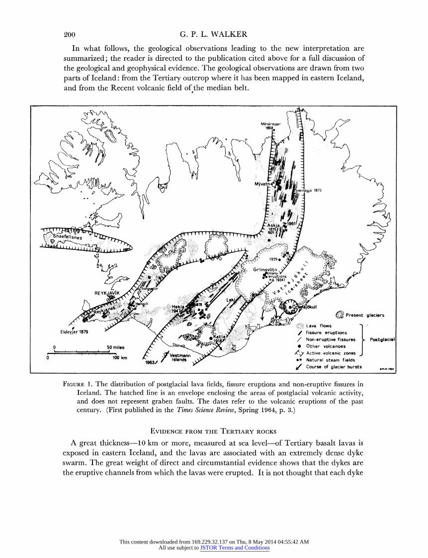
In what follows, the geological observations leading to the new interpretation are summarized; the reader is directed to the publication cited above for a full discussion of the geological and geophysical evidence. The geological observations are drawn from two parts of Iceland: from the Tertiary outcrop where it has been mapped in eastern Iceland, and from the Recent volcanic field of the median belt.
Eldeyjar 1879~~~~~~~~~~~~~~~~~~MAAeya
0 . r 100 km t fVlesitmann ** Natural steam fields
. ~~~~~~~~~~~/ Course of glacier bursts *PLW.
FIGURE 1. The distribution of postglacial lava fields, fissure eruptions and non-eruptive fissures in Iceland. The hatched line is an envelope enclosing the areas of postglacial volcanic activity, and does not represent graben faults. The dates refer to the volcanic eruptions of the past century. (First published in the Times Science Review, Spring 1964, p. 3.)
EVIDENCE FROM THE TERTIARY ROCKS
A great thickness-10 km or more, measured at sea level-of Tertiary basalt lavas is exposed in eastern Iceland, and the lavas are associated with an extremely dense dyke swarm. The great weight of direct and circumstantial evidencze shows that the dykes are the eruptive channels from which the lavas were erupted. It is not thought that each dyke
This content downloaded from 169.229.32.137 on Thu, 8 May 2014 04:55:42 AMAll use subject to JSTOR Terms and Conditions

SYMPOSIUM ON CONTINENTAL DRIFT 201
gave birth to a surface lava flow-perhaps as few as half of them did-but it is believed that nearly all the basalt lavas came from the fissures now occupied by dykes.
The key to the crustal drift problem here is the observation that the lavas thin rapidly up-dip,t and mappable stratigraphic horizons asymptote towards a level a short distance above the mountain summits, a level the position of which can be deduced by several independent methods (Walker I960). This level is believed to mark the top of the lava pile. The dykes which cross the present sea level to feed the lavas up to this level can be measured.
It is found in the Reydarfjordur area of eastern Iceland that a total of approximately 1000 dykes, with an aggregate thickness of 3 km, cross sea level to feed a prism of lavas 55 km wide by 1-5 km high (from sea level to the level referred to above), a cross-section of 80 km2 of lavas. This prism of lavas is envisaged as necessitating this thickness of dyke feeders, in much the same way that a bridge must have foundations of a size commen- surate with the size of the bridge they must support.
TABLE 1. DILATION OF THE BASE OF A PRISM OF LAVAS
500 km WIDE BY x km THICK
(A, based on the Reydarfjdrdur figure of 3 km dilation per 80 km2 cross-section of lavas; B, assuming that 50 % of the Reydarfjdrdur section consists of lavas which originated from concealed dykes, giving 6 km of dilation per 80 km2 cross-section of lavas.)
x A B (km) (km) (km)
5 100 170 10 180 280 15 240 350 20 290 390 25 330 420
Application of the Reydarfj6rdur figures shows that a prism of lavas of the present width of Iceland (500 km) rising to an average height of 1 km above the present sea level should require a total of some 6000 dykes with an aggregate thickness of around 20 km. The base of this prism must thus have suffered a dilation of about 20 km by the intrusion of dykes, plus a small increment, estimated at 3 km, due to normal faults. Extrapolating further, the base of a prism of lavas 10 km thick, with a surface width of 500 km, must have suffered a dilation of the order of 150 to 200 km, and a substantial amount of crustal drift is thereby involved.
There are two main uncertainties in the application of the Reydarfjordur figures to the determination of the amount of crustal drift accompanying Icelandic volcanism. One, as will readily be appreciated, is that many of the lavas in the 80 km2 Reydarfjordur profile may have been erupted from dykes concealed down-dip, beneath the present sea level. This is shown schematically by figure 2, in which the percentage of the total cross-section of lavas which have issued from concealed fissures is seen to be closely related to the lateral extent of the individual lava flows. Data to hand are inadequate to enable this percentage to be reliably estimated, but they suggest the possibility that it may approach 50 %. If so, the amount of dilation, or crustal drift, involved in the outpourinlg of the 80 km2
t Individual lava flows do not thin; thinning is accomplished by an up-dip decrease in the number of lava flows, as illustrated by the schematic sections of figure 2.-- X
26 VOL. 258. A.
This content downloaded from 169.229.32.137 on Thu, 8 May 2014 04:55:42 AMAll use subject to JSTOR Terms and Conditions

202 G. P. L. WALKER
cross-section might be as much as 6 km, and the dilation of the base of a prism of lavas 500 km wide by 10 km thick might then exceed 250 km (table 1).
The other uncertainty concerns the thickness of the lava pile beneath Iceland, for the Reydarfjordur figures merely indicate the possibility of substantial dilation by crustal drift of the base of the pile provided that it has a substantial thickness, and the amount of dilation cannot be estimated unless the thickness is known. Purely geological considera- tions show that the thickness may be very great, and is probably much more than 10 km. The measured thickness of the lava accumulation at sea level exceeds 10 km, and almost
average size of flow
averale size o low
FIGURE 2. Schematic sections showing the up-dip thinning of a group of basalt lava flows, as found in eastern Iceland, and also showing how the percentage of lavas above sea level which have been fed from concealed dykes varies with the width of the flows (it amounts to about 20% in the upper diagram and about 35% in the lower). In each, the lavas fed from dykes concealed below sea level (S.L.) are stippled.
everywhere the lavas show down-dip thickening. Several hundred km of crustal drift of the base of the lava pile is thus possible. Geophysical considerations are discussed by Bodvarsson; although difficult to interpret they appear to restrict the thickness to a figure appreciably less than that deduced geologically, but still perhaps about 10 km.
EVIDENCE FROM TJE RECENT AREAS
Iceland is the classic area for fissure eruptions. Most of the postglacialt lavas, which cover some 12 000 km2 or one-eighth of the area of the country, have issued from fissures. The fissure-eruption origin of many of the lavas is very well substantiated; the great Laki eruption of 1783 and the Askja eruption of 1961 (Thorarinsson & Sigvaldason 1I96I) are two particularly well knowrn examples. The magma which congealts in the feeding :fissure forms a dyke, and one or two examples are known where the dyke feeder has been laid
t The extent of postglacial time over most of Iceland may perhaps be estimated as about 10000 yr.
This content downloaded from 169.229.32.137 on Thu, 8 May 2014 04:55:42 AMAll use subject to JSTOR Terms and Conditions

SYMPOSIUM ON CONTINENTAL DRIFT 203
bare by subsequent erosion. Each dyke is responsible for a small amount of crustal dilation, perhaps on average about 3 m.
In addition to eruptive fissures, gaping fissures from which no lava has emerged are frequently encountered in the young lava fields of Iceland, and probably represent dykes which have failed to attain the surface. That these are dilation fractures is clearly evident in the field, and the amount of dilation is generally easily measured. Eruptive and non- eruptive fissures together form a parallel swarm crossing the country in a great curving arc from the north coast to the southwest promontary (figure 1)-they represent a dyke swarm which is actively growing-and figure 3 summarizes the topographic expression of the various types of dilation features encountered. Measurements made in the Thingvellir and Myvatn areas suggest that the dilation has amounted to about 30 m in the last 5000 to 10000 y, an average of about 5 mm/y.
FIGURE 3. Block diagram illustrating the various types of dilation feature seen in the young lava field of Thingvellir in southwestern Iceland. 1, Palagonite tuff-breccia ridge due to subglacial fissure eruption. 2, Postglacial lava field partially burying 1. 3, Non-eruptive fissures produced by dilation. Some vertical movement has accompanied the dilation in the fissure on the left. 4, Dyke feeders at sites of fissure eruption. 5, Spatter craters along the line of an eruptive fissure. 6, Cinder cone along the line of the eruptive fissure. 7, Lava rivers which conveyed lava away from the eruptive fissure. (First published in the Times Science Review, Spring 1964, p. 4.)
To digress, there are petrological grounds for suspecting the existence beneath Iceland of a micro-continent of the type envisaged for the Indian Ocean by Heezen earlier in this symposium; a continental fragment which perhaps once occupied the 'hole' found by Bullard & Everett when attempting a geometrical fit of the 500 fm. line west of the British Isles with that off the east coast of Greenland; a fragment which has since no doubt suffered many vicissitudes and of which a substantial fraction is now seen on the surface as rhyolitic lavas and pyroclastic rocks.
CONCLUSIONS
Although there are considerable uncertainties, extrapolation of figures from the Tertiary volcanic region of eastern Iceland indicates the likelihood that the base of the Icelandic lava pile may have suffered a dilation of the order of several hundred km since the earliest Tertiary rocks were formed. Moreover, measurements from the young lava fields indicate
26-2
This content downloaded from 169.229.32.137 on Thu, 8 May 2014 04:55:42 AMAll use subject to JSTOR Terms and Conditions

204 G. P. L. WALKER
a present rate of dilation of the order of half a cm per year, a rate which could amount to several hundred km during the course of the Tertiary period.
There is thus a strong case to be made for the existence of a crustal structure of the type represented schematically in figure 4 (4). Four stages in the development of Iceland are illustrated by figure 4; the present wide separation of the oldest rocks-a separation of the order of 400 km-is considered to be due alrnost entirely to the intrusion of dykes, of which
l ~~~active zone
LI3 lavas
dyke s
3
4
FIGURE 4. Crustal drift by dyke injection: four stages in the evolution of Iceland. (First published in R. Astr. Soc. Geopliq. J. 8, 291.)
only a few are represented for the sake of clarity. A form of 'conveyor belt' mechanism is envisaged, with lavas and their dyke feeders being generated in the median active zone-- a narrow zone which remains more or less constant in width throughout-and then carried to either side as more dykes and lavas are generated in the middle; a process that com- menced in early Tertiary times (or earlier?) and is still actively in progress.
REFERENCES (Walker) Askelsson, J,, Bodvarsson, G., Einarsson, T., Kjartansson, G. & Thorarinsson, S. I960 On the
geology and geophysics of Iceland. Guide to excursion no. A2. Int. Geol. Congr., XXI Session. Bodvarsson, G. & Walker, G. P. L. i964 Crustal drift in Iceland. Geophyv. J. 8, 285-300. Thorarinsson, S. & Sigvaldason, G. E. I96I The eruption in Askja 1961. A preliminary report.
Amer. J. Sci. 260 641-651. Walker, G. P. L. i960 Zeolite zones and dike distribution in relation to the structure of the basalts
of eastern Iceland. J. Geol. 68, 515-528.
This content downloaded from 169.229.32.137 on Thu, 8 May 2014 04:55:42 AMAll use subject to JSTOR Terms and Conditions