a study of vegetation change along the north coast …
TRANSCRIPT

A STUDY OF VEGETATION CHANGE ALONG THE
NORTH COAST OF KWAZULU-NATAL FROM
THE UMGENI RIVER TO THE TUGELA RIVER
by
.. , I '
INDRANI GOVENDER
Submitted as the thesis component in partial fulfilment of the requirements for the degree
of Master of Science in the Department of Geographical and Environmental Sciences,
University of Natal
Durban
February 2000

ii
ABSTRACT
The vegetation along the north coast of KwaZulu-Natal has long been considered to have
originally consisted of forest, scrub forest and savanna. The classical view is that in the
last 600 years the early Africans and European farmers were responsible for the removal
of forest and scrub forest along the coast. This view was not based on direct evidence but
on the theory that the eastern part of the country has a climate "suitable" for forest and
scrub forest. The present 'false' grasslands were thus thought to have developed through
anthropogenic influences. All of this has its basis in the paradigm of ecological
succession and the presence of a "climatic climax". This traditional view has been
contested recently, based on archaeological, historical, biogeographical and ecological
evidence that has become available since the 1950's. It is suggested that South Africa's
grass lands have been in existe~ce for the last two thousand years but probably for more
than ten thou~d years. This study aims to investigate this controversy in greater detail,
using evidence from archaeological records, travellers records, transcripts, historical
reviews, and diarised records.
The locations of archaeological sites within the study area were determined and mapped
out, followed by an analysis and interpretation of the data with reference to vegetation
change. Archaeological evidence included shell middens, evidence of iron working and
pottery remains. The activities of the early humans included iron smelting, agriculture
and stock farming. Their activities required the selective use of vegetation for specific
purposes, and vegetation was cleared for homesteads and villages. However, the density
of people within the study area was low, and there was limited technological
development, such that extensive clearing by relatively few people is unlikely.
Furthermore, sites are concentrated along the coastline, with fewer sites away from the
coast, suggesting that impacts would have been greatest along the coastline. However,
this is where forests presently occur. Overall, the evidence suggests that the natural
vegetation on the north coast was not modified drastically by preco lonial settlers.

Hi
Historical accounts of early travellers and settlers indicate a strip of forest along the
coastline and a grassland/woodland mosaic away from the coast. Records of mammals
suggest a fauna typical of savannas and not forest. With settlement over time, the major
activity that impacted on the north coast vegetation, was agriculture. Sugar cane
plantations contributed considerably to the clearing of vegetation that seems to have
consisted primarily of open grasslands with patches of trees. Colonial settlement of this
area resulted in various activities that required the large-scale removal of natural
vegetation.
It is important to know the human disturbance history of an area as this helps to assess
the extent of change and to design appropriate management strategies for conservation of
plant resources. The belief that the early vegetation of the north coast was forest has
placed great emphasis on the conservation of forests along this coastal area. Based on
this study, it seems that this vegetation type should not be the focus of conservation
efforts, but that coastal grasslands with scattered bush clumps should be given much
greater emphasis. Grasslands were more widespread in the region prior to European
settlement, and based on this, conservationists should place greater emphasis on
preserving this habitat.

iv
PREFACE
The work described in this thesis was carried out in the School of Life and Environmental
Sciences, University of Natal, Durban, from March 1997 to February 2000, under the
supervision of Pr of W.N. Ellery.
This study represents original work by the author and has not been submitted in any other
form to another tertiary institution. Where use has been made of the work of others it is
duly acknowledged in the text.

CHAPTER 1: INTRODUCTION
1.1 The North Coast Under Threat
CONTENTS
1.2 Conservation Through Open Space Systems
1.3 Vegetation Change
1.4 Implications for Conservation
1.5 Aim and Objectives
1.6 Structure of the Thesis
CHAPTER2: THEORETICAL BACKGROUND
2.1 Introduction
2.2 Succession Theory
2.2.1 Classical Views of Succession and the Climatic Climax
2.2.2 Views of Vegetation Succession after Clements
2.3 Current Views on the Role of Humans in Vegetation Change
2.4 Early Settlement Patterns
2.5 Vegetation Distribution, Succession and Human Disturbance
2.6 Climax Vegetation of the Natal North Coast
2.7 Conclusion
CHAPTER 3: THE STUDY AREA
3.1 Introduction
3.2 Climate
3.3 Geology
3.4 Soils
3.5 Physiography
3.6 Coastal Morphology
3.7 Vegetation and Conservation Status
3.8 Land Use
3.9 Settlement Patterns
3.10 Socioeconomic characteristics
v
1
2
3
4
5
5
7
8
8
11
12
14
16
18
19
20
23
26
27
29
29
31
33
35
36

CHAPTER 4: PRECOLONIAL IMPACT ON VEGETATION
4.1 Introduction
4.2 Precolonial History
4.2.1 Stone Age People
4.2.2 Iron Age People
4.2.3 Migration ofIron Age People
4 .3 Methodology
4.4 Results and Discussion
4.4.1 General Settlement Patterns
4.4.2 Analysis of Stone Age Settlements
4.4.3 Analysis ofIron Age Settlements
4.4.4 Reference to Vegetation
4.5 Conclusion
CHAPTER 5: COLONIAL IMPACT ON VEGETATION
5. 1 Introduction
5.2 Methodology
5.3 Results and Discussion
5.3.1 Land Use and Land Use Change
(i) The Impact of Sugar Cane
(ii) The Impact of Other Agricultural Products
(iii) The Impact of Settlements
(iv) The Impact of Transport Routes
(v) The Impact of Exotic Plants
5.3.2 Flora and Fauna in Early Accounts
(i) Flora
(ii) Fauna
5.4 Vegetation of Undeveloped Coastal Areas in KwaZulu-Natal
5.5 Conclusion
vi
38
39
39
41
43
44
45
45
51
53
66
67
69
70
70
71
71
72
73
74
75
76
76
79
80
80

CHAPTER 6: CONCLUSION
6.1 The Impact of Settlement
6.2 The Role Played by Climate and Fire
6.3 Implications for Conservation
REFERENCES
APPENDIX 1
vii
83
83
86
87
93

viii
LIST OF TABLES
Table 1. Land Use along the Natal Coast in 1981. 34
Table 2. Guidelines for the dating of the various periods in precolonial
South Africa. 40
Table 3. The number of sites per "cultural period". 46
Table 4. Summary of features of all archaeological sites along the north
coast margin between the Umgeni River and the Tugela River
(Appendix 1: Total Sites 210) 48

LIST OF FIGURES AND PLATES
Figure 1. The major vegetational divisions of the grassland biome.
Figure 2. The Study Area shown in a broader context.
Figure 3. The Study Area
Figure 4. Mean monthly temperatures of the Study Area.
Figure 5. Mean monthly rainfall of the Study Area.
Figure 6. Geology of the Study Area.
Figure 7. Landforms and Physiographic Regions ofKwaZulu-Natal.
Figure 8. The Vegetation of the Study Area as Described by Acocks
Figure 9. Archaeological Sites within the Study Area.
Figure 10. Stone Age Sites.
Figure 11 . Iron Age Sites.
Figure 12. Sites where middens were present.
Figure 13 . Sites where pottery was present.
Figure 14. Sites with Charcoal present.
Figure 15. Sites where Grindstones were present
Figure 16. Sites with evidence of iron working.
Plate 1. The mosaic of grassland and tree clumps, with forested foredunes,
between Sodwana and Kosi Bay.
ix
13
21
22
24
25
28
30
32
47
49
50
57
59
61
63
65
81

x
ACKNOWLEDGEMENTS
I would like to thank the following people:
Prof W.N. Ellery, for his assistance, guidance and patience;
My husband, Ricky, for his assistance, support and encouragement;
Family and friends, for their help and encouragement;
Val Ward and Gavin Whitelaw, of the Natal Museum for their assistance and cooperation
with the use of archaeological data and printed material;
The staff of Killie Campbell Africana Library for their assistance;
Pravin Poorun (Ward Herbarium) for his help in the confirmation of plant names;
Frank Sokolic (School of Life and Environmental Sciences) for his patience and
assistance in the preparation of maps;
Shirley Brookes (School of Life and Environmental Sciences) and Prof Guy (Department
of History) for their help with references on colonial material;
The staff of the School of Life and Environmental Sciences, for their help, support and
encouragement.

CHAPTER 1
INTRODUCTION
1.1 The North Coast Under Threat
The natural vegetation of the north coast of KwaZulu-Natal is under threat. Agriculture
and development have disturbed and destroyed much of the pre-existing vegetation. The
result of this is the confinement of remaining coastal forest to coastal foredunes and to
isolated forest patches on steep ground unsuitable for agriculture. This stretch of coastal
vegetation has been under threat for many centuries, especially as the land was
recognised to be fertile and as having great potential for crop cultivation by the colonial
settlers. The vegetation of this coastal margin has been highly modified due to
agricultural activity and the development of urban nodes. Prior to European settlement
Iron Age people also impacted on the vegetation through their use of natural vegetation
for the building of homesteads and the use of wood for fires. The people of this time also
cleared vegetation for cultivation and they reared stock. The extent of their impact on the
natural vegetation during their period of occupation has been a subject of debate (Ellery
& Mentis, 1992).
Even early accounts of the vegetation of South Africa indicate the destructive nature of
humans on natural vegetation. Pole Evans, in a 1917 account of the vegetation of South
Africa, stressed that it was necessary to have a picture of the present vegetation of South
Africa since many parts of the country were undergoing "rapid development under the
influence of man", and it would follow that there would be considerable changes in the
character and distribution of the existing vegetation (pole Evans, 1918). He described the
loss of important timber and forest trees, and considered overstocking and grass fires as
being responsible for this. He listed settlement, cultivation, drainage and irrigation as
some of the main activities that altered the original landscape.
The coastal margin continues to experience the growth of urban and peri-urban
development and the coastline is seen as an opportunity for economic gevelopment, with

2
the Port of Durban at the southern end and the Port of Richards Bay further north. This
area has vast stretches of magnificent beaches and it has tremendous potential for
tourism. This may result in the development of more beach resorts and/or the expansion
of existing resorts. Nodal development is most likely along the north coast resulting from
the recently upgraded transport route, which makes coastal towns more accessible. The
greater capacity of the N2 national road provides opportunities for various activities to
occur along this coastline.
1.2 Conservation Through Open Space Systems
There is interest in the development of this area occurring in a manner that does not
compromise the natural environment to a great extent. It is hoped that sustainable
development will thus be achieved by maintaining a network of conservation areas in
keeping with open space systems elsewhere in the region and in the world. This may be
possible through a more holistic and integrated approach to urban planning. In the past
urbanisation in South Africa has disregarded ecological value and has resulted in certain
species being threatened. As a result of this it has become important for open space
systems to be an integral part of the design and planning of urban developments (Roberts,
1994).
There are many areas along this coastline that have tremendous conservation value and
many pristine areas which have the potential for ecotourism. Apart from the many values
that urban. open space systems have (parks Department, Durban, 1994), such as aesthetic,
recreational and temperature regulation, of particular importance in this context is the
value of open space as a means to conserve indigenous vegetation (Roberts, 1994).
3
1.3 Vegetation Change
According to Acocks (1953) natural vegetation change is a consequence of vegetation
succession. This was the foundation for Acocks's classification of the vegetation types of
Southern Africa. Ellery & Mentis (1992) however, have contested his explanation of
how the vegetation of South Africa has changed, with specific reference to the age of
South Africa's grasslands.
In his famous "Veld Types of South Africa", Acocks (1953), described the east coast of
South Africa as being extensively covered by forest and scrub-forest in the past. He
proposed that in the past six hundred years this vegetation was replaced by grasslands,
which he tenned "false grasslands". He attributed these changes to the activities of the
Bantu-speaking and European settlers. Bews (1920) described the chief climax
vegetation along the Natal coastal belt as forest. He also indicated that the grasslands in
this area were very unstable and that fire played an important role in preventing
succession from going any further. Bews (1920) stated that "pure grassveld areas" along
the coastal belt were not extensive. White (1983), in his description of the vegetation of
the Tongaland-Pondoland region, describes secondary grasslands which replaced coastal
forests as the latter were destroyed.
Acocks's (1953) work on the vegetation of South Africa became the foundation for many
courses taught at tertiary educational institutions (Feely, 1987). Since Acocks's (1953)
first edition of the ''Veld Types of South Africa", an ecological paradigm emerged which
persists up to the present. Many authors, including Feely (1987) have recently challenged
this paradigm and in particular, Ellery & Mentis (1992) have contested Acocks's (1953)
theory. They based their argument on evidence from various fields of study including
archaeology, palaeobotany, biogeography and ecology. While there may have been
alteration of the boundaries of biomes in the past few hundred years these authors suggest
that it seems unlikely that there was a biome-wide alteration such that one biome was
completely replaced by another biome. In particular it is unlikely that the early Iron Age
4
and/or European settlers cleared vegetation to the extent that there was a biome-wide
change (Hoffinan, 1997).
The role of fire in the modification of vegetation is also of importance, since humans
have been using fire for thousands of years (Ellery & Mentis, 1992). According to
Acocks (1953) the climatic climax vegetation of the east coast should be forest and scrub
forest, however natural fires, edaphic factors and fauna indicate that the distribution of
grasslands in this area may have been as they are today, for a long time, possibly several
thousand years (Mentis & Huntley, 1982). Ellery, Scholes and Mentis (1991) suggested
that distribution of the grassland biome is determined by climate. Despite many
grassland and savanna areas having the ability to support forest vegetation, disturbance
regimes (e.g. fire) prevent this from happening. The fire disturbance regime is natural
and is viewed as being under climatic control (Ellery, Scholes & Mentis, 1991). Natural
fIres are considered inevitable in areas with strongly seasonal rainfall where there is a
prolonged dry season.
1.4 Implications for Conservation
Work of this kind is important from a conservation perspective. At present there is the
general view amongst natural scientists and the public at large that the north coast
vegetation was forest and scrub forest, and that this should remain a priority for
conservation. It is believed that this forest was subsequently removed due to settlement
(Wager, 1976), development and agriculture. It is for this reason that conservationists
working along the north coast have focussed primarily on forest conservation. However,
if grasslands were widespread in the area, then we should probably place more emphasis
on preserving this habitat.
It is important that we ascertain whether grasslands encroached into the coastal forest
biome or whether the present vegetation along the north coast ofKwaZulu-Natal has been
unchanged for the past few thousand years. Knowledge of the most accurate

5
representation of the earliest vegetation of this area will assist us in developing proper
management systems in order to conserve the vegetation in a sustainable manner.
1.5 Aim and Objectives
The earliest vegetation of the north coast is unknown. Although most of the removal of
natural vegetation has occurred during the modem era due to technology and industry, the
extent of early human impact is uncertain. The aim of this study is to determine the
patterns of vegetation distribution of this area prior to human settlement. This study
investigates the impact of Stone Age and Iron Age humans as well as European settlers
on the vegetation of this area.
The following objectives were identified in order to achieve the aim:
• To determine the patterns of settlement of the Iron Age Bantu speaking people in the
regIon.
• To determine the possible impacts on vegetation by these Iron Age settlers, by
investigation of relevant information from archaeological records.
• To determine the nature of the vegetation prior to settlement of the regIon by
European settlers, by studying the earliest European travellers' records.
1.6 Structure of the Thesis
Chapter Two reviews the theoretical debate that forms the background to this study. The
role of humans in vegetation change in the area over time is reviewed. In this regard
Acocks's views are compared to that of more "modem ecologists". There is an
examination of the work of Acocks with reference to the vegetation of the study area and
consideration of contemporary views of the vegetation of this area. The prevailing
ecological paradigm of ecological succession at the time that Acocks published his work,
is discussed. Classical views of succession and the concept of the climatic climax are

6
examined, followed by a review of succession theory after Clements. Finally there is a
discussion of the current views on the climax vegetation ofthe north coast.
Chapter Three, entitled "The Study Area", describes the area in question, its boundaries
and its characteristic features. This chapter gives an account of the climate, geology,
soils, physiography, coastal morphology, vegetation and conservation status, land use,
socioeconomic conditions and settlement patterns of the north coast.
Chapter Four investigates the impact of precolonial settlement on the vegetation of the
north coast. The methods used are described and the results are presented primarily in
tabular form. Accounts of archaeological fmds in the area and elsewhere in the province
are used to establish what activities brought these early settlers to this area. An attempt is
made to recreate the lifestyle of these people in order to understand their impact on the
vegetation. The archaeological records are mapped to establish patterns of settlement.
Chapter Five gives an account of the impact of colonial settlement on the area. The
major activities that took place here are examined. Historical records and historical texts
form the bulk of the sources of information used in this chapter. The strong influence of
agriculture in this area is discussed in detail in order to establish the major impacts on the
vegetation during this period.
Chapter Six attempts to consolidate the findings and conclusions reached in chapters four
and five in order to provide a holistic picture of the impacts of settlement on the
vegetation of this area. The role played by seasonal rainfall and natural fires in
vegetation change is examined. It is here that an attempt is made to fulfil the aim of
presenting a description of the vegetation of the north coast prior to settlement.

7
CHAPTER 2
THEORETICAL BACKGROUND
2.1 Introduction
Conservation along the north coast emphasises the conservation of the "natural
environment". It is however, uncertain what exactly is meant by "natural". This is of
concern if one considers that humans have inhabited this area for thousands of years.
Wherever humans have settled or passed, their activities have had an effect on the
original state of the environment. This raises fundamental philosophical questions about
what nature conservation organisations should attempt to achieve in their conservation
efforts. On the north coast of KwaZulu-Natal it is difficult to know exactly what is
natural because the landscape has been dramatically altered over the last 200 years and
there is little record of what the landscape was like prior to settlement by Iron Age or
European settlers. These are important issues that need to be considered by conservation
organisations such as the KwaZulu-Natal Nature Conservation Services and the Wildlife
and Environment Society of South Africa.
Traditionally it has been considered that the "natural environment" that needs to be
conserved along the KwaZulu-Natal north coast is coastal forest (Wager, 1976). This
seems to be justified by the reigning view that prior to human settlement much of the
province was covered in forest, scrub forest and savanna. This view had a strong
foundation in early views of vegetation succession and the existence of a "climatic
climax" (Clements, 1916). Acocks (1953) based his views very much on the paradigm of
plant succession. In his "Veld Types of South Africa", Acocks proposed the view that
much ofKwaZulu-Natal was covered in forest, scrub forest and savanna.
The vegetation of South Africa, according to Acocks (1953), is a result of millions of
years of natural vegetation migration. A secondary influence on the vegetation has been
the activities of Iron Age Bantu-speaking people and European settlers during the last

8
300 years and particularly the last 100 years. Acocks (1953), in his classical view of the
origin of grass lands, identified the grasslands of the eastern part of South Africa to be
'false' grass lands. He claimed that these grass lands replaced the original forest and
scrub-forest vegetation of this area as a result of human disturbance in the last 600 years.
His assumption that the original vegetation of this area was forest or scrub-forest was
rooted in the theory of succession, which proposed that the climax vegetation of an area
was influenced primarily by climate. Acocks (1953) viewed the climate of the eastern
part of the country as "suitable" for forest development. This view was supported by the
fact that this area received high rainfall (greater than 800 mm per annum), which was
favourable for forest or scrub-forest growth.
This chapter will elaborate on the classical views of succession and the concept of
climatic climax. Vegetation succession after Clements looks at the individualistic
hypothesis, the continuum concept and allogenic succession amongst others. This is
followed by the current views held with regards to the role of humans in vegetation
change along the north coast, and the importance of studying the disturbance history of
an area. The strong influence of Acocks's work is discussed, with particular reference to
the paradigm of ecological succession. Finally current views on the climax vegetation of
the north coast are discussed, with reference to work done by Ellery and Mentis (1992)
on the age of the grasslands of South Africa.
2.2 Succession Theory
2.2.1 Classical views of Succession and the climatic climax
Vegetation is dynamic and various processes influence the changes that occur. One
significant process of natural vegetation change is succession. This process was fIrst
reviewed by Clements in 1916 (Luken, 1990). Ecological succession was fIrst described
by a French biologist, Dureau de la Malle in 1825 (Golley, 1977). Plant communities all
over the world change as they age. These changes include replacement of species and

9
shifts in population structure, as well as changes in availability of resources such as light
and nutrients. Since elements's work was published in 1916 the concept of regular
patterns of vegetation change has become an important subject in vegetation ecology
(Burrows, 1990). Succession is basically explained as follows: "One group of plants
establishes and is then replaced by another group until a stable state is reached" (Luken,
1990). Succession can be described as an orderly sequence of development over many
years until a stable or "climax" community is reached (Mitsch & Gosselink, 1993). The
limiting factor with regard to succession is traditionally viewed as the climate of a region.
Early views of succession viewed plant cover as a complex community from which
animals and humans sought shelter, food and resources. This community, was viewed as
"essentially an organism" which possessed structure and underwent development. There
was coordination of functions and the whole "organism" was viewed as a unified
mechanism which was more effective than the individual constituents acting on their
own. This "organism" had properties of its own. This concept was first introduced by
elements in 1916. He claimed that the climax community as an organism, arose, grew,
matured and died.
The theory of vegetation succession as described by elements (1916) was associated with
an elaborate terminology. It started with nudation (provision of new sites). This was
followed by ecesis (plants establish, grow and reproduce). Also included in this view of
succession are action (effects of the environment on the plants), reaction (effects of the
plants on the environment and their response to the environmental effects), competition
and stabilization. The term sere was also introduced at this time to define a stage of
succession from the pioneer to the climax. The term seral derives from the term sere.
and is used to describe developmental phases. Cliseres are initiated by major climatic
shifts (Burrows, 1990).
Successions that occur on recently exposed land and occur in the absence of external
changes in abiotic factors are termed autogenic succession (Begon, et ai., 1996). In the
instance where the landform was bare and was being settled for the first time, this was
10
termed primary succession. This type of succession takes hundreds of years to reach the
climax stage. Secondary succession follows fire or cultivation, when existing disturbed
land is left bare, and this type of succession may be complete in less than half a century.
The initial processes of aggregation and migration contribute to formation of the
community. Growth of the community is influenced by soil and climate (Allred &
elements, 1949).
According to succession theory, the communities go through various changes until the
fmal community, termed the climax community, is attained. Every climate has a specific
climax community (Allred & elements, 1949). The climax constitutes the major unit of
vegetation and forms the foundation for the classification of plant communities. This
view that a single climax exists in any given climatic region, i.e. the monoclimax view,
was contested by many ecologists. The polyclimax view holds that a local climax may
be influenced by one factor or a combination of factors, such as climate, soil conditions,
fire and topography. Hence a single climatic area may contain a number of specific
climax types (Begon, et al. , 1996)
Any community that is more or less permanent and resembles the climax to a certain
degree is termed the proclimax. This may be replaced by the climax in the absence of
disturbance and under the influence of the climate. The subclimax is the general term
used to describe the stage preceding the climax in all complete seres (Allred & elements,
1949). Disclimax is frequently represented by climax communities that are modified
through disturbance by humans and domestic animals. This type of community also
results where the true climax vegetation is replaced, for example, by alien species.
Serule is the diminutive of the term sere, a term used to describe miniature successions
that run a short course within a larger community.

11
2.2.2 Views on Vegetation Succession after elements
Many plant ecologists found the mono climax concept to be unrealistic at regional or local
scales as the habitat conditions are not homogeneous. This results in local vegetation
patterns being diverse. This led to the development of the polyclimax concept by some
ecologists, most notably Whittaker, during the period up to the 1930s (Burrows, 1990).
Whittaker further proposed the prevailing climax concept which states that climax
communities are relatively stable and self-maintaining within the vegetation continuum
(Burrows, 1990).
As early as 1917, Gleason proposed an individualistic hypothesis to describe the
distribution of plant species (Mitsch & Gosselink, 1993). Gleason's view proposed that
recognised vegetation units are temporary and fluctuating (Burrows, 1990). Species
come together due to their overlapping environmental requirements, but essentially
species behave as individuals and adapt their own responses to environmental variations.
Vegetation therefore varies in space and time. Hence, succession according to Gleason,
is not an orderly process and does not lead to a definite climax, but rather tends to be
stochastic with much more noise than pattern in the process of vegetation development.
These ideas have developed into the continuum concept which states that individual
species responses to the environment determine vegetation composition and distribution
(allogenic succession). Each species responds individually and therefore different species
occupy different zones. There is a continuum of overlapping sets of species, as each
species responds to slight differences in the environment. In this view no "communities"
or clearly defined associations of species exist as proposed in Clementsian succession.
Although changes occur in the ecosystem, there is little evidence to indicate that this
change is directed and that a particular climax is attained. In the classical view of
succession there is zonation of vegetation that simply reflects different associations of
species, but in the continuum concept the zonation is an indication of an underlying
environmental gradient (Mitsch & Gosselink, 1993).

12
Some ecologists have considered eliminating the use of the term 'climax'. Proposed
alternatives to terms such as 'sera!' and 'climax' were 'intermediate' and 'most advanced
phases' of vegetation development. Since it is unlikely that absolute stability is possible,
it was recommended that the term 'climax' be replaced with 'steady state', while some
ecologists preferred the term 'mature'.
Succession was the reigning ecological paradigm at the time that Acocks (1953) was
studying vegetation in South Africa, and the notion of a "climatic climax" strongly
influenced his ideas on the nature of vegetation prior to human disturbance. The high
rainfall and generally mild temperatures characteristic of the coast ofKwaZulu-Natal and
the Eastern Cape, led him to conclude that prior to human disturbance, much of the land
to the east of the Drakensberg escarpment was covered in scrub forest and/or forest (Fig.
1).
2.3 Current Views on the Role of Humans in Vegetation change
It is important to know the human disturbance history of an area. Knowing the extent of
transformation enables one to partition climatic and anthropogenic effects to seek
important interactions where they might exist (Hoffinan, 1997). Knowledge of the
disturbance history of an area assists in the construction of baseline vegetation patterns
that may have existed prior to human settlement. A comparison of the present vegetation
of an area with "hypothesised pre-human constructs" provides a clue to the extent of
change in an area (Hoffinan, 1997).
The vegetation of an area constantly changes through natural processes. Throughout the
history of humankind however, there has been interaction between natural processes and
human interference, which varies temporally and spatially. During the period of
occupation by early humans, people impacted on vegetation by burning and cutting
vegetation or by tilling the land and keeping livestock. As human activity increased, the
natural character of landscapes changed. This pattern of disturbance by humans has

- ,. - - ,
, ,
I
I ,
, I
/
~ 'False' grassveld ~ scral to savaJUla
t·:: : : =1 'False' grassveld • •• • • seral to forest
Fig. 1. The major vegetational divisions ofthe grassland biome (after Mentis and Huntley, 1982).
13

14
escalated in recent times and there are few areas in South Africa that have been spared
human influence (Luken, 1990).
The north coast of KwaZulu-Natal is no exception to human disturbance. The influence
of humans is quite evident by the vast areas that are now cultivated. Durban is now a
major city in South Africa, but about 500 years ago it had just been reached by travellers
from the western world and it was not until late in the 15th century that European settlers
had sighted the land and realised what potential the land had for settlement (Mackeurtan,
1930). By the 18th century cultivation was well established as a major activity of the
European settlers (Hattersley, 1950).
Hoffman (1997) discusses the importance of knowledge pertaining to southern Africa's
disturbance history and relates the 'slash-and-bum' agriculture of the early Iron Age
farmers to the change in vegetation along the coastal forested areas. He postulates that
the activities of these farmers resulted in the clearing of coastal forest margins, which, in
a few hundred years, led to an increase in the extent of scrub and grassland biomes. This
has been contested by McKenzie (1989), as he is of the view that the activities of the Iron
Age people were insufficient to cause such significant changes. McKenzie (1989) rather
proposes that there has been an increase in the woody vegetation of some areas.
Commercial crop cultivation is listed as having the greatest impact on terrestrial biota,
especially by replacing natural vegetation. The coastal lowlands of KwaZulu-Natal have
received the greatest impact from the cultivation of sugar cane. This started in the 1840s
and by 1866 over 5000 hectares of land was under cultivation (Hoffinan, 1997). Today,
much of the coastal lowlands are cultivated under sugar cane.
2.4 Early Settlement Patterns
Hominids have existed in southern Africa for at least the last 3 million years (Hoffman,
1997). There is general agreement amongst authors that the coastal lowlands of the
northeastern seaboard were initially occupied by Iron Age agropastoralists. Areas north

15
of Durban were settled about 1800 B.P. The exact details of the movement of early
human settlers in this area has been debated. It is suggested that the Stone Age settlers
have been on the subcontinent for the last one to one-and-a-half million years. Their use
of fire since approximately 150 000 years ago would have influenced the natural fire
regimes. It is difficult to ascertain the impacts of early humans as a result of incomplete
archeaological and palaeoecological records (MacDonald, 1989). It has often been
assumed, on the basis of very little evidence, that the vegetation of certain areas of the
subcontinent have been human-induced. This has led to controversy based on studies of
archaeological material and evidence. An example is the grassland vegetation of the
Transkei, which was suggested to be man-induced by Acocks (1953), but archaeological
evidence suggests that this area has been dominated by grasslands for more than 10 000
years (Feely, 1987).
The impacts of human settlement and human activities on vegetation change are subject
to debate. The 'classical' view of land degradation in southern Africa holds that during
the modem industrial period in the last few decades, southern Africa has experienced the
most vegetation degradation (MacDonald, 1989; Hoffinan, 1997). This view is based on
the fact that modem technology and an ever-increasing human population have placed
great pressures on the land resource. However, many authors also consider the impacts
of early humans to have contributed significantly towards vegetation change. The
activities of early humans (including agriculture, livestock grazing, and settlement) would
have impacted on the vegetation, but there is still uncertainty as to the extent of their
impact (MacDonald, 1989).
The older views with regard to the migration of Bantu-speaking farmers into southern
Africa from the north, at the time that Acocks (1953) was formulating ideas about
historical change in vegetation distribution, indicate the belief that the movement of
these people occurred in successive waves. It was believed that this occurred at about
400-300 B.P. across much of the subcontinent. The routes used by these early farmers
were proposed around 1905 by Stow (Feely, 1987). However these views were not
supported by historiographic or archaeological evidence, but were rooted in speculation

16
and on the pattern of settlement of the subcontinent at the time of European settlement.
This view of the history of these early farmers had been accepted and was even taught at
tertiary level at the time that Acocks's work was published initially in 1953. This view,
as well as Acocks's view of the grasslands of the eastern region of South Africa, were
based on indirect evidence, and based on more recent evidence it is possible to shed more
light on this matter.
By 1979, archaeological evidence gave new insight into the Vlews related to the
settlement of early Iron Age farmers in South Africa. With the aid of radiocarbon dating,
the settlement of these farmers dated back to about 1500 B.P. By 1982 the availability of
more information resulted in the dates being amended to 1750 B.P. (Feely, 1987). This
more current view proposes that early Iron Age farmers settled along the coast of Natal as
well as in the lowveld of the Transvaal and Mozambique, about 1750 B.P. or earlier.
These settlements expanded inland, along valleys below 1000m above sea level in
KwaZulu-Natal.
Modem ecologists have been strongly influenced by Acocks in their views of the state of
vegetation prior to the arrival of Iron Age and European settlers. Acocks's work had
become the most influential ecological text in this country for many decades. His work
has only recently been contested by ecologists.
2.5 Vegetation Distribution, Succession and Human Disturbance
Acocks (1953) refers to South Africa as a "recently settled country", which is a
subjective, if not disputable, statement. He also bluntly suggests that there is little or no
vegetation in the country left in the original state. In contradiction to these statements, he
further states that the records of vegetation at the time of European settlement was very
scarce, and that changes in the vegetation since then are difficult to describe. Amidst all
the uncertainty and the lack of adequate records, Acocks (1953) was able to provide a
classification of the vegetation of South Africa which has reigned as the most often cited

17
reference for ecological studies in South Africa for many decades. Acocks's (1953) work
has also provided the basis for ecological and vegetation analysis in teaching at tertiary
level, and is still used at present.
Acocks's (1953) classification of vegetation types or "Veld Types of South Africa" was
based on the ecological paradigm of succession. He postulated that the vegetation on the
north coast of KwaZulu-Natal in about A.D. 1400 consisted of forest, scrub forest and
savanna. By the 1950's this area was predominantly bushveld and sour grassveld. The
classical view is that in the last 600 years Bantu-speaking African people as well as
European farmers were instrumental in the removal of forest, scrub forest and savanna.
He explained that although the eastern part of the country has a climate suitable for forest
and scrub forest, it consists of grasslands, which have developed through anthropogenic
factors. He therefore called these 'false' grasslands. The anthropogenic factors he
referred to included keeping livestock, practising agriculture and the frequent use of fire.
The Iron Age Bantu-speaking people were considered to be primarily responsible for
destruction of the forest vegetation, and conversion of this vegetation to grassland
(Acocks, 1953). There is much evidence to suggest that the vegetation of the eastern part
of the country has been in its present form for a longer period than it has been inhabited
by Iron Age people (Ellery & Mentis, 1992). Adaptations in lifestyle of these people to
an environment lacking trees became evident as Iron Age people moved, after A.D. 1000-
1200, into areas currently classified as grassland in KwaZulu-Natal. These adaptations
included the use of stone walls for construction, bone tools rather than iron tools, and the
use of dung as a major source of fuel. Hence these people may have replaced their
requirement for wood resources with alternatives. Fossil evidence containing ungulate
mammal remains, which were more than 5000 years old, from the 'false' grasslands,
similarly indicated association with grasslands a long time ago. This raises questions
about the age of these so-called 'false' grasslands.
18
2.6 Climax Vegetation of the Natal North Coast
Acocks's theory has been contested by Ellery and Mentis (1992), suggesting that the
grasslands of South Africa as they are at present, have been so for the last 2000 years, but
probably for more than 10 000 years. This has also been supported by evidence from a
variety of disciplines such as palaeobotany, biogeography, archaeology and ecology. This
pattern has revealed that many of the areas in Africa believed to have been forest initially,
were in fact grassland for many thousands of years.
Since Acocks's initial work in 1953, many studies have produced views that are contrary
to that of Acocks's. This is based on evidence from a variety of factors that have
influenced the vegetation of the north coast. Fire, initiated by lightning or other natural
agents, which favours grasslands over woody biomes, may have played a role in
maintaining the grasslands (Mentis & Huntley, 1982). There is also evidence of soils in
the areas covered by 'false' grass lands in the Natal coastal hinterland, which are typical
of grasslands at higher altitudes. Research in palaeobotany by means of pollen analysis
has revealed that areas that Acocks predicted as being forested contain pollen principally
from the Poaceae, Compositae and Cyperaceae (Meadows & Meadows, 1988),
suggesting grassland. There is also the doubt raised by the widespread occurrence of
Themeda triandra, which is a grass characterised by poor powers of dispersal but which
dominates most of the 'false' grasslands of KwaZulu-Natal (Mentis & Huntley, 1982).
This evidence suggests that the influence of early humans on the grassland biome was not
as considerable as believed by Acocks (1953). Ellery & Mentis (1992) are of the view
that the boundaries of savannas, forests and grasslands may have been modified from the
original situation prior to settlement, but the proposal that forests and savannas were
replaced by grasslands in the last five to six centuries, is unwarranted. Similarly, studies
done on the vegetation of Transkei suggest that the grasslands thought to be seral to
forest may have been as they are at present, for the past 1750 years, long before the first
farmers settled there (Feely, 1987).

19
2.7 Conclusion
Two decades after Pole Evans (1936) produced the first colour map depicting the
vegetation of South Africa, Acocks (1953) published his classification of the vegetation
of South Africa, where he also looked at vegetation change over time and he predicted
future changes in vegetation under different scenarios. Acocks' s work had a significant
effect on the field of ecology in the region. Acocks's map was produced with the
objective of agricultural planning as its basis and it was based on a supposed relationship
between vegetation development and climate. With the availability of new information
and new approaches it is possible to re examine Acocks's vegetation maps and the
concepts and paradigms that underpinned them

20
CHAPTER 3
THE STUDY AREA
3.1 Introduction
The area selected for this study was the coastal belt of the north coast of KwaZulu-Natal
from the Umgeni River to the Tugela River (Fig. 2). The western boundary was the N2
national road and the eastern boundary was the sea. This represents a coastal strip
approximately 6 km wide (varied from 2km to 8 km in places), over a distance of
approximately 80 km (Fig. 3).
The natural resources of this coastal belt are important for the economy and the
development of this area. The distinguishing characteristic of the north coast of
KwaZulu-Natal that is familiar to most people, is the rolling hills of sugar cane grown
throughout this area. The climate and soils that make this area suitable for the growth of
sugar cane were discovered during the last century and these have resulted in sugar cane
cultivation becoming an important economic activity. Land owners have been occupied
with sugar cultivation, resulting in much available and suitable land being used for this
purpose (Pistorius, 1962).
The other important resource of this area is the coastline. This resource holds great
potential for development of this area. However, due to large-scale sugar cane farming,
development has been discouraged by denying access to the beaches, possibly due to the
increased likelihood of accidental cane fires (Pistorius, 1962).
Development of the transport route along the north coast of KwaZulu-Natal was done for
two main reasons: to serve the needs of the sugar industry and to make Zululand
accessible. This communication axis was positioned some distance from the coast, which
further discouraged development of the coast. A national road has recently been built in
the area, which connects Durban to Richards Bay, the latter being an important centre

LadyslIIilh
• Dundee
Pielcrmari tzburg •
ll\'~~ (~ (;>~ ~.
"l}-t
I Slanger, , ,
• Porl Shepslone o
21
""---,--~----
Empangeni • tRichards Bay
-Y r--
STUDY AREA
30 60 90 120 km
Fig. 2. The Study Area shown in a broader context. A map ofKwaZulu-Natal indicating the location of the study area.

• Tongaat
Fig.3: Study Area: The north coast of KwaZulu-Natal between the Umgeni River and the Tugela River.
T uge/a River
N
A Scale (KM)
o 5 10
23
That is developing rapidly. This new road has made the towns in this area more
accessible and will probably increase the tourism potential of this area, an activity which
is already showing tremendous growth. These developments will however have a
considerable effect on the natural environment.
3.2 Climate
The coastlands of Natal are warm or hot for most of the year and in summer this area
becomes exceptionally hot. Most of this area has an average maximum summer
temperature (October to March) of approximately 27° C (Fig. 4). In winter the coast is
warm, with long periods of fine weather with light winds. The average minimum winter
temperature (April to September) varies between 10.9° C and 16.7° C (Mount
Edgecombe; Fig. 4). Frost is seldom experienced along the coast.
Coastal areas experience exceptionally high maximum temperatures under Berg wind
conditions, which occur mainly in the winter months (Preston-Whyte, 1980). As such the
highest maximum temperatures are experienced in winter. The presence of these hot, dry
winds desiccate vegetation, rendering it susceptible to frre (Ellery et aI., 1991).
The humidity is relatively high, particularly in summer (Pistorius, 1962). The average
relative humidity for Durban for the month of January is approximately 85-90 % at night
and approximately 65-70 % during the day. In winter the air is drier, with July having an
average relative humdity of 70-80 % at night and the figure for the day being
approximately 55 % (Pistorius, 1962). Relative humidity has a greater range in the
winter months, when the land breeze circulation is strongest, while the sea breeze plays a
major role in circulation during the summer months (Preston-Whyte, 1980).
This area receives mainly summer rainfall, from October to March (Fig. 5). During this
time this area receives about 70 % of its rainfall, although there is some rainfall every
month of the year. In spring much ofthe rain is in the form of drizzle which may last

30 1
rIJ ~ ~
25
Q 20 ~
e~ ~ = ; ]15 ..... ~
=u J-. ~
c.. 10 e ~
~
5
o Jan Feb March April May June July Aug Sept
Months
Fig. 4. Mean Monthly Maximum, Mimimum and Average (Maximum + Minimum/2) Temperatures of the Study Area
Weather Station: Mount Edgecombe (Weather Bureau, 1990)
Oct Nov Oec
.MaxTemp
~1!i Min Temp
'- Mean Temp
N ~

160
140
120
_ 100 e e --- 80 -~ = .-~ 60
40
20
0 Jan Feb March April May June July Aug Sept Oct
Months
Fig. 5. Mean Monthly Rainfall of the Study Area for the period 1961-1990 Weather Station: Mount Edgecombe
(Weather Bureau, 1990)
Nov Oec
I\) ,U'I

26
several days. Annual rainfall is approximately 1000-1200 mm (Pistorius, 1962). This
coastline is characterised by coastal lows and berg winds. Coastal lows produce warm
offshore airflow ahead of them and cool onshore airflow behind. Berg winds are
associated with dry, hot conditions (Preston-Whyte & Tyson, 1988). There are regular
sea breezes during the day and the nights are generally cool (Pistorius, 1962). The
prevailing winds also influence precipitation along the north coast. May, June and July
are the ''windless'' months and August is the beginning of the windy season. Mean wind
speeds are the lowest in May and June, with the strongest winds experienced in
September and October. The prevailing wind directions are north-northeast, northeast,
south-southwest and southwest (preston-Whyte, 1980).
3.3 Geology
The north coast lies on the seaward slope of the Natal monocline, which resulted from
folding movement at the time that Gondwanaland broke up about 150 million years B.P.
(Archaeology and Natural Resources of Natal, 1951). The axis of the monocline,
approximately 32-40 km inland, runs almost parallel with the coast. East of the axis are
the originally horizontal beds of Karoo rocks and Natal Group Sandstones, which tilt
down towards the east. The basement rock beneath these have also been tilted down
towards the sea. Subsequent to the break-up of Gondwanaland, movement and erosion
has occurred which has resulted in the surface of Natal sloping down towards the sea, and
this has caused the rivers to erode deeply into the steepening land surface, which has
resulted in the broken topography of the area with its numerous deeply incised rivers.
The north coast is on a granite basement and on the seaward side, Natal Group
Sandstone, Dwyka Tillite, Lower and Middle Ecca shales and sandstones, as well as sand
that has been recently deposited, occur.
Many fault lines occur as a result of the formation of the Natal monocline and this is
further complicated by many dolerite intrusions (Pistorius, 1962). Beach sand is confined
to long narrow beaches, with large concentrations of sand usually close to river estuaries
where they may form substantial dunes (Linstrom, 1987). Alluvium occurs along rivers,

27
streams and many valley drains, as this is deposited by flowing water. This does not
always contribute to good soil, as much ofthis forms river sands (Beater, 1957).
The beaches on the north coast are often characterised by rock outcrops, which breaks
from the general straight, featureless, unsheltered beaches. These rock outcrops along
the shore are often dolerite sills or belong to the Natal Group Sandstone, Dwyka and
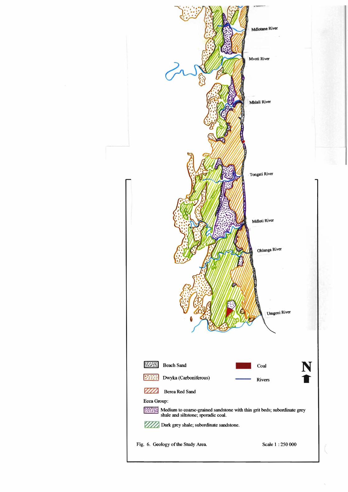
Middle Ecca or coal-bearing series (pistorius, 1962). Some places such as Umhlali have
thin seams of coal (Fig. 6). This coal had been removed in some places by Bantu
speaking Iron Age settlers and early European settlers, to fire smelting furnaces or sugar
mills.
3.4 Soils
The soils of this area reflect the rocks from which they are formed. They vary in
structure, depth and fertility, depending on the slope, parent material and the climatic
conditions prevalent at the time of their formation. Alluvial deposits and alluvial soils
are a common occurrence along the large rivers. The soils may vary in fertility but they
are generally suitable for cultivation of sugar cane, the only limitations being steepness of
slope and waterlogging (Pistorius, 1962).
Red and grey coastal sands are found along the ridges and valleys of the coast and
generally do not occur more than 6.5 kilo meters from the coast (Beater, 1957). The grey
sands occur on flat terrain while the red sands occur on the steeper areas.
There are a great variety of soils in the sugar belt. Some are poor for cultivation while
others are naturally fertile. The latter type was described by Van der Merwe as "gley-like
podsolic soils" (Archaeology and Natural Resources of Natal, 1951). He stated that these
soils were in their initial stages of development and that the topography inhibited the
production of stable profiles. Soil analyses have shown that a large amount of gravel had
accumulated in the B 1 horizon, which consisted predominantly of 'pea ore' iron oxide
Beach Sand
Dwyk (C~-I..~ . fi ) _ . __ a _ D!vvDLerOUS
W~ Berea Red Sand
EccaGroup:
Mdlotane River
Mvoti River
Mblali River
\ Tongati River
Mdloti River
Ohlanga River
Umgeni River
- Coal
Rivers
N •
"", ." _ ,.,,,. ,4 Mediwn to coarse-grained sandstone with thin grit beds; subordinate grey shale and siltstone; sporadic coal.
~ Dark grey shale; subordinate sandstone.
Fig. 6. Geology Ofth0 Study Area. Scal0 1 : 250 000 (

29
deposits. Some soils did not develop the podsolic profile completely due to unfavourable
topography.
3.5 Physiography
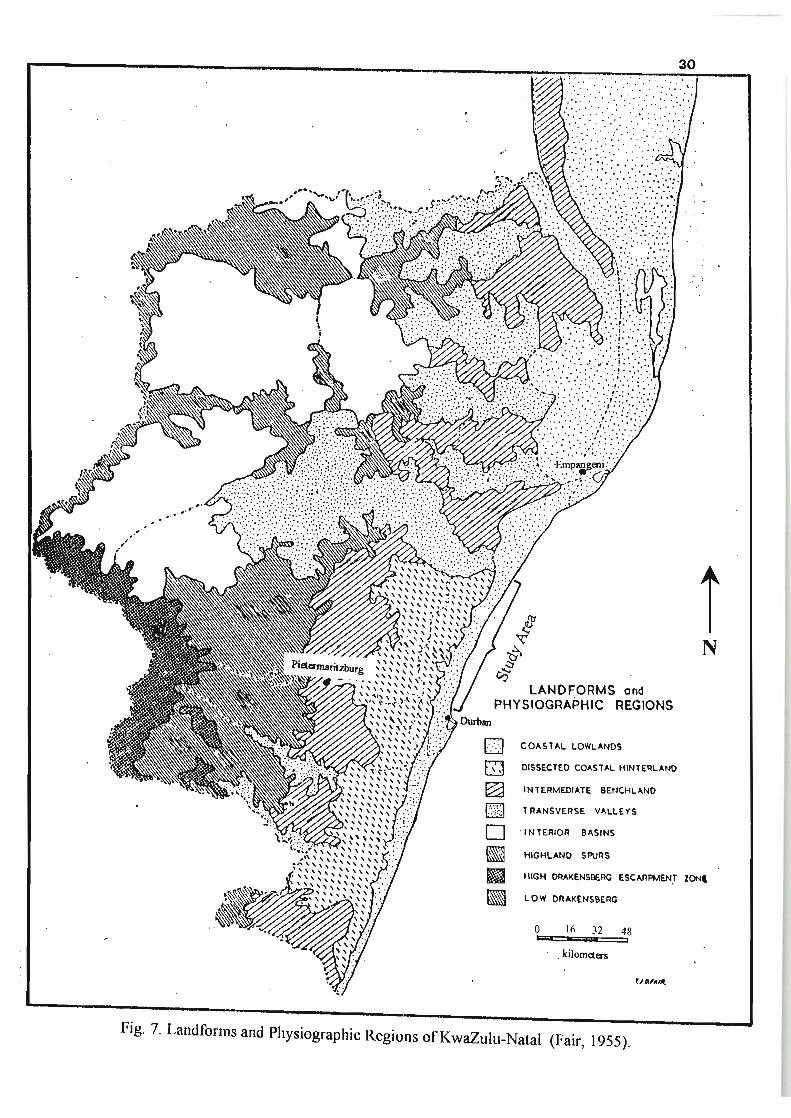
The characteristic land forms in this area are rolling hills. The north coast can be
described as coastal lowland (Fig. 7). In the inland areas the rivers cut deeply into the
Natal Group Sandstone, while at the coast the valleys tend to be shallower. During
geologically recent times the sea level has risen and fallen many times. Consequently,
when the sea was low, the rivers cut very deeply into the valleys and these became
choked with silt when the sea level rose. As a result of this, the mouths of the large rivers
have solid rock far below the lagoon surface.
As the sea level dropped in earlier periods, raised beaches were left behind. The high red
dune which lies parallel to the coast covers some of these raised beaches. These may
have been formed due to wind or may have been a submarine sand-bar during a period
when the sea level had risen. These dunes are characteristic of the Natal coast and form
prominent hills behind the beach, as at Umdloti (Pistorius, 1962).
The process of silt deposition is common on the north coast. This results in the formation
of a submarine offshore sand-bar which closes off the mouth of a river, forming a lagoon
in the dry season. This is a characteristic feature of the north coast.
3.6 Coastal Morphology
The north coast of KwaZulu-Natal is characterised by magnificent beaches with
numerous rock outcrops. The mouth of the Tugela River is bordered by an extensive
beach on the south side that forms part of the river mouth barrier. South of this, densely
vegetated coastal dunes form the backdrop to a narrow beach which is underlain by rock
, "
. " . : . ' . . , -
.' ,f ' : .• ' .
' ..
LANDFORMS and PHYSIOGRAPHIC REGIONS
[] COASTAL LOWLANDS
~ DISSECTED COASTAL HINTERLAND ~
~ INTERMEDIATE BENCHLAND
[JJ TRANSVERSE VALLEYS
o ' INTERIOR BASINS
~ HIGHLAND SP.JRS
30
I N
11 HIGH DRAKENS9ERG ESCARPMEN,T ZONI
~ LOW ORAKENSBERG
o 16 IJ;;;;a
32 48 ,
, kilomtiers
Fig. 7. Landforms and Physiographic Regions ofKwaZulu-Natal (Fair, 1955).

31
outcrops (Dwyka Tillite). South of the Zinkwazi River mouth is a narrow beach with
rocky outcrops. The Nonoti River is flanked by a large donga on the north side and two
large dongas on the south side. As far south as Blythedale Beach, the beach is underlain
by rock resulting in several embayments between prominent rocky outcrops.
On the south side of the Mvoti River is a dolerite outcrop and a wide vegetated dune.
South of this river is an irregular coastline resulting from continuous bedrock outcrop.
This part of the coastline has a narrow beach and scattered coastal dune development.
The coast between Umhlali and Port Zimbali is very irregular and rocky where dolerite
outcrops occur. In contrast there is a wide sandy beach with little rocky outcrop between
Port Zimbali and the Tongati River. South of this, up to the Mdloti River, the coast is
rocky, while between Umdloti and Umhlanga Rocks the beach is mainly sandy with
scattered rock outcrops. A wide sandy beach is found between Umhlanga and the
Umgeni River. This section of coast has experienced much destruction by humans and
most of the coastal dunes have been modified or removed due to development (Cooper,
1991).
3.7 Vegetation and Conservation Status
In his description of the coastal vegetation ofKwaZulu-Natal, Acocks (1953) refers to the
forest and scrub forest which have largely disappeared (Fig. 8). This area is covered by
thomveld and bushveld at lower altitudes and by mixed grassveld at intermediate
altitudes. Patches of forest have survived in the area.
Coastal forest typically exists in areas of high rainfall. In some areas these forests are
restricted to the dunes. In certain areas where the vegetation is exposed to salt spray, tall
trees are prevented from reaching their full potential as this damages the trees and results
in dune thicket (Low & Rebelo, 1996). Dune thicket develops into forest in more
sheltered areas. Forest patches constitute part of the coastal bushveld-grassland
vegetation type, which is part of the savanna biome (Low & Rebelo, 1996).

o Co ... nl Forest find Thornvnld
~ Ngongrlnl Veld
[2l V,,"ev nlutw.ld
L-::1 __ r:.-~ Sf')I'It-.~'n Tall Grln' .... ld
8] NnonAnnl V~ld fir NAt,., MISlhfth
D ttlgh'Alld S nur VoId
JOroJO' 31'00'
-- - - 29"00'
01020:10 ~=-""'--I
A Anlln1imlolj
0 lJurhan
G (;rtywwn
K Kramlwp
N Nfl1Iinghlm HOIll
Nil New Ilanover
r I'itltrnurilll ll ltll
11 HidllnlHlI1
S Slang'" ,. Ton~ul
Itn:u\,
Hivt",~
Fig. 8. The vegetation of the study area as described by Acocks (Moll, 1976).
32

33
Coastal Forest is well conserved in some reserves in KwaZulu-Natal, although this
vegetation type is threatened by holiday resort developments, and the use of flrewood,
building materials and muti plants in rural areas (Low & Rebelo, 1996). Coastal
bushveld-grassland exists in the form of remnants and is poorly conserved. This
vegetation type shows signs of disturbance and invasion by alien plants. Urbanisation,
industrial development and especially sugar and timber plantations have aided in the
eradication of this vegetation type. The use of wild timber has ceased but there is still
illegal exploitation of some poor specimens.
Tinley (1985) described the dunes of the study area as being small and supporting thicket
or forest. According to TinIey the following were unique coastal dune areas that require
protection (Fig. 3):
• Hawaan Forest at Umhlanga lagoon
• Seteni: a strip of dune forest south ofCasuarina (At Westbrook)
• Deep forested ravines, south of the Mvoti River
• Dune forest between Blythedale and Mdlotane River
• Deep forested ravine, south ofNonoti River
• Hlogwane forest, south of the Tugela River.
3.8 Land use
The dominant activities along the north coast are the cultivation and processing of sugar
cane. Approximately 70 percent of the area was covered by this crop by 1960 (pistorius,
1962). As one travels along the north coast the importance of sugar cane in this area is
evident by the endless flelds of this crop in various stages of cultivation. The north coast
is the most intensively cultivated region in KwaZulu-Natal.
The following table extracted from a study done by McCarthy (1987) demonstrates the
intensive cultivation of sugar cane along the north coast when compared to the south
coast. McCarthy (1987) divided the coastal margin into regions and for each region the

34
land use of the coastal belt was determined (Table 1). The percentage of land used for
sugar cane cultivation is highest in the regions that fall within the study area. It is also
evident that with the exception of the area from Illovo Beach to Umhlanga, the study area
contains high proportions of natural vegetation. The areas further south are more built up
than those on the north coast in spite of the relatively high land usage for sugar cane
cultivation.
Table 1. Land Use along the Natal Coast in 1981 (McCarthy, 1987).
Port Edward to 16 7
Southbroom
Ramsgateto 6 48 45
Melville
Mtwalume to Ocean 7 4 14 75
View
Park Rynie to 9 3 20 68
Umkomaas
Illovo Beach to 2 0 5 82
Umhlanga * Umdloti to 13 0 5 82
Ballito * Umhlali to 18 3 2 76
Tugela *
* Regions that fall within the study area.
Immediately north of the Umgeni River there is an industrial area, but as one moves
eastwards and north away from here, residential areas are predominant. Further north,
towards Umhlanga Rocks, the residential and commercial area is close to the coast (about
1 km from the coast) and west of this is cultivated land. Between Umhlanga Rocks and
Newsel Beach-Umdloti there is little or no formal urban development. In this area there
is natural vegetation along the coast and cultivated land west of this. Between the Mdloti
35
and Tongati rivers there are small residential areas (La Mercy, Desainagar and
Westbrook). Apart from these, the rest is cultivated land. North of this are extensively
cultivated areas, with few patches of natural vegetation. The developed areas here
include Ballito, Umhlali, Salt Rock, Sheffield Beach, Blythedale Beach and Zinkwazi.
Land use along this area is changing as development spreads up the coast. This is due to
the expansion of the Durban metropolitan area in keeping with decentralisation. More
and more people tend to live a considerable distance from the city centre and commute
daily to work. In addition, the development of this coast as a tourist attraction is likely to
influence land use change in the near future.
3.9 Settlement Patterns
Many of the areas along the north coast were settled as sugar mills sprung up, and these
have become prominent towns in the area. A few decades ago these towns were
controlled and serviced by sugar companies. Apart from the settlements that grew around
sugar mills there are three other centres that became important areas for trading and
commerce. These are Stanger, Tongaat and Verulam (Fig. 3).
The residential areas north of the Umgeni River were laid out in 1926 (Durban North)
and thereafter these areas grew considerably. Umhlanga Rocks is expanding rapidly to
accommodate the large number of people that choose to live in this area, due to its sea
views, exclusive character and close proximity to the city centre. The growth of office
parks and commercial nodes in Umhlanga have also drawn people to this area, as services
and employment seem promising.
McCarthy (1987) studied urbanisation along the Natal coastal margin with a view to
developing planning policy for this area. In his study he grouped the various towns
according to their settlements. Tongaat Beach and Tinley Manor were grouped as
settlements characterised by high levels of undeveloped land and low levels of space used

36
for flats and houses. Umhlanga, Umdloti, Umhlali, Blyhtedale and Tugela were
characterised by high levels of space used for housing and much land used for public
recreational space. These settlements were also found to have rapid population growth
rates. Glen Anil was characterised by a large percentage of land used for industrial
purposes and rapid non-residential growth. Ballito and Zinkwazi were found to have
high levels of population growth and a 'good supply' 0 f public recreational space. Most
of the towns in the study area were classified as medium or small size coastal towns by
McCarthy (1987), with reference to future planning and policy formulation.
3.10 Socioeconomic characteristics
In the 1960s there were eight sugar mills (Mount Edgecombe, Maidstone, Shakaskraal,
Groutville, Gledhow, Glendale, Darnall and Doornkop) along the north coast. At present
this number has decreased to three (Maidstone, Gledhowand Darnall). This decrease in
the number of the sugar mills initially was due to two large sugar companies
monopolising the sugar industry, which resulted in the smaller mills shutting down.
Subsequently there was a focus on efficiency of the existing mills, which became larger
in order to process more sugar cane. More recently however, there has been pressure for
urban development, which has resulted in the closing down of one large sugar mill. In
the southern part of the study area, the growth of the metropolitan area of Durban has
resulted in development encroaching on cultivated areas (Pistorius, 1962).
Although the coastal resorts within the study area did not play a significant role in the
economy of this area, this is changing, especially in the cases of Umhlanga, Umdloti,
Ballito, Shaka's Rock and Salt Rock. These areas have long stretches of beaches with
rocks and varied coastline. Other resort areas include T ongaat Beach, Compensation
Beach, Willard Beach, Sheffield Beach, Blythedale Beach and Zinkwazi Beach (Fig. 3).
The north coast has pristine beaches and large tracts of undeveloped land, but developers
and investors realise the potential of this area for development. Umhlanga, which is

37
situated about 20 km north of Durban, is growing rapidly. There are plans to develop this
into a major regional node (Verbaan, 1998). There has also been a major development of
a prestigious lodge at Zimbali, north of Tongaat. There are additional plans to develop
Umdloti and expand the residential area at Ballito by rezoning a large sugar estate. The
development along this coastline is largely due to the potential of this area as a holiday
destination and the plans to relocate the existing airport south of Durban, to La Mercy
west ofUmhlanga.
The need for development along the north coast is a very controversial issue. There are
those that support this as it will create jobs and economic growth for the area while there
are those that oppose this as it will disturb the natural areas that have been protected from
human impact for decades. McCarthy (1987) indicates the importance of a
comprehensive coastal planning policy, especially in terms of ensuring that coastal
conservation is an integral part of development along the coast.
38
CHAPTER 4
PRECOLONIAL IMPACT ON VEGETATION
4.1 Introduction
Southern Africa has been inhabited by hominids for at least three million years (Volman,
1984). The settlement pattern of the subcontinent of southern Africa by Bantu-speaking
people has only recently been established. It was believed that as Bantu-speaking people
were still moving southwards and westwards, they first encountered white colonists on
the Eastern Cape border. However evidence indicates that Bantu-speaking people settled
south of the Limpopo River in the first few centuries A.D. and that Iron Age communities
were well established in Natal and Transvaal before A.D. 300 (Maggs, 1986). It is
important to examine the settlement pattern of the study area in order to ascertain what
impact early settlers had on the land, including both the Stone Age and Iron Age people.
In order to survive, the Stone Age and Iron Age people relied extensively on natural
resources. One important resource was, most certainly, vegetation. The natural
vegetation at the time would have been used for consumption (food), to build dwellings,
for fuel and later vegetation would have been cleared to create bare land that could be
cultivated or settled and used to rear livestock. Agriculture played a major role in
changing the lifestyle of these people from a nomadic to a settled one (Maggs, 1986).
The physical environment played a significant role in the existence of early humans. The
availability of material for tools, the climate and the surrounding terrain were of
importance. The climate determined the type of shelter that was required and this in turn
determined the type of tools required. For example, where caves were available, there
was no need to construct a shelter, and fewer tools were required for construction. In this
instance~ ordinary stone and bone implements were required for hunting. Stones were
required for softening small skins and reeds were used for making arrows (Cooke, 1968).
In contrast, where there was a lack of cave shelters, there was a need to construct a

39
shelter. It then became necessary to use chopping tools. The type of food eaten also
determined the type of tools required.
The geology was important for both Stone Age and Iron Age people, as the former relied
on rocks for manufacture of stone tools and the latter relied on rocks and soil to shape
their social structure. The available rocks were also a determining factor in the
manufacture of tools for various activities. Iron Age people relied on the rocks and soil
as a source of iron ore as this was a prerequisite for the process of iron smelting. This
process also required a source of energy in the form of charcoal (Haaland, 1985). These
two requirements determined where these people settled. Iron smelting became
important as a specialised occupation and villages formed around this activity.
4.2 Precolonial History
4.2.1 Stone Age People
Based on the technological innovation and lifestyle of humans, it is possible to
distinguish different periods in the history of human development (Table 2). The use of
tools in hominid development was gradual as was the domestication of crops and
livestock. The excavation and collection of Stone Age materials in southern Africa have
assisted in an understanding of the cultural development of humans over time. The Stone
Age is divided into the Early Stone Age (ESA), the Middle Stone Age (MSA) and the
Late Stone Age (LSA). These three phases can be distinguished by the tools used, the
aggregations and industrial complexes prevalent during the various phases (Volman,
1984).
The Early Stone Age involved the production of rough choppers from flakes of pebbles.
This period was also characterised by the production of large hand-axes, picks, cleavers
and choppers. Hand-axes and picks were used, amongst other things, to kill animals, dig

40
Table 2. Guidelines for the dating of the various periods in precolonial South Africa.
(Anderson & Whitelaw, 1996b)
-Early Stone Age ESA 2 million years ago to 200 000 years ago
Middle Stone Age MSA 200000 years ago to 30 000 years ago
Late Stone Age LSA 30000 years ago to the last century
Early Iron Age EIA 1 700 years ago to 1 000 years ago
Late Iron Age LIA 1 000 years ago to A.D. 1829
Historical period Post-1829
up roots and dig game traps. Cleavers had a wide blade and were used to chop wood or
to skin animals. The ESA covers about 400 000 years. Early hominids had a
predominantly vegetarian diet but as the diet changed, the manufacture and use of tools
became very important. Wild fruit and other vegetable foods were the food source during
the wet season but during the dry season it was necessary to seek meat as a food resource,
which required the use of tools (Clark, 1959). There has been evidence of hunting and
killing of animals at ESA sites (Volman, 1984). Tools such as cleavers, handaxes and
bifacial knives were found at these sites. Some ESA assemblages have been assigned to
the Sangoan Industrial Complex, which were represented by small scraping forms and
crude pick-like forms (Volman, 1984).
ESA site location generally varied but the extremes of dry desert and dense forest were
avoided (Volman, 1984). These sites were often located close to water sources, as there
was a lack of utensils to carry water. The majority of ESA sites were disturbed, open
areas but some evidence suggests that the Sangoan Complex had adapted to more
wooded areas. Sangoan assemblages occur predominantly north of the Limpopo River.
Palaeoenvironmental information at ESA sites is lacking, making it difficult to make
general statements regarding the duration and intensity of occupation (Volman, 1984).

41
The main tools of the Middle Stone Age were thin flakes and blades, including points,
scrapers and denticulates. The main weapon during this phase was the spear. MSA sites
have similar locations to ESA sites. These include river banks, floodplains, lake or pan
edges and springs. Information on the subsistence of the MSA people comes from faunal
remains. Evidence suggests that MSA people hunted more intensively than their
predecessors and they sometimes managed to drive entire herds over cliffs (Volman,
1984). It is generally believed that MSA people were hunter-gatherers and that they had
little impact on the vegetation.
The Late Stone Age was characterised by use of the barbed arrow. In Natal, this was
known as the Smithfield culture, where people used tools made from thin flakes which
were more carefully trimmed. Also characteristic of this phase were ground bone and
stone objects, various types of scrapers and microbladelets (Kaplan, 1990). Unlike MSA
people who lived in open areas, most Smithfield people lived in rock shelters
(Archaeology and Natural Resources of Natal, 1951).
4.2.2 Iron Age People
Evidence indicates that iron technology diffused from North Africa southwards. Iron
using traditions may have spread through contact, although this is not well documented.
Metallurgical technology necessitated changes in the socio-economic structure of
communities (Kense, 1985). Iron working may have had a great role to play in a given
society, economically, socially and politically. Factors of importance in this regard
include: the purposes of iron production, the availability of raw materials, the time
invested in iron working, the labour cost involved, the risk involved in construction of a
furnace, the intensity of iron working required, and control of the process of
manufacturing and distribution of iron products. These factors resulted in fundamental
differences between Iron Age society and Stone Age society. Unlike their Stone Age
predecessors, Iron Age people could make metal objects.

42
The Iron Age is divided into two phases, namely, Early Iron Age and Late Iron Age.
This is based on chronology and ceramic typology. Much controversy surrounds this
dichotomy. Distinctions between EIA and LIA sites are based on location (EIA sites
were generally close to a water source and LIA on hill tops), huts, the use of stone walls,
smelting furnaces, grindstones, ceramic sculpture and ornaments (Maggs, 1984). There
was also considerable variation geographically.
The process of iron smelting required a specialised knowledge involved in the selection
and preparation of the fuel (wood), furnace construction, maintaining a constant
temperature and creating the finished product. In Africa there were (and still are) three
main types of furnaces: bowl furnaces, low shaft furnaces and high shaft furnaces.
Bellows were classified as either drum bellows or skin bellows (Kense, 1985). Skin
bellows were made of sheep skin or goat skin (Haaland, 1985). Tuyeres were made by
shaping clay around a stick. These were used to direct air from the bellows deep within
the furnace.
Iron smelting commenced with the construction of the furnace and the bellows, as well as
tuyeres, where the latter were used. The ore was added to the furnace. Slag was
separated from the iron either during the process of smelting or when the process was
over. Shaft furnaces were tied with plant fibres in order to prevent the shaft from
cracking during the firing (Haaland, 1985).
The Iron Age people settled in an area to form a village of several to many homesteads,
as they kept livestock and they grew crops. In addition they produced pottery and other
crafts. The Iron Age people in southern Mrica were Bantu-speaking. It is thus generally
agreed that the spread of the Iron Age was associated with the spread of this language and
its derivatives within Southern Africa (Maggs, 1986).
Pottery manufacture was a significant activity in the lives of Iron Age people. Pottery
may be differentiated by the materials they were made from and the technology that they
were associated with. Different types of pottery also give us clues to different

43
technologies associated with them. Reference may be made to NC2 and NC3 pottery in
the course of this account. NC2 pottery was either found on its own or together with
NC3 pottery. NC2 pottery was made of soft material and tended to be grey to black in
colour (Inskeep, 1971). This type of pottery included platters, pots and bowls. These
were characterised by notching of the rim, surface pitting and surface relief by pinching,
grooving, incisions and comb-stamping. NC3 pottery was made of generally course
material and 'self-coloured'. Decorations included deep grooving in parallel lines, cross
hatching and herring-bone. NC3 pottery was commonly found in association with iron
smelting (lnskeep, 1971).
4.2.3 Migration of Iron Age People
Iron smelting was first discovered in the Middle East. It spread to West Africa by about
500 B.C. and a few centuries later this technology had reached Central Africa (Maggs,
1986). Early Iron Age sites dating back to around 2000 years ago were discovered in
parts of Central and East Africa, with some sites in these areas dating to around 400 B.C.
It has been accepted that the first route used by Iron Age people to reach South Africa
was down the eastern seaboard. The Natal coast had been reached before AD. 300.
Early Iron Age people moved into areas that were alfeady inhabited by Stone Age hunter
gatherers, spreading through the savanna areas of southern Africa. They settled primarily
in the summer rainfall area of more than 600 mm mean annual rainfall (Maggs, 1986).
This rainfall was adequate to meet the requirements for cultivation, for grazing, and for
timber, which was used for building materials and fuel.
The Early Iron Age (EIA) sites represented four phases (Anderson & Whitelaw, 1996b):
(a) the Matola phase - 4th to 6th centuries AD.
(b) the Msuluzi phase - 6th and 7th centuries AD.
(c) the Ndondonwane phase - 9th century AD.
(d) the Ntshekane phase - 9th and 10th centuries AD.

44
During the Late Iron Age (1000 years B.P. to A.D. 1829) there was expansion from the
savanna areas into areas currently mapped as open grassland areas of South Africa.
Settlement was influenced to a large degree by agriculture, as this activity tied people
down to a specific area. People had to remain in the area to tend to crops in the growing
season, and to process and store produce during and after the harvest. Iron Age crops
included grain (sorghum, bulrush millet, finger millet), legumes (groundnuts and
cowpeas), cucurbits (Cucurbitaceae), pumpkins, melons, squashes and gourds. These
crops were originally domesticated in Africa, although the time and location of this
domestication is unknown (Maggs, 1986). The pioneer villages in Natal practised
agriculture but depended on wild animals for their meat requirements, since it was not
until about A.D. 500 that domestic animals were kept.
4.3 Methodology
It was necessary to examine archaeological sites within the study area in order to discover
more about the patterns of settlement and the livelihoods of the Stone Age and Iron Age
people. It was hoped that the information contained in archaeological records would
provide clues or direct evidence as to the type of vegetation present during the
precolonial settlement of the study area. This would enable one to compare the
vegetation during this early period to the vegetation present during later periods, and thus
establish possible patterns of vegetation change.
There was a need to establish where archaeological sites existed within the study area.
The Natal Museum in Pietermaritzburg was visited and archaeological records for Natal
were examined in detail, covering the area from the Umgeni River to the Tugela River.
Information captured for this purpose included the following:
• Site number (For the purposes of this study site numbers were used when the sites
were plotted on a map. )
• Locality
45
• Local name
• Grid reference
• Date of occupation (Early, middle, late - Stone or Iron age)
• Site category (midden, dune, riverine site, surface pottery, pottery scatter)
• Evidence of pottery
• Evidence of iron implements or smelting activity (slag or tuyeres)
• Evidence of shells
• Evidence of stone implements
• Other evidence
These criteria were used to draw up a table of all sites within the study area. Using the
grid reference, these sites were plotted on 1: 50 000 maps which covered the entire study
area. The result was a single map which included the archaeological sites, together with
major rivers and towns. The map was then reduced to a more manageable scale. From
this map, patterns of the location of archaeological sites were identified.
Some information was gathered by speaking to staff of the Natal Museum,
Pietermaritzburg. This information included the activities and movement of Iron Age
and Stone Age people in the study area. Books, journal articles and magazines were used
as sources of additional information.
4.4 Results and Discussion
4.4.1 General Settlement Patterns
A total of 210 archaeological sites were recorded within the study area, details of which
are presented as Appendix 1. The period (EarlylMiddlelLate Stone Age or EarlylLate
Iron Age) of occupation was not available for all sites. Of the total, 109 sites were
recorded as having been of the Iron Age period and 23 sites were of the Stone Age

46
period, with the remaining sites being classified as unknown or Stone Age and Iron Age
(Table 3). All the sites were plotted on a map to determine settlement patterns.
Table 3. The number of sites per "cultural period"
No. of Sites
Percentage
of Total
23
11
109 20
51.9 9.5
57 1 210
27.1 0.5 100
Figure 9 indicates certain areas where there are concentrations of archaeological sites.
Sites were generally concentrated along the coast, and where sites were not within close
proximity to the coast, they were located within close proximity to rivers. Very few sites
occupied the elevated interfluves of the interior of the study area. Areas where
concentrations of archaeological sites were high are as follows (numbers in brackets refer
to locations shown on Fig. 9):
• Between Durban North and Mdloti River N2 (1))
• Between Genazzano and Sheffield Beach (2)
• Near the Mhlali River at Headlands and Tinley Manor (3)
• At Blythedale Beach near the Mvoti River (4)
• At Zinkwazi Beach and at the mouth of the Zinkwazi River (5)
• Along the Tugela River, away from the coast (6 and 7) .
The majority of the above concentrations of archaeological sites on the beaches coincided
with rock outcrops. The rocks would have provided the ideal place for abundant marine
food resources in the form of mussels and oysters. The inhabitants of the area would

5
2
1
N
A Scale (KM)
Fig. 9: Archaeological sites within the study area o 5 10

48
have come to the beaches to consume this valuable resource. This would also explain the
large percentage (53 .3%) of sites where middens were found (Table 4).
Table 4. Summary of features of all archaeological sites along the north coast
margin between the U mgeni River and the Tugela River.
(Appendix 1: Total Sites 210)
Middens 112 • 53.3 12
Evi~ence of Pottery 97 · 46.2 13
Charcoal 10 · 4.8 14
Grindstones 11 5.2 IS
Evidence ofIron working 13 · 6.2 16
Stone Tools 13 6.2
Bones 26 12.4
At 1, Figure 9 there were scattered rocks at the coast, with fairly flat land adjacent to this
coastal area. This area consisted predominantly of Iron Age sites, dense concentrations
of middens and pottery. This implies that there was a fair amount of activity in this area,
although the evidence does not directly imply the extent to which these activities
impacted on the vegetation. At concentrations 2 and 3 (Fig. 9), there was a similar
pattern. At 4 (Fig. 9) middens and pottery were very sparse. At 5, 6 and 7 (Fig. 9)
middens were less numerous than in the cases of 1 and 2, but pottery occurred in
abundance. It is possible that these three sites coincided with agriculture, as these
occurred in the alluvial flats, which would have been suitable for cultivation.
If one considers the Stone Age sites (Fig. 10), these seem to be concentrated in the area
between Port Zimbali and the Tongati River mouth along the coast. There is a fairly high
density of Stone Age sites south of this, up to Umhlanga. In contrast, the Iron Age sites
(Fig. 11) occurred in concentrations along the coast close to the river mouths (Zinkwazi,
Mvoti, Mhlali, Tongati) or they occurred in coastal strips (between the Mhlali River and

49
•
Stone Age Sites
• ESA
• LSA
• MSA
USA
" >1 Stone Age
N
A Scale (KM)
Fig. 10: Stone Age Sites o 5 10
ESA: Early Stone Age; LSA: Late Stone Age; MSA: Middle Stone Age; USA: Undifferentiated Stone Age

Iron Age Sites
• ErA
• LIA
.. UIA
ErA, LIA
N
A Scale (KM)
Fig. 11: Iron Age Sites o 5 10 EIA: Early Iron Age; LIA: Late Iron Age; UIA: Undifferentiated Iron Age

51
Genazzano). South of the Mdloti River, as far as just north of the Umgeni River, sites
were widely distributed, and appear to have been concentrated a few kilometres from the
coast.
Artefacts recorded at the archaeological sites were predominantly middens (containing
discarded shells of shellfish) and sherds (pottery fragments). Stone tools, bone, charcoal
and grindstones were other artefacts that were found (Table 4). Direct evidence of iron
smelting took the form of tuyeres and iron ore. These records were used to produce maps
that would provide a picture of localities where specific artefacts were found . This would
enable one to determine whether distribution patterns were present and whether these
were related in any way to the vegetation or the physical environment.
4.4.2 Analysis of Stone Age Settlements
At the sites encountered in the study area, 43 showed evidence of Stone Age activities
(Table 3). At many of the sites examined, stone tools were found. These included stone
knives, "shell-openers", broken stones, flakes and one basalt arrow-head. The presence
of flakes at some sites may be indicative of the manufacture of stone tools. Stone tools
were found at 6.2 % of the total number of sites (Table 4). Areas with concentrations of
stone tools include Port Zimbali, Genazanno, Blythedale Beach, Tinley Manor, Zinkwazi
Beach and a few localities close to the Tugela River mouth (Appendix 1). There was a
preference for coastal sites (Fig. 10), presumably where there was easy access to the
marine food resource.
Tools found in the region ofZinkwazi and the Tugela River included handaxes, cleavers,
choppers and stone flakes (Anderson & Whitelaw, 1996b). There was a large scatter of
stone tools found here. At another site close by, many stone tools were found,
predominantly consisting of flakes and river pebbles. This seems to indicate an ancient
quarry of some sort. The Sangoan culture in Natal has been found at the Tugela River

52
mouth (Clark, 1959). Unifaced and bifaced picks, handaxes, flakes, side-scrapers and
choppers were found at this site. This culture is associated with the Red Dune (Berea
formation). The Smithfield culture is also found in Natal and shows various regional
variations. The coastal Smithfield culture sites in Natal indicate that this culture existed
at an earlier period than the Bantu occupation, as this underlies the Bantu middens (Clark,
1959).
An excavation at Umhlanga Rocks revealed a very large specimen of the sand-oyster,
which became very rare due to over-exploitation (Davies & MacDonald, 1978). There
were scanty remains in this midden, which included shell openers. It was suggested that
this site was occupied by non-Bantu speakers, as middens of Bantu-speakers normally
contained pottery. Although it is a possibility that this midden was occupied by Bantu
speaking people, the evidence suggests that there were people of Stone Age culture that
occurred in this area as late as the middle of the present millenium (A.D. 1500).
There is evidence that indicates continuity in the technology between MSA and LSA.
The MSAlLSA transition occurred between 35 000 and 20 000 years ago. It has been
suggested that this transition was influenced to a greater degree by social responses rather
than by adaptations to the environment (Kaplan, 1990). There have been indications that
the hunter-gatherers interacted with Iron Age farmers.
During the Stone Age there was reliance on the geology to produce tools to assist these
people in their daily lives. Concentrations of stone tools were generally found close to a
food source, namely meat. These stone tools were used to dismember animals in order to
consume them (Clark, 1959). The Stone Age people's requirements of the natural
vegetation were few. They required vegetation as food sources. Wood was used for the
production of throwing sticks, digging sticks and wooden spears during the Early Stone
Age.
Stone tools were also used along the coast in the processing of shellfish (Anderson,
1997). These stone tools were used to open up the shellfish and extract the meat. Early

53
humans utilised roots and tubers as food sources and these were dug up with the aid of
stone tools. Wood required for fire was chopped with specially modelled stone tools. As
the diet changed, and meat was consumed to supplement the vegetarian diet, intricately
designed tools were used to skin animals (Archaeology and Natural Resources of Natal,
1951) and cut the meat into smaller pieces.
Hence the bulk of the impact of Stone Age people on the vegetation would have been
through the use of vegetation for food requirements. This would have been largely non
destructive and therefore sustainable. Plant material would also have been used in the
form of wood for fire but presumably dead wood would have been used. Charcoal found
at some of the Stone Age sites (Appendix 1) indicates the use of fire. Stone Age people
began to use fire about 150 000 years ago, which would have resulted in changes in
natural fire regimes (MacDonald, 1989). Fire was used by Stone Age people to keep
warm. Furthermore, fire was used extensively to drive game into enclosures where they
could be killed during hunting (Woodhouse, 1971).
The impact of Stone Age people on vegetation is considered to be low as they were
hunter-gatherers and did not clear large areas of natural vegetation. The role played by
Stone Age humans in changing the vegetation of the study area, therefore, was probably
small. Stone Age people generally avoided densely vegetated areas for settlement
(Volman, 1984). The occurrence of the Stone Age people along the coast may therefore
imply that this area was more open, possibly grassland with tree patches.
4.4.3 Analysis of Iron Age Settlements
The social structure of the Iron Age people differed from the Stone Age people in that
Iron Age people settled in villages. This was a result of their lifestyle. Iron working was
associated with occupational specialization. While the Stone Age people moved in
search of food and hence led a nomadic existence, the Iron Age people cultivated crops

54
and kept domestic animals which required them to settle in one area to tend to these
activities.
The social structure of Iron Age people was specialised. The EIA villages had
populations of several hundred people. These villages consisted of scattered homesteads
which housed small families (Maggs, 1986). Each village was self-sufficient with
regards to food and the implements that they produced. The men were involved in the
production of iron and the women were responsible for making pottery. The area around
the village was used to graze their herds, hunt and gather wood, as well as gather wild
plants for food. There was also some form of trade between villages.
Figure 11 shows the settlement pattern of the Iron Age people within the study area. The
EIA sites are concentrated at the coast to a greater extent than the LIA sites. The latter
sites tended to be further inland. The possible reason for this is that EIA people
depended more on the marine food resource than the LIA people, who placed more
emphasis on agriculture, which implied that the LIA people would need to carry out their
activities in areas with suitable soil, for example, river valleys.
The transition from EIA to LIA was characterised by a change in the pottery styles,
architecture, settlement patterns, iron smelting furnaces, tools and ornaments. One
significant change in the LIA was the expansion of settlements from the exclusively
savanna areas during the EIA, to the grassland areas in the LIA. In this open, more
treeless environment, building material was predominantly stone. This was done to cope
with the scarcity of wood as a building material (Maggs, 1986). These stone-built
dwellings are well preserved, ~ut those built of wood have long since perished and leave
us little or no evidence of settlement. The occurrence of EIA sites along the coastline
suggests that the immediate coastline was more densely vegetated (Fig. 11), while the
LIA sites away from the coast suggest a more open vegetation.
At Zinkwazi River sites (Anderson & Whitelaw, 1996b), there were many pottery sherds,
fragmented upper grindstones, upper and lower grindstones, and charcoal. There was

55
also evidence of iron smelting activity in the form of slag, and tuyere fragments. The
Zinkwazi River sites conform to the EIA settlement patterns of the Ntshekane phases.
These settlements are generally near a river, on flat low-lying ground. The people of this
period were agriculturists. They cultivated sorghum and millet and they kept stock
animals such as cattle, sheep and goats. They also ate wild animals such as antelope and
bushpigs (Anderson & Whitelaw, 1996b).
EIA sites were found at Mount Edgecombe and Sunningdale (Fig. 11). EIA sites
throughout southern Africa occur on arable land near lakes or rivers in wooded areas such
as savanna and forest (Whitelaw & Moon, 1996). These EIA sites at Mt Edgecombe and
Sunningdale were amongst the earliest Iron Age sites in Natal, and Matola-like pottery
was found here. Matola is named after a site in southern Mozambique, and Matola
pottery has been found in Northern Province, Swaziland, Zimbabwe, Mozambique and
East Africa. This indicates the southward movement of Bantu-speaking agriculturists
into the savanna and coastal regions of Sub-Saharan Africa. In Natal, the Motala phase
dates back to a period between A.D. 400 and A.D. 600 (Anderson & Whitelaw, 1996a).
Matola sites were influenced by the availability of iron ore, arable soil and the use of
natural vegetation as a resource. Matola site societies were located close to iron ore
sources, and they were typically small settlements. The evidence of Matola sites in
KwaZulu-Natal indicates the availability of iron ore in the near-coastal or coastal
environment. Evidence at Sunningdale indicated iron-working, including the presence of
slag at these sites.
There was considerable EIA material found at Mzonjani (Fig. 11), near La Lucia (sites
71, 193 and 194, Appendix 1; Maggs, 1980). This indicates a village of considerable size
and an occupation of several decades. A shallow pit with ,small quantities of domestic
debris was found here. It has been concluded that cattle were kept and that hunting and
trapping were activities of this settlement. There was also gathering of shellfish and wild
plant foods.

56
At Westbrook Beach a midden site was discovered (Anderson, 1997). This site was
repeatedly occupied through a single phase of the EIA. This was the Msuluzi phase
which dates between AD. 615 to AD. 879. This site consisted of two occupations, one
shortly after the other. The predominant food source at this site was shellfish, and to a
lesser extent terrestrial food sources (such as small bovids) were consumed. It is most
likely that this was an area where shellfish were processed rather than an area where
people settled. Evidence found here included fire-cracked stones, hammerstones,
grindstones and a hearth-like feature. This could have been used to crack open mussel
shells, which could have then been boiled or baked, as this relaxes the mussels in the
shell, making it easy to process this food source (Anderson, 1997).
Coastal resources played an important role in the livelihoods of coastal Iron Age
agricultural communities. There was an extensive period of coexistence between
agriculturists and remnants of the hunter-gatherer communities in Natal. This has led to a
debate over which group was responsible for the middens in the area (Horwitz, et. al.,
1991). Within the study area, shell middens were found predominantly at the coast (Fig.
12). Shell middens were found at 53.3% of the archaeological sites. This indicates the
extensive use of the marine food resources. At most sites there was no indication of
settlement, which suggests that the shellfish were processed and consumed at the coast
before returning to the settlements further away, or the shellfish were processed and
carried away to the settlements.
Two shell middens at Emberton Way (north of the Tongati River) and Umhlanga lagoon
on the north coast of Natal yielded a substantial amount of mollusc shells. Terrestrial
fauna appeared insignificant in the diet, based on the remains found. The evidence at
Emberton Way suggests that there was a long period of use of the shellfish resource over
several centuries which spanned the EIA At this site, as at Westbrook Beach, the
presence of hearths and fire-stones, together with a large amount of pottery, is indicative
of shellfish processing. Here as well, shells were cracked open either by using a stone
tool, or by baking, steaming or boiling (Horwitz, et aI., 1991). The pottery at this site
consisted of the four EIA phases (Matola, Msuluzi, Ndondondwane, Ntshekane). There

• Tongaat
Middens
Middens Present
N
A Scale (KM)
Fig.12: Sites where Middens were present o 5 10

58
was a change in shellfish exploitation as settlement and socioeconomic patterns changed
during the Iron Age. As time progressed, fewer shells were transported inland. Instead,
there was more shellfish processing that occurred at the coast and only the meat of these
shellfish was transported inland.
A close examination of the clay used to manufacture the pottery at these sites (Emberton
Way and Umhlanga lagoon) indicates that these were of granitic origin rather than from
the sedimentary formations of the immediate coastal strip. Granite outcrops occur in a
belt 20 to 40 km inland which is parallel to the coast. Should this pottery be confirmed of
granitic origin, then either oftwo explanations are possible:
a) The pottery was produced in the interior of Natal and reached the coast due to trade
with the coastal communities,
b) People of the inland communities carried pots to the coast where shellfish processing
occurred and they then used the pots to transport the meat back to their settlements
(Horwitz, et ai., 1991).
A significant activity of the Iron Age people was the making of pottery. Pottery is
closely associated with agricultural activity, as these hollow utensils would have been
very useful when gathering agricultural produce (Woodhouse, 1971). These vessels were
also very useful in the processing of shellfish and in the transportation of processed
shellfish (Horwitz, et ai., 1991). Sites containing pottery were located all along the study
area (Fig. 13). This could be attributed to the fact that pottery was used for a wide range
of activities and it could be readily transported. Pottery remains were found scattered in
the floodplains within the study area (Tugela River, Zinkwzi River, Mhlali River,
Ohlanga River and Umgeni River). These areas would have been suitable for agriculture
and settlement, hence the presence of pottery. Pottery manufacture would have also
required wood to fire them in order to harden the clay. This fuelwood requirement is
likely to have impacted on the vegetation.
The first Iron Age people lived and mixed with the Stone Age people (Clark, 1959). In
order to understand more about the early Iron Age in southern Africa, we need to look to
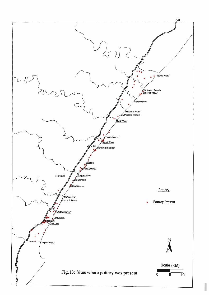
• Tongaat
Pottery
• Pottery Present
N
A Scale (KM)
Fig.I3: Sites where pottery was present o 5 10
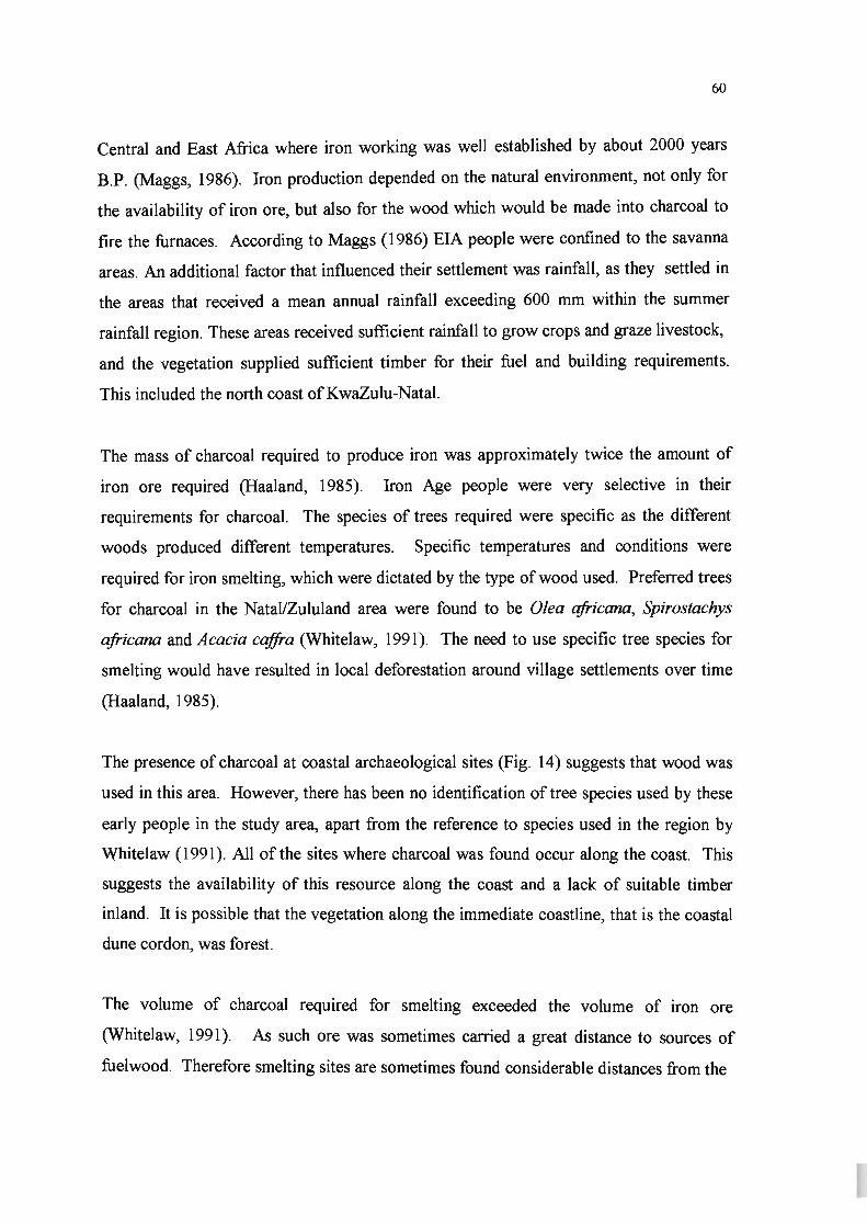
60
Central and East Africa where iron working was well established by about 2000 years
B.P. (Maggs, 1986). Iron production depended on the natural environment, not only for
the availability of iron ore, but also for the wood which would be made into charcoal to
fire the furnaces. According to Maggs (1986) EIA people were confined to the savanna
areas. An additional factor that influenced their settlement was rainfall, as they settled in
the areas that received a mean annual rainfall exceeding 600 mm within the summer
rainfall region. These areas received sufficient rainfall to grow crops and graze livestock,
and the vegetation supplied sufficient timber for their fuel and building requirements.
This included the north coast ofKwaZulu-Natal.
The mass of charcoal required to produce iron was approximately twice the amount of
iron ore required (Haaland, 1985). Iron Age people were very selective in their
requirements for charcoal. The species of trees required were specific as the different
woods produced different temperatures. Specific temperatures and conditions were
required for iron smelting, which were dictated by the type of wood used. Preferred trees
for charcoal in the NatallZululand area were found to be Olea africana, Spirostachys
africana and Acacia caffra (Whitelaw, 1991). The need to use specific tree species for
smelting would have resulted in local deforestation around village settlements over time
(Haaland, 1985).
The presence of charcoal at coastal archaeological sites (Fig. 14) suggests that wood was
used in this area. However, there has been no identification of tree species used by these
early people in the study area, apart from the reference to species used in the region by
Whitelaw (1991). All of the sites where charcoal was found occur along the coast. This
suggests the availability of this resource along the coast and a lack of suitable timber
inland. It is possible that the vegetation along the immediate coastline, that is the coastal
dune cordon, was forest.
The volume of charcoal required for smelting exceeded the volume of iron ore
(Whitelaw, 1991). As such ore was sometimes carried a great distance to sources of
fuelwood. Therefore smelting sites are sometimes found considerable distances from the

1
Charcoal
Charcoal Present
N
A Scale (KM)
Fig. 14: Sites with Charcoal present o 5 10

62
source of the ore. Smelting sites are often found in areas that would have had suitable
trees for charcoal production. Most smelting sites have been found in savanna areas
where these preferred species occur. Other smelting sites are also located in coastal
forests. Although ore was carried vast distances to sources of fuelwood, the usual
destination of the ore would have been a river valley where settlements occurred.
The shellfish that were collected were either processed at the coast and consumed there,
or they were processed and the meat was then taken back to the settlements (Anderson,
1997). This required pottery in order to transport the shellfish, whether processed or
unprocessed (Horwitz, et ai., 1991). Many of the recorded sites within the study area
contain both mussel shells and pottery sherds. This may imply the use of pottery in
processing the shellfish. Although grindstones (Fig. 15) are generally indicative of
agricultural activity (used to grind grain), they may be associated with the processing of
shellfish as well (Anderson, 1997), since they may have been used to crack open
shellfish. This would explain the presence of grindstones both along the coast and away
from the coast within the study area (Fig. 15), since agriculture was generally practised in
the river valleys where the soil was fertile and suitable. In the region of the Zinkwazi
River and the Tugela River there are many grindstones, which imply the presence of
agriculture and settlements in these valleys. The presence of agriculture implies the
clearing of natural vegetation to cultivate crops and settlement implies the use of trees for
fuel and construction.
Sixteen sites were discovered in the Durban area which contain debris from iron smelting
operations (Whitelaw, 1991). These consisted of one loose cluster in the greater Durban
area and another cluster on the northern bank of the Umgeni River. The sources of iron
ore used by precolonial smelters in southeast Africa have varied, but the iron-rich
sediments of the Ecca Group were exploited to a great extent. A band of the older
Pietermaritzburg Formation occurs between Mtunzini in the north and the Umgeni River
in the south, near Durban. Many of the iron producing sites close to Durban occur near
or on outcrops of this Formation. This Formation contains bands and lenses of siderite
(FeC03) and pyrite (FeS2), which occurs in the many joints of this Formation. When

&3
Grindslones
• Grindstones Present
N
A Scale (KM)
Fig. 15: Sites where grindstones were present o 5 10
I. I I

64
siderite and pyrite are exposed to weathering and oxidation, they result in the formation
of haematite (Fe203). These processes resulted ultimately in the formation of snuff-box
shale which provided sources of rich ores for precolonial smelters (Whitelaw, 1991).
Hence weathered surface outcrops of the Pietermaritzburg Formation were valuable to
the Iron Age people.
The presence of slag and tuyeres are direct indications of iron smelting. Due to rapid
oxidation of worked iron there is a lack of evidence of iron implements and worked iron
at archaeological sites. Slag is more durable (Clark, 1959) and this explains the presence
of slag but not iron at many excavations. The distribution of sites where there is evidence
of iron smelting in the form of slag and tuyeres, is shown in Figure 16.
The presence of iron working (Fig. 16) close to the coast may be related to the vegetation
and the geology of the area. It is possible that the iron ore or ore-rich rock was collected
some distance from the coast and then brought to the coast where the preferred trees for
fuelwood were found. It is also possible that there were settlements along the coast due
to the proximity to the Ecca Group of iron-rich sediments which was a source of ore for
iron smelting (Whitelaw, 1991). In addition to this resource, the coast provided a rich
source of protein food in the form of shellfish. This may explain the clusters of
archaeological sites close to the river mouths. These relatively flat floodplains associated
with some of the rivers may have been suitable for cultivation and grazing, while the
abundant protein resources were close by. Hence settlements in the river valleys close to
the coast were ideal.
Many possibilities exist as to the activities and settlement of the Iron Age people. It is
however necessary to draw conclusions from the evidence and related literature to obtain
a picture of the natural vegetation at the time of occupation of these people and assess
their impact on the vegetation. It is apparent from the evidence that Iron Age people did
impact on the natural vegetation. However the extent of their impact would not have
been great enough due to their low densities.

Iron Working
AI. Iron Present
N
A Scale (KM)
Fig. 16: Sites with Evidence of Iron Working o 5 10
66
4.4.4 Reference to Vegetation
Anderson & Whitelaw (1996b) conducted an archaeological survey of the N2 road, part
of which was between the Zinkwazi River and the Tugela River. The vegetation of this
area is said to have been Coast Forest or Palm Veld (Moll, 1976), although this could
have changed to a mosaic of grassveld, forest and thornbush due to the settlement of
agriculturists in the area, as they would have cleared vegetation for crop land and village
sites. Livestock grazing and ftre could also have reduced the amount of forest during the
Iron Age period (Maggs, 1980). According to Maggs (1980), the area between the
Umgeni River and the Mdloti River was described as having a mosaic of tall grassveld
with patches of Acacia bush and forest trees. It is possible that the Mzonjani site
attracted Iron Age settlers because the vegetation here was more open, e.g. open
woodland or grassland (Maggs, 1980). Hence there was no need to clear away trees for
settlement and farming.
In their analysis of the material within the midden found at Emberton Way, Horwitz, et
al. (1991), made reference to numerous female cysts of the genus Margarodes, which is a
bug that feeds on plant root sap. These cysts were present in the upper three layers but
absent in the lower layers of the midden. These cysts are resistant to decay and are
indicative of a dense vegetation cover as the midden accumulated. This suggests that the
midden had been covered by coastal dune forest. There was one speciftc identiftcation of
faunal remains from a midden at Emberton Way, that of a blue duiker which is endemic
to coastal forests (Horwitz, et. al. 1991). The site of Emberton Way is currently located
within the built up area at Ballito. It is possible that this area was covered by coastal
dune forests initially.
The distribution of the archaeological sites (Fig. 9) on the north coast provides an
interesting picture. Middens and other archaeological ftnds along the north coast indicate
a strong tendency towards rivers or river mouths. There are distinct clusters or loose
clusters that occur close to the rivers. This may be so due to the settlement patterns of the
agriculturists. The preference was to settle in the river valleys where there was fertile soil
to grow crops and graze stock animals. The creation of villages and the cultivation of

67
crops would have required the clearing of natural vegetation. In the case of LIA sites,
these occurred in more open areas.
Rock outcrops are significant features along the coast. Many of the clusters of
archaeological sites are located close to rock outcrops (Fig. 9), such as Sheffield Beach,
Headlands, Ballito Bay and Umdloti Beach. Rock outcrops are the ideal habitats for
mussels and limpets. The bulk of the middens (Fig. 12) contained considerable volumes
of empty mussel shells and to a lesser extent limpet shells. The Iron Age communities
came to the coast to exploit the protein resources available in the form of shellfish.
Although it is the general view that the Iron Age people lived in the river valleys where
the soil was good for cultivation, evidence presented here suggests settlement along the
coast as well.
4.5 Conclusion
Early settlement of the north coast of KwaZulu-Natal has impacted on the vegetation of
this area through various activities. Many cultures have existed here over thousands of
years and as time progressed there were changes in the technologies of the different
cultures. The various cultures required different natural resources from the environment.
These technologies in turn influenced their social structures, their movement and
settlement patterns.
Settlement of the north coast of KwaZulu-Natal by Stone Age and Iron Age people did
impact on the vegetation of the area. It is evident that many of the activities of Iron Age
people required the selective removal of vegetation for specific uses, as well as the
clearing of vegetation, which was replaced by agricultural crops and homesteads or
villages. The evidence also suggests that settlement may have been preferred in more
open areas, rather than wooded or forest areas (Maggs, 1980), although close proximity
to wooded areas would have been preferred as wood was required for various activities.
LIA sites would have occurred predominantly in more open areas. The dependence of

68
these people on wood as a resource suggests that there were trees in the area which
satisfied their need for this resource in some way.
The number of sites within the study area is relatively low compared to the period that is
under consideration. A total of 210 sites have been discovered over a period of
considerably more than 2000 years, and over a distance of approximately 100 km of
coastline. This suggests a very low density of occupation, which implies low impact on
the natural vegetation. In addition, the technology present at this time would have been
inadequate to have a great impact on the vegetation.
From the archaeological records it is evident that the greatest activity occurred along the
coast. However, this is where the forests or forest patches occur today in relative
abundance. One would expect that the areas of greatest activity would have the greatest
impact, yet the reverse is true, based on current patterns of vegetation distribution. All of
this suggests that the impact of precolonial settlers on the natural was low.
According to Maggs (1980) the vegetation of this area was a mosaic of grassland and
trees. It is unlikely that these early settlers would have cleared forest vegetation for
cultivation and settlement, as they seem to have preferred more open areas where they
could carry out their activities unhampered. If this was the situation, this implies that the
vegetation was not modified in a drastic way by these people, but that impacts were local
in the case of settlement and agricultural activities, or diffuse in the case of selective tree
removal for the production of iron. Evidence presented in this chapter suggests that the
impact of precolonial settlers in the area was relatively low and it is therefore unlikely
that they were responsible for biome-wide change in vegetation.

69
CHAPTER 5
COLONIAL IMPACT ON VEGETATION
5.1 Introduction
The eastern seaboard of South Africa was sighted by Vasco da Gama at Christmas in
1497, on his voyage from Europe to Asia. He named this land Natal (Brookes & Webb,
1965). About 150 years later Portuguese sailors who were shipwrecked on the coast of
Natal observed the indigenous people growing a sweet cane.
The first permanent colonial settlers in Natal were English. This initial settlement was
the result of a storm, as a group of Englishmen had to seek shelter at the Port of Natal in
1822 (Brookes & Webb, 1965). Francis George Farewell and James Saunders King were
the founders of the first permanent European settlement of Natal in 1824 (Shuter, 1963).
The study area was historically known as Victoria County by the colonial settlers. This
county consisted of two divisions. From the Umgeni River to the Tongaat River was the
Inanda Division and from the Tongaat River to the Tugela River was the Lower Tugela
Division. The magisterial centre of the Inanda Division was Verulam and that of the
Lower Tugela Division was Stanger (Ingram, 1895).
The north coast was described as the chief sugar producing area in KwaZulu-Natal
(Russell, 1911). This area was found to be suitable for the cultivation of many sub
tropical crops due to its suitable soil, good climate and the absence of frost (peers, 1930;
Palmer, 1957; Bleek, 1965). These factors attracted settlers in search of prosperity.
Hattersley (1950) stated that the area lying parallel to the coast was the most fertile and
was 'bush-covered' with deep red soil. Kermode (1882) described Victoria county as
one of the most 'thickly populated' counties and as being very prosperous and
progressive as early as the 1800s.

70
Natal was also viewed as being favourable for settlement as this area was generally
disease-free and was described as the "healthiest region". Hence, despite the subtropical
climate which is often associated with diseases, Natal was viewed as a 'healthy' place to
settle, with the exception of some cases of fever and dysentry (Methley, 1850).
The aim of this chapter is to attempt to understand what the vegetation was like at the
time of or prior to European settlement along the Natal north coast margin. This is
achieved by an analysis of land use change over the last 280 years, and by an analysis of
early accounts of vegetation prior to development.
5.2 Methodology
This part of the study included an intensive literature search. As various works were
consulted, secondary references from these were also followed up.
Information was gathered from the following sources:
a) Diarized records
b) Travellers records
c) Historical accounts/texts of early colonial settlers in Natal
d) Transcripts of early accounts
e) Photographs and/or drawings and paintings
5.3 Results and Discussion
According to Hattersley (1936) the earliest European settlers were attracted to Natal in
the hope of securing ivory and profitable trade with the Zulus. The very fertile coastal
area which was suitable for cultivation had to be cleared in order to grow crops. This
'bush-covered' land was difficult to clear but once felled, the timber was burned to
produce readily available potash for agriculture (Hattersley, 1950).

71
5.3.1 Land Use and Land Use Change
Various activities of the colonial settlers, which involved a change in land use, impacted
on the vegetation. These activities included settlement, development of infrastructure,
agriculture and the planting of exotic species. All of these activities involved the removal
of existing vegetation and/or the gradual replacement of indigenous vegetation by other
species. Each of these activities is discussed below.
(i) The Impact of Sugar Cane
Experimentation with sugar cane began in the 1840s. There was a temporary collapse of
sugar prices in 1847. Due to this, many Mauritian sugar planters immigrated to Natal to
experiment with sugar cane (Bulpin, 1958). There was initially much speculation about
the prospects of growing cane in Natal. 'Mpha', an indigenous variety of cane flourished
in Natal and was eaten by the African people. This cane, however, was not profitable as
the sugar content was too low. In 1847 cane seeds and shoots were imported from
Mauritius and grown by many farmers as a trial. Edward Morewood successfully grew
cane on his estate at Compensation in 1849 and produced the first sugar from a crudely
built sugar mill in 1851 (Bulpin, 1958). The first sugar was produced and sold
commercially on the Durban market by the Milner brothers in 1855 (Shuter, 1963).
Following Morewood's success with sugar cane, the north coast received much attention
as an ideal cane-growing area, and many settlers obtained farms here (Bulpin, 1958). In
subsequent years, the cane was grown chiefly on alluvial plains, until the great flood of
1856, when there was extensive damage to Springfield Estate along the Umgeni River.
This estate had supplied the first Natal-grown cane for sale to the Durban market
(Hattersley, 1936). Morewood also discovered coal on his farm at Compensation, but
this was found to be of inferior quality (Bulpin, 1958).
Sir Leige Hulett came to Natal in 1857. Through his dedication and effort, Hulett's
Sugar Refinery was established. At this time sugar cane was cultivated at Mount

72
Edgecombe, Umvoti, Tongaat and Umdloti. The two largest sugar mills were at Mount
Edgecombe and Tongaat (Russell, 1911). There was experimentation with various crops
along the coast, but it was eventually realised that the area was best suited for sugar cane
cultivation (palmer, 19"57). Choonoo (1967) recognised that the presence of the sugar
belt represented the extent to which there had been destruction of the natural vegetation
along the Natal coastal area. As the sugar industry grew, more of the natural vegetation
was removed.
Fuel was also required for manufacturing processes (Ellis, 1998). The early industry in
the area that required fuelwood was the sugar processing mills. However, these
operations were initially small, which implies that their impact on the vegetation was
probably small.
(ii) The Impact of Other Agricultural Products
Initially there was vigorous competition between arrowroot, indigo, cotton, coffee and
sugar, in order to determine which would be successful enough for export. The coast was
suitable for the cultivation of coffee, indigo and cotton (Hattersley, 1950). The Natal
variety of indigo gave a better yield than the Javanese indigo (Hattersley, 1950), hence
some indigo was also cultivated for export (Hurwitz, 1957). Indigo was used to dye
cotton and woolen materials but the market for this crop decreased with the development
of synthetic dyes (Akitt, 1953). Fruits grown in Natal included bananas, pineapples and
figs (Bleek, 1965).
Cotton was also experimented with and it grew well in Natal. In the 1840s there was a
general rise in the price of cotton in England, and interest grew in planting cotton in
Natal. There was a good opportunity to export cotton from Natal, but a lack of expertise
and the presence of unskilled labour, led to the failure of the cotton industry (Shuter,
1963). Morewood became manager of a cotton plantation on the Mdloti River. He
experimented with cotton in his efforts to find the most suitable crop for the coast
(Bulpin, 1958). Morewood later abandoned cotton in favour of sugar cane cultivation

73
(Hattersley, 1950). England' s interest in Natal cotton was the beginning of publicity In
England to encourage the English to seek agricultural land in Natal.
Coffee was also grown along the north coast at Umhlali in 1856. Not enough was known
about growing coffee, which resulted in its failure as a commercial crop (Brooks, 1876).
Tobacco and cayenne pepper were also planted along the coast and maize was grown
throughout the province and became the staple grain (Russell, 1911). Tea plants were
brought from Kew Gardens in the mid-1800's. In the 1880s James Liege Hulett
expanded the tea farming sector (Hattersley, 1950). The main tea plantations were
between U mhlali and the Tugela, with the largest at Kearsney tea estate.
Despite much interest in the agricultural development of the north coast of K waZulu
Natal in the last century, and interest in the area today, sugar cane cultivation is the most
important agricultural activity in this area.
(iii) The Impact of Settlements
There was clearing of 'bush' in order to build houses and shops. 'Bush' may indicate
dense vegetation, but it is unlikely that large areas of forest were cleared away as this
would have been an immense task. Wood of many of the Natal trees was used to build
houses and .other buildings, and to make wagons, coaches and furniture (Ingram, 1895).
Wood was also suitable for building ships (Kermode, 1882).
Durban was formally established in 1835, with 40 European inhabitants (Fair, 1955).
Verulam was founded in 1850 and grew from twenty houses in 1850 to forty houses in
1870 (Hattersley, 1936). The land in Verulam was very fertile and the fIrst settlers had
much success in growing fruit and vegetables (Bulpin, 1958). Russell's 1911 account of
Victoria county made reference to the population of Verulam as being 1325. Verulam
became the third important town of the colony of Natal and the capital of Victoria
County. Stanger was established in 1873 (Fair, 1955). A number of immigrants from
Holland had settled at New Guelderland and Doesberg, a few kilo meters north of Stanger

74
(Russell, 1911). The total white population of the coastal area from the Tugela River in
the north to the Mthamvuna River in the south, by 1870, was just over three thousand,
which implies that their exploitation of the vegetation for domestic fuel was not extensive
(Ellis, 1998).
A government proclamation granted every immigrant a farm of 3000 acres, provided that
he settled on it and contributed to defence. This land ('farm' as stated in the
proclamation) could only be sold after seven years (Bleek, 1965).
Due to labour shortages, indentured Indian labourers were brought to Natal in 1860 to
work on the cane fields. Many of these Indians chose to settle along the north coast and
in Durban once their term of employment ended. This led to an increase in the number of
settlements and farms along the north coast.
(iv) The Impact of Transport Routes
In the 1860s sugar was transported by rail from Umgeni to the Point (Hattersley, 1936).
By 1854 there was a need for a railway to serve the sugar industry along the north coast.
Verulam became the terminus of the north coast railway line in 1879, which made this
settlement accessible. This railway line was extended to Tongaat in 1897. In December
1898 this railway was completed up to the Tugela River (Bulpin, 1958).
The north coast road (Russell, 1911) crossed the Umgeni River over a low bridge and
continued into Victoria county, through Tugela Ferry into Eshowe and Melmoth. Along
most of this road cultivated land was visible. The only river that was bridged was the
Tongaat River.
Indigenous trees were also used in the development of the railway network during the
19th
century. Indigenous timber was used for railway sleepers (Lawes & Eeley, 2000).
Species used for this purpose included yellowwood (Podocarpus), stinkwood (Ocotea
bullata), sneezewood (Ptaeroxylon ob/iquum) and hard pear (O/inia radiata). Most of

75
these species are typical of forest or coastal bush habitats (pooley, 1993). It was simple
to find this timber but regulating the felling of these species was difficult.
(v) The Impact of Exotic Plants
Apart from the indigenous wood being used for building and carpentry, exotic trees and
shrubs were planted (Kermode, 1882). The British settlers planted exotic flora for their
fruit or for ornamental purposes. Many of these exotic plants grew very well in South
Africa (Kermode, 1882). Urnzimbeet and flatcrown trees were marketed as wagon wood
(Sim, 1905). Mr McEwan, a keen horticulturist, made his home at Greenwood Park. He
planted trees from every part of south, east and central Africa in the area, which were
thriving well. In this area there were still remnants of a densely wooded vegetation
(Ingram, 1895).
In the early 19th century it was perceived that the indigenous forests would not be able to
sustain the needs of the Colony of Natal. Due to this, there was an increase in tree
planting. This resulted in the introduction of exotic species (Sim, 1905). Black wattle
(Acacia mearnsii), blue gum (Eucalyptus globulus) and pine (Pinus sp.) were grown as
they were easily obtainable and grew rapidly. The casuarina (Casuarina leptoclada), the
silk oak (Grevillea robusta) and the teak (Tectona grandis) were grown for their useful
timber. Various species of bamboo were grown for their use as ornamentals, for shelter
and timber (Sim, 1905). Palms were also grown along the coast, for their ornamental
value.
Many of the above introduced species replaced the indigenous vegetation as they invaded
large areas. These species competed with the indigenous vegetation. Some of these
species have become a problem to the extent that they need to be deliberately removed.

76
5.3.2 Flora and Fauna in Early Accounts
(i) Flora
The coastal areas were viewed with wonder and admiration, and were found to be very
valuable fertile land. The area between the Umgeni River mouth and the Umdloti River
mouth was described as a belt of 'primeval' forest that was almost uninterrupted. This
belt of forest was about two miles (3 .2 km) in width (Hattersley, 1936). Hattersley
(1936) described the area between Umhlali and Stanger as "park-like", which indicated
the natural state of the area as grassland with scattered trees or tree clumps. He also
referred to this area as "beautiful sylvan retreats", until they were invaded by sugar cane
plantations. The latter description indicated the presence of trees, possibly dense. The
phrase "across the grassy glades from bush to bush" implies the presence of grasslands
with scattered trees or patches of trees. Hattersley (1950) also referred to the coastal belt
as undulating grassland scattered with low trees and brushwood.
The road between Verulam and Zululand was described as having remnants of the
original forests along the way in the form of euphorbias and mimosa trees, but the area
was predominantly covered by cultivated lands in the late 1800s (Ingram, 1895). This
suggests a park-like savanna of grassland with trees.
In contrast, many accounts of the coastlands of Natal describe the vegetation as being
lush forest prior to sugar cane cultivation (Ingram, 1895~ Peers, 1930). Akitt (1953)
described the vegetation of the coast as dense bush and forest, during the 1850's, which
would have been a 'formidable task' to clear, in preparation for agriculture. There was
little or no conservation of forests when the coastal area was established as sugar cane
cultivation land (Phillips, 1973).
The graceful date-palm (Phoenix reclinata) and wild banana (Strelitzia nicolai) were seen
growing wild, in clumps, all along the coast. Other common plants included the leafless,
succulent tree-euphorbia and its relatives, Euphorbia candelabrum and Euphorbia caput-

77
medusae, as well as the amatungulu (Carissa), which is found along the beaches
(Russell, 1911). The trees were described as being generally low (9-18m high), consisting
of mainly leguminous evergreens. Common trees included the water berry (Syzygium
cordatum), flat crown (Albizia adianthifolia), Cape chestnut (Calodendrum capense),
knob thorn (Acacia nigrescens), red milkwood (Mimusops cciffra), white milkwood
(Sideroxylon inerme), red ivorywood (Berchemia zeyheri), ironwood (Olea capensis),
umsimbithi (Millettia grand is) and the coast coral tree (Erythrina cciffra). Many of these
trees are typical of coastal forest while others are typical of savanna or woodland. It is
possible that these trees occurred in forest patches within more open vegetation.
Kermode in his 1882 account of Natal describes the deficiency of wood fuel. He
described the excessive consumption of wood and the great extent of tree-felling. At this
time it seemed that there was already a great deal of damage done. The claim was that
the normal humidity of the coastal area, in particular, had been affected by the British due
to the clearing of coastal bush. Kermode (1882) stated that there was no legislation to
protect indigenous trees or forest trees and that there was need to stop tree-felling and to
resort to tree-culture. Indigenous trees listed by Kermode (1882), included the following:
bitter-almond wood (Prunus africana), Cap~ chestnut (Calodendrum capense), \
essenwood (Ekebergia capensis), flat-crown wood (Albizia adianthifolia), ironwood
(Olea capensis), milkwood (various species), saffion wood(Cassine sp.), stinkwood
(Ocotea bullata), tamboti wood (Spirostachys africana) and yellowwood (Podocarpus
sp). These woods were used for cabinet-making and building. Only some of these trees
are typical of coastal forest, while the majority are typical of savanna and grassland
habitats still found further inland today.
Brooks (1876) described the coastal vegetation as one great mass of trees and flowering
shrubs, with evergreen vegetation, and having open 'park-like glades' covered in
luxuriant grass and flowers. The wild banana (Strelitzia nicolai) and wild date palms
(Phoenix reclinata) were common along the coast. Other common coastal plants
included the 'Natal plum' (Carissa macrocarpa) and coast coral tree (Erythrina cciffra).
Many timber trees were to be found in the 'thick bush' along the coast.

78
Choonoo (1967) stressed the importance of the remnants of the original vegetation which
appear in areas that have been difficult to cultivate or unsuitable for the cultivation of
sugar cane. These remnants afford some idea of the appearance of the original landscape.
The claim by this author was that a narrow strip of the coast consisted of green
subtropical forest. This forest was described as short, dense and tangled. There are also
areas between forest patches, which were described as open 'parkland', with single trees
or groups of trees scattered amongst mixed grassland. Some of these 'parklands' are
scattered with wild banana (Strelitzia nicolai) and Ilala palms (Hyphaene natalensis),
hence the label ''Palm Belt" in some areas. Ellis (1998) describes the early coastal
vegetation behind the dune forest as forested areas interspersed with palm belts, where
the Natal fig (Ficus natalensis) and the wild banana (Strelitzia nicolai) are common. This
is still evident in some areas of the north coast.
Many accounts of the coastal area of Natal describe the patches of forest in the area, as
remnants of the original vegetation. Most of these authors (Archaeology .& Natural
Resources of Natal, 1951; Choonoo, 1967; Hurwitz, 1964) made assumptions or based
their description of the vegetation on classifications used by the Pentz (1945) or Acocks
(1953). The latter two authors based their classifications on the concept of a climatic
climax vegetation that they expected to be typical of the area.
From the evidence discussed above, it is apparent that the original vegetation of the north
coast, in parts, consisted of dense trees and forest. However, there is also considerable
evidence of grassland with scattered bush clumps, and also of savanna typical of the dry
river valleys in KwaZulu-Natal ("Valley Bushveld" as described by Acocks, 1953). It
seems highly unlikely that large areas were stripped of dense coastal forest, in order to
cultivate sugar cane and other crops. Powerful tools, much labour and much time would
have had to be invested in the widespread removal of such dense vegetation. One
problem that was faced by the settlers, was a shortage of labour, as the African people
were unwilling to work for them. Agriculture had to be profitable in order to continue,
but it seems that this would not have been the case if vast areas of dense forest were to

79
be cleared. However, densely forested areas may have provided the timber mentioned in
some records, which were used for building, carpentry and fuel.
Forest patches that are believed by some authors to be remnants of the original
vegetation, may actually be remnants of larger patches. The settlers may have removed
trees from these patches for various uses. There is no concrete evidence to suggest that
there was continuous forest along the coast, as proposed by Acocks (1953), Adamson
(1938) and Moll (1976), Pentz (1945), Pole Evans (1936).
(ii) Fauna
Game was plentiful prior to colonial settlement. "Wild deer" were commonly found
amongst the grazing cattle of the indigenous African people, and elephants were viewed
in large herds when Natal was visited by Europeans in the late seventeenth century
(MacKeurtan, 1930). Kermode (1882) expresses concern over the diminishing number of
antelope seen in Natal. These included eland, oribi, kudu, duiker, roan antelope, steen
buck and blue buck.
Methley (1850) in his account of Port Natal made reference to lion, elephant, buffalo,
leopard, hyaena, eland, hartebees, alligator and wild boar along the coastal areas, and
hippopotamus near riv,er mouths. Lion and hyaena were seen in Natal in 1855-1856
(Bleek, 1965). Lions were roaming free at Verulam in the 1850s and they were a
menace in cattle kraals (Bulpin, 1958). Hippos were found at Sea-Cow Lake and hyaenas
and jackals were plentiful along the old North Coast Road (Bulpin, 1958). Herds of
buffalo were sighted at the Umgeni, Mvoti and Tugela Rivers in the early 1850s.
Settlers killed many species of wild animals as they caused much destruction. The
dwindling numbers of these animals from the areas with the passage of time meant that
their habitats were being destroyed. This occurred as agricultural land became a priority
along the north coast.

80
Most of the animal species that were sighted along the north coast, were species typical
of savanna habitats, and would not occur in the area had it been forest or scrub forest.
5.4 Vegetation of Undeveloped Coastal Areas in KwaZulu-Natal
Coastal areas further north of the study area display vegetation that consists of grasslands
with scattered bush clumps. Areas south of Mozambique, such as at Sodwana Bay, have
vegetation that is open grassland, with scattered patches of trees, together with dune
forest along the immediate coastline, predominantly on the foredunes (plate 1).
It is possible that the original vegetation of the study area was very similar to that in Plate
1. This implies that the original vegetation of this area has changed to a much smaller
extent than proposed by Acocks (1953). The areas currently under cultivation, along the
north coast, were possibly grasslands with scattered tree clumps. It is likely that these
areas were cultivated because the land required less preparation than if it were forested,
as the existing vegetation was more open. Much greater effort would have been required
to clear forests.
5.5 Conclusion
The coastal belt has become well known for its thriving sugar industry. This began more
than a century ago and its impact on the vegetation is apparent by the extensive areas
covered by sugar cane. Agriculture was initially the predominant activity along the north
coast of KwaZulu-Natal, but this area has since proven to offer much more. The colonial
settlers impacted on the vegetation in various ways, which included agriculture,
settlements and tree planting. It is evident that agriculture has had the greatest impact on
the vegetation of the north coast.

Plate 1. The mosaic of grassland and tree clumps, with forested foredunes, between Sodwana and Kosi Bay.

82
The coastal dune forests and patches of trees along the north coast are interpreted by
many authors as remnants of a continuous belt of forest along the eastern seaboard of
South Africa. Evidence suggests that the colonial settlers cleared vegetation that was
more open than proposed by authors who described the coastal vegetation as forest. The
flora and fauna imply grassy vegetation with patches of trees. This is very much as the
natural vegetation is at present, where it has not been removed or replaced. Hence,
Acocks's (1953) 'false' grasslands may have been in existence for much longer than the
600 years proposed by Acocks.

83
CHAPTER 6
CONCLUSION
6.1 The Impact of Settlement
The evidence provided in this thesis suggests that the vegetation of the north coast of
KwaZulu-Natal has not been subject to a biome-wide change by the settlement of the
area, as proposed by Acocks (1953). Rather, the picture presented, is of an area with
natural vegetation that has remained largely unchanged, except for areas where
vegetation has been replaced by settlements, developments and agriculture. The
vegetation was most likely a mosaic of grassland and forest patches or tree clumps, with
coastal forest on the foredunes. Although the settlement of the study area by precolonial
and colonial people did impact on the vegetation, this impact was insufficient to result in
the extensive conversion of forest to grassland, due to their low densities. Iron Age
settlers used woody plants and trees for domestic purposes (fire), iron smelting,
homesteads and later, European settlers used it for building purposes and the construction
of furniture and wagons. They also cleared vegetation in order to settle in the area or for
agricultural reasons.
Various studies have suggested that the grassland biome (including the 'false' grass lands)
as it is presently mapped, is considerably older than the 600 years which was suggested
by Acocks (1953). It is possible that the boundaries of grass lands, forests and savannas
have been altered through time but it is unlikely that there has been a biome-wide change
(Ellery & Mentis, 1992).
6.2 The Role played by Climate and Fire
Fire has played an important role in ecosystems (Ellery & Mentis. 1992). In areas where
there is seasonal rainfall, fIres are a common occurrence during the dry season. These

84
natural fires may occur regularly and must play a role in the maintenance of the different
biomes.
Fires generally occur in areas with a mean annual rainfall that exceeds 235 mm
(Rutherford & Westfall, 1994). Moderate rainfall is required in order to accumulate
sufficient fuel to carry a fire. However, biomes in which fire is an important driving
variable, need to burn relatively frequently and generally have a climate with more than
450 mm rainfall per annum, and the presence of a marked and prolonged dry season
which desiccates vegetation and makes it flammable. The study area is susceptible to
ftres, due to its high annual rainfall, and the presence of a season of relatively low
rainfall. These conditions would create conditions that make fires a possibility.
The north coast of KwaZulu-Natal has summer rainfall, with dry winters. During winter
hot dry 'berg' winds are experienced which result in extremely hot, dry conditions. This
desiccates the vegetation and results in their greater susceptibility to burning (Ellery, et
al., 1991). Within the 'false' grassland areas, woody vegetation occurs predominantly in
sites that are sheltered from fife (Mentis & Huntley, 1982) referred to as "berg wind
shadow areas" by Ellery et al. (1991). The importance ofberg winds as a driving force
in the vegetation of the eastern seaboard of KwaZulu-Natal has not really been
recognised, but is illustrated by the fact that the highest daily maximum temperatures are
recorded here in the winter months (Weather Bureau, 1990). During this time of the year
these high temperatures are associated with very low humidities. The climate therefore
maintains a disturbance regime that excludes the establishment of woody plants.
Apart from fife that results from hot dry weather, natural fires may result from lightning.
Lightning fifes have played a signiftcant role in shaping tropical and subtropical savannas
(Goldhammer, 1992). Traditional practices of vegetation burning over millenia, have
also influenced the distribution of plant communities. Savannas are often of edaphic,
climatic or fife (natural) origin. Within the savanna biome, the grass stratum
predominantly provides the fuel for fires. The moist savannas that have high loads of
flammable grasses per unit area have intense fires and shorter fire-return intervals.

85
Feely (1987) alternately suggested that the grassland biome may have been maintained by
edaphic factors rather than climate. It has also been suggested by Rutherford & Westfall
(1994) that distribution of the grassland biome may be influenced by specific edaphic
conditions. It is believed that the deep, humic A horizon soils of the interfluves along the
coastal hinterland of Natal develop under grasslands (Mentis & Huntley, 1982). This
suggests that the 'false' grass lands could be much older than that proposed by Acocks
(1953).
There are areas further north of the study area that have not been densely settled on yet
(e.g. Sodwana and Kosi Bay). These areas are relatively undisturbed. Here the
vegetation is a mosaic of grassland and tree clumps, with forested foredunes (Plate 1).
Dense vegetation occurs predominantly in depressions and river valleys that are protected
from fire. In contrast, the flatter, qlore open areas are grass lands, and these appear to
have been maintained by the natural fire regime. This area also falls within Acocks's
(1953) 'false' grasslands. It is therefore possible that the study area originally had a
similar vegetation to this, in which natural fire may have played a major role.
It is indisputable that there has been extensive removal of trees in the past, in KwaZulu
Natal (Lawes & Eeley, 2000). Many early accounts refer to areas of the coast and
Durban as "dense jungle" and "primeval bush". The extent of this dense forest however,
is questionable. There is little evidence that suggests a continuous strip of coastal forest
along the north coast. Many early descriptions of forests along the coast may in fact be
reference to what is often termed "relict patches of forest" (Lawes & Eeley). This could
possibly be reference to forest patches in "berg wind shadow areas".
Acocks (1953) proposed that the climax vegetation ofthe eastern seaboard was forest and
scrub forest, based on the notion of a "climatic climax" vegetation that was the highest
expression of vegetation that a given climate could support. The grassland/forest mosaic
discussed above may have been the original vegetation of this area but can this be termed
"climatic climax"? Despite the important role of the climate in maintaining the
vegetation via the natural fire disturbance regime, it is debatable whether this would

86
concur with Acocks's (1953) concept of a "climatic climax". This study therefore
highlights the need to further understand the relationship between fire and vegetation
distribution, and the relationship between climate and fire, in order to fully understand
natural distribution of vegetation at a biome-wide scale.
6.3 Implications for Conservation
The general VIew held by scientists, ecologists and the general public is that the
vegetation of the north coast of KwaZulu-Natal was forest, and that this has been
destroyed by human activities during the precolonial and colonial periods. The focus
therefore, has been to conserve forested areas and forest patches. This neglects the
opposing view that grasslands in the area may be natural, and that they should be
considered as having a high conservation value. It is therefore necessary for the relevant
conservation officials to acknowledge that the so-called 'false' grasslands are in fact
natural, and that they are important in the future conservation and management plans of
the area. This should also be considered in the event of developments in the area, as the
north coast is rapidly becoming developed as an important tourist area.

REFERENCES
Acocks, J.P.H. 1953. Veld Types of South Africa. Memoirs of the Botanical Survey of
South Africa No. 28. Botanical Research Institute, South Africa.
87
Adamson,R.S. 1938. Vegetation of South Africa. British Empire Vegetation Committee,
London.
Akitt, H. 1953. Government Assisted Immigration into Natal, 1857 to 1862.
Unpublished MA Thesis. University of Natal, Pietermaritzburg.
Allred, B.W. & E.S. Clements. (ed) 1949. Dynamics and Vegetation. The H.W. Wilson
Company, New York.
Anderson, G. 1997. Archaeological Excavations at the Westbrook Shell Midden for
Simon Elliot and Associates. Unpublished Report.
Anderson, G. & Whitelaw, G. 1996a Results from the Archaeological Excavations at
Sunningdale and Mount Edgecombe, KwaZulu-Natal for Tongaat-Hulett.
Unpublished Report.
Anderson, G. & Whitelaw, G. 1996b. Archaeological Survey of the NewN2 Road,
KwaZulu-Natal, for the Department of Transport. Unpublished Report.
Archaeology and Natural Resources of Natal. 1951. Natal Regional Survey Vol. 1.
Oxford University Press, Cape Town.
Beater, B.E. 1957. Soils of the Sugar Belt. Part 1: Natal North Coast. Natal Regional
Survey Report Number 3. Oxford University Press: Cape Town.
Begon, M., Harper, J.L. & C.R. Townsend. 1996. Ecology: Individuals, Populations and
Communities. Blackwell Science Limited, Oxford.
Bews, J.W. 1920. The Plant Ecology of the Coast Belt of Natal. Annals of Natal
Museum 4(2):367-469.
Bleek, W.H.1. 1965. The Natal Diaries of Dr WHI Bleek 1855-1856. A.A.Balkema,
Cape Town.
Brookes, E. H. & C. Webb. 1965. A History of Natal. University of Natal Press,
Pietermaritzburg.
Brooks, H. 1876. Natal. A History and Description of the Colony. L.Reeve & Co.,
London.

Bulpin, T.V. 1958. To the Shores of Natal. Howard B. Timmins, Cape Town.
Burrows, C.J. 1990. Processes of Vegetation Change. Unwin Hyman, London.
Choonoo, AG. 1967. Indentured Indian Immigration into Natal 1860-1911, With
Particular Reference to its Role in the Development ofthe Natal Sugar Industry.
Unpublished MA thesis. University ofDurban-Westville.
Clark, J.D. 1959. Prehistory of Southern Africa. Penguin Books, Middlesex.
Clements, F.E. 1916. Plant Succession: An Analysis of the Development of Vegetation.
Carnegie Institute Washington Publication No. 242: 3-4.
Cooke, C.K. 1968. Tools and Environment. South African Journal of Science 64 (9):
352-354.
88
Cooper, J.AG. 1991. Shoreline Changes on the Natal Coast. Mkomazi River Mouth to
Tugela River Mouth. Natal Town & Regional Planning Report Vol. 77. Natal
Town and Regional Planning Commission: Pietermaritzburg.
Davies, o. & J. MacDonald. 1978. Excavation of a Shell Midden at Umhlanga Rocks.
Annals of Natal Museum 23(2): 461-464.
Director: Parks Department. 1994. D'MOSS. Durban Metropolitan Open Space System.
Physical Environment Service Unit, Durban Corporation.
Ellery, W.N. & M.T. Mentis. 1992. How Old are South Africa's Grasslands? In: P.A
Furley, J. Proctor & J.A Ratter (eds), Forest-Savanna boundaries, p 283-292.
Chapman & Hall, London.
Ellery, W.N., Scholes, R.J. & M.T. Mentis, 1991. An Initial Approach to Predicting the
Sensitivity of the South African Grassland Biome to Climate Change. South
African Journal of Science 87 :499-503.
Ellis, B. 1998. The Impact ofthe White Settlers on the Natural Environment of Natal,
1845-1870. Unpublished MA Thesis. University of Natal, Pietermaritzburg.
Fair, T.J.D. 1955. The Distribution of Population in Natal. Natal Regional Survey.
Vol. 3.
Feely, J.M. 1987. The Early Farmers ofTranskei, Southern Africa. Before A.D. 1870.
Cambridge Monographs on African Archaeology 24. BAR International Series
378, England.
Goldhammer, J.G. 1993. Historical Biogeography of Fire: Tropical and Subtropical. In:

89
P.l Crutzen & J.G. Go1dhammer (eds), Fire in the Environment. The Ecological
Atmosphere and Climatic Importance of Vegetation Fires, p. 297-314. John
Wiley & Sons Ltd, Chichester.
Golley, F.B. (ed) 1977. Ecological Succession. Dowden, Hutchinson & Ross. Inc.,
Pennsylvania.
Haa1and, R 1985. Iron Production, its Socio-cu1tural Context and Ecological
Implications. In: RHaaland & P. Shinnie (eds), African Iron Working: Ancient
and Traditional, p 50-72. Norwegian University Press, Oxford.
Hattersley, A.F. 1950. The British Settlement of Natal: A Study in Imperial Migration.
Cambridge University Press, Cambridge.
Hattersley, A.F. 1936. More Annals of Natal. Shuter & Shooter, Pietennaritzburg.
Hoffinan, M.T. 1997. Human impacts on vegetation. In: RM. Cowling, D.M.
Richardson and S.M. Pierce (eds), Vegetation of Southern Africa, p 507-534.
Cambridge University Press, Cambridge.
Horwitz, L., Maggs, T. & V. Ward. 1991. Two Shell Middens as Indicators of Shellfish
Exploitation Patterns during the First Millenium AD on the Natal north coast.
Natal Museum Journal of Humanities 3: 1-28.
Hurwitz, N. 1964. The Development of Natal Agriculture, with Special Reference to
Land Use - 1860 to 1945. Unpublished MastersThesis. University of
Stellenbosch.
Hurwitz, N. 1957. Agriculture in Natal 1860-1950. Natal Regional Survey. Vo112.
Ingram, IF. 1895. The Colony of Natal. An Official Illustrated Handbook and Railway
Guide. Sir Joseph Causton & Sons, London.
Inskeep, R 1971. South Africa. In: P.L. Shinnie (ed), The African Iron Age, p 245-273.
Clarendon Press, Oxford.
Kaplan, J. 1990. The Umhlatuzana Rock Shelter Sequence: 100000 years of Stone Age
History. Natal Museum Journal of Humanities 2: 1-94.
Kense, F.l 1985. The initial diffusion ofIron to Africa. In: RHaaland & P. Shinnie
(eds), African Iron Working: Ancient and Traditional, p 11-27. Norwegian
University Press, Oxford.
Kennode, W. 1882. Natal as A Fieldfor Emigration. Trubner & Co., London.

Lawes, M.J. & H.AC. Eeley. 2000. Where have all the forests gone? African Wildlife
54(1): 16-19.
Linstrom, D. 1987. Die Geologie van die Gebied Durban. Geological Survey.
Department of Mineral and Energy Affairs, Pretoria.
Low, AB. & Rebelo, AG. 1996. Vegetation of South Africa, Lesotho and Swaziland.
Department of Environmental Affairs and Tourism, Pretoria.
Luken, J. o. 1990. Directing Ecological Succession. Chapman & Hall, London.
MacDonald,I.AW. 1989. Man's role in changing the face of southern Africa. In: B.J.
Huntley (ed) , Biotic Diversity in Southern Africa. Concepts and Conservation,
p 51-77. Oxford University Press: Cape Town.
Mackeurtan, H.G. 1930. The Cradle Days of Natal, 1497-1845. Longmans, London.
Maggs, T. 1986. The Early History ofthe Black People of Southern Africa. In: T.
Cameron. & S.B. Spies (ed), An illustrated history of South Africa, p 37-44.
Jonathan Ball: Johannesburg.
90
Maggs, T. 1984. The Iron Age south ofthe Zambezi. In: R.G. Klein (ed), Southern
African Prehistory and Paleoenvironments, p 329-360. AABalkema, Rotterdam.
Maggs, T. 1980. Mzonjani and the beginning of the Iron Age in Natal Annals of Natal
Museum 24(1): 71-96.
McCarthy, J.J. 1987. Natals Coastal Margins. Towards a Planning Policy for the
management of urbanisation. Natal Town and Regional Planning Commission:
Pietermaritzburg.
McKenzie, B. 1989. Medium-term changes of vegetation in Transkei. South African
Forestry Journal, 150: 1-9.
Meadows, M.E. & K.F. Meadows. 1988. Late quartemary vegetation history of the
Winterberg Mountains, eastern Cape, South Africa South African Journal of
Science, 84: 253-259.
Mentis, M.T. & B.J. Huntley. 1982. A Description of the Grassland Biome Project.
South African National Scientific Programmes Report No 62. CSIR, Pretoria.
Methley, lE. 1850. 3rd ed. The New Colony of Port Natal. Houlston & Stoneman,
London
Mitsch, W.l & Gosselink, lG. 1993. 2nd ed. Wetlands. Van Nostrand Reinhold, New

91
York.
Moll, E .l 1976. The Vegetation of the Three Rivers Region, Natal. Town and Regional
Planning Commission, Natal.
Palmer, M. 1957. The History of the Indians in Natal. Oxford University Press, Cape
Town.
Peers, c.E. 1930. Natal. A Series of Pencil Sketches. William Brown & Davies Ltd,
Durban.
Pentz, lA. 1945. An Agro-Ecological Survey of Natal. Department of Agriculture and
Forestry Bulletin No. 250, Government Printer, Pretoria.
Phillips, l 1973 . The Agriculture and Related Development of the Tugela River Basin
and its Influent Surrounds. Town and Regional Planning Report V19. Natal
Town and Regional Planning Commission, Natal.
Pistorius, RA. 1962. Natal North Coast Survey. Town and Regional Planning
Commission, Natal.
Pole Evans, I.B. 1936. A Vegetation Map of South Africa. Government Printer, Pretoria.
Pole Evans, I.B. 1918. The Plant Geography of South Africa. Government Printer,
Pretoria.
Pooley, E. 1993. The Complete Field Guide to the Trees of Natal, Zululand and
Transkei . Natal Flora Publications Trust, Durban.
Preston-Whyte, RA. 1980. Climate of Durban. Town and Regional Planning
Commission Vo144, Pietermaritzburg.
Preston-Whyte, RA. & Tyson, P.D. 1988. The Atmosphere and Weather of Southern
Africa. Oxford University Press, Cape Town.
Roberts, D.C. 1994. The Design of an Urban Open-space Network for the City of
Durban (South Africa). Environmental Conservation, 21 (1): 11-17.
Russell, R 1911. 12th ed. Natal. The Land and its Story. P. Davis & Sons,
Pietermaritzburg.
Rutherford, M. C & RH. Westfall. 1994. Biomes of Southern Africa: An Objective
Categorization. Memoirs of the Botanical Survey of South Africa No. 63 .
Botanical Research Institute, Pretoria.
92
Shuter, C.F. 1963. Englishman's Inn: "Engelsche logie". An Account of the Experiences
of the British Settlers and Colonists of Natal, 1824-1885. Timmins, Cape Town.
Sim, T.R 1905. Tree Planting in Natal. P.Davis & Sons, Pietermaritzburg.
Tinley, K.L. 1985. Coastal Dunes of South Africa. S.A National Scientific Report No.
109. CSIR, Pretoria.
Verbaan, M. 1998. KwaZulu-Natal. The North Coast. The South Africa Report. No. 4 :
(76-78).
Volman, T.P. 1984. Early Prehistory of southern Africa. In: RG. Klein (ed), Southern
African Prehistory and Paleoenvironments, p 169-220. AABalkema, Rotterdam.
Wager, V.A 1976. Dwindling Forests of the Natal Coast. Wildlife Society of South
Africa, Durban.
Weather Bureau 1990. Climate of South Africa, 1961-1990. WE 42 Climatic Statistics.
Weather Bureau, Pretoria.
White, F. 1983. The Vegetation of Africa. UNESCO, Switzerland.
Whitelaw, G. 1991. Precolonial Iron Production around Durban and in southern Natal.
Natal Museum Journal of Humanities 3: 29-39.
Whitelaw, G. & Moon, M. 1996. The Ceramics and Distribution of Pioneer
Agriculturists in KwaZulu-Natal. Natal Museum Journal of Humanities 8: 53-79.
Woodhouse, H. C. 1971. Archaeology in Southern Africa. Purnell, Cape Town.

93
APPENDIX 1
Data Table of Archaeological Sites
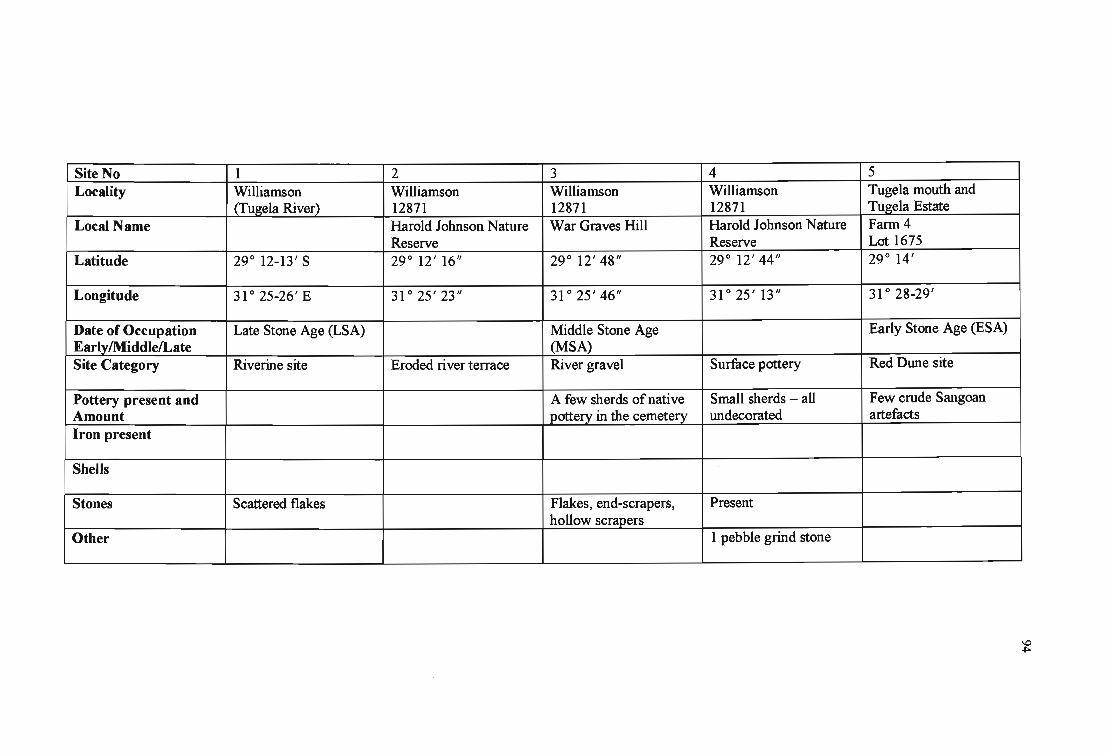
Site No 1 2 3 4 5 Locality Williamson Williamson Williamson Williamson Tugela mouth and
(Tugela River) 12871 12871 12871 Tugela Estate Local Name Harold Johnson Nature War Graves Hill Harold Johnson Nature Farm 4
Reserve Reserve Lot 1675 Latitude 29 0 12-13' S 29 0 12' 16" 29 0 12' 48" 29 0 12' 44" 29 0 14'
Longitude 31 0 25-26' E 31 0 25' 23" 31 0 25' 46" 31 0 25' 13" 31028-29'
Date of Occupation Late Stone Age (LSA) Middle Stone Age Early Stone Age (ESA) EarlylMiddlelLate (MS A) Site Category Riverine site Eroded river terrace River gravel Surface pottery Red Dune site
Pottery present and A few sherds of native Small sherds - all Few crude Sangoan Amount pottery in the cemetery undecorated artefacts Iron present
Shells
Stones Scattered flakes Flakes, end-scrapers, Present hollow scrapers
Other 1 pebble grind stone L __ _ __
~

Site No 6 7 Locality Tugela Mouth, Fann - Havelock Fann, Damall
lliloko Bos Local Name
Latitude 29° 13' 45" 29° 14'
Longitude 31 ° 29' 15" 31 ° 28'
Date of Occupation Late Iron Age (LIA) LSA EarlylMiddlelLate Site Category Shell Midden
Pottery present and One NC2 Sherd Amount Iron present
Shells Present
Stones Spherical, highly polished stone, flattened stone
Other
8 Maccorkindales Grant 1810 Zinkwazi River
29° 14' 55"
31°24'39"
Early, Middle, Late Stone Age; EIA Surrnce, buried
EIA pottery; pots
Scatter of slag; Ore present.
EIA grindstones
9 Maccorkindales Grant 1810 Zinkwazi Estate
29° 14' 18"
31 ° 26' 55"
LIA
Surrnce
Many sherds
Small concentration of ore and ochre
several grindstones
10 Maccorkindales Grant 1810 Zinkwazi Estate
29° 14' 14"
31 ° 25' 07"
ESA
Surrnce
Quartzite choppers, Flake-handaxe in-slate
\0 \Jl

Site No 11 Locality Maccorkindales Grant
1810 Local Name Zinkwazi Estate
Latitude 29 0 13' 50"
Longitude 31 0 25' 18"
Date of Occupation LSA Early/MiddlelLate Site Category Surface
Pottery present and Scattered sherds; 1 LIA Amount rim sherd; some pottery
Iron present A piece of ore
Shells
Stones Present
Other 3 grindstones
12 13 Fort Pearson Fort Pearson
29 0 12' 54" 29 0 12' 52"
31 0 25'50" 31 0 26' 03"
MSA, EIA, LIA Historic
Surface Surface
EIA pottery;
Small piece of vitrified tuyere
Present
LIA broken grindstones Historical - boot heels, rifles from Anglo-Zulu war
14 Fort Pearson
29 0 13' 00"
31 0 26' 15"
EIA
Surface
Very small sherds; 2 large pieces of daga; pieces of pottery
- -- ----
15 Tugela Mouth, Farm-lliloko bos
29 0 14' 45"
31 0 28' 25"
Shell midden
Mussels
\0 0'\

Site No 16 17 Locality ItiBay Zinkwazi Beach
Local Name
Latitude 29° 17' 30/1 29° 17' 10/1
Longitude 31°25'55/1 31 ° 26' 28/1
Date of Occupation EIA EarlylMiddlelLate Site Category Stray Shell middens
Pottery present and 1 Incised sherd, Ne3 Amount Iron present
Shells Large mussels I
Stones
Other
-
18 19 Zinkwazi Beach Zinkwazi Beach
29° 17' 12/1 29° 17' 20/1
31 ° 26' 25/1 31 ° 26' 20/1
Shell middens Shell middens
Fragments of small Fragmentary large mussels mussels; Large oysters
1 Scrap of bone
20 Salt Rock Sheffield Beach Stevens Rock
29° 29' 20/1
31 ° 15' 07/1
Undifferentiated Iron Age Shell middens
Few sherds
Large dense midden
I
I
\0 -...l

Site No 21 22 Locality Blythedale Beach Mvoti River -
North Bank Local Name Blythedale Beach
Latitude 29 0 22' 10" 29 0 22' 40"
Longitude 31 0 20' 42" 31 0 20' 30"
Date of Occupation Early/MiddlelLate Site Category Red Dune Site
Pottery present and Few Sangoan pieces Amount Iron present
Shells
Stones Small hammer stone
Other
23 24 Sheffield Beach Tinley Manor Beach
Elephant Rock Headlands
29 0 29' 07" 29 0 27' 16"
31 0 15' 25" 31 0 17' 07"
EIA
Shell midden Shell midden
Large quantity of Ne3 sherd; Much pottery pottery, undecorated
Small amount of shells Mussels, oysters, few limpets
25 Sheffield Beach
Elephant Rock
29 0 29' 12"
31 0 15' 18"
Shell midden
Present; 4 sherds
Mostly mussels; few oysters; small limpets
Possibility of a hearth; Scraps of charcoal; a little bone
\0 00

Site No 26 Locality Zinkwazi Beach
Local Name
Latitude 29 0 16' 57"
Longitude 31 0 26' 38"
Date of Occupation EarlylMiddlelLate Site Category Shell midden
Pottery present and Amount Iron present
Shells Perna; limpets; oysters
Stones Broken stones
. Other
27 28 Zinkwazi Beach Zinkwazi Beach
29 0 17' 25" 29 0 17' 26"
31 0 26' 20" 31 0 26' 20"
Undifferentiated Iron VIA Age (VIA) Shell midden Shell midden
Perna Mostly Perna
Few small stones
Charcoal
29 Zinkwazi Beach
29 0 17' 27"
31 0 26' 19"
UIA
Shell midden
Mostly Perna
30 Zinkwazi Beach
29 0 17' 28"
31 0 26' 19"
VIA
Shell midden
Small sherds; NC2 and NC3 Few pieces of iron ore
LargePerna
I
-
\0 \0

Site No 31 32 33 34 35 Locality Zinkwazi Beach Blythedale Blythedale Tinley Manor Tinley Manor
Local Name Headlands Headlands
Latitude 29° 17' 31" 29° 22' 10" 29° 22' 50" 29° 27' 03" 29°27' 12"
Longitude 31 ° 26' 17" 31°21'10" 31 ° 20' 22" 31 ° 17' 11" 31 ° 17' 08"
Date of Occupation VIA EarlylMiddlelLate Site Category Shell midden On beach, possibly Beach sand Shell midden Shell midden
from midden Pottery present and No sherds Few undecorated sherds Much NC3 pottery Amount Iron present
Shells Perna; few burnt shells; Present Mussels Mostly mussels; few few limpets limpets; few oysters
Stones Few pebbles 2 Flat lydianite pebbles, Few small pebbles Beach pebbles flaked as "shell-openers"
Other Charcoal Few grindstones Grindstones
-~
§
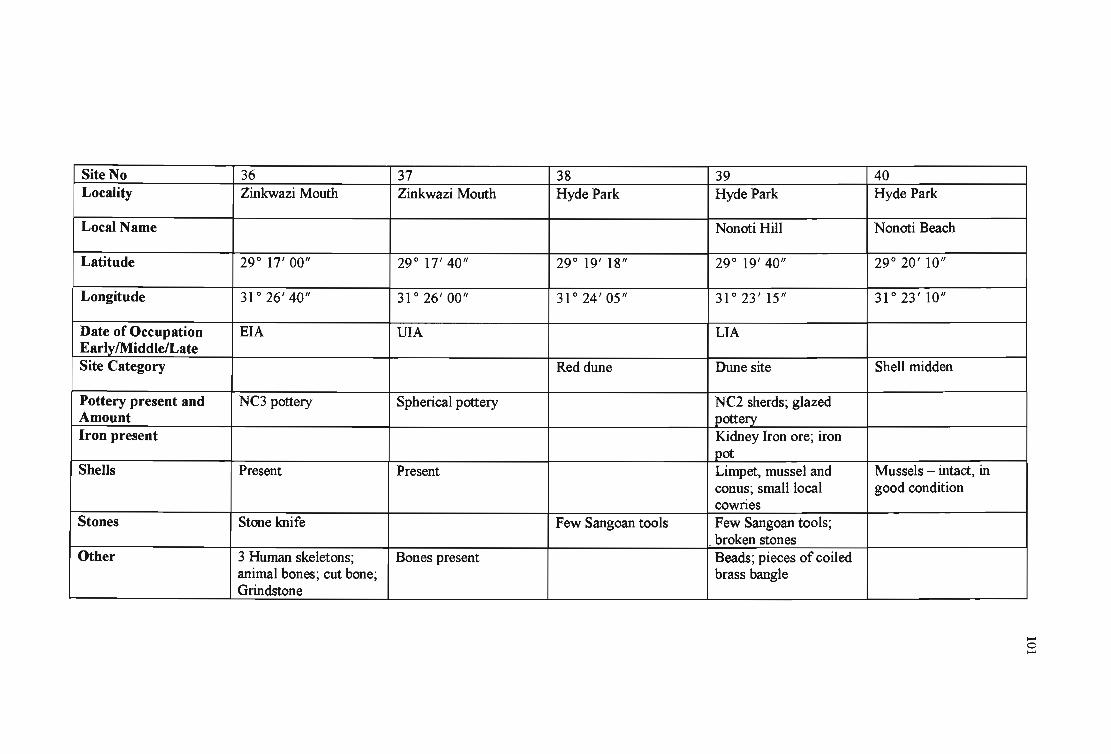
Site No 36 37 38 39 40 Locality Zinkwazi Mouth Zinkwazi Mouth Hyde Park Hyde Park Hyde Park
Local Name Nonoti Hill Nonoti Beach
Latitude 29 0 17' 00" 29 0 17' 40" 29 0 19' 18" 29 0 19' 40" 29 0 20' 10"
Longitude 31 0 26' 40" 31 0 26' 00" 31 0 24' 05" 31 0 23' 15" 31 0 23' 10"
Date of Occupation EIA VIA LIA EarlylMiddlelLate Site Category Red dune Dune site Shell midden
Pottery present and NC3 pottery Spherical pottery NC2 sherds; glazed Amount pottery Iron present Kidney Iron ore; iron
pot Shells Present Present Limpet, mussel and Mussels - intact, in
conus; small local good condition cownes
Stones Stone knife Few Sangoan tools Few Sangoan tools; broken stones
Other 3 Human skeletons; Bones present Beads; pieces of coiled animal bones; cut bone; brass bangle Grindstone
-o -

Site No 41 42 43 44 45 Locality Blythedale Beach Blythedale Beach Blythedale MvotiMouth Kearsney
Local Name Jex Estates
Latitude 29 0 22' 02" 29 0 22' 30" 29 0 22' 35" 29 0 23' 35" 29 0 24' 10"
Longitude 31 0 20' 50" 31 0 21' 00" 31 0 19' 45" 31 0 20' 09" 31 0 19' 30"
Date of Occupation LIA EarlylMiddlelLate Site Category Raised Beach Shell midden Shell midden Stratified shell rnidden Shell midden
Pottery present and NC2 Sherds Amount i
Iron present I I
Shells Mussels, some burnt Mussels present Mussels in good Mussels, soft and I
condition compacted Stones Rough flakes and Burnt stones Broken stones
choppers - Sangoan pieces
Other Charcoal Animal bones Lower levels abundant Black, humic sand charcoal
-o N

Site No 46 47 48 49 50 Locality Tinley Manor Tinley Manor Tinley Manor Tinley Manor Tinley Manor
Local Name Skea's Rock
Latitude 29° 25' 25" 29° 26' 00" 29° 26' 40" 29° 27' 00" 29° 27' 02"
Longitude 31 ° 18' 34" 31° 17' 15" 31°17'30" 31 ° 16' 57" 31 ° 16' 55"
Date of Occupation EIA, LIA EIA LIA EarlyiMiddlelLate Site Category Shell midden Pottery midden Shell midden Shell midden Shell midden
Pottery present and NC2, NC3 sherds NC3 pottery Some sherds NC2 sherds Amount Iron present
Shells Mussels, in good Perna Mussels in poor Perna condition condition
Stones Few smashed pebbles Few dolerite pebbles
Other Wood charcoal; animal bones
-o w

Site No 51 52 53 54 55 Locality Tinley Manor Tinley Manor Tinley Manor Sheffield Beach Zinkwazi Beach
Local Name Headlands Dune
Latitude 29° 27' 07" 29° 27' 10" 29° 27' 15" 29° 29' 01" 29° 17' 40"
Longitude 31 ° 16' 09" 31 ° 16' 56" 31°17'11" 31 ° 15' 00" 31 ° 25' 30"
Date of Occupation EIA LSA, EIA, LIA ESA, MSA, LSA, LIA VIA EarlylMiddlelLate Site Category Shell middens Shell midden Red dune & midden site Shell midden Shell midden
Pottery present and NC3 sherds NC2 pottery Present Few NC2 sherds Amount Iron present
Shells Perna Mussels Present Mussels and limpets Perna
Stones Pebbles Broken boulders Pebbles
Other Little charcoal; little Bones and teeth Broken, large bone grindstone
~- ~
-o
"'"
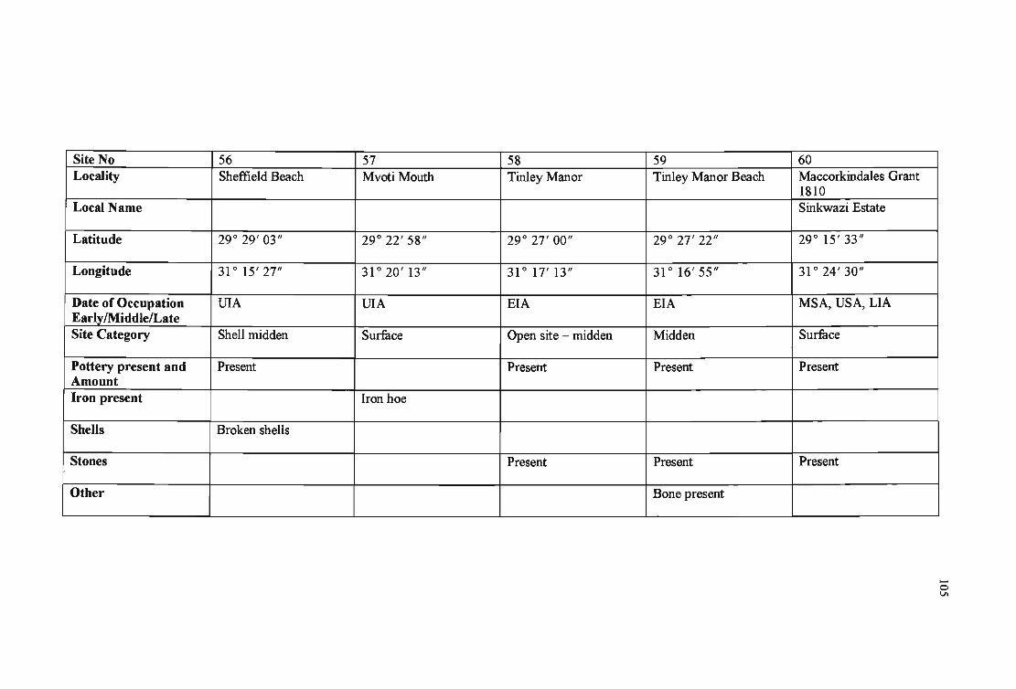
Site No 56 57 58 59 60 Locality Sheffield Beach Mvoti Mouth Tinley Manor Tinley Manor Beach Maccorkindales Grant
1810 Local Name Sinkwazi Estate
Latitude 29° 29' 03" 29° 22' 58" 29° 27' 00" 29° 27' 22" 29° 15' 33"
Longitude 31°15'27" 31°20'13" 31° 17'13" 31 ° 16' 55" 31 ° 24' 30"
Date of Occupation VIA VIA EIA EIA MSA, USA, LIA Early/MiddlelLate Site Category Shell midden Surface Open site - midden Midden Surface
Pottery present and Present Present Present Present Amount Iron present Iron hoe
Shells Broken shells
Stones Present Present Present
Other Bone present ~-
-o U1

Site No 61 62 63 64 65 Locality Hyde Park Maccorkindales Grant Tinley Manor BalIito Bay Willard's Beach
Local Name Headlands Compensation Beach
Latitude 29° 18' 40" 29° 16' 10" 29° 27' 08" 29° 32' 45" 29° 31' 35"
Longitude 31 ° 21' 40" 31 ° 24' 10" 31° 17'12" 31°12'52" 31-° 13' 37"
Date of Occupation LIA LIA EIA, LIA EIA EarlylMiddlelLate Site Category Surface Surface Midden Shell midden Shell midden
Pottery present and Small sample of pottery Present LIApottery Abundant sherds Amount Iron present
Shells Small mussels, few Shells in patches oysters
Stones Present Present
Other Evidence of grinding
-o 0\

Site No 66 67 68 69 70 Locality Cotton lands Cotton lands Umdloti Beach, Umdloti Beach, Lot A39
Verulam Road Verulam Road 1532 Local Name
Latitude 29° 37' 13" 29° 37' 35" 29° 40' 17" 29° 40' 10" 29° 42' 07"
Longitude 31 ° 06' 19" 31 ° 06' 38" 31°05'56" 31°05'50" 31 ° 04' 28"
Date of Occupation EIA LIA LIA EIA EarlvlMiddlelLate I Site Category Unstratified Pottery scatter Pottery scatter Scatter of pottery and Red Dune Rock
molluscs interface Pottery present and 6 sherds 7 sherds Sherds present Amount Iron present 2 pieces of iron slag;
1 piece tuyere Shells Mussels
Stones Pebble tools and 1 flake 1 flake Pebbles
Other Very little bone; Bones Geological 2 grindstones
-o -....l

Site No 71 Locality Mzonjani
Local Name
Latitude 29 0 44' 05"
Longitude 31 0 03' 15"
Date of Occupation EIA EarlylMiddlelLate Site Category
Pottery present and Present Amount Iron present
Shells EIA Shells
Stones
Other
72 73 Tongaat Beach Genezzano Westbrook
29 0 35' 50" 29 0 36' 47"
31 0 10' 05" 31 0 09' 27"
EIA
Shell midden
Dense NC3 pottery
Concentration of Perna Mussels, oysters shells
Flakes
74 Genezzano Beach
29 0 36' 40"
31 0 09' 30"
Shell midden
Very little pottery
Perna, Patella
Flat pebbles
75 Emberton Way
29 0 32' 22"
31 0 13' 12"
EIA
EIA sherds
Densely composted and decalcified shells (mussels)
Some charcoal
.... o 00

Site No 76 Locality Salt Rock
Local Name
Latitude 29 0 30' 08"
Longitude 31 0 14' 20"
Date of Occupation EIA EarlvlMiddlelLate Site Category Shell middens (2)
Pottery present and Few plain sherds Amount Iron present
Shells Large mussels
Stones
Other Great deal of charcoal
77 78 Salt Rock Umhlali
29 0 30' 19" 29 0 30' 45"
31 0 14' 15" 31 0 13' 50"
EIA
Shell midden Midden
A few sherds Plain sherds
Mussels Broken shells
Sharp piece of stone
Few bones
79 Tongaat Beach Hotel
29 0 34' 58"
31 0 10' 40"
EIA
Shell midden
A few coarse sherds
Broken mussels
---------- --- ----
80 Umhlanga Lagoon -North bank
29 0 42'
31 0 06'
Midden
NC2 sherds
.-o \0

Site No 81 82 83 84 85 Locality Tongaat River Mouth TongaatRiverMouth Umdloti Beach Port Zimbali Port Zimbali
North Bank North Bank Local Name
Latitude 29 0 36' 25/1 29 0 33' 03/1 29 0 41' 20/1 29 0 33' 08/1 29 0 33' 24/1
Longitude 31 0 09' 36/1 31 0 12' 04/1 31 0 06' 30/1 31 0 12' 17/1 31 0 11' 46/1
Date of Occupation LIA, EIA ESA, EIA EIA ESA, EIA, LIA Early/MiddlelLate Site Category Midden Dune sites Coastal middens Midden Midden
Pottery present and NC2, NC3 fragments of NC2 pottery Present Pot present Amount pottery Iron present Metal
Shells Present Present Present
Stones NC2, NC3 pebbles Flakes Present Present
Other Bone Bone
-_ .. __ . -
--o

Site No 86 Locality Port Zimbali
Local Name
Latitude 29° 33' 34"
Longitude 31°11'47"
Date of Occupation LSA,USA EarlylMiddlelLate Site Category Midden
Pottery present and Present Amount Iron present
Shells Present
Stones Present
Other Bone
87 88 89 La Lucia La Lucia La Lucia
29° 45' 00" 29° 45' 00" 29° 45' 06"
31 ° 02' 05" 31 ° 03' 16" 31 ° 02' 50"
LIA LIA LIA
Surface precipitate Surface precipitate Surface precipitate
90 Lot 31 1560
29° 42' 57"
31 ° 04' 02"
LIA
Surface
Present
Present
Present
Bone
!
...... ...... ......

Site No 91 92 93 94 95 I
Locality Lot 31 Lot 31 Lot 31 Lot 31 Lot 31 ,
1560 1560 1560 1560 1560 I
Local Name
Latitude 29° 43' 16/1 29° 43' 24/1 29° 43' 14/1 29° 43' 15/1 29° 43' 18/1
Longitude 31 ° 03' 54/1 31°03'50/1 31 ° 04' 02/1 31 ° 04' 27/1 31 ° 04' 20/1
Date of Occupation LIA LIA LIA LIA LIA Early/Middle/Late Site Category Surface Surface Surface Surface Surface
Pottery present and Present Present Present Present Present Amount Iron present
Shells Present Present Present Present Present
Stones Stone Present Present
Other Bone
--N

Site No 96 97 98 99 100 Locality Lot 31 Tongati River Mouth Tongati River Mouth Tongati River Mouth Tongati River Mouth
1560 North Bank North Bank North Bank North Bank Local Name
Latitude 29° 43' 20" 29° 34' 00" 29° 33' 50" 29° 33' 43" 29° 33' 42"
Longitude 31 ° 04' 14" 31°11'11" 31 ° 11' 26" 31°11'37" 31 ° 11' 42"
Date of Occupation LIA EIA EIA LSA LIA EarlylMiddlelLate Site Category Surface Midden Midden Dune Coastal midden
Pottery present and Present Amount Iron present
Shells Present
Stones Present
Other Bone
-----
--w

--
Site No 101 102 Locality Tongati River Mouth Tongati River Mouth
North Bank North Bank Local Name
Latitude 29° 33' 411/ 29° 33'301/
Longitude 31°11'421/ 31 0 11' 431/
Date of Occupation LSA, LIA LSA Early/Middle/Late Site Category Coastal midden Open
Pottery present and Amount Iron present
Shells
Stones
Other
103 104 Tongati River Mouth Tongati River Mouth North Bank North Bank
29° 33' 251/ 29° 33' 251/
31 ° 12' 001/ 31°11'571/
LSA LIA
Dune Midden
Present
105 Tongati River Mouth North Bank
29° 33' 041/
31 ° 12' 021/
LSA, EIA
Dune
-
......
...... ~

Site No 106 107 108 109 no Locality Tongati River Mouth Tongati River Mouth Tongati River Mouth Tongati River Mouth Tongati River Mouth
North Bank North Bank North Bank North Bank North Bank Local Name
Latitude 29° 33' 06/1 29 0 33' 08/1 29° 33' 08/1 29 0 33' 15/1 29 0 33' 16/1
Longitude 31 0 12' 15/1 31 0 12'15/1 31 0 12' 05/1 31 0 12' 02/1 31 0 12' 05/1
Date of Occupation EIA LSA, EIA LSA, EIA LSA, EIA LIA EarlylMiddlelLate Site Category Dune Shell midden Dune Dune Dune
Pottery present and Amount Iron present
Shells Present
Stones
Other
--VI

Site No III Locality Tongati River Mouth
North Bank Local Name
Latitude 29° 33' 08"
Longitude 31°11'59"
Date of Occupation EarlylMiddlelLate Site-Category Coastal
Pottery present and Amount Iron present
Shells
Stones I
Other
112 113 Tongati River Mouth Tongati River Mouth North Bank North Bank
29° 33' 35" 29° 33' 25"
31°11'42" 31 ° 11' 48"
LSA, EIA, LIA LIA
Stratified Dune
114 Tongati River Mouth North Bank
29° 33' 25"
31°11'56"
LIA
Dune
115 La Mercy Township
29° 38' 36"
31 ° 07' 32"
Marine gravel
..... ..... 0'1

Site No 116 117 118 119 120 Locality La Mercy Township La Mercy Township La Mercy Township Umdloti Beach Umdloti Beach
Local Name
Latitude 29 0 38' 15" 29 0 37' 56" 29 0 37' 36" 29 0 40' 10" 29 0 40' 05"
Longitude 31 0 07' 13" 31 0 07' 18" 31 0 06' 36" 31 0 05'53" 31 0 07' 00"
Date of Occupation- ESA LSA EarlylMiddlelLate Site Category Beach gravel Beach gravel Beach gravel
Pottery present and Amount Iron present
Shells
Stones
Other
---...l

Site No 121 Locality Umdloti Beach
Local Name
Latitude 29 0 40' 00"
Longitude 31 0 07' IS"
Date of Occupation EIA EarlylMiddlelLate Site Category Shell midden
Pottery present and Amount Iron present
Shells
Stones
Other
122 123 Umdloti Beach Umdloti Beach
29 0 40' 00" 29 0 40' 00"
31 0 06' 58" 31 0 06' 27"
LIA UIA
Midden
124 Umdloti Beach
29 0 38' 40"
31 0 07' 42"
Beach gravel
125 Umdloti Beach
29 0 39' 41"
31 0 06' 08"
LSA, EIA, LIA
Dune middens, NC2 and NC3 sherds
..... ..... 00

Site no 126 127 128 129 130 Locality Umdloti Beach Umdloti Beach. Umdloti Beach Umdloti Beach Ballito Bay
Local Name
Latitude 29 0 39' 07/1 29 0 39' 45/1 29 0 39' 49/1 29 0 39' 52/1 29 0 32' 49/1
Longitude 31 0 07' 27/1 31 0 07' 00/1 31 0 07' 22/1 31 0 07' 03/1 31 0 12' 43/1
Date of Occupation LSA, LIA MSA,LSA LIA EIA EarlylMiddlelLate Site Category Stratified Middens Shell midden Shell midden
Pottery present and Amount Iron present
Shells
Stones
Other
-->0

Site No 131 Locality Ballito Bay
Local Name
Latitude 29° 32' 43/1
Longitude 31°12'54/1
Date of Occupation EIA EarlylMiddle!Late Site Category Shell midden
Pottery present and Amount Iron present
Shells
Stones
Other
132 133 Ballito Bay Ballito Bay
29° 32' 43/1 29° 32' 42/1
31 ° 12' 37/1 31° 12' 58/1
USA, UIA
Shell midden Shell midden, 2 burials
134 Ballito Bay
29° 32' 42/1
31°13'01/1
EIA, LIA
Shell midden
135 Ballito Bay
29° 32' 42 /1
31 ° 12' 43/1
LIA
Shell midden
..N o

'Site No 136 Locality Ballito Bay
Local Name
Latitude 29° 32' 41"
Longitude 31 ° 13' 00"
Date of Occupation EIA, LIA EarlylMiddlelLate Site Category Shell midden
Pottery present and Amount Iron present
Shells
Stones
Other
137 138 139 Ballito Bay Ballito Bay Ballito Bay
29° 32' 39" 29° 32' 37" 29° 32' 20"
31°13'01" 31 ° 12' 45" 31 ° 13' 15"
VIA
Shell midden Shell midden Human burials and middens
140 Ballito Bay
29° 32' 13-15"
31 ° 13' 22"
Shell midden
i
i I
I
I
i
I I
-IV -
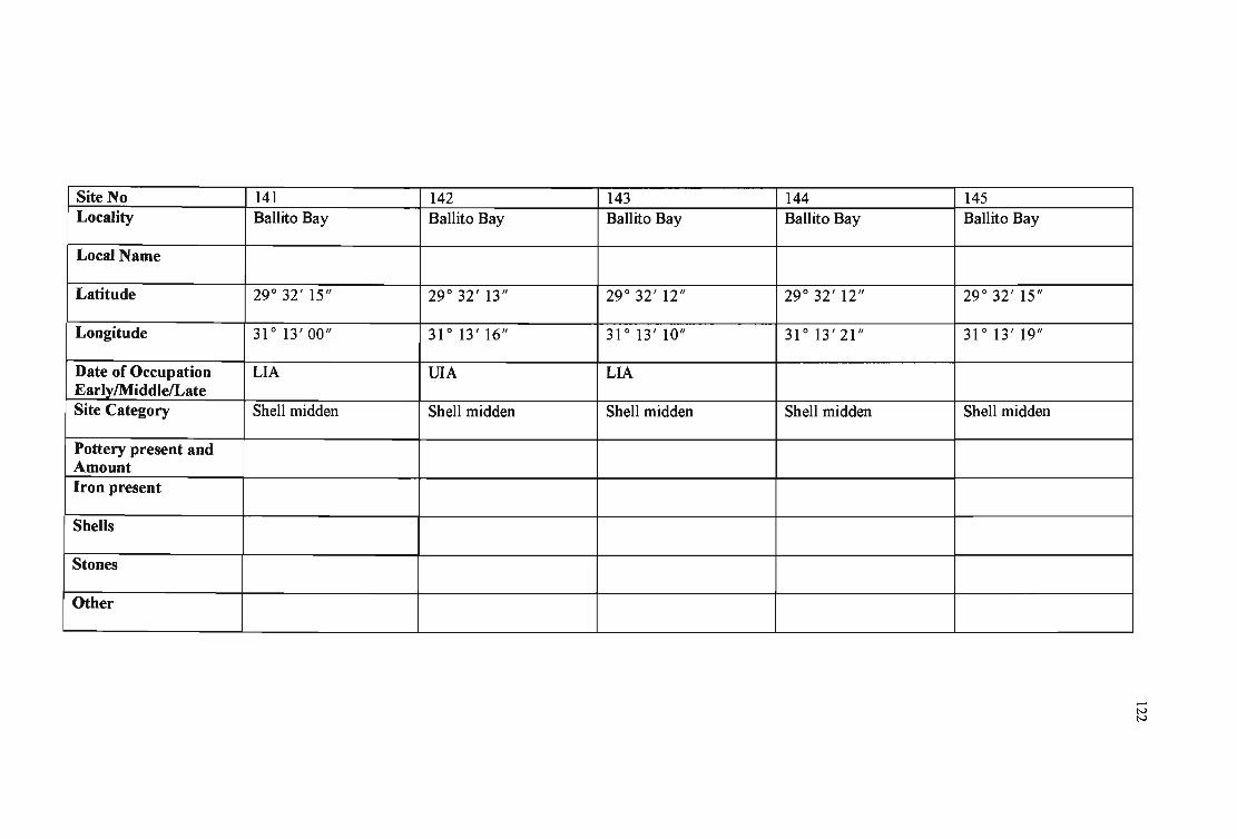
Site No 141 Locality Ballito Bay
Local Name
Latitude 29° 32' 15/1
Longitude 31 ° 13' 00/1
Date of Occupation LIA EarlylMiddlelLate Site Category Shell midden
Pottery present and Amount Iron present
Shells
Stones
Other
142 143 Ballito Bay Ballito Bay
-
29° 32' 13/1 29° 32' 12/1
31° 13'16/1 31° 13' 10/1
VIA LIA
Shell midden Shell midden
144 Ballito Bay
29° 32' 12/1
31 ° 13' 21/1
Shell midden
145 Ballito Bay
29° 32' 15/1
31° 13'19/1
Shell midden
-IV IV

Site No 146 Locality Ballito Bay
Local Name
Latitude 29° 32' 06"
Longitude 31 ° 13' 24"
Date of Occupation EarlylMiddlelLate Site Category Shell midden
Pottery present and Amount Iron present
Shells
Stones
Other
147 148 Ballito Bay Ohlanga River Mouth
(Jiorth Bank)
29° 32' 10" 29° 41' 32"
31°13'01" 31 ° 06' 23"
LIA
Shell midden Shell midden
149 Ohlanga River Mouth (North Bank)
29° 41' 43"
31 ° 06' 17"
Shell midden
150 Ohlanga River Mouth (North Bank)
29° 41' 48"
31 ° 06' 11"
Shell midden
I
I !
I
...... N w

Site No 151 Locality Ohlanga River Mouth
(North Bank) Local Name
Latitude 29 0 41' 54"
Longitude 31 0 06' 00"
Date of Occupation LSA EarlylMiddlelLate Site Category Shell midden
Pottery present and Amount Iron present
Shells
Stones
Other
152 153 Ohlanga River Mouth Ohlanga River Mouth (North Bank) (North Bank)
29 0 42' 10" 29 0 42' 08"
31 0 06' 02" 31 0 05' 49"
EIA, LIA MSA, LSA
Shell midden Shell midden
154 Sunningdale Extension
29 0 44' 24"
31 0 03' 24"
LIA
Surface
Present
Present
Bone
155 Sunningdale Extension
29 0 44' 16"
31 0 03' 30"
LIA
Surface
Present
..N .j:>.

Site No 156 157 158 159 160 Locality Sunningdale Extension Sunningdale Extension Sunningdale Extension Sunningdale Extension Sunningdale Extension
Local Name Tongaat Hulett Office
Latitude 29 0 44 ' 20" 29 0 43' 55" 29 0 44 ' 16" 29 0 44' 14" 29 0 44' 00"
Longitude 31 0 03' 21" 31 0 03' 46" 31 0 04' 06" 31 0 03 ' 05" 31 0 03' 24"
Date of Occupation LIA LIA EIA UIA EarlylMiddlelLate Site Category Surface Surface Surface Shell midden
Pottery present and Present Present Present Amount Iron present
Shells Present
Stones Present
Other
-------- ---------
-N VI
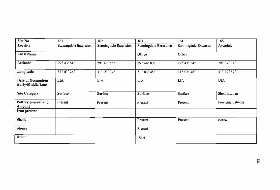
Site No 161 162 163 164 165 ,
Locality Sunningdale Extension Sunningdale Extension Sunningdale Extension Sunningdale Extension Avendale
Local Name Office Office
Latitude 29° 43' 54" 29° 43' 55" 29° 44' 03" 29° 43' 54" 29° 32' 14"
Longitude 31 ° 03' 26" 31 ° 03' 34" 31°03'45" 31 ° 03' 46" 31 ° 12' 52"
Date of Occupation LIA LIA LIA LIA U1A EarlylMiddlelLate
Site Category Surface Surface Surface Surface Shell midden
Pottery present and Present Present Present Present Few small sherds Amount Iron present
Shells Present Present Perna
Stones Present
Other Bone
-~

Site No 166 167 Locali9' Tongati Beach - South Genezanno
Bank Local Name
Latitude 29° 34' 23" 29° 36' 25"
Longitude 31°10'58" 31 ° 09' 30"
Date of Occupation LSA LSA, EIA EarlylMiddlelLate Site Category Shell midden Shell midden
Pottery present and NC3 Amount Iron present
Shells Mussel, oyster, limpet. Mussels
Stones Flakes
Other Little charcoal, Fish bones, few fragments of animal bones.
168 169 Genezanno Genezanno
29° 36' 32" 29° 36' 33"
31 ° 09' 37" 31 ° 09' 36"
EIA LSA
Shell midden Shell midden
NC3
Mussels Perna, Patella
Broken stones Shell opener, Blade.
Vertebra of large mammal, bone.
170 Newsel-Umdloti crossroads
29° 40' 16"
31 ° 06' 22"
UIA
Pottery site and midden
NC2
Mussels
-N ~

Site No 171 Locality Selection Beach
Local Name
Latitude 29 0 40' 24/1
Longitude 31 0 06 ' 58/1
Date of Occupation EarlvlMiddlelLate Site Category Shell midden
Pottery present and Amount Iron present
Shells Mussels
Stones Pebbles, marine sandstone.
Other
172 173 Smerdon 's Flat Huletts Sugar Estates
29 0 42' 00/1 29 0 42' 02/1
31 0 05'30 /1 31 0 04 ' 50/1
MSA USA
Dune Site
Absent Present
Basalt arrow-head and Stone chips flakes
~-
174 Ballito
29 0 32' 37/1
31 0 12' 57/1
VIA
Midden
Present
Human skeleton
- ---
175 Sunnyside
29 0 30' 00/1
31 0 12'10/1
LIA
Middens
Tuyeres
Mussels
Bones
-N 00

Site No 176 177 Locality Madelaine A ve, Ballito Newsel Beach
Local Name
Latitude 29° 32' 04" 29° 40' 32"
Longitude 31 ° 12' 54" 31 ° 06' 55"
Date of Occupation VIA EIA EarlylMiddlelLate Site Category Midden Midden
Pottery present and Present Present Amount Iron present
Shells
Stones Present
Other Bone Bone
178 179 Thompsons Bay Blackbum
29°31'26" 29° 41' 13"
31 ° 13' 41" 31°05'43"
LIA LIA
Midden Surface
Present Present
Present Present
Present
Bone
180 Umhlanga Lagoon
29° 42' 35"
31 ° 05' 40"
LIA
Midden
Present
Present
----- --
I
I
!
...... IV \0

Site No 181 182 Locality Ballito Bay Willard Beach
Local Name
Latitude 29 0 32' 05" 29 0 31' 14"
Longitude 31 0 13' 10" 31 0 13 ' 44"
Date of Occupation VIA EarlylMiddlelLate Site Category Shell midden Shell midden
Pottery present and Amount Iron present
Shells
Stones
Other
.. .. . L _____ __
183 Umhlanga Lagoon
29 0 43' 40"
31 0 05' 28"
EIA
Coastal midden
NC3 sherds
Mussels
Broken stones
- --
184 La Lucia
29 0 44' 15"
31 0 03' 41"
Dune
185 La Lucia
29 0 44' 43"
31 0 04' 35"
EIA
NC3 settlement or midden
-t.H o
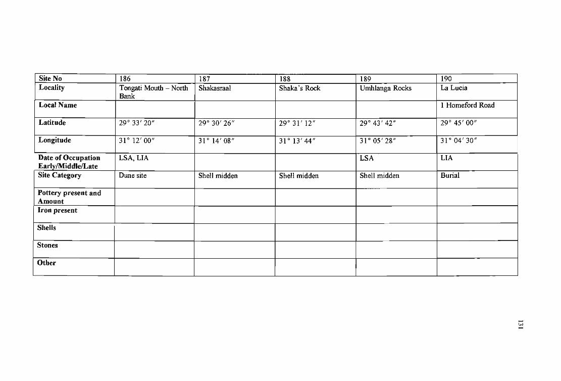
Site No 186 Locality Tongati Mouth - North
Bank Local Name
Latitude 29 0 33' 20"
Longitude 31 0 12' 00"
Date of Occupation LSA, LIA Early/Middle/Late Site Category Dune site
Pottery present and Amount Iron present
Shells
Stones
Other
-
187 188 Shakasraal Shaka's Rock
29 0 30' 26" 29 0 31' 12"
31 0 14' 08" 31 0 13' 44"
Shell midden Shell midden
189 Umhlanga Rocks
29 0 43' 42"
31 0 05' 28"
LSA
Shell midden
190 La Lucia
1 Homeford Road
29 0 45' 00"
31 0 04' 30"
LIA
Burial
...... w ......

Site No 191 Locality Peace Cottage
Local Name
Latitude 29° 41' 01/1
Longitude 31 ° 06' 44/1
Date of Occupation UIA EarlylMiddle1Late Site Category Midden
Pottery present and Amount Iron present
Shells Present
Stones
Other
192 193 La Lucia Ridge Mzonjani 2
29° 44' 50/1 29° 44' 20/1
31 ° 02' 53/1 31°03'06/1
LIA EIA, LIA
Surface Surface
Present Present
194 Mzonjani Extension
29° 44' 24/1
31 ° 02' 58/1
LIA
Surface
Present
Slag
Present
Daga, smoking pipe
195 Zimbali 1
29° 32' 50/1
31°11'50/1
EIA
Surface, midden
Present
-W N

Site No 196 Locality Zimbali 4
Local Name
Latitude 29° 33' 34/1
Longitude 31 ° 11' 30/1
Date of Occupation ESA EarlylMiddlelLate Site Category Surface
Pottery present and Amount Iron present
Shells
Stones Present ,
Other
197 198 Ballitoville Tongati Beach
Boulder Bay
29° 32' 22/1 29° 34' 40/1
31° 13'12/1 31 ° 10' 40/1
EIA LIA
Midden Midden
Present
Present
Pebbles
199 Willard Beach
29° 31' 25/1
31 ° 13' 30/1
Marine terraces
200 Athlone, Durban North
29° 48 ' 31/1
31 ° 02' 30/1
Swamp stray find
A number of sherds
I
I
..... w w

Site No 201 Locality Glen Anil 909
Local Name
Latitude 29° 45' 55"
Longitude 31 ° 03' 42"
Date of Occupation EIA EarlvlMiddlelLate Site Category Sherds from destroyed
midden Pottery present and 6 EIA sherds Amount Iron present
Shells
Stones
Other
202 203 Durban North Durban North
Virginia Aerodrome Old Reservoir
29° 46' 30" 29° 46' 42"
31 ° 03' 20" 31 ° 02' 02"
LSA, LIA EIA
NC2 pottery NC3, NC2 pottery
204 Greenwood Park
29° 47' 20/1
31°01'15/1
MSA
Boulder bed
MSA artefacts
205 Durban North
29° 48' 13"
31 ° 02' 26"
MSA
Dune site
Sangoan and Smithfield material
- _ .. -
...... w
"""

Site No 206 207 Locality Riverside Road Riverside
Local Name
Latitude 29° 48' 25" 29° 48' 18"
Longitude 31 ° 02' 04" 31°01'16"
Date of Occupation VIA EarlylMiddlelLate Site Category Estuarine terrace Surface
Pottery present and Present Amount Iron present
Shells
Stones
: Other
208 209 Effingham Effingham
29° 45' 50" 29° 45' 59"
31 ° 00' 36" 31 ° 00' 25"
LIA LSA, EIA
Surface Surface
Present Present
Slag, tuyere.
Present Present
210 Effingham
29° 46' 08"
31 ° 00' 07"
LIA
Surface
Present
Slag, tuyere.
-v.> V'o