a socio-technical assessment framework for …
TRANSCRIPT

A SOCIO-TECHNICAL ASSESSMENT FRAMEWORK FOR INTEGRATED
WATER RESOURCES MANAGEMENT (IWRM) IN LAKE URMIA BASIN, IRAN
A Thesis
by
MUKHTAR HASHEMI
Submitted for the degree of Doctor of Philosophy (PhD)
at Newcastle University
January 2012
A Socio-technical Assessment Framework for Integrated Water Resources Management
(IWRM) in Lake Urmia Basin, Iran
Copyright 2012 Mukhtar Hashemi

A SOCIO-TECHNICAL ASSESSMENT FRAMEWORK FOR INTEGRATED
WATER RESOURCES MANAGEMENT (IWRM) IN LAKE URMIA BASIN, IRAN
A thesis
by
MUKHTAR HASHEMI
Submitted for the degree of Doctor of Philosophy (PhD)
at Newcastle University
Approved by:
External Examiner, Professor J. Anthony Allan
Internal Examiner, Professor Paul Younger
Main Supervisor, Professor Enda O’Connell
Supervisor, Dr Geoff Parkin
Supervisor, Dr Jaime M. Amezaga
Head of Department, Professor Jon Mills
January 2012

iii
ABSTRACT
The main aim of this interdisciplinary research is to develop a socio-technical and
institutional framework for implementing the Integrated Water Resources Management
(IWRM) paradigm by analysing how water resources can be managed in response to
anthropogenic drivers (e.g. population/economic growth) and environmental pressures
(e.g. climate change) within an evolving institutional set-up. Implementation of the
Framework has focussed on Iran, and Lake Urmia basin as a case study, which involved
a significant element of action research based upon stakeholder participation.
Lack of implementation of concepts such as IWRM has been attributed to the gap
between technical outcomes and policy decisions. To achieve an integrated synthesis for
this interdisciplinary study, the integrated methodological framework has used four
analytical components based on the IWRM concept: (1) Driver-Pressure-State-Impact
Response (DPSIR); (2) Institutional Analysis and Development (IAD); (3) Integrated
Socio-technical Assessment (ISTA) using modelling and Multi criteria Decision-Making
(MCDA) tools; and (4) Ethics to assess water allocation decision outcomes in multitier
Multi-Stakeholder Platforms (MSPs).
Results from the case study show that the non-structural responses (legislations,
new administrations etc.) adopted since 2003 have not guaranteed the implementation of
sustainable water allocation outcomes in river basins including Lake Urmia basin. Water
allocation has become highly political and caused polarisation in opinions and multiple
perspectives among stakeholders underlined by diverging discourses on climate change,
water and land development and irrigation water use efficiency. The participatory water
allocation decision reached for Lake Urmia Basin, which included an allocation to
sustain the hydrological and ecological functions of the Lake, has been re-evaluated by
analysing historical climatic and hydrologic data. The outcome suggests that water
availability in the basin is less than that adopted by the stakeholders based on trend
analysis within the existing discourse. Therefore, the thesis demonstrates a mechanism
for adaptive water allocation and demand management under an uncertain future climate
which is represented through rainfall scenarios generated using a stochastic rainfall

iv
model. It is concluded that the participatory process has enhanced the efficacy of the
water governance system, but the effectiveness of water allocation will be compromised
unless an adaptive water allocation approach is implemented, and basin-wide water use
efficiency measures are taken.
It is recommended that modern day water and land governance has to take into
account the ethical and cultural aspects of the community to form an alliance for
sustainable resource use; thus, an Ethical legal framework for community-based land
and water governance has been proposed. The overall integrated methodological
approach provides an innovative analytical framework to understand the discursive
deliberations in a complex Social-Ecological system heightened by (1) scientific
uncertainty over climate variability and change; and (2) dynamic institutional
transformation and evolution.

v
DEDICATION
In memory of my beloved father who has been the inspiration for all my work
To Three Women in my Life
My mother Frisha who is the angle in my life
My sister Saadat who I feel that our soul is inseparable
My wife Leila who is the love of my life
And
To my adorable trio Ammar…..Mona ….and ….Ahmad Hadi

vi
ACKNOWLEDGEMENTS
I would like to express my sincere gratitude to all my supervisors: Professor
Enda O’Connell, Dr Geoff Parkin and Dr Jaime M Amezaga who have supported me
with dedication and professionalism providing scholarly leadership and scientific
excellence. I thank them for their kindness, friendliness and sheer determination to guide
me throughout the course of my journey towards the goal of the PhD programme. I am
proud to have worked under their leadership.
I am indebted to Dr Jalal Attari, my consulting supervisor in Iran for all his
efforts in introducing me the Iranian water sector. I am grateful to his scholarly inputs
into my work.
Many individuals have helped me to finish my Journey at Newcastle University.
I would like to thank those how have given me an opportunity to work and have treated
me with respect and trust; especially the Office of Applied Research, Iran Water
Resources Management Company by partially funding my research work.
I would like also, to express my appreciation to my colleagues at the
Conservation of Iranian Wetlands Project (CIWP) for providing the platform to carry out
my work and for their unlimited support especially Dr Ali Nazaridoust, Mr Solaymani,
Mr Saber Masoumi, Mr Ali Arvahi, Ms Sara Koochaki, Mr Osqoee, Mr Arabpour, Dr
Mike Moser, Professor Eeloc van Beek, Mr Lotfi and Mr Saeid Ferdosi.
Many people who have encouraged me to carry out the research, I have relied on
their advice and scholarship, and I am grateful for all their support: Dr Ali Daemi, Dr
Hedayat Fahmi, Mr Rozebeh Javaheri, Mr Mustafa Fadaeifard, Mr Anvar Jamshinejad,
Mr Esfandiari, Mr Tehrani and Mr Dargahi.
My sincere thanks go to all the stakeholders for their dedication and
professionalism especially Water and Agriculture Working Group members.
Finally, I thank my family and all my friends who morally, spiritually and
financially supported me throughout my work and it is not possible to acknowledge all
of them on this page.

vii
NOMENCLATURE
AHP Analytical Hierarchy Process
AJO Agricultural Jihad Organisation
AMP Asiatic Model of Production
BAU Business as Usual
CIWP Conservation of Iranian Wetlands Project
COP Conference of the Parties
DoE Department of Environment
DPSIR Drivers (Driving forces)-Pressures-States-Impacts-Responses
DSS Decision Support System
EA East Azerbaijan
EAAJO East Azerbaijan Agricultural Jihad Organisation
EAEPO East Azerbaijan Environmental Protection Organisation
EARWC East Azerbaijan Regional Water Company
FAO Food and Agriculture Organisation
FWD Fair Water Distribution (Act)
FYDP Five-Year Development Plan
GCM general circulation model
GDP Growth Domestic Product
GEF Global Environmental Facility
GHGs greenhouse gases
GIS geographical information system
GWP Global Water Partnership
HTO Heritage and Tourism Organisation
IAD Institutional Analysis and Development
IDA Institutional Decomposition and Analysis
IPCC Intergovernmental Panel on Climate Change
ISTA Integrated Socio-technical Assessment

viii
IWRM Integrated Water Resource Management
IWRMC Iran Water Resources Management Company
JWF Japan Water Forum
KAJO Kurdistan Agricultural Jihad Organisation
KEPO Kurdistan Environmental Protection Organisation
KRWC Kurdistan Regional Water Company
LUB Lake Urmia basin
MCDA Multi-Criteria Decision-making Analysis
MENA Middle East and North Africa
MJS Ministry of Jihad-e- Sazandegi (Construction Jihad)
MoAJ Ministry of Agricultural Jihad
MoE Ministry of Energy
MoM Minute of Meeting
MP Member of Parliament
MSP Multi-stakeholder Platform
NGO Non-Governmental Organisation
NRWMO Natural Resources and Watershed Management Organisation
RWC Regional Water Company
SES Social-Ecological System
SYDP Seven-Year Development Plan
ToR Terms of Reference
UNDP United Nations Development Program
UNESCO United Nations Educational, Scientific and Cultural Organization
UNFCCC United Nations Framework Convention on Climate Change
WA West Azerbaijan
WAC Water Allocation Code (2008)
WAD Water Allocation Directive (2003)
WAM water allocation model
WAP Water Allocation Permit

ix
WBM water balance model
WAAJO West Azerbaijan Environmental Protection Organisation
WAEPO West Azerbaijan Environmental Protection Organisation
WANA West Asia and North Africa
WARWC West Azerbaijan Regional Water Company
WPAC Water Policy and Allocation Commission
WAWG Water and Agriculture Working Group
WJF World Justice Forum
WRS Water Resources System
WRWW Water Resources and Water and Wastewater
x
TABLE OF CONTENTS
Page
Abstract ..................................................................................................................... iii
Dedication ................................................................................................................ v
Acknowledgements ................................................................................................... vi
Nomenclature ....................................................................................................... vii
Table of Contents ..................................................................................................... x
List of Figures .......................................................................................................... xix
List of Tables ............................................................................................................ xxiv
List of Boxes ............................................................................................................ xxvi
Chapter I. Water Resources Management: Issues of Concern ......................... 1
1.1 An overview 1
1.2 Rationale of the research: Research gaps and questions 3
1.3 Main Aim 7
1.4 Objectives 7
1.5 The structure of the thesis 8
Chapter II. Sustainable Water Resources Management in the 21st Century:
Concepts, Theories, Issues and Methodologies .............................. 9
2.1 Introduction 9
2.2 Governing principles: definitions, concepts and issues
2.2.1 IWRM
2.2.2 Sustainable Development
2.2.3 Sustainability and environmental ethics
2.2.4 Socio-political (institutional) dimension of sustainability
2.2.5 policy and decision-making process
2.2.6 Sustainability and the application of modelling systems
2.2.7 Sustainability and uncertainty in sustainable decision
10
10
12
15
15
18
19
22

xi
outcomes
2.3 Reassessment of IWRM paradigm
2.3.1 Conceptual constraints
2.3.2 Neglecting parts of the water cycle: omissions in IWRM
approach
2.3.3 Putting more food on the planet: Land-water-food nexus
2.3.4 The role of cultural and ethical aspects
2.3.5 Institutional capacity development: dealing with
participation issue
24
24
26
29
32
36
2.4 Discussion and Conclusions: towards a socio-technical approach 38
Chapter III. Integrated Socio-technical Framework: Methodologies and
Analytical Components ............................................................... 41
3.1 Introduction: 41
3.2 Development of science-policy interface: describing the Integrated
Socio-technical Framework
3.2.1 Multi-strategy research design
3.2.2 Describing the Framework
43
43
47
3.3 DPSIR framework component 51
3.4 IAD component
3.4.1 An overview
3.4.2 Conceptual unit of institutional analysis
3.4.3 Biophysical and material conditions
3.4.4 Community attributes: role of belief systems
3.4.5 Linking rules in use to action situations
54
54
56
58
58
58
59
3.5 Integrated Socio-Technical Assessment for sustainable water
allocation
3.5.1 Modelling and Multi-criteria Decision Analysis (MCDA) for
water resources allocation
60
61

xii
3.5.2 Modelling
3.5.3 Evaluative Criteria: institutional sustainability
63
64
3.6 Ethics component: framing the issues in the decision-making process
3.6.1 Perceptions vs. perspectives
3.6.2 Add-on (optional) application of Ethics Component:
Bridging the gap between tradition and modern day land and
water governance system
65
66
67
3.7 Data collection methods
3.7.1 The methods
3.7.2 Non-English language references, names and terms in
Chapter VIII
69
69
72
3.8 Application of the Framework: modifying DPSIR-IAD components
3.8.1 Introduction
3.8.2 Politicising IWRM through politicising IAD
3.8.3 Incorporating socio-political variables
3.8.4 Integrating synthesis
3.8.5 Conceptual setting: a unit of analysis
3.8.6 overcoming language barrier: re-defining biophysical
conditions
3.8.7 Interfacing the components of the Framework
73
73
73
74
76
77
78
81
3.8 A guided tour of the thesis 82
Chapter IV. Towards Sustainable Land and Water Management in Iran: An
Integrated Socio-technical Assessment ............................................ 85
4.1 Introduction 85
4.2 Methodological approach
4.2.1 Data collection
4.2.1 Analytical approach
85
85
86
4.3 Contextual setting: 86

xiii
4.3.1 Action arena, action situation and major actors
4.3.2 Community attributes
4.3.3 Biophysical and materials conditions: socio-economic,
political, ecological, hydrological and hydraulic attributes
86
87
88
4.4 A national outlook for the water resources sector in Iran
4.4.1 Introduction
4.4.2. Driving forces
4.4.2. Pressures
4.4.3. States/Impacts
4.4.4. Responses:
91
91
92
103
107
114
4.5 Discussion
4.6 Concluding Remarks
119
120
Chapter V. Towards Sustainable Water Allocation Decisions in
Lake Urmia Basin (LUB) ................................................................. 124
5.1 Introduction: a historical context towards IWRM in LUB 124
5.2 Methodology: data collection and analysis 126
5.3 Contextual setting:
5.3.1 Pre-MoU action arena and action situation
5.3.2 Actors
5.3.3 Biophysical and materials conditions: socio-economic,
political, ecological hydrological and hydraulic attributes
5.3.4 Community attributes
127
127
128
130
132
5.4 The DPSIR Analysis in LUB
5.4.1 Introduction
5.4.2. Drivers (Driving forces)
5.4.3. Pressures
5.4.4. States/Impacts:
5.4.5. Responses
134
134
134
139
142
146
5.5 Institutional analysis: The efficacy of the Responses on water

xiv
allocation decisions for the period 2003-2008
5.5.1. Introduction
5.5.2 Rules in Use
5.5.3 The vertical integration of action situation and rules in use
5.5.4. Interactions: Water allocation practice in LUB pre-MoU
period
5.5.5. Need for revised Responses:
152
152
152
155
157
160
5.6 Discussions: BAU is not sustainable 164
5.7 Concluding remarks: a new Response based on IWRM
165
Chapter VI. Integrated Socio-technical Assessment for Sustainable and
Adaptive Water Allocation Strategy in Lake Urmia Basin ................................. 167
6.1 Introduction 167
6.2 Methodological approach
6.2.1 Unpacking the ISTA component
6.2.2 Data collection
167
168
170
6.3 Contextual setting 174
6.4 DPSIR assessment
6.4.1 Drivers
6.4.2 Responses 1: Ecohydrological approach to determine
minimum ecological water requirement fro Lake Urmia
6.4.3 Responses 2: 2008 Water Allocation Code (WAC)
6.4.4 Responses 3: establishment of MSPs
6.4.5 Responses 4: formal lake Urmia water rights
178
178
180
182
183
183
6.5 Participatory Water allocation Decisions:
6.5.1Choosing baseline data as a basis for water allocation
criteria
6.5.2 Weighting water allocation criteria using AHP MCDA
185
185

xv
approach
6.5.3 Technical support for water allocation using water balance
modelling and system dynamic simulation
6.5.4 Finalising the water allocation agreement
6.5.5 Concluding remarks: fixed water allocation is not realistic
191
192
195
197
6.6 Methodological approach
6.6.1 Assessment of baseline data
6.6.2 Components of the methodological framework
199
199
201
6.7 Time series analysis approach to evaluating regional rainfall and
runoff trends
6.7.1 Rainfall and runoff time series analysis
6.7.1 Results
202
202
204
6.8 Water balance modelling
6.8.1 Water balance of Lake Urmia
6.8.2 WBM simulations of LU storage using natural and
observed runoff
6.8.3 Stochastic rainfall model
207
207
208
209
6.9 Towards a sustainable and adaptive water allocation strategy
6.8.1 Adaptive water allocation model
6.8.2 Results
214
214
216
6.10 Concluding remarks 222
Chapter VII. Re-assessment of Water Allocation Governance in Lake
Urmia Basin: An Institutional Design .................................................................... 224
7.1 Introduction: 224
7.2 Methodological approach
7.2.1 Data collection and the context of analysis
7.2.2 Evaluative Criteria
225
225
226

xvi
7.3 Rules in use: an assessment
7.3.1 Crafting new rules for participation
7.3.2 2010 NEC By-law: dynamic rule-crafting powers
227
229
230
7.4 Interactions-Outcome Pathway: Socio-political context
7.4.1 Understanding the ideological aspects behind decision-
making
7.4.2 Loops of narrative behind policy discourses
7.4.3 The discourses
7.4.4 Emerging water management paradigm in Iran: toward
reflexive modernity?
235
235
239
242
250
7.5 Revised Responses: institutional re-design for resilience and
sustainability
7.5.1 Rethinking design principles:
7.5.2 Establishing adaptive water resources governance
254
254
257
7.6 Concluding remarks: towards Ethical decision-making
258
Chapter VIII. An Ethical Legal Framework Towards Good Governance:
A Community-based Approach ................................................................................ 261
8.1 Introduction 261
8.2 Conceptual setting
8.3 Methodological approach
8.4 An overview of key Islamic concepts
8.4.1 Land and water inter-linkage: evolution of natural
resources governance
8.3.2 Hima approach: community based natural resources
governance system
8.3.3 Islamic vision on human development: ‘Maqasid’ model
8.3.4 Principles of Islamic environmental ethics
8.5 Islamic legal theory
xvii
8.5.1 Linking to IWRM and Sustainability concepts
8.5.2 Basis of policy appraisal and law making process
8.5.3 Gathering data or evidence for the legal framework
8.5.4 A framework for legitimacy: rules-obligation inter-linkage
8.6 Revised Responses: revival of Hima governance in WANA region
8.6.1 Principles of Hima Governance
8.6.2 Ethical legal framework
8.7 Sustainable CBNR governance for Lake Urmia basin
8.6.1 Strengthening environmental ethics
8.6.2 Fostering collective choice arrangements and nested
enterprises
8.8 Concluding remarks
Chapter IX. Lessons Learned, Conclusions and Recommendations for Further
Research .............................................................................................. 293
9.1 Introduction: restating the Aim and Objectives 293
9.2 Summary of major conclusions and recommendations
9.2.1 Objective 1: Evolving the IWRM paradigm
9.2.2 Objective 2: developing an integrated methodological
Framework
9.2.3. Objective 3: Implementation of IWRM in Iran
9.2.4. Objective 4: Towards Implementation of IWRM in Lake
Urmia basin
9.2.5 Objective 5: Integrated socio-technical assessment (ISTA)
for sustainable water allocation in Lake Urmia Basin
9.2.6 Objective 6: Institutional sustainability of water resource
governance
9.2.7 Objective 7: an ethical legal framework for good
governance
294
294
295
297
299
300
303
307

xviii
9.3 Applications of the Framework
9.3.1 A reflection
9.3.2 Contribution of the research: from research to policy briefs
9. 3.3 Disseminations of the results
309
309
310
312
9.4 Further works 314
REFERENCES .......................................................................................................... 316
Appendix A1: Data collection sources ...................................................................... 337
Appendix A2: ToR, National IWRM Consultant ...................................................... 342

xix
List of Figures
Page
Figure 1.1: IWRM approach (After GWP, 2000).
Figure 1.2: Sustainability triangle and IWRM implementation approach (GWP, 2000).
Figure 1.3: Geopolitical map of Iran within WANA region (Source: www.wanaforum.com).
Figure 1.4: The scope and objectives of the thesis with relevant methodological tools used in each
Chapter denoted by ‘Ch’.
Figure 2.1: The components of WRS (Adapted from Loucks and van Beek, 2005).
Figure 2.2: The cycle for IWRM plans (Source: CAP-NET, 2005).
Figure 2.3: Iran's wheat imports in 2008 (Source: Iran Economics, 2009).
Figure 2.4: Virtual Water as exogenous and endogenous to the water box which represents total
water in a system within political boundaries.
Figure 2.5: The level of participation with reference to the degree of decision-making powers
(based on DelliPerscoli, 2003).
Figure 3.1: Sequential transformative design: conceptual research approach for translating or
transforming the IWRM concept into implementable management options using the
theoretical Integrated Socio-Technical Assessment Framework.
Figure 3.2: The Integrated Socio-technical Framework.
Figure 3.3: The DIPSIR component with reference to the water resources system.
Figure 3.4: Institutional (decision-making) levels in IAD component, adapted from
Ostrom (1999)
Figure 3.5: Action situation and action arena as focal level of institutional analysis
(Ostrom, 2005; p15).
Figure 3.6: The internal structure of an action situation (Source: Ostrom, 2005).
Figure 3.7: Conceptualisation of rules linked to components of an action situation
(Source: Ostrom, 2005, 2011).
Figure 3.8: Water allocation cycle based on the ISTA component.
Figure 3.9: Timeline of the WANA Forum process (Source: www.wanaforum.org).
Figure 3.10: Narrative Policy Analysis (NPA) procedure (Adapted from Roe, 1994).
Figure 3.11: Action situations embedded in broader Social-Ecological Systems (SESs)
(Source: Ostrom, 2011).
Figure 3.12: Second-tier variables of the SES (Source: Ostrom, 2011).
Figure 3.13: Conceptual unit of analysis: the interfaces and points of interaction between the four
components of the proposed Integrated Socio-technical Framework.
Figure 4.1: Geopolitical map of Iran.
1
2
3
8
11
12
31
32
37
44
50
53
55
56
57
60
61
68
77
79
80
81
88

xx
Figure 4.2: Iran's ethno-religious distribution (Public domain map).
Figure 4.3: Annual sectoral water use in 2007, all in MCM (Source: FAO, 2009).
Figure 4.4: Results of the DPSIR assessment at national level, 1909-2007.
Figure 4.5: Population growth for the period 1956-2010 (SCI, 2010) and population growth
rate (1960-2009) (World Bank /WDI, , 2010).
Figure 4.6: Trends in precipitations and climatic variability during 1969-2009 based on
MoE (2010a) discourse on climate change.
Figure 4.7: Percentages of water resources development in each period corresponding to the
Development Plans.
Figure 4.8: Irrigated land development downstream of dams in each period corresponding to the
Development Plans
Figure 4.9: Fluctuations in inflation and growth rates for the period 1960-2005
(Source: MRC, 2008).
Figure 4.10: Shows discharges from different groundwater resources (1973-2004): (a) left axis
shows total groundwater discharges and abstraction from wells; (b) right axis
illustrates natural spring and qanats flows and abstractions.
Figure 4.11: Annual rate of cumulative change of discharge per structure (1973-2005).
Figure 4.12: Predicted future water demands in 2021(IWRMC, 2005).
Figure 4.13: Perceptions of participants about the overall performance of water sector
(Source: Survey questionnaires, Appendix A1).
Figure 4.14: Schema showing agricultural water ownership and management
(Memari, 2006; interview).
Figure 4.15: Perception of the inter-sectoral co-operation/coordination to implementing IWRM in
Iran (Source: Survey questionnaires, Appendix A1).
Figure 4.16: Perception of the level of participatory approach in IWRM planning in Iran
(Source: Survey questionnaires, Appendix A1).
Figure 4.17: Perception of the need for institutional reforms
(Source: Survey questionnaires, Appendix A1).
Figure 4.18: Major river basins in Iran (After WRI, 2005).
Figure 5.1: Timeline of CIWP’s workplan (Photo by author).
Figure 5.2: Map of Lake Urmia basin showing the political boundaries of the provinces situated
within LUB and water resources hydraulic infrastructure.
Figure 5.3: Major actors.
Figure 5.4: Average precipitation in LUB and corresponding annual average lake levels
1969-2009 (Source MoE, 2010b).
90
90
92
94
95
101
101
102
105
106
107
110
111
112
112
114
123
125
128
130
131

xxi
Figure 5.5: Land use in LUB (Source: Yekom, 2002).
Figure 5.6: DPSIR Analysis at LUB level.
Figure 5.7: Precipitation trends for 1969-1994 and 1995-2010 periods based on MoE discourse
on climate change (Source MoE, 2010b).
Figure 5.8: Number of existing dams (red line) and new modern irrigation network area (blue line)
for the period 1969-2010: showing a rapid growth in the number of dams but irrigation
networks has lagged behind; the graph is misleading to suggest that over one 1 nearly
80,000 ha of land was developed; this perhaps shows the capacity for Mahabad dam
which came to operation in 1970; therefore the green line (drawn by the author) is
postulated to show a realistic representation of irrigation development: the expansion
began after the Imposed War specially after the 2nd FYDP.
Figure 5.9: The dynamics of the States/Impacts inter-linkage for LUB.
Figure 5.10: The timeline for the development of provincial administrative divisions and
respectivewater administrations with reference to water resources planning and
allocation.
Figure 5.11:Farming at the Coast of the LU; up to 7 km coastal retreat is shown (25 May
2009, Mahabad-Urmia Motorway; photo by Mukhtar Hashemi).
Figure 5.12: Lake Urmia coastal retreat (Photo by Mukhtar Hashemi).
Figure 5.13: Conceptual focal point of analysis.
Figure 5.14: Rules in use.
Figure 5.15: Vertical integration of rules in use: level of analysis and outcomes
(Ostrom, 1999, p.60; 2005, p.59).
Figure 6.1: Data analysis, modelling and MCDA, with reference to the ISTA component of the
Integrated Socio-technical Framework.
Figure 6.2: Action arena: multitier MSPs in LUB.
Figure 6.3: Main actors in the Action Arena, showing the levels they operated at and the linkages
between them.
Figure 6.4: The relationship between Lake level and salinity (quantity and quality indicators;
Abbaspour and Nazaridoust, 2007).
Figure 6.5: Satellite image showing how, at elevation 1274.1,m, the southern salt marshes will be
filled with water.
Figure 6.6: Satellite Images showing that the Eslami Islands are surrounded with water at elevation
1274.1 m asl (Yekom, 2005).
Figure 6.7: Water allocation process progression in the WAWG meetings (Photo courtesy of
WARWC).
133
134
137
138
144
5.10
150
151
152
156
157
169
175
176
181
182
182
183

xxii
Figure 6.8: The timeline of development of the concept of minimum ecological water requirement
for Lake Urmia as 3100 MCM/year.
Figure 6.9: Water allocation criteria and constraints (Appendix A, Table A1.4).
Figure 6.10: This is an illustration of how detrending is done: in this figure, an example historical
series of annual average runoff into Lake Urmia for the period 1969-2009 is shown
with a trend line in black; the green line shows the average value of 6255 MCM
obtained by the Detrending Method for this time series.
Figure 6.11: Template of baseline data for MCDA used in WBM in Microsoft Excel
Figure 6.12: The timeline of NEC meetings to approve the water allocation decisions (some of the
Photos by Jabbari, 2011).
Figure 6.13: Trends in rainfall and observed runoff for 1969-1994 and 1995-2008.
Figure 6.14: Cumulative departures from the mean for LU basin annual rainfall ,mm (1969-2010).
Figure 6.15: Observed lake levels (m asl) vs. reconstructed lake levels based on regression of
annual change in lake level on rainfall (1969-1994).
Figure 6.16: Inflows into Lake Urmia (1969-2009) and the reconstructed natural flow using the
regression of the pre-1995 inflow record on rainfall.
Figure 6.17: Water balance model simulations of Lake Urmia storage for natural and observed
Runoff.
Figure 6.18: Validation of the stochastic rainfall models using R/S analysis.
Figure 6.19: Risk analysis for BaU scenarios 3 and 6 with high persistence (SRM3).
Figure 6.20: Comparison of lake inflow and users’ allocation for a strong adaptive management
option and the no persistence rainfall model (SRM1).
Figure 6.21: Risk analysis of lake levels for the moderate adaptive management option at 3700
MCM target level of abstraction, and rainfall models SRM1-3.
Figure 6.22: Risk analysis of moderate adaptive management option under the no persistence
(scenario 13) and high persistence (scenario 15) rainfall cases (SRM1 and SRM3).
Figure 7.1: Focal level of analysis in Chapter VII.
Figure 7.2: Post MoU Rules in use.
Figure 7.3: Historical account of lake levels (Jabbari, 2011).
Figure 7.4: The role of ideological aspects of actors and the hidden actors on water allocation
decision outcomes in LUB.
Figure 7.5: A comparison between European (North) and Iran (south) routes to reflexive modernity
water management paradigm.
Figure 8.1: Optional Ethical component within the focal level of analysis
184
188
189
191
197
200
205
206
6.16
209
214
217
219
220
221
226
228
235
238
252
265

xxiii
Figure 8.2: A historical Development of Environmental Ethics attributes of the Islamic
‘environmental’ ethics.
Figure 8.3: The Pillars of Islamic legal theory.
Figure 9.1: The environmental discourse is gaining more ground; the figure shows
graphic designs by local artists to save Lake Urmia (Source: Barzakh Cyber Magazine;
available from http://www.barzakhmag.com/?p=1369).
276
280
293

xxiv
List of Tables
Page
Table 1.1: Issues map for Iran's water sector .
Table2.1: Integration and sustainability in terms of IWRM(Source: Hashemi and
O'Connell, 2011).
Table 2.2: Different perspectives models and their main attributes.
Table 2.3: Stakeholder roles with reference to river basin management objectives
(Source: Cap-Net, 2008).
Table.3.1: Examples of water resources system action situations in Iran and Lake Urmia
case study.
Table 4.1: Iran's water balance based on 2006 statistics (Source: MRC (2007).
Table 4.2: Iran's land use and agricultural and rural demography in 2007 (Source: FAO, 2009).
Table 4.3: Iran’s Population (Source: SCI (2010) unless stated).
Table 4.4: Land use change in Iran1, 987-2007 (sources: FAO 2009).
Table 4.5: Total annual water use (all in MCM) (Sources: FAO, 2009; Jamab, 2007;
MoE, 2010a).
Table 4.6: Groundwater exploitation, 1994-2001 (Main source: Jamab 2007).
Table 4.7: Groundwater over-exploitation in parts of the Iranian plains (Source
Motagh et al 2008 from InSAR-derived subsidence maps).
Table 4.8: Change in good governance indicators for Iran from 1996 to 2009
(World Bank/WDI, 2010).
Table 4.9: Water resources development (dams and irrigated area) 1948-2010 representing the
Pressures by the short term development plans (source: IWRMC, 2010).
Table 4.10: The reform of the water sector through legislations (1999-2004).
Table 5.1: Seasonal distribution of the precipitation in the Lake Urmia basin (%)
(WRI, 2005).
Table 5.2: Proportion of provincial Regional Domestic Product (RDP) outputs for economic
sectors showing dominant economic models for each province.
Table 5.3: Population trends in LUB.
Table 5.4: Water demand based on Year 2001 and return flows (Jamab, 2007).
Table 5.5: Major aquifers with negative groundwater recharge and continuous water table
lowering (Source: WRI, 2005).
Table 5.6: Land use/land covers change of the Ecological Zone, 1990-2000 (Yekom, 2002).
Table 5.7: Human Impacts on Lake Urmia compared to Aral Sea.
4
12
26
37
56
89
91
93
97
104
105
105
113
114
118
131
132
136
140
141
142
145

xxv
Table 5.8: The contents of the 1982 Fairwater Distribution Act.
Table 6.1: Past and on-going multi-disciplinary research studies in LUB.
Table 6.2: Follow up of major research gaps which were identified by Yekom (2002), WRI (2005)
and Yekom (2005).
Table 6.3: Permanent actors in the WAWG meetings.
Table 6.4: Provisional template for water allocation baseline data and criteria agreed by
stakeholders (CIWP, 2008); based on secondary data analysis, Hashemi (2008)
reported that there is about 7 BCM potential surface water in the basin based on past
work; the minimum lake requirement is 3 BCM.
Table 6.5: Estimation of natural runoff and levels of abstraction by Mahab (2011).Box 6.1: EMP
Table 6.6: Weights applied to the criteria. Box
Table 6.7: Results of water availability and WAM showing provincial water shares.
Table 6.8: Probability of occurrence and return periods of different drought conditions
(Yekom, 2005).
Table 6.9: Results of regression I v. P to estimate natural runoff and level of abstraction.
Table 6.10: Breakdown of LU inflow and estimated natural runoff (MoE, 2010b) by province for
the period.
Table 6.11: ARMA model parameter values used in the stochastic rainfall models (SRMs).
Table 6.12: Description of rainfall (climatic driver) and adaptive management scenarios.
Table 6.13: Simulation results for average annual inflows and abstraction over the 41year periods
for 100 realizations.
Table7.1: Typology of rules in the 2010 NEC By-law.
Table 7.2: Typology of rules made by the 3rd NEC and 4th Joint NEC/RC meeting.
Table 8.1: The degree of applicability different dominant theories in conjunction with
Ecological Law.
Table 8.2: Principles of Hima (CBNR) Governance based on Sharia.
Table 8.3: Proposed Hima (CBNR) legal Framework based on Sharia.Table 8.4: Comparison of
Contemporary CBNR Governance principles with Hima
Governance system.
161
172
173
177
180
190
192
196
199
206
207
212
216
218
231
234
278
285-6
287-8
289

xxvi
List of Boxes
Page
Box 2.1: The components of systems analysis approach and their basic definitions (Hashemi and
O’Connell, 2011b).
Box 2.2: The main characteristics of the status of water resources modelling systems in the 1990s.
Box 3.1: DPSIR: definitions (based on e.g. EEA, 1998,1999; Turner et al, 1998).
Box5.1: Regional agriculture development plans.
Box 6.1: EMP clauses relevant to water allocation.
Box 6.2: Procedure for Detrending Method (Source: MoE 2008 WAC).
Box 6.3: Analytical Heretical Process (AHP) (Excerpts from Ananda and Herath, 2009;
Appendix A, p. 2554).
Box 7.1: Evaluative Criteria: the three E’s based on Checkland, P and Scholes, J. (1990), p 39.
Box 8.1: Land and Water development strategies during 661-930.
Box 8.2: Some of the main Legal maxims from Islamic legal theory.
18
21
51
149
179
189
192
225
268
279

Chapter 1 1
Chapter I. Water Resources Management: Issues of Concern
1.1 An overview
With increasing human population coupled with expanding economic activities and
improved living standards, the world’s freshwater resources are under increasing pressure. The
competition and often conflict 1over the limited freshwater resources leads to mismanagement
of the precious resource (e.g. Tamas, 2003). In addition, water pollution is inherently
connected with human activities as a water resource often acts as a medium for transporting
domestic, agricultural and industrial waste, thus degrading its potential as a resource.
The above problems are aggravated by shortcomings in the management of water.
Fractional (sectoral) approaches to water resources management have dominated and still
prevail, especially in the developing world; as a result, fragmented and uncoordinated
development and management of the resource is a real practice. The overall problem is caused
by inadequate legal legislation (governance) and institutional set-ups as well as increased
demand for the finite amount of the water resources. Hence, the need for a new integrated and
holistic approach to water management has been widely recognised to achieve sustainability of
the water resources system (e.g. GWP, 2000).
The concept of Integrated Water Resources Management (IWRM), Figure1.1, was
envisaged by the International Water Resources Association nearly 4 decades ago (Braga
2001), and IWRM now constitutes an emerging global norm (Swatuk, 2005).
Figure 1.1: IWRM approach (After GWP, 2000).
1 Conflicts can be inter and intra state tensions and disputes and do not imply waging wars. A list of water conflicts can be found in this website http://www.worldwater.org/conflict/list/.
Water & Agriculture
Integrated management
Management
instruments Water Supply and
Wastewater
Policy and legal
framework
Institutional
framework
Infrastructure
Water &
Environment
Water for
other uses

Chapter 1 2
IWRM came to prominence in 2000 by the effort of the Global Water Partnership (GWP)
which defines IWRM as:
a process which promotes the co-ordinated development and management of water, land and
related resources, in order to maximise the resultant economic and social welfare in an
equitable manner without compromising the sustainability of vital ecosystem”(GWP, 2000; p.22)
On this basis, the IWRM paradigm is a holistic, river-basin oriented approach2 with the
following aims: (i) water-use efficiencies, (ii) equity of access, (iii) balance of competing uses,
(iv) environmental sustainability, and (v) participation of all stakeholders. The definition also
suggests that IWRM is a process, which “is not a goal in itself. It is a means to an end, or
rather it is a process of balancing and making trade-offs between different goals in an
informed way”(Jønch-Clausenand Fugl, 2001).
The institutional implementation of the IWRM paradigm within the trianglular model
of sustainability (Khan, 1995) has three components (Figure 1.2):
· Enabling environment: good governance, adequate policies etc;
· Management instruments: water allocation modelling, economic tools etc
· Institutional roles: capacity building, level of actions etc.
Figure 1.2: Sustainability triangle and IWRM implementation approach (GWP, 2000).
Iran, which has a semi-arid/arid climate and is part of West Asia and North Africa
(WANA) region (Figure 1.3), experiences many challenges in moving towards sustainable
water resources management. Sustainable water resources system are “those designed and
2 This is not in the definition but implied in its application

Chapter 1 3
managed to fully contribute to the objectives of society, now and in the future, while
maintaining their ecological, environmental and hydrological integrity” (ASCE, 1998). A
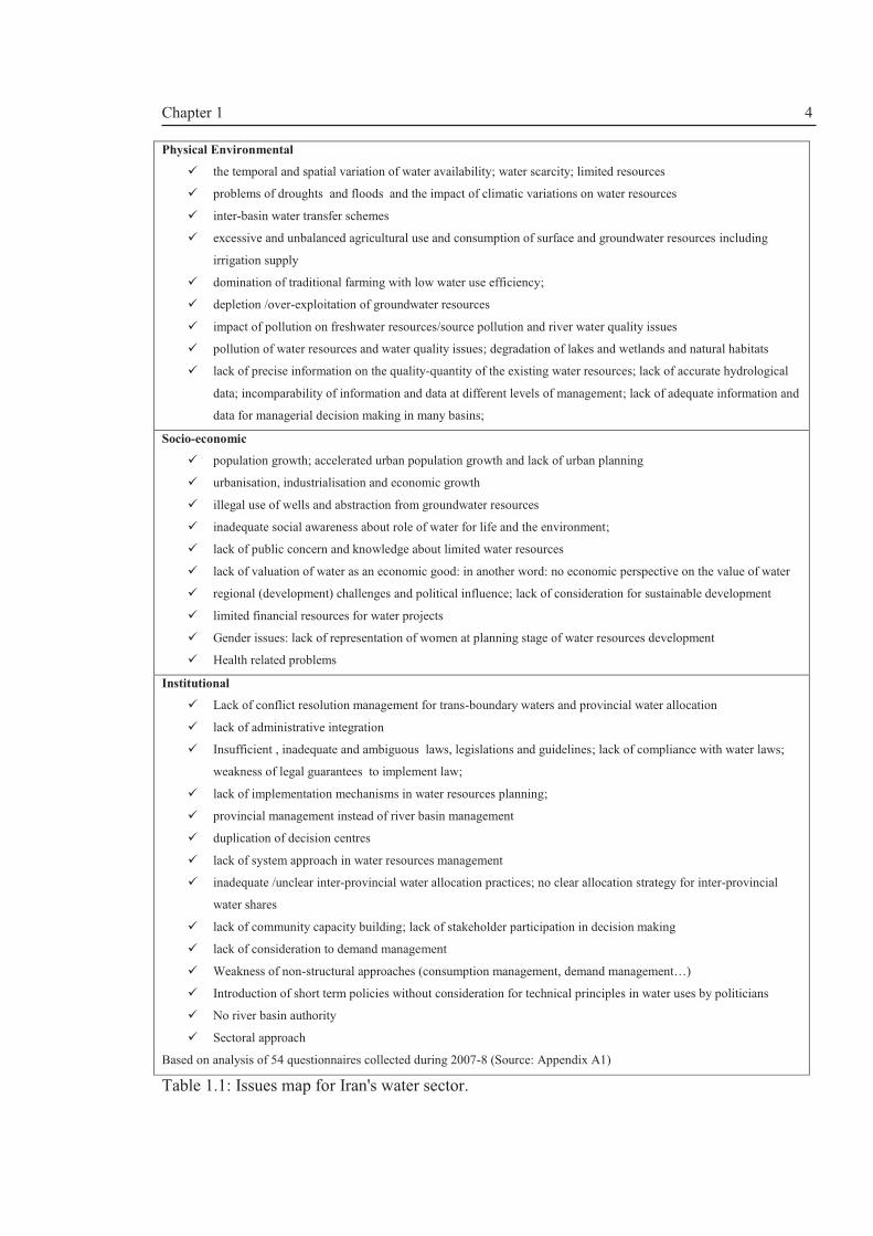
survey of 54 water managers conducted by the author during 2007-8 reveals that there is a
need for a holistic and integrated approach to water management (Table 1.1). The managers
were asked to list the five most important issues in the water sector (Source: Appendices A1).
Table1.1 presents a summary of the broad definition of issues of concern in Iran's water sector.
Based on the many challenges indicated, there has been a move towards adopting the IWRM
paradigm in Iran.
Figure 1.3: Iran within WANA region in dark blue (Source: www.wanaforum.org).
In the following sections of this chapter, the rationale, aim, objectives and scope of the
research are outlined.
1.2 Rationale of the research: Research gaps and questions
In recent years, there has been a great deal of interest in how to implement IWRM and
in why it has not been implemented since its introduction some 40 years ago. Van der Zaag
(2005) argues that IWRM is not just a buzzword but is a relevant, yet elusive and fuzzy
concept. Wide-scale implementation has been limited. Many scholars and researchers (e.g
Brown, 2005; Amjad, 2003) have concluded that there is a need for institutional change and
reform underpinned by capacity building interventions targeted at enabling a learning culture
that values integration and a participatory approach. Therefore, the question remains as to
what intervention pathway is required to achieve the IWRM concept.
Iran
Turkey
Pakistan Afghanistan
Saudi Arabia
Iraq
Egypt Libya Algeria
Moroc
co
Mauritania
Sudan Yemen
Oman
Chapter 1 4
Physical Environmental
ü the temporal and spatial variation of water availability; water scarcity; limited resources
ü problems of droughts and floods and the impact of climatic variations on water resources
ü inter-basin water transfer schemes
ü excessive and unbalanced agricultural use and consumption of surface and groundwater resources including
irrigation supply
ü domination of traditional farming with low water use efficiency;
ü depletion /over-exploitation of groundwater resources
ü impact of pollution on freshwater resources/source pollution and river water quality issues
ü pollution of water resources and water quality issues; degradation of lakes and wetlands and natural habitats
ü lack of precise information on the quality-quantity of the existing water resources; lack of accurate hydrological
data; incomparability of information and data at different levels of management; lack of adequate information and
data for managerial decision making in many basins;
Socio-economic
ü population growth; accelerated urban population growth and lack of urban planning
ü urbanisation, industrialisation and economic growth
ü illegal use of wells and abstraction from groundwater resources
ü inadequate social awareness about role of water for life and the environment;
ü lack of public concern and knowledge about limited water resources
ü lack of valuation of water as an economic good: in another word: no economic perspective on the value of water
ü regional (development) challenges and political influence; lack of consideration for sustainable development
ü limited financial resources for water projects
ü Gender issues: lack of representation of women at planning stage of water resources development
ü Health related problems
Institutional
ü Lack of conflict resolution management for trans-boundary waters and provincial water allocation
ü lack of administrative integration
ü Insufficient , inadequate and ambiguous laws, legislations and guidelines; lack of compliance with water laws;
weakness of legal guarantees to implement law;
ü lack of implementation mechanisms in water resources planning;
ü provincial management instead of river basin management
ü duplication of decision centres
ü lack of system approach in water resources management
ü inadequate /unclear inter-provincial water allocation practices; no clear allocation strategy for inter-provincial
water shares
ü lack of community capacity building; lack of stakeholder participation in decision making
ü lack of consideration to demand management
ü Weakness of non-structural approaches (consumption management, demand management…)
ü Introduction of short term policies without consideration for technical principles in water uses by politicians
ü No river basin authority
ü Sectoral approach
Based on analysis of 54 questionnaires collected during 2007-8 (Source: Appendix A1)
Table 1.1: Issues map for Iran's water sector.

Chapter 1 5
A report by the fourth World Water Forum (WWF, 2006)3, entitled: Implementing
Integrated Water Resources Management: the Inclusion of IWRM in National Plans, reviews
the progress made by countries in some 6 regional categories. According to two different
statistical surveys by the Japan Water Forum (JWF) and the GWP, up to 28% have made good
progress but some 28% are in their initial stages of implementing IWRM. They make some
key recommendations for future work on IWRM, which are centred on five themes: (1)
institutional and legal framework, (2)stakeholder participation, (3)socio-economic,
(4)capacity-building and (5)environmental sustainability. More recently, UN-Water (2008)
completed a survey showing an improvement of IWRM planning process at national level but
much more efforts are required to implement the plans at local levels and in Asia generally,
the institutional reforms are advanced but there are problems with institutional cooperation
and coordination. The fifth World Water Forum, which was held in Istanbul in 2009,
confirmed the importance of the institutional and cultural dimensions of water resources
management (WWDR, 2009).
Read-in to this, the neglect of the institutional dimension in water resources
management has created a huge barrier to implementing IWRM. Water resources management
requires a radical reorientation and an effective dialogue between decision makers,
stakeholders and engineers/academics (Falkenmark et al, 2004). However, the challenge is
how this radical reorientation can be made operational on the ground, and how to design and
use institutional reforms, potential interactions with other incentives/disincentives at the
operational level and the effect they may ultimately demonstrate in practice. Institutional
transformations are not a common occurrence (Cowie and Borrett, 2005), so the question is:
what are the prerequisites for institutional change? And what constitutes change?
Biswas (2004), in reassessing the IWRM paradigm, concludes that there is a need for
“an objective, impartial and non-dogmatic assessment of the applicability of IWRM”. Can a
single paradigm be applicable to every climatic conditions, every cultural, economic and
social settings? “…can it be applicable……to Islamic customs?”(Biswas, 2004). Is there a
need for an evolving paradigm to make the concept implementable? How can we have local
solutions using a global concept? Iran has a strong Islamic tradition as a Constitutional
democratic Islamic Republic. For example, what is the institutional role of Islamic principles
in implementing IWRM based on sustainability criteria? How can sustainable policies emerge
3 This report came out at the start of the PhD project providing an insight into research gaps in implementing the IWRM paradigm.

Chapter 1 6
from the moral and ethical values of Islam, bearing in mind that institutional, ethical and
cultural aspects have been recognised as important elements of IWRM (e.g. WWDR, 2009).
Strengthening institutional aspects by having and implementing adequate policies,
laws, regulations and administrations are vital for the implementation of an integrated
approach to water management. This is known as good governance. The World Bank (2007)
asserts that Middle East and North African (MENA) countries have appreciated the
importance of good governance in implementing sustainable water management policies in the
region, which includes Iran.
Multiple stakeholder participation (social learning process) is crucial to the evolution
of sustainable river basin management, and an integral part of the IWRM paradigm. Social
learning theory developed by Bandura (1977) postulates that people can learn from each
other’s experiences via observation, imitation and modelling or coding the information, which
guides the actions. Therefore, the question is how to facilitate multi-stakeholder processes and
social learning. This leads to questions about governance and democracy, which have become
important global issues as we work towards making sustainable development a reality.
Research is required on linking technical analytical methods and participation (social learning)
approaches, (Pahl-Wostl, 2002). For IWRM to be effective, a tripartite alliance between policy
maker, stakeholder and engineer (scientist) is required (Schulz et al, 2004). Simonovic and
Bender (1996) conclude that participation is essential because stakeholders have the
knowledge and experience necessary to formulate effective alternatives.
IWRM is a wide-ranging concept. The scope of the PhD programme has therefore
focussed on developing a socio-technical framework for implementing the IWRM paradigm in
general, and in Iran specifically, by considering the water allocation decision-making using:
a) a sustainability framework for analysing drivers and pressures associated with water
management and management options which provides a pathway towards
implementing the IWRM paradigm
b) an institutional analysis framework that can be linked to (a)
c) a case study approach to facilitate participatory decision-making; and
d) exploring the ethical and cultural spheres to foster good governance
The PhD programme will address the above questions and hence will contribute to the
advancement of IWRM theory and practice.

Chapter 1 7
1.3 Main Aim
The main aim of this project is to develop an integrated Socio-technical Framework for
implementing the Integrated Water Resources Management (IWRM) paradigm in a case study
approach by analysing how water resources can be managed and adaptively administered in
response to anthropogenic drivers (e.g. population/economic growth) and environmental
pressures (e.g. climate change) within the current institutional set-up, and to demonstrate the
application of the Framework using a case study approach that is based upon stakeholder
participation (Lake Urmia basin, Iran).
1.4 Objectives
1. To assess the applicability of IWRM through a critical analysis of the underlying
principles, and to assess progress made with implementation (Chapter II).
2. To develop an integrated methodological framework which can be used to implement
the IWRM paradigm by integrating the elements of social and technical assessment
(Chapter III).
3. To assess the status of progress towards implementing IWRM in Iran (Chapter IV).
4. To assess the status of water resources planning, management and allocation in the
Lake Urmia Basin (Chapter V).
5. To make an integrated socio-technical assessment of the water resources availability
for sustainable water allocation management in the Lake Urmia Basin, Iran (Chapter
VI).
6. To make a re-assessment of the institutional sustainability of the water allocation
strategy in Lake Urmia basin. (Chapter VII).
7. To develop an ethical and cultural framework that can provide a basis for good
governance based on Islamic principles (Chapter VIII).
8. To demonstrate the applicability of the overall framework through the Lake Urmia
case study approach (Chapters VI - VIII).
Chapter 1 8
1.5 The structure of the thesis:
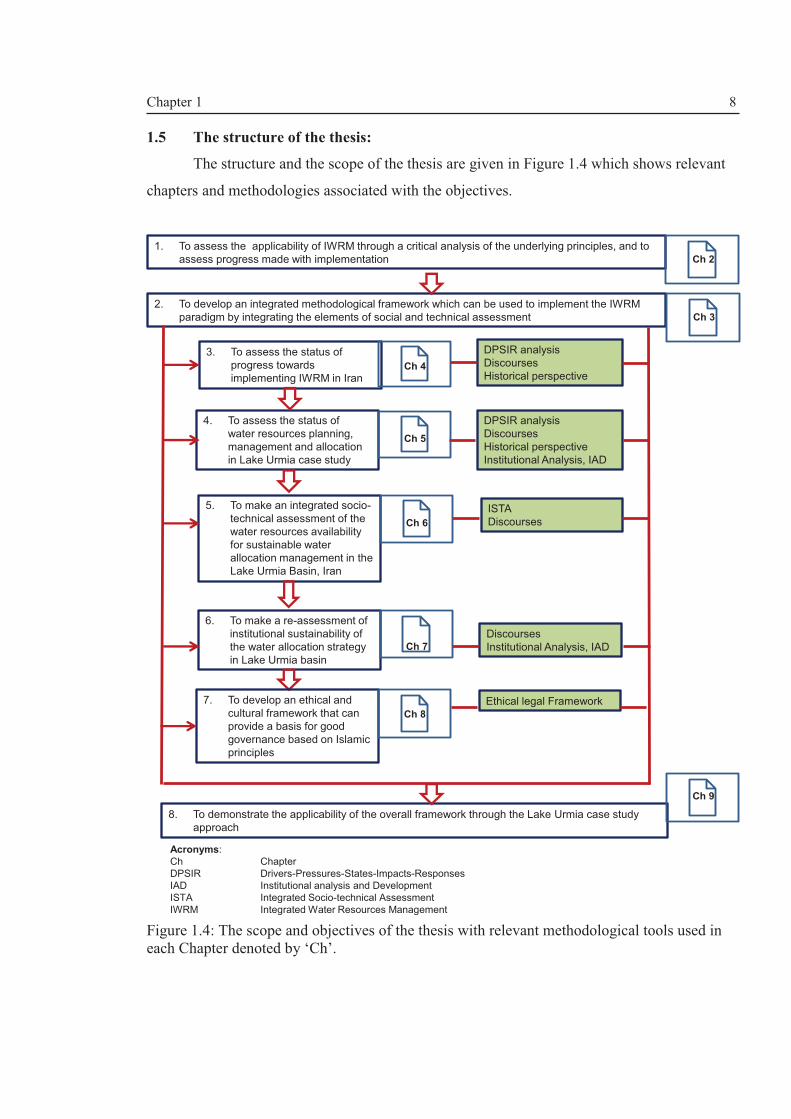
The structure and the scope of the thesis are given in Figure 1.4 which shows relevant
chapters and methodologies associated with the objectives.
Figure 1.4: The scope and objectives of the thesis with relevant methodological tools used in each Chapter denoted by ‘Ch’.
1. To assess the applicability of IWRM through a critical analysis of the underlying principles, and to
assess progress made with implementation Ch 2
2. To develop an integrated methodological framework which can be used to implement the IWRM
paradigm by integrating the elements of social and technical assessment
3. To assess the status of
progress towards
implementing IWRM in Iran
Ch 3
Ch 4
4. To assess the status of
water resources planning,
management and allocation
in Lake Urmia case study
Ch 5
5. To make an integrated socio-
technical assessment of the
water resources availability
for sustainable water
allocation management in the
Lake Urmia Basin, Iran
Ch 6
6. To make a re-assessment of
institutional sustainability of
the water allocation strategy
in Lake Urmia basin
Ch 7
7. To develop an ethical and
cultural framework that can
provide a basis for good
governance based on Islamic
principles
8. To demonstrate the applicability of the overall framework through the Lake Urmia case study
approach
Ch 9
Ch 8
DPSIR analysis
Discourses
Historical perspective
DPSIR analysis
Discourses
Historical perspective
Institutional Analysis, IAD
ISTA
Discourses
Discourses
Institutional Analysis, IAD
Ethical legal Framework
Acronyms:
Ch Chapter
DPSIR Drivers-Pressures-States-Impacts-Responses
IAD Institutional analysis and Development
ISTA Integrated Socio-technical Assessment
IWRM Integrated Water Resources Management

Chapter 2 9
ChapterII. Sustainable Water Resources Management in the 21st
Century: Concepts, Theories, Issues and Methodologies
2.1 Introduction
In Chapter I, the challenges facing the water resources sector worldwide, and in Iran
in particular, have been outlined. The survey (Table1.1, p.4) showed that lack of
institutional capacity development in Iran is perceived as one of the main obstacles on the
road to sustainable water resources management; and this is probably the case in many
other countries. Despite acknowledging the need for an integrated management approach,
the implementation of concepts such as IWRM has been slow or non-existent. Therefore,
Chapter II attempts to assess the progress made and applicability of IWRM through a
critical review of the underlying governing principles and related concepts such as ethics of
decision-making and water institutions. The main aim of IWRM is to achieve
sustainability. Thus, IWRM is reviewed through the lens of sustainability of different
aspects of the water resources system (WRS).
IWRM has become a dominant paradigm and actively promoted by national
governments and international agencies as the basis for sustainable water resources
management (e.g. Falkenmark and Rockström, 2006; Molle et al, 2008; Merrey, 2008). The
Global Water Partnership (GWP) has been a driving force behind the internationalisation of
the concept. However, there has been a lack of implementation of IWRM worldwide
despite its adoption by national governments around the globe (Biswas, 2004; Merrey,
2008). According to the Johannesburg Summit in 2002, governments had to have an IWRM
plan by 2005. In 2003, Iran was the first country in the Middle East region to adopt the
principles of IWRM through a landmark legal provision and normative plan called ‘Long
Term Development Strategies for Iran’s Water Resources’ (IWRMC, 2004). In addition to
legislative measures, several IWRM research studies have been initiated and are on-going.
Thus, IWRM concept which was conceptualised in the latter half of the 20th century is a
dominant paradigm but is still relevant in contemporary water resources management
despite much criticism about its practical applications by e.g. Merrey, 2008; Biswas, 2004
and van der Zaag, 2005.
Chapter II is divided into three main parts: first, the governing principles of
sustainable water resources management will be described; then IWRM is reassessed by

Chapter 2 10
considering its (a) conceptual limitations and (b) applicability. The discussion and
conclusions constitute the final part of this chapter.
2.2 Governing principles: definitions, concepts and issues
2.2.1 IWRM
A critical landmark in the history of the development of IWRM was the UN Water
Conference in Mar Del Plata in 1977 which set the general principles for international and
national agencies (Amezaga, 2005), and these principles were updated in 1992 in Dublin.
The Dublin principles1 contributed to the Agenda 21 recommendations (see Chapter 18 of
UNCED (1992) on freshwater resources) and were adopted at the UN conference on
Environment and Development (UNCED) in Rio de Janeiro, 1992. They provide the basis
for an integrated approach to water management.
From its definition (Chapter I: p.2), IWRM considers all the three interacting
components of a WRS (Figure2.1; Loucks and van Beek, 2005):
i. Physical (infrastructure and technology) and natural environment;
ii. Institutional and political (policies, laws, regulations and administrations); and
iii. Socio-economic.
Neglecting a particular aspect of the system poses great challenges to the
sustainable management of this precious resource. Hence, the water resource system is not
only about the natural system and the infrastructure and technology, but it is inter-related
with institutional and socio-economic and institutional subsystems as well.GWP (2000)
acknowledges that there is no unique definition of IWRM. Moreover, GWP (2000) has
further elaborated on the meaning of ‘management’ and ‘integration’; management
encompasses both development and management and integration is defined as:
the art and science of blending the right proportions of regular interaction and
interdependent groups of items into a whole. The concept of integrated water resources
management in contrast to traditional fragmented management is concerned with the
management of water demand as with its supply (GWP, 2000; p.23)
1The 4 Dublin Principles form the basis of modern water management: (1) Freshwater is a finite and vulnerable resource, essential to sustain life, development and the environment; (2) Water development and management should be based on a participatory approach, involving users, planners and policy-makers at all levels; (3) Women play a central part in the provision, management, and safeguarding of water; (4) Water has an economic value in all its competing uses, and should be recognised as an economic good.

Chapter 2 11
Figure 2.1: The components of WRS (Adapted from Loucks and van Beek, 2005).
The essence of integration is challenging and the process of integration has been
beset with both technical and conceptual problems. Collaboration, cooperation and
coordination are terms used to describe partially the meaning of ‘integration’ within the
context of an integrated management decision-making process. However, Morrison et al
(2004) suggest that integration means all of the named terms and more. A seven
dimensional diagnostic framework has been envisaged including strategic, structural,
procedural, facilitative, functional and methodological integrations (Morrison et al, 2004).
An integration of water resources may have four characteristics or dimensions as shown in
Table 2.1.
In the context of IWRM, the word ‘paradigm’ refers to the idea that IWRM is a
balancing process that facilitates trade-offs among competing goals and not a goal in itself
(Jønch-Clausen and Fugl, 2001). This is very important. IWRM plans are not traditional,
project-oriented ‘Water Master Plans’ but they are strategic ‘dynamic’ plans based on long
term visions that continuously will be reassessed and evaluated over time (Figure 2.2).
Politics

Chapter 2 12
Figure 2.2: The Cycle for IWRM plans (Source CAP-NET, 2005).
Four dimensions of integration (Morrison et al, 2004))
Five criteria for sustainability
(sustainable development (Gasparatos et al, 2008)
Interpretations in terms of IWRM
1- A multi-jurisdictional spatial organization
1- Integration of social, economic, environmental and institutional issues and their interactions and interdependencies;
1-Fulfilling Sustainability criteria using sustainability assessment frameworks
2-Participatory coordination of different stakeholders, civil societies and actors
2- Creating a participatory environment; empowerment policies;
2- Stakeholder participation mechanisms such as stakeholder platforms; councils, forums associations etc. Balance of power among stakeholders Facilitating bottom up decisions
3-Collaborative decision- making from the participatory approach
3- Predictions of future trends and the impact of policies and development plans on sustainability; 4- dealing with uncertainties by taking conservative and precautionary measures
3-Using a systems analysis approach (policies, scenarios, management options (measures) and strategies) and integrated assessment tools
4- Agreement based on rationality
5- To foster ecocentric ethics and equity (intergenerational and intergenerational);
4- Supporting the socio-economic welfare of people i.e. eradicating poverty; empowering women; sustaining the environment
Table 2.1: Integration and sustainability in terms of IWRM.
2.2.2 Sustainable Development: ecological and environmental sustainability
The concept of sustainability came into the domain of academia In the 1970s
(Rogers et al, 2006,p.42). However, Sustainable Development came into prominence after
the publication of the 1987 World Commission on Environment and Development (WCED)
report2 which defines sustainable development as “development that meets the needs of the
present without compromising the ability of future generations to meet their own needs”
(WCED, 1987: 43).
2Also known as the Brundtland Report named after the former Norwegian Prime Minister, Gro Harlem Brundtland.

Chapter 2 13
The word “needs” is used twice in the above sentence and some critics have argued
that the anthropocentric nature of the Brundtland report is a paradox and accused the author
of taking a political stance in her approach by putting human needs at the centre of
Sustainable Development (Barr, 2008). Braga (2001) points out that the explanation of the
meaning of the term given by WCED (1987) is rather ambiguous and argues that the
sustainability of natural systems is a measure of how they come into equilibrium during
naturally occurring changes. However, humans have used these natural resources as if they
are in ‘infinite supply’ which is a linear approach or “the one- way society” approach
(Braga, 2001). As given in Chapter I, ASCE (1998) proposes another definition of
Sustainable Development within the context of river basin approach that not only
encompasses the “needs’’ or the demands of the current generation but gives an equal if not
higher importance to the need for demand management. Demand management is an integral
strategy within river basin approach. It is argued that the ASCE definition needs to be
improved to include the political dimension or the institutional sustainability of WRSs.
In recent decades, there have been many contributions to the Sustainable
Development debate (e.g. Barr, 2008; Khan, 1995; Hediger, 2000; Pearce 1988; Pearce et
al, 1989 among others), notably Khan’s (1995) triangular model of sustainable
development (social, economic and environmental sustainability) and Giddings et al’s
(2002) nested sustainability model based on trade-offs among social, ecological and
economic objectives. Gasparatos et al’s (2008) review on the Sustainable Development
debate came up with a consensus on five criteria for sustainability which forms the basis of
a holistic sustainability assessment as given in Table 2.1.ASCE (1998) outlines a number of
methods to measure sustainability criteria in terms of net welfare of the system with
reference to three development objectives: efficiency, survivability and sustainability
including:
1. weighted criteria indices which consists of a list of criteria which are
subsequently divided into sub-criteria which capture different aspects of
the WRS; each are given equal weights and “the sum of numerical values
given in each sub-criterion is a sustainability index “ (ibid, 51);
2. statistical indices which are defined as “separate or weighted combination
of reliability, resilience and vulnerability (RRV) of various economic,
environmental ecological and social criteria that contribute to
sustainability ” (ibid, 51);

Chapter 2 14
3. reversibility criteria which uses entropy as a sustainability criterion; and
4. robustness criteria by using the economic concept for evaluating
alternative water resources development plans.
Among these methods, RRV analysis has been widely used to assess the
performance of WRSs under the impact of climatic variability and change (e.g. Walsh and
Kilsby, 2007; Jain and Bhunya, 2008; Kjeldsen and Rosbjerk;2004).
Worldwide acceptance of Sustainable Development made it necessary to develop
sustainability assessment frameworks. Guio-Torres (2006) and Waheed et al (2009) have
reviewed various approaches. Waheed et al (2009) categorises the sustainability assessment
frameworks into 6 categories (ibid; p.448):
· Objective-based (e.g., strategic environmental assessment (SEA)
· Impact-based (e.g., Environmental Impact Assessment (EIA), Sustainability
Impact Assessment(SIA), TBL Assessment)
· Influence-based (e.g., Transport Canada Framework)
· Process-based or stakeholder-based (e.g., USDOE “Ten Steps to
Sustainability”)
· Material flow accounting and Life cycle assessment
· Linkages-based (e.g., pressure-state-response (PSR), Driving forces-
Pressures-States-Impacts-Responses (DPSIR)
The main conclusion drawn from the review and comparison of the assessment tools
is that none of the approaches can fulfil the criteria for holism. The complex nature of
natural physical, socio-political, economics and institutional issues with ethical dimensions
present the problem in a way that cannot individually tackle the sustainability assessment
task (Hashemi and O’Connell, 2011b). They are complementary to each other and a variety
of tools might be considered, depending on the context of the assessment. Another obvious
point is that these shortcomings are not disadvantageous to the point of nullifying the
various approaches, but it is advised that stakeholders should know about these limitations
and assumptions so to make informed decisions.
Despite their limitations, linkage based frameworks such as DPSIR have been
successfully implemented in many sectors (Waheed et al, 2009). There is room for
improving the conceptual and analytical dimensions of these frameworks. For example,
Turner et al (1998) call for incorporation of ethics into the DPSIR framework. We will
discuss this topic further in Chapter III.

Chapter 2 15
2.2.3 Sustainability and environmental ethics
Ethics can be defined as a set of beliefs, values and perceptions which have cultural
and religious dimensions and are a vital element in policy and decision-making situations.
Ethical principles are frequently ignored in conventional water management (Sohail and
Cavil, 2006). However, the ethical dimension of decision-making should be acknowledged
since it empowers a certain group of people to make robust decisions affecting others.
Lord Selborne (2000) states that the ethics of freshwater use have five elements: (1)
human dignity (rights); (2) stakeholder participation, (3) equity; (4) sustainability; and (5)
good governance. The latter is part of an enabling environment to implement the IWRM
paradigm. These ethical elements are implicit within the concepts of IWRM and
Sustainable Development.
Environmental ethics is defined as “a systematic account of the moral relations
between human beings and their natural world (Des Jardins, 2001 p. 11). Des Jardins
(2001) provides a comprehensive review of different environmental ethics based on their
philosophical foundations. Throughout the history of mankind till today, the
anthropocentric ethics have dominated with severe environmental consequences resulting
in environmental degradation and resource depletion as humans are considered to be the
central fact in the universe (Proops and Wilkinson, 2000). The biocentric ethics considers
animal rights but fails to recognize ecosystems as a unit. Therefore, a sound environmental
ethic has to be ecocentric giving full environmental protections but recognises human
society as an integral part of the ecosystem.
Armstrong (2009) outlines a ‘water ethic’ in line with Leopold’s (1949) ‘Land
Ethic’. The proposed water ethic principles is based on the “rights of the nature”
(Armstrong, 2009) which emphasises the ecological dimension of water management:
“ethical water management is thus not just about the allocation of water resources to
human beings, but to all species, and to all landscape components” (ibid, p.146).
2.2.4 Socio-political (institutional) dimension of sustainability
Institutions are considered to be the mould of social life, consisting of interacting
systems of laws (rules) with inbuilt monitoring and enforcing mechanisms (Campbell,
2004). The mechanisms are enabled by actors to make decisions regarding water resources
management (Cowie and Borrett, 2005). Institutions, therefore, are the means of stability in
society by channelling and regulating conflicts. Therefore, water resources decision-makers
Chapter 2 16
need to consider their social responsibilities in achieving sustainable societies (ASCE,
1998).
There is no unique definition for the term ‘institution’ (Ostrom 1999, 2005). A
confusing prospect for non-institutional experts is the varying ways in which institutions
are analysed based on the conceptual definition of an institution. In an institutional analysis
process, we must clearly state what is meant by a water institution. Classical
institutionalists such as Ostrom (1999, 2005) take the view that institutions are the rules
that organisations (administrative institutions) or actors adhere to but Saleth and Dinar
(2004) and Bandaragoda (2000) have taken a broader view to consider institutions in terms
of three main components: policy, law and administration. This is a pragmatic view since
water administrations cannot exist without the other two and vice versa. Therefore, in any
institutional analysis of sustainability, the term ‘institution’ has to be clearly defined based
on the applied analytical framework.
From comprehensive literature reviews (by e.g. Amezaga, 2005; Hashemi et al,
2007a,b; Ivey et al, 2006; Cowie and Borrett, 2005), a water resources institution can be a
mixture of six broad categories:
1. Vision statements, policies and guidelines and strategies
2. Laws (which can be formal and informal), rules, regulations and conventions
operational plans and procedures
3. Administrative structures (organisations), their bylaws and core values
4. Political structures and processes (accountability mechanisms)
5. Economic and financial arrangements e.g. incentive mechanisms
6. Norms, traditions, practices and customs
Governance is a term which is widely used in the literature. It is defined by
UNESCAP3 (undated) as “the process of decision-making and the process by which
decisions are implemented (or not implemented)”. A further consideration is the need to
understand that a governmental system is part of a larger governance system and is
characterised by its sectoral, functional and hierarchical differentiations; these are the
sources of governance complexity (Blau and Meyer, 1956). Sectoral and functional
differentiations are the result of government specialization in a discrete policy area and
usually cause duplication of efforts and fragmentation of responsibility. This is not
necessarily disadvantageous (Imperial, 1999).
3The United Nations Economic and Social Commission for Asia and the Pacific(UNESCAP)

Chapter 2 17
In a world in which water scarcity is a fact of life, water sector institutions need to
be re-oriented to cater for the needs of changing supply-demand and quantity-quality
relationships in the emerging realities (Saleth & Dinar, 2004).ASCE (1998) postulates that
“any process involving change will require that we change our institutions – the rules
under we function”. As noted by many researchers, water resources institutions are in a
continuous flux and we need to analyse institutional mechanisms that allow the change to
occur (ASCE, 1998). But the study of institutional change is in the domain of social and
political sciences and hence there is a need to link institutional analysis to any sustainability
assessment of WRS.
One of the vital characteristics of IWRM is its “strong institutional orientation”
(Imperial, 2009). Therefore, IWRM concept is consistent with the notion of institutional
(decision-making) levels (see e.g. ASCE, 1998) i.e. IWRM can interface with three levels
of institutional interventions: (1) operational (local/basin) level which deals with
biophysical, environmental, hydrological, ecological and socio-technical aspects of the
WRS; (2) organisational level which deals with administrative aspects of the WRS; and (3)
policy level which deals with policy and legal aspects.
Decisions at a higher level determine the rule sets or institutional arrangements at
the lower level. However, the actions in the operational level will directly affect the
distribution of water and land resources and usage in the physical world. By monitoring and
assessing the distribution of outcomes at the operational level, a process of feedback to
higher levels is established. Therefore, the processes at each level are not mutually
exclusive.
Searle (2005) makes an outstanding contribution to the institution debate as he
advises those who are involved with the theory of institutions that they should see an
institution from the first person point of view since the institutional ontology is subjective.
Searle (2005) believes that you can see the institution through the lens of the participant
and no external functionalist can understand the situation. You have to be an insider rather
than an outsider looking into institutional problems. An inner knowledge of institutional
matters will foster (a) good relationships and partnerships (long term socio-political
commitments to sustainability concept); (b) socio-political support (financial
sustainability); and(c) achievable stakeholder participation.
Institutional analysis is a key theme in this thesis which will be discussed in the next
sub-section.

Chapter 2 18
2.2.5 Policy/decision-making processes
IWRM uses systems analysis approach (Figure 2.1; Box 2.1) to achieve holistic
sustainability(e.g. Loucks and van Beek, 2005).A water policy (see Box 2.1 for definition)
is usually based on water uses. There are different policies for agricultural, domestic, urban,
industrial, energy and environmental uses of water. Now, on an international platform,
water policy comes within broader policies on sustainable development, Millennium
Development Goals, (MDGs) and human development.
Box 2.1: The components of systems analysis approach and their basic definitions (Source: Hashemi and O'Connell, 2011b).
The most crucial stage for an issue to become policy is to gain agenda status.
Framing an issue depends in part upon whether the claims persuade others that “X is a
social problem or that Y offers the solutions” (Best, 1995). Issues labelled as social or
public problems get the attention of legislative bodies and hence will gain agenda status.
Issues that are not perceived as a problem by society will not become a policy. Therefore, it
must be remembered that policies are made by politicians in response to perceived social
problems and for the advancement of their own political interests and careers.
A policy has two goals: the interests of individual wellbeing and the interests of the
society as a whole. However, these two goals are not the same (Pearce, 2000). In a
politically correct world, decision-making based on self-interest (the first goal) is
unacceptable, and so citizens' preferences are accepted. Pearce (2000) asserts that this kind
of contrast between the preferences is exaggerated and unhelpful. Socially motivated
preferences are elicited by political means whereas self-interests are well served by the
· Policy: a political (governmental) statement outlining the vision,goals
and objectives of IWRM plans
· Scenario: a futuristic outlook of development such as assumptions
under which development occurs; these are exogenous to the water
system such as population growth or climate change that cannot be
controlled or determined by the water resources system
· Management option: a measure or an action taken to improve the
performance of the water system, these measures can be legal,
institutional, technical, social, economics, ecological.
· Strategy: a collection of management options to be considered under
different anthropogenic and natural climatic scenarios.

Chapter 2 19
economic medium. However, political decision-making is open to the influence of lobby
groups and political self-interest.
The policy-making process should ideally be participatory since policy decisions are
based on societal values as a whole (Stave, 2002). Thus, on this basis, all stakeholders
should be given a voice and be heard without prejudice and advantage (Hampton, 2004)
and should be involved in discussing the trade-offs. However, the challenge is that there is
no clear way to assign and determine the qualitative values (i.e. weights) attributing the
relative importance of different management options in a Multi-Criteria Decision-making
Analysis (MCDA) approach to decision making (discussed in Chapter III).
It is argued that participation provides legitimacy for a given policy (Hendriks,
2005). Furthermore, people’s evaluation of policies may change as their perception changes
about issues they value. Therefore, in recent years, far-reaching public policy changes have
occurred in many countries so that some scholars consider them as shifts in policy
paradigms (Menahem, 1998). A policy paradigm comprises of a system with two
components (ideas and standards) that defines policy goals.
In a dynamic world (climate, technological and resource availability changes),
policy-makers have to consciously change their assumptions. Financial resources can be an
important factor. For example, technological changes affect water sector organisations and
in response, they have to adapt to these changes in order to survive in a competitive
financial environment e.g. monetary or market forces (see e.g. Archibugi et al, 1999). So,
policy-makers tend to use technological assessment tools such as modelling systems to
legitimise policy decisions which have a great deal of uncertainties. We have to understand
that the interplay between public policy and legitimacy is a vital component in a policy
analysis (Hashemi et al, 2007a) and to remember that the primary role of the modelling
systems is to educate the policy-makers about the nature of the problem and provide
evidence for a sound decision using the available data and technologies and not to
legitimize policy (Sharifi, 2003). In Chapter III, more insight is given on institutional and
policy analysis tools. In the next sub-section we will further discuss the role of technology
on the sustainability of WRSs.
2.2.6 Sustainability and the application of modelling systems:
Sparked by the availability of digital computers, a flurry of watershed modelling
activity started around the late 1950s. Comprehensive digital modelling was initiated

Chapter 2 20
thorough the Stanford Watershed Model, (Crawford and Linsley, 1966)4. In parallel to the
development of watershed modelling, the wider field of water resources planning and
management saw the evolution of a range of WRS simulation and optimisation methods
which dates back to1950s (Keiner, 2004; Jain & Singh, 2003). The ‘Harvard Water
Program’ (HWP, 1955-1965) was the driving force behind the agenda for water resources
modelling in the USA and worldwide (e.g. Maass et al, 1962; Loucks et al, 1985; Dzurik,
2003). HWP’s contribution to water resources planning and management was three fold
(Reuss, 1989): (1) using computer simulation to design water resource systems; (2)
developing synthetic or operational hydrology as a means for designing water resource
systems and (3) the development of multi-objective economic analysis and planning. The
HWP’s ‘blueprint’ remains a relevant vision to date (Reuss, 2003).
Due to the sheer number of simulation and optimisation models, it is almost
impossible to make an inventory of the models. Many researchers have reviewed different
types of models including Biswas (1974), Loucks et al (1981), OTA (1982), Basson et al
(1994), Watkins and McKinney (1995), Wurbs (1997, 2005), Boughton and Droop (2003),
McKinney (2004) and Labadie (2004).
Based on a comprehensive review, Hashemi and O’Connell (2011a) conclude that
water resources models have contributed greatly to the advancement of the planning and
management of water resources and have been recognised as an integral part of the
decision-making process. Water resources models are used to simulate future demands and
assess the impact of water resources development plans on the available resource in terms
of quantity and quality. They can be generally classified as (a) reservoir/river systems or
river basin (water balance/allocation) models; (b)emergency (Flood/spill) models; (c) water
Quality models; (d) environmental models; and (e) integrated modelling systems (i.e. a
combination of socio-economic, hydrologic, ecologic and hydraulic models) which
emerged in the 1990s.
The start of the 1990s brought further technological advancements and the
proliferation of Personal Computers (PCs) and better MS Windows (Microsoft
Corporation) environments with even better graphical capabilities. The main characteristics
of the status of modelling system in the 1990s can be summarised in Box 2.2.The
increasingly important role of information technology in the development and application
4In this section we concentrate on the role of water resources modelling systems in sustainable management of the resource see Hashemi and O’Connell (2011a) for a comprehensive review on the development of watershed and hydrological modelling including physically based distributed models.

Chapter 2 21
Box 2.2: The main characteristics of the status of water resources modelling in the 1990s.
1. Emergence of a number of comprehensive, distributed, and physically based models such as Mike-SHE (Refsgaard & Storm, 1995) and SHETRAN (Ewen et al, 2000) which could be applied to address a wide range of environmental and water resources problems.
2. Linking hydrologic models with water quality/ecosystem models
3. Models gained greater acceptance as tools for water resources planning, development, design, operation, and management.
4. Major advances in the field of digital imagery and data acquisition techniques (e.g. remote sensing, radar and satellite technology) with applications in e.g. real-time flood forecasting, weather forecasting, forecasting of seasonal and/or short-term snowmelt, mapping of groundwater potential to support the conjunctive use of surface water and groundwater; Environmental Impact Assessment (EIA) of large-scale water resource projects etc.
5. Use of Digital Elevation Models (DEMs) (e.g. Sugumaran et al ,2000) and Digital Terrain Models (DTM) and other digital maps of vegetation, soils and geology etc in hydrologic modelling systems
6. Application of new hydroinformatics data mining tools such as artificial neural networks (ANNs) in river basin/hydrologic modelling
7. Improvement of the technology of model calibration and use of optimisation techniques and multi-criteria analysis techniques for multiple objective evaluations
8. Emergence of the first generations of integrated systems such as NELUP, WaterWare, IQQM, RIBASIM, WEAP etc
of watershed and water resources system models was encompassed very well by the new
integrating and cross-disciplinary concept of hydroinformatics formulated by Abbott (1991)
which embraces hydraulics,
hydrology, environmental
engineering, socioeconomic and
political (institutional) sciences,
and uses information and
communication technologies to
provide evidence for decision-
makers.
There are many examples
of integrated modelling systems
such as MODSIM (Labadie et al,
1984), IRIS (Salewicz et al,
1991), NELUP(O’Callaghan,
1995), WaterWare(Jamieson and
Fedra, 1996),IQQM (Simons et al,
1996), AQUATOOL (Andreu et
al, 1996), WEAP (Raskin et al,
2001), MIKE SHE river basin
integrated modeling tool (Graham
& Butt, 2005), Mike Basin (DHI,
2003, Ammentorp, 2001) and RIBASIM (WL| Delft Hydraulics, 2005). These exhibit some
(i.e. not all) of the five desirable features:
· GIS/graphical user interface and geo-database management system
· scenario analysis with multi-criteria analysis or statistical techniques for
strategy evaluation (expert systems)
· socio-economic assessment tools/indicators
· institutional assessment tools (e.g. water pricing)
In 2000, IWRM took the centre stage in both national and international policy
spheres worldwide. Due to the interdependent nature of the interplay among various WRS
components, there is an implicit quest for integrated assessment tools. The IWRM concept
which requires the integration of physical, chemical, biological, environmental, ecological

Chapter 2 22
and socio-economic components has helped for the conceptualisation of integrated
modelling approaches.
There is a strategic trend towards implementing integrated assessment tools at multi
resolution, multidisciplinary levels. Major projects around the globe spend a large amount
of resources on developing modelling systems with the aim of attaining IWRM goals to
achieve sustainability criteria. Examples include the SAHRA (Semi-Arid Hydrology and
Riparian Area) initiative (Liu et al, 2008); the Nile Basin Initiative (NBI) covering 10
African counties, the Colorado River DSS (CRDSS) and EU’s NOSTRUM-DSS which
aims to support the EU’s policy on stronger stakeholder participation, pro-poor emphasis
and gender sensitivity. Other examples include WaterStrategyMan (Todini et al, 2006)
MULINO, (Giupponi et al., 2004) and DANUBIA (Ludwig et al, 2003).
2.2.7 Sustainability and uncertainty in sustainable decision outcomes
There are three categories of uncertainties: (i) inherent; (ii) knowledge (e.g.
scientific, data); and (iii) decision-making uncertainties (Langsdale, 2008; Loucks and van
Beek, 2005).
Inherent uncertainty is due to the complexity, dynamic and unpredictable nature of
ecological and water resource systems processes. One of the lessons that have to be learned
is that most decision-makers perceive uncertainty to be of the second category (knowledge
uncertainty) and hence scrutinise scientific outputs ignoring the inherent uncertainty. Thus,
Langsdale (2008) calls for two important actions: (1) the acknowledgment of the inherent
uncertainties in the decision/policy-making process and (2) clear communication of
uncertainty elements in the outputs to the stakeholders.
Knowledge uncertainty relates to available data or the inadequacies of the
assumptions made or gaps in the structure of methodological approach. There are four
knowledge management domains (Steyaert & Jiggins, 2007): (1) the known: these are
manageable and there is no uncertainty or risks attached to them; (2) the complicated but
unknown: they are normally very important; e.g. climate change, population growth
pressures, physical processes affecting evaporation rates, the impact of geometry of pore
size in preferential flow etc.; (3) the complex, unknowable but partly predictable: most
model outputs fall into this category; and the chaotic: all natural processes fall into this
category.
‘Uncertainty due to lack of data’ is now a cliché in the water resources
management. The enhancement of data management technology and modelling will not

Chapter 2 23
improve the knowledge uncertainty on its own unless collection and data measurements
techniques are improved too. They are a complement to the data collection process and not
a substitute to it and scientific observations are needed for better understanding of the
system problems (Silberstein, 2006). In the case of hydrological data for example, Sutcliffe
(2004) calls for improving measurement techniques. Therefore, there should be a shift from
purely technological to a combined technological and data collection techniques approach.
Shackley and Wynne (1996) also note that knowledge uncertainties can diminish
the authority of scientific judgements in policy and decision-making process. The scientific
ambiguity serves both policymakers and scientists: it can be used as an alibi in accounting
for a lack of policy effectiveness. However this should not affect the importance of
scientific knowledge in decision-making, as uncertainty is a by-product of analysing
complex issues (Armitage, 2004). Furthermore, the process will benefit from better
dialogue between natural and social scientists, water users, environmental regulators and
the public at large (Ioris, et al, 2008).
Decision uncertainty is shaped by incoherent goals and objectives and influenced
by the ethical context of decision-making e.g. customs, culture and belief (Loucks & van
Beek, 2005). Loucks and van Beek (2005) assert that, in many cultures and legal systems,
doing nothing is more acceptable than failing after an action. Loucks et al (1985) make an
intelligent observation about the incremental nature of political decisions. Based on this,
they suggest that the model solutions should also be incremental as political communities
are not happy admitting that they were wrong but they might be happy with making small
changes within a learning process. Therefore, the uncertainty should not be a scapegoat for
inaction (Cosgrove et al, 2008).
Scientific arguments are often the basis for public policy debates and the importance
of science in sound public policy-making cannot be ignored (Montz, 2008). There is a
strong link between science and the policy-making process (e.g. Montz, 2008; Freehafer,
2008). Scientific uncertainties normally polarise policy-making decisions and indeed
provide a hindrance for change or reform. But uncertainty is part of the decision-making
process i.e. it is fact of life (see e.g. Refsgaard et al, 2007). It is not possible to isolate,
remove or eliminate uncertainty entirely by further research. However, research can
improve the uncertainty of know-how and knowledge.

Chapter 2 24
2.3 Reassessment of IWRM paradigm
Many scholars have called for reassessment of the IWRM concept (e.g. Biswas,
2004; Falkenmark et al, 2004; and Llamas and Martinez-Santos, 2005; Falkenmark and
Rockström, 2006; Merrey, 2008). Nevertheless, the conceptualization of the IWRM
paradigm came about at a time when water resources around the world were poorly
managed. Therefore, most scholars (whom criticise IWRM) also value the importance of
the concept as a countermeasure to balance conventional water management practices
which manifest unsustainable development.
In this section, we discuss the problems with the ‘integration’ aspect of the IWRM
paradigm and reassess the validity of the concept, bearing in mind its dismal lack of
implementation success. In the next sub-sections, issues and constraints of implementing
IWRM are discussed.
2.3.1 Conceptual constraints
Problems with scope of IWRM. According to Molle (2006), the river basin concept
“has been associated with various strands of thinking and sometimes co-opted or mobilised
by a particular group to strengthen the legitimacy of their agenda". IWRM is a political
process seeking to entrench democracy through participation and good governance. Hence,
it should be possible to envisage political boundaries that influence the hydrologic
boundaries and incorporate an enlarged political map by identifying actors and
organisations that affect WRS. Therefore, a politicised IWRM is envisaged by moving
away from a watershed to a “problemshed” perspective (Mollinga , 2008). Merrey (2008 )
states the need for “identifying empirically what are the boundaries of a problem and not
imposing a hydrological boundary”. This means that the scope of IWRM should be
enlarged and goes beyond hydrological boundaries (i.e. river basins). WWDR (2009) calls
for dealing with the ‘water box’ dilemma’ by looking for solution outside the ‘water box’
with a political decision-making process involving political, civil society and business and
economic actors.
The call for politicising IWRM by enlarging the boundary of the watershed (i.e.
considering ‘problemsheds’) is well founded as IWRM is essentially a political process
(e.g. Allan, 2003a). But, it is argued that there is a misconception on the philosophical
nature of IWRM. As stated earlier, IWRM provides interfaces for three decision-making
levels (policy, organisational and operational levels) which go beyond watershed
boundaries. The reason why IWRM has been very elusive in terms of being implemented is

Chapter 2 25
that it is not a framework; instead it is a romanticised (idealistic) concept. What is required
is a framework that can translate the IWRM concept into implementable strategies and
management decisions. It is argued that river basin approach is still valid because it
represents the operational level within nested decision levels (boundaries) i.e. for our
analysis; we need to consider the ‘resource unit’ which is affected by our decisions.
According to Merrey (2008), the wide ranging scope of IWRM “normative
package” objectives is leading to “indecisions and paralysis”. It is simply not possible to
achieve all the objectives of IWRM at the same time. For example, the complexity of the
nature of implementing IWRM is clear as Biswas (2004) lists some 36 issues that should be
‘integrated’. Therefore, objectives need to be prioritised. However, Merrey (2008) does not
call to abandon IWRM altogether but asserts that the IWRM normative form should be
discarded as an unchallenged “religious text” or a blueprint.
It is argued that IWRM is a high level set of water management principles and so it
is vague on how to prioritise its wide ranging objectives but a practical implication of
IWRM by ‘being a process and not a goal in itself’ is that objectives can be prioritised by
having short term objectives within a long term vision i.e. the long term sustainability of
water resources systems can be achieved by gradual implementation of IWRM plans.
Therefore, there is a need to develop ‘good practice’ guidelines on how IWRM is
implemented.
Need for paradigm shift. Researchers such as Pahl-Wostl, (2007), Lankford et al
(2007)and Rivers-Moore and Jewitt (2007) among others, call for incorporation of the idea
of adaptive management within a “social learning” process. The idea of adaptive
management originates from the understanding of ecosystems as being adaptive or “self-
organising” to changes in the system (Holling, 1978). It has been introduced to resources
management for quite some time (Pahl-Wostl , 2007; Jewitt, 2002). The overall approach is
to combine ‘‘soft’’ subjective perceptions (values, ideology, belief systems) based on
perspectives or mental models of stakeholders and ‘‘hard’’ factual knowledge from data
analysis in a participatory group model building process (Pahl-Wostl, 2007). Stakeholders
will learn from each other and make decisions based on their evolving understandings and
perspectives. People can have multiple non-mutually exclusive value-laden perspectives at
the same time (Spranger, 1928). Different human perspective models are shown in Table
2.2. In my opinion, the human face of IWRM can be improved by consideration of

Chapter 2 26
perspectives in an implementation framework. We will return to the theme of perspectives
in Chapter III.
Name of perspectives
model
Perspectives’ values and their attributes
Spranger ‘s (1928)
Human Perspective
Theoretical
general legality,
value of
objectivity
Economic
utilitarian
ethics
the value of
utility
Aesthetic
inner form and
the value of
proper form and
harmony
Political
desire or will to
gain political
status (power)
Social
ethics of helpful
love and loyalty
and social ties
Religious
holiness in
God
TOPEA Model plus
economic (Hall et al.
2003; Hall and
Davis; 2007 and
Hall, 2008) based on
Courtney’s (2001)
TOPEA model
Technical
A functional,
rational and
ordered
orientation
Economic
Efficiency
Aesthetic
The beauty and
harmony of a
solution design
Personal
Prestige, power
Organizational
organisational
self-interest
Ethical
Integrity,
way
criticism is
dealt with
Table 2.2: Different perspectives models and their main attributes.
2.3.2 Neglecting parts of the water cycle: omissions in IWRM approach
One of the main criticisms of IWRM is that it focuses more on the “Blue Water”
part of the water cycle. Falkenmark (1997) introduced the concept of Blue and Green Water
to separately account for (a) renewable surface runoff and groundwater resources (Blue
Water); (b) and soil moisture and water consumed by plants through evapotranspiration
(Green Water); and (c) return flow or wastewater (Grey Water). Falkenmark et al (2004)
points to “three omissions” in IWRM approach: i.e. water sources which are not fully
considered in IWRM plans including Green Water, Grey Water and environmental services
(ecological functions) of water.
Need for Evergreen Revolution. From 1960’s, irrigated areas in the world has
increased exponentially based on extensive use of Blue Water. Expansion of irrigation
agriculture which is termed as the first “Green Revolution” brought economic prosperity to
many countries and enhanced food security lifting the threat of hunger from many parts of
Asia (Falkenmark and Rockström, 2006).The Green Revolution has placed a great pressure
on the WRS worldwide. Overexploitation of groundwater resources in many parts of the
world had reached a crisis level (Calder, 2004 and 2005; Falkenmark &Rockström, 2006,
Falkenmark et al, 2004). Surface water developments have been marred with financial
difficulty and environmental degradation and political controversies. But according to
Llamas and Martinez-Santos (2005), despite the problems posed by the Green Revolution,

Chapter 2 27
its impact on irrigation policy changes has been minimal and less attention has been drawn
to irrigational expansions because of the socio-economic gains.
Expanding Blue Water consumptions (that is mainly irrigation) are not a sustainable
option in the future. Thus, to deal with this problem, IWRM plans in many developing
countries including Iran have concentrated on Blue Water.
Food security and removal of world hunger cannot be addressed without
considering the full water cycle including Green Water. A new “Evergreen Revolution” is
required to enhance our understanding of the relationship of land and water and the Green
Water part of the water cycle i.e. evapotranspiration or total evaporation (Falkenmark et al,
2004; Falkenmark and Rockström; 2006; Calder, 2005). However, there are many
technical and social challenges to initiating the Evergreen Revolution. As, rightly pointed
out by Jewitt (2006) “good conceptual understanding is prerequisite for integrating Blue
and Green Water Flows for water resources management”.
On the social side, the Evergreen Revolution is a difficult proposition to lead and
control and depends on decision-making at both micro (e.g. farmers) and macro (e.g.
market forces) levels. Abderrahman (2000) reports a successful case study from Saudi
Arabia in which Islamic principles were used in water demand management in which
support for wheat cultivation was reduced to about 25% of the previous level to minimize
irrigation water use. Hence, cultural aspects of the society need to be considered in any
policy shifts.
At the policy (political) level, Calder (2005) argues that many land and water
polices failed because of the “mismatch between the public and scientific perceptions of the
biophysical impacts of changing land-use, with policies more often based on ‘land and
water myths’ than modern science” (Calder, 2005; p.309). Duda (2003) makes a valid point
that “the land linkage must also be included because land-use decisions often represent
water-use decisions”. Calder (2005) proposes an Integrated Water and Land Resources
Management (IWLRM) paradigm as there is an explicit inter-linkage between land and
water management (Amezaga, 2005). Therefore, it is desirable for IWRM to conceptually
implicate land use management in water resources planning.
In technical (hydrological) terms, lumping evaporation and transpiration as one
parameter (evapotranspiration) is problematic (Jewitt, 2006). To understand the
transpiration part of the Green Water, physical processes such as the rate of plant water
uptake in different climates have to be studied so the potential of rain-fed or dryland

Chapter 2 28
agriculture (Green Water) can be evaluated in any policy shifts. Modelling techniques will
have an important role to play here. It has to adjust to the new paradigm’s set of added
parameters and take an adaptive and innovative modelling strategy. Therefore, the
Evergreen Revolution entails (a) recognition of land-water nexus and (b) improvement of
technological solutions to improve productivity and reduce water consumptions in different
water uses including irrigation agriculture; and consideration for ethical and cultural
aspects of land and water governance.
Considering Grey Water. IWRM has been criticised for neglecting the role of Grey
Water i.e. return flow from households and industrial wastewater, return water from
irrigated land, recycled water from treatment plants in water balance calculations
(Falkenmark et al, 2004; Falkenmark and Rockström; 2006). Traditionally, IWRM has been
associated with Blue Water allocation which represents the majority of renewable
resources. In Iran for example, out of total renewable water resources of 159 BCM, 29
MCM are return flows (Siadat, 1999) which represent 18.2% of the total amount. Grey
Water can enhance water availability in water scarcity conditions (e.g. Halalsheh et al,
2008).
Using Grey Water is not straight forward to calculate or to use. For example, a
religious Islamic ruling or ‘fatwa’ was used in Saudi Arabia as part of demand management
strategy to enhance the acceptability of using treated (recycled) wastewater for non-
drinking purposes such asgreen area irrigation in cities (e.g.Abderrahman, 2000). The
untreated Grey Water has been used for agriculture in some countries such as Pakistan but
objections on health ground are made to the use of untreated Grey Water. Accounting for
Grey Water is also problematic as return flows from irrigation sites are not usually
monitored or calculated. There is a degree of evaporation and some of the Grey Water will
enter the Blue Water cycle by recharging groundwater and entering water bodies such as
wetlands and rivers. Therefore, Grey Water is somehow covered by Blue Water. Therefore,
water resources planners find it less attractive to account for Grey Water due to uncertainty
about estimating it and the prevailing cultural barriers. In addition, recycling or re-use of
Grey Water not only involves technology, it is energy dependent as well5. Energy is a
limiting factor in the use of recycled wastewater. It is anticipated that energy policy in the
Middle East will have a profound impact on water sector (see e.g. Siddiqi and Diaz
5 Water desalination from seas and brackish water cannot be considered as Grey Water or wastewater; it is an alternative source of water for semi-arid and arid countries which have access to sea. Again, they are extensively energy-dependent.

Chapter 2 29
Anadon, 2011). The World Bank (2007) has highlighted the influence of non-water policies
such as energy policy on the water resources of the region including Iran.
Streamlining with ecohydrological approach. The good governance principles of
IWRM seeks to achieve ecological sustainability of the WRS i.e. integrating water and
land use governance based on environmental and ecological principles (GWP, 2000).
However, much of the work has concentrated on river quality and environmental water
flows6 but this is not sufficient. GWP (2000) acknowledges that more multidisciplinary
research is required to value ecological functions of water as “valuation of ecosystem costs
and benefits has not been on the practical water management agenda so far” (ibid, p.58).
Therefore, paradigms such as ecohydrology might be a useful to enhance the ecological
credential of IWRM. Zalewski (undated: 1) defines ecohydrology as a“transdisciplinary7
and applied science” which “uses the understandings of relationships between hydrological
and biological processes at the catchment scale to achieve water quality improvement,
biodiversity enhancement and sustainable development”.
Application of this concept entails three steps (Gouder de Beauregard et al, 2002):
(1) a comprehensive ecological study of the catchment (climate, soil science, vegetation,
human occupation), (2) implementation of a water quality catchment modelling system to
assess the fluxes of pollutants where the outputs of the model will contribute to a land use
management policy and long term management strategies; and (3) Implementation of
technologies to restore the ecosystem. In the Lake Urmia case study, we will further
consider the ecohydrological approach to water allocation decision in Chapter VI.
2.3.3 Putting more food on the planet: Land-water-food nexus
The debate over water and food security shows a degree of confusion as there are no
unique definitions for the above terms and all depends on what ‘threats’ we are looking for.
One might think of water and food security as the measure of the access and availability of
water and food to the population. But it is more than that because the term ‘security’ has
different connotations depending on the context of the problems. This term implies that we
need a defensive measure in response to conditions of water scarcity. Therefore, water
6This global trend is perhaps influenced by the Water Framework Directive (WFD) of the European Union (EU); about the river quality in European river basins highlighting a North-South divide i.e.this perhaps indicates the difference between well-developed industrialised North and the less developed industrializing South; (see. e.g. Allan, 2005 about the development of water paradigms). 7 See e.g. Max-Neef (2005) as there are philosophical arguments with regards to the meanings of different concepts attached to ‘disciplinarity ’ e,g transdisciplinary , interdisciplinary’ and ‘multidisciplinary’. In
Chapter III, we will explore this further to describe the methodological design.

Chapter 2 30
scarcity is one of the main attributes of water security. According to Grey and Sadoff
(2007), water security involves “harnessing the productive potential of water and limiting
its destructive impact”.
National food security has become a distinct agricultural policy in many countries
which is based on increasing food production through irrigation agriculture (i.e. more Blue
Water consumption) and better crops (i.e. enhanced technology). This policy is supported
by UN and international agencies which aim to increase food and social security (alleviate
hunger and eradicate poverty). The impact of this policy on water resource systems is to
allocate more water for irrigation. Therefore, the present world water crisis is essentially a
food crisis (Green, 2003). Hence, water security will increasingly become an important
issue in the future. This is because physical water scarcity is partially induced by human
behaviour8as well as being affected by natural phenomena like droughts. John Parker
(2011) writing in the Economist on how to feed “9 Billion-people” acknowledges the
impact of water shortages and Climate change but asks for producing more crop for less
water by using better technology to achieve food security. He finishes on an optimistic note
by saying that despite the challenges, “countries from Brazil to Vietnam have shown that,
given the right technology, sensible policies and a bit of luck, they can transform
themselves from basket cases to bread baskets”. Parker (2011) implies that policymakers
have no choice but to deal with growing problem of food security but this can only happen
through technologically-oriented measures or Evergreen Revolution as stated earlier. Thus,
to deal with water security we need to consider water-land-food nexus9 (Source: Appendix
A, Table A.1.6).
Despite their obvious interdependencies, it is not easy to link water and food policy.
An innovative concept to link food ‘trade’ and water was coined by Allan (1997): Virtual
Water ‘trading.’ Allan defines Virtual Water as the water embedded in the production of
commodities including agricultural products e.g. 1000 litres of water needed to produce a
kilo of grain is considered to be Virtual Water. Therefore, ‘trading’ food commodities can
be considered as ‘trading’ Virtual Water (Zeiton et al, 2010). Despite some controversy and
criticism about the economic and linguistic credibility of the term (e.g. Merrett, 2003),
Virtual Water can address blind water policy assumption gaps in water scarce countries.
8 There are some empirical evidences that climate change is induced by human lifestyle because of greenhouse gas emissions. 9 This issue of water-land-food nexus was strongly featured at the Amman Workshop in Jordan held by WANA Forum in February 2011 (see Appendix A1, Table A1.6.)

Chapter 2 31
Virtual Water ‘trading’ in fact is a reality and many countries depend on imports of
agricultural produce. Iran, as an example of a semi-arid country in the Middle East,
imported 6 million tons of wheat from 15 countries in 2008 and was expected to import 7.5
million tons in 2009 as shown in Figure 2.3. The question is why this is not considered in
agricultural policy and regional developments plans. Therefore, this issue needs greater
debate in the political and academic arena.
Figure 2.3: Iran's wheat imports in 2008 (Source: Iran Economics, 2009).
One issue to be considered is that many policymakers are uneasy about using the
terminology because of the political sensitivity. For example, in an interview with Memari
(2006), advisor to Deputy Minister for Water Resources, Ministry of Energy (MoE), Iran,
he dismissed the idea of Virtual Water because it encourages more reliance on food imports
and “derails the production cycle” i.e. it will damage the agricultural sector as one of the
most important productive economic sectors10. This clearly demonstrates the political
nature of decision-making about water resources system which has been noticed by many
researchers (e.g. Allan, 2003a and Merrey, 2008).
As Virtual Water ‘trade’ is not really ‘virtual’ and happens in reality, it can be
considered as one of policy tools which is both exogenous and endogenous to the ‘water
box’as schematically presented in Figure 2.4. Virtual Water ‘trading’ may
· influence Blue Water by shifting priority from water for food to water for
drinking or industry
· shift attention to Green Water by emphasising on rain-fed agriculture
10 The author experienced similar resentment in WANA workshop on water scarcity in Amman Jordan attended by a former advisor to the Late King of Jordan, February 2011 (Appendix A1).
Wheat imports in 2008 (6 million tons)
0 5 10 15 20 25 30
Swizerland
Canada
USA
Germany
Russia
France
others
co
ntr
ies
of
imp
ort
% of total import
Switzerland
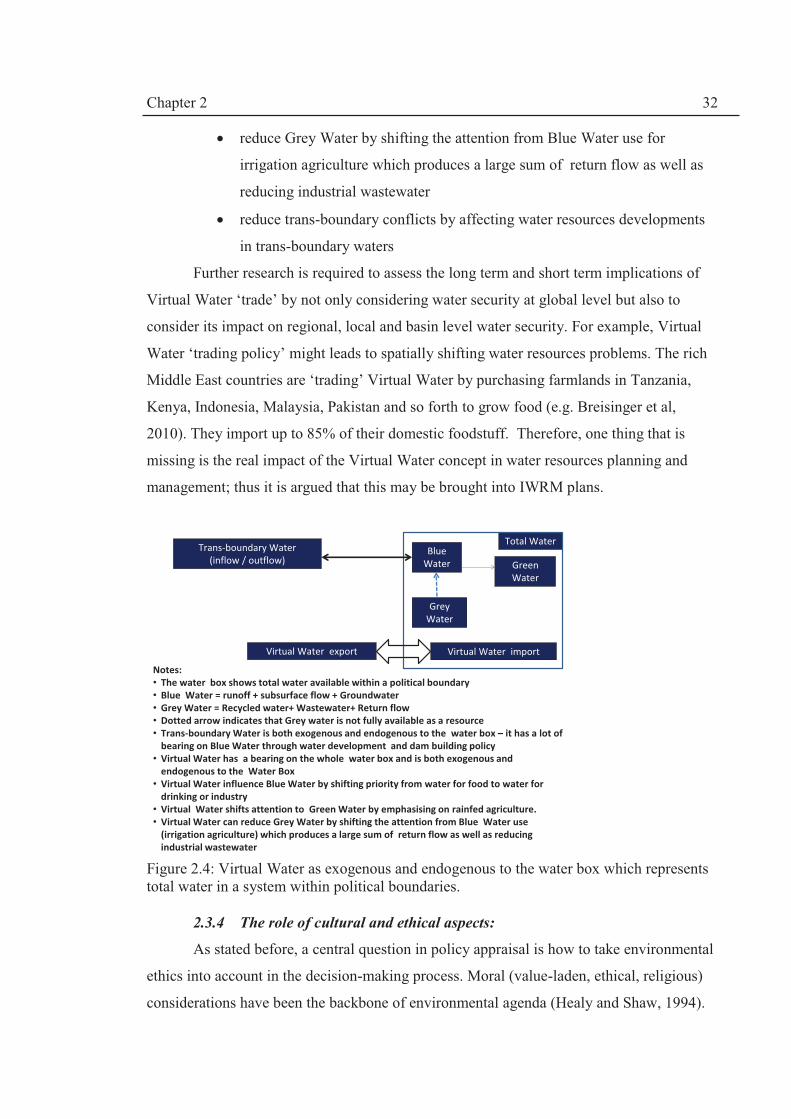
Chapter 2 32
· reduce Grey Water by shifting the attention from Blue Water use for
irrigation agriculture which produces a large sum of return flow as well as
reducing industrial wastewater
· reduce trans-boundary conflicts by affecting water resources developments
in trans-boundary waters
Further research is required to assess the long term and short term implications of
Virtual Water ‘trade’ by not only considering water security at global level but also to
consider its impact on regional, local and basin level water security. For example, Virtual
Water ‘trading policy’ might leads to spatially shifting water resources problems. The rich
Middle East countries are ‘trading’ Virtual Water by purchasing farmlands in Tanzania,
Kenya, Indonesia, Malaysia, Pakistan and so forth to grow food (e.g. Breisinger et al,
2010). They import up to 85% of their domestic foodstuff. Therefore, one thing that is
missing is the real impact of the Virtual Water concept in water resources planning and
management; thus it is argued that this may be brought into IWRM plans.
Figure 2.4: Virtual Water as exogenous and endogenous to the water box which represents total water in a system within political boundaries.
2.3.4 The role of cultural and ethical aspects:
As stated before, a central question in policy appraisal is how to take environmental
ethics into account in the decision-making process. Moral (value-laden, ethical, religious)
considerations have been the backbone of environmental agenda (Healy and Shaw, 1994).
Total Water
Grey
Water
Trans-boundary Water
(inflow / outflow)
Virtual Water export
Green
Water
Blue
Water
Notes:
• The water box shows total water available within a political boundary
• Blue Water = runoff + subsurface flow + Groundwater
• Grey Water = Recycled water+ Wastewater+ Return flow
• Dotted arrow indicates that Grey water is not fully available as a resource
• Trans-boundary Water is both exogenous and endogenous to the water box – it has a lot of
bearing on Blue Water through water development and dam building policy
• Virtual Water has a bearing on the whole water box and is both exogenous and
endogenous to the Water Box
• Virtual Water influence Blue Water by shifting priority from water for food to water for
drinking or industry
• Virtual Water shifts attention to Green Water by emphasising on rainfed agriculture.
• Virtual Water can reduce Grey Water by shifting the attention from Blue Water use
(irrigation agriculture) which produces a large sum of return flow as well as reducing
industrial wastewater
Virtual Water import
Chapter 2 33
Also, WWDR, (2009) has acknowledged the role of actors (politicians, civil society and
business actors) in decision-making; ethics and cultural attributes of the actors play a major
role in the process. In this sub-section, we consider three aspects: (1) the sustainability of
land and water resources system by looking at community-based governance approach; (2)
the universality of IWRM; and (3) the legitimacy issue.
Community-based governance systems. The decline and the overexploitation of
common resources such as water resources, fisheries and forests due to population and
urbanisation growth have prompted Hardin (1968) to posit his theory on the “Tragedy of
the Commons“. Hardin’s notion of the “Tragedy” prompted Ostrom (2005) to assess the
role of local communities in managing ‘common pool resources’ including water for
irrigation. Scholars such as Ostrom (1990, 2005) and Imperial (1999) among others have
shown empirical evidences that local community have the ability to manage common pool
resources. To be effective, policies should be relevant to the communities they serve
otherwise it will not be implemented. Armitage (2004) recalls the failure of a top-down
approach in policy-making to control population growth and environmental degradation in
West Africa which was based on national and international policy discourses on resource
mobilisation mechanisms. The policy has caused the marginalization of local communities
(disadvantaged resource users) least able to protect their interests and rights. Similarly,
Kidane-Mariam (2003) notes that the top-down policies adopted by Ethiopia and Ghana
had little impact on actual population growth and environmental degradation because of the
lack of implementation strategies at local, regional and national levels. Therefore, any
successful policy should take into account local knowledge systems on the use of resources
(Armitage, 2004).
Local Knowledge (expert) systems stem from practical experiences and cultural and
ideological heritage. Based on the above assumption, crafting community-based land and
water (natural resources) management is increasingly popular (Fortmann et al, 2001). The
reason is that top-down centralised interventions such as the introduction of environmental
regulations, protected areas, IWRM and so forth have not completely stopped the over
utilisation of these resources. Therefore, community-based participatory governance
systems based on local values and belief systems are encouraged. There is a need for
research that how community based governance principles can be bridged with modern day
governance systems. This theme will be further explored in Chapter VIII.

Chapter 2 34
Universality of IWRM.Biswas’ (2004) questions the universal applicability of the
IWRM paradigm and asks whether it is applicable under different cultures and religions.
This question epitomises the IWRM dilemma: as Merrey (2008) noticed, IWRM has been
promoted by its global advocates like a universal religious text. The universality question
is a wrong one in my opinion. The question should be how can we localise IWRM and
adapt it to diverse social-ecological systems rather than apply it like a prescriptive dogmatic
doctrine.
This notion of universality hides the fact that local communities (the society) and its
core values and ethics have been rather overlooked in the IWRM equation. IWRM concept
is ambiguous about its foremost principle of participation which is termed “appropriate
level of participation” (GWP, 2000; p.17). For example how the principle of economic cost
recovery matters to communities which have no access the water due to lack of hydraulic
infrastructure? Without hydraulic infrastructure and well developed institutional set up for
distribution and allocation of water resources, it is very difficult to implement cost recovery
principles; thus developing countries (the South) perhaps continue with their “hydraulic
mission” (Allan, 2005) i.e. go ahead with development plans to build hydraulic
infrastructure (e.g. Allan, 2003b, Merrey, 2008).
Water resources governance is influenced by the ideological component of the
decision-makers (e.g. Denzau and North, 2000). Cultural and ethical aspects (including
religious beliefs) can have a bearing on water management policies and have an impact on
the way people perceive water-related issues such as the impact climate change, wasteful
use of water etc. On the issue of climate change, Daniels and Endfield (2009) argue that the
actions taken by the decision makers are influenced by their perception of the ‘danger’ of
climate change. Hence, the cultural context of the climate change issue should not be
ignored:
..what people make of climate change, and what they do about it, are complex cultural
matters, with a matrix of narratives, specific meanings emerging in and from particular
times and places; they draw attention to a continuing, if troubled, and fractious, history of
human –environment relations (Daniels and Endfield , 2009; p. 222)
Therefore, lately, there has been a move towards acknowledging ideology as an
influential aspect of policymaking and decision-making processes and moving away from
‘rational choice approach’ to common pool resources management.
Legitimacy. Most religions have the same value-laden perspectives with regard to
water as the precious resource. Therefore, there is an assumption that religious ethics can

Chapter 2 35
assist the implementation of IWRM plans in two ways: increasing environmental awareness
and improve the legitimacy of the decision-making process. Bearing in mind that
policymaking is about “a struggle over ideas” and values, high moral grounds are used to
justify political decision-making especially in the WANA region. There have been some
attempts to streamline IWRM with religious beliefs11 such as Faruqui et al (2001) whom
worked on Islamic principles of water management. They have concluded that Islamic
beliefs are compatible with IWRM and Sustainable Development. Beaumont (2005)
believes that it certainly includes all the concepts for a sustainable management of water. In
the case of Christianity for instance, Jenkins (2008) asserts that the mainstream
environmental ethical discourse overlooks “practical domains” of Christian community
which could be used “to help reintroduce to public debate these major arenas too often left
to the invisible hand and other unquestioned logics of salvation”.
In Iran, for instance, legitimacy is based on the Islamic model which can has two
dimensions: the first refers to citizens’ (public) support for a policy (the cultural context)
and the second refers to the fulfilment of the religious criterion of public interest or
‘musalaha’ as it is called in Islamic principles or ‘Sharia’. Hashemi et al (2007a) have
illustrated how Islamic environmental ethics is comparable to ecological ethics. However,
the Muslim world such as most of WANA region like a large part of the world, historically
suffers from anthropogenic ethics in water management, despite the very explicit ‘green’
credential of a religious perspective on the environment. The question is why such
entrenched beliefs are ignored? The answer may lie in the cultural dimension of the set of
beliefs. For example, ideas such as ‘basic human needs’ (which is both social and religious)
and ‘life necessities’ which is both economic and natural can override strongly-held beliefs
about stewardship for nature (which is religious and ethical). This prioritisation of human
basic need and its right and integrity forms part of the “meta-belief” that has to be
considered. It is not enough just to dismiss the ‘needs’ concept, as it was not ignored by the
WECD’s report (1987) on Sustainable Development. Therefore, there is a need to show
how common good values and ethics can be used to implement sustainable water resource
management within the context of societal livelihoods.
11 I have reviewed Islam since our case study area is Iran and WANA region which have predominately Islamic culture.

Chapter 2 36
2.3.5 Institutional capacity development: dealing with participation issue
Institutional capacity development is a corner stone of IWRM. Therefore, in this
part we deal with one main aspect which is stakeholder participation. Capacity building,
development or enhancement is a term widely used since the 1980s (e.g. Attari and
Salehzadeh, 2009) and the term capacity relates to the Sustainable Development concept.
Alaerts and Kaspersma (2009) provide a review on the definition of capacity and they
define it as:
the capability of a society or a community to identify and understand its development
issues, to act to address these, and to learn from experience and accumulate knowledge for
the future” (ibid, p.7).
Institutional capacity development can take four main forms which are not mutually
exclusive (Hashemi and O’Connell, 2009):
(1) Human resources development e.g. training and education requirements, changes in
ethics and perceptions, culture, morals and motivation etc. The concept of human
development is defined by HDR12 (2006) as “first and foremost about allowing
people to lead a life that they value and enabling them to realise their potential as
human beings”. To achieve this goal, a visionary framework is set out in the
Millennium Development Goals (MDGs). The objectives are to reduce “extreme
poverty, extending gender equality, and advancing opportunities for health and
education”. So this internationally agreed set of time bound goals centres around
human wellbeing.
(2) Knowledge capacity development e.g. research, stakeholder participation.
(3) Organisational capacity development which entails both financial and institutional
sustainability of water management ; it includes infrastructure as well as
administrative change or reform.
(4) Enabling environment capacity development which includes good governance;
adequate policies and laws; enforcement and conflict resolution mechanisms.
According to IWRM concept, stakeholder participation ensures the implementation
of IWRM plans within river basin context since this will increase their acceptability and
ownership. There are vital roles that they can play as shown in Table 2.3 (Cap-Net, 2008).
There are different levels of stakeholder involvement and decision-making powers as
12 Human Development Report (UNDP)

Chapter 2 37
shown in Figure 2.5 (Delli Perscoli, 2003) which indicates the level of decision-making
powers associated with the level of involvement.
Table 2.3: Stakeholder roles with reference to river basin management objectives (Source: Cap-Net, 2008).
Worldwide, a mixture of participatory mechanisms has been used such as river
basin councils, water user associations (WUAs), and local water and agriculture
committees. The main aim of stakeholder participation has been conflict resolution. Albeit
being a useful platform for dialogue, participation is bigger than conflict resolution.
With increasing complexity and the involvement different sectors and interests,
decision-making has become more difficult and hence a participation platform is seen as
“decision-making body (voluntary or statuary) comprising of different stakeholders”
(Warner, 2007) which are called Multi-stakeholder Platforms (MSPs). Warner (2007)
stresses that dialogue has been increasingly recommended in common pool resources such
as water management based on multifaceted systems approach integrating the interaction
and relations between (1) quality and quantity’ (2) surface and groundwater’ (3) water and
land use, (4) water and stakeholders and (5) water institutions (ibid, p.2).
Figure 2.5: The level of participation with reference to the degree of decision-making powers ( based on Delli Perscoli, 2003)
Management
objectives
Roles of Stakeholders
Basin planning Problem identification, priority setting,
situation analysis, approval.
Water Allocation Advisory, monitoring and reporting,
decision making.
Pollution control Monitoring, reporting, permitting
Lowest=no participation
Con
trol
led
Info
rmed
Con
sult
ed
Del
egat
ed
Dev
olut
ion/
sel
f go
vern
men
t
Inde
pend
ent
Highest
making decisions
Decision-making level of participation
Forming/agreeing
Joint decision-making
Influencing decision
Being heard before
decisions
Knowledge sharing
before decisions
Degree of independence or involvement Adapted from Creighton (2001)

Chapter 2 38
However, this holistic approach requires an unprecedented level of institutional
cooperation and coordination; as well as posing a great challenge to model complex social
and ecological systems settings. Furthermore, modelling integrated socio-technical aspects
are going to be very difficult.
Mitchell (2007) believes that MSPs are compatible with IWRM if institutional
design recognises two levels of sub-basin and basin-wide MSPs working and
communicating in parallel to each other (ibid, 61). Otherwise, IWRM’s strong river basin
orientation can cause tensions. Participatory governance requires a special attention to the
enabling environment in terms of capacity development and empowerment and the removal
of legal obstacles in the way of participation. New laws might be required to facilitate the
participatory approach. Participation has been linked to good governance and democracy by
enhancing accountability and transparency of the decision-making and remains one of the
most important issues in the water and land resources management.
2.4 Discussion and conclusions: towards a socio-technical approach
Need for a paradigm shift. Based on previous sections, water resources management
is multi-dimensional (human, society and environment), multilevel (national, regional and
local), multi-sectoral (energy, food, drinking etc.) and multi-disciplinary (hydrology,
ecology, law etc). Implementing sustainable land and water resources management poses
five main challenges:
1. How to integrate the complex and overlapping dimensions of WRS?
2. How to deal with the dynamism of the system?
3. How to measure sustainability?
4. How to deal with various levels of decision-making (institutional levels) and
ethics and values held by decision-makers?
5. How to create mechanism for participatory consensus?
To deal with the above challenges, many scholars have called for a paradigm shift
towards:
· Consideration of full water cycle in IWRM i.e. Green Water and Grey
Water concepts should be considered in IWRM plans (e.g. Falkenmark et al
(2004), Falkenmark and Rockström (2006)
· Virtual Water ‘trading’ (e.g. Zeiton et al 2010) can offer real alternative
policy instruments to deal with water security (and scarcity)

Chapter 2 39
· Inter-linkage with land use management (e.g. Calder, 2004, 2005;
Amezaga, 2005)
· Adaptive management (e.g. Pahl-Wostl, 2007; 2009, Merrey, 2008)
· A more politicised IWRM (e.g. Allan, 2003a; Merrey, 2008)
· Mapping institutional elements beyond hydrological boundaries such as
influential actors in the decision-making process (e.g. Merrey, 2008)
· Social learning processes and multi-stakeholder platforms (MSPs) for
effective engagement and participation of actors in the IWRM process (e.g.
Warner, 2007)
· Greater emphasis on culture and ethics ( e.g. Daniels and Endfield, 2009)
There are many 'scattered' research efforts at both national and international levels.
As stated, there are more than 26 UN organisations that deal with water related research
which necessitates a call for an integrated international strategy for research into IWRM
that can cater for the required paradigm shift and the change of boundaries of research
inquiries.
Need for a methodological framework. IWRM normative package has very little to
offer on implementation. Therefore, a methodological framework is needed to evaluate the
implementation of IWRM. It can be concluded that the main obstacle to implementing
IWRM is institutional inadequacy (e.g. WWF, 2006; WWDR, 2009). Consequently, the
neglect of the institutional dimension has created a huge drawback in implementing the
IWRM paradigm worldwide. Institutional matters were still the most important issue in the
2009 Istanbul World Water Forum (WWDR, 2009). Lack of implementation has been
attributed to the gap between policy decisions and technical outcomes. Therefore, there has
been a move from technical to socio-technical approach.
Scientific and conceptual inquiries are required to have a greater understanding of
the physical process of the hydrological cycle as well as the points of interactions with
ecological, social, economic and institutional dimensions of WRSs. Technological
advancements have not solved many of the uncertainties in our knowledge systems (e.g.
assumptions and conceptual models). We need to understand better the inherent
uncertainties to better manage decision-making uncertainties.
Researchers as facilitators. In Iran and worldwide, numerous researchers are
involved in a variety of IWRM research themes but their efforts are dispersed and there is
lack of communications between different research groups as well as between policy
Chapter 2 40
makers and the research communities. A dialogue between the research communities and
stakeholders is essential to create a platform for a wider dialogue among policy makers, the
scientific community and the public at large. Researchers can become facilitators in
difficult public policy debates and create a foundation for participatory decision-making
processes (Hashemi and O’Connell, 2011b).
To achieve the objectives of the PhD research, a new integrated socio-technical
methodological approach has been developed in Chapter III based on combining multiple
theoretical and analytical components into a single methodological framework to attain a
linkage between technical science and policymaking. By using this unique analytical
approach in which technical and non-technical assessment tools are linked, an Integrated
Socio-technical Assessment Framework can be attained which is described in Chapter III.

Chapter 3
41
Chapter III. Integrated Socio-technical Framework: Methodologies and
Analytical Components
3.1 Introduction:
Objective 2 of the PhD research (Section 1.4, p.8) aims to develop an Integrated
Socio-technical Framework by linking the elements of social and technical assessments
approaches to implement IWRM. With reference to governing principles described in
Chapter II, five main ingredients are considered with the methodological approach:
1. The underlying conceptual approach is provided by concepts such as
IWRM, Sustainable Development and Ethics.
2. The analytical components are used to deal with technical and socio-
political (institutional) aspects of water resources system (WRS)
sustainability.
3. Integrated Socio-technical Assessment tools are applied to provide
evidences using reliable data about the WRS.
4. Role of Ethics and community belief systems are considered to (a) frame
the mental models or perspectives of actors in decision-making process and
(b) to provide evaluation criteria for analysis of the decision outcomes.
5. Multitier Multi-stakeholder Platforms (MSPs) are crafted for participatory
decision-making.
In Chapter II, it was shown that despite conceptual constraints IWRM is still
relevant for ever increasing challenges in the water sector (van der Zaag, 2005; Merrey,
2008). From the literature review, it is apparent that lack of implementation has been
attributed to the fact that IWRM is a concept and not a framework. Therefore, it is
postulated that there is a need to develop an integrated methodological framework for
IWRM since the normative form of the concept is not implementable.
To design the methodological framework, two survey questionnaires were used with
the following objectives:
1. To sketch an issues map for Iran’s water sector based on perceptions of
water managers, consultants and policymakers (as described in Chapter I).
2. To assess the progress made in Iran with respect to the introduction and
implementation of IWRM (i.e. whether IWRM is relevant to Iran); it is

Chapter 3
42
noted that IWRM has been formally adopted in 2003 and this need to be
further evaluated in Chapter IV).
3. To provide guidance on choosing a suitable analytical components for the
proposed Integrated Socio-technical Framework.
For achieving the objectives 1 and 2, a questionnaire was design based on European
Commission (2006). Some of the results are given in Table 1.1, Chapter I. A total of 54
acceptable questionnaires were collected while rejecting incomplete ones.
Based on the literature review in Chapter II, it seems that that linkage based
approaches such as Drivers-Pressures-States-Impacts-Responses (DPSIR) have been
successfully implemented in many sectors since it can study environmental change and
capture the relationship between the physical environment and the human system
(e.g.Waheed et al, 2009). Therefore, DPSIR approach is used to evaluate changes in all the
components of the water resources system (WRS)
The second questionnaire was based on Saleth and Dinar’s (2004) with an exception
that a section was added on how IWRM can be implemented within the water sector. The
questionnaire was translated in close consultation with Dr Jalal Attari my consulting
supervisor in Iran. It is a 20 page questionnaire on the performance of water sector based on
Institutional Decomposition and Analysis (IDA) approach in which water institution is
decomposed as: water policy; water law and water administration. The inter-linkages
between different components were statistically measured. This survey produced 24
completed questionnaires from both national and provincial stakeholders providing an
overall picture of water sector and acted as a validation for the choice of Institutional
Analysis and Development (IAD) approach (Ostrom, 2005) as a suitable component for the
proposed Framework. Saleth and Dinar’s IDA approach cannot capture the role of actors in
participatory decision-making. Therefore, IAD (Ostrom, 2005) was chosen for the proposed
Integrated Socio-technical Framework.
In Section 3.2, first, the development of the Integrated Socio-technical Framework
is described including research design and the overall description of the Framework.
Secondly, the components of the Framework are outlined in Sections 3.3 to 3.6. Thirdly,
data collection methods are described in Section3.7. Fourthly, the application of the
Framework in the thesis is described in Section 3.8 followed by an overview of the thesis in
Section 3.9.

Chapter 3
43
3.2 Research design and development of the Integrated Socio-technical
Framework
3.2.1 Multi-strategy research design
Innovative approach. According to Max-Neef (2005), water is one of the main
“problematiques” i.e. “problems of global and long term impact”; thus no single discipline
can adequately deal with such multifaceted problem. Water resources planning, allocation
and management can be considered as an interdisciplinary endeavour (see Max-Neef,
2005). In the past, many multidisciplinary teams have failed to produce integrative
synthesis because the members “ carry out their analyses separately, as seen from the
perspective of their individual disciplines, the final result being a series of reports pasted
together, without any integrating synthesis” (ibid, p.6. ) Max Neef (2005) asserts that
integrative inter-disciplinary approach cannot be achieved by amassing different brains;
educational capacity development is needed to build a shared vision. Hence, it is argued
that interdisciplinarity needs to be embraced to synchronise research in the interface of both
social and physical sciences. An interface is defined as the points of interaction, interplay
and linkage between technical and social (institutional) analytical components.
In social sciences, combining qualitative and quantitative research approaches are
increasing popular within the same project (Robson, 2011). Robson labels this type of
method as “multi-strategy design research” because it is not only about collecting different
types of data but it also uses “more than one research strategy” (ibid, p.161). However, as
cited by Robson (2011) multi-strategy research has been rejected on the ground that the
quantitative and quantitative paradigms are distinctly different and are not compatible with
each other. The “incompatibility thesis” have been refuted by Howe (1988) arguing that the
multi-strategy research approach is beneficial and qualitative and quantitative methods are
“inseparable” (Robson, 2011, p.162). The author has been convinced by Howe’s argument.
Although, Robson (2011) describes quantitative and qualitative debate within the realm of
social sciences data, this research has leapt forward a step further by using quantitative data
from the physical sciences as well as the mixed strategy social research. Nevertheless, the
description of multi-strategy (mixed design) research is valid to describe the
interdisciplinary methodological approach taken in this thesis.
Turner (2000) highlights some of lessons learned from interdisciplinary research to
synthesise and communicate policy relevant findings including (ibid, p.459):

Chapter 3
44
· To deal with natural science/social science divide there is a need to
“translate across disciplines the different terminologies and
methodological approaches”.
· To deal with information failure, data needs assessments for both natural
and social sciences are required before the start of the research “in order to
identify data inconsistencies, limitations or real gaps”.
· “Naive expectations across the disciplinary divide” are understandable but
we need to appreciate that the mismatches “reflects the difference between
functioning of ecological, institutional and societal systems”.
Striving to be an interdisciplinary PhD work, a “Sequential transformative
design”(Robson, 2011, p. 165) strategy has been used to develop the Framework. The
application of the sequential transformative design is to translate the normative form of
IWRM concept into polices and strategies by assessing the outcomes of interactions of
stakeholders in the participatory decision-making process using social and technical
analytical components (Figure 3.1).
Figure 3.1: Sequential transformative design: conceptual research approach for translating or transforming the IWRM concept into implementable management options using the theoretical Integrated Socio-Technical Assessment Framework.
This research is guided by a theoretical perspective which manifests the Integrated
Socio-technical Framework. The Framework represents a major innovation in this thesis by
Concept:
IWRM
Analytical Components
Assessment tools
Participation Platform
Outcomes: Responses strategy (Management options)
Interface

Chapter 3
45
complementarily combining socio-technical, ethical and socio-political (institutional)
analytical and assessment components to assess the sustainability of the WRS.
Meaning of Framework. Before explaining the new Framework, we need (1) to
understand the meaning of the ‘framework’ and differentiate it from theory and model (see
e.g. Clement, 2008); and (2) to appreciate the implications (and advantages) of combining
different analytical components to form the single Integrated Socio-Technical Framework.
As explained by Clement (2008) “A framework identifies structures and links the
relevant variables or elements that affect the issue in concern, but does not make any
predictions” (ibid, p. 33). By comparison, a theory “makes specific assumptions on the
linkages between variables and outcomes” and a model provides outcomes based on
assumptions made in the theory and available data (inputs).
Some might criticise this approach of combining different analytical components
into a single framework to be “an internally contradictory and messy approach, with a
limited explanatory capacity” (Clement, 2008, p.40). However, we need to appreciate that
these components are non-mutually exclusive and there are interfaces between them; hence
they can be conceptually linked to each other as can be seen in the following sections in
which the components of the Framework are described.
Definitions of stakeholders, actors and participants. Stakeholders are defined as
any individuals or organisations that influence or are influenced by decisions made about
water resources system. Actors are individuals or organisations which are involved in
making decisions on water resources planning, allocation and consumption. Participants are
actors that are either directly involved in policy/decision-making and consultation processes
through the formation of a participation mechanism such as Multi-stakeholder Platforms
(MSPs) or participate in the process of social research i.e. surveys, interviews and
questionnaires
Flexible research design. Two approaches to flexible research design have been
considered (Robson, 2011):
1. The case study approach which is a well-established research strategy
“where the focus is on the case” and usually involves “multiple methods of
data collection”. Our case is the water resources system in Lake Urmia but
we also look into wider characteristics of WRS in Iran since decisions about
the WRS are centralised.

Chapter 3
46
2. An ethnographic study approach which focuses on the cultural, ethical and
social structure of stakeholders and communities within the WRS. It
enriches the case study approach by having a better understanding of
discourses and narratives that shape stakeholders perspectives. The author
has had multiple positions in addition to being a researcher and has built up
a close relationship with many of the stakeholders in the field. The author
has acted as
a. a facilitator and actor in Multi-Stakeholder Platforms such as
workshops, seminars, stakeholder and working group meetings;
b. an advisor to national and international agencies working on the
Lake Urmia case study;
c. a researcher as a PhD candidate at the School of Civil Engineering
and Geosciences, Newcastle University which is partially funded by
the Ministry of Energy, Iran (the main stakeholder); and
d. an actor in producing policy briefs for west Asia and North Africa
(WANA) region through the initiative of WANA Forum based on
the research results.
3. Therefore, the case study entailed a large element of ‘real world (applied)
research comprising linking valuation research and participatory action
research (Robson, 2011, p.189). The purpose of action research is “to
influence or change some aspect of whatever is the focus of the research”
(ibid, p.188). In the context of this PhD work, the real world research is
concerned with (a) involvement, improvement and broadened understanding
of the water allocation decision-making process; (b) evaluating the outcome
of the decisions using analytical components; and(c) studying change where
there is concern for actions.
Scientific attitude and ethics of research. Robson (2011) stresses that real world
enquiry requires a scientific attitude with three ingredients (ibid, p.14): (1) a systematic
approach is taken to develop a sound methodology with ability to observe, evaluate and
scrutinise the issues of concern; (b) enquiries are carried out in a sceptical manner; and (3)
the research ethics are maintained. According to Robson (2011), a scientific ethical attitude
to research adheres to a code of conduct which “ensures that the interests and concerns of
those taking part in, or possibly affected by, the research are safeguarded”. In this
Chapter 3
47
research, the University’s Code of Conduct has been maintained in dealing with other
individuals and organisations. Permissions have been taken for the material used in the
thesis and in no way have I misled or disadvantaged anybody to obtain information. In fact,
I have been warmly received to engage in almost all of the meetings with formal
invitations. I have had gain stakeholders’ trust and respect through ethical conduct inside
and outside the field.
I have had an influential role as an independent facilitator during water allocation
negotiations and this was accepted by all the stakeholders involved with little reservations. I
have been transparent in all my dealings as a facilitator about my discursive position to
foster a win-win IWRM discourse which is the subject of my thesis.
Robson (2011) notes that close engagement with stakeholders stimulate some
researchers to cross the boundary and change the role “to that of advocate”.
Acknowledging this difficult task, on the one hand, I have preserved the independence of
this research from any influences from the stakeholders. On the other hand, my PhD
research programme and statement of interest have been acknowledged and well known to
stakeholders while co-facilitating workshops, working groups, seminars; conducting
interviews or collecting questionnaires and other qualitative and quantitative data.
Discursive position of analysis. IWRM encompasses both the principles of
Sustainable Development and ethical decision-making concepts and provide the context to
deal with issues of integration and sustainability aspects of WRS by using systems analysis
approach as described in Chapter II. IWRM will be carried through the thesis by providing
the objectives (social, economic, environmental) which feed into the analytical components
of the proposed Integrated Socio-technical Framework.
3.2.2 Describing the Framework
The Integrated Socio-technical Framework which combines FOUR core analytical
components (Figure 3.2) is a non-predictive representation of structures and links between
different variables and components that influence the water resources planning and
allocation system in Iran and the Lake Urmia case study. There is a continuous iterative
time-based loop in the overall framework:
1. First, the Drivers-Pressures-States-Impacts-Responses (DPSIR) component
which is a causal framework is used to provide an understanding of the
changes that occurred to the various components of the water resources
system by “describing the interactions between society and the

Chapter 3
48
environment” (EEA, 2011). Based on a systems analysis approach, the
socio-economic, political and climatic Drivers exert Pressures on the WRS
which leads to changes in the social, economic and environmental States of
the WRS. After a strategic assessment of the changes (States), the Impacts of
policies on water resources systems are assessed and the evolution of
previous Responses in time t-1 are described. In this thesis, DPSIR is used to
make a strategic multilevel evaluation of the IWRM concept in Iran and the
Lake Urmia basin (LUB), thus providing a structured overview of water
resources management in contemporary Iran, (Chapter IV) and LUB
(Chapter V) for the period of 1909-2008. The IWRM concept provides
objectives which feed in at both the Drivers and Responses levels.
2. The Institutional Analysis and Development (IAD) component is used to
make an ex post analysis of Responses:
a. First, ex post analysis of Responses in time t-1is carried out which
represents a Business as Usual (BAU) scenario. In Chapter V, the
water allocation process during 1909-2008 has been analysed in the
context of the case study.
b. Secondly, in Chapter VI, (a) DPSIR Analysis is extended for period
2008-2010 to describe the new Drivers and Responses based on
IWRM and (b) water allocation is made using Integrated Socio-
technical Assessment (ISTA) component (describe in bullet number
3). Then, in Chapter VII, IAD is used to evaluate the new Responses
(i.e.in time t) which have been made by actors (stakeholders) to deal
with the Pressures on the water environment to propose revised
Responses (e.g. institutional design or reform or an adaptive
allocation strategy that factors in an environmental allocation).
3. As mentioned, Integrated Socio-technical Assessment (ISTA) component
(Chapter VI) describes how actors in MSPs use information or data to make
their decisions based on a scientific integrated assessment approach using
modelling and Multi-Criteria Decision Analysis (MCDA) to reach a decision
on water allocation. The overall ISTA is used to evaluate the Responses
made by the actors e.g. water allocated to the lake (Chapter VI) and propose
revised (preferred) Responses as part of the PhD work (Chapter VII). It also

Chapter 3
49
evaluates the quality of the evidence (data and information) used in the
decision-making process (Chapter VI and VI). ISTA comprises of three
elements:
a. MCDA used by actors and represents
i. the simple water allocation model (WAM) using an Excel
Spreadsheet (Chapter VI);
ii. the Analytical Hierarchy Process (AHP) procedure used to
allocate water shares (Chapter VI)
b. Modelling
i. by stakeholders using Vensim Dynamic simulation (Chapter
VI) and
ii. as part of the thesis using water balance modelling,
stochastic modelling and risk based analysis (Chapter VI)
c. Evaluative Criteria for measuring institutional sustainability which
are based on Good Governance principles and the Ethics component
of the Framework (Chapters, V, VI and VII)
4. The Ethics component:
a. represents perspectives (or mental models) of actors which have been
shaped by values and cultural aspects of the community; and have a
bearing on the decision-making by influencing the exogenous factors
affecting the IAD component and providing a basis for Evaluative
Criteria used to reach outcomes (Chapters V, VI, VII)
b. is further developed based on community values (predominantly
Islamic) to propose revised Responses to enhance the water and land
resources governance system (Chapter VIII).
In Sections 3.3 -3.6, the components of the Framework will be described.

Chapter 3
50
Figure 3.2: The Integrated Socio-technical Framework.
3.3 DPSIR component
The definitions of the D-P-S-I-R elements are given in Box 3.1 (e.g. EEA, 1998,
1999; Turner et al, 1998). DPSIR is linkage-based sustainability assessment approach (e.g.
Guio-Torres, 2006; Waheed et al, 2009) which provides a strategic evaluation of the status
of the water resources system by describing the causal relationship between various
interacting subsystems. As stated in Chapter II, linkage-based sustainability assessment
approach have been widely used in general and in particular since it was adopted by many
international and regional organisations such as the European Environment Agency (EEA)
for “structuring integrated research program and assessment” (Svarstad et al, 2008) i.e. as
a method for the State of the Environment (SoE) reporting. Turner et al (1998)
demonstrated its usefulness in assessing the marine and coastal environments by
considering the feedbacks between the human system and the coastal and marine system
DRIVERS IWRM
PRESSURES
MODELLING MCDA
Multi-stakeholder
Platforms (MSPs)
ETHICS
STATES/ IMPACTS
OUTCOMES/
RESPONSES (t)
IAD multi-level
analytical tool
Integrated Socio-technical Assessment (ISTA)
Evaluative Criteria
RESPONSES (t-1)
Acrynoms:
t time;
DPSIR Drivers-Pressures- States-Impacts-Responses;
IAD Institutional Analysis and Development;
IWRM Integrated Water Resources Management
DPSIR

Chapter 3
51
using a function based valuation
methodology. Many researchers
have used DPSIR as a framework
for sustainability indicators in
many environmental assessments
(e.g. Walmsley, 2002; Agyemang
et al, 2007; Borja et al, 2006).
EEA (1999) acknowledges
that DPSIR (Figure 3.3) is a
simplification of a complex and
dynamic system but nevertheless,
it deals with dynamism by
focusing on the “links” between
DPSIR elements; e.g. EEA (1999)
states that:
the relationship between the
Impacts on humans or eco-
systems and the ‘S’ depends on the carrying capacities and thresholds for these systems.
Whether society ‘Responds’ to impacts depends on how these impacts are perceived and
evaluated; and the results of ‘R’ on the ‘D’ depends on the effectiveness of the Response
(ibid, p.7)
Therefore, DPSIR is increasingly used since it can easily capture the relationship
between human and non-human impacts on the environments. In addition, the DPSIR
appraoch has been successfully implemented in developing integrated modelling systems
or decision support systems (DSSs) such as the WaterStrategyMan (WSM) DSS (ProGea,
2004), MULINO DSS (Giupponi et al, 2004).
EEA (2003) asserts that DPSIR, while providing “good way of structuring thoughts
on indicators, has its limitations in terms of interpretation”. However, we have to
appreciate that the DPSIR approach is based on discursive biases and it is not a tool for
producing impartial evidence as argued by Svarstad et al (2008). The reason is that the
application of DPSIR will bring out discursive positions based on the discourse implied in
the application. As stated previously, in this research, the IWRM discourse is used based on
a win-win discursive position which has some implications for how the DPSIR elements
are interpreted.
Box 3.1: DPSIR: definitions (based on e.g. EEA,
1998, 1999; Turner et al 1998)
D, the Drivers: root causes on a macro level described
through scenarios representing alternative futures (e.g.
climate change and variability, socio-economic etc.)
P, The Pressures (threats) variables: immediate causes (e.g.
water demands, water pollutions)
S, The States: describing physical and measurable
characteristics and social livelihood systems (e.g. water
availability)
I, The Impacts: monitor the long term impacts of change
defined as changes in states resulting from pressures (e.g.
environmental degradation)
R, The Responses: are problem-solving policies, actions or
investments; an appropriate mix of Structural Options e.g.
new reservoirs/pipelines etc. and Non-Structural Options e.g.
legislation, institutional reform, demand management etc.

Chapter 3
52
The main criticism centres on the causality aspects of DPSIR and the linearity and
simplicity of the cause-effect relationship of its components (e.g. Kohsaka, 2010;
Rounsevell et al, 2010). However, Rounsevell et al (2010) asserts that the notion of
linearity is confused with “sequential thinking”. They conclude that DPSIR takes into
account the non -liner behaviour of Social-Ecological Systems (SESs) and the complex
interdependences of the variables by allowing for positive and negative feedback
Responses which is explicit in the schema.
Figure 3.3: The DPSIR component with reference to the water resources system.
Drivers (Driving forces)
Pressures
States/Impacts
Responses: policy options
Population
growth
Climate change
scenariosWater resources development
plans/ IWRM plans
Water and Environmental Laws
Regulations, International Standards Ethics
Urbanisation /Poor
housing design/
Shanty towns
Water demands/ Waste
production/ Pollution
loads/ Greenhouse
emissions
Water quantity, allocation,
distribution and quality
institutional/organisational
Performance: efficacy,
efficiency and effectiveness/
Financial sustainability
Physical/environmental
Supply- demand balance/
Flood and droughts risks/
Chemical and ecological
status
socio-economic
Investments/ Costs/
Economic efficiency/
Equity/ Water rights/ Health
Good Governance/
Stakeholder participation/
Institutional capacity
development
Structural interventions/
Technological options/ Waste
reduction/ Emission reduction/
Demand management
Strategy(Management options)
IWRM
principles

Chapter 3
53
DPSIR and its modified versions have been widely adopted in many policy relevant
environmental assessments because of its communication power (Niemeijer and de Groot,
2008). The DPSIR approach provides applicable management options for policy and
decision-makers by bridging socio-economic and natural sciences (Karageorgis et al, 2005).
In this research, DPSIR analysis has been enhanced by combining it with
institutional analysis and development (IAD) component within the socio-political and
ethical context of policy and decision-making process interactions. Turner et al (1998) have
acknowledged that the DPSIR analytical approach “should also be extended to cover
ethical analysis of inter temporal and inter species choice” i.e. analysis should consider
“community, social norms and collective preferences” (ibid, p.271). Also, the DPSIR
component is linked to technical assessment tools such as modelling systems for evaluating
States (e.g. water availability), Impacts and Responses and is a powerful tool to study the
development and evolution of policies and institutions (i.e. institutional change) in
conjunction with the IAD component. Therefore, it is a robust and rigorous approach to
assess the socio-technical attributes of Social-Ecological Systems (SESs).
3.4 IAD component
3.4.1 An overview
Definition of institution. Ostrom (1999, 2005) broadly defines institutions as the
principles that humans use to organise all form of repetitive and structured interactions
including those within communities, private associations and governments at all scales
(ibid, p.3). More specifically institutions are rule sets that direct/constrain actions at
multiple levels. Each level comprises of situations where choices are made and actions are
taken in an action arena influenced by a set of exogenous external variables: (1) biophysical
conditions; (2) community attributes; and (3) rules in use (see next sections).
Levels of decision-making. The IAD approach is based on rational choice theory1
and has been described in detail by Ostrom (1999, 2005, 2007; 2010 and 2011). It proposes
four levels of analysis as shown in Figure 3.4 (Ostrom, 1999): meta-constitutional,
constitutional, collective choice and operational levels; at each level, rules are prescribed,
invoked, monitored, applied and enforced which affect how rules are made at the next
1 Ostrom’s Institutional Rational Choice conceives public policies as institutional arrangements or rules so policy changes result from action by rational actors in an action arena (see Schlager and Blomquist, 1996) but this thesis moves away from rational choice theory as will be described later.

Chapter 3
54
level2. The operational level deals with rules that govern how decisions on water and land
resources management are taken in terms of provision, production, distribution,
appropriation, assignment and consumption of the resource. Frequently only three levels
are used.
Figure 3.4: Institutional (decision-making) levels in IAD component, adapted from Ostrom
(1999).
The IAD approach is a powerful analytical tool to capture institutional (decision-
making) levels which do not necessarily correspond to administrative levels. For example,
local communities can establish their own rules which can operate at collective choice or
even the constitutional levels (see e.g. Clement, 2008). Therefore, it is not a rigid
framework and can be used in a variety of situations depending on the actors and action
situations. As noted by Clement (2009) among others, IAD has been extensively developed
for common pool resources and is one of the most tested and distinguished approaches. It
has also been applied to an extent to water resources problems e.g. Imperial (2009); Smajgl
et al (2009); Ostrom (2010); Larson (2006), Maru and LaFlamme (2008). In this research,
the IAD approach has been used primarily to assess the extent of central government’s
(national level) recognition of local level basin governance i.e. water allocation decisions
by Lake Urmia basin stakeholders.
2 In most case studies, three levels are taken excluding meta-constitutional level of analysis.

Chapter 3
55
3.4.2 Conceptual unit of institutional analysis
Focal level of institutional analysis. The aim of the IAD approach is to analyse
situations of human interaction (Ostrom, 2010). Therefore, the focal point of analysis is the
concept of an action situation affected by exogenous factors within an action arena as
shown in Figure 3.5.
Figure 3.5: Action situation and action arena as focal level of institutional analysis (Ostrom, 2005; p15).
Ostrom (2005, 2011) describes the IAD approach as a cluster of variables or holons
defined as “nested subsystems of whole units in complex adaptive systems” (Ostrom, 2005).
The water resources system can be analysed by ‘unpacking’the cluster of variables (holons)
depending on action situations. The action arena3 is a conceptual unit of institutional
analysis. This can be as small as a household and as large as a continent. The key to the
IAD approach is identification of an action situation to focus the analysis on(Ostrom,
2011). Examples of action situations for the land and water resources system in the Lake
Urmia basin is given in Table 3.1.
Decision-making
analysis levels
Example of action situations
Operational provincial water allocation, sectoral water allocation decisions, land use decisions (irrigation area); water
charges; developmental plans
Collective choice The design of rules governing water allocation; design and implementation of water resources polices and
WR development projects
Constitutional choice
level
The selection of actors in collective choice level who will implement and enforce water allocation
policies with their ToR; definition of water rights; rules governing collective choice decisions
Table 3.1: Examples of water resources system action situations in Iran and Lake Urmia case study
3Ostrom (2011) acknowledges that many have confused the difference between action arena and action situation and so the term ‘action arena’ has been removed in her latest paper.
Action
Arena
Community
Attributes
Evaluative
CriteriaActors
Action
Situations
Outcomes
Patterns of
Interactions
Rules-
in-Use
Bio-physical
Conditions
Exogenous
Factors

Chapter 3
56
The internal structure of an action situation can be described and analysed using
seven sets of variables (Figure 3.6): the set of actors (participants)(1) are assigned to the
positions(2) which is assigned to sets of allowable actions(3) and functions to achieve the
potential outcomes(4) as a result of the degree of control(5) exhibited by the actor and based
on the available information(6) about actions, outcomes and their linkages (i.e. evidence)
and the Costs and benefits(7) assigned to actions and outcomes (used as an incentive
measure).
Figure 3.6: The internal structure of an action situation (Source: Ostrom, 2005).
The actors (participants or stakeholders) in an action situation can be an individual,
a group of individuals such as a community or an organisation (institution). There are four
characteristics of the actors that have to be considered by the analyst (Ostrom, 2011):
· The belief and value systems they use to evaluate the outcomes ;
· the resources at their disposal to make the decisions
· the level of information they possess and their ability to process the
information
· the way they are going to choose a strategy (a selection of management
options) based on their “mental heuristics (Clement, 2008)”
PARTICIPANTS
Assigned to
POSITIONS
Assigned to
ACTIONS
INFORMATION
about
Linked
to
CONTROL
over
POTENTIAL
OUTCOMES
NET COSTS AND
BENEFITS
Assigned to
Exogenous Variables
Given the theory used by an analyst
Predicted Interactions and Outcomes
Evaluative Criteria
Theoretical Analysis
Given implicit models used by actors
Observed Interactions and Outcomes
Evaluative Criteria
Empirical Analysis

Chapter 3
57
3.4.3 Biophysical and material conditions
Ostrom (2005) explains the attributes of the biophysical variables in terms of how
the attributes of the biophysical world affect what actions are physically possible and what
effect a set of rules in use4will have on the resource use based on available types of goods
(resources) (ibid, p.22). V. Ostrom and E. Ostrom (1977) identify four types of goods: Toll,
private, public and common pool. Ostrom (2005) uses two criteria to assess the biophysical
conditions which are: subtractability of use and difficulty to exclude other users. This
typology of resource use is based on common pool resources (CPR) literature and was
influenced by Hardin’s notion of “Tragedy of the Commons” (1968). CPRs are both less
difficult to exclude others and have a high subtractability of use5 (Schagler, 2007).
Based on the current legislations, the land and water property regime in Iran does
not fit the classification made by V. Ostrom and E. Ostrom. Ostrom considers natural
resources systems in the broadest sense to be CPRs. However, in Iran the State
(government) owns certain types of CPR which are named as public state property goods.
Iranian legislation implicitly acknowledges private ownership of groundwater from private
wells but tries to restrict their use or even charge a price for their use. Therefore, the
property regime in not well defined in the water legislations in Iran. But, in general, water
is considered as a common property.
3.4.4 Community attributes: role of belief systems
Actors or participants can be individuals or representative of organisations which
display a degree of aggregate behaviour i.e. they follow organisations’ strategy and interest.
A community is an array of actors e.g. users, decision-makers, researchers, stakeholders
etc. Due to heterogeneity of the social fabric of the community, there is going to be a
varying degree of common understanding about the action situation. In this analysis, the
attributes of the community are articulated by analysing the mental models (perspectives)
of the actors which represent the community in question. There are some examples which
can be considered:
· level of trust between different provinces and national and regional levels
4Ostrom distinguishes between rules in use which can be formal or informal and rules in form which have not been enforced despite being formal rules. 5 For limited water resources, subtractability means that if someone uses a unit of resource it will not be available for others (e.g. Schagler, 2007); for instance, if an upstream user is withdrawing water from a river stream, then the water is not available for downstream users.

Chapter 3
58
· level of homogeneity in the preferences and priorities of the regions in terms of
water resources planning and allocation compared to the national priorities
· the allocation of basic assets among the regions
· the dominant economic models in the regions
· the influence of the political system on the decision-making
3.4.5 Linking rules in use to action situations
Ostrom (2005) has based her ‘rules’ concept on Black’s (1962) understanding of the
word ‘rule’ to denote the meaning of rule in terms of (ibid, p.17):
· regulations which are effectively legislations made by constitutional and
judicial lawmakers;
· strategies i.e. instruction rules adopted by participants as plan of actions
· norms which are ethical codes of practice; and
· principles which describes a law used in everyday language.
Rules can be formal or informal. Informal rules are rules practiced with regard to an
action situation and include customary rules as well unauthorised rules in use such as
informal and unauthorised abstraction rules for water resources. In this analysis, we
concentrate on legislative and policy (normative) rules.
In the IAD approach, rules are linked to the action situations (Ostrom, 2005, 2011).
As described earlier, an action situation has seven components and so it is reasonable for
these components to be governed by seven types of rules as shown in Figure 3.7 (Ostrom
and Crawford, 2005):
1. Boundary rules control who can leave or enter the positions;
2. Position rules denote a set of positions and how many actors hold each one;
3. Choice rules regulate which actions are bestowed upon an actor in a
position;
4. Information rules refer to how information is communicated across or
among actors and what can be shared or kept from the actors;
5. Scope rules affect the outcomes;
6. Aggregation rules specify how a decision-making process is made e.g.
whether a decision is based on consensus or majority rule etc.
7. Payoff rules regulates how benefits and costs are distributed in the
community of actors

Chapter 3
59
Figure 3.7: Conceptualisation of rules linked to components of an action situation. (Source: Ostrom, 2005, 2011).
3.5 Integrated Socio-Technical Assessment for sustainable water allocation
The ISTA component has three main parts:
1. Modelling and MCDA elements are used by the stakeholders in making
water allocation decisions which will be described in Chapter VI.
2. Water balance and stochastic rainfall modelling and risk-based assessment
tools are used to assess the decisions made in (1). The ISTA component
complements IAD analysis: Larson (2006) criticises the IAD approach for
being evaluations (ex-post) rather than assessments (ex-ante). Nevertheless,
the ISTA component can provide risk-based ex-ante assessment for future
climate and water abstractions scenarios using stochastic modelling for
proposal on revised Responses i.e. adaptive water allocation governance.
3. Evaluative Criteria used to assess the institutional sustainability of the water
allocation process and stakeholder participation arrangements in Chapters V
(pre- participatory water allocation) and VII (Post-participatory water
allocation).
The methodological approaches of part (1) will be briefly described in this section
However; more elaboration about (1) and a full description of (2) are given in Chapter VI,
Section 6.4. This is because parts (1) and (2) are based on the stakeholder consultation and

Chapter 3
60
participation process and without introducing and describing the contextual setting of the
case study, it is inappropriate to describe the methodology. Part (3) is described in this
section.
3.5.1 Modelling and Multi-criteria Decision Analysis (MCDA) for water
resources allocation
A generalised schema of the participatory water allocation process cycle is shown in
Figure 3.8.
Figure 3.8: Water allocation cycle based on the ISTA component.
Water allocation in Iran is based on a legal requirement pertaining to the use of
modelling and assessment tools. It can be seen that the ISTA component of the Framework
has a profound role in the decision-making process but the role of MCDA and modelling is
limited to stages 4-8 as shown in the cycle. Usually, the actual decision is made by actors at
a higher level in the multitier MSPs (see e.g. Buchholz et al, 2009).
Expectations from MCDA. MCDA methods have been used in many resource
sectors including water and environment (e.g. Hajkowicz and Higgins, 2008), forestry and
land management (e.g. Ananda and Herath, 2009) energy (e.g. Pohekar and Ramachandran,
2004) and so forth. Figueira et al (2005) edited a book in which 70 MCDA software
packages have been reviewed by Weistroffer et al (2005). Drawing from an extensive
reviews by many researchers (e.g. Hayashi, 2000; Pohekar and Ramachandran, 2004; Roy,
1. Selection of
actors to
involve in MSP
2. Agreement on
possible Responses
(Management
options/measures)
5. criteria
selection 8. Sensitivity
analysis
3. Data collection and
agreement on
available water using
Detrending Method
6. Weighting
criteria
4. Building water balance model and dynamic simulation model
7. Water
Allocation
Model
10. Re-evaluation of
water allocation
decisions
9. Decision on
water allocation
Selection of
actors &
data analysis
Modelling
MCDM
Methods

Chapter 3
61
2005; Hajkowicz and Higgins, 2008; Ananda and Herath, 2009), it can be seen that MCDA
methods have a great deal of theoretical limitations and conceptual constraints in
sustainability assessments. However, Munda (2005) believes that the MCDA approach can
deal adequately with “sustainability conflicts at both micro and macro levels of analysis”.
Problems of participation. Sustainable Development (and of course IWRM), call
for far greater public participation in policy issues. The scientific community are no longer
dealing with only decision-makers but they have a far reaching responsibility towards the
society (Munda, 2005). This dominant paradigm of participation puts a formidable
challenge to the scientists involved in the MCDA process as they are ethically accountable
to critically scrutinise inputs by the actors (Munda, 2005). Therefore, the power
relationship between different actors in the multi-criteria participation process is crucial.
There are powerful actors who might try to influence the decision-making process. Thus,
participatory MCDA is not just a scientific endeavour but it is also a social learning process
(see Chapter II). Therefore, knowledge of actors and their values and judgements are
necessary to ensure the scientific credibility of the process. Munda (2005) concludes that
other social research methods such as institutional analysis can be used to map “social
actors” to avoid pitfalls in decision-making. We also have to acknowledge that focus
groups and MSPs are not fully representative of all the stakeholders. Nevertheless, they
provide a platform to make “better’’ and more accountable and transparent decisions
fostering democratic reconstruction of the society.
Since the 1960s, the subject of Multi-criteria Decision Analysis (MCDA) has been
producing a phenomenal number of theories and applications (Roy, 2005) but there are no
clear guidelines of how to choose a particular method. Therefore, some practitioners may
use methods based on their expertise and judgments. However, “Both analysts and
stakeholders need to be informed about the underlying assumptions of the tools used
(Gasparatos, et al, 2008)”.To choose a method, we need to understand the factors
influencing the outcomes of an MCDA application. Munda (2005) provides some “good
practice” guideline on factors affecting the result of MCDA exercise; these are (1) quality
of the information available; (2) information about why indicators are chosen by the actors
and whose interests are taken into account i.e. transparency; (3) direction of each indicator
(i.e. positive or negative influence); (4) weights of the indicators which reflect their
importance; and (5) ranking method used.

Chapter 3
62
In the case study, MCDA has been used; the methodological approach for MCDA
method chosen by the actors will be outlined in Chapter VI, Section 6.3. ExpertChoice
software (Saaty, 2005) which is based on the analytical hierarchy process (AHP) procedure
has been used as part of the MCDA.
3.5.2 Modelling
With increasing pressure on limited water resources due to population growth and
greater demand, there is a need for modelling approach to simulate future demand and
assess the impact of water resources development plans on the available resource in terms
of quantity and quality. Modelling systems have been recognised to help with the decision-
making process and their use is now an integral part of planning and management of water
resources. From an extensive literature review in Chapter II, it can be concluded that
modelling systems are indispensible tools in modern water resources planning and
management. As described in Chapter II, there is no doubt that the modelling approach has
contributed greatly to the advancement of the planning and management of water resources.
The main aim of a modelling system is to provide information or ‘evidence’ for a sound
decision using the available data and technologies.
Generally, there are two kinds of modelling approach: simulation and optimisation
which are often used conjunctively as described in Chapter II. Wurbs (1997) listed a
number of generalized water resources simulation models in seven categories: watershed,
river hydraulics, river and reservoir water quality, reservoir/river system operation
groundwater, water distribution system hydraulics and demand forecasting models.
Increasingly, sophisticated hydrological models became integrated into the water resources
field. Many multi-reservoir modelling systems have been reviewed by Labadie (2004).
In Iran, there is an explicit requirement to use system dynamic simulation modelling
in the water allocation process as shown in Figure 3.8. Vensim is a “visual modelling tool
that allows you to conceptualise, document, simulate, analyse, and optimize models of
dynamic systems …..” and “provides a simple and flexible way of building simulation
models from causal loop or stock and flow diagrams (Ventana Systems, 2007). Thus, the
modelling component consists of
· VENSIM system dynamic software (Ventana Systems, 2007)
· a water balance model of Lake Urmia in Excel Spreadsheet
· the Expert Choice software which is AHP/MCDA software as water
allocation model (Saaty, 2005).

Chapter 3
63
The methodology will be fully described in Chapter VI, Section 6.3.
3.5.3 Evaluative Criteria: institutional sustainability
General criteria. Evaluative criteria are used to assess the performance of the water
resources planning and allocation governance and hence it is a vital part of the ISTA
component. The choice of these criteria depends on the requirement of the analyst and
hence they are flexible. Ostrom (2005) provides a set of general criteria including
· economic efficiency,
· equity,
· adaptability,
· resilience and robustness,
· accountability,
· conformance to general morality, and
· the need for trade-offs. Ostrom (2005 p.67) asserts that trade-offs are “often
necessary in using performance criteria as a basis for selecting from
alternative institutional arrangements”
The base assumption is that any change in institutional arrangements will influence
these criteria i.e. a new or revised institutional arrangements can increase (or decrease)
these criteria (Clement, 2008).
Design Principles. Ostrom (2005) describes in detail eight design principles and
asserts that they are not blueprints (ibid, p.257) but they characterise “long-enduring
institutions for governing sustainable resources” and are a measure of their robustness and
ability to “adapt and learn so as to be robust to the many social, economic and ecological
disturbances that occur over time”. Cox et al (2009) analysed over 100 studies and
confirmed the validity of the design principles and have made some adjustments which
have been adopted by Ostrom (2011). A brief description of the design principles are as
follows (Cox et al, 2009; Ostrom (2005, 2011):
1. Clearly Defined and Locally Understood Boundaries:
a. User boundaries separating legitimate users from non-users
b. Resource boundaries separating specific resources from larger SESs
2. Proportional Equivalence between Benefits and Costs:
a. Congruence with Local Conditions: Appropriation and provision
rules are congruent with local social and environmental conditions

Chapter 3
64
b. Appropriation and Provision: Appropriation rules are congruent with
provision rules; the distribution of costs is proportional to the
distribution of benefits.
3. Collective Choice arrangements (or decision level rules): local people
should be able to participate in modifying the rules
4. Monitoring is done by accountable and independent monitors at two level:
a. the allocations and provisions levels of users and
b. the biophysical condition of the resource.
5. Graduated Sanctions: unauthorised uses (i.e. those who break the rules) are
likely to face graduated sanctions.
6. Conflict Resolution Mechanisms: conflicts have to be timely resolved at
local arena using affordable methods.
7. Minimal Recognition of Rights: the government should lift restrictions on
local users to make their own rules.
8. Nested Enterprises: planning, allocations, provisions, monitoring,
enforcements, conflict resolutions are organised by multi-layered nested
enterprises.
3.6 Ethics component: framing the issues in the decision-making process
As stated in Chapter II, there has been a call to embrace Ethics in water resources
management and therefore, this is an integral part of the Integrated Socio-Technical
Framework. In this research, the Ethics component has three functions:
· Ethics is part of the community attributes and constitute the actors’ belief
systems which factor in cultural, ideological and religious values. The
mental models are shaped into perspectives based on perception of actors
about the reality and the exogenous factors such as discourses and
narratives behind the discourses. The cultural context of ethics relates to
the environment in which decision-making takes place.
· Ethical principles can be used as a basis for Evaluative Criteria in the
ISTA component (as described earlier).
· In a case study approach, the role of predominantly Islamic Ethics is
considered to revive the concept of traditional community-based land and
water governance in the West Asia and North Africa (WANA) region and

Chapter 3
65
the way to present revised Responses for Lake the Urmia Case study. A
new Ethical framework developed in Chapter VIII provides a proposal for
good governance of land and water resources.
In the following sub-sections, the remaining functional elements of the Ethics
component are described.
3.6.1 Perceptions vs. perspectives
Perceptions have been studied as part of psychology in terms of cognitive and
attitudinal aspects. Perception is the conviction of actors about reality and truth. For
example, our perception of climate change risk has three main components:
1. emotional (feelings): e.g. our fears about future uncertainty over climate
change
2. attitudes (action and behaviour): e.g. our attitudes towards climate change
adaptation measures; and
3. cognitive (intellectual and mental): e.g. our belief about what is happening
in reality.
Perspectives are an informal representation of actors’ emotions, attitudes and
cognitive understanding about the truth i.e. the mental models of actors showing some sort
of belief that might be “primitive” (Oppenheimer, 2006). Oppenheimer states that belief is
“the mental state or function of cognising reality… [Quoting from James, 1890] a sort of
feeling more allied to the emotions than to anything else. The true opposites of belief,
psychologically considered, are doubt and inquiry, not disbelief
Oppenheimer (2006) notes that previous “primitive beliefs” are transformed into
advanced and developed beliefs because of our inquiry and subsequent understanding that
“become dominant in human functioning, rather than to completely replace previous
primitive beliefs’’. Mankind exhibits residual perceptions and can have deep rooted beliefs
affected by value and cultural dimensions.
In this research, perspectives are mental models of actors involved in the decision-
making process; they have an important role and can have inputs into both analytical and
conceptual components of the Integrated Socio-technical Framework by measuring cultural
and ethical influences on policy-making decisions. Therefore, perspectives are considered
as part of evidence or input information within the Framework.

Chapter 3
66
3.6.2 Add-on (optional) application of Ethics component: bridging the gap
between tradition and modern day land and water governance system
As part of Objective 6 of the research outlined in Chapter I, Chapter VIII aims to
assess the role of the Islamic belief system in attaining good governance for the land and
water resources system by developing an Ethical legal framework.
As demonstrated, the role of belief systems in decision-making is very important.
Religion is considered to be part of a meta-belief (e.g. Hall, 2008). Most religions have the
same value-laden perspectives with regard to water and land. Researchers such as Faruqi et
al (2001) and Jenkins (2008) have attempted to use religious environmental ethics as a basis
for IWRM and Sustainable Development. In Chapter II, lack of good governance was
highlighted as one of the major stumbling blocks in implementing the IWRM paradigm.
Therefore, the assumption is that participation at community level can provide a basis for
good governance: community participation ensures sustainable use of the resources and an
ethical and cultural component for the legal framework will provide the required
sustainability perspective. This off course depends on how the the community places a
value on allocating water to the environment, particularly if water is scarce due to
Pressures. In this thesis we will not make an analysis of the proposed Ethical legal
framework. Therefore, this hypothesis must be tested in future research.
Environmental degradation as a result of unsustainable water use in the farming and
agriculture sector and, in a wider context, the depletion of land and water resources have
led many to re-consider policy options in Response to the Pressures driven by socio-
political and climatic Drivers. The rationale for the optional Ethical legal framework is
based on four assumptions: (1) stopping over-exploitation of natural resources cannot be
achieved without the involvement of local communities and consideration for their cultural
and belief systems; (2) there is an explicit relationship and strong inter-linkage between
land and water management bearing in mind water governance traditionally has been
subordinate of land rights (Wilkinson, 1990); (3) traditional practices, knowledge systems
and institutions can offer an interface and platform for establishing a community based
approach to natural resources management for sustainable use and (4) Islamic ethics and
legal theory can provide a coherent set of principles for community-based natural resources
governance in the WANA region.
It has to be emphasised that this dissertation is not debating or promoting any
religious theological discourse i.e. it is not a theological thesis, but like any other ethical

Chapter 3
67
discourses, the potential of Islamic environmental ethics is demonstrated in contemporary
land and water management.
Chapter VIII is an attempt to bridge the gap between tradition and modern day
governance of land and water resources. It uses the concept of Hima to develop an Ethical
legal framework. Hima is defined as a Community-based Natural Resources6 Management,
(CBNRM) system based on community ethics which are predominately Islamic. The
applicability of the Ethical legal framework in the context of the Iranian case study will not
be assessed but is taken as a proposal for further research. The Work has also contributed to
formulate a policy brief on Hima governance system for WANA Forum which was founded
in 2009 for an initial period of 5 years with the aim of becoming a platform for new
regional thinking based on shared values and common good (Figure 3.9). The Forum
maintains that it is apolitical, non-partisan and an independent platform for dialogue. The
dialogue centres on the formation of a regional perspective on water and land resources
governance; a policy brief contribution has also been provided on super-national (inter-
State) governance mechanisms for cooperation to deal with water scarcity in the region
(WANA,2011). The proposed legal framework is used as a basis for a Global Hima
Initiative which is at proposal stage. The platform to carry forward the work is provided by
WANA Forum and some other partners.
6 Natural resources imply both land and water resources.

Chapter 3
68
Figure 3.9: Timeline of the WANA Forum Process (Source: www.wanaforum.org)
3.7 Data collection methods
3.7.1 The methods
The term ‘data’ is used with different contexts in the social and physical sciences
and hence we must appreciate the controversy of using the term ‘data’ in defining data in
the context of the thesis. In physical sciences, data is considered to be quantitative
(numerical) which can be raw (i.e. direct measurements), experimental (i.e. outputs of an
experiment), simulated (i.e. outputs of models) or processed (i.e. analysed). Aerial
photographs, satellite images and maps are also considered as spatial data in remote sensing
and geographical information system (GIS) and modelling applications. The word
information and data is sometime used in a confused manner. However, information is
considered to be a higher level of data abstraction. For example data about rainfall trend
will inform us about climatic veracity. Once the information is verified by our mental
patterns it becomes knowledge which is the highest level of abstraction.
In social sciences, there is a controversy about what kind of data is used depending
on philosophical and ideological schools. As described earlier, social sciences use two
types of research methods: quantitative and qualitative (e.g. Robson, 2011); thus broadly

Chapter 3
69
speaking, we can have quantitative and qualitative data. We have to appreciate that the
quantitative data in social sciences is used in a different context compared to the physical
sciences. In social sciences, quantitative data is the basis for scientific facts according to
quantitative research paradigm which is closely related to positivism. So, quantitative data
is used to understand a social phenomenon using statistical tools to establish causal
relationship between variables under study; thus social quantitative data is defined as
statistical quantitative data in this research.
To implement the multidisciplinary objectives outlined in Chapter I which has
elements of both social and physical sciences, the context for data collection encompasses a
broader definition to be able to understand the physical subsystem of the water resources
system as well as the policymaking processes within the institutional and socio-economic
subsystems (referring to Figure 2.1, Chapter II). Thus, multiple methods are required to
collect data based on both social and physical sciences to accommodate the data needs of
the thesis. The thesis uses elements of qualitative and quantitative data within the realm of
real world research (e.g. Robson, 2011) and quantitative data as well as information or
knowledge in the context of physical sciences. Therefore, some element of social
quantitative data is used in addition to predominately physical data which represent the
baseline data.
Various data collection techniques have been used including (Robson, 2011):
1. Quantitative data comprises of
a. quantitative physical data which is defined as baseline data from
various sources including:
i. Internet-based databases including national and international
agencies online databases such as FAO, the World Bank,
World Water Council, UNDP, different Iranian Ministries
including Energy, Environment, State and Agriculture and so
forth;
ii. Data from desktop study using electronic journals and
databases provided by Newcastle University Library
iii. Secondary data is defined as data which is collected and
compiled by different research; consulting and departmental
organisations. For Lake Urmia case study, secondary data
consists of more than 6000 pages of project reports which

Chapter 3
70
have been reviewed by the author to produce a synthesis
report for the Water and Agriculture Working Group
(WAWG). The document was adopted by the stakeholders as
the basis for decision-making. It is referenced as Hashemi
(2008) in the thesis.
iv. Lake Urmia case study baseline data was mainly obtained
through a participation process. There was a mismatch
between national databases of Ministry of Energy (MoE) and
Ministry of Agricultural Jihad (MoAJ) and their provincial
representatives (Regional Water Companies, RWC, and
Agricultural Jihad Organisations, AJOs). In general, there
was a level of mistrust. This has created some confusion and
frustration for both sides. Also, there is a low level of
information exchange between provinces and between
different departments within a province. No field
measurements or reconstructions of the data were made.
Stakeholders provided baseline data during Working Group
meetings. This has ensured data ownership and acceptance
and reduced some uncertainty. However, there have been
some question marks on the quality of the data; therefore it
went through a verification process during the meetings. The
baseline data is referenced as MoE (2010b).
b. Statistical quantitative data based on survey questionnaires.
2. Qualitative surveys using non-probability purposive sampling7 (ibid, 275):
many interviews and 78 fully completed questionnaires were obtained using:
a. Formal (structured) and informal (unstructured) interviews of water
sector experts during 2008-2011 during meetings with stakeholders;
a large number of meetings have been held which involved
discussion about the case study. Notes were taken during these
meeting with the prior knowledge of the participants.
7 Robson (2011, p. 275) states that “the principle of selection in purposive sampling is the researchers
judgment as to typicality or interest”. The reason this approach was chosen is that the author had
unprecedented access to key stakeholders and so, data collected from these stakeholders is very authentic and relevant to participatory decision-making.

Chapter 3
71
b. Forums: one forum was arranged with agricultural experts in 2008.
c. Capacity development training workshops: Three events were
organised by the author; these were held for governmental
departments.
d. Policy proposal workshops: the author has gained a better
understanding of water scarcity issues on a regional scale by sharing
preliminary results with experts and policymakers in the WANA
Forum network. The author attended several workshops held by the
WANA Forum in Amman, Jordan (twice) and Istanbul, Turkey.
3. Secondary data analysis including
a. Content analysis of documents: Media (newspapers) and internet
resources about major governmental organisations have been
monitored to understand the underlining perspectives held by policy-
makers and decision-makers. References are provided when directly
used in the thesis.
4. Observation methods: the author has been an observer in many meetings:
a. Working Group meetings: some 50 hours of video and audio tapes
were recorded with prior knowledge to observe the participants
(actors and stakeholders) in the decision-making process providing
perspectives, narratives, and discourses associated with the action
situation; and
b. Informative missions during field work: meetings with experts and
managers of the key national (Tehran-based) and provincial
departmental ministries and organisations. Evidence from this
category has been assigned to the respected organisation e.g.
Ministry of Energy; thus the persons who provided the evidence are
not mentioned by name as this is not culturally seen appropriate to
personalise public issues . As an advisor and facilitator, the persons
gave the evidence to the author to position themselves in the
negotiations and hence they intended to be used and quoted.
c. Consultation workshops organised as stakeholder meetings
d. Drought Risk Management workshop involving almost all the major
60 stakeholders from national and provincial organisations.

Chapter 3
72
Details of the data collection sources and fieldwork are given in Appendix A1.
3.7.2 Non-English language References, names and terms in Chapter VIII
Many original works by early, medieval8 and late Islamic scholars (7th to 19th
century) on various Islamic sciences have been used in Chapter VIII; however, either recent
reprints or new references by contemporary writers have been used based on these original
works in three languages: Arabic, English and Persian. Preference has been given to works
either translated or written in English. The references which are not in English have been
indicated in the references sections. No particular guideline has been used in translating
Arabic or Persian names for the references that did not appear in English at all. The
simplest form of translation has been used based only on the primary English alphabets.
Islamic terminologies are shown in italic. Some of the terms have entered the English
dictionary and are widely used. The translations of some of the foreign language works are
the author’s own work. The prefix ‘Al’ in Arabic is commonly used for names e.g. Al-
Karaji (1966). In the References Section, this prefix has been ignored in listing the
references; thus Al-Karaji is listed under letter ‘k’ authors.
3.8 Application of the Framework: modifying DPSIR-IAD components
3.8.1 Introduction
The adopted research design moves away from multidisciplinarity to
interdisciplinarity by working in the interface of physical and social sciences. The
Framework uses the DPSIR component as a platform for socio-technical analysis. The
Outcomes of the DPSIR strategic assessment i.e. the Responses are then analysed using the
IAD and ISTA components.
IAD component is the engine or the ‘motherboard’ which provides the linkages or
points of interaction for different components of the Framework including the individual D-
P-S-I-R components. IAD provides the focal level for the analysis. To elaborate further, the
original conceptualisation of the IAD focal level analysis developed by Ostrom (2005) is
modified to become a focal level of integrated socio-technical analysis. Using Ostrom’s
terminology, we need to “unpack” the IAD within the Framework i.e. how different
components are linked to provide a robust assessment and evaluation of water allocation
8 The term medieval might have a negative connotation; with regards to Islamic science and philosophy; the medieval period was a golden age for Islamic thinking.

Chapter 3
73
decision outcomes. We will return to this theme later. First, the IAD component itself has
to be modified to incorporate power issues.
3.8.2 Politicising IWRM through politicising IAD
Both IWRM and IAD approaches had been criticised for inadequate handling of
power issues9 and political interests within the institutional design or “Crafting of
institutions” (Clement, 2009). Our point of entry is the notion of politicising the IAD
approach which is postulated by Clement (2009). As part of a PhD research project based at
Newcastle University, she added discourses (and narratives) and socio-political context to
the list of the exogenous factors in Figure 3.5.
The rational choice theory does not recognise the role of ideas (values, beliefs) in
the policy analysis and instead focuses on “the behaviour of intendedly rational individuals
motivated by material self-interest” (Sabatier, 1999; p.8). Power-centred approaches (such
as political ecology and decentralisation studies) will provide some useful insight into the
question of power within an institutional and social contexture. But as Clement (2009)
noted, power-centred approaches have lacked a rigorous conceptual framework and hence it
is argued that institutional analysis or IAD should be used as the core institutional
analytical tool in the Integrated Socio-technical Framework but reconciled with the
discourses and narratives (or stories) behind the discourses that shape actors’ beliefs and
mental models. Therefore, a power-based discourse analysis will be used within a political
and economic context at three levels: local/basin, provincial (regional) and national levels
In addition to the contextual use of discourses in the institutional analysis, societal
values and culture are taken into consideration by incorporating the Ethics component to
provide perspectives or mental models of actors shaped by the discourses. Ethics, which
form parts of the community attributes, are usually overlooked in the analysis. We will
explore this theme further in Chapter VIII.
3.8.3 Incorporating socio-political variables
Discourses, narratives (stories) and arguments (i.e. linguistic parameters) have been
central to policy analysis and they emphasise the need for participatory decision-making
involving all the three main domains: citizens (or civil society), analysts (e.g. researchers)
and decision-makers (actors). Discourses, narratives and arguments play an important role
9 The ‘Integration’ (I) and the ‘Management’ (M) including water allocation aspects of IWRM are essentially part of a political process. Therefore, attributes of politics has to be considered in the implementation approach.

Chapter 3
74
in public policy debates on environmental and natural resources issues (Hajer and Versteeg,
2005; Clement, 2008; Roe, 1994).
In terms of IWRM, a water policy can be defined as a well-developed political
perspective with three elements: (i) a political statement of vision; (ii) goals and objectives
which will govern (iii) the implementation plans. This definition is adopted bearing in mind
various definitions have been put forward for public policy. Fischer (2003) noted that
defining public policy is not as straightforward as expected. According to Fischer (2003),
since Laswell founded the field of policy science in the 1950s, there has been a shift from
“technocratic orientation” towards recognising ideas and beliefs in policy analysis in the
1980s onwards10. Fisher asserts that the technocratic form “geared more to managerial
practices than to the facilitation of democratic government (ibid, p.4)”. This brand of
science was based on Positivist Empiricism which separated facts and values. In the
process, decision-making is based on rationality. This empirical approach has neglected the
socio-political variables. Fischer notes that there has been appreciation of the importance of
the social context including normative story-telling (narratives) about policy problems
(ibid, p.12).
Discourse is defined as “an ensemble of ideas, concepts and categories through
which meaning is given to social and physical phenomena, and which is produced and
reproduced through an identifiable set of practices (Hajer and Versteeg, 2005).
Discourse is defined according to two schools:11Foucaultian12 and Habermasian13.
The latter refers to the communicative rationality of the discourse with a goal “to supply
communication model of action” (Fischer, 2003). According to Fischer, Foucault focuses
on the functionality of discourse within historical context i.e. how people has been shaped
by discourses rather than how people construct the reality through discourses (ibid, p. 37).
In the analysis, we consider discourses in the Foucaultian sense (Chapters IV-VII).
There are two essential elements to the discursive policy approach: language and
power. The knowledge embedded in discourses is “transformed into discursive formations
10 This is a reference to the point that is made by e.g. Fischer (2003) that self-interest models cannot explain major social and political changes or understand religious and ideological worldviews held by political leaders; in fact it is established from a body of research work that social and demographic characteristics and ideological orientations provided a better explanation. (ibid, p.26) 11 The philosophical arguments about the two schools are beyond this dissertation; what we are interested in is the way discourse is defined. 12 After French philosopher Paul-Michel Foucault (1926-1984) which discussed discourses within the context of power structures and hence its link to critical theorists. 13 After the German philosopher and sociologist Jürgen Habermas (1929-)

Chapter 3
75
(that is) disciplines such as science, law and so forth” (ibid, p. 38). As Hajer and Versteeg
(2005) stated, discourse analysis can be regarded to be part of the social constructionists’
tradition in the social sciences (ibid, p.176) which asserts that multiple “socially
constructed” realities can exist and we can gain knowledge about the real world through
inductive methods. Clement (2008) asserts that discourse analysis is not in contradiction
with institutional analysis (see Section 3.4):
Indeed it is in accordance with sociological institutionalism arguments that discover
conferring power to institutions by reinforcing or undermining their credibility. In return,
institutions influence discourses as the latter depend on the institutional practices in which
they are embedded (ibid; p.38)
Narratives behind discourses. Policy narratives are stories, scenarios and
arguments on which policies are based (e.g. Roe, 1994). Stories commonly used in
describing and analysing policy issues are a force in themselves and must be considered
explicitly in assessing policy issues. In this approach, our use of “narratives” is limited as
will be explained later.
Narrative Policy Analysis (NPA) has come about because of the limited capacity of
conventional methods to deal with highly complex and polarised issues as well as financial
and time constraints. Roe (1994), who proposed the NPA approach, notes that policies
resist change or modification even in the presence of “contradicting empirical data”. This
is because they continue to override and stabilise the assumptions for decision making in
the face of high uncertainty (which is different from risk or ignorance), complexity (which
is about issues’ internal intricacy or their interdependence with other policy issues) and
polarization (i.e. concentration of groups around extremes in the issue). There is a lack of
knowledge about what really matters in terms of complexity and polarization. In other
words, many policy issues have become so uncertain, complex and polarised that their
empirical, political, legal and administrative merits are unknown and not agreed upon.
Therefore, the only thing left is to examine and analyse different stories which policy
makers and their critics use to articulate arguments and make sense of the three elements of
a policy issue.
The NPA procedure proposed by Roe (1994), which is a dynamic and powerful tool
in assessing very complex and uncertain situations, can help us to understand loops in the
narratives or stories told by the participants e.g. it will help us to unblock the deadlock over
the controversial reallocation of water resources. The procedure is outlined in Figure 3.10.
Chapter 3
76
In this research, Roe’s (1994) concept is only used to provide a structured approach to
establish the problems or “Problem Statements” (PSs) and their causal relationship and thus
demonstrating how uncertain or how complex the issues are (Chapter VII) and to see how
an alternative narrative policy is formed (i.e. steps 1-2 of Figure 3.10):
· The dominant narratives behind discourses are obtained
· Alternatives policy narratives or counter-stories are established.
This will enable us to understand better how arguments are articulated within a
participatory decision-making process.
3.8.4 Integrating synthesis
Unlike multidisciplinary research, the thesis aims to achieve interdisciplinarity by
producing an “integrating synthesis” (Max-Neef, 2005) of the assessments. Therefore, we
have to overcome language barriers between physical and social sciences. It is not desirable
to omit well-established terminologies used by different component but it is reasonable that
they can be conceptualised as to be complementary to each other. For example, socio-
political context which is considered as part of the exogenous factors in the modified IAD
component is extended to be the basis of DPSIR analysis using discourse analysis tool to
broaden our understanding of the water resources governance in Iran and Lake Urmia case
study. Hence we need to redefine the focal (conceptual) point of analysis which is larger in
scope to visualise how different components of the Framework interface with each other.
Therefore, the original conceptual focal point for institutional analysis is broadened as
described in the next sub-section.

Chapter 3
77
Figure 3.10: Narrative Policy Analysis (NPA) procedure (Adapted from Roe, 1994).
3.8.5 Contextual setting: a conceptual unit of analysis
The integrated synthesis of the assessments is presented within a contextual setting
which is our conceptual unit of analysis describing the attributes of the water resources
system that are relatively unchanged including:
· The geopolitical characteristics of the action arena
· Actors (as described earlier)
· Community attributes (as described earlier)
· Socio-economic conditions
· Biophysical, and materials conditions as an element of the IAD component
(Figure 3.5) are enhanced to include not only institutional attributes but also
ecological, hydrological and hydraulic attributes of the water resources
system which will be discussed in the next sub-section.
In this study, three action arenas were considered.
· In Chapter IV, a geographic setting (i.e. Iran) was considered to describe
the national water resources planning and management process.
Step 2:
Alternative policy
narratives:
nonstories and
counterstories
Step 3: Generate
Metanarrative:
Comparing a set
of narratives
Step 4b:
Create new
metanarratives
to frame policy
discussion
Step 1:
stakeholders
Engagement:
Identify dominant
narratives
Step 4a:
use conventional
policy tools to reach
agreement
If agreement reached If no agreement

Chapter 3
78
· In Chapter V, a multi-tier action arena is considered: national level and
provincial level organisations (actors) involved in the water allocation
process. This represents the business as usual (BAU) process i.e. the
sectoral water management and allocation action situation.
· In Chapter VI and VII, Lake Urmia basin is the geographic action arena but
a new institutional set up has been designed to facilitate stakeholder
participation. Multitier Multi-stakeholder Platforms (MSPs) have been in
place. The platforms were designed through stakeholder consultation;
although the author attended most of the workshops, but was not directly
involved in the institutional design.
There are three types of MSP models (Verhallen et al, 2007): (1) a scientific rational
model comprised of experts using socio-technical assessment tools to come with the “one
best way solution” using distributive negotiations and lobbying techniques; (2) A
communicative social learning model guided by values in an open access adaptive process
using integrative negotiations and skilled discussions and arguments; and (3) a mixed-
mode model comprised of invited major stakeholders who are guided by both values and
scientific facts to present a consensus on a coherent set of better solutions using an
integrated methodological approach. The crafted multi-tier MSP used in the case study is
mainly based on a modified scientific rational model by choosing experts from invited or
selected national and local actors.
3.8.6 Overcoming language barrier: re-defining biophysical conditions
As stated before, the linguistic barriers have to be appreciated in combining
technical and social components. Perhaps one of the obstacles in using IAD in water
resources assessment is the problem in understanding the socio-political language used in
the IAD literature. Ostrom (2007) has omitted the use of the term ‘action situation’ in her
attempt to elaborate the role of ecological variables in an action situation by describing how
Interaction-Outcomes pathway is affected in Social-Ecological Systems (SESs). In her
latest writings, Ostrom (2011) has recognised that action situations are affected not only by
institutional (social science) variables such as rules in use but by an array of socio-technical
variables relating to the ecological system that have not been unpacked.
Using a taxonomical approach, Ostrom and her colleagues are developing the SES
framework i.e. it is evolving. Ostrom (2011) describes the SES framework with reference to
Figure 3.11 as follows:

Chapter 3
79
…one can think of Actors interacting in Action Situations generating Interactions and
Outcomes [i.e. Responses]that are affected by and affect a Resource System, Resource
Units, Governance System, which then affect and are affected by Social, Economic, and
Political Settings and Related Ecosystems (ibid, p.22)
Figure 3.11: Action situations embedded in broader Social-Ecological Systems (SESs) (Source: Ostrom, 2011).
Basurto and Ostrom (2009) and Ostrom (2009, 2011) have identified several
variables in the four holons within the action situation: Resource System, Resource Units,
Resource Governance and Actors as shown in Figure. 3.11 which represents the “highest
tier of variables” (which exists in all the SESs) which “can be unpacked multiple times
when one is trying to analyse specific questions related to SESs in the field” (Ostrom,
2007). The second tier variables are given in Figure 3.12.
defin
e an
d set ru
les for
participate inare inputs to
are
pa
rt o
f
set conditions for set conditions for
GovernanceSystems (GS)
Resource Systems (RS)
Resource Services and Units (RSU)
Related Social, Economic, and Political Systems (S)
Related Ecosystems (ECO)
Direct link Feedback
Focal Action SituationsInteractions (I) → Outcomes (O)
Actors (A)
Revised SES Framework with Multiple First-Tier Components
(Source Ostrom, 2011)

Chapter 3
80
Figure 3.12: Second-tier variables of a SES (Source, Ostrom, 2011).
Therefore, it is argued that it is reasonable to include the ecological, hydrological
and socio-economic attributes together with the biophysical and materials conditions
described earlier. Also, it is argued that Ostrom’s description of biophysical conditions can
be enhanced by the contribution made by the DPSIR analysis. For example, referring back
to the issue of subtractability of use, Hardin (1968) noticed that the main aspect of
common pool resources strategy is overpopulation which is one of the main socio-
economic Pressures caused by population growth which in turn is one of the main Drivers
(the D of the DPSIR component) of a resource system. It can be seen that the rate of
subtractability of use depends on Drivers such as population growth. Therefore, DPSIR
sustainability analysis complements IAD by describing Drivers and Pressures affecting the
Interactions-Outcomes pathway in water allocation action situation in the SES.
Social, Economic, and Political Settings (S)S1- Economic development. S2- Demographic trends. S3- Political stability.
S4- Government resource policies. S5- Market incentives. S6- Media organization.
Resource Systems (RS) Governance Systems (GS)
RS1- Sector (e.g., water, forests, pasture, fish)RS2- Clarity of system boundariesRS3- Size of resource systemRS4- Human-constructed facilitiesRS5- Productivity of systemRS6- Equilibrium propertiesRS7- Predictability of system dynamicsRS8- Storage characteristicsRS9- Location
GS1- Government organizationsGS2- Nongovernment organizationsGS3- Network structureGS4- Property-rights systemsGS5- Operational rulesGS6- Collective-choice rulesGS7- Constitutional rulesGS8- Monitoring and sanctioning rules
Resource Services and Units (RSU) Actors (A)
RU1- Resource unit mobilityRU2- Growth or replacement rateRU3- Interaction among resource unitsRU4- Economic valueRU5- Number of unitsRU6- Distinctive characteristics
RU7- Spatial and temporal distribution
A1- Number of actorsA2- Socioeconomic attributes of actorsA3- History of useA4- LocationA5- Leadership/entrepreneurshipA6- Norms (trust-reciprocity)/social capitalA7- Knowledge of SES/mental modelsA8- Importance of resource (dependence)A9- Technology used
Action Situations: Interactions (I) → Outcomes (O)
I1- Harvesting levelsI2- Information sharingI3- Deliberation processesI4- ConflictsI5- Investment activities
I6- Lobbying activitiesI7- Self-organizing activitiesI8- Networking activitiesI9- Monitoring activities
O1- Social performance measures (e.g., efficiency, equity, accountability, sustainability)
O2- Ecological performance measures (e.g., overharvested, resilience, biodiversity, sustainability)
O3- Externalities to other SESs
Related Ecosystems (ECO)ECO1- Climate patterns. ECO2- Pollution patterns. ECO3- Flows into and out of focal SES.
Second-Tier Variables of a SES (Source: Ostrom , 2011)

Chapter 3
81
3.8.7 Interfacing the components of the Framework
The interface between the four analytical components of the Framework is shown in
Figure 3.13. This is achieved by considering the Interaction-Outcome pathway in the action
situation. With reference to Figure 3.13:
Figure 3.13: Conceptual unit of analysis: the interfaces and points of interaction between the four components of the Integrated Socio-technical Framework.
· the DPSIR analysis (Chapters IV and V) complements the IAD analysis by
better mapping the ecological, hydrological and environmental elements in
the analysis and feeds into the IAD component. This will provide an
enhanced understanding of the water resources system and the decision-
making process operating in multitier MSPs. It provides Responses in time
t-1 (Rt-1) which represent the evolutions of rules in use and administrative
institutions. Therefore, the Rt-1component is a measure of institutional
change. Additionally, the D-P-S-I elements represent a multi-level
assessment of changes in biophysical conditions and socio-political and
economic attributes of the action situation for a particular action arena in the
IAD approach. Some of Responses in time t-1 represents rules in use. In this
research, since we are assessing water allocation and planning governance,
then we are only concerned with operational level decision-making level.
Evaluative Criteria/
Integrated Socio-
technical
Assessment
ISTA
Actors/
Stakeholders
Action
situation/
Water
Allocation
Process
Outcomes:
Non-structural or structural Responses (t)
Patterns of
Interactions
Source: Modified from Kiser and Ostrom, 1982; Ostrom, Gardner, and Walker
1994; Ostrom, 2005; Clement, 2009;
Community
Attributes
(Rules-in-
Use)
Bio-physical
Conditions
Discourses
Narratives
socio-
political
context
Drivers
Pressures
States
Impacts
Responses (t-1)
ETHICS
Action arena/
MSPs
Contextual Setting

Chapter 3
82
The rules in use will be assessed according to design principles and rule
typology analysis as described.
· IAD makes an ex-post analysis of water allocation decisions and earlier
rules in use i.e. Responses at time ( t-1) by using results from the ISTA
(Chapter VI ) as the basis for analysing, designing and integrating
institutional reforms as part of proposed Responses (Chapter VII)
· ISTA component provides two types of analysis of the Interactions-
Outcomes pathway: (1) analysis based on MCDA and system dynamic
modelling to allocate water using the water allocation model; and (2)
Evaluative Criteria which is a theoretical analysis based on good governance
principles i.e. it provides (a) the evidence (i.e. information) for the decision-
making and (b) the Evaluative Criteria for institutional sustainability of the
Outcomes or Responses (i.e. costs and benefits associated with the
Outcomes).
· The Ethics component feeds into the IAD, capturing mental models of the
actors as well as providing Evaluative Criteria which sets a benchmark for
institutional sustainability in the ISTA component.
3.9 A guided tour of the thesis
The scope of the research and its aim and objectives is outlined in Chapter I. The
aim of the PhD thesis is to develop an Integrated Socio-technical Framework for IWRM by
linking social and physical sciences using a case study approach.
Chapter II is a critical state of the art review on the theories, concepts, and
methodologies of sustainable water resources management in the 21st century. Different
aspects of sustainability are reviewed followed by a reassessment of the governing
principles of water resources management.
Chapter III presents an Integrated Socio-technical Framework to achieve the
objectives of the research. The Framework has four core analytical components which
represent the innovation of the PhD work:
· Drivers-Pressures-Impacts-States-Responses (DPSIR) sustainability
assessment component
· Institutional Analysis and Development (IAD) component
· Integrated Socio-Technical Assessment (ISTA) component

Chapter 3
83
· Ethics Component
Chapter IV provide a historic analysis of the evolution of water resources
management in Iran, viewed within the DPSIR analytical component. The DPSIR analysis
outlines the Drivers which create Pressures on the water resource system during the modern
history of Iran (1906-2003). DPSIR analysis is used to assess the progress made with
respect to the introduction and implementation of IWRM plan in Iran. The impact of water
resources policies and plans and the States of the Social-Ecological systems are assessed.
DPSIR analysis provides a wider national outlook which has a strong bearing on the Lake
Urmia basin case study.
With reference to Chapter IV, Chapter V focuses on the Lake Urmia case study to
deal with water allocation conflicts in the basin. In the first part, a detailed DPSIR analysis
is done to understand the physical, biological, ecological, socio-economic and institutional
attributes of the Lake Urmia water resources system. Within DPSIR, historical analysis of
institutional reforms (Responses) is made for the period 1909-2008. Then, the IAD
component is applied to make an ex-post analysis of rules in use (earlier Responses) to deal
with the Drivers and Pressures on the water resources system as described earlier in
Chapter IV and the first part of Chapter V. Both IAD and DPSIR analysis are enriched by
using the power-based approaches. Narratives behind discourses and discourse analysis are
used as tools to understand the power relationship within the socio-political context of the
water allocation process for the period mentioned. Throughout the thesis, discourses which
shape the perspectives of actors are analysed to have a better understanding of the socio-
political and cultural context of water resources management in the Lake Urmia basin.
Chapter VI is comprised of two parts: the first part describes a stakeholder
participation process in which actors have used the ISTA component of the Framework to
make water allocation decisions at basin level. The Ethics component provides a
benchmark to the ISTA component by providing Evaluative Criteria for sustainability. It
also has a bearing on the mental models and perspectives of the actors involved in the
decision-making process.
System dynamic modelling and Multi-criteria Decision Analysis (MCDA) are used
to allocate water to provinces within the basin on multitier Multi-Stakeholder Platforms
(MSPs). Further modelling techniques are applied to evaluate the technical sustainability of
the water allocation decisions using water balance modelling, stochastic rainfall modelling
and risk based analysis in part two of Chapter VI.

Chapter 3
84
The outcome of the ISTA analysis in Chapter VI forms the basis of an institutional
analysis using the IAD component in Chapter VII to propose revised Responses based on
an adaptive water resources allocation strategy. The ISTA component is also used to
analyse the performance of the water resources system under different futuristic climatic
water allocation scenarios.
In Chapter VIII, the principles of community based natural resources (CBNR)
governance in the WANA region are developed based on predominately Islamic culture and
ethics to foster sustainable resource use and livelihood management within the context of
conservation and environmental protection. An Ethical legal framework for CBNR
governance is proposed. The implication of the use of the proposed Ethical legal for the
Lake Urmia case study is outlined.
Finally, after revisiting the Objectives of the thesis, lessons learned, the applicability
of the PhD work, conclusions and recommendations for further work are described in
Chapter IX.

Chapter 4
85
Chapter IV. Towards Sustainable land and Water Management in Iran:
DPSIR Assessment
4.1 Introduction
The concept of IWRM is not new to Iran. As stated previously, since the mid-1990s,
the IWRM concept has been deliberated in public policy debates in Iran, and in 1999, the
first inter-sectoral Directive was introduced. In 2003, IWRM was formally adopted.
Therefore, the objectives of this chapter are (a) to describe the progress made in Iran in
implementing the IWRM paradigm and (b) to define the boundary of issues and conflicts
with reference to water allocation in Iranian river basins.
Therefore, Chapter IV is structured as follows: first, it describes the methodological
approach to achieve the mentioned objectives (Section 4.2); then it presents the contextual
setting (Section 4.3) followed by the DPSIR assessment at national level within the socio-
political context is described in Section 4.4. Finally, the discussion and conclusions are
given in Sections 4.5 and 4.6 respectively.
4.2 Methodological approach
4.2.1 Data collection
With reference to section 3.7 (Chapter III) and Appendix A1, data used in Chapter
IV include:
· quantitative baseline data (i.e. hydrologic, hydraulic, climatic and socio-
economic data):
o online databases and printed surveys of international organisations
such as FAO Statistical Yearbook, the World Bank, various United
Nations agencies etc.
o a survey of official online databases and printed surveys of different
ministries such as Ministry of Energy (MoE), Ministry of
Agricultural Jihad (MoAJ), Iran Statistical Centre (ISC) and
provincial state organizations etc.
o secondary data analysis such as research reports and journal
publications on Iran (online and printed format)
· qualitative data including questionnaire survey, formal interviews,
observational data from stakeholder meetings or workshops.

Chapter 4
86
4.2.1 The analytical approach
With reference to Section 3.8 in Chapter III, the data has been analysed in the
following steps:
1. With reference to Section 3.8, the contextual setting is described in Section
4.3
2. In Section 4.4, DPSIR component is used as the core analytical approach to
capture the hydrological, ecological, socio-economic, political and
institutional factors which influenced the development of water resources
governance in Iran. The DPSIR analysis is enhanced by the historical
analysis of the development of the Responses (and subsequently Drivers) in
the form of evolution of rules in use (mainly legislations) within a socio-
political context i.e. discourse analysis is used to highlight dominant
discourses which are relevant to water resources planning in Iran.
3. To reflect the water resources system’s dynamism, DPSIR analysis focuses
on the links between DPSIR elements; thus, it does not take a rigid
taxonomical approach. The analytical results are presented illustrating the
inter-linkages among the DPSIR elements. By showing the interplay and the
dynamic nature of the DPSIR elements, the integrating synthesis is
achieved.
4.3 Contextual setting:
4.3.1 Action arena, action situation and major actors
The action situation is water resources planning for the period of 1909-2007.
Iran is divided into 30 provinces (Figure 4.1) which are administered by governors
(appointed by the central government). Water resources planning and management (i.e.
action situation) is the sole responsibility of MoE which uses the 1982 Fair Water
Distribution (FWD) Act to manage water resources. The administrative structure of MoE
has three levels of decision-making. (1) Policy level is administered by the Deputy Minister
for Water Resources and Water and Wastewater (WRWW). Deputy Minister has 6 deputies
responsible for 6 Directorates including the Office of Macro Planning for WRWW which
has a Water Resources Group responsible for river basin planning. (2) The implementation
of polices are administered by Iran Water Resources Management Company (IWRMC);
which has an Water Planning Bureau which has a technical Committee dealing with water

Chapter 4
87
allocation applications. (3) At the operational level, Regional Water Companies (RWCs)
are the executive arm of the IWRMC.
However, the MoAJ is also a major player in the planning process as 92% of the
water is used for agriculture and is responsible for managing the agricultural water sector
and irrigation and drainage networks. The role of Department of Environment (DoE ) has
become more important since the introduction of the 1974 Environmental Protection Act
and, recently, the 1998 Environmental Impact Assessment (EIA) Act which requires EIA
for all major projects. The Strategic Planning Directorate at the office of the President
(formally known as Planning and Management Organisation) is responsible for 5 Year
Development Plans (FYDP) which set the developmental goals and fiscal (material
conditions) needs of the FYDPs. Non-governmental organisations (NGOs) and local
communities have no input into the top-down policy-making and planning process.
However, the Members of Parliament (MPs) have been lobbying on behalf of their
constituents (especially farmers) during the passage of FYDP in the parliament. In Chapter
V, I will return to the theme of actors with greater detail.
4.3.2 Community attributes
Iran is a multi-ethnic and religious society (Figure 4.2). There are 49 languages in
Iran (Moqimi, 2006; p.21). However, Persian (Farsi) is the official language of the country
(Article 15 of the Constitution). Bilingualism has posed serious ethno-political and cultural
problems (Khadivi and Kalantari, 2010). The majority religion is Shiite Islam which is the
official religion and the Constitution is based on Shiite doctrine but recognising the civil
rights of Sunnis and other religions (Articles 12, 13 and 14). The Constitution states all
citizens are equal irrespective of their ethnic background.
Sunnis are mainly in the border regions and are the majority among Kurds, Baluch
and Turkmen. There is a small minority of Christians (mainly Armenian) and Jews. Also, a
small community of Iran's ancient religion (Zoroastrian) has survived. It is worth
mentioning that there are ethnic and religious tensions and conflicts but they constitute a
smaller factor than socio-economic and political aspects. Full implementation of the
Constitution is lagging in many areas such as environmental protection (Article 50) and
privatisation and economic efficiency (Article 44) and so forth.
Based on the questionnaire survey (Appendix A1) the main community attributes
are: (1) inter-basin water transfers plans have caused tensions between various RWCs and
Governor’s Offices demanding more water allocations quota for their province;

Chapter 4
88
(2)incomparability of information and data at different levels of management i.e. lack of
trust and exchange of data between different national and inter-provincial organisations; (3)
inadequate social awareness about role of water for life and the environment; and
(4)political influence and imbalance of power among actors.
4.3.3 Biophysical and materials conditions: socio-economic, political,
ecological, hydrological and hydraulic attributes
Iran's population was estimated to be nearly 75 million people in 2010; the 2006
census put the population at nearly 71 million people (SCI, 2010). Population growth has
accompanied urbanisation as more than 68% of the population lives in cities (World
Bank/WDI, 2010); there are some seven mega-cities in Iran with a population over 1
million people (Ardakanian, 2005: P. 98).
Figure 4.1: Geopolitical map of Iran.
Iran has 0.36% of the world’s freshwater resources whereas about 1% of the world’s
population lives in Iran (IWRMC, 2005).Annual precipitation is characterised by both
temporal and spatial variations ranging between 50 mm in central Kavir Desert to 2275 mm
in Caspian Sea river basins, and with an overall annual average of about228 mm (FAO,
2009)1. Iran has total renewable water resources of 130 BCM (Table4.1). Iran's hot summer
1 There are different figures for average annual rainfall e.g. Almasvandi (2010) states it 247 mm based on 1969-2009 dataset

Chapter 4
89
climate means that almost 66% of the precipitation is evaporated before reaching the land.
The amount of return flow is 29 BCM (Siadat, 1999).
92 % of the 93.3 BCM water use is consumed by the agricultural sector (Figure
4.3). Environmental water requirements are only met through unregulated and overflow
waters (IWRMC, 2005). Groundwater is the main source of agricultural water use which is
estimated at about 70% considering illegal and informal abstractions.
The 1982 FWD Act states that water is a common pool property and belongs to the
state. However, much of groundwater is owned and controlled by private well owners. The
1982 Act controls the use of groundwater resources by issuing Water Allocation Permits.
There are illegal and informal abstractions in addition to the quotas in both surface and
groundwater resources. Much of the surface water is used through traditional water rights
(abstraction from rivers which is about 50% of the total). Regulated water from dams is
considered to be a State owned public property.
Resources billion (109) cubic meters (BCM)
Precipitation 400
Evapotranspiration 270
Renewable Surface water 92
Renewable Groundwater 38
Overlap between surface water and groundwater 18.1 (Source,FAO, 2009)
Total renewable resources 130
Return flow 29
Table 4.1: Iran's water balance (Source: MRC (2007) based on 2006 statistics).
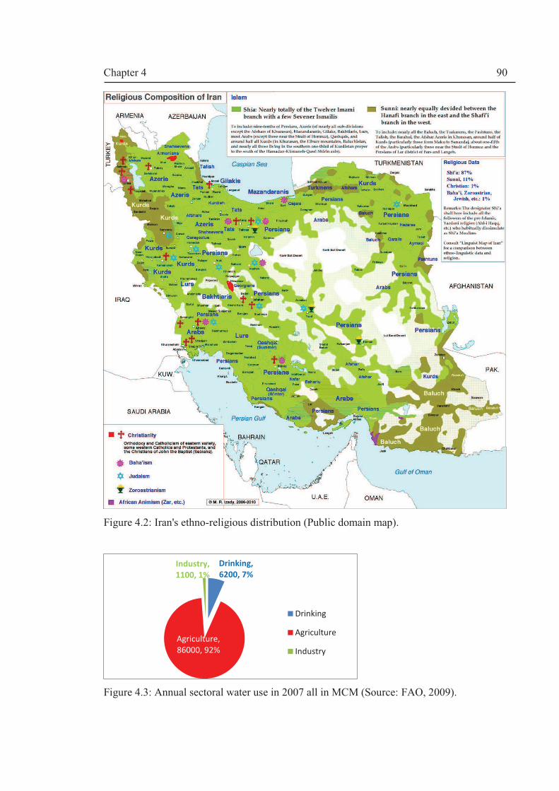
Chapter 4
90
Figure 4.2: Iran's ethno-religious distribution (Public domain map).
Figure 4.3: Annual sectoral water use in 2007 all in MCM (Source: FAO, 2009).
Drinking,
6200, 7%
Agriculture,
86000, 92%
Industry,
1100, 1% , 0
Drinking
Agriculture
Industry
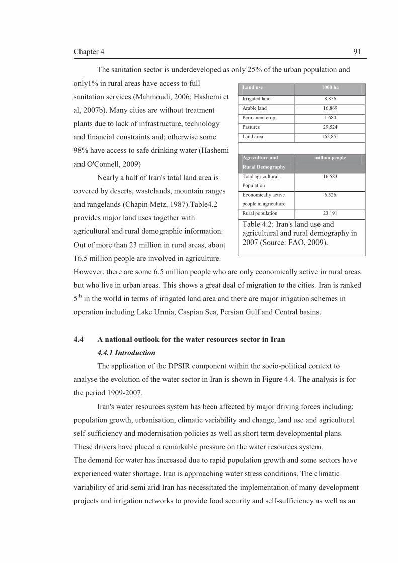
Chapter 4
91
The sanitation sector is underdeveloped as only 25% of the urban population and
only1% in rural areas have access to full
sanitation services (Mahmoudi, 2006; Hashemi et
al, 2007b). Many cities are without treatment
plants due to lack of infrastructure, technology
and financial constraints and; otherwise some
98% have access to safe drinking water (Hashemi
and O'Connell, 2009)
Nearly a half of Iran's total land area is
covered by deserts, wastelands, mountain ranges
and rangelands (Chapin Metz, 1987).Table4.2
provides major land uses together with
agricultural and rural demographic information.
Out of more than 23 million in rural areas, about
16.5 million people are involved in agriculture.
However, there are some 6.5 million people who are only economically active in rural areas
but who live in urban areas. This shows a great deal of migration to the cities. Iran is ranked
5th in the world in terms of irrigated land area and there are major irrigation schemes in
operation including Lake Urmia, Caspian Sea, Persian Gulf and Central basins.
4.4 A national outlook for the water resources sector in Iran
4.4.1 Introduction
The application of the DPSIR component within the socio-political context to
analyse the evolution of the water sector in Iran is shown in Figure 4.4. The analysis is for
the period 1909-2007.
Iran's water resources system has been affected by major driving forces including:
population growth, urbanisation, climatic variability and change, land use and agricultural
self-sufficiency and modernisation policies as well as short term developmental plans.
These drivers have placed a remarkable pressure on the water resources system.
The demand for water has increased due to rapid population growth and some sectors have
experienced water shortage. Iran is approaching water stress conditions. The climatic
variability of arid-semi arid Iran has necessitated the implementation of many development
projects and irrigation networks to provide food security and self-sufficiency as well as an
Land use 1000 ha
Irrigated land 8,856
Arable land 16,869
Permanent crop 1,680
Pastures 29,524
Land area 162,855
Agriculture and
Rural Demography
million people
Total agricultural
Population
16.583
Economically active
people in agriculture
6.526
Rural population 23.191
Table 4.2: Iran's land use and agricultural and rural demography in 2007 (Source: FAO, 2009).

Chapter 4
92
adaptation policy to droughts. The rapid economic growth and developments have brought
better living standards (Zekavat, 1997) but they have caused environmental degradation and
loss of biodiversity in many rivers and wetlands (Bahrainy, 2003).In this section, the results
of the assessment are presented and analysed.
Figure 4.4: Results of the DPSIR assessment at national level, 1909-2007.
4.4.2. Driving forces (Drivers)
Population growth and migration. The first nationwide population census was
carried out in 1956 (Bharier, 1968). Prior to this date, only estimated population values
were available. Gilbar (1979) states that Iran was regarded as the most populated country in
the MENA region in the mid-19th century and according to Lambton (1998) the population
was estimated to be 9 million people in 19002.
There has been an almost three-fold increase in population since 1956. Much of the
population lives in urban centres and there are 7 mega-cities. Thus, there are 2main
characteristics of the increase in population: (1) a faster rate of growth in urban areas, and
2Bharier (1968) estimates population to be 9.9 million.
Driving Forces
Responses
Structuralü Inter-basin water transfers and dam-buildings
ü Large investments in developmental projects
Non-structural ü1906 Civil Code (water rights, well ownership etc)
ü1929 Qanat Law
ü1943 Act of Establishment of Independent Irrigation Agency (Bongah)
ü1959 Water Resources Blueprint
ü1962 Act of Establishment of Ministry of Water and Power
ü1968 Nationalisation of Water resources Act
ü1971 Act of Establishment of Ministry of Energy
ü1974 Environmental Protection Act
ü1982 Fair Water Distribution Act
ü1990 Establishment of Urban Water and Wastewater Companies
ü1997 Environmental Impact Assessment Act
ü1998 Establishment of Rural Water and Wastewater Companies
ü1999 Inter-sectoral Water Resources Directive
ü2001 Act of Establishment of Ministry of Agricultural Jihad (merging Agriculture and Construction Jihad Ministries)
ü2003 Water Allocation Directive (WAD)
ü2003 Water Resources Long Term Strategies
Impacts StatePressures
Ø Population growth and
Migration
Ø Climate variability/change
scenarios
Ø Land tenure use/policy
land reforms
Ø Short term Development
policies and plans
Ø Poverty eradication policy
q Increasing
urbanization
q Increasing water
demands in all
sectors,
qWater quality:
Water source
pollutions
q Increase of
irrigation lands
q Increased
groundwater
abstraction
vBetter living standards in cities and
villages
vWater availability: water stress
v Increased reservoir storage capacity
vObserved changes in land use
including increased urban centres
and irrigated area and loss of
pastures
vEnvironmental and ecological
degradation: loss of biodiversity in
many rivers and water bodies
vHigher human development index
vEnhanced water and sanitation facilities
vPhysical: water shortage; pollution of
water sources
vGroundwater over-exploitation; negative
recharge
vSalinsation of irrigated lands (water
logging)
v expansion of urban slums
v Institutional: financial problems in the
water supply and wastewater sector;
conflicts over river basin water allocation
shares from dam projects (provincial and
cross cultural tensions)

Chapter 4
93
(2) immigration from rural to urban areas in search of employment which resulted in
enlargement of existing cities and the creation of new ones.
The introduction of a Family Planning Program (i.e. birth control policy) during
1966-1979 (see e.g. Abbasi-Shavazi, 2002) did not have a lasting impact on the rate of
population growth showing an increasing trend (Figure 4.5). The Program was suspended
after the 1979 Islamic Revolution but it was started in late 1980s and proven to be one of
the effective factors affecting the downward trend in population growth rate. There has
been a mismatch between the total population growth and rate of urban population growth.
Table 4.3 shows a huge increase in urban population due to migration. Between 1990 and
2008, the annual growth rate of urban population is 2.6% which is much greater than the
average annual population growth rate of 1.6% for the same period; whereas rural areas had
a negative growth rate of -0.3% (World Bank/WDI, 2010). Earlier projections of the
population of Iran reaching 100 million by 2025 has been revised to 80.2 million
(Table4.3).
Year Population Notes
1900 9,000,000* * estimated (Lambton, 1998)
1956 18,954,704 Nationwide census (NC)
1966 25,788,722 NC
1976 33,708,744 NC
1986 49,445,010 NC
1991 55,837,163
1996 60,055,488 NC
2006 70,495,782 NC
2010 74,733,230** ** estimated (SCI, 2010)
2025 80,200,000 *** revised projection (SCI, 2007)
2050 100,200,000 *** projected (SCI, 2007)
Urban areas (source World bank/WDI, 2010)
Year Population (millions) % of total population
1990 30.6 56
2008 49.3 68
Table 4.3: Iran’s population (Source: SCI (2010) unless stated).

Chapter 4
94
Figure 4.5: Population growth for the period1956-2010(SCI, 2010) and population growth rate (1960-2009) (World Bank /WDI, 2010).
Climate variability/change. As a semi-arid and arid country, Iran is characterised
by high climatic variably; thus historically experienced low spells of rainfall or
meteorological droughts which have affected natural runoff i.e. caused hydrological
droughts. Droughts usually have longer terms impacts including (1) socioeconomic
(immigration, poverty famine) and (2) agricultural (i.e. shortage of foods) impacts3.
By the late 1990s, a new discourse emerged based on the climate change discourse.
The experts of the Water Planning Bureau at IWRMC have started to doubt the
sustainability of the development plans and supply-oriented Water Master Plans4. Climate
change discourse centred on the downward trends of the precipitation based on linear
regression approach in the 15 years since 1995(Figure 4.6) as can be noticed in Figure 4.6,
the linear regression variance is not statistically significant at all. The time series used
(1969-2009) is too short to provide conclusive evidence in a meaningful trend analysis. But
most water managers started to belief that climate change is already happening due to
successive droughts and increasing trends in flood events in the last 50 years (MoE,
2010a)5. However, no conclusive evidence has been presented despite some attempts to
study climate change.
3For example there was “recurrence of famine in Tehran in 1860, 1870, 1872, and 1896” due to food
shortages and related to mismanagement of the economy and climatic factors (EttehadiehNezam-Mafi, 1993) 4We will introduce this later under the Pressures sub-section. 5 Recently, the perception held by many ordinary people is that we have less rainfall and certainly less snowfalls compared to the 1960s (from author’s experience).
18,954,704
25,788,722
33,708,744
49,445,010
60,055,488
70,495,782
1.31
0
0.5
1
1.5
2
2.5
3
3.5
4
4.5
0
10,000,000
20,000,000
30,000,000
40,000,000
50,000,000
60,000,000
70,000,000
80,000,000
1950 1960 1970 1980 1990 2000 2010 2020
gro
wth
ra
te
, %
Po
pu
latio
n
Year
population
Population Growth Rate

Chapter 4
95
Figure 4.6: Trends in precipitations and climatic variability during 1969-2009 based on MoE (2010a) discourse on climate change.
In the 1990s, research on climate change and droughts started; for example as cited
by DoE (2003), Khalili et al (1990) completed a pioneering work to understand the impact
of climate change on water resources in Iran. In June 1992, Iran joined the United Nations
Framework Convention on Climate Change (UNFCCC) at the Earth Summit and ratified
the Convention in 1996. The 4th FYDP (1999-2004) did not explicitly link climate change
to water resources but it recognised that Iran should be part of the Kyoto Protocol of the
3rdConference of the Parties (COP) meeting of the UNFCCC which was attended by Iran in
1997. The drive to join the Kyoto Protocol prompted the national project on climate change
at DoE producing the Initial National Communication to UNFCCC6 in 2003 (DoE, 2003).
The report was an example of inter-sectoral cooperation between various ministries in the
era of the reformist government of President Khatami and was an achievement of the first
woman Vice President, Dr Massouma Ebtekar, Head of the DoE.
DoE (2003) outlines the status of the environment, greenhouse gases (GHGs)
inventory, mitigation policies, vulnerability and adaptation assessments and proposed
strategies to address the issue of climate change. Results from a Runoff Assessment Model
(RAM) applied to all the river basins obtained by Fahmi7 (1999) are also cited in the report
indicating that a rise in temperature (as a result of emissions of GHGs) will have an impact
on runoff regimes; for example, the snowmelt season will be brought forward due to the
6 This project was led by Dr Taqi Ebtekar the first Director of DoE after the 1979 Revolution and the father of Mrs Ebtekar, Head of DoE. 7Dr Hedayat Fahmi was Head of Research Committee at the Office of Planning at IWRM at the time and now has moved to MoE, the Office of Macro Planning as Manger of Water Resources Group. He represented Iran on climate change issues.
y = 0.1625x - 69.707
R² = 0.0006
y = -4.3442x + 8934.3
R² = 0.1119
0.0
50.0
100.0
150.0
200.0
250.0
300.0
350.0
400.0
1965 1970 1975 1980 1985 1990 1995 2000 2005 2010 2015
rainfall, mm
Year
rainfall 1969-1994
Rainfall 1995-2009
Linear (rainfall 1969-1994)
Linear (Rainfall 1995-2009)

Chapter 4
96
rise in temperature; the flood regime will change in many watersheds (higher flood index)
and there will be a shift in rainfall and snowfall seasons as well (DoE, 2003).
The study used 6 (3 emission and 3 climate sensitivity) scenarios using selective
combinations of two global circulation models (HadCM2 and ECHAM4). The temperature
and precipitation changes were predicted using MAGICC 8 software for different
combinations of scenarios, climate sensitivities and CO2 rate of emissions up to 2100.
However, the climate change modelling was primitive as acknowledged by the writers
whom asserted that more precise scenarios should have been used as well as recommending
the use of regional/local general circulation models (GCMs) and more spatially improved
GCMs. Nevertheless, the DoE report (DoE, 2003) enhanced the acceptability of the climate
change discourse within policymaking circles but it provides rather inconclusive and
confusing remarks about temperature and precipitation changes and asks for better and
more detailed analysis.
DoE (2003) provides an assessment of vulnerabilities and adaptation measures for
the main economic sectors such as agriculture which represents more than a fifth of the
GDP. For example, DoE (2003) shows the vulnerability of the agricultural sector to
climatic variability and the question of food security (self-sufficiency policy) by stating the
loss of 3.6 million tons of wheat production of during the 1998-99 droughts.
Intergovernmental Panel on Climate Change (IPCC)’s Second Assessment Report
(IPCC, 1997) has acknowledged “the importance of adaptation in the climate change
question”; however, there are differences within most countries to how to adapt to climate
change (Smithers and Smit, 1997). Therefore, DoE (2003) asks for an adaptive
management strategy to deal with this pressing Driver. To deal with climate change, a
range of management options should be taken; for example deficit irrigation9 has been
shown to increase water use efficiency (e.g. Mushtaq and Moghaddasi (2011). Climate
change adaptation policy requires an adaptive governance system which recognises
“institutional flexibility and diversity which is the ability to create local institutions that can
respond to location-specific needs rather than needing to fit cleanly within nationally or
regionally defined frameworks”; in addition building infrastructures should accommodate
8 For more information See website http://www.cgd.ucar.edu/cas/wigley/magicc/ which states that “MAGICC
consists of a suite of coupled gas-cycle, climate and ice-melt models integrated into a single software package.” 9Based on a literature review, Mushtaq and Moghaddasi(2011) define deficit irrigation as a practice of deliberate under-irrigation of a crop or deliberate stressing of crops to influence yield and profit

Chapter 4
97
“uncertainty, variability, and change, while avoiding path dependencies” (Moench, 2010;
p.977).
Land tenure/use policy. Despite climatic aridity, most Iranians policymakers in the
last 100 years perceive that Iran can accommodate more agricultural developments and can
achieve food self-sufficiency given the right technological means i.e. water is not seen as a
limiting factor. Therefore, irrigation policy has been instrumental as a major Driver.
Data from Table 4.6 show a net loss of nearly 16.5 million ha of pastures to other
land covers in Iran between 1995 and 2007. Irrigated area has increased by 21% between
1996 and 2007. A substantial increase in the permanent crop cover has occurred: from 1.13
million ha to 1.68 million ha; an increase of 48%.
Table 4.4: Land use change in Iran, 1987-2007 (Source: FAO, 2009).
One of the major drivers of land use change has been the1962-71 Land Reform
which was part of Pahlavi's White Revolution (Pahlavi, 1998). Hasan Arsenjani (1922-
1969), the architect of the Land Reform, was a "brilliant and erratic" leading Iranian
politician who was a regular visitor to the Shah in the 1950s (Cottam, 1999)10. He
masterminded the populist reform but was mistrusted by the Shah and was dismissed in
1963 and was sent to Italy to serve as Iranian ambassador. By the end of 1978 some 3.5
million acres were distributed to the peasants to channel support for the monarchy.
10An authentic translation is available in Farsi which has been referenced here. The English edition was published in 1979 by University of Pittsburgh Press.
Year/ Arable area
(x 10**3 ha)
Permanent crop
(x 10**3 ha)
Pastures
(x 10**3 ha)
Irrigated area
(x 10**3 ha)
1987 15,400 1,130
1992 16,969 1,318
1995 17,388 1,320 45,500
1996 7,308
1997 16,502 1,330
2000 14,924 1,360 46,600
2001 7,868
2002 16,029 1,415
2005 8,574
2006 8,715
2007 16,029 1,680 29,524 8,856
Percentage change
10% increase 48% increase 35% decrease 21% increase
Chapter 4
98
However, this has politicised the peasantry and hence is regarded as one of the main
reasons for the 1979 Revolution. It seems that the Shah thought that the development plans
were vehicles for implementing the 1966 Cultural Policy outlined by Behnam (1973) and a
stride towards modern Iran.
Scholars have asserted that the Land Reform were marked with failure due to
poverty, water shortages as a consequence of lack of necessary infrastructure (Walton,
1980) and inappropriate water governance(Farman-Farmaian& Farman-Farmaian, 2002)11.
The Land Reform dismantled the feudal land management system and degraded the
agricultural sector and caused the migration of rural communities to urban centres; hence it
caused economic imbalance (Engineer12, 1980).
Post Revolution Land Reform in 1979-80 was led by a radical movement within the
new Islamic Republic headed by Reza Esfahani, Deputy Agriculture Minister for Land
Affairs. He tried to redistribute the agricultural land with the aim of empowering the
'oppressed'. Esfahani’s zealous efforts resulted in a Program bearing his name: the Reza
Esfahani1980 Land Reform. McLachlan (1988) provides a scholarly analysis of this
Program describing it as "little short of a disaster (ibid, p.221)". The post Revolution
agrarian reform had the following characteristics : (1) geographically sporadic as it mostly
affected Kurdish populated regions i.e. Kermanshah, Kurdistan and West Azerbaijan;(2)
large land owner institutions were created such as Bonyad-e- Mostaz'afan (The Foundation
of the Oppressed) owning some 100,000 ha of land and major dairy industries; in total
some 850,000 ha were distributed among those so called ‘oppressed’ people on temporary
Farming Contracts (Eslahi et al, 2002); (3) the Ministry of Agriculture (MoA)did not have
the sole responsibility for the Program because the Ministry of Jihad-e- Sazandegi
(MJS)which was linked to the Guards (Pasdaran) of Islamic Revolution Militia was in
charge of rural regeneration and were effectively in control; (4) the Program was halted and
the Council of Guardians produced a legal verdict that the new Land Reform is illegitimate
as it transgresses ownership rights and limits the size of private ownership (Eslahi et al,
11
The book ‘Blood and Oil: Memoirs of a Persian Prince, was published in English by Random House, New York in 1997. The authors belong to one of the most influential political families in Iran until the 1979 Revolution. 12Ali Ashghar Engineer, is an Indian reformist-writer and activist focusing on collectivism advocating communal harmony and a culture of peace and non-violence (Source: Wikipedia website: http://en.wikipedia.org/wiki/Asghar_Ali_Engineer)
Chapter 4
99
2002) and (5) the majority of land confiscated was given back to the owners and many
rulings of the Courts of The Islamic Revolutions were overturned13.
The MJS and MoAJ were not on good terms. The MJS was established in 1983 and
lead by Bejan Namdar Zanganeh who later became Minister of Energy (1988-1997). In
2001, MoA and MJS were amalgamated to form the MoAJ. Traditionally, the MoAJ
ministers are appointed from former MJS members. They also provided many ministerial
ranks to other sectors including petrochemical and energy.
The agricultural modernisation policy and land use policy on irrigation have placed
a great deal of pressure on groundwater resources. Groundwater development plans started
in 1945 with the introduction of deep wells to replace traditional qanats and new
technologies in irrigation. This is a legacy of sectoral land use and water governance
system. We will come back to the theme of Pressures from groundwater developments in
the next section.
Short term development planning. One of the main discourses centres on the belief
that we need to harness more surface water development plans as a measure (i) to adapt to
the droughts conditions14; (ii) to produce clean hydropower energy and (iii) to achieve food
security. However, despite concerns for climate change and the emergence of a new
discourse, the water resources development plans are underway unabated as an adaption
policy for climate change too. It has been shown that infrastructure buffers the impacts of
climatic variability on the economic outputs (Halsnaes and Traerup, 2009).
Based on the questionnaire survey (Appendix A1), many participants felt that
building more dams fosters superficial expectations about alleviation of climate change
risks; creates new water rights for farmers in downstream and has generated a great deal of
tensions among provinces sharing a rivers basin.
The idea of short term development planning is not new. For example, colonial
development planning was enacted at the time of Chamberlain in 1895 (Abbott, 1971) with
the purpose of solving unemployment in the UK by having limited development spending
in the colonial territories. Later, the 1929 Colonial Development Act and the 1940 Colonial
Development & Welfare Act were introduced, and in 1947, the Colonial (Commonwealth)
Development Corporation was established (Cowen, 1984).
13 The author has witnessed that many noble families such as Ardalan, Sanandaji, Kamangar in Kurdistan and Kermanshah provinces have regained their lands. 14This is perhaps a case in semi-arid/arid regions e.g. E. Strobl and R.O. Strobl (2011) states that adaption to drought is the main reason for building dams in Africa
Chapter 4
100
Iran was not inspired by the British or the Russian ‘Communist’ neighbours’
(formerly USSR) on the idea of short term development planning. Instead, the emergence
of the World Bank in the 1950s as an important agency has been very influential in surface
water development planning (dams and irrigation networks) in Iran.
In 1946 the Planning Committee was active and with the aid of the Overseas
Consultants Inc. (McLachlan, 1986), the first Seven Year Development Plan (SYDP) was
enacted in 1948. At the time of Imperial Iran, 2 SYDPs and 3 Five Year Development Plans
(FYDPs) were completed during which major dams were built and these has been reviewed
by Beaumont (1974). Massive dam building and water supply and irrigation networks were
built as a result of these plans. After enacting five Plans i.e. 3 FYDPs and 2 SYDP, the
proposed fourth FYDP (i.e. the 6th Plan) did not see the light of day as the monarchy was
overthrown by the new Islamic Revolution in 1979 (Figures 4.7 and 4.8).
The plans lacked both long term vision and strategy. The First Five Year Development
Plan (i.e. the 3rd Plan) concentrated on planning to irrigate the Khuzestan lowlands and
build hydropower plants (Beaumont, 1974)and so 5000 million Iranian Riyals (IRR) were
allocated for the projects. The actual dam construction started in the Second Development
Plan as 4 major dams were built. There was a policy shift in both the Third and the Fourth
Development Plans to concentrate on existing irrigation networks and water supply
schemes for the growing urban populations respectively (Beaumont, 1974). The Fifth Plan
concentrated on consolidating the existing water structure, and13 major dams, 17 major
diversion dams and 17 large irrigation schemes were built as a result.
Iraq invaded Iran soon after the 1979 Revolution (22 Sep 1980). The longest
conventional war in the 20th century continued until August 1988 which brought much
devastation to both countries. During this period, no FYDPs were employed (MoE, 2003).
Agricultural developments were hindered by the war and ideological wrangling about land
ownership and a multiplicity of institutional responsibilities in the management of the land
resources. The imposed war was partially responsible for this mismanagement. After the
imposed war, the past legacy of development planning continued. The post-war
reconstruction was led by Zanganeh from the MJS who headed the MoE from 1988 and
brought with him MJS's zeal for hard work.
A massive reconstruction programme started with the 1stpost-RevolutionFYDP
(1989-1993) which was characterised by the sheer number of development projects which
were very difficult to manage due to the lack of a holistic approach and any sort of

Chapter 4
101
integrated approach to river basin management. Hence, the percentage of completed water
resources and irrigation networks was small compared with the 3rd and 4th FYDPs.
Figure 4.7: Percentages of water resources development in each period corresponding to FYDPs.
Figure 4.8: Irrigated land development downstream of dams in each period corresponding to FYDPs.
The overall policy was shaped by President Ali Akbar Rafsanjani (1989-97) which
believed in liberalisation of the market. Rafsanjani's market economy lacked political
reforms and openness; hence his plans were not popular with the public.
pre 1948
0.04%
1948-1954
0.00%
1955-1962
19.31% 1963-1967
1.00%
1968-1973
11.71%
1974-1979
14.27% 1980-1988
4.85%
1989-1993
2.49%
1994-1999
6.55%
2000-2005
24.46%
2005-2010
15.31%
pre 1948
0%
1948-1954
0%
1955-1962
14%
1963-1967
1%
1968-1973
17%
1974-1979
7%
1980-
1988
8%
1989-1993
3%
1994-
1999
9%
2000-2005
26%
2005-2010
15%
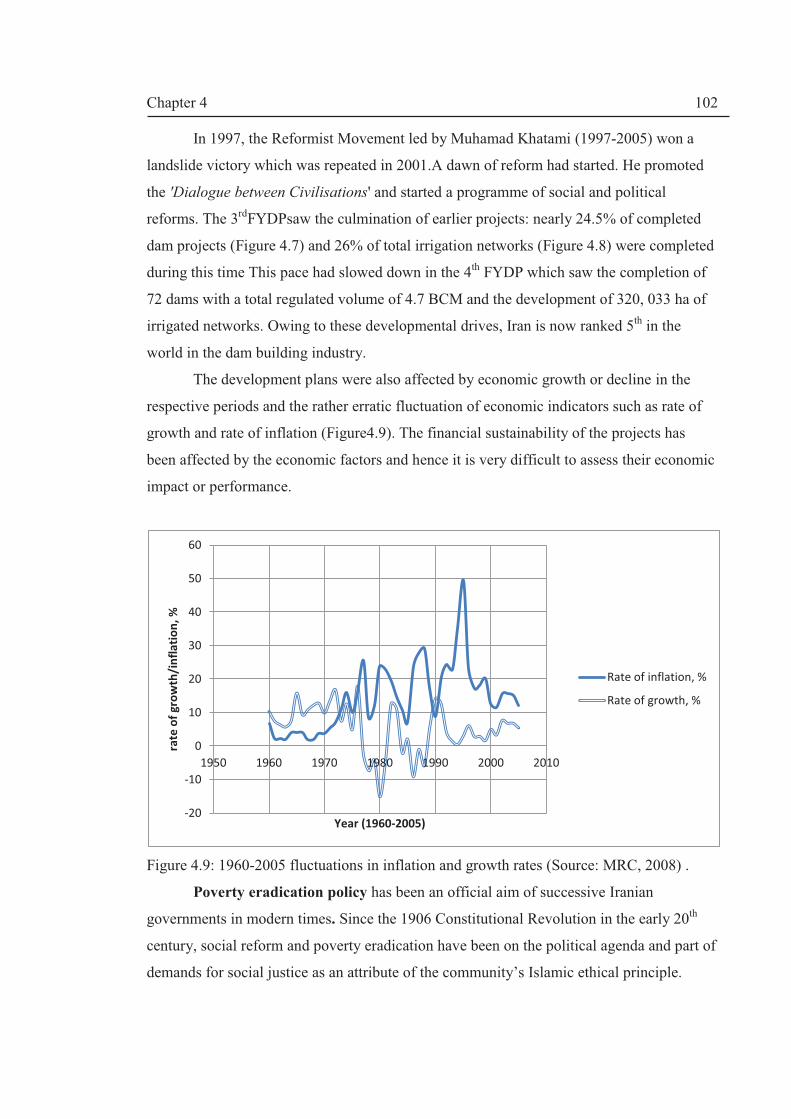
Chapter 4
102
In 1997, the Reformist Movement led by Muhamad Khatami (1997-2005) won a
landslide victory which was repeated in 2001.A dawn of reform had started. He promoted
the 'Dialogue between Civilisations' and started a programme of social and political
reforms. The 3rdFYDPsaw the culmination of earlier projects: nearly 24.5% of completed
dam projects (Figure 4.7) and 26% of total irrigation networks (Figure 4.8) were completed
during this time This pace had slowed down in the 4th FYDP which saw the completion of
72 dams with a total regulated volume of 4.7 BCM and the development of 320, 033 ha of
irrigated networks. Owing to these developmental drives, Iran is now ranked 5th in the
world in the dam building industry.
The development plans were also affected by economic growth or decline in the
respective periods and the rather erratic fluctuation of economic indicators such as rate of
growth and rate of inflation (Figure4.9). The financial sustainability of the projects has
been affected by the economic factors and hence it is very difficult to assess their economic
impact or performance.
Figure 4.9: 1960-2005 fluctuations in inflation and growth rates (Source: MRC, 2008) .
Poverty eradication policy has been an official aim of successive Iranian
governments in modern times. Since the 1906 Constitutional Revolution in the early 20th
century, social reform and poverty eradication have been on the political agenda and part of
demands for social justice as an attribute of the community’s Islamic ethical principle.
-20
-10
0
10
20
30
40
50
60
1950 1960 1970 1980 1990 2000 2010
rate
of
gro
wth
/in
fla
tio
n,
%
Year (1960-2005)
Rate of inflation, %
Rate of growth, %

Chapter 4
103
According to the World Bank ( 2001), Iran has made considerable progress with
poverty eradication; the percentage of people below the poverty line 15has fallen
significantly from 47% in 1978 to 15.5%" in 1995 which has further fallen to 6.21% in
2002 (MPO/UN, 2004) . However, here are different ways of measuring the poverty line.
Hence, there are different statistics; for example, based on the 2002 data, some of the
researchers put the number of people below poverty line at about 20% of the population
(e.g. Mehrgan and Nessabian, 2010). This means that poverty is an important issue to the
policy-makers. The government policy in the 3rd FYDP was to reduce it to 7%, and this
goal has been reached as mentioned.
Land Reform and water and agricultural development plans have been seen as a
means to achieve economic prosperity. Poverty is a multi-dimensional phenomenon and
hence cannot be eradicated with only economic plans. Access to education, health service,
drinking water and sanitation, political empowerment and employment are among the key
factors that affect the degree of poverty.
4.4.2. Pressures
Increased water demand. Population growth as a high level Driver has induced
other Drivers such as land use policy, short term development plans, energy policy on
hydropower and irrigation politics which have led to increasing pressure on the water
resources by increasing demands in all the sectors.
Jamab (1998; 2007) state that
· the demand for water has increased from 83 BCM in 1995 to 93.3 BCM in
2004;
· the agricultural water withdrawal increased from 76 (91.2% of total
withdrawals) to 86 BCM (92.18% of total withdrawals);and
· there has been a 21% increase in the irrigated land area during this period.
Total annual water use based on 2007 survey is given in Table 4.5.
15Poverty line is defined as income of US $2 per day. There are criticisms about this simplistic monetary indicator but it is widely used as a target indicator and very practical to measure.

Chapter 4
104
Freshwater No conventional water source
Total water use Surface water Groundwater Total % of
total
water use
Desalination % of
total
water
use
Reused
treated
wastewater
Reused
agricultural
drainage water
40, 000 53, 100 93,100 99.8 200 0.2 - - 93,300
Table 4.5: Total annual water use (all in MCM) (Sources: FAO, 2009; Jamab, 2007; MoE,
2010a)
There is scattered and inaccessible information on water demands before 1975. To
make strategic assessments, comprehensive Water Master Plans were initially
commissioned in 1969 by Plan and Budget Organisation for making projections on water
demands and potential water resource development capacity in Iranian basins. Later the
initiative was adopted by MoE and produced the first Water Master Plan in 1975 and since
then the Plans have been updated by Jamab Consulting Company in 1991 (based on 1983
baseline date); 1996 (based on 1993 baseline data), and 1998 (based on 1994 data). Jamab
(1998) was a first attempt to foster basin-wide water resources planning and development
process in LUB. However, the demand-driven Water Master Plans do not recognise
systems analysis approach or IWRM and is mainly based on assessment of the technical
aspects of river basin planning. Also, Management and Planning Organisation
commissioned Jamab (2007) to produce an adapting Master Plan for Arid/semi-arid
Climate of Iran which lacks holistic planning approach.
Groundwater over-exploitation. Officially, 59.9 % of the 2004 water demand of
93.3 BCM is met from groundwater resources (FAO, 2009). More than 120,000 illegal
wells are in operation, which accounts for an excess withdrawal of 5 BCM/year i.e. an
additional 5.4% is utilised (Almasvandi, 2010). Almasvandi16 (2010) states that more than
70% of water demands utilise groundwater resources (mainly private wells). The
phenomenal increase in the utilisation rate is due to the introduction of deep wells after
1945(Figure4.10); before that date, groundwater utilisation was through qanats and springs
(Vali-Khodjeni, 1995). This level of utilisation has depleted groundwater resources and
there has been a drop in the water table of between 12 and 67 m as depicted in Table 4.6
(Motagh et al 2008). Motagh et al (2008) assert that there is a great deal of land subsistence
due to falling water tables of varying degrees in Iran's main plains (Table 4.7). The
16 Managing Director of IWRMC at the time; illegal or informal abstraction information is not given but this rare information was provided during a keynote speech at a conference which was picked up by Iran News Agency, IRNA

Chapter 4
105
numbers of groundwater structures (wells, qanats and springs) have increased (Figure
4.10), but the discharge per structure has lowered by up to 50% which indicates depletion
of groundwater resources (Figure 4.11).
Year Wells Springs Alluvial
qanats
Total discharge, BCM
Alluvial Hardrock Alluvial Hardrock Alluvial Hardrock Total
No. Q No. Q No. Q No. Q No. Q
1994 365,711 40.5 unknown 0.2 5,290 1.1 37,300 12.75 31,521 9.4 51 12.95 63.95
2001 435,729 42.9 1064 1064 4,067 0.92 43,588 12.8 32,163 7.9 51.7 13.3 65.0
No Q, BCM No Q, BCM No Q Q, BCM
2007 624,833 48.9 124,443 22.9 37,197 7.4 79.2
Table 4.6: Groundwater exploitation, 1994-2001 (Main source: Jamab, 2007).
Region Period Decrease in water table (m) Rate of land subsistence
cm/year
Tehran area (Varamin Plain) Since 1990s ~13 19-23
Rafsanjan Plain (central Iran) 1971-2001 ~15 ~50
Valleys of Mashhad and Kashmar In the last 4 decades 15-64 ~27-30
Zarand-Kerman Plain Since 1990s ~27 ~ 25
Yazd Since 1970s ~12 ~9.4
Table 4.7: Groundwater over-exploitation in parts of the Iranian plains (Source: Motagh et al 2008 from InSAR-derived subsidence maps).
Figure 4.10:Shows discharges from different groundwater resources (1973-2004): (a) Left axis shows total groundwater discharges and abstraction from wells; (b) right axis illustrates natural spring and qanats flows and abstractions.
73859.8
0
5000
10000
15000
20000
25000
0.00
10,000.00
20,000.00
30,000.00
40,000.00
50,000.00
60,000.00
70,000.00
80,000.00
1960 1980 2000 2020
dis
cha
rge
, q
an
ats
an
d s
pri
ng
s
To
tal
dis
cha
rge
an
d
Dis
cha
rge
fro
m w
ell
s
Year
Discharge, Wells, MCM
total discharge, MCM
discharge, Qanats, MCM
discharge, Springs, MCM

Chapter 4
106
Figure 4.11: Annual rate of cumulative change of discharge per structure (1973-2005).
Pressures from pollutions. The land use policy was based on self-sufficiency and
food security has exerted pressure on the environment. The excessive water demand in
agriculture has posed a serious problem with land quality. There are over 1,000,000 ha of
irrigated lands which are water-logged (source: FAO, 2009). As a result of water-logging,
30% of irrigated lands have been affected by salinisation (Siadat, 1999); which have led to
low irrigation efficiencies. Nearly 20% of the renewable resources are coming back into the
system as return flows with much lower qualities. Sewage and untreated urban and
industrial effluents enters rivers and streams and hence groundwater and surface water
resources pollution and degradation put huge Pressures on the water resources system.
Environmental services. The economic prosperity and overall higher living
standards has placed huge pressure on the environment sector. Water allocation for the
environment is not given any priority. This places a huge pressure on inland waters such as
rivers as well as wetlands. Irrigation water efficiency is seen as the key to reducing the
percentage of water use in agricultural sector for environmental purposed. But IWRMC
(2005) predicts that water demands in 2021 will increase to 123,000 MCM; an increase of
30,000 MCM. The net increase in agricultural water use will be from 86,000 to 106,000
MCM. Hence, the reduction of agricultural water use in % terms is rather misleading. In
real terms, the saved water might not return to the environment. In fact, IWRMC (2005)
predict that it is expected to officially allocate5% of the total renewable resources to the
-80
-70
-60
-50
-40
-30
-20
-10
0
1970 1975 1980 1985 1990 1995 2000 2005 2010
% c
um
ula
tiv
e c
ha
ng
e i
n d
isch
arg
e p
er
stru
ctu
re
Year
wells
qanats
springs

Chapter 4
107
environment (Figure4.12). This clearly shows that the future demands are not sustainable
and there is a need for IWRM type of Responses i.e. more emphasis on demand
management rather than build and supply perspective to deal with the environmental
requirements of the water resources system.
Figure4.12: Predicted future water demands in 2021(IWRMC, 2005)
4.4.3. States/Impacts
Better living standards but poverty looms. Iran has moved up 10 places in the
Human Development Index HDI17 ranking during the last 20 years and is now ranked 70th
in the world (HDR, 2010). Despite stagnation in the income and a fall in the GDP, Iran has
experienced good health and education indicators as reported by HDR (2010). Since 1990,
water supply and sanitation have improved in rural and urban areas (IWRMC, 2005), and
now more than 98% and 87% have access to safe drinking water in urban and rural areas,
respectively. Low cost interventions have helped the non-income part of HDI to improve,
but the income complement has not improved as such and so the poverty eradication policy
has not been as successful due to inflationary and other factors; as mentioned before, some
researchers suggest that up to20% of the population are living below the poverty line.
The status of environmental services. Valuing Ecosystem Services is not an easy
task since much of environmental damage is traded off against economic benefits and
17 HDI is a multi-dimensional index which reflects the wellbeing of the society and aggregate income and non-income based indicators.
7%
86%
86,000 MCM
2%
5%
Drinking
Agriculture
Industry
Environment
Chapter 4
108
reflected in the economic indicators such as GDP (World Bank, 2004). In 2000, the UN
started the Millennium Ecosystem Assessment (MA)18 to “assess the consequences of
ecosystem change for human well-being and the scientific basis for action needed to
enhance the conservation and sustainable use of those systems and their contribution to
human well-being." (MA, 2005). The Word Bank (2005) produced a report on Iran which
was a valuable attempt at highlighting the cost of environmental damage.
It is noted that industrial, hospital and municipal wastes are directly discharged into
many rivers. Increased irrigation activities have caused groundwater and surface water
resources pollution and degradation. World Bank (2005) notes that many watersheds lack
proper land use or watershed management and so there are a great deal of soil erosion and
sedimentation of dams. World Bank (2005) asserts that deforestation and poor land use
management can contribute to increasing flood events. The number of floods has already
increased from 192 events in 1950s to 1,341events in 1990s (World Bank, 2005)19. World
Bank (2005) has estimated that the total environmental cost due to the degradation of water
and land services represents 2.82 and 1.7 % of the GDP respectively. Land resources costs
are due to cropland salinisation, rangeland degradation, wetland loss, and floods. For
example in 1975, 16 of the 90 million ha of rangeland were considered to be in a poor state
compared with 43.4 million ha in 2003.
Water stress. Water scarcity (shortage) in Iran (and the MENA region) is multi-
dimensional. A World Bank Report (2007) highlights three factors influencing levels of
scarcity including
a. Lack of physical resource.
b. Lack of organisational capacity and
c. Governance deficiencies (transparency and decision-making)
Physical resource scarcity. Water shortage in Iran is both a spatial and temporal
phenomenon. Iran is approaching water stress level20 (i.e.1700 m3/capita): per capita
renewable water resources are~1900 m3/capita (MoE, 2010a). In 1956, annual renewable
water availability was 7000 m3/capita. By 2001, this figure had reached 2000 m3/capita. It
is expected to reach 1300 m3/capita in year 2021(IWRMC, 2005; MoE, 2010a).
18 MA is used and not MEA as one might expect. 19 As stated by MoE (2010a) in earlier parts as parts of the climate change discourse. 20
Falkenmark’s water stress index (resource per population per year) is a measure of scarcity of a country;
based on a threshold of 1700 m3/inhabitant/year as the requirement for sustaining the needs of population in all the sectors (see e.g. Falkenmark, Lundqvist and Widstrand, 1989)

Chapter 4
109
Self-sufficiency policy on cereal production such as wheat has been adopted since
the Pahlavi era but it became a real objective of the Islamic Republic and this policy has
had a tremendous impact on the state of water resources as noted by Faramarzi et al (2009).
Wheat self-sufficiency was achieved in 2005. But three years later, as shown in Figure 2.2
(Chapter II, Section 2.3.4), Iran needed to import wheat during the 2008 season to
compensate for the shortage in production.
However, official strategy on Virtual Water ‘trade’21 (e.g. Zeitoun et al ,2010) has
been opposed by policymakers despite empirical evidence (e.g. Memari22, 2006; Chapter
II). The perception is that any official Virtual Water strategy will encourage import trades
which will be governed by globalisation forces such as international trade patterns. Memari
(2006) draws a geo-cultural mental model (North- South and West -East divide) that
Iranians who come from water scarce regions i.e. mainly East, Central and southern parts of
Iran) are very sensitive to water scarcity and are "interested in utilising and harnessing
water [resources] …..They are interested in holding water in reservoirs rather than
allowing it to flow [naturally] away [outside the region]"23. Accordingly, Northern and
Western Iran have not such sensitivities since they have plenty of water. Based on this
analogy, since major policymaking centres in Iran lie in the arid regions (Central region e.g.
Tehran, Semnan; Eastern region e.g. Khurasan; and Southern region e.g. Yazd and
Esfahan),the cultural perceptions and discourses of these regions dominate public policy
decisions i.e. they favour dam building.
Lack of organisational capacity. The perception of water sector performance by
Iranian water managers is given in Figure4.13. (Source: survey questionnaires, Appendix
A1). More than 82% of the participants believe that the water sector performance is
average, below average or unsatisfactory.
21 The issue of Virtual Water trading is dealt with in Chapter II. 22 Advisor to Deputy Minister for Water Resources, He is a poet and a speech writer for ministerial ranks in MoE. As a cultural figure, he has a web of influence within the ranks and orders at the MoE. He is fluent in English, French and Arabic. His first degree was in Irrigation in 1953. Then he obtained an MSc degree in 1974. 23 Many experts and policymakers consider natural flowing water and low efficiency water use to be ‘wasted
water’; this perspective is based on pure engineering utilitarian culture.
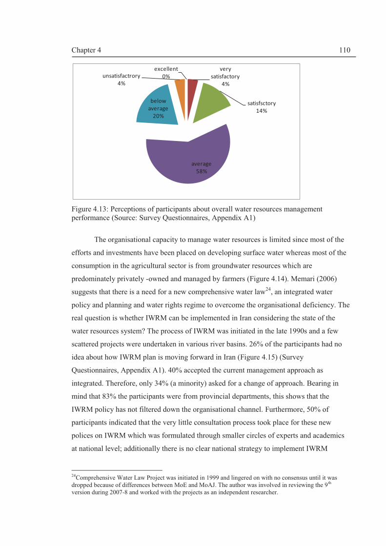
Chapter 4
110
Figure 4.13: Perceptions of participants about overall water resources management performance (Source: Survey Questionnaires, Appendix A1)
The organisational capacity to manage water resources is limited since most of the
efforts and investments have been placed on developing surface water whereas most of the
consumption in the agricultural sector is from groundwater resources which are
predominately privately -owned and managed by farmers (Figure 4.14). Memari (2006)
suggests that there is a need for a new comprehensive water law24, an integrated water
policy and planning and water rights regime to overcome the organisational deficiency. The
real question is whether IWRM can be implemented in Iran considering the state of the
water resources system? The process of IWRM was initiated in the late 1990s and a few
scattered projects were undertaken in various river basins. 26% of the participants had no
idea about how IWRM plan is moving forward in Iran (Figure 4.15) (Survey
Questionnaires, Appendix A1). 40% accepted the current management approach as
integrated. Therefore, only 34% (a minority) asked for a change of approach. Bearing in
mind that 83% the participants were from provincial departments, this shows that the
IWRM policy has not filtered down the organisational channel. Furthermore, 50% of
participants indicated that the very little consultation process took place for these new
polices on IWRM which was formulated through smaller circles of experts and academics
at national level; additionally there is no clear national strategy to implement IWRM
24Comprehensive Water Law Project was initiated in 1999 and lingered on with no consensus until it was dropped because of differences between MoE and MoAJ. The author was involved in reviewing the 9 th version during 2007-8 and worked with the projects as an independent researcher.
excellent
0%
very
satisfactory
4%
satisfsctory
14%
average
58%
below
average
20%
unsatisfactrory
4%

Chapter 4
111
(Figure 4.16). Therefore, institutional capacity development is needed to harmonise
national and local level policy implementation strategies. IWRM should not be seen as a
blueprint enforced by top-down approach as it was perceived by many participants because
they were not involved in the process or at least 50 % of them.
Figure 4.14: Schema showing agricultural water ownership and management (Memari, 2006; interview)
Figure 4.15: Perception of inter-sectoral co-ordination to implementing IWRM in Iran (Source: Survey questionnaires, Appendix A1)
Water for agriculture
100%
Groundwater supply
70%
Qanats and springs 6%
20% benevolent
80% Shared private water management)
mainly deep wells: 94%
99% private ownership and
managemenrt by farmers
1% others
Surface water supply
30%
yes
40%
no
34%
don’t know
26%
Q: Is there an inter-sectoral cooperation to implement
IWRM in Iran? i.e. are all the subsystems of the water
resources system considered in the implementation
process?

Chapter 4
112
Figure 4.16: Perception of level of participatory approach in IWRM planning in Iran (Source: Survey questionnaires, Appendix A1)
Governance deficiencies. Earthtrends (2003) has narrated governance indices based
on criteria set by the Freedom House 25"that advocates for American-style leadership in
international affairs" and have understandably given Iran a very low rating in terms of
freedom 6 out of 7 for 2 criteria political rights (PR) and civil liberties (CL) where 7 is the
worst case. The methodology is based on a list of questions that measure different aspects
of CL and evaluated by a group of “in-house and consultant regional experts and scholars”
(Freedom House, 2010). These are highly biased and subjective indices based on a list of
questions that is and cannot be a good measure of good governance in Iran. However, they
partially reflect contemporary governance issues. Worldwide Governance Indicators (WGI)
developed by the World Bank/WGI (2010) are based on perception data and measure six
categories of good governance since 1996 as tabulated in Table 4.8 which shows a mixture
of improved and worsening indicators; it shows that Iran has improved in Control of
Corruption and Rule of Law indicators.
25 Based in New York, Freedom House is an advocacy organization close to the US government; it was established in 1941 to fight the Nazis and later was involved in anti-communist propaganda.
yes
23%
no
50%
don’t know
27%
Q: Is there a national IWRM strategy? are all the participants involved
in planning and mangement of water resources?

Chapter 4
113
Table 4.8: Change in good governance indicators for Iran from 1996 to 2009 (World Bank/WGI, 2010)
Participants show a large degree of dissatisfaction with water sector governance and
there are calls for the introduction of new laws and capacity development. Areas such as
accountability, government effectiveness, regulatory quality and rule of law have been
highlighted. 89% of the participants emphasised the need to strengthen the current
governance set up and for new ‘enforceable’ legislative measures as indicated in Figure
4.17 (Source: survey questionnaire; Appendix A1).
Figure 4.17: Perception of the need for institutional reforms (Source: Survey questionnaires, Appendix A1)
Water storage capacity has increased from 14.6 BCM in 1979 to 30.4 BCM in
2010; a total of 588 dams are in operation (see Table4.9). However, the volume of reservoir
storage behind the dams has been fluctuating and sometimes they are less than 50% full.
Climatic variability and the resulting droughts or dry spells have resulted in these dams
operating under their capacity. Also, another feature is that many dams lack primary
yes
89%
no
3%
don’t know
4%
not answered
4%
Q: Do you think that there is a need for new policies and laws to
manage water resources?
Indicators 1996 Rank
2009 Rank
Voice and Accountability -1.3492238 11 -1.486247382 8
Political Stability and Absence of Violence -0.63080443 24 1.518201658 8
Government Effectiveness -0.64752027 29 -0.742798693 26
Regulatory Quality -1.64474609 6 -1.737524811 3
Rule of Law (RL) -1.17095084 13 -0.900895771 20
Control of Corruption (CC). -1.0686678 13 -0.829989113 22
Notes:
Ranks are based on 1-99 where 1 is the worst
Indicators value between -2.5- 2.5 where 2.5 is highest (best)

Chapter 4
114
irrigations networks beside secondary and tertiary networks. Due to the arid climate, a
considerable amount of water is evaporated from the reservoirs which amount to 1.22
BCM/year (FAO, 2009). There are massive water transfer projects such as Sirvan-
Garmasiri project which entails 400 km of tunnelling and a large number of diversion and
storage dams. The whole system has high vulnerability to both system failure and climatic
variability and change (Hashemi, 2008a).
Development Plan periods
No. of dams Regulated volume,
MCM
Irrigated land, ha
Pahlavi Era
Pre-development planning 24 12 190
1st SYDP: 1948-1954 1 0 0
2nd SYDP: 1955-1962 5 5915 307,240
3rd FYDP:1963-1967 4 307 31,800
4th FYDP: 1968-1973 7 3587 379,371
5th FYDP: 1974-1979* 4 4370 140,872
Subtotal Pahlavi era 45 14,191 859,483
Dawn of Islamic Republic in 1979
Iran-Iraq war: 1980-1988 113 1486 168,162
1st FYDP: 1989-1993 75 762 56,833
2nd FYDP: 1994-1999 157 2007 203,289
3rd FYDP: 2000-2004 126 7492 571,436
4th FYDP: 2005-2010 72 4690 320,033
Subtotal after 1979 543 16,437 1,319,753
Total 588 30,628 2,179,236
* 2 dams completed in 1979 which were ready just after the revolution so 1979 is added to this era.
Table 4.9: Water resources development (dams and irrigated area) 1948-2010 representing the Pressures by the short term development plans (Source: IWRMC, 2009/2011).
4.4.4. Responses:
In this section, past Responses are analysed to understand the institutional evolution
of water resources planning and management providing an overview of the institutional
performance.
Responses under uncertainty. As discussed earlier, 9 ‘Development Plans’ have
been implemented since 1948. In the process, the water industry has become a subject of
national pride by fulfilling the ambitions of the political domain through engineering
progress. But, as a result of these developmental drives, many challenges appeared in the

Chapter 4
115
water resources sector including: entering a water stress phase; depletion of groundwater
resources; pollution of surface waters; an increased gap between demand and supply
leading to the rise of social conflicts according to MoE (2010a).
From ancient history of Iran, the need for irrigation was based on an economic
perspective for more revenue to the state coffers from agricultural produce (see e.g.
Ravandi, 1975). This has been accompanied by the need for developing water distribution
systems such as qanat groundwater system and canals for irrigation. The historical legacy is
mixed with the new discourse on climate change. So, the need for more development is not
only to deal with economic security but it is about water and food security. The perception
is that the vulnerability to climate change can be offset by harnessing the renewable surface
water resources. The complex hydraulic systems need an integrated management approach
and hence, there is a great interest in the ‘M’ component of the IWRM concept based on
risk assessments.
In the next part of this section, I present the historical development of Non-
structural Response i.e. the evolution of rules in use and changes in perspectives among
major actors in water sector26.
Monarchy era 1909-1979. During the early monarchy era, the 1906 Civic Code
established private water and land rights. The first water law was the 1929 Qanat Law. In
1943, the Independent Irrigation Agency ‘Bongah’ was established to allow for a central
planning and management of water and land resources. New dams and irrigation networks
were established and hence the state officially tried to control surface water provisions.
More importantly, traditional groundwater management systems such as qanats were
neglected and drilling for private and public deep wells started in the mid-1940s.
The 1959 Water Resources Blueprint paved the way for the development plans.
During the 2nd SYDP, in 1962, the Bongah became part of the Ministry of Water and Power
(MoWP). Regional and provincial water authorities were established during this period to
oversee the modernisation efforts.
In order to implement the plans, Muhammad Reza Shah’s ‘White Revolution’ and Land
Reform accompanied important water sector legislation such as the creation of Ministry of
Water and Power (1962) and the1968 Nationalisation of Water Resources Act (Beaumont,
1974) which was the basis of the 1982 Fair Water Distribution Act which has remained as
26 The historical evolutions of Ministry of Energy and water legislations were described by Memari (2006) in his interview. Later the transcript was corroborated with official publicly accessible information.
Chapter 4
116
the most important water law in Iran. MoWP expanded and changed its name to Ministry of
Energy (MoE) in 1971.
The first conservation law was the Game Law which was enacted in 1956 to
establish the Game Council. This law was proven to be difficult to implement due to the
socio-political climate of the time (Firouz et al, 1970). In 1967, the Game and Fish Council
was established with broader responsibilities including creating protected areas and national
parks. In 1971, the Game and Fish Council was upgraded to a ministry within the office of
the Prime Minister, namely the Department of Environment (DoE). Eskandar Firouz27,one
of the leading charismatic environmentalists, became DoE’s first director.
Firouz was a major actor in the 1972 Stockholm Conference on Human
Environment and was elected as one of the 26 vice-presidents of the Conference (Gowdy
Wygant, 2004) and later became the vice president of the IUCN. He was instrumental in
enacting the 1974 Environmental Protection Act which has remained an important
legislation to date.
Earlier in 1971, Firouz organised a Convention on wetlands held in the Caspian seaside
resort of Ramsar. 18 countries signed the Convention which was named the Ramsar
Convention on Wetlands and was adopted officially in 1975. In line with Shah's grandeur
vision, Firouz initiated one of the most expensive Pardisan28
Ecoparks (1973-1978).
Despite the dominance of the oil economy and the decline of agriculture, landmark
policies and laws were introduced in the 1970s: in 1974 the Environmental Protection Act
was adopted. The Department of the Environment became more significant during this
period. In addition, Iran signed international conventions and protocols such as 1948
International Union for Conservation of Nature and Natural Resources in 1974. Firouz was
able to establish a more institutionally powerful DoE by the late 1970s.
Post Revolution, 1979- 2008.This period can be divided into 5 main phases as
follows:
1979-80: Political instability. The new Constitution was enacted despite chaotic
socio-political, security and economic conditions. Articles 44, 45 and 50 of the
Constitution deal with privatisations, water rights and the environment, respectively. The
latter is credited to Taqi Ebtekar who became Director of DoE towards the end of 1979.
27 Prince Firouz (b.1926-) is a grandson of former Iranian Shahensha 'King of Kings’ of the previous Qajar Dynasty, an alumni of Yale University and is known as the father of Iran's Environmentalism. 28 Farsi word for Paradise

Chapter 4
117
1980-1988: The Imposed War. During the period 1980 - 1988, some 27 thematic
water laws were passed (Memari, 2006). Notably, an important piece of legislation was
adopted in 1982: the Fair Water Distribution Act. This Act was an attempt to officially
control groundwater resources as 99% of groundwater is controlled by private land owners
either by shared customary rights in the case of qanats or privately owned wells. The
owners were offered ‘Water Allocation Permits’ or ‘Licences’.
1989-1997: Reconstruction period. Since the late 1980s, the trend was to break up
regional water authorities into provincial water authorities and now there are 33 companies
in the 30 provinces29. This was to create a provincial base for the reconstruction drive
guided by the FYDPs. Another important land mark was the Bill for the Establishment of
Water and Wastewater Companies for urban areas (1990) and rural areas (1998). The aim is
to completely “privatise” all the companies (owned by the state); at present, they operate
privately under the auspices of the Mother State Companies: Iran Water Resources
Company (IWRMC) and Iran National Water and Wastewater Company (INWWC). These
companies are not economically viable and make cumulative losses and are financed by the
central treasury. The economic value of water is not appreciated. Water is traded at a small
fraction of its full cost.
By 1997, Iran had signed over 24 major international conventions related to the
environment, and Water Master Plans for all the rivers basins were completed (Jamab,
1998) which was an important water resources study.
1998-2008: Reform period. Legal reforms were initiated in the late 1990s and the
Environmental Impact Assessment (EIA) Act was enacted in 1998. Large projects are
required to have proper EIA studies. The institutional and political fragmentation of the
agricultural sector was evident from the post Revolution Land Reform series of events as
described earlier. For example, MJS exercised more power in the rural areas and did not
cooperate with MoA; many of their works overlapped. Thus, from 1987 onwards, there was
a call to merge MSJ with MoAJ to create a new Ministry of Agricultural Jihad (MoAJ).
Finally, The Bill to create MoAJ was enacted in 2001.
MoE has officially adopted the IWRM concept in 2003 (IWRMC, 2004) with
emphasis on a holistic, integrated approach to water management which were inspired by a
new understanding of the Constitution dealing with the environment. Furthermore, Article
29 The 31st province was created at the start of 2011; Alborz province which was part of Greater Tehran, taking Karaj as its capital.

Chapter 4
118
17 of the fourth 5 Year (2004-2009) Development Plan (FYDP) asserts the principles of
IWRM and sustainable development based on a river basin approach (MPO, 2005). It refers
to water as playing a ‘central’ role in development of the country and appreciates the
economic and environmental value of water. Thus, there is a movement in the right
direction by having better polices and acknowledging the link between water resources
management and sustainability. The green credential of the 4th FYDP was enhanced by
Article 67 which explicitly asks for drafting and implementing an ecological management
plan for Lake Urmia and other wetlands.
Table 4.10 shows some important legislation which paved the way for the
introduction of IWRM in Iran. The introduction of the 2003 Water Allocation Directive
provides a detailed procedure for river basin planning and sustainable water allocation
decisions. The directive asserts that the water allocation policy is based on dynamic
simulation of water resources availability at river basin level.
.
Legislations Year Articles
Approved Polices of the Expediency
Council
2000 6
Principles of the Water Resources
Management
2000 28
3rd 5 Year Socio-economic Development
Plan (1999-2003): Section 3
1999 6
IWRMC Mother Holding’s Articles of
Association (Public Company)
2003 33
Water Allocation Directive 2003
Long Term Strategies for the
Development of Iran’s Water Resources
(IWRM Plan)
2003 18
Law of Promotion of Investment in Water
Projects in Iran
2003 15
4th 5 Year Socio-economic Development
Plan (FYDP) (2004-2009):
2004 23
Table 4.10: The reform of the water sector through legislations (1999-2004).

Chapter 4
119
4.5 Discussion
Iran has made tremendous progress in terms of living standards and, since 1948,
with the exception of the Imposed War (1980-88), has embarked on massive reconstruction
and modernisation development projects in the water resources and agriculture sectors. Iran
holds the fifth position in dam building and size of irrigated area in the world. The
anthropogenic and demographic dynamics have been Drivers for change and relative
prosperity. Contemporary Iran has been moulded into a highly urbanised consumer society;
the rural regeneration has occurred but with less population and less importance.
Incomes from oil provide 75% of the budget. This rentier economy (i.e. based on
selling oil) has shown erratic fluctuations as economic and inflation growth rates have been
unpredictable, showing the influence of oil price instability on the economy. As coined by
McLachlan (1988), Iran can be described as “the neglected garden” since agriculture has
been neglected and Iran moved from an agro-economy to an oil economy. The irony is that
the promotion of agriculture and agro-society has been part of the psychic and mentality of
Iranian policy makers: that ‘Iran can attain food self-sufficiency’ has been entrenched even
in the 1979 Constitution30.
The DPSIR analysis at the national level has shown that, as a result of the historical
economic growth Drivers, there are great pressures on the water resources both in terms of
quality and quantity. Environmental degradations have accompanied better economic living
standards. Informal and unauthorised abstraction for agricultural use has become an
important common practice and account for nearly 11% of the total water use (nearly 10
BCM) of groundwater and about 50% of the surface waters. The use of water cannot be
easily policed. Also, despite building many dams, the associated irrigation and drainage
networks have lagged behind and many dams lack even primary irrigation networks and are
thus rendered useless.
Lack of consideration for environmental concerns has been noticed. The 1974
Environmental Protection Act has not been updated and clearly, this cannot satisfy the
environmental sector. A major shift occurred in the late 1980s and 1990s where the
question of sustainability was highlighted, but the war-torn Iran embarked on more
developments, and since 1989, has implemented four more FYDPs.
30 Article 3, Clause 13 states “the attainment of self-sufficiency in scientific, technological, industrial,
agricultural, and military domains, and other similar spheres”.

Chapter 4
120
Fast institutional changes have occurred in the water sector. Since 1943, the state
has been trying to control water resources planning and allocation. The institutional
changes have been dramatic and progressive but have failed to completely tackle private
water rights and enforce water laws. The institutional changes have been the result of an ad-
hoc approach. The evolving nature of water sector institutions shows that institutional
equilibrium has not been reached. As previously stated, 89% of the senior water managers
expressed the view that there is a need for institutional reform.
Emergence of climate change discourse. Since the 1990s, Iranian policymakers
have been aware of climatic change as a major driver and so embarked on a policy of
executing basin-wide planning exercises. Water allocation has been a source of conflicts
between different provinces. So, MoE has been trying to implement the 2003 Water
Allocation Directive (WAD) which is based basin-wide planning. The idea has not been
welcomed at provincial level. We will come back to this issue in Chapter V (Lake Urmia
case study). Since 2003, WAD has been promoted by MoE’s Water Policy and Allocation
Commission (WPAC). MoE has embarked on an institutional capacity building programme
to train water companies on the river basin planning.
4.6 Concluding Remarks
Paradigm shift. Senior managers and experts in the Office of Macro Planning at
MoE have come to the conclusion that dam-building as a Response to the Drivers in years
gone by, has created unsustainable Pressures on the resources, as has happened in many
other countries; hence the need for revised Responses based on IWRM principles and there
should be a reassessment of development plans (Appendix A1, Tables A1.1-A.1.4).
However, these decisions are solely political and the socio-political Pressure such as
lobbying MPs, provincial Governors and farmers have created a two tier discourse within
MoE: a regional development discourse is favoured by Regional Water Companies and
IWRMC and the IWRM discourse is strongly advocated by some sections of MoE.
Therefore, the non-structural Responses (legislations, new administrations and rules etc.)
have not guaranteed the implementation of sustainable polices adopted since 1999 due to
disparity in priorities among major actors; political influences, lack of institutional capacity
development and so forth.
Water allocation planning and allocation are mainly political and hence, there
should be both lateral and vertical capacity buildings. MPs and provincial governors hold a

Chapter 4
121
great deal of influence in terms of provincial development objectives which are based on
political boundaries and not the river basin approach. Therefore, MoE has recognised that
water resources planning and allocation is one of the major challenging issues. Internal
conflicts and different perspectives within MoE at governance level have caused the
‘Business as Usual’ (BAU) to continue in terms of water planning and allocation. Also, the
implementation of the 2003 WAD has been hampered by the ‘build (dams) and provide’
lobby which has been (and remains) a strong thread of thinking among policymakers within
MoE. Lack of information about abstraction from rivers and streams and data uncertainty
and lack of cooperation between provincial water companies have led to a lull in the
progress of enforcing the 2003 WAD.
Emergence ofcentralised groundwater resources governance. There has been
some success with regards to control of groundwater resources. The 1982 Act required well
owners to register their wells to provide them with Permits. However, this controlling
measure has been marred with over subscription of permits which has caused a great deal
of problems.
Groundwater resources are literally managed by farmers and well owners (Memari,
2006). MoE’s policy has been to bring some order to surface water management through
the enactment of 1982 Act. MoE overlooked groundwater and concentrated on controlling
surface water by investing in dam-building and irrigation network projects. 90% of the
investments has gone towards the projects (MoAJ, 2008); but in the process they have
created more water rights, much tension among upstream and downstream stakeholders and
lost some control to socio-political forces. In Lake Urmia for example, 27% more
abstractions are taken from the rivers informally (MoE, 2010b). In fact, there is no formal
water allocation for dams in Lake Urmia basin with more than 60 dam-building projects
(Appendix A1; Table A1.4). MoE has failed to implement IWRM in its first phase of
introduction (1999-2008). Institutional reforms are not sufficient unless there are water use
efficiency strategies as well as capacity development. Build and supply approach will lead
to disaster.
MoAJ has become a giant ministry with a wide-ranging mandate (from farming to
building small dams). It is like a dinosaur that cannot locate its prey. The MJS cloud is still
hanging over it and perhaps it has not reached an institutional equilibrium.
There is a consensus that there is a need for a better institutional design to cater for
complex governance systems which exists within multilevel smaller nested agricultural

Chapter 4
122
enterprises. A community-based participatory water resources management approach has
been advocated by most of the participants in Lake Urmia basin (LUB) based on the social
research conducted as described in Appendix A1.
In chapter V, LUB has been taken as a case study to make an integrated assessment
of water allocation decisions at basin level since water allocation is central to the
implementation of IWRM. LUB is a suitable case study for the following reasons (not an
exhaustive list):
· Lake Urmia is one of the 6 main river basins of greatest importance in Iran (Figure
4.18). The Lake itself is considered to be one of the “most important and valuable
ecosystems in Iran” (WRI, 2005) and had been declared as a National Park, Ramsar
Site (since 1971) and UNESCO31 Biosphere Reserve (since 1976). In addition, the
Lake is surrounded by equally internationally important freshwater satellite
wetlands including Ramsar sites. Although, the basin is only 3% of the total area of
Iran, it contains more than 7% of the total available freshwater resources. Therefore,
it is of vital importance within the water resources management and planning
strategies.
· In the last 10 years, there have been more than three major national and
international projects with the aim of implementing IWRM. Article 67 of the 4th
FYDP (2005-2010) specifies to implement a participatory project to formulate an
ecosystem management plan based on IWRM paradigm for Lake Urmia basin;
therefore, there was a window of opportunity for the author to get involved in the
formulation and implementation of the IWRM plan.
· It provides a classic case study for common pool resources management in which
water allocation among different interests is central in the implementation plan. The
Lake itself is a salt lake similar to the Aral Sea in the neighbouring countries of
Middle Asia which has almost dried up (98%).
· The basin is situated within three provinces and so it can be considered as a trans-
boundary water allocation case study with cross-cultural conflicts.
31United Nations Educational, Scientific and Cultural Organization

Chapter 4
123
Figure 4.18: Major river basins in Iran (Courtesy of WRI, 2005).

Chapter 5
124
Chapter V. Towards Sustainable Water Allocation Decisions in
Lake Urmia Basin (LUB):
5.1 Introduction: a historical context towards IWRM in Lake Urmia Basin
Start of IWRM initiatives. Lake Urmia basin has been an interest to the Iranian
policy/decision-makers since it has nearly 7% of Iran’s water resources. A massive
programme of dam-building and irrigation networks have started in late 1960s. However, a
growing attention has been on Lake Urmia that has shrunk with falling water levels since
1995. So, Lake Urmia has been registered on the political agenda since 2000. In late 1990s
onwards, several multidisciplinary joint projects were initiated with international partners
including:
· 1994-2002: a joint Dutch-Iranian and the World Bank venture which was
part of the Environmental Component of the IIP (EC-IIP) to evaluate and
design land and water resources development programme of 4 sub-basins in
LUB (1994-2002) (Yekom, 2002); and
· 1998-2005: the IWRM for Lake Urmia project (WRI, 2005).
Emergence of a socio-economic Driver. The 4th FYDP (2005-10) explicitly asks
for drafting and implementing an ecological management plan for Lake Urmia indicating
the main boundary and position rules:
Ecological management plan in sensitive ecosystems, especially in Orumiye1 Lake will be
prepared and implemented. Executive By-law of this Article will be prepared by the Environment Protection Organization
2 in cooperation with the Management and
PlanningOrganisations, and Ministries of Energy and Agriculture Jihad, and shall receive
approval of the Council of Ministers. (MPO, 2005 p.106)
1The spelling for Urmia used by MPO (2005) is kept. 2 This is DoE; MPO (2005) uses this term in translations

Chapter 5
125
Evolvement of Participation mechanisms. In line with the above ruling, in
February 2005, DoE on behalf of the government signed an agreement with the
UNDP/GEF to conduct a 7 year project named as Conservation of Iranian Wetlands
Project, CIWP (Figure5.1). The IWRM project proved to be a “strong catalyst for the
approval, design and execution of this GEF project” (WRI, 2005).
Figure 5.1: Timeline of CIWP’s workplan (Source: CIWP, 2010; Photo by author).
Both IWRM for LUB Project and CIWP are a continuation of the EC-IIP (Yekom,
2002) which proposed an ecosystem management plan and an implementation action plan.
This was the first attempt to make Lake Urmia the central theme of the studies as previous
studies mainly concentrated on water and agricultural developmental potentials.
Window of opportunity. In 2006 (start of the PhD work), the author was introduced
to the CIWP3. The CIWP had a slow start as it coincided with the inauguration of a new
President; it almost collapsed and the project’s team were released from their duties during
2006-2007. In early 2007, the CIWP was given a new mandate and has been led by a new
National Manager, Dr Ali Nazaridoust4 who has just ended his PhD thesis on the subject of
3 This was facilitated by a distinguished scholar, Dr Jalal Attari, former graduate from Imperial College, University of London and Project Manager of the IWRM for LUB Project and deputy Chancellor of Water Research Institute (WRI), MoE, who accepted to become the author’s PhD consulting supervisor in Iran as
part of Newcastle University regulations for combined PhD degrees. 4 At that time, Nazaridoust was also an environmental expert at MoE.

Chapter 5
126
ecological water requirement of Lake Urmia. In 2007, the author was invited to attend
various workshops and seminars (Appendix A1) as an observer and independent researcher.
In 2007, CIWP initiated a consultation exercise to allow for the interaction of stakeholders
from the three provinces under a new management. The CIWP invited the author to most of
the stakeholder meetings. LUB was established as the new action arena.
Formations of Multi-stakeholder Platforms. In 2008, after several stakeholder
consultations, an important step towards implementing IWRM in LUB was taken as a
Memorandum of Understanding (MoU) was signed by all the stakeholders; adopting an
Ecosystem Management Plan (EMP)5. In Chapter IV, we have witnessed that Iran has
moved towards river basin planning and management within the legal context of the 2003
Water Allocation Directive (WAD). At national level, there is a consensus that the status
quo is not sustainable; hence there has been a call for implementing IWRM. The 2003
WAD requires water allocation to be made based on river basin level rather than the
geopolitical boundaries i.e. provinces. But as noticed, a top-down approach of management
still prevails.
The objectives of this chapter are:
· To make a DPSIR analysis to assess the progress made with respect to
implementing IWRM in LUB for the pre 2008 (MoU) period
· To employ IAD to make an institutional analysis to analyse the
sustainability of water allocation governance for the same period by
analysing the efficacy of water allocation rules in use mainly legislations at
three levels of decision-making.
In the next section, the methodological approach to achieve the above objectives is
described.
5.2 Methodology: data collection and analysis
Data collection. With reference to Chapter III and Appendix A1, the same data
collection methods are used as described in Chapter IV, Section 4.2.1. The baseline data
and information in this chapter is based on a synthesis of a considerable amount of
secondary data which was obtained during the stakeholder meetings (workshops, working
groups, seminars etc.) and provided by the stakeholders, carried out by Hashemi (2008).
5 The ceremony was held in Urmia city on the 20th of October.

Chapter 5
127
We will return to this theme in Chapter VI. Any data or information used is accordingly
referenced in the text.
Analytical approach. With reference to Section 3.8 in Chapter III, the Integrated
Socio-technical Framework is applied as follows:
· Similar to Section 4.3 (Chapter IV), the contextual setting is described in
Section 5.3.
· Having projected a national outlook of the WRS in Iran in Chapter IV, the
DPSIR component is used to map different aspects of the WRS at Lake
Urmia basin level by repeating steps 1-3 used in Section 4.2.2. This captures
the changes occurred to the WRS of LUB during 1909-2008. It also provides
the development of the water resources allocation governance system at
different decision levels (Section 5.4).
· In Section 5.5, the efficacy of the major legislations on water resources
allocations assessed by for a transitional period from the start of IWRM
initiative to the signing of the MoU i.e. 2003- 2008 Using the IAD
component. This represents the analysis of water allocation for ‘Business As
Usual’ scenario. The efficacy of these Responses is measured by the level of
their implementation
· The combined DPSIR-IAD assessments at national level will have a direct
bearing on the provincial action situation; hence, Chapter IV is a prerequisite
reference for this chapter; thus the results and arguments presented in
Chapter IV will not be repeated in Chapter V. However, Chapter V attempts
to highlight the relevant specific characteristics of the Social-Ecological
Systems at local level (i.e. at Lake Urmia basin level).
Finally, discussions and conclusions are given in Sections 5.6 and 5.7 respectively.
5.3 Contextual setting
5.3.1 Pre MoU Action arena and action situation
The action arena is Lake Urmia Basin (LUB) which is located in NW of Iran
between 44°-07´ and 47°-53´ eastern longitude and 35°-40´ to 38°-30´ northern latitude has
an area totalling 51,876km2 is situated in the west of Iran covering 3 provinces: West
Azerbaijan (WA), East Azerbaijan (EA) and Kurdistan Provinces. Around 500 km2 of the
basin is located in Turkey (Figure 5.2). LUB covers the northern slopes of Mount Zagros

Chapter 5
128
and the eastern slopes of the mountain ranges between Iran and Turkey with arid-semi arid
climatic conditions. It can be classified as an endorheic (closed) drainage catchment and
Lake Urmia (LU) acts as a sink.LU has a surface area of about 5,100 km2 and is surrounded
by equally internationally important freshwater wetlands including Ramsar sites mainly in
the southern part. The area around Lake Urmia is a National Park or a protected area and
considered as an “ecological zone” (Yekom, 2002). The action situation which is provincial
water allocation is described in Section 5.5.
Figure 5.2: Map of Lake Urmia basin showing the political boundaries of the provinces situated within LUB and water resources hydraulic infrastructure.
5.3.2 Actors
Key actors are given in Figure5.3. MoE is responsible for water allocation as
recognised by the 1982 Fair Water Distribution (FWD) Act. MoE is bestowed with
decision-making powers for the water resources planning process which ends up in water
allocation policy. The 2003 WAD provides specific action plan for the allocation process.
Several other national and provincial political institutions have played a major role
in water allocation process. These include, MoAJ, DoE, the Majlis (MPs), Presidential
Office and provincial governors. Based on the qualitative data i.e. questionnaires and
Lake
Urmia
River
EA
WA
Kurdistan
LUB boundary
Under study dams
Under construction dams
Existing reservoirs
Existing dyke
Under construction dyke
Guideline
WA
Kurdistan
EA
Nazloo
Darik
Water Resources Development
including existing, under
construction and under study
dams in all the provinces of the
Lake Urmia Basin
Kilometer
0 100
Chapter 5
129
interviews and stakeholder meeting (Appendix A1, Tables A1.1- A1.4), the political
leverage on the MoE is fourfold: (1) the Majlis has powers to approve developmental
priorities and budgets and controls water price which is set every year by an Act of
Parliament; (2) provincial politicians together with local MPs have been a source for
lobbying for greater water resources development and greater allocation; (3) MoAJ has
pursued a demand driven policy and have been actively building small water supply
dams6and hence in effect bestowed with water allocation powers; (4) Presidential By-laws
for development of provincial water resources and irrigation projects have placed a pressure
to give more allocation. Council of Ministers and its subcommittee, the Supreme Water
Council7 has watered down the MoE’s decision- making powers.
At provincial level, MoE is represented by the regional water companies (RWCs).
Water allocation is made at the national level but provincial conflicts are sorted out atthe
provincial Water and Agricultural Commission which is a subcommittee under the
Provincial Economic and Production Working Group of the Planning Bureau at the
Governor’s Office. The Commission can make recommendations to be approved in the
Provincial Planning Council
At local level, farmers are by large the main actors and they are not involved in the
formal water allocation process. Provincial agricultural Jihad organisations (AJOs)
represent their interests and conflicts can be resolved in the Water and Agriculture
Commission. District organisations of the governmental departments are the first point of
contact of water users. Initial individual applications have to be first approved by the
district (i.e. county level) departmental organisations.
Independent consulting engineering firms such as Mahab Ghods (a subsidiary of
MoE), Jamab, Yekom and Pandam Consulting Engineers and over 50 public research
institutes such as MoE’s Water Research Institute (WRI) have been involved in collecting
baseline data and information and analytical results on all aspects of water resources
planning and future water demands as well as management of the resources in Lake Urmia
basin. But water allocation process has not been the focus of their studies. Jamab (1998)
presents the Water Master Plan for the basin but it does not include inter-provincial or
provincial water allocation strategy.
6 Small dams have a capacity of less than 5 MCM. 7Sometimes it is called High Water Council; it has no policy/decision-making powers according to Memari (2006) and hence it is seen as ineffective extra administrative layer by some stakeholders.

Chapter 5
130
5.3.3 Biophysical and material conditions: socio-economic, political, ecological,
hydrological and hydraulic attributes
Average annual rainfall is 329.6 mm based on 1969-2010 period (Figure5.4). Much
of the precipitation (20.3 BCM) is evaporated and about 6.9 MCM is captured in surface
runoff which is the potential surface water for the whole basin according to Jamab, (1998)
and MoE, (2010b).
Note: This figure only shows the spatial distribution and not the level of influence and importance of actors
Figure 5.3: Major actors
Outcome: provincial/sectoral water allocation
Regional Water
Companies
RWCs
Provincial
Level
National level
Parliament/
Majlis
Supreme Water
Council
Council of
Ministers
MoE: Water
Allocation
Commission
IWRMC: WR
Planning
Directorate
Actors
Water , Agriculture &
Natural Resources
Commission
MoE:
Parliamentarian
Undersecretary
Provincial
Water and
Agriculture
Commision
Presidential Office: First
Vice President Office
Commission for
Infrastructure Affairs
IWRMC:
Technical
Committee
Provincial
Infrastructure
Working
Group
Economic and
productions
Working
Group
Governors office:
Provincial
Planning Council
Provincial
Agricultural
Jihad
Organisations
(AJOs)
Provincial
Environmental
Protection
Organisation
EPO s Provincial Water & Wastewater
Companies (WWC)
District AJO‘s, WWC‘s, EPOsLocal level
Water Users: Farmers, Industries and Drinking
MoAJ: Water
and Land
Directorate

Chapter 5
131
There is about 2 BCM of potential groundwater resources and are mainly in the eastern part
of the basin. Groundwater abstractions are mainly through privately owned wells. There are
unauthorised wells operating but the legal wells have Water Allocation Permits8.
Season Fall Winter Spring Summer year
Precipitation 26.5 32.3 38.4 2.8 100
Table 5.1: Seasonal distribution of the precipitation in the Lake Urmia basin (%) (WRI, 2005).
Figure 5.4: Average precipitation in LUB and corresponding annual average lake levels, 1969-2009 (Source MoE, 2010b).
There are 17 permanent rivers, 12 seasonal rivers and 39 flood routes which
terminate at LU (Hashemi, 2008) as shown in Figure 5.1.In the last decade, lake levels have
dropped (Figure 5.3) and the lake area has reduced by nearly 46% to 2700 km2 (Jabbari,
2011).LU is very sensitive to the surface inflows as only receives a small amount of
groundwater discharge (up to 210 MCM). Much of water inflow into the lake is from
southern rivers. The rivers' runoff flows vary in time and space due to temporal and
seasonal variation in precipitation as given in Table 5.1. The hydraulic system consists of
37 dams including 6 major storage dams with 1680 MCM capacity in WA and EA.
Kurdistan has no existing dam in operation.
Evaporation from Lake Urmia is the most difficult hydrological parameter to
quantify: only point estimations can be made. WRI (2005) suggests establishing 4 new
evapometric stations to better the estimation. WRI (2005) makes a good attempt to quantify
8 No official data is accessible; we will return to this theme later.
1271
1272
1273
1274
1275
1276
1277
1278
1279
0
100
200
300
400
500
600
1960 1970 1980 1990 2000 2010 2020
Lak
e le
vel
, m
asl
P,
mm
Year
P, 1969-2009 Lake Level
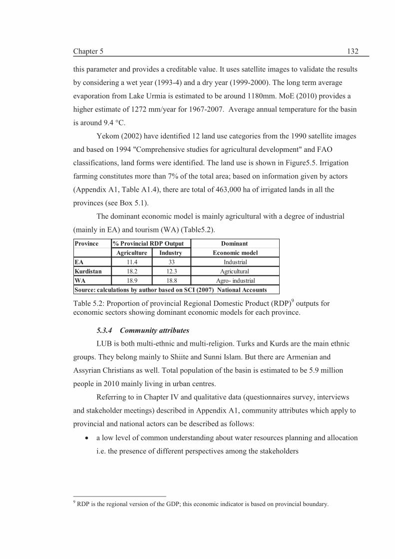
Chapter 5
132
this parameter and provides a creditable value. It uses satellite images to validate the results
by considering a wet year (1993-4) and a dry year (1999-2000). The long term average
evaporation from Lake Urmia is estimated to be around 1180mm. MoE (2010) provides a
higher estimate of 1272 mm/year for 1967-2007. Average annual temperature for the basin
is around 9.4 °C.
Yekom (2002) have identified 12 land use categories from the 1990 satellite images
and based on 1994 "Comprehensive studies for agricultural development" and FAO
classifications, land forms were identified. The land use is shown in Figure5.5. Irrigation
farming constitutes more than 7% of the total area; based on information given by actors
(Appendix A1, Table A1.4), there are total of 463,000 ha of irrigated lands in all the
provinces (see Box 5.1).
The dominant economic model is mainly agricultural with a degree of industrial
(mainly in EA) and tourism (WA) (Table5.2).
Province % Provincial RDP Output Dominant
Agriculture Industry Economic model
EA 11.4 33 Industrial
Kurdistan 18.2 12.3 Agricultural
WA 18.9 18.8 Agro- industrial
Source: calculations by author based on SCI (2007) National Accounts
Table 5.2: Proportion of provincial Regional Domestic Product (RDP)9 outputs for economic sectors showing dominant economic models for each province.
5.3.4 Community attributes
LUB is both multi-ethnic and multi-religion. Turks and Kurds are the main ethnic
groups. They belong mainly to Shiite and Sunni Islam. But there are Armenian and
Assyrian Christians as well. Total population of the basin is estimated to be 5.9 million
people in 2010 mainly living in urban centres.
Referring to in Chapter IV and qualitative data (questionnaires survey, interviews
and stakeholder meetings) described in Appendix A1, community attributes which apply to
provincial and national actors can be described as follows:
· a low level of common understanding about water resources planning and allocation
i.e. the presence of different perspectives among the stakeholders
9 RDP is the regional version of the GDP; this economic indicator is based on provincial boundary.

Chapter 5
133
· low level of homogeneity in the preferences and priorities among national
stakeholders and the same is true among the provinces of the basin in terms of water
resources planning and allocation (later described as shown in Box5.1)
· lack of trust between different provinces and national and provincial levels e.g. lack
of flow of information among stakeholders
· there are disparity or inequality of basic assets among the provinces (e.g. disparity
in RDP or distribution water resources and so forth)
· the economic paradigms of the provinces are different (Table 5.2)
· local political influence has an important bearing on the dynamics decision-making
by the actors
This has created an environment of tension and high level of mistrust with
conflicting priorities due to heterogeneity of the social fabric of the community.
Figure 5.5: Land use in LUB (Source: Yekom, 2002).
Irrigated
farms
299,000
7%
Irrigated land/orchard
67,000
1%
Orchards/tree sets
184,000
4%dry farming
15,500
0%
Dry farming/rangeland
783,600
17%
Rangeland
2,912,700
63%
Forestlands
30,900
1%
Salt land/salt flat
123,700
3%
Satellite Wetlands
5,150
0%
Marsh vegetation
15,500
0%
Bad lands/highly eroded
128,900
3%
Others including urban
67,000
1%

Chapter 5
134
5.4 DPSIR assessment for Lake Urmia basin
5.4.1 Introduction
The DPSIR assessment results are given in Figure 5.6 and each of the components
are described in the following sub-sections. Given the centralised management of water
resources allocation, the DPSIR analysis in this section complements the DPSIR results in
Chapter IV.
Figure 5.6: DPSIR analysis at LUB level.
5.4.2. Drivers (Driving forces)
I938 Administrative Divisions (AD)Act was a turning point in establishing a form
of local government in modern Iran replacing the princedom divisions governed by the
1909 AD Act. These administrative divisions have been changing due to modified
legislations namely the 1960 and 1983 AD Acts. The old princedom divisions were
changed to provinces or 'ustans'. Administrative divisions are driven by political objectives
and depend on (i) demographic trends (population based), (ii) ease of communications and
transport and (iii) economic considerations. By gaining town or city status, the urban
institutions will gain much greater financial and political influence as the town of the city
Driving Forces
ResponsesNon structural
ü1983 Definitions and Directive of Administrative Divisions Act
üEstablishment of Governorates and local government
üEstablishment of Provincial and regional water companies
üDisseverment of regional water organisations to provincial companies
üEstablishment of Provincial offices of Management and Plan Organisation
Structural
üLarge investments in developmental projects
üDams and irrigation networks
Impact StatePressure
q 1938
Administrative
Divisions Act
q FYDPs
q Population growth
q Climate variability
/ droughts
q Land use policy
q Increasing Urbanization
q Increased Water demands in all
sectors
q Increase of return flow
q Increased groundwater
abstractions (Illegal surface and
groundwater abstraction)
q Increase of irrigation lands
q Water quality: Water source
pollutions e.g. pollution of
rivers; waste production; lack
of full sanitation services in
many urban and rural area
v Water shortage due to droughts
v Reduce rate of inflow into the
lake
v Increased reservoir storage
capacity
v Increased urban centres (500% in
ecological zone around LU
v Water shortage in some areas
v Groundwater over-exploitation in
some aquifers
v Increased percentage of irrigated
area,
v Decrease in pastures and wetland
area
v Increase use of fertilizers and
pesticides and discharge into
rivers and streams
v LU level decreased
v Decreased inflow into LU
v Sanitation discharge into rivers
and streams
Ø Significant fall in the population of the
Artemia (salt lake Shrimps) which lead
to the drop of the number of migratory
birds, e.g., flamingos
Ø LU desiccation and lower lake level
Ø Loss of wetland
area/habitat/biodiversity
Ø Negative groundwater recharge in some
aquifers
Ø Salinsation of irrigated lands (water
logging)
Ø Environmental degradation of rivers by
pollution
Ø Conflicts over river basin water
allocation shares (provincial and cross
cultural tensions)
Ø Regional economical imbalance
Ø Unsustainable development
Ø LU hyper-salination

Chapter 5
135
will be included in formal development and fiscal planning. So, urbanism10 is a major
driving force in local politics.
Cottom (1999) believes that nationalism did not have a strong base among the Azeri
and Kurdish minorities of Iran but the ethnic and cultural identities remain very strong
especially among the Kurds. Thus, both Azerbaijan and Kurdistan have a turbulent
historical past. In the aftermath of World War II, local dissidences from central rule were
registered with the inauguration of the short lived Republic of Azerbaijan and the Kurdish
Mahabad Republic which were crushed by the Imperial Army of the Shah in 1949. Despite
having comparatively small publicity, the 1945-8 Azerbaijan crisis was an important event
in modern world history: as Hess (1974) noted, it was the start of the 'Cold War' between
USSR and USA.
Internal boundary changes show a degree of political instability (Ahmadipour and
Mansorian, 2006). The political instability is perhaps due to complex ethno-religious
distribution which makes the idea of integrated Iran postulated by Reza Shah Pahlavi
(1887-1944) a very difficult aim to achieve. The cost of this integration has been multi-
dimensional including environmental degradation and unsustainable water resources
developments. Much of developmental projects have not performed well due to the
disparity created by the administrative divisions due to imbalance of power distribution
(Farzanegan, 2001). As a result, different economic paradigms have evolved (Table 5.2)
EA is more industrialised compared with WA and Kurdistan. The latter is less developed
compared with both EA and WA.
Population growth has been phenomenal since 1976 (Table 5.3). Yekom (2002) has
made a detailed analysis of the demographic trends in LUB. They suggest that rural
communities are in decline despite vast agricultural developments. However, in areas such
as Mahabad sub basin, rural communities have increased (WRI, 2005)11 and so this sort of
generalisation is misleading to an extent. Also, the definition of ' city' or 'town has changed
with the passage of time (see e.g., Fanni, 2006). The AD Act now requires a city to have a
municipality. But previously, a city was considered to have a population of 5000 people. In
recent times, it seems that MPs and Presidential Candidates have used AD Act for their
convenience and has been included in manifestos of MPs.
10 Urban way of life provides access to a wider socioeconomic and political sphere- traditionally; rural areas are associated with peasantry and non-political community. 11 This module of the project was carried out by Pandam Consulting Engineers under the heading water for environment; thus Pandam prefers to be cited as (Pandam, 2005).

Chapter 5
136
Table 5.3: Population trends in LUB.
Climate variability/droughts. Much of the discussion in Chapter IV about climate
variability and change is applicable here but at provincial level, greater reference is given to
droughts. Partly, this is because droughts attract central treasury funds as part of the
'Emergency and Crisis Management' package. The official position of MoE is based on
attribution analysis made for year 2000 which was a severe drought year (this will be
described in chapter VI) which suggests that in year 2000, 67% of the Lake's decline is due
to droughts, 27% to recent developments (i.e. abstractions) and 5% as a direct impact of
dams (Namjo12, 2009; MoE, 2010b). As shown in Figure 5.7, the rainfall series for 1969-
1994 exhibits an upward trend whereas downward trends are observed for 1995-2010.
Therefore, trend analysis might be inappropriate approach to formulate an understanding of
the hydrologic and climatic regime of Lake Urmia basin which shows a large degree of
variability. We will return to this theme in Chapter VI.
Despite this concern and MoE's strong environmental inclinations since late 1990s,
water resources planning have been sectoral in approach and pro-development. The change
of attitude (i.e. considering climate change in planning matters) by MoE is marred by the
question of the uncertainty about data (mainly hydrological data) resulting in the
polarisation of opinions on both sides of the argument (see e.g. Roe, 1994). There is a
discrepancy between MoE and IWRMC’s database mainly due to a disagreement between
MoE and IWRMC about the feasibility of some of the proposed development plans as well
as some of the small dam projects are funded through provincial budgets and may not be
listed on the MoE database. It is interesting to note that none of the dams have Water
Allocation Permits.
12Majid Namjo is the current Minister for Energy.
Year Population Cumulative
Rural Urban Total increase %
1976 1,440,731 1,223,338 2,664,069 0.0
1986 1,565,892 1,565,892 3,131,784 17.6
1996 1,607,845 2,750,724 4,358,569 63.6
2002* - - 4,800,000 80.2
2010** - - 5,900,000 121.5
Notes
*estimated
** provided by provincial stakeholders in 2010
Source Yekom (2002)

Chapter 5
137
Figure 5.7: Precipitation trends for 1969-1994 and 1995-2010 periods based on MoE discourse on climate change (Source MoE, 2010b)
MoE is trying to use the climate change discourse (see Chapter IV) to resist
additional provincial water resources development applications as demonstrated by
Namjo13 (2009) who wrote to the Governor of EA that the current demands for more dam
building are not tenable mainly due to the climate change. However, RWCs have taken a
provincial perspective and implicitly have been on the side of MPs and governors to “get a
better deal14
” for the provinces (Source: Questionnaire survey, Appendix A1). The
differences between MoE and RWCs priorities have been detrimental in terms of
implementing effective water resources planning and allocation. So, despite introducing
Responses such as the 2003 Water Allocation Directive (WAD) (as described in Chapter
IV), no integrated planning and allocation has been made15.
FYDPs. In 1970, the first major dam came into operation in LUB i.e. Mahabad dam
which is situated in a city that bears the name of the Kurdish Republic led by Qazi
Muhammad. 40 years later, there are 37 dams in operation in WA and EA (Figure 5.8).
Kurdistan and WA has been less fortunate in the “hydraulic mission”16 as they were
embroiled in the Kurdish autonomy movement after the demise of Shah. The political
instability was further heightened by the Imposed War17 (1980-88). On the other hand, EA
was able to capitalise on low exchange rates and went on a development spree according to
13 He is Deputy Minister of Energy for WRWW. 14 I.e. to get more water allocation for the province. 15 Responses such as legislation will be analysed in Section 5.5. 16 This terms used by Allan (2005) to describe a demand driven water management paradigm involving building hydraulic infrastructure as described in Chapter II and will be discussed further in Chapter VII. 17 Iraq-Iran war is known as the 1st Gulf War. It is commonly agreed that Iraq started the war and so in Iran is known as the Imposed War (1980-88).
y = 0.6485x - 935.66
R² = 0.0041
y = -0.604x + 1527.6
R² = 0.0016
0
100
200
300
400
500
600
1960 1970 1980 1990 2000 2010 2020
P,
mm
Year
P, 1969-1994, mm P, 1995-2010, mm
Linear (P, 1969-1994, mm) Linear (P, 1995-2010, mm)

Chapter 5
138
some Kurdish politicians (Table A1.4, 2010). This perspective is very strong in Kurdistan
and WA. However, WA has now taken over EA in terms of its development drive but have
an extensive program to catch up. 12 dams are under construction with 1235 MCM
regulated capacity (IWRMC, 2011). FYDPs drive the infrastructure building programme
and hence remain the most important legal framework with respect to water resources
planning and development.
Figure 5.8: Number of existing dams (red line) and new modern irrigation network area (blue line) for the period 1969-2010:showing a rapid growth in the number of dams but irrigation networks has lagged behind; the graph is misleading to suggest that over one 1 nearly 80,000 ha of land was developed; this perhaps shows the capacity for Mahabad dam which came to operation in 1970; therefore the green line (drawn by the author) is postulated to show a realistic representation of irrigation development: the expansion began after the Imposed War specially after the 2nd FYDP.
Pro development arguments have won since water sector performance is judged by
the level of achieving FYDPs i.e. how many dams have been completed. In addition, there
is a tremendous political lobbying by provincial governors and MPs to provide economic
incentives to their constituents.
Land use policy. The politics of irrigation and “hydraulic mission” (Allan, 2005)
have dominated the policy sphere in LUB but with not much physical success (see Figure
5.8). Water resources planning have emphasised securing more water for agriculture but
irrigation and drainage network constructions have lagged behind dam-building. There are
many dams without even primary networks. The land use policy on the other hand, has
resulted in loss of wetland area, increase in reservoir (dam) area and loss of rangelands.
0
5
10
15
20
25
30
35
40
0
20000
40000
60000
80000
100000
120000
140000
160000
180000
1965 1970 1975 1980 1985 1990 1995 2000 2005 2010 2015
Cu
mu
lati
ve
No
. o
f d
am
s
Cu
mu
lati
ve
irr
iga
tio
n n
etw
ork
are
a,
ha
Year

Chapter 5
139
5.4.3. Pressures
Urbanisation explosion. The rate of urbanisations has been fast and Tabriz is
considered to be the 4th mega city18 in Iran. A 500% increase in urban land use in the
sensitive ecological zone around LU for the period 1990-2000 (Yekom, 2000) is a clear
pressure indicator. Inter-provincial conflicts have risen as a result of the increased
urbanisation and population growth. For example, Tabriz mega city (capital of EA) has a
population of over 1.2 million people. Tabriz's water supply is secured for WA's Zarinarud
dam which receives much of its water from Kurdistan. However, Tabriz is suffering from
water shortage and hence a second water transfer line is underway from WA (Sorkhab,
2010). But this has been opposed by the WA Governor. The project has been delayed
because foreign finance has not been found and there has been resistance from WA to the
proposed plans.
WA sells water to EA despite lack of formal water trading rules. The present
agreement to deliver water to Tabriz can be regarded as water trading between provinces.
In informal interview meetings with both EA and WA stakeholders, the idea was not
paradoxically popular (Appendix A1, Table A1.5).The implication is that they have to buy
from Kurdistan. Nevertheless, participants from Kurdistan thought that there is a clear need
to establish water trading rules or legislation to ensure equitable use of the resource and
reduce the provincial conflicts.
Increased demand. Hashemi (2008) reviewed much of the recent secondary data on
water demands (e.g. Yekom, 2002, 2005; WRI, 2005 and Jamab, 2007) but there is lack of
adequate information about water demands. However, they all agree that most of water
demands come from the agricultural sector i.e. 94% compared to 5.6% for drinking and
0.4% for industry. Water use efficiency in irrigation is very low (less than 30%) (Table
5.4).
Agricultural water use is virtually uncontrolled: 87% come from groundwater
resources owned by mainly private well owners and most of surface water is abstracted by
traditional water rights. However, drinking supply is a cause of heightening future conflicts
as in the Tabriz case.
18 Mega city means a population of more than 1 million people

Chapter 5
140
Urban
waste
Agriculture Drinking Industry Total (Tons)
SW GW SW GW SW GW SW GW
4022 313.117 44.057 4379 957 451.5 36.4 116.18 16.85 10.25 1010.5 677.68 986,799
note:
GW: Groundwater, SW: Surface water
Agriculture Drinking Industry Total
Water demand, MCM Return Flows, MCM,
Table 5.4: Water demand based on Year 2001 and return flows (Jamab, 2007).
As stated, MoE (2010b) has found that 27% of abstractions are due to new mainly
agricultural development based on trend method analysis. Unfortunately, there is no clear
statistical data of consumptions to be able to draw an accurate trend. Nevertheless, the
increases in demands have been noticed in all the sectors. Most of the major national
studies (Yekom, 2002, WRI, 2005, Jamab, 2007) have estimated water demands for the
basin with different methodological approach and periods.
To deal with increased demands, MoE is using the climate change discourse based
on several main narratives:
1. risks due to climate change and drastic climatic variability in the basin;
2. agricultural water demand has to be re-assessed in the re-allocation process;
3. “water for environment” should be emphasised; for example, Lake Urmia
have not featured in Water Master Plans; and
4. resources are limited: i.e. we cannot allocate water based on average
conditions or normal conditions because of the climatic variability and
change
However, policymakers have not been able to formulate real solutions to the
problem underlined in the above discourse. Irrigation efficiency has been postulated as a
way to save more water for the environment but in practice, farmers tend to use extra water
to irrigate more land; and in fact the land policy has favoured this option. It is interesting to
note that lower irrigation efficiency has meant that the return flow has been ‘beneficial’ as
inflows into LU. Without the return flows, LU would be in serious problems.
Localised groundwater overexploitation and pollution. Groundwater resources
supply 45% of the total demand; of which 87% is used for agriculture (WRI, 2005). Most
of the aquifers are in normal conditions have a prospect of further development by about
150 MCM according to WRI (2005). However, several northern and eastern aquifers suffer
from continuous lowering and negative recharge as shown in Table 5.5. Nearly more than
65% of the abstractions return to the system with much less quality and hence put pressures
on the WRS.

Chapter 5
141
Aquifer area Province Average annual groundwater lowering (m)
Unit Hydrograph duration (year)
General condition of water table
Salmas WA -1 7 Continuous lowering
Ajabshir EA -0.4 13 Continuous lowering
Tabriz EA -0.1 12 Negative recharge
Azarshahr EA -0.1 10 Negative recharge
Bilverdi-Duzozan
EA -0.4 5 Continuous lowering
Sufian-Shabestar
EA 0.45 8 Continuous lowering
Tessuj EA 1.4 7 Continuous lowering
Table 5.5: Major aquifers with negative groundwater recharge and continuous water table lowering (Source: WRI, 2005).
Return flow and wastewater from settlements (urban and rural) agricultural,
drainage and industrial sites (Table 5.4) are increasingly an important component of water
resources management in LUB. They form a large portion of the basin’s water cycle. There
is consensus that in future, these return flows constitute a large segment of the renewable
water resources with an increasing role; hence, there is a need to include this factor in the
strategic planning and integrated management of the water resources.
A third of the agricultural water demand and more than 2/3 of the water supply,
sanitation, industrial and mining sectors return to the system and in many cases cause
environmental degradation of the water resources (Jamab, 2007).
WRI (2005) notes that the amount of water required for sustainable management of
the satellite wetlands (e.g. about 15 MCM for Mahabad sub basin) is negligible and can be
obtained from return flow without impairing agricultural developments and irrigations
schemes. However, this is not true for the survival of the Lake. In the case of the Lake,
abstracted water reduces inflow into the Lake and hence has a direct impact of the
sustainability of its biodiversity and environment.
Land use change in the urban, industrial and farming sectors have been a source of
pressure on water resources system. For example, some of the pressures to the satellite
wetlands are (WRI, 2005 based on Pandam, 2005): (1) conversion of the wetland habitat
into cultivated land, (2) increased pollution from agricultural fertilisers and pesticides
causing eutrophication and degradation of the water quality, (3), disturbance of wetland
wildlife and (4) overgrazing in the basin. For example the trends in land use changes in the
ecological zone during 1990-2000 (Yekom, 2002) are shown in Table 5.6.

Chapter 5
142
Table5.6: Land use/land covers change of the Ecological Zone, 1990-2000 (Yekom, 2002).
5.4.4. States/Impacts:
Lake Urmia (LU)’s physical and biochemical indicators. Lake Urmia is situated at
the extreme downstream of all the river watersheds in the basin. Therefore, the lake itself is
a good indicator for both the State of the ecosystem and the Impact of the water resources
planning and abstraction. Since mid-1990s, two major droughts were experienced (1999-
2001 and 2007). LU's water level drops started in 1995 which coincided with the
introduction of 2 dams. The droughts have heightened the water shortage problem and
some fear that LU will slowly be desiccated. Another Aral Sea is looming in Iran's most
celebrated and historic lake. The State of the LUB ecosystem and the Impact on the water
resources system is shown in Figure 5.9 which simplifies a complex set of dynamic and
complex interactions within the ecological, geological and hydrological dimensions of the
system.
Land use/land cover Area (ha) Area (ha) Area changed
(ha) 1990-2000 % change 1990-2000
1990 2000
Irrigated land 116870 128220 11350 9.7
Orchard and tree sets 46060 47420 1360 3
Mixed agriculture/orchards 14730 23140 8410 57.1
Mixed range/dry farming 37760 38420 660 1.7
Rangeland1 233170 123290 -109880 -47.1
Salt land/salt flat2 115320 231540 116220 100.8
reservoirs/fishponds and
artificial wetlands3
2470 8880 6410 359.5
Lake Urmia 523940 483300 -40640 -7.8
Others 2890 15200 12060 426
Total 1093210 1099410
Notes:
¹ The trend of changes was not determined due to the lack of information
² The area of rangeland and salt lands and their corresponding changes during 1990-2000 are
for the northeast of the Ecological Zone
³ Wetlands in the Mahabad and Gadar chai sub basins which were completely desiccated out equal to 2085 ha

Chapter 5
143
Williams (2002) highlights five major human induced factors affecting (usually
with an adverse impact) salt lakes as follows (Table 5.7): (1) surface inflow diversions
which will affect both the physical (volume, water level) and chemical (salinity)
characteristics of the salt lakes - permanent salt lakes are more inclined to be affected by
surface inflow diversions as well as catchment activities; (2) catchment activities such as
(a) secondary (or anthropogenic) salinisation caused by leaching of salt deposits in the
catchment of the salt lakes; (b) soil erosion, (c) groundwater pumping and (d) urban
development; (3) salt-mining mostly affects dry lakes; (4) pollution especially from
wastewater and agriculture and (5) anthropogenically-induced climatic and atmospheric
changes as climate models predict that the aridity of arid regions will increase. This means
that the temporary salt lakes will be drier for longer periods and permanent lakes will
become smaller and saltier (Williams, 2002). Based on these five factors, LU is compared
to Aral Sea, which is a permanent salt lake on the brink of extinction (Table 5.7). LU has a
striking similarity with the Aral Sea as most of the water use is in the agriculture sector.
Increase storage capacity. Permanent lakes, such as Aral Sea and Lake Urmia, have
been affected by the diversion of surface water (by dams) mainly for agriculture. In the last
10 years, surface water diversion has affected the salt concentration and water balance of
the Lake. For a decade, inflow into LU has been in the order of a tenth of the average long-
term inflow. The precipitation in the basin has been on a downward trend. The salinity has
increased, which has caused the demise of the only organism in the Lake; namely Artimea.
Many birds, such as pelicans and flamingo, have lost their habitat and so the Lake is on its
death-bed, if the current situation persists.
The physiochemical characteristics of the Lake Urmia Lake are vital indicators to
assess the environmental, ecological status of the Lake. With regard to quality of the lake
water, past works have looked into 4 parameters:
1. Sedimentation in the Lake via inflowing rivers
2. The Electric Conductivity (EC)
3. The Total Dissolved Solid (TDS) rate
4. The dissolved salt (NaCl) (since this is an important factor for Artima's
reproduction-the only living organism in the Lake together with some green
and blue alga)

Chapter 5
144
Figure 5.9: The dynamics of the States/Impacts inter-linkage for LUB.

Chapter 5
145
Table 5.7: Human Impacts on Lake Urmia compared to Aral Sea.
The last 3 parameters are basically measures of Lake's salinity. The origin of the
salinity is well discussed by WRI (1995) which has been reflected in all the studies
including Yekom (2002, 2005,). According to researchers, LU has a history of 500
thousand years and the present Lake is 35-40 thousand years old. The ultra-saturated
condition had prevailed since 8-9 thousand years ago. There are two issues with important
consequences: (1) LU has a natural depth (cavity) without any exits for sediments and
dissolved particles. Therefore, after evaporation, all the solids are left behind; and (2) the
sediment loads mix with salt particles to form 90 m deep muddy layers at the bottom of the
Lake. Hence, it is concluded that the main source of salinity is from surface water inflows
into the lake.
Various consulting engineers and IWRMC reports indicate that the amount of
annual sediment inflow into the Lake is estimated as 5.3 million tonnes of which 40% is
conveyed by Aji Chai River, EA. The completion of many dam building projects is going
to affect the level of sedimentation into the Lake and will reduce sharply the amount of
sediments entering the Lake [off course it will reduce the amount of inflow as well]. EC is
the most common indictor used to establish the salinity of a water body. Due to a large drop
in the Lake's water level, EC of the Lake has risen sharply. EC depends on internal ionic
movements of the dissolved salt but it is a function of surrounding temperature as well
Factors mining Pollution Biological
disturbances
Salinity
g/l
+ve Wastewate
r
500% in
sensitive
area
between
1990-2000
Solid
waste
Aral Sea **
(P)
- -20 m*** 10→>50 √ √ -ve Loss of
communitie
s
? wastewate
r
27 fish
species
extinct
No longer;
dust wind
?
Notes:
^ types of salt lakes, P= permanent; -ve= decrease; +ve= increase; √ adverse impact; GW= groundwater, UD= Urban Development; ?= unknown
* in the last 10 years, ** based on Williams (2002), *** at the end of 2002, Based on Yekon (2006)
√ -ve Not at this
stage-
coastal
retreat so
certain
pressure on
mining
Loss of
Artemia and
wetland
birds
-ve****, in
the
highlands,
precipitation
is affected
by the
surface area
of the Lake
?
Local
Climate
moderation
Utra-Violet
Urmia (P) 32→14
BCM
-6 m* 204→326 √
Surface water Diversion Catchment activities Climatic
Lake (types)^ Volume Lake level Salinisati
on
Soil erosion GW UD

Chapter 5
146
since temperature will affect molecular movements. The Average EC in the past 36 years
(1967-2004) has been estimated as 382,740 μm/ cm by Yekom (2005).
In the index period of 1966-2002, the average TDS has been 267 g/l according to
WRI (2005) study at the average water level. A value of 222.6 g/l is given for an index
period of 1993-2004 by the Yekom (2005). The maximum TDS of 362g/l was recorded in
February 2002. A recent TDS of 338 g/l was recorded in January 2008. This is above the
tolerance level of Artemia production. According to some reports as sited by Yekom (2002)
and Nazaridoust (2006), the Artemia cysts are unable to hatch when the NaCl (salt)
concentration is above 250g/l. Therefore; the ecological requirement (discussed in Chapter
VI) for salt level is 240 g/l.
The annual rate of salt inflow into the lake is estimated to be 2.2 million tons (WRI,
2005 and Yekom, 2005); some 54% (1.2 million tons) is from Aji Chie River. It is
estimated that 4.8 billion tons of salts are dissolved in the Lake. This is 2800 times more
than the annual inflow of salts via surface flows. There is a direct linear relationship
between the TDS value and the EC (Nazaridoust, 2006). With reduction in Lake's water
level, there is a corresponding increase in EC value of the Lake which is an indication of
the salinity of the Lake's water content.
Water quality dose not consist only of salinity related parameters as discussed
above. Additional water pollution indicators need to be considered in any assessment of the
quality of the Lake. Therefore, these indicators are important and paramount in the
application of IWRM and attainment of environmental sustainability criteria in the
management of the lake. At present, it is unfortunate that there is no baseline data on
pollution indicators which is a major information gaps with regard to water quality of LU.
5.4.5. Responses
In Section 4.4.4 in Chapter IV, the main Responses and policy options were
discussed and are not repeated here. Therefore, this section is complimentary to the
discussion in the named section.
Emergence of new governance system. The modern state required new
administrative divisions to move away from Princedoms (Ayalat) and small States
(Welayat) systems. So the Constitutional Revolution (1905-9) started the process. Figure
5.10 shows the evolution of a new governance system with reference to LUB. However, as
shown in Figure 5.10, the development of water administration has lagged behind the

Chapter 5
147
political administrations. This shows that the new governance system did not include water
planning and allocation management.
Formal water planning administration came into existence in 1943 with the
establishment of the Independent Irrigation Agency (the Bongah). This was an attempt to
manage the water resources planning process. With reference to Figure 5.10 it can be
deduced that
· There has been a mismatch between the establishment of political administrational
and water administration.
· Water resources planning have gone through 4 phases. The administrative evolution
has been driven by 1959 Water Resources Blueprint which envisaged a programme
of water (dams) and land (irrigation) development. The Development Council and
Plan and Budget Organisation were responsible for these plans initially and so the
Bongah was established to oversee the developments. Hence, administrative
changes were born based on political considerations outside the water resources
domain.
Figure 5.10: The timeline for the development of provincial administrative divisions and respective water administrations with reference to water resources planning and allocation.
· The drastic disparity and mismatch is illustrated by the development of water
management institutions in LUB. East and West Azerbaijan provinces were
established in 1937 whereas Kurdistan province was established in 1958. Both
Azerbaijan had some sort of regional water company since 1960s but Kurdistan
Year 1900-9 1910-19 1920-9 1930-9 1940-9 1950-9 1960-9 1970-9 1980-9 1990-9 2000-9
Provincial AD
development
1906
Constitutional
Law
1921 End of
QaJar Dynasty
and start of
Modern State
1937
Administrative
Law, EA and
WA Provinces
established,
Kurdistan part
of Western
State
abdication of
Reza Shah in 1941
, 1945-1948
Azerbaijan Crisis
and no local
government
1958 Kurdistan
province
established and
separated from
Kermanshah
jurisdiction
1960 amended AD
Law
1979 Islamic
Revolutions and
end of Pahlavi
Dynasty
1983 AD Definitions
and Regulations Act,
1980-88 Iran-Iraq War
greater
urbanisation rate
888 citied in 2001
compared with 338
cities in 1976
(Fanni, 2006)
Water
resource
planning and
provincial
water
administration
development
1943
Independent
Irrigation Agency:
first formal water
resources
planning, 1948
1st SYDP
1956 Khuzestan
Water and Land
Plan ; 1959 Water
Resources
Blueprint
Milestone: 1963
Water and Power
Ministry; Regional
Water and Power
Organisations
1972 Western
Development
Company in
Kurdistan, 1974
Ministry of Energy ,
EA and Ardabil
Regional Water
company, WA
Regional Water
company
1980 Western
Regional Company in
Kermanshah replaced
Western
Development
Company in
Kurdistan 1982 Fair
Water Distribution
Act, comprehensive
water planning and
management law,
1989 1st FYDP
milestone: 1990
Water and
Wastewater
Companies
2005, Regional
water companies
were dissolved to
create provincial
companies, 2006
Kurdistan Regional
Water Company, EA
Regional Company
was established
(Ardabil became
separate)
Traditional water management , no
coordinated water planning, 1929 Qantas Law
Phase I: no national and provincial water
resources planning and allocation
Phase II: Towards co-ordinated water
resources Planning and allocation
Phase III: consolidation
period Phase IV: Towards IWRM
Chapter 5
148
Regional Water Company (KRWC) was established in 2006. Therefore, in past,
Kurdistan has not been considered to be a major player in LUB. This current tension
between Kurdistan and WA water allocations to Kurdistan from existing Zarinarud
dam has a historical dimension. Despite supplying more than 85% of the dam's
water, Kurdistan has a small share of the allocation.
· It can be said that both Azerbaijanis and Kurdistan share a turbulent history and so
has been influenced by non-water policies. For example, in 1980, Western
Development Company which was based in Kurdistan was moved to Kermanshah
under the name of Western Regional Water Company (WRWC) "due to political
situations and a Decree by the Supreme Revolutionary Council"19.
· After the revolution, administrative changes continued to be motivated by the old
Pahlavi vision of modernisation and development until late 1990s when the
concepts such as IWRM and sustainable development were adopted in national
policy and legislations. However, opinions and perspectives within MoE have been
without consensus. The political drive for decentralisation and privatisations has not
been reflected in water administrative change.
· In 2004, some of the remaining regional water companies were broken into
provincial companies. WRWC was dismantled to form 5 provincial companies
including Kurdistan Regional Water Company (KRWC). So, a dual policy has been
pursed: IWRM and the concept of river basin as a unit at national level in
conjunction with provincial water management at regional level. This related to
power relationship between governors and the regional water companies: on the
one hand, regional companies such as WRWC were not accountable to provincial
officials i.e. they had a larger jurisdiction than the political boundary of a province
and felt more powerful. On the other hand, provincial representatives of regional
companies did not have the ranking status as director general enjoyed by other
governmental departments; thus in the case of WRWC, Kurdistan's local
representative as well as Hamadan, Ilam and Lorestan wanted to gain more power
and independence from Kermanshah-based WRWC. Kurdistan has felt that there
has been a degree of discriminations in terms of water resources planning and
allocation due to their downgraded status. Hence, the discourse is that the new
KWRC is in a better place to take care of the province's interest. According to this
19 This is mentioned in the website of KRWC.

Chapter 5
149
Box 5.1: Regional agriculture development plans
· Kurdistan: currently have
19,000 ha irrigated area; future
plans: orchards: 20,000ha,
irrigated lands: 40,000 ha
· WA: currently have 189,200ha
irrigated area; future plans:
orchards: 40,000ha, irrigated
lands: 162,600 ha
· EA: currently have 265,000 ha
irrigated area; future plans: an
increase of 3.5% (9300 ha per
year) in the last 7 years.
Source: Appendix A1, Table A1.4
notion, home-grown (local) mangers are more accountable and act more
responsibly. This discourse has been encouraged by political manifestos which
promised local rule and managers in the provinces e.g. this issue was part of the
2009 Presidential Manifesto20.
The non-structural response in the water sector has been partially based on the
needs to carry out the structural response programme but the geopolitical factors have
played a major role in shaping the institutional set up. Administrative divisions are
unavoidable due to population growth and economic realities but they should take a holistic
approach by considering environmental, transportation, tourism, agriculture, energy and
water demands, commerce and security aspects within the macroeconomic planning and
development strategy (Farzanegan, 2001).
The structural Response has been based on agrarian policy of food security and
more irrigated area (described in Chapter IV). As
noted earlier, most of the large dams have been built
or under construction. The dam building in LUB has
been marred with financial difficulties and hence the
progress made by some projects is under par.
Agricultural development plans for the provinces are
based on increasing more irrigated land (Box 5.1).
EA is leading the provinces and in the last 7 years an
average of 9300 ha has been developed each year.
WA is planning to develop a further 202,000 ha and
this requires nearly 4000 MCM of surface water.
Kurdistan is lagging behind and has no dams in operation and no irrigation and drainage
network in place. It seeks to develop a further 60,000 ha. IWRMC (2011) recognised that
by year 2016, irrigation networks will be around 324,000 ha after the completion of the 12
dams.
There are many important questions to be considered: (1) are there adequate water
resources for these expansion plans? (2) Are these plans within the framework of
agricultural sustainability and IWRM? (3) What criteria have been used in these plans? (4)
What are the impact of climate changes and other anthropogenic drivers? (5) Can LU and
20 Section 2.8 of the 9th Government Plans available on http://www2.irna.ir/occasion/dolat9/index.htm

Chapter 5
150
the satellite wetlands survive after implementing these plans? Lake Urmia has entered a
very critical stage; its demise is a distinct possibility as graphically shown in Figures 5.11
and 5.12; the lake has shrunk to half of its size. None of the stakeholders could have a clear
answer to the above questions which indicates that the plans did not consider the IWRM
and sustainability approaches. Thus, the sustainability of these plans is doubtful. Therefore,
revised Responses are required to deal with the imbalance created by the “hydraulic
mission” in LUB.
Figure 5.11: Farming at the Coast of the LU; up to 7 km coastal retreat is shown (25 May 2009, Mahabad-Urmia Motorway; photo by Mukhtar Hashemi).
New rules. Referring to Section4.4.4, there are two main legislations in water
planning, management and allocation including
· The 1982 FWD Act which aims to empower MoE to become 'the guardian'
of both groundwater and surface waters and
· The2003 WAD which has given responsibility to Water Policy and
Allocation Commission (WPAC) at MoE to make allocation decisions based
on simulation and modelling of the water resources at basin or sub-basin
level. It requires legally using system dynamic modelling and this in itself is
an innovation. We will return to this theme in Chapter VI.

Chapter 5
151
Before year 2003, water allocation was based on proposal applications by regional
companies indirectly to the commission via the Planning and Development Deputy Office,
IWRMC. Hence the 2003 WAD aims to reverse the provincial perspective to water needs
(or demands) and to have a river basin approach.
In reality many decisions have been made about dam buildings in the WPAC
without upholding the 2003 WAD. Some have ignored the commission altogether by
building dams without any allocation decisions. Therefore, much customary rules in use
have prevailed and RWCs have not been able to implement the formal rules. There are
three important elements: (1) unauthorised abstractions of both groundwater and surface
waters have been rife; (2) according to the WPAC "no dams in LUB have formal Water
Allocation Permits (WAPs)" (Appendix A1, Table A1.4) and (3) groundwater overdraft has
continued and RWCs have not been able to cap the consumption of legal permit holders.
The institutional set up has failed to sustainably manage water resources in LUB; e.g. MoE
has been unable to manage water resources during the LU crisis and the sharp drop in its
levels (Figure 5.11 and Figure 5.12).
Figure 5.12: Lake Urmia coastal retreat (Photo by Mukhtar Hashemi).
Concluding remarks. The DPSIR analysis in Section 5.4 shows that despite
introducing the 2003 WAD, MoE has failed to implement a sustainable water allocation
strategy in LUB. In the next section, an institutional analysis is made to better understand
the process of water allocation in the period from 2003 till the period leading up to the
MoU agreement in 2008 in the path towards IWRM.

Chapter 5
152
5.5 Institutional analysis: The efficacy of the Responses on water allocation
decisions for the period 2003-2008
5.5.1. Introduction
With reference to Figure 3.13 (Chapter III, p.82), the focal level of water allocation
decision analysis is at multitier action arena and action situations; Figure 5.13 shows the
focal point of analysis used to make an assessment that why water allocation institutions
failed to implement the IWRM paradigm after its introduction.
Figure 5.13: Conceptual focal point of analysis.
Earlier parts of Chapters IV and V (as indicated on Figure 5.13) providea detailed
account of the characteristics of the national and provincial attributes using combined
DPSIR-IAD approach. In this analysis, we concentrate on the rules in useusing IAD
analytical approach. First, the rules in use in described in Section 5.5.2 and then their
vertical integration in multi-level decision-making are outlined.(Section 5.5.3) Water
allocation interactions in pre 2008 period is evaluated (Section 5.5.4) followed by an
assessment of the efficacy of the rules in use at constitutional, collective choice and
operational decision-making levels in Section 5.5.5.
5.5.2 Rules in use
The main rules in use are given in Figure 5.14. Before 1943, there was no specific
water allocation law. Customary water rights existed and users freely used water resources.
In 1909, The Civic Code introduced laws governing property rights which included well
Evaluative
Criteria/Eficacy of rules in
use
Actors/
Section 5.3
Action
situation/
2003-2008
water
allocation
process
Outcomes: Response (t) i.e. 2008 MoU
described in Section 5.1
Patterns of
Interactions: path
towards IWRM
Section 5.5
based on Ostrom, 2005
Rules-in-Use
are part of
Responses
To be
analysed in
Section 5.5.
Contextual
setting
attributes
Sections 4.3
and 5.3
Contextual Setting
D-P-S-I and R (t-1)
within
Socio-political context
and Discourses
Narratives
Section 4.4 and 5.4
ETHICS
IWRM
Action arena
LUB

Chapter 5
153
and qanat (groundwater rights) ownership. The first water law came in 1929, the Qanat
Law which again was an attempt to control the use of qanats. The Civic Code was updated
in 1989 and is still in force.
In 1943, the Bill for the establishment of the Irrigation Bongah was established to
control the use of surface water resources and to bring in some sort of order to a
disorganised water sector. However, water allocation was based on property (land) rights
with no implicit reference to centralised allocation process. The dominant perspective had
strong economic and institutional (political) dimensions. The FYDPs were a driving force
towards both economic reconstruction and institutional (organisational) change. Laws were
brought in as a result of this economic and political perspective.
In 1968, The Nationalisation of Water Act was a first major step to have a central
control over water allocation. This allowed water charging for distribution of water
(drinking and industrial as well as irrigation). The water charges were nominal. Provincial
water companies were established in mid 1960s but they did not have a control over water
allocation. However, informal rules were prevalent and water allocation was based on
riparian rights. Major dams were built and this meant that agricultural corporations were
formed to sell water for irrigation. Water allocation for newly built irrigation networks and
agro-businesses in the 1970s was enforced centrally. But, this represented a small
percentage of water abstraction.
Formal Water allocation rule was specified by the 1982 FWD Act. Since 1983,
there has been an attempt to control water allocation by the central authorities.
Accordingly, MoE is responsible for water allocation to each sector and province. Intra-
sectoral allocation will be made by each sectoral institution; for example agricultural water
quota will be given to MoAJ to allocate for its sector. However, all water abstraction
permits should be obtained from MoE. The 1982 Act specifies priories for water allocation
in the following ranking order: drinking, industrial, agriculture and environment. In 1990,
the Bill for creating water and wastewater companies was passed and gave these companies
the power to obtain water quota and then distribute to the households and industrial
customers. The Majlis produces a Water Charging Bill every year and controls highly
subsidized water prices. In 1998, the Bill for establishing rural water and wastewater
companies were passed but lacked any real financial investments to make inroads in the
rural area. However, this attempted to control water allocation in rural area by tagging a
subsidised price to water supply in rural areas. In this period, MoE gradually fastened its

Chapter 5
154
control over water allocation but the main problem remained to be groundwater resources
which were mostly owned by private well owners. The wells are provided with Water
Allocation Permits. However, there are considerable number of unauthorised wells in
addition to informal or unauthorised abstractions from unregulated rivers and streams as
well. Information about unauthorised wells is not public and RWCs sometimes hide this
information from MoE (Appendix A1, Table A1.5)
In 2000, the Bill for establishment of MoAJ created some confusion about the role
of MoAJ in agricultural water allocation. Article 11 asks for an inter-sectoral cooperation
and agreement between MoE and MoAJ for agricultural water demand, supply, utilisation
and distribution. In the meantime, MoAJ and AJOs had built small supply dams and
petitioned MoE and RWCs for the required water under the legal umbrella of the
Agricultural Water, Water Supply, Reservoirs and Irrigation Network Directive. MoAJ
was supposed to create water user associations (WUA) in which the users, RWCs and AJOs
have a stake of 25%, 24% and 23% respectively. This rule has not been materialised.
Instead, RWCs established a limited number of WUAs which were 100% owned by the
RWCs.
2003 Water Allocation Directive. Article 11 of the MoAJ Bill, was very vague and
had produced tensions between MoAJ and MoE and their provincial subsidiaries. The 2003
Directive have moved from economic perspective to an environmental and physical
resources perspective. The 2003 Directive is based on river basin planning and allocation.
IWRM became the national policy and so, water allocation was supposed to follow the
IWRM principles. It requires the use of modelling tools to simulate the whole basin in
order to come up with water allocation strategy. However, the Directive fails to recognize
the provincial and inter-provincial water allocation conflicts and hence, the application of
the Directive has been limited so far.
Informal rules. In parallel to the formal set of formal rules, informal rules operate
in the form of
· a communal set of traditional water rights including groundwater resources
from private wells as well as traditional river stream rights ;
· unplanned water abstractions21 and
· unauthorised abstractions
21 For example due to sectoral and provincial planning, some of the water abstractions are not within formal planning framework

Chapter 5
155
Informal rules are important in two ways: firstly, as there are no effective provincial
and inter-provincial water allocation rules, informal rules are widely applied in the basin;
and secondly, the formal rules have been used to legalise informal or unauthorised
abstractions by issuing permits creating water rights for the users. Hence, any new water
allocation process involves highly sensitive issue of re-allocating the existing water
abstractions by the water users. This is a classic example of upstream and downstream
conflict.
5.5.3. The vertical integration of action situation and rules in use
Based on IAD component described in Chapter III, the interactions of rules in use
and action situations at multiple decision and analysis levels are shown in Figure 5.15. We
have to remember that the water allocation process is entwined with broader sets of rules
which are related to wider action situations such as planning process, utilisation of water
resources and so forth.
Water allocation decision outcomes which occur at the operational level action
situation not only monitored and sanctioned by collective choice rules but will be affected
by the attributes of the community and the biophysical world. Furthermore, the collective
choice rules are monitored and sanctioned by the Constitutional level rules. Water users
such as farmers have created informal rules which are based on customary laws, informal
water rights and sometimes unauthorised abstraction rules. These rules are not recognised
but decision-makers are aware of them. However, in most occasions, they are unable to
change these rules.
The “nesting of rules” (as termed by Ostrom, 2005) in LUB is complicated by the
fact that water allocation outcomes which is an operational decision is made at national,
provincial and local levels and hence poses a serious challenge and is a source of conflict.

Chapter 5
156
Figure 5.14: Rules in use.
The evolution time of constitutional rules such as 1982 FWD Act are longer and
they cannot easily be modified. The collective choice rules are easier to redefine and
modify. In the case of FYDPs, this is a five year plan and sometimes By-laws are added to
it during its implementation. Operational rules are also slow to modify and sometimes the
explanatory and procedural Codes are produced much later. For example the Water
2003 Long Term Water Resources
Strategies (IWRM) Plan
1982 Fair water
Distribution ActWater
Pricing Bill/
/ statuary
allocation
priorities 2003 Water Allocation
By-Law
Provincial
Level
National Level
Constitution, Water Vision, Council of
Expediency and Supreme Leader’s
Water Directive, inter-sctoral water
resources Management Directive
other relevant
Acts e.g. 1905
Civil Code
revised 1989
Provincial water
allocation
priorities/rights
outcome:
Provincial sectoral
water allocations
Rules in Use
2000 Bill for
Establishing
MoAJ
Local level
Outcome:
Local Formal
water
allocation
rights
Customary
water
rights
Outcome: informal water allocation
Note:
dotted lines indicate informal rules in use
4th FYDP
Provincial Development
Directive
Presidential By-
laws on
provincial visits
IWRMC Water
Allocation
Code
RWC Water Allocation
Code
informal Local Water Rights Rules
(illegal, unplanned or unhindered abstraction
rules)
Election
Political
manifestos
(MPs and
presidential )
MoAJ Water small Water
Supply, dams,
reservoirs and Irrigation
networks Directive
Credits Orders-
Annual Budget
Law
Water and
irrigation
project Plans
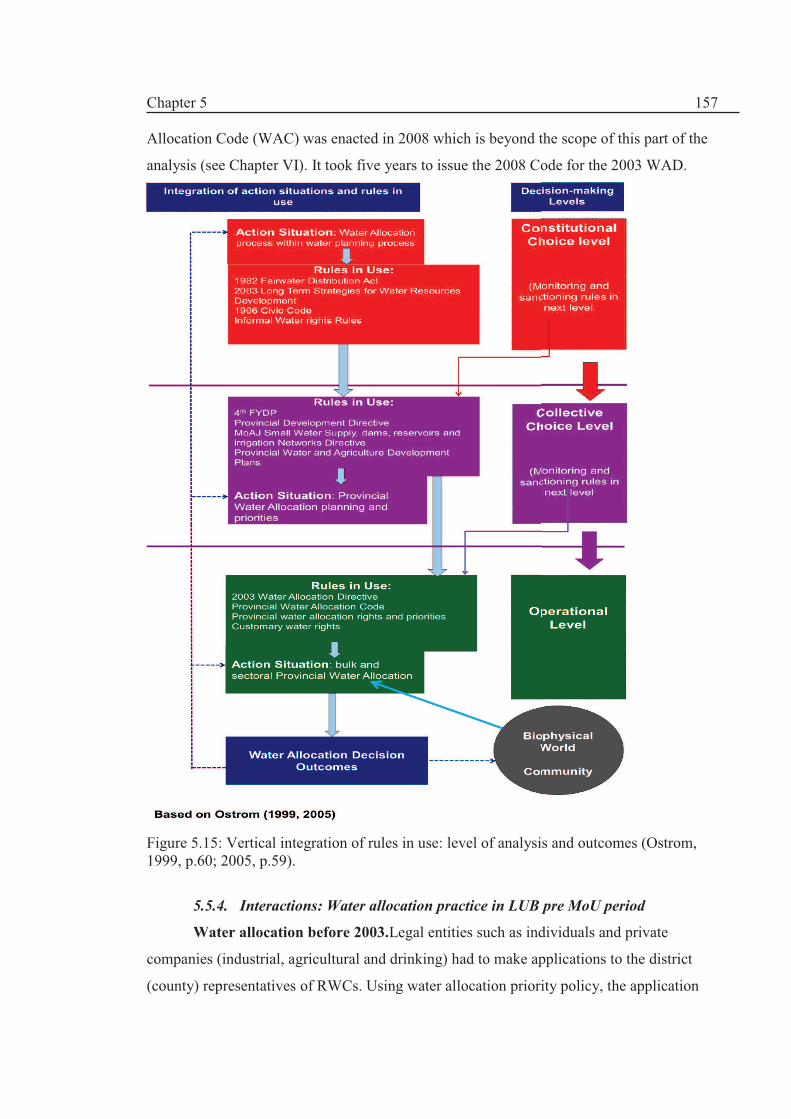
Chapter 5
157
Allocation Code (WAC) was enacted in 2008 which is beyond the scope of this part of the
analysis (see Chapter VI). It took five years to issue the 2008 Code for the 2003 WAD.
Figure 5.15: Vertical integration of rules in use: level of analysis and outcomes (Ostrom, 1999, p.60; 2005, p.59).
5.5.4. Interactions: Water allocation practice in LUB pre MoU period
Water allocation before 2003.Legal entities such as individuals and private
companies (industrial, agricultural and drinking) had to make applications to the district
(county) representatives of RWCs. Using water allocation priority policy, the application

Chapter 5
158
was approved given that the necessary documents and technical reports were submitted.
Ownership and property documents were the most important documents. This allocation
would have been in line with the quota given to each province. In this analysis, we will not
concentrate on individual water allocation; instead, provincial bulk surface water allocation
process is discussed.
Groundwater resources in LUB are mainly controlled by private landowners of
wells and qanats and hence, the 1982 FWD Act was an attempt to control groundwater
resources. Initially, private individuals and companies were offered a Water Allocation
Permit (WAP) without any strict criteria to encourage owners to register their share. The
wells did not have volumetric devices to monitor the implementations of the WAPs which
are oversubscribed. According to the participants (Appendix A1), there are many non-
permit owners which use groundwater resources. Basically, there is no policing mechanism
towards implementation of groundwater allocations.
Provincial’ bulk’ shares were determined according to water resources planning
and allocation proposals which were prepared separately by different economic sectors in
the province. RWCs made application to the Water Planning Bureau of the IWRMC. After
appraisal of the proposal by the technical committee it was sent to the WPAC for final
approval. Some of stakeholders (participants) were highly critical of the decisions made by
WPAC which according to them was biased and highly political (Appendix A1, Tables
A1.1- A1.3). However, due to inter-provincial conflicts, not much decision was made by
the Commission. But this did not stop provinces to ask for water allocation through their
water and agriculture plans. Some of these projects were provincial projects with provincial
Credit Orders and so did not need MoE’s approval. Some of these projects later become
national projects and were entitled to national Credit Orders.
EA was more successful than the other two to attract Credit Orders for their national
and provincial projects with Kurdistan being least fortunate. Kurdistan did not have an
independent RWC and was part of the Western Regional Water Company based in the
neighbouring province of Kermanshah. According to some participants (Appendix A1,
Table A1.5), a high level of mistrust between WAPC and RWCs was created. IWRMC’s
Water Planning Bureau also felt unease about the role of WPAC and the manner it dealt
with the backlogs of proposals which were with no decisions. Some of the stakeholders felt
that these projects “should be closed and finished” or “if water allocation was not possible,
WPAC should formally reject them” (Source: ibid). These tensions between two MoE

Chapter 5
159
subsidiary organisations have not hindered the will of the provinces to ask for more and
many proposals were sent. Water for environment was only met through unregulated river
flows. There was no formal consideration for environmental water allocation.
Local provincial water allocation was controlled by Water Allocation Departments
of the RWCs. First, provincial water resources plan was approved according to the
guidelines and the codes based on the rules in use and then allocation was made according
to the plan. Any conflicts of interest between different sectors were resolved in the
provincial Water and Agriculture Commissions
This period is characterised by lack of inter-provincial co-ordination in water
planning in LUB and each province tried to attract more projects with varying success to
have more bargaining power at a later date. Informal water abstractions (pumping from
rivers and streams, unauthorised wells etc.) were exercised in LUB. According to some
participants from Kurdistan, WA had exercised less control over the informal abstractions.
Local MPs and provincial governors (and district governors) were considered to be the
most influential players in “supporting the informal abstraction due to socio-economic
considerations” (Source: ibid).
Water allocation for period 2003-2008. The pre 2003 procedure has continued
despite the new requirement for a basin wide IWRM assessment made by the 2003
Directive. IWRMC’s Planning directorate has approved many provincial projects to be
approved by the WPAC. The Commission has reluctantly approved dam building planning
projects but did not issue any Water Allocation Permits. Many provincial projects have
easily obtained Credit Orders without the need for MoE approval so provinces have built
the infrastructure. Effectively, water allocation was not considered in these plans.
MoAJ 2003 Directive on small projects was a main driver for building small water
supply and irrigation networks under the management of AJOs. The Annual Budget Law
had financed such small projects and so there was a clear source of funding for these
projects which had an informal water allocation arrangement. Participants have stated
MoE’s unease about this sort of planning which was an added burden on the RWCs
(Source: ibid). MoAJ felt that building large dams are not suitable for agriculture and
hence, these projects were “value for money” and less damaging to the environment
(Appendix A1, Table A1.3). On the other hand, MoE felt that a comprehensive basin wide
water resources planning is needed as mentioned in the 2003 WAD (Source: ibid). The

Chapter 5
160
political wrangling between MoE and MoAJ continued while provincial RWCs and AJOs
were on good terms to attract more development funds for their respective provinces.
To conclude, the outcomes of this analysis can be summarised as follows:
· Emergence of new rules on water allocation and
· The inability of MoE to fully implement the rules e.g. 1982 FWD Act and
2003 WAD based on IWRM after six years of experience and deliberations
In the next sub-section, we will analyse the main rules in use affecting the
Interaction-Outcome pathway: (a) based on taxonomical framework for rules; and (b)
design principles which are described in Chapter III.
5.5.5. Need for revised Responses:
Need for comprehensive water law. The 1982 FWD Act (Table 5.8) was an
important piece of legislation with water resources allocation rules. Prior to this water
allocation rules were scattered and incomplete. However, the Act has several shortcomings.
In this section, the Act is analysed based on Ostrom’s (2005) classification of rules as
followings:
1. Boundary and position rules: Article 21 (Chapter IV) explicitly states that MoE is
‘solely’22 responsible for water allocation decisions as the main position rule. Water
rights were exclusively given to the State but the law implicitly acknowledges
private water entitlements ‘haqabe’23 and water users ‘abbaran’
24. Haqaba is
defined as a ‘consumption right’ which has to be rational25. The Act tries to avoid
the word of private water entitlements. But, it mentions that these rights are only
transferable with the transfer of lands. Chapter II extends the boundary rule to
encompass groundwater entitlements and provide a deadline for owners to register
and gain WAPs based on ‘rational consumption’. However, Article 21 does not
specify how to apply for water entitlements and hence the 2003 WAD was to
provide procedural instruction for water allocation. There are numerous Bylaws,
Directives and Codes and Nota Bene to help the implementation of the Act.
2. Choice and scope rules: there are numerous choice and scope rules with regard to
issuance of Water Allocation Permits (WAPs) including consumers should control
22 The Farsi words indicates an exclusive right for MoE 23 The Farsi word is combination of words ‘right’ and ‘water’ to form right to water and could mean access as
well as ownership 24 The Farsi term is ‘water takers’ 25 The Farsi term for rational, could mean reasonable and wise consumption as well. The author has chosen the word rational which is based on reasons and wise mode of actions.

Chapter 5
161
demand and stop excessive use as well as their responsibility for not polluting the
sources. Choice rules deal with actual water allocation rules and the Act has no
provision for the environment. But, the Act mentioned several situations where it
can issue WAPs such as if there is un-used public water; or water from treatment
plants etc. Much of the choice rules are about issuing Permits to the users and less
about the criteria of water allocation. The scope rule (water allocation outcome) is
vaguely defined as ‘rational (reasonable) right’ of use has no upper limit and hence
it cannot be enforced.
3. Payoff rules are included in Chapter VII with 10 clauses which deal with ‘damage
caused to water system structures and unauthorised abstraction or violation of other
water consumers with up to 3 months imprisonment. Pricing water is discussed in
Chapter V but the Act does not recognise full water costs and the water charges are
to be approved by the Supreme Economic Council. The over usage is not permitted
but no limits have been set and the penalty is not clear.
Chapters Articles Bylaws, Directives
and Codes
I. Ownership and water rights
II. Groundwater
III. Surface waters
IV. Duties and responsibilities
including water allocation clause
V. Water Charges
VI. Protection and maintenance of
Public water structures
VII. Penalties
2
15
3
12
2
8
10
4
9
3
7
4
1
2
Total 52 30
Table 5.8: the contents of the 1982 Fairwater Distribution Act
4. Information rules which refer to the regulations about communication between
MoE and the applicants are ambiguous and based on voluntary exchange of
information. In case of pollution for example, the users have to report this to the
DoE. The Act specifies that agricultural water consumptions will be decided on
information provided by MoAJ or groundwater abstractions rate is based on
‘provided information on water resources etc. In another clause it refers to the right
of MoE to conduct water resources studies and collect information.

Chapter 5
162
5. Aggregation Rules to the decision making process. The 1982 Act does not have a
clear aggregation rule on how for example data information are coordinated that
lead to consensual perspective on data validity. As there is lack of trust among
actors, the situation has worsened. There are no rules for concurrence of other actors
(e.g. MoAJ) to MoE decisions.
Based on the above assessment, it is argued that in order to implement IWRM, the
main water law has to be streamlined with other legislations. It is not enough just to
introduce new rules while the main legislations are in use and there is a far greater
precedence for its application than newly ‘untested’ rules which are ambiguous.
2003 WAD: need for procedural guidelines. As mentioned before, WPAC was
frustrated for the lack of cooperation of RWCs and IWRMC to implement the 2003 WAD.
There was a degree of resistance to change and off course; there were conflicts between
WPAC and Water Planning Bureau of IWRMC on procedural matters. The 2003 WAD for
example, did not have any procedural and operational guidelines and hence it was not
favoured by water managers.
IWRMC believed that WPAC should be concerned with policy and governance
issues (Appendix A1, Tables A1.1- A1.3). However, national actors (MoE, Majlis etc.) had
shared a dominant perspective that water allocation decisions (an operational level rule)
should be made at national level and not the basin level based on national interests
discourse (e.g. MRC, 1995; Memari, 2006). This is in contradiction with IWRM which
fosters decisions at “lowest local level possible” (GWP, 2000). RWCs continued to use
1982 FWD Act as the main law and they were not obliged to use 2003 WAD. WPAC was
frustrated by not receiving support from RWCs.
Using the design principles (Ostrom, 2005, p.259), an analysis is made based on
stakeholder perceptions in addition to the outcomes of water allocation process in the LUB.
Principle 1: clearly defined boundaries. Unlike post 1999 legislations and policy
documents, the 1982 Act does not specify river basins as a unit for water resources
planning and management. In the post 1999, a new set of rules were created at
constitutional and collective choice levels (such as the 2003 WAD, 2003 Long Term
Strategies and so forth) which made the1982 Act an out-dated piece of legislation but still
in force. This means that RWCs would legally follow the 1982 Act approach. The interface
between province and river basins are not clear. All the provinces in LUB have Trans-
boundary river basins and hence this unclear boundary rule makes the decisions more

Chapter 5
163
difficult. So each province did not have any water allocation quota and so the projects were
either stopped or went ahead irrespective of water allocation.
Principle 2: proportional equivalence between costs and benefits. The cost of new
rules did not feature in the assessment of benefits and costs to the community in question.
This was due to (1) lack of information and (2) lack of time and funds to have an IWRM
study of LUB. Provincial stakeholders could not recognise the cost or benefits of the
government polices to their communities. There is a question of fairness and equity and
many felt that the system is unfair and unjust especially from Kurdistan and WA points of
view (Source: ibid).
Principle 3: collective choice arrangements. Ostrom (2005) asserts that many who
are affected by the constitutional and collective choice level rules should be able to
participate in modifying the rules. However, water users were not involved through any
consultations. These rules were made and modified through a consultation including only
MoE and RWCs.
Principle 4: monitoring. Generally, stakeholders have acknowledged that there are
low enforcement and executive powers to enforce the rules at the operational level (Source:
questionnaire survey, Appendix A1). There is no basin wide monitoring program and the
provinces zealously guard their ‘local interests’ rather than swaying towards national
interest discourse put forward by MoE.
Principle 5: graduated sanctioning. The sanctions and penalties for non-
compliance are not specified in the 2003 WAD. They are mainly normative type of rules
and hence, the enforcement is not easy.
Principle 6: conflicts resolutions. Taking up the river basin approach by MoE
heightened conflicts between provinces as they were trying to gain more benefits from this
new approach. The provincial communities generally felt that it is a one way traffic and
they are not listened too if a conflict arises from WPAC decision. Hence, a conflict
resolution mechanism has to be incorporated to bridge the gap between provincial
stakeholders and the WPAC.
Principle 7: minimal recognition of rights to organise: Referring to Ostrom’s
notions of the right of users to devise their own institution and their long term tenure rights,
the new rules lack such rights. In fact, the whole aim of the 1982 Act and the 2003 WAD is
to define a rigid and rigorous water allocation rules and the users have the right to consume
only. There is no provision for local level management or participation. The decisions are

Chapter 5
164
made by the experts appointed by MoE. In the case of conflicts, courts can give a legal
ruling and normally very few people win against the state in the courts. However, in
practice, the balance of power has been towards the users as MoE was not able to fully
implement the mentioned legislations due to socio-political pressures.
Principle 8: nested enterprises. In explaining the advantage of smaller nested
enterprises in larger organisation, Ostrom (2005) advocate the robustness of polycentric
systems. This will blend local knowledge with scientific information and allow for more
efficient governance systems. Most of the stakeholders are working within the nested
systems of both government and the water sector. The stakeholders felt that there is a need
for streamlining rules within the complex multilevel sectoral governance systems (Source:
ibid). The 2003 WAD is not going to encourage the formation of polycentric systems of
governance for water allocation.
The design principles analysis shows that water allocation system in LUB was not
robust and the informal local rules of water allocation have dominated the operational
action arena. Due to the decision uncertainties, the provincial water and agriculture
development plans remained a major Driving force in the face of pro IWRM rules and
policies at national level.
5.6 Discussions: Business as Usual (BAU) is not sustainable
Local Drivers. Geopolitical factors and administrative divisions have played a
major part in water resource planning and some regional disparity is seen in the country as
well as provincial inequality at the LUB level. The Administrative Divisions Acts have
been influential on the scope and scale of the developments and have caused political and
ethno religious tensions. Administrative changes have taken place without consideration of
the impact on the water resources system. The reform of AD Act is required to cater for the
eco-hydrological and environmental dimensions of water resource planning and allocation.
Environmental aspects have not been a top priority in LUB. The environmental
catastrophe of LU had a political repercussion and LU gained an agenda status on national
level (see Chapter II on policymaking aspects). Although, provincial concerns about LU
have been registered but the “hydraulic mission” and call for more developments have been
unabated.
The DPSIR analysis has shown that most of the pressure comes from the
agricultural sector in terms of increased agricultural demand driven by land use policy and

Chapter 5
165
politics of irrigation. The developmental discourse is dominant and has had far reaching
consequence on environmental degradations in terms of poorer water quality of rivers and
loss of wetland area as well as a huge drop in Lake Urmia’s water level. Informal (and
unauthorised) abstraction has become an important norm with virtually no monitoring
system. Thus, a better institutional design is needed to cater for complex governance
systems which exist within multilevel smaller nested farming enterprises.
The institutional analysis has shown that the formal rules (1982 Act, 2003 WAD)
have not been implemented in LUB due to several important factors including:
· Lack of cooperation between RWC and MoE on the one hand and MoE and
IWRMC on the other hand i.e. internal conflicts within water resources
organisations.
· Lack of mechanism to bridge the gap between recent laws and established
water allocation practices (pre 2003 era).
· Lack of capacity building to institutionalise the new rules in RWCs.
· Lack of inter-provincial cooperation in terms of water planning.
· The impact of non-water legislations such as FYDPs and provincial.
Development Directives on water resources planning i.e. FYDP is project
driven plan and is different from IWRM Plans.
5.7 Concluding remarks: a new Response based on IWRM
“Officially, participation is encouraged but in practice stones are thrown in the way”
A quote by an NGO participant
It can be concluded that the integrated DPSIR-IAD analysis has shown that the
present institutional set up has failed because it could not deal properly with an increased
water demand from agricultural sector. There is a need for re-orientation of LUB water
sector institutions so that it can deal with the pressures exerted on the system. However,
any institutional design should consider the informal rules in use which have been long
practiced in LUB and so a participatory water allocation process is recommended. We will
return to this theme in Chapter VII.
Emergence of new water management paradigm. As described in Section 5.1, the
4th FYDP (Article 67) initiated a move towards implementing an integrated ecosystem
management plan for Lake Urmia. The Ecosystem Management Plan (EMP) was agreed by

Chapter 5
166
the stakeholders through the MoU on Lake Urmia management. Due to the Lake’s
predicament, there was a national outcry to save the lake and to implement the EMP. It can
be claimed that Iran is moving towards a new water management paradigm. We will return
to this theme in Chapter VII.
Earlier, in November 2007, a new institutional design was undertaken by creating
several working groups on water resources and agricultural management, biodiversity and
public awareness issues. New boundary and position rules were created in terms of water
allocation decisions. Initially, water and agriculture were separated but they were put
together because of the inter-linkage between the two issues, the groups were merged. The
first meeting of the new Water and Agriculture Working Group (WAWG) meeting was
conducted in November 2007 as two separate meetings in Urmia city. A stakeholder
participation platform was created. Position rules about the membership of the WAWG
were drafted by the CWIP team. Membership was restricted to representatives of the main
provincial (RWCs, AJOs, EPOs) and national (WPAC, IWRMC) stakeholders. Kurdistan
stakeholders were not involved in this stage. CWIP was aware of the need of the
participation of Kurdistan Province in the WAWG. However, Kurdistan Governor’s office
was not aware of the importance of the issue and KRWC was slow to react to the invitation.
Meanwhile, the preparation was underway to draft the EMP through a consultation process
comprising of several workshops attended by the provincial stakeholders, national and
international consultants including the author. On the 20th of October 2008, the MoU was
signed. Later, in November 2008, the report by Hashemi (2008) and the final draft of the
EMP were presented to the stakeholders to be approved and start the water allocation
process which will be described in the next chapter.
In March 2009, the author officially became the IWRM National Consultant for
CIWP to facilitate the agreement on water allocation through the formation of the WAWG.
Terms of Reference (ToR) for the above position rule is given in Appendix A2.
Next in Chapter VI, the new participatory approach to water allocation based on a
new institutional design will be discussed and the technical merits of water allocations
decisions are assessed using the Integrated Socio-technical Assessment (ISTA) component.
A reassessment of the institutional set up is made in Chapter VII.

Chapter 6
167
Chapter VI. Integrated Socio-technical Assessment (ISTA) for
Sustainable Water Allocation in Lake Urmia Basin
6.1 Introduction
As described in Chapter V, Lake Urmia (LU) has been experiencing a fall in its
level without recovering ever since the1999-2001 drought and has been shrinking at an
alarming rate; at the end of 2010, the lake level was more than 4 m below its annual
long term average. Policymakers and, in particular, the Ministry of Energy (MoE) have
been searching for a window f opportunity to make a reassessment of the development
plans. But faced with immense socio-political and climatic challenges (Drivers), MoE
was unable to implement its national flagship polices on IWRM and river basin
planning. LU’s predicament ironically has been helpful in the quest for sustainable
water allocation. The 2008 Memorandum of Understanding (MoU) between all the
stakeholders endorses an IWRM-based Ecosystem Management Plan (EMP) in which
Lake Urmia is a central theme in the water planning and allocation process.
Based on the MoU, multitier Multi-Stakeholder Platforms (MSPs) were
established by the government to implement the Ecosystem Management Plan (EMP)
by agreeing on a water allocation strategy for all the provinces, while also allocating
water to Lake Urmia. The MSP comprised of the Water and Agriculture Working Group
(WAWG), the membership of which was drawn from the major stakeholder
organizations and selected NGOs. The first part of this chapter (part (1)) describes the
stakeholder interaction process, consisting of a mix of meetings and technical
Campaign for LU water rights
(Design: unknown, source: internet)

Chapter 6
168
assessments) that led to the water allocations required by the EMP. Therefore, Chapter
VI has three main objectives:
1. To describe the new contextual setting for decision-making at Lake
Urmia basin level; this is described in Section 6.3. The new institutional
design in the form of multitier Multi-Stakeholder Platforms (MSPs) and
associated actors is described.
2. To extend the DPSIR analysis in Chapter V to cover the period 2008-
2010;this is described in Section 6.4 to include major IWRM-based
Responses (R); The D-P-S-I elements have been dealt with in Chapters
IV and V.
3. By using the ISTA component of the Integrated Socio-technical
Framework comprising of two main elements, the analysis was carried
out by
a. the actors to make water allocation decisions which is outlined in
Section 6.5 (part (1); and
b. the author to assess the sustainability of the water allocation
decisions using water balance, stochastic rainfall and water
allocation modelling as shown in Figure 6.1 (part (2):Sections 6.6
– 6.9).
4. Conclusions are presented in Section 6.10
In the next section, the methodological approach employed to achieve the above
objectives is outlined.
6.2 Methodological Approach
6.2.1. Unpacking the ISTA component
With reference to Figure 6.1, the ISTA component comprises of two main
assessments:
1. The analysis in part (1) is based on the 2008 Water Allocation Code
(WAC) which specifies procedures for water allocation. This consist of
11 steps as fully shown in Figure 6.1 with 4 main phases:
a. selection of actors and data analysis (steps 1-3);
b. water resources simulation using system dynamic and water
balance modelling;
c. use of Multi-Criteria Decision Analysis (MCDA) tools to express
stakeholder preferences; and
d. decision-making based on the trade-offs in the MCDA process.

Chapter 6
169
Figure 6.1: Data analysis, modelling and MCDA, with reference to the ISTA component of the Integrated Socio-technical Framework.
2. Risk based assessment to evaluate the sustainability of water allocation
decisions in part (2). Part (2) will be fully explained in Section 6.6.
It must be recognised that the steps described in Figure 6.1 were not carried out
in a strict order which reflects a real world action arena. For example, data analysis
1. Selection of
actors to
involve in MSP
2. Agreement on
possible Responses
(Management
options/measures)
5. criteria
selection 8. Sensitivity
analysis
3. Data collection and
agreement on
available water using
Detrending Method
6. Weighting
criteria
4. Building water balance model and dynamic simulation model
7. Water
Allocation
Model
11. Monitoring / Re-
evaluation
9. Proposal on water
allocation by WAWG
Selection of
actors &
data analysis
Modelling
MCDM
Methods
Multitier
Decisions 10. Decision on water
allocation by NEC
Analysis by Actors based on 2008 Water Allocation Code (WAC )
Analysis by author/ analyst: Water Balance Simulations
Using
regression
analysis of
Historical
data
Validation of Water
Balance Model
(WBM)
Using ARMA Model
and Monte Carlo
simulation to
generate multiple
series of rainfall
Stochastic Rainfall
Modelling for
present and future
climates Simulation of WBM
Using sliding scale
reductions of
abstractions
Adaptive Water
Allocation Model
Risk Based Assessment
Notes:
Dotted lines/boxes indicate feedback
ARMA Autoregressive moving average
MCDA Multii-criteria Decision Analysis
NEC National Executive Council for the management of Lake Urmia basin
WBM Water Balance Model
WAWG Water and Agriculture Working Group

Chapter 6
170
continued until the last meeting of the stakeholders and beyond; the MCDA process
started before the completion of simulation model construction. Therefore, the
dynamism of the process is reflected in this part of the chapter. The process is outlined
as follows:
1. Step 3: Data collection is described next in Section 6.2.3.
2. Step 1: Contextual setting is described in Section 6.3.
3. Step 2: The strategy (i.e. management options) which is represented by
Responses is outlined in Section 6.4
4. Steps 3 and 5, which involve choosing baseline data as a basis for water
allocation criteria are described in Section 6.5.1
5. Step 6: the weighting of criteria for water allocation using the Analytical
Hierarchy Process (AHP) MCDA approach is outlined in Section 6.5.2.
6. Steps 4, 7,8, and 9: technical support for water allocation using water
balance modelling and system dynamic simulation (Section 6.5.3)
7. Step 10: finalising the water allocation decision by the National
Executive Council (NEC) is outlined in Section 6.5.4.
8. Step 11: no reassessment of the allocations was made by the actors;
however, assessments in part (2) are a contribution towards re-evaluating
the water allocation outcome decisions.
6.2.2 Data collection
Data collection methods are given in Chapter III. Data collection was the most
contentious part of a complex process and agreement on data continued well after the
provisional decision on allocations was made. In this chapter, the main data used is
baseline data which was the basis of the water allocation criteria. Baseline data
collection went through two main stages: secondary data analysis which was carried out
by the author on behalf of the stakeholders to provide an independent synthesis of the
available water resources i.e. no new data was produced. This will be described later.
The baseline data needed for the MCDA included:
· socio-economic data (population, Regional Domestic Product
(RDP),etc.)
· water resources data (e.g. potential natural surface runoff; water demands
and supply; water abstractions; inflow into the lake etc.) and
· climatic data (e.g. precipitation, evaporation etc.); all the data were
provided by the stakeholders and agreed during the water allocation

Chapter 6
171
process. The data was also scrutinised during the participatory decision-
making.
Groundwater resources were not considered in the allocation process for two
reasons: (1) groundwater discharge to Lake Urmia is about 190 MCM/year which
represents a small percentage of total inflow into the lake; and (2) it is extremely
controversial since there is an overlap between groundwater and surface water and
groundwater is not directly managed by the MoE as abstraction rights are mostly held
by private tenants. This is a major gap that has to be dealt with in the future and we will
come to this theme in Chapters VII and IX.
Synthesis report based on secondary data. At the start of the participatory
process, it was evident that there was no baseline databank which was endorsed by all
the actors. There was a clear ownership problem. Thus, a critical review of secondary
data was commissioned by the actors; the author was chosen to appraise the available
data and produce the synthesis report which is an independent review of major studies
made on the Lake Urmia basin. Hashemi (2008) evaluated the status of the water
resources in the basin and the water budget of the Lake itself based on the
studies/projects carried out by national and international agencies and organisations.
Through this synthesis, the knowledge and data uncertainty were dealt with. This
synthesis report was used as the main reference for making strategic decisions in the
basin by all the stakeholders and the members of various Working Groups formed as a
result of consultation exercises during the early stages of the project.
The independent review by Hashemi (2008) was presented to the stakeholders in
the last consultation workshop in 2008. Hashemi (2008) tried to address three main
issues. First, during the consultation period, there was no consensus about even basic
data e.g. average annual rainfall for the basin; thus, facts and figures needed to be
synthesised in a coherent manner. Secondly, water for ecosystems (satellite wetlands
and LU) is not specified in the Fair Water Distribution Act (1982) and so water rights
for the ecosystem including LU and other satellite wetlands needed to be specified. Past
works since the1960s1 neither focus on LU nor contain any water balance modelling of
the lake. They were either (a) Feasibility Studies carried out in the 1960s- 1980s as parts
of agricultural, irrigation, dam building or highway development projects including
valuable information about water resources and water quality, or (b) demand driven
Comprehensive Water Master Plans (described in Chapter IV) which do not recognise
1They are mainly consultancy reports commissioned by ministries and governmental institutions but they are not necessarily ‘owned’by them.

Chapter 6
172
IWRM and are mainly based on assessment of the technical aspects of river basin
planning. A brief summary of Hashemi’s (2008) synthesis is provided here.
In the late 1990s, multi-disciplinary projects based on the river basin paradigm
started as summarised in Table 6.1. Yekom (2002) was the first project to highlight the
environmental issues in the basin; there, certain management action plans were
proposed to deal with institutional, hydrological and ecological requirements in the
basin.
Reference
Description
ISTA tools
Yakom (2002)
1995-2002: EC-IIP project conducted baseline studies of the natural, human and
institutional environment of the Lake Urmia basin, as well as making a large
number of recommendations for future research, monitoring and sustainable
management of the Basin
Socio-technical assessment
but no modelling was used
WRI (2005) 2002-2005: It consists of four modules: IWRM (with integrated modelling system);
water for food, water for ecosystems and Cross cutting module (capacity building).
RIBASIM, HYMOS and
GIS software
Nazaridoust
(2006)
2002-2006: PhD thesis entitled “A Methodological Framework, Guidelines and
DSS Model to Calculate the Minimal Ecosystem Water Requirements for Lake
Urmia”
Ecohydrological approach
Regression modelling
Yekom (2005) 2003-2005: 9 volumes of reports by Yekom Consulting Engineers: The
Environmental Impact Assessment and study (quality and quantity) of the
Development Projects in the LUB. Commissioned by WARWC
Used the work done by
Nazaridoust (2006); water
balance modelling;
droughts assessment
On-going
projects
Timeline
Reference
Description
Modelling used
MoE (2010b)
2005-2012: Conservation of Iranian Wetlands Project (CIWP) to prepare and
implement an ecosystem management plan for LUB. This PhD‘s work is based on
this project.
Vensim dynamic
simulation; AHP and
Expert choice (Multi-
criteria software)
MoE(2011) 2008-2012:MoE’s Updating the Water Master Plan project (IWRM approach)
carried out by Mahab Ghodss Consulting Engineers. Draft report has been
produced in 2011
A DSS to be developed
Table 6.1: Past and on-going multi-disciplinary research studies in LUB.
There is a lot of overlapping and repetitive reporting which makes the analysis
rather tedious. The data comes from the most reliable sources since these reports were
commissioned by ministries and related organisations and the consultancy firms had
good connections to produce these reports and carry out these major studies. Despite all
these, there are major information gaps, and much work was needed to organise a
databank for the basin.
Yekom (2005) contains a rather detailed analysis of the hydrological data. Using
results from Nazaridoust (2006), the study comes up with the concept of a minimum
ecological water requirement of Lake Urmia, providing a first insight into one of the
elusive pieces of data needed for the water allocation process. We will return to this

Chapter 6
173
theme later. Hashemi (2008) highlighted this data in the synthesis report as most of the
actors were not aware of Lake Urmia’s water requirement.
Major research gaps identified in the Yekom (2002) study were followed upby
the other multidisciplinary projects as shown in Table 6.2. One great advantage of the
multidisciplinary projects has been that a lot of information gaps have been covered:
new hydrological, climatic and institutional data have been collected and recorded. It
makes the Lake Urmia basin one of the best-studied catchments in Iran. There is a
historic link between the projects which can be considered complimentary to each other;
they also show continuity in the research agenda in the basin which is both unique and
advantageous. The Conservation of Iranian Wetlands Project (CIWP) can be considered
to be the continuation and culmination of the international projects as the main aim of
these projects was to achieve sustainability and ecological balance in the whole basin.
No. Recommendation made by Yekom (2002) Works corresponding to the recommendations
1 Water resources developments in the basin combined with the drought period have had a remarkable effect on water level and lake surface area. A detailed study of the water budget in the basin is therefore needed.
Yekom (2005) Volume 2: Water Budget of the Lake; WRI 2005: water resources planning modelling including the water balance of the lake Nazaridoust (2006): ecological water requirement of the lake
2 A detailed study on microclimatic changes and the effect of the Lake in climatic moderation is recommended.
Yekom (2005) Volume 5: The Impact of Microclimatic (local Climate) changes on the Surface Area of the Lake and vice versa: effect of the Lake on temperature and humidity Volume 4: Impacts of Droughts on the Condition of the Lake: drought analysis with respect to water inflow into the lake and Lake's water level.
3 Hydrometric stations should be installed at the outfall of tributaries near the Lake, to provide an accurate estimate of the inflows to the Lake.
Yekom (2005) Volume 1: Calculation of Inflow into the Lake; WRI (2005): water balance of the Lake
4 Extensive agriculture is undertaken in the coastal areas around the Lake. The amount and quality of withdrawal water and the return flow to the Lake should be monitored.
Yekom (2005) Volume 1: Calculation of Inflow into the Lake
5 Installation of a water quality-monitoring network (surface and groundwater) near the Lake is essential for future monitoring.
Yekom (2005) Volume 1: Calculation of Inflow into the Lake (Water Quality section).
6 An assessment of saltwater intrusion into coastal aquifers should be made and appropriate measures, such as artificial recharge undertaken.
WRI (2005) Module 1 Basic Studies Report, section 4 Groundwater Resources
7 Since the condition of the Lake is too critical from hydrological point of view and consequently from biological point of view, it is strongly recommended to make a comprehensive study of long term consequences of water resources projects throughout the Lake Urmia Basin.
Yekom (2005) Volume 7: The Impact of Water Resources Developments in the Basin on the Lake WRI: RIBASIM Modelling approach
Table 6.2: Follow up of major research gaps which were identified by Yekom (2002), WRI (2005) and Yekom (2005).
Qualitative and observational data. Most of the meetings were documented by
audio and video recordings with the knowledge of the participants in addition to
minutes of the meetings (MoM) which the author took the lead in recording. These

Chapter 6
174
types of data are used to provide the socio-political context for the ISTA component.
Full details are given in Appendix A1.
6.3 Contextual setting
The attributes of the Social- Ecological system of Lake Urmia basin has been
described in Section 5.3 (Chapter V); thus, we only consider here the action arena and
the actors involved in the participatory decision-making.
The Action arena is the same as in Chapter V with a difference that new
multitier Multi-Stakeholder Platforms (MSPs) has been established for the management
of LUB including the National Executive Council (NEC), the Regional Council (RC)
and Water and Agriculture Working Group (WAWG) as shown in Figure 6.2.
The MSPs paved the way for a participatory decision-making process at the
basin level. WAWG is an advisory platform helping the Regional Council (RC) to
facilitate agreements on proposals to be approved by the policy-making NEC. This
institutional design did not work in practice as RC was dormant, and so the Working
Group (i.e. WAWG) decisions were presented to the NEC via CIWP acting on behalf of
Department of Environment (DoE).
Actors. The actors for each of the Working Group, Regional Council and
National Executive Council (NEC) are given in Figure 6.2 and Figure 6.3. In this
Chapter, the focus is on the Working Group actors whom have been involved in the
water allocation process (steps 1-9) as given in Figure 6.1. The participants have been
appointed as representatives of major governmental departments primarily representing
wider respective provincial and national interests, but they were mandated to make a
socio-technical judgement on water allocation in Lake Urmia .
From the outset, provincial representatives formed a united front in the
discussion i.e. coalitions were formed based on political borders e.g. Kurdistan
representatives formed a coalition of governmental departments, becoming an actor
with one voice. Deputy Governorates for Development and Planning were behind
‘gluing’ the antagonistic provincial organisations to safeguard provincial interests.
Kurdistan’s dominant perspective has been that they have lost because of being
upstream to trans-boundary watersheds. Hence, the Kurdistan Regional Water Company
(KRWC) played an active role in the negotiations based on scientific and political
arguments. WA and EA were more relaxed since their shares of the surface water
consumption are about 90% of the total abstraction.

Chapter 6
175
Figure 6.2: Action arena: multitier MSPs in LUB.
The RC Secretariat was unofficially established by the West Azerbaijan
Environmental Protection Organisation (WAEPO) in October 2009 as a floating unit;
the extra tasks have been bestowed upon employees of the WAEPO with limited
resources. The RC became irrelevant as the time went by. In 2010, the RC Secretariat
was officially appointed by the WA governor but no budget or resources have been
allocated to it as yet (Jabbari, 2011).
National Executive Council (NEC) for
Sustainable Management of LUB
Chairperson: First Vice President
Main Members:
Vice Presidents for (1)Planning and Strategic Monitoring, (2) Executive
Minister of Energy
Minister of Agricultural Jihad
Home office Minister
Minister of Housing and Urban Planning
EA Governor
WA Governor
Kurdistan Governor
Convener: Head of DoE
and Vice President
Water and Agriculture Working Group
(WAWG)WPA Commission representative
MoAJ Representative
Representatives from Provincial governmental departments, RWC, AJOs, EPOs,
Selected NGOs
Regional Council did not convene until after the water allocation
decision outcome
Regional Council (RC) for Sustainable
Management of Lake Uremia(Permanent Secretariat in WA)
WA Governor
EA Governor
WA Governors
From each province:
Deputy governors of Planning and Development
Managing Director, RWC,
Director General of AGO
Director General of EPO
In addition: representatives from other governmental departments such as
Pastoral and Natural Resources Organization, Cultural heritage and
Tourism Organisation

Chapter 6
176
Figure 6.3: Main actors in the action arena, showing the levels they operated at and the linkages between them.
With the exception of selected NGOs, no local civil society actors were involved
in the negotiations. We will discuss this important theme in Chapter VII. CIWP offices
in WA and EA had a very limited role. There was no CIWP office in Kurdistan; thus the
author has been representing CIWP in Kurdistan. This informal position rule was
Outcome: provincial/sectoral water allocation
Basin Level
NATIONAL
LEVEL
DoE
Council of
Ministers including
MoE, MoAJ etc
National Executive Council (NEC)for
the Sustainable Management of LUB
Actors
Conservation of Iranian
Wetlands Project
(CIWP)
Provincial Water
and Agriculture
Commisions
Presidential Office: First Vice
President Office
Commission for
Infrastructure Affairs
Provincial
Infrastructure
Working Group
Regional Counicl (RC)
for Sustainable
Management of LUB
Lake Urmia Water
and Agricultre
Working Group
(WAWG)
RWCs and other departmental
organisations
District AJO‘s, WWC‘s, EPOs
Water Users: Farmars, Industries and Drinking
Provincial
Level
WAEPO:
Regional
Secretatiate
Management of
LUB
Governor‘s
Office
Local Level
Provincial
CIWP
Office
Dotted lines indicate informal or time bound or occasional or lobbying relationships
Selected
NGOs
Provincial
Members of Majlis
(Parliament)
High Water
Council
Notes: (a) figure only shows the spatial distribution of actors and does not represent the level of influence or
importance of actors; (b) dotted lines indicate informal or time bound or occasional or lobbying relationship

Chapter 6
177
sanctioned by CIWP and was endorsed by Kurdistan stakeholders who tried to put
across their arguments and narratives. On many occasions, the author was invited to
attend Kurdistan Water and Agriculture Commission meetings.
Table 6.3 summarises the roles and positions of the main national and provincial
actors in the water allocation process. CIWP tried to maintain its role as a facilitator,
but, due to negotiation deadlocks, it became an important game-changer which was
respected by the provincial stakeholders. The author was given a mandate by the CIWP
to facilitate the proceedings as described in Appendix A2. The agendas of the WAWG
meetings were initially drafted by the author as the national consultant for the CIWP,
and then they were reviewed and sanctioned by the CIWP team.
Actors Role and position
National
CIWP: Conservation of Iranian Wetlands Project
Played an important role as facilitator in the water allocation process from consultation stage to implementation
Energy Group, Office of the 1st Vice President
Responsible for preparing budgets and financial package for implementation of the agreement on the allocations; a major player in getting the final agreement
DoE: Department of Environment, Office of Head of DoE, Vice President
Represented by CIWP which carried out its work under the auspices of DoE
MoE: Ministry of Energy represented by Water Policy and Allocation Commission (WPAC)
WPAC set the rules for analysis by the actors to make a decision according to the 2008 Water Allocation Code
IWRMC: Iran Water Resources Management Company
Represented by various departments including the Water Planning Office and the newly established Office of River Basins; they participated in the process mainly to support the process and to clarify some operational ambiguities about water resources planning and allocation
MoAJ Ministry of Agricultural Jihad
MoAJ participated through the Office of Water and Land to confirm baseline data on potential irrigation areas for each province
Provincial : each province was represented by four main stakeholders;
Provincial Governor’s Office Represented by the Office of Planning and Office of Development; Except for Kurdistan, the other two provinces did not have an active role in the WAWG meetings
RWCs: Regional Water Companies
They led the negotiations for most of the time
AJOs: Agricultural Jihad Organisations
They also actively participated in the negotiations
EPOs: Environmental Protection Organisations
The EPOs were not active in the later stages since the LU’s
minimum ecological water requirement was approved by law
NGOs A few NGOs participated but had a very limited role Note: For the provincial organizations, the acronyms used were K for Kurdistan, EA for East Azerbaijan and WA for West Azerbaijan; thus, the West Azerbaijan Agricultural Jihad Organisations is denoted as WAAJO
Table 6.3: Permanent actors in the WAWG meetings.
The relationship between CIWP and national actors was not so comfortable i.e.
there was a difference in perspective. Nevertheless, CIWP had the support of the Vice-
President’s office which was crucial for its saliency in the process. The Water Policy

Chapter 6
178
and Allocation Commission (WPAC) and Iran Water Resources Management Company
(IWRMC) represented MoE as a national stakeholder. IWRMC was represented by
three departments: the Baseline Data Bureau, the Water Planning Bureau and the Office
of River Basins. The Office of River Basins was newly established to coordinate river
basin activities but did not have an established ‘institutional charter’ or ‘Code of
Conduct’ as it has been evolving from the new policy on river basin management.
Therefore, the Water Planning Bureau continued to take responsibility for water
allocation and planning at provincial level and there has been no basin level planning as
yet. Also, no unified position was held by the IWRMC departments and so there was no
uniformity in their perspectives. There was also a degree of rivalry and mistrust among
these departments. However, they acted positively in the negotiations and left the
provinces to take the lead in the negotiations.
The Water Policy and Allocation Commission (WPAC) had a bigger stake and
has traditionally been the game-changer. The allocation was made according to the
procedures drawn up by the Commission: the 2008 WAC as will be described in the
next section.
NEC is a mini- Council of Ministers comprising of several ministries (including
Energy, Agricultural Jihad, Home and Housing and Urbanisation) and the three
provincial governors.
6.4 DPSIR assessment
6.4.1 Drivers
The main Driver has been the2008 EMP which was the outcome of numerous
seminars and workshops and provides a vision and a goal with four main objectives;
priority actions for each of the objectives were also set. Objective 2 of the EMP is on
sustainable management of water resources and land use (Box 6.1).The methodological
approach was to prepare a sustainable water allocation target in LUB. The 25year vision
states that:
Lake Urmia will have adequate water to sustain an attractive landscape and rich
biodiversity where people and local communities can make wise use of its resources,
and will enhance cooperation between the involved provincial organizations (DoE,
2008)

Chapter 6
179
Box 6.1: EMP clauses relevant to water allocation
Objective 2: Sustainable management of water
resources and land use
Aim (goal) (long term e.g. 25 year vision): is to save
the lake
Purpose (Priority Issues): water supply to the lake
& wetlands
Target:
Long Term: inflows to maintain water supply to the
Lake and satellite wetlands: water level at 1274 m
amsl
Short Term: increase river flow (inflows) by 3% each
year
Suggested Indicator by the author: a measurable
indicator is needed to verify whether the target has
been met–in this case an indicator could be
measurements of river flows (and inflow into the LU)
Priority actions (Management Options) for water
Supply to Lake Urmia and satellite wetlands
Priority 1: Prepare an agreed plan for allocating the
water resources of the basin to the three provinces
and the Lake, taking into account required
environmental flows for the rivers and satellite
wetlands
Priority 2: Prepare provincial Master Development
Plans for water and land resources based on an
ecosystem approach and taking into account the
available water for each province resulting from
action 1.
Priority 3: Determine an agreed range of Lake water
level fluctuation - how to deal with dry years
Priority 4: Investigate feasibility for water diversion
from neighbouring catchments and evaluate
environmental impacts
Priority 5: Investigate feasibility of measures to
reduce excess evaporation from the Lake (i.e.
segregation of the very shallow parts of the Lake in
dry years), and evaluate environmental impacts
Based on the above vision,
the 2008 EMP specifies a strategy
comprising of five action priorities
(management options) to deal with
the pressures outlined in the DPSIR
assessment (Chapter V). The
strategy was agreed during the 2008
Tabriz IWRM Workshop (see next
section, Figure 6.6) by the
stakeholders as shown in Box 6.1;
the prime priority was to agree on a
water allocation plan for the basin.
Priority 1 of the strategy deals with
preparing a water allocation plan
based on IWRM with consideration
for socio-economic and
environmental conditions. Based on
the consultation process, a simple
water allocation model was agreed
as a starting point for the water
allocation process based on a
MCDM approach. Provisionally,
several criteria were chosen as
shown in Table 6.4. The provisional
allocation criteria were: total area,
population, regional domestic product (RDP), existing withdrawals and average supply
(surface runoff).

Chapter 6
180
Table 6.4: Provisional template for water allocation baseline data and criteria agreed by stakeholders (DoE, 2008); based on secondary data analysis, Hashemi (2008) reported that there is about 7 BCM potential surface water in the basin; the minimum lake requirement is 3 BCM.
6.4.2 Response 1:Ecohydrological approach to determine minimum
ecological water requirement for Lake Urmia
The concept of a minimum ecological water requirement for Lake Urmia came
about due to MoE’s quest to understand the lake’s water needs. There has been no
formal water allocation for Lake Urmia as historically it received direct precipitation
over the lake and the surplus water (unregulated) from river tributaries. The concept was
investigated by Yekom (2005) based on Nazaridoust’s (2006) PhD thesis which
employed a risk analysis and regression modelling approach based on the water balance
of Lake Urmia by considering ecological and hydrological (water quality and quantity)
indicators.
Lake Urmia has a small biota with a simple food chain; Artemia, which is the
only primary consumer, feed on green algae and provide nutrition for flamingos
(Abbaspour and Nazaridoust, 2007). Therefore, Artemia plays an important role in the
food chain and can be a good ecological indicator. Artemia is sensitive to the level of
salinity and, in particular, sodium chloride and hence, salinity was chosen as the water
quality indicator. Then, the water quality was related to a water quantity indicator, lake
level and the relationship between lake level and change in salinity shown in Figure 6.4
was described by the following equation:
Elv(Eco)= (1.657E-10)×NaCl(Eco)2-(1.012E-4) × NaCl(Eco) + (1288.83 ) (6.1)
Socio-economic data
Pre
sent
inflo
ws
to
the la
ke
Average
supply
Allocation
To Lake
(check) 1
To
tal a
rea
Po
pu
latio
n
RD
P
Irrig
atio
n
are
a
Exi
stin
g
with
dra
w.
W-Azerbaijan.
E-Azerbaijan.
Kurdistan
Total 7.0 4.0 3.0
ha Mil. BRial ha BCM BCM BCM BCM BCM 1) This allocation should be checked to ensure adequate water is supplied to the satellite wetlands.
RDP is regional Domestic product in billion Riyals; BCM: billion meter cubed (109 m3); The figures shown in table were approximations only Source: IWRM Workshop Tabriz, Nov 2008

Chapter 6
181
where Elv(Eco)is the ecological elevation or lake level and NaCl(Eco) is the optimal salt
concentration i.e. 240 g/l.
Figure 6.4: The relationship between Lake level and salinity (quantity and quality indicators; Abbaspour and Nazaridoust, 2007).
Based on an extensive literature review, Abbaspour and Nazaridoust (2007)
concluded that the optimal salinity for normal reproduction of Artemia is 240 g/l.
Hence, using equation 6.1, the ecological lake level was estimated to be 1274.1 m asl.
Using a volume -surface area -lake level (VAL) relationship, the ecological surface area
(AEco) was calculated as 4652.2 km2 using the following equation
(km2) (6.2)
In order to find the water requirement to maintain the ecological lake level,
Abbaspour and Nazaridoust (2007) simulated the water balance of the lake for the
historical period 1966-2004 using the following water balance model(WBM):
DS= I + A(PL – E) (6.3)
where DS is monthly change in storage, PL is monthly rainfall over the lake in mm, I is
the monthly inflow into the lake in MCM, E is monthly evaporation in mm and A is
area in km2.
Constant values for E (960 mm/year) and PL (296 mm/year) were assumed to
simulate the water balance and to calculate the minimum ecological water requirement
needed to sustain the ecological and hydrological (quantity and quality) functioning of
the lake; this was estimated as 3086 MCM or approximately 3100 MCM/year. Yekom
(2005) states that considering ecological lake level as a benchmark serves two important
functions: (1) the salt marshlands in the southern part of the lake will be filled with
El=(1.657E-10)*NaCl2-(1.012E-4)*NaCl+(1288.83)
1272
1273
1274
1275
1276
1277
1278
1279
1280
100000 150000 200000 250000 300000 350000
(▼╣ōħ ▼╜ ĩ ▼Φ ŋĨōī)NaCl ╡●Ĩċ
(▼╣ī)
ĶŮ╙Ō►
▓ ╚┤ ◄
╘▼╢
Change in salinity mg/l
Lake Level
(m)
)(
8
)(
1005501.6479923
Eco
EcoElv
A´
-=

Chapter 6
182
water (Figure 6.5) and (2) the important islands will be surrounded with water which
provide sanctuary for endangered red deer species on these islands; otherwise, they
would be threatened by hunters as shown in Figure 6.6.
Figure 6.5: Satellite image showing how, at elevation 1274.1,m, the southern salt marshes will be filled with water.
Figure 6.6: Satellite Images showing that the Eslami Islands are surrounded with water at elevation 1274.1 masl (Yekom, 2005)
6.4.3 Response 2: 2008 Water Allocation Code (WAC)
Water allocation has been a source of conflict in all the Iranian basins and so
MoE’s dominant perspective has been that a water resources modelling system can help
the process. In 2008, a new Water Allocation Code (WAC) was enacted containing a
comprehensive procedure for water allocation in the river basins based on an evidence-
based approach that specifies that “evidences should be documented”. But the WAC
does not endorse participatory decision-making. The water allocation process in the
Mark for 1274.1 m asl
(red line)
Salt marshes due
to lake level drop

Chapter 6
183
Working Group is governed by both the 2008 WAC and the Ecosystem Management
Plan (EMP). The 2008 WAC procedures were described earlier in Section 6.2.
6.4.4 Response 3: establishment of MSPs
Guided by the 2008 Water Allocation Code (WAC) and the 2008 EMP, Water
and Agriculture Working Group (WAWG) meetings were convened to reach a decision
on water allocation as shown in Figure 6.7.
With reference to the procedure (1-9 steps) outlined in Figure 6.1, Figure 6.7
shows the main achievements in each of the meetings which will be described in the
next section. The meetings took place during a period from November 2007 to July
2010. The water allocation decision was finalised at a higher MSP i.e. National
Executive Council (NEC) which will be described in Section 6.5.4.
Figure 6.7: Water allocation process progression in the WAWG meetings (Photo courtesy of WARWC).
6.4.5 Response4: formal Lake Urmia water rights
As shown in Figure 6.8, the concept of a minimum water requirement for Lake
Urmia gained a legal status in 2010 through a By-law issued by the Council of
Ministers.

Chapter 6
184
Figure 6.8: The timeline of development of the concept of minimum ecological water requirement for Lake Urmia as 3100 MCM/year.
With reference to Figure 6.8, two important steps became the entry point to the
participatory decision-making process. First, the 1st WAWG meeting (Figure 6.7) was
convened before the formal adoption of the 2008 EMP, as CIWP was aware that more
preparation was needed for the adoption of the EMP. The participants highlighted two
important challenges: agreements on (1) baseline data and (2) the water requirement of
the Lake. Hashemi (2008) prepared the synthesis report in response to a request from
the first meeting. The report highlighted the findings on the minimum ecological
requirement of the Lake. The intention was that the report would be endorsed by the
stakeholders. The stakeholders initially endorsed a simple water allocation model
(WAM) based on MCDA approach, which in principle recognised LU’s water rights.
With reservations, they accepted the idea of a minimum ecological water requirement of
3100 MCM per year to be used as a constraint in the water allocation model (WAM).
Parallel to the CIWP work at basin level, the MoE and the DoE established a
‘Joint Committee’ to look into the water requirement of the lake but could not come up
with a decision. CIWP had to be neutral during the MoE and DoE synergy. After
attending the 13th MoE/DoE Joint Committee meeting in 2009, it was apparent that the
Water Policy and Allocation Commission (WPAC) would not accept the figure of 3100
MCM. The meetings produced great tensions between MoE and DoE; DoE dismissed
the disagreement on the data among the MoE ‘group’ and asked for the delivery of the
water to LU as required by law. So CIWP had to detach itself from DoE patronage by
asserting that it was an independent national project under the umbrella of DoE, and
thus mended the relationship with the powerful WPAC.
- 2005 Yekom (2005) produced a report based on a PhD thesis by Nazaridoust
(2006)
- 2007 the concept was used in the consultation workshops
- 2008 Hashemi (2008) highlighted Yekom’s finding which was to be presented at
the final consulting workshop to be included in the EMP
An MoU including the EMP was signed and endorsed by stakeholders,thus
accepting the concept
- 2009 the concept was approved by the High Water Council’s technical committee
through the work of CIWP
- 2010 Council of Ministers approved the minimum ecological water requirement as
a By-law.
Chapter 6
185
Secondly, CIWP realised that, without formal water rights for the Lake, it was
very difficult to initiate the basin water allocation process, and there was a need to have
a legal basis for the decisions made by the Working Group. In 2009, DoE and CIWP put
the idea of a minimum water requirement to the test at the High2 Water Council (HWC)
which made a recommendation to the Council of Ministers. The Council of Ministers
approved the minimum requirement agreed in 2010 (Figure 6.8). This proved to be very
effective in galvanising the participatory water allocation process which is described in
the next section.
To support the WAWG, CIWP had to act independently from DoE and use the
institutional mechanisms to continue and push forward the process. The political
support came from the Office of the First Vice President and its Energy Commission
Group and the Infrastructure Committee of the Presidential Office. The latter has the
power to approve budgets and hence had financial leverage as well.
6.5 Participatory Water Allocation Decisions
6.5.1 Choosing baseline data as a basis for water allocation criteria
Dealing with uncertainty. It was commonly acknowledged that the available
data were not very accurate; thus there was (and is) a degree of uncertainty about the
validity of the hydrological and climatic data. Knowledge (data; scientific such as
climate change) uncertainty was one of the important issues which was mentioned in
almost all the meetings and workshops. There was a need to deal with knowledge
uncertainty so that it would not become a reason for inaction or lack of action or
decision-making. Thus, the ownership of the information was of paramount importance.
Hence, the provincial stakeholders were involved in providing data that they accepted
and owned and then in compiling a database agreed by all stakeholders based on
consensus. For example, it took a considerable time to arrive at figures such as the
amount of potential surface water in each province. The important issue is that the risks
and uncertainties should be communicated to the stakeholders (Hashemi and O’Connell,
2011a). Therefore, the data used in this process have been provided and owned by
stakeholders and considered to be the best data available.
Rule for facilitating dialogue. CIWP was aware that filling data/information
gaps by adding interpretations and elaborations was not a practice envisaged as a
facilitator of the WAWG meetings because any elaboration or interpretation would
2 In some English texts, the word ‘Supreme Water Council’ is also used.

Chapter 6
186
require an extensive dialogue with the provinces; they might disagree with the
interpretation or the elaboration, leading to conflicts.
In addition, a new information rule had to be established: one of the challenges
was to divide the Lake Urmia basin into three pseudo sub-basins in line with provincial
geopolitical boundaries to obtain baseline data on (1) water resources availability and
supply; (2) agricultural production and water use and (3) socioeconomic data. The
problem is that information on (2) and (3) is based on district administrative divisions
and information on (1) is based on river catchments, of which some are trans-boundary
catchments.
Choosing water allocation criteria and constraints. Based on the vision
outlined in the 2008 EMP, a MCDA approach was recommended. There were some
guidelines in choosing the possible criteria and constraints: they should be simple and
measurable and be based on consensus i.e. everyone should accept them in the
consultation process. Based on long deliberations in the WAWG meetings, participants
discussed a large number of possible criteria to be used which are summarised in Figure
6.9.
Water resources availability and supply. Agreement on hydrologic baseline
data proved to be very difficult. The reports provided by the provinces were the basic
facts on the ground and were not considered to be reliable by the WPAC. Before the 2nd
Working Group meeting in May 2009 in Urmia City, a request was sent that all the
provinces should send their reports on water and agriculture sectors and the information
needed for water allocation i.e. to complete Table 6.4. However, despite having sent a
single format to all the three provinces, they did not exactly follow it in presenting their
reports. They did not hand in any documentations-just oral presentations. This was
inconsistent with the aim of the WAWG. Also, the provinces were selective in how to
present the data. MoE’s perception was that “they may use statistics to suit their case”3.
“…part of the reason I think is the fact that they either did not have the information, or
they did not want to report it”4. Provincial stakeholders were very careful about their
statements and hence there was a perception by WPAC that provinces hid some
information or would like to engineer some data and statistics. This perception was
supported by the fact that the provinces failed to produce socio-economic data as well.
This was outside MoE’s sphere and the governorates were responsible for these data.
The WPAC was pressing for documentation of the data as a basis for the process
and was dismissive about the data presented in the meeting. CIWP realised that WPAC
3 This statement is from a mission report to the CIWP 4personal communication of a CIWP colleague

Chapter 6
187
has its own hydrological database but it had not been corroborated with the provincial
database. On the other hand, provincial stakeholders were conservative in their
approach as all official documents had to be approved by the provincial authorities and
the participants did not have that authority.
The provincial actors disliked the “excessive and aggressive pressure put by
WPAC”. The sentiment was that “It seems that WPAC has a veto power” (Appendix
A1, Table A1.4). CIWP tried to tilt the power balance and reassure the actors that the
process would not be dominated by WPAC. However, the 2008 WAC specifies that
“evidences should be documented” and so WPAC was ‘hard to please’ about the sources
of the data, especially the hydrological data. The ‘documentation rule’ has created
provincial cooperation and alliances. Any discrepancy would have discredited the
legitimacy of the evidence. Therefore, actors were cornered into thinking segmentally
and not in terms of the wider LUB. However, the process was advantageous as the
hydrologic data was rigorously evaluated.
A distinct outcome of this rigid requirement of WPAC was that three blocks
were formed in the WAWG to represent the interests of the three provinces. Now we
had three coalitions advocating the interests of their province in the negotiations. Such
formations have been described by Sabatier and Jenkins-Smith (1999) as Advocacy
Coalitions (this will be described in Chapter VII). As a result, a sectoral integration has
resulted in the provinces. In Kurdistan, for example, the Kurdistan Province Water and
Agriculture Commission became a meeting place for the Kurdistan WAWG block; they
started to make joint decisions and put forward a united front in the WAWG. This form
of solidarity was perhaps stronger in Kurdistan because of the discourse that Kurdistan
lags behind WA and EA in implementing the development plans (dams and irrigation
networks) because of the past political turmoil.

Chapter 6
188
Water Allocation Model Criteria/Constraints
A. Criteria are factors used in the water allocation model (WAM); their direction is either positive
(+ve) i.e. a province with a higher value will get more water or negative (-ve) i.e. a province with
a higher value will get less water
Criteria and
constraints / units
Direction, Definition and Purpose
Potential available
surface water) /
MCM/year
(+ve); defined as the amount of water that the province ‘generates’ itself; the idea behind including
this criterion is that a province has the first right to use its own water
Potential area for
irrigation/ 1000 ha
(+ve); defined as potential area within LU only that physically and economically can be irrigated;
the areas should be spatially defined (where) and be supported by a kind of pre-feasibility study
Regional Domestic
Product per capita
(RDP/cap) / Million
Riyals per capita
(-ve); defined as RDP in year 2008 according to official national statistics divided by official
national population statistics; included to express the urgency of a province to support its people to
develop themselves; only the RDP and population within the LU basin should be taken into
account; this may require a kind of proportional allocation of basic data (e.g. at district level)
Population/ no in
millions
(+ve); obtained from official national population statistics. only the population within the LU basin
should be taken into account as above; included to express the requirement of a province to
support its population’s need for water (drinking, industrial and agricultural water)
Per capita
investment in
water/
MRial (price level
2009)
(-ve); defined as replacement value of existing infrastructure for irrigation development (only
reservoirs, intake structures, first and second level irrigation canals) in 2009 price level divided by
population (see under population); included to express the invested capital in the water sector; the
idea behind this criterion is that provinces will less development should be given more chance to
develop; only investment for agricultural use to be taken into account
Consumption per
capita/ m3 per capita
(-ve); total water intake per year of a province (for drinking, industrial and agricultural use) for an
‘average’ year, divided by population; included to express the present level of use of water and by
that the level of development of the water system to support the people in their socio-economic
activities
B. Constraints are the ‘hard’ criteria that have to be taken into account in the allocation between
the provinces. The ultimate allocation should meet these constraints. There was no consensus on
how these has to be calculated but they were considered for later modification of the WAM
Constraints / MCM Implementation in the water allocation model
Existing
withdrawals
Present withdrawals under average (meteorological and hydrological conditions) included to make
sure that the present users will be able to continue their activities
Upstream rights This was considered as a high level policy constraint. The determination if this constraint is met
will have to be done by applying a river basin allocation model (WEAP, RIBASIM, etc.)
Environmental flow
rivers/ MCM
This constraint applies to all individual rivers in the province and cannot be aggregated. included
to ensure a minimum ecological functioning of the rivers; in principle this should include the
required flow characteristics (minimum flow, flood levels, maximum flow, etc.) at certain points at
a river and at/during certain time periods; for practical purposes, this criterion should limit to a
maximum of 2 flow characteristics; ;the determination if the allocation complies with these
constraints can only be done by applying a dynamic water allocation model (e.g. WEAP,
RIBASIM or the VENSIM application
Water supply to
satellite wetlands
included to ensure that there will be sufficient supply of water to the wetlands
Figure 6.9: Water allocation criteria and constraints (Appendix A, Table A1.4).
Detrending Method to estimate potential surface water (natural runoff). The
2008 WAC specifies the use of the Detrending Method (Box 6.2) to calculate the annual
average surface runoff which was estimated to be about 6927 MCM. The method was
applied by the MoE to runoff series from 27 stations in the provinces by removing the
trend from the inflow and then adding the amount given by the trend line to get natural
runoff. The use of the method has been illustrated here by applying it to the aggregate

Chapter 6
189
annual basin runoff time series (Figure 6.10). Initially, a value of 7400 was obtained
from the MoE analysis,
but the final agreement
was on 6927 MCM.
This shows that the
value was not based
entirely on independent
assessment but was
partly a result of
political manoeuvring.
Also, this figure was
almost the same as the
synthesis report’s value
(Hashemi, 2008). The
Detrending Method was
used primarily to estimate the huge level of abstractions in recent years but there is a
doubt about the soundness of the approach and many of the actors were not happy about
using it, but it was dictated by the 2008 Water Allocation Code (WAC).Also, Mahab
(2011) criticized the method and applied a reduction factor to “minimise the deficiency
of the Detrending Method”, providing a different result for both the natural runoff and
the level of abstractions as given in Table 6.5.
Figure 6.10: This is an illustration of how detrending is done: in this figure, an example historical series of annual average runoff into Lake Urmia for the period 1969-2009 is shown with a trend line in black; the blue line shows the average value of 6255 MCM obtained by the Detrending Method for this time series.
y = -82.648x + 168643
R² = 0.1472
0
2000
4000
6000
8000
10000
12000
14000
1960 1970 1980 1990 2000 2010
Ru
no
ff i
nto
th
e l
ak
e,
MC
M
Year
observed Runoff into the lake
average annual natural runoff
Linear (observed Runoff into the lake )
Box 6.2: Procedure for Detrending Method (Source: MoE 2008 WAC).
1. choose statistical period for stationary data: in this case 58 years was chosen from 1949-50 water year to 2007-8 was chosen; in most cases no data matched the period.
2. choose hydrometric stations to estimate potential water available for each watershed
3. In Excel, Runoff, R, is plotted against time in years, t for a period n 4. A linear Trend Line is drawn in the form of:
Rt= A*t+ B where A and B are the coefficients of linear regression.
5. Then the A coefficient is used to obtain Natural Runoff, RNt , using the
formula: RNt = Rt + [- (A* t )] where t= 1, n
6. The upstream abstraction, UA, is calculated from UA= RNt - Rt where t= n i.e. the final year of the period 7. Finally, Detrended RNt time series is obtained from Detrended RNt = RNt - UA where t= 1, n 8. Potential average surface runoff generated for a given catchment is calculated using
Average annual surface water = åDetrended RNt / n (for t= 1, n)
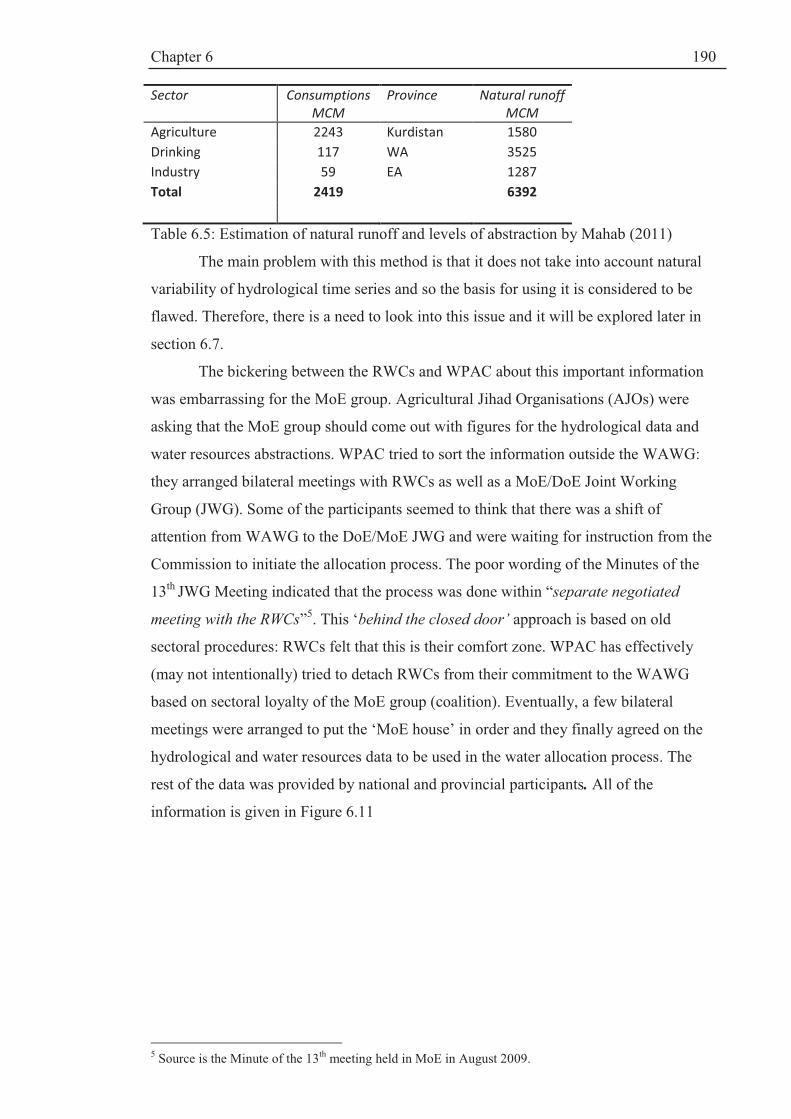
Chapter 6
190
Sector Consumptions
MCM
Province Natural runoff
MCM
Agriculture 2243 Kurdistan 1580
Drinking 117 WA 3525
Industry 59 EA 1287
Total 2419 6392
Table 6.5: Estimation of natural runoff and levels of abstraction by Mahab (2011)
The main problem with this method is that it does not take into account natural
variability of hydrological time series and so the basis for using it is considered to be
flawed. Therefore, there is a need to look into this issue and it will be explored later in
section 6.7.
The bickering between the RWCs and WPAC about this important information
was embarrassing for the MoE group. Agricultural Jihad Organisations (AJOs) were
asking that the MoE group should come out with figures for the hydrological data and
water resources abstractions. WPAC tried to sort the information outside the WAWG:
they arranged bilateral meetings with RWCs as well as a MoE/DoE Joint Working
Group (JWG). Some of the participants seemed to think that there was a shift of
attention from WAWG to the DoE/MoE JWG and were waiting for instruction from the
Commission to initiate the allocation process. The poor wording of the Minutes of the
13th JWG Meeting indicated that the process was done within “separate negotiated
meeting with the RWCs”5. This ‘behind the closed door’ approach is based on old
sectoral procedures: RWCs felt that this is their comfort zone. WPAC has effectively
(may not intentionally) tried to detach RWCs from their commitment to the WAWG
based on sectoral loyalty of the MoE group (coalition). Eventually, a few bilateral
meetings were arranged to put the ‘MoE house’ in order and they finally agreed on the
hydrological and water resources data to be used in the water allocation process. The
rest of the data was provided by national and provincial participants. All of the
information is given in Figure 6.11
5 Source is the Minute of the 13th meeting held in MoE in August 2009.

Chapter 6
191
Figure 6.11: Template of baseline data for MCDA used in WBM in Microsoft Excel.
Despite many efforts to document the data, the water allocation process was
undertaken under the shadow of uncertainty. There was still a disagreement on the
potential irrigated land area in each province and so it was decided that MoAJ should
present the data on behalf of the provinces. The data was presented in the 6th (final)
meeting by the MoAJ.
6.5.2: Weighting water allocation criteria using AHP MCDA approach
As stated in Chapter III, there are numerous MCDA methods that can be used in
water allocation problems. WPAC recommended the Analytical Hierarchy Process
(AHP: Box 6.3) which has been widely used in natural resources management and has
been very popular despite its shortcomings (e.g.Ananda and Herath, 2009).
Wattage and Mardle (2005) have used AHP to investigate stakeholder
preferences towards conservation versus development for a wetland in Sri Lanka. They
have acknowledged that AHP “requires significantly less time and expertise
requirements from respondents”. A similar approach is taken by Heck et al (2011) in
the design of a marine protected area (MPA) using a Multi-stakeholder Platform. They
found that AHP is useful towards contributing a local vision for MPA planning by
showing local preferences and opinions. Steiguer et al (2003) have considered the AHP
to be “a method and planning framework with potential for implementation of
Integrated Watershed Management” by providing “numerical weights to criteria where
subjective judgments of either quantitative or qualitative alternatives constitute an
important part of the decision process”.
Environm.
Pote
ntial
irrigation a
rea
RD
P/c
ap
Pote
ntial w
ate
r
availa
bili
ty
Per
capita invest-
em
ent in
wate
r
Popula
tion
Consum
ption p
er
capita
Allo
cation
(gw
+sw
)
To L
ake
Exis
ting
withdra
wals
Upstr
eam
rig
hts
Environm
enta
l
flow
riv
ers
Wate
r supply
to
sate
llite
wetlands
W-Azerbaijan. 600 19 3.98 6.0 2.8 1256 1.91
E-Azerbaijan. 647 28 1.36 6.0 2.9 523 0.78
Kurdistan 289 19 1.58 2.0 0.2 1330 0.22
Total/average 1536 NA 6.92 NA 5.9 NA 3.82 3.10 2.91
1000 ha
MRial/
cap BCM
MRial/
cap Mil. m3/ cap BCM BCM BCM BCM BCM BCM
+ - + - + -
Notes: + means more water if criteria is high
- means more water if criteria is low
the missing information in the table is provided in next phase of the process
and wetlands
CRITERIA
individual rivers
Economic Social Allocation Social
CONSTRAINTS
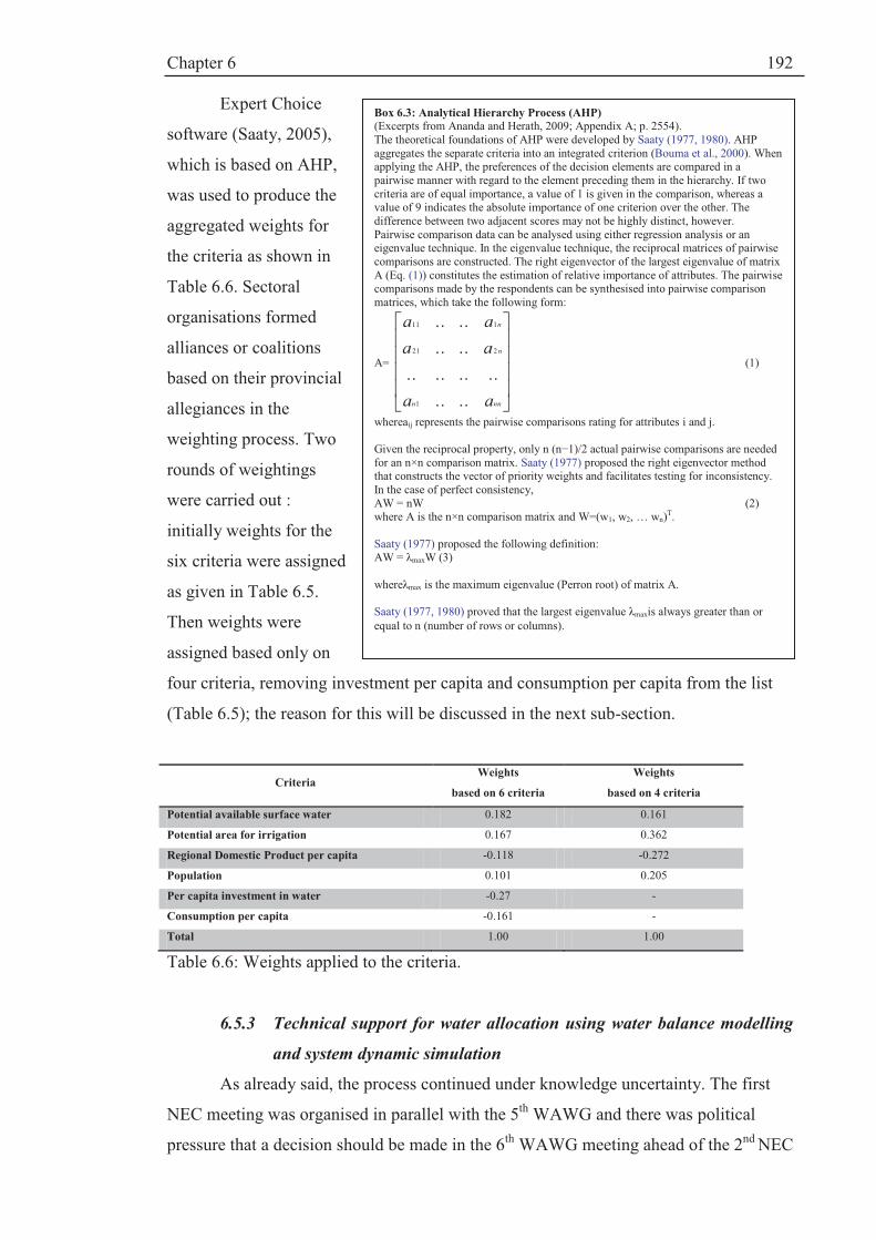
Chapter 6
192
Expert Choice
software (Saaty, 2005),
which is based on AHP,
was used to produce the
aggregated weights for
the criteria as shown in
Table 6.6. Sectoral
organisations formed
alliances or coalitions
based on their provincial
allegiances in the
weighting process. Two
rounds of weightings
were carried out :
initially weights for the
six criteria were assigned
as given in Table 6.5.
Then weights were
assigned based only on
four criteria, removing investment per capita and consumption per capita from the list
(Table 6.5); the reason for this will be discussed in the next sub-section.
Criteria Weights
based on 6 criteria
Weights
based on 4 criteria
Potential available surface water 0.182 0.161
Potential area for irrigation 0.167 0.362
Regional Domestic Product per capita -0.118 -0.272
Population 0.101 0.205
Per capita investment in water -0.27 -
Consumption per capita -0.161 -
Total 1.00 1.00
Table 6.6: Weights applied to the criteria.
6.5.3 Technical support for water allocation using water balance modelling
and system dynamic simulation
As already said, the process continued under knowledge uncertainty. The first
NEC meeting was organised in parallel with the 5th WAWG and there was political
pressure that a decision should be made in the 6th WAWG meeting ahead of the 2nd NEC
Box 6.3: Analytical Hierarchy Process (AHP)
(Excerpts from Ananda and Herath, 2009; Appendix A; p. 2554). The theoretical foundations of AHP were developed by Saaty (1977, 1980). AHP aggregates the separate criteria into an integrated criterion (Bouma et al., 2000). When applying the AHP, the preferences of the decision elements are compared in a pairwise manner with regard to the element preceding them in the hierarchy. If two criteria are of equal importance, a value of 1 is given in the comparison, whereas a value of 9 indicates the absolute importance of one criterion over the other. The difference between two adjacent scores may not be highly distinct, however. Pairwise comparison data can be analysed using either regression analysis or an eigenvalue technique. In the eigenvalue technique, the reciprocal matrices of pairwise comparisons are constructed. The right eigenvector of the largest eigenvalue of matrix A (Eq. (1)) constitutes the estimation of relative importance of attributes. The pairwise comparisons made by the respondents can be synthesised into pairwise comparison matrices, which take the following form:
A=
úúúú
û
ù
êêêê
ë
é
nnn
n
n
aa
aa
aa
....
........
....
....
1
221
111
(1)
whereaij represents the pairwise comparisons rating for attributes i and j. Given the reciprocal property, only n (n−1)/2 actual pairwise comparisons are needed for an n×n comparison matrix. Saaty (1977) proposed the right eigenvector method that constructs the vector of priority weights and facilitates testing for inconsistency. In the case of perfect consistency, AW = nW (2) where A is the n×n comparison matrix and W=(w1, w2, … wn)
T. Saaty (1977) proposed the following definition: AW = λmaxW (3) whereλmax is the maximum eigenvalue (Perron root) of matrix A. Saaty (1977, 1980) proved that the largest eigenvalue λmaxis always greater than or
equal to n (number of rows or columns).

Chapter 6
193
meeting. The participants (actors) had to make some difficult decisions about the
modelling approach.
Agreement on minimum ecological water requirement. The 2008 WAC
requires system dynamic modelling for river basin allocation. Between 2003 and 2008,
WPAC consolidated its know-how on the use of Vensim® system dynamic simulation
software described in Chapter III (Ventana Systems, 2007) by preparing a prototype
model for LUB. As a visual modelling tool, Vensim simulates the water balance (as in
eq. 6.3) based on a feedback system or causal loop i.e. stock and flow diagrams. It
allows visualisation of how changes in the parameters will affect the water balance
simulation. The water balance model was implemented in Microsoft Excel and linked to
the Vensim software as an input of data (MoE, 2010 b). The purpose of the simulation
was to determine the amount of required inflow into the lake to maintain the ecological
lake level of 1274.1 m asl.
The simulated results from the Vensim model indicated that, to keep the lake
level at 1274.1 (minimum ecological lake level), an average annual inflow of 3900
MCM is required. This is higher than the minimum requirement predicted by
Abbaspour and Nazaridoust (2007) which amounts to 3100 MCM. Initially, WPAC was
not open about its Vensim Model for LUB. The author tried to encourage WPAC to
share its results by allowing two representatives from each province to see how the
model was built. This suggestion was not accepted and hence, everybody prepared for a
heated negotiation ahead in the culminating 6th WAWG meeting to be held in Sanandaj
(Kurdistan).
As stated, MoE accepted the figure of 3100 MCM at the High Water Council
and did not block it becoming a legal requirement. But WPAC was adamant about
presenting its case at the 6th WAWG meeting. Unlike Abbaspour and Nazaridoust
(2007) which used a fixed evaporation rate, MoE (2010) used monthly estimates of
evaporation and precipitation over the Lake. The result seemed to be more realistic than
Yekom’s (2005) but this method also involved a great deal of uncertainty about how
evaporation and lake area have been estimated; hence, it is not as accurate as claimed by
WPAC.
At the 6th Working Group meeting, WPAC presented the simulation result (3900
MCM needed by the lake) but it was rejected by all the other actors. They decided to
use 3100 MCM as a constraint in the water allocation model (WAM). WPAC also did
not accept the 3100 MCM and indeed recommended 3900 MCM. After long
negotiations, it was agreed that, since 3100 MCM is a legal requirement, this value
should be used for now and the final decision should be taken by the National Executive

Chapter 6
194
Council (NEC). The gamble did not pay off for WPAC even after an emotional appeal.
Other actors were not involved in building the Vensim Model for LU; thus, they easily
overruled it despite clear evidence from the Vensim simulation. WPAC’s motive will
become evident in the next step of the process.
Water allocation shares: scenarios. WPAC had postulated to use two scenarios
in the WAM model:
1. WPAC’s favourite option was to use 6 criteria (as in Figure 6.12) with
two constraints : a minimum lake allocation of 3900 MCM and existing
abstractions of 2900 MCM; this means there is no water for further
development
2. The second best option was to use 6 criteria with two constraints i.e. LU
water requirement of 3100 and existing abstraction of 2900; this means
that there is about 817 MCM for further allocation.
Both options were rejected and opposed as they completely ignored what the
participants (actors) had agreed in previous meetings. The participants and CIWP
wanted a re-allocation of the resources; otherwise, WA and EA would be rewarded for
overstating their demands. The hidden message behind the WPAC position was that the
basin has reached saturation level and dams under constructions should not be built as
there is no more water left if the lake is considered as a demand site. WPAC felt
responsibility for Lake Urmia and therefore wanted to take a precautionary route
towards the wellbeing of the lake. The Commission made a staunch attempt to bring the
‘environment’ into decision-making but the other actors had other priorities. WPAC’s
motive was not purely environmental: the Commission wanted to block extra
applications by the provinces for more allocation and dam-building projects in the basin
as well.
As a facilitator, CIWP overruled the unilateral position held by WPAC. To
resolve the turmoil, a very delicate balancing act was needed, and so a compromise had
to be reached. The issue was that, if the existing abstraction was accepted, this would
indicate that unfair development in the basin was accepted as well as legalising
unauthorised abstractions, and no consensus could be reached. WPAC agreed to scrap
this constraint if only two criteria were removed: existing investment in the water sector
and consumption per capita. After a heated debate, this was agreed, and the simulation
was made to allocate provincial water shares using four criteria, with 3100 MCM as a
constraint. The shares were quite different from the previous simulation. Kurdistan
which gained a 24% share under 6 criteria now had less than 16% of the total shares.

Chapter 6
195
Kurdistan made a passionate appeal that they should get a greater share based on
their upstream rights and given the historical injustices. The Energy Group (from the
Vice President Office) played a major role to mediate and exert pressure on the
negotiators to come to the agreement at the WAWG: “no one is leaving here until a
decision is reached”. EA happily accepted the results which give them even less
commitment to the lake. WA was happy for more shares to be given to Kurdistan since
the water flows downstream to WA and it is not used. Kurdistan was not happy with the
figure of 16% and expected some 22%. Then, after long negotiations, it was agreed that
the results should be accepted, but the issue of upstream rights of Kurdistan needed to
be decided by the NEC.
The author and Eelco van Beek (International consultant) were asked to revise
the WAM procedure and to look into Kurdistan’s share. It was concluded that
ExpertChoice AHP procedure uses binary rules attributing 0 weights to the lowest
criterion. For example, the Kurdistan population was very small compared to the other
two provinces (230,000 compared to 2.8 and 2.9 million) and hence increasing the
Kurdistan population to 1,000,000 would not change the weights. Therefore, AHP
method can produce an output with a great degree of discrepancy. However, despite this
inconsistency, AHP was seen by CIWP and MoE as the most appropriate way to
allocate resources and the allocation shares were agreed (Table 6.7)
6.5.4 Finalising the water allocation agreement
The agreement reached at the 6th WAWG meeting was not welcomed or
sanctioned by higher ranking provincial actors outside the Working Group platform; for
example, WARWC believed that WA representatives were “misled and conned”6. The
re-allocation meant new developments should be halted or else future water rights
would be compromised. Kurdistan was ‘angry’ about WPAC’s attitude towards using
the AHP approach which produced less than expected shares for Kurdistan. The results
were presented in the 2nd meeting of NEC and a series of meetings and lobbying has
followed as shown in Figure 6.12.
NEC sanctioned the establishment of a Technical Committee to harmonise the
disagreement that spilled over after the last WAWG meeting. The Committee was a
mini-WAWG inviting major provincial stakeholders (RWCs and AJOs) to agree on the
potential irrigated land for each province which was disputed. NEC did not attempt to
make the decision and invited the provinces to try to sort out their differences.
Therefore, NEC acted positively to share power with the provinces by maintaining a”
6 Personal communications to the author

Chapter 6
196
non-coercive” approach to governance to enhance the effectiveness of the WAWG (see
e.g. Verhallen et al, 2007).
Water Allocation Model
Options
1 2 3
MoE’s favorite
option: existing
abstractions as a
constraint (6 criteria)
MoE 2nd best proposal:
Criteria: 6
Constraints: Existing
abstraction and lake Urmia
water rights
Final agreement: 4 criteria only
Lake Uremia water right as the
only constraint
A- Water Availability using Vensim simulation software and WBM
Average Potential
surface water 6920 6920 6920
Lake Urmia water rights 3900 3100 3100
Existing abstraction 2900 2900 Not applicable
Total constraints 6800 6000 3100
Water available for
allocation
nil 817 3700
B. Water Allocation Model Using ExpertChoice software based on AHP approach
Provinces Weighed
share %
No n
ew
develo
pm
ent
Weighed
share %
Share of water
MCM
Weighed
share %
Share of water
MCM
Kurdistan 24 24 196 15.8 585.1
East Azerbaijan 37.4 37.4 305.5 29.2 1079.2
West Azerbaijan 38.6 38.6 315.5 55 2035.6
Total 100 100 817 100 3700
Table 6.7: Results of water availability and WAM showing provincial water shares.
WA wrote a letter to the Deputy Minister for Energy (Karimi, 2010). In the
letter, Karimi (2010) asks for re-negotiation based on bilateral arrangement i.e. EA-WA
and WA-Kurdistan. This offer was not accepted and NEC has decided to implement the
agreement. On the other hand, the Kurdistan governor wrote to the First Vice President
and formally accepted the results and asked for immediate allocation of funds to
implement the plan. The author represented CIWP in its efforts to make Kurdistan
engage with the participatory decision-making. If the results were overruled, the whole
process would have been undermined. The AHP allows for inconsistent criteria
weighting by the actors. Therefore, the actors influenced the weighting by showing
inconsistency in their preferences and hence affected the allocation results. In real world

Chapter 6
197
decisions, inconsistent preferences and ranking are a reality. Therefore, AHP could be
argued to be an appropriate method for participatory MCDA processes.
Figure 6.12: The timeline of NEC meetings to approve the water allocation decisions (some of the Photos by Jabbari, 2011).
6.5.5 Concluding remarks: fixed water allocation is not realistic
Political will. The controversy over the LU water allocation was complex and
the manipulation of data and knowledge to suit negotiating positions caused a great deal
of polarisation of opinions. Political support for CIWP and its shared vision with
WPAC by accepting its rules have contributed to a successful conclusion of provincial
water allocation shares. Without establishing formal water rights for the LU, it was
difficult to allocate water to it. The institutional sustainability of the water allocation
governance will be described in Chapter VII but it is necessary to appreciate that the
5 May 2010 1st NEC Meeting: setting the rules for decision-making on LU
- Assessment of the challenges and opportunities with regard to LU; presenting
management options and strategies ; setting rules for the 2nd NEC meeting
7 June 2010 2nd NEC Meeting: how to implement the 2010 NEC Bylaw
- examining the process of how to implement the 2008 By-law on LUB; reviewing
and prioritizing project
9 June 2010 1st Technical Committee Meeting: Operational aspects of EMP
- Assessment and approval of EMP
- Finalising and Approval of LU water right (3100 MCM);
- Detailed assessment and approval of the projects
12 June 2010 2nd Technical Committee setting Meeting: rules for water allocation process
- Approval of the projects
- Agreement on the process of provincial water allocation
19 July 2010 3rd Technical Committee Meeting: approval of water allocation shares
- Approval of water allocation shares
- Approval of 73 MCM water rights for satellite wetlands
12 Oct 2010 3rd NEC Meeting: Provisional agreement on water allocations
- Assessment and provisional approval of water shares pending further
investigations
- Approval of projects
30 Oct 2010 4th Technical Committee Meeting: Reassessment of water allocation decisions
- Reassessment of provincial water allocation decisions
- Reassessment of water allocation criteria including upstream rights
23 July 2011 4th NEC and RC Joint Meeting: Finalising water allocation shares
- Announcement of water allocation decisions
- Formally establishing the RC
Acronyms:
EMP Ecosystem Management Plan; LUB Lake Urmia Basin; MCM Million Cubic Meters; NEC National Executive Council;
RC Regional Council

Chapter 6
198
provincial administrative divisions as a geopolitical Driving force (described in Chapter
V) was an important factor in the final decision made by the NEC. Water allocation to
Lake Urmia was a resounding success for the environmental movement in Iran.
However, the implication of this decision has to be evaluated and it is not as simple as it
is portrayed in the simple water allocation template (Table 6.4).
Uncertainty. Changes in the state of Lake Urmia have been dramatic and visual.
Also, it has been politically sensitive because it registered on the national agenda. More
recently, social networks and sport events such as football matches have been an avenue
to express urban dissatisfaction. Press and media have compared this situation to that of
the Aral Sea in Middle Asia which has been reduced by 98% of its size. The
environmental discourse is getting stronger. But water availability lies at the heart of the
matter; hydrology and, of course, climate are the determining factors. The strong
environmental discourse has been undermined by lack of accurate, acceptable data and
this has caused polarisation of opinions and confusion about what action plans should
be taken forward. Although the significance of the threatening changes that have
occurred were recognised by the participants (actors), it is still rather difficult to attain
consensus among them regarding the causal relationship between different factors
affecting the lake. There is a distinct concern about the appropriateness of the
Detrending Method dictated by the 2008 WAC to calculate water availability. A trend
in a natural phenomenon is not unusual in a short record; thus detrending is problematic
as the effects of natural and human induced effects (e.g. due to the abstraction) are
difficult to separate. This difficult issue will be dealt with in section 6.7.
Adaptive water allocation to deal with climatic variability. The outcomes of the
process can only be valid for average (normal) conditions and it did not consider
climatic variations which are important characteristics of the climatic system. It is
strongly argued that this level of allocation to the lake and the users is not sustainable in
the long-term future as there are many years in which water availability can be below
the allocated volume. Therefore, it is postulated that there is a need for an adaptive
water allocation strategy to be able to cater for climatic variability which exerts a strong
control over the fluctuations in LUB levels.
Droughts were recognised by the participants as an important issue. Yekom
(2005) concludes that the cyclical appearance of droughts is normal and should be
expected every 6 years on average (Table 6.8). Therefore, actors should make a plan for
the occurrence of drought in the basin.

Chapter 6
199
Return period probability Indicator Condition
6.3 0.1587 SPI<-1 drought 14.97 0.0668 SPI<-1.5 Intense drought
44 0.0227 SPI<-2 Extreme drought
Note: SPI: Standardised Precipitation Index
Table 6.8: Probability of occurrence and return periods of different drought conditions (Yekom, 2005).
The second day of the 6th WAWG meeting was assigned to the first Drought
Taskforce meeting as part of the Drought Risk Management module of the CIWP. The
Taskforce was established to design an adaptive water allocation strategy during
drought conditions. The work will continue as part of next round of negotiations
through WAWG meetings. The author is involved in an advisory role as will be
described in Chapter IX.
Sustainability analysis. Based on the above argument, there is a need to assess
the reliability of the water resources system, considering the historical data as well as
possible future changes in climatic and hydrological parameters with reference to Lake
Urmia. Hence, in the next section, the long term sustainability of LU under different
climatic and water allocation scenarios is evaluated using a risk based analysis. Based
on these concluding remarks, the main objectives of the second part of the chapter are as
follows:
· To assess the water availability i.e. the natural runoff
· To make a risk based analysis of the future variability of the lake levels
under different management scenarios and probabilistic projections of
annual precipitation representing the next 41 years (2011-2051)
· To devise an adaptive water allocation strategy by assessing different
management options
· To come up with a recommendation for implementation of the 2008
EMP
The methodological approach to achieve these objectives is described in the
following sections.
6.6 Methodological approach
6.6.1 Assessment of baseline data
There is a concern about the Detrending Method used to estimate natural runoff.
The on-going Updating of the Water Master Plan Project obtained a different result (i.e.
lower values) of annual average runoff using a modified Detrending Method as shown

Chapter 6
200
above in Table 6.9 (Mahab, 2011). Therefore, it is paramount that this issue has to be
considered to make an analysis of the sustainability of the proposed water allocations.
By using data from MoE (2010b), annual average rainfall and observed runoff
records are plotted in Figure 6.13 which shows that, for the period 1969-1994,there is an
upward trend in both records, while, from 1995-2008, there is a downward trend in both
time series. This shows that (a) an upward trend observed over a short period of record
may reverse as the record becomes longer and (b) that, when assessing the effects of
abstractions on a runoff record, this must be done in conjunction with an associated
rainfall record so that the effect of abstractions can be isolated. Figure 6.13 also
illustrates that a trend cannot be relied upon as an indicator of future water availability
and so stochastic modelling should be used which can reproduce this natural climatic
variability.
Figure 6.13: Trends in rainfall and observed runoff for 1969-1994 and 1995-2008.
The Detrending Method has also been the basis for the climate change discourse in
which an attribution analysis was made (as stated in Chapter V) to ascribe
· 67% of the lake level’s decline to droughts and climate change (and of course
variability);
· 27% to extra abstraction; and
· 5% to direct impacts of dam-building.
0
100
200
300
400
500
600
0
2000
4000
6000
8000
10000
12000
14000
1960 1970 1980 1990 2000 2010
P,
mm
ob
serv
ed
ru
no
ff,
R,
MC
M
Year
observed runoff 1969-1994 observed runoff 1995-2008
P, 1969-1994, mm P, 1995-2008, mm
Linear (observed runoff 1969-1994) Linear (observed runoff 1995-2008)
Linear (P, 1969-1994, mm) Linear (P, 1995-2008, mm)
Linear (P, 1995-2008, mm)

Chapter 6
201
These results were derived for the year 2000, a severe drought year, based on 1967-
2000 data.
This attribution analysis has been used to shape the climate change discourse by
MoE based on the argument that, in the last 15 years (i.e. since 1995) there has been a
downward trend in average annual rainfall as illustrated in Figure 6.13. However, the
concern is that, when determining natural runoff as described in section 6.5.1, 100% of
the trend is attributed to abstraction. This ignores completely the climatic fluctuations
which can appear as trends in short records. Thus, the Detrending Method is highly
questionable, and so this issue is re-evaluated here as the whole process depends on how
much water is available for allocation. Therefore, there is a need to evaluate the
historical water balance of the lake and its climatic drivers to establish the amount of
natural runoff that is available annually. A stochastic modelling approach which can
reproduce quasi-cycles and quasi-trends (persistence) in the simulated rainfall data is
the main driver for the inter-annual fluctuations in natural runoff.
Baseline data. Most of the data used for this part of the ISTA component is from
MoE (2010b) i.e. the same data as used by the actors to make the water allocation
decision so that the analysis in this section is consistent with part (1) of the ISTA
framework. The data were scrutinised and agreed during the process where the water
allocations were agreed. The data analysis approach is summarized in Figure 6.1. Lake
levels have been recorded on a daily basis since 1966. This daily record was obtained
from the West Azerbaijan Regional Water Company. The lake level on the 22nd of
September marks the end of thewater year in Iran. In section 6.6.2, the methodology is
outlined and the results are presented in Section 6.7- 6.9.
6.6.2 Components of the methodological framework
The methodological framework for this part of Chapter VI comprises of the
following components:
· In Section 6.7, time series analysis of rainfall and runoff records is used
to determine natural runoff and abstraction, and lake level analysis is
used to assess the impact of climate and non-climatic parameters on the
lake level drop.
· In section 6.8, a lake water balance model (WBM) for the historic data is
used to understand the hydrological characteristics of Lake Urmia and
validate the time series analysis made above. This will also be used as
the basis for risk based analysis of lake management by simulation of
future rainfall records using a stochastic approach
Chapter 6
202
· Stochastic rainfall models (SRMs) for Lake Urmia basin are built to
generate rainfall series that reproduce short-term and long-term climatic
variability (Section 6.8).
· The water balance model is used in conjunction with the stochastic
rainfall model to simulate an adaptive water allocation strategy based on
reduction (scaling) factors (Section 6.9).
Overall conclusions and recommendations for the ISTA component are
presented in Section 6.10.
6.7 Time series analysis approach to evaluating regional rainfall and runoff
trends
6.7.1 Rainfall and runoff time series analysis.
First, the MoE discourse is that, since 1995, there has been a change in climate;
a downward trend in precipitation has been noted. However Robson et al (2000; p. 59)
note that “climatic variability has a very marked effect on many hydrological series” in
two ways: (1) it can cause an apparent trend when the length of records are short; i.e.
any records below 50 years are very difficult to assess; and (2) obscures other changes
that might affect the trend as they are typically large.
Secondly, the Detrending Method was not an independent fact and involved a
great deal of subjective judgement, particularly in assuming that abstraction effects
started in the beginning of the runoff record. It is noted that Mahab (2011) also does not
agree with the estimated value of 6927 MCM for natural runoff as well. Therefore,
trends and fluctuations in runoff need to be analysed in conjunction with those in
rainfall.
Recalling the information presented in Chapters IV and V, land reforms in the
1960s were followed by the introduction of hydraulic structures in the 1970s. Many of
the dams lagged behind in terms of building irrigation networks. After the 1979
Revolution, the Imposed War continued until 1988. The first Post Revolution
Development plan came into action in 1989 and was consolidated in the second and
third plans. As a result, in the mid 1990s, two major dams came into operation. Since
then, water consumption has increased dramatically.
Therefore, the regression is made for the pre-1995 period i.e. 1969-1994 to
reconstruct the lake levels in the post-1994 period i.e. 1995-2009. Therefore, one of the
main issues is to establish the relationship between lake level and precipitation and the
separate impacts of hydrological drought (precipitation deficiency) and abstraction on

Chapter 6
203
the decreased lake level. For this analysis, up to date data are needed i.e. up to 2010 to
be able to analyse the impact of abstractions on the lake levels.
Reconstruction of lake levels. Firstly, the annual average precipitation series, Pt
over the catchment area draining to the lake for the period 1969-2010is plotted and
secondly, the annual lake level increments (in m) are calculating as in equation 6.4:
DYt= Yt – Yt-1 for t= 1, 2, …, n (6.4)
where Yt is lake level on 22nd of September of each water year, t, DYt is the annual
change in lake level, and n is 42 years i.e. 1969-2010.Then, the following regressions
are made for the period 1969-1994:
· Yt against Pt:
Yt =a + b Pt (6.5)
· DYt against Pt
DYt = a’ + b’Pt (6.6)
where Pt is precipitation for the period 1969-1994 and a, b and a’ and b’ are regression
coefficients.
Based on the results obtained, Model (6.6) was used to reconstruct levels for
1969-94 and 1995-2010 to show the effects of abstractions and climate variability.
Runoff time series analysis. The above procedure was repeated using observed
runoff or inflow into the lake, It instead of Yt. During years when there are no net
abstractions i.e. 1969-1994, inflow It is assumed to be equal to natural runoff , Rt i.e.It =
Rt. Therefore, from the regression of inflow on rainfall Pt, Rt can be reconstructed as in
equation 6.7:
Rt = c + d Pt (6.7)
where c and d are regression coefficients. Equation 6.7 is used to estimate natural runoff
for the period 1969-2009. In the presence of abstractions, natural runoff is given by
equation 6.8:
Rt =NAt + It (6.8)
where NAt is net abstraction i.e. abstractions minus return flow. Then the abstraction is
given by equation 6.9:
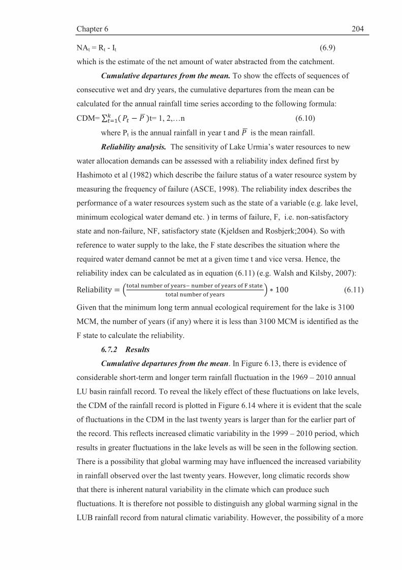
Chapter 6
204
NAt = Rt - It (6.9)
which is the estimate of the net amount of water abstracted from the catchment.
Cumulative departures from the mean. To show the effects of sequences of
consecutive wet and dry years, the cumulative departures from the mean can be
calculated for the annual rainfall time series according to the following formula:
CDM= t= 1, 2,…n (6.10)
where Pt is the annual rainfall in year t and is the mean rainfall.
Reliability analysis. The sensitivity of Lake Urmia’s water resources to new
water allocation demands can be assessed with a reliability index defined first by
Hashimoto et al (1982) which describe the failure status of a water resource system by
measuring the frequency of failure (ASCE, 1998). The reliability index describes the
performance of a water resources system such as the state of a variable (e.g. lake level,
minimum ecological water demand etc. ) in terms of failure, F, i.e. non-satisfactory
state and non-failure, NF, satisfactory state (Kjeldsen and Rosbjerk;2004). So with
reference to water supply to the lake, the F state describes the situation where the
required water demand cannot be met at a given time t and vice versa. Hence, the
reliability index can be calculated as in equation (6.11) (e.g. Walsh and Kilsby, 2007):
(6.11)
Given that the minimum long term annual ecological requirement for the lake is 3100
MCM, the number of years (if any) where it is less than 3100 MCM is identified as the
F state to calculate the reliability.
6.7.2 Results
Cumulative departures from the mean. In Figure 6.13, there is evidence of
considerable short-term and longer term rainfall fluctuation in the 1969 – 2010 annual
LU basin rainfall record. To reveal the likely effect of these fluctuations on lake levels,
the CDM of the rainfall record is plotted in Figure 6.14 where it is evident that the scale
of fluctuations in the CDM in the last twenty years is larger than for the earlier part of
the record. This reflects increased climatic variability in the 1999 – 2010 period, which
results in greater fluctuations in the lake levels as will be seen in the following section.
There is a possibility that global warming may have influenced the increased variability
in rainfall observed over the last twenty years. However, long climatic records show
that there is inherent natural variability in the climate which can produce such
fluctuations. It is therefore not possible to distinguish any global warming signal in the
LUB rainfall record from natural climatic variability. However, the possibility of a more

Chapter 6
205
variable rainfall regime in the future, with more persistent runs of wet and dry years,
cannot be ruled out.
Figure 6.14: Cumulative departures from the mean for LU basin annual rainfall (mm) (1969-2010).
Lake level reconstruction based on regression analysis. The lake levels were
reconstructed using the regression model in eq. 6.6 applied to the pre 1995 rainfall
record. Figure 6.15 shows the impact of climatic variability as well as human impacts
on Lake Urmia levels. The reconstructed levels match well overall with the observed
levels, although they do not fit year by year. From 1991- 1995, there is a lake level rise
which is reproduced very well. Then, there is a steady decline up to 1999, followed by a
sharp fall continuing to the year 2001. The period 1999-2001 is characterised by a sharp
reduction in precipitation (Figure 6.13 ). After that, the lake level does not recover
despite an upward precipitation fluctuation. This shows that drought is not the only
cause of the fall in lake level since 1995. In 1995, 2 major dams came into operation
followed by 4 more dams in 2002 and 2006 and the impact of dam-building and
increased water withdrawals have clearly registered.
The reconstructed lake levels show increasing divergence from the observed
levels from 1995, which reflect the accelerated development referred to above. This
clearly shows that new developments or abstractions have greatly amplified the lake
level drop. Figure 6.15 suggests that, without abstractions, the lake levels post the high
1995 level would have returned to the levels observed in the earlier part of the record.
-100
0
100
200
300
400
500
19
68
19
70
19
72
19
74
19
76
19
78
19
80
19
82
19
84
19
86
19
88
19
90
19
92
19
94
19
96
19
98
20
00
20
02
20
04
20
06
20
08
20
10
Cumulative departure from the mean
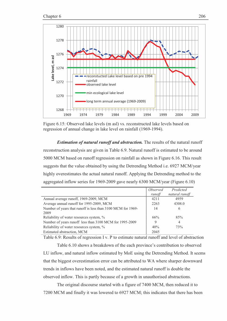
Chapter 6
206
Figure 6.15: Observed lake levels (m asl) vs. reconstructed lake levels based on regression of annual change in lake level on rainfall (1969-1994).
Estimation of natural runoff and abstraction. The results of the natural runoff
reconstruction analysis are given in Table 6.9. Natural runoff is estimated to be around
5000 MCM based on runoff regression on rainfall as shown in Figure 6.16. This result
suggests that the value obtained by using the Detrending Method i.e. 6927 MCM/year
highly overestimates the actual natural runoff. Applying the Detrending method to the
aggregated inflow series for 1969-2009 gave nearly 6300 MCM/year (Figure 6.10)
Observed
runoff
Predicted
natural runoff
Annual average runoff, 1969-2009, MCM 4211 4959
Average annual runoff for 1995-2009, MCM 2263 4308.0
Number of years that runoff is less than 3100 MCM for 1969-2009
14 6
Reliability of water resources system, % 66% 85%
Number of years runoff less than 3100 MCM for 1995-2009 9 4
Reliability of water resources system, % 40% 73%
Estimated abstraction, MCM 2045
Table 6.9: Results of regression I v. P to estimate natural runoff and level of abstraction
Table 6.10 shows a breakdown of the each province’s contribution to observed
LU inflow, and natural inflow estimated by MoE using the Detrending Method. It seems
that the biggest overestimation error can be attributed to WA where sharper downward
trends in inflows have been noted, and the estimated natural runoff is double the
observed inflow. This is partly because of a growth in unauthorised abstractions.
The original discourse started with a figure of 7400 MCM, then reduced it to
7200 MCM and finally it was lowered to 6927 MCM; this indicates that there has been
1268
1270
1272
1274
1276
1278
1280
1969 1974 1979 1984 1989 1994 1999 2004 2009
Lak
e l
ev
el,
m a
sl
reconstucted Lake level based on pre 1994
rainfall observed lake level
min ecological lake level
long term annual average (1969-2009)
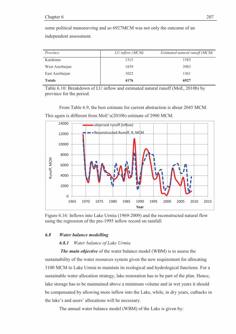
Chapter 6
207
some political manoeuvring and so 6927MCM was not only the outcome of an
independent assessment.
Province LU inflow (MCM) Estimated natural runoff (MCM)
Kurdistan 1315 1583
West Azerbaijan 1839 3983
East Azerbaijan 1022 1361
Totals 4176 6927
Table 6.10: Breakdown of LU inflow and estimated natural runoff (MoE, 2010b) by province for the period.
From Table 6.9, the best estimate for current abstraction is about 2045 MCM.
This again is different from MoE’s(2010b) estimate of 2900 MCM.
Figure 6.16: Inflows into Lake Urmia (1969-2009) and the reconstructed natural flow using the regression of the pre-1995 inflow record on rainfall.
6.8 Water balance modelling
6.8.1 Water balance of Lake Urmia
The main objective of the water balance model (WBM) is to assess the
sustainability of the water resources system given the new requirement for allocating
3100 MCM to Lake Urmia to maintain its ecological and hydrological functions. For a
sustainable water allocation strategy, lake restoration has to be part of the plan. Hence,
lake storage has to be maintained above a minimum volume and in wet years it should
be compensated by allowing more inflow into the Lake, while, in dry years, cutbacks in
the lake’s and users’ allocations will be necessary.
The annual water balance model (WBM) of the Lake is given by:
0
2000
4000
6000
8000
10000
12000
14000
1965 1970 1975 1980 1985 1990 1995 2000 2005 2010 2015
Ru
no
ff,
MC
M
Year
observed runoff (inflow)
Reconstructed Runoff, R, MCM

Chapter 6
208
)(11 tttttt EPLAISS -++= -- (6.12)
where
St = storage volume at the end of year t ( in MCM)
It = observed runoff (inflow from surrounding catchment) in MCM
At = average annual lake area at the end of year t in m2
PLt = annual average precipitation over the lake year t (in m)
Et = evaporation from Lake Urmia during year t in m
A second model is constructed by replacing It with the natural runoff, Rt:
)(11 tttttR EPLARSS -++= -- (6.13)
where Rt is calculated from equation 6.7. Results from both models are plotted and
compared in Figure 6.17.
The initial storage was obtained by converting the observed initial water level
using a parabolic Volume-Area-Level (VAL) relationship obtained by WRI (2005):
ïî
ïíì
+-´=
-+-=28
2
419.3701.94055110970548.5
309046.3014.7790850057395
YYS
YYA (6.14)
where A, S and Y are area (km2), storage (MCM) and elevation (m asl), respectively.
The VAL curves have an important application in estimating the water balance
of the lake since there is no bathymetric data which is the most accurate way to find the
mathematical relationship between the VAL elements (a bathymetric study of Lake
Urmia should be carried out in the future). WRI (2005) used maps or satellite images
which cannot necessarily be interpolated to higher or lower elevations. However, the
above relationship must suffice for the present study.
Originally, the VAL curves were obtained by studying a range of lake level
varying between 1273-1280 m.a.s.l. however; the lake level in 2010 was 1271.6 which
is below the level above which the VAL curves described by eq. 6.14 are valid. The
measured area for this elevation is known to be 2700 km2 (Jabbari, 2011). Therefore, for
lower lake levels, a linear relationship was used based on this data point
Evaporation. As stated in Chapter V, there is a great deal of uncertainty about
evaporation. Based on past research and MoE (2010b) estimates, the average is between
1180 and 1272 mm/year. By minimising the sum of the differences between the
observed and simulated lake volumes over the period 1967-1994, the average
evaporation rate was calibrated as 1244 mm/year.
6.8.2 WBM simulations of LU storage using natural and observed runoff
The WBM simulations of storage (Figure 6.18)correspond well with the
regression results obtained in Section 6.7.1 for lake levels ; the same overall fluctuations

Chapter 6
209
are observed, as well as the same divergence between the lake storage series
reconstructed from the (reconstructed) natural runoff data and that produced using the
observed runoff series. However, Figure 6.17 shows that there is a time shift in the
WBM simulated storage compared to the historical storage series derived from the VAL
relationship, particularly for the recent period. There is no obvious explanation for this;
however, it does not significantly affect the results of the analysis or change the overall
conclusions.
Figure 6.17: Water balance model simulations of Lake Urmia storage for natural and observed runoff.
Acknowledging the data uncertainty referred to above, it can be deduced that the
lake volume in 2009 has reduced since 1968 to about one quarter of its original volume
(assumed to be 21,000 MCM at the start of the simulation). The storage is now about
5000 MCM and the equilibrium volume is about 18000 MCM according to Mahab
(2011).
6.8.3 Stochastic rainfall model
In analysing the trends in the historic catchment average rainfall record, it was
noted that there was an upward trend for the period 1969-1994, and a downward trend
for the period of 1995-2009 (Figure 6.13). This is evidence for persistence, where runs
of years that are above or below average occur. Stochastic time series models provide a
means of simulating such fluctuations using Monte Carlo simulation.
One of the key issues in modelling climatic and hydrological time series is the
level of persistence present in a particular historical record. The higher the level of
persistence, the higher the variability, with the possibility those periods of high and low
flows can be unusually long, appearing as pseudo-trends in short records. Landwehr and
0
5000
10000
15000
20000
25000
30000
35000
1960 1970 1980 1990 2000 2010 2020
Sto
rag
e,
MC
M
Year
Lake Urmia water balance 1969-2009
WBM Historic WBM using reconstructed R Observed storage from VAL

Chapter 6
210
Matalas (1986) assert that hydrologic processes can exhibit a high level of persistence
i.e. they have “a tendency for high flows to follow high flows or low flows to follow low
flows (ibid, 239). Short term persistence in data describes any incremental changes
(increase or decrease) for a short time span whereas “If this span of time is many times
the time-increment between successive data, especially in yearly data, it is called long-
term persistence” (Panu and Unny, 1980).
Hurst (1951, 1956) analysed a long record of annual flows for the River Nile and
characterised long-term persistence /variability in terms of the rescaled range R/S which
he related to record length n as:
(R/S) ~ (n/2)h (6.15)
where h is termed the Hurst coefficient. The range, R, of cumulative departures from the
mean is defined as
Rj = Max Pj– Min Pj (6.16)
where Pjare the partial sums given by
XjXPjj
i
i -=å=1
(6.17)
and the mean is å=
=n
i
iXn
X1
1
The standard deviation S given by
(6.18)
To estimate the coefficient h (now called the Hurst Coefficient), Hurst used the
expression
(R/S) = (n/2)K
from which
)2/log(
)/log(
n
SRK = (6.19)
where K is an estimator of the Hurst Coefficient h.
For a large number of geophysical records, including Nile flows, Hurst found
that the average value of K was 0.73, with a standard deviation of 0.09. For an
independent process with no persistence, he showed theoretically that h= 0.50. He
attributed the discrepancy between this theoretical result and the average value of 0.73
to long term persistence/variability. The discrepancy between the theoretical value of

Chapter 6
211
0.5 and the average value of 0.73 obtained from observed data is known as the Hurst
phenomenon.
The variability of River Nile flows and many other long records of runoff
observed across the world is associated with natural climatic variability whereby
periods of wet and dry years can be unusually long. It is expected that this variability
will increase under climate change. Therefore, the aim here is to build a stochastic
model of rainfall that can be used to explore the sensitivity of Lake Urmia levels to this
type of variability.
O’Connell (1971, 1974 a, b) has shown that an ARMA (1,1) model can explain
the Hurst phenomenon in the behaviour of R/S. Salas et al (1979) postulated that, since
hydrological data are time dependent, the transient region in R/S with h>0.5 can be
prolonged to reproduce the Hurst phenomenon. ARMA models have the capability to
explain the Hurst phenomenon since their “correlation structure dictates the behaviour
of the rescaled range” (ibid, p.7). Additionally, ARMA models not only have well
known theoretical properties, but they possess physical foundations in hydrology (Hipel
and McLeod, 1994; Salas and Smith 1981).
The autocorrelation function of the ARMA (1,1) model used by O’Connell
(1971) to reproduce long term persistence is given by:
(6.20)
ρk = ρk-1 , k = 2, 3,….
where is the parameter of the autoregressive (AR) part; and θ is the parameter
of the moving average (MA) part. An ARMA (1,1) model for annual precipitation, Xt,
can be written as (e.g. Hipel and McLeod, 1994):
(Xt-μx)/σx) = ((Xt-1 - μx)/ σx) + σε (εt -θεt-1) (6.21)
where and θ are model parameters, εt is a noise term that follows a normal
distribution N (0, 1); σx is the standard deviation and μx is the mean of the rainfall time
series.
The generated rainfall is given by
Xt = μx + zt σx (6.22)
where zt is the standardised rainfall given as:
zt = zt-1 + σε (εt –θεt-1) (6.23)
where σε is the standard deviation of the noise term given by:
σε= (6.24)

Chapter 6
212
For a range of selected values of the ARMA (1,1) model parameters, O’Connell
(1974) derived, through Monte Carlo simulation, expected values of the lag-one
autocorrelation coefficient ρ1 and the estimate K of the Hurst coefficient for samples of
size 25, 50 and 100. To build the rainfall model, estimates of ρ1 and K must be
estimated from the available annual rainfall data. The lag-one autocorrelation
coefficients ρ1is calculated using
(6.25)
The estimates of ρ1 and K for the 42 years of historical annual LUB rainfall
series (1969 -2010) are 0.1 and 0.59, respectively. The value of K indicates a low to
moderate level of persistence. Due to sampling variability, it was not possible to match
these values exactly with one set of values in the tables produced by O’Connell (1974),
and so three sets of parameter values were selected to (a) reflect uncertainty in selecting
the appropriate parameter set and (b) to allow for the possibility of a more variable
climatic regime in the future due to global warming. As noted earlier, there is some
evidence of increased variability in the historic record for the period 1990-2010.
The first parameter set is for the case where and θ are equal, which
corresponds to an independent process with no persistence. The second set ( = 0.14
and θ=0) corresponds to a moderate level of persistence /variability while the third set
( =0.75and θ=0.60) corresponds to a higher level of persistence. The parameters are
summarised in Table 6.11
Parameters /
SRM
θ Level of persistence
SRM1 0 0 Corresponds to independent case, as a sort of lower bound on the
persistence level i.e. no persistence
SRM2 0.14 0 corresponds to a first order autoregressive process with a moderate
level of persistence
SRM3 0.75 0.60 this corresponds to a higher level of persistence, as might be
encountered under climate change
Table 6.11: ARMA model parameter values used in the stochastic rainfall models (SRMs).
100 series of 42 years in length were produced and tabulated using Matlab
software code based on the following procedure:
1. 2010 was used as the starting year, so precipitation (X2010) for that year was
standardized using the mean and standard deviation to give the starting value
z2010.
Chapter 6
213
2. 100 series of 42 years were produced using equations (6.21) and (6.22).
Validation of stochastic rainfall models. To compare the generated annual
rainfall series with the historical series, R/S values for all the realisations were
calculated and compared to the R/S value for the historical data (1969 – 2010). Figure
6.18 shows histograms of R/S for 100 realisations of 42 years in length. The historic
value of R/S is 6.1. From the histograms (Figure 6.18), the probability of having a
higher value of R/S in any future flows series is given in the table drawn in Figure 6.18
for the three sets of parameters. As expected, the historic value is more likely under the
case of no persistence (reflecting the low variability/persistence of the early part of the
rainfall record) and less likely under the higher persistence ARMA (1,1) model but,
since the expectation is of higher variability/persistence in the future, given the recent
increase in variability and the possible influence of climate change, the models with
higher levels of persistence allow for the uncertainty over future climatic variability.
The three sets of parameters should not be regarded as covering the range of variability
that might occur in the future in a definitive way, but will illustrate the sensitivity of
future lake levels to this variability under various management scenarios.

Chapter 6
214
Figure 6.18: Validation of the stochastic rainfall models using R/S analysis.
6.9 Towards a sustainable and adaptive water allocation strategy
6.9.1 Adaptive water allocation model
As stated in Section 6.5, there has been concern about the recent higher
variability in the rainfall record. There is a lack of knowledge about how climate change
will influence rainfall variability in the future. In drought years, it will not be possible to
meet the abstractions requirements and the lake’s requirement of 3100 MCM; thus,
there will be a need to apply cutbacks to both and to capture how to balance the needs of
Notes:
line corresponds to the historical data 1969-2010
R/S rescaled range/standard deviation
SMR1 independent case
SMR2 moderate persistence
SMR3 high level of persistence similar to climate change
R/S for 100 41 year period synthetic data for the period 2010-2051
Mean Min Max
SRM1 7.1 3.7 12.0
SRM2 7.8 4.0 12.8
SRM3 9.0 4.3 14.4
Note: R/S for Historical data 1969-2010 is 6.1
(a) R/S Results for SRM1simualtuions for ARMA parameters (0,0)
0.00%
20.00%
40.00%
60.00%
80.00%
100.00%
120.00%
0
5
10
15
20
25
30
3.5 4.5 5.5 6.5 7.5 8.5 9.5 10.5 11.5 12.5
Fre
qu
en
cy
R/S
SRM1: Average R/S
Historic record R/S= 6.1
(b) R/S Results for SRM2 simulations for ARMA parameters (0.14,0
0.00%
20.00%
40.00%
60.00%
80.00%
100.00%
120.00%
0
2
4
6
8
10
12
14
16
4 4.5 5 5.5 6 6.5 7 7.5 8 8.5 9 9.5 10 10.5 11 11.5 12 12.5 13
Fre
qu
en
cy
R/S
SRM 2: Average R/S
(c) R/S Results for SRM3 simulations for ARMA Parameters (0.75,0.60)
0.00%
20.00%
40.00%
60.00%
80.00%
100.00%
120.00%
0
2
4
6
8
10
12
14
16
18
20
4 4.5 5 5.5 6 6.5 7 7.5 8 8.5 9 9.5 10 10.5 11 11.5 12 12.5 13 13.5 14 14.5
Fre
qu
en
cy
R/S
SMR 3: average R/S
Historic record
R/S= 6.1
Historic record R/S= 6.1
Historic record R/S= 6.1
0
100
200
300
400
500
600
2005 2010 2015 2020 2025 2030 2035 2040 2045 2050 2055
P,
mm
Year (2011-2051)
A sample of simulated rainfall time sereis Using
SRM3
0
100
200
300
400
500
600
2005 2010 2015 2020 2025 2030 2035 2040 2045 2050 2055
P,
mm
Year (2011-2051)
A sample of simulated Rainfall time series using
SRM2
0
100
200
300
400
500
600
2005 2010 2015 2020 2025 2030 2035 2040 2045 2050 2055
P,
mm
Year (2011-2051)
A sample of simulated rainfall time series using
SRM1

Chapter 6
215
the abstractions and the needs of the lake in a sustainable way. Therefore, there is a need
for an adaptive water allocation model since fixed allocations are not realistic.
The stochastic rainfall model is linked with the water balance model to (a)
simulate different levels of rainfall variability; (2) capture the sensitivity of lake levels
to these; and (3) assess the ability to maintain the 3100 LU MCM requirement. The
water balance model is based on eq. 6.9. The rainfall over the lake is estimated using the
ratio of direct annual average rainfall over the lake to the catchment rainfall which is
calculated as 0.75 based on the 1969 – 94 data. They are closely correlated.
The adaptive water allocation model uses a sliding scale approach based on two
levels:
1. a warning (alpha) level: in which user allocation reduction will be initiated
with a value of alpha in the range of 0<α <1;
2. a critical (beta) level which entails a further reduction from alpha. This
should be linked to a drought risk management plan which defines
‘exceptional circumstances’ under which to apply a beta level reduction
defined as 0<β<1 and β<α.
The procedure is as follows:
1. The WBM is used to simulate a sliding scale reduction of the target abstraction
rate NA as the lake level approaches the critical level. If the storage drops below
the warning level e.g. if St < S1, then a reduced level of abstraction NAt is
determined as
NANAt a= where 0<α <1. (6.28)
2. If the storage the storage drops below the critical level ie St < S2 ,then
NANAt b= where 0<β<1 and β<α. (6.29)
There are 4 sets of simulations (Table 6.12). In each set, three stochastic rainfall
models (SRMs) are used with two abstraction rates; thus, there are six simulations for
each set. Also, four pairs of alpha and beta values (sliding scale reductions) have been
used as indicated in Table 6.12.
· Business as Usual (BaU): alpha and beta equal to 1
· Mild adaptive management option: alpha and beta are equal to 0.9 and 0.8
respectively
· Moderate adaptive management option: alpha and beta are equal to 0.8 and 0.6
respectively
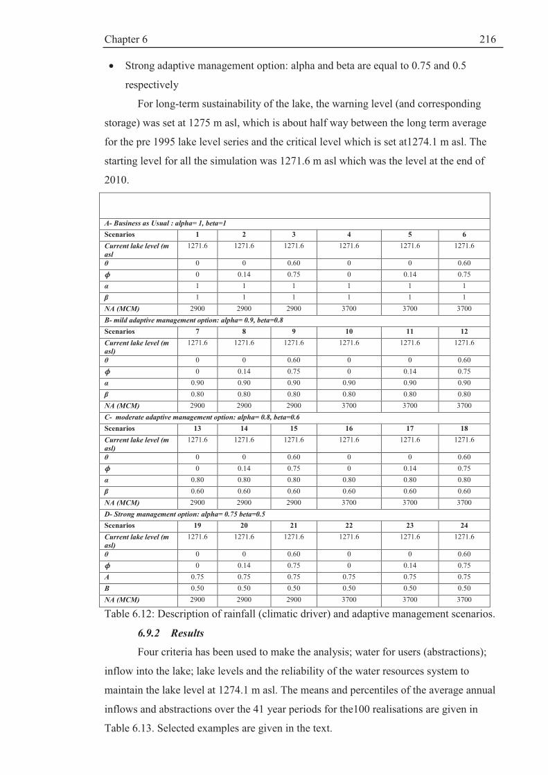
Chapter 6
216
· Strong adaptive management option: alpha and beta are equal to 0.75 and 0.5
respectively
For long-term sustainability of the lake, the warning level (and corresponding
storage) was set at 1275 m asl, which is about half way between the long term average
for the pre 1995 lake level series and the critical level which is set at1274.1 m asl. The
starting level for all the simulation was 1271.6 m asl which was the level at the end of
2010.
A- Business as Usual : alpha= 1, beta=1
Scenarios 1 2 3 4 5 6
Current lake level (m
asl
1271.6 1271.6 1271.6 1271.6 1271.6 1271.6
θ 0 0 0.60 0 0 0.60
0 0.14 0.75 0 0.14 0.75
α 1 1 1 1 1 1
β 1 1 1 1 1 1
NA (MCM) 2900 2900 2900 3700 3700 3700
B- mild adaptive management option: alpha= 0.9, beta=0.8
Scenarios 7 8 9 10 11 12
Current lake level (m
asl)
1271.6 1271.6 1271.6 1271.6 1271.6 1271.6
θ 0 0 0.60 0 0 0.60
0 0.14 0.75 0 0.14 0.75
α 0.90 0.90 0.90 0.90 0.90 0.90
β 0.80 0.80 0.80 0.80 0.80 0.80
NA (MCM) 2900 2900 2900 3700 3700 3700
C- moderate adaptive management option: alpha= 0.8, beta=0.6
Scenarios 13 14 15 16 17 18
Current lake level (m
asl)
1271.6 1271.6 1271.6 1271.6 1271.6 1271.6
θ 0 0 0.60 0 0 0.60
0 0.14 0.75 0 0.14 0.75
α 0.80 0.80 0.80 0.80 0.80 0.80
β 0.60 0.60 0.60 0.60 0.60 0.60
NA (MCM) 2900 2900 2900 3700 3700 3700
D- Strong management option: alpha= 0.75 beta=0.5
Scenarios 19 20 21 22 23 24
Current lake level (m
asl)
1271.6 1271.6 1271.6 1271.6 1271.6 1271.6
θ 0 0 0.60 0 0 0.60
0 0.14 0.75 0 0.14 0.75
Α 0.75 0.75 0.75 0.75 0.75 0.75
Β 0.50 0.50 0.50 0.50 0.50 0.50
NA (MCM) 2900 2900 2900 3700 3700 3700
Table 6.12: Description of rainfall (climatic driver) and adaptive management scenarios.
6.9.2 Results
Four criteria has been used to make the analysis; water for users (abstractions);
inflow into the lake; lake levels and the reliability of the water resources system to
maintain the lake level at 1274.1 m asl. The means and percentiles of the average annual
inflows and abstractions over the 41 year periods for the100 realisations are given in
Table 6.13. Selected examples are given in the text.

Chapter 6
217
BaU scenarios. In the long run, the BaU scenarios are not sustainable. If more
persistence/variability is realized in the future, then the outlook based on the 3rd and 6th
scenarios is bleak. Figure 6.19 shows that the reliability of the system in maintaining
Lake Urmia at 1274.1m asl is almost zero. For example, in Scenario 3, the average lake
level is below the critical level for 99% of the realisations. These statistics can be
generalised for other parameters such as the3100 MCM minimum inflow requirement of
the lake. For example in scenario 3, the average inflow is less than 3100 MCM in 97%
of realisations. Therefore, it is concluded that fixed water allocations of 3700 and 2900
MCM will cause the demise of Lake Urmia in the short/medium term. Consequently,
the decisions reached in Section 6.5 would have to be adjusted to take into account the
role of climatic variability, and the overestimation of the available natural runoff.
Figure 6.19: Risk analysis for BaU scenarios 3 and 6 with high persistence (SRM3).
Scenario 3
0.00%
20.00%
40.00%
60.00%
80.00%
100.00%
120.00%
0
5
10
15
20
25
30
35
1400 1700 2000 2300 2600 2900 3200 3500 3800 4000
Fre
qu
en
cy
Inflow, MCM
scenario 3: inflow
0.00%
20.00%
40.00%
60.00%
80.00%
100.00%
120.00%
0
10
20
30
40
50
60
1266 1268 1270 1272 1274 1276
Fre
qu
en
cy
m asl
Scenrio 3: lake level
0.00%
20.00%
40.00%
60.00%
80.00%
100.00%
120.00%
0
5
10
15
20
25
30
35
0 10 20 30 40 50 60 70
Fre
qu
en
cy
%
Scenario 3: Reliability
0.00%
20.00%
40.00%
60.00%
80.00%
100.00%
120.00%
0
5
10
15
20
25
30
950 1200 1450 1700 1950 2200 2450 2700 2950 3200
Fre
qu
en
cy
Inflow, MCM
Scenario 6: inflow
0.00%
20.00%
40.00%
60.00%
80.00%
100.00%
120.00%
0
5
10
15
20
25
30
1265 1266 1267 1268 1269 1270 1271 1272 1273
Fre
qu
en
cy
m asl
Scenario 6: Lake level
0.00%
20.00%
40.00%
60.00%
80.00%
100.00%
120.00%
0
10
20
30
40
50
0 7 14 21 28 35 42
Fre
qu
en
cy
%
Scenario 6: Reliability
Scenario 6

Chapter 6
218
Scenario Water allocation Percentile
Max 90 mean 10 Min
A-
Bu
sin
ess
as
Usu
al
(a
lph
a,
beta
=1
)
1 Lake Urmia 3170.9 2711.3 2326.8 1966.9 1706.3
Users 2900 2900 2900 2900 2900
2 Lake Urmia 3314.952 2796.399 2328.488 1935.674 1636.103
Users 2900 2900 2900 2900 2900
3 Lake Urmia 3935.5 2892.0 2366.4 1937.2 1404.9
Users 2900 2900 2900 2900 2900
4 Lake Urmia 2440.527 2029.328 1692.854 1382.184 1183.666
Users 3700 3700 3700 3700 3700
5 Lake Urmia 2572.199 2083.573 1699.494 1361.295 1146.216
Users 3700 3700 3700 3700 3700
6 Lake Urmia 3188.427 2171.56 1731.521 1311.021 931.0843
Users 3700 3700 3700 3700 3700
B-
ad
ap
tiv
e:
alp
ha
= 0
.9,
beta
=0.8
7 Lake Urmia 3545.003 3172.199 2786.228 2452.471 2152.968
Users 2510.976 2426.098 2362.439 2334.146 2320
8 Lake Urmia 3638.798 3216.347 2775.39 2413.274 2072.225
Users 2567.561 2435.293 2369.512 2334.146 2320
9 Lake Urmia 4183.03 3310.111 2805.406 2365.012 1822.043
Users 2652.439 2490.463 2383.659 2334.146 2320
10 Lake Urmia 3016.74 2621.011 2270.528 1913.358 1664.543
Users 3104.39 3006.024 2978.049 2960 2960
11 Lake Urmia 3104.638 2674.56 2249.782 1884.454 1594.062
Users 3140.488 3041.22 2987.073 2960 2960
12 Lake Urmia 3659.01 2774.456 2298.877 1851.151 1363.451
Users 3212.683 3068.293 2987.073 2960 2960
C-a
dap
tiv
e, a
lpha=
0.8
, b
eta=
0.6
13 Lake Urmia 3785.491 3517.959 3191.645 2911.931 2590.544
Users 2263.415 2051.22 1923.902 1824.878 1782.439
14 Lake Urmia 3865.14 3546.587 3164.474 2859.779 2503.644
Users 2348.293 2095.073 1938.049 1824.878 1782.439
15 Lake Urmia 4317.42 3575.592 3199.772 2755.986 2251.228
Users 2518.049 2164.39 1966.341 1839.024 1754.146
16 Lake Urmia 3785.491 3517.959 3191.645 2911.931 2590.544
Users 2263.415 2051.22 1923.902 1824.878 1782.439
17 Lake Urmia 3865.14 3546.587 3164.474 2859.779 2503.644
Users 2348.293 2095.073 1938.049 1824.878 1782.439
18 Lake Urmia 3947.791 3247.569 2824.667 2382.329 1869.604
Users 2923.902 2580.976 2382.439 2256.098 2220
D-
ad
ap
tiv
e: a
lph
a=
0.7
5,
bet
a=
0.5
19 Lake Urmia 3889.689 3660.299 3359.189 3095.834 2812.283
Users 2157.317 1929.207 1732.927 1591.463 1520.732
20 Lake Urmia 3967.701 3677.801 3339.233 3047.304 2711.643
Users 2245.732 1964.573 1768.293 1609.146 1520.732
21 Lake Urmia 4377.542 3684.073 3351.502 2936.43 2454.099
Users 2457.927 2035.305 1785.976 1609.146 1538.415
22 Lake Urmia 3591.201 3375.176 3063.193 2787.153 2495.322
Users 2481.707 2233.537 2075.61 1940.244 1895.122
23 Lake Urmia 3619.885 3373.888 3038.331 2750.005 2397.751
Users 2594.512 2278.659 2098.171 1940.244 1895.122
24 Lake Urmia 4051.571 3420.282 3045.269 2624.151 2157.692
Users 2820.122 2368.902 2120.732 1962.805 1850
Table 6.13: Simulation results for average annual inflows and abstraction over the 41year periods for 100 realizations.
Adaptive scenarios. Three pairs of sliding scale parameters were chosen to
simulate the impact of mild, moderate and strong adaptive management options.
For mild adaptive management (alpha=0.9 and beta=0.8), although the reliability
of the system has increased compared with BaU scenarios, this level of reduction factor
favours the users more than the lake, as shown in Table 6.13.If the target abstraction
rate is increased, more water is given to the users at the expense of the lake. Therefore,
in the moderate adaptive model, the target abstraction rate is the determining factor. For
example, in scenarios 10,11 and 12witha target abstraction rate of 3700 MCM, the lake
on average receives of the order of 2300 MCM, whereas, for scenarios 7, 8, and 9 with a
target abstraction rate of 2900, the average inflow increases to 2800 MCM. Therefore,

Chapter 6
219
this level of adaptive management will not achieve the long term aim of the Ecosystem
Management Plan (EMP).
Generally speaking, the strong adaptive approach has favourably influenced the
three criteria used for Lake Urmia sustainability:
· the amount of water inflow into the lake has been greater than 3100 MCM;
· the lake level has recovered to more desirable levels;
· The reliability of the system to maintain the lake at 1274.1 masl has increased.
However, the amount of water available for users has been reduced. For example, for
Scenario 22 in Figure 6.20, the inflow is above 3100 for about 50% of the realisations
whereas none of the realisations achieve the target abstraction of 2900 MCM.
Therefore, there is a need for a trade-off between water allocation to users and to the
lake.
Figure 6.20: Comparison of lake inflow and users’ allocation for a strong adaptive
management option and the no persistence rainfall model (SRM1).
Table 6.13 shows that, for the moderate adaptive management option, and a
target user allocation of 3700 MCM, the average inflow to the lake exceeds 3100 MCM
except under high variability/persistence (i.e. scenario 18). However, the users receive
less than 2000 BCM on average. This reflects the fact that, on average, there is just over
5000 MCM available to be allocated between users and the lake. However as shown in

Chapter 6
220
Figure 6.21, it seems that the lake level under this level of abstraction will not recover
from its current level i.e. the lake level is less than 1274.1 m asl for about 90% of the
realisations, with this figure increasing for the high level of persistence
Figure 6.21: Risk analysis of lake levels for the moderate adaptive management option at 3700 MCM target level of abstraction and rainfall models SRM1-3.
The simulation of the moderate adaptive management option at the target
abstraction rate of 2900 MCM is shown in Figure 6.22, and for the no persistence and
high persistence levels. Generally, the users are expected to be allocated 2000 MCM for
50 % of the realisations i.e. on average this figure can be used while maintaining the
lake level at 1274.1 m asl. This is in line with the current abstraction estimated by the
regression analysis (2045 MCM). This indicates that there is no scope for further water
resources development in the basin and it has reached a saturation point. Any
development will heighten the pressure on the lake and will cause it to go into
permanent decline.

Chapter 6
221
Figure 6.22: Risk analysis of moderate adaptive management option under the no persistence (scenario 13) and high persistence (scenario 15) rainfall cases (SRM1 and SRM3).
0.00%
20.00%
40.00%
60.00%
80.00%
100.00%
120.00%
0
5
10
15
20
25
17
50
18
00
18
50
19
00
19
50
20
00
20
50
21
00
21
50
22
00
22
50
23
00
Fre
qu
en
cy
Abstraction, MCM
Scenario 13: water for users
0.00%
20.00%
40.00%
60.00%
80.00%
100.00%
120.00%
0
10
20
30
40
50
60
1270 1271 1272 1273 1274 1275
Fre
qu
en
cy
m asl
Scenario 13: lake level
0.00%
20.00%
40.00%
60.00%
80.00%
100.00%
120.00%
0
10
20
30
40
5
15
25
35
45
55
65
75
Mo
re
Fre
qu
en
cy
%
Scenario 13: Reliabilty
0.00%
20.00%
40.00%
60.00%
80.00%
100.00%
120.00%
0
5
10
15
20
25
30
35
Fre
qu
en
cy
Inflow, MC
Scenario 13: inflow
0.00%
20.00%
40.00%
60.00%
80.00%
100.00%
120.00%
0
5
10
15
20
25
30
35
1750 1850 1950 2050 2150 2250 2350 2450 2550 2650
Fre
qu
en
cy
Abstractions, MCM
Scenario 15: water for users
0.00%
20.00%
40.00%
60.00%
80.00%
100.00%
120.00%
0
5
10
15
20
25
30
Fre
qu
en
cy
Inflow, MCM
Scenario 15: inflow
0.00%
20.00%
40.00%
60.00%
80.00%
100.00%
120.00%
0
10
20
30
40
Fre
qu
en
cy
m asl
Scenario 15: lake levels
0.00%
20.00%
40.00%
60.00%
80.00%
100.00%
120.00%
0
10
20
30
40
5 15 25 35 45 55 65 75 85 95
Fre
qu
en
cy
%
Scenario 15: Reliability

Chapter 6
222
6.10 Conclusions and recommendations
The conclusions drawn in Section 6.5.5 for part (1) of this Chapter are not
repeated here, but the main outcome of the ISTA component is that, although the
efficacy of the governance system has improved, the effectiveness of the EMP i.e.
achieving long term sustainability of the lake, is in doubt, considering the agreement on
the level of water allocation, and what has emerged from part (2) of this chapter on
overall water availability It seems that both sides of the water allocation equation have
not been fully considered a basin-wide planning approach that requires rigorous
hydrological assessments of water availability and potential for water use. The
implications of the water allocation decisions have not been foreseen by the actors. On
the one hand, the user water allocation ceiling of 3700 MCM lacks rigorous scientific
assessment, and on the other hand, the minimum ecological requirement of the lake has
become a legal right which ignores the hydrological and climatic variability and
persistence.
In the first part of this chapter, the overall outcome of the water allocation
process was that 3100MCM was allocated to Lake Urmia and 3700 MCM to users. This
was based on the estimate of 6900 MCM for natural average runoff to LU derived using
the Detrending Method prescribed by the MoE. However, an examination of the use of
the Detrending Method has revealed that it was based on the highly questionable
assumption that the downward trend in observed runoff over the 1950 – 2008 (58 years)
period of record was attributed entirely to abstraction. By establishing a regression
relationship between runoff and rainfall over the period 1969 – 1995 when the influence
of abstractions was minimal, average annual natural runoff over the period 1969 – 2010
was found to be approximately 5000 MCM. The current level of abstraction was
estimated as approximately 2000 MCM/year, so, based on these figures, there is no
scope for further development/ abstraction if the lake is to receive its allocation of
3100MCM.
Due to climatic variability, fixed allocations cannot be sustained, and so a risk
analysis of a number of management scenarios was carried out using an ARMA (1,1) to
generate multiple realizations of future rainfall for different levels of
persistence/variability. The management scenarios were based on fixed target
allocations of 3700 MCM and 2900 MCM and an adaptive allocation strategy whereby
sliding scale reductions to abstractions were made when the lake levels fell below
warning and critical levels. Mild, moderate and strong levels of reduction were explored
under different levels of rainfall variability.

Chapter 6
223
Overall, the results reflect the overall natural runoff constraint of approximately
5000 MCM, so the fixed targets of 3700 MCM and 2900 MCM cannot be sustained. If
the user abstraction increases above the current level of around 2000 MCM, the Lake
will go into permanent decline. The moderate and strong adaptive options can initiate
Lake Urmia level recovery but only if the target rate of abstraction is much lower than
3700 MCM. It was shown that, at the 2900 MCM target rate of abstraction, the
moderate management option is effective in delivering the amount of water to the lake
required to maintain the minimum ecological requirement (3100 MCM) based on the
vision stated in the EMP which understandably focuses on Lake Urmia’s water
requirements. However, the average amount of water available to users reflects the
overall constraint of 5000 MCM for average natural runoff availability.
However, the actors have chosen to allocate a higher level of abstraction ceiling
which does not take into account the basin- wide hydrological and climatic conditions.
Therefore, the following recommendations are made:
1. A thorough review of the hydrological and climatic baseline data to remove
much of the uncertainty about the water allocation governance.
2. Modification of the 2008 Water Allocation Code by (a) by removing the
Detrending Method in the estimation of the water availability for the basin since
it produces a highly overestimated value of natural runoff; (b) allowing other
MCDA approaches other than AHP to minimise the inconsistency about
weighting water allocation criteria; and (c) using a stochastic approach in the
water allocation strategy since trend analysis is highly unreliable and cannot
account for the persistence and variability of rainfall records.
3. Vensim dynamic simulation has to be calibrated with more sophisticated generic
water resources modelling systems such as WEAP, Mike Basin or RIBASIM.
To conclude, it can be said that the ISTA approach highlighted three main issues: (a)
the need for an independent scientific assessment based on rigorous reliable data; (b) the
revision of the existing water allocation rules i.e.the 2008 WAC; Although, the 2008
WAC has introduced basin-wide planning, it has a rigid scientific approach and uses
highly unreliable methodology in assessing water availability and (c) the outcome of the
WAC process is unrealistic as it ignores demand management which is the cornerstone
of IWRM. To redress this, the reassessment calls for an adaptive water allocation
strategy which is a form of demand management required to achieve long term
sustainability.
In Chapter VII, the institutional implications of the results obtained in this chapter
will be further assessed and further recommendations given.

Chapter 7
224
Chapter VII.Re-assessment of Water Allocation Governance in Lake
Urmia Basin: an Institutional Design
7.1 Introduction:
Chapter VI described Lake Urmia’s new governance system as well as re-assessing
the sustainability and reliability of the water resources system (WRS) to maintain Lake
Urmia’s minimum ecological status using the Integrated Socio-technical Assessment
(ISTA) component. Without repeating the arguments and the conclusions, the main
outcome of the technical assessment is that the participatory process has produced
unsustainable water allocation outcome decisions because most of the participants in Water
and Agriculture Working Group (WAWG) meetings failed to provide accurate data and
information on water availability. It seems that there has been a degree of “data fitting” by
all sides. Therefore, it is argued that the existing institutional set up has to instigate an
inbuilt mechanism for independent assessment since we have a viable governance system
and structure is in place for a re-evaluation process to take place.
Based on the conclusions in Chapter VI, it is argued that fixed water allocation is
not just unrealistic but also (1) fosters zealous impractical expectations for water demands
and (2) hides the realistic outlook of climatic variability and persistence. Hence, it is
recommended to use an adaptive water allocation strategy which is a form of water demand
management. In Chapter VII, we reassess the new water resources governance system (i.e.
multitier MSPs) with the following objectives:
1. To make an analysis of institutional sustainability the MSPs
2. To evaluate the implications of adopting the adaptive water allocation
3. To propose revised Responses based on (1) and (2)
The methodological approach to achieve the above objectives is outlined in the next
section.
7.2 Methodological approach
7.2.1 Data collection and the context of analysis
This chapter is a cross cutting chapter using results from previous chapters as
indicated in Figure 7.1 which provides a schema of the focal level of analysis. The
Institutional Analysis and Development (IAD) approach is used to assess the sustainability
of the socio-political component of the WRS based on the objectives outlined above. The
analytical approach is:

Chapter 7
225
1. To assess the institutional sustainability of the water allocation decisions by
evaluating the efficacy (Box 7.1) of the new rules in use at the operational
level (Section 7.3).
2. To assess the socio-political context of the decision making by
a. analysing the role of ideological aspects of actors in dominant policy
discourses (Section 7.4.1);
b. analysing the narratives behind policy discourses on water resources
planning and allocation (Section 7.4.2);
c. analysing the discourses that influenced the water resources
allocation and management decision-making process (Section
7.4.3); and
d. exploring the potential of a new water management paradigm to
achieve sustainability within the socio-political context (7.4.4).
3. To revise Responses by proposing how to enhance the new institutional
design for an adaptive water resources management in LUB e.g. crafting
new rules to reflect the adaptive water allocation model described in
Chapter VI (Section 7.5).
7.2.2 Evaluative Criteria
The Evaluative Criteria has been introduced in Chapter III (Section 3.5.3). Efficacy
is used as the main criterion for analysing the rules in use. Economic efficiency did not
appear to have been among the list of concerns in LUB- although the stakeholders
Box 7.1: Evaluative Criteria: the three E’s based on Checkland and Scholes (1990, p 39). The rules in use can be judged based on
· Efficacy (for ‘do the rules work?) which “checks whether the means chosen actually work”
· Efficiency (for’ amount of output divided by amount of resources used’) which “considers whether the
transformations is being carried out with the minimum use of
resource”
· Effectiveness ( ‘is the rule in use meeting the longer term
aim’) which shows that a “transformation works and used
minimum resources”

Chapter 7
226
mentioned it; they did not attempt to evaluate it in real terms. In addition to efficacy,
several criteria have been considered:
a. Equity and justice in terms of water allocation outcome: the question
of conformance to general morality was a big issue: can those who
‘cheated the system’ (i.e. EA and lately WA) be rewarded by getting
more allocation of the resource (i.e. to have greater payoff)? It was
decided to re-allocate the water resources regardless of existing
abstractions
Figure 7.1: Focal level of analysis in Chapter VII.
b. Accountability and transparency of the participatory decision-making
process provided the legitimacy of the decisions outcomes
c. Reliability of the WRS in terms of the degree of ability for lake
restoration from ISTA analysis
d. As Ostrom (2005, p.68) notes that it is very difficult to compare the
performance of alternative institutional arrangements; thus trade-offs
are often required in using performance criteria. The trade-off
process used are as follows (a) socio-technical criteria used in the
MCDA of the ISTA component to allocate water resources using
multi-criteria water allocation model (WAM) and (b) risk based
Evaluative Criteria
Efficacy of rules in
use
Results from ISTA in
Section
6.6 and 6.7
Actors
Section 6.3
Action
situation/
2008-2011
Provincial
water
allocation
Outcomes: Revised Response R (t+1)
Section 7.5
Patterns of
Interactions
Section 7.4
based on Ostrom, 2005
R (t)= (Rules-
in-Use:
e.g. MoU
2008 including
EMP
2008 WAC
Section 6.4
2010 NEC By-
law
Section 7.3
Contextual
setting
attributes
Sections 4.3,
5.3 and 6.3
D-P-S-I and R (t)
within
Socio-political context
and Discourses
Narratives
Sections 4.4 and 5.4
and Section 6.4
ETHICS
IWRM
Action arena
Multitier MSP
Contextual Setting

Chapter 7
227
technical evaluation of the allocation decisions using adaptive WAM
for different management options and climatic scenarios (i.e. a trade-
off among different criteria used in the allocation model; then the
allocation was evaluated using the risk-based assessment based on
water balance and stochastic rainfall modelling).
In this chapter, we concentrate on the efficacy of the rules in use in addition to the
above criteria. In Chapters IV, and V, the efficacy of the rules in use was measured in terms
of the adequacy of their design and the implementability.
7.3 Rules in use: an assessment
Several new rules have evolved as part of a well organised effort by CIWP and high
level political support for sustainable water managements in LUB. The new rules have been
‘inserted’ onto the rules map as shown in yellow in Figure 7.2.
As the main rules have been described in earlier part of the thesis; we will
concentrate on the operational decision-making level rules i.e. the 2010 NEC Bylaw on
implementing the 2008 EMP and the WAWG rules or Terms of Reference (ToR). The
latter is discussed first.

Chapter 7
228
Figure7.2: Post MoU rules in use.
2003 Long Term Water Resources
Strategies (IWRM) Plan
1982 Fair water
Distribution Act
Water
Pricing Bill/
/ statuary
allocation
priorities 2003 Water
Allocation By-
Law
PROVINCIAL
LEVEL
NATIONAL
LEVEL
Constitution, Water Vision, Council of
Expediency and Supreme Leader’s
Water Directive, inter-sctoral water
resources Management Directive
other relevant
Acts e.g. 1905
Civil Code
revised 1989
Provincial water
allocation
priorities/rights
outcome:
Provincial sectoral
water allocations
Rules in Use
2000 Bill for
Establishing
MoAJ
LOCAL LEVEL Outcome:
Local Formal
water
allocation
rights
Customary
water
rights
Outcome: informal water allocation
Note:
dotted lines indicate informal rules in use
4th FYDP
Provincial Development
Directive
Presidential By-
laws on
provincial visits
IWRMC Water
Allocation Code
RWC Water Allocation
Code
informal Local Water Rights Rules
(illegal, unplanned or unhindered abstraction
rules)
Election
Political
manifestos
(MPs and
presidential )
MoAJ Water small
Water Supply,
dams, reservoirs
and Irrigation
networks
Directive
Credits Orders-
Annual Budget
Law
Water and
irrigation
project Plans
LUB LEVEL
2008 Water
Allocation Code
2008 MoU
2010 By-law
NECLUB
WAWG Rules
(stakeholder)
2008 EMP
Regional
Council
Rules

Chapter 7
229
7.3.1 Crafting new rules for participation
With reference to the ToR of the author as national IWRM consultant (Appendix
A2), a capacity development strategy was agreed for facilitating the Working Group
meetings in consultation with the CIWP. The strategy was centred on the following rules
(Appendix A1, Table A1.4):
1. Boundary and scope rules: there was a need to create a basin perspective rather than
sectoral and provincial approaches to water and land management in the basin.
Therefore, in order to foster the emergence of a new water management paradigm,
river basin approach was chosen as a boundary unit for water resources planning
and allocation.
2. In addition to the position rule on the author’s role as described earlier, there was an
emphasis on
a. a new general position rule based on the new scope and boundary rules was
established to foster (institutionalise) a basin-wide role for the participants
so that members of the WAWG are disengaged (detached) from their official
provincial roles as representatives of different organisations;
b. national stakeholders were invited to the meetings to enhance the ownership
of the results and to give MoE assurances that it will act according the 2003
WAD and the 2008 WAC. This was based on the assumption that the
success of the WAWG depended on how the WAWG transmits its higher
decision-making levels since water allocation decision is highly centralised.
De Jong and Spaans (2009) assert that” an active government is particularly
needed in the initial stage in which a decision has to be made about the
creation and design of the trade-off scheme”. As a result, the process was
‘blessed’ by the MoE.
3. New information rules were created: (a) a databank to be created i.e. data should be
shared across the sectors; (b) transparency about the quality of the data i.e. data is
scrutinised in an open participatory way and (c) uncertainty should be
communicated to the decision-makers by considering the available facts and figures
and acknowledge any information inadequacy i.e. to foster the belief that we have
enough evidence about the water resources in the basin to make sound decisions.

Chapter 7
230
4. An aggregation rule was established to adjust the balance of power among actors
i.e. national and provincial stakeholders were on the same level and decision to be
made based on consensus.
5. An empowerment (scope) rule was used to foster the belief that decisions made at
the WAWG will be used by decision-makers at higher levels i.e. unlike previous
projects such as WRI (2005), this is for real and the outcome will be approved by
the national and provincial decision-makers and implemented accordingly. CWIP
had an added advantage in the legal sense compared to other national and
international projects: MoU provided the legal mandate of the Working Group work
and hence part of the strategy was to “sell” the unique status of CIWP in the water
allocation process.
6. Payoff rule was centred on the notion that if the participants fail to reach a decision;
then the decision is made at a higher level. Therefore, there should be no
complacency as local problems require local solutions.
7. Choice rule to make LU a water demand site: on the onset of the process, it was
important to emphasise the need to make hard choices and to accept a compromised
outcome. McShane et al (2011) have demonstrated the difficulty to attain win-win
outcomes in complex environmental action situations in which socio-economic
prosperity is a prime objective based on 20 years of empirical research results by
different researchers. The win-win approach has been rather rare compared with
trade-offs and ‘hard choices ‘approach which is norm. However, the ethical and
morality of win-win approach was maintained in terms of making Lake Urmia as a
priority demand site in the water allocation process.
Other contextual factors include improving the democratic nature of the decision-
making or accountability by encouraging self-belief among the stakeholders i.e. there was a
need for decisions as the problems are well known; hence stakeholders should not be afraid
of taking responsibilities for their decisions.
The successful outcome of the WAWG meetings can be attributed to the ability and
the flexibility to craft new rules at the local level (operational level) by dealing with issues
related to the participation arrangements such as power relationships among actors.
7.3.2 2010 NEC By-law: dynamic rule-crafting powers
The typology of the rules used in the 2010 NEC By-law is given in Table 7.1. There
are 8 Articles dealing with the issues at the operational level decision-making.

Chapter 7
231
LU water rights. The 2010 NEC By-law recognises LU’s water rights of 3100
MCM which provided a new lifeline for the Working Group bearing in mind that neither
the Regional Council nor the Working Group are explicitly mentioned in the Bylaw but it
refers to the Ecosystem Management Plan which refers to both. For the first time ever,
water allocation in LUB was based on an ecohydrological policy. This in itself is an
achievement for environmentalism in Iran.
Lack of aggregation rules. The By-law lacks clear aggregation rules on how
position and choice rules are evaluated, assessed and agreed upon. Also, the 2008 NEC
Bylaw takes a top-down approach1 by centralising all the work in the NEC which makes it
almost impractical: designing, planning and monitoring are bestowed upon the NEC which
comprises of several ministers and led by the First Vice President.
Article Rule Typology Description
1 Boundary Members of NEC are selected (Figure7.1)
Position Actors are assigned to coordinate and implement 2008 EMP
2 Position DoE will act as a secretariat of the NEC
3 Position and
Boundary
Chairperson can invite any other relevant organisations to attend the meetings
4 Aggregation Decision-making is by the majority rule;
Scope The presidential powers are delegated to the members of the NEC and any ruling can become legally
binding and issued as a By-Law of Council of Ministers.
5 Position NEC Terms of reference has been outlined;
Choice design and planning of action and implementation plans especially during environmental crisis and
droughts conditions;
Choice and Scope Assessment of management proposals and planning
Choice Make sure the supply of 3100 MCM of min ecological of LU and allocate provincial water shares
Choice and Scope Monitoring the performance of governorates and organisations on the implementation of the EMP
Choice and Scope Allocation of budgets and assessment of project proposals
6 Scope, Choice and
Position
Sets out in detail the responsibilities of each of MoE, MoAJ, DoE and provincial governorates in
implementing the 2008 EMP by assigning to them positions to act with a target outcomes
7 Payoff provinces are given public finances according to their share and role in the 2008 EMP
8 Position and choice NEC reports each year to the President
Table7.1: Typology of rules in the 2010 NEC By-law.
This requires a high level of coordination at the collective choice level decision-making to
make operational decisions such as water allocations. For example, the Vice President (VP)
is responsible for nearly 40 collective choice level (i.e. policy-making) committees and part
1 In practice, NEC has not exercised its powers and delegated it to WAWG meeting decisions but there is a potential to apply the rule in a different way.

Chapter 7
232
of the delay for finalising the Sanandaj agreement was due to lack of time and difficulty of
managing the time of collective choice level actors such as three Vice Presidents and other
ministers. Therefore, NEC has been interlocked in the governmental web and has become
ineffective for a long period until the 4th joint meeting.
Government without coercion. After the Sanandaj (6th WAWG) meeting, NEC had
a strong mandate to act but it preferred to referring back to the WAWG and establishing a
technical committee based on smaller WAWG members to finalise the Sanandaj agreement.
This clearly shows that NEC abstained from top-down approach of the By-law by not did
forcibly issue a decision on the provincial water shares and looked to establish consensus. .
Government is needed in the form of political support for the process but with no coercion.
Polycentricism. To deliver the water to LU requires an unprecedented cooperation
between multi-level and multi-sectoral institutions; thus it seems that NEC has recognised
the polycentricism of nested interests in the water allocation process. Since late 1960,
Elinor and Vincent Ostrom have worked on the idea of polycentric institution as opposed to
homocentric conception of public administration (Toonen, 2010). The IAD framework is
used to comprehend institutional diversity in the form analysing and formation of robust
governance in polycentric institutions (ibid, p.198). As described in Chapter III, Ostrom
(2011, 2010) which has crafted the idea of Social-Ecological Systems (SESs) Framework
asserts that actors in the action situation “are not external, but are endogenous to the
development of ecosystems (Toonen, 2010). Ostrom (2005, 2007, 2011) conceives robust
governance system to be polycentric and multi-layered nested enterprises representing the
diversity and complexity of SESs; diversity and complexity should be recognised and not
eliminated from institutional design (e.g. Toonen, 2010).
Lack of community level involvement. Article 6 deals with identifying water-saving
projects to implement the EMP but there is no guidance of how to coordinate and monitor
water demand management programme. There is no mention of how to deal with existing
informal abstraction in terms of its equitable re-allocation and provinces such as WA
consider these as downstream water rights (Karimi, 2010). The absence of community level
actors (farmers) can jeopardise the process as they are one of real game-changers in LUB.
As with the land reforms narratives (Chapter IV), farmers have a strong political niche in
the Iranian political system and they can exercise immense power in elections and
especially local MPs will not disenfranchise these local constituents.

Chapter 7
233
There are two main conclusions from above analysis of the rules. First, insertion of
new rules as in the case of LUB (Figure 7.2 shown in yellow) without revamping existing
laws and rules are going to produce confusion among actors. The legal frameworks need to
be streamlined to make sure that any contradiction and duplication are removed. Secondly,
creating position rules without considering the capacities required to fulfil the positional
role is rendered useless. All of the actors have had many other responsibilities and
basically, they had little free time to prepare for their new roles. Many could not reconcile
their new position by breaking from their existing jobs and hence there was a conflict of
interest between fulfilling their official duties and work for the new institutional setup. The
financial costs of these rules were not considered and this threatens the long-term
institutional sustainability of the multi-stakeholder participation platforms.
Dynamic rule crafting. The 2010 NEC By-law gives an important legal mechanism
to NEC with delegating presidential powers. This means that the NEC decisions have a
legal stature same as the Council of Ministers By-laws. Law-making is a long process; it
takes decades for an Act of Majlis to be ratified. Council of Minsters’ By-laws can take
years to be endorsed. Therefore, to address immediate operational level needs, this
mechanism can be very effective. Some of the issues which were missing from the 2010
NEC By-law have been addressed by the third and 4th NEC meeting Directives which
includes important choice, payoff, position and scope rules as shown in Table 7.2
From Table 7.2, there are some important rulings:
1. It gives MoE the power to reassess the water development plans in the
provinces and asserts LU’s water rights by specifying any water allocated
from dams to be deducted from surface water allocation given to provinces.
2. It allocates financial resources to the implementation of the projects and the
establishment of a permanent secretariat for the management of the LUB.
3. Recognising the need for political support for the RC, it implicitly calls for
the merger of the RC and NEC.
4. It recognises unauthorised abstraction as the one of the main issues but asks
the provinces to manage informal abstractions without providing clear
guidance of how this should be done.

Chapter 7
234
A. 3rd
NEC Meeting Directive
Article Rule Typology Description
1 Choice 3100 MCM minimum environmental water rights of LU to maintain lake level at 1274.1 m asl
Choice 73 MCM water to be allocated to Satellite wetlands to be jointly agreed by MoE and DoE
2 Payoff 47,000,000,000 Riyals for environmental projects to implement the EMP (equivalent to UD$5,000,000)
3 Payoff Water use efficiencies projects to implemented; 50% of the cost of upgrading irrigation technology
(20,000,000 Riyals= US$2000) per ha to be given to farmers; bank loan facilities to provide the other 50%
as incentive
Choice Water saving from water demand management to be allocated to Lake Urmia
Position/ Scope First Vice president delegates its power to Mr Aliabadi, Deputy Vice President for Coordination and
Monitoring Public Organisation.
4 Choice Provincial water shares to be reviewed and agreed within 10 days. (Sanandaj Agreement was finally
endorsed
Choice and
Scope
In reassessing provincial water shares, MoE is given power to review the water allocated to the dams built
in each province and how much provinces can use with the aim of increasing Lake Urmia’s water allocation
i.e. volume of existing allocated water from dams are deducted from their provincial shares
5 Choice Due to limited water resources, further water resources development should be stopped and no more water
rights should be given
Scope Kurdistan Province is exempted from the above rule to allow equitable development
6 Choice All the projects as listed has been approved; NEC should review allocated budgets for these projects in the
next meeting
7 Position and
Choice
Unauthorised water abstraction should become an agenda and precisely monitored with greater control by
MoE and MoAJ
8 Position MoE and MOAJ reports every 6 months to the NEC on the issue of unauthorised abstraction
B. 4th NEC and 1st RC meeting Directive
1 Choice Shares are allocated as per 6th WAWG meeting in Sanandaj
2 Position/Scope Provinces to establish a monitoring system and a plan to provide LU with water
3 Position/Scope With the support of judicial and political actors, unauthorised abstractions to be managed
4 Position/Scope ToR of the Working Groups agreed
5 Payoff 3 Billion Rial to establish the Secretariat
6 Scope Joint RC and NEC meetings Twice a year
Position/Scope WAWG to draw water allocation strategy (plan)
Table 7.2:Typology of rules made by the 3rd NEC and 4th Joint NEC/RC meeting.
Therefore, there are still gaps in these Directives which have to be filled. As IWRM
is a “process and not a goal in itself” (see Chapter II), then it is understandable that this
process is gradual and can be improved when the participatory process is refined through
the process of social learning.
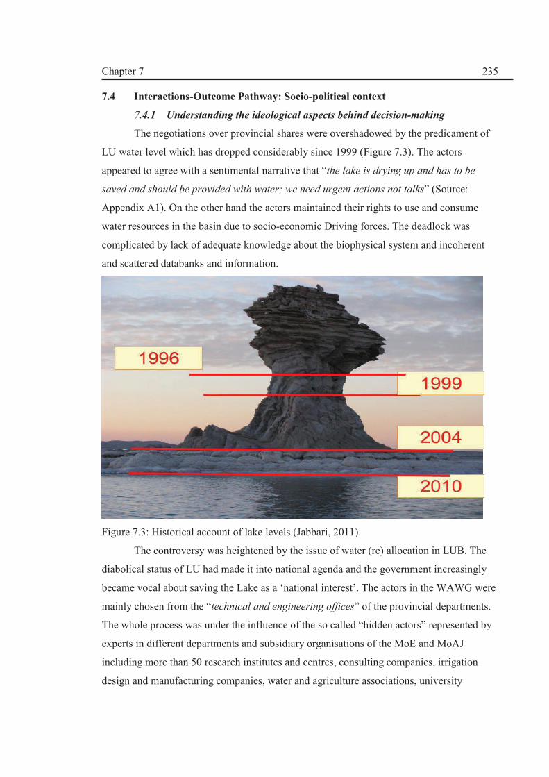
Chapter 7
235
7.4 Interactions-Outcome Pathway: Socio-political context
7.4.1 Understanding the ideological aspects behind decision-making
The negotiations over provincial shares were overshadowed by the predicament of
LU water level which has dropped considerably since 1999 (Figure 7.3). The actors
appeared to agree with a sentimental narrative that “the lake is drying up and has to be
saved and should be provided with water; we need urgent actions not talks” (Source:
Appendix A1). On the other hand the actors maintained their rights to use and consume
water resources in the basin due to socio-economic Driving forces. The deadlock was
complicated by lack of adequate knowledge about the biophysical system and incoherent
and scattered databanks and information.
Figure 7.3: Historical account of lake levels (Jabbari, 2011).
The controversy was heightened by the issue of water (re) allocation in LUB. The
diabolical status of LU had made it into national agenda and the government increasingly
became vocal about saving the Lake as a ‘national interest’. The actors in the WAWG were
mainly chosen from the “technical and engineering offices” of the provincial departments.
The whole process was under the influence of the so called “hidden actors” represented by
experts in different departments and subsidiary organisations of the MoE and MoAJ
including more than 50 research institutes and centres, consulting companies, irrigation
design and manufacturing companies, water and agriculture associations, university
Chapter 7
236
departments on water and agriculture and technical offices and lobbying groups (see e.g.
Keshavarz and Dehghanisanji, 2007).
Reverence for water. Almost all the meeting started with the recitation from Holy
Quran on water: “We made from water every living thing” (21:30). This strong religious
reverence for water is embedded in the development discourse i.e. the belief system of the
community of actors. But also, there is a reverence for land and farming is considered as
the noblest profession. This has resulted in distinctive and dominant polices such as the
populist agricultural polices of land reforms in the 1960s and the farmer -welfare oriented
policy of the successive governments after the revolution in 1979 (Chapter IV); self-
sufficiency and food security polices and pro-development polices . The actors‘
perspectives (mental models) have been affected by the cultural and religious ethics in
LUB. As mentioned in Section 2.3.5 (Chapter II), the religious ethics of environmental
stewardship can be overridden by other meta-beliefs such as attaining basic human needs
which is reiterated by the sustainable development concept and the idea of win-win
solutions.
Cultural and ethical factors. The evidence based decision-making stems from a
tradition of strong esteem for knowledge and scientific deliberation in Iranian and Islamic
culture. Knowledge is the way to enlightenment: it is the light or ‘Noor’ in terms of
spiritual development of human capacity to make sound decisions (see e.g. Rosenthal,
2007). This rational approach is firmly embedded in the cultural and religious values
making knowledge or ‘ilm’, an essential part of narrative form of the discourses. These
research and technical centres within the water sector organisations have an important role
in shaping the narratives as well as providing alternative policy options.
Role of hidden actors. Qolipour and Gholampour-Ahangar (2010) assert that
experts employed by Iranian governmental organisation have a great role in drafting laws
and policies but later their drafts are changed by the policymakers to an extent that it no
longer addresses the policy problems due to the impact of “hidden” lobbying groups. Also,
the religious organisation including their research bodies have a very instrumental role in
policymaking and they contribute to the discourses on wider policy implications. We will
come back to the theme of hidden actors later.
Qolipour and Gholampour-Ahangar‘s (2010) work which was commissioned by the
influential Majlis[i.e. Parliament] Research Centre (MRC) proposes a framework for public
policy analysis which appreciates the role of “politics and political streams” and “interests”
Chapter 7
237
associated with power relationships within the socio-political and religious arena i.e. policy
discourses framed by these hidden actors play a vital role during information and
knowledge sourcing, utilisation and application. .Therefore, they acknowledge that
policymaking is not just based on rational choices but involves policy discourses within the
political environment.
The concept of ‘hidden actors’ was postulated by Kingdon (2002) describing the
role of these actors in the policy making process. They play a far greater role after a policy
issue (idea) gains an agenda status (see Chapter II) and the evidence-based decision-making
pathway is initiated. Kingdon (2002) states that “visible participants (actors)” have a major
role in agenda setting but “hidden participants” including academic researchers,
consultants, career bureaucrats and official and advisors of governmental departments and
so forth are influential in crafting alternative policies and proposing solutions to policy
problems. The presence of these actors manifested in the presence of WPAC and IWRMC
in the WAWG meetings dictating how information and knowledge is used in the decision-
making process as described earlier (Figure 7.4).

Chapter 7
238
Figure 7.4: The role of ideological aspects of actors and the hidden actors on water allocation decision outcomes in LUB.
Figure 7.4 refers to the perspectives (mental models) of actors involved in the
WAWG knowledge-based decisions and the role of discourses and ideological aspects
(cultural and religious values) on the actual water allocation outcomes based on “Shared
Mental Model” (SMM) developed by Denzau and North (1994, 2000). Ideology is not
uniquely defined in the political sciences but Jackson and Kingdon (1992) define ideology
“whether unidimensional or multidimensional” as “a set of core beliefs that organize
perceptions of political issues and that underlie individual preferences.” According to
Denzau and North (1994) SMM are “internal representations that individual cognitive
systems create to interpret the environment”. Thus ideologies are a framework of path-
dependent SMMs held by actors which process knowledge about the environment and
prescribe “how the environment be structured” (Denzau and North, 1994). SMMs are
intertwined with history (path-dependency feature) and represent religious and cultural
attributed of the community.
Refereeing to Figure 7.4, the evidence-based pathway framework proposed by
Bowsen and Zwi (2005) consists of three phases: sourcing the evidence, using the evidence
and considering capacity to implement. These are related to three decision making factors
(Figure7.4): adopt, adapt and act. According to Bowsen and Zwi (2005), once adopted, the
evidence is adapted or changed by actors and then it will be implemented once certain
Hidden Actors:
cv
External action situations
Chosen
Water
Allocation
Perceptions of
the situation
Actors(stakeholders) in
Water Allocation action
situations in LUB MSPs
Perspective(s)
Ideology
Cultural ethics &
religious values
Evidence Pathway Framework
for Water allocation situation
Discourses and
Policy Narratives
Possible
actions
Revised
Perspective(s)
Expected
Outcomes
Actual Water Allocation Outcomes
Evidence and
information about
Actual Outcomes of
Prior Water Allocation
Adapted from Ostron (2005, p.105) based on Denzau and North (2000, p.36)
External
Actors: 1. Sourcing the evidence
(Knowledge, Research,
ideas, politics, economic)
2. Using the Knowledge
(interpreting, applying,
knowledge utilisation)
3. Considering capacity
to implement
(individual actors,
organisations, policy
system)
After Bowen and Zwi (2005)
Adopt
Adapt
Act

Chapter 7
239
capacities are in entrusted in individuals or organisations. The dominant anthropocentric
perspective on water allocation in LUB stems from welfare-oriented cultural and religious
ethics of fulfilling the basic human needs which were shaped by developmental and climate
change discourses of the actors within the process and “hidden actors” in the water and
agriculture sector as represented in Figure7.4.
The 2008 WAC which provides guidelines on how evidences are acquired, used and
applied is the brainchild of the WPAC. With reference to results from ISTA in Chapter VI,
the actors involved in the WAWG rejected the evidence provided by the WPAC on
dynamic modelling simulation which was based on the documented information provided
by them; they rejected the proposition to keep the lake level at the minimum ecological
level of 1274.1 m asl, LU has to be allocated 3900 MCM; instead, the actors endorsed the
proposition of 3100 MCM which was made by Nazaridoust (2006) and Yekom (2005) as
part of research work and promoted by CIWP through the synthesis report prepared by the
author (Hashemi, 2008). A “window of opportunity”2was opened for WPAC to postulate a
“hidden” discourse that there is no further potential for development in the basin after
finishing the on-going dam projects and the idea of water requirement for the lake provided
an opportunity for basin-wide planning and allocation. But, the actors rejected WPAC’s
favourite strategy instead they chose to make a complete reallocation of water resources
(see Figure 6.12). Also, provinces ascertained shared perspectives or SMMs based on the
local needs in weighting the water allocation criteria. They formed blocks based on political
boundaries and not sectoral affiliations. For example, Environmental Protection
Organisations (EPOs) joined other organisations in their respective provinces.
7.4.2 Loops of narrative behind policy discourses
In the previous section, we shed some light on the interplay between information
and knowledge utilisation processes and ideological attributes of the community shaping
the policy discourses. The discourses will be discussed in the next subsection but there is a
need to understand the stories (narratives) behind the argumentations provided behind these
discourses to show the level of complexity which caused polarisation of opinions among
the actors. The outcome of LU water allocation can be analysed based on narratives
(stories) which were told by the participants reflecting a complex multi-layered mental
maps or perspectives of actors. Media stories about LU drying up prompted ‘save the lake’
2This term is used to indicate a practical mechanism for institutional change or reform e.g. with respect to
administrative changes in political office, Groenewegen and de Jong, 2008 note that “to shift the balance of
power, a window of opportunity is required”.
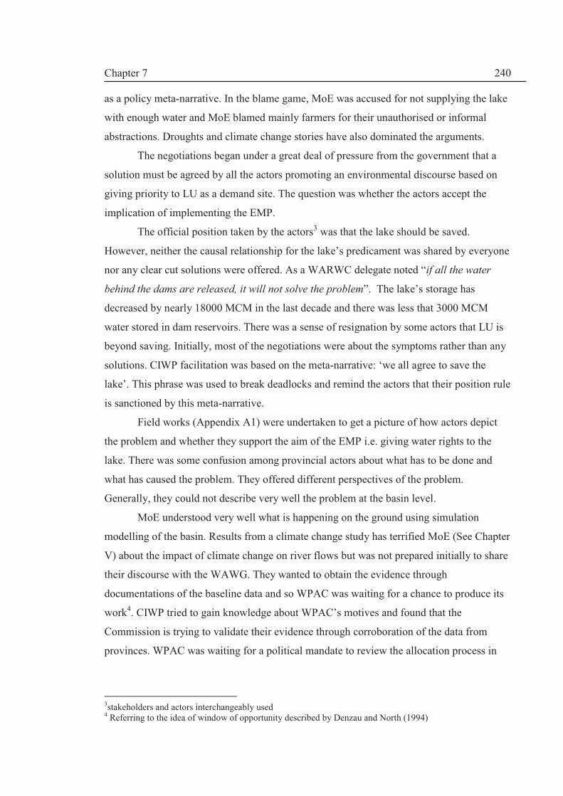
Chapter 7
240
as a policy meta-narrative. In the blame game, MoE was accused for not supplying the lake
with enough water and MoE blamed mainly farmers for their unauthorised or informal
abstractions. Droughts and climate change stories have also dominated the arguments.
The negotiations began under a great deal of pressure from the government that a
solution must be agreed by all the actors promoting an environmental discourse based on
giving priority to LU as a demand site. The question was whether the actors accept the
implication of implementing the EMP.
The official position taken by the actors3 was that the lake should be saved.
However, neither the causal relationship for the lake’s predicament was shared by everyone
nor any clear cut solutions were offered. As a WARWC delegate noted “if all the water
behind the dams are released, it will not solve the problem”. The lake’s storage has
decreased by nearly 18000 MCM in the last decade and there was less that 3000 MCM
water stored in dam reservoirs. There was a sense of resignation by some actors that LU is
beyond saving. Initially, most of the negotiations were about the symptoms rather than any
solutions. CIWP facilitation was based on the meta-narrative: ‘we all agree to save the
lake’. This phrase was used to break deadlocks and remind the actors that their position rule
is sanctioned by this meta-narrative.
Field works (Appendix A1) were undertaken to get a picture of how actors depict
the problem and whether they support the aim of the EMP i.e. giving water rights to the
lake. There was some confusion among provincial actors about what has to be done and
what has caused the problem. They offered different perspectives of the problem.
Generally, they could not describe very well the problem at the basin level.
MoE understood very well what is happening on the ground using simulation
modelling of the basin. Results from a climate change study has terrified MoE (See Chapter
V) about the impact of climate change on river flows but was not prepared initially to share
their discourse with the WAWG. They wanted to obtain the evidence through
documentations of the baseline data and so WPAC was waiting for a chance to produce its
work4. CIWP tried to gain knowledge about WPAC’s motives and found that the
Commission is trying to validate their evidence through corroboration of the data from
provinces. WPAC was waiting for a political mandate to review the allocation process in
3stakeholders and actors interchangeably used 4 Referring to the idea of window of opportunity described by Denzau and North (1994)

Chapter 7
241
Lake Urmia basin. IWRMC was critical of the WPAC’s inaction on provincial applications
for water allocations. The tension between the MoE groups was evident.
From the Problem Statements (PS) (described Chapter III, Roe, 1994), two distinct
strategies (management options) have been considered in LUB:
1. non-structural Responses i.e. to have irrigation water efficiency measures within a
change in regional development (agricultural) policy (change in type of crops); and
2. structural interventions (Responses) i.e. continue with water resources development
plans.
Both of these policies were found to have loops or as described by Roe (1994) to
have circular arguments. Loops in the policy narratives illustrate a high degree in
complexities. One of the solutions mentioned in the negotiations was change in regional
development policy i.e. changing crop types to deal with water scarcity problem in LU. The
actors presented the following PSs: changing crop types
Ø leads to irrigation efficiency i.e. more water saving;
Ø leads to more irrigated land i.e. an incentive to farmers to own this extra water
(explicitly stated in the Directive);i.e. less water saving
Ø is financially unfeasible and cannot be controlled i.e. market forces will have a
control;
Ø requires subsidised help and incentives i.e. it has an economic burden;
Ø leads to economic valuation of water i.e. more appreciation of water price;
Ø should be based on socio-economic aspects of farmers i.e. it should be driven by
anthropogenic pressures;
Ø can cause less water for the Lake.
Based on the above PSs, (a) water savings (if any) is mainly used to irrigate new
lands rather than delivered to the lake; (b) it will cost more because incentives should be
given to the farmer (usually financial incentives like price guarantees); and (c)
consequently, changing crop type means less water for LU.
Water development loop arises from regional agricultural policy which justifies
dam-building and development of irrigation networks to maintain the environmental low
flow of rivers in dry spells (i.e. drought conditions) and for irrigation. The PSs on dam-
building were:
Ø Climate change and droughts necessitate to build dams to harness access to water
Ø Climate change and droughts cause low flow

Chapter 7
242
Ø Low flow causes LU water level to fall
Ø LU water level is not helped by releasing all the volume of water behind the dam
Ø Climate change (variability) and droughts has caused the lake to dry up
Ø Dams are built to regulate low flow
Ø Dams recharge groundwater tables
Ø Dam reduce groundwater abstractions i.e. more surface water used
Ø Dams use more water for irrigation (i.e. more water abstractions)
Ø Dams cost money and over designed; i.e. partially full
Ø Regulated water from dams to be given to the highest bidders
Ø ‘Trading’ water as Virtual Water has to be considered and is not considered
Ø Water markets have no place in this problem
Ø Social unrest happens if to charge for modern dam facilities- people want free
water
Ø Social unrest will be caused by not building dams
Ø Lack of environmental criteria has caused the Lake to dry up
The fear of droughts and climate change is a dominant meta-narrative: dams will
provide the means to control water resources in droughts and water scarce areas. Dam
building seems to offer a solution to important socio-economic problems of water scarcity.
So the main questions are: can the lake be given priority over the societal needs? And who
pays to buy water for the Lake?
As noticed, the social and political aspects dominated the narratives. It is noted that
LU was not clearly on the mental map of the provincial actors. The only credible solution
i.e. changing crop types and irrigation water use efficiencies were dismissed as non-
practical. With this in mind, WAWG meetings embarked on a difficult task to put Lake
Urmia on the ‘issues map’ and making it central to any water allocation in the basin.
Therefore, the momentum of the participatory process was kept by high political support
for WAWG. It can be concluded that there are many loops in the arguments and the actors
have no idea how to implement a win-win strategy to save the lake. In fact, saving the lake
was not on their issues map despite paying a lips service to it as mentioned earlier.
7.4.3 The discourses
By analysing the narratives form of the main discourses in the LUB in the last
section, it was demonstrated that provincial water resources planning did not consider LU
as an environmental ‘demand site’. In this part, we want to show how LU dilemma shaped

Chapter 7
243
the perspectives of the actors based on their discursive deliberation on the policy in
question i.e. saving the lake by recognising its formal rights.
Fostering environmental law-making. MRC (1995) recognises that MoE lacks
institutional capacity to protect the environment (rivers and wetlands) and hence, there is a
need for water and land management paradigm shift towards environmental sustainability
within the water sector and MoE in particular for any successful implementation of EMPs
in Iranian river basins. There are no explicit provisions of environmental water allocation in
the existing water legislation (1982 FWD Act). Therefore, according to Ramsar Convention
Secretariat (2007), one of the options is to follow the path of law and policy-based
decision-making5 : either to make the wetland a higher or equal priority than others uses.
Under this option, “there is a need to remain realistic, especially where the short-term
demands and economic development may be pressing, although the long-term requirement
and for protection of ecosystems are recognised” (ibid). In LUB, the 2008 NEC provides
the institutional basis for environmental sustainability by explicitly stating that the MoE has
to deliver 3100 MCM to the lake.
The environmental discourse has not been part of the mainstream polices and lacked
political support. So, the development in LUB is a welcome sign for the environmentalists.
Additionally, the environmental discourse been marred by ‘mixed-bag’ polices i.e. polices
that endorse only some aspects of environmental sustainability and presented as IWRM
policy. For example, Fadeifard (2009) is reconstructing the environmentalist discourse in
this way:
We ask them [i.e. environmentalists] to provide alternative options; these friends
concentrate on three options and I can say with great confidence that they are pursued [by
policy-makers] and the government fortunately has invested on these issues: for example:
recycling water; water efficiency, use of gray water; more research on water management
… use of desalinations… water cost recovery …[Fadaeifard, 2009].
Fadeifard (2009) capitalises on the environmentalists’ lack of politically acceptable
alternative policy narrative. According to him much of the environmental discourse has
been debated and approved by public policy-makers such as non-structural responses in
terms of demand management and water efficiency measures and adaptive management
policies. Also, environmentalists are portrayed as alarmists with no real alternative policy.
5 The other path is valuation-based process.

Chapter 7
244
The environmentalists such as Muhammadi (2010) have used media to expose “the
myths of dam buildings”. Muhammadi (2010) acknowledges the weakness of the
environmental voice but envision an activist approach to deal with the “catastrophes”
caused by dams as he mentions some successes achieved by public protests resulted in e.g.
lowering a dam height or stopping dam-building altogether. MoE had responded to some of
the criticism through mass media. With regard to Lake Urmia, the environmental discourse
is gaining momentum and there has been an urban show of protest in recent times.
However, it is suggested that politicising the environmental discourse will further fuel
ethnic tensions in both EA and WA. Since Lake Urmia water right has been established, it
is time for independent objective technical re-evaluation and not political maundering on
Lake Urmia. The blame game might not be effective to achieve the goal of the EMP.
Most environmentalists believe that we have enough laws and polices but they are
not implemented mainly due to DoE’s lack of logistical instruments to monitor the
environment. Thus, there is a lack in data related to the environment. Therefore, the impact
of the policies cannot be completely assessed. The environmental discourse relies upon the
general public perception of environmental degradation which can polarise the policy issue
and policymakers be made to defend their positions. There is a high level of risk that any
future environmental meta-narrative is going to be rejected when the socio-economic
interests and security (food, water, social welfare etc.) are balanced against environmental
protection (i.e. the perspective of the actors may be modified during cost-benefit analysis of
the action-outcome linkage). The 1974 Environment Protection Act needs to be updated
and streamlined with water and land laws.
More research on climate change needed. Climatic variability and change is
neither well defined in Iran nor in Lake Urmia. There is some linguistic confusion in the
Iranian (Persian) literature between changes in climatic parameters and climate change.
However, the term “droughts” is used by provincial stakeholders to get extra revenue for
developmental works or some of other programs (Appendix A1, Table A1.4). For Lake
Urmia basin as an arid to semi-arid region, droughts are not unusual. The discrepancy in the
WPAC’s climate change discourse (see e.g. Attarzadeh, 2009; MoE, 2010b) is that on the
one hand it places a great weight on the “droughts” component but put less importance to
the human induced impacts such as dam-building. On the other hand, in the water
allocation process, it attributes 100% of the trend to the abstraction (see Chapter VI).
Therefore, MoE is happy with building the dams since they attribute very little to the Lake

Chapter 7
245
Urmia crisis (only 5%) and can provide a buffer for hard times such as droughts. Thus,
MoE agrees to continue with the development but would like to restrict water allocation.
However, it is politically very difficult to restrict water allocation once the infrastructure is
built. For example, Tabriz mega city’s (Chapter V) urban and industrial water demands are
rising and there are calls for more investments to transfer water from dams in WA.
The prospect of dam decommissioning. Furthermore, the defenders of expanding
irrigation development use the uncertainty of climatic parameters as shown in this
statement by a member of Iran’s Committee on Large Dams (IRCOLD):
Building a dam has a prime advantage in controlling waters which we could not previously
control. They are collected in a place (reservoir) and we can ensure downstream water
rights and even environmental requirements with a greater confidence……like controlling
traffic in Tehran city; we control the waters during floods and prevent damage. The extra
water available [behind the dams] can be used for our developmental needs and
downstream water rights… (Fadaeifard, 2009)
Therefore, there is need for more rigorous research on topic of climate change in
LUB to deal with the knowledge uncertainty. Based on the results in Chapter VI (i.e. results
from ISTA component); it is not possible to conclude that climate change has occurred. The
3rd NEC meeting Bylaw-Article 5 (Table 7.2) calls for immediate halt to dam-building and
so there is a hint of dam decommissioning. This paradigm will send shock waves to the
quarters of those who call for more developments. The new environmental discourse is also
hinging around the decommissioning of dams around the globe.
Reconciling National vs. local interests. The hidden perspective of MoE is that
local short-termism is not compatible with long term national interests. There is a need to
reconcile this mismatch. Since 1940s and the implementation of the first SYDP (1948-
1955) (See Chapter IV), the Iranian policymakers have made water allocation a centralised
‘national’ issue (MRC, 1995) and according to MRC6 (1995) any change in policy will
cause vulnerability and damage the national interest. The local needs can be met by
allowing the regions to continue with the “desired local development” and this offers
incentives for local aspirations. So for example in the 2nd post Revolution FYDP (1994-
1999), regional water resources development budgets were bigger than 50% of the national
development plans of the 1st FYDP (MRC, 1995). MRC (1995) asserts that water allocation
should be centrally managed by the state and should not be based on administrative
divisions. Small dams and irrigation projects can be used to satisfy local demands and the
6 Majlis Research Centre

Chapter 7
246
water budget can be used to allocate water from groundwater resources for local demand
sites (industrial, agricultural and so forth). The recommendation made by the parliament in
this report can explain the drive to over-exploit groundwater resources (See Chapter IV for
a national picture). The legacy have come about because water allocation is seen a national
security issue.
The current decentralisation drive to give more fiscal powers to provincial
governors have come into conflict with centralised water allocation practice as governors
have been acting to protect the rights of their provincial constituents. The governors’
dilemma is that they represent central government and appointed by the Ministry of State
(MoS)7 but they have to be faithful to their provincial constituents. Thus the three
provincial governors in the LUB have pursued a local agenda for water and agricultural
development. Therefore, the role of MoS in implementing the water allocation strategy is
critical especially under climatic variability and droughts conditions. Droughts budgets are
under the direct supervisions of the governors’ Office of Disaster Reconstruction.
Harmonising cross-sectoral multiple perspectives. At collective choice level, MoE
and MoAJ have different perspectives on major discourses. There are two distinct
discourses within the agricultural sector shaping MoAJ’s perspective on irrigation
perspective as noted by Keshavarz and Dehghanisanij (2007): (1) the agricultural water
allocation is not enough to provide sufficient food for the growing population; thus there is
a potential to increase irrigation water development by 11%; and (2) Increasing water use
productivity is going to provide the basis for sustainable water allocation and food security.
Water use productivity is defined as the amount of dry produce (in kg) produced by 1 m3 of
water use. In Iran this figure is below 0.8 kg. Therefore, technological interventions can be
applied to produce ‘more crops per drops of water’.
The narrative behind the discourses is that agricultural sector plays a major role in
the Iranian economy providing 18% of GDP, 25% of employment, 85% of food supply and
90% of raw materials used in industry (Keshavarz and Dehghanisanij, 2007). Irrigation
water is the blood life to keep the agriculture sector in a healthy state since Iran is
characterised by Aridity “which is a non-avoidable fact” and “drought is also an important
threat to agriculture in Iran” thus, optimal and efficient use of water is unavoidable (ibid).
Therefore, MoAJ strategy is to secure more agriculture water in a water resource regime
characterised by rivalry of different uses.
7 Same as Home Office in the UK

Chapter 7
247
Mismatches in the IWRM Plan. Iran’s IWRM discourse has not been immune from
the irrigation discourse: Iran’s IWRM Plan (2003 Strategic Water Resources Planning
Bylaw) endorsees more surface water irrigation development e.g. Articles 1 and 2 state as
follows:
1. Increase of surface water use (currently more than 56% of total consumption
and 70% of agriculture use is from groundwater) i.e. more developments for
agriculture
2. Agricultural water use to be reduced from 92% to 87% by 2020 through
water efficiency measures only.
The demand in real terms increases from 8520 MCM in 2005 to 9970 MCM in
20208 which is contradictory to the IWRM approach. There is a need to issue Directives to
rectify this imbalance in the IWRM Plan.
In Lake Urmia, groundwater withdrawal is more than 2000 MCM. There are many
aquifers with continuous lowering in water table (Chapter V). The issue of groundwater did
not enter in the water allocation debate. Groundwater is controlled by private ownership
and hence, MoE is not confident that this can be done at this stage but the scope exists to
include groundwater is the strategy in the future. This can only be done if current
agricultural policies on food security and self-sufficiency are revised. This is a major gap
that has to be addressed in future.
Evading responsibilities. The MoE has not delegated agricultural water allocation
to MoAJ despite the assertion of the 1982 FWD Act (Etimad-Fard, 2007). Thus, the
sticking point between these two ministries has been the fact that Article 11 and 13 of the
1982 Act has been ignored by MoE giving power of water allocation to MoAJ (Zare, 2007).
Accordingly, both ministries failed to act according to the 1982 FWD Act:
On one hand, MoE has legally violated the rule on the formation of the water user
associations (WUAs); instead of establishing WUAs with 25% shares from MoAJ, 24%
shares of MoE and 51% people participation, 100% public WUAs have been formed….e.g.
Qazvin network is 100% public (state owned). On the other hand, MoAJ legally had a duty
to divide and distribute its water share. In practice it has not done this so far[Source: MoAJ, 2008]
Also, MoAJ criticises MoE for lagging behind building the primary irrigation
networks for the dams; the water companies have been engaged in dam-building since the
developments are a lucrative business:
8 In percentage terms the water allocated decreased from 92.5% to 85.3 assuming the water behind reservoirs increases the potential renewable water resources by 30000 MCM. This does not consider climate change and variability as well

Chapter 7
248
There is not volumetric allocation of water to the agricultural sector neither in the time nor
in the place required……… (MoAJ, 2008)
The concept of establishing water user associations (WUAs) has not gained any
ground due to lack of users (mainly farmers) in being part of these associations which bring
extra responsibilities and financial burden. So, MoE has embarked on establishing splinter
companies owned by the provincial regional water companies (RWCs). On one hand, MoE
has been moving to privatise the existing public WUAs to create a water market i.e. selling
water to the customers through these companies (Appendix A1, Table A1.4). This is
unlawful under the current FWD Act. On the other hand, MoAJ has evolved from an
internal battle with its old adversaries Ministry of Jihad-e-Sazandegi (MJS) and has been
ineffective in managing the agricultural water sector by evading its responsibilities to start
farmer participation for sustainable water and land management. In order to implement the
adaptive water allocation strategy in Lake Urmia, the role of informal institutions and
WUAs need to be considered in further work.
Reviving traditional water governance. MoAJ also criticises MoE for neglecting
tradition water structures such as qanats and aab-bandans (natural water ponds in the
north) and have made a great deal of efforts in reviving the traditional systems which
became part of the Iran’s IWRM Plan (e.g. Dargahi, 2007 a, b):
Major problem of the water [sector] is that 70% of the [available] agricultural water is
from wells, qanats and springs and 30% from surface waters. Nevertheless, 95% of the
governmental investment is on surface waters. Surface water consumption efficiency is far
less than groundwater consumption rate
40% of agricultural water is supplied through wells. The ownership of wells in Law is
better clarified and people are willing to take out loans and banking facilities so they can
use water saving measures such as piping systems –but the government provide little
[financial] facilities to the well owners [ Source: MoAJ, 2008]
MoAJ (2008) believes that traditional water and land governance system has been
affected by large dams-building drives while not replacing it with a viable modern
governance system. Thus, it has opted for more small scale dam-building projects which is
less damaging and repair of old qanat and aab-bandans (natural or artificial ponds) which
have been destroyed in the last five decades.
Sayar-Irani and Muradinejad (2007) outline the deficiencies in the legislation on
maintenance of traditional governance and hydraulic system including irrigation networks.

Chapter 7
249
In Chapter VIII, we will return to the theme of bridging the gap between tradition and
modern day governance of land and water resources.
Sustainable agriculture. It is paramount that to implement adaptive water
allocation, the concept of sustainable agriculture has to be explored in further work on Lake
Urmia basin. To achieve sustainable agriculture, cross sectoral alliances are required. The
mistrust between agriculture and water sectoral governance system as well as the mismatch
between the sectoral policies have to be resolved. It seems that MoE and RWCs view the
agricultural sector as a challenge rather than an opportunity. It is argued that MoE should
link with MoAJ to develop a shared understanding of the challenges ahead and to better
recognise the dynamics of cross sectoral interactions. For example, MoAJ (2008) believes
that there is little regards on behalf of MoE for many farmers who have invested thousands
of dollars in new irrigation technologies and have faced investment insecurity by diverting
water from agricultural use to urban drinking requirements (MoAJ, 2008). In LUB for
instance, a second pipeline scheme to transfer water to provide drinking for EA capital,
Tabriz, is underway which means less water for irrigation in WA and Kurdistan. Business
as Usual is no longer sustainable. If the allocations to Kurdistan materialise, then it is very
difficult to foresee how the water transfer can go ahead.
Small dams vs. large dams. The MoE’s paradigm shift towards IWRM and
adaptive management has caused a friction with MoAJ on the construction of small water
supply projects (small dams) by MoAJ. MoAJ (2008) believes that concentrating on large
dams is environmentally and socially damaging (MoAJ, 2008). The small dam discourse
has evolved due to lack of progress in supplying water because of lag of construction
irrigation networks of the large dams. This discourse is based on the environmental and
socio-economic services offered by small dams:
· alleviating water scarcity in droughts;
· limiting flood risks;
· providing groundwater recharge;
· stopping erosion and sedimentation of large dams;
· requiring much less investment;
· less technological complexity;
· equitable distribution and allocation;
· ensuring local participation; and
· reducing maintenance problems.

Chapter 7
250
However, as illustrated in a Pakistani case study by Ashraf et al (2007), the full use of small
dams are hindered by several challenges including “(i) unauthorised water cutting; (ii) non-
functional water user associations; (iii) improper maintenance of watercourses; (iv) broken
outlets; (v) poorly maintained field channels; (vi) undulated fields; and (vii) lack of
agricultural support services, etc.”. Building small dams without overall assessment of the
water resources in a river basin context is problematic to say the least and MoE has strongly
opposed to such activity by MoAJ which has been limited in scope and size in recent years
due to change of paradigm shift to river basin management.
Water-Land-Food-Energy Nexus. MoAJ claims water for agriculture is inflated by
the MoE. For example: much of water used for hydropower is also considered as
agricultural water; in fact, the water is released but is not used in agriculture:
Water used for hydropower production is accounted as agricultural water but in practice it
is not used for farming… [Source: MoAJ, 2008] The above statement reveals two dilemmas: first, the trade-offs between water for food and
water for energy i.e. water used for hydropower production. In LUB, there are no
substantial hydropower dams. However, the issue of water-land-food-energy nexus is an
important issue that need to be explored in further work. In late 2010, the 5th Five-Year
Development Plan (FYDP: 2010-2015) was enacted with introduction of economic
austerity measures centred on removing agricultural and energy subsidies. The cost of a
litre of petrol has moved from $0.1 to $0.7 on average. The impact of the new energy
policy on water allocation and use as well as agricultural productions needs to be
thoroughly examined in re-evaluating the land and water resources plans. The financial
viability of agricultural developments needs to be re-evaluated.
The second dilemma is that both sides do not agree on basic facts about water for
food. As shown in Chapter VI, driven by the mistrust between the actors, the level of
abstraction was overestimated and most of the errors came from almost doubling the
abstraction in WA. This was also true for data on land use and potential irrigation area.
Therefore, it is argued that without a shared data sets or scientific facts sustainable
agriculture cannot be achieved.

Chapter 7
251
7.4.4 Emerging water management paradigm in Iran: toward reflexive
modernity?
Allan (2005) describes the historical development of five water management
paradigms in Europe (or North) from pre-modern to reflexive modernity9 or second
modernity (Figure 7.5). Allan (2005) divides the reflexive modernity era into three
paradigms: the 1980’s perspective on water allocation for the environment (3rd Paradigm);
the economic valuation of water in the 1990s (4th paradigm) and the IWRM paradigm
which recognises the political processes as well as encompassing the other two paradigms.
There are signs that Iran is moving towards reflexive modernity paradigm (Balali,
2009). However, Iran’s route is somehow different form the North’s route as shown in
Figure 7.5. IWRM (5th paradigm) was adopted in 2003 (see Chapter IV) and in April 2008,
the Council of Ministers has approved a By-Law which states that “the commercial value of
water should be established” by MoE10 (4th paradigm). Article 67 of the 2005 4th FYDP
established the ecological needs of the river basins (3rd paradigm).
It is argued that prescribing a similar North (European) route of paradigm change
for the non-European (South) including Iran by Allan (2005) can be troublesome. To
elaborate this point we consider the following concepts:
· Modernity;
· modern state; and
· the Marxist theory on the development of ‘hydraulic’ despotism.
The concepts of modernity and modern state which are both political in nature and
Eurocentric associated with democracy and Western modern state ideals. Beck et al (2003)
point out the South or non-European route to reflexive modernity can be distorted and need
to be discovered:
Naturally this European constellation must be enlarged and reassessed by studying the
effects of second modernity on non-European constellations, where the dynamic of reflexive
modernization displays its effects not on first modern societies but rather on the distorted
constellations of postcolonialism. Different non-European [i.e. South] routes to and
through second [i.e. reflexive] modernity still have to be described, discovered, compared
and analysed.
9Zinn (2007) states that Ulrich Beck coined the term reflexive modernity “by explicitly demarcating himself
from postmodern approaches which would imply that current developments go beyond modernity: 10Article 3 of the By-Law.
Chapter 7
252
Figure 7.5: A comparison between European (North) and Iranian (South) routes to reflexive modernity water management paradigm.
Colonialism has been an important factor in shaping the non-European (South)
journey to modernity and reflexive modernity. There are historical gaps or breaks appear in
the transformation which is described as transitional state in Figure 7.5. The influence of
modern societies (the North) on the South route of water and land management has been
remarkable in the Post-colonialism. The ‘hydraulic mission’ and welfare state have been
the backbone of the modernisation efforts and political polices of the emerging modern
societies helped by Northern polices based on creating markets and jobs in the North. The
South has been inspired by the notion of nation-state and modernity to create full
employment and provide a good standard of living. In Iran, there is a strong belief that
modernisation is required to fill the historical gaps left by political instability in the post-
colonial era.
As stated in Chapter IV, many scholars believe that the modern state in Iran began
with the reign of Reza Shah who started a great deal of 'modernisation' of the army and
administrative institutions of the government. There are several theories analysing the idea
of the formation of the modern state and these are outside the scope of this study. The start
Green movement in Iran
1970s a possible
trajectory of
reflexive
modernity in Iran
based on new
discourses on
ethical water
management
paradigm- more
reverence for
water and the
environment
19901980
Business as Usual (BAU) scenario -
no paradigm shift for South
Industrial modernity
Traditional- pre modern
Hydraulic mission
Uncertainty
Reflexive modernityIndustrial modernityPre-modern
Hydraulic mission
2nd water management paradigm GreenEcono
mic
Political &
institutional
Modernity inspired by
the Enlightenment,
science, capitalism and
the belief that Nature
could be controlled
1st paradigm
3rd
para.
4th
para.
5th
paradigm
Green movement in
the North
1900 1950 2000
Trajectory of
reflexive
modernity in the
North
Certainty
Contentious
discourse
Towards Reflexive
modernity in
Lake Urmia BasinNew Participatory
governance system
Adapted from Allan (2005)
Iranian
Route(Lake Urmia Basin)
European
Route
(North)
Irrigation
Water Use
An indicator
of the
hydraulic
mission's
indicative
trajectory
Modernisation
Neglect of
Traditional water
management start
of modernisation
Iran with 3000 years of
sophisticated traditional water
management paradigm
1915 1948 2000 2010
IWRM
Adopted
Transition to Reflexivity Transition to
modernity:
Iran under
Occupation of
Foreign powers
Colonial influences
Weak political system
Post-colonialism

Chapter 7
253
of the modern state in the west initiated with the Westphalia Treaty in 1648 (Samiei, 2007).
This meant an end to the political, social and economic subsidiaries of the feudalism
system. However, the beginning of modern state in Iran does not fit the pattern of historical
events that describes the idea of formation of the western modern state. For example, there
was not a fully developed feudal system outside Europe so the idea of a modern state is
essentially a European concept and cannot be easily compared to the rest of the world.
Oriental Despotism theory is relevant to the modern state analysis of irrigational
water use (our indication of hydraulic mission as postulated by Allan, 2005). The theory of
the Asiatic Model of Production (AMP) of water deficient and scattered society which is
given by Karl Marx in his book ‘Grundriesse’ (1858) was elaborated by Wittfogel's so
called Eastern hydraulic (water-based) despotism in 1957 (Samiei, 2007). AMP suggests
that the water scarcity conditions never allowed the formation of a true feudalist regime
which is a prerequisite to the formation of the modern state by preventing the formation of
autonomous economic units; instead networks of small, independent but scattered villages
were formed. These required a strong central bureaucracy to provide water supply and
irrigation to cities and villages in the deserts and arid/semi-arid region of the country.
The oriental despotism theory is a good description for some of the historical
periods of Iran but cannot represent a complete analysis. For example, in the Qajar Dynasty
rule (1722-1925), there was neither a strong central bureaucracy nor a central irrigation
administration. Qanats were constructed and serviced by the beneficiaries and not the state.
Samiei (2007) reviews several critiques of the Marxist ideas by Iranian scholars11 whom
assert that there is no strong evidence that a central Iranian State:
1. controlled, supplied or allocated water,
2. controlled or managed Iran's agricultural sector or production,
3. had a large central irrigation bureaucracy,
4. had serviced or drilled qanats-it was done by villagers,
5. had owned all the land- there were other types of property land tenures
6. had a nation-wide irrigation plan-it did not consider economic advantages of
irrigation.
In addition, the Marxist theories did not consider the societal forces that influenced the
power of states such as the weakening factor of nomadic lifestyle and the role of religious
scholars. Despite criticisms of Allan’s unilinear depiction of institutional change (e.g.
11such as A.Wali, H. Katozian, Y .Abrahamian and M.A Khonji

Chapter 7
254
Balali, 2009) and the deficiency of the Marxist theory on the formation of South’s modern
state and the APM, these represent a partial description of the water and land governance in
Iran.
There is a cause for optimism: as there are many signals illustrating that Iran has
entered a transitional phase towards reflexive modernity as illustrated by the Lake Urmia
case study. The institutional (policy, legislation and administration) evolution or changes
have shown that since 1970s, Iran is moving towards sustainability in terms of water and
land management (see chapter IV). Iran was actively involved in the 1972 Stockholm
Conference on the Environment. In 1974, DoE was established and the 1974 Environmental
Protection Act was enacted. Environmental conversation and protection have been
endorsed in the Article 50 of the 1979 Constitution. Since 1999s, the institutional fluxes
have been driven by the IWRM paradigm.
7.5 Revised Responses: institutional re-design for resilience and sustainability
From the analysis in Section 7.4, it seems that a dual approach has been taken by
simultaneously enforcing ‘top-down’ and participatory bottom-up approaches. This
imbalance has to be redressed. The professionals and experts (hidden actors) within
ministries have been instrumental in keeping the status quo i.e. top-down approach of
management. According to Beck et al (2003) the first modernity has restructured social
knowledge by (1) devaluing “experiential and occupational knowledge” and (2) enhancing
the status of the theoretical and supervisory knowledge which has resulted in “the creation
of a hierarchy between experts and laymen which was grounded on the monopoly of
knowledge by professionals”. Therefore, participation of civil society is not yet welcomed.
This has to change if participatory decision-making to be institutionalised in Iran.
In this section, first, the factors which affect the interplay of the actors in the
decision-making process are discussed to revise the design principles used in institutional
reforms. Secondly, the implication of adaptive water allocation strategy is discussed.
7.5.1 Rethinking design principles:
As stated before, the design principles postulated by Ostrom (2005) are not
blueprints and it should be able to deal with factors influencing the interplay of actors in the
decision making arena. The Water allocation process described in Chapter VI points out to
certain factors which have been influential in the decision-making. In the following part of
this subsection these are introduced.

Chapter 7
255
Mistrust. The community of stakeholders in the water sector has been characterised
by mistrust. This was clearly illustrated by the lack of trust about data provided by the
stakeholders. Data uncertainty and mistrust continued even after the decision made in the
6th WAWG meeting. The process required arbitration in addition to the negotiation. The
author for example has acted as an arbitrator to diffuse disagreements on specific issues
related to the MCDA approach. Therefore, fostering trust among actors is of paramount
importance to the long term sustainability of the MSPs.
Lack of shared understanding. Knowledge uncertainty played an important role in
shaping multiple and parallel discourses on water development policy, droughts and climate
changes and the level of mistrust prevented the convergence of perspectives among the
actors. Therefore, Lake Urmia issues were neither well defined nor well understood. Most
of the actors have transposed and transformed a simple discourse into strongly held meta-
beliefs which has caused the polarisation of opinions.
Lack of shared vision and mutual interest. There was a disparity in the provincial
priorities e.g. EA was content with its level of development and have achieved most of its
plans whereas WA and Kurdistan wanted to build more dams and catch up with “wasted
opportunities”.
Greater choice of management options. The participants were not just happy about
saving the lake but wanted to have more policy options including implementing structural
and non-structural Responses. For example, ‘saving the lake’ was considered as one of the
management options. Therefore, the demand management proposal in the 2010 NEC Bylaw
has to be streamlined with local development drives. The Bylaw offers incentives for water
saving activates. For example nearly $US5,000,000 has been allocated for Water use
efficiency projects to be implemented; in the process 50% of the cost of upgrading
irrigation technology (20,000,000 Riyals= US$2000) per ha to be given to farmers; and the
other 50% to be provided by bank loan facilities. Based on the results from the ISTA
component (Chapter VI), water demand management approach has to be a key to any
strategy for sustainable water use in the basin.
Equity and intrinsic rights. Actors wanted to safeguard the ’intrinsic rights’ of their
respective provinces in allocating water shares. They wanted to secure the maximum
possible share of water resources.
Political support. The momentum of the meetings was kept by receiving the highest
political support possible from the office of the President and First Vice President. The

Chapter 7
256
political commitment to institutional change or the political temperature has to be kept
high. Implementing IWRM in SESs requires a strong political well that starts the process.
The implementation of the EMP in Lake Urmia was sanctioned by the 67th Article of the 4th
FYDP without which the whole process would not have started.
Ability to craft rules at local levels based on principle of capacity development is
required. This entails empowerment of actors and the enabling Environment for
cooperation and trust as well as education and knowledge acquisition. The tenacity of
provincial actors in negotiating their way in the first ever experience of MSP in Iran, and
their capacity to analyse a complex situation hearten and inspire those who support
‘community-based or bottom up’ governance system. With a careful capacity development
as described earlier, local actors were able to see a wider vision than their local interests.
They did not question why 3100 MCM of freshwater should be delivered to a salt-lake. The
disparity among the communities and the equalities in terms of sharing benefits were more
controversial. The actors who were involved in the WAWG process went through a
learning curve and they become closer at the end. The process was hijacked by the outside
actors who did not understand the process. They could not see the benefits of sharing godly
given resources. Jabbari (2011) asks for a capacity development to introduce the process to
the wider institutional sub-system of the water and land resources system. The political
forces (MPs, governors and so forth) need to be educated about the process.
It is argued that the re-design of the governance system in LUB is not a sign of total
failure. After all, institutional designs and rule changing should be viewed as experiments
(Ostrom, 2005) and since the socio-political and environmental and ecological setting are
changing, we can assume that “no specific set of rules will produce the same distribution of
benefits and costs over the time” (ibid, p.255). Ostrom makes a valid point that institutional
design is not an absolute science as we have limited but growing knowledge of the complex
interactions of various rules and policies to result in outcomes. However, we are not
“hopeless” to design institutions to enhance the performance of complex ecological
commons systems (or SESs).
It is most interesting to note that the empirical findings of this research support what
Imperial (2009) found in his study about IWRM and rational choice literature. Imperial
notes that for large river basins (such as LUB) with complex resources systems additional
design principles are required as follows:
1. Development of trust across organisations

Chapter 7
257
2. To Develop shared definition and understanding
3. Recognising mutual interest
4. Balance of power among stakeholders
5. Wide range of policy instruments (management options)
Finally, it is argued that we have to create structural mechanisms to bring in to the
picture of the issue of unauthorised abstractions which will be discussed in the next sub-
section. Therefore, the new intuitional reform (revised Responses) should recognise all the
factors mentioned in this section.
7.5.2 Establishing adaptive water resources governance
This part which deals with the implication of adaptive water allocation strategy on
the institutional reform is complementary to the previous section. The effectiveness of the
EMP might be enhanced by a strategy (i.e. revised Responses) which can have the
following elements:
(a) Collective Choice Arrangements. Most of the participants felt that community-
based water and land governance system can help to achieve the objectives of water
allocation strategy (Appendix A, Table A1.4). There is little knowledge about the
watershed and farm level management: e.g. water may not be delivered to the lake if it is
consumed illegally (i.e. unauthorised use) or informally on the way to the lake. Local
political support is needed and so the representation should be enhanced by including civil
society and NGOs. In addition to linking the current institutional setup to existing MSPs
such as water user associations (WUAs), incorporating local nested enterprises by
recognising the informal institutions and their knowledge systems seems to be necessary to
implement the EMP. Bringing the informal institutions into the formal set up can be
achieved gradually through the social learning processes and adaptive management
practices.
(b) Monitoring is non-existent. Monitoring system is required not just to monitor
water inflow into the lake, but also to reflect the adaptive nature of water allocation under
different climatic conditions. Monitoring system can be part of a Drought risk management
(DRM) plan which is an integrated part of the EMP and should be seen as a major
component which has a bearing on water allocation among provinces and different uses and
sectors. Therefore, DRM plan is an IWRM plan in the condition of droughts and have five
constituents: (1) a drought mitigation plan before the drought; (2) a crisis plan during the
drought; (3) an emergency state plan during severe and long term drought; (4) monitoring

Chapter 7
258
system and (5) forecasting and public information system which include education
programmes as well as research
In addition, the monitoring system requires investment and therefore, it has to be
considered in the financial plans. Most of the participants felt that monitoring should be
done by an independent organisation.
(c) Revising the EMP. The EMP understandably concentrates on LU’s water rights
and its management. However, EMP’s scope has to be widened to consider the whole basin
based on river catchment governance. The EMP has achieved its goal to put Lake Urmia’s
water rights on water resources planning map. But now it has to be streamlined with river
basin planning which require a wider vision.
(d) Graduated Sanctions. Ostrom (2005) reports that many self-organising system
use graduated sanctions against those who break rules. Involving farmers in the collective
choice arrangements (i.e. decision-making process) may enhance mutual monitoring and
better compliance. So far this element has been missing from the institutional reform.
Informal or unauthorised abstractions have been highlighted in the 3rd and 4th NEC Meeting
Directives. This level of monitoring is very difficult to police. Therefore, it is argued that
smaller watershed units should be considered in the institutional design as there are about
31 river catchments in the basin. This level of monitoring requires community based water
and land governance. This theme will be discussed in Chapter VIII in which a revised
Response is proposed by considering community culture and ethics as a basis for the
governance system. It must be stressed that the revised Response will not be analysed and
postulated for future research.
7.6 Concluding remarks: towards Ethical decision-making
Based on the detailed analysis, the major issue is to understand how community
participation or community-based governance can help the adaptive land and water
management in Lake Urmia basin i.e.(a) how to create a culture for the wise use of the
limited and scarce resources? How to deal with the issue of informal and unauthorised
abstractions and (b) how to ensure compliance?
It has been argued that community belief systems and culture can be used in an
institutional context to create a culture of self-organising governance system that not only
use but also conserve the resources. It was shown that IWRM requires a high political
support to be initiated but to implement the decisions, local informal institutions may play

Chapter 7
259
an important role. Turner et al (1998) argue that the issue of environmental problems can
not only have technical or technological solutions but require considering ethical systems.
Therefore, it is required to consider how community belief systems can be used in this
process.
As an Islamic Republic, Iran takes its Constitution from the Islamic principles
‘sharia’ as in Article 4 of the Constitution. Therefore, one of the important issues is to
understand whether Islamic beliefs are compatible with IWRM.
The political inquiry about Islam and democracy has been the subject of research
and study by many researchers including Gudrun Kramer (1993) who makes some
scholarly observations. Kramer (1993) concludes since government is a matter of
convenience and mere technique, then democracy or elements of it such as pluralism
(within the framework of Islam), political participation, government accountability, the rule
of law and the protection of human rights can be adapted and even become mandatory.
Water management reforms (i.e. water policy, law and administration) can take place from
the Sharia perspective since it is part of transactions aspects of Islamic legal theory. Thus,
As Kramer suggests, it can be reformed on different models outside the sphere of Islam and
adapted even from non-Islamic concepts such as IWRM.
Faruqi et al (2001) conclude that Islam relates to IWRM and sustainable
development concept very well. Beaumont (2005) believes that it certainly includes all the
concepts for a sustainable management of water. The new theory as put by Larijani (1993,
1994) asserts that reaching postmodernism (reflexive modernity) state is a national goal or
vision: “The Islamic society can be a comprehensive modern society fulfilling the criteria
(e.g. authentic and technical rationality) of modernity” (ibid, p 41). ‘Islamic rationalism’ as
postulated by Larijani (1995, 1998) can offer four bases for water and land governance:
1. Legitimacy. It provides a framework for legitimacy. This element has been a
problem in modern history of Iran. The framework has an ethical dimension: we can
reach a goal not only with the best mean but it has to be legitimate (ethical).
2. Transparency, accountability and distribution of power. A community
orientated government which adheres to Islamic rationalism- the government is
recognised as a legal entity, its efficacy is the measure of its legitimacy.
3. Participation. The formation of an organised civil society enhancing participatory
approach or functional democracy as described by Larijani.

Chapter 7
260
4. Environmental protection. Civil tolerance or freedom should be exercised with
responsibility. The ‘no harm, no injury principles open the door for governmental
intervention and to implement laws which might restrict peoples freedom of actions;
especially with relation to the environmental issues.
Community-based approach should not be a recipe for chaos but the community
knowledge systems need to be bridged with modern principles of conservation and
sustainability to facilitate the involvement of local actors by widening their perspective to
move away from territorial thinking into a basin-wide thinking.
Hanberger (2003) notes that (i) the erosion of public confidence together with (ii)
complexity of the issues have made it difficult to actively address pressing social problems.
Thus, according to Larijani’s theory, under Islamic guidance, water policymakers can
legitimize their policy. Complexity is associated with implementation of legal codes
(whether secular or Islamic) to resolve conflicts. The question of legitimacy is a profound
issue and assertion of moral (Islamic) codes to agreed universal principles may create a new
dimension in the implementation process.
Participation which is the cornerstone of IWRM can be found in the Islamic
Principle of ‘shura’ (or consultation) which provides a strong basis for human participation
based on ethical values. Prophet Muhammad is ordered in the Holy Quran to “consult them
[i.e. the companions] in all the matters” (3:159)12. This clearly shows the fallacy of some
opinions that associate Islam with allowing only the divine rules. The word ‘them’ means
the whole community and cannot be narrowed to a particular group. Not just scholarly
consensus is valued but community involvement is an essential prerequisite for any policy
and law making as given by traditions from the Holy Prophet.”(Khallaf, 1977: 47; Keller,
1997: 24-5):
My community shall not agree on an error”; “Allah is not wont to make my community
concur on misguidance”; “That which the Muslims consider good, Allah considers good”
Based on the above argument, the role of cultural values and belief systems in
attaining land and water good governance will be examined in Chapter VIII by proposing
an Ethical legal framework for community- based land and water resources governance
systems.
12 The community is also asked to consult each other: "their affairs are conducted by consultation ‘shura’
among them" (42:38)
Chapter 8
261
Chapter VIII. An Ethical Legal Framework Towards Good Governance:
A Community-based Approach
8.1 Introduction
Lake Urmia case study is a classic example of common pool resources conflict
which has resulted in overexploitation of natural (water and land) resources and
subsequently created environmental degradation. As shown in previous chapters, to
implement the Ecosystem Management Plan (EMP) in LUB, a strong political commitment
is not enough to deliver water to Lake Urmia. Water allocation for the Lake will be only on
paper if (1) the current development programs go ahead; (2) the current informal or illegal
abstractions continue and (3) no water demand management is taken. The key to a
successful implementation is getting on board the agriculture sector which consumes 94%
of the total usage.
The inter-provincial conflicts, diverse ethno-religious perspectives, politics of
irrigation and the “hydraulic mission” have created an environment of mistrust. With no
monitoring system and polarization of opinions among decision-makers at national and
basin levels, delivering the required water to the Lake is almost impossible. The pace of the
multitier participatory decision-making has been slow. The impacts of lobbying groups and
hidden actors have been registered in the inability to reach agreement on time. Despite
fostering evidence-based decision-making, the empirical scientific evidences were ignored
in the water allocation.
The participation process has been inadequate for the following reasons:
1. The real actors (i.e. farmers) have been overlooked: informal and
unauthorised water users who made an informal rule of abstraction for
generations. This has been acknowledged in the 2011 Directive of the 3rd
and 4th NEC meetings. Farmers are not the only monsters of this
environmental catastrophe. Perhaps they are a victim of a legacy of
unsustainable land use polices. Most farmers have made a great deal of
investments in pumping and irrigation technologies. They feel insecure
and vulnerable and have a great deal of financial debts and little choice
but to continue with irrigating and developing:
Major problem of the water [sector] is that 70% of the [available]
agricultural water is from wells, qanats and springs and 30% from

Chapter 8
262
surface waters. Nevertheless, 95% of the governmental investment is on
surface waters. Surface water consumption efficiency is far less than
groundwater consumption rate (MoAJ, 2008)
2. Provincial stakeholders have been elevated to basin-wide actors whom at
most times could not break from their provincial ties. There was not a
sense of belonging to the new multitier Multi-stakeholder Platforms
(MPSs).
There is a great of deal empirical evidence that community based approach to
natural resources management has been effective in deal with common pool resources such
as water and forests e.g. Ostrom (2005) make a summary of tens of case studies that self-
organising nested enterprises have been able to monitor resource use; thus the presumption
is that the cultural and ethical values together with respect for informal institutions can
bring about change in attitudes and cultures.
In the water allocation process described in previous parts of this thesis, the
importance of culture and belief systems have been acknowledged - In addition to socio-
economic and political realities, cultural and ethical discourses need to be considered in a
strategy based on multi-stakeholder participation. Anthwal et al (2010, p.969) conclude
that:
Religion and belief should be respected before declaring them odious, as they have an
important role toward the conservation of the natural resources that sustain the biospheric
life support system (ibid, p.969)
Hence, institutional strengthening is not enough without considering the cultural and ethical
perspectives in the capacity development.
Therefore, the aim of the chapter is to bridge the gaps between tradition (religious,
cultural, etc.) and modern land and water governance systems and to explore the potential
role of belief systems in achieving good governance (see Chapter II for the definition of
good governance). The intrinsic link between land and water has been acknowledged by
many scholars such as Calder (2005) thus, the term ‘land and water’ is replaced by the term
‘natural resources’. In this chapter, the Principles of Hima which is a traditional
community-based natural resources (CBNR) governance system is used as an entry point to
develop an Ethical legal framework for CBNR governance system for West Asia and North
Africa (WANA) region including Iran.

Chapter 8
263
WANA countries including Iran have a predominantly Islamic common heritage,
culture and religion. Therefore, it is reasonable to consider Iran within WANA region as a
case study to assess the application of predominately Islamic ethics by developing an
Ethical legal framework. The Islamic legal theory describes land and water resources as
natural wealth of the community.
In the next section, the attributes of the case area is briefly described followed by
the methodology in Section 8.3. Then, an overview of key Islamic concepts is given in
Section 8.4. Next, the Islamic legal theory is outlined in Section 8.5. The principles for
Hima CBNR governance system is described in Section 8.6 followed by the applications of
the framework in LUB case study (Section 8.7). Finally conclusions are made in Section
8.8
8.2 Contextual setting
WANA region (Figure 1.1, Chapter I) is characterised by environmental
degradation and resource depletion. There is an emerging discourse that the destruction or
depletion of the natural resources occurred by concentrating on economic developments
and leaving cultural, ethical and institutional aspects behind (WANA, 2011; p26). The
problem has been aggravated by lack of good governance and a gap between ruling elites
and the people. Water scarcity is one of the major issues that threaten the security and the
well-being of the region. There are trans-boundary resources (oil, water etc) that require
regional policymaking mechanisms. For example in Iran, the implementation of so called
‘short term ‘Development Plans’ using revenues from oil and other non-renewable
resources threatens the long term sustainability of the nations and will cause socio-
economic decline (Chapters IV and V).
The WANA action arena is a complex system of nested enterprises within diverse
communities and cultures and mainly characterised by disunity and fragmentation, lack of
regional cooperation, social unrest, disintegration and segregation. The main assumption is
that the ‘common good’ values can be the basis of a shared vision on natural resources
sustainable use and conservation. The new action situation is regional policymaking
process on water scarcity and revival of an ethical CBNR governance system in WANA
region.

Chapter 8
264
8.3 Methodological approach
Basic definitions. In order to understand the institutional role of Islamic principles
in natural resources governance, there is a need to define the meaning of Sharia and Fiqh
and there is a need to differentiate between them. Sharia (which literally means a waterway
or path) is the Islamic principles framework which is unchangeable and unquestionable in
terms of religious enquiries. But Fiqh (literally meaning wisdom) is the human
comprehension of the Sharia and is a collection of human opinions (fatwas) and judgments
i.e. it is a set of legal codes. Islamic legal theory1or jurisprudence provides the mechanisms
for drawing legal codes from Sharia. The word ‘Islamic principles (IP) and ‘Sharia’ are
interchangeable throughout this chapter. The Objectives (Maqasid) of Sharia which we
refer to it as the Maqasid model, is the Islamic vision of human development, prosperity
and wellbeing. This describes the relationship of human with its environment.
Referring to Chapter III, Islamic legal theory provides three categories of rules
namely principles, norms and strategies. The instructions (directives and guidelines or
operational rules) can be deduced based on the three main categories. In Chapter VIII, a
proposal is made to use Ethical legal framework for Hima CBNR governance system as
part of revised Responses based on the three levels of rules as shown in Figure 8.1. As
noted on Figure 8.1, Chapter VIII describes the proposed Ethical legal framework; hence it
is only a proposal and should be tested in future research.
The approach. This chapter fulfils Objective 6 of the research (Chapter I) to use
Islamic Ethics to develop the principles and legal framework for Hima CBNR Governance
system. The assumptions and the rationale for this chapter are given in Chapter III. The
methodological approach to achieve the above aim is as follows:
1 It is called Usulol-Fiqh or Principles of Fiqh

Chapter 8
265
Figure 8.1: Optional Ethical component within the focal level of analysis
1. To make a Historical analysis (evolution) of land and water management practices
in Iran within a cultural context; the reason for taking Iran as a case study for the
historical analysis is two folds: (1) looking at ancient history of Iran has an
advantage since the ancient Persian empires ruled over a vast area of the WANA
region maintaining laws and customs of those nations (e.g. Ravandi, 1975); thus,
Iran’s cultural heritage is not extraneous to the region and (2) Iranians have greatly
contributed to the Islamic civilisation and history. The historical analysis is from the
start of Islam till 19092.
2. To show the relevance of the Hima concept to contemporary CBNR systems by
zooming into the evolution of the Hima concept and its chances for revival.
3. The Maqasid model is outlined as basis for ethical principles of Hima governance.
This will provide a vision and a strategic framework for Hima governance
4. Principles of Islamic environmental ethics are outlined to form the basis for the
Ethical legal framework for Hima governance
5. Islamic legal theory will be described as a mechanism for policy/law-making
appraisal.
2In Chapter IV, the evolution of modern water and land governance in Iran from 1909 till present day has been presented.
ISTA/Evaluative
Criteria
Actors
Action
situation/
Community
based Natural
resources
management
Outcomes: Revised R Optional (t+1)
Future research
Patterns of
Interactions
based on Ostrom, 2005
R Optional
(t+1)= (Rules-
in-Use:
e.g. CBNR
Legal
framework
Chapter VIII
Contextual
setting
attributes
Contextual setting
D-P-S-I and R (t)
within
Socio-political context
and Discourses
Narratives
ETHICS
IWRM
Action arena
Multitier MSPs
ETHICS
Islamic Principles,
community belief
systems

Chapter 8
266
6. The framework for Hima governance will be outlined based on (1) to (4).
7. Based on (6), a proposal is made to revive the Hima concept in WANA region.
8. The potential application of Hima governance system for Lake Urmia basin is also
assessed.
8.4 An overview of key Islamic concepts
8.4.1 Land and water inter-linkage: evolution of natural resources governance
The rise of Islam started in 622 when Prophet Muhammad (d. 632) went to Madina
(Yathrib as it was called) establishing a new Abrahamic religion and subsequently a simple
administration. The administration was governed by ‘Al-Wathiqa’ or ‘Dastor’ [meaning the
Document] and known as the first Islamic state Constitution outlining the relationship
between different people in Madina (e.g. Berween, 2003; Ahmadian, 2002; Shalabi,
2003).Al-Wathiqa (Provision VI, clause 2)defines Yathrib as a sanctuary (Hima)
conservation zone. Hima is a land use zoning concept which literally means ‘protected
zone’ and refers to a pre-Islamic practice in the Arabian Peninsula. However, Islamic
principles revived the Hima concept to incorporate conservation and environmental
protection principles as well as supporting sustainable livelihood and social justice (Section
8.4.2). Later the Haram land use concept was introduced: haram (harim) sanctuaries are to
be used for protection of groundwater sources and stop overexploitation and conflicts
among well owners.
The adaptability of Islamic doctrine and the pragmatism of its approach had been
historically noted by Wilkinson (1990): “the Islamic State kept customary laws regarding
water and land practices from earlier Byzantine, Roman, or Persian codes”. For example,
the traditional "Tumar" code of water allocation based on pre-Islamic customary laws for
irrigation on the River Zayandeh in Esfahan survived until the early 20th century (Lambton
1998).
Land reforms at the time of Umar bin Khatab(634-644), the second Caliph,
revolutionised the economy of the emerging Islamic State by giving private land ownership
to farmers based on the Islamic principle of Ihyaul-amowat (bringing life to dead land)
converting neglected and dry lands to irrigated lands which brought about immense wealth
and prosperity unknown during the pre-Islamic era. Water institutions and laws were
established as a sub set of "the laws and practices subsumed under land management"
(Wilkinson, 1990). Umar introduced the principle of cost recovery with a new tax: a 10%
Chapter 8
267
tax was levied against agricultural products and established Tigris and Nile Irrigation
Departments. Also, a 69 miles long navigation canal was built connecting Nile and Red Sea
with the main purpose of irrigation.
Umar also declared natural resources (grazing and forestry) as well as water as
common property 3(Faruqi et al, 2001, Izzi Dien, 1990, 1997; Azmi, 2002). Also, private
water ownership was recognised and limited to waters in containers, reservoirs, wells,
qanats (aflaj, Kariz etc) and small pools or ponds within private lands (Ahmadian, 2002).
A new urban land use policy emerged at the time of Umar which had a bearing on
water resources system. For example, Ahmadian (2002) recalls that in 635, Umar ordered
to build Basra City and to divert a canal from River Tigris for water supply of the city by
employing Iranian architects and Roman engineers.
Ali (656-661 AD), the 4th Caliph4, introduced a policy document5on governance
issues including agricultural policy, land tax (kharaj) (Lambton, 1998; Rahbar, 1985, 1987).
Ali envisaged that the taxation should be based on different land conditions and water
availability. He wrote that the State can impose land taxes but can give incentives (tax
reliefs) in certain cases: if the overall tax burden is high, crops suffer from disease, water
shortages, drought conditions, flooded lands or water logging as well as land degradation.
In fact, he refers in a way to sustainable development and links it with prosperity, social
justice and eradication of poverty.
During a stable period of the Caliphate Era (661-1258) many fiscal and
administration literature were produced which contained consolidation of previous
practices and cases of land and water resources development strategies (e.g. Azmi, 2002)
which are given in Box8.1. Notably, institution of Iqta or land grants was legally
established to promote agriculture in lands without owners (common pool resource).
3 This refers to a prophetic tradition narrated by Abo Dawood, tradition number 3470: Muslims have common
share in three [things]: grass (pasture), water and fire (fuel) (Faruqui et al, 2001; p. 2). 4 Ali is ideologically considered as the First Imam and the heir to Holy prophet by the Shiite branch of Islam; we take his legal status as the 4th Caliph which is accepted by both the Sunnis and Shiites. 5 The famous ‘Letter’ to Malik Ashtar, the Governor of Egypt,.

Chapter 8
268
The first ever book on
groundwater hydrology appeared
around 1017 written by Al-
Karaji, called ‘Withdrawal of
Hidden Waters’ (Al Karaji
,1966). He dedicated two
chapters on legal boundary
(haram) of qanants and wells:
the first chapter is according to
Islamic principles and the second
chapter is according to geo-
morphological condition of the
land (soil types). He has
differentiated that some haram or
boundary need to take into
account not only Fiqh but also
scientific considerations.
During this period, three
main intellectual lines of
thinking about land-use policy
(agriculture) were developed: (1) Nizam al Mulk ‘s social charter for the welfare of farmers
based on equity and justice (Nizam al Mulk, 2002); (2) Ibn Khaldon’s a social cohesion and
integrity policy based on eight-dimensional development model with general, historical
heritage, geographical, social governance and governmental (political), economical
(exploitation & consumption) and cultural (thought) aspects. (Ra’ad, 1993; p. 22); and (3)
Najmaddin Razi’s (d.1247) spiritual (Sufi) discourse on ethics of farming:, in his famous
book ‘Mirsad al Ibad’; narrating from Prophet Muhammad that a farmer who plants a seed
or cultivates land will get a reward if creatures like birds and wild animals eat the by-
products. The farmers' main mission is to conserve God's bounties including the entrusted
land (Razi, 1982).
During Medieval Islam (1258-1500) which started after the Mogul attack and fall of
Baghdad in 1258, the Islamic world went into a socio-economic and political recession.
Feudal system of land ownership was widespread and continued till the land reforms in
Box 8.1: Land and Water development
strategies during 661-930 · Leasing state lands with free holdings on water courses
to generate revenue for the treasury
· Private ownership of lands through Ihyaul-amowat ,
revival of dead land, policy
· Hima land use system for sustainable resource use
· Haram sanctuaries for groundwater protection
· Promotion of agriculture through land grants or Iqta’
(un-claimed land).
· Provide loans for land regeneration and cultivation
· Taxation system based on fertility of land, types of crops and irrigation system; e.g. 10% tax on irrigated lands from canals
· Tax relief or ‘zero tax’ for ‘infertile’ lands, flooded or
drought conditions.
· Dams and water locks to be built by the state: tax for dam building projects are allowed if necessary.
· Welfare tax is allowed to carry out social programmes according the economic climate.
· Central treasury to pay for building canals and waterways
· Central treasury to pay for embankments of rivers to avoid flooding
· Help with famine victims and poverty eradication.
· State responsible to remedy drinking facilities in the cities and water supply to urban dwellers
· Private canals should be cleaned and maintained by the owners.
· Voluntary sector to be involved in public finance e.g. waaqfs (endowments); public borrowing was allowed
in water related projects.

Chapter 8
269
1960s (see Chapter IV). However, there were some enlightened cases as Lambton (1998)
recalls that at the time of Ghazan Khan (1295-1304) there was a distinct agricultural policy.
One of the major reforms was to tax the farmers according to their ability to pay as well as
introducing legislative reforms to stop bogus claims on lands by powerful elite (Razi, 1983;
p. 326-7).
The Safavid dynasty (1500-1722) was influenced by the Ottoman practices for their
land property system (Sabbagh, 1999). The state lands were classified into four categories
(Sabbagh, 1999): (1) Crown land known as Khassah; (2) Siuoghal lands (or 'Iqta’') was
given to powerful families and crown court members; (3) Tiuol lands, a temporary
allocation of land to state officials as part of their annual salary; and (4) Mamalik land:
which was given to provincial service officials and local governors. There was an attempt
to reform and change the land division practice which faced resistance from powerful elites
(Sabbagh, 1999).
During the Qajar Dynsty (1722-1925) traditional water resources management
system, i.e. the qanat system, was in a desperate condition. Attempts to renew the qanat
systems were hampered by mismanagement at all levels of government (Ettehadieh Nezam-
Mafi, 1993). Water rights were noted to be separate from land rights (Afary, 1991; quoting
from Lambton, 1969). IRNCID (2005) shows purchase documents of water shares; these
had been as part of land or individual water shares sold in the period 1790-1956 in Na’en
City. Private water rights had been in practice without any religious or political hindrances.
The Constitutionalists movement (1905-1909) tried to dismantle the feudal land and
water property system. This is illustrated by buying the land and water rights of the
Baharestan building which is the seat of Iranian Parliament (Majlis) during the second term
of the Legislative council (1909-1911) from the heirs of Mirza Hussein khan Sepahsalar
for 500 Toman with 10 Toman registration fee (Shahrokh, 2003). The reform succeeded to
produce the Civic Code which was based on Islamic principles and was similar to the
Ottoman’s Macelle6. The Civic Code (was revised in 1989) contains implicit references to
private water rights and an awareness of land and water relationship.
8.3.2 Hima approach: community based natural resources governance system
In the tribal power set up of the Arabia, Hima zones (as described earlier) were
almost exclusively used by powerful tribes and elites within the tribal communes. Islam
6 In 1870, the Ottomans produced a Civil Law document called Macella (the Gazette). This was the first version of modern Islamic law.
Chapter 8
270
brought an element of social justice to the Hima concept (Draz, 1969). Islam provided a
legal and institutional framework to establish Himas. In Arabia, Himas were mainly used
for pastoral activities and the new governance system encompassed conservation and
biodiversity principles in terms of allowing for rangeland regeneration and water
management during droughts (Bourn, 2003). Abu Izzedin (2004) asserts that Himas
“played important roles in restoring rangelands, stabilising and controlling nomadic
grazing, indicating rangeland potential, animal husbandry, the management of water
catchment areas, and the protection of biological diversity”.
In governance terms, Hima:
· has to be institutionalised by a legitimate authority
· is a common property which provides rights and benefits with no exclusive
rights
· is based on equal access to natural resources for sustainable livelihood
· is a CBNR management approach that fosters shared responsibility among
the community.
· use rights can be prohibited or restricted if needed
· can be used as a conservation zone; the first Hima sanctuary was declared
was a “strip of 12 miles-wide around Madina City” (e.g. Muinul Islam,
2004; Al-Mawardi, 2004)
As a usufruct system of property, Hima institution had a broad legal mandate to
promote beneficial use of the ‘protected zone’ (Abu Izzedin, 2004). A controlled
(restricted) right use ensures conservation. Islamic legal framework also recognised that a
social institution needs to apply socially accepted sanctions depending on the cultural
context of the Hima community. So, for example, the meaning of equitable distribution or
access was determined by the community (Abu Izzedin, 2004). This provided a flexible
legal framework which allowed those who are affected to modify it according to local
knowledge. For example, Hima communities were able to make boundary and position
rules as required in time and place.
Himas have been practiced throughout the Muslim World and sometimes under
different local names (Kilani, et al, 2007; Abu Izzedin, 2004). Hima-style traditional natural
resources management has been reported outside the Arabian peninsula and WANA region;
for example in Kenya (Wishitemi and Okello, 2003). Tiwari et al (2010) report about a
sophisticated Hima governance system in Northern India comprising of a territorial area, a

Chapter 8
271
political local institution and a community of several villages. The Hima approach has been
providing welfare for the community, management of natural resources and control over a
territory. It is worth mentioning that Hima land system was part of the land taxonomy in the
Sokoto Caliphate, Nigeria enacted in 1810 by Abdulahi dan Fodio (1766-1828), the Sultan
of Eastern part of present Nigeria (Barau, 2009). In Indonesia, the Hima is commonly used
in forestry resource management. (Bhagwat et al, 2011).
The disintegration of traditional land rights in the last centuries and nationalisation
of the natural resources by central governments have been a global trend. Since the 1950,
there has been a decline in the number of Himas in WANA region (Bourn, 2003). For
example, in Kingdom of Saudi Arabia (KSA), there was 3000 Himas and this number has
dramatically reduced (Abu Izzedin, 2004) ) bearing in mind that in 1953 the Hima system
was abolished due to territorial conflicts among tribes and governmental settlement policy
of the nomadic communities, technological changes and better living standards in the cities
(Al-Hathlouland Edadan, 1993). Al-Shayaa et al (2007) asserts that creating protected areas
in the KSA did not stop over utilisation of the resources. They note that there has been
“confusion between the principles of the Hima systems and the laws of the reservation
modern administration” (ibid, p.125). Al-Shayaa et al (2007) make an important
observation: the participation process failed due to lack of a clear position rule to define the
role of participation of the local people. In addition, they recommended that training is
needed for conservationists of how to deal with local people. But, Sillitoe et al (2010) noted
that there has been a problem to accommodate local views by policymakers and researchers
and managers.
The revival of these traditional knowledge systems to natural resource management
has started in more recent times such as the 1990s HIMA project in Tanzania (Minja and
East, 1996) which aimed to revive the community-based management of the natural
resources. Gladstone (2000) describes a project based on Hima systems: he defined 6 types
of Hima zones in the Red Sea marine protected area of Farasan Islands, KSA based on their
biophysical characteristics and management objectives: sustainable resource use;
biological, natural, special natural and recreational Hima zones.
FAO (2009a) calls for the incorporation of Hima in the forestry management and
noted the quasi-religious force of Hima prescriptions. In 2000, Mauritania enacted ‘Code
Pastoral’ to revive nomadic rights to common property based on Islamic legal theory
which has been described by Wabnitz (2009) as an adaptive, effective legislation.
Chapter 8
272
According to Wabnitz (2009), the Code pastoral builds on Islamic law and has effective
self-executing conflict resolution procedures and recognizes the Islamic Hima principle of
use rights instead of exclusivity and ownership rights.
The traditional communities have been much influenced by the of socio-economic
Driving forces and so their outlook and knowledge has changed and so applying traditional
knowledge systems is not as straightforward as it sounds (e.g. Sillitoe et al , 2010); the tide
of modernity has change perceptions and Hima might not be wanted in younger generations
in its primitive nomadic form. We need to understand the informal (traditional) institutions
in order to be able to revive the concept in the modern settings. Institutional analysis is an
important part of the strategy. It is interesting to note that Colding et al (2003) reports that
Bennet (1990) argued early anthropologists did not believe that traditional (informal)
institutions existed in traditional communities; nevertheless, the recognition of the
importance of “informal institutions in sustainable resources and ecosystem management is
on the rise”. That is why the Himas seems to be relevant in modern times.
8.3.3 Islamic Vision on human development: ‘Maqasid’ model
The concept of human development is defined by HDR/UNDP (2006) as “first and
foremost about allowing people to lead a life that they value and enabling them to realise
their potential as human beings”. To achieve this goal, a visionary framework is set out in
the Millennium Development Goals (MDGs). The objectives are to reduce “extreme
poverty, extending gender equality, and advancing opportunities for health and education”.
So this internationally agreed set of time bound goals centres around human wellbeing.
The Islamic worldview (ethical principles) on development have five main
components ( see Chapra, 2008, Ahmad, 1994, Khallaf, 1977 among others):
· Unity of God ‘tawhid’ denotes both the divine relationship with humans
andthe societal interactions
· Message’ Risala’ of Prophets providing guidance for interactions
· Vicegerency’ Khilafa’ of humans which brings accountability to the
positions held in all action situations
· Refinement ‘Tazkiya’ of spirit which an indicator of human development
· Day of Judgement ‘Akhira’ which is about how humans utilised the
resources provided by God.

Chapter 8
273
The Islamic version of human development based on the above worldview is very
much comparative and consists of five compulsory or essential Maqasid7as derived from
Quranic and Prophetic sources by great Sufi and reformist scholar, Imam Ghazali (d. 505
AH/1111 AD) and approved by other prominent scholars such as Imam Eshaq Al-Shatebi
(d.790/1388) and Imam Fakhrad-din al Razi (d. 606/1209) (e.g. Chapra, 2008; Khallaf,
1977; Al-Alwani, 2005; Al-Resoni, 2008):
1. invigoration of the human self (nafs)
2. enrichment of human faith (din)
3. enrichment of intellect (aql)
4. enrichment of posterity (nasl)
5. development and expansion of wealth (mal)
Chapra (1996) and Ahmad (1994) provide a comprehensive review of the Islamic
vision on economic and sustainable development in the light of the Maqasid model. The
Islamic development vision is based on social and economic justice and environmental
integrity:
· Optimal utilisation of the resources based on thankfulness ‘shukr’, i.e. no
excessive use.
· Equitable use and distribution based on Justice ‘adl’.
· Environmental integrity based on condemning disvalues of ‘kufr’ (denial or
rejection of God’s blessings) and ‘zulm8’ (aggression, harm, abuse)
Chapra (2008) provides a detailed account of how to achieve the above essential
Maqasid9. The main need for human self-enrichment is: its dignity, self-respect,
brotherhood and social equality. This can be achieved through justice and maintained by
spiritual and moral uplift (see strengthening faith). Self-enrichment can be realised if the
life, property and honour of individuals are secured by (1) creating a free environment for
self-development; (2) providing affordable education; (3) strengthening good governance;
(4) providing equal opportunities in employment and wealth creation and (5) supporting
family and social solidarity (Chapra, 2008).
Spiritual (non-material) needs of the community deal with the second criteria,
enrichment of faith which is based on interpreting how self-interest of an individual is
7Maqasid is the plural of a Maqsad
8 Zulm is a set of acts that brings injustice and can vary within different contexts 9 There are many other references in Arabic and Farsi on this subject; however, Chapra (2008) is one of the few good references in English.

Chapter 8
274
matched with the individual’s responsibilities before the God and hence his worldview is
constructed to accept values sustained by proper motivation and maintained by moral and
material education. Chapra (2008) acknowledges that Maqasid model emphasises the role
of State in providing good governance and providing enabling environment for the
protection of self-dignity and establishment of freedom and justice and security. However,
this role in enforcing laws and regulations will be lessened if there is uplift in moral
standards motivated by high ethical ideals. This will increase the effectiveness of socio-
economic, judicial, financial, social, educational and cultural institutions.
Enrichment of the intellect provides a basis for social integration and harmony. As a
result, intolerances, fanaticism and conflicts will be avoided. According to Ghazali,
intellect is the Driving force behind development and growth since it the “foundation of
knowledge” and the “source of success in the world and hereafter” (Chapra, 2008). There
must be an enabling environment for freedom of thought and expression as well as
incentives and rewards for creative work.
The strategy to attain Enrichment of the Posterity is to have clean and healthy
environment and be free from fear of conflict and insecurity (see e.g. Chapra 2008). So
there is a need for conflict resolution within an institutional and governance system. The
environmental ethics are neglected by Islamist literature despite many indications of
environmental protection in the Holy Quran. The depletion of natural resources and
destruction of ecosystems are a threat to the community’s security and prosperity. Indeed,
the other objectives will not be achieved if this objective is ignored. We will discuss this
theme in the next sub-section
For a community to be vibrant it has to be able to create wealth which is a trust
(amana) from Allah. Wealth creation ability is paramount to the success of other
objectives. The strategy to achieve this is to eradicate poverty, minimising inequalities of
income by providing social support to those in need relying on redistributive mechanisms
such as different forms of taxes (zakat10
, sadaqa11
, awqaf12 etc.). Therefore, the economic
development should not be ignored in an overall strategy. Concentrating on economic
developments alone will be beneficial in a short term but it might not be sustainable in a
longer run due to the “rise in inequalities, family disintegration, juvenile delinquency,
crime and social unrest (Chapra, 2008)”.
10 Income Tax 11 Charity Gifts 12 Benevolent Funds

Chapter 8
275
8.3.4 Principles of Islamic environmental ethics
The principles of Islamic environmental ethics (Figure 8.2a) have been discussed by
many researchers e.g. Bagader et al, 2007, Izzi Dien, 1990, 1997; Khalid, 2002, Adam,
2007; Schwarte, 2003, Faruqi et al, 2001; Jusoff and Abu Samah, 2011). The Islamic
environmental ethics is comparable to the modern version defined by Des Jardins (2001) in
Chapter II.
The Islamic environmental ethics which are governed and guided by the Maqasid
model, are compatible with the ecocentric ethics (Figure8.2b). Humans are considered as
trustees of the earth and God’s vicegerents (Caliphs) and should not spoil (do mischief or
fasaad), harm or damage the natural world and avoid excessive use of the resources.
Islamic ethics considers both animal rights13 (e.g. Masri, 1989; Wescoat, 1995; Foltz, 2002)
which Roman and Anglo-Saxson laws have ignored (Green, 2003) and there is clear
indication to protect the ecosystem as a unit by not interfering with the balance and
measured nature of the creation. Islamic ethics is pro afforestation and specify that wild
plants and forests should not be cut. Furthermore, Islamic theory is more applicable to the
ecological principles than the liberal and democratic theories as shown in Table 8.1.
Water and Earth (land) are considered to be sacred. Water appears 63 times in the
Quran “And His [i.e. God’s] Throne has been resting on water”. Paradise is described as”
Gardens beneath which rivers flow” [47: 12]. Water is a source of life: “And Allah has sent
down the water from the sky and therewith gives life to the earth after its death” [16:65];
“We made from water every living thing” [21:30]. Water is a source for purification and its
quality has a special importance in Islam since before performing every prayer ablution is
necessary and after each sexual contact, bathing is required. So water has a psychological
dimension in Muslim’s daily life. Equitable right to water is entrenched in Islam including
right of animals to drink (Quran, 26:155)14.
13 Reference to ‘haqq al-shurb’
or the right of thirst” 14Referring to the verse: “He said: (Behold) this she-camel. She hath the right to drink (at the well), and ye
have the right to drink, (each) on an appointed day”.

Chapter 8
276
Quran mentions the word ‘earth’ in more than 400 occasions (Jusoff and Abu
Samah, 2011). It considers land ‘earth’ as a medium for development in the context of
better living standards and place for worship. Quran refers to the colonial nature of human
Biocentric Ethics:
Animal Rights: organisms have equal /proportionate
rights to life No ecosystem: partially
green
Anthropocentric: Considering human beings and their existence as the
most important and central fact in the universe
Ecocentric Ethics:
Biocentric plus the whole ecosystem as a unit of
nature
Green Ethics
Environmental
degradation
Development driven
Resource depletion
Full environmental
protection
Basic inherent value of
nature
Weakness: no
consideration
for ecosystem
(a) A historical Development: The Relationship between Ethics (adopted from Proops and Wilkinson, 2000)
Islamic Ethics for environmental sustainability · God as sustainer; Any damage to the Environment considered as going against
God’s wil
· Humans are trustee with responsibility
· Humans are stewards and accountable
· Holism of nature: All creatures (animal and plant species) are Nations like humans (possesses intrinsic value and rights for others in the ecosystem.
· Ecosystem equilibrium: “Creation is a balance and measured way”
· No harm and Fassad principles
· No excessive use
· Hima(protected)zones for sustainable natural resource use and conservation
· Haram (boundary) and environmental protection
· Wild and planted trees and vegetation need to be conserved should be protected from deliberate fire or cuts (pro-afforestatio)
· Respect for rule of law: the principle of Maintenance of Order ‘hefz-e-al-nizam’
(b) Islamic Environmental Ethics
Figure 8.2: A historical Development of Environmental Ethics and Islamic ‘environmental’ ethics

Chapter 8
277
organisation and settlement and societal behaviour (Quran 11:61)15. The choice of word
“colonised” refer to the human activities and developmental pressures as a result of
demographic Drivers. But there is an explicit prohibition of land pollution (fassad ) or any
other harm done to the environment.
There is noticeable challenge in applying the Islamic environmental ethics despite
the notion of stewardship because of the anthropocentric elements in the Islamic principles
towards natural resources use: natural resources are bounties from God and it has created
for the welfare of mankind. Similarly, as mentioned in Chapter II, the conservation ethics
propagated by the ideals of the Sustainable Development is centred on the human needs and
the needs of future generations (WCED, 1987). This implies that humans are given priority
in terms of their needs. The balance has been shifted towards anthropocentric ethics within
both the Islamic and Sustainable Development discourses. The religious discourses centre
on several themes:
· The Earth belongs to God and we all have a share i.e. it may imply a non-
restrictive rights to the resources as described by Simmons (1993) as the
ethic of “instrumentalism” or the “use of the environment“.
· We have freedom to work and create wealth using God’s bounties. Holden
(2003) reports that “Nash (1989) suggests, inherent within the concept of
stewardship is the notion that God has given nature to humans”.
· Humans are superior or masters of the world. This implies that human needs
have greater priority over other creations.
In the past, the strong welferist and anthropogenic nature of religious teachings
with regard to various aspects of human rights has been shaped by these dominant
discourses which did not came into conflicts with Islamic environmental principles and the
Maqasid model before the modern age. However, in modern times, with the overpopulation
and expansion of human existence on earth, the overuse and over exploitation of resources
are in direct conflict with the religious moral codes. Thus, these discourses cannot be
supported by the Islamic legal criteria on environmental integrity. Therefore, these intrinsic
human developmental aspirations and needs have to be balanced with ecological needs of
the universe and its sustainability. Jenkins (2005) calls for using Islamic legal theory
(jurisprudence) to “envision an alternative practical strategy for Islamic environmental
ethics”. On this basis, the ethical legal framework is developed for community based
15Reference to the verse: “It is He Who hath produced you from the earth and colonised (settled) you therein”

Chapter 8
278
natural resources governance. There are some examples for producing practical guidelines
using Islamic environmental ethics; e.g. in Philippine which depends heavily on forest and
marine resources (dependence rate is more than 70%), the Islamic environmental
governance has been successfully developed and promoted in the Muslim area as part of the
U.S. Agency for International Development (USAID)!s Philippine Environmental
Governance 2 Project (EcoGov2, 2008). The document is called the Steward (Al- Khalifa)
and sets governance rules on environmental protections.
Criteria Ecological Law Liberal Theory Democratic theory Islamic theory
Enforcement
Of environmental
morals
Enforcement of
environmental
morals is implicit
in the ethics to
save the ecosystem
Tenets of liberalism
asserts that one
should not interfere
with matters of
personal morality
Popular support can
approve non-
enforcement
strategies such as
short-term plans (e.g.
development plans)
Duty to preserve
God’s Creature: so
enforcement is
implicit in the ethics
Scope rules and
right of access
Based on what is
right, good and
virtue
No interference
except on the ground
of harm
Based on popular
support ‘participation
Based on what is
right, good and virtue
Boundary of enquiry Community as a
unit
individual Popular majority rule Community as a unit
Table 8.1: The degree of applicability different dominant theories in conjunction with Ecological Law
8.5 Islamic Legal Theory
Islamic legal theory was founded by Imam Shafei (767-820) in the second century
of Islam (Khallaf, 1977). It is a mechanism to transform the ethical principles into
normative and strategic rules. In this section, the role of Islamic legal theory as an interface
between the environmental ethics within the framework of Islamic developmental vision
(Maqasid model) and the IWRM and sustainability science is discussed.
Islamic legal theory is a powerful approach to translate Islamic environmental ethics
into practical governance rules (Jenkins, 2005). Therefore, it is assumed that if we want to
make a genuine attempt to deal with the environmental problems in the WANA region or
Iran; the Islamic environmental ethics and the Maqasid model should be accommodated
into the existing governance system. Ragab (1980) believes that this is also dictated by the

Chapter 8
279
Box8.2: Some of the main Legal maxims from Islamic
legal theory
(Source: Khallaf, 1977; Kamali (2006) and Old Islamic texts)
Action situations
· Acts are judged by its goal and objectives (i.e.Maqasid)
· Original Allowance Rule: the foundation of all things is allowance
· Certainty is not overruled by doubt
· Custom is the basis of judgment
· Necessities should not be exaggerated (i.e. limited by a proportion)
· Necessities permits prohibitions
Public interest or Masalaha
· Masalaha : entrustment of governance power over the citizens to the Head of the State (Imam) is dependent on serving public interest
Repulsion of Harm
· Harm must be eliminated
· Repulsion of harm(spoil, corruption, damage) takes precedence over the acquisition of benefit
· A harm cannot be eliminated by conflicting another harm
· A greater harm can be avoided by accepting a smaller harm
· Choosing the worst of two evils to avoid their full potentials
Removal of difficulty
· Hardship brings facilitation i.e. elimination of hardship brings satisfaction and wellbeing
· Discomfiture is lawfully removed
Islamic faith since in Islam the social and belief systems are seen as one entity (Ragab,
1980).
8.5.1 Linking to IWRM and Sustainability concepts
Islamic legal theory needs to be benchmarked with the sustainability science to be
harmonised and streamlined with modern day principles. Therefore, we need to establish
how a belief system (in our case Islam) can be linked to non-religious concepts such as
IWRM16.
Islamic legal theory
distinguishes between two sets of
laws: (1) acts of worship (‘ibadat)
which are a set of unchangeable
religious values; and (2) transactions
(mu’amalat) which are the way how a
society is organised socially,
economically and politically. Natural
resources management reforms can
take place from the Sharia perspective
since it is part of the transactions
aspects of Fiqh. As Kramer (1993)
suggests it can be reformed on
different models outside the sphere of
Islam and adapted even from non-
Islamic concepts such as IWRM.
Faruqi et al (2001) and Beaumont
(2005) conclude that Islam relates to
IWRM and sustainable development concept very well.
8.5.2 Basis of policy appraisal and law making process
The Maqasid science was ignored for centuries until late 19th century (e.g. Alwani,
2005). Recently, there have been a huge movement towards rekindling the Maqasid model
16 The philosophical and theological arguments are not relevant as we take religion as a cultural attribute of the community.

Chapter 8
280
into Islamic legal theory (e.g. Chapra, 2008; Al-Resoni, 2008; Alwani, 2005; al-Qardhawi,
1998; Azmi, 2002).
The Maqasid model provides the governing principles of the Islamic legal theory.
The main aim of the Islamic legal theory is to serve public interest (Masalaha) by
achieving two criteria: repulsion of harm ‘daf’e zarar’ and removal of difficulty ‘raf’e
haraj’.A set of sophisticated legal maxims have been developed on these two criteria as
given in Box8.2 (e.g. Khallaf, 1977; Kamali, 2006). The legal framework to achieve the
criteria has three Maqasid levels (e.g. Alwani, 2005; p. 138; Khallaf, 1977):
1. The obligatory Maqasid level: the five necessities (Section 8.3) are considered to
be high level governing objectives and form the basis of the source methodology in
coming up with a ruling or a policy.
2. The complementary necessary level: one of the main Islamic principles is to make
the law easier to implement and remove any unnecessary restriction and difficulty to
achieve the five main Maqasid. It can be considered as a refinement of legal
application to deal with social and ecological vulnerabilities. At the time of
droughts for example, additional rules can be enforced to reflect the new realities.
Hence at this level, the benefits or costs of a ruling is distributed.
3. The enhancement level: is a level in which the aim is to reach a desirable status in
terms of moral conduct.
8.5.3 Gathering data or evidence for the legal framework
Data sources for the Ethical legal framework are based on three pillars: (1) divine
revelation (texts), (2) intellect and (3) cultural experiences (customs) as shown in Figure
8.3.
Figure 8.3: The Pillars of Islamic legal theory.

Chapter 8
281
The evidences can be divided into four classes17 (see e.g. Khallaf, 1977; Johnston,
2004):
1. First order evidence is taken from the revealed (divine) texts:
a. the Holy Quran and
b. Narratives (Hadith, traditions or Sunna) of the Holy Prophet; and
2. Second order evidences from non-divine sources are:
a. analogical reasoning of experts for the public interest ‘qiyas’or ‘reason’
b. Consensus on scientific evidences from experts
3. Third order evidences:
a. Customs and cultural experiences
b. istihsan ("legal equity" or "preferential choice")
c. istishab (presumption of continuity)
4. Fourth order sources
a. maslaha mursala (social welfare not mentioned in the texts)
b. sadd-al-zaria (closing the gate to evil): necessity rules
c. Shar' man qablana (revealed norms and principles from those before us-
cross-cultural experiences)
d. Madhhab al-sahdba (the school, or juridical method of the companions of
Prophet Muhammad).
The authenticity of the sources is indicated by their order. Quran represents the most
authentic source; first and second order sources are agreed among most scholars. Quranic
texts (verses) are of two categories:
1. explicit as evidence ‘muhkamat’ i.e. they are precise in their meaning and
cannot be open to different interpretations or
2. probabilistic as evidence ‘mutashbehat’; which are open to different
interpretations
Most of the Quran is from the latter category as stated by Keller (1997). On the
above bases, the dynamic nature of Islamic legal basis makes it adaptive to changing
environments and circumstances. The idea of absolute divine rule is a misconception and
there is a large degree of freedom with regard to interpreting even the divine ‘sacred’
sources and this is highlighted by the strong presence of human dimension in the policy/
law-making process.
17 Classification is made by the author

Chapter 8
282
8.5.4 A framework for legitimacy: rules-obligation inter-linkage
Fiqh provides a framework to understand the relationship between action-actor as a
basis for legitimacy and enforcement of the rule of law. This is based on rule-obligation
concept (e.g. Khallaf, 1977; Al-Alwani , 2003). A rule assigns a task (a human-induced act)
to be performed and actors will respond according to their worldview. In the analysis of the
dynamics of ‘act- actor’ relationship, there are certain criteria that should be met with
regard to the ‘act’ and the process of ‘acting’. The dual analysis can be based on the
following algorithm:
1. The act (the actual task):
a. the clarity of the act to the actors
b. the ethical nature of the act- measure of its legitimacy based on the
constitutional level decision-making principles
c. degree of hardship associated with an act: how practical is the act:
i. impossible acts are invalid
ii. probable acts with absolute hardship is invalid
iii. probable acts with a relative hardship (tolerable and
acceptable level) is acceptable
2. Actors:
a. their ability to understand the process of acting without any
ambiguity
b. are they fit to carry out the act? I.e. do they have the capacity to act?
A legitimate rule should satisfy the above criteria of no hardship, ability to
understand and capacity to perform according to the rule. Legitimacy is then a
measure of the successful implementation of the CBNR management plans. This
means that Islamic Fiqh should not be only about law making but it should take
wider societal dimensions into consideration. Introducing a new rule might not be
enough to ensure its implementation. Therefore, there might be a need for capacity
development strategy. The participation of the community might need an
adjustment to the socio-political setting and the community has to be empowered by
creating boundary and positions rules.

Chapter 8
283
8.6 Revised Responses: revival of Hima governance in WANA region
The Hima governance system has been deduced based on Islamic environmental
ethics, Maqasid model and legal theory. It can have three main elements
1. The principles of Hima governance which refers to constitutional governance level
2. The Ethical legal framework which refer to collective choice governance level
3. Hima organisations (institutions) which refers to operational governance level
The thesis provides a proposal on the first two elements. The operational
(procedural) level governance are not discussed since this depends on community based
knowledge and scientific good practice principles which varies in time and place.
8.6.1 Principles of Hima governance
The principles of Hima governance are categorised into four broad categories which
are not mutually exclusive and presented in Table 8.2.
I. The Ethical principles which include the Hima development vision and
describe the aims and objectives and the ethical dimension of Hima
governance system.
II. Environmental sustainability principles are based on reverence to natural
resources and no harm and no fassad.
III. Institutional principles recognise (a) the role of the State in providing basic
needs; (b) the role of the voluntary sector to contribute to socio-economic
and non-material development of the community and (c) the devolution of
Hima management within the local community.
IV. Good governance principles provide a framework for the adequate
management of the natural resources in Hima zones.
The specific principles deals with the three elements of Hima approach:
1. Social cohesion and sustainable livelihood for Hima communities
2. Criteria on property rights and resource use which is based on carrying
capacity and regeneration of resources
3. Environmental protection and conservation and adaptive management
8.6.2 Ethical legal framework
Islamic legal theory also provides an Ethical legal framework for Hima governance
system. This describes the journey of translating the principles into strategies and
normative rules. There are two important issues in contemporary CBNR that has to be well
Chapter 8
284
defined: property rights and right of use. The proposed legal framework which is given in
Table 8.3, deals specifically with these issues.
We can conclude that Islam put a coherent set of principles for an equitable and
sustainable use and management of natural resources and is comparable to
· nine contemporary CBNR governance principles presented by Dudley
(2008) representing IUCN’s guidelines on protected area and
· twelve organisational principles based on a survey of latest research
(Gruber, 2010).
The comparison is shown in Table 8.4.
However many WANA countries including Iran have been experiencing lack of
implementation of these principles due to many factors including resistant to change, unfair
distribution practices, lack of good governance as well as weak operational and financial
management of the natural resource. Therefore, there has been a renewal of interest in
traditional governance systems as an entry point for CBNR management programmes. The
Islamic belief system provides a coherent governance system: principles, norms and legal
frameworks. It is proposed that that the developed Hima governance system can be adopted
in WANA region and beyond. But this has to be tested in case studies.
The PhD work has been linked to international and regional initiatives (Source
Appendix A1, Table A1.5) including
· World Justice Forum (WJF)
· WANA Forum
· United Nations University- Institute for Water and Environmental Sciences (UNU-
IWES) in Dubai.
The work will also be part of WANA Forum policy brief on ‘Hima CBNR
Governance for WANA Region”. The work has already presented at a recent workshop in
Istanbul (Appendix A1) and the third World Justice Forum (WJF) meeting, Barcelona,
Spain. The work will also form the basis of ‘Hima Global Initiative’ to be launched in May
2012. The author is involved currently in writing the proposal for this global initiative.

Chapter 8
285
Table 8.2: Principles of Hima (CBNR) governance based on Islamic principles
Part I: Ethical principles
(1) Hima development vision: based on the ethics and the Maqasid model, this outlines the aim and objectives of establishment of Hima zones: the aim is ‘fallah’ or human wellbeing
which can be achieved at three Maqasid levels (criteria) which can be attained if justice, equity and public interest are established. (2) General policymaking criteria: are Justice, equity and public interest Justice can only be achieved if there is social solidarity or cohesion (e.g. Chapra, 2008a) (3) Integration and social cohesion: a multi-dimensional principle based on the notion of community as an integrative unit. We can have different communities as ‘holons’ that can
be part of the whole or considered as a whole at the same time: (a) Collective duty and responsibility: the notion of Umma provides individual rights for the community members but it also provides sense of collective duty and responsibility. (b) Hima zones should create no hardship for other communities around the zone. (c) ‘Fraternizing’ principle: the level of associations and cooperation among Hima communities. The social fabric of Hima communities is heterogeneous and hence The Fraternizing ‘Brotherhood’ principle creates a coalition alliance to implement Hima
governance system. (d) Diversity principle: pluralism in the human society is a Quranic concept: “if Allah had so willed, He could have made them a single people”; ”And among His Signs is the
creation of the heavens and the earth, and the variations in your languages and your colours: verily in that are Signs for those who know. 30: 22). (e) Integration and social cohesion require having a broader holistic and aesthetic worldview about the nature: “Indeed, God is beautiful and loves beauty1
” as a prophetic
narration. Therefore, the splendours of nature and its equilibrium should be acknowledged. (4) Holism principals are based on the followings principles which describe human rights within the greater environment: humans are part of the holistic system: (a)All creatures (plants, animals and inanimate) are signs of God. (b) All creatures are nations like human with intrinsic rights. (5) No excessive use principle: right to use for sustainable livelihoods based on these principles: (a) Allah is the definite and factual Proprietor: “…to Allah doth belong the dominion of
the heavens and the earth and all that is therein…” (5: 17 and 120). (b) Humans are beneficiaries of the creation: “It is He Who hath created for you all things
that are on earth (2: 29); “It is He Who has made the earth manageable for you, so traverse ye through its tracts and enjoy of the Sustenance which He furnishes: but unto Him is the Resurrection” (67:15). (c) Original allowance rule (Box 8.2) can be restricted if required. (6) Respect for international treaties and conventions: This is based on Al-Wathiqa Constitution (e.g. Berween, 2003). This can provide a linkage to principles from other CBNR paradigms which are either mutual or complementary. . Part II: Environmental sustainability principles
(7) Reverence for natural resources: God is the sustainer: Any damage to the Environment considered as a going against God’s will (8) Environmental equilibrium : “Creation is a balance and measured way” (9)No Harm principle– psychological, opportunities, environmental etc (10) No Fassad (spoil, corruption or damage) to the Environment
Part III: Institutional principles
Continue on next page

Chapter 8
286
Table 8.2: Principles of Hima governance….. continue
(11) Devolution to local community by recognising informal institutions and local traditional knowledge systems
(12) Collective action Principle as basis for the role of the State and voluntary sector: Fulfilment of the needs Principle- everyone in the community should have enough of basic goods and services. This are collective (socially- obligatory) duties that has to be fulfilled by the state.“Allocative and re-distributive role of voluntary sector” (Sediqqi,
1988) to be enhanced in achieving socially obligatory duties (13) Financial sustainability principle is based on (a) Upkeep of social welfare of the vulnerable members of the Hima community such as establishing Child Welfare Fund, Zakat Wealth Fund, reduction of tax burden and so forth. (b) Economic efficiency: e.g. extra taxes on goods and service to recover costs and enhance community accountability (c)Payoffs for efficiency targets and penalties for non-compliance (14) Conflict resolutions based on (a) Acknowledging and understanding rights of each other in terms of nationality (i.e. ethnic, cultural), loyalty and kinship, gender : “Created you from nations and tribes, men and women to acknowledge [rights of] each other” (b) Peaceful existence as Quran calls for Home of Peace: "….and God calls to the Home of Peace.." [ 10:25] (c)Mutual consultation process: “who (conduct) their affairs by mutual Consultation (42:38)”. (d) Conflict resolution should lead to Eslah which can have several meaning: i. Reform: I only desire reform to the best of my ability. And my guidance cannot come except from Allâh, in Him I trust and unto Him I repent. (11: 88) ii. Betterment of conditions: The best thing to do is what is for their good 2: 220 iii. reconciliation between people’ (4:14) Part IV- Good governance Principles:
(15) Responsive : principle of humans are Trustees. (16) Accountable: principle of humans are Stewards; participation in decision-making; “It
is He who hath made you (His) agents, inheritors [stewards] of the earth “(6:165) (17) Consensus oriented: Principle of Consensus or Ijma of experts (18)Participatory based Principle of shura or consultation and community participation: “and consult them in affairs of moment)”(3:159) (19) Proclaiming the clear message: transparency and clarity in information dissemination and policymaking. (20)Follow rule of law: principle of Maintenance of the Order is to avoid chaos and injustice. Sanctions can be enforced as well as incentives to achieve environmental sustainability principles. (21)Legitimacy and capacity development: effectiveness and efficiency of the governance system is a measure of its legitimacy; capacity development and empowerment ethical and moral obligations provide a basis for the legitimacy of the governance system. (22) Exercise of Knowledge and intellect: knowledge is more than acquiring information; knowledge can be considered as a societal force embracing theory (belief system i.e. Islam), enlightenment (Spiritual), thought (philosophical and scientific), and society (educational), Rosenthal (2007). Therefore, knowledge system is vital to any governance system

Chapter 8
287
Table 8.3: Proposed Hima (CBNR) legal framework based on Islamic principles
Part I: Preamble:
This includes an introduction, goals and objectives of Hima governance system for sustainable livelihood and based on the Principles in Table 8.2 Part II: Definitions
(a) Natural resources are considered to be public and owned by the State or the legitimate authority. (b) Natural resources include 1. Water resources (surface and groundwater) 2. Sources of Energy and 3. Land resources including minerals, wastelands rangelands, woodlands and forests etc. Part II: Provisions for Right to use
(a) Non-exclusive (open) and equitable access rights to public and common properties such as Hima land allocation for development system (b) Right to use natural resources can be given to individuals or legal entities. (c) Right in (b) is a restrictive right to use in accordance with public interest criterion
Part III: General provisions for Private ownership
(a) Private property right can be achieved by 8 mechanisms (al-Dibani, 1998): p.53): inheritance, compensations and trade-offs, gifts, will, benevolent, charity, war bounties and regenerated or revived (ihya) lands. Revived Lands can be owned after their allocation. (b) Chattel (movable) properties can be owned within Hima zones. (b) Private ownership of natural resources is limited by 1. No waste/ conservation principle: Verily spendthrifts are brothers of the Evil Ones (17:27).
2. It can be accumulated but spend it the way of Allah: “and those who treasure up gold and silver and expend them not in the way of Allah -announce thou unto them a torment afflictive (9:34)
3. Taxes can be introduced on wealth accumulated by use of natural resources.
Part IV: Provisions for Water use and ownership
(a) Water is the source of life and equitable water rights for all (humans, animals and the environment) should be ensured. (b) Right of drink is recognised for humans and animals (b) Customary water rights are recognised including groundwater resources system. (d)Riparian water rights are recognised as priority of use. (e) Private groundwater rights to groundwater by owners of private wells (f) Return river (excess) flows is publically owned and should not be stored and should be directed back to the river (h) Private water are water in private containers, treatment plants, distribution systems, and reservoirs (Kadori, 2001; Sabeq, 1981; Zohaili, 1997) (i) Private waters can be traded. Pricing is decided by market forces. No fix pricing except for the public interest criterion. (J) Right to thirst clause (b) implies that public drinking water installations for human and animal consumption can be built in Hima zones. (k) Aesthetics water needs should be established: three things bring joy to the eye sight: greenery, flowing streams and good looking humans (prophetic tradition, e.g. al-Khashin, 2004): 1. Water for Green belts and parks 2. Enough Water for rivers to keep their aesthetics or basic functions Next page continue

Chapter 8
288
Table 8.3: Proposed Hima Ethical legal framework continue
Part V. Provisions for Land use and ownership
(a) publically owned land allocation system are: 1. Hima zone land allocation system is for sustainable development and conversation 2. Haram (boundary) sanctuaries can be established for source protection including rivers and wells 3. Green spaces around populated areas in Hima zones (b) Privately owned land use systems are
1. Irrigated and dry farmland can be owned privately. Sustainable agriculture is encouraged including farming and fruit growing: “Agriculture is the greatest treasure” 2. Ihaul-Mowat land allocation system is for development and the regenerated land can be owned privately. 3. the provision in (2) is a restricted private ownership and is only provided if it is not neglected Part VI: Provisions for Environmental protections (a) Land resources 1. Hima zones can be assigned as conservation zone if necessary and use rights can be restricted or prohibited for a prescribed time in exceptional circumstances such as droughts or i 2. During Easement and restricted right to use in Hima conservation zones is only established if there is no hardship to local community and general public and extensive damage to the environment. 3.Haram (boundary) sanctuaries can be established for source protection including surface and groundwater resources. Landfills and sewage should be kept out of the sanctuaries. 4. Wild and planted trees and vegetation need to be conserved should be protected from deliberate fire or cuts. (b) Water resource 1. No sewage should be dumped in streams, rivers and water bodies. 2. No poisonous chemical should enter water resources 3. Polluted water should not be used as it is potentially a health hazard 4. Groundwater resources to be protected from sewage and dumping sites 5. River and sea coasts to be protected from human and animal sewage
Part VII: Provisions for Natural resources management
(a) Hima zones are managed by community based local institutions which are non- rigid self-governing entities. The devolution is based on good governance principles. (b) Informal local institutions are nested within the institutional system to ascertain local needs and provide traditional and local knowledge systems for an effective management. (c) Research and development are undertaken to understand both local and scientific knowledge about Hima zones (c) Recognising adaptive (and demand) management: Principle of ‘Necessity’ Rules: new rules
can be made according to new conditions (d) Management of the Hima zones are based on no hardship clause to allow for Social justice in addition to the conservation and protection of the natural resources. (e) International good practices and standards from conventions and treaties can be incorporated into Hima governance system. (f) Monitoring Hima zones are supervised by the relevant authorities in cooperation with local administration. (h) Sanctions are based on Environmental sustainability and good governance principles should reflect local realties and social justice principles.
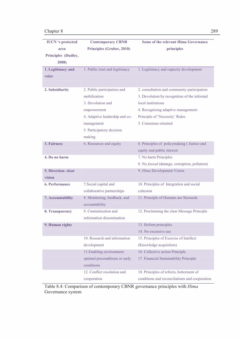
Chapter 8
289
IUCN ‘s protected
area
Principles (Dudley,
2008)
Contemporary CBNR
Principles (Gruber, 2010)
Some of the relevant Hima Governance
principles
1. Legitimacy and
voice
1. Public trust and legitimacy 1. Legitimacy and capacity development
2. Subsidiarity
2. Public participation and
mobilization
3. Devolution and
empowerment
4. Adaptive leadership and co-
management
5. Participatory decision
making
2. consultation and community participation
3. Devolution by recognition of the informal
local institutions
4. Recognising adaptive management:
Principle of ‘Necessity’ Rules
5. Consensus oriented
3. Fairness
6. Resources and equity 6. Principles of policymaking ( Justice and
equity and public interest
4. Do no harm
7. No harm Principles
8. No fassad (damage, corruption, pollution)
5. Direction- clear
vision
9. Hima Development Vision
6. Performance 7.Social capital and
collaborative partnerships
10. Principles of Integration and social
cohesion
7. Accountability
8. Monitoring, feedback, and
accountability
11. Principle of Humans are Stewards
8. Transparency
9. Cmmunication and
information dissemination
12. Proclaiming the clear Message Principle
9. Human rights
13. Holism principles
14. No excessive use
10. Research and information
development
15. Principles of Exercise of Intellect
(Knowledge acquisition)
11.Enabling environment:
optimal preconditions or early
conditions
16. Collective action Principle
17. Financial Sustainability Principle
12. Conflict resolution and
cooperation
18. Principles of reform, betterment of
conditions and reconciliations and cooperation
Table 8.4: Comparison of contemporary CBNR governance principles with Hima Governance system

Chapter 8
290
8.6 Sustainable CBNR governance for Lake Urmia basin
In Lake Urmia basin (LUB) case study, resource regime and property rights,
monitoring system and environmental ethics are the determinant factors on the path to
sustainability.
It is proposed that the Hima governance system:
· can directly deal with the use right issues; referring to Table 8.2, Hima legal
framework provisions recognise a mixture of public-private water rights
and use rights as shown in Table 8.3;
· will foster collective choice arrangements which is also advocated as one of
the eight design principles by Ostrom (2005) as a basis for establishing a
viable monitoring system which is owned by local community and
regulated by relevant authorities; and
· can provide robust environmental ethics which have to be strengthened in
LUB to bring about changes in attitudes and cultures.
8.6.1 Strengthening environmental ethics
Environmental policy debates are more or less about morality and ethics. Therefore,
ethical consideration in land and water resources (natural resources) use and conservation
(i.e. the environment as a whole) is vital for attaining sustainability criteria. This is
important in persuading general public to comply with management strategies and create a
basis for a participatory involvement of stakeholders which either have to be restricted or
asked to pay for the upkeep of natural resources.
The Islamic ‘green’ credential has earlier been demonstrated by noticing a close
match between ecological laws and Islamic environmental ethics. Some Scholars such as
Ibn Khaldon acknowledged that sustainable development is a condition for developmental
needs in addition to advocating social harmony principles (e.g. Ra’ad, 1993). However,
historically, sustainability has been overlooked by Muslim policymakers because political
thinkers dominated the policy debate and they thought of political stability as a result of
developmental works within equity principles. So the ethical approach to environment
advocated by some Sufi writers such as Najmadin Razi was overlooked18. As shown in
Tables 8.2 and 8.3, Hima governance framework represents a strong environmental ethics
18. As mentioned, Razi (1982) introduces the idea of ethics into activities such as farming and allowing a share for other creatures.

Chapter 8
291
which is based on community’s belief systems and this can be used to strengthen
environmental ethics in LUB within a capacity development strategy.
8.6.2 Fostering collective choice arrangements and nested enterprises
Referring to rule-obligation concept; rules-actors relationship can be visualised as a
Rules-Actors Mesh (RAM) : the cells of a mesh are spatial representations of human’s
action in space (action situations) and the threads represent the boundary and position rules
that define human’s relationship with other action situations. The dynamics of the RAM
process can be assessed by relating rules to the nature of the act (task, duty, obligation)
itself which is prescribed to be sanctioned. In terms of community participation (i.e.
farmers or their representative), it is not enough just to create a simple position rule of
membership. In order to create the new position rules, a set of other rules has to be
changed. With regard to the position rule, the fitness or the capacity of the actors is
important as well the information that controls the action-outcome path.
The RAM concept suggests three main interventions: (1) an information rule has to
be created to increase the understanding about the underlying principles of the CBNR
management process; (2) a payoff rule is needed to monitor the resource use and (3) a
scope rule is needed to recognise the role of community of users including informal users.
Giving a legal mandate to the community to participate in decisions about resource regime
and property rights implies that actors who are affected by a resource regime can participate
in modifying their rules. They are empowered to enter a decision making process (boundary
rule) and decide on the resource regime (choice rules) and can monitor by applying the
payoff rules.
In terms of institutional design; the scale (boundary rule) of LUB with an area of
52,000 Km2 is a very large action arena to coordinate a community-based management.
Therefore, there are inter-boundary rules that have to be recognised: provinces, river
watersheds, local village level and so forth. Lake Urima is engulfed by these boundaries as
it lies to the downstream of each of the watersheds. This is advantageous since LU can
become a central node on the RAM. As was shown in Chapter V, LU is a good
environmental State/Impact indicator and hence can be the central theme for a monitoring
system which is needed in any institutional design. Based on the RAM concept, the LUB
Hima governance can have three levels of decision making:
1. LUB Hima authority to oversee 31 watershed zones in LUB (17 permanent rivers and
14 seasonal rivers )

Chapter 8
292
2. Catchment Hima authority to be managed collectively by representatives the
communities in a river catchment
3. local community Hima authorities are managed directly by the users
There would be inter-boundary Himas and so there is a need for a LUB basin
authority that sanctions rules on the allocation (choice) rules at watershed levels.
Fostering water demand management and resource conservation. In Iran, every
village has a council. Village Councils which are elected by the villagers can provide the
legal base for local Hima authorities. A local Hima authority can be made up of several
villages depending on the biophysical conditions of the natural resources system. Each of
the local Hima will be responsible for the management of the area and accountable and
have to monitor the status of the natural resources in accordance with the Lake Urmia as an
ultimate criterion. Water demand management and resource conservation will be an
important element in the strategy of Hima institutions. A network of smaller nested
enterprises then will be able to deliver the plan of the EMP.
8.7 Concluding remarks
Contradictory to some popular belief, the hallmark of the Islamic legislative process
has been its human dimension. A wealth of opinions has been reordered in different schools
of thoughts. Azmi (2002) points out that the most important feature of Islamic law making
is innovation or legal reasoning (Ijtihad). It can be concluded that Islamic principles are
compatible with CBNR management and IWRM paradigms and provide a viable ethical
governance framework.
According to the rule-obligation theory in Fiqh, environmental policymakers can
legitimise water demand policy based on the tolerable hardship criteria. Therefore, careful
capacity development and empowerment is needed at community level to achieve the
sustainability criteria.
Hima governance seems to have a wide application in sustainable resource use
based on demand management and conservation of natural resources in LUB, WANA
region and beyond. This theoretical treatise should be tested in case studies and the scope of
the research can be widened by considering other belief systems as all religions have
similar value-laden principles.

Chapter 9
293
Chapter IX. Lessons Learned, Conclusions and Recommendations for Further
Research
Figure 9.1: The environmental discourse is gaining more ground; the figure shows graphic designs by local artists to save LU (Source: Barzakh Cyber Magazine; available from http://www.barzakhmag.com/?p=1369)
9.1 Introduction: restating the Aim and Objectives
The scope of the PhD programme has focussed on developing a socio-technical
framework for implementing the IWRM paradigm in general, and in Iran specifically, by
considering the water allocation decision-making in Lake Urmia basin.
Bearing in mind the financial and time constraints, eight objectives were identified as
follows:
1. To assess the applicability of IWRM through a critical analysis of the underlying
principles, and to assess progress made with implementation (Chapter II);
2. To develop an integrated methodological framework which can be used to
implement the IWRM paradigm by integrating the elements of social and technical
assessment (Chapter III);

Chapter 9
294
3. To assess the status of progress towards implementing IWRM in Iran (Chapter IV);
4. To assess the status of water resources planning, management and allocation in the
Lake Urmia Basin (Chapter V);
5. To make an integrated socio-technical assessment of the water resources availability
for sustainable water allocation management in the Lake Urmia Basin, Iran (Chapter
VI);
6. To make a re-assessment of the institutional sustainability of the water allocation
strategy in Lake Urmia basin. (Chapter VII);
7. To develop an ethical and cultural framework that can provide a basis for good
governance based on Islamic principles (Chapter VIII);
8. To demonstrate the applicability of the overall framework through the Lake Urmia
case study approach (Chapters VI - VIII)
Chapter IX describes how each of the objectives have been realised which can be
considered as a contribution to the advancement of IWRM theory and practice. In Section
9.2, major conclusions and recommendations are outlined. The applicability of the overall
Framework is discussed in Section 9.3 together with contributions of the work to scientific
knowledge as well as dissemination of the research findings. Further work is discussed in
Section 9.4
9.2 Summary of major conclusions and recommendations
9.2.1 Objective 1: Evolving the IWRM paradigm
Need for socio-technical approach. It is argued that the IWRM normative package
has very little to offer on implementation. New methodological frameworks are needed to
enable the implementation of IWRM. The neglect of the institutional (socio-political)
dimension has created a huge drawback in implementing the IWRM paradigm worldwide.
Lack of implementation has been attributed to the gap between technical outcomes and
policy decisions. Hence, there is a need to move from a technical to a socio-technical
approach to bridge this gap.
Need for paradigm shift. Chapter II shows that implementing sustainable land and
water resources management poses five main challenges: (1) the integration of the complex
and overlapping dimensions of water resource system; (2) dealing with the dynamism of
the system; (3) measuring sustainability; (4) dealing with various levels of decision-making

Chapter 9
295
(institutional levels) and ethics and values held by decision-makers; and (5) creating
mechanisms for gaining participatory consensus.
To deal with the above challenges, many scholars have called for a paradigm shift
towards:
· Consideration of full water cycle in IWRM i.e. Green Water and Grey
Water concepts should be considered in IWRM plans (e.g. Falkenmark et al
(2004), Falkenmark and Rockström (2006).
· Virtual Water Trading (Zeiton et al 2010) can offer real alternative policy
instruments to deal with water security (and scarcity).
· Inter-linkage with land use management (e.g. Calder, 2004, 2005;
Amezaga, 2005)
· Adaptive management (e.g. Pahl-Wostl, 2007; 2009, Merrey, 2008)
· A more politicised IWRM (e.g. Allan, 2003a; Merrey, 2008).
· Mapping institutional elements beyond hydrological boundaries such as
influential actors in the decision-making process (e.g. Merrey, 2008)
· Social learning processes and multi-stakeholder platforms (MSPs) for
effective engagement and participation of actors in the IWRM process (e.g.
Warner, 2007)
· Greater emphasis on culture and ethics ( e.g. Daniels and Endfield, 2009)
However, it is argued that despite these conceptual constraints, IWRM is a relevant
concept for addressing the ever increasing water management problems.
9.2.2 Objective 2: developing an integrated methodological framework
In Chapter III, an Integrated Socio-technical Framework has been developed to deal
with the complexity of water resources systems and capture the diverse dimensions of
Social-Ecological Systems. The adopted research design moves away from
multidisciplinarity to interdisciplinarity by working at the interface of the physical and
social sciences. The Framework uses the Drivers-Pressures- States-Impacts-Responses
(DPSIR) component as a platform for socio-technical analysis. The Outcomes of the
DPSIR strategic assessment i.e. the Responses are then analysed using the Institutional
Analysis and Development (IAD) and Integrated Socio-technical Assessment (ISTA)
components comprising of modelling systems and Multi-Criteria Decision-Making
(MCDA) tools.

Chapter 9
296
The IAD component is the engine or the ‘motherboard’ which provides the linkages
or points of interaction for different components of the Framework. While DPSIR provides
a wider approach for analysing changes in the system, IAD provides the focal level for
socio-technical analysis; thus presenting a robust and rigorous analytical component for
implementing IWRM.
Politicising IWRM through institutional analysis. There has been a call for
politicising IWRM (e.g. Allan, 2003; Merrey, 2008). This has been done through the use of
a politicised IAD approach. IAD has also been criticised for the inadequate handling of
power issues and political interests within the institutional design (Clement, 2009). IAD has
been used as the core institutional analytical tool in the Integrated Socio-technical
Framework but complemented with the discourses and narratives behind the discourses that
shape actors’ beliefs and mental models or perspectives. These Socio-political variables i.e.
linguistic parameters have been incorporated since they are central to policy analysis and
they emphasise the need for participatory decision-making involving all the three main
participatory domains: citizens (or civil society), analysts (e.g. researchers) and decision-
makers (actors) to seek solutions outside the “water box” (WWAP, 2009).
To deal with highly complex and polarised issues, narrative analysis (Roe , 1994) is
used to provide a structured approach to establishing the problems or “Problem Statements”
(PSs) and their causal relationships. This demonstrates how uncertain or how complex the
issues are (Chapter VII) and how an alternative narrative policy is formed to enable us to
understand better how arguments are articulated within a participatory decision-making
process.
Highlighting the role of Ethics. In addition to the contextual use of discourses in
the institutional analysis, societal values and culture are taken into consideration by
incorporating the Ethics component to provide perspectives or a mental model of actors
shaped by the discourses. Ethics, which form part of the community attributes, are usually
overlooked in the institutional analysis. This theme is highlighted through the work on
Objective 7.
Integrating synthesis. Unlike multidisciplinary research, the thesis aims to achieve
interdisciplinarity by producing an “integrating synthesis” (Max-Neef, 2005) of the
assessments. Therefore, we have to overcome language barriers between the physical and
social sciences. It is not desirable to omit well-established terminologies used by the
different disciplines but it is reasonable that they can be conceptualised so as to be

Chapter 9
297
complementary to each other. The integrated synthesis of the assessments is presented
within a contextual setting i.e. a unit of analysis which describes the relatively unchanged
attributes of the water resources system including:
· The geopolitical characteristics of the action arena
· Actors or stakeholders
· Community attributes
· Socio-economic conditions
· Biophysical conditions as an element in the IAD approach are enhanced to
include not only institutional attributes but ecological, hydrological and
hydraulic attributes of the water resources system.
The interface between the four analytical components of the Framework is achieved by
considering the Interaction-Outcome pathway in the action situation.
9.2.3. Objective 3: Implementation of IWRM in Iran
Chapter IV describes the move towards IWRM since the establishment of water
governance in the 1940s. Iran has formally adopted IWRM since 2003 but the
implementations have lagged behind. An overwhelming majority of water managers
believe that there is a need for institutional reform but there is no consensus about the
nature of the reforms (Source: Questionnaire Survey, Appendix A1).
The DPSIR analysis at the national level has shown that, as a result of the
historical economic growth Drivers, there are great pressures on the water resources both in
terms of quality and quantity. Informal unauthorised abstractions for agricultural use have
become an important common practice and account for nearly 11% of the total water use
(nearly 10 BCM) of groundwater and about 50% of the surface waters. The use of water
cannot easily be policed.
Lack of consideration for environmental concerns has been noticed. The 1974
Environmental Protection Act has not been updated and clearly, this cannot satisfy the
environmental sector. A major shift occurred in the late 1980s and 1990s where the
question of sustainability was highlighted, but the war-torn Iran embarked on more
developments, and since 1989, has implemented four Five Year Development Plans
(FYDPs).
The institutional changes have been dramatic and progressive but have failed to
completely tackle private water rights and enforce water laws. The evolving nature of water
sector institutions shows that institutional equilibrium has not been reached. Since the

Chapter 9
298
1990s, Iranian policymakers have been aware of climatic change as a major Driver and so
embarked on a policy of executing basin-wide planning exercises. Water allocation has
been a source of conflicts between different provinces. So the Iranian Ministry of Energy
(MoE) has been trying to implement the 2003 Water Allocation Directive (WAD) which is
based on basin-wide planning. The idea has not been welcomed at provincial level.
Sign of paradigm shift. Senior managers and experts in the Office of Macro-
Planning at MoE have come to the conclusion that dam-building as a Response to the
Drivers in years gone by, has created unsustainable Pressures on the resources, as has
happened in many other countries; hence the need for revised Responses based on IWRM
principles to make a reassessment of the development programs. However, these decisions
are solely political and the socio-political Pressures such as lobbying MPs, provincial
governors and farmers have created a two tier discourse within MoE: the regional
development discourse is favoured by Regional Water Companies and IWRMC, and the
IWRM discourse is strongly advocated by some sections of MoE.
Emergence of centralised water resources governance. There has been some
success with regards to the control of groundwater resources. The 1982 Act required well
owners to register their wells to provide them with permits. However, this controlling
measure has been marred with over subscription of permits which has caused a great deal
of problems. Groundwater resources are literally managed by farmers and well owners
(Memari, 2006). MoE’s policy has been to bring some order to surface water management
through the enactment of the 1982 Act. MoE overlooked groundwater and concentrated on
controlling surface water by investing in dam-building and irrigation network projects.
Some 90% of the investments has gone towards the projects (MoAJ, 2008), but, in the
process, they have created more water rights, much tension among upstream and
downstream stakeholders and lost some control to socio-political forces (MoE, 2010a).
Need for reform. There is a consensus that there is a need for a better institutional
design to cater for complex governance systems which exist within multilevel smaller
nested agricultural enterprises. A community-based participatory water resources
management approach has been advocated by most of the stakeholders in Lake Urmia basin
(LUB) based on the social research conducted by the author.
Data uncertainty. Lack of information about abstraction from rivers and streams
and data uncertainty and lack of cooperation between provincial water companies have led
to a lull in the progress of enforcing the IWRM strategy.

Chapter 9
299
Water allocation is central to the implementation of IWRM. Therefore, Lake Urmia
basin has been taken as a case study to show the applicability of the proposed Integrated
Socio-technical Framework (Chapters V-VII).
9.2.4. Objective 4: Towards Implementation of IWRM in Lake Urmia basin
DPSR analysis
In Chapter V, the DPSIR analysis has shown that, in Lake Urmia basin, most of the
Pressures come from the agricultural sector in terms of increased agricultural demand
driven by land use policy and the politics of irrigation. The developmental discourse is
dominant and has had far reaching consequences for environmental degradation in terms of
poorer water quality of rivers and loss of wetland areas as well as a huge drop in Lake
Urmia’s water level. Informal and unauthorised abstractions have become an important
norm with virtually no monitoring systems. Thus, a better institutional design is needed to
cater for complex governance systems which exist within multilevel smaller nested farming
enterprises.
The institutional analysis has shown that the formal rules (1982 Act, 2003 WAD)
have not been implemented in LUB due to several important factors including:
· Lack of cooperation between Regional Water Companies (RWCs) and MoE
on the one hand and MoE and IWRMC on the other hand i.e. internal
conflicts within water resources organisations;
· Lack of mechanisms to bridge the gap between 2003 Water Allocation
Directive and established water allocation practices (pre 2003 era);
· Lack of capacity building to institutionalise the new rules in RWCs;
· Lack of inter-provincial cooperation in terms of water planning;
· The impact of non-water legislations such as Five Year Development Plans
(FYDPs) and provincial Development Directives on water resources
planning i.e. an FYDP is a project-driven plan and is different from an
IWRM Plan.
It can be concluded that the integrated analysis has shown that the present
institutional set up has failed because it could not deal properly with an increased water
demand from the agricultural sector. There is a need for re-orientation of the Lake Urmia
basin water sector institutions so that it can deal with the pressures exerted on the system.
However, any institutional design should consider the informal rules in use which have

Chapter 9
300
been long practiced in Lake Urmia Basin. Therefore, a participatory water allocation
process has been recommended.
IWRM plan for Lake Urmia Basin. Article 67 of the fourth Five Year Development
Plan (FYDP) initiated a move towards implementing an integrated ecosystem management
plan for Lake Urmia. The Ecosystem Management Plan (EMP) was agreed by the
stakeholders through the Memorandum of Understanding (MoU) on Lake Urmia
management. Earlier, in November 2007, a new institutional design was undertaken by
creating several Multi-Stakeholder Platforms (MSPs) i.e. working groups on water
resources and agricultural management, biodiversity and public awareness issues.
Window of opportunity. In March 2009, the author officially became the IWRM
National Consultant for the Conservation of Iranian Wetlands Project (CIWP) to facilitate
the agreement on water allocation through the formation of the Water and Agriculture
Working Group (WAWG). He has been given specific tasks in facilitating the Water and
Agriculture Working Group meetings and the water allocation process. The new
participatory approach to water allocation based on a new institutional design as provided a
window of opportunity to apply the proposed Integrated Socio-technical Framework.
9.2.5 Objective 5: Integrated socio-technical assessment (ISTA) for sustainable
water allocation in Lake Urmia basin
Chapter VI describes the new water allocation governance system in Lake Urmia
basin based on the agreement among stakeholders to implement the Ecosystem
Management Plan (EMP) through the establishment of multitier Multi-stakeholder
Platforms (MSPs). The aim was to agree on a water allocation strategy for all the provinces
and on allocating water to Lake Urmia. By using the ISTA component of the Integrated
Socio-technical Framework comprising of two main elements, the author carried out an
analysis of:
a. the process whereby the actors made water allocation decisions; and
b. the sustainability of the water allocation decisions.
The main conclusions are as follows:
1. Environmental water rights. The new governance system provided water rights to
Lake Urmia which can be considered as a considerable achievement for the
environmental movement in Iran.
2. Water availability is less than that adopted by actors using trend analysis. By
establishing a regression relationship between runoff and rainfall over the period

Chapter 9
301
1969 – 1994 when the influence of abstractions was minimal, average annual
natural runoff over the period 1969 – 2010 was found to be approximately 5000
MCM whereas MoE (2010b) produced a value of 6927 MCM using a highly
questionable Detrending Method.
3. Unsustainable water allocation. In achieving Objective 5, it was concluded that
the participatory process which has produced unsustainable water allocation
outcome decisions has been marred by data uncertainty and ambiguity about
scientific methodology. However, it has to be noted that the governance system
and structure is in place for a re-evaluation of the decisions.
4. Although the efficacy of the governance system has improved, the effectiveness of
the EMP i.e. achieving long term sustainability of Lake Urmia , is in doubt,
considering the agreement on a target water allocation of 3700 MCM, and what
has emerged from the re-evaluation of overall water availability.
5. Ignoring scientific knowledge. It seems that both sides of the water allocation
equation have not fully considered a basin-wide planning approach that requires
rigorous hydrological assessments of water availability and potential for water use.
The implications of the water allocation decisions have not been foreseen by the
actors. On the one hand, the user water allocation ceiling of 3700 MCM/year lacks
rigorous scientific assessment, and on the other hand, the minimum ecological
requirement of the lake has become a legal right which ignores the hydrological
and climatic variability and persistence.
6. No scope for further development. The current level of abstraction has been
estimated to be approximately 2045 MCM/year, so, since the average annual
natural runoff has been estimated as 5000 MCM there is no scope for further
development/ abstraction if the lake is to receive its allocation of 3100MCM/year.
7. The results support the concept of a minimum water requirement for Lake Urmia
of about 3000 MCM. Given that the annual average natural runoff available is
5000 MCM, and assuming that no further abstraction above 2045 MCM/year is
allowed, this leaves about 3000 MCM/year for the Lake.
8. Proposing adaptive water allocations based on stochastic modelling. Due to
climatic variability, fixed allocations cannot be sustained, and so a risk analysis of
a number of management scenarios was carried out using a stochastic ARMA (1,1)
rainfall model to generate multiple realisations of future rainfall for different levels
Chapter 9
302
of persistence/variability. The management scenarios were based on fixed target
allocations of 3700 MCM and 2900 MCM so an adaptive allocation strategy (a
form of demand management) was explored whereby sliding scale reductions to
abstractions were made when the lake levels fell below warning and critical levels.
Mild, moderate and strong levels of reduction were explored under different levels
of rainfall variability. The results of the risk-based analysis showed that the
moderate and strong adaptive options can initiate Lake Urmia recovery but only if
the abstraction target is much lower than 3700 MCM. It was shown that, at a target
abstraction rate of 2900 MCM, the moderate management option is effective in
delivering the amount of water to the lake needed to maintain the minimum
ecological requirement (3100 MCM/year) based on the vision stated in the EMP
Independent scientific assessment needed. The results of the reassessment
highlight three main issues: (a) the need for independent scientific assessment based on
rigorous reliable data; (b) the revision of the existing water allocation rules i.e. the 2008
WAC; although, the 2008 WAC has introduced basin-wide planning, it has a rigid scientific
approach and uses highly unreliable methodology in assessing water availability and (c) the
outcome of the WAC process is unrealistic as it ignores demand management which is one
of the cornerstones of IWRM. To redress this, the reassessment calls for an adaptive water
allocation strategy which is a form of demand management which, together with basin-
wide water use efficiency measures, is required to achieve long term sustainability.
Therefore, the following recommendations are made:
1. A thorough review of the hydrological and climatic baseline data to remove much
of the uncertainty about the water allocation governance.
2. Modification of the 2008 Water Allocation Code by (a) by removing the Detrending
Method in the estimation of the water availability for the basin since it produces a
highly overestimated value of natural runoff; (b) allowing other MCDA approaches
other than AHP to minimise the inconsistency about weighting water allocation
criteria; and (c) using a stochastic approach in the water allocation strategy since
trend analysis is highly unreliable and cannot account for the persistence and
variability of rainfall records.
3. Vensim dynamic simulation has to be calibrated with more sophisticated generic
water resources modelling systems such as WEAP, Mike Basin or RIBASIM.
4. Implementation of water use efficiency measures.

Chapter 9
303
9.2.6 Objective 6: Institutional sustainability of water resource governance
Chapter VII makes (a) an analysis of the institutional sustainability of the new
governance system i.e. the MSPs; (b) evaluates the implications of adopting the adaptive
water allocation approach and (c) proposes revised Responses for sustainable management
of water resources in Lake Urmia basin.
In Chapter VII, first, the efficacy of new operational level rules in use is assessed.
It is concluded that the successful conclusion of the WAWG meetings can be attributed to
the ability and the flexibility to craft new rules at the local level (operational level)
entrusted in the 2010 NEC bylaw. Law-making is a long process; an Act of Majlis can take
decades to be ratified. Council of Ministers’ By-laws can take years to be approved.
Therefore, to address immediate operational level needs, this mechanism can be very
effective.
Secondly the mental models and perspectives of the actors within the evidence-
based decision-making process were analysed. This provides an understanding of how
discursive deliberations are used by the actors. There is a strong evidence of the influence
of “invisible” or ‘hidden’ actors (mainly career bureaucrats, and officials and advisors of
governmental departments) in crafting alternative policies and proposing solutions to policy
problems. The presence of these actors was manifested in the presence of Water Policy and
Allocation Commission (WPAC) and the Iran Water Resources Management Company
(IWRMC) in the Working Group (i.e. WAWG) meetings dictating how information and
knowledge is used in the decision-making process
Thirdly, by examining the narratives told by the actors and participants, it is noted
that Lake Urmia is not clearly on the mental map of the provincial actors and some of
national actors. Therefore, the Working Group (i.e. WAWG) meetings embarked on a
difficult task to put Lake Urmia on the ‘issues map’ and making it central to any water
allocation in the basin. The momentum of the participatory process was maintained by high
political support. It can be concluded that there are many loops in the arguments and the
actors have no idea how to implement a win-win strategy to save the lake.
Fourthly, discourse analysis shows how different discourses made actors to have
multiple perspectives with regards to the issues of concern or solutions to stop the demise
of Lake Urmia. The diverging cross-sectoral multiple perspectives need to be harmonised
to establish a common understanding between national and provincial actors.
Based on the discourse analysis, major recommendations are as follows:

Chapter 9
304
· To incorporate environmentally friendly clauses in a revised water law since
there are no explicit provisions of environmental water allocation in the existing
water Act (i.e.1982 FWD Act)
· To strengthen the environmental discourse (Figure 9.1) by scientific arguments
rather than alarmist activism which has characterised Iranian environmental
movement; this will help to gain political support and provide an alternative
meta-narrative on the environment.
· Reconciling national vs. local interests. The hidden perspective of MoE is that
local short-termism is not compatible with long term national interests. There is
a need to reconcile this mismatch. The Iranian policymakers have made water
allocation a centralised ‘national’ issue (MRC, 1995) and, according to MRC
(1995), any change in policy will create vulnerability and cause damage to the
national interest. The local needs can be met by allowing the regions to continue
with the “desired local development” and this offers incentives for local
aspirations. Small dams and irrigation projects can be used to satisfy local
demands and the water budget can be used to allocate water from groundwater
resources for local demand sites (industrial, agricultural and so forth). The
recommendation made by the parliament in this report (i.e. MRC, 1995) can
explain the drive to over-exploit groundwater resources (See Chapter IV for a
national picture). The legacy has come about because water allocation is
detached from local attributes and seen as a national security issue.
· To rectify mismatches in the national IWRM Plan which is based on more
surface water for irrigation i.e. the 2003 Strategic Water Resources Planning
Bylaw endorsees more surface water irrigation development so there is a need to
rectify this imbalance
· Reviving traditional water governance such as the qanat system has been
identified as a key management option for the future
Towards modernity. Next, we have demonstrated that there has been a paradigm shift in
Iran and there are signs that Iran is moving towards a reflexive modernity paradigm as
illustrated by the Lake Urmia case study. Iran’s route is somehow different form the
North’s route depicted by Allan (2005).Political instability and short term interests of
political actors are instrumental in striving toward sustainability. These will hamper any
attempts towards implementing IWRM in Iran.
Chapter 9
305
Institutional analysis. Finally, the institutional sustainability of the governance
system has been analysed and some recommendations have been made i.e. new Responses
have been suggested. First, the design principles have been reviewed; then
recommendations have been made for the adoption of adaptive water allocation.
Re-thinking design principles. One of the major findings is that the empirical
evidence from the Lake Urmia basin case study showed that the original eight design
principles developed by Ostrom (2005; 2011) and verified by Cox et al (2009) are not
enough for the institutional sustainability of large river basins with complex Social-
Ecological Systems. The findings support Imperial’s (2009) suggestion to include
additional principles to attain institutional robustness. It is recommended to include new
design principles including:
1. To develop trust across organisations
2. To develop shared definition and understanding
3. To recognise mutual interests
4. To maintain the balance of power among stakeholders
5. To employ a wide range of policy instruments (management options)
6. it is argued that we have to create structural mechanisms to bring into the
picture the issue of unauthorised abstractions
The implication of adaptive water resource governance. Adaptive water resources
governance may be established as part of proposed revised Responses that may have the
following elements:
(a) Collective Choice Arrangements: most of the participants felt that community-
based water and land governance system can help to achieve the objectives of water
allocation strategy as there is a high level of informal and unauthorised abstractions i.e.
without community support, the adaptive management approach cannot be put into practice
(Appendix A, Table A1.4). Local political support is vital and so the community level
representations should be enhanced by including civil society and NGOs. Incorporating
local nested enterprises by recognising the informal institutions and their knowledge
systems seems to be necessary to implement the EMP. Bringing the informal institutions
into the formal set up can be achieved gradually through the social learning processes and
adaptive management practices.
(b) Monitoring: is non-existent. Most of the participants felt that monitoring should
be done by an independent organisation. Monitoring system is required not just to monitor

Chapter 9
306
water inflow into the lake, but also to reflect the adaptive nature of water allocation under
different climatic conditions. Monitoring system can be part of a Drought Risk
Management (DRM) plan which is an integral part of the EMP and should be seen as a
major component which has a bearing on water allocation among provinces and different
uses and sectors. However, the cost of monitoring has to be taken into account.
(c) Revising the Ecosystem Management Plan (EMP). The EMP understandably
concentrates on Lake Urmia water rights and its management. However, the EMP’s scope
has to be widened to consider the whole basin based on river catchment governance. The
EMP has achieved its goal to put Lake Urmia’s water rights on the water resources
planning map. But now it has to be streamlined with river basin planning which requires a
wider vision. The effectiveness of the EMP is in doubt if the recommendations in Chapter
VI are not dealt with (see Objective 5)
(d) Incorporating demand management within wider management options. The
participants were not just happy about saving the lake but wanted to have more policy
options including implementing structural and non-structural responses. For example,
‘saving the lake’ was considered as one of the management options. Therefore, the demand
management proposal in the 2010 NEC Bylaw has to be streamlined with local
development drives. The Bylaw offers incentives for water saving activities. For example,
nearly $US5,000,000 has been allocated for implementing water use efficiency projects, in
the process 50% of the cost of upgrading irrigation technology (20,000,000 Riyals=
US$2000) per ha to be given to farmers; and the other 50% is to be provided by bank loan
facilities. Based on the results from the ISTA component (Chapter VI), a water demand
management approach has to be a key to any strategy for sustainable water use in the basin.
(e) Graduated sanctions. Ostrom (2005) reports that many self-organising systems
use graduated sanctions against those who break rules. Involving farmers in the collective
choice arrangements (i.e. decision-making process) may enhance mutual monitoring and
better compliance. So far this element has been missing from the institutional reform.
Informal or unauthorised abstractions have been highlighted in the 3rd and 4th NEC Meeting
Directives. This level of monitoring is very difficult to police. Therefore, it is argued that
smaller watershed units should be considered in the institutional design as there are about
31 river catchments in the basin. This level of monitoring requires community based water
and land governance. This theme has been dealt with in Objective 7 (Chapter VIII).

Chapter 9
307
9.2.7 Objective 7: an Ethical legal framework for good governance
In Chapter VIII we established a clear link between land and water resources and
thus the term natural resources has replaced the term land and water. This chapter fulfils
Objective 7 of the research by using Islamic environmental Ethics to develop the principles
and legal framework for a Hima community-based natural resources (CBNR) governance
system.
The analysis in Chapters IV-VII has shown that there is paradigm shift towards
community based governance and this has been recommended by many participants since
the livelihood issues need to be considered. A general consensus was that ethical and
cultural aspects of the community have to be considered. The normative format of ethics is
not enough. These norms and principles have to be translated into practical rules in use.
Chapter VIII highlights that Islamic legal theory is a powerful approach to translate
Islamic environmental ethics into practical governance rules (Jenkins, 2005). Some
examples of the use of Islamic environmental ethics have been noted in parts of Africa and
Asia. Therefore, it is argued that the Hima concept is relevant in modern times.
Islamic legal theory provides a framework for understanding the action-actor
relationship as a basis for legitimacy and enforcement of the rule of law. A legitimate rule
should satisfy the criteria of no hardship, ability to understand and capacity to perform
according to the rule. Legitimacy is then a measure of the successful implementation of the
CBNR management plans i.e. the efficacy of a governance system is a measure of its
legitimacy. Therefore, careful capacity development and empowerment is needed at the
lowest level of decision-making (i.e. community-based) to achieve institutional efficacy i.e.
community based governance will foster legitimacy by improving the effectiveness and the
efficiency of the administrations.
The proposed Hima governance system consists of:
1. The principles of Hima governance which refer to the constitutional governance
level are divided into four broad categories fulfilling the three objectives of the
Hima approach: social cohesion, sustainable resource use and environmental
protection. It is concluded that Islam provide a coherent set of principles for an
equitable and sustainable use and management of natural resources and is
comparable to (a) the nine contemporary CBNR governance principles presented by
Dudley (2008) representing IUCN’s guidelines on protected areas and (b) twelve
organisational principles based on a survey of latest research (Gruber, 2010).

Chapter 9
308
2. The Ethical legal framework for a Hima governance system which refers to a
collective choice governance level is derived from Islamic legal theory. This
describes the journey of translating the principles into strategies and normative
rules.
On Islamic environmental ethics, it is postulated that
· Environmental policy debates are more or less about morality and ethics.
Therefore, ethical consideration in land and water resources use and
conservation (i.e. the environment as a whole) is vital for attaining
sustainability criteria.
· The Islamic ‘green’ credential has earlier been demonstrated by noticing a
close match between ecological laws and Islamic environmental ethics.
· The Hima governance framework represents a strong approach to
environmental ethics which is based on the community’s belief systems and
this can be used to strengthen environmental ethics in Lake Urmia basin
within a capacity development strategy.
· the Hima concept will foster collective choice arrangements and nested
enterprises based on the legitimacy framework provided by Islamic legal
theory
Proposed Responses for Lake Urmia basin. There are two important issues in
contemporary CBNR that have to be well defined: property rights and right of use. In Lake
Urmia basin, resource regime and property rights, a monitoring system, and environmental
ethics are the determinant factors on the path to sustainability.
It is proposed that the Hima governance system:
· can directly deal with the right of use issues; the Hima legal framework
provisions recognise a mixture of public-private water rights and use rights
· will foster collective choice arrangements which are also advocated as one
of the eight design principles by Ostrom (2005) as a basis for establishing a
viable monitoring system which is owned by the local community and
regulated by relevant authorities; and
· can provide robust environmental ethics which have to be strengthened in
LUB to bring about changes in the attitudes and cultures.
Hima governance which is based on ethical community -based natural resources
management seems to have a wide application in sustainable resource use and the

Chapter 9
309
conservation of natural resources in LUB, the WANA region and beyond. This theoretical
treatise should be tested in case studies and the scope of the research can be widened by
considering other belief systems as all religions have similar value-laden principles.
9.3 Applications of the Framework
9.3.1 A reflection
The integrated methodological approach provides an innovative analytical
framework to understand the discursive deliberations in a complex Social-Ecological
system heightened by (1) scientific uncertainty over climate variability and change and (2)
dynamic institutional transformation and evolution.
To work at the interface of social and physical sciences, the linguistic attributes and
language barriers have to be well understood in order to be able to navigate through
multiple approaches and concepts. The social-physical discipline divide and critical
inquires about the nature of the epistemological1 aspect of the interdisciplinary research
should be treated with care and due diligence and should not be treated as naïve
expectations from single discipline research. The points of interaction and linkage have to
be found to present a coherent integrating synthesis as well as preserving the internal
consistency of the methodological framework.
The proposed Framework is characterised by coherency and internal consistency to
make it a powerful analytical approach to resolving water resources problems. For example,
IWRM as a conceptual framework has a strong institutional (decision-making) orientation;
the DPSIR component provides logical sequential linkage to the issues and problems facing
a water resources system and can be used to describe the institutional change and evolution
over time; and IAD component is used to make an ex-post analysis of the Responses
element of the DPSIR.
Although the methodological approach has been useful in integrating the complex
and overlapping dimensions of the water resource system and the dynamics of the evolution
of non-structural Responses (policy options) i.e. providing a study of change and
institutional dynamism, it can be further improved. The combined DPSIR-IAD approach
can be considered as the core analytical framework. There is a possibility to incorporate
different analytical tools in the proposed Framework.
1 Epistemology is the branch of philosophy of science that study the nature of knowledge, its scope and validity i.e. how we find reality
Chapter 9
310
Although the Framework has captured certain characteristics of the Interaction-
Outcome pathway, it could not provide a thorough basis for analysis. With reference to the
Lake Urmia basin, for example, the results have shown the interplay of various policy-
making actors, the presence of hidden actors as well as group formation and coalition
buildings in the negotiations. Therefore, it is suggested that other institutional and policy
analysis tools can be considered to capture different aspects of the multi-level complex
action situation. The Advocacy Coalition Framework (Sabatier and Jenkins-Smith, 1999)
may be used to assess the inter-personal competitions and group formations by provincial
actors which showed a degree of aggregation in decision-making patterns. Similarly, the
Multiple-Streams Framework (Kingdon, 2003) can give an insight into how different
streams of actors work together if a window of opportunity arises in the form of MSPs.
Also, the ISTA component may also be modified to accommodate the requirement of
different action situations. Therefore, as a pioneering work, the Framework has to be tested
in different action situations to develop a more robust theoretical basis.
Also, we have to recognise the limitations of the different components used in the
analysis. In Chapter III we have dealt with the criticisms made on the use of the DPSIR for
not being “a tool for generating neutral knowledge” (Svarstad et al , 2008). However, in
Chapter III, the ontological and epistemological approach of the research design has been
clearly outlined.
The IWRM is a global concept. Therefore, the developed Integrated Socio-technical
Framework has a universal dimension, and it could be applied in any developing or even
developed countries. Hence, the degree of transferability of the methodological framework
is very high. However, due to the physical and financial limitations, only an Iranian case
study has been considered. The Framework has to be refined and tested in more case
studies.
9.3.2 Contribution of the research: from research to policy briefs
Researchers as facilitators. In Iran and worldwide, numerous researchers are
involved in a variety of IWRM research themes, but their efforts are dispersed and there is
a lack of communication between different research groups as well as between policy -
makers and the research communities. A dialogue between the research communities and
stakeholders is essential to create a platform for a wider dialogue among policy makers, the
scientific community and the public at large (Hashemi and O’Connell, 2011). This work

Chapter 9
311
has contributed to the notion that researchers can become facilitators in difficult public
policy debates and create a foundation for participatory decision-making processes.
The PhD work contributes to greater understanding of real world action research
on water allocation governance through the work on the Lake Urmia case study led by the
UNDP/GEF Conservation of Iranian Wetlands Project (CIWP). In the context of this PhD
work, the real world research is concerned with (a) involvement in, improvement and
broadened understanding of the water allocation decision-making process; (b) evaluating
the outcome of the decisions using analytical components; and (c) studying change where
there is concern for actions.
The author was involved in the consultation and implementation of multitier Multi-
Stakeholder Platforms (MSPs) which opened unique windows of opportunity to test the
innovative methodological framework. Also, the author has experienced a transformation in
his role and status by holding multiple positions as a researcher, facilitator, actor and
advisor.
Development of methods for institutional analysis. In addition to developing a
pioneering work towards the implementation of IWRM, the research has contributed to the
Newcastle Institute for Research on Environmental Sustainability’s (NIReS) and the School
of Civil Engineering and Geosciences’ line of research on methods for institutional analysis
which has previously been applied in the land and water policy process in India, Vietnam
and Spain. This thesis has developed further the methodological innovation produced by
Clement (2009). This work was presented in the 6th International conference of
Environmental Futures session led by Professor Elinor Ostrom (2005, 2011) who won a
Nobel Prize for economic sciences in 2009 on her works related to the IAD namely “"for
her analysis of economic governance, especially the commons"2.
Policy briefs for regional and global initiatives. The PhD work has been linked to
international and regional initiatives including
· United Nations University- Institute for Water and Environmental Sciences (UNU-
IWES) in Dubai.
· WANA Forum, Jordan
· World Justice Forum (WJF), New York
2 Deatails can be found on the official site of the Swedish Academy of Sciences: http://www.nobelprize.org/nobel_prizes/economics/laureates/2009/press.html

Chapter 9
312
The author has made several contributions on water scarcity policy and Hima
governance for the West Asia and North Africa (WANA) Forum. Furthermore, a proposal
was presented at the Third World Justice Forum meeting in Barcelona to foster community-
based governance with an emphasis on Rule of Law. The work will also form the basis of
the Hima Global Initiative to be launched in May 2012. The author is involved currently in
writing the proposal for this Global Hima Initiative.
Contribution to the national IWRM project in Iran. The author has been involved
on an informal basis with Updating the Water Master Plan-IWRM Project at the Office of
Macro Planning at the Ministry of Energy. The office of Applied Research at IWRMC has
also supported the PhD work and the author has worked with its various departments.
Additionally, the author organised four workshops (8 days in total as described in
Appendix A1) to introduce IWRM and institutional aspects to senior water sector
managers. He also contributed to three national conferences on the theme of IWRM and its
implementation in Iran which is described in the next sub-section.
9. 3.3 Disseminations of the results
Research findings and results were disseminated through international and national
conferences and workshops as well the publication of two chapters in a book. The details
are as follows:
Two chapters in the Handbook of Research in Hydroinformatics
1. Hashemi, M. and O’Connell, P.E. (2011a). Historical perspectives: from hydrological
models to decision support systems (DSSs). In. Gasmelseid, T. (ed.). Handbook of
Research on Hydroinformatics: Technologies, Theories and Applications,
USA/Hershey PA: IGI Global.
2. Hashemi, M. and O’Connell, P.E. (2011b). Science and Water Policy Interface: An
Integrated Methodological Framework for Developing Decision Support Systems
(DSSs). In. Gasmelseid, T. (ed.). Handbook of Research on Hydroinformatics:
Technologies, Theories and Applications, USA/Hershey PA: IGI Global.
Seven international conference papers (oral presentation with the papers or abstracts
being published in the proceedings or available online)
3. 2011: An Integrated Socio-technical and Institutional Framework for Sustainable
Water Allocation Decisions in Lake Urmia Basin (LUB). Paper presented at 6th
International Conference on Environmental Futures 18 - 22 July 2011 Newcastle
University, England.

Chapter 9
313
4. 2010: A Socio-technical Framework for Implementing the Integrated Water
Resources Management (IWRM) Plan in Lake Urmia Basin, Iran. Paper presented
at the International Symposium of BHS, 19-23 July, Newcastle upon Tyne, England
5. 2009: A Strategic Framework for Institutional Capacity Building in the MENA
Region: Cultural and Ethical Context. Paper presented at the International
Conference on Capacity Building in Urban Water Management Under Water
Scarcity Condition, 13 - 15 December Muscat, Sultanate of Oman.
6. 2007: Sustainable Water Policy in Arid regions: Ethical Dimension. The 4th
UNESCO International Conference on Wadi Hydrology, Muscat Oman December
2007.
7. 2007: Urban Water Management: need for institutional reforms. UNESCO
International Symposium on New Direction in Urban Water Management, Paris,
France, September 2007.
8. 2007: Water Policy in Iran: an ethical Dimension. UNESCO/ISESCO/ UWMRC
International Conference on Water Resources management in the Islamic Countries,
Tehran Feb 2007.
9. 2006: Institutional Aspects of Integrated Coastal Zones Management: Case study
Lake Urmia. 7th International Conference on Coasts, Ports and marine Structures
ICOPMAS, Nov 2006, Tehran.
Three papers at National Conferences
10. 2010: A Framework for Re-assessing the IWRM Paradigm: A New National
Strategy for Research. Paper presented at the 1st National Conference on Natural
Resources, September 2010.
11. 2010: A New Hydroinformatics paradigm to Attain Science and Water Policy
Interface. Paper presented at the 1st Iranian national Conference on Applied
Research in Water Resources, Kermanshah, 13-15 May 2010
12. 2006: The Importance of Institutional Dimension in Integrated Urban Water
Management and Urbanization in the Lake Uromiyeh Basin: The Role of
Stakeholder participation. 1st National Conference on Urban development,
Sanandaj, Iran, December 2006.

Chapter 9
314
Five contributions to Policy briefs for West Asia and North Africa (WANA) Forum and
World Justice Forum workshops
13. Evolving the Integrated Water Resources Management (IWRM) Paradigm:
Reassessing the underline policy assumption
14. Science-Water Policy Interface: An integrated methodological framework to deal
with water scarcity in WANA region
15. Allocating Environmental Water requirements of Lake Urmia, Iran: an
Ecohydrological Approach
16. Principles of Hima Governance: a Community-Based Natural Resources
Management (CBNRM) System
17. A Social Model towards WANA Union: An Islamic Governance Perspective on
Non-sectarian policy for Social Cohesion
Six discussion and resource papers for Conservation of Iranian Wetlands project (CIWP)
18. Discussion paper series 1: Sustainable Agriculture: true or myth
19. Discussion paper series 2:Analysis report: Comparative study of Salt lakes: putting
more salt into the Lake
20. Discussion paper series 3: Irrigation Pricing
21. Discussion paper series 4: Droughts in the LU basin: concepts, Issues, challenges
and methodologies: to develop Drought Risk Management (DRM) Plan
22. Resource paper 1: Principles of Designing & Developing an Integrated Modelling
System (Decision Support System, DSS) for Lake Urmia Basin
23. Resource paper 2: Lake Urmia Basin DSS( LUB DSS): Design and Development
Plan
9.4 Further works
There has been a call for a paradigm shift and this necessitates a call for an
integrated international strategy for research into IWRM that can cater for the required
paradigm shift and the change of boundaries of research inquiries. For example, the
inclusion of Green Water (Objective 1, Chapter II) requires better understanding of the
physical processes. Therefore, much greater emphasis should be placed on our
understanding of the physical processes. As shown by the controversy over water
availability in Lake Urmia, there is a need to come up with technical methods that can
accurately reflect the physical processes (Hashemi and O’Connell, 2011b).

Chapter 9
315
With reference to Lake Urmia basin, more research on climate change is needed
since natural climatic variability and human-induced climate change and their interaction
are not well defined. Therefore, this theme requires much more attention since higher
climatic variability is expected in future climates. The climate change discourse which
dominates the MoE perspective (see e.g. Attarzadeh, 2009; MoE, 2010b) is misleading
since it overemphasise ‘natural’ droughts as the main cause of Lake Urmia’s demise and in
the process giving a wrong signal to the provincial stakeholders about the importance of the
human induced impacts such as water utilisation and abstraction and global warming. For
example, many politicians in the provinces easily dismiss the importance of the impact of
dam-building and abstractions on the Lake. Therefore, there is a need for more rigorous
research on topic of climate change in Lake Urmia basin to deal with the knowledge
uncertainty. Furthermore, groundwater resources did not enter the debate and this represent
a major gap in the water allocation governance system in LUB. Chapters VII provides a
detailed proposal for institutional design (i.e.revised Responses) to be considered in further
works. Chapter VIII present a proposal for Hima CBNR governance system. Also, further
work is needed on:
· How the water-food-energy nexus will affect the water sector after the introduction of
economic reforms set out by the 5th FYDP (2011-2015)?
· How to establish a monitoring system which is needed to monitor outcomes and to re-
evaluate the water allocation process?
· How to design an institutional mechanism to make a proper independent technical
review or re-evaluation of water allocation decisions?
· How to prepare a strategic plan to assess baseline data as a prerequisite for further
work since publically available reliable data are the backbone of any further research?
· How to establish a viable water allocation governance system by considering water
user associations (WUA) and other informal local institutions i.e. how to formulate
community based governance systems?
· How to link water allocation and sustainable water use to the provincial land and water
planning process i.e. how to achieve sustainable agriculture by applying water saving
and water use efficiency measures?
· How can water allocation go through the politics of the decentralisation process e.g.
how to bring local actors into the formal institutional set up?

References
316
REFERENCES
Abbaspour, M. and Nazaridoust, A. (2007). Determination of environmental water requirement of Lake Urmia, Iran: an ecological approach. International Journal of Envirnmental studies, 64(2), 161-169.
Abbasi-Shavazi, M.J. (2002). Recent changes and the future of fertility in Iran. Paper presented at the Expert Group Meeting on Completing the Fertility Transition, at United Nations Headquarters in New York, from 11-14 March 2002, the United Nations Population Division (UNPD).
Abbott, G.C. (1971). A Re-examination of the 1929 Colonial Development Act. The Economic History
Review, 24 (1), 68–81.
Abbott, M. B. (1991). Hydroinformatics. UK /Aldershot: Avebury Technical.
Abderrahman, W.A. (2002). Water Demand Management and Islamic Water management Principles: A case study. Water Resources Development, 16 (4), 465-473.
Abu-Izzedin, F. (2004).Traditional Systems of Land-Use in the Middle East: The Hima System and Mountain Terraces. In: de Merode, E., Smeets, R. and Westrik, C. (eds.). Linking Universal and Local Values:
Managing a Sustainable Future for World Heritage (pp.99-90), World heritage papers: 13UNESCO, Paris
Adam, B.(2007). The Creation of an Environmental Conscience. Retrieved December 1, 2007, from http://www.islamreligion.com/articles/366/viewall.
Afary, J. (1991). Peasant Rebellions of the Caspian Region during the Iranian Constitutional Revolution, 1906-1909. International Journal of Middle East Studies, 23 (2), 137-161.
Agyemang, I.,McDonald, A. and Carver, S. (2008). Application of the DPSIR framework to environmental degradation assessment in northern Ghana. Natural Resources Forum, 31(3), 212-225.
Ahmad, K. (1994). Economic development in an Islamic framework. Leicester/UK: The Islamic Foundation.
Ahmadian, A. (2002). The Character of the second Caliph of Islam: Omar Bin Khatab. Saqez/ Iran Mohammadi Publishing Institute [in Persian].
Ahmadipour, Z. and Mansorian, A.R. (2006). Admistrative divisions and political instability in Iran 1906- 1978. Geopolitics Quarterly, 2(1), 62-89 [In Persian].
Alaerts, G.J. & Kaspersma J.M. (2009). Progress and challenges in knowledge and capacity development. In Blokland, M.W., Alaerts, G.J. Kaspersma, J.M. and Hare, M. (eds.).Capacity development for improved water
management (pp. 3-30), UNESCO-IHE & UNW-DPC.
Allan, J.A. (1997). Virtual Water: A long term solution for water short Middle Eastern economies? Water Issues Group, School of Oriental & African Studies, University of London.
Allan, J.A. (2003a). Integrated Water Resources Management is more a Political than a Technical Challenge. In: Alsharhan, A.S. and Wood W.W. (eds.). Water Resources Perspectives: Evaluation, Management and
Policy, (pp. 9-23), Netherlands/Amsterdam: Elsevier Science.
Allan, J.A. (2003b). Virtual water - the water, food and trade nexus: useful concept or misleading metaphor? Water International, 28, 4-11.
Allan, J.A. (2005). Water in the environment/socio-economic development discourse: sustainability, changing management paradigms and policy responses in a global system. Government and Opposition, 40 (2), 181-199.
Almasvandi, A. (2010). Challenges of the country’s water sector. Iran/Tehran: Water Resources Management Company [in Persian].
Al-Alwani, T.J. (2003). Source methodology in Islamic jurisprudence. Third edition, UK/London: The International Institute of Islamic Thought.
Al-Alwani, T.J. (2005). Objectives ‘Maqasid’ of Sharia. Lebanon/ Beirut: Daralhadi Publishing and Distribution [in Arabic].
Ammentorp, H.C. (2001). Application of MIKE BASIN to Nakanbé Catchment. Paper presented at the 4th DHI Software Conference, 6-8 June 2001, Helsingør, Denmark.

References
317
Amezaga, J.M. (2005). Inter-Institutional links in land and water management. In Anderson, M.G.and McDonnell, J.J (eds.).Encyclopaedia of Hydrological Sciences (pp. 3003-3012), 5-Volume Set. England/ West Sussex: John Wiley and Sons.
Amjad, U.Q. (2006). A System of Innovation? Integrated Water Resources Management complemented with coevolution: examples from Palestine and Israeli joint water management. World Futures- Journal of General
Evolution, 62, 157-170.
Ananda, J. and Herath, G. (2009). Methods: A critical review of multi-criteria decision making methods with special reference to forest management and planning. Ecological Economics, 68, 2535–2548.
Andreu, J., Capilla, J. and Sanchis, E. (1991). AQUATOOL. A computer assisted support system for water resources research management including conjunctive use. In: Loucks, D.P. and da Costa, J.R. (eds.). Decision Support Systems (pp. 333–55). Berlin: Springer-Verlag.
Anthwal, A. Gupta, N., Sharma, A., Anthwal, S. and Kim K.H. (2010).Conserving biodiversity through traditional beliefs in sacred groves in Uttarakhand Himalaya, India. Resources, Conservation and Recycling, 54(11), 962-971.
Archibugi, D., Howells J., and Michie J. (ed.). (1999). Innovation Systems and Policy in a Global Economy. In: Innovation Policy in a Global Economy(pp.1-18), UK: Cambridge University Press
Ardakanian, R. (2005). Overview of water management in Iran. In: Policies and strategic options for water
management in the Islamic countries (pp98-110), Proceedings of the Symposium organised by RCUWM-Tehran, Dec. 2003, UNESCO-IHP-VI Technical Documents in Hydrology, No. 73,Paris: UNESCO.
Armitage, D., (2004). Nature-society dynamics, policy narratives and ecosystem management: Integrating perspective on upland change and complexity in central Sulawesi, Indonesia. Ecosystems, 7, 717-728.
Armstrong, A.C. (2009). Viewpoint: Further ideas towards a water ethic. Water Alternatives, 2(1), 138-147.
ASCE (1998). Sustainability Criteria for Water Resources Systems. UNESCO/IHP Project M-4.3, Reston/Virginia: ASCE.
Ashraf, M., Kahlown, M.A. and AshfaqA. (2007).Impact of small dams on agriculture and groundwater development: A case study from Pakistan. Agricultural Water Management, 92 (1/2), 90-98.
Attari, J. and Salehzadeh, F. (2009). Professional Training: an Integral Part of Capacity Development for
Water & Wastewater Companies in Iran. Paper presented at the7th International Science Conference on Human Dimension Program on Global Environmental Change, April 2009, Bonn Germany.
Azmi, S. (2002). Islamic economics. New Delhi: Goodword Books.
Bagader, A., El-Sabbagh A., Al-Glayand M., and Samarrai M. (2007). Environmental Protection in Islam. Retrieved December1, 2007 from http://www.islamreligion.com/articles/312/viewall.
Bahrainy, H. (2003). Natural disaster management in Iran during the 1990s-Need for a New Structure. Journal of Urban Planning and Development, 129 (3), 140-160.
Balali, M.R. (2009). Towards Reflexive Land and Water Management in Iran: Linking Technology,
Governance and Culture. PhD Dissertation, Netherlands: Wageningen University.
Bandaragoda, D.J. (2000). A Framework for institutional Analysis for water resources management in a river
basin context. Working Paper 5. Colombo, Sri Lanka: International Water Management Institute, IWMI.
Bandura, A. (1977). Social learning theory. New York: General Learning Press.
Barau, A. S. (2009). Shari'ah Framework for land resources management: A sustainability opportunity for
Muslim States? Paper presented at the IHDP Open Meeting 2009, Bonn, Germany.
Barr, S. (2008). Environment and Society: sustainability, policy and citizen. England: Ashgate Studies in Environmental Policy and Practice.
Basson, M.S., Allen, R.B., Pegram, G.G.S., van Rooyen, J.A. (1994). Probabilistic Management of Water
Resource and Hydropower Systems. USA /Colorado: Water Resources Publications.

References
318
Basurto, X., and Ostrom, E. (2009). Beyond the tragedy of the commons. Economia delle fonti di energia e
dell'ambiente, 52(1), 35-60.
Beaumont, P. (1974). Water resource development in Iran. The Geographical Journal, 140 (3), 418-431.
Beaumont P. (2005). Water Institutions in the Middle East. In Gopalakrishnan, C., Tortajada, C. and Biswas, A.K.(eds.) Water institutions,polices performance and prospects (pp. 131-153), Berlin:Springer-Berlag.
Beck, U. Bonss, W. and Lau, C. (2003). The theory of Reflexive Modernization: problematic, hypotheses and research programme. Theory, Culture & Society, 20(2), 1–33.
Berween, M. (2003). Al-Wathiqa: The First Islamic State Constitution. Journal of Muslim Minority Affairs, 23 (1), 103-120.
Best, J. (ed.), (1995). Images of Issues. 2nd Edition, New York: Aldine de Gruyter.
Behnam, D. (1973). Cultural policy in Iran. Paris, UNESCO.
Bhagwat, S.A., Dudley, N. and Harrop, S.R. (2011). Religious following in biodiversity hotspots: challenges and opportunities for conservation and development. Conservation Letters, 4 (3),234–240.
Bharier, J. (1968). A note on the population of Iran. Population Studies, 22, 273-279.
Biswas, A.K. (1974). Modelling of Water Resources Systems. (ed.). I and II. Canada/ Montreal: Harvest House.
Biswas, A.K. (2004). Integrated Water Resources Management: A Reassessment of Water Forum Contibution. Water International, 29(2), 248- 256.
Biggs, H. C., Breen, C. M. and Palmer, C. G. (2008). Engaging a window of opportunity: Synchronicity between a regional river conservation initiative and broader water law reform in South Africa.International
Journal of Water Resources Development, 24(3), 329-343.
Black, M. (1962). Models and metaphors. Ithaca: Cornell University Press.
Blau, P.M. and Meyer, M.W. (1956). Bureaucracy in Modern Society. New York: Random House.
Borja, A., Galparsoro, I., Solaun, O., Muxika, I., Tello, E.M., Uriarte, U and Valencia, V. (2006). The European Water Framework Directive and the DPSIR, a methodological approach to assess the risk of failing to achieve good ecological status. Estuarine, Coastal and Shelf Science, 66, 84-96
Bourn, D. (2003). Livestock dynamics in the Arabian Peninsula: A regional review of national livestock
resources and international livestock trade. UK: Environmental Research Group Oxford Limited.
Bowen, S. and Zwi, A.B (2005).Pathways to“evidence-informed” policy and practice: A framework for
action. PLoS Medicine, 2(7), e166
Box, G.E.P. and Jenkins, G.M., 1970. Time series analysis: forecasting and control. San Francisco, Calif: Holden-Day.
Boughton, W. (2005) Catchment water balance modelling in Australia 1960–2004. Agricultural Water
Management, 71(2, 2), 91-116.
Boughton, W. and Droop, O. (2003). Continuous simulation for design flood estimation—a review. Environmental Modelling & Software, 18 (4), 309-318.
Breisinger, C., van Rheenen, T., Ringler, C., Nin Pratt, A., Minot, N., Aragon, C., Bingxin, Y., Ecker, O. and, Zhu, T., (2010). Food security and economic development in the Middle East and North Africa:Current state
and future perspectives. IFPRI Discussion Paper 00985.
Braga, B. P. F. (2001). Integrated Urban Water Resources Management: A Challenge into the 21st Century. International Journal of Water Resources Development, 17(4), 581-599.
Brooks, D.B. 2007. Human rights to water in North Africa and the Middle East: What is new and what is not; what is Important and what is Not. International Journal of Water Resources Development, 23(2), 227 – 241.
Brown, R. R. (2005). Impediments to Integrated Urban Stormwater Management: The Need for Institutional Reform, Environmental Management, 36(3), 455-468.

References
319
Buchholz, T., Rametsteiner, E., Volk, T.A. and Luzadis, V.A. (2009). Multi Criteria Analysis for bioenergy systems assessments.Energy Policy, 37, 484- 495.
Calder, I.R. (2004). Forests and water-closing the gap between public and science perceptions. Water Science
Technology, 49 (7), 39-53.
Calder .I.R (2005). Blue Revolution: Integrated Land and Water Resources Management. 2nd edition,
London: Earthscan.
Campbell John L. (2004). Institutional change and Globalization. USA: PrincetonPaperbacks.
Cap-Net (2005). IWRM Training Manual and Operational Guide. Retrived July 1, 2011, fromhttp://www.cap-net.org/TMUploadedFiles/FileFor67/IWRM_Plan.doc
Cap-Net (2008). IWRM for river basin organization traininag manual. Retrived July 1, 2011, fromhttp://www.cap-net.org/sites/cap-net.org/files/RBO%20Manual.pdf
Chapin Metz, H. (ed.). (1987). Iran: Country Study. Washington: GPO for the Library of Congress.
Chapra, M.U. (1996). Objectives of the Islamic economic order. Leicester/UK: The Islamic Foundation.
Chapra, M. U. 2008. The Islamic Vision of Development in the Light of Maqasid al-Shariah. Occasional Paper Series 15, UK/London: The International Institute of Islamic Thought.
Checkland, P and Scholes, J. (1990). Soft systems methodology in action. Chichester: John Wiley.
CIWP (2010). Conservation of Iranian Wetlands Project internal documentations. Tehran: CIWP.
Clement, F.C. (2008). A multilevel Analysis of Forest Polices in Northern Vietnam: Uplands, People,
Institutions and Discourses. Unpublished doctoral dissertation, University of Newcastle Upon Tyne, UK.
Clement, F.C. (2009). Analysing decentralised natural resource governance: proposition for a “politicised”
institutional analysis and development framework. Policy Sceinces, 43(2),129-156
Colding, J., Folke, C. and Elmqvist, T. (2003). Social institutions in ecosystem management and biodiversity conservation. Tropical Ecology, 44(1): 25-41
Cosgrove, D. M., Johnson, G. S., and Tuthill, D. R. (2008). The Role of uncertainty in the use of ground water Models for administration of water rights. Journal of Contemporary Water research & Education, 140, 24-29.
Cottam, R. (1999). Nationalism in Iran. Translated by M. Tadayon; 2nd edition, Kavir Publications, Tehran, Iran [Persian].
Courtney, J.F. (2001). Decision making and knowledge management in inquiring organizations: toward a new decision-making paradigm for DSS. Journal of Decision Support Systems, 31, 17-38.
Cowen, M. (1984). Early years of the colonial development corporation: British State enterprise overseas during late colonialism. African Affaris (Lond), 83(330), 63-75.
Cowie, G. M. and Borrett, S. R., (2005). Institutional perspectives on participation and information in water management.Environmental Modelling and Software, 20, 469-483.
Crawford, N.H., Linsley, R.K. (1966). Digital simulation in hydrology: Stanford Watershed Model IV. Department of Civil Engineering, Technical Report 39, California: Stanford University.
Cox, M., Arnold, G.and Villamayor Tomás, S. (2010). A review of design principles for community-based natural resource management. Ecology and Society, 15(4), 38.
Daniels S & Endfield G.H. (2009). Narratives of Climate change: an introduction. Journal of Historical Geography, 35(2), 215-222.
Danish Hydraulic Institute, DHI (2003). MIKE BASIN: operating manual and description. Denmark: Hørsholm.
Dargahi, B. (2007a). Ab-bandan and its influence in agricultural water consumption management to increase productivity in the north of Iran. Mehr-e-aAb, 40, 24-25.

References
320
Dargahi, B. (2007b). Assessment of approaches to increase the performance of qanats. Mehr-e-aAb, 41, 12-14.
Delli Perscoli, J. (2003). Participation, consensus building and conflict management training couese. Technical documents in Hydrology, Report No. 22, Paris: UNESCO-IHP.
Denzau, A.T, North, D.C (1994). Shared mental models: ideologies andinstitutions. Kyklos, 47(1), 3–31
Denzau, A.T. and North, D.C. (2000). Chapter 2: Shared mental models: ideologues and institutions. In: Lupia, A., McCubbins, M.D. and Popkin, S.L.(eds.). Elements of Reason: Cognition, Choice, and the Bounds of Rationality (pp23-46),UK/ Cambridge: Cambridge University Press.
Iran Economics (2009). Iran at a glance- economic developments: imports of wheat in 2008. Iran Economics
Magazine, 11(123), 9.
DoE (2003). Iran’s Initial communication to the UNFCCC. Iran/ Tehran: Iran National Climate Change Office, Department of Environment (DoE).
DoE (2008). The Ecosystem Managemet Plan (EMP) for Lake Urmia Basin. Tehran: Depertement of Environment and Conservation of Iranian Wetlands Project (CIWP).
Dudley, N. (ed.). (2008). Guidelines for Applying Protected Area Management Categories. Gland, Switzerland: IUCN
Draz, O. (1969). The Hima system of range reserves in the Arabian Peninsula: its possibilities in range improvement and conservation projects in the Middle East. FAO/PL:PFC/13.11, Rome: FAO.
Duda, A. M. (2003). Integrated management of land and water resources based on a collective approach to fragmented international conventions. Phil. Trans. R. Soc. Lond. B, 358, 2051–2062.
Dzurik, A. A. (2003). Water resources planning. 3rdedition, USA: Rowman & Littlefield.
Earthtrends (2003). Population, Health and Human Well-Being- Islamic Republic of Iran, Retreived December 1, 2009, fromhttp://earthtrends.wri.org.
EcoGov2. (2008). Al Khalifa (The Steward) What Every Muslim Needs to Know About His Role in Environmental Governance. Philippine Environmental Governance 2 Project (EcoGov2), U.S. Agency for International Development (USAID).
EEA (1998). Guidelines for Data Collection and Processing - EU State of the EnvironmentReport. Annex 3. , Copenhagen: EEA.
EEA (1999). Environmental indicators: Typology and overview. Technical report No 25, Copenhagen: EEA
EEA (2003). An inventory of biodiversity indicators in Europe, 2002. Technical report 92, Copenhagen: EEA.
EEA (2011). EEA Glossary. Retrieved August 11, 2011 from http://glossary.eea.europa.eu/terminology/concept_html?term=dpsir.
Engineer A.A. (1980).The Islamic State. New York: Advent Books.
Eslahi, H., Qazaqi, H and Ahmadi-Muhammadnia, M., (2002). Training martial on Land Reform Legislation. Land Affairs Organistion, MoAJ, Tehran.
Etemad-Fard, R. (2007). Establishment of MoAJ Act and its role in integrated water management in Iran. Mehr-e-aAb, 39, 26-27.
Ettehadieh Nezam-Mafi, M. (1993). The Khalisah of Varamin. International Journal of Middle East Studies, 25(1), 5-15,
European Commission (2006). Evaluation of Integrated Coastal Zone Management (ICZM) in Europe. Final Report Prepared by International Ocean Institute and Rupprecht Consult- Forschung & Beratung GmbH.
Ewen, J. Parkin G. & O’Connell P.E. (2000). SHETRAN: Distributed River Basin Flow and Transport
Modelling System. Journal of Hydrologic Engineering, 5(3), 250-258.

References
321
Fadeifard, M. (2009). In defense of dam-building. Transcript of a radio interview with Radio Javan Tehran: Radio Javan.
Falkenmark, M., (1997). Water Scarcity- Challenges for the Future. In:Brans, E.H.P., de Haan, E.J., Rinzema, J and Nollkaemper, A. (eds.). The Scarcity of Water Emerging Legal and Policy Responses. London: Kluwer Law International.
Falkenmark, M., Gottschalk L., Lundqvist J. and Wouters P. (2004). Towards Integrated Catchment Management: Increasing the dialogue between scientists, policymakers and stakeholders. Water Resources
Development, 20(3), 297-309.
Falkenmark, M, Lundquist, J. and Widstrand, C. (1989). Macro-scale water scarcity requires micro-scale approaches: Aspects of vulnerability in semi-arid development. Natural Resources Forum,13 (4), 258-267.
Falkenmark, M. and Rockstörm, J. (2006). The New Blue and Green Water Paradigm: Breaking New Ground for Water Resources Planning and Management. J. Water Resources Planning and management, 132(3), 129-132.
Falkenmark, M. 2001. The greatest water problem: The inability to link environmental security, water security and food security. International Journal of Water Resources Development 17(4):539-554.
Fanni, Z. (2006). Cities and urbanization in Iran after the Islamic revolution. Cities, 23 (6), 407- 411.
FAO (2009). Irrigation in the Middle East region in figures AQUASTAT Survey– 2008. FAO Water Report 34, Italy/Rome: the Food and Agriculture Organisation of the United Nations.
FAO. (2009a). Guidelines for good forestry and range practices in arid and semi-arid zones of the Near East. Cairo, FAO Regional Office for the Near East.
Faramarzi, M., Abbaspour, K. C., Schulinand and Yang, R. H. (2009). Modelling blue and green water resources availability in Iran. Hydrol. Process. 23, 486-501.
Farman-Farmaian M. and Farman-Farmaian, R. (2002). Blood and Oil: Memoirs of a Persian Prince. Trans. by M. Haqiqatkhah, Iran, Qaqnos Publications), [In Persian].
Faruqui N. I, Biswas A.K., and Bino M.J. (eds.). (2001). Water Management in Islam. United Nations University Press.
Farzanegan, M. (2001). A legal assessmenet of adminstratuive divions in Iran. MA thesis, Tehran: Tehran Central Azad Islamic University.
Figueira, J., Salvatore, G., Ehrgott, M. (eds.). (2005). Multiple Criteria Decision Analysis: State of the Art
Surveys. New York: Springer.
Firouz, E., Hassinger, J. and Ferguson, D.A., (1970). The Wildlife Parks and Protected Regions of Iran. Biological Conservation, 3 (1), 37-45.
Fischer, F. (2003). Reframing public policy: discursive politics and deliberative practices. UK/Oxfrod: Oxford University Press.
Foltz R.C. (2002). Iran’s Water Crisis: Cultural, Political and Ethical Dimensions. Journal of Agriculture and
Environmental Ethics, 15, 357-380.
Fortmann, L., Roe E., and van Eeten M., (2001). At the threshold between governance and management: community based management in Southern Africa. Public Administration and Development, 21, 171-185
Freedom House (2010). Freedom in the world in 2011: the authoritarian challenge to democracy. Selected
data from Freedom. House’s annual survey of political rights and civil liberties, New York: Freedom House.
Freehafer, P. (2008). Foreword: Science and Watershed Management: A View from the Chesapeake Bay Program. Journal of Contemporary Water research & Education, 138, 1-2.
Gasparatos, A., El-Haram, M. and Horner, M. (2008). A critical review of reductionist approaches for assessing the progress towards sustainability. Environmental Impact Assessment Review, 28, 286–311.
Giddings B, Hopwood B, O'Brien G. (2002). Environment, Economy and Society: Fitting Them Together Into Sustainable Development. Sustainable Development, 10, 187-196.

References
322
Gilbar, Gad G, (1979). The Persian Economy in the Mid-19th Century. Die Welt des Islams, New Ser., 19
(1/4), 177-211.
Giupponi, C., Mysiak, J., Fassio, A and Cogan, V. (2004). MULINO-DSS: a computer tool for sustainable use of water resources at the catchment scale. Mathematics and Computers in Simulation, 64 (1), 13-24.
Gladstone, W. (2000). The ecological and social basis for management of a Red Sea marine-protected area. Ocean & Coastal Management, 43, 1015-1032
Gomide, F.L.S., (1978). Markovian inputs and the Hurst phenomenon. J. Hydrol., 37, 23-45.
Gouder de Beauregard, A.C., Torres , G., Malaisse, F. (2002). Ecohydrology: a new paradigm for bioengineers ? Biotechnol. Agron. Soc. Environ, 6 (1), 17- 27.
Gowdy Wygant, C. (2004). United Nation Conference on the Human Environment: formation, significance
and politvical challenges. Masters of Art Thesis, USA: Texas Technical University.
Graham, D.N. Butts M.B. (2005). Chapter 10: Flexible Watershed Modelling with MIKE SHE. In Singh V. P. And Frevert D. K. (eds.). Watershed Models (pp. 245-272). Denver/ Colorado, USA: CRC Press.
Grey, D. and Sadoff, C. W. (2007). Sink or Swim? Water security for growth and development. Water Policy, 9 (6), 545–571.
Groenfeldt, D. (2010). Viewpoint – The next nexus? Environmental ethics, water policies, and climate change. Water Alternatives, 3(3), 575-586.
Gruber, J.S. (2010). Key Principles of Community-Based Natural Resource Management: A synthesis and interpretation of identified effective approaches for managing the commons. Environmental Management, 45:52–66.
Guio-Torres, D.M. (2006). Sustainability indicators for assessment of urban water systems: the need for a common ground. Paper presented at the 1st SWITCH Scientific meeting, 9-10 Jan, 2006, University of Birmingham, UK.
Green, C. (2003). Handbook of Water Economics: Principles and Practices. Chichester, John Wiley and Sons.
Groenewegen, J. and de Jong, M. (2008).Assessing the potential of new institutional economics to explain institutional change: the case of road management liberalization in the Nordic countries. Journal of
Institutional Economics, 4. 1, 51- 71.
GWP (2000). Integrated water Resources Management. Technical Advisory Committee Background Paper No 4. Global Water Partnership (GWP), Stockholm: Sweden.
Hajer, M. Versteeg, W. (2005). A decade of discourse analysis of environmental politics: achievements, challenges and perspectives. Journal of Environmental Policy & Planning, 7(3), 175-184.
Hajkowicz , S. and Higgins, A. (2008). A comparison of multiple criteria analysis techniques for water resource management. European Journal of Operational Research, 184, 255- 265.
Halalsheh, M, Dalahmeh, S., Sayed, M., Suleiman, W., Shareef, M., Mansour, M. and Safi, M. (2008). Grey water characteristics and treatment options for rural areas in Jordan. Bioresource Technology, 99, 6635- 6641.
Hall, D.J. (2008). Chapter 5: Decision makers and their need for support. In Burstein, F. and Holsapple, C. W. (Eds.), Handbook on Decision Support System 1: Basic Themes, Series: International Handbooks on
Information Systems (pp 83-102). Berlin: Springer.
Hall, D.J. and Davis R.A. (2007). Engaging multiple perspectives: A value-based decision-making model Decision Support Systems. Decision Support Systems, Special Issue Clusters, 43(4), 1588-1604.
Hall, D.J., Y. Guo and Davis R.A. (2003). Developing a value-based decision-making model for inquiring
organizations. Paper presented at the36th Annual Hawaii International Conference on System Sciences (HICSS'03) — track 4, Hawaii: Big Island.

References
323
Halsnaes K. and Traerup, S. (2009). Development and Climate Change: A Mainstreaming Approach for Assessing Economic, Social, and Environmental Impacts of Adaptation Measures. Environmental
Management, 43, 765- 778.
Hampton, G.(2004). Enhancing public participation through narrative analysis. Policy Sciences 37, 267-276.
Hanberger A. (2003). Public Policy and Legitimacy: A historical policy analysis of interplay of public policy and legitimacy. Policy Sciences, 36, 257-278.
Hashemi, M. (2008). An Independent Review: The Status of Water Resources in the Lake Urmia Basin. A Synthesis Report for the GEF/UNDP Conservation of Iranian Wetlands Project.
Hashemi, (2008a). A Report on the Development of the Sirvan River Basin DSS. Tehran/ Iran: Mahab Ghods Consulting Company.
Hashemi, M. Amezaga, J.M., O'Connell, P.E., Parkin, G and Attari. (2007a). Sustainable Water Policy for
Wadi Regions: An Ethical Dimension. Paper presented at the 4th International Conference on Wadi Hydrology, 2-4 December, Muscat, Sultanate of Oman.
Hashemi, M., Attari, J., Amezaga J.M. and O'Connell, P.E. (2007b). Iran’s urban water management: Need
for Institutional Reform. Paper presented at the International Symposium on New Directions in Urban Water Management, UNESCO, Parsi12-14 September 2007, Paris.
Hashemi, M and O’Connell. P.E. (2009). A Strategic Framework for Institutional Capacity Building within
the Water Sector in the MENA Region: Cultural and Ethical Context”, Paper presented at the International
Conference on Urban Water Capacity, Muscat Oman.
Hashemi, M. and O’Connell, P.E. (2011 a). Historical perspectives: from hydrological models to decision
support systems (DSSs). In. Gasmelseid, T. (ed.). Handbook of Research on Hydroinformatics: Technologies,
Theories and Applications, USA/Hershey PA: IGI Global
Hashemi, M. and O’Connell, P.E. (2011b). Science and water policy: An integrated methodological
framework for developing decision support systems (DSSs). In. Gasmelseid, T. (ed.). Handbook of Research on Hydroinformatics: Technologies, Theories and Applications, USA/Hershey PA: IGI Global.
Hashimoto, T.; Stedinger, J. R.; Loucks, D. P. 1982. Reliability, resilience and vulnerability criteria for water resource system performance evaluation. Water Resources Research 18(1): 14-20.
Al-Hathloul, S. and Edadan, N. (1993). Evolution of settelement pattterens in Saudi Arabia. Habitat
International, 17: 4, 31-46.
Hayashi, K. (2000). Multicriteria analysis for agricultural resource management: A critical survey and future perspectives. European Journal of Operational Research, 122, 486-500.
Heck, N., Dearden, P. and McDonald. A. (2011). Stakeholders’ expectations towards a proposed marine
protected area: A multi-criteria analysis of MPA performance criteria. Ocean & Coastal Management, 54 687- 695.
Hediger, W. (2000) ANALYSIS: Sustainable development and social welfare. Ecological Economics 32(3), 481-492.
Heikkila, T., Schlager, E.and Davis, M.W. (2011). The role of cross-scale institutional linkages in common pool resource management: assessing interstate river compacts. The Policy Studies Journal, 39(1), 121-145.
Hardin, G. (1968). The Tragedy of the Commons. Science, 162 (3859), 1243-1248.
Harremoës, P. and Turner, R.K. (2001). Methods of integrated assessment. Regional Environmental Change, 2, 57-65.
Hendriks C.M., (2005). Participatory storylines and their influence on deliberative forums. Policy Sciences, 38, 1-20.
Hess, G.R. (1974). The Iranian crisis of 1945-46 and the Cold War. Politcal Sceince Quartetly, 89 (1), 117-146.
Hipel, K.W. and McLeod, A.I. (1994). Time Series Modelling of Water Resources and Environmental
Systems. Amsterdam: Elsevier,

References
324
Hurst, H.E., (1951). Long-term storage capacity of reservoirs. Transactions ASCE., 16, 770- 808.
Hurst, H.E (1956). Methods of using long-term storage in reservoirs. Proceedings of Institute of Civil
Engineers, Paper 6059, 519-543.
HDR (2006). Beyond Scarcity: Power, Poverty and the global water crisis. USA/ NY: United Nations Development Program (UNDP).
HDR (2010). The Real Wealth of Nations: Pathways to Human Development. Human Development. Report
2010 —20th Anniversary Edition, USA/ NY: United Nations Development Program (UNDP).
Healy, P., and Shaw T. (1994). Changing Meaning of ‘Environment’ in the British Planning System.
Transactions of the Institute of the British Geographers, New Series, 19(4). 425-438.
Helsel, D.R. and Hirsch, R. M. (2002). Statistical Methods in Water Resources Techniques of Water
Resources Investigations. Book 4, chapter A3. U.S. Geological Survey.
Holden, A. (2003). In a Need of New Environmental Ethics For Tourism? Annals of Tourism Research, 30 (1), 94-108.
Holling, C. S. (ed.) (1978). Adaptive Environmental Assessment and Management. Chichester: John Wiley
Howe, K.R. (1988). Against the quantitative- qualitative incompatibility thesis: or dogmas die hard. Educational Researcher, 19, 10-16.
Imperial, M. T. (1999). Analyzing Institutional Arrangements for Ecosystem-Based Management: Lessons from the Rhode Island Salt Ponds SAM Plan, Coastal Management, 27, 1- 31.
Imperial, M. T. (2009). Paradoxes, possibilities, and the obstacles to IWRM: lessons from the institutional
Rational Choice literature. Paper presented at the International Symposium on Society and Resource Management (ISSRM), July 5- 8, 2009, Vienna, Austria.
Ioris, A.A.R., Colin Hunter, C. and Walker, S. (2008). The development and application of water management sustainability indicators in Brazil and Scotland. Journal of Environmental Management, 88 1190–1201.
IPCC (1997).The Regional Impacts of Climate Change: An Assessment of Vulnerability. A special Report of IPCC Working Group II, WMO/UNEP: IPCC.
IRNCID (2005). Conventional Irrigation System in Na’en City. Safinejad J. (ed.), Publication no. 94 Tehran: Iranian National Committee on Irrigation and Drainage (IRNCID) Publishing.
Ivey, J.L., de Loë R., Kreutzwiser R., and Ferreira C., (2006). An institutional perspective of local capacity for source water protection. Geoforum, 37(6), 944-957.
IWRMC (2004). Long Term Development Strategies for Iran’s Water Resources. Iran Water Resources Management Company (IWRMC), Iran/ Tehran: Ministry of Energy.
IWRMC(2005). An Overview of Water Demand & Supply Management in Iran. Water Planning Bureau, Water Resources Management Company, Iran/ Tehran: Ministry of Energy.
IWRMC (2009/2011). Interactive online database on dams and irrigation networks. Development Projects Office, IWRMC, MoE, available from http://daminfo.wrm.ir/dam-fa.html
Izzi Dien, M. (1990) Islamic environmental ethics, law and society.In: Engel J.R. and Engel J.G. (eds).Ethics
of Environment and Development (pp.189-198), UK/ London: Belhaven.
Izzi Dien, M. (1997) Islam and the Environment, theory, and practice. Journal of Beliefs & Values, 1, Carfax.available fromhttp://www.lamp.ac.uk/trs/staffgallery/mawil_paper.html
Jabbari, H. (2011). Introducing National Executive Council and Regional Council for the management of LUB: opportunities and challenges. Paper Presented at the Drought Risk Management Workshop, Feburary, 2011. Kish Island. Tehran: Conservation of Iranian wetlands Project (CIWP).
Jackson, E. and Kingdon, J.W. (1992). Ideology, Interest Group Scores, and Legislative Votes. American
Journal of Political Science, 36 (3), 805-823.

References
325
Jain, S. K. and Bhunya, P. K. (2008). Reliability, resilience and vulnerability of a multipurpose storage reservoir.Hydrological Sciences Journal, 53 (2), 434- 447.
Jain, S.K. and Singh, V.P. (2003). Water Resources Systems Planning and Management. Developments in Water Science, Amsterdam/Netherlands: Elsevier Science.
Jamab (1998). National Water Master Plans. Iran/ Tehran:Jamab Consulting Enginenering Comapany.
Jamab (2007). A Master Plan studied for Arid/semi-arid Climate of Iran. : Equipoise of Consumption and Available Resources in the Iranian Basins. Iran/ Tehran:Jamab Consulting Enginenering Comapany/ MPO.
Jamieson, D.G. and Fedra, K. (1996). The WaterWare decision-support system for river basin planning: I. Conceptual Design. Journal of Hydrology, 177(3/4), 163-175.
Des Jardins, J. R. (2001).Envoropnmental Ethics: an introduction to environmental philosophy. Third edition, Canada: Wadsworth/Thomas Learning.
Jenkins, W. (2005). Islamic law and environmental ethics: how juripredeince (usul al Fiqh) mobilises practical reform. Worldviews, 9 (3), 338-364.
Jenkins, W. (2008). Ecologies of Grace: Environmental Ethics andChristian Theology. UK: Oxford University Press.
Jewitt, G. (2002). Can Integrated Water Resources Management sustain the provision of ecosystem goods and services? Physics and Chemistry of the Earth, 27, 887- 895.
Jewitt, G (2006). Integrating blue and green water flows for water resources management and planning.Physics and Chemistry of the Earth, 31, 753- 762.
Johnston, D. (2004). A Turn in the Epistemology and Hermeneutics of Twentieth Century Uṣ ūl al-Fiqh. Islamic Law and Society, 11(2), 233-282.
Jønch-Clausen, T. and Fugl, J. (2001). Firming up the Conceptual Basis of Integrated Water Resources Management. International Journal of Water Resources Development, 17(4), 501-510.
Jusoff, K. and Abu Samah, S.A. (2011).Environmental Sustainability: What Islam Propagates? Special Issue on Creating Knowledge Based Society, World Applied Sciences Journal, 12, 46-53.
Kamali, M.H. (2006). Principles of Islamic Jurisprudence. Third edition, UK: Islamic Texts society.
Karageorgis A.P., Skourtos M.S., Kapsimalis V., Kontogianni A.D., Skoulikidis N.Th., Pagou K., Nikolaidis N.P., Drakopoulou P., Zanou B., Karamanos H., Levkov Z., Anagnostou Ch., (2005). An integrated approach to watershed management within the DPSIR Framework: Axios River catchment and Thermaikos Gulf. Regional Environmental Change, 5, 138-160.
Al-Karaji, A.M.H.H. (1966). Withdrawal of Hidden Waters. (Trans. By H.K. Jam), Bonyad-e- Farhang, old masterpieces series: 8, Tehran, Iran [in Persian].
Karimi, N. (2010). Letter to Deputy Minister, MoE on Lake Urmia water allocations. Letter reference no. 24138/123[in Persian]
Keiner, C. (2004). Modelling Neptune’s Garden: The Chesapeake Bay Hydraulic Model, 1965-1984. In: Rozwadowski, H.M. and van Keuren D.K. (eds.). The Machine in Neptune’s Garden: Historical Perspectives
on Technology and the Marine Environment (pp.273-314), USA: Science History Publications.
Keller, N.H.M., (1997). [Commentary, appendices edited and translated by] Reliance of the Traveller: A
Classic Manual of Islamic Sacred Law by Ahmed ibn Naqib al-Misri. Maryland: Amana Publications.
Keshavarz, A. and Dehghanisanjid (2007). Agricultural Water Scarcity, Water Supply and Water Demand in
Iran. Paper presented at the International Conference on Water Management in the Islamic Countries, 19 - 21 Feb., 2007- Tehran, Iran.
Khadivi, A. and Kalantari, R. (2010). Bilingualism in Iran: Challenges, Perspectives and Solutions. Paper presented at International Conference on Minority and Majority: Language, Culture and Identity. November
23rd and 24th, 2010, Hilton Kuching, Sarawak, Malaysia; available online at:
http://www.mymla.org/files/icmm2010_papers/ICMM2010_p14.pdf.
References
326
Al-Khafif, A. (1990). Islamic Property Rights and a comparison with Arabic legal Codes. Beirut: Lebanon, Dalalnahza Al-Arabia Publishing and Distribution [in Arabic].
Khalid, F. M., (2002). Islam and the Environment. In: Timmerman, P. (Ed.).Encyclopedia of Global
Environmental Change: Volume 5, Social and economic dimensions of global environmental change (pp 332–
339). Chichester/UK: John Wiley & Sons.
Khallaf, A. (1977). The Science of Source Methodology in Islamic Jurisprudence ‘elm usul al fiqh’. 11th edition, Kuwait: Dar al-Qalam [in Arabic].
Khan, A.M. (1995). Sustainable development: the key concepts, issues and implications. Sustainable
Development, 3, 63-9.
Al-Khashn, H. (2004). Islam and the Environment. Towards an Environmental Jurisprudence. Book Series: Modern Islamic Issues at the Philosophical Research Centre in Baghdad, Lebanon/ Beirut: Daralhadi Publishing and Distribution [in Arabic].
Kidane-Mariam T., (2003). Environmental and Habitat Management: The Case of Ethiopia and Ghana. Environmental Management, 31(3), 313-327.
Kilani, H., Serhal, A. and Llewlyn, O. (2007). Al-Hima: A way of life. IUCN West Asia regional Office, Amman Jordan – SPNL Beirut, Lebanon.
Kingdon, J.W. (2002). Agendas, Alternatives, and Public Policies. 2nd Edition, New York: Longman Classics Edition.
Kjeldsen, T.R. and Rosbjerg, D. (2004). Choice of reliability, resilience and vulnerabilityestimators for risk assessments of water resourcessystems. Hydrological Sciences–Journal–des Sciences Hydrologiques, 49(5), 755-767.
Kohsaka, R. (2010). Developing biodiversity indicators for cities: applying the DPSIR model to Nagoya and integrating social and ecological aspects. Ecological Research, 25(5), 925-936
Kramer, G. (1993). Islamist Notions of Democracy. Middle East Report, No. 183, Political Islam. (Jul. - Aug., 1993), 2-8.
Labadie, J.W. (2004). Optimal operation of multireservoir systems: state-of-the-art review. Journal of Water
Resources Planning and Management, 130: 93-111.
Labadie, J.W., Pineda, A.M. and Bode, D.A. (1984). Network Analysis of Raw Supplies UnderComplex Water
Rights and Exchanges: Documentation for Program MODSIM3. Fort Collins, Colorado: Colorado Water Resources Institute.
Lambton, A.K.S. (1998). Landlord and Peasant in Persia: A study of land tenure and land revenue
administration. Translated by M Amiri; Scientific and cultural Publishing company, Tehranbased on the Englishedition published in 1991 by I.B. Tauris & Co. Ltd, London [ in Persian].
Lankford, B. A.; Merrey, D. J.; Cour, J.; Hepworth, N. (2007). From integrated to expedient: An adaptive
framework for river basin management in developing countries.IWMI ResearchReport 110, Colombo, Sri Lanka: International Water Management Institute.
Lankford, B. and Hepworth, N. (2010). The cathedral and the bazaar: Monocentric and polycentric river basin management. Water Alternatives 3(1), 82-101.
Landwehr, J.M. and Matalas, N.C. (1986). On the nature of persistence in dendrochronologic records with implications for hydrology. J. Hydrol., 86, 239-277.
Langsdale, S. (2008). Communication of Climate Change Uncertainty to Stakeholders Using the Scenario Approach. Journal of Contemporary Water research & Education, 140, 24-29.
Larijani, M.J. (1993). From Modernism to Postmodernism. Journal of Parliament & Research. 5(1), 33-48.
Larijani, M.J. (1994). Government and Effectiveness and Efficiency. Journal of Parliament & Research, 10(2), 13-42.
Larijani, M.J. (1995). Islamic Rationality. Journal of Parliament & Research, 17(3), 11-23.

References
327
Larijani, M.J. (1998). The limit of Civil Tolerance ‘freedom’ in Islamic Rule. Journal of Parliament &
Research. 24(5), 8-20.
Larson, S. (2006). Analysis of the water planning process in the Georgina and Diamantina catchment: An
application of the Institutional Analysis and Development (IAD) framework. CSIRO Sustainable Ecosystems, Townsville and Desert Knowledge CRC, Alice Springs.
Liu, Y., Gupta H., Springer, E. and Wagener T. (2008). Linking science with environmental decision making: Experiences from an integrated modelling approach to supporting sustainable water resources management. Environmental Modelling & Software, 23, 846-858.
Llamas, M.R. and Martinez-Santos, P. (2005). Editorial: Intensive groundwater use: Silent Revolution and Potrential Source of Social Conflicts. Journal of Water Resources Planning and Management, 131, 337-341.
Lord Selborne (2000). The ethics of freshwater use. Retrieved July 1, 2009 from http: //www.unesdoc.unesco.org/images/0012/001220/122049e.pdf.
Leopold, A. (1949). A Sand County almanac. Oxford Univ. Press. New York, N.Y. 226pp.
Loucks, D. P. and van Beek E. (2005). Water Resources Systems Planning and Management: An Introduction
to Methods, Models and Applications. Paris: UNESCO.
Loucks, D.P., Stedinger, J.R. and Haith, D.A. (1981). Water Resources Systems Planning and Analysis. USA: Prentice Hall.
Loucks, D.P.; Stedinger, J.R. and Shamir, U. (1985). Modelling water resources systems: issues and experiences. Civil Engineering Systems, 2, 223–31.
Ludwig, R., Mauser, W., Niemeyer, S., Colgan, A., Stolz, R., Escher-Vetter, H., Kuhn, M., Reichstein, M., Tenhunen, J., Kraus, A., Ludwig, M., Barth, M. and Hennicke, R. (2003). Web-based modelling of energy, water and matter fluxes to support decision making in mesoscale catchments––the integrative perspective of GLOWA-Danube. Physics and Chemistry of the Earth, Parts A/B/C, 28 (14-15), 621-634.
MA (2005). Ecosystems and Human Well-being: Synthesis. Washington DC: Millennium Ecosystem Assessment (MA) Island Press
Maass, A. , Hufschmidt, M. M., Dorfman,R., Thomas Jr., H.A., Marglin, S. A. and Fair G. M. (1962). Design
of Water-Resource Systems: New Techniques for Relating Economic Objectives, Engineering Analysis, and
Governmental Planning. USA: Harvard University Press.
Mahab (2011). Updatig the Water Master Plan for Lake Urmia Basin. Draft report. Tehran: Mahab Ghods Consulting Company.
Mahmoudi, S. (2006). Supply and Consumption Management in Megacities: Experiences Related to Megacity of Tehran. In: Practices and experiences of water and wastewater technology, Proceedings of the Seminar organised by RCUWM-Tehran, Oct. 2004, Sultanate of Oman UNESCO-IHP-VI Technical Documents in Hydrology, No. 79. UNESCO Paris, pp92-101.
Mahmoudi, S. (2009). Water Resources: Revitalizing Resources. Paper presented at the 13th Joint Seminar of Senior Managers of water resources and water and wastewater sectors on 7 April 2009, Tehran.
Mailhot, A., Rousseau, A.N., Massicotte, S., Dupont, J., Villeneuve, J.P. (1997). A Watershed –Based System for the Integrated Management of Surface Water Quality: the GIBSI System. Water Science and Technology, 36(5), 381-387.
Marttunen M. and Suomalainen A. (2005). Participatory and Multi-objective Development of Water Course Regulation- Creation of Regulation Alternatives from Stakeholders’ Preferences. Journal of Multi-Criteria Decision Analysis, 13 (29), 29-49.
Maru, Y.M and La Flamme. M. (2008). Institutions for allocating water resources in desert towns: The Alice Springs water resource strategy, DKCRC Research Report 32, Desert Knowledge Cooperative Research Centre, Alice Springs
Masri, B. A. (1989). Animals in Islam. Ehson, Malaysia: University Kebongsoon Malaysia
References
328
al-Mawardi, Abul-Hasan A.M.H. 2004. The Governmental Precepts (Al-ahkam al-Sultaniya). Translated into Persian: S. Hosseini, Iran/Tehran: Scientific and Cultural Publishing Company.
Max-Neef, M.A. (2005). COMMENTARY: foundations of transdisciplinarity. Ecological Economics 53 (2005) 5– 16.
McKinney, D.C. (2004). International survey of decision support systems for integrated water management. Technical Report. SEPIC/IRG PROJECT NO: 1673-000. Romania/Bucharest: Ministry of Agriculture Forestry Water and Environment Protection (MAFWEP).
McLachlan K. S. (1986). Food Supply and Agricultural Self-Sufficiency in Contemporary Iran. Bulletin of the School of Oriental and African Studies, University of London, Vol. 49,No. 1, In Honour of Ann K. S. Lambton (1986), pp. 148-162
McLachlan K. S., (1988). The Neglected Garden: Politics, Ecology and Agriculture in Iran. London: I.B.
Tauris.
Mehrgan, N. and Nessabian, S. (2010). Agricultural growth and income distribution in Iran. American-
Eurasian J. Agric. & Environ. Sci., 7(6): 6337-643.
Memari A., (2006). Interview: with the Advisor to the Deputy Minister for Water affairs on 28 Nov 2006. Ministry of Energy, Iran
Menahem G., (1998). Policy Paradigms, Policy Networks and Water Policy in Israel. Journal of Public
Policy, Vol. 18, No. 3, pp 283-310.
Mendoza, G.A., H. Martins b Multi-criteria decision analysis in natural resource management: A critical review of methods and new modelling paradigms. Forest Ecology and Management, 230 (2006) 1–22.
Merrett. S. (2003). Virtual Water and Ocean’s Razor. Water International 28(1).
Merrey, J.D (2008). Is normative integrated water resources management implementable? Charting a practical course with lessons from Southern Africa. Physics and Chemistry of the Earth, 33, 899- 905.
Merrey, J.D. (2009). African models for transnational river basin organisations in Africa: An unexplored dimension. Water Alternatives, 2(2), 183-204
Mitchell, B. (2007). Integrated catchment management and MSPs: pulling in different directions. In Warner J (ed.) Multi-Stakeholder Platforms for integrated water management (pp. 49-67), UK: Hampshire: Ashgate.
Miller, S.N., Semmens, D.J., Goodrich, D.C., Mariano Hernandez, M., Miller, R.C. Kepner, W.G. and D. Phillip Guertin, P. (2007). The Automated Geospatial Watershed Assessment (AGWA) Tool. Environmental
Modelling & Software, 22, -365-377.
Minja, R. and East, R.M. (1996).The HIMA Program: Adopting a farming systems perspective to facilitate successful participatory forestry. Proceedings of the UNEP-World Bank Africa Forest Policy Forum Conference, 29-30 August, Nairobi, Kenya.
MoAJ (2008). Transcript: Forum on water for food at the Ministry of Agricultural Jihad (MoAJ). Meeting held in July 2008 at the Water and Land Office, MOAJ, Karaj, Iran
MoE (2010a). Fifth Development Plan: Proposals for water resources management. Ministry of Energy, Tehran.
MoE. (2010b). Water availability and demands in Lake Urmia basin. Office of Macro Planning for Water Resources and Water and wastewater. Ministry of Energy, Tehran.
Moench, M. (2010). Responding to climate and other change processes in complex contexts: Challenges facing development of adaptive policy frameworks in the Ganga Basin. Technological Forecasting & Social
Change, 77, 975- 986.
Molle, F., (2006). Planning and managing water resources at the river-basin level: Emergence and evolution
of a concept. Comprehensive Assessment Research Report 16, Colombo, Sri Lanka: IWMI.
Molle, F; Mollinga, P.P and Meinzen-Dick. (2008). Water, politics and development: Introducing Water Alternatives,Water Alternatives 1(1), 1-6.

References
329
Mollinga, P. P. 2008. Water, politics and development: Framing a political sociology of water resources management. Water Alternatives 1(1), 7-23.
Montz, B. E. (2008). Introduction to the Issue: The Role of Science in Watershed Management. Journal of
Contemporary Water research & Education, 138, 3-6.
MPO/UN (2004). The First Millennium Development Goals Report Islamic Republic of Iran. Co-Published by the Management and Planning Organisation and the United Nations Tehran, Iran.
MPO (2005).Law of the Fourth Economic, Social and Cultural Development Plan of the Islamic Republic of Iran: 2004-2009, enacted 1 September 2004. Management and Planning Organisation (IMPO), Deputy for Administrative, Financial and Human Resources Affairs, (Tehran, Centre for Documentation, Museum and Publications).
Moqimi, (2006). Report on Cultural Engineering Forum by H. Damchi. Biweekly Gazette of Cultural
Engineering, 1(3), 20-22.
Moriarty, P.B.; Batchelor, C.H.; Laban, P. and Fahmy, H. (2010). Developing a practical approach to 'light IWRM' in the Middle East. Water Alternatives 3(1), 122-136.
Morrison T.H., McDonald G.T. and Lane M.B. (2004). Integrating Natural Resources Management for Better Environmental Outcomes. Australian Geographer, 35(3), 243-258.
Motagh, M., Walter, T. R., Sharifi, M. A., Fielding, E., Schenk, A., Anderssohn, J., Zschau, J. (2008). Land subsidence in Iran caused by widespread water reservoir overexploitation. Geophysical Research Letters, 35, L1640.
MRC (1995). The institutional framework for water resources in Iran. Report No. 2500735, Tehran Reseach Directorate:Majlis Research Centre [in Persian].
MRC (2007). Introducing water sector to People’s Representatives in the 8th Majlis. Research Paper 8762, Infrastructural Studies Bureau, Majlis Research Centre, Tehran.
MRC (2008). Clarifying the relationship between inflation and economic growth in Iran. Economic Studeis Bureau, MRC, Tehran.
Muhammadi, A. (2010) Myths of dam-building. Available on: http: // www .iranboom.ir/didehban/zistboom /1344-afsaneh-sad-sazi.html.
Muinul Islam, M. (2004). Towards a green Earth: an Islamic perspective. Asian Affairs, 26(4), 44-89.
Munda, G. (2005). Multiple Criteria Decision Analysis and Sustainable Development. In: Figueira, J., Salvatore, G., Ehrgott, M. (eds.), Multiple Criteria Decision Analysis: State of the Art Surveys(pp 953-988), Springer, New York.
Mushtaq, S., Moghaddasi, M., (2011). Evaluating the potentials of deficit irrigation as an adaptive response to climate change and environmental demand. Environ. Sci. Policy, doi:10.1016/j.envsci.2011.07.007.
Namjo, M. (2009). Minster for Energy’s letter to the governor of East Azerbijan on Lake Urmia basin. Letter no. 100/31/85218, Tehran: MoE.
Nazaridoust, A. (2006).A Methodological Framework, Guidelines and DSS Model to Calculate the Minimal
Ecosystem Water Requirements for Wetlands: A Case Study of the International Wetlands in the Lake Urmia
Basin. Unpublished Doctroal dissertation, Science Research Directorate, Azad Islamic University.
Newson, M. (2007). Contrasting UK experiences with partccipatory appraoces to integrated river basin management. In Warner J (ed.) Multi-Stakeholder Platforms for integrated water management (pp. 69-94), UK: Hampshire: Ashgate.
Niemeijer, D. and de Groot, D.S. (2008). A conceptual framework for selecting environmental Indicator sets. Ecological Indicators, 8, 14– 25.
Nizamul-Mulk (2002). The book of government, or, Rules for kings: the Siyar al-Muluk, or, Siyasat Nameh. Trans. By Hubert Darke. UK/London: Persian Heritage Foundation
O’Callaghan, J.R. (1995). NELUP: an introduction, Journal of Environmental Planning and Management, 38 (1), 5–20.
References
330
O'Connell, P.E. (1971). A simple stochastic modelling of Hurst's law. In: Mathematical Models in Hydrology. Symp., Warsaw (Int. Assoc. Sci. Hydrol., Publ. 100, 1974), 1:169--187.
O'Connell, P.E. (1974). Stochastic modelling of long-term persistence in streamflow sequences. Unpublished Doctoral dissertation, Imperial College, University of London.
O’Connell, P. E. (1976). Skew inputs ands the Hurst effect- a comment. Journal of Hydrology, 31 (1976) 185-191.
Oppenheimer, L. (2006). The belief in a just world and subjective perceptions of society: a developmental perspective. Journal of Adolescence, 29, 655–669
Ostrom, E. (1999). Institutional Rational choice: An Assessment of the Institutional Analysis and Development Framework. In: Sabatier, P.A (ed.) Theories of the Policy Processes. Westview Press: Boulder.
Ostrom, E. (2005). Understanding Institutional Diversity. USA: Princeton University Press.
Ostrom, E. (2007). Going Beyond Panaceas Special Feature: A diagnostic approach for going beyond panaceas. Proceedings of the National Academy of Sciences, 104(39): 15181-15187
Ostrom, E. ( 2010). Polycentric systems for coping with collective action and global environmental change. Global Environ. Change, doi:10.1016/j.gloenvcha.2010.07.004.
Ostrom, E. (2011). Background on the Institutional Analysis and Development Framework. The Policy
Studies Journal, 39(1), 6-26.
Ostrom, E. and Crawford, S. (2005). Classifying rules. In Understanding Institutional Diversity, ed. Elinor Ostrom, (pp.186-216). Princeton, NJ: Princeton University Press.
Ostrom, V., and Ostrom. E. (1977). Public Goods and Public Choices. In E. S. Savas, ed., Alternatives for Delivering Public Services: Toward Improved Performance, 7–49. Boulder, CO: Westview Press.
OTA (1982). Use of models for water resources management, planning, and policy. USA: DIANE Publishing.
Pahlavi, M.R. (1998) Respond to History. Comments by S Makan. Tehran: Paykan Publications [in Persian].
Pahl-Wostl, C.(2002). Participative and Stakeholder-Based Policy Design, Evaluation and Modeling Processes. Integrated Assessment, 3, 1-3
Pahl-Wostl, C. (2007). The implications of complexity for integrated resources management. Environmental
Modelling & Software, 22, 561-569.
Panu, U.S. and Unny, T.E., 1980. Stochastic synthesis of hydrologic data based on concepts of pattern recognition, I. General methodology of the approach. J. Hydrol., 46, 5-34.
Parker, J. (2011). Special Report: The 9 billion-people question. The Economist, 24 Feb, 2011, available fromhttp://www.economist.com/node/18200618\
Pearce D. (1988). Economics, Equity and Sustainable Development. Futures, 20(6), 598-605.
Pearce D. (2000) Public Policy and Natural Resources Management: A Framework for integrating concepts and methodologies for policy evaluation. DGXI European Commission, University College, London
Pearce D.W, Markandya A, Barbier EB. (1989). Blueprint for a Green Economy. London: Earthscan.
Pirrone, N., Trombino, G. , Cinnirella, S. , Algieri, A., Bendoricchio, G. and Palmeri, L. (2005). The Driver-Pressure-State-Impact-Response (DPSIR) approach for integrated catchment-coastal zone management: preliminary application to the Po catchment-Adriatic Sea coastal zone system. Reg Environ Change, 5, 111-137.
Pohekar, S.D. and Ramachandran, M. (2004). Application of multi-criteria decision making to sustainable energy planning-A review. Renewable and Sustainable Energy Reviews, 8,365–381.
ProGea (2004). Deliverable 11: WaterStrategyMan Integrated Decision Support System applicable to the
paradigms, Italy: ProGea s.r.l.

References
331
Proops J., and Wilkinson D., (2000). Sustainabilty, Knowledge, Ethics and Law. In: Michael Redclift (ed.) Sustainability: life chances and livelihood, London: Routledge.
Al-Qardhawi, Y. (1998). Prophetic traditions as a Source of Knowledge and Civilisation. 2nd Edition. Egypt/ Cairo: Daralshroq. [in Arabic].
Qolipour, R. and Gholampour-Ahangar, I. (2010). Public policy process in Iran. Tehran, Majlis Research Centre, Tehran, MRC [in Persian].
Ra’ad, S.M. (1993) Development in the ‘Al-Muqqadema ‘of Ibn Khaldun. Third edition, Syria/Damascus: Talas Publications [in Arabic].
Ragab, I.A. (1980). Islam and development. World Developmemt, 8, 513-521.
Roy, B. (2005). Paradigms and Challenges In: Figueira, J., Salvatore, G., Ehrgott, M. (Eds.), Multiple Criteria
Decision Analysis: State of the Art Surveys (pp.3-18), USA/ NY: Springer.
Rahbar, M.T. (1985) Political lessons from Imam Ali's 'Nahjul Balaghah'. Tehran: Islamic Propagation Organisation Publications [In Persian].
Rahbar, M.T. (1987) Imam Ali's Approach to Politics and Management. Tehran: Islamic Propagation Organisation Publications [In Persian].
Raskin, P.; Sieber, J. and Huber-Lee, A. (2001). Water evaluation and planning system: user guide for
WEAP21. Boston-Mass: Tellus Institute.
Ravandi M., (1975) Social History of Iran. First Volume, Amir Kabir Publishing Organisation [In Persian].
Razi A. (1983).The Comprehensive History of Iran. Fifth Edition, revised by Kazim Kazimzadeh Iranshahr, Tehran: Eqbal Publications [in Persian].
Razi, Najm al-Din (1982). Mirsad al-‘ibad The Path of God’s Bondsmen. Trans. H. Algar, Delmar, NY: Caravan Books.
Al-Resoni, A. (2008). Reasoning and Objective Jurisprudence. In: Al-Refaei. A (ed.). Objective
Jurisprudence: from Sharia Objectives to religion’s Objectives, Beirut: Lebanon, Daralhadi Publishing and Distribution [in Arabic].
Refsgaard, J. C., and Storm, B. (1995). Chapter 23: MIKE SHE. In V. P. Singh (Ed.) Computer models of
watershed hydrology (pp 809-847). Littleton/Colorado: Water Resources Publications.
Refsgaard, J. C., van der Sujis, J.P., Hojberg, A.L. and Vanrolleghem, P.A. (2007). Uncertainty in the environmental modelling process- a framework and guidance. Environmental Modelling and software, 22 (11), 1543-1556.
Reuss, M. (1989). Water resources people and Issues: Interview with Professor Arthur Maass. Office of History, U.S. Army Corps of Engineers, the Supt. of Docs., U.S. G.P.O. (Fort Belvoir, Va, Washington, D.C).
Reuss, M. (2003). Is it time to resurrect the Harvard Water Program? Journal of Water Resources Planning
andManagement, 129 (5): 357-360.
Rivers-Moore, N.A. Jewitt G.P.W. (2007). Adaptive management and water temperature variability within a South African river system: What are the management options? Journal of Environmental Management, 82, 39- 50.
Robson, A. Bardossy, A. Jones, D. and Kundzewicz, Z. W. (2000). Statistical methods for testing for change. In: Kundzewicz, Z. W. and Robson, A. (eds.). Detecting trend and other changes in hydrological data (pp. 46-64), World Climate Programme-Water, WMO/TD-No.1013, WCDMP-45, Geneva: WMO.
Robson, C. (2011) Real world research. Third edition, Chichester: John Wiley.
Walsh, C.L, Kilsby C.G. (2007) Implications of climate change on flow regime affecting Atlantic salmon. Hydrology and Earth System Sciences 2007, 11(3), 1127-1143.
Roe, E. (1994). Narrative Policy Analysis Theory and Practice. USA: Durham,North Carlolina: Duke University Press.

References
332
Rogers, P.R., Jalal, K.F. and Boyd, J.A. (2006). An introduction to sustainable development. The continuing Education Division, Harvard University and Glen Educational Foundation.
Rosenthal, F. (2007). Knowledge triumphant: the concept of knowledge in medieval Islam. Netherlands: Brill.
Rounsevell, M.D.A., Dawson, T. P. and Harrison, P. A. (2010). A conceptual framework to assess the effects of environmental change on ecosystem services. Biodiversity and Conservation, 19 (10), 2823-2842.
Saaty, T.L. (2005) The Analytic Hierarchy and Analytic Network Processes for the Measurement of Intangible Criteria and for Decision-Making In: Figueira, J., Salvatore, G., Ehrgott, M. (eds.), Multiple Criteria Decision Analysis: State of the Art Surveys (pp.354-408), New York: Springer.
Sabbagh, A.I. (1999).The History of Ottoman Iranian Relationships: War and Peace between Ottomans and
Safavids. First edition, Beirut: Dar An-Nafaès Publications [in Arabic].
Sabatier, P.A (ed.). (1999). Theories of the Policy Processes. Westview Press: Boulder.
Sabatier, P.A. and Jenkins-Smith, H.C. (1999). The Advocacy Coalition Framework: an assessment. In: Sabatier, P.A (Ed.) Theories of the Policy Processes. Westview Press: Boulder.
Salas, J.D. Boes, D.C, Vevjevich, V., and Pegram, G.G.S. (1979). Hurst Phenomenon as a pre-asymmetric behavior. Journal of Hydrology, 44, 1-15.
Salas, J. D. and Smith, R. A. (1981). Physical basis of stochastic models of annual flows. Water Resources
Research, 17(2), 428-430.
Saleth, R.M., and Dinar, A., (2004). The Institutional Economics of Water. Cheltenham/UK: Edward Elgar Publishing.
Salewicz, K.A., Loucks, D.P and Gandolfi, C. (1991). IRIS: Interactive River Simulation program, Environmental Software, 6(1) March, 5-10.
Samiei, A.R. (2007). The Modern Absolutist State and the economic and institutional regenerations 1925-1998. in R Afzali(ed.) Modern State in Iran, Political Science Series 2, Qom: Mofid University Press [in Persian].
Sayar-Irani, K. and Dargahi, B. (2007).IWRM with participation of agricultural water users. Mehr-e-Ab, 43, p.27[in Persian].
Sayar-Irani, K. and Muradinejad, A. (2007). Necessities and Legal inadequeses in the operational and manteance of water utitilris, Mehr-e-aAb, 39, 20-22 [in Persian].
SCI (2007/2010). Estimated Update of Population of counties (based for the period upto September 2010). Report Code 07.03.89, Statistical Centre of Iran, Tehran [in Persian].
Schlager, E. (2007). Community Management of Groundwater. In: M. Giordano and K.G. Villholth (eds.)The
Agricultural Groundwater Revolution: Opportunities and Threats to Development (pp.131-151), Wallingford/UK: CAB International.
Schlager E., and Blomquist W., (1996). A comparison of three emerging theories of the policy process. Political Research Quarterly, 49(3), 651-672
Schulze, R., Horan M., Seetal A. and E. Schmidt. (2004) Roles and perspectives of the policy-maker, affected water sector and scientist in integratedwaterresourcesmanagement: a case study from South Africa, International Journal of Water Resources Development, 20(3), 325-344
Schwarte, C., (2003). Environmental protection in Islamic Law: an overview on potential influences for legal development in Iraq. Local Environment: the International Journal of Justice and Sustainability, 8:5, 567-576.
Searle, J.R. (2005). What is an institution? Journal of Institutional Economics, 1(1), 1-22.
Shackley S., and Wynne B. (1996). Representing Uncertainty in Global Climate Change Science and Policy: Boundary Ordering Devices and Authority. Journal of Science, Technology and Human Values, 21(3), 275-302.
References
333
Shahrokh, A.K. (2003) The memoirs of Keikhosrow Shahrokh. S. Shahrokh & R. Writer (ed.) G.M.Saleh [translated by], Tehran, Maziar Publishing [in Persian].
Shalabi, M (2003) Umar's Socialism. M.S. Majidi (Translated by), Sanandaj: Kurdistan Publishing [in Persian].
Sharifi, M.A. (2003) Integrated Planning and Decision Support Systems for sustainable water resources
management: Concepts, Potentials and Limitations. Paper presented at the Seminar on Water Process Management for Sustainable Agricultural Productivity, Asian Productivity Organization, Lahore, Pakistan.
Al-Shayaa, M.S., El Hag, E.H.A. and Muneer, S.E. (2007).The Role of People’s Knowledge and Attitudes in Conservation of Wildlife in the Natural Reservations: A Case Study of the Ibex Reservation in AL-Riyadh Region, Saudi Arabia. Saudi Journal of Biological Sciences 14 (1) 123-135.
Siadat, H. (1999). Iranian Agriculture and Salinity. Proceedings of the International Symposium on New
Technologies to Combat Desertificationheld in Tehran, Iran 12–15 October 1998 (pp. 9-14), United Nations University, Tokyo, Japan.
Siddiqi, A. and Diaz Anadon, L. (2011). The water energy nexus in Middle East and North Africa. Energy
Policy, 39, 4529-4540.
Siddiqi, M. N. (1996). Role of the State in the economy: an Islamic perspective. Leicester/UK: The Islamic Foundation.
Siddiqi, M.N. (1988). Muslim Economic Thinking: a survey of contemporary literature. Leicester, The Islamic Foundation.
Silberstein, R.P. (2006). Hydrological models are so good, do we still need data? Environmental Modelling &
Software, 21, 1340-1352.
Sillitoe, P., Alshawi, A.A. and Hassan, A.B.A., (2010). Challenges to conservation: land use change and local participation in the Al Reem Biosphere Reserve, West Qatar. Journal of Ethnobiology and Ethnomedicine, 6:28.
Simmons, I. (1993). Interpreting Nature: Cultural Constructions of the Environment. London: Routledge.
Simonovic S.P. and Bender M.J. (1996) Collaborative planning-support system: an approach determining evaluation criteria. Journal of Hydrology, 177, 237-251.
Simons, M., Podger, G. & Cooke, R. (1996). IQQM—a hydrologic modelling tool for water resource and salinity management. Environmental Software, 11(1-3), 185-192.
Smajgl, A., Brown, D.G., Valbuena, D. and Huigen M.G.A. (2011). Empirical characterisation of agent behaviours in socio-ecological systems. Environmental Modelling & Software, 26, 837-844
Smithers, J. and Smit, B. (1997). Human adaptation to climatic variability and change. Global Environmental
Change, 7(2): 129-146.
Sohail, M., Cavill S. (2006). Ethics: making it the heart of water supply. Civil Engineering, 159, 11-15.
Somlyody, L. (1997). Use of Optimization Models in River Basin Water Quality Modelling.Water Science
and Technology, 36(5), 209-218.
Sorkhab (2010). After years of dealy: the operaitional work of the second pipeline from Zarinarud to Tabriz is
underway. Sorkhan Daily Newspaper, 4 (936):p.1.
Spranger, E.,(1928/1966). Types of men: the psychology and ethics of personality/auth. transl. of the 5th German ed. By Paul J.W. Pigors. New York, N.Y., Johnson Reprint Corp, Repr. from the ed. 1928. (Original work published 1914 under the title Lebensformen: Geisteswissenschaftliche Psychologie und Ethik drr Personlichkeit).
Stave K.A., (2002). Using system dynamics to improve public participation in environmental decisions. System Dynamics Review, 18(2), 139-167.

References
334
Steiguer, J.E, Duberstein, J and Lopes V. (2003). The Analytic Hierarchy Process as a Means for Integrated Watershed Management. Proceedings of the First Interagency Conference on Research in the Watersheds, USA, 736-740 Uzoka, F.M.E & Akinyokun, O.C.
Steyaert, P. and Jiggins, J. (2007). Governance of complex environmental situations through social learning: a synthesis of SLIM’s lessons for research, policy and practice. Environmental Science and Policy, 10, 575- 586.
Sugumaran, R., Davis, C., Meyer, J., Prato, T. & Fulcher, C. (2000). Web-based decision support tool for floodplain management using high-resolution DEM. Photogrammetric Engineering & Remote Sensing, 66(10), 1261-1265.
SUSMAQ (2003). Rainfall Variability and Change in the West Bank. Report No. SUSMAQ- RAIN # 13 V 1.0, Sustainable Management of the West Bank and Gaza Aquifers, Palestinian Water Authority (Palestine) and University of Newcastle upon Tyne (UK).
SUSMAQ (2006). Sustainable Management of the West Bank and Gaza Aquifers. Summary Report, UK: Newcastle University
Sutcliffe, J.V. (2004) Hydrology: A question of Balance. Wallingford/ England: IAHS Press.
Svarstad, H., Peterson, K.L., Rothman, D., Siepel, H., and Wätzold F., (2008). Discursive biases of the environmental research framework DPSIR, Land Use Policy, 25(1), 116-125.
Swatuk, Larry A., 2005, Political challenges to implementing IWRM in Southern Africa, Physics and Chemistry of the Earth, 30 (11/16): 872-880.
Tamas, P. (2003). Water Resource Scarcity and Conflict: Review of Applicable Indicators and Systems of Reference. Technical documents in Hudrology, Report No. 21, Paris: UNESCO-IHP.
Tiwari, B.K., Tynsong. H. and & Lynser, M.B, (2010). Forest Management Practices ofthe Tribal People of Meghalaya, North-East India. Journal of Tropical Forest Science 22(3): 329–342.
Todini, E, Schumann, A. and Assimacopoulos, D. (2006). WaterStrategyMan Decision Support System. In. Koundouri, P., Karousakis, K., Assimacopoulos, D., Jeffrey, P. and Lange, M. (eds.). Water Management in
Arid and Semi-Arid Regions: Interdisciplinary Perspectives (pp.13-40), Gloucestershire/UK: Edward Elgar Publishing.
Toonen, T. (2010). Resilience in Public Administration: The Work of Elinor and Vincent Ostrom from a Public Administration Perspective.Public Administration Review, 70(2): 193- 202.
Turner, R.K. (2000). Integrating natural and socio-economic science in coastal management. Journal of Marine Systems , 25, 447–460
Turner, R. K., Lorenzoni, I., Beaumont, N., Bateman, I. J., Langford, I. H. and McDonald, A. L. (1998) Coastal management for sustainable development: analysing environmental and socioeconomic changes on the UK coast. The Geographical Journal,164 (3), 269-281.
UNCED (1992). Agenda 21: The Rio Declaration on Environment and Development. Earth Summit, United Nations Conference on Environment and Development (UNCED), Rio de Janeiro, 3-14 June 1992. Retrieved on 11 September 2011 from http://habitat.igc.org/agenda21/index.htm.
UNESCAP (undated). What is good governance? Retrieved August 12, 2011, from http://www .unescap.org/ pdd/prs/ProjectActivities/Ongoing/gg/governance.asp
UN-Water (2008). Status Report on IWRM and Water Efficiency Plans for CSD16. NU-Water.
Vali-Khodjeni, A. (1995). Human impacts on groundwater resources in Iran. IAHS Publ. no. 230, Proceedings of the Symposium on Man's Influence on Freshwater Ecosystems and Water Boulder, 141-146.
Ventana Systems (2007). Vensim® Ventana® Simulation Environment Users’ Guide Manual. USA:Ventana Systems Inc.
Verhallen, V. Warner, J and Santbergen, L., (2007). Towards evaluating MSPs for integrated catchment management. In Warner J (ed.) Multi-Stakeholder Platforms for integrated water management (pp. 259-271), UK: Hampshire: Ashgate.

References
335
Wabnitz, H.W. (2009). Return to the Sources: Revival of Traditional Nomads’ Rights to Common Property
Resources in the Code Pastoral of the Islamic Republic of Mauritania. Natural Resources Journal, 49, 91-218
Walton, T. (1980). COMMENTARY: Economic development and revolutionary upheavals in Iran. Cambridge Journal of Economics, 4, 271-272.
Walmsley, J.J. (2002). Framework for measuring sustainable development in Catchment systems. Environmental Management, 29 (2), 195- 206.
WANA (2011). Region in transition. WANA Forum 2011Annual meeting Report, Jordan/Amman: WANA Forum.
Warner, J. (2007). The beauty and the beast: Multi-Stakeholder Participation for integrated catchment management. In Warner J (ed.) Multi-Stakeholder Platforms for integrated water management (pp. 1-20), UK: Hampshire: Ashgate.
Warner, J., Lulofs, K. and Bressers, H. (2010). The fine art of boundary spanning: Making space for water in the East Netherlands. Water Alternatives, 3(1), 137-153.
Watkins, D.W. Jr, and Mckinney, D.C. (1995). Recent developments associated with decision support systems in water resources. Reviews of Geophysics (July Supplement), 941-948.
Watson, R. T. (2005). Turning science into policy: challenges and experiences from the science–policy interface. Phil. Trans. R. Soc. B, 360, 471- 477.
Wattage, P.and Mardle, S. (2005). Stakeholder preferences towards conservation versus development for a wetland in Sri Lanka. Journal of Environmental Management, 77,122–132
WCED (1987). Our Common Future (The Bruntland Report). World Commission on Environment and Development (WCED), UK/Oxford: Oxford University Press.
Weistroffer, H.R., Smith, C.H., Narula, S.C. (2005). MCDM Software. In: Figueira, J., Salvatore, G., Ehrgott, M. (Eds.), Multiple Criteria Decision Analysis: State of the Art Surveys (pp.989-1019), Springer, New York.
Wescoat, J. L. Jr, (1995). The 'right of thirst' for animals in Islamic law: a comparative approach. Environment and Planning D: Society and Space, 13(6), 637- 654.
Williams, W.D. (2002). Environmental threats to salt lakes and the likely status of inland saline ecosystems in 2025.Environmental Conservation 29 (2), 154–167.
Wilkinson, J.C., (1990). Muslim Land and Water Law. Journal of Islamic Studies, 1, 54-72.
Wishitemi, B. E. L. and M. M. Okello (2003). Application of the Protected Landscape Model in SouthernKenya. Parks 13(2), 12-21.
WL| Delft Hydraulics (2005). RIBASIM Documentation. Retrieved July, 20, 2009, from http://www.wldelft.nl/soft/ribasim/doc/index.html
World Bank (2004). Assessing the economic value of ecosystem conservation. Environmental Department paper No. 101, Washington D.C.: International Bank for Reconstruction and Development/ the World Bank.
World Bank (2005). Islamic Republic of Iran Cost Assessment of Environmental Degradation. Report No. 32043-IR, Rural Development, Water and Environment Department, Middle East and North Africa Region.
World Bank (2007). Making the Most of Scarcity: Accountability for Better Water Management Results in theMiddle East and North Africa. MENA DEVELOPMENT REPORT, Washington D.C.: International Bank for Reconstruction and Development/ the World Bank.
Word Bank/WGI (2010). World Governance Indicators (WGI). Online database in Microsfot Excel format for 1996-2010 avaiable from http://info.worldbank.org/governance/wgi/index.asp.
World Bank /WDI (2010). 2010 World development indicators. Washington D.C.: International Bank for Reconstruction and Development/ the World Bank.
WRI (2005).Integrated Water Resources Management (IWRM) for Lake Urmia Basin, Iran Project (PvW-02.048), Reports (4 volumes); Tehran: Water Research Institute, Ministry of Energy

References
336
Wurbs, R. A (1997). Computer Models for Water-Resources Planning and Management: National Study of
Water Management during Drought. USA: DIANE Publishing.
Wurbs, R.A. (2005). Comparative Evaluation of Generalized Reservoir/River System Models. Technical Report No. 282, USA: Texas: Department of Civil Engineering, Texas A&M University System College Station.
WWDR (2009). Water in a changing world. The United Nations World Water Development Report 3, UNESCO, London: Earthscan
WWF (2006). Implementing Integrated Water Resources Management: The Inclusion of IWRM in National
Plans.4th World Water Forum Theme Report United Nations
Yekom (2002). The lake Urmia Environmental Management project. Irrigation Improvement Project (IBRD
Loan 3570 IRN), Ministry of Agricultural Jihad, Tehran: Yekom Consulting Engineers.
Yekom (2005): The Environmental Impact Assessment and study (quality and quantity) of the Development Projects in the Lake Urmia Basin, The West Azerbaijan Water Authority (WWA), Ministry of Energy (MoE), Tehran: Yekom Consulting Engineers.
van der Zaag, Pieter, (2005). Integrated Water Resources Management: Relevant concept or irrelevant buzzword? A capacity building and research agenda for Southern Africa. Physics and Chemistry of the Earth, 30 (11/16) – 867-871.
Zagona, E.A., Fulp, T.J., Shane, R., Magee, T. and Goranflo, H.M. (2001). RiverWare; a generalized tool for complex reservoir system modelling. Journal of the American Water Resources Association, 37(4): 913-929.
Zalewski, M. (undated). European Regional Centre for Ecohydrology under the auspices of UNESCO. Brochure.
Zapatero‚ E.G., Smith‚ C.H. and Weistroffer, H.R. (1997). Evaluating multiple-attribute decision support systems. Journal of Multi-Criteria Decision Analysis‚ 6, 201–214‚ 1997.
Zare, A. (2007). Interview: MoE and MoAJ will collaborate instead disagreeing if a shared vision for water and agriculture sector is defined. Mehr-e-aAb, 39, 61-62.
Zeitoun, M., J.A. Allan and Mohieldeen, Y. (2010). Virtual water ‘flows’ of the Nile Basin, 1998–2004: A first approximation and implications for water security. Global Environmental Change, 20 (2): 229-242.
Zekavat, S.M., (1997). The State of the Environment in Iran. Journal of Developing Societies, June issue, 13(1): 49-71.
Zinn, Jens. Reflexive Modernization. Blackwell Encyclopedia of Sociology. Ritzer, George (ed). Blackwell Publishing, 2007. Blackwell Reference Online. 09 April 2011

Appendices
337
Appendix A1. Data collection sources
The data collection methods and sources are arranged two parts: Part I is arranged in
explanatory table format and Part II is arranged in a diary format. In the main text of the
thesis, the data source is mentioned with reference to the Appendix number or Table
number or both e.g. (Appendix A1, Table A1.1). The acronyms are given in the
nomenclature list.
Part I: List of workshops, working group meetings with key stakeholders
Activity/ Date/ Location Outcome of
activities
Participants (organisations)
Lake Urmia Second Integrated Management Plan Workshop, 17-18 November 2007, Tabriz, EA
Draft EMP 51 people from national stakeholders (MoAJ, MoE,); academic centres in EA and WA; NGOs from EA and WA; Governor’s office (EA and WA); provincial
departments of RWCs, AJOs, EPOs (EA and WA); Kurdistan representative from EPO.
Wetland Monitoring Training Workshop, 29 April- 1 May 2008, Urmia City , WA
Monitoring Protocol
40 people: 51 people from national stakeholders (MoAJ, MoE,); academic centres in EA and WA; NGOs from EA and WA; Governor’s office (EA and WA); provincial
governmental departments (RWCs, AJO, EPOs) from EA and WA; Kurdistan representative from EPO.
Urmia Zoning for Sustainable Management Workshop, 26-27 May 2008, Urmia City, WA
Lake Urmia Zoning map
57 people: 51 people from national stakeholders (MoE, MoAJ,); academic centres in EA and WA; NGOs from EA and WA; Governor’s office (EA and WA); provincial governmental departments of RWCs, AJO and EPOs (EA and WA); Kurdistan representative from EPO.
Notes:
My role was participant and facilitator. Data collection methods used are: (1) qualitative survey including many informal interviews and 78 fully completed questionnaires based on European Commission (2006) and Saleth and Dinar (2004); (2) observational data including stakeholder meetings and discussions; (3) secondary data analysis including major past work reports; (4) baseline data on Lake Urmia basin.
Table A1.1: Main interactive stakeholder consulting workshops (2007-2008)
Activity/ Date/ Location Participants (organisations)
Institutional Building Capacity to Implement IWRM, 25 April 2007 Kermanshah City
31 people mainly senior executive water managers from regional water companies in 4 western provinces: Kermanshah, Kurdistan, Lurestan and Ilam; IWRMC, Tehran University academic and consulting companies.
Implementing IWRM- Conflict resolutionWorkshop; 2-3 March 2008, Sanandaj, Kurdistan
24 people mainly senior executive mangers of regional water companies of Kurdistan and WA as well as participants from the Sanandaj city Municipality, city planning office and local consulting company
Institutional Aspect of Water Management (Open event), 7th May 2008 Karaj, School of Water and Land, Tehran University
Nearly 60 people representatives from MoAJ as well as academics and postgraduate students from the Faculty of Agriculture: Department of Land and Water, Tehran University
Note:
My role was trainer; I organised these interactive workshops providing (1) qualitative survey and (2)
observational data as in Table A1.1.
Table A1.2: Main interactive capacity building workshops (2007-2008)

Appendices
338
Reference used
in the thesis
Interview/ forum Participant (s)
Memari (2006) Interview with Advisor to Deputy
Minister for Water Affairs,
November 2006
Mr Memari
Kashfi (2007) Interview with the World Bank Co-
ordinator of the Iran Water and
Wastewater Company, Feb 2007
Mr Kashfi
MoAJ (2008) Forum at the Agricultural Water
Productivity Management
Department, MoAJ, Karaj, 30 June
2008
Mr Janbaz (deputy director); Mr Bijan Dargahi (wetlands and irrigation networks); Mr Sayar Irani (Institutional ); Mr Bahri (Agricultural Water use) Mr Kiamars Nazarpor I (Agricultural Water use); Mr Riazi (water economics); Mr Etrmadfar (Lake Urmia)
Notes: The transcripts of these forums have been approved and can be quoted as data in the thesis.
Table A1.3a: Formal interviews and forums (2006-2008)
Participant Position
Mr Ali Daemi Director General, Office of Macro Planning, MoE
Dr Hedayt Fahmi Director, Water Resources Planning
Dr Sedegha Torabi, Director, , WAPC, MoE
Mr Kakahaji Deputy Manager, Office of Lake Urmia and Caspian Sea Basins IWRMC
Mr Tehrani Manager, Office of Lake Urmia and Caspian Sea Basins, IWRMC
Dr Ali Nazaridoust National manager, CIWP
Mr Esfandiari Manager, Water Economics section, IWRMC
Mr Mustafa Qadri Director General, MoE ParliamentaryAffairs Office; Advisor to the Minister for Energy
Mr sayari Director of Planning, IWRMC
MR Rozbeh
Javaheri
Director, Applied Research Office, IWRM
Mr Mustafa
Fedaeifard
Manager, Updating Master Plan - IWRM project, Office of Macro Planning, MoE
Mr Bijan Dargahi Wetlands and Qanats Expert, Agricultural Water Productivity Management Department, MoAJ
Note:
I had a number of informal meetings and discussions with key stakeholders in MoAJ, MoE and IWRMC during the PhD work. They have contributed to my understanding about the issues in Iran’s water sector.
Table A1.3b:List of Key national stakeholders (2007-2011).

Appendices
339
1. Water and Agriculture Working Group (WAWG) meetings
Date Place Activity Type of data MoM
23-4 Nov 2007 Urmia 1st WAWG meeting Notes on the meeting ü
26 May 2009 Urmia 2nd WAWG meeting Observation data: 8 hours audio tape
ü
26 Sept. 2009 Sanandaj 3rd WAWG meeting
Observation data: 9 hours video tape
ü
16 Nov 2009 Tabriz 4th WAWG meeting Observation data: 9 hours video tape; Mission Report by Eelco van Beek, International IWRM Consultant
ü
8-9 May Urmia 5th WAWG meeting Observation data: 12 hours video tape
ü
3 July 2010 Sanandaj 6th WAWG meeting Observation data: 8 hours video tape
ü
2. Drought Taskforce meetings and Droughts Risk Management Workshop
4 July 2010 Sanandaj 1st Taskforce meeting
Observation data: 4 hours of video tape
ü
9 Aug 2010 Tabriz 2nd Taskforce meeting
Personal Notes on the meeting -
6-12 Feb 2011 Kish Island, Persian Gulf
Droughts Risk Management DRM Workshop
6 Draft consultancy reports on different aspects of droughts including hydrological, climatic and drought management plan Summary of Qualitative questionnaires
-
Notes:
Minute of Meeting (MoM) contained a detailed transcript of the proceedings of the meetings. All the meetings were documented either by audio or video recorders and the MoM was sent to stakeholders for approval. 1st meeting was attended by 21 people EA:AJO, Governor’s Office, EPO, RWC, HTO, NRWMO and an
Environmental NGO; WA: AJO, Governor’s Office, EPO, RWC, HTO, NRWMO; Kurdistan: EPO Other meetings the numbers and participants varied from meeting to meeting but a core of people attended the meeting including; national: WAPC (MoE); CIWP consultant and project co-predicators in Tehran as well as provincial co-ordinators in EA and WA. I played the role of Kurdistan project coordinator as well as the facilitator and organiser of the meetings. Between 38 to58 people attended the remaining 5 meetings. Permanent members for all three provinces include representatives from: RWC, AJOs, Governor’s office and EPOs.
Members who attended all the meetings:
I am indebted to the permanent WAWG members who have engaged with me with respect and trust: National stakeholders: Dr Sedegha Torabi, WPAC CIWP team:, MoE, Dr Ali Nazaridoust, Mr Saber Masomi, Mr Najafi (EA CIWP office), Dr Qureshi (WA CIWP Office) EA: Mr Husseinlar and Mr Torabi (EARWC); Mr Musavi (MoAJ); Kurdistan: Mr Khaleqpanah and Mr (KRWC); Mr Amerifar (KEPO), Mr Zulfaqarnejad and Mr Saeidi (KAJO), Mr Husseini (Governor’s Office) WA: Mr Torabi, Mr Rezaei and Mr Rajabi (WARWC); Mr Hafezi (WAAJO) and Dr Hojat Jabbari ( WAEPO and unofficial Secretariat of the Regional Council who has also provide some of the photos of Lake Urmia)
Table A1.4: Working group meetings, Droughts Taskforce meetings and Droughts Risk Management Workshop (2007-2010);

Appendices
340
Part II: Diary of the main Official Fact- finding Missions and meetings
Date Mission Activity
8 April 2009 Tehran - meeting with CIWP management team and consultants 17 May 2009 Sanandaj - provincial Water and Agriculture Commission meeting 21 May 2009 Sanandaj - provincial Water and Agriculture Commission meeting 25 May 2009 Satellite Wetlands - field visits to different satellite wetlands in the Gadarchai and Mahabad chi river basin 27 May 2009 Urmia - meeting with provincial stakeholders in WA: AJO and RWC 15 June 2009 Sanandaj - meeting with provincial stakeholders in Kurdistan: AJO and RWC 17 June 2009 Tabriz -meeting with provincial stakeholders in EA: AJO and RWC 18 July 2009 Sanandaj - meeting with Deputy Governor for Development , Kurdistan 25 July 2009 Tehran - MoE and DoE’s joint working group meeting on LU 27 July 2009 Tehran - IWRMC: meeting with Director of newly established north and LU river basin organization
(Eng. Tehrani) and Water allocation unit of the Water Resources Planning Office 28 July 2009 Tehran - meeting with CIWP management team and consultants 5 Sept. 2009 Sanandaj - meeting at Farmer’s Association (NGO) and governor’s office 6 Sept. 2009 Sanandaj - meeting with RWC 9 Sept2009 Sanandaj - Water and Agriculture Commission meeting 14 Sept.2009 Sanandaj - meeting with Planning and Budget Deputy Governor 16 Sept 2009 Sanandaj - meeting with major stakeholders at KRWC 24 Sept 2009 Sanandaj meeting with KRWC & Governor’s office 18 Oct 2009 Tehran - meeting with CIWP management team and consultants 13 Oct 2009 Sanandaj - meeting: Agricultural Engineering Council of Kurdistan and Deputy Governor of Kurdistan
for Development 17 Oct2009 Sanandanj - meeting: Director general of Kurdistan Natural Resources Organisation introducing IWRM
into Land and Water Plans 13-20 Nov 2009
Tehran, Tabriz and Urmia
· meeting with staff and international consultants, Eelco van Beek
· Stakeholder meetings with provincial representatives of EA, WA and Kurdistan
· meeting with Dr Mnihaj and his team on their proposal for monitoring system 23 Feb 2010 Tehran - meeting with CIWP management team and consultants 19 April 2010 Tehran - CIWP seminar 20 April 2010 Tehran - meetings with Dr Riahi, Director of Water Research Institute WRI;
Dr Fahmi (MoE) and Mr Pourzand (Mahab Ghodss); Mr KakaHaji, Deputy Manager, Office of Lake Urmia and Caspean Sea Basins
21 April 2010 Tehran - meeting Dr Minhaj on Monitoring DSS - Mr Ferdosi, UNDP
5 May 2010 Sanandaj - meeting Kurdistan governor's Office 10 May 2010 Urmia - WARWC data collection 30 May 2010 Sanandaj - stakeholder meeting at KRWC 3 June 2010 Sanandaj - meeting at KAJO- Potential irrigation report 13 June 2010 Sanandaj - stakeholder meetings at KRWC 26-29 June 2010
Tehran - several Meetings with international consultant; MoE, MoAj, Mahab Ghods
8-9 Aug 2010 Tabriz - Stakeholder meetings and Drought Risk management Taskforce meeting 23-26 Aug 2010
Tehran - various National stakeholder meetings
9 Oct 2010 Sanandaj - meeting Mr Azhari Deputy Governor and his staff 11Oct 2010 Sanandaj - meeting with Mr Khaleqpanah and KRWC staff 14 Oct 2010; Sanandaj - attending Water & Agriculture Commission 16 Oct 2010
Sanandaj - meeting Deputy Governor of Kurdistan for Development with regards to 6th WAWG outcomes
3 Jan 2011 Tehran - meetings at MoE with key stakeholders 24 Jan 2011 Sanandaj - attending Water & Agriculture Commission 6-12 Feb 2011 Kish Island,
Persian Gulf -stakeholder meetings during Droughts Risk Management DRM Workshop
14 March 2011 Sanandaj - meeting Deputy Governor of Kurdistan for Development
Notes:
I had several positions: (1) National IWRM Consultant to CIWP project; (2) unofficial Kurdistan co-coordinator for CIWP; and (3) researcher as PhD candidate. As a, my role was facilitator and advisor, I was invited to many stakeholder meetings on fact finding missions as listed below. I had to liaise with many organisations on various matters related to the Lake Urmia case study. Types of data are: notes on these stakeholder meetings; Mission and Quarterly Work Progress Reports written for CIWP; and several analytical and discussion papers for CIWP analysing stakeholder narratives and discourse by the author.
Table A1.5: Diary of main Official Fact- finding Missions and stakeholder meetings (2009-2011)

Appendices
341
Activity/ Date/ Location contribution Type of data Participants
(organisations)
Workshop on Towards Supernational Mechanisms in Addressing the Challenges of Water Scarcity in WANA, 22-24 Feb 2011 atKempinski Hotel, Amman- Jordan
Three contributions to Policy brief on water scarcity
MoM Concept Note Perspectives of regional actors
17 people from various universities and professional bodies Mediterranean in WANA region
* Workshop on Hybrid Hima Approach to Community based Resources Management: Bridging the gap between tradition and modern-day governance, 14-16 April 2011 at IRCICA, Istanbul- Turkey
** Policy brief paper on Principles on Hima Governance
MoM Concept Note Feedback on research results Perspectives
About 40 people attended from different parts of WANA, the Principles of Hima Governance was presented at this meeting
WANA FORUM Annual Meeting, 9-10 May 2011 at Kempinski Hotel, Amman- Jordan
Keynote speech on the issue of integration towards creation of supernational mechanisms for cooperation in WANA
Concept Note Feedback on results of PhD; Perspectives on various policy issues
An audience of 100 people from WANA region, UN agencies, European and American academic and policy institutes
Notes:
* This workshop was sponsored by World Justice Forum (WJF) and co-organised by Society for the Protection of Nature in Lebanon (SPNL) ** a paper based on the research and the feed from this workshop was presented at the 3rd meeting of World Justice Forum in Barcelona in July 18-21, 2011.
Table A1.6: WANA Forum workshops and meeting (2011)

Appendices
342
Appendix A2: ToR of National IWRM Consultant (i.e. the author)
Specific tasks with reference to water allocation process in Lake Urmia are as follows:
(a) Water Allocation between provinces
a. Facilitate agreement provincial water shares - normal conditions
b. Facilitate development water allocation protocol by WAWG
c. Development of monitoring protocol by WAWW
d. Decision making on water allocation by Regional Basin Council
e. Implementation of monitoring system
(b) Supporting studies
f. Support provinces to develop provincial IWRM plans
g. Study/awareness on relative importance drought / development
h. Workshop and awareness material on drought and climate change including
Drought conference and Taskforce
i. Develop ToR for bathymetry study of LU
j. Support study on options for reducing evaporation from LU
k. Support study to determine full cost of water for agriculture
(c) Water & Agriculture Working Group (WAWG) meetings
l. Supporting and participating Lake Urmia WAWG meetings