a small satellite hyperspectral mission
TRANSCRIPT

4S Symposium Small Satellites, Systems and Services 20-24 September 2004, La Rochelle, France. SP571
A SMALL SATELLITE HYPERSPECTRAL MISSION
Dr Mike A Cutter
Sira Technology Ltd, South Hill, Chislehurst, Kent, BR7 5EH, UK, Email: [email protected]
ABSTRACT This paper will describe a low hyper-spectral mission based around the Compact High Resolution Imaging Spectrometer (CHRIS) that has been developed at Sira Technology Ltd. The imaging spectrometer is flying on the ESA PROBA platform, a small agile satellite, which was launch in October 2001. The main purpose of the instrument is to provide images of land areas. Of particular interest is the measurement of the Bi-directional Reflectance Distribution Function (BRDF) properties for selected targets on the Earth surface using multi-angle observations.
1. INTRODUCTION The CHRIS instrument was developed by Sira Technology Ltd (formerly Sira Electro-Optics Ltd) principally to provide remote sensing data for land applications and aerosol measurements. It is also being used for coastal zone monitoring. It is the main instrument payload on the European Space Agency (ESA) small satellite platform PROBA (Project for On-Board Autonomy). PROBA was launched from the Indian PSLV on the 22nd October 2001. The platform orbits the Earth with an apogee of 673km and a perigee of 560km. PROBA is a highly manoeuvrable small satellite, capable of large, rapid rotations on pitch and roll axes, with fine control over pitch and roll rates. CHRIS provides a ground sampling distance of 17m, at perigee, over typical image areas 13km square. It has a spectral range from 400nm to 1050nm, at spectral resolution <11nm. The instrument provides sets of images of selected target areas, at different pointing angles, forming a maximum of 5 images of each target in a single overpass. The five nominal pitch angles are 0°, ±36° and ±55°. To access the targets the platform can provide roll angles up to ±25°. The data is being used to analyse directional effects in the radiance of targets, with particular emphasis on vegetation targets and aerosols.
The CHRIS instrument and the PROBA platform development programmes were initiated as part of a technology demonstration programme. The interest in the utilisation of the CHRIS instrument has led to the formation of an “operational” programme to fully exploit the capability of the instrument and the opportunity to acquire space-based hyperspectral data sets. The ground station infrastructure includes the ESA ground stations in Redu, Belgium and at Kiruna, Sweden.
2. MISSION OBJECTIVES The mission objectives for the CHRIS instrument are two fold: scientific and technological. The scientific aim is to provide data on Earth surface reflectance in the visible/near-infrared (VNIR) spectral band, at high spatial resolution. The instrument uses the PROBA platform pointing capabilities to provide Bi-directional Reflectance Distribution Function (BRDF) data (variation in reflectance with view angle) for selected scenes on the Earth surface. The instrument is used mainly to provide images of land areas, and is of interest particularly in recording features of vegetation and aerosols. One aim is to validate techniques for future imaging spectrometer missions, particularly with respect to precision farming, regional yield forecasting and forest inventory. The high resolution of the instrument has also found application in coastal region monitoring. To evaluate the scientific benefits of the mission three key Principal Investigators (PIs) were appointed covering Land - (Prof. Mike Barnsley, Swansea University, UK), Aerosols - (Dr Jeff Settle, ESSC, Reading University, UK) and Coastal - (Dr Samantha Lavender, Plymouth University, UK). In addition approximately 60 investigators were selected in the first year following an Announcement of Opportunity (AO), which was issued by the European Space Agency on behalf of the CHRIS Steering Group. These 60 investigators were spread across, Europe, the USA, Canada, Australia and elsewhere. A second year programme has now been established involving additional investigators.
The technological objective of the mission was to evaluate the performance of the compact design form. There is particular interest in instrument sensitivities and the methodology for calibration, since options for on-board calibration systems are limited on a small satellite platform. Use of the platform agility to provide pointing and motion compensation also required evaluation. Experience gained from this mission will feed into the design decisions of hyperspectral systems for future small satellite missions and, hopefully, provide some pointers to design of more demanding systems such as the proposed ESA Earth Explorer Mission SPECTRA.
3. CHRIS INSTRUMENT CONCEPT The instrument is an imaging spectrometer of basically conventional form, with a “telescope” forming an image of Earth onto the entrance slit of a spectrometer, and an area-array detector at the spectrometer focal plane. The instrument operates in a push-broom mode during Earth imaging. The spectral waveband covered by the instrument is limited to the band 400m to 1050nm, which can be achieved using a single CCD area-array detector. However, the optics coatings limit performance below 450nm. 3.1 Optical Design The optical system comprises a telescope and an imaging spectrometer. The system has no moving parts. 3.2 Telescope A catadioptric design for the telescope provides the required spectral range and spatial resolution. The focal length of the system is set at approximately 746mm, and the aperture diameter at 120mm (f/6). The telescope is axially symmetrical and has only spherical surfaces, so that conventional construction methods can be applied. 3.3 Spectrometer The spectrometer is a design patented by Sira. It uses “prisms” with curved surfaces integrated into a modified Offner relay. The design has only spherical surfaces, and uses only fused quartz for the prisms. The dispersion of the spectrometer varies from 1.25 to 11nm across the spectrum, with the highest dispersion at 400nm and the lowest in the near infrared at 1050nm.
3.4 Detection Electronics The detector is an area CCD array, which operates in a frame transfer mode, with image and masked storage zones. The mask leaves 748 unobscured imaging pixels in each CCD row. The spectrometer image fills <200 of the CCD rows, but part of the nominally-unexposed area is used to provide data to compensate for stray light and CCD smear effects. The instrument electronics includes:
• programmed line integration and dumping on chip for spectral band selection
• pixel integration on chip for spatial resolution control
• correlated double sampling (noise reduction circuit)
• dynamic gain switch for optimum usage of the ADC resolution
• 12 bit ADC. There is considerable useful flexibility in operation of the CCD. It offers the facility to sum sets of row-signals in the shift register, before read-out – providing users with a facility to compose spectral bands of optimum widths. Signals can also be integrated in pairs at the output port, relaxing across-track spatial resolution by a factor 2, and integration time can be increased over a wide range to provide control of spatial resolution along-track (in combination with control over the platform pitch rate). The system also allows images to be restricted to half swath widths to increase the number of spectral bands that can be read out. It is possible to read out 18 spectral bands at the highest spatial sampling and the full swath width, plus one band assigned to smear/stray light calibration in each frame. However, it is possible to read out much larger numbers of spectral bands with relaxations of spatial resolution and/or swath width. Current user configurations are listed in table 1.
Mode No. of bands
GSD (m)
Swath width
Application
1 62 34 Full Aerosols 2 18 18 Full Water 3 18 18 Full Land 4 18 18 Full Chlorophyll 5 37 18 Half Land
Table 1 CHRIS Nominal Operating Modes
Relaxed Ground Sampling Distance (GSD) (associated with increased integration periods) provides enhanced signal-to-noise ratios.

3.5 Calibration The small platform provides limited scope for on-board calibration facilities. Consequently, calibration is provided by a mixture of on-ground and in-orbit measurements. On-ground measurements included:
• full aperture radiometric calibration, • stray light calibration, • spatial resolution, • spectral and spatial registration assessment, • wavelength characterisation • linearity and saturation • noise measurements
In-flight measurements included:
• DC offset measurements • relative gain measurements, • linearity and saturation measurements, • spatial resolution • wavelength calibration • solar calibration • power consumption
Vicarious calibration has also been undertaken using data recorded in dark and bright scenes of known effective radiance. Data for absolute response measurement is gathered in flight by use of a solar calibration device (SCD). This device comprises a small reflecting prism, with one lens surface, which is located at the outer end of the instrument external baffle. When the platform is over the Antarctic region, on the dark side of the terminator, imaging a dark Earth area at nadir, the SCD receives direct sunlight. The platform is manoeuvred so that the device reflects sunlight into the field of the instrument, with spread provided by it’s lens power. The SCD fills the field of the instrument at a nominal radiance equivalent to albedo 0.25 in direct sunlight. The SCD is not moved; it is fixed in the main instrument aperture area, but occupies (and samples) only a small fraction of the instrument aperture area. The field of the device for receiving sunlight is limited to 2° x 4°, and this field is fully sampled, in pre-flight calibration and in orbit, to check for non-uniformities in transmission of the device and instrument optics over a small area and thus to detect signs of local optics contamination. Wavelength calibration is checked in flight using atmosphere absorption features, particularly the oxygen absorption band at 762nm.
3.6 Physical Characteristics The CHRIS instrument has an envelope of approximately 200 x 260 x 790mm, a mass of less than 14kg and a power consumption of less than 8W.
Figure 1 CHRIS Instrument An illustration of the instrument, comprising the telescope, spectrometer and the electronics box, is shown in Figure 1. 4. MISSION ASPECTS 4.1 Observation Programme Observations requests for the science mission are selected by the CHRIS Steering Group, prioritised and scheduled into feasible observations on a daily basis. These observations are then compared with a UK Met Office 48 hour cloud predictions before selecting the preferred image acquisition for each day. Instrument configurations files and target coordinates are then transmitted to the platform from Sira via the ESOC ground station in Redu, Belgium. The platform implements the request and downloads the data to either Redu or Kiruna in Sweden. Data is then transmitted to Sira for Level 1a processing before being placed on an FTP server for access by the investigators. Quick-look images are also placed on the CHRIS website (www.chris-proba.org.uk), where other details such as the observational programme and investigator details can be found. The daily imaging capacity of CHRIS-PROBA is in limited to two image sets (i.e. two sites) of five images every 24 hours. A further geographical limitation is placed on the location of the selected sites since they
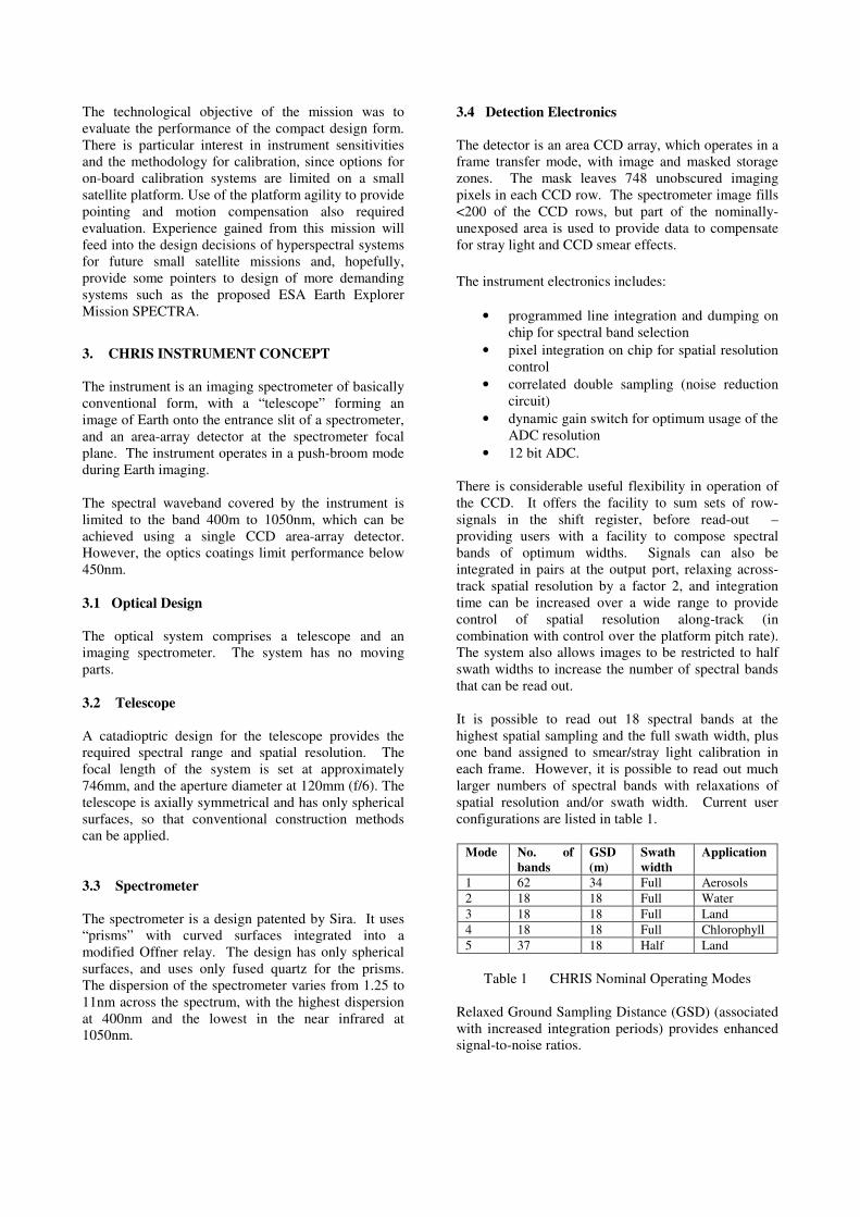
must be sufficiently apart, in terms of orbit time, to enable the data from the previous acquisition to be downloaded before new acquisitions are made. Three overpasses are needed to download a five-image set.
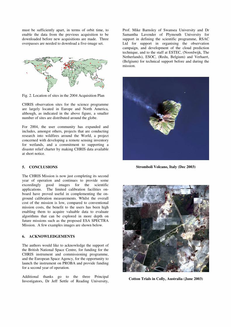
Fig. 2. Location of sites in the 2004 Acquisition Plan CHRIS observation sites for the science programme are largely located in Europe and North America, although, as indicated in the above figure, a smaller number of sites are distributed around the globe. For 2004, the user community has expanded and includes, amongst others, projects that are conducting research into wildfires around the World, a project concerned with developing a remote sensing inventory for wetlands, and a commitment to supporting a disaster relief charter by making CHRIS data available at short notice. 5. CONCLUSIONS The CHRIS Mission is now just completing its second year of operation and continues to provide some exceedingly good images for the scientific applications. The limited calibration facilities on-board have proved useful in complementing the on-ground calibration measurements. Whilst the overall cost of the mission is low, compared to conventional mission costs, the benefit to the users has been high enabling them to acquire valuable data to evaluate algorithms that can be explored in more depth on future missions such as the proposed ESA SPECTRA Mission. A few examples images are shown below.
6. ACKNOWLEDGEMENTS The authors would like to acknowledge the support of the British National Space Centre, for funding for the CHRIS instrument and commissioning programme, and the European Space Agency, for the opportunity to launch the instrument on PROBA and provide funding for a second year of operation. Additional thanks go to the three Principal Investigators, Dr Jeff Settle of Reading University,
Prof. Mike Barnsley of Swansea University and Dr Samantha Lavender of Plymouth University for support in defining the scientific programme, RSAC Ltd for support in organising the observation campaign, and development of the cloud prediction technique, and to the staff at ESTEC, (Noordwijk, The Netherlands), ESOC, (Redu, Belgium) and Verhaert, (Belgium) for technical support before and during the mission.
Stromboli Volcano, Italy (Dec 2003)
Cotton Trials in Colly, Australia (June 2003)