a semantically-informed multirobot system for exploration
TRANSCRIPT
Noname manuscript No.(will be inserted by the editor)
A Semantically-Informed Multirobot System for Explorationof Relevant Areas in Search and Rescue Settings
Alberto Quattrini Li · Riccardo Cipolleschi · Michele Giusto · Francesco
Amigoni
Received: date / Accepted: date
Abstract Coordinated multirobot exploration involves
autonomous discovering and mapping of the features
of initially unknown environments by using multiple
robots. Autonomously exploring mobile robots are usu-
ally driven, both in selecting locations to visit and in
assigning them to robots, by knowledge of the already
explored portions of the environment, often represented
in a metric map. In the literature, some works addressed
the use of semantic knowledge in exploration, which,
embedded in a semantic map, associates spatial con-
cepts (like ‘rooms’ and ‘corridors’) with metric entities,
showing its effectiveness in improving the total area ex-
plored by robots. In this paper, we build on these results
and propose a system that exploits semantic informa-
tion to push robots to explore relevant areas of initially
unknown environments, according to a priori informa-tion provided by human users. Discovery of relevant
areas is significant in some search and rescue settings,
in which human rescuers can instruct robots to search
for victims in specific areas, for example in cubicles if a
disaster happened in an office building during working
Alberto Quattrini Li (B) · Riccardo Cipolleschi · MicheleGiusto · Francesco AmigoniArtificial Intelligence and Robotics LaboratoryDipartimento di Elettronica, Informazione e Bioingegneria,Politecnico di MilanoPiazza Leonardo da Vinci 32, 20133Tel.: +39 02 2399 9687Fax: +39 02 2399 3411E-mail: [email protected]
Riccardo CipolleschiE-mail: [email protected]
Michele GiustoE-mail: [email protected]
Francesco AmigoniE-mail: [email protected]
hours. We propose to speed up the exploration of spe-
cific areas by using semantic information both to select
locations to visit and to determine the number of robots
to allocate to those locations. In this way, for example,
more robots could be assigned to a candidate location
in a corridor, so the attached rooms can be explored
faster. We tested our semantic-based multirobot explo-
ration system within a reliable robot simulator and we
evaluated its performance in realistic search and res-
cue indoor settings with respect to state-of-the-art ap-
proaches.
Keywords Coordinated multirobot exploration ·Semantic map · Search and rescue
1 Introduction
Coordinated multirobot exploration (Burgard et al, 2005)
autonomously discovers features of initially unknown
environments by using mobile robots equipped with
sensors. Exploration is fundamental in tasks like map
building (Thrun, 2002) and search and rescue (Tadokoro,
2010). Decisions about where to go next and about
which robot goes where are crucial in coordinated mul-
tirobot exploration and are usually made according to
information extracted from the known portion of the
environment, represented in a metric map that robots
incrementally build. A metric map represents the spa-
tial features of the environment, like the position of
obstacles. In the last years, several methods have been
proposed to build semantic maps of environments (like
(Wolf and Sukhatme, 2008) and (Mozos et al, 2005)),
which label some spatial elements with high-level hu-
man concepts. For example, areas of a metric map can
be labeled as ‘corridor’ or ‘room’, thus providing knowl-
edge about the structure of the environment. Despite
2 Alberto Quattrini Li et al.
the great effort in constructing semantic maps, the study
of their use for exploration is still rather limited.
In this paper, we contribute to this study by present-
ing a coordinated multirobot exploration system that
operates in search and rescue settings and that exploits
semantic labels to explore relevant areas of environ-
ments. A relevant area is defined as a portion of the
environment that is considered of interest according to
what human users communicate to the system. Our sys-
tem is composed of multiple robots equipped with laser
range scanners that operate according to the following
steps: they (a) perceive the surrounding environment,
(b) integrate the perceived data within a metric and a
semantic map representing the environment known so
far, (c) decide where to go next and who goes where,
and (d) go to the assigned target locations and start
again from (a). In this work, we focus on the decision
making (step (c)).
Some works (e.g., (Calisi et al, 2009; Stachniss et al,
2008)) have already addressed the problem of exploit-
ing semantic knowledge to improve exploration, finding
out that the use of semantic information can reduce the
time required to cover a given amount of area and can
increase the total amount of area mapped by robots in
a given time interval. In this paper, we extend these
results by showing that semantic knowledge can also
be used to significantly improve the exploration of rel-
evant areas of indoor environments. We assume that a
priori and reliable information about the areas of the
environment that are considered relevant is available,
for example, provided by humans. This assumption is
of interest in realistic scenarios. In a search and rescue
setting, the a priori information could be the possible
location of victims or the preferred areas to search first,
given by human rescuers. For example, if a disaster hap-
pens during office hours, victims are most likely located
in the offices, and, thus, robots should focus on search-
ing small-size rooms. If it happens during lunch time,
robots should head to large-size rooms, like a canteen.
In the following of this paper, we consider two kinds of
a priori information about victim location: victims in
small rooms and victims in big rooms. However, our ap-
proach can be applied to more general settings with ar-
bitrary a priori information coming from human users.
We propose to exploit semantic information to select
interesting locations to visit and, differently from the
literature, to assign more robots to a single location.
For example, in an indoor environment, if a location
lies in an area labeled as ‘corridor’, then that area could
be privileged by sending there several robots, so that
rooms, typically attached to corridors, can be explored
faster.
Our system originally addresses the following prob-
lem: To what extent is it possible and convenient to ex-
ploit semantic information to efficiently explore areas
(of an initially unknown environment) that are con-
sidered relevant? To the best of our knowledge, none
of the works present in the literature has addressed
such research question. The main original contribution
of this paper is thus a system that exploits semantic
information to improve exploration of relevant areas.
Specifically, we propose a method for evaluating can-
didate locations, which is a variant of that presented
in (Basilico and Amigoni, 2011), and a method for allo-
cating robots to candidate locations. The contributions
of this paper significantly extend the preliminary results
in (Cipolleschi et al, 2013) and include a more com-
plete experimental analysis of the behavior and benefits
of the proposed multirobot system, also involving ad-
ditional experiments using state-of-the-art approaches
for comparison and the deployment of more robots.
This paper is structured as follows. The next sec-
tion surveys the methods that have been proposed to
perform the decision making step (c) in the context of
coordinated multirobot exploration. Section 3 presents
the proposed multirobot exploration system. Section 4
shows extensive experimental simulated activities with
the aim to display the effectiveness of the proposed ap-
proach. Finally, Section 5 concludes the paper.
2 Related work
Robotic exploration is the task in which mobile robots,
equipped with on-board sensors, are employed in the it-erative online process presented in the previous section
with the goal to discover (initially unknown) features
in environments. The mainstream approach to robotic
exploration (Yamauchi, 1998) identifies some candidate
locations on the frontiers between known (already ex-
plored) and unknown portions of the environment, eval-
uates them, and assigns them to robots, iteratively. In
this paper, we are interested in problems of searching
targets in an initially unknown environment, by using
multiple mobile robots, with a semantic map and some
a priori reliable information about the location of the
targets (e.g., victims most likely located in offices of a
building), which is provided by humans. In addressing
these issues, and in order to clearly present our contri-
bution, we tear apart the aspects of evaluating the can-
didate locations (exploration strategy) and of allocating
robots to candidate locations (coordination method).
In the following, we present a representative sample
of the several exploration strategies and coordination
methods (focusing on those using semantic information
A Semantically-Informed Multirobot System for Exploration of Relevant Areas in Search and Rescue Settings 3
for speeding up autonomous exploration of initially un-
known environments) presented in literature.
2.1 Exploration strategies
In the literature, exploration strategies usually employ
a utility function that combines different criteria, which
characterize each candidate location, to assess the good-
ness of different candidate locations. Most of the criteria
considered by exploration strategies are only relative to
metric information, namely information that can be de-
rived from metric maps that robots build. For example,
the robotic exploration system of Gonzales-Banos and
Latombe (2002) combines, in an exponential function,
the distance between a robot r and a candidate loca-
tion p and the expected amount of information that r
can acquire at p (measured as the maximum amount
of unknown area visible from p). A system using the
same two criteria, but combining them in a linear func-
tion, is that of Burgard et al (2005). The system pro-
posed by Basilico and Amigoni (2011) adds a criterion
that measures the probability that r, once in p, can
communicate with a fixed base station (like Visser and
Slamet (2008)), and combines all the criteria using a
theoretically-grounded approach.
Only few exploration systems use semantic informa-
tion to evaluate candidate locations and assign them to
the robots. An early attempt in this direction is that
of Kuipers and Byun (1981), in which candidate loca-
tions with a large distinctiveness (e.g., located at the in-
tersections of corridors) are privileged. Specifically, the
authors, without explicitly considering semantic infor-
mation, use a geometric measure, which derives from
finding points that are equally-distant to close obsta-
cles, and apply a hill-climbing control strategy to find
the robot’s exploration path, so that distinctiveness is
maximized. They show the goodness of the exploration
path found through a qualitative analysis of the solu-
tion obtained during simulations.
The work in (Stachniss et al, 2008) exploits the
knowledge on the structure of an indoor environment
(represented as a hidden Markov model) to drive robots
to select, first, candidate locations that are in corridors.
For each robot r and each candidate location p, the dif-
ference between the initial utility of p (which is equal
for all frontiers and is initialized at 1, not considering
any features of p) and the distance between the cur-
rent position of r and p is calculated. The initial utility
of candidate locations that are in corridors is multi-
plied by γ (set to 5 in the experimental activity). Then
the method greedily allocates the candidate locations to
the robots by selecting the pair r and p that maximizes
the above difference. Experimental results (performed
in simulation) show that the approach is effective in
decreasing the time required to explore some environ-
ments with respect to an approach that does not update
the initial utility of corridors.
Another work that uses semantic information to im-
prove exploration is presented in (Calisi et al, 2009). In
this case, contextual information related to the mis-
sion (e.g., the relative importance of a goal with re-
spect to another goal), to the environment (e.g., the
presence of rooms and corridors and the difficulty for
traversing a given area and for detecting victims in
that area), and to the agents (e.g., the presence of loop
closures for improving localization of robots) is repre-
sented by a prolog rule-based system and exploited
to enhance the performance of a robotic system oper-
ating in a search and rescue scenario. The experiments
(performed in simulation) use a single robot and show
that the proposed approach can significantly increase
the area mapped by the robot within 15 minutes.
Another system that exploits the structure of the
environment for determining the best candidate loca-
tions and assigning them to the robots is presented
in (Wurm et al, 2008). The known portion of the map
of the environment is segmented and a single robot is
assigned to (one of the frontiers of) each segment. The
utility function used to assign a robot r to a frontier
p considers the distance from the current position of
r to p. Experimental results in simulation show that
the approach can significantly reduce the overall explo-
ration time for realistic environments with respect to a
closest-frontier approach that assigns to each robot the
closest candidate location. Also, the authors validated
the method with two real robots in an environment,
qualitatively analyzing the paths they follow.
All these works that embed semantic information
in the exploration strategy show that the total area ex-
plored in a given time interval can be improved by using
semantic information, but do not exploit semantic in-
formation to push robots to explore areas that are rele-
vant, according to a priori information available from,
for example, human rescuers. Moreover, all these ap-
proaches use a utility function that considers basically
just the cost to reach a candidate location. Amigoni
(2008) experimentally showed that, in some common
settings, exploration strategies that balance utility and
cost tend to have better performance than those that
use only cost.
Since in this paper we are assuming that some a
priori information is available about relevant areas, the
above works are not directly comparable with our ap-
proach, in terms of the relevant areas explored. How-
ever, in our experimental simulated activities, we will
compare the proposed exploration strategy with that
4 Alberto Quattrini Li et al.
proposed by Basilico and Amigoni (2011), which has
been experimentally proven to perform well in search
and rescue scenarios, but do not consider any seman-
tic information. In this paper, we aim at showing that,
when a priori knowledge on victims’ locations is avail-
able (i.e., preferred areas to visit are specified), the use
of semantic information could improve also the per-
formance of exploration of relevant areas of the envi-
ronment, besides the total explored area, as shown by
the works presented above (like (Stachniss et al, 2008)
or (Calisi et al, 2009)).
2.2 Coordination methods
Coordination between multiple exploring robots, namely
assigning robots to candidate locations, is achieved in
different ways in the literature.
A series of works ((Burgard et al, 2000, 2005; Stach-
niss et al, 2008) and, partially, (Fox et al, 2006)) pro-
pose an interesting approach in which the coordination
method is embedded within the exploration strategy. In
particular, the utility value of a candidate location is re-
duced according to the number of robots that can view
it, in order to discourage the assignment of more robots
to the same candidate location. Experimental results
show that this coordinated behavior has better perfor-
mance than uncoordinated behavior (in which differ-
ent robots can select the same location to reach) and
slightly worse performance than a method that finds
the optimal allocation over all possible permutations
of candidate locations to robots, where the optimality
criterion depends on the difference between utility and
cost of visiting the candidate locations.
Several other works (e.g., (Simmons et al, 2000; Zlot
et al, 2002)) are based on market mechanisms. Specif-
ically, coordination of mobile robots is performed by a
central executive that, beyond collecting local maps and
combining them into a single global map, manages an
auction-like mechanism by asking bids to the robots and
assigning tasks (i.e., locations to reach) according to the
received bids. Bids contain information about expected
utility for pairs robot-location; utility are calculated by
the exploration strategy adopted. Experimental results
show that the auction-based coordination methods (as
expected) outperform the uncoordinated methods. An
extension of such works is the approach of Hawley and
Butler (2013), who propose an auction-based coordina-
tion method not only for task assignment, but also for
coalition formation, when there are more robots than
candidate locations.
All of the presented approaches for coordination at-
tempt to spread the robots around the environment.
The (often) implicit assumption is that the exploration
problem is considered to involve, according to the clas-
sification in (Gerkey and Mataric, 2004), single-task
robots (ST) and single-robot tasks (SR), where the task
is to reach a candidate location. ST means that each
robot executes one task at a time and SR means that
each task requires one robot. Thus, all the above works
act basically as ST-SR.
In this paper, we attempt to overcome the ST-SR
assumption by allocating more robots to the same can-
didate locations according to a multi-robot tasks (MR)
paradigm. Specifically, we aim at showing that seman-
tic information enables the possibility to determine the
ideal number of robots to send to a specific area so that
exploration can proceed faster and more effectively.
3 A Semantic-based multirobot exploration
system
In this section, we present our proposed exploration sys-
tem that exploits semantic information. Specifically, af-
ter a brief system overview, we go into the details of the
exploration strategy and the coordination method we
designed for the semantic-based multirobot exploration
system.
3.1 System overview
The robotic platform used is a Pioneer P3AT equipped
with a sonar ring and two laser range scanners, mounted
at the same height and back-to-back for covering a 360◦
area around the robot with radius R = 20 m and an-
gular resolution at 1◦.
Each robot builds a two-dimensional occupancy grid
map of the explored environment. Each cell is either
known, if the robot perceived the corresponding area,
or unknown. Known cells can be free or occupied (by
obstacles). The map of the environment is maintained
by a base station, whose position is fixed in the environ-
ment, and to which robots send their maps every 2.5 s.
We assume that communication is error-free and un-
limited in range and bandwidth (effects of more realis-
tic communication models on exploration are discussed
in (Tuna et al, 2012)). Our exploration system is largely
independent of the mapping system employed to incre-
mentally build the grid map. In our experiments, we
use a simple scan matching method, inspired to that
in (Lu and Milios, 1997), in which a new acquired scan
is aligned with the current map (using odometry as ini-
tial guess) and the occupancy grid is updated corre-
spondingly. Since we are not interested in analyzing the
quality of the resulting map, we assume that the map-
ping module is error-free. Given the grid map, clusters
A Semantically-Informed Multirobot System for Exploration of Relevant Areas in Search and Rescue Settings 5
of (adjacent) free cells that are on the frontier between
known and unknown parts of the map are extracted.
For each cluster, the free cell belonging to that cluster
and closest to its centroid is considered as a candidate
location to reach. Paths are planned using A* on the
grid map. Sonars are used for obstacle detection during
navigation.
We assume that the system has a semantic map that
labels each free cell of the grid map with its room type
(i.e., labels ‘corridor’, ‘small room’, ‘medium room’, ‘big
room’) and with the number of doorways present in the
room in which the cell is located. This semantic map
can be built exploiting any available method (e.g., (Mo-
zos et al, 2005)). However, in this paper we assume the
semantic map as available, because we are only inter-
ested in its use. In practice, we manually annotate with
semantic labels the portions of the simulated environ-
ments used for the experimental activities. Note that
the proposed approach can be, in principle, applied to
any number of semantic labels, different from the four
we consider.
3.2 MCDM-based exploration strategy
Our Multi-Criteria Decision Making (MCDM) explo-
ration strategy uses several criteria to evaluate the good-
ness of a candidate location. More formally, the explo-
ration strategy is used to estimate the utility u(p, r) of
every candidate location p for all robots r. It combines
the following criteria:
– A(p) is the expected amount of free area beyond the
frontier of p computed as the length (in cells) of the
frontier. The larger its value, the more information
is expected to be acquired from p.
– d(p, r) is the Euclidean distance between p and cur-
rent position of r. Using Euclidean distance instead
of actual distance calculated by path planner drasti-
cally reduces the computational effort in calculating
this criterion without affecting too much the esti-
mated utility u(p, r), as some preliminary experi-
ments we performed have shown.
– b(p, r) is an estimate of the energy spent by r for
reaching p, calculated considering a very simple model,
in which the power consumption is related to the
time required for reaching p, computed according to
the path that r should follow and according to lin-
ear and angular velocities of the robots. The larger
its value, the smaller the amount of residual energy
in the battery (0 = full, 1 = empty).
All these criteria can be calculated from the robots’
status and from the metric grid map.
In addition to the above criteria, other criteria em-
ploying information from semantic map are considered:
– S(p) is the relevance of p (from 0, not relevant, to
1, relevant), calculated according to the semantic
label of p and the a priori knowledge on victims’
locations. For example, if it is known that victims
are most likely in big rooms, and p is labeled as
‘big room’, S(p) = 1, while if p is labeled as ‘small
room’, and under the same hypothesis about the
location of victims, S(p) = 0. If p is labeled as ‘cor-
ridor’, regardless the hypothesis on victims’ loca-
tions, S(p) = 0.15, as corridors are usually impor-
tant to reach relevant rooms. The values for S(p)
have been manually set to obtain good performance
after experiments with different combinations of val-
ues. In our preliminary tests, different value combi-
nations (e.g., range [0.10, 0.50] for S(p) with p in
corridors), that maintain relevance of corridors and
of rooms according to the hypothesis on victims’ lo-
cation, have been experimentally demonstrated to
have similar performance.
– ND(p) is the number of doors in the room where p is
located. This criterion evaluates the connectivity of
a room with other rooms. The idea is that a highly-
connected room should be visited to ease finding
relevant rooms.
We assume that semantic labeling used to calculate the
criteria S(p) and ND(p) is perfect. This assumption will
be relaxed later to experimentally verify the robustness
of the approach. Note that, in order to apply our ap-
proach to other semantic labels and other kinds of a
priori information, criterion S() should be changed.
All the criteria N = {A, d, b, S,ND} are combined
using the MCDM approach introduced in (Basilico and
Amigoni, 2011), to which we refer for a complete de-
scription; here we just summarize the main features.
We selected the MCDM approach because it is theoret-
ically grounded and allows to easily integrate several
criteria in a utility function. Consider a set of candi-
date locations P (i.e., the cells closest to the centroids
of their frontiers at some time during exploration), a
set of robots R, and a set of criteria N . Call uj(p, r)
the utility value for candidate location p ∈ P and robot
r ∈ R according to criterion j ∈ N . The larger uj(p, r),
the better the pair p and r according to j. To apply
MCDM, utilities need to be normalized to a common
scale I = [0, 1]. We use a linear relative normalization
for each uj . With a slight abuse of notation, we call
u(j), with (j) ∈ N , the j-th criterion according to an in-
creasing ordering with respect to utilities: for candidate
location p and robot r, u(1)(p, r) ≤ . . . ≤ u(n)(p, r) ≤ 1,
where n = |N | (we assume u(0)(p, r) = 0). The MCDM
6 Alberto Quattrini Li et al.
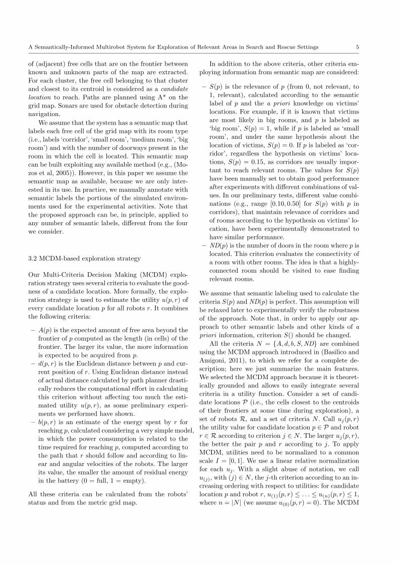
S-M
CD
M
criteria µ() criteria µ() criteria µ()A 0.09 d, b 0.09 A, b 0.15d 0.09 d, S 0.8 d, b, S 0.8b 0.02 b, S 0.6 A,S 0.65S 0.5 A, d, b 0.3 A, d, b, S 0.8ND 0.3 A, d, S 0.8A, d 0.3 A, b, S 0.65
D-M
CD
M
criteria µ()A 0.4d 0.4b 0.2A, d 0.95A, b 0.7d, b 0.4
Table 1 Weights of MCDM-based exploration strategies.
strategy integrates the criteria in N with the following
function:
u(p, r) =
n∑j=1
(u(j)(p, r)− u(j−1)(p, r))µ(A(j)), (1)
where µ : 2N → [0, 1] (2N is the power set of set
N) are weights, and the set A(j) is defined as A(j) =
{i ∈ N |u(j)(p, r) ≤ ui(p, r) ≤ u(n)(p, r)}. Specifically,
µ({∅}) = 0, µ(N) = 1, and, if N ′ ⊂ N ′′ ⊂ N , then
µ(N ′) ≤ µ(N ′′). That is, µ is a normalized fuzzy mea-
sure on the set of criteria N that will be used to as-
sociate a weight to each group of criteria. The weights
specified by the definition of µ describe the relation-
ships between criteria. Criteria belonging to a group
G ⊆ N are said to be redundant if µ(G) <∑i∈G µ(i),
synergic if µ(G) >∑i∈G µ(i), and independent oth-
erwise. Namely, Equation (1) provides a sort of “dis-
torted” weighted average that accounts for synergies
and redundancies between criteria.
In MCDM, beyond selecting the set of criteria N ,
we need to define weights µ for each subset of criteria.
For our semantically-informed exploration strategy (S-
MCDM ), we use the criteria N = {A, d, b, S,ND} de-
fined above and the weights reported in Table 1 (left).
The weights of the subsets of criteria not reported in the
table are calculated by summing the weights of the indi-
vidual criteria. Note that in selecting these weights, we
have chosen values reasonably (e.g., criteria d() and A()
have the same importance, so their weights are equal).
Moreover, criteria d() and b() are redundant (both pre-
fer candidate locations close to the robot and a can-
didate location satisfies both criteria well or both not
well) and so µ({d, b}) < µ({d}) + µ({b}). Criteria A()
and d() are instead synergic (one prefers candidate lo-
cations on long frontiers while the other one prefers
candidate locations close to the robot and a candidate
location can satisfy one criterion well and the other
one not well) and so µ({A, d}) > µ({A}) + µ({d}).Values of weights have been set to obtain good per-
formance, according to criteria importance and rela-
tions (Basilico and Amigoni, 2011). Slightly varying the
selected weights values (±10%), we experimentally ob-
tained similar performance. Principled methods for se-
lecting weights are discussed in (Basilico and Amigoni,
2011).
For comparing the performance of S-MCDM, we
chose a state-of-the-art exploration strategy. Specifi-
cally, we defined another MCDM-based exploration strat-
egy (called in the following Default MCDM, or D-MCDM ),
whose criteria set is N = {A, d, b}, similarly to (Basil-
ico and Amigoni, 2011), and with weights reported in
Table 1 (right). As discussed in Section 2 and to the
best of our knowledge, no exploration strategy that fo-
cuses on relevant areas is available. Furthermore, the
work of Calisi et al (2009) is not easily configurable
in our setting, as prolog rules should be set. Nev-
ertheless, the D-MCDM exploration strategy has been
shown by Basilico and Amigoni (2011) to be very effec-
tive in exploring environments (in particular, it outper-
formed the exploration strategies proposed by Visser
and Slamet (2008) and Amigoni and Caglioti (2010)).
3.3 ST-MR coordination method
Coordination methods are used to assign candidate lo-
cations to robots. The mechanism we use is market-
based (Zlot et al, 2002). The base station regularly sets
up auctions in which candidate locations (generated on
current frontiers as discussed before) are auctioned to
the robots, which bid on them. This process allocates
candidate locations p to robots r attempting to maxi-
mize the sum of utilities u(p, r). In our system, the co-
ordination method can allocate multiple robots (MR)
to the same candidate locations. For example, allocat-
ing two robots to the same candidate location in a big
room could speed up the exploration of the room, over-
coming potential negative effects due to the initially
overlapping views of the two robots.
We employ a fuzzy-based function i(p) that com-
putes the ideal number of robots (1, 2, or 3, in our
experiments) that should be assigned to a candidate
location p, according to the semantic label given to p
and to some other features. In particular, if p is located
in a room (‘small room’, ‘medium room’, or ‘big room’),
the features considered are the room area, the free area
percentage of the total area in the room (visibility), the
number of doors, and the already perceived area of the
room. Note that an estimate of the already perceived
area of a room can be computed by having a knowledge
base that associates the semantic labels of rooms to the
corresponding average area (see, e.g., the work of Lu-
perto et al (2013)). Fig. 1 illustrates the membership
functions for the input features and for the output for
p in a room that we have used for experiments we show
in the next section. When slightly varying the selected
fuzzy values (±10%), we experimentally obtained sim-
ilar performance. Given p, if the room in which p is
located is large, the number of its doors is large, its
A Semantically-Informed Multirobot System for Exploration of Relevant Areas in Search and Rescue Settings 7
visibility is large, and the amount of already perceived
area is small, then more robots are allocated to p. An-
other example of the rules for determining the ideal
number of robots i(p) to be allocated to p (in a room)
is reported in Algorithm 1.
1 if RoomSize is SMALL and #Doors is HIGH and Visibilityis LOW and AlreadyPercArea is MEDIUM then #Robotsis MEDIUM ;
2 if RoomSize is BIG and #Doors is LOW and Visibility isLOW and AlreadyPercArea is HIGH then #Robots isLOW ;
3 if RoomSize is BIG and #Doors is MEDIUM andVisibility is MEDIUM and AlreadyPercArea is LOW then#Robots is HIGH ;
Algorithm 1: Sample of rules for calculating the
ideal number of robots that can be allocated to p
(in a room).
Similarly, if p is located in a corridor (label ‘corri-
dor’), the features considered are the size of the corri-
dor, the number of doors, the number of intersecting
corridors, and the already perceived area of the corri-
dor. The membership functions and the rules are similar
to those for the room case, as shown in Fig. 2 and in
Algorithm 2. Note that, in order to use our approach
with different semantic labels, membership functions
and rules for calculating i(p) should be changed.
1 if CorridorSize is SMALL and #Doors is HIGH and#IntersectingCorridors is MEDIUM and AlreadyPercAreais MEDIUM then #Robots is LOW ;
2 if CorridorSize is SMALL and #Doors is MEDIUM and#IntersectingCorridors is LOW and AlreadyPercArea isLOW then #Robots is MEDIUM ;
3 if CorridorSize is MEDIUM and #Doors is MEDIUM and#IntersectingCorridors is MEDIUM and AlreadyPercAreais LOW then #Robots is HIGH ;
4 if CorridorSize is BIG and #Doors is HIGH and#IntersectingCorridors is MEDIUM and AlreadyPercAreais LOW then #Robots is VERY HIGH ;
Algorithm 2: Sample of rules for calculating the
ideal number of robots that can be allocated to p
(in a corridor).
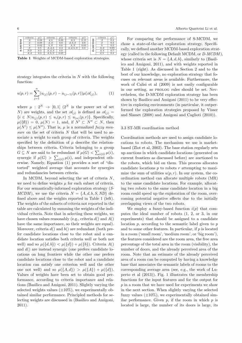
Each robot r evaluates all candidate locations p, as
auctioned by the base station every 5 s or when re-
quested by a robot that has reached its assigned loca-
tion, according to the exploration strategy, and submits
bids u(p, r) accordingly. We propose two coordination
methods executed by the base station to allocate candi-
date locations to robots. The first coordination method
(MRv1 ) works as reported in Algorithm 3. Basically,
MRv1 greedily allocates the best pair (p∗, r∗), avoiding
to allocate p∗ to more than i(p∗) robots.
The second coordination method, called MRv2, is
similar to MRv1, but, after each allocation of a robot
1 collect bids u(p, r), which are calculated using (1);2 while ∃ robot r not allocated and candidate location p do3 find the pair (p∗, r∗): (p∗, r∗) = arg maxp,r u(p, r);4 allocate p∗ to r∗;5 if i(p∗) is equal to the number of robots already assigned
to p∗ then6 eliminate p∗;
end7 eliminate robot r∗;
end
Algorithm 3: MRv1.
Fig. 3 Discount factor vs. the number of robots already al-located to p, when i(p) = 3.
to a p∗ (step 4), it discounts the utility of p∗ for other
robots, according to the number of robots already allo-
cated to p∗ (similarly to (Stachniss et al, 2008)). Fig. 3
shows the discount factor we employ that decreases lin-
early until the number of allocated robots is less than
or equal to i(p∗), and then decays exponentially. The
rationale is that assigning to p∗ less robots than i(p∗)
could be a necessity (e.g., there are not enough robots)
and that assigning to p∗ more robots than i(p∗) is not
useful to speed up exploration.
The two proposed ST-MR coordination methods are
experimentally compared to a standard coordination
method (ST-SR) (Zlot et al, 2002), which allocates just
one robot to a candidate location in a greedy fashion.
Namely, it runs MRv1 with i(p) = 1 for every p.
4 Experimental activity
This section, first, shows the experimental setup in which
we tested our proposed semantic-based exploration sys-
tem. Then, we show some preliminary experiments to
support the choice of the state-of-the-art exploration
strategy against which our system is compared, and we
present extensive experimental results that validate the
system. Further, we present additional experiments for
showing the robustness of our proposed system, for ex-
ample by relaxing the assumption on the perfect seman-
tic knowledge and by adopting a different termination
criterion. Finally, we discuss the obtained results.
8 Alberto Quattrini Li et al.
(a) (b) (c)
(d) (e)
Fig. 1 Membership functions for the input features (a-d) and for the output (e), when p is in a room.
(a) (b) (c)
(d) (e)
Fig. 2 Membership functions for the input features (a-d) and for the output (e), when p is in a corridor.
4.1 Experimental setup
In order to perform replicable tests under controlled
conditions, we use a robot simulator. We selected US-
ARSim (Carpin et al, 2007), because it is a realistic
and reliable 3D robot simulator. The multirobot system
controller software we developed and the experimental
data are publicly available at http://sourceforge.
net/projects/polimirobocup.
We report simulated experiments conducted in two
indoor environments, called office and mall (Fig. 4),
where robots start from fixed starting locations with-
out any initial knowledge about the structure of the
environment. The cells of the test environments are
manually labeled as ‘corridor’, ‘small room’, ‘medium
room’, or ‘big room’ according to the size of the rooms
they belong to. Label distributions are reported in Ta-
bles 2 and 3. The office environment is part of the
vasche library floor1 taken by Radish repository (Howard
and Roy, 2003), and is characterized mainly by the pres-
ence of small and medium rooms (as we can see from
Table 2, the number of small and medium rooms is
almost the 86% of the total number of rooms in the en-
vironment). The mall environment is a floor of a (real)
mall, and is characterized by the presence of very big
A Semantically-Informed Multirobot System for Exploration of Relevant Areas in Search and Rescue Settings 9
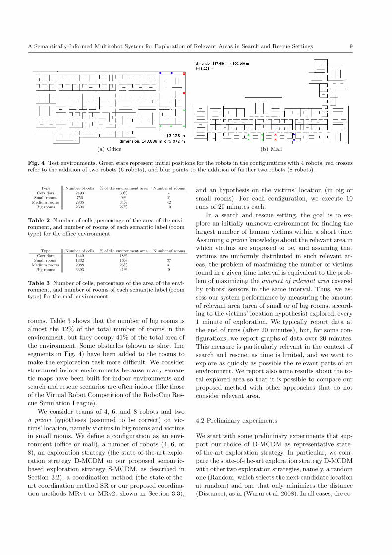
(a) Office (b) Mall
Fig. 4 Test environments. Green stars represent initial positions for the robots in the configurations with 4 robots, red crossesrefer to the addition of two robots (6 robots), and blue points to the addition of further two robots (8 robots).
Type Number of cells % of the environment area Number of roomsCorridors 2493 30% -
Small rooms 756 9% 21Medium rooms 2835 34% 42
Big rooms 2304 27% 10
Table 2 Number of cells, percentage of the area of the envi-ronment, and number of rooms of each semantic label (roomtype) for the office environment.
Type Number of cells % of the environment area Number of roomsCorridors 1449 18% -
Small rooms 1332 16% 37Medium rooms 2088 25% 31
Big rooms 3393 41% 9
Table 3 Number of cells, percentage of the area of the envi-ronment, and number of rooms of each semantic label (roomtype) for the mall environment.
rooms. Table 3 shows that the number of big rooms is
almost the 12% of the total number of rooms in the
environment, but they occupy 41% of the total area of
the environment. Some obstacles (shown as short line
segments in Fig. 4) have been added to the rooms to
make the exploration task more difficult. We consider
structured indoor environments because many seman-
tic maps have been built for indoor environments and
search and rescue scenarios are often indoor (like those
of the Virtual Robot Competition of the RoboCup Res-
cue Simulation League).
We consider teams of 4, 6, and 8 robots and two
a priori hypotheses (assumed to be correct) on vic-
tims’ location, namely victims in big rooms and victims
in small rooms. We define a configuration as an envi-
ronment (office or mall), a number of robots (4, 6, or
8), an exploration strategy (the state-of-the-art explo-
ration strategy D-MCDM or our proposed semantic-
based exploration strategy S-MCDM, as described in
Section 3.2), a coordination method (the state-of-the-
art coordination method SR or our proposed coordina-
tion methods MRv1 or MRv2, shown in Section 3.3),
and an hypothesis on the victims’ location (in big or
small rooms). For each configuration, we execute 10
runs of 20 minutes each.
In a search and rescue setting, the goal is to ex-
plore an initially unknown environment for finding the
largest number of human victims within a short time.
Assuming a priori knowledge about the relevant area in
which victims are supposed to be, and assuming that
victims are uniformly distributed in such relevant ar-
eas, the problem of maximizing the number of victims
found in a given time interval is equivalent to the prob-
lem of maximizing the amount of relevant area covered
by robots’ sensors in the same interval. Thus, we as-
sess our system performance by measuring the amount
of relevant area (area of small or of big rooms, accord-
ing to the victims’ location hypothesis) explored, every
1 minute of exploration. We typically report data at
the end of runs (after 20 minutes), but, for some con-
figurations, we report graphs of data over 20 minutes.
This measure is particularly relevant in the context of
search and rescue, as time is limited, and we want to
explore as quickly as possible the relevant parts of an
environment. We report also some results about the to-
tal explored area so that it is possible to compare our
proposed method with other approaches that do not
consider relevant area.
4.2 Preliminary experiments
We start with some preliminary experiments that sup-
port our choice of D-MCDM as representative state-
of-the-art exploration strategy. In particular, we com-
pare the state-of-the-art exploration strategy D-MCDM
with other two exploration strategies, namely, a random
one (Random, which selects the next candidate location
at random) and one that only minimizes the distance
(Distance), as in (Wurm et al, 2008). In all cases, the co-
10 Alberto Quattrini Li et al.
Office ExplorationCoord. D-MCDM (B) S-MCDM (B) D-MCDM (S) S-MCDM (S)
#Robots = 4SR 747.3(112.5) 1473.9(202.7) 80.4(22.4) 276.2(83.9)
MRv1 953.8(111.4) 1729.9(81.9) 103.1(22.7) 224.6(73.1)MRv2 921.6(130.3) 1773.8(65.4) 112.9(24.4) 272.1(52.1)
#Robots = 6SR 1024.6(220.7) 1603.2(59.1) 127.6(38.5) 235.7(43.1)
MRv1 1123.6(143.6) 1851.3(7.8) 148.6(21.2) 400.5(100.4)MRv2 1164.9(94.2) 1856.7(36.3) 162.5(22.2) 429.0(83.8)
#Robots = 8SR 1222.6(133.0) 1653.5(129.2) 170.3(43.0) 312.0(28.1)
MRv1 1379.8(122.8) 1877.6(62.6) 186.2(31.7) 496.3(101.8)MRv2 1284.9(144.5) 1854.3(80.3) 185.6(42.7) 454.3(125.2)
Table 4 Results (average and standard deviation) of ex-plored relevant area (m2) for the office environment, after20 minutes of exploration. B indicates victims most likely arein big rooms, S in small rooms.
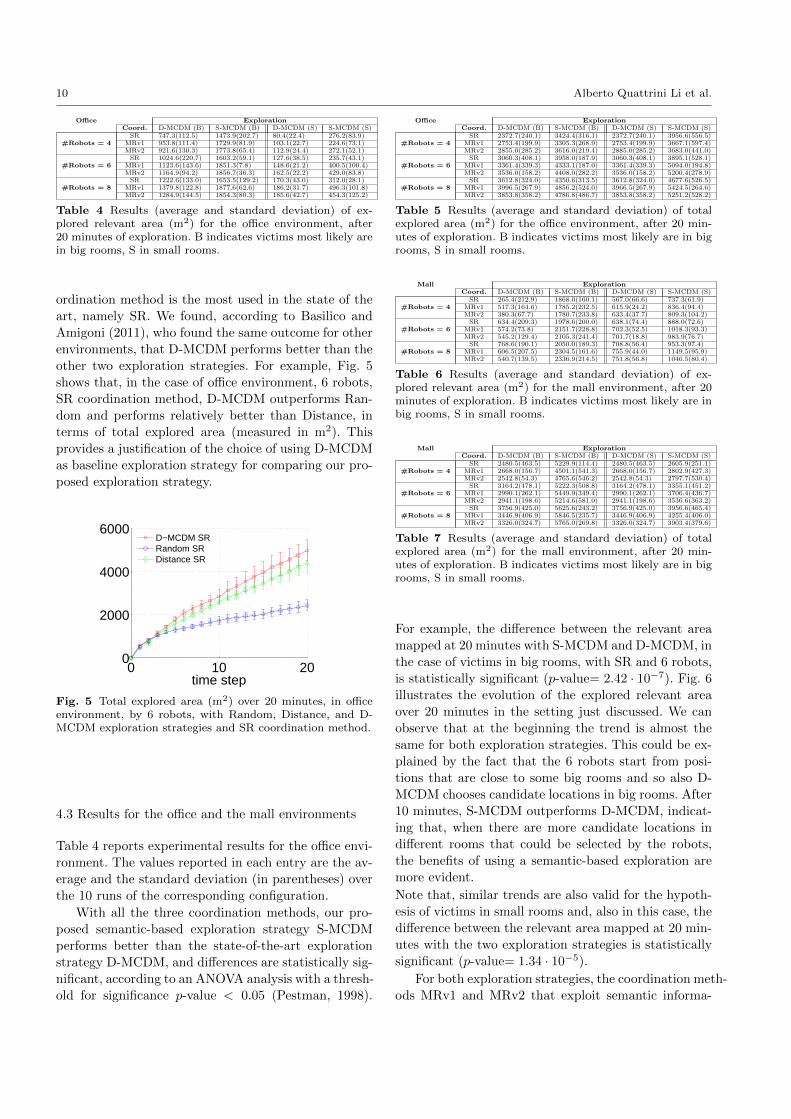
ordination method is the most used in the state of the
art, namely SR. We found, according to Basilico and
Amigoni (2011), who found the same outcome for other
environments, that D-MCDM performs better than the
other two exploration strategies. For example, Fig. 5
shows that, in the case of office environment, 6 robots,
SR coordination method, D-MCDM outperforms Ran-
dom and performs relatively better than Distance, in
terms of total explored area (measured in m2). This
provides a justification of the choice of using D-MCDM
as baseline exploration strategy for comparing our pro-
posed exploration strategy.
0 10 200
2000
4000
6000
time step
D−MCDM SRRandom SRDistance SR
Fig. 5 Total explored area (m2) over 20 minutes, in officeenvironment, by 6 robots, with Random, Distance, and D-MCDM exploration strategies and SR coordination method.
4.3 Results for the office and the mall environments
Table 4 reports experimental results for the office envi-
ronment. The values reported in each entry are the av-
erage and the standard deviation (in parentheses) over
the 10 runs of the corresponding configuration.
With all the three coordination methods, our pro-
posed semantic-based exploration strategy S-MCDM
performs better than the state-of-the-art exploration
strategy D-MCDM, and differences are statistically sig-
nificant, according to an ANOVA analysis with a thresh-
old for significance p-value < 0.05 (Pestman, 1998).
Office ExplorationCoord. D-MCDM (B) S-MCDM (B) D-MCDM (S) S-MCDM (S)
#Robots = 4SR 2372.7(240.1) 3424.4(316.1) 2372.7(240.1) 3956.6(556.5)
MRv1 2753.4(199.9) 3305.3(268.9) 2753.4(199.9) 3667.1(597.4)MRv2 2855.0(285.2) 3616.0(219.4) 2885.0(285.2) 3683.0(441.0)
#Robots = 6SR 3060.3(408.1) 3958.0(187.9) 3060.3(408.1) 3895.1(528.1)
MRv1 3361.4(339.3) 4333.1(187.0) 3361.4(339.3) 5094.0(194.8)MRv2 3536.0(158.2) 4408.0(282.2) 3536.0(158.2) 5200.4(278.9)
#Robots = 8SR 3612.8(324.0) 4350.6(313.5) 3612.8(324.0) 4677.6(526.5)
MRv1 3996.5(267.9) 4856.2(524.0) 3966.5(267.9) 5424.5(264.6)MRv2 3853.8(358.2) 4786.8(486.7) 3853.8(358.2) 5251.2(528.2)
Table 5 Results (average and standard deviation) of totalexplored area (m2) for the office environment, after 20 min-utes of exploration. B indicates victims most likely are in bigrooms, S in small rooms.
Mall ExplorationCoord. D-MCDM (B) S-MCDM (B) D-MCDM (S) S-MCDM (S)
#Robots = 4SR 265.4(212.9) 1868.0(160.1) 567.0(66.6) 737.3(61.9)
MRv1 517.3(164.6) 1785.2(232.5) 615.9(24.2) 836.4(94.4)MRv2 380.3(67.7) 1780.7(233.8) 633.4(37.7) 809.3(104.2)
#Robots = 6SR 634.4(209.3) 1978.6(200.0) 638.1(74.4) 888.0(72.6)
MRv1 574.2(73.8) 2151.7(228.8) 702.3(52.5) 1018.3(93.3)MRv2 545.2(129.4) 2105.3(241.4) 701.7(18.8) 983.9(76.7)
#Robots = 8SR 768.6(190.1) 2050.0(189.3) 708.8(56.4) 953.3(97.4)
MRv1 606.5(207.5) 2304.5(161.6) 755.9(44.0) 1149.5(95.9)MRv2 540.7(139.5) 2336.9(214.5) 751.8(56.8) 1046.5(80.4)
Table 6 Results (average and standard deviation) of ex-plored relevant area (m2) for the mall environment, after 20minutes of exploration. B indicates victims most likely are inbig rooms, S in small rooms.
Mall ExplorationCoord. D-MCDM (B) S-MCDM (B) D-MCDM (S) S-MCDM (S)
#Robots = 4SR 2480.5(463.5) 5229.9(114.4) 2480.5(463.5) 2605.9(251.1)
MRv1 2668.0(156.7) 4501.1(541.3) 2668.0(156.7) 2802.9(427.3)MRv2 2542.8(54.3) 4765.6(546.2) 2542.8(54.3) 2797.7(530.4)
#Robots = 6SR 3164.2(478.1) 5222.3(508.8) 3164.2(478.1) 3355.1(451.2)
MRv1 2990.1(262.1) 5449.9(349.4) 2990.1(262.1) 3706.4(436.7)MRv2 2941.1(198.6) 5214.6(581.0) 2941.1(198.6) 3536.6(363.2)
#Robots = 8SR 3756.9(425.0) 5625.6(243.2) 3756.9(425.0) 3956.6(465.4)
MRv1 3446.9(406.9) 5846.5(235.7) 3446.9(406.9) 4255.4(406.0)MRv2 3326.0(324.7) 5765.0(269.8) 3326.0(324.7) 3903.4(379.6)
Table 7 Results (average and standard deviation) of totalexplored area (m2) for the mall environment, after 20 min-utes of exploration. B indicates victims most likely are in bigrooms, S in small rooms.
For example, the difference between the relevant area
mapped at 20 minutes with S-MCDM and D-MCDM, in
the case of victims in big rooms, with SR and 6 robots,
is statistically significant (p-value= 2.42 · 10−7). Fig. 6
illustrates the evolution of the explored relevant area
over 20 minutes in the setting just discussed. We can
observe that at the beginning the trend is almost the
same for both exploration strategies. This could be ex-
plained by the fact that the 6 robots start from posi-
tions that are close to some big rooms and so also D-
MCDM chooses candidate locations in big rooms. After
10 minutes, S-MCDM outperforms D-MCDM, indicat-
ing that, when there are more candidate locations in
different rooms that could be selected by the robots,
the benefits of using a semantic-based exploration are
more evident.
Note that, similar trends are also valid for the hypoth-
esis of victims in small rooms and, also in this case, the
difference between the relevant area mapped at 20 min-
utes with the two exploration strategies is statistically
significant (p-value= 1.34 · 10−5).
For both exploration strategies, the coordination meth-
ods MRv1 and MRv2 that exploit semantic informa-
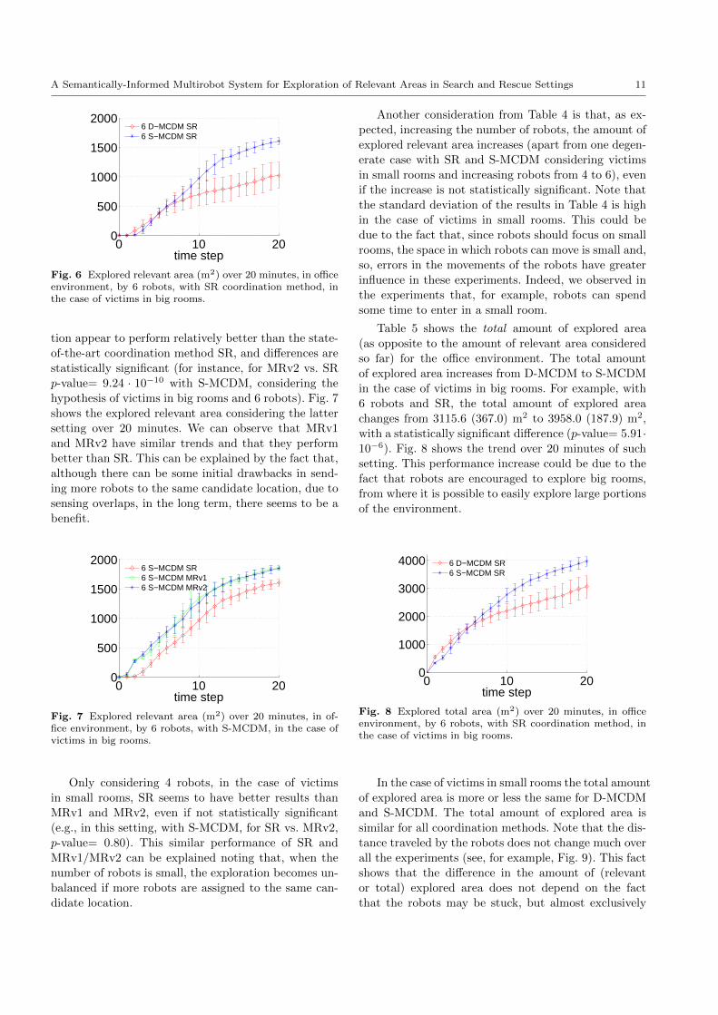
A Semantically-Informed Multirobot System for Exploration of Relevant Areas in Search and Rescue Settings 11
0 10 200
500
1000
1500
2000
time step
6 D−MCDM SR6 S−MCDM SR
Fig. 6 Explored relevant area (m2) over 20 minutes, in officeenvironment, by 6 robots, with SR coordination method, inthe case of victims in big rooms.
tion appear to perform relatively better than the state-
of-the-art coordination method SR, and differences are
statistically significant (for instance, for MRv2 vs. SR
p-value= 9.24 · 10−10 with S-MCDM, considering the
hypothesis of victims in big rooms and 6 robots). Fig. 7
shows the explored relevant area considering the latter
setting over 20 minutes. We can observe that MRv1
and MRv2 have similar trends and that they perform
better than SR. This can be explained by the fact that,
although there can be some initial drawbacks in send-
ing more robots to the same candidate location, due to
sensing overlaps, in the long term, there seems to be a
benefit.
0 10 200
500
1000
1500
2000
time step
6 S−MCDM SR6 S−MCDM MRv16 S−MCDM MRv2
Fig. 7 Explored relevant area (m2) over 20 minutes, in of-fice environment, by 6 robots, with S-MCDM, in the case ofvictims in big rooms.
Only considering 4 robots, in the case of victims
in small rooms, SR seems to have better results than
MRv1 and MRv2, even if not statistically significant
(e.g., in this setting, with S-MCDM, for SR vs. MRv2,
p-value= 0.80). This similar performance of SR and
MRv1/MRv2 can be explained noting that, when the
number of robots is small, the exploration becomes un-
balanced if more robots are assigned to the same can-
didate location.
Another consideration from Table 4 is that, as ex-
pected, increasing the number of robots, the amount of
explored relevant area increases (apart from one degen-
erate case with SR and S-MCDM considering victims
in small rooms and increasing robots from 4 to 6), even
if the increase is not statistically significant. Note that
the standard deviation of the results in Table 4 is high
in the case of victims in small rooms. This could be
due to the fact that, since robots should focus on small
rooms, the space in which robots can move is small and,
so, errors in the movements of the robots have greater
influence in these experiments. Indeed, we observed in
the experiments that, for example, robots can spend
some time to enter in a small room.
Table 5 shows the total amount of explored area
(as opposite to the amount of relevant area considered
so far) for the office environment. The total amount
of explored area increases from D-MCDM to S-MCDM
in the case of victims in big rooms. For example, with
6 robots and SR, the total amount of explored area
changes from 3115.6 (367.0) m2 to 3958.0 (187.9) m2,
with a statistically significant difference (p-value= 5.91·10−6). Fig. 8 shows the trend over 20 minutes of such
setting. This performance increase could be due to the
fact that robots are encouraged to explore big rooms,
from where it is possible to easily explore large portions
of the environment.
0 10 200
1000
2000
3000
4000
time step
6 D−MCDM SR6 S−MCDM SR
Fig. 8 Explored total area (m2) over 20 minutes, in officeenvironment, by 6 robots, with SR coordination method, inthe case of victims in big rooms.
In the case of victims in small rooms the total amount
of explored area is more or less the same for D-MCDM
and S-MCDM. The total amount of explored area is
similar for all coordination methods. Note that the dis-
tance traveled by the robots does not change much over
all the experiments (see, for example, Fig. 9). This fact
shows that the difference in the amount of (relevant
or total) explored area does not depend on the fact
that the robots may be stuck, but almost exclusively
12 Alberto Quattrini Li et al.
on the exploration strategy and the coordination meth-
ods adopted.
0 10 200
100
200
300
400
time step
S−MCDM SRS−MCDM MRv1S−MCDM MRv2
Fig. 9 Sum of the traveled distances (m) over 20 minutes,in office environment, by 8 robots, considering S-MCDM, inthe case of victims in big rooms.
The difference in the performance of the exploration
strategies can be further analyzed by looking at how
they evaluate candidate locations in different rooms.
As explained in Section 3.2, this evaluation for our pro-
posed exploration strategy S-MCDM changes according
to the semantic labels of the cells and to the hypoth-
esis on the victims locations (criterion S()), while the
state-of-the-art exploration strategy D-MCDM evalu-
ates candidate locations in different rooms more uni-
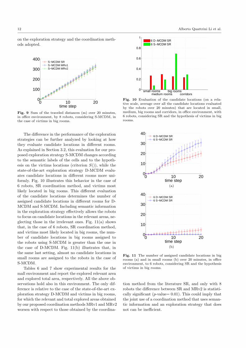
formly. Fig. 10 illustrates this behavior in the case of
6 robots, SR coordination method, and victims most
likely located in big rooms. This different evaluation
of the candidate locations determines the number of
assigned candidate locations in different rooms for D-
MCDM and S-MCDM. Including semantic information
in the exploration strategy effectively allows the robots
to focus on candidate locations in the relevant areas, ne-
glecting those in the irrelevant ones. Fig. 11(a) shows
that, in the case of 6 robots, SR coordination method,
and victims most likely located in big rooms, the num-
ber of candidate locations in big rooms assigned to
the robots using S-MCDM is greater than the one in
the case of D-MCDM. Fig. 11(b) illustrates that, in
the same last setting, almost no candidate locations in
small rooms are assigned to the robots in the case of
S-MCDM.
Tables 6 and 7 show experimental results for the
mall environment and report the explored relevant area
and explored total area, respectively. All the above ob-
servations hold also in this environment. The only dif-
ference is relative to the case of the state-of-the-art ex-
ploration strategy D-MCDM and victims in big rooms,
for which the relevant and total explored areas obtained
by our proposed coordination methods MRv1 and MRv2
worsen with respect to those obtained by the coordina-
0
0.2
0.4
0.6
0.8
1
small rooms
6 D−MCDM SR
medium roomsbig rooms
corridors
6 S−MCDM SR
Fig. 10 Evaluation of the candidate locations (on a rela-tive scale, average over all the candidate locations evaluatedby the robots over 20 minutes) that are located in small,medium, big rooms and corridors, in office environment, with6 robots, considering SR and the hypothesis of victims in bigrooms.
0 10 200
10
20
30
40
time step
6 D−MCDM SR6 S−MCDM SR
(a)
0 10 200
10
20
30
40
time step
6 D−MCDM SR6 S−MCDM SR
(b)
Fig. 11 The number of assigned candidate locations in bigrooms (a) and in small rooms (b) over 20 minutes, in officeenvironment, to 6 robots, considering SR and the hypothesisof victims in big rooms.
tion method from the literature SR, and only with 8
robots the difference between SR and MRv2 is statisti-
cally significant (p-value= 0.01). This could imply that
the joint use of a coordination method that uses seman-
tic information and an exploration strategy that does
not can be inefficient.
A Semantically-Informed Multirobot System for Exploration of Relevant Areas in Search and Rescue Settings 13
4.4 Robustness
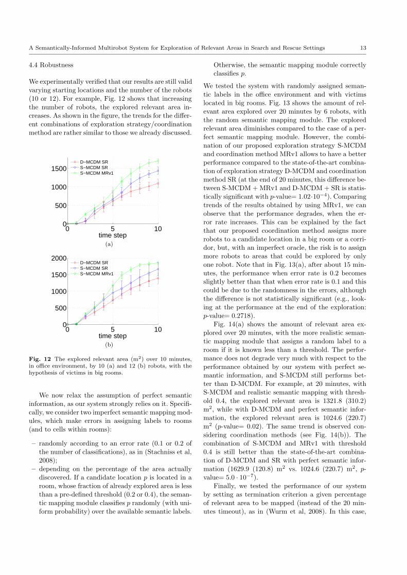
We experimentally verified that our results are still valid
varying starting locations and the number of the robots
(10 or 12). For example, Fig. 12 shows that increasing
the number of robots, the explored relevant area in-
creases. As shown in the figure, the trends for the differ-
ent combinations of exploration strategy/coordination
method are rather similar to those we already discussed.
0 5 100
500
1000
1500
time step
D−MCDM SRS−MCDM SRS−MCDM MRv1
(a)
0 5 100
500
1000
1500
2000
time step
D−MCDM SRS−MCDM SRS−MCDM MRv1
(b)
Fig. 12 The explored relevant area (m2) over 10 minutes,in office environment, by 10 (a) and 12 (b) robots, with thehypothesis of victims in big rooms.
We now relax the assumption of perfect semantic
information, as our system strongly relies on it. Specifi-
cally, we consider two imperfect semantic mapping mod-
ules, which make errors in assigning labels to rooms
(and to cells within rooms):
– randomly according to an error rate (0.1 or 0.2 of
the number of classifications), as in (Stachniss et al,
2008);
– depending on the percentage of the area actually
discovered. If a candidate location p is located in a
room, whose fraction of already explored area is less
than a pre-defined threshold (0.2 or 0.4), the seman-
tic mapping module classifies p randomly (with uni-
form probability) over the available semantic labels.
Otherwise, the semantic mapping module correctly
classifies p.
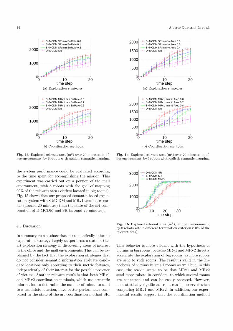
We tested the system with randomly assigned seman-
tic labels in the office environment and with victims
located in big rooms. Fig. 13 shows the amount of rel-
evant area explored over 20 minutes by 6 robots, with
the random semantic mapping module. The explored
relevant area diminishes compared to the case of a per-
fect semantic mapping module. However, the combi-
nation of our proposed exploration strategy S-MCDM
and coordination method MRv1 allows to have a better
performance compared to the state-of-the-art combina-
tion of exploration strategy D-MCDM and coordination
method SR (at the end of 20 minutes, this difference be-
tween S-MCDM + MRv1 and D-MCDM + SR is statis-
tically significant with p-value= 1.02·10−4). Comparing
trends of the results obtained by using MRv1, we can
observe that the performance degrades, when the er-
ror rate increases. This can be explained by the fact
that our proposed coordination method assigns more
robots to a candidate location in a big room or a corri-
dor, but, with an imperfect oracle, the risk is to assign
more robots to areas that could be explored by only
one robot. Note that in Fig. 13(a), after about 15 min-
utes, the performance when error rate is 0.2 becomes
slightly better than that when error rate is 0.1 and this
could be due to the randomness in the errors, although
the difference is not statistically significant (e.g., look-
ing at the performance at the end of the exploration:
p-value= 0.2718).
Fig. 14(a) shows the amount of relevant area ex-
plored over 20 minutes, with the more realistic seman-
tic mapping module that assigns a random label to a
room if it is known less than a threshold. The perfor-
mance does not degrade very much with respect to the
performance obtained by our system with perfect se-
mantic information, and S-MCDM still performs bet-
ter than D-MCDM. For example, at 20 minutes, with
S-MCDM and realistic semantic mapping with thresh-
old 0.4, the explored relevant area is 1321.8 (310.2)
m2, while with D-MCDM and perfect semantic infor-
mation, the explored relevant area is 1024.6 (220.7)
m2 (p-value= 0.02). The same trend is observed con-
sidering coordination methods (see Fig. 14(b)). The
combination of S-MCDM and MRv1 with threshold
0.4 is still better than the state-of-the-art combina-
tion of D-MCDM and SR with perfect semantic infor-
mation (1629.9 (120.8) m2 vs. 1024.6 (220.7) m2, p-
value= 5.0 · 10−7).
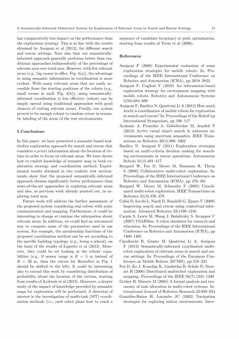
Finally, we tested the performance of our system
by setting as termination criterion a given percentage
of relevant area to be mapped (instead of the 20 min-
utes timeout), as in (Wurm et al, 2008). In this case,
14 Alberto Quattrini Li et al.
0 10 200
1000
2000
time step
S−MCDM SR min ErrRate 0.0S−MCDM SR min ErrRate 0.1S−MCDM SR min ErrRate 0.2D−MCDM SR
(a) Exploration strategies.
0 10 200
1000
2000
time step
S−MCDM MRv1 min ErrRate 0.0S−MCDM MRv1 min ErrRate 0.1S−MCDM MRv1 min ErrRate 0.2D−MCDM SR
(b) Coordination methods.
Fig. 13 Explored relevant area (m2) over 20 minutes, in of-fice environment, by 6 robots with random semantic mapping.
the system performance could be evaluated according
to the time spent for accomplishing the mission. This
experiment was carried out on a portion of the mall
environment, with 8 robots with the goal of mapping
90% of the relevant area (victims located in big rooms).
Fig. 15 shows that our proposed semantic-based explo-
ration system with S-MCDM and MRv1 terminates ear-
lier (around 20 minutes) than the state-of-the-art com-
bination of D-MCDM and SR (around 29 minutes).
4.5 Discussion
In summary, results show that our semantically-informed
exploration strategy largely outperforms a state-of-the-
art exploration strategy in discovering areas of interest
in the office and the mall environments. This can be ex-
plained by the fact that the exploration strategies that
do not consider semantic information evaluate candi-
date locations only according to their metric features,
independently of their interest for the possible presence
of victims. Another relevant result is that both MRv1
and MRv2 coordination methods, which use semantic
information to determine the number of robots to send
to a candidate location, have better performance com-
pared to the state-of-the-art coordination method SR.
0 10 200
500
1000
1500
2000
time step
S−MCDM SR min % Area 0.0S−MCDM SR min % Area 0.2S−MCDM SR min % Area 0.4D−MCDM SR
(a) Exploration strategies.
0 10 200
500
1000
1500
2000
time step
S−MCDM MRv1 min % Area 0.0S−MCDM MRv1 min % Area 0.2S−MCDM MRv1 min % Area 0.4D−MCDM SR
(b) Coordination methods.
Fig. 14 Explored relevant area (m2) over 20 minutes, in of-fice environment, by 6 robots with realistic semantic mapping.
0 10 20 300
1000
2000
3000
time step
D−MCDM SRS−MCDM SRS−MCDM MRv1
Fig. 15 Explored relevant area (m2), in mall environment,by 8 robots with a different termination criterion (90% of therelevant area).
This behavior is more evident with the hypothesis of
victims in big rooms, because MRv1 and MRv2 directly
accelerate the exploration of big rooms, as more robots
are sent to such rooms. The result is valid in the hy-
pothesis of victims in small rooms as well but, in this
case, the reason seems to be that MRv1 and MRv2
send more robots in corridors, to which several rooms
are connected and can be easily accessed. However,
no statistically significant trend can be observed when
comparing MRv1 and MRv2. In addition, our exper-
imental results suggest that the coordination method
A Semantically-Informed Multirobot System for Exploration of Relevant Areas in Search and Rescue Settings 15
has comparatively less impact on the performance than
the exploration strategy. This is in line with the results
obtained by Amigoni et al (2012), for different search
and rescue settings. Note also that our semantically-
informed approach generally performs better than tra-
ditional approaches independently of the percentage of
relevant area over total area. However, with few relevant
areas (e.g., big rooms in office, Fig. 4(a)), the advantage
in using semantic information in coordination is more
evident. With many relevant areas that are easily ac-
cessible from the starting positions of the robots (e.g.,
small rooms in mall, Fig. 4(b)), using semantically-
informed coordination is less effective (robots can be
simply spread using traditional approaches with good
chances of visiting relevant areas). Finally, our system
proved to be enough robust to random errors in seman-
tic labeling of the areas of the test environments.
5 Conclusions
In this paper, we have presented a semantic-based mul-
tirobot exploration approach for search and rescue that
considers a priori information about the location of vic-
tims in order to focus on relevant areas. We have shown
how to exploit knowledge of semantic map in both ex-
ploration strategy and coordination method. Experi-
mental results obtained in two realistic test environ-
ments show that the proposed semantically-informed
approach obtains significantly better performance than
state-of-the-art approaches in exploring relevant areas
and also, as previous work already pointed out, in ex-
ploring total area.
Future work will address the further assessment of
the proposed system considering real robots with noisy
communication and mapping. Furthermore, it could be
interesting to change at runtime the information about
relevant areas. In addition, we could find an automated
way to compute some of the parameters used in our
system. For example, the membership functions of the
proposed coordination method can be set according to
the specific building typology (e.g., being a school), on
the basis of the results of Luperto et al (2013). More-
over, they could be set looking at the robots’ capa-
bilities (e.g., if sensor range is R = 5 m instead of
R = 20 m, then the curves for RoomSize in Fig. 1
should be shifted to the left). It could be interesting
also to extend this work by considering distribution of
probability about the location of the victims, starting
from results of Aydemir et al (2013). Moreover, a deeper
study of the impact of knowledge provided by semantic
maps for exploration will be performed. A direction of
interest is the investigation of multi-task (MT) coordi-
nation methods (i.e., each robot plans how to reach a
sequence of candidate locations) or path optimization,
starting from results of Tovar et al (2006).
References
Amigoni F (2008) Experimental evaluation of some
exploration strategies for mobile robots. In: Pro-
ceedings of the IEEE International Conference on
Robotics and Automation (ICRA), pp 2818–2823
Amigoni F, Caglioti V (2010) An information-based
exploration strategy for environment mapping with
mobile robots. Robotics and Autonomous Systems
5(58):684–699
Amigoni F, Basilico N, Quattrini Li A (2012) How much
worth is coordination of mobile robots for exploration
in search and rescue? In: Proceedings of the RoboCup
International Symposium, pp 106–117
Aydemir A, Pronobis A, Gobelbecker M, Jensfelt P
(2013) Active visual object search in unknown en-
vironments using uncertain semantics. IEEE Trans-
actions on Robotics 29(4):986–1002
Basilico N, Amigoni F (2011) Exploration strategies
based on multi-criteria decision making for search-
ing environments in rescue operations. Autonomous
Robots 31(4):401–417
Burgard W, Fox D, Moors M, Simmons R, Thrun
S (2000) Collaborative multi-robot exploration. In:
Proceedings of the IEEE International Conference on
Robotics and Automation (ICRA), pp 476–481
Burgard W, Moors M, Schneider F (2005) Coordi-
nated multi-robot exploration. IEEE Transactions on
Robotics 21(3):376–378
Calisi D, Iocchi L, Nardi D, Randelli G, Ziparo V (2009)
Improving search and rescue using contextual infor-
mation. Advanced Robotics 23:1199–1216
Carpin S, Lewis M, Wang J, Balakirsky S, Scrapper C
(2007) USARSim: A robot simulator for research and
education. In: Proceedings of the IEEE International
Conference on Robotics and Automation (ICRA), pp
1400–1405
Cipolleschi R, Giusto M, Quattrini Li A, Amigoni
F (2013) Semantically-informed coordinated multi-
robot exploration of relevant areas in search and res-
cue settings. In: Proceedings of the European Con-
ference on Mobile Robots (ECMR), pp 216–221
Fox D, Ko J, Konolige K, Limketkai B, Schulz D, Stew-
art B (2006) Distributed multirobot exploration and
mapping. Proceedings of the IEEE 94(7):1325–1339
Gerkey B, Mataric M (2004) A formal analysis and tax-
onomy of task allocation in multi-robot systems. In-
ternational Journal of Robotics Research 23:939–954
Gonzales-Banos H, Latombe JC (2002) Navigation
strategies for exploring indoor environments. Inter-
16 Alberto Quattrini Li et al.
national Journal of Robotics Research 21(10-11):829–
848
Hawley J, Butler Z (2013) Hierarchical distributed task
allocation for multi-robot exploration. In: Martinoli
A, Mondada F, Correll N, Mermoud G, Egerstedt
M, Hsieh MA, Parker LE, Støy K (eds) Distributed
Autonomous Robotic Systems, vol 83, Springer, pp
445–458
Howard A, Roy N (2003) The robotics data set reposi-
tory (Radish). http://radish.sourceforge.net/
Kuipers B, Byun YT (1981) A robot exploration and
mapping strategy based on a semantic hierarchy of
spatial representations. Robotics and Autonomous
Systems 8:47–63
Lu F, Milios E (1997) Robot pose estimation in
unknown environments by matching 2d range
scans. Journal of Intelligent and Robotic Systems
18(3):249–275
Luperto M, Quattrini Li A, Amigoni F (2013) A system
for building semantic maps of indoor environments
exploiting the concept of building typology. In: Pro-
ceedings of the RoboCup International Symposium,
pp 504–515
Mozos OM, Stachniss C, Burgard W (2005) Supervised
learning of places from range data using AdaBoost.
In: Proceedings of the IEEE International Conference
on Robotics and Automation (ICRA), pp 1742–1747
Pestman W (1998) Mathematical Statistics: an Intro-
duction. de Gruyter
Simmons R, Apfelbaum D, Burgard W, Fox D, Moors
M, Thrun S, Younes H (2000) Coordination for multi-
robot exploration and mapping. In: Proceedings of
the National Conference on Artificial Intelligence
(AAAI), pp 852–858
Stachniss C, Mozos OM, Burgard W (2008) Efficient
exploration of unknown indoor environments using a
team of mobile robots. Annals of Mathematics and
Artificial Intelligence 52(2-4):205–227
Tadokoro S (2010) Rescue Robotics. Springer-Verlag
Thrun S (2002) Robotic mapping: A survey. In: Ex-
ploring Artificial Intelligence in the New Millenium,
Morgan Kaufmann, pp 1–35
Tovar B, Munoz L, Murrieta-Cid R, Alencastre M,
Monroy R, Hutchinson S (2006) Planning exploration
strategies for simultaneous localization and mapping.
Robotics and Autonomous Systems 54(4):314–331
Tuna G, Gulez K, Gungor VC (2012) The effects of
exploration strategies and communication models on
the performance of cooperation exploration. Ad Hoc
Networks 11(7):1931–1941
Visser A, Slamet B (2008) Including communication
success in the estimation of information gain for
multi-robot exploration. In: Proceedings of the Inter-
national Symposium on Modeling and Optimization
in Mobile, Ad Hoc, and Wireless Networks (WiOpt),
pp 680–687
Wolf D, Sukhatme G (2008) Semantic mapping us-
ing mobile robots. IEEE Transactions on Robotics
24(2):245–258
Wurm K, Stachniss C, Burgard W (2008) Coordinated
multi-robot exploration using a segmentation of the
environment. In: Proceedings of the IEEE/RSJ Inter-
national Conference on Intelligent Robots and Sys-
tems (IROS), pp 1160–1165
Yamauchi B (1998) Frontier-based exploration using
multiple robots. In: Proceedings of the International
Conference on Autonomous Agents, pp 47–53
Zlot R, Stentz A, Dias MB, Thayer S (2002) Multi-
robot exploration controlled by a market economy.
In: Proceedings of the IEEE International Conference
on Robotics and Automation (ICRA), pp 3016–3023