a sedimentological approach to refining reservoir architecture using the well log...
TRANSCRIPT
A sedimentological approach to refining reservoir architecture using the
well log data and core analysis in the Saharan Platform of Algeria.
R. BAOUCHE, * A. NEDJARI, ** S. EL ADJ * and M.DJEDDI * *Laboratory of the Physical Earth, University of Boumerdes, 2 Avenue of Independence,
Boumerdes, Algeria, [email protected]; [email protected] **University of Sciences and Technology–Sedimentary Basins–FTSGAT, Algiers,
[email protected]; [email protected] Abstract: - Improved reservoir characterisation in the mature oil applied to Gourara Field of Sahara in Algeria, aimed at maximising both in-field and near-field hydrocarbon potential, requires a clearer understanding of sub-seismic stratigraphy and facies distributions. In this context, we present a regional, high-resolution sequence stratigraphic framework for the Oued Namouss Field based on extensive sedimentological re-interpretation of core and wireline log data, combined with core analysis and published literature. This framework is used to place individual reservoirs in an appropriate regional context, thus resulting in the identification of subtle sedimentological and tectono-stratigraphic features of reservoir architecture that have been previously overlooked. We emphasise the following insights gained from our regional, high-resolution sequence stratigraphic synthesis: (1) improved definition of temporal and spatial trends in deposition both within and between individual reservoirs, (2) development of regionally consistent, predictive sedimentological models for two enigmatic reservoir intervals (the Formations I and II), and (3) recognition of subtle local tectono-stratigraphic controls on reservoir architecture, and their links to the regional structural evolution of the Province. We discuss the potential applications of these insights to the identification of additional exploration potential and to improved ultimate recovery. In this research a procedure was developed to assess and quantify uncertainties in hydrocarbon estimates related to depositional facies, petrophysical data and gross reservoir volumes. This procedure was applied to the Gourara Field, which is a mature gas field in the Oued Namous Basin, Algeria. The aim was to investigate the reasons for an unexpectedly high hydrocarbon recovery factor.
Key Words: Famenian, Strunian Formations; Sequence stratigraphy; Reservoir architecture; Well log analysis; Algeria.
Proceedings of the 1st International Conference on Manufacturing Engineering, Quality and Production Systems (Volume I)
ISBN: 978-960-474-121-2ISSN: 1790-2769 264
1.Introduction The principal structural elements which characterize this basin from West to East are (Aît Ouali R. et al., 1996): • The extreme Eastern part of the vault of Oued Namous. • The North of the depression of Gourara and the Allal vault. Two discovered and a confirmation of discovery was recorded. They are the wells Htj-1, Hbh-1 and Hbh-3 respectively 170000m 3 / J, 81800m 3 / J and 878000m 3
/ gas J in Strunian. Currently the total of the drilled wells is at about 26; the density of drilling is very weak 4 puits/10 000 Km². The total mileage of seismic is of 14709 km. The seismic density is of 0.23km/Km². The quality of seismic is at good to average. 12 prospects and 10 leads are cartés in this basin and the discounted resources are about 173.10 9 m 3 of gas. In this research a procedure was developed to assess and quantify uncertainties in hydrocarbon estimates related to depositional facies, petrophysical data and gross reservoir volumes. This procedure was applied to the Gourara Field, which is a mature gas field in the Oued Namous Basin, Saharian Algeria (Boudjema, A., 1987 and Budding, M.C. and Inglin, H.F., 1981). The aim was to investigate the reasons for an unexpectedly high hydrocarbon recovery factor. This study was conducted in four phases: reservoir characterisation, stochastic geological modeling, hydrocarbon estimation and uncertainty assessment. The objective of the reservoir characterisation phase was to conduct an integrated reservoir study utilising all available data from Gourara Field and the surrounding area to build a conceptual geological model. A geological description, based on core analysis, of the facies in the reservoir interval in the Gourara Field is provided. These facies were matched to their petrophysical log signatures, so facies can be defined based on logs in uncored wells. Extensive work was performed to estimate
reservoir geometry by using thickness-to-width ratios plots, net gross ratio plots and modern and ancient analogues. Based on this work, nine facies maps representing the Gourara Field depositional model are presented. The final outcome of this phase was the building of a new conceptual geological model for the Field that contains all the available data at the time of the study. The stochastic modeling phase aimed to generate 3-D petrophysical properties models based on the conceptual geological model created in the reservoir characterisation phase (Bourquin, S., 1991). Different stochastic modeling algorithms were used to generate a range of petrophysical properties. Object based modeling algorithms were used to generate facies-based models based on specific conceptual geological models. The porosity models were generated using a facies based geostatistical algorithm. Several stochastic models constrained by well logs and facies maps were produced. Although these studies have undoubtedly been valuable exploration and production tools, there remain significant discrepancies in the spatial and temporal scales considered by the various low-resolution, regional studies and high-resolution, reservoir studies (Bourquin, S. et al., 1991, 1993 and 1996). As a result, regional trends in deposition have rarely been understood at a sufficiently high temporal resolution to enable reliable predictions of reservoir-scale stratigraphic architecture within, and between, individual fields. 2. Geological setting The Northern Gourara basin, vault of Allal is located in the Western part of the Saharan platform. It includes eight (8) blocs: 316b-317-319b-321b-322b2-347-348 and 349 adding up a surface of 62741 km 2. Two perimeters of research belong to this basin. They are the perimeters Hassi Mouina and Hassi BaHamou.
Proceedings of the 1st International Conference on Manufacturing Engineering, Quality and Production Systems (Volume I)
ISBN: 978-960-474-121-2ISSN: 1790-2769 265

The perimeter Hassi Mouina is composed of blocks 317 B, 319 B, 321 B, 322 b2 and has a surface 22992, 77 km 2. This perimeter is in partnership with the Statoil company following the 5 ft invitation to tender and the contract was signed the 26 09 2004. The perimeter Hassi Ba Hamou is composed of blocks 347 B, 348,349 B and has a surface of 16312.77 km 2. The project Guern El Guessa made up of the blocks 316b and 317b1 and has a surface of 12167.6 km 2. The sedimentary characters observed with the wells Gk-1, Hbh-1 and Htj-1, the surfaces of gullying underlined by soft rollers, the intersected, oblique stratifications of weak slope and the wrinkles of currents, show that the sandstones of Famenian-Strunian are deposited in a deltaic medium with Predominance River sometimes marked by an influence tidale and of storm (Bourquin, S. et al., 1991, 1993 and 1996). The environment of deposits of these sandstones corresponds to the zone of the face of delta made up of lobes and bars of mouths of the channels of recipients.The facies fine, argillaceous, bioturbated are deposited in the valleys of the interdistributaires ((Courel L., Ait Salem H., Ben Ismail H., El Mostaine M., Fekirine B., Kamoun F., Mami L., Oujidi M., Soussi M., 2000 and Hamouche B., 2006) 3. Facies analysis and depositional environments a) Sandy facies (Well HTJ-1) � Sh: Fine sandstone with very fine, gray with gray clear, sometimes ferruginous, with horizontal stratification, bioturbated, with many remainders of bioclastes of bivalves and soft rollers. The provision of these rollers inside these sandstones underlines the bedding planes. � Sdf: Gray sandstone with dark, fine gray with very fine, showing sedimentary structures of deformation (slumps and convolute), basic bench (of load and
flame). They are marked at their base by soft rollers. � Ms: Massive sandstone, gray with dark gray, bioclastic, containing in particular at their base of the dispersed soft rollers. Sedimentary structures observed primarily represented by the structures of water exhaust and basic of benches (of load and flame). � Srdx: Very fine sandstone at end, gray with clear gray, bioclastic and bioturbés, characterized by structures in HCS, overlapping wrinkles, of currents and waves. � Cgm: Conglomérat low consolided, with argilaceous cement. The average size of galets is at one centimeter. � Slax: Fine sandstone sometimes with means, dark gray, little consolidated, with argillaceous cement, marked by oblique and intersected weak slope, very porous stratifications. � So: Fine sandstone, dark gray, with cement argillaceous, not very friable, with oblique, very porous stratification. b) Heterolitic facies � h/Sf: Sandstone heterolithic, very fine, with sedimentary flaser, lenticular structure. a) Sandy facies (Well HBH-1) � Slax: Sandstones fine with means, gray, characterized by oblique stratifications underlined by siderite rollers and intersected weak slope. These sandstones are marked at their base by the surfaces of gullying underlined by black clay rollers. � Srdx: Sandstone fine, gray, characterized by structures of overlapping wrinkles, currents and waves. � Sdf: Gray sandstone with dark gray, very ends, showing sedimentary structures of deformation (slumps and convolute). b) Faciès hétérolithiques � Very fine sandstone alternation, of silts with sedimentary structures of wrinkles of currents, of convolute and rolled clays
Proceedings of the 1st International Conference on Manufacturing Engineering, Quality and Production Systems (Volume I)
ISBN: 978-960-474-121-2ISSN: 1790-2769 266
characterized by traces of vertical bioturbation with subverticales. a) Sandy facies (Well DKM-1) � f/Sdf: Gray sandstone with clear gray, very fine, with argillaceous cement, slumpé and marked at the base by small black clay rollers whose average size is about millimetre. Figures of loads underline the base of the benches of this facies. � f/Ms: Sandstone gray, very fine, massive, argillaceous, marked by figures of water exhaust. � f/Sh: Gray sandstone clearly, very end, with plane horizontal stratification.
b) Heterolitic facies : ���� h/Sf : Siltstone micaceous, with structures sedimentary of wrinkles of current and corrugated. a) Sandy facies (Well GK-1) � Slax: Average, gray sandstones beige, ferruginous, characterized by oblique stratifications and intersected weak slope. These sandstones are marked at their base by the surfaces of gullying underlined by soft rollers. � Srdx: Fine sandstones, gray with beige gray, characterized by structures in HCS, overlapping wrinkles, of currents and waves. � Sdf: Gray sandstone with dark, fine gray with very fine, showing sedimentary structures of deformation (slumps and convolute), basic bench (of load and flame). b) Heterolitic facies : They are very fine sandstone alternation, of silts with sedimentary structures of wrinkles of currents, of convolute and rolled clays characterized by traces of vertical bioturbation.
4. Lateral variations of facies
The analysis of the strato-growth of the sandstone benches realized on the basis of the signatures GR. of the wells Gk-1, Htj-1 and Hbh-1 show, primarily, three
sequences long term, regressive and transgressive, about 3 to 4. These sequences long terms correspond respectively to the phases of progradation and retrogradation. Thus, the definite series of Famennian-Strunian a complete cycle (progradation-retrogradation), delimited by two surfaces of flood correlable on the scale of punt forms Saharan (Hampson, G.J., 2000 and Livera, S.E., 1989), the maximum surface of flood frasnienne at the base and the surface of transgression tournaisienne at the top. The cross section of these sequences long terms shows a deltaic system progradant in West of the field (fig. 4).
5. Well log data
5.1 Core to wireline-log calibration Widespread use of the facies scheme (Table 1) and sequence stratigraphic interpretations described above relies on the accurate calibration of core and wireline-log data. Several facies associations possess a distinctive wireline-log character, particularly the lagoonal and coastal plain facies associations of the Famenian Formation, which generally display pronounced variations in lithology and consequent wireline-log response. However, differentiating fluvial channel-fill sandstones (Table 1) and estuarine channel-fill sandstones, which most likely occur within incised valleys, is not possible from wireline-log data alone, but requires core interpretation. The various sand-dominated, shallow marine facies of the Famenian, Strunian formations possess less distinctive wireline-log characteristics. Concentrations of heavy minerals are diagnostic of wave-dominated foreshore deposits, and thus sand-prone successions containing thin (<2 m), high gamma-ray ‘spikes’ are likely to comprise wave-dominated facies. Tidal inlet/estuarine and fluvial channel-fill deposits in the Famenian formation are difficult to distinguish, because each is characterised by abrupt increases in sand content, grain
Proceedings of the 1st International Conference on Manufacturing Engineering, Quality and Production Systems (Volume I)
ISBN: 978-960-474-121-2ISSN: 1790-2769 267
size and porosity across their bases. Inter-well correlation using key sequence stratigraphic surfaces is essential to such calibration, because this methodology provides a framework in which core-based facies trends may be extrapolated using appropriate depositional models. 5.3 Cross sections The analysis of the strato-growth of the sandstone benches realized on the basis of the signatures GR. of the wells Gk-1, Htj-1 and Hbh-1 (Fig. 9) show, primarily, three sequences long term, regressive and transgressive, about 3 to 4. These sequences long terms correspond respectively to the phases of progradation and retrogradation. Thus, the definite series of Famenian-Strunian a complete cycle (progradation-retrogradation), delimited by two surfaces of flood correlables on the scale of punt forms Saharan, the maximum surface of flood frasnienne at the base and the surface of transgression tournaisian at the top. The well log correlations of these sequences long terms show a deltaic system progradant from East to West of the field (fig. 9). 6. Discussion: the added value of an integrated regional- to reservoir-scale approach The high-resolution sequence stratigraphic framework summarised above integrates core-scale sedimentology, reservoir-scale facies architecture and regional stratigraphy. The extensive use of core data is important, because it allows sedimentological and sequence stratigraphic interpretations to be constructed ‘from first principles’. The integrated regional- to reservoir-scale approach aids identification of subtle intra- and inter-reservoir features, which are not evident via the detailed study of individual reservoirs in isolation. This approach is particularly valuable in a mature
hydrocarbon province, such as the Oued Namous Basin, because it generates new insights, concepts and models that will likely contribute to improved ultimate recovery and the identification of additional exploration potential. We highlight several key insights below. 6.1. Improved definition of depositional trends The framework outlined here resolves temporal and spatial trends in Oued Namous deposition across the entire Gourara Field at a very high (i.e. reservoir-scale) resolution (Nedjari, A., Ait Ouali R., Delfaud J., 2002 and Taylor, K.G., Simo, T., Yokum, D. and Leckie, D.A., 2002). Our core-based sequence stratigraphic approach subdivides the Formations into genetically related stratal packages within which lateral facies relationships and sandbody distribution can be robustly elucidated. The stratal packages identified by the framework are defined by widespread facies discontinuities, and consequently they correspond closely to the existing reservoir zonation in many fields. By placing these reservoir zones within a regional context, it is possible to refine intra-zone facies trends both within and between fields. The framework also provides a context in which reservoir zonation may be tested and refined, particularly for those reservoirs in the early stages of development.
6.2. Predictive depositional models of the Strunian and Famenian Formations
The insights discussed above also have applications to improved understanding of facies architecture in producing reservoirs, and thus, via input to reservoir models, to predicting the distribution of remaining oil in place. We highlight three approaches through which reservoir facies architecture may be improved. The framework discussed above may provide a context for improved temporal and spatial resolution of depositional trends within some
Proceedings of the 1st International Conference on Manufacturing Engineering, Quality and Production Systems (Volume I)
ISBN: 978-960-474-121-2ISSN: 1790-2769 268
reservoirs, thus leading to refinement of reservoir zonation and intra-zone facies trends. For example, regional and sub-regional facies trends may be extrapolated into reservoir zones to constrain intra-zone trends, particularly where data density is low. This approach may be used to increase the deterministic geological knowledge available during reservoir model construction, and thus reduce the range of uncertainty in model realisations. The framework highlights similarities and differences in reservoir zonation and facies architecture between various fields. Regional interpretations can thus be used as a filter for the application of well-constrained analogue datasets from the same depositional system in reservoir modelling. 8. Conclusions The results of the analyses of facies of the sandstones of Famennian-Strunian show that they correspond to bars of mouths of the channels of recipients proximales of the zone of the face of delta. The sedimentary characters observed of studied carrots shows that this deltaic complex with river predominance is influenced sometimes by the tidal phenomena and of storms. Using an extensive core and wireline-log dataset, integrated with core analysis and published literature, we have constructed a high-resolution sequence stratigraphic framework for the Gourara Field. This framework allows temporal and spatial trends in regional deposition to be interpreted at a higher resolution than previously possible. The resulting high-resolution interpretations of reservoir distribution are consistent both within and accommodation space. Consequently, the structural trends accumulated significant geomorphological expression and were the dominant control on palaeogeography and sediment transport ways. These structural features also compartmentalised the Gourara Field, thus suppressing wave processes and enhancing tides during
deposition of the Famenian and Strunian Formations. During deposition of a low-frequency highstand systems tract, sediment supply outpaced differential tectonic subsidence, such that active faults and basement structural trends had no geomorphological expression, despite significant thickness changes across them. These structural features therefore had little influence on palaeogeography and sediment transport ways, while the wave-dominated character of shallow-marine deposition at these times testifies to the open, non-compartmentalised character of the Gourara Province. The insights gained from an integrated regional- to reservoir-scale approach may contribute to the identification of near-field exploration potential and to improved in-field recovery. The former is achieved via the recognition of various stratigraphic trapping mechanisms. The latter involves using the regional sedimentological and tectono-stratigraphic context to constrain intra-reservoir depositional trends and the choice of analogue datasets in reservoir model construction, therefore reducing uncertainty in reservoir characterisation.
Acknowledgments
This work has been funded by The Laboratory od Earth Physical in the University of Boumerdes of Algeria, and has been the subject of a lot discussions with the Laboratory of Geology of the Sedimentary Basins, University of Boumerdes, 2 Avenue of Independence, Boumerdes, Algeria. We thank all the geologs who take parts with this study and the reviewers for their constructive comments. References: [1] Aît Ouali R., Nedjari A., 1996. The
Saharan Triassic province. 20 years of geological information: critical assessment and reflexions. Bulletin of the Geological Service of Algeria, 7 (2) (1996) 211–228. ].
Proceedings of the 1st International Conference on Manufacturing Engineering, Quality and Production Systems (Volume I)
ISBN: 978-960-474-121-2ISSN: 1790-2769 269

[2] Boudjema, A., 1987. Structural evolution of the oil basin "Triassic" of the Eastern northern Sahara (Algeria) Thesis of doctorate, Univ. Paris-South. Hundred. Orsay, pp. 279, 1987.
[3] Budding, M.C. and Inglin, H.F., 1981. A reservoir geological model of the Brent Sands in southern Cormorant. In: Illing, V. and Hobson, G.D., Editors, 1981. Petroleum geology of the continental shelf of north-west Europe, Institute of Petroleum, London, pp. 326–334.
[4] Bourquin, S., 1991. Analyze facio-sequential by well log mid-west of the basin of Paris: contributions with the reconstitution of the environment of deposit. Thesis University Nancy I, 215 p., 72 fig. 6.
[5] Bourquin, S., Boehm, C., Clermonte, J., Durand, M. and Serra, O., 1993. Faciologic and sequential analysis of Sorted mid-west of the Basin of Paris starting from the well log data. Bulletin of the Geological Company of France, 2. Bull. Soc. Geol. Fr., t. 164, 2, pp. 177-188, 12 Fig.pp.
[6] Bourquin, S. and Guillocheau, F., 1996. Keuper stratigraphic cycles in the Paris Basin and comparison with cycles in other Peritethyan basins (German Basin and the Bresse-Jura Basin). Sedimentary geology, 105: 159–182.
[7] Budding, M.C. and Inglin, H.F., 1981. A reservoir geological model of the Brent Sands in southern Cormorant. In: Illing, V. and Hobson, G.D., Editors, 1981. Petroleum geology of the continental shelf of north-west Europe, Institute of Petroleum, London, pp. 326–334.
[8] Courel L., Ait Salem H., Ben Ismail H., El Mostaine M., Fekirine B., Kamoun F., Mami L., Oujidi M., Soussi M., 2000. An overview of the epicontinental, Triassic series of the Maghreb (NW Africa). In: G. H. Bachmann and Ian Lerche (eds.) (2000). An overview of the
epicontinental Triassic series of Maghreb (N-W Africa). In Bachmann G.H & Lerche I. (eds): Epicontinental Triassic. Zbl. Geol. Päont., tome 2, 9-10 (1998), 1145-1166.
[9] Hamouche B., 2006. Safeguarding of the fluvial systems of Sorted Algerian: impact of the climate and the deformation. In: 10th French congress of Sedimentology, October 11-13, 2005, Giens, Delivers summaries, Oral Communication. Géosciences de Rennes1, 2006.
[10] Hampson, G.J., 2000. Discontinuity surfaces, clinoforms, and facies architecture in a wave-dominated, shoreface-shelf parasequence. Journal of Sedimentary Research 70, pp. 325–340.
[11] Livera, S.E., 1989. Facies associations and sand-body geometries in the Ness Formation of the Brent Group, Brent Field. In: Whateley, M.K.G. and Pickering, K.T., Editors, 1989. Deltas: Sites and traps for fossil fuelsGeological Society of London, Special Publication 41, pp. 269–286.
[12] Nedjari, A., Ait Ouali R., Delfaud J., 2002. Sorted basins Saharan and atlassic Algerian: development and news approaches. [Triassic of the Algerian Atlassic and Saharan basins: check not and new approach]. In: Stratigraphy of Algeria: Contributions and developments; Csa, SGA (Eds). Memories of the Geological Service of Algeria 11 (2002) 87–113.
[13] Taylor, K.G., Simo, T., Yokum, D. and Leckie, D.A., 2002. Stratigraphic Significance of ooidal ironstones from the Cretaceous Western Interior Seaway: The Castlegate Sandstone, Utah and the Peace River Formation, Alberta. Journal of Sedimentary Research 72, pp. 316–327.
Proceedings of the 1st International Conference on Manufacturing Engineering, Quality and Production Systems (Volume I)
ISBN: 978-960-474-121-2ISSN: 1790-2769 270

Figure captions Figure.1: Location map of the Petroleum Province showing major oil Group reservoirs. Figure.2: Well Location in the Gourara field. Figure. 3: Location map of the Petroleum Province. Figure. 4: Geological cut of Northern Gourara Basin. Photo-4: Sandy shale. Marmorizations, traces of roots with fine-grained dolomite crust. Figure. 5: Schematic Structural of Northern Gourara – Voute of allal. Figure. 6: Sectional view of the Hercynian unconformitie of Northern Gourara Basin. Figure.7: Stratigraphic Column of Northern Gourara Basin. Figure. 8: Synthetic log of Well DKM-1 of Northern Gourara Basin. Photo-1: Slip figure (slump). Photo-2: conglomerates, bases channel. Figure. 9: Cross sections of the sequences of Famennian – Strunian through the wells Hbh-1, Gk-1 and Htj-1. Table captions
Table. 1: Gourara field facies well log responses.
Proceedings of the 1st International Conference on Manufacturing Engineering, Quality and Production Systems (Volume I)
ISBN: 978-960-474-121-2ISSN: 1790-2769 271

Fig. 1 - Location map of the Petroleum Province showing major oil Group reservoirs.
Fig. 2 - Well Location in the Gourara field.
Proceedings of the 1st International Conference on Manufacturing Engineering, Quality and Production Systems (Volume I)
ISBN: 978-960-474-121-2ISSN: 1790-2769 272
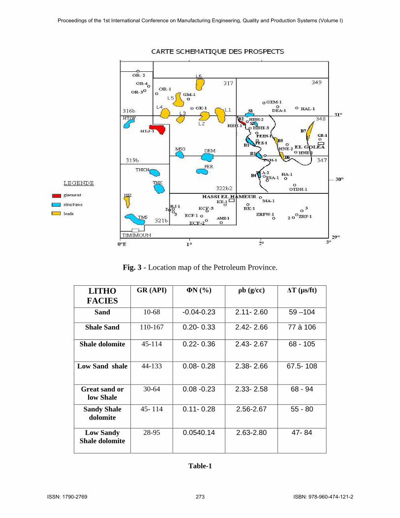
Fig. 3 - Location map of the Petroleum Province.
LITHO FACIES
GR (API) ΦN (%) ρb (g/cc) ∆T (µs/ft)
Sand 10-68 -0.04-0.23 2.11- 2.60 59 –104
Shale Sand 110-167 0.20- 0.33 2.42- 2.66 77 à 106
Shale dolomite 45-114 0.22- 0.36 2.43- 2.67 68 - 105
Low Sand shale 44-133 0.08- 0.28 2.38- 2.66 67.5- 108
Great sand or low Shale
30-64 0.08 -0.23 2.33- 2.58 68 - 94
Sandy Shale dolomite
45- 114 0.11- 0.28 2.56-2.67 55 - 80
Low Sandy Shale dolomite
28-95 0.0540.14 2.63-2.80 47- 84
Table-1
Proceedings of the 1st International Conference on Manufacturing Engineering, Quality and Production Systems (Volume I)
ISBN: 978-960-474-121-2ISSN: 1790-2769 273
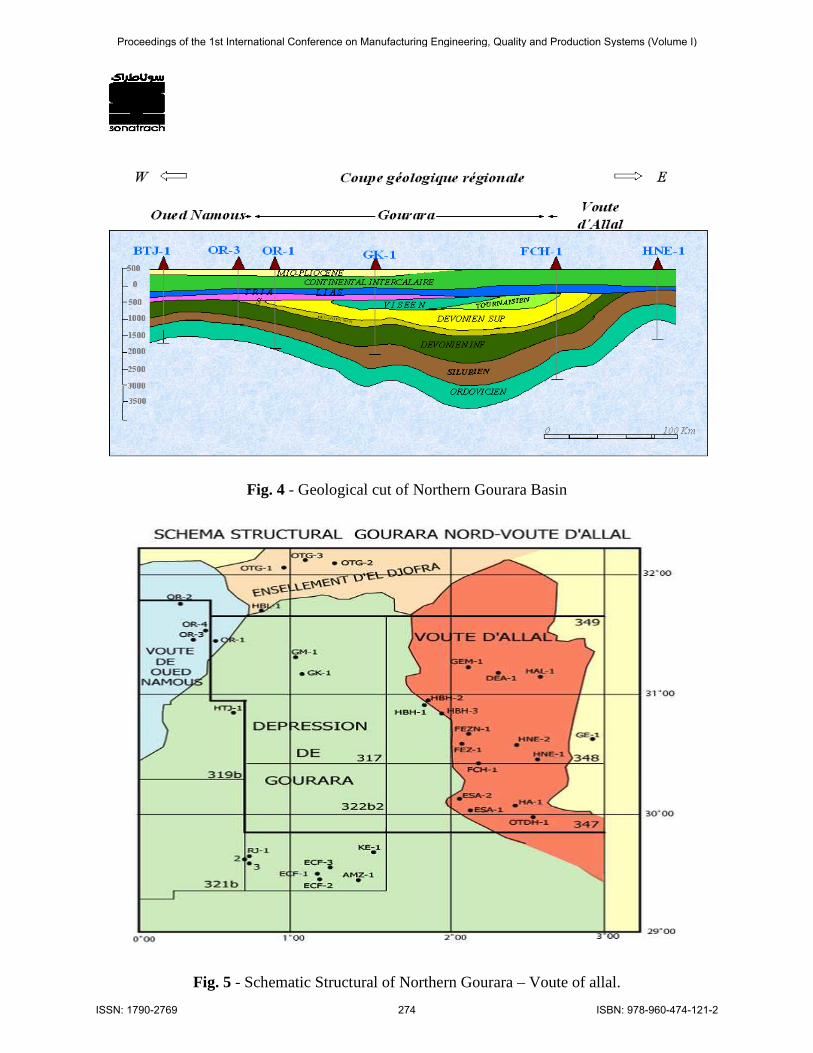
Fig. 4 - Geological cut of Northern Gourara Basin
Fig. 5 - Schematic Structural of Northern Gourara – Voute of allal.
Proceedings of the 1st International Conference on Manufacturing Engineering, Quality and Production Systems (Volume I)
ISBN: 978-960-474-121-2ISSN: 1790-2769 274
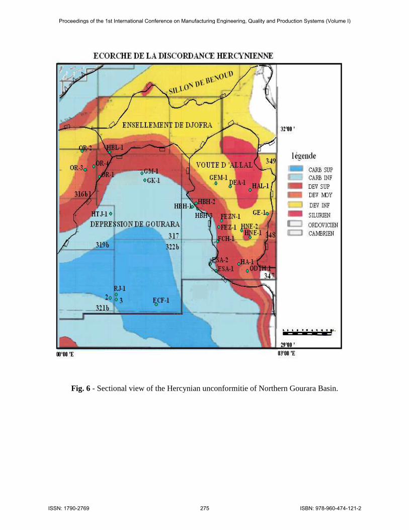
Fig. 6 - Sectional view of the Hercynian unconformitie of Northern Gourara Basin.
Proceedings of the 1st International Conference on Manufacturing Engineering, Quality and Production Systems (Volume I)
ISBN: 978-960-474-121-2ISSN: 1790-2769 275

Fig. 7 - Stratigraphic Column of Northern Gourara Basin.
Proceedings of the 1st International Conference on Manufacturing Engineering, Quality and Production Systems (Volume I)
ISBN: 978-960-474-121-2ISSN: 1790-2769 276
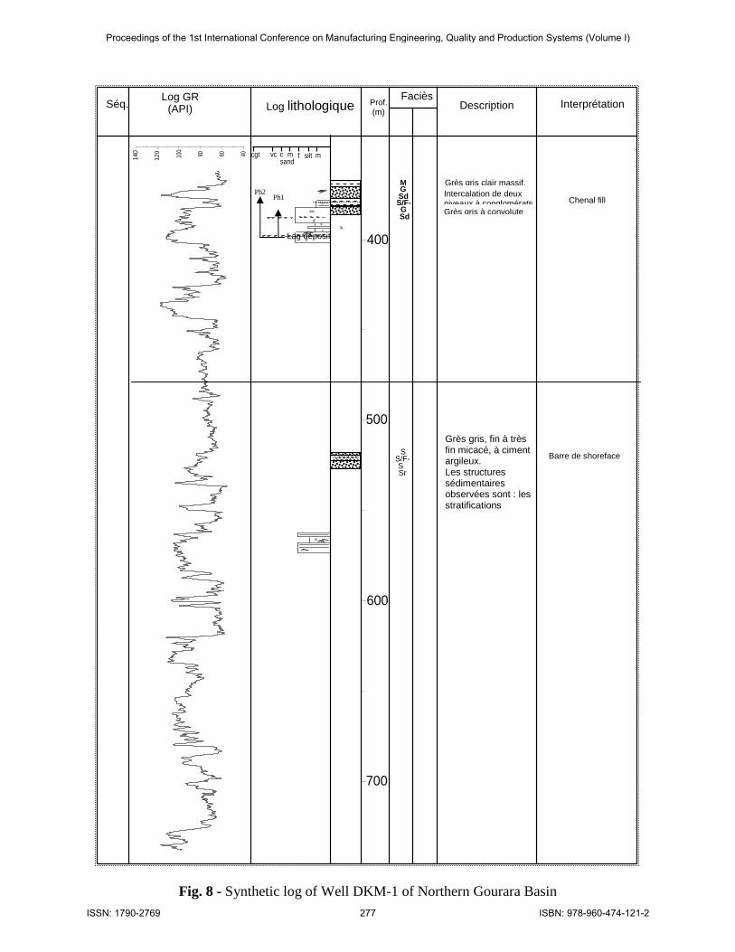
Fig. 8 - Synthetic log of Well DKM-1 of Northern Gourara Basin
406080100
120
140
500
600
700
400
SS
SS
FeSS
SSSS
Ms
^
msiltfmcvccgtsand
Log GR (API) Log lithologique Description Interprétation
Faciès Prof. (m)
Séq.
Grès gris, fin à très fin micacé, à ciment argileux. Les structures sédimentaires observées sont : les stratifications ondulées, les rides
Intercalation de deux niveaux à conglomérats.
Grès gris clair massif.
Grès gris à convolute
S/F-
SrS
S
Sdf
Gc
S/F-r
Gc Sdf
Ms
Lag déposit
Chenal fill
Barre de shoreface
Ph1 Ph2
Proceedings of the 1st International Conference on Manufacturing Engineering, Quality and Production Systems (Volume I)
ISBN: 978-960-474-121-2ISSN: 1790-2769 277
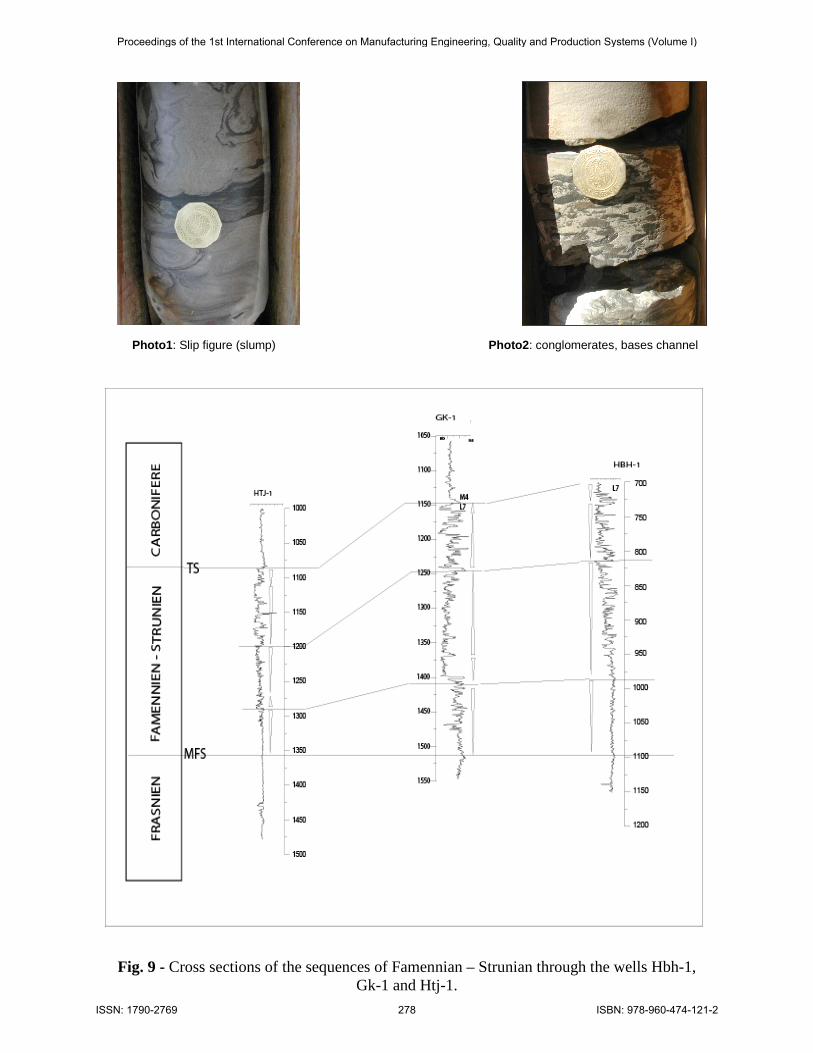
- Photo1: Slip figure (slump) Photo2: conglomerates, bases channel
Fig. 9 - Cross sections of the sequences of Famennian – Strunian through the wells Hbh-1, Gk-1 and Htj-1.
Proceedings of the 1st International Conference on Manufacturing Engineering, Quality and Production Systems (Volume I)
ISBN: 978-960-474-121-2ISSN: 1790-2769 278
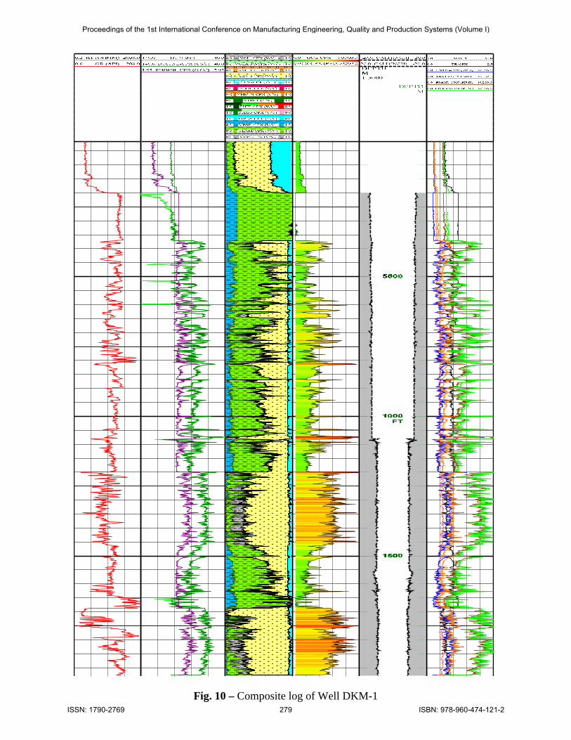
Fig. 10 – Composite log of Well DKM-1
Proceedings of the 1st International Conference on Manufacturing Engineering, Quality and Production Systems (Volume I)
ISBN: 978-960-474-121-2ISSN: 1790-2769 279