a remote sensing approach for mapping the development of
TRANSCRIPT

remote sensing
Article
A Remote Sensing Approach for Mapping theDevelopment of Ancient Water Management in theNear East
Louise Rayne 1 and Daniel Donoghue 2
1 School of Archaeology and Ancient History University of Leicester Leicester LE1 7RH UK2 Department of Geography Durham University Durham DH1 3LE UK dannydonoghuedurhamacuk Correspondence ler14leicesteracuk Tel +44-116-229-7370
Received 14 November 2018 Accepted 10 December 2018 Published 14 December 2018
Abstract We present a novel approach that uses remote sensing to record and reconstruct tracesof ancient water management throughout the whole region of Northern Mesopotamia an areawhere modern agriculture and warfare has had a severe impact on the survival of archaeologicalremains and their visibility in modern satellite imagery However analysis and interpretation ofdeclassified stereoscopic spy satellite data from the 1960s and early 1970s revealed traces of ancientwater management systems We processed satellite imagery to facilitate image interpretation and usedphotogrammetry to reconstruct hydraulic pathways Our results represent the first comprehensivemap of water management features across the entirety of Northern Mesopotamia for the period ca1200 BC to AD 1500 In particular this shows that irrigation was widespread throughout the regionin the Early Islamic period including within the zone traditionally regarded as ldquorain-fedrdquo Howeverwe found that a high proportion of the ancient canal systems had been damaged or destroyed by20th century changes to agricultural practices and land use Given this there is an urgent need torecord these rapidly vanishing water management systems that were an integral part of the ancientagricultural landscape and that underpinned powerful states
Keywords ancient water management archaeology CORONA imagery photogrammetry imageinterpretation Syria Iraq
1 Introduction
This research used satellite remote sensing to examine the spread scale and distribution of ancientwater management systems throughout Northern Mesopotamia an area of approximately 100000 km2
between the Euphrates and the Tigris rivers in northern Syria and Iraq (see Figure 1) Wilkinsonand Rayne [1] have hypothesised that powerful ancient empires transformed the environment usingirrigation systems and created ldquohydraulic landscapesrdquo structured around water management To testthis hypothesis we aimed to (1) measure the extent to which the density of water management featuresincreased at the time of the later territorial empires (from ca 1200 BC to AD 1500 Table 1) and (2)identify if there was a peak in any particular period
To achieve this comprehensive regional-scale evidence was needed best provided by satellitedata (Table 2) Many ancient irrigation systems can be large-scale features flowing over significantextents If we mapped these across their full reaches it was possible to understand how they functionedand how they were designed revealing information about past agricultural practices
Unfortunately recent conflict continues to limit access to Syria and Iraq and warfare-relateddamage to archaeology has been high-profile In addition ongoing intensification of modernagriculture and urbanisation have had a severe impact on the landscape and its archaeology This has
Remote Sens 2018 10 2042 doi103390rs10122042 wwwmdpicomjournalremotesensing
Remote Sens 2018 10 2042 2 of 21
particularly affected ancient irrigation systems which are usually collocated with modern agricultureThe construction of new irrigation systems and fields since the 1970s has caused older layouts to belevelled Large areas of land have been inundated by modern dams which removed some historiclarge canals that flowed alongside the Euphrates near Tell Fray and Dibsi Faraj (see References [12])The historical birdrsquos-eye view offered by declassified cold war (1960sndash1970s) satellite imagery enabledthe layout and function of these complex hydraulic features to be interpreted Contextualising thismapped evidence with the archaeological and historical evidence for dating and function allows thepolitical and economic implications of past water management to be understood
Remote Sens 2018 10 2042 2 of 21
has particularly affected ancient irrigation systems which are usually collocated with modern agriculture The construction of new irrigation systems and fields since the 1970s has caused older layouts to be levelled Large areas of land have been inundated by modern dams which removed some historic large canals that flowed alongside the Euphrates near Tell Fray and Dibsi Faraj (see References [12]) The historical birdrsquos-eye view offered by declassified cold war (1960sndash1970s) satellite imagery enabled the layout and function of these complex hydraulic features to be interpreted Contextualising this mapped evidence with the archaeological and historical evidence for dating and function allows the political and economic implications of past water management to be understood
Figure 1 Northern Mesopotamia and interpolated average rainfall isohyets (interpolated from gridded rain gauge data from GPCC (Global Precipitation Climatology Centre) see [3]) The terrain is derived from the SRTM DEM (Shuttle Radar Topography Mission Digital Elevation Model)
Table 1 Timeline of empires active in Northern Mesopotamia (after [4])
Dates Empire Era BC 1750
Bronze Age 1200 Middle Assyrian
1000 800 Neo-Assyrian
Iron Age 600 Babylonian Persian 400 Hellenistic Seleucid
Classical 200 Hellenistic Parthian 0
Roman Parthian 200 AD
400 Byzantine Late Antique
600 800
Early Islamic Medieval 1000
Figure 1 Northern Mesopotamia and interpolated average rainfall isohyets (interpolated from griddedrain gauge data from GPCC (Global Precipitation Climatology Centre) see [3]) The terrain is derivedfrom the SRTM DEM (Shuttle Radar Topography Mission Digital Elevation Model)
Table 1 Timeline of empires active in Northern Mesopotamia (after [4])
Dates Empire Era
BC 1750Bronze Age1200 Middle Assyrian
1000800 Neo-Assyrian Iron Age600 Babylonian Persian400 Hellenistic Seleucid
Classical200 Hellenistic Parthian
0Roman Parthian200 AD
400 Byzantine Late Antique600800 Early Islamic Medieval1000
The Assyrian empire was responsible for some of the first large-scale water features known inNorthern Mesopotamia in particular the Neo-Assyrians who were active in northern Iraq in around1600ndash1200 BC Neo-Assyrian deportation and resettlement programs brought previously marginalagricultural lands into cultivation [5] Their waterworks often consisting of large-scale canals andinscriptions decorated with state propaganda are well known (eg References [6ndash8])
Remote Sens 2018 10 2042 3 of 21
Table 2 Spaceborne data used in this study
Dataset Date Range SpatialResolution (m) Coverage Function
CORONA KH-4B 1967ndash1972 18ndash27 100 Image interpretation of now-destroyedlandscapes
Landsat 1985ndash2017 15ndash30 100To facilitate understanding of whereand when the pre-modern hydrauliclandscapes were destroyed
IKONOS 2000 08ndash3 3 tiles Image interpretation of some survivingfeatures
Google Earthimagery various
sensors1999ndash2018 ~03ndash3 100 Image interpretation of some surviving
features
SRTM DEM 2000 30ndash90 100 Hydraulic context of canal systems
CORONA DEMMissions 1105ndash1009 04-NOV-68 ~10 1 stereopair Morphology of selected canal features
The empires and states that followed (eg the Hellenistic Roman Umayyad and Abbasidstates) were also able to control large areas of the Northern Mesopotamian landscape supportingtheir economies with agriculture and trade Well-dated water management features of this periodare known including a canal in the Balikh [9] and rock-cut water conduits in the Jerablus area [210]Throughout the time of the later empires (from ca 2nd millennium BC) and especially by the EarlyIslamic period (ca 8th century AD) water management technology was widespread [1211] includingalongside the difficult-to-control Euphrates [12ndash14] as well as intensive cultivation in tributaries suchas the Balikh and the Habur [1111516] Increased uptake of water management technology at thistime may have been related to specific Early Islamic policies of bringing more land into cultivation [17](pp 181ndash182)
The environmental context in which irrigated agriculture was developed in NorthernMesopotamia is significant Rain-fed cultivation (roughly where rainfall is at least 200ndash250 mmon average per year see Reference [18]) is technically possible in the north meaning that irrigation isnot necessary for successful agriculture although precipitation is variable making reliance on it riskyNorthern Mesopotamia receives sufficient rainfall for the growth of vegetation in non-irrigated areasalthough the steppe is sparsely vegetated However irrigable areas with perennial water sources areas attractive to present-day cultivators as they were in the past so land cover in these zones tends tobe intensive arable cultivation of crops including wheat cotton and fruit [19] The rain-fed north is incontrast to southern Iraq which Wittfogel [20] used to illustrate his theory of ldquooriental despotismrdquoHe proposed that the development of irrigation in southern Iraq led to a need for bureaucracy whichin turn drove the development of the state [20] Ancient Mesopotamian irrigation was traditionallyviewed in the context of this theory and this much drier region where rain-fed cultivation wasnot possible Salinization as a result of irrigation may also have been a particular problem in thesouth [21]Throughout Mesopotamia soil has been degraded due to human activity [22] Principallyhowever the only soils really suitable for arable cultivation are the moisture-retaining alluvial rivervalleys [23]
Proxy evidence has indicated that there were increased trends toward aridity from around 2000BC in Syria [24] (p 1011) and that rainfall amounts may have been similar to todayrsquos throughoutthe time of the later territorial empires [25] (p 166) Increased dryness has been suggested for themedieval period in the eastern Mediterranean a symptom of the ldquoMedieval Climate Anomalyrdquo (MCA)and has been linked to historical economic processes [26] Some regions may have been as warm asthe 20th century at this time [27] (p 386) The results of our research correspond with this revealingextensive irrigation in the rain-fed zone during the time of the later territorial empires especially inthe medieval period
Remote Sens 2018 10 2042 4 of 21
Archaeological and historical research has identified traces of former canal systems in the rain-fedzone of northern Syria and Iraq Many of the studies have focused on specific features or have takena historical approach For example Dalley used Assyrian documents and art to understand watermanagement features in the Neo-Assyrian heartland around cities such as Nineveh and Nimrud [7](p 53) Kamash described historical and archaeological evidence of irrigation features throughout theregion with a focus on the Roman period [2829] In some cases single sections in individual canalswere excavated [12] providing chronological evidence although scientifically dated examples such asthese are still relatively scarce
Increasingly archaeologists are using remote sensing to record features relatively quickly andcheaply in the Near East including satellite imagery [30] and aerial photography [31] This often allowsexamination of areas where fieldwork is not possible due to conflict [30] A few studies have usedimage interpretation methods to study water management in the Near East Ur [8] and Altaweel [32]examined Neo-Assyrian canals in Northern Iraq Aerial photographs were examined for the Habur [33]and parts of the Balikh (Wilkinson personal communication 2010)
These reviews represent scattered studies A regional-scale and long-term view of the entirelandscape does not exist which makes it impossible to understand the development of water managementactivity throughout Northern Mesopotamia over time The present study addressed this gap generatinga map of ancient irrigation systems across northern Syria and Iraq and revealing particularly denseirrigation in the Balikh Valley of Syria The existing literature and detailed archaeological and historicalimplications of this research have been discussed in additional publications [1111516] This paperoutlines our methodology which used remote sensing to map the ancient landscape and presents thekey results
2 Materials and Methods
21 Satellite Imagery
A range of satellite image data were used to address our objectives (Table 2) The best method ofrecording water features across a huge region quickly and inexpensively was found to be systematicinterpretation of historical and (relatively) high spatial resolution satellite images (CORONA) The satelliteimages could then be understood by combining them with evidence from ground surveys excavationsand historical accounts However while fieldwork data provided important details such as datingmaterial the area that could be investigated was limited by time and budget constraints Water featuresespecially large-scale reticulated canal systems can extend for many kilometres Moreover they areoften complex features consisting of connected and branching channels performing different functions(abstraction transport irrigation drainage) They are usually represented by very faint and ephemeralearthworks and soil marks which are difficult to identify on the ground but which are clear linear featuresin satellite images and some elevation models
A retrogressive analysis of Landsat images (from 1985ndash2017) was used to understand the extent towhich the study area has changed Landsat images corrected to top of atmosphere (TOA) reflectancewere obtained using Google Earth Engine (GEE) by filtering the image catalogue by location date rangeand cloud cover (less than 10) Cloud masks were applied The median values of all pixels in thearea of interest over time-steps of two years were composited to make each mosaic (see SupplementaryMaterials for script and Gorelick et al [34] for explanation of GEE) The composites were visualised asfalse-colour composites using the near-infrared band as a way of highlighting vegetation (includingirrigated areas)
Modern high-resolution images were examined (eg via Google Earth) but most ancient irrigationfeatures had been destroyed by the time these images were produced To view Northern Mesopotamiabefore modern agriculture had changed it CORONA images were used Because the CORONAimagery is panchromatic spectral analysis was not possible using this data The remains of ancientirrigation systems are generally too small to be identified using freely available multispectral imagery
Remote Sens 2018 10 2042 5 of 21
such as Landsat The applicability of high-resolution multispectral satellite imagery (eg WorldViewIKONOS) was very limited because the archaeological remains of ancient canals had been mostlydestroyed by modern agriculture before this type of data became available
The CORONA project operated for United States (US) intelligence purposes and was the first satellitemission to take systematic pictures of the earthrsquos surface In 1995 the US government declassified anarchive of reconnaissance photography from over 100 separate low earth orbit missions from 1960 to 1972The camera systems on the CORONA programme evolved through time and since February 1962 theKH-4 KH-4A and KH-4B included modifications to the design to allow calibration and measurementsto be made from stereoscopic imagery
The ground resolution of CORONA imagery varied with each mission depending on thealtitude of the satellite and its orbit characteristics KH-4B imagery achieved a spatial resolutionof 2 m The wide frame of CORONA images combined with their relatively high spatial resolutionmakes them useful for identifying archaeological features Most importantly however they show aview of the landscape shortly before it was irreversibly changed by modern agriculture and urbanexpansion Given these properties they have been increasingly used to map archaeological remains(eg Reference [30])
We were able to obtain orthorectified CORONA KH-4B imagery for the entire study region ofnorthern Syria and Iraq through collaboration with the Fragile Crescent Project (FCP) [35] fromthe USGS and through the CORONA Atlas of the Middle East [36] We processed some imagesphotogrammetrically (outlined below in Section 22) This involved placing control points generatingtie points and performing triangulation using ERDAS LPS version 101
22 Hydraulic Context and Terrain Extraction
The design of any water management system is influenced by the existing topography Knowingthe steepness of canals and the gradient of the landscape through which they flow allows us toanalyse how they functioned and where they abstracted water from as well as to further confirm theirinterpretation as water features While in the past archaeologists have undertaken slow and laborioussurveys from the ground to obtain the measurements of short segments of canals as well as thetopography of the land remotely sensed elevation data offers faster ways to model much larger areasin 3D Given this we used the SRTM DEM to model the landscape of Northern Mesopotamia For afew selected areas in the Balikh Valley we used CORONA photogrammetry to model the morphologyof specific canals at higher resolution and as they were at the time the CORONA images were collectedThese canals have since been damaged or obliterated completely by modern agriculture
The SRTM DEM (collected in 2000) was created from interferometric radar data and has verticalaccuracy of approximately 9 m [37] with versions available in 90 m and 30 m spatial resolutions SRTMwas used extensively in this study to measure the hydraulic properties of ancient water managementfeatures despite its relatively coarse spatial resolution in the absence of freely available higherresolution DEMs
However 3D information extractable by photogrammetry from CORONA images is of particularvalue allowing high-resolution DEMs to be generated for case studies The satellite KH-4B wasequipped with two panoramic cameras in forward and aft positions on the satellite Although thesewere intended for manual stereoscopic interpretation we can now produce digital DEMs using theseldquostereopairsrdquo by calculating the degree of parallax between conjugate points in each image usingdedicated software (in this case the ERDAS photogrammetry toolbox) Of the CORONA satellitesKH-4B offers the best image quality and an overlap of 10 in the flight direction [38] In order todetermine the dimensions (x y z) of points in the two images making up a stereopair the relativeorientation of the camera needs to be established from specific parameters of camera rotation andbase line direction (exterior orientation) [39] as well as the ground coordinates of at least 3 points [40]In the case of CORONA images some of these parameters have to be calculated because they were notreleased as part of the declassification process along with the images (Table 3 lists known parameters)
Remote Sens 2018 10 2042 6 of 21
This information is needed to determine the geometric relationship between the ground the imageand the sensor
Table 3 KH-4B parameters [4142]
KH-4B Parameters
CORONA Mission 1105 04-NOV-68 KH-4BCamera type Panoramic
Film width (mm) 70Approximate frame format (cm) 554 times 7569
Focal length (cm) 607609Best approximate film resolution (Lmm) 160Best approximate ground resolution (m) 183Nominal system altitude (nautical miles) 81
Image scale 1247500Nominal ground coverage (km) 14 times 188
Archaeologists working in the Near East have found CORONA stereopairs to be of value forrecording the distinctive shape of Bronze Age Tell sites and settlements for example Galiatsatos et alrsquos [43]models of archaeological settlements Casana and Cothren [44] also used photogrammetry to reconstructseveral Tell sites Due to distortions across the panoramic frames they found that better results could beobtained by subsetting the frames into smaller areas [44]
Although many archaeological studies using historical imagery have relied on manual stereoscopyfor this project we focused on producing automatically extracted terrain models using photogrammetrysoftware Once a camera model and DEM extraction method were set up then these were appliedto subsets of multiple areas of interest The orientation of the camera was established fromparameters of rotation (exterior orientation) and interior orientation (eg focal length principalpoint) This information was used to perform collinearity which describes the relationship betweenthe ground and image coordinates and the camera [39]
In this case a stereopair dating to 4 November 1968 was used Three sample areas in the Balikhwere subsetted and processed using the software ERDAS LPS Version 101 While not all exterior andinterior orientation parameters were known a nonmetric camera model could be applied using theknown details of flying height focal length and scanned pixel size (see Table 3) Sufficient controlpoints were placed in order to mitigate against the lack of known orientation parameters and toestimate the exterior orientation parameters (coordinates of the principal point and the rotation angles)through the process of space resection Good ground control points for example differential GPSpoints were not available for this project due to the security situation in Syria In 2010 we were notpermitted to use GPS during fieldwork and were not able to return for future field seasons due to thewar that broke out in 2011 However DEMS could be generated from CORONA without field-basedground control as Galiatsatos et al demonstrated [43] Instead x and y coordinates were collectedfrom other sources including rectified CORONA images modern satellite imagery and Google Earthand z coordinates were obtained from SRTM DEM with as many as 87 control points obtainable inthis way for example for the DEM of the Nahr al Abbara system (Table 4)
Table 4 DEM production from CORONA stereopairs
Nahr al Abbara Canal System Tell Hammam et Turkman Sahlan-Hammam Canal
Subset size (km) 26 times 45 14 times 08 09 times 10Control points 87 40 24Auto-tie points 184 44 12
RMSE 26 115 13mX 53141 23103 55780mY 35408 23402 26244mZ 53759 43616 62376
Remote Sens 2018 10 2042 7 of 21
Triangulation was performed in 10 iterations using a bundle block adjustment with a least squaressolution applied to the tie points and orientation information The triangulation results of each pointwere examined in order to determine accuracy (Table 4) Control point values were calculated by thesoftware following the bundle block adjustment and calculation of estimated orientation parametersThe standard deviation of the control point residuals (the difference between the original points andthe calculated values) are listed in Table 4 (mX mY mZ) The root mean square error (RMSE) is a globalindicator of the quality of the DEM based on the image coordinate residuals (eg see Reference [43])
Some erroneous control and tie points were identified through this process and removedimproving the RMSE Overall these were considered to be within thresholds sufficient for thepurposes of our research Standard deviations were between 2 and 7 for the control points of allDEMs The highest error was in the vertical of the Sahlan-Hammam canal Low contrast for thispart of the stereopair made placing points difficult Values for individual control and tie points areset out in the Supplementary Materials A sum of squared differences (SSD) correlation algorithmwas applied to the subsetted CORONA stereopairs in order to measure parallax and extract DEMsThe SSD algorithm (Equation (1)) uses a moving window technique to examine every location in boththe images searching for correlation between the templates and the images DEMs with grid cell sizesof about 10 m were produced
sumx( f (X + Y)minus t(X))2 (1)
SSD (eg [45] (p 45)) f is the image and t is the search template
23 Interpretation Criteria
The study region measured approximately 100000 km2 In order to view and interpret CORONAimagery for this whole area efficiently it was divided into transects Features that could be recognisedas pre-1970s water management channels through interpretation of the CORONA imagery wererecorded based on selected criteria that we describe here (see Figure 2)
The trace (overall pathway) form (relative sinuosity) and embankment of canals varieddepending on their context Figure 2 shows pre-modern canals that were generally linear but notalways completely straight Some had prominent upcast banks as a result of their construction andmaintenance (Figure 2A) In some cases their gradient caused them to flow along a linear but sinuoustrace (Figure 2C) Scholars have debated whether hollow ways (ancient tracks) and canals can bedistinguished (eg Reference [46]) However in most cases ancient canals flowed downhill followingthe contours of the landscape while hollow ways did not need to conform to this (Figure 3) solandscape gradient derived from the SRTM DEM was used as a variable to assist interpretationKnown ancient irrigation systems consisting of reticulated canal networks tended to function bygravity flow Where gravity-fed irrigation was possible it is unlikely that the expense and difficulty ofwater lifting (eg pre-diesel pump) would have been preferred Other water features such as qanatsand tunnels were also recorded (eg Figure 2D) These are visible as a line of ldquodotsrdquo representingupcast soil surrounding maintenance and air shafts It could be difficult to distinguish betweengroundwater-collecting qanats and tunnels that transported water from perennial watercourses andsprings unless the abstraction point was clear
In order to understand how ancient irrigation systems functioned the different segments of asystem should be recorded As Figure 4 shows a reticulated canal system consisted of an abstractionpoint a main transportconveyor channel offtakes (irrigation laterals and field laterals) and drainsMany archaeological studies have recorded and examined the main channels of ancient canal systemsbut not much research has investigated all parts of the system including the laterals that deliveredwater into the fields We have found that in some cases these can be identified through an analysis ofimagery and DEMs The early Islamic Nahr al Abbara in the Balikh Valley north of Raqqa in Syria is agood example of a well-preserved reticulated layout as it was at the time of CORONA [1111516]which has been visited in the field [9]
Remote Sens 2018 10 2042 8 of 21Remote Sens 2018 10 2042 8 of 21
Figure 2 Examples of water management features that could be identified using CORONA (A) Straight trace and form prominent upcast banks (B) mostly straight trace and form low banks (C) straight trace meanderingsinuous form (D) qanat channels represented by series of shafts in a linear arrangement
Figure 3 Long profile graphs using SRTM elevation and CORONA images Hollow ways (A) did not need to conform to the gradient of the landscape while canals (B) flowed clearly downhill
Figure 2 Examples of water management features that could be identified using CORONA (A) Straighttrace and form prominent upcast banks (B) mostly straight trace and form low banks (C) straight tracemeanderingsinuous form (D) qanat channels represented by series of shafts in a linear arrangement
Remote Sens 2018 10 2042 8 of 21
Figure 2 Examples of water management features that could be identified using CORONA (A) Straight trace and form prominent upcast banks (B) mostly straight trace and form low banks (C) straight trace meanderingsinuous form (D) qanat channels represented by series of shafts in a linear arrangement
Figure 3 Long profile graphs using SRTM elevation and CORONA images Hollow ways (A) did not need to conform to the gradient of the landscape while canals (B) flowed clearly downhill
Figure 3 Long profile graphs using SRTM elevation and CORONA images Hollow ways (A) did notneed to conform to the gradient of the landscape while canals (B) flowed clearly downhill
Remote Sens 2018 10 2042 9 of 21
Remote Sens 2018 10 2042 9 of 21
Figure 4 Irrigation systems comprised a series of canals enabling abstraction transport of water and drainage Storage of water could also be incorporated into these systems
However in many cases only a main canal remained visible in the imagery Smaller distributaries do not usually leave traces This includes prominent canals alongside the Euphrates and in northern Iraq [1516] Even the abstraction point tends to be unclear although it can be projected based on the relative levels of the river and fields [1516] Often only the tunnel part of qanats and tunnel irrigation systems have survived without the lateral channels that delivered the water directly to the fields and crops
24 Archaeological Survey and Dating Evidence
Contextualising the evidence with data from archaeological surveys allowed us to link the water management features with dating material in order to understand their chronology for example the work done by Wilkinson to investigate the canals in the Balikh (eg Reference [9] and unpublished data) The significance of the dated canals was then examined further by reference to historical sources [47]
Fieldwork was undertaken at the outset of this project in 2010 in Syria We conducted walk-along surveys of selected irrigation features and of specific locations along others Canals in the Jerablus and Raqqa areas were visited and recorded with some new features identified [24849] Given the difficulty of undertaking further fieldwork in the Middle East at present data were sought from existing published and unpublished surveys and excavations These included Wilkinsonrsquos work in the Balikh [9] and Dibsi Faraj [12] surveys undertaken by Ur [8] and Altaweel [32] in northern
Figure 4 Irrigation systems comprised a series of canals enabling abstraction transport of water anddrainage Storage of water could also be incorporated into these systems
However in many cases only a main canal remained visible in the imagery Smaller distributariesdo not usually leave traces This includes prominent canals alongside the Euphrates and in northernIraq [1516] Even the abstraction point tends to be unclear although it can be projected based on therelative levels of the river and fields [15] Often only the tunnel part of qanats and tunnel irrigationsystems have survived without the lateral channels that delivered the water directly to the fieldsand crops
24 Archaeological Survey and Dating Evidence
Contextualising the evidence with data from archaeological surveys allowed us to link the watermanagement features with dating material in order to understand their chronology for example thework done by Wilkinson to investigate the canals in the Balikh (eg Reference [9] and unpublished data)The significance of the dated canals was then examined further by reference to historical sources [47]
Fieldwork was undertaken at the outset of this project in 2010 in Syria We conducted walk-alongsurveys of selected irrigation features and of specific locations along others Canals in the Jerablusand Raqqa areas were visited and recorded with some new features identified [24849] Given thedifficulty of undertaking further fieldwork in the Middle East at present data were sought fromexisting published and unpublished surveys and excavations These included Wilkinsonrsquos work in theBalikh [9] and Dibsi Faraj [12] surveys undertaken by Ur [8] and Altaweel [32] in northern Iraq andothers throughout Northern Mesopotamia (see References [1516] for more detailed literature reviews)
In a few cases excavation of sections across canal beds had provided organic material from withinthe fill of canals allowing the dates of their construction and use to be obtained Remains from a
Remote Sens 2018 10 2042 10 of 21
section of the Sahlan-Hammam canal excavated by Wilkinson gave an uncalibrated date of 1380 + 70BP (Beta-78543) which is around 570 AD [9] (p 71) placing it within the period of the later empiresSimilarly an Early Islamic date was obtained through excavation of a prominent canal on a terrace ofthe Euphrates which was associated with the Early Islamic site of Dibsi Faraj [12]
At some locations surface surveys alongside the remains of ancient canals yielded datinginformation The Nahr al Abbara in the Balikh was dated to the Early Islamic period in this way [9]Other canals such as the system in the southwest of the Balikh Valley could be more tentatively datedby association with known Islamic features north of Raqqa [15] The features that could be dated tothe period of the later empires through excavation survey or historical evidence and by associationwere plotted on a map (Figure 5)
Remote Sens 2018 10 2042 10 of 21
Iraq and others throughout Northern Mesopotamia (see References [1516] for more detailed literature reviews)
In a few cases excavation of sections across canal beds had provided organic material from within the fill of canals allowing the dates of their construction and use to be obtained Remains from a section of the Sahlan-Hammam canal excavated by Wilkinson gave an uncalibrated date of 1380 + 70 BP (Beta-78543) which is around 570 AD [9] (p 71) placing it within the period of the later empires Similarly an Early Islamic date was obtained through excavation of a prominent canal on a terrace of the Euphrates which was associated with the Early Islamic site of Dibsi Faraj [12]
At some locations surface surveys alongside the remains of ancient canals yielded dating information The Nahr al Abbara in the Balikh was dated to the Early Islamic period in this way [9] Other canals such as the system in the southwest of the Balikh Valley could be more tentatively dated by association with known Islamic features north of Raqqa [15] The features that could be dated to the period of the later empires through excavation survey or historical evidence and by association were plotted on a map (Figure 5)
Figure 5 Ancient water management featuressystems throughout northern Mesopotamia [1281115165051] Although the zone represented by the 200ndash300 mm isohyets technically could support rain-fed agriculture precipitation was highly variable
3 Results
Figure 5 shows the results of applying our methodology to an area of over 100000 km2 A comprehensive map of irrigation at the time of the later empires did not exist prior to this study The image interpretation exercise using CORONA proved to be the only practical way of mapping ancient water management across the entirety of Northern Mesopotamia and revealed over 2900 km of canals and qanats Canals already known in archaeological and historical sources were located for example the Nahr Maslama at Dibsi Faraj [12] and mapped using the CORONA in order to place them within their wider regional context The present study also identified previously unknown features such as a tunnel at Raqqa [15] (Figure 6) By utilising elevation data (SRTM and CORONA DEMs) as well as archaeological and historical records the context of this map of water management could be recognised The combined image elevation and archaeological data allowed distinct irrigation systems with chronological associations to be understood (Table 5) separating these out from channels or linear features of unknown date and context
Figure 5 Ancient water management featuressystems throughout northern Mesopotamia [1281115165051] Although the zone represented by the 200ndash300 mm isohyets technically could supportrain-fed agriculture precipitation was highly variable
3 Results
Figure 5 shows the results of applying our methodology to an area of over 100000 km2A comprehensive map of irrigation at the time of the later empires did not exist prior to this studyThe image interpretation exercise using CORONA proved to be the only practical way of mappingancient water management across the entirety of Northern Mesopotamia and revealed over 2900 kmof canals and qanats Canals already known in archaeological and historical sources were locatedfor example the Nahr Maslama at Dibsi Faraj [12] and mapped using the CORONA in order to placethem within their wider regional context The present study also identified previously unknownfeatures such as a tunnel at Raqqa [1516] By utilising elevation data (SRTM and CORONA DEMs)as well as archaeological and historical records the context of this map of water management couldbe recognised The combined image elevation and archaeological data allowed distinct irrigationsystems with chronological associations to be understood (Table 5) separating these out from channelsor linear features of unknown date and context
Although anthropogenic processes natural erosion and deposition activity of the river haveremoved much of this water management evidence the surviving traces show that canals wereconstructed alongside the Euphrates from at least Dibsi Faraj down to Mari and in the northern reachesof the Tigris and its tributaries Irrigation was also recorded by the tributaries of the Euphrates the SajurHabur and particularly the Balikh Qanats extended the range of cultivable lands in Syria and Iraq
Remote Sens 2018 10 2042 11 of 21
Table 5 Water management systems recorded by this study using satellite data
Chronological Period Water Management Systems Key References
Pre-1st millennium BCCanal at Tell Fray [52]Some canals alongside the Euphrates between Balikh and Mari [14]
1st millennium BCCanals in northern Iraq [6ndash832]Canal at Carchemish [1648]Origin of canals alongside Habur [3353]
Hellenisticndashlate RomanCanal and rock-cut conduits in Jerablus area [1648]Sahlan-Hamman canal and Qara Mokh canals in Balikh [911]Qanats south of Membij [151654]
Early Islamic (8thndash15thcenturies AD)
Large embanked canal between Tell Fray and Qalat Jabar [16]
Large embanked canal at Dibsi Faraj and qanat [112]Canals in Balikh Valley north of Raqqa [11516]Canals in Balikh Valley west of Raqqa [111516]
Qanats a tunnel and canals around Raqqa [111516]
Canals alongside the Habur [53]
Nahr Dawrin Nahr Sarsquoid Large embanked canals on both banks ofthe Euphrates between the Balikh and Mari [13ndash16]
Some of the large embanked canals in northern Iraq Tarbisu canaland Nahr Qanausa [832]
Qanats on the Sinjar Plain [1516]
We mapped pre-Islamic water management features in Northern Mesopotamia including rock-cutconduits near Jerablus (investigated during fieldwork see References [1648]) and Hellenistic qanatsaround Membij (dated by a historical source see Reference [54]) Although some of the tracesof large embanked channels alongside the Euphrates have been attributed to the pre-Islamic era(eg Reference [14]) it can be argued the technology capable of facilitating this may not have beenwidely applied until the medieval period [55] (p 115) Tributaries such as the Balikh and the Haburwere easier to irrigate from attested by a likely Assyrian origin for canals alongside the Habur [33] andsome Hellenisticndashlate Roman canals in the Balikh dated through excavation radiocarbon dating surfacesurvey and association with dated sites (eg the Sahlan-Hammam canal Figure 6 References [911])The Neo-Assyrian canals in northern Iraq are already well-known although it is important to note someof the canals in northern Iraq have been attributed to the Early Islamic period (see References [832])
Early Islamic canals were constructed and maintained alongside the Euphrates for example thelarge embanked canals of the Nahr Maslama Nahr Dawrin and Nahr Sarsquoid which are referred to inIslamic texts (see Reference [1516]) The canals alongside the Habur may also have been used into theEarly Islamic period and a possible connection to the Nahr Dawrin has been proposed [151656]
Especially in the Balikh the analysis of systems that were reasonably preserved at the time of theCORONA images showed a high degree of sophistication and represented hydrological knowledgebefore the modern era (see Figures 7 and 8) The Nahr Al Abbara dated through surface survey [9]abstracted water to the north near Tell Sahlan which it transported in a main canal for over 15 km (seeFigures 7 and 8) Traces of an earlier phase of canal on the same alignment could be identified in placesusing the CORONA imagery (see [2] Figure 6 38) Water was delivered to fields via laterals branchingoff the main channel at fairly regular intervals During a surface survey Wilkinson [9] (p 68) recordedlarge stone blocks that may have functioned as part of sluice structures As the SRTM DEM confirmedthe overall gradient of the landscape of the Balikh is very flat but the Nahr Al Abbara system mitigatedagainst it by running the main canal at a low gradient (approximately 01) along a slight and somewhatnarrow ridge (see [11] Figure 6) The CORONA DEM (Figure 9) allowed this to be visualised at higherresolution The main canal could flow for a greater distance but at the same time the offtakes could attaina slightly steeper gradient (approximately 05) The system also incorporated drainage provision intothe Balikh and into the fairly wide basin of a seasonal runoff stream to the east the Wadi al Keder andmay have been associated with a complex layout of spring water channels and drainage systems (see [11]Figures 7 and 8) There are several Early Islamic settlements nearby including Medinet al Farr and
Remote Sens 2018 10 2042 12 of 21
Khirbet Ambar which are known through historical sources and archaeological investigations [5758]It is likely that these sites were involved in the administration of irrigation in the area
Remote Sens 2018 10 2042 11 of 21
Figure 6 The eroded and infilled remains of the Sahlan-Hammam canal in the 1990s when Tony Wilkinson visited Tony provides scale
Table 5 Water management systems recorded by this study using satellite data
Chronological Period Water Management Systems Key References
Pre-1st millennium BC Canal at Tell Fray [52] Some canals alongside the Euphrates between Balikh and Mari [14]
1st millennium BC Canals in northern Iraq [6ndash832] Canal at Carchemish [1648] Origin of canals alongside Habur [3353]
Hellenisticndashlate Roman Canal and rock-cut conduits in Jerablus area [1648] Sahlan-Hamman canal and Qara Mokh canals in Balikh [911] Qanats south of Membij [151654]
Early Islamic (8thndash15th centuries AD)
Large embanked canal between Tell Fray and Qalat Jabar [16] Large embanked canal at Dibsi Faraj and qanat [112] Canals in Balikh Valley north of Raqqa [115] Canals in Balikh Valley west of Raqqa [1115] Qanats a tunnel and canals around Raqqa [1115] Canals alongside the Habur [53] Nahr Dawrin Nahr Sarsquoid Large embanked canals on both banks of the Euphrates between the Balikh and Mari
[131416]
Some of the large embanked canals in northern Iraq Tarbisu canal and Nahr Qanausa
[832]
Qanats on the Sinjar Plain [1516]
Although anthropogenic processes natural erosion and deposition activity of the river have removed much of this water management evidence the surviving traces show that canals were constructed alongside the Euphrates from at least Dibsi Faraj down to Mari and in the northern reaches of the Tigris and its tributaries Irrigation was also recorded by the tributaries of the Euphrates the Sajur Habur and particularly the Balikh Qanats extended the range of cultivable lands in Syria and Iraq
We mapped pre-Islamic water management features in Northern Mesopotamia including rock-cut conduits near Jerablus (investigated during fieldwork see References [1648]) and Hellenistic qanats around Membij (dated by a historical source see Reference [54]) Although some of the traces of large embanked channels alongside the Euphrates have been attributed to the pre-Islamic era (eg Reference [14]) it can be argued the technology capable of facilitating this may not have been widely applied until the medieval period [55] (p 115) Tributaries such as the Balikh and the Habur were
Figure 6 The eroded and infilled remains of the Sahlan-Hammam canal in the 1990s when TonyWilkinson visited Tony provides scaleRemote Sens 2018 10 2042 13 of 21
Figure 7 Irrigation systems in the Balikh Valley
Figure 8 The channel of the Nahr al Abbara canal system is marked with arrows (1968 CORONA image)
Figure 7 Irrigation systems in the Balikh Valley
Remote Sens 2018 10 2042 13 of 21
An extensive set of canals in the southwest horseshoe of the Balikh Valley may also be EarlyIslamic based on a connection with known sites (Figure 10A see Reference [11]) Most significantlyin the south the CORONA images showed several water management features associated with theEarly Islamic city of Raqqa which was particularly prominent as a capital city during the Abbasid erawith palaces and an industrial area The city itself and its immediate hinterland appears to have beenwatered by qanats with a northern palace complex supplied by a tunnel stemming from the QaraMokh stream as well as the Balikh [111516]
Overall historical sources present a picture of intensive irrigated cultivation in NorthernMesopotamia in the Early Islamic period [47] Even away from the main perennial water sourcesqanats extended the cultivable area The CORONA images revealed an area of dense qanat irrigationradiating from the town of Sinjar in Iraq which may be medieval in date [59] (discussed in more detailin Reference [16])
Remote Sens 2018 10 2042 13 of 21
Figure 7 Irrigation systems in the Balikh Valley
Figure 8 The channel of the Nahr al Abbara canal system is marked with arrows (1968 CORONA image) Figure 8 The channel of the Nahr al Abbara canal system is marked with arrows (1968 CORONA image)Remote Sens 2018 10 2042 14 of 21
Figure 9 10 m spatial resolution DEM constructed using a CORONA stereopair
Figure 10 (A) Relict canals in the southwest Balikh Valley in 1968 which were (B) destroyed and replaced with a new irrigation system in 1972 (CORONA images)
4 Discussion
This research revealed an intensification of irrigation in most of the cultivable areas of Early Islamic Northern Mesopotamia particularly in the Balikh Valley The transformation of the environment that we observed fits the concept of ldquohydraulic landscapesrdquo Historical accounts and archaeological excavations have indicated that Raqqa was temporarily the centre of the Abbasid empire and a significant industrial town (eg see Reference [60]) which may offer an explanation for the intensification of water management features at this time In addition medieval irrigation in the Balikh may have been a response to deliberate policies of bringing marginal land into cultivation [17] policies that explain the increased application of water management technology throughout Northern Mesopotamia in the Early Islamic period This is an area where irrigation was not necessary but where employing it would have increased the reliability and quantity of agricultural yields developing and supporting powerful and demanding imperial economies Many existing hydraulic landscapes were maintained and developed while new ones were created in response to incentives
This intensive use of the landscape must have declined because until the later 20th century cultivation in Northern Mesopotamia was largely reported to be reliant on rainfall [61] (p 137) This transition followed the Early Islamic period By the 15th century the ancient water systems of Mesopotamia were falling into disrepair possibly due to plague and the depredations of the Mongols with subsequent depopulation and upheaval (eg see References [151662]) In many areas agriculture did not seem to have intensified again until the 2nd half of the 20th century
Figure 9 10 m spatial resolution DEM constructed using a CORONA stereopair
Remote Sens 2018 10 2042 14 of 21
4 Discussion
This research revealed an intensification of irrigation in most of the cultivable areas of Early IslamicNorthern Mesopotamia particularly in the Balikh Valley The transformation of the environment thatwe observed fits the concept of ldquohydraulic landscapesrdquo Historical accounts and archaeologicalexcavations have indicated that Raqqa was temporarily the centre of the Abbasid empire anda significant industrial town (eg see Reference [60]) which may offer an explanation for theintensification of water management features at this time In addition medieval irrigation in theBalikh may have been a response to deliberate policies of bringing marginal land into cultivation [17]policies that explain the increased application of water management technology throughout NorthernMesopotamia in the Early Islamic period This is an area where irrigation was not necessary but whereemploying it would have increased the reliability and quantity of agricultural yields developing andsupporting powerful and demanding imperial economies Many existing hydraulic landscapes weremaintained and developed while new ones were created in response to incentives
This intensive use of the landscape must have declined because until the later 20th centurycultivation in Northern Mesopotamia was largely reported to be reliant on rainfall [61] (p 137)This transition followed the Early Islamic period By the 15th century the ancient water systems ofMesopotamia were falling into disrepair possibly due to plague and the depredations of the Mongolswith subsequent depopulation and upheaval (eg see References [151662]) In many areas agriculturedid not seem to have intensified again until the 2nd half of the 20th century although traces of theancient irrigation systems remained embedded in the landscape until very recently (see travellersrsquoaccounts of abandoned canals eg [6364])
More recently however modern agricultural strategies in the Middle East have completelytransformed the landscape replacing ancient man-made hydraulic pathways with large-scale damsand canal systems and pumping from individual wells Many ancient irrigation systems have beenabandoned and destroyed to make way for new irrigation schemes A remote sensing methodologyusing interpretation from CORONA images dating from the period 1967ndash1972 proved to be a veryeffective strategy for recording ancient water management and for mapping its spread and distribution
When CORONA images (1968 and 1972) were compared (Figure 10) the initial construction ofthe modern field and irrigation systems in the 1970s Balikh is apparent This highlights the timelinessof the 1960s images which represent the last record of most of the ancient canal systems presented inFigures 5 and 7
Remote Sens 2018 10 2042 14 of 21
Figure 9 10 m spatial resolution DEM constructed using a CORONA stereopair
Figure 10 (A) Relict canals in the southwest Balikh Valley in 1968 which were (B) destroyed and replaced with a new irrigation system in 1972 (CORONA images)
4 Discussion
This research revealed an intensification of irrigation in most of the cultivable areas of Early Islamic Northern Mesopotamia particularly in the Balikh Valley The transformation of the environment that we observed fits the concept of ldquohydraulic landscapesrdquo Historical accounts and archaeological excavations have indicated that Raqqa was temporarily the centre of the Abbasid empire and a significant industrial town (eg see Reference [60]) which may offer an explanation for the intensification of water management features at this time In addition medieval irrigation in the Balikh may have been a response to deliberate policies of bringing marginal land into cultivation [17] policies that explain the increased application of water management technology throughout Northern Mesopotamia in the Early Islamic period This is an area where irrigation was not necessary but where employing it would have increased the reliability and quantity of agricultural yields developing and supporting powerful and demanding imperial economies Many existing hydraulic landscapes were maintained and developed while new ones were created in response to incentives
This intensive use of the landscape must have declined because until the later 20th century cultivation in Northern Mesopotamia was largely reported to be reliant on rainfall [61] (p 137) This transition followed the Early Islamic period By the 15th century the ancient water systems of Mesopotamia were falling into disrepair possibly due to plague and the depredations of the Mongols with subsequent depopulation and upheaval (eg see References [151662]) In many areas agriculture did not seem to have intensified again until the 2nd half of the 20th century
Figure 10 (A) Relict canals in the southwest Balikh Valley in 1968 which were (B) destroyed andreplaced with a new irrigation system in 1972 (CORONA images)
Remote Sens 2018 10 2042 15 of 21
While modern imagery such as IKONOS has been available for the study area since about 2000(Table 1) these images postdate major land use change that led to the destruction of most of the ancientcanals and therefore CORONA images are the only way of recording now-destroyed canal systemsFigure 11 shows how changes around the city of Raqqa between the 1960s and 2000s meant thatmuch of Early Islamic Raqqa and its environs (visible in the CORONA Figure 11A) had already beendestroyed by the time the IKONOS image (Figure 11B) was collected
Remote Sens 2018 10 2042 15 of 21
although traces of the ancient irrigation systems remained embedded in the landscape until very recently (see travellersrsquo accounts of abandoned canals eg [6364])
More recently however modern agricultural strategies in the Middle East have completely transformed the landscape replacing ancient man-made hydraulic pathways with large-scale dams and canal systems and pumping from individual wells Many ancient irrigation systems have been abandoned and destroyed to make way for new irrigation schemes A remote sensing methodology using interpretation from CORONA images dating from the period 1967ndash1972 proved to be a very effective strategy for recording ancient water management and for mapping its spread and distribution
When CORONA images (1968 and 1972) were compared (Figure 10) the initial construction of the modern field and irrigation systems in the 1970s Balikh is apparent This highlights the timeliness of the 1960s images which represent the last record of most of the ancient canal systems presented in Figures 5 and 7
While modern imagery such as IKONOS has been available for the study area since about 2000 (Table 1) these images postdate major land use change that led to the destruction of most of the ancient canals and therefore CORONA images are the only way of recording now-destroyed canal systems Figure 11 shows how changes around the city of Raqqa between the 1960s and 2000s meant that much of Early Islamic Raqqa and its environs (visible in the CORONA Figure 11A) had already been destroyed by the time the IKONOS image (Figure 11B) was collected
Figure 11 (A) CORONA image (May 1968) showing Early Islamic features of Raqqa including the 8th century AD walled city palace structures to the north of this and canals (B) IKONOS image (27 March 2000) showing that most of the medieval features were destroyed by modern buildings fields and roads
The Landsat sequence shows the intensification of agriculture underway from the 1980s (Figures 12 and 13) In Syria this was part of a programme involving construction of the Tabqa dam in 1966 30 km upstream of Raqqa [61] Figure 13 highlights the Balikh where we identified many ancient canal networks that corresponded neatly to the areas of modern irrigated agriculture highlighted by using a false colour visualisation By the 21st century modern agriculture had expanded throughout the valley including new fields and irrigation networks in the south the area known as the ldquohorseshoerdquo where several ancient canals supplied Early Islamic palaces and urban areas around Raqqa Recent disruption to irrigation infrastructure has been reported in the region due to the current conflict in Syria [1965] which is demonstrated by a slight reduction in the vegetated area between the 2010ndash2011 and 2016ndash2017 Landsat composites
Figure 11 (A) CORONA image (May 1968) showing Early Islamic features of Raqqa including the8th century AD walled city palace structures to the north of this and canals (B) IKONOS image(27 March 2000) showing that most of the medieval features were destroyed by modern buildingsfields and roads
The Landsat sequence shows the intensification of agriculture underway from the 1980s(Figures 12 and 13) In Syria this was part of a programme involving construction of the Tabqadam in 1966 30 km upstream of Raqqa [61] Figure 13 highlights the Balikh where we identifiedmany ancient canal networks that corresponded neatly to the areas of modern irrigated agriculturehighlighted by using a false colour visualisation By the 21st century modern agriculture had expandedthroughout the valley including new fields and irrigation networks in the south the area known asthe ldquohorseshoerdquo where several ancient canals supplied Early Islamic palaces and urban areas aroundRaqqa Recent disruption to irrigation infrastructure has been reported in the region due to the currentconflict in Syria [1965] which is demonstrated by a slight reduction in the vegetated area between the2010ndash2011 and 2016ndash2017 Landsat composites
Figure 12 shows a Landsat false colour composite of a large part of the Euphrates river in Syria in1985 and 1986 and again in 2016 and 2017 with Lake Assad in the top left and the Balikh and Haburtributaries joining from the north Figure 13 zooms in on the Syrian Balikh The red colours in theLandsat images seen in Figures 12 and 13 show the distribution of modern productive agriculturalland where changes shown in both figures reflect the intensification of agriculture the effect of whichhas been to remove traces of ancient water features The Landsat images emphasise the particularimportance of the Balikh which represents a large area of agricultural production within the wholeEuphrates valley The TurkeyndashSyria border can be clearly seen in the imagery (Figure 12) becauseof the contrast in water available for irrigation this serves as a reminder of the importance of thegeopolitics of water resources in the region from ancient times right up to the present day
Remote Sens 2018 10 2042 16 of 21Remote Sens 2018 10 2042 16 of 21
Figure 12 False colour Landsat composites showing the intensification of agriculture in Northern Mesopotamia over the past 40 years (A) Landsat 5 composite 1985ndash1986 (B) Landsat 8 composite 2016ndash2017 Images downloaded and mosaicked using Google Earth Engine
Figure 13 Landsat composites showing the expansion of modern irrigation in the Balikh (A) Landsat 5 1985ndash1986 (B) Landsat 7 2010ndash2011 (C) Landsat 8 2016ndash2017 Images downloaded and mosaicked using Google Earth Engine and visualised as false colour composites
Figure 12 False colour Landsat composites showing the intensification of agriculture in NorthernMesopotamia over the past 40 years (A) Landsat 5 composite 1985ndash1986 (B) Landsat 8 composite2016ndash2017 Images downloaded and mosaicked using Google Earth Engine
Remote Sens 2018 10 2042 16 of 21
Figure 12 False colour Landsat composites showing the intensification of agriculture in Northern Mesopotamia over the past 40 years (A) Landsat 5 composite 1985ndash1986 (B) Landsat 8 composite 2016ndash2017 Images downloaded and mosaicked using Google Earth Engine
Figure 13 Landsat composites showing the expansion of modern irrigation in the Balikh (A) Landsat 5 1985ndash1986 (B) Landsat 7 2010ndash2011 (C) Landsat 8 2016ndash2017 Images downloaded and mosaicked using Google Earth Engine and visualised as false colour composites
Figure 13 Landsat composites showing the expansion of modern irrigation in the Balikh (A) Landsat5 1985ndash1986 (B) Landsat 7 2010ndash2011 (C) Landsat 8 2016ndash2017 Images downloaded and mosaickedusing Google Earth Engine and visualised as false colour composites
There are some caveats to a methodology that relies principally on image interpretation Whetheror not water management features can be identified depends on a number of factors including imagequality and timing and natural conditions We identified rock-cut conduits and tunnels alongside
Remote Sens 2018 10 2042 17 of 21
dry streams in the Jerablus region during a survey in 2010 [48] that were not visible in the CORONA(1967 and 1972) and modern imagery There may well be other ancient irrigation features throughoutnorthern Syria and Iraq that have not yet been identified However many of the features we identifiedin the CORONA images were no longer visible on the ground having been destroyed to make way formodern agriculture This included the Nahr al Abbara canal system in the Balikh
Working with CORONA was difficult due to the panoramic and historical nature of the dataThe panoramic frames were distorted (eg see Reference [41] (p 228) Reference [66]) especiallytoward the edges and some image acquisition parameters were not available making constructing anaccurate camera model challenging The quality and time of collection of different images was variableSome higher resolution modern imagery was examined for example IKONOS imagery covering thearea around Raqqa in the southern Balikh However it was found that recent landscape changes haddestroyed much of the archaeology (see Figure 11) The CORONA data were often of the best timeperiod consistency of image quality (spatial and radiometric) and availability for large area coveragemaking it ideal for recording ancient water management features In fact we were able to obtainCORONA imagery for our entire 100000 km2 study area
5 Conclusions
Declassified CORONA satellite images from the 1960s and early 1970s are used to identify andreconstruct ancient hydraulic landscapes over large geographic areas The CORONA KH-4B camerahas stereoscopic capability which helps to identify and interpret water management features When theCORONA images were analysed in conjunction with modern satellite imagery DEMs and contextualinformation from archaeological and historical surveys the trajectory of the development of irrigationtechnology becomes clear
This study mapped water management features from the period ca 1200 BC to AD 1500 acrossthe entirety of Northern Mesopotamia for the first time (Figure 5) Irrigation increased in densitythroughout the region including within the zone traditionally regarded as ldquorain-fedrdquo and revealeda peak in the Early Islamic era Environmental considerations for understanding why and whereirrigation was undertaken during the period of the later empires also helped us to contextualise theresults An average rainfall of 200ndash250 mm a year is often interpreted as the limit of rain-fed cultivationfor modern and ancient agriculture (eg see References [186768]) and depicted as an isohyet lineHowever an analysis of modern rain gauge data indicates that much of the area encompassed byancient irrigation (receiving approximately 100ndash400 mm per year) experiences high variability today(20ndash40 see Reference [2] (p 158)) which makes irrigation necessary to mitigate against irregularrainfall [65] (p 5) If rainfall was similarly variable during the period of the later empires (eg atthe time of the MCA) our data suggests that they were investing in large-scale irrigation in a regionwhere rain-fed cultivation was technically possible but where it was risky due to the variability ofprecipitation Unlike in Southern Mesopotamia irrigation was not absolutely necessary for agriculturein Northern Mesopotamia but the construction of water management features was a way to ensureaccess to water in order to mitigate against disruptions to food supply
It is unlikely to be a coincidence that irrigation activity was intensified during the era of the firsttrue territorial empires when these powerful entities exerted and contested political control over thelandscape It is apparent that from the Neo-Assyrian period and by the Early Islamic period most ofthe perennial water courses in Northern Mesopotamia were used as sources of irrigation water andthat available groundwater was utilised The water management systems that we recorded includedmany reticulated and sophisticated systems that supported powerful states represented by traces ofprominent channels alongside the main rivers dense networks of irrigation in the tributaries andsignificant groundwater exploitation using qanats Many canals and parts of canal systems wouldhave been missed if examined through fieldwork alone Through interpretation of satellite imagesthis study was able to locate and map some previously unknown or understudied systems suchas numerous qanats in the Sinjar Plain of Iraq [1516] the qanat at Dibsi Faraj in Syria [1] and the
Remote Sens 2018 10 2042 18 of 21
real complexity of irrigation in the Balikh Valley in Syria [1111516] The combination of remotesensing archived data and fieldwork enabled further chronological and historical contextualisation ofthese remains
If fieldwork should become possible in the near future this reconstruction of ancient watermanagement in Northern Mesopotamia would benefit from ground sample testing using scientificdating techniques such as optically stimulated luminescence (OSL) (eg see Reference [69]) The use ofunmanned aerial vehicles (UAVs) dGPS and newer high-resolution DEMs such as TanDEM-X wouldprovide improved control data for photogrammetric processing of CORONA Several significant areasof relict channels require further investigation (for example qanats around Membij and Sinjar seeReferences [1516]) which itself might enable increased protection of this archaeological resource Dueto the current risk of looting and vandalism to archaeological sites in Mesopotamia it is not possible tomake the GIS database of canal locations publically available but these can be provided to verifiedheritage professionals via the EAMENA database if requested [70]
Conflict in Syria and Iraq has led to an ongoing humanitarian crisis and has impacted severelyon cultural heritage with deliberate destruction of many monumental sites including some of theIslamic remains in Raqqa Satellite imagery is being extensively used to highlight the destruction ofarchaeology in the Middle East during conflict [71] although its efficacy as a solution to stopping thedestruction is unclear Media reports often draw attention to damage to large monumental sites whilethe routine destruction of ancient canals by modern agricultural and urban development is frequentlyoverlooked Water management features may not be a particular target for vandalism but longer-termland use changes have wiped out many of their traces from the landscape making CORONA the lastrecord of the intensive hydraulic landscapes of the ancient empires
Supplementary Materials The following are available online at httpwwwmdpicom2072-429210122042s1 CORONA DEM triangulation reports Landsat comparisons SRTM CORONA and Landsat data availablefrom the US Geological Survey
Author Contributions Conceptualization LR and DD formal analysis LR funding acquisition DDinvestigation LR methodology LR and DD project administration LR supervision DD visualization LRwritingmdashoriginal draft LR writingmdashreview and editing LR and DD
Funding This PhD research was funded by the Faculty of Social Sciences and Health Durham University
Acknowledgments We would particularly like to acknowledge the role of the late Tony Wilkinson in supervisingsupporting and encouraging this research and for providing information about his surveys in the Balikh Valley
Conflicts of Interest The authors declare no conflicts of interest The funders had no role in the design of thestudy in the collection analyses or interpretation of data in the writing of the manuscript or in the decision topublish the results
References
1 Wilkinson TJ Rayne L Hydraulic Landscapes and Imperial Power in the near East Water Hist 2010 2115ndash144 [CrossRef]
2 Rayne L Water and Territorial Empires The Application of Remote Sensing Techniques to Ancient ImperialWater Management in Northern Mesopotamia PhD Thesis University of Durham Durham UK 2014
3 Schneider U Becker A Meyer-Christoffer M Ziese B Global Precipitation Analysis Products of theGpcc Available online httpwwwcgducareducascatalogsurfaceprecipgpcchtml (accessed on14 December 2018)
4 Wilkinson TJ Archaeological Landscapes of the near East University of Arizona Press Tucson AZ USA 20035 Oded B Mass Deportations and Deportees in the Neo-Assyrian Empire L Reichert Depew NY USA 19796 Jacobsen T Lloyd S Sennacheribrsquos Aqueduct at Jerwan University of Chicago Press Chicago IL USA 19557 Dalley S Nineveh Babylon and the Hanging Gardens Cuneiform and Classical Sources Reconciled Iraq
1994 56 45ndash58 [CrossRef]8 Ur J Sennacheribrsquos Northern Assyrian Canals New Insights from Satellite Imagery and Aerial Photography
Iraq 2005 67 317ndash345 [CrossRef]
Remote Sens 2018 10 2042 19 of 21
9 Wilkinson TJ Water and Human Settlement in the Balikh Valley Syria Investigations from 1992ndash1995J Field Archaeol 1998 25 63ndash87
10 Wilkinson TJ Peltenburg E McCarthy A Wilkinson EB Brown M Archaeology in the Land ofCarchemisch Landscape Surveys in the Area of Jerablus Tahtani 2006 Levant 2007 39 213ndash247 [CrossRef]
11 Rayne L Imperial Water Systems and Human Niche Construction in the Balikh Valley Water Hist 2015 7419ndash440 [CrossRef]
12 Harper RP Wilkinson TJ Excavations at Dibsi Faraj Northern Syria 1972ndash1974 A Preliminary Note onthe Site and Its Monuments with an Appendix Dumbarton Oaks Papers 1975 29 319ndash338 [CrossRef]
13 Berthier S DrsquoHont O Ressources Hydriques Et Peuplement Sur Le Moyen Euphrate Viiegraveme-Xix EgravemeSiegravecle In Proceedings of the RURALIA 2003 Lyon France 17 September 2003
14 Geyer B Monchambert JY La Basse Valleacutee De Lrsquoeuphrate Syrien Du Neacuteolithique Agrave Lrsquoavegravenement De LrsquoislamGeacuteographie Archeacuteologie Et Histoire IFAPO Paris France 2003
15 Rayne L Early Islamic Water Management in Northern Mesopotamia In Economic Integration and SocialChange in the Islamic World System 800ndash1000 Ce The Geography and Infrastructure of Trade in Early IslamBessard F Kennedy H Eds Oxford University Press Oxford UK in press
16 Rayne L Early Islamic Water Management in the Hinterland of Raqqa In New Agendas in Remote Sensing andLandscape Archaeology in the Near East Studies in Honor of T J Wilkinson Altaweel M Lawrence D Philip GEds Oriental Institute of the University of Chicago Chicago IL USA in press
17 Kennedy HN The Feeding of the Five Hundred Thousand Cities and Agriculture in Early IslamicMesopotamia Iraq 2011 73 177ndash199 [CrossRef]
18 Perrin de Brichambaut G Walleacuten CC FaoUnescoWmo Interagency Project on Agroclimatology 1962 DraftGeneral Report on a Study of Agroclimatology in Semi-Arid and Arid Zones of the Near East FAO Rome Italy 1962
19 Counting the Cost Agriculture in Syria after Six Years of Crisis Available online httpwwwfaoorgemergenciesresourcesdocumentsresources-detailenc878213 (accessed on 11 November 2018)
20 Wittfogel K Oriental Despotism A Comparative Study of Total Power Yale University Press New Haven CTUSA London UK 1957
21 Christensen P The Decline of Iranshahr Irrigation and Environments in the History of the Middle East 500 Bc toAd 1500 Museum Tusculanum Press Copenhagen Denmark 1993
22 Fisher WB The Middle East A Physical Social and Regional Geography 7th ed Completely Revised and Reseted Methuen London UK 1978
23 Jewitt TN Soils of Arid Lands In Arid Lands A Gographical Appraisal Hills ES Ed Methuen and Co LtdLondon UK 1966
24 Riehl S Bryson R Pustovoytov K Changing Growing Conditions for Crops During the near Eastern BronzeAge (3000ndash1200 Bc) The Stable Carbon Isotope Evidence J Archaeol Sci 2008 35 1011ndash1022 [CrossRef]
25 Bar-Matthews M Ayalon A Kaufman A Late Quaternary Paleoclimate in the Eastern MediterraneanRegion from Stable Isotope Analysis of Speleothems at Soreq Cave Israel Quat Res 1997 47 155ndash168[CrossRef]
26 Xoplaki E Fleitmann D Luterbacher J Wagner S Haldon JF Zorita E Telelis I Toreti A Izdebski AThe Medieval Climate Anomaly and Byzantium A Review of the Evidence on Climatic FluctuationsEconomic Performance and Societal Change Quat Sci Rev 2016 136 229ndash252 [CrossRef]
27 IPCC Climate Change 2013 The Physical Science Basis Contribution of Working Group I to the Fifth AssessmentReport of the Intergovernmental Panel on Climate Change Stocker TF Qin D Plattner G-K Tignor MAllen SK Boschung J Nauels A Xia Y Bex V Midgley PM Eds Cambridge University PressCambridge UK 2013
28 Kamash Z Archaeologies of Water in the Roman near East 63 Bc-Ad 636 Piscataway Gorgias Press PiscatawayNJ USA 2010
29 Kamash Z Water Supply and Management in the Near East 63 Bc-Ad 636 PhD Thesis University ofOxford Oxford UK 2007
30 Philip G Donoghue DNM Beck A Galiatsatos N Corona Satellite Photography An ArchaeologicalApplication from the Middle East Antiquity 2002 76 109ndash118 [CrossRef]
31 David K Bewley R Aerial Archaeology in Jordan Antiquity 2009 83 69ndash8132 Altaweel M The Imperial Landscape of Ashur Settlement and Land Use in the Assyrian Heartland OrientVerlag
Heidelberg Germany 2008
Remote Sens 2018 10 2042 20 of 21
33 Van Liere WJ Lauffray J Nouvelle Prospection Archaeologique Dans La Haute Jazireh Syrienne Les AnnalsArchaeologiques De Syrie 1954ndash1955 4 129ndash148
34 Gorelick N Hancher M Dixon M Ilyushchenko S Thau D Moore R Google Earth EnginePlanetary-Scale Geospatial Analysis for Everyone Remote Sens Environ 2017 202 18ndash27 [CrossRef]
35 Galiatsatos N Wilkinson TJ Donoghue DNM Philip G The Fragile Crescent Project (Fcp) Analysis ofSettlement Landscapes Using Satellite Imagery Available online httpdroduracuk6909 (accessed on18 December 2018)
36 Casana J Cothren J The Corona Atlas Project Orthorectification of Corona Satellite Imagery andRegional-Scale Archaeological Exploration in the near East In Mapping Archaeological Landscapes fromSpace Comer DC Harrower MJ Eds Springer Berlin Germany 2013
37 Farr TG Rosen PA Caro E Crippen R Duren R Hensley S Kobrick M Paller M Rodriguez ERoth L The Shuttle Radar Topography Mission Rev Geophys 2007 45 [CrossRef]
38 Schmidt M Goossens R Menz G Altmaier A Devriendt D The Use of Corona Satellite Images forGenerating a High Resolution Digital Elevation Model Paper Presented at the IEEE 2001 InternationalGeoscience and Remote Sensing Symposium Sydney NSW Australia 9ndash13 July 2001
39 Mugnier CJ Forstner W Wrobel B Paderes F Munjy R The Mathematics of Photogrammetry InManual of Photogrammetry McGlone JC Ed American Society of Photogrammetry and Remote SensingBethseda MD USA 2004 pp 181ndash316
40 Wong KW Basic Mathematics of Photogrammetry In Manual of Photogrammetry Slama CC Ed AmericanSociety of Photogrammetry Falls Church VA USA 1980 pp 37ndash101
41 Altmaier A Kany C Digital Surface Model Generation from Corona Satellite Images ISPRS J PhotogrammRemote Sens 2002 56 221ndash235 [CrossRef]
42 USGS Declassified Satellite Imagerymdash1 Available online httpsltacrusgsgovdeclass_1 (accessed on 18December 2018)
43 Galiatsatos N Donoghue DNM Philip G High Resolution Elevation Data Derived from StereoscopicCorona Imagery with Minimal Ground Control Photogramm Eng Remote Sens 2007 73 1093ndash1106 [CrossRef]
44 Casana J Cothren J Stereo Analysis Dem Extraction and Orthorectification of Corona Satellite ImageryArchaeological Applications from the near East Antiquity 2008 82 732ndash749 [CrossRef]
45 Boyle R Thomas RC Computer Vision A First Course Blackwell Scientific Publications Ltd Hoboken NJUSA 1988
46 Ur J Wilkinson TJ Settlement and Economic Landscapes of Tell Beydar and Its Hinterland Brepols TurnhoutBelgium 2008
47 Le Strange G The Lands of the Eastern Caliphate Mesopotamia Persia and Central Asia from the Moslem Conquestto the Time of Timur Cambridge University Press Cambridge UK 1905
48 Peltenburg E Wilkinson TJ Wilkinson EB Carchemish in Context Oxbow Books Oxford UK 201649 Wilkinson EB Wilkinson TJ Peltenburg E Revisiting Carchemish The Land of Carchemish Project in
Syria 2009 and 2010 Antiquity Bull 2011 85 329ndash33250 Ur J de Jong L Giraud J Osborne JF MacGinnis J Ancient Cities and Landscapes in the Kurdistan
Region of Iraq The Erbil Plain Archaeological Survey 2012 Season Iraq 2013 75 89ndash118 [CrossRef]51 Ur J Tell Hamoukar Volume 1 Urbanism and Cultural Landscapes in Northeastern Syria The Tell Hamoukar Survey
1999ndash2001 The Oriental Institute of the University of Chicago Chicago IL USA 201052 Bounni A Campaign and Exhibition from the Euphrates in Syria Annu Am Schools Orient Res 1977 44
1ndash453 Ergenzinger PJ Kuumlhne H Ein Regionales Bewaumlsserungssystem Am Habur In Die Rezente Umwelt Von Tell
Sheikh Hamad Und Daten Zur Umweltrekonstruktion Der Assyrischen Stadt Dur-Katlimmu Berichte Aus DerAusgrabungen Tell Sheikh HamadDur-Katlimmu Dietrich Reimer Verlag Berlin Germany 1991
54 Lightfoot JL Lucian on the Syrian Goddess Oxford University Press Oxford UK 200355 Van Liere WJ Lauffray J Capitals and Citadels of Bronze-Iron Syria in Their Relationship to Land and
Water Les Annales Archaeol De Syrie 1963 13 107ndash12256 Berthier S Peuplement Rural Et Ameacutenagements Hydroagricoles Dans La Moyenne Valleacutee De Lrsquoeuphrate Fin
Viie-Xixe Siegravecle Reacutegion De Deir Ez Zor-Abu Kemal Syrie Mission Meacutesopotamie Syrienne Archeacuteologie Islamique1986ndash1989 Institut Franccedilais drsquoEacutetudes Arabes de Damas Paris France 2001
Remote Sens 2018 10 2042 21 of 21
57 Heidemann S The Agricultural Hinterland of Baghdad Al-Raqqa and Samarra Settlement Patterns in theDiyar Mudar In Le Proche-Orient de Justinien aux Abbasides Peuplement et Dynamiques Spatiales Actes ducolloque Paris France 2011
58 Bartl K Fruumlhislamische Besiedlung Im Balı
Remote Sens 2018 10 2042 21 of 21
49 Wilkinson EB Wilkinson TJ Peltenburg E Revisiting Carchemish The Land of Carchemish Project in Syria 2009 and 2010 Antiquity Bull 2011 85 329ndash332
50 Ur J de Jong L Giraud J Osborne JF MacGinnis J Ancient Cities and Landscapes in the Kurdistan Region of Iraq The Erbil Plain Archaeological Survey 2012 Season Iraq 2013 75 89ndash118
51 Ur J Tell Hamoukar Volume 1 Urbanism and Cultural Landscapes in Northeastern Syria The Tell Hamoukar Survey 1999ndash2001 The Oriental Institute of the University of Chicago Chicago IL USA 2010
52 Bounni A Campaign and Exhibition from the Euphrates in Syria Annu Am Schools Orient Res 1977 44 1ndash4
53 Ergenzinger PJ Kuumlhne H Ein Regionales Bewaumlsserungssystem Am Habur In Die Rezente Umwelt Von Tell Sheikh Hamad Und Daten Zur Umweltrekonstruktion Der Assyrischen Stadt Dur-Katlimmu Berichte Aus Der Ausgrabungen Tell Sheikh HamadDur-Katlimmu Dietrich Reimer Verlag Berlin Germany 1991
54 Lightfoot JL Lucian on the Syrian Goddess Oxford University Press Oxford UK 2003 55 Van Liere WJ Lauffray J Capitals and Citadels of Bronze-Iron Syria in Their Relationship to Land and
Water Les Annales Archaeol De Syrie 1963 13 107ndash122 56 Berthier S Peuplement Rural Et Ameacutenagements Hydroagricoles Dans La Moyenne Valleacutee De Leuphrate Fin Viie-
Xixe Siegravecle Reacutegion De Deir Ez Zōr-Abu Kemāl Syrie Mission Meacutesopotamie Syrienne Archeacuteologie Islamique 1986ndash1989 Institut Franccedilais dEacutetudes Arabes de Damas Paris France 2001
57 Heidemann S The Agricultural Hinterland of Baghdad Al-Raqqa and Samarra Settlement Patterns in the Diyar Mudar In Le Proche-Orient de Justinien aux Abbasides Peuplement et Dynamiques Spatiales Actes du colloque Paris France 2011
58 Bartl K Fruumlhislamische Besiedlung Im Balī ḫ-Tal Nordsyrien Reimer Berlin Germany1994 59 Fuccaro N Aspects of the Social and Political History of the Yazidi Enclave of Jabal Sinjar (Iraq) under the British
Mandate 1919ndash1932 Durham University Durham UK 1994 60 Henderson J Challis K OrsquoHara S McLoughlin S Gardner A Priestnall G Experiment and
Innovation Early Islamic Industry at Al-Raqqa Syria Antiquity 2005 79 130ndash145 61 Beaumont P Agricultural and Environmental Changes in the Upper Euphrates Catchment of Turkey and
Syria and Their Political and Economic Implications Appl Geogr 1996 16 137ndash157 62 Dols MW The Second Plague Pandemic and Its Recurrences in the Middle East 1347ndash1894 J Econ Soc
Hist OrientJo Lhist Econ Soc lOrient 1979 22 162ndash189 63 Bell G Amurath to Amurath Macmillan and Co Ltd London UK 1924 64 Sykes M Journeys in North Mesopotamia Geogr J 1907 30 237ndash254 65 Tull K Agriculture in Syria In K4D Helpdesk Report 133 Institute of Development Studies Brighton UK
2017 66 Sohn HG Kim GH Yom JH Mathematical Modelling of Historical Reconnaissance Corona Kh-4b
Imagery Photogramm Record 2004 19 51ndash66 67 Wilkinson TJ The Structure and Dynamics of Dry-Farming States in Upper Mesopotamia Curr Anthropol
1994 35 483ndash520 68 Jas RM Rainfall and Agriculture in Northern Mesopotamia Nederlands Historisch-Archaeologische Instituut
te Istanbul Istanbul Turkey 2000 69 Bailiff IK Gerrard CM Gutieacuterrez A Snape-Kennedy LM Wilkinson KN Luminescence Dating of
Irrigation Systems Application to a Qanat in Aragoacuten Spain Quat Geochronol 2015 30 452ndash459 70 EAMENA Eamena Database Available online httpeamenaarchoxacukresourcesdatabase-2
(accessed on 4 December 2018) 71 Bjoslashrgo E Boccardi G Cunliffe E Fiol M Jellison T Pederson W Saslow C Satellite-Based Damage
Assessment to Cultural Heritage Sites in Syria UNITARUNOSAT 2014 Available online httpwww unitar orgunosatchs-syria (accessed on 1 October 2017)
copy 2018 by the authors licensee MDPI Basel Switzerland This article is an open access article distributed under the terms and conditions of the Creative Commons Attribution (CC BY) license (httpcreativecommonsorglicensesby40)
-Tal Nordsyrien Reimer Berlin Germany 199459 Fuccaro N Aspects of the Social and Political History of the Yazidi Enclave of Jabal Sinjar (Iraq) under the British
Mandate 1919ndash1932 Durham University Durham UK 199460 Henderson J Challis K OrsquoHara S McLoughlin S Gardner A Priestnall G Experiment and Innovation
Early Islamic Industry at Al-Raqqa Syria Antiquity 2005 79 130ndash145 [CrossRef]61 Beaumont P Agricultural and Environmental Changes in the Upper Euphrates Catchment of Turkey and
Syria and Their Political and Economic Implications Appl Geogr 1996 16 137ndash157 [CrossRef]62 Dols MW The Second Plague Pandemic and Its Recurrences in the Middle East 1347ndash1894 J Econ Soc
Hist OrientJo Lrsquohist Econ Soc lrsquoOrient 1979 22 162ndash189 [CrossRef]63 Bell G Amurath to Amurath Macmillan and Co Ltd London UK 192464 Sykes M Journeys in North Mesopotamia Geogr J 1907 30 237ndash254 [CrossRef]65 Tull K Agriculture in Syria In K4D Helpdesk Report 133 Institute of Development Studies Brighton
UK 201766 Sohn HG Kim GH Yom JH Mathematical Modelling of Historical Reconnaissance Corona Kh-4b
Imagery Photogramm Record 2004 19 51ndash66 [CrossRef]67 Wilkinson TJ The Structure and Dynamics of Dry-Farming States in Upper Mesopotamia Curr Anthropol
1994 35 483ndash520 [CrossRef]68 Jas RM Rainfall and Agriculture in Northern Mesopotamia Nederlands Historisch-Archaeologische Instituut
te Istanbul Istanbul Turkey 200069 Bailiff IK Gerrard CM Gutieacuterrez A Snape-Kennedy LM Wilkinson KN Luminescence Dating of
Irrigation Systems Application to a Qanat in Aragoacuten Spain Quat Geochronol 2015 30 452ndash459 [CrossRef]70 EAMENA Eamena Database Available online httpeamenaarchoxacukresourcesdatabase-2
(accessed on 4 December 2018)71 Bjoslashrgo E Boccardi G Cunliffe E Fiol M Jellison T Pederson W Saslow C Satellite-Based Damage
Assessment to Cultural Heritage Sites in Syria UNITARUNOSAT 2014 Available online httpwwwunitarorgunosatchs-syria (accessed on 1 October 2017)
copy 2018 by the authors Licensee MDPI Basel Switzerland This article is an open accessarticle distributed under the terms and conditions of the Creative Commons Attribution(CC BY) license (httpcreativecommonsorglicensesby40)
- Introduction
- Materials and Methods
-
- Satellite Imagery
- Hydraulic Context and Terrain Extraction
- Interpretation Criteria
- Archaeological Survey and Dating Evidence
-
- Results
- Discussion
- Conclusions
- References
-
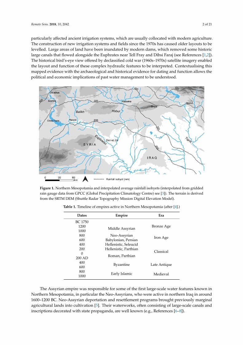
Remote Sens 2018 10 2042 2 of 21
particularly affected ancient irrigation systems which are usually collocated with modern agricultureThe construction of new irrigation systems and fields since the 1970s has caused older layouts to belevelled Large areas of land have been inundated by modern dams which removed some historiclarge canals that flowed alongside the Euphrates near Tell Fray and Dibsi Faraj (see References [12])The historical birdrsquos-eye view offered by declassified cold war (1960sndash1970s) satellite imagery enabledthe layout and function of these complex hydraulic features to be interpreted Contextualising thismapped evidence with the archaeological and historical evidence for dating and function allows thepolitical and economic implications of past water management to be understood
Remote Sens 2018 10 2042 2 of 21
has particularly affected ancient irrigation systems which are usually collocated with modern agriculture The construction of new irrigation systems and fields since the 1970s has caused older layouts to be levelled Large areas of land have been inundated by modern dams which removed some historic large canals that flowed alongside the Euphrates near Tell Fray and Dibsi Faraj (see References [12]) The historical birdrsquos-eye view offered by declassified cold war (1960sndash1970s) satellite imagery enabled the layout and function of these complex hydraulic features to be interpreted Contextualising this mapped evidence with the archaeological and historical evidence for dating and function allows the political and economic implications of past water management to be understood
Figure 1 Northern Mesopotamia and interpolated average rainfall isohyets (interpolated from gridded rain gauge data from GPCC (Global Precipitation Climatology Centre) see [3]) The terrain is derived from the SRTM DEM (Shuttle Radar Topography Mission Digital Elevation Model)
Table 1 Timeline of empires active in Northern Mesopotamia (after [4])
Dates Empire Era BC 1750
Bronze Age 1200 Middle Assyrian
1000 800 Neo-Assyrian
Iron Age 600 Babylonian Persian 400 Hellenistic Seleucid
Classical 200 Hellenistic Parthian 0
Roman Parthian 200 AD
400 Byzantine Late Antique
600 800
Early Islamic Medieval 1000
Figure 1 Northern Mesopotamia and interpolated average rainfall isohyets (interpolated from griddedrain gauge data from GPCC (Global Precipitation Climatology Centre) see [3]) The terrain is derivedfrom the SRTM DEM (Shuttle Radar Topography Mission Digital Elevation Model)
Table 1 Timeline of empires active in Northern Mesopotamia (after [4])
Dates Empire Era
BC 1750Bronze Age1200 Middle Assyrian
1000800 Neo-Assyrian Iron Age600 Babylonian Persian400 Hellenistic Seleucid
Classical200 Hellenistic Parthian
0Roman Parthian200 AD
400 Byzantine Late Antique600800 Early Islamic Medieval1000
The Assyrian empire was responsible for some of the first large-scale water features known inNorthern Mesopotamia in particular the Neo-Assyrians who were active in northern Iraq in around1600ndash1200 BC Neo-Assyrian deportation and resettlement programs brought previously marginalagricultural lands into cultivation [5] Their waterworks often consisting of large-scale canals andinscriptions decorated with state propaganda are well known (eg References [6ndash8])
Remote Sens 2018 10 2042 3 of 21
Table 2 Spaceborne data used in this study
Dataset Date Range SpatialResolution (m) Coverage Function
CORONA KH-4B 1967ndash1972 18ndash27 100 Image interpretation of now-destroyedlandscapes
Landsat 1985ndash2017 15ndash30 100To facilitate understanding of whereand when the pre-modern hydrauliclandscapes were destroyed
IKONOS 2000 08ndash3 3 tiles Image interpretation of some survivingfeatures
Google Earthimagery various
sensors1999ndash2018 ~03ndash3 100 Image interpretation of some surviving
features
SRTM DEM 2000 30ndash90 100 Hydraulic context of canal systems
CORONA DEMMissions 1105ndash1009 04-NOV-68 ~10 1 stereopair Morphology of selected canal features
The empires and states that followed (eg the Hellenistic Roman Umayyad and Abbasidstates) were also able to control large areas of the Northern Mesopotamian landscape supportingtheir economies with agriculture and trade Well-dated water management features of this periodare known including a canal in the Balikh [9] and rock-cut water conduits in the Jerablus area [210]Throughout the time of the later empires (from ca 2nd millennium BC) and especially by the EarlyIslamic period (ca 8th century AD) water management technology was widespread [1211] includingalongside the difficult-to-control Euphrates [12ndash14] as well as intensive cultivation in tributaries suchas the Balikh and the Habur [1111516] Increased uptake of water management technology at thistime may have been related to specific Early Islamic policies of bringing more land into cultivation [17](pp 181ndash182)
The environmental context in which irrigated agriculture was developed in NorthernMesopotamia is significant Rain-fed cultivation (roughly where rainfall is at least 200ndash250 mmon average per year see Reference [18]) is technically possible in the north meaning that irrigation isnot necessary for successful agriculture although precipitation is variable making reliance on it riskyNorthern Mesopotamia receives sufficient rainfall for the growth of vegetation in non-irrigated areasalthough the steppe is sparsely vegetated However irrigable areas with perennial water sources areas attractive to present-day cultivators as they were in the past so land cover in these zones tends tobe intensive arable cultivation of crops including wheat cotton and fruit [19] The rain-fed north is incontrast to southern Iraq which Wittfogel [20] used to illustrate his theory of ldquooriental despotismrdquoHe proposed that the development of irrigation in southern Iraq led to a need for bureaucracy whichin turn drove the development of the state [20] Ancient Mesopotamian irrigation was traditionallyviewed in the context of this theory and this much drier region where rain-fed cultivation wasnot possible Salinization as a result of irrigation may also have been a particular problem in thesouth [21]Throughout Mesopotamia soil has been degraded due to human activity [22] Principallyhowever the only soils really suitable for arable cultivation are the moisture-retaining alluvial rivervalleys [23]
Proxy evidence has indicated that there were increased trends toward aridity from around 2000BC in Syria [24] (p 1011) and that rainfall amounts may have been similar to todayrsquos throughoutthe time of the later territorial empires [25] (p 166) Increased dryness has been suggested for themedieval period in the eastern Mediterranean a symptom of the ldquoMedieval Climate Anomalyrdquo (MCA)and has been linked to historical economic processes [26] Some regions may have been as warm asthe 20th century at this time [27] (p 386) The results of our research correspond with this revealingextensive irrigation in the rain-fed zone during the time of the later territorial empires especially inthe medieval period
Remote Sens 2018 10 2042 4 of 21
Archaeological and historical research has identified traces of former canal systems in the rain-fedzone of northern Syria and Iraq Many of the studies have focused on specific features or have takena historical approach For example Dalley used Assyrian documents and art to understand watermanagement features in the Neo-Assyrian heartland around cities such as Nineveh and Nimrud [7](p 53) Kamash described historical and archaeological evidence of irrigation features throughout theregion with a focus on the Roman period [2829] In some cases single sections in individual canalswere excavated [12] providing chronological evidence although scientifically dated examples such asthese are still relatively scarce
Increasingly archaeologists are using remote sensing to record features relatively quickly andcheaply in the Near East including satellite imagery [30] and aerial photography [31] This often allowsexamination of areas where fieldwork is not possible due to conflict [30] A few studies have usedimage interpretation methods to study water management in the Near East Ur [8] and Altaweel [32]examined Neo-Assyrian canals in Northern Iraq Aerial photographs were examined for the Habur [33]and parts of the Balikh (Wilkinson personal communication 2010)
These reviews represent scattered studies A regional-scale and long-term view of the entirelandscape does not exist which makes it impossible to understand the development of water managementactivity throughout Northern Mesopotamia over time The present study addressed this gap generatinga map of ancient irrigation systems across northern Syria and Iraq and revealing particularly denseirrigation in the Balikh Valley of Syria The existing literature and detailed archaeological and historicalimplications of this research have been discussed in additional publications [1111516] This paperoutlines our methodology which used remote sensing to map the ancient landscape and presents thekey results
2 Materials and Methods
21 Satellite Imagery
A range of satellite image data were used to address our objectives (Table 2) The best method ofrecording water features across a huge region quickly and inexpensively was found to be systematicinterpretation of historical and (relatively) high spatial resolution satellite images (CORONA) The satelliteimages could then be understood by combining them with evidence from ground surveys excavationsand historical accounts However while fieldwork data provided important details such as datingmaterial the area that could be investigated was limited by time and budget constraints Water featuresespecially large-scale reticulated canal systems can extend for many kilometres Moreover they areoften complex features consisting of connected and branching channels performing different functions(abstraction transport irrigation drainage) They are usually represented by very faint and ephemeralearthworks and soil marks which are difficult to identify on the ground but which are clear linear featuresin satellite images and some elevation models
A retrogressive analysis of Landsat images (from 1985ndash2017) was used to understand the extent towhich the study area has changed Landsat images corrected to top of atmosphere (TOA) reflectancewere obtained using Google Earth Engine (GEE) by filtering the image catalogue by location date rangeand cloud cover (less than 10) Cloud masks were applied The median values of all pixels in thearea of interest over time-steps of two years were composited to make each mosaic (see SupplementaryMaterials for script and Gorelick et al [34] for explanation of GEE) The composites were visualised asfalse-colour composites using the near-infrared band as a way of highlighting vegetation (includingirrigated areas)
Modern high-resolution images were examined (eg via Google Earth) but most ancient irrigationfeatures had been destroyed by the time these images were produced To view Northern Mesopotamiabefore modern agriculture had changed it CORONA images were used Because the CORONAimagery is panchromatic spectral analysis was not possible using this data The remains of ancientirrigation systems are generally too small to be identified using freely available multispectral imagery
Remote Sens 2018 10 2042 5 of 21
such as Landsat The applicability of high-resolution multispectral satellite imagery (eg WorldViewIKONOS) was very limited because the archaeological remains of ancient canals had been mostlydestroyed by modern agriculture before this type of data became available
The CORONA project operated for United States (US) intelligence purposes and was the first satellitemission to take systematic pictures of the earthrsquos surface In 1995 the US government declassified anarchive of reconnaissance photography from over 100 separate low earth orbit missions from 1960 to 1972The camera systems on the CORONA programme evolved through time and since February 1962 theKH-4 KH-4A and KH-4B included modifications to the design to allow calibration and measurementsto be made from stereoscopic imagery
The ground resolution of CORONA imagery varied with each mission depending on thealtitude of the satellite and its orbit characteristics KH-4B imagery achieved a spatial resolutionof 2 m The wide frame of CORONA images combined with their relatively high spatial resolutionmakes them useful for identifying archaeological features Most importantly however they show aview of the landscape shortly before it was irreversibly changed by modern agriculture and urbanexpansion Given these properties they have been increasingly used to map archaeological remains(eg Reference [30])
We were able to obtain orthorectified CORONA KH-4B imagery for the entire study region ofnorthern Syria and Iraq through collaboration with the Fragile Crescent Project (FCP) [35] fromthe USGS and through the CORONA Atlas of the Middle East [36] We processed some imagesphotogrammetrically (outlined below in Section 22) This involved placing control points generatingtie points and performing triangulation using ERDAS LPS version 101
22 Hydraulic Context and Terrain Extraction
The design of any water management system is influenced by the existing topography Knowingthe steepness of canals and the gradient of the landscape through which they flow allows us toanalyse how they functioned and where they abstracted water from as well as to further confirm theirinterpretation as water features While in the past archaeologists have undertaken slow and laborioussurveys from the ground to obtain the measurements of short segments of canals as well as thetopography of the land remotely sensed elevation data offers faster ways to model much larger areasin 3D Given this we used the SRTM DEM to model the landscape of Northern Mesopotamia For afew selected areas in the Balikh Valley we used CORONA photogrammetry to model the morphologyof specific canals at higher resolution and as they were at the time the CORONA images were collectedThese canals have since been damaged or obliterated completely by modern agriculture
The SRTM DEM (collected in 2000) was created from interferometric radar data and has verticalaccuracy of approximately 9 m [37] with versions available in 90 m and 30 m spatial resolutions SRTMwas used extensively in this study to measure the hydraulic properties of ancient water managementfeatures despite its relatively coarse spatial resolution in the absence of freely available higherresolution DEMs
However 3D information extractable by photogrammetry from CORONA images is of particularvalue allowing high-resolution DEMs to be generated for case studies The satellite KH-4B wasequipped with two panoramic cameras in forward and aft positions on the satellite Although thesewere intended for manual stereoscopic interpretation we can now produce digital DEMs using theseldquostereopairsrdquo by calculating the degree of parallax between conjugate points in each image usingdedicated software (in this case the ERDAS photogrammetry toolbox) Of the CORONA satellitesKH-4B offers the best image quality and an overlap of 10 in the flight direction [38] In order todetermine the dimensions (x y z) of points in the two images making up a stereopair the relativeorientation of the camera needs to be established from specific parameters of camera rotation andbase line direction (exterior orientation) [39] as well as the ground coordinates of at least 3 points [40]In the case of CORONA images some of these parameters have to be calculated because they were notreleased as part of the declassification process along with the images (Table 3 lists known parameters)
Remote Sens 2018 10 2042 6 of 21
This information is needed to determine the geometric relationship between the ground the imageand the sensor
Table 3 KH-4B parameters [4142]
KH-4B Parameters
CORONA Mission 1105 04-NOV-68 KH-4BCamera type Panoramic
Film width (mm) 70Approximate frame format (cm) 554 times 7569
Focal length (cm) 607609Best approximate film resolution (Lmm) 160Best approximate ground resolution (m) 183Nominal system altitude (nautical miles) 81
Image scale 1247500Nominal ground coverage (km) 14 times 188
Archaeologists working in the Near East have found CORONA stereopairs to be of value forrecording the distinctive shape of Bronze Age Tell sites and settlements for example Galiatsatos et alrsquos [43]models of archaeological settlements Casana and Cothren [44] also used photogrammetry to reconstructseveral Tell sites Due to distortions across the panoramic frames they found that better results could beobtained by subsetting the frames into smaller areas [44]
Although many archaeological studies using historical imagery have relied on manual stereoscopyfor this project we focused on producing automatically extracted terrain models using photogrammetrysoftware Once a camera model and DEM extraction method were set up then these were appliedto subsets of multiple areas of interest The orientation of the camera was established fromparameters of rotation (exterior orientation) and interior orientation (eg focal length principalpoint) This information was used to perform collinearity which describes the relationship betweenthe ground and image coordinates and the camera [39]
In this case a stereopair dating to 4 November 1968 was used Three sample areas in the Balikhwere subsetted and processed using the software ERDAS LPS Version 101 While not all exterior andinterior orientation parameters were known a nonmetric camera model could be applied using theknown details of flying height focal length and scanned pixel size (see Table 3) Sufficient controlpoints were placed in order to mitigate against the lack of known orientation parameters and toestimate the exterior orientation parameters (coordinates of the principal point and the rotation angles)through the process of space resection Good ground control points for example differential GPSpoints were not available for this project due to the security situation in Syria In 2010 we were notpermitted to use GPS during fieldwork and were not able to return for future field seasons due to thewar that broke out in 2011 However DEMS could be generated from CORONA without field-basedground control as Galiatsatos et al demonstrated [43] Instead x and y coordinates were collectedfrom other sources including rectified CORONA images modern satellite imagery and Google Earthand z coordinates were obtained from SRTM DEM with as many as 87 control points obtainable inthis way for example for the DEM of the Nahr al Abbara system (Table 4)
Table 4 DEM production from CORONA stereopairs
Nahr al Abbara Canal System Tell Hammam et Turkman Sahlan-Hammam Canal
Subset size (km) 26 times 45 14 times 08 09 times 10Control points 87 40 24Auto-tie points 184 44 12
RMSE 26 115 13mX 53141 23103 55780mY 35408 23402 26244mZ 53759 43616 62376
Remote Sens 2018 10 2042 7 of 21
Triangulation was performed in 10 iterations using a bundle block adjustment with a least squaressolution applied to the tie points and orientation information The triangulation results of each pointwere examined in order to determine accuracy (Table 4) Control point values were calculated by thesoftware following the bundle block adjustment and calculation of estimated orientation parametersThe standard deviation of the control point residuals (the difference between the original points andthe calculated values) are listed in Table 4 (mX mY mZ) The root mean square error (RMSE) is a globalindicator of the quality of the DEM based on the image coordinate residuals (eg see Reference [43])
Some erroneous control and tie points were identified through this process and removedimproving the RMSE Overall these were considered to be within thresholds sufficient for thepurposes of our research Standard deviations were between 2 and 7 for the control points of allDEMs The highest error was in the vertical of the Sahlan-Hammam canal Low contrast for thispart of the stereopair made placing points difficult Values for individual control and tie points areset out in the Supplementary Materials A sum of squared differences (SSD) correlation algorithmwas applied to the subsetted CORONA stereopairs in order to measure parallax and extract DEMsThe SSD algorithm (Equation (1)) uses a moving window technique to examine every location in boththe images searching for correlation between the templates and the images DEMs with grid cell sizesof about 10 m were produced
sumx( f (X + Y)minus t(X))2 (1)
SSD (eg [45] (p 45)) f is the image and t is the search template
23 Interpretation Criteria
The study region measured approximately 100000 km2 In order to view and interpret CORONAimagery for this whole area efficiently it was divided into transects Features that could be recognisedas pre-1970s water management channels through interpretation of the CORONA imagery wererecorded based on selected criteria that we describe here (see Figure 2)
The trace (overall pathway) form (relative sinuosity) and embankment of canals varieddepending on their context Figure 2 shows pre-modern canals that were generally linear but notalways completely straight Some had prominent upcast banks as a result of their construction andmaintenance (Figure 2A) In some cases their gradient caused them to flow along a linear but sinuoustrace (Figure 2C) Scholars have debated whether hollow ways (ancient tracks) and canals can bedistinguished (eg Reference [46]) However in most cases ancient canals flowed downhill followingthe contours of the landscape while hollow ways did not need to conform to this (Figure 3) solandscape gradient derived from the SRTM DEM was used as a variable to assist interpretationKnown ancient irrigation systems consisting of reticulated canal networks tended to function bygravity flow Where gravity-fed irrigation was possible it is unlikely that the expense and difficulty ofwater lifting (eg pre-diesel pump) would have been preferred Other water features such as qanatsand tunnels were also recorded (eg Figure 2D) These are visible as a line of ldquodotsrdquo representingupcast soil surrounding maintenance and air shafts It could be difficult to distinguish betweengroundwater-collecting qanats and tunnels that transported water from perennial watercourses andsprings unless the abstraction point was clear
In order to understand how ancient irrigation systems functioned the different segments of asystem should be recorded As Figure 4 shows a reticulated canal system consisted of an abstractionpoint a main transportconveyor channel offtakes (irrigation laterals and field laterals) and drainsMany archaeological studies have recorded and examined the main channels of ancient canal systemsbut not much research has investigated all parts of the system including the laterals that deliveredwater into the fields We have found that in some cases these can be identified through an analysis ofimagery and DEMs The early Islamic Nahr al Abbara in the Balikh Valley north of Raqqa in Syria is agood example of a well-preserved reticulated layout as it was at the time of CORONA [1111516]which has been visited in the field [9]
Remote Sens 2018 10 2042 8 of 21Remote Sens 2018 10 2042 8 of 21
Figure 2 Examples of water management features that could be identified using CORONA (A) Straight trace and form prominent upcast banks (B) mostly straight trace and form low banks (C) straight trace meanderingsinuous form (D) qanat channels represented by series of shafts in a linear arrangement
Figure 3 Long profile graphs using SRTM elevation and CORONA images Hollow ways (A) did not need to conform to the gradient of the landscape while canals (B) flowed clearly downhill
Figure 2 Examples of water management features that could be identified using CORONA (A) Straighttrace and form prominent upcast banks (B) mostly straight trace and form low banks (C) straight tracemeanderingsinuous form (D) qanat channels represented by series of shafts in a linear arrangement
Remote Sens 2018 10 2042 8 of 21
Figure 2 Examples of water management features that could be identified using CORONA (A) Straight trace and form prominent upcast banks (B) mostly straight trace and form low banks (C) straight trace meanderingsinuous form (D) qanat channels represented by series of shafts in a linear arrangement
Figure 3 Long profile graphs using SRTM elevation and CORONA images Hollow ways (A) did not need to conform to the gradient of the landscape while canals (B) flowed clearly downhill
Figure 3 Long profile graphs using SRTM elevation and CORONA images Hollow ways (A) did notneed to conform to the gradient of the landscape while canals (B) flowed clearly downhill
Remote Sens 2018 10 2042 9 of 21
Remote Sens 2018 10 2042 9 of 21
Figure 4 Irrigation systems comprised a series of canals enabling abstraction transport of water and drainage Storage of water could also be incorporated into these systems
However in many cases only a main canal remained visible in the imagery Smaller distributaries do not usually leave traces This includes prominent canals alongside the Euphrates and in northern Iraq [1516] Even the abstraction point tends to be unclear although it can be projected based on the relative levels of the river and fields [1516] Often only the tunnel part of qanats and tunnel irrigation systems have survived without the lateral channels that delivered the water directly to the fields and crops
24 Archaeological Survey and Dating Evidence
Contextualising the evidence with data from archaeological surveys allowed us to link the water management features with dating material in order to understand their chronology for example the work done by Wilkinson to investigate the canals in the Balikh (eg Reference [9] and unpublished data) The significance of the dated canals was then examined further by reference to historical sources [47]
Fieldwork was undertaken at the outset of this project in 2010 in Syria We conducted walk-along surveys of selected irrigation features and of specific locations along others Canals in the Jerablus and Raqqa areas were visited and recorded with some new features identified [24849] Given the difficulty of undertaking further fieldwork in the Middle East at present data were sought from existing published and unpublished surveys and excavations These included Wilkinsonrsquos work in the Balikh [9] and Dibsi Faraj [12] surveys undertaken by Ur [8] and Altaweel [32] in northern
Figure 4 Irrigation systems comprised a series of canals enabling abstraction transport of water anddrainage Storage of water could also be incorporated into these systems
However in many cases only a main canal remained visible in the imagery Smaller distributariesdo not usually leave traces This includes prominent canals alongside the Euphrates and in northernIraq [1516] Even the abstraction point tends to be unclear although it can be projected based on therelative levels of the river and fields [15] Often only the tunnel part of qanats and tunnel irrigationsystems have survived without the lateral channels that delivered the water directly to the fieldsand crops
24 Archaeological Survey and Dating Evidence
Contextualising the evidence with data from archaeological surveys allowed us to link the watermanagement features with dating material in order to understand their chronology for example thework done by Wilkinson to investigate the canals in the Balikh (eg Reference [9] and unpublished data)The significance of the dated canals was then examined further by reference to historical sources [47]
Fieldwork was undertaken at the outset of this project in 2010 in Syria We conducted walk-alongsurveys of selected irrigation features and of specific locations along others Canals in the Jerablusand Raqqa areas were visited and recorded with some new features identified [24849] Given thedifficulty of undertaking further fieldwork in the Middle East at present data were sought fromexisting published and unpublished surveys and excavations These included Wilkinsonrsquos work in theBalikh [9] and Dibsi Faraj [12] surveys undertaken by Ur [8] and Altaweel [32] in northern Iraq andothers throughout Northern Mesopotamia (see References [1516] for more detailed literature reviews)
In a few cases excavation of sections across canal beds had provided organic material from withinthe fill of canals allowing the dates of their construction and use to be obtained Remains from a
Remote Sens 2018 10 2042 10 of 21
section of the Sahlan-Hammam canal excavated by Wilkinson gave an uncalibrated date of 1380 + 70BP (Beta-78543) which is around 570 AD [9] (p 71) placing it within the period of the later empiresSimilarly an Early Islamic date was obtained through excavation of a prominent canal on a terrace ofthe Euphrates which was associated with the Early Islamic site of Dibsi Faraj [12]
At some locations surface surveys alongside the remains of ancient canals yielded datinginformation The Nahr al Abbara in the Balikh was dated to the Early Islamic period in this way [9]Other canals such as the system in the southwest of the Balikh Valley could be more tentatively datedby association with known Islamic features north of Raqqa [15] The features that could be dated tothe period of the later empires through excavation survey or historical evidence and by associationwere plotted on a map (Figure 5)
Remote Sens 2018 10 2042 10 of 21
Iraq and others throughout Northern Mesopotamia (see References [1516] for more detailed literature reviews)
In a few cases excavation of sections across canal beds had provided organic material from within the fill of canals allowing the dates of their construction and use to be obtained Remains from a section of the Sahlan-Hammam canal excavated by Wilkinson gave an uncalibrated date of 1380 + 70 BP (Beta-78543) which is around 570 AD [9] (p 71) placing it within the period of the later empires Similarly an Early Islamic date was obtained through excavation of a prominent canal on a terrace of the Euphrates which was associated with the Early Islamic site of Dibsi Faraj [12]
At some locations surface surveys alongside the remains of ancient canals yielded dating information The Nahr al Abbara in the Balikh was dated to the Early Islamic period in this way [9] Other canals such as the system in the southwest of the Balikh Valley could be more tentatively dated by association with known Islamic features north of Raqqa [15] The features that could be dated to the period of the later empires through excavation survey or historical evidence and by association were plotted on a map (Figure 5)
Figure 5 Ancient water management featuressystems throughout northern Mesopotamia [1281115165051] Although the zone represented by the 200ndash300 mm isohyets technically could support rain-fed agriculture precipitation was highly variable
3 Results
Figure 5 shows the results of applying our methodology to an area of over 100000 km2 A comprehensive map of irrigation at the time of the later empires did not exist prior to this study The image interpretation exercise using CORONA proved to be the only practical way of mapping ancient water management across the entirety of Northern Mesopotamia and revealed over 2900 km of canals and qanats Canals already known in archaeological and historical sources were located for example the Nahr Maslama at Dibsi Faraj [12] and mapped using the CORONA in order to place them within their wider regional context The present study also identified previously unknown features such as a tunnel at Raqqa [15] (Figure 6) By utilising elevation data (SRTM and CORONA DEMs) as well as archaeological and historical records the context of this map of water management could be recognised The combined image elevation and archaeological data allowed distinct irrigation systems with chronological associations to be understood (Table 5) separating these out from channels or linear features of unknown date and context
Figure 5 Ancient water management featuressystems throughout northern Mesopotamia [1281115165051] Although the zone represented by the 200ndash300 mm isohyets technically could supportrain-fed agriculture precipitation was highly variable
3 Results
Figure 5 shows the results of applying our methodology to an area of over 100000 km2A comprehensive map of irrigation at the time of the later empires did not exist prior to this studyThe image interpretation exercise using CORONA proved to be the only practical way of mappingancient water management across the entirety of Northern Mesopotamia and revealed over 2900 kmof canals and qanats Canals already known in archaeological and historical sources were locatedfor example the Nahr Maslama at Dibsi Faraj [12] and mapped using the CORONA in order to placethem within their wider regional context The present study also identified previously unknownfeatures such as a tunnel at Raqqa [1516] By utilising elevation data (SRTM and CORONA DEMs)as well as archaeological and historical records the context of this map of water management couldbe recognised The combined image elevation and archaeological data allowed distinct irrigationsystems with chronological associations to be understood (Table 5) separating these out from channelsor linear features of unknown date and context
Although anthropogenic processes natural erosion and deposition activity of the river haveremoved much of this water management evidence the surviving traces show that canals wereconstructed alongside the Euphrates from at least Dibsi Faraj down to Mari and in the northern reachesof the Tigris and its tributaries Irrigation was also recorded by the tributaries of the Euphrates the SajurHabur and particularly the Balikh Qanats extended the range of cultivable lands in Syria and Iraq
Remote Sens 2018 10 2042 11 of 21
Table 5 Water management systems recorded by this study using satellite data
Chronological Period Water Management Systems Key References
Pre-1st millennium BCCanal at Tell Fray [52]Some canals alongside the Euphrates between Balikh and Mari [14]
1st millennium BCCanals in northern Iraq [6ndash832]Canal at Carchemish [1648]Origin of canals alongside Habur [3353]
Hellenisticndashlate RomanCanal and rock-cut conduits in Jerablus area [1648]Sahlan-Hamman canal and Qara Mokh canals in Balikh [911]Qanats south of Membij [151654]
Early Islamic (8thndash15thcenturies AD)
Large embanked canal between Tell Fray and Qalat Jabar [16]
Large embanked canal at Dibsi Faraj and qanat [112]Canals in Balikh Valley north of Raqqa [11516]Canals in Balikh Valley west of Raqqa [111516]
Qanats a tunnel and canals around Raqqa [111516]
Canals alongside the Habur [53]
Nahr Dawrin Nahr Sarsquoid Large embanked canals on both banks ofthe Euphrates between the Balikh and Mari [13ndash16]
Some of the large embanked canals in northern Iraq Tarbisu canaland Nahr Qanausa [832]
Qanats on the Sinjar Plain [1516]
We mapped pre-Islamic water management features in Northern Mesopotamia including rock-cutconduits near Jerablus (investigated during fieldwork see References [1648]) and Hellenistic qanatsaround Membij (dated by a historical source see Reference [54]) Although some of the tracesof large embanked channels alongside the Euphrates have been attributed to the pre-Islamic era(eg Reference [14]) it can be argued the technology capable of facilitating this may not have beenwidely applied until the medieval period [55] (p 115) Tributaries such as the Balikh and the Haburwere easier to irrigate from attested by a likely Assyrian origin for canals alongside the Habur [33] andsome Hellenisticndashlate Roman canals in the Balikh dated through excavation radiocarbon dating surfacesurvey and association with dated sites (eg the Sahlan-Hammam canal Figure 6 References [911])The Neo-Assyrian canals in northern Iraq are already well-known although it is important to note someof the canals in northern Iraq have been attributed to the Early Islamic period (see References [832])
Early Islamic canals were constructed and maintained alongside the Euphrates for example thelarge embanked canals of the Nahr Maslama Nahr Dawrin and Nahr Sarsquoid which are referred to inIslamic texts (see Reference [1516]) The canals alongside the Habur may also have been used into theEarly Islamic period and a possible connection to the Nahr Dawrin has been proposed [151656]
Especially in the Balikh the analysis of systems that were reasonably preserved at the time of theCORONA images showed a high degree of sophistication and represented hydrological knowledgebefore the modern era (see Figures 7 and 8) The Nahr Al Abbara dated through surface survey [9]abstracted water to the north near Tell Sahlan which it transported in a main canal for over 15 km (seeFigures 7 and 8) Traces of an earlier phase of canal on the same alignment could be identified in placesusing the CORONA imagery (see [2] Figure 6 38) Water was delivered to fields via laterals branchingoff the main channel at fairly regular intervals During a surface survey Wilkinson [9] (p 68) recordedlarge stone blocks that may have functioned as part of sluice structures As the SRTM DEM confirmedthe overall gradient of the landscape of the Balikh is very flat but the Nahr Al Abbara system mitigatedagainst it by running the main canal at a low gradient (approximately 01) along a slight and somewhatnarrow ridge (see [11] Figure 6) The CORONA DEM (Figure 9) allowed this to be visualised at higherresolution The main canal could flow for a greater distance but at the same time the offtakes could attaina slightly steeper gradient (approximately 05) The system also incorporated drainage provision intothe Balikh and into the fairly wide basin of a seasonal runoff stream to the east the Wadi al Keder andmay have been associated with a complex layout of spring water channels and drainage systems (see [11]Figures 7 and 8) There are several Early Islamic settlements nearby including Medinet al Farr and
Remote Sens 2018 10 2042 12 of 21
Khirbet Ambar which are known through historical sources and archaeological investigations [5758]It is likely that these sites were involved in the administration of irrigation in the area
Remote Sens 2018 10 2042 11 of 21
Figure 6 The eroded and infilled remains of the Sahlan-Hammam canal in the 1990s when Tony Wilkinson visited Tony provides scale
Table 5 Water management systems recorded by this study using satellite data
Chronological Period Water Management Systems Key References
Pre-1st millennium BC Canal at Tell Fray [52] Some canals alongside the Euphrates between Balikh and Mari [14]
1st millennium BC Canals in northern Iraq [6ndash832] Canal at Carchemish [1648] Origin of canals alongside Habur [3353]
Hellenisticndashlate Roman Canal and rock-cut conduits in Jerablus area [1648] Sahlan-Hamman canal and Qara Mokh canals in Balikh [911] Qanats south of Membij [151654]
Early Islamic (8thndash15th centuries AD)
Large embanked canal between Tell Fray and Qalat Jabar [16] Large embanked canal at Dibsi Faraj and qanat [112] Canals in Balikh Valley north of Raqqa [115] Canals in Balikh Valley west of Raqqa [1115] Qanats a tunnel and canals around Raqqa [1115] Canals alongside the Habur [53] Nahr Dawrin Nahr Sarsquoid Large embanked canals on both banks of the Euphrates between the Balikh and Mari
[131416]
Some of the large embanked canals in northern Iraq Tarbisu canal and Nahr Qanausa
[832]
Qanats on the Sinjar Plain [1516]
Although anthropogenic processes natural erosion and deposition activity of the river have removed much of this water management evidence the surviving traces show that canals were constructed alongside the Euphrates from at least Dibsi Faraj down to Mari and in the northern reaches of the Tigris and its tributaries Irrigation was also recorded by the tributaries of the Euphrates the Sajur Habur and particularly the Balikh Qanats extended the range of cultivable lands in Syria and Iraq
We mapped pre-Islamic water management features in Northern Mesopotamia including rock-cut conduits near Jerablus (investigated during fieldwork see References [1648]) and Hellenistic qanats around Membij (dated by a historical source see Reference [54]) Although some of the traces of large embanked channels alongside the Euphrates have been attributed to the pre-Islamic era (eg Reference [14]) it can be argued the technology capable of facilitating this may not have been widely applied until the medieval period [55] (p 115) Tributaries such as the Balikh and the Habur were
Figure 6 The eroded and infilled remains of the Sahlan-Hammam canal in the 1990s when TonyWilkinson visited Tony provides scaleRemote Sens 2018 10 2042 13 of 21
Figure 7 Irrigation systems in the Balikh Valley
Figure 8 The channel of the Nahr al Abbara canal system is marked with arrows (1968 CORONA image)
Figure 7 Irrigation systems in the Balikh Valley
Remote Sens 2018 10 2042 13 of 21
An extensive set of canals in the southwest horseshoe of the Balikh Valley may also be EarlyIslamic based on a connection with known sites (Figure 10A see Reference [11]) Most significantlyin the south the CORONA images showed several water management features associated with theEarly Islamic city of Raqqa which was particularly prominent as a capital city during the Abbasid erawith palaces and an industrial area The city itself and its immediate hinterland appears to have beenwatered by qanats with a northern palace complex supplied by a tunnel stemming from the QaraMokh stream as well as the Balikh [111516]
Overall historical sources present a picture of intensive irrigated cultivation in NorthernMesopotamia in the Early Islamic period [47] Even away from the main perennial water sourcesqanats extended the cultivable area The CORONA images revealed an area of dense qanat irrigationradiating from the town of Sinjar in Iraq which may be medieval in date [59] (discussed in more detailin Reference [16])
Remote Sens 2018 10 2042 13 of 21
Figure 7 Irrigation systems in the Balikh Valley
Figure 8 The channel of the Nahr al Abbara canal system is marked with arrows (1968 CORONA image) Figure 8 The channel of the Nahr al Abbara canal system is marked with arrows (1968 CORONA image)Remote Sens 2018 10 2042 14 of 21
Figure 9 10 m spatial resolution DEM constructed using a CORONA stereopair
Figure 10 (A) Relict canals in the southwest Balikh Valley in 1968 which were (B) destroyed and replaced with a new irrigation system in 1972 (CORONA images)
4 Discussion
This research revealed an intensification of irrigation in most of the cultivable areas of Early Islamic Northern Mesopotamia particularly in the Balikh Valley The transformation of the environment that we observed fits the concept of ldquohydraulic landscapesrdquo Historical accounts and archaeological excavations have indicated that Raqqa was temporarily the centre of the Abbasid empire and a significant industrial town (eg see Reference [60]) which may offer an explanation for the intensification of water management features at this time In addition medieval irrigation in the Balikh may have been a response to deliberate policies of bringing marginal land into cultivation [17] policies that explain the increased application of water management technology throughout Northern Mesopotamia in the Early Islamic period This is an area where irrigation was not necessary but where employing it would have increased the reliability and quantity of agricultural yields developing and supporting powerful and demanding imperial economies Many existing hydraulic landscapes were maintained and developed while new ones were created in response to incentives
This intensive use of the landscape must have declined because until the later 20th century cultivation in Northern Mesopotamia was largely reported to be reliant on rainfall [61] (p 137) This transition followed the Early Islamic period By the 15th century the ancient water systems of Mesopotamia were falling into disrepair possibly due to plague and the depredations of the Mongols with subsequent depopulation and upheaval (eg see References [151662]) In many areas agriculture did not seem to have intensified again until the 2nd half of the 20th century
Figure 9 10 m spatial resolution DEM constructed using a CORONA stereopair
Remote Sens 2018 10 2042 14 of 21
4 Discussion
This research revealed an intensification of irrigation in most of the cultivable areas of Early IslamicNorthern Mesopotamia particularly in the Balikh Valley The transformation of the environment thatwe observed fits the concept of ldquohydraulic landscapesrdquo Historical accounts and archaeologicalexcavations have indicated that Raqqa was temporarily the centre of the Abbasid empire anda significant industrial town (eg see Reference [60]) which may offer an explanation for theintensification of water management features at this time In addition medieval irrigation in theBalikh may have been a response to deliberate policies of bringing marginal land into cultivation [17]policies that explain the increased application of water management technology throughout NorthernMesopotamia in the Early Islamic period This is an area where irrigation was not necessary but whereemploying it would have increased the reliability and quantity of agricultural yields developing andsupporting powerful and demanding imperial economies Many existing hydraulic landscapes weremaintained and developed while new ones were created in response to incentives
This intensive use of the landscape must have declined because until the later 20th centurycultivation in Northern Mesopotamia was largely reported to be reliant on rainfall [61] (p 137)This transition followed the Early Islamic period By the 15th century the ancient water systems ofMesopotamia were falling into disrepair possibly due to plague and the depredations of the Mongolswith subsequent depopulation and upheaval (eg see References [151662]) In many areas agriculturedid not seem to have intensified again until the 2nd half of the 20th century although traces of theancient irrigation systems remained embedded in the landscape until very recently (see travellersrsquoaccounts of abandoned canals eg [6364])
More recently however modern agricultural strategies in the Middle East have completelytransformed the landscape replacing ancient man-made hydraulic pathways with large-scale damsand canal systems and pumping from individual wells Many ancient irrigation systems have beenabandoned and destroyed to make way for new irrigation schemes A remote sensing methodologyusing interpretation from CORONA images dating from the period 1967ndash1972 proved to be a veryeffective strategy for recording ancient water management and for mapping its spread and distribution
When CORONA images (1968 and 1972) were compared (Figure 10) the initial construction ofthe modern field and irrigation systems in the 1970s Balikh is apparent This highlights the timelinessof the 1960s images which represent the last record of most of the ancient canal systems presented inFigures 5 and 7
Remote Sens 2018 10 2042 14 of 21
Figure 9 10 m spatial resolution DEM constructed using a CORONA stereopair
Figure 10 (A) Relict canals in the southwest Balikh Valley in 1968 which were (B) destroyed and replaced with a new irrigation system in 1972 (CORONA images)
4 Discussion
This research revealed an intensification of irrigation in most of the cultivable areas of Early Islamic Northern Mesopotamia particularly in the Balikh Valley The transformation of the environment that we observed fits the concept of ldquohydraulic landscapesrdquo Historical accounts and archaeological excavations have indicated that Raqqa was temporarily the centre of the Abbasid empire and a significant industrial town (eg see Reference [60]) which may offer an explanation for the intensification of water management features at this time In addition medieval irrigation in the Balikh may have been a response to deliberate policies of bringing marginal land into cultivation [17] policies that explain the increased application of water management technology throughout Northern Mesopotamia in the Early Islamic period This is an area where irrigation was not necessary but where employing it would have increased the reliability and quantity of agricultural yields developing and supporting powerful and demanding imperial economies Many existing hydraulic landscapes were maintained and developed while new ones were created in response to incentives
This intensive use of the landscape must have declined because until the later 20th century cultivation in Northern Mesopotamia was largely reported to be reliant on rainfall [61] (p 137) This transition followed the Early Islamic period By the 15th century the ancient water systems of Mesopotamia were falling into disrepair possibly due to plague and the depredations of the Mongols with subsequent depopulation and upheaval (eg see References [151662]) In many areas agriculture did not seem to have intensified again until the 2nd half of the 20th century
Figure 10 (A) Relict canals in the southwest Balikh Valley in 1968 which were (B) destroyed andreplaced with a new irrigation system in 1972 (CORONA images)
Remote Sens 2018 10 2042 15 of 21
While modern imagery such as IKONOS has been available for the study area since about 2000(Table 1) these images postdate major land use change that led to the destruction of most of the ancientcanals and therefore CORONA images are the only way of recording now-destroyed canal systemsFigure 11 shows how changes around the city of Raqqa between the 1960s and 2000s meant thatmuch of Early Islamic Raqqa and its environs (visible in the CORONA Figure 11A) had already beendestroyed by the time the IKONOS image (Figure 11B) was collected
Remote Sens 2018 10 2042 15 of 21
although traces of the ancient irrigation systems remained embedded in the landscape until very recently (see travellersrsquo accounts of abandoned canals eg [6364])
More recently however modern agricultural strategies in the Middle East have completely transformed the landscape replacing ancient man-made hydraulic pathways with large-scale dams and canal systems and pumping from individual wells Many ancient irrigation systems have been abandoned and destroyed to make way for new irrigation schemes A remote sensing methodology using interpretation from CORONA images dating from the period 1967ndash1972 proved to be a very effective strategy for recording ancient water management and for mapping its spread and distribution
When CORONA images (1968 and 1972) were compared (Figure 10) the initial construction of the modern field and irrigation systems in the 1970s Balikh is apparent This highlights the timeliness of the 1960s images which represent the last record of most of the ancient canal systems presented in Figures 5 and 7
While modern imagery such as IKONOS has been available for the study area since about 2000 (Table 1) these images postdate major land use change that led to the destruction of most of the ancient canals and therefore CORONA images are the only way of recording now-destroyed canal systems Figure 11 shows how changes around the city of Raqqa between the 1960s and 2000s meant that much of Early Islamic Raqqa and its environs (visible in the CORONA Figure 11A) had already been destroyed by the time the IKONOS image (Figure 11B) was collected
Figure 11 (A) CORONA image (May 1968) showing Early Islamic features of Raqqa including the 8th century AD walled city palace structures to the north of this and canals (B) IKONOS image (27 March 2000) showing that most of the medieval features were destroyed by modern buildings fields and roads
The Landsat sequence shows the intensification of agriculture underway from the 1980s (Figures 12 and 13) In Syria this was part of a programme involving construction of the Tabqa dam in 1966 30 km upstream of Raqqa [61] Figure 13 highlights the Balikh where we identified many ancient canal networks that corresponded neatly to the areas of modern irrigated agriculture highlighted by using a false colour visualisation By the 21st century modern agriculture had expanded throughout the valley including new fields and irrigation networks in the south the area known as the ldquohorseshoerdquo where several ancient canals supplied Early Islamic palaces and urban areas around Raqqa Recent disruption to irrigation infrastructure has been reported in the region due to the current conflict in Syria [1965] which is demonstrated by a slight reduction in the vegetated area between the 2010ndash2011 and 2016ndash2017 Landsat composites
Figure 11 (A) CORONA image (May 1968) showing Early Islamic features of Raqqa including the8th century AD walled city palace structures to the north of this and canals (B) IKONOS image(27 March 2000) showing that most of the medieval features were destroyed by modern buildingsfields and roads
The Landsat sequence shows the intensification of agriculture underway from the 1980s(Figures 12 and 13) In Syria this was part of a programme involving construction of the Tabqadam in 1966 30 km upstream of Raqqa [61] Figure 13 highlights the Balikh where we identifiedmany ancient canal networks that corresponded neatly to the areas of modern irrigated agriculturehighlighted by using a false colour visualisation By the 21st century modern agriculture had expandedthroughout the valley including new fields and irrigation networks in the south the area known asthe ldquohorseshoerdquo where several ancient canals supplied Early Islamic palaces and urban areas aroundRaqqa Recent disruption to irrigation infrastructure has been reported in the region due to the currentconflict in Syria [1965] which is demonstrated by a slight reduction in the vegetated area between the2010ndash2011 and 2016ndash2017 Landsat composites
Figure 12 shows a Landsat false colour composite of a large part of the Euphrates river in Syria in1985 and 1986 and again in 2016 and 2017 with Lake Assad in the top left and the Balikh and Haburtributaries joining from the north Figure 13 zooms in on the Syrian Balikh The red colours in theLandsat images seen in Figures 12 and 13 show the distribution of modern productive agriculturalland where changes shown in both figures reflect the intensification of agriculture the effect of whichhas been to remove traces of ancient water features The Landsat images emphasise the particularimportance of the Balikh which represents a large area of agricultural production within the wholeEuphrates valley The TurkeyndashSyria border can be clearly seen in the imagery (Figure 12) becauseof the contrast in water available for irrigation this serves as a reminder of the importance of thegeopolitics of water resources in the region from ancient times right up to the present day
Remote Sens 2018 10 2042 16 of 21Remote Sens 2018 10 2042 16 of 21
Figure 12 False colour Landsat composites showing the intensification of agriculture in Northern Mesopotamia over the past 40 years (A) Landsat 5 composite 1985ndash1986 (B) Landsat 8 composite 2016ndash2017 Images downloaded and mosaicked using Google Earth Engine
Figure 13 Landsat composites showing the expansion of modern irrigation in the Balikh (A) Landsat 5 1985ndash1986 (B) Landsat 7 2010ndash2011 (C) Landsat 8 2016ndash2017 Images downloaded and mosaicked using Google Earth Engine and visualised as false colour composites
Figure 12 False colour Landsat composites showing the intensification of agriculture in NorthernMesopotamia over the past 40 years (A) Landsat 5 composite 1985ndash1986 (B) Landsat 8 composite2016ndash2017 Images downloaded and mosaicked using Google Earth Engine
Remote Sens 2018 10 2042 16 of 21
Figure 12 False colour Landsat composites showing the intensification of agriculture in Northern Mesopotamia over the past 40 years (A) Landsat 5 composite 1985ndash1986 (B) Landsat 8 composite 2016ndash2017 Images downloaded and mosaicked using Google Earth Engine
Figure 13 Landsat composites showing the expansion of modern irrigation in the Balikh (A) Landsat 5 1985ndash1986 (B) Landsat 7 2010ndash2011 (C) Landsat 8 2016ndash2017 Images downloaded and mosaicked using Google Earth Engine and visualised as false colour composites
Figure 13 Landsat composites showing the expansion of modern irrigation in the Balikh (A) Landsat5 1985ndash1986 (B) Landsat 7 2010ndash2011 (C) Landsat 8 2016ndash2017 Images downloaded and mosaickedusing Google Earth Engine and visualised as false colour composites
There are some caveats to a methodology that relies principally on image interpretation Whetheror not water management features can be identified depends on a number of factors including imagequality and timing and natural conditions We identified rock-cut conduits and tunnels alongside
Remote Sens 2018 10 2042 17 of 21
dry streams in the Jerablus region during a survey in 2010 [48] that were not visible in the CORONA(1967 and 1972) and modern imagery There may well be other ancient irrigation features throughoutnorthern Syria and Iraq that have not yet been identified However many of the features we identifiedin the CORONA images were no longer visible on the ground having been destroyed to make way formodern agriculture This included the Nahr al Abbara canal system in the Balikh
Working with CORONA was difficult due to the panoramic and historical nature of the dataThe panoramic frames were distorted (eg see Reference [41] (p 228) Reference [66]) especiallytoward the edges and some image acquisition parameters were not available making constructing anaccurate camera model challenging The quality and time of collection of different images was variableSome higher resolution modern imagery was examined for example IKONOS imagery covering thearea around Raqqa in the southern Balikh However it was found that recent landscape changes haddestroyed much of the archaeology (see Figure 11) The CORONA data were often of the best timeperiod consistency of image quality (spatial and radiometric) and availability for large area coveragemaking it ideal for recording ancient water management features In fact we were able to obtainCORONA imagery for our entire 100000 km2 study area
5 Conclusions
Declassified CORONA satellite images from the 1960s and early 1970s are used to identify andreconstruct ancient hydraulic landscapes over large geographic areas The CORONA KH-4B camerahas stereoscopic capability which helps to identify and interpret water management features When theCORONA images were analysed in conjunction with modern satellite imagery DEMs and contextualinformation from archaeological and historical surveys the trajectory of the development of irrigationtechnology becomes clear
This study mapped water management features from the period ca 1200 BC to AD 1500 acrossthe entirety of Northern Mesopotamia for the first time (Figure 5) Irrigation increased in densitythroughout the region including within the zone traditionally regarded as ldquorain-fedrdquo and revealeda peak in the Early Islamic era Environmental considerations for understanding why and whereirrigation was undertaken during the period of the later empires also helped us to contextualise theresults An average rainfall of 200ndash250 mm a year is often interpreted as the limit of rain-fed cultivationfor modern and ancient agriculture (eg see References [186768]) and depicted as an isohyet lineHowever an analysis of modern rain gauge data indicates that much of the area encompassed byancient irrigation (receiving approximately 100ndash400 mm per year) experiences high variability today(20ndash40 see Reference [2] (p 158)) which makes irrigation necessary to mitigate against irregularrainfall [65] (p 5) If rainfall was similarly variable during the period of the later empires (eg atthe time of the MCA) our data suggests that they were investing in large-scale irrigation in a regionwhere rain-fed cultivation was technically possible but where it was risky due to the variability ofprecipitation Unlike in Southern Mesopotamia irrigation was not absolutely necessary for agriculturein Northern Mesopotamia but the construction of water management features was a way to ensureaccess to water in order to mitigate against disruptions to food supply
It is unlikely to be a coincidence that irrigation activity was intensified during the era of the firsttrue territorial empires when these powerful entities exerted and contested political control over thelandscape It is apparent that from the Neo-Assyrian period and by the Early Islamic period most ofthe perennial water courses in Northern Mesopotamia were used as sources of irrigation water andthat available groundwater was utilised The water management systems that we recorded includedmany reticulated and sophisticated systems that supported powerful states represented by traces ofprominent channels alongside the main rivers dense networks of irrigation in the tributaries andsignificant groundwater exploitation using qanats Many canals and parts of canal systems wouldhave been missed if examined through fieldwork alone Through interpretation of satellite imagesthis study was able to locate and map some previously unknown or understudied systems suchas numerous qanats in the Sinjar Plain of Iraq [1516] the qanat at Dibsi Faraj in Syria [1] and the
Remote Sens 2018 10 2042 18 of 21
real complexity of irrigation in the Balikh Valley in Syria [1111516] The combination of remotesensing archived data and fieldwork enabled further chronological and historical contextualisation ofthese remains
If fieldwork should become possible in the near future this reconstruction of ancient watermanagement in Northern Mesopotamia would benefit from ground sample testing using scientificdating techniques such as optically stimulated luminescence (OSL) (eg see Reference [69]) The use ofunmanned aerial vehicles (UAVs) dGPS and newer high-resolution DEMs such as TanDEM-X wouldprovide improved control data for photogrammetric processing of CORONA Several significant areasof relict channels require further investigation (for example qanats around Membij and Sinjar seeReferences [1516]) which itself might enable increased protection of this archaeological resource Dueto the current risk of looting and vandalism to archaeological sites in Mesopotamia it is not possible tomake the GIS database of canal locations publically available but these can be provided to verifiedheritage professionals via the EAMENA database if requested [70]
Conflict in Syria and Iraq has led to an ongoing humanitarian crisis and has impacted severelyon cultural heritage with deliberate destruction of many monumental sites including some of theIslamic remains in Raqqa Satellite imagery is being extensively used to highlight the destruction ofarchaeology in the Middle East during conflict [71] although its efficacy as a solution to stopping thedestruction is unclear Media reports often draw attention to damage to large monumental sites whilethe routine destruction of ancient canals by modern agricultural and urban development is frequentlyoverlooked Water management features may not be a particular target for vandalism but longer-termland use changes have wiped out many of their traces from the landscape making CORONA the lastrecord of the intensive hydraulic landscapes of the ancient empires
Supplementary Materials The following are available online at httpwwwmdpicom2072-429210122042s1 CORONA DEM triangulation reports Landsat comparisons SRTM CORONA and Landsat data availablefrom the US Geological Survey
Author Contributions Conceptualization LR and DD formal analysis LR funding acquisition DDinvestigation LR methodology LR and DD project administration LR supervision DD visualization LRwritingmdashoriginal draft LR writingmdashreview and editing LR and DD
Funding This PhD research was funded by the Faculty of Social Sciences and Health Durham University
Acknowledgments We would particularly like to acknowledge the role of the late Tony Wilkinson in supervisingsupporting and encouraging this research and for providing information about his surveys in the Balikh Valley
Conflicts of Interest The authors declare no conflicts of interest The funders had no role in the design of thestudy in the collection analyses or interpretation of data in the writing of the manuscript or in the decision topublish the results
References
1 Wilkinson TJ Rayne L Hydraulic Landscapes and Imperial Power in the near East Water Hist 2010 2115ndash144 [CrossRef]
2 Rayne L Water and Territorial Empires The Application of Remote Sensing Techniques to Ancient ImperialWater Management in Northern Mesopotamia PhD Thesis University of Durham Durham UK 2014
3 Schneider U Becker A Meyer-Christoffer M Ziese B Global Precipitation Analysis Products of theGpcc Available online httpwwwcgducareducascatalogsurfaceprecipgpcchtml (accessed on14 December 2018)
4 Wilkinson TJ Archaeological Landscapes of the near East University of Arizona Press Tucson AZ USA 20035 Oded B Mass Deportations and Deportees in the Neo-Assyrian Empire L Reichert Depew NY USA 19796 Jacobsen T Lloyd S Sennacheribrsquos Aqueduct at Jerwan University of Chicago Press Chicago IL USA 19557 Dalley S Nineveh Babylon and the Hanging Gardens Cuneiform and Classical Sources Reconciled Iraq
1994 56 45ndash58 [CrossRef]8 Ur J Sennacheribrsquos Northern Assyrian Canals New Insights from Satellite Imagery and Aerial Photography
Iraq 2005 67 317ndash345 [CrossRef]
Remote Sens 2018 10 2042 19 of 21
9 Wilkinson TJ Water and Human Settlement in the Balikh Valley Syria Investigations from 1992ndash1995J Field Archaeol 1998 25 63ndash87
10 Wilkinson TJ Peltenburg E McCarthy A Wilkinson EB Brown M Archaeology in the Land ofCarchemisch Landscape Surveys in the Area of Jerablus Tahtani 2006 Levant 2007 39 213ndash247 [CrossRef]
11 Rayne L Imperial Water Systems and Human Niche Construction in the Balikh Valley Water Hist 2015 7419ndash440 [CrossRef]
12 Harper RP Wilkinson TJ Excavations at Dibsi Faraj Northern Syria 1972ndash1974 A Preliminary Note onthe Site and Its Monuments with an Appendix Dumbarton Oaks Papers 1975 29 319ndash338 [CrossRef]
13 Berthier S DrsquoHont O Ressources Hydriques Et Peuplement Sur Le Moyen Euphrate Viiegraveme-Xix EgravemeSiegravecle In Proceedings of the RURALIA 2003 Lyon France 17 September 2003
14 Geyer B Monchambert JY La Basse Valleacutee De Lrsquoeuphrate Syrien Du Neacuteolithique Agrave Lrsquoavegravenement De LrsquoislamGeacuteographie Archeacuteologie Et Histoire IFAPO Paris France 2003
15 Rayne L Early Islamic Water Management in Northern Mesopotamia In Economic Integration and SocialChange in the Islamic World System 800ndash1000 Ce The Geography and Infrastructure of Trade in Early IslamBessard F Kennedy H Eds Oxford University Press Oxford UK in press
16 Rayne L Early Islamic Water Management in the Hinterland of Raqqa In New Agendas in Remote Sensing andLandscape Archaeology in the Near East Studies in Honor of T J Wilkinson Altaweel M Lawrence D Philip GEds Oriental Institute of the University of Chicago Chicago IL USA in press
17 Kennedy HN The Feeding of the Five Hundred Thousand Cities and Agriculture in Early IslamicMesopotamia Iraq 2011 73 177ndash199 [CrossRef]
18 Perrin de Brichambaut G Walleacuten CC FaoUnescoWmo Interagency Project on Agroclimatology 1962 DraftGeneral Report on a Study of Agroclimatology in Semi-Arid and Arid Zones of the Near East FAO Rome Italy 1962
19 Counting the Cost Agriculture in Syria after Six Years of Crisis Available online httpwwwfaoorgemergenciesresourcesdocumentsresources-detailenc878213 (accessed on 11 November 2018)
20 Wittfogel K Oriental Despotism A Comparative Study of Total Power Yale University Press New Haven CTUSA London UK 1957
21 Christensen P The Decline of Iranshahr Irrigation and Environments in the History of the Middle East 500 Bc toAd 1500 Museum Tusculanum Press Copenhagen Denmark 1993
22 Fisher WB The Middle East A Physical Social and Regional Geography 7th ed Completely Revised and Reseted Methuen London UK 1978
23 Jewitt TN Soils of Arid Lands In Arid Lands A Gographical Appraisal Hills ES Ed Methuen and Co LtdLondon UK 1966
24 Riehl S Bryson R Pustovoytov K Changing Growing Conditions for Crops During the near Eastern BronzeAge (3000ndash1200 Bc) The Stable Carbon Isotope Evidence J Archaeol Sci 2008 35 1011ndash1022 [CrossRef]
25 Bar-Matthews M Ayalon A Kaufman A Late Quaternary Paleoclimate in the Eastern MediterraneanRegion from Stable Isotope Analysis of Speleothems at Soreq Cave Israel Quat Res 1997 47 155ndash168[CrossRef]
26 Xoplaki E Fleitmann D Luterbacher J Wagner S Haldon JF Zorita E Telelis I Toreti A Izdebski AThe Medieval Climate Anomaly and Byzantium A Review of the Evidence on Climatic FluctuationsEconomic Performance and Societal Change Quat Sci Rev 2016 136 229ndash252 [CrossRef]
27 IPCC Climate Change 2013 The Physical Science Basis Contribution of Working Group I to the Fifth AssessmentReport of the Intergovernmental Panel on Climate Change Stocker TF Qin D Plattner G-K Tignor MAllen SK Boschung J Nauels A Xia Y Bex V Midgley PM Eds Cambridge University PressCambridge UK 2013
28 Kamash Z Archaeologies of Water in the Roman near East 63 Bc-Ad 636 Piscataway Gorgias Press PiscatawayNJ USA 2010
29 Kamash Z Water Supply and Management in the Near East 63 Bc-Ad 636 PhD Thesis University ofOxford Oxford UK 2007
30 Philip G Donoghue DNM Beck A Galiatsatos N Corona Satellite Photography An ArchaeologicalApplication from the Middle East Antiquity 2002 76 109ndash118 [CrossRef]
31 David K Bewley R Aerial Archaeology in Jordan Antiquity 2009 83 69ndash8132 Altaweel M The Imperial Landscape of Ashur Settlement and Land Use in the Assyrian Heartland OrientVerlag
Heidelberg Germany 2008
Remote Sens 2018 10 2042 20 of 21
33 Van Liere WJ Lauffray J Nouvelle Prospection Archaeologique Dans La Haute Jazireh Syrienne Les AnnalsArchaeologiques De Syrie 1954ndash1955 4 129ndash148
34 Gorelick N Hancher M Dixon M Ilyushchenko S Thau D Moore R Google Earth EnginePlanetary-Scale Geospatial Analysis for Everyone Remote Sens Environ 2017 202 18ndash27 [CrossRef]
35 Galiatsatos N Wilkinson TJ Donoghue DNM Philip G The Fragile Crescent Project (Fcp) Analysis ofSettlement Landscapes Using Satellite Imagery Available online httpdroduracuk6909 (accessed on18 December 2018)
36 Casana J Cothren J The Corona Atlas Project Orthorectification of Corona Satellite Imagery andRegional-Scale Archaeological Exploration in the near East In Mapping Archaeological Landscapes fromSpace Comer DC Harrower MJ Eds Springer Berlin Germany 2013
37 Farr TG Rosen PA Caro E Crippen R Duren R Hensley S Kobrick M Paller M Rodriguez ERoth L The Shuttle Radar Topography Mission Rev Geophys 2007 45 [CrossRef]
38 Schmidt M Goossens R Menz G Altmaier A Devriendt D The Use of Corona Satellite Images forGenerating a High Resolution Digital Elevation Model Paper Presented at the IEEE 2001 InternationalGeoscience and Remote Sensing Symposium Sydney NSW Australia 9ndash13 July 2001
39 Mugnier CJ Forstner W Wrobel B Paderes F Munjy R The Mathematics of Photogrammetry InManual of Photogrammetry McGlone JC Ed American Society of Photogrammetry and Remote SensingBethseda MD USA 2004 pp 181ndash316
40 Wong KW Basic Mathematics of Photogrammetry In Manual of Photogrammetry Slama CC Ed AmericanSociety of Photogrammetry Falls Church VA USA 1980 pp 37ndash101
41 Altmaier A Kany C Digital Surface Model Generation from Corona Satellite Images ISPRS J PhotogrammRemote Sens 2002 56 221ndash235 [CrossRef]
42 USGS Declassified Satellite Imagerymdash1 Available online httpsltacrusgsgovdeclass_1 (accessed on 18December 2018)
43 Galiatsatos N Donoghue DNM Philip G High Resolution Elevation Data Derived from StereoscopicCorona Imagery with Minimal Ground Control Photogramm Eng Remote Sens 2007 73 1093ndash1106 [CrossRef]
44 Casana J Cothren J Stereo Analysis Dem Extraction and Orthorectification of Corona Satellite ImageryArchaeological Applications from the near East Antiquity 2008 82 732ndash749 [CrossRef]
45 Boyle R Thomas RC Computer Vision A First Course Blackwell Scientific Publications Ltd Hoboken NJUSA 1988
46 Ur J Wilkinson TJ Settlement and Economic Landscapes of Tell Beydar and Its Hinterland Brepols TurnhoutBelgium 2008
47 Le Strange G The Lands of the Eastern Caliphate Mesopotamia Persia and Central Asia from the Moslem Conquestto the Time of Timur Cambridge University Press Cambridge UK 1905
48 Peltenburg E Wilkinson TJ Wilkinson EB Carchemish in Context Oxbow Books Oxford UK 201649 Wilkinson EB Wilkinson TJ Peltenburg E Revisiting Carchemish The Land of Carchemish Project in
Syria 2009 and 2010 Antiquity Bull 2011 85 329ndash33250 Ur J de Jong L Giraud J Osborne JF MacGinnis J Ancient Cities and Landscapes in the Kurdistan
Region of Iraq The Erbil Plain Archaeological Survey 2012 Season Iraq 2013 75 89ndash118 [CrossRef]51 Ur J Tell Hamoukar Volume 1 Urbanism and Cultural Landscapes in Northeastern Syria The Tell Hamoukar Survey
1999ndash2001 The Oriental Institute of the University of Chicago Chicago IL USA 201052 Bounni A Campaign and Exhibition from the Euphrates in Syria Annu Am Schools Orient Res 1977 44
1ndash453 Ergenzinger PJ Kuumlhne H Ein Regionales Bewaumlsserungssystem Am Habur In Die Rezente Umwelt Von Tell
Sheikh Hamad Und Daten Zur Umweltrekonstruktion Der Assyrischen Stadt Dur-Katlimmu Berichte Aus DerAusgrabungen Tell Sheikh HamadDur-Katlimmu Dietrich Reimer Verlag Berlin Germany 1991
54 Lightfoot JL Lucian on the Syrian Goddess Oxford University Press Oxford UK 200355 Van Liere WJ Lauffray J Capitals and Citadels of Bronze-Iron Syria in Their Relationship to Land and
Water Les Annales Archaeol De Syrie 1963 13 107ndash12256 Berthier S Peuplement Rural Et Ameacutenagements Hydroagricoles Dans La Moyenne Valleacutee De Lrsquoeuphrate Fin
Viie-Xixe Siegravecle Reacutegion De Deir Ez Zor-Abu Kemal Syrie Mission Meacutesopotamie Syrienne Archeacuteologie Islamique1986ndash1989 Institut Franccedilais drsquoEacutetudes Arabes de Damas Paris France 2001
Remote Sens 2018 10 2042 21 of 21
57 Heidemann S The Agricultural Hinterland of Baghdad Al-Raqqa and Samarra Settlement Patterns in theDiyar Mudar In Le Proche-Orient de Justinien aux Abbasides Peuplement et Dynamiques Spatiales Actes ducolloque Paris France 2011
58 Bartl K Fruumlhislamische Besiedlung Im Balı
Remote Sens 2018 10 2042 21 of 21
49 Wilkinson EB Wilkinson TJ Peltenburg E Revisiting Carchemish The Land of Carchemish Project in Syria 2009 and 2010 Antiquity Bull 2011 85 329ndash332
50 Ur J de Jong L Giraud J Osborne JF MacGinnis J Ancient Cities and Landscapes in the Kurdistan Region of Iraq The Erbil Plain Archaeological Survey 2012 Season Iraq 2013 75 89ndash118
51 Ur J Tell Hamoukar Volume 1 Urbanism and Cultural Landscapes in Northeastern Syria The Tell Hamoukar Survey 1999ndash2001 The Oriental Institute of the University of Chicago Chicago IL USA 2010
52 Bounni A Campaign and Exhibition from the Euphrates in Syria Annu Am Schools Orient Res 1977 44 1ndash4
53 Ergenzinger PJ Kuumlhne H Ein Regionales Bewaumlsserungssystem Am Habur In Die Rezente Umwelt Von Tell Sheikh Hamad Und Daten Zur Umweltrekonstruktion Der Assyrischen Stadt Dur-Katlimmu Berichte Aus Der Ausgrabungen Tell Sheikh HamadDur-Katlimmu Dietrich Reimer Verlag Berlin Germany 1991
54 Lightfoot JL Lucian on the Syrian Goddess Oxford University Press Oxford UK 2003 55 Van Liere WJ Lauffray J Capitals and Citadels of Bronze-Iron Syria in Their Relationship to Land and
Water Les Annales Archaeol De Syrie 1963 13 107ndash122 56 Berthier S Peuplement Rural Et Ameacutenagements Hydroagricoles Dans La Moyenne Valleacutee De Leuphrate Fin Viie-
Xixe Siegravecle Reacutegion De Deir Ez Zōr-Abu Kemāl Syrie Mission Meacutesopotamie Syrienne Archeacuteologie Islamique 1986ndash1989 Institut Franccedilais dEacutetudes Arabes de Damas Paris France 2001
57 Heidemann S The Agricultural Hinterland of Baghdad Al-Raqqa and Samarra Settlement Patterns in the Diyar Mudar In Le Proche-Orient de Justinien aux Abbasides Peuplement et Dynamiques Spatiales Actes du colloque Paris France 2011
58 Bartl K Fruumlhislamische Besiedlung Im Balī ḫ-Tal Nordsyrien Reimer Berlin Germany1994 59 Fuccaro N Aspects of the Social and Political History of the Yazidi Enclave of Jabal Sinjar (Iraq) under the British
Mandate 1919ndash1932 Durham University Durham UK 1994 60 Henderson J Challis K OrsquoHara S McLoughlin S Gardner A Priestnall G Experiment and
Innovation Early Islamic Industry at Al-Raqqa Syria Antiquity 2005 79 130ndash145 61 Beaumont P Agricultural and Environmental Changes in the Upper Euphrates Catchment of Turkey and
Syria and Their Political and Economic Implications Appl Geogr 1996 16 137ndash157 62 Dols MW The Second Plague Pandemic and Its Recurrences in the Middle East 1347ndash1894 J Econ Soc
Hist OrientJo Lhist Econ Soc lOrient 1979 22 162ndash189 63 Bell G Amurath to Amurath Macmillan and Co Ltd London UK 1924 64 Sykes M Journeys in North Mesopotamia Geogr J 1907 30 237ndash254 65 Tull K Agriculture in Syria In K4D Helpdesk Report 133 Institute of Development Studies Brighton UK
2017 66 Sohn HG Kim GH Yom JH Mathematical Modelling of Historical Reconnaissance Corona Kh-4b
Imagery Photogramm Record 2004 19 51ndash66 67 Wilkinson TJ The Structure and Dynamics of Dry-Farming States in Upper Mesopotamia Curr Anthropol
1994 35 483ndash520 68 Jas RM Rainfall and Agriculture in Northern Mesopotamia Nederlands Historisch-Archaeologische Instituut
te Istanbul Istanbul Turkey 2000 69 Bailiff IK Gerrard CM Gutieacuterrez A Snape-Kennedy LM Wilkinson KN Luminescence Dating of
Irrigation Systems Application to a Qanat in Aragoacuten Spain Quat Geochronol 2015 30 452ndash459 70 EAMENA Eamena Database Available online httpeamenaarchoxacukresourcesdatabase-2
(accessed on 4 December 2018) 71 Bjoslashrgo E Boccardi G Cunliffe E Fiol M Jellison T Pederson W Saslow C Satellite-Based Damage
Assessment to Cultural Heritage Sites in Syria UNITARUNOSAT 2014 Available online httpwww unitar orgunosatchs-syria (accessed on 1 October 2017)
copy 2018 by the authors licensee MDPI Basel Switzerland This article is an open access article distributed under the terms and conditions of the Creative Commons Attribution (CC BY) license (httpcreativecommonsorglicensesby40)
-Tal Nordsyrien Reimer Berlin Germany 199459 Fuccaro N Aspects of the Social and Political History of the Yazidi Enclave of Jabal Sinjar (Iraq) under the British
Mandate 1919ndash1932 Durham University Durham UK 199460 Henderson J Challis K OrsquoHara S McLoughlin S Gardner A Priestnall G Experiment and Innovation
Early Islamic Industry at Al-Raqqa Syria Antiquity 2005 79 130ndash145 [CrossRef]61 Beaumont P Agricultural and Environmental Changes in the Upper Euphrates Catchment of Turkey and
Syria and Their Political and Economic Implications Appl Geogr 1996 16 137ndash157 [CrossRef]62 Dols MW The Second Plague Pandemic and Its Recurrences in the Middle East 1347ndash1894 J Econ Soc
Hist OrientJo Lrsquohist Econ Soc lrsquoOrient 1979 22 162ndash189 [CrossRef]63 Bell G Amurath to Amurath Macmillan and Co Ltd London UK 192464 Sykes M Journeys in North Mesopotamia Geogr J 1907 30 237ndash254 [CrossRef]65 Tull K Agriculture in Syria In K4D Helpdesk Report 133 Institute of Development Studies Brighton
UK 201766 Sohn HG Kim GH Yom JH Mathematical Modelling of Historical Reconnaissance Corona Kh-4b
Imagery Photogramm Record 2004 19 51ndash66 [CrossRef]67 Wilkinson TJ The Structure and Dynamics of Dry-Farming States in Upper Mesopotamia Curr Anthropol
1994 35 483ndash520 [CrossRef]68 Jas RM Rainfall and Agriculture in Northern Mesopotamia Nederlands Historisch-Archaeologische Instituut
te Istanbul Istanbul Turkey 200069 Bailiff IK Gerrard CM Gutieacuterrez A Snape-Kennedy LM Wilkinson KN Luminescence Dating of
Irrigation Systems Application to a Qanat in Aragoacuten Spain Quat Geochronol 2015 30 452ndash459 [CrossRef]70 EAMENA Eamena Database Available online httpeamenaarchoxacukresourcesdatabase-2
(accessed on 4 December 2018)71 Bjoslashrgo E Boccardi G Cunliffe E Fiol M Jellison T Pederson W Saslow C Satellite-Based Damage
Assessment to Cultural Heritage Sites in Syria UNITARUNOSAT 2014 Available online httpwwwunitarorgunosatchs-syria (accessed on 1 October 2017)
copy 2018 by the authors Licensee MDPI Basel Switzerland This article is an open accessarticle distributed under the terms and conditions of the Creative Commons Attribution(CC BY) license (httpcreativecommonsorglicensesby40)
- Introduction
- Materials and Methods
-
- Satellite Imagery
- Hydraulic Context and Terrain Extraction
- Interpretation Criteria
- Archaeological Survey and Dating Evidence
-
- Results
- Discussion
- Conclusions
- References
-
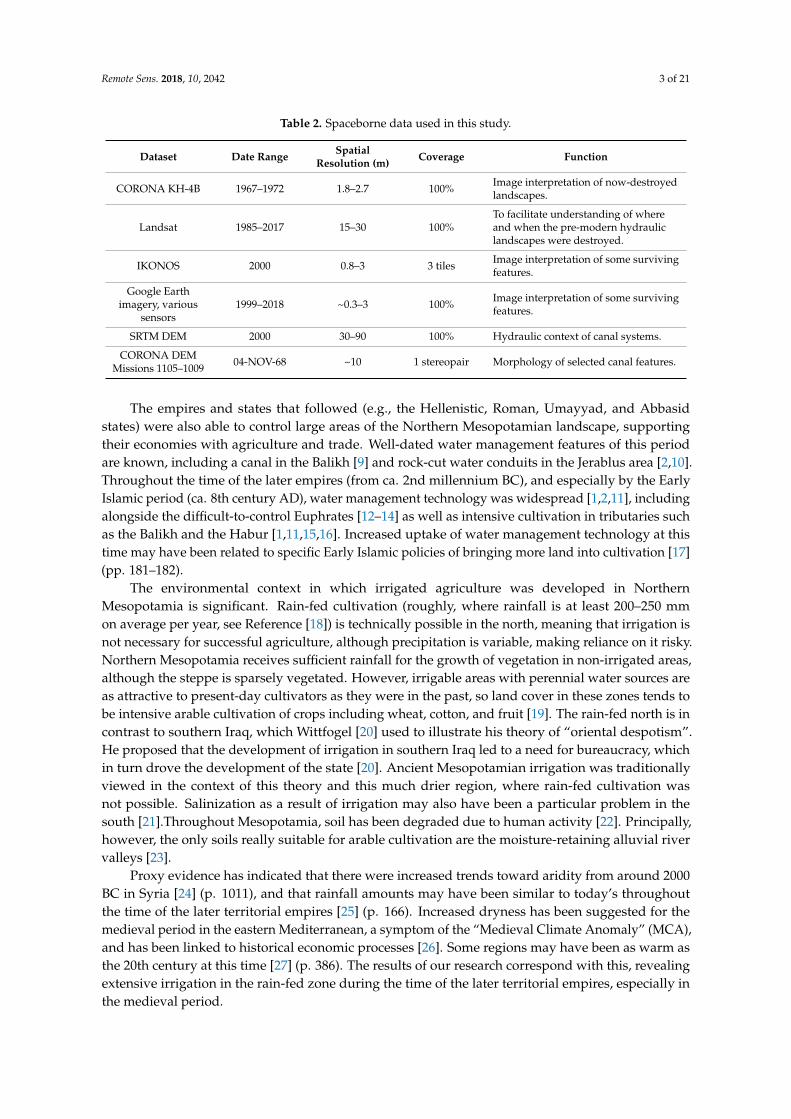

Remote Sens 2018 10 2042 9 of 21
Remote Sens 2018 10 2042 9 of 21
Figure 4 Irrigation systems comprised a series of canals enabling abstraction transport of water and drainage Storage of water could also be incorporated into these systems
However in many cases only a main canal remained visible in the imagery Smaller distributaries do not usually leave traces This includes prominent canals alongside the Euphrates and in northern Iraq [1516] Even the abstraction point tends to be unclear although it can be projected based on the relative levels of the river and fields [1516] Often only the tunnel part of qanats and tunnel irrigation systems have survived without the lateral channels that delivered the water directly to the fields and crops
24 Archaeological Survey and Dating Evidence
Contextualising the evidence with data from archaeological surveys allowed us to link the water management features with dating material in order to understand their chronology for example the work done by Wilkinson to investigate the canals in the Balikh (eg Reference [9] and unpublished data) The significance of the dated canals was then examined further by reference to historical sources [47]
Fieldwork was undertaken at the outset of this project in 2010 in Syria We conducted walk-along surveys of selected irrigation features and of specific locations along others Canals in the Jerablus and Raqqa areas were visited and recorded with some new features identified [24849] Given the difficulty of undertaking further fieldwork in the Middle East at present data were sought from existing published and unpublished surveys and excavations These included Wilkinsonrsquos work in the Balikh [9] and Dibsi Faraj [12] surveys undertaken by Ur [8] and Altaweel [32] in northern
Figure 4 Irrigation systems comprised a series of canals enabling abstraction transport of water anddrainage Storage of water could also be incorporated into these systems
However in many cases only a main canal remained visible in the imagery Smaller distributariesdo not usually leave traces This includes prominent canals alongside the Euphrates and in northernIraq [1516] Even the abstraction point tends to be unclear although it can be projected based on therelative levels of the river and fields [15] Often only the tunnel part of qanats and tunnel irrigationsystems have survived without the lateral channels that delivered the water directly to the fieldsand crops
24 Archaeological Survey and Dating Evidence
Contextualising the evidence with data from archaeological surveys allowed us to link the watermanagement features with dating material in order to understand their chronology for example thework done by Wilkinson to investigate the canals in the Balikh (eg Reference [9] and unpublished data)The significance of the dated canals was then examined further by reference to historical sources [47]
Fieldwork was undertaken at the outset of this project in 2010 in Syria We conducted walk-alongsurveys of selected irrigation features and of specific locations along others Canals in the Jerablusand Raqqa areas were visited and recorded with some new features identified [24849] Given thedifficulty of undertaking further fieldwork in the Middle East at present data were sought fromexisting published and unpublished surveys and excavations These included Wilkinsonrsquos work in theBalikh [9] and Dibsi Faraj [12] surveys undertaken by Ur [8] and Altaweel [32] in northern Iraq andothers throughout Northern Mesopotamia (see References [1516] for more detailed literature reviews)
In a few cases excavation of sections across canal beds had provided organic material from withinthe fill of canals allowing the dates of their construction and use to be obtained Remains from a
Remote Sens 2018 10 2042 10 of 21
section of the Sahlan-Hammam canal excavated by Wilkinson gave an uncalibrated date of 1380 + 70BP (Beta-78543) which is around 570 AD [9] (p 71) placing it within the period of the later empiresSimilarly an Early Islamic date was obtained through excavation of a prominent canal on a terrace ofthe Euphrates which was associated with the Early Islamic site of Dibsi Faraj [12]
At some locations surface surveys alongside the remains of ancient canals yielded datinginformation The Nahr al Abbara in the Balikh was dated to the Early Islamic period in this way [9]Other canals such as the system in the southwest of the Balikh Valley could be more tentatively datedby association with known Islamic features north of Raqqa [15] The features that could be dated tothe period of the later empires through excavation survey or historical evidence and by associationwere plotted on a map (Figure 5)
Remote Sens 2018 10 2042 10 of 21
Iraq and others throughout Northern Mesopotamia (see References [1516] for more detailed literature reviews)
In a few cases excavation of sections across canal beds had provided organic material from within the fill of canals allowing the dates of their construction and use to be obtained Remains from a section of the Sahlan-Hammam canal excavated by Wilkinson gave an uncalibrated date of 1380 + 70 BP (Beta-78543) which is around 570 AD [9] (p 71) placing it within the period of the later empires Similarly an Early Islamic date was obtained through excavation of a prominent canal on a terrace of the Euphrates which was associated with the Early Islamic site of Dibsi Faraj [12]
At some locations surface surveys alongside the remains of ancient canals yielded dating information The Nahr al Abbara in the Balikh was dated to the Early Islamic period in this way [9] Other canals such as the system in the southwest of the Balikh Valley could be more tentatively dated by association with known Islamic features north of Raqqa [15] The features that could be dated to the period of the later empires through excavation survey or historical evidence and by association were plotted on a map (Figure 5)
Figure 5 Ancient water management featuressystems throughout northern Mesopotamia [1281115165051] Although the zone represented by the 200ndash300 mm isohyets technically could support rain-fed agriculture precipitation was highly variable
3 Results
Figure 5 shows the results of applying our methodology to an area of over 100000 km2 A comprehensive map of irrigation at the time of the later empires did not exist prior to this study The image interpretation exercise using CORONA proved to be the only practical way of mapping ancient water management across the entirety of Northern Mesopotamia and revealed over 2900 km of canals and qanats Canals already known in archaeological and historical sources were located for example the Nahr Maslama at Dibsi Faraj [12] and mapped using the CORONA in order to place them within their wider regional context The present study also identified previously unknown features such as a tunnel at Raqqa [15] (Figure 6) By utilising elevation data (SRTM and CORONA DEMs) as well as archaeological and historical records the context of this map of water management could be recognised The combined image elevation and archaeological data allowed distinct irrigation systems with chronological associations to be understood (Table 5) separating these out from channels or linear features of unknown date and context
Figure 5 Ancient water management featuressystems throughout northern Mesopotamia [1281115165051] Although the zone represented by the 200ndash300 mm isohyets technically could supportrain-fed agriculture precipitation was highly variable
3 Results
Figure 5 shows the results of applying our methodology to an area of over 100000 km2A comprehensive map of irrigation at the time of the later empires did not exist prior to this studyThe image interpretation exercise using CORONA proved to be the only practical way of mappingancient water management across the entirety of Northern Mesopotamia and revealed over 2900 kmof canals and qanats Canals already known in archaeological and historical sources were locatedfor example the Nahr Maslama at Dibsi Faraj [12] and mapped using the CORONA in order to placethem within their wider regional context The present study also identified previously unknownfeatures such as a tunnel at Raqqa [1516] By utilising elevation data (SRTM and CORONA DEMs)as well as archaeological and historical records the context of this map of water management couldbe recognised The combined image elevation and archaeological data allowed distinct irrigationsystems with chronological associations to be understood (Table 5) separating these out from channelsor linear features of unknown date and context
Although anthropogenic processes natural erosion and deposition activity of the river haveremoved much of this water management evidence the surviving traces show that canals wereconstructed alongside the Euphrates from at least Dibsi Faraj down to Mari and in the northern reachesof the Tigris and its tributaries Irrigation was also recorded by the tributaries of the Euphrates the SajurHabur and particularly the Balikh Qanats extended the range of cultivable lands in Syria and Iraq
Remote Sens 2018 10 2042 11 of 21
Table 5 Water management systems recorded by this study using satellite data
Chronological Period Water Management Systems Key References
Pre-1st millennium BCCanal at Tell Fray [52]Some canals alongside the Euphrates between Balikh and Mari [14]
1st millennium BCCanals in northern Iraq [6ndash832]Canal at Carchemish [1648]Origin of canals alongside Habur [3353]
Hellenisticndashlate RomanCanal and rock-cut conduits in Jerablus area [1648]Sahlan-Hamman canal and Qara Mokh canals in Balikh [911]Qanats south of Membij [151654]
Early Islamic (8thndash15thcenturies AD)
Large embanked canal between Tell Fray and Qalat Jabar [16]
Large embanked canal at Dibsi Faraj and qanat [112]Canals in Balikh Valley north of Raqqa [11516]Canals in Balikh Valley west of Raqqa [111516]
Qanats a tunnel and canals around Raqqa [111516]
Canals alongside the Habur [53]
Nahr Dawrin Nahr Sarsquoid Large embanked canals on both banks ofthe Euphrates between the Balikh and Mari [13ndash16]
Some of the large embanked canals in northern Iraq Tarbisu canaland Nahr Qanausa [832]
Qanats on the Sinjar Plain [1516]
We mapped pre-Islamic water management features in Northern Mesopotamia including rock-cutconduits near Jerablus (investigated during fieldwork see References [1648]) and Hellenistic qanatsaround Membij (dated by a historical source see Reference [54]) Although some of the tracesof large embanked channels alongside the Euphrates have been attributed to the pre-Islamic era(eg Reference [14]) it can be argued the technology capable of facilitating this may not have beenwidely applied until the medieval period [55] (p 115) Tributaries such as the Balikh and the Haburwere easier to irrigate from attested by a likely Assyrian origin for canals alongside the Habur [33] andsome Hellenisticndashlate Roman canals in the Balikh dated through excavation radiocarbon dating surfacesurvey and association with dated sites (eg the Sahlan-Hammam canal Figure 6 References [911])The Neo-Assyrian canals in northern Iraq are already well-known although it is important to note someof the canals in northern Iraq have been attributed to the Early Islamic period (see References [832])
Early Islamic canals were constructed and maintained alongside the Euphrates for example thelarge embanked canals of the Nahr Maslama Nahr Dawrin and Nahr Sarsquoid which are referred to inIslamic texts (see Reference [1516]) The canals alongside the Habur may also have been used into theEarly Islamic period and a possible connection to the Nahr Dawrin has been proposed [151656]
Especially in the Balikh the analysis of systems that were reasonably preserved at the time of theCORONA images showed a high degree of sophistication and represented hydrological knowledgebefore the modern era (see Figures 7 and 8) The Nahr Al Abbara dated through surface survey [9]abstracted water to the north near Tell Sahlan which it transported in a main canal for over 15 km (seeFigures 7 and 8) Traces of an earlier phase of canal on the same alignment could be identified in placesusing the CORONA imagery (see [2] Figure 6 38) Water was delivered to fields via laterals branchingoff the main channel at fairly regular intervals During a surface survey Wilkinson [9] (p 68) recordedlarge stone blocks that may have functioned as part of sluice structures As the SRTM DEM confirmedthe overall gradient of the landscape of the Balikh is very flat but the Nahr Al Abbara system mitigatedagainst it by running the main canal at a low gradient (approximately 01) along a slight and somewhatnarrow ridge (see [11] Figure 6) The CORONA DEM (Figure 9) allowed this to be visualised at higherresolution The main canal could flow for a greater distance but at the same time the offtakes could attaina slightly steeper gradient (approximately 05) The system also incorporated drainage provision intothe Balikh and into the fairly wide basin of a seasonal runoff stream to the east the Wadi al Keder andmay have been associated with a complex layout of spring water channels and drainage systems (see [11]Figures 7 and 8) There are several Early Islamic settlements nearby including Medinet al Farr and
Remote Sens 2018 10 2042 12 of 21
Khirbet Ambar which are known through historical sources and archaeological investigations [5758]It is likely that these sites were involved in the administration of irrigation in the area
Remote Sens 2018 10 2042 11 of 21
Figure 6 The eroded and infilled remains of the Sahlan-Hammam canal in the 1990s when Tony Wilkinson visited Tony provides scale
Table 5 Water management systems recorded by this study using satellite data
Chronological Period Water Management Systems Key References
Pre-1st millennium BC Canal at Tell Fray [52] Some canals alongside the Euphrates between Balikh and Mari [14]
1st millennium BC Canals in northern Iraq [6ndash832] Canal at Carchemish [1648] Origin of canals alongside Habur [3353]
Hellenisticndashlate Roman Canal and rock-cut conduits in Jerablus area [1648] Sahlan-Hamman canal and Qara Mokh canals in Balikh [911] Qanats south of Membij [151654]
Early Islamic (8thndash15th centuries AD)
Large embanked canal between Tell Fray and Qalat Jabar [16] Large embanked canal at Dibsi Faraj and qanat [112] Canals in Balikh Valley north of Raqqa [115] Canals in Balikh Valley west of Raqqa [1115] Qanats a tunnel and canals around Raqqa [1115] Canals alongside the Habur [53] Nahr Dawrin Nahr Sarsquoid Large embanked canals on both banks of the Euphrates between the Balikh and Mari
[131416]
Some of the large embanked canals in northern Iraq Tarbisu canal and Nahr Qanausa
[832]
Qanats on the Sinjar Plain [1516]
Although anthropogenic processes natural erosion and deposition activity of the river have removed much of this water management evidence the surviving traces show that canals were constructed alongside the Euphrates from at least Dibsi Faraj down to Mari and in the northern reaches of the Tigris and its tributaries Irrigation was also recorded by the tributaries of the Euphrates the Sajur Habur and particularly the Balikh Qanats extended the range of cultivable lands in Syria and Iraq
We mapped pre-Islamic water management features in Northern Mesopotamia including rock-cut conduits near Jerablus (investigated during fieldwork see References [1648]) and Hellenistic qanats around Membij (dated by a historical source see Reference [54]) Although some of the traces of large embanked channels alongside the Euphrates have been attributed to the pre-Islamic era (eg Reference [14]) it can be argued the technology capable of facilitating this may not have been widely applied until the medieval period [55] (p 115) Tributaries such as the Balikh and the Habur were
Figure 6 The eroded and infilled remains of the Sahlan-Hammam canal in the 1990s when TonyWilkinson visited Tony provides scaleRemote Sens 2018 10 2042 13 of 21
Figure 7 Irrigation systems in the Balikh Valley
Figure 8 The channel of the Nahr al Abbara canal system is marked with arrows (1968 CORONA image)
Figure 7 Irrigation systems in the Balikh Valley
Remote Sens 2018 10 2042 13 of 21
An extensive set of canals in the southwest horseshoe of the Balikh Valley may also be EarlyIslamic based on a connection with known sites (Figure 10A see Reference [11]) Most significantlyin the south the CORONA images showed several water management features associated with theEarly Islamic city of Raqqa which was particularly prominent as a capital city during the Abbasid erawith palaces and an industrial area The city itself and its immediate hinterland appears to have beenwatered by qanats with a northern palace complex supplied by a tunnel stemming from the QaraMokh stream as well as the Balikh [111516]
Overall historical sources present a picture of intensive irrigated cultivation in NorthernMesopotamia in the Early Islamic period [47] Even away from the main perennial water sourcesqanats extended the cultivable area The CORONA images revealed an area of dense qanat irrigationradiating from the town of Sinjar in Iraq which may be medieval in date [59] (discussed in more detailin Reference [16])
Remote Sens 2018 10 2042 13 of 21
Figure 7 Irrigation systems in the Balikh Valley
Figure 8 The channel of the Nahr al Abbara canal system is marked with arrows (1968 CORONA image) Figure 8 The channel of the Nahr al Abbara canal system is marked with arrows (1968 CORONA image)Remote Sens 2018 10 2042 14 of 21
Figure 9 10 m spatial resolution DEM constructed using a CORONA stereopair
Figure 10 (A) Relict canals in the southwest Balikh Valley in 1968 which were (B) destroyed and replaced with a new irrigation system in 1972 (CORONA images)
4 Discussion
This research revealed an intensification of irrigation in most of the cultivable areas of Early Islamic Northern Mesopotamia particularly in the Balikh Valley The transformation of the environment that we observed fits the concept of ldquohydraulic landscapesrdquo Historical accounts and archaeological excavations have indicated that Raqqa was temporarily the centre of the Abbasid empire and a significant industrial town (eg see Reference [60]) which may offer an explanation for the intensification of water management features at this time In addition medieval irrigation in the Balikh may have been a response to deliberate policies of bringing marginal land into cultivation [17] policies that explain the increased application of water management technology throughout Northern Mesopotamia in the Early Islamic period This is an area where irrigation was not necessary but where employing it would have increased the reliability and quantity of agricultural yields developing and supporting powerful and demanding imperial economies Many existing hydraulic landscapes were maintained and developed while new ones were created in response to incentives
This intensive use of the landscape must have declined because until the later 20th century cultivation in Northern Mesopotamia was largely reported to be reliant on rainfall [61] (p 137) This transition followed the Early Islamic period By the 15th century the ancient water systems of Mesopotamia were falling into disrepair possibly due to plague and the depredations of the Mongols with subsequent depopulation and upheaval (eg see References [151662]) In many areas agriculture did not seem to have intensified again until the 2nd half of the 20th century
Figure 9 10 m spatial resolution DEM constructed using a CORONA stereopair
Remote Sens 2018 10 2042 14 of 21
4 Discussion
This research revealed an intensification of irrigation in most of the cultivable areas of Early IslamicNorthern Mesopotamia particularly in the Balikh Valley The transformation of the environment thatwe observed fits the concept of ldquohydraulic landscapesrdquo Historical accounts and archaeologicalexcavations have indicated that Raqqa was temporarily the centre of the Abbasid empire anda significant industrial town (eg see Reference [60]) which may offer an explanation for theintensification of water management features at this time In addition medieval irrigation in theBalikh may have been a response to deliberate policies of bringing marginal land into cultivation [17]policies that explain the increased application of water management technology throughout NorthernMesopotamia in the Early Islamic period This is an area where irrigation was not necessary but whereemploying it would have increased the reliability and quantity of agricultural yields developing andsupporting powerful and demanding imperial economies Many existing hydraulic landscapes weremaintained and developed while new ones were created in response to incentives
This intensive use of the landscape must have declined because until the later 20th centurycultivation in Northern Mesopotamia was largely reported to be reliant on rainfall [61] (p 137)This transition followed the Early Islamic period By the 15th century the ancient water systems ofMesopotamia were falling into disrepair possibly due to plague and the depredations of the Mongolswith subsequent depopulation and upheaval (eg see References [151662]) In many areas agriculturedid not seem to have intensified again until the 2nd half of the 20th century although traces of theancient irrigation systems remained embedded in the landscape until very recently (see travellersrsquoaccounts of abandoned canals eg [6364])
More recently however modern agricultural strategies in the Middle East have completelytransformed the landscape replacing ancient man-made hydraulic pathways with large-scale damsand canal systems and pumping from individual wells Many ancient irrigation systems have beenabandoned and destroyed to make way for new irrigation schemes A remote sensing methodologyusing interpretation from CORONA images dating from the period 1967ndash1972 proved to be a veryeffective strategy for recording ancient water management and for mapping its spread and distribution
When CORONA images (1968 and 1972) were compared (Figure 10) the initial construction ofthe modern field and irrigation systems in the 1970s Balikh is apparent This highlights the timelinessof the 1960s images which represent the last record of most of the ancient canal systems presented inFigures 5 and 7
Remote Sens 2018 10 2042 14 of 21
Figure 9 10 m spatial resolution DEM constructed using a CORONA stereopair
Figure 10 (A) Relict canals in the southwest Balikh Valley in 1968 which were (B) destroyed and replaced with a new irrigation system in 1972 (CORONA images)
4 Discussion
This research revealed an intensification of irrigation in most of the cultivable areas of Early Islamic Northern Mesopotamia particularly in the Balikh Valley The transformation of the environment that we observed fits the concept of ldquohydraulic landscapesrdquo Historical accounts and archaeological excavations have indicated that Raqqa was temporarily the centre of the Abbasid empire and a significant industrial town (eg see Reference [60]) which may offer an explanation for the intensification of water management features at this time In addition medieval irrigation in the Balikh may have been a response to deliberate policies of bringing marginal land into cultivation [17] policies that explain the increased application of water management technology throughout Northern Mesopotamia in the Early Islamic period This is an area where irrigation was not necessary but where employing it would have increased the reliability and quantity of agricultural yields developing and supporting powerful and demanding imperial economies Many existing hydraulic landscapes were maintained and developed while new ones were created in response to incentives
This intensive use of the landscape must have declined because until the later 20th century cultivation in Northern Mesopotamia was largely reported to be reliant on rainfall [61] (p 137) This transition followed the Early Islamic period By the 15th century the ancient water systems of Mesopotamia were falling into disrepair possibly due to plague and the depredations of the Mongols with subsequent depopulation and upheaval (eg see References [151662]) In many areas agriculture did not seem to have intensified again until the 2nd half of the 20th century
Figure 10 (A) Relict canals in the southwest Balikh Valley in 1968 which were (B) destroyed andreplaced with a new irrigation system in 1972 (CORONA images)
Remote Sens 2018 10 2042 15 of 21
While modern imagery such as IKONOS has been available for the study area since about 2000(Table 1) these images postdate major land use change that led to the destruction of most of the ancientcanals and therefore CORONA images are the only way of recording now-destroyed canal systemsFigure 11 shows how changes around the city of Raqqa between the 1960s and 2000s meant thatmuch of Early Islamic Raqqa and its environs (visible in the CORONA Figure 11A) had already beendestroyed by the time the IKONOS image (Figure 11B) was collected
Remote Sens 2018 10 2042 15 of 21
although traces of the ancient irrigation systems remained embedded in the landscape until very recently (see travellersrsquo accounts of abandoned canals eg [6364])
More recently however modern agricultural strategies in the Middle East have completely transformed the landscape replacing ancient man-made hydraulic pathways with large-scale dams and canal systems and pumping from individual wells Many ancient irrigation systems have been abandoned and destroyed to make way for new irrigation schemes A remote sensing methodology using interpretation from CORONA images dating from the period 1967ndash1972 proved to be a very effective strategy for recording ancient water management and for mapping its spread and distribution
When CORONA images (1968 and 1972) were compared (Figure 10) the initial construction of the modern field and irrigation systems in the 1970s Balikh is apparent This highlights the timeliness of the 1960s images which represent the last record of most of the ancient canal systems presented in Figures 5 and 7
While modern imagery such as IKONOS has been available for the study area since about 2000 (Table 1) these images postdate major land use change that led to the destruction of most of the ancient canals and therefore CORONA images are the only way of recording now-destroyed canal systems Figure 11 shows how changes around the city of Raqqa between the 1960s and 2000s meant that much of Early Islamic Raqqa and its environs (visible in the CORONA Figure 11A) had already been destroyed by the time the IKONOS image (Figure 11B) was collected
Figure 11 (A) CORONA image (May 1968) showing Early Islamic features of Raqqa including the 8th century AD walled city palace structures to the north of this and canals (B) IKONOS image (27 March 2000) showing that most of the medieval features were destroyed by modern buildings fields and roads
The Landsat sequence shows the intensification of agriculture underway from the 1980s (Figures 12 and 13) In Syria this was part of a programme involving construction of the Tabqa dam in 1966 30 km upstream of Raqqa [61] Figure 13 highlights the Balikh where we identified many ancient canal networks that corresponded neatly to the areas of modern irrigated agriculture highlighted by using a false colour visualisation By the 21st century modern agriculture had expanded throughout the valley including new fields and irrigation networks in the south the area known as the ldquohorseshoerdquo where several ancient canals supplied Early Islamic palaces and urban areas around Raqqa Recent disruption to irrigation infrastructure has been reported in the region due to the current conflict in Syria [1965] which is demonstrated by a slight reduction in the vegetated area between the 2010ndash2011 and 2016ndash2017 Landsat composites
Figure 11 (A) CORONA image (May 1968) showing Early Islamic features of Raqqa including the8th century AD walled city palace structures to the north of this and canals (B) IKONOS image(27 March 2000) showing that most of the medieval features were destroyed by modern buildingsfields and roads
The Landsat sequence shows the intensification of agriculture underway from the 1980s(Figures 12 and 13) In Syria this was part of a programme involving construction of the Tabqadam in 1966 30 km upstream of Raqqa [61] Figure 13 highlights the Balikh where we identifiedmany ancient canal networks that corresponded neatly to the areas of modern irrigated agriculturehighlighted by using a false colour visualisation By the 21st century modern agriculture had expandedthroughout the valley including new fields and irrigation networks in the south the area known asthe ldquohorseshoerdquo where several ancient canals supplied Early Islamic palaces and urban areas aroundRaqqa Recent disruption to irrigation infrastructure has been reported in the region due to the currentconflict in Syria [1965] which is demonstrated by a slight reduction in the vegetated area between the2010ndash2011 and 2016ndash2017 Landsat composites
Figure 12 shows a Landsat false colour composite of a large part of the Euphrates river in Syria in1985 and 1986 and again in 2016 and 2017 with Lake Assad in the top left and the Balikh and Haburtributaries joining from the north Figure 13 zooms in on the Syrian Balikh The red colours in theLandsat images seen in Figures 12 and 13 show the distribution of modern productive agriculturalland where changes shown in both figures reflect the intensification of agriculture the effect of whichhas been to remove traces of ancient water features The Landsat images emphasise the particularimportance of the Balikh which represents a large area of agricultural production within the wholeEuphrates valley The TurkeyndashSyria border can be clearly seen in the imagery (Figure 12) becauseof the contrast in water available for irrigation this serves as a reminder of the importance of thegeopolitics of water resources in the region from ancient times right up to the present day
Remote Sens 2018 10 2042 16 of 21Remote Sens 2018 10 2042 16 of 21
Figure 12 False colour Landsat composites showing the intensification of agriculture in Northern Mesopotamia over the past 40 years (A) Landsat 5 composite 1985ndash1986 (B) Landsat 8 composite 2016ndash2017 Images downloaded and mosaicked using Google Earth Engine
Figure 13 Landsat composites showing the expansion of modern irrigation in the Balikh (A) Landsat 5 1985ndash1986 (B) Landsat 7 2010ndash2011 (C) Landsat 8 2016ndash2017 Images downloaded and mosaicked using Google Earth Engine and visualised as false colour composites
Figure 12 False colour Landsat composites showing the intensification of agriculture in NorthernMesopotamia over the past 40 years (A) Landsat 5 composite 1985ndash1986 (B) Landsat 8 composite2016ndash2017 Images downloaded and mosaicked using Google Earth Engine
Remote Sens 2018 10 2042 16 of 21
Figure 12 False colour Landsat composites showing the intensification of agriculture in Northern Mesopotamia over the past 40 years (A) Landsat 5 composite 1985ndash1986 (B) Landsat 8 composite 2016ndash2017 Images downloaded and mosaicked using Google Earth Engine
Figure 13 Landsat composites showing the expansion of modern irrigation in the Balikh (A) Landsat 5 1985ndash1986 (B) Landsat 7 2010ndash2011 (C) Landsat 8 2016ndash2017 Images downloaded and mosaicked using Google Earth Engine and visualised as false colour composites
Figure 13 Landsat composites showing the expansion of modern irrigation in the Balikh (A) Landsat5 1985ndash1986 (B) Landsat 7 2010ndash2011 (C) Landsat 8 2016ndash2017 Images downloaded and mosaickedusing Google Earth Engine and visualised as false colour composites
There are some caveats to a methodology that relies principally on image interpretation Whetheror not water management features can be identified depends on a number of factors including imagequality and timing and natural conditions We identified rock-cut conduits and tunnels alongside
Remote Sens 2018 10 2042 17 of 21
dry streams in the Jerablus region during a survey in 2010 [48] that were not visible in the CORONA(1967 and 1972) and modern imagery There may well be other ancient irrigation features throughoutnorthern Syria and Iraq that have not yet been identified However many of the features we identifiedin the CORONA images were no longer visible on the ground having been destroyed to make way formodern agriculture This included the Nahr al Abbara canal system in the Balikh
Working with CORONA was difficult due to the panoramic and historical nature of the dataThe panoramic frames were distorted (eg see Reference [41] (p 228) Reference [66]) especiallytoward the edges and some image acquisition parameters were not available making constructing anaccurate camera model challenging The quality and time of collection of different images was variableSome higher resolution modern imagery was examined for example IKONOS imagery covering thearea around Raqqa in the southern Balikh However it was found that recent landscape changes haddestroyed much of the archaeology (see Figure 11) The CORONA data were often of the best timeperiod consistency of image quality (spatial and radiometric) and availability for large area coveragemaking it ideal for recording ancient water management features In fact we were able to obtainCORONA imagery for our entire 100000 km2 study area
5 Conclusions
Declassified CORONA satellite images from the 1960s and early 1970s are used to identify andreconstruct ancient hydraulic landscapes over large geographic areas The CORONA KH-4B camerahas stereoscopic capability which helps to identify and interpret water management features When theCORONA images were analysed in conjunction with modern satellite imagery DEMs and contextualinformation from archaeological and historical surveys the trajectory of the development of irrigationtechnology becomes clear
This study mapped water management features from the period ca 1200 BC to AD 1500 acrossthe entirety of Northern Mesopotamia for the first time (Figure 5) Irrigation increased in densitythroughout the region including within the zone traditionally regarded as ldquorain-fedrdquo and revealeda peak in the Early Islamic era Environmental considerations for understanding why and whereirrigation was undertaken during the period of the later empires also helped us to contextualise theresults An average rainfall of 200ndash250 mm a year is often interpreted as the limit of rain-fed cultivationfor modern and ancient agriculture (eg see References [186768]) and depicted as an isohyet lineHowever an analysis of modern rain gauge data indicates that much of the area encompassed byancient irrigation (receiving approximately 100ndash400 mm per year) experiences high variability today(20ndash40 see Reference [2] (p 158)) which makes irrigation necessary to mitigate against irregularrainfall [65] (p 5) If rainfall was similarly variable during the period of the later empires (eg atthe time of the MCA) our data suggests that they were investing in large-scale irrigation in a regionwhere rain-fed cultivation was technically possible but where it was risky due to the variability ofprecipitation Unlike in Southern Mesopotamia irrigation was not absolutely necessary for agriculturein Northern Mesopotamia but the construction of water management features was a way to ensureaccess to water in order to mitigate against disruptions to food supply
It is unlikely to be a coincidence that irrigation activity was intensified during the era of the firsttrue territorial empires when these powerful entities exerted and contested political control over thelandscape It is apparent that from the Neo-Assyrian period and by the Early Islamic period most ofthe perennial water courses in Northern Mesopotamia were used as sources of irrigation water andthat available groundwater was utilised The water management systems that we recorded includedmany reticulated and sophisticated systems that supported powerful states represented by traces ofprominent channels alongside the main rivers dense networks of irrigation in the tributaries andsignificant groundwater exploitation using qanats Many canals and parts of canal systems wouldhave been missed if examined through fieldwork alone Through interpretation of satellite imagesthis study was able to locate and map some previously unknown or understudied systems suchas numerous qanats in the Sinjar Plain of Iraq [1516] the qanat at Dibsi Faraj in Syria [1] and the
Remote Sens 2018 10 2042 18 of 21
real complexity of irrigation in the Balikh Valley in Syria [1111516] The combination of remotesensing archived data and fieldwork enabled further chronological and historical contextualisation ofthese remains
If fieldwork should become possible in the near future this reconstruction of ancient watermanagement in Northern Mesopotamia would benefit from ground sample testing using scientificdating techniques such as optically stimulated luminescence (OSL) (eg see Reference [69]) The use ofunmanned aerial vehicles (UAVs) dGPS and newer high-resolution DEMs such as TanDEM-X wouldprovide improved control data for photogrammetric processing of CORONA Several significant areasof relict channels require further investigation (for example qanats around Membij and Sinjar seeReferences [1516]) which itself might enable increased protection of this archaeological resource Dueto the current risk of looting and vandalism to archaeological sites in Mesopotamia it is not possible tomake the GIS database of canal locations publically available but these can be provided to verifiedheritage professionals via the EAMENA database if requested [70]
Conflict in Syria and Iraq has led to an ongoing humanitarian crisis and has impacted severelyon cultural heritage with deliberate destruction of many monumental sites including some of theIslamic remains in Raqqa Satellite imagery is being extensively used to highlight the destruction ofarchaeology in the Middle East during conflict [71] although its efficacy as a solution to stopping thedestruction is unclear Media reports often draw attention to damage to large monumental sites whilethe routine destruction of ancient canals by modern agricultural and urban development is frequentlyoverlooked Water management features may not be a particular target for vandalism but longer-termland use changes have wiped out many of their traces from the landscape making CORONA the lastrecord of the intensive hydraulic landscapes of the ancient empires
Supplementary Materials The following are available online at httpwwwmdpicom2072-429210122042s1 CORONA DEM triangulation reports Landsat comparisons SRTM CORONA and Landsat data availablefrom the US Geological Survey
Author Contributions Conceptualization LR and DD formal analysis LR funding acquisition DDinvestigation LR methodology LR and DD project administration LR supervision DD visualization LRwritingmdashoriginal draft LR writingmdashreview and editing LR and DD
Funding This PhD research was funded by the Faculty of Social Sciences and Health Durham University
Acknowledgments We would particularly like to acknowledge the role of the late Tony Wilkinson in supervisingsupporting and encouraging this research and for providing information about his surveys in the Balikh Valley
Conflicts of Interest The authors declare no conflicts of interest The funders had no role in the design of thestudy in the collection analyses or interpretation of data in the writing of the manuscript or in the decision topublish the results
References
1 Wilkinson TJ Rayne L Hydraulic Landscapes and Imperial Power in the near East Water Hist 2010 2115ndash144 [CrossRef]
2 Rayne L Water and Territorial Empires The Application of Remote Sensing Techniques to Ancient ImperialWater Management in Northern Mesopotamia PhD Thesis University of Durham Durham UK 2014
3 Schneider U Becker A Meyer-Christoffer M Ziese B Global Precipitation Analysis Products of theGpcc Available online httpwwwcgducareducascatalogsurfaceprecipgpcchtml (accessed on14 December 2018)
4 Wilkinson TJ Archaeological Landscapes of the near East University of Arizona Press Tucson AZ USA 20035 Oded B Mass Deportations and Deportees in the Neo-Assyrian Empire L Reichert Depew NY USA 19796 Jacobsen T Lloyd S Sennacheribrsquos Aqueduct at Jerwan University of Chicago Press Chicago IL USA 19557 Dalley S Nineveh Babylon and the Hanging Gardens Cuneiform and Classical Sources Reconciled Iraq
1994 56 45ndash58 [CrossRef]8 Ur J Sennacheribrsquos Northern Assyrian Canals New Insights from Satellite Imagery and Aerial Photography
Iraq 2005 67 317ndash345 [CrossRef]
Remote Sens 2018 10 2042 19 of 21
9 Wilkinson TJ Water and Human Settlement in the Balikh Valley Syria Investigations from 1992ndash1995J Field Archaeol 1998 25 63ndash87
10 Wilkinson TJ Peltenburg E McCarthy A Wilkinson EB Brown M Archaeology in the Land ofCarchemisch Landscape Surveys in the Area of Jerablus Tahtani 2006 Levant 2007 39 213ndash247 [CrossRef]
11 Rayne L Imperial Water Systems and Human Niche Construction in the Balikh Valley Water Hist 2015 7419ndash440 [CrossRef]
12 Harper RP Wilkinson TJ Excavations at Dibsi Faraj Northern Syria 1972ndash1974 A Preliminary Note onthe Site and Its Monuments with an Appendix Dumbarton Oaks Papers 1975 29 319ndash338 [CrossRef]
13 Berthier S DrsquoHont O Ressources Hydriques Et Peuplement Sur Le Moyen Euphrate Viiegraveme-Xix EgravemeSiegravecle In Proceedings of the RURALIA 2003 Lyon France 17 September 2003
14 Geyer B Monchambert JY La Basse Valleacutee De Lrsquoeuphrate Syrien Du Neacuteolithique Agrave Lrsquoavegravenement De LrsquoislamGeacuteographie Archeacuteologie Et Histoire IFAPO Paris France 2003
15 Rayne L Early Islamic Water Management in Northern Mesopotamia In Economic Integration and SocialChange in the Islamic World System 800ndash1000 Ce The Geography and Infrastructure of Trade in Early IslamBessard F Kennedy H Eds Oxford University Press Oxford UK in press
16 Rayne L Early Islamic Water Management in the Hinterland of Raqqa In New Agendas in Remote Sensing andLandscape Archaeology in the Near East Studies in Honor of T J Wilkinson Altaweel M Lawrence D Philip GEds Oriental Institute of the University of Chicago Chicago IL USA in press
17 Kennedy HN The Feeding of the Five Hundred Thousand Cities and Agriculture in Early IslamicMesopotamia Iraq 2011 73 177ndash199 [CrossRef]
18 Perrin de Brichambaut G Walleacuten CC FaoUnescoWmo Interagency Project on Agroclimatology 1962 DraftGeneral Report on a Study of Agroclimatology in Semi-Arid and Arid Zones of the Near East FAO Rome Italy 1962
19 Counting the Cost Agriculture in Syria after Six Years of Crisis Available online httpwwwfaoorgemergenciesresourcesdocumentsresources-detailenc878213 (accessed on 11 November 2018)
20 Wittfogel K Oriental Despotism A Comparative Study of Total Power Yale University Press New Haven CTUSA London UK 1957
21 Christensen P The Decline of Iranshahr Irrigation and Environments in the History of the Middle East 500 Bc toAd 1500 Museum Tusculanum Press Copenhagen Denmark 1993
22 Fisher WB The Middle East A Physical Social and Regional Geography 7th ed Completely Revised and Reseted Methuen London UK 1978
23 Jewitt TN Soils of Arid Lands In Arid Lands A Gographical Appraisal Hills ES Ed Methuen and Co LtdLondon UK 1966
24 Riehl S Bryson R Pustovoytov K Changing Growing Conditions for Crops During the near Eastern BronzeAge (3000ndash1200 Bc) The Stable Carbon Isotope Evidence J Archaeol Sci 2008 35 1011ndash1022 [CrossRef]
25 Bar-Matthews M Ayalon A Kaufman A Late Quaternary Paleoclimate in the Eastern MediterraneanRegion from Stable Isotope Analysis of Speleothems at Soreq Cave Israel Quat Res 1997 47 155ndash168[CrossRef]
26 Xoplaki E Fleitmann D Luterbacher J Wagner S Haldon JF Zorita E Telelis I Toreti A Izdebski AThe Medieval Climate Anomaly and Byzantium A Review of the Evidence on Climatic FluctuationsEconomic Performance and Societal Change Quat Sci Rev 2016 136 229ndash252 [CrossRef]
27 IPCC Climate Change 2013 The Physical Science Basis Contribution of Working Group I to the Fifth AssessmentReport of the Intergovernmental Panel on Climate Change Stocker TF Qin D Plattner G-K Tignor MAllen SK Boschung J Nauels A Xia Y Bex V Midgley PM Eds Cambridge University PressCambridge UK 2013
28 Kamash Z Archaeologies of Water in the Roman near East 63 Bc-Ad 636 Piscataway Gorgias Press PiscatawayNJ USA 2010
29 Kamash Z Water Supply and Management in the Near East 63 Bc-Ad 636 PhD Thesis University ofOxford Oxford UK 2007
30 Philip G Donoghue DNM Beck A Galiatsatos N Corona Satellite Photography An ArchaeologicalApplication from the Middle East Antiquity 2002 76 109ndash118 [CrossRef]
31 David K Bewley R Aerial Archaeology in Jordan Antiquity 2009 83 69ndash8132 Altaweel M The Imperial Landscape of Ashur Settlement and Land Use in the Assyrian Heartland OrientVerlag
Heidelberg Germany 2008
Remote Sens 2018 10 2042 20 of 21
33 Van Liere WJ Lauffray J Nouvelle Prospection Archaeologique Dans La Haute Jazireh Syrienne Les AnnalsArchaeologiques De Syrie 1954ndash1955 4 129ndash148
34 Gorelick N Hancher M Dixon M Ilyushchenko S Thau D Moore R Google Earth EnginePlanetary-Scale Geospatial Analysis for Everyone Remote Sens Environ 2017 202 18ndash27 [CrossRef]
35 Galiatsatos N Wilkinson TJ Donoghue DNM Philip G The Fragile Crescent Project (Fcp) Analysis ofSettlement Landscapes Using Satellite Imagery Available online httpdroduracuk6909 (accessed on18 December 2018)
36 Casana J Cothren J The Corona Atlas Project Orthorectification of Corona Satellite Imagery andRegional-Scale Archaeological Exploration in the near East In Mapping Archaeological Landscapes fromSpace Comer DC Harrower MJ Eds Springer Berlin Germany 2013
37 Farr TG Rosen PA Caro E Crippen R Duren R Hensley S Kobrick M Paller M Rodriguez ERoth L The Shuttle Radar Topography Mission Rev Geophys 2007 45 [CrossRef]
38 Schmidt M Goossens R Menz G Altmaier A Devriendt D The Use of Corona Satellite Images forGenerating a High Resolution Digital Elevation Model Paper Presented at the IEEE 2001 InternationalGeoscience and Remote Sensing Symposium Sydney NSW Australia 9ndash13 July 2001
39 Mugnier CJ Forstner W Wrobel B Paderes F Munjy R The Mathematics of Photogrammetry InManual of Photogrammetry McGlone JC Ed American Society of Photogrammetry and Remote SensingBethseda MD USA 2004 pp 181ndash316
40 Wong KW Basic Mathematics of Photogrammetry In Manual of Photogrammetry Slama CC Ed AmericanSociety of Photogrammetry Falls Church VA USA 1980 pp 37ndash101
41 Altmaier A Kany C Digital Surface Model Generation from Corona Satellite Images ISPRS J PhotogrammRemote Sens 2002 56 221ndash235 [CrossRef]
42 USGS Declassified Satellite Imagerymdash1 Available online httpsltacrusgsgovdeclass_1 (accessed on 18December 2018)
43 Galiatsatos N Donoghue DNM Philip G High Resolution Elevation Data Derived from StereoscopicCorona Imagery with Minimal Ground Control Photogramm Eng Remote Sens 2007 73 1093ndash1106 [CrossRef]
44 Casana J Cothren J Stereo Analysis Dem Extraction and Orthorectification of Corona Satellite ImageryArchaeological Applications from the near East Antiquity 2008 82 732ndash749 [CrossRef]
45 Boyle R Thomas RC Computer Vision A First Course Blackwell Scientific Publications Ltd Hoboken NJUSA 1988
46 Ur J Wilkinson TJ Settlement and Economic Landscapes of Tell Beydar and Its Hinterland Brepols TurnhoutBelgium 2008
47 Le Strange G The Lands of the Eastern Caliphate Mesopotamia Persia and Central Asia from the Moslem Conquestto the Time of Timur Cambridge University Press Cambridge UK 1905
48 Peltenburg E Wilkinson TJ Wilkinson EB Carchemish in Context Oxbow Books Oxford UK 201649 Wilkinson EB Wilkinson TJ Peltenburg E Revisiting Carchemish The Land of Carchemish Project in
Syria 2009 and 2010 Antiquity Bull 2011 85 329ndash33250 Ur J de Jong L Giraud J Osborne JF MacGinnis J Ancient Cities and Landscapes in the Kurdistan
Region of Iraq The Erbil Plain Archaeological Survey 2012 Season Iraq 2013 75 89ndash118 [CrossRef]51 Ur J Tell Hamoukar Volume 1 Urbanism and Cultural Landscapes in Northeastern Syria The Tell Hamoukar Survey
1999ndash2001 The Oriental Institute of the University of Chicago Chicago IL USA 201052 Bounni A Campaign and Exhibition from the Euphrates in Syria Annu Am Schools Orient Res 1977 44
1ndash453 Ergenzinger PJ Kuumlhne H Ein Regionales Bewaumlsserungssystem Am Habur In Die Rezente Umwelt Von Tell
Sheikh Hamad Und Daten Zur Umweltrekonstruktion Der Assyrischen Stadt Dur-Katlimmu Berichte Aus DerAusgrabungen Tell Sheikh HamadDur-Katlimmu Dietrich Reimer Verlag Berlin Germany 1991
54 Lightfoot JL Lucian on the Syrian Goddess Oxford University Press Oxford UK 200355 Van Liere WJ Lauffray J Capitals and Citadels of Bronze-Iron Syria in Their Relationship to Land and
Water Les Annales Archaeol De Syrie 1963 13 107ndash12256 Berthier S Peuplement Rural Et Ameacutenagements Hydroagricoles Dans La Moyenne Valleacutee De Lrsquoeuphrate Fin
Viie-Xixe Siegravecle Reacutegion De Deir Ez Zor-Abu Kemal Syrie Mission Meacutesopotamie Syrienne Archeacuteologie Islamique1986ndash1989 Institut Franccedilais drsquoEacutetudes Arabes de Damas Paris France 2001
Remote Sens 2018 10 2042 21 of 21
57 Heidemann S The Agricultural Hinterland of Baghdad Al-Raqqa and Samarra Settlement Patterns in theDiyar Mudar In Le Proche-Orient de Justinien aux Abbasides Peuplement et Dynamiques Spatiales Actes ducolloque Paris France 2011
58 Bartl K Fruumlhislamische Besiedlung Im Balı
Remote Sens 2018 10 2042 21 of 21
49 Wilkinson EB Wilkinson TJ Peltenburg E Revisiting Carchemish The Land of Carchemish Project in Syria 2009 and 2010 Antiquity Bull 2011 85 329ndash332
50 Ur J de Jong L Giraud J Osborne JF MacGinnis J Ancient Cities and Landscapes in the Kurdistan Region of Iraq The Erbil Plain Archaeological Survey 2012 Season Iraq 2013 75 89ndash118
51 Ur J Tell Hamoukar Volume 1 Urbanism and Cultural Landscapes in Northeastern Syria The Tell Hamoukar Survey 1999ndash2001 The Oriental Institute of the University of Chicago Chicago IL USA 2010
52 Bounni A Campaign and Exhibition from the Euphrates in Syria Annu Am Schools Orient Res 1977 44 1ndash4
53 Ergenzinger PJ Kuumlhne H Ein Regionales Bewaumlsserungssystem Am Habur In Die Rezente Umwelt Von Tell Sheikh Hamad Und Daten Zur Umweltrekonstruktion Der Assyrischen Stadt Dur-Katlimmu Berichte Aus Der Ausgrabungen Tell Sheikh HamadDur-Katlimmu Dietrich Reimer Verlag Berlin Germany 1991
54 Lightfoot JL Lucian on the Syrian Goddess Oxford University Press Oxford UK 2003 55 Van Liere WJ Lauffray J Capitals and Citadels of Bronze-Iron Syria in Their Relationship to Land and
Water Les Annales Archaeol De Syrie 1963 13 107ndash122 56 Berthier S Peuplement Rural Et Ameacutenagements Hydroagricoles Dans La Moyenne Valleacutee De Leuphrate Fin Viie-
Xixe Siegravecle Reacutegion De Deir Ez Zōr-Abu Kemāl Syrie Mission Meacutesopotamie Syrienne Archeacuteologie Islamique 1986ndash1989 Institut Franccedilais dEacutetudes Arabes de Damas Paris France 2001
57 Heidemann S The Agricultural Hinterland of Baghdad Al-Raqqa and Samarra Settlement Patterns in the Diyar Mudar In Le Proche-Orient de Justinien aux Abbasides Peuplement et Dynamiques Spatiales Actes du colloque Paris France 2011
58 Bartl K Fruumlhislamische Besiedlung Im Balī ḫ-Tal Nordsyrien Reimer Berlin Germany1994 59 Fuccaro N Aspects of the Social and Political History of the Yazidi Enclave of Jabal Sinjar (Iraq) under the British
Mandate 1919ndash1932 Durham University Durham UK 1994 60 Henderson J Challis K OrsquoHara S McLoughlin S Gardner A Priestnall G Experiment and
Innovation Early Islamic Industry at Al-Raqqa Syria Antiquity 2005 79 130ndash145 61 Beaumont P Agricultural and Environmental Changes in the Upper Euphrates Catchment of Turkey and
Syria and Their Political and Economic Implications Appl Geogr 1996 16 137ndash157 62 Dols MW The Second Plague Pandemic and Its Recurrences in the Middle East 1347ndash1894 J Econ Soc
Hist OrientJo Lhist Econ Soc lOrient 1979 22 162ndash189 63 Bell G Amurath to Amurath Macmillan and Co Ltd London UK 1924 64 Sykes M Journeys in North Mesopotamia Geogr J 1907 30 237ndash254 65 Tull K Agriculture in Syria In K4D Helpdesk Report 133 Institute of Development Studies Brighton UK
2017 66 Sohn HG Kim GH Yom JH Mathematical Modelling of Historical Reconnaissance Corona Kh-4b
Imagery Photogramm Record 2004 19 51ndash66 67 Wilkinson TJ The Structure and Dynamics of Dry-Farming States in Upper Mesopotamia Curr Anthropol
1994 35 483ndash520 68 Jas RM Rainfall and Agriculture in Northern Mesopotamia Nederlands Historisch-Archaeologische Instituut
te Istanbul Istanbul Turkey 2000 69 Bailiff IK Gerrard CM Gutieacuterrez A Snape-Kennedy LM Wilkinson KN Luminescence Dating of
Irrigation Systems Application to a Qanat in Aragoacuten Spain Quat Geochronol 2015 30 452ndash459 70 EAMENA Eamena Database Available online httpeamenaarchoxacukresourcesdatabase-2
(accessed on 4 December 2018) 71 Bjoslashrgo E Boccardi G Cunliffe E Fiol M Jellison T Pederson W Saslow C Satellite-Based Damage
Assessment to Cultural Heritage Sites in Syria UNITARUNOSAT 2014 Available online httpwww unitar orgunosatchs-syria (accessed on 1 October 2017)
copy 2018 by the authors licensee MDPI Basel Switzerland This article is an open access article distributed under the terms and conditions of the Creative Commons Attribution (CC BY) license (httpcreativecommonsorglicensesby40)
-Tal Nordsyrien Reimer Berlin Germany 199459 Fuccaro N Aspects of the Social and Political History of the Yazidi Enclave of Jabal Sinjar (Iraq) under the British
Mandate 1919ndash1932 Durham University Durham UK 199460 Henderson J Challis K OrsquoHara S McLoughlin S Gardner A Priestnall G Experiment and Innovation
Early Islamic Industry at Al-Raqqa Syria Antiquity 2005 79 130ndash145 [CrossRef]61 Beaumont P Agricultural and Environmental Changes in the Upper Euphrates Catchment of Turkey and
Syria and Their Political and Economic Implications Appl Geogr 1996 16 137ndash157 [CrossRef]62 Dols MW The Second Plague Pandemic and Its Recurrences in the Middle East 1347ndash1894 J Econ Soc
Hist OrientJo Lrsquohist Econ Soc lrsquoOrient 1979 22 162ndash189 [CrossRef]63 Bell G Amurath to Amurath Macmillan and Co Ltd London UK 192464 Sykes M Journeys in North Mesopotamia Geogr J 1907 30 237ndash254 [CrossRef]65 Tull K Agriculture in Syria In K4D Helpdesk Report 133 Institute of Development Studies Brighton
UK 201766 Sohn HG Kim GH Yom JH Mathematical Modelling of Historical Reconnaissance Corona Kh-4b
Imagery Photogramm Record 2004 19 51ndash66 [CrossRef]67 Wilkinson TJ The Structure and Dynamics of Dry-Farming States in Upper Mesopotamia Curr Anthropol
1994 35 483ndash520 [CrossRef]68 Jas RM Rainfall and Agriculture in Northern Mesopotamia Nederlands Historisch-Archaeologische Instituut
te Istanbul Istanbul Turkey 200069 Bailiff IK Gerrard CM Gutieacuterrez A Snape-Kennedy LM Wilkinson KN Luminescence Dating of
Irrigation Systems Application to a Qanat in Aragoacuten Spain Quat Geochronol 2015 30 452ndash459 [CrossRef]70 EAMENA Eamena Database Available online httpeamenaarchoxacukresourcesdatabase-2
(accessed on 4 December 2018)71 Bjoslashrgo E Boccardi G Cunliffe E Fiol M Jellison T Pederson W Saslow C Satellite-Based Damage
Assessment to Cultural Heritage Sites in Syria UNITARUNOSAT 2014 Available online httpwwwunitarorgunosatchs-syria (accessed on 1 October 2017)
copy 2018 by the authors Licensee MDPI Basel Switzerland This article is an open accessarticle distributed under the terms and conditions of the Creative Commons Attribution(CC BY) license (httpcreativecommonsorglicensesby40)
- Introduction
- Materials and Methods
-
- Satellite Imagery
- Hydraulic Context and Terrain Extraction
- Interpretation Criteria
- Archaeological Survey and Dating Evidence
-
- Results
- Discussion
- Conclusions
- References
-
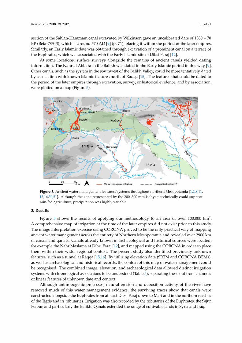
Remote Sens 2018 10 2042 10 of 21
section of the Sahlan-Hammam canal excavated by Wilkinson gave an uncalibrated date of 1380 + 70BP (Beta-78543) which is around 570 AD [9] (p 71) placing it within the period of the later empiresSimilarly an Early Islamic date was obtained through excavation of a prominent canal on a terrace ofthe Euphrates which was associated with the Early Islamic site of Dibsi Faraj [12]
At some locations surface surveys alongside the remains of ancient canals yielded datinginformation The Nahr al Abbara in the Balikh was dated to the Early Islamic period in this way [9]Other canals such as the system in the southwest of the Balikh Valley could be more tentatively datedby association with known Islamic features north of Raqqa [15] The features that could be dated tothe period of the later empires through excavation survey or historical evidence and by associationwere plotted on a map (Figure 5)
Remote Sens 2018 10 2042 10 of 21
Iraq and others throughout Northern Mesopotamia (see References [1516] for more detailed literature reviews)
In a few cases excavation of sections across canal beds had provided organic material from within the fill of canals allowing the dates of their construction and use to be obtained Remains from a section of the Sahlan-Hammam canal excavated by Wilkinson gave an uncalibrated date of 1380 + 70 BP (Beta-78543) which is around 570 AD [9] (p 71) placing it within the period of the later empires Similarly an Early Islamic date was obtained through excavation of a prominent canal on a terrace of the Euphrates which was associated with the Early Islamic site of Dibsi Faraj [12]
At some locations surface surveys alongside the remains of ancient canals yielded dating information The Nahr al Abbara in the Balikh was dated to the Early Islamic period in this way [9] Other canals such as the system in the southwest of the Balikh Valley could be more tentatively dated by association with known Islamic features north of Raqqa [15] The features that could be dated to the period of the later empires through excavation survey or historical evidence and by association were plotted on a map (Figure 5)
Figure 5 Ancient water management featuressystems throughout northern Mesopotamia [1281115165051] Although the zone represented by the 200ndash300 mm isohyets technically could support rain-fed agriculture precipitation was highly variable
3 Results
Figure 5 shows the results of applying our methodology to an area of over 100000 km2 A comprehensive map of irrigation at the time of the later empires did not exist prior to this study The image interpretation exercise using CORONA proved to be the only practical way of mapping ancient water management across the entirety of Northern Mesopotamia and revealed over 2900 km of canals and qanats Canals already known in archaeological and historical sources were located for example the Nahr Maslama at Dibsi Faraj [12] and mapped using the CORONA in order to place them within their wider regional context The present study also identified previously unknown features such as a tunnel at Raqqa [15] (Figure 6) By utilising elevation data (SRTM and CORONA DEMs) as well as archaeological and historical records the context of this map of water management could be recognised The combined image elevation and archaeological data allowed distinct irrigation systems with chronological associations to be understood (Table 5) separating these out from channels or linear features of unknown date and context
Figure 5 Ancient water management featuressystems throughout northern Mesopotamia [1281115165051] Although the zone represented by the 200ndash300 mm isohyets technically could supportrain-fed agriculture precipitation was highly variable
3 Results
Figure 5 shows the results of applying our methodology to an area of over 100000 km2A comprehensive map of irrigation at the time of the later empires did not exist prior to this studyThe image interpretation exercise using CORONA proved to be the only practical way of mappingancient water management across the entirety of Northern Mesopotamia and revealed over 2900 kmof canals and qanats Canals already known in archaeological and historical sources were locatedfor example the Nahr Maslama at Dibsi Faraj [12] and mapped using the CORONA in order to placethem within their wider regional context The present study also identified previously unknownfeatures such as a tunnel at Raqqa [1516] By utilising elevation data (SRTM and CORONA DEMs)as well as archaeological and historical records the context of this map of water management couldbe recognised The combined image elevation and archaeological data allowed distinct irrigationsystems with chronological associations to be understood (Table 5) separating these out from channelsor linear features of unknown date and context
Although anthropogenic processes natural erosion and deposition activity of the river haveremoved much of this water management evidence the surviving traces show that canals wereconstructed alongside the Euphrates from at least Dibsi Faraj down to Mari and in the northern reachesof the Tigris and its tributaries Irrigation was also recorded by the tributaries of the Euphrates the SajurHabur and particularly the Balikh Qanats extended the range of cultivable lands in Syria and Iraq
Remote Sens 2018 10 2042 11 of 21
Table 5 Water management systems recorded by this study using satellite data
Chronological Period Water Management Systems Key References
Pre-1st millennium BCCanal at Tell Fray [52]Some canals alongside the Euphrates between Balikh and Mari [14]
1st millennium BCCanals in northern Iraq [6ndash832]Canal at Carchemish [1648]Origin of canals alongside Habur [3353]
Hellenisticndashlate RomanCanal and rock-cut conduits in Jerablus area [1648]Sahlan-Hamman canal and Qara Mokh canals in Balikh [911]Qanats south of Membij [151654]
Early Islamic (8thndash15thcenturies AD)
Large embanked canal between Tell Fray and Qalat Jabar [16]
Large embanked canal at Dibsi Faraj and qanat [112]Canals in Balikh Valley north of Raqqa [11516]Canals in Balikh Valley west of Raqqa [111516]
Qanats a tunnel and canals around Raqqa [111516]
Canals alongside the Habur [53]
Nahr Dawrin Nahr Sarsquoid Large embanked canals on both banks ofthe Euphrates between the Balikh and Mari [13ndash16]
Some of the large embanked canals in northern Iraq Tarbisu canaland Nahr Qanausa [832]
Qanats on the Sinjar Plain [1516]
We mapped pre-Islamic water management features in Northern Mesopotamia including rock-cutconduits near Jerablus (investigated during fieldwork see References [1648]) and Hellenistic qanatsaround Membij (dated by a historical source see Reference [54]) Although some of the tracesof large embanked channels alongside the Euphrates have been attributed to the pre-Islamic era(eg Reference [14]) it can be argued the technology capable of facilitating this may not have beenwidely applied until the medieval period [55] (p 115) Tributaries such as the Balikh and the Haburwere easier to irrigate from attested by a likely Assyrian origin for canals alongside the Habur [33] andsome Hellenisticndashlate Roman canals in the Balikh dated through excavation radiocarbon dating surfacesurvey and association with dated sites (eg the Sahlan-Hammam canal Figure 6 References [911])The Neo-Assyrian canals in northern Iraq are already well-known although it is important to note someof the canals in northern Iraq have been attributed to the Early Islamic period (see References [832])
Early Islamic canals were constructed and maintained alongside the Euphrates for example thelarge embanked canals of the Nahr Maslama Nahr Dawrin and Nahr Sarsquoid which are referred to inIslamic texts (see Reference [1516]) The canals alongside the Habur may also have been used into theEarly Islamic period and a possible connection to the Nahr Dawrin has been proposed [151656]
Especially in the Balikh the analysis of systems that were reasonably preserved at the time of theCORONA images showed a high degree of sophistication and represented hydrological knowledgebefore the modern era (see Figures 7 and 8) The Nahr Al Abbara dated through surface survey [9]abstracted water to the north near Tell Sahlan which it transported in a main canal for over 15 km (seeFigures 7 and 8) Traces of an earlier phase of canal on the same alignment could be identified in placesusing the CORONA imagery (see [2] Figure 6 38) Water was delivered to fields via laterals branchingoff the main channel at fairly regular intervals During a surface survey Wilkinson [9] (p 68) recordedlarge stone blocks that may have functioned as part of sluice structures As the SRTM DEM confirmedthe overall gradient of the landscape of the Balikh is very flat but the Nahr Al Abbara system mitigatedagainst it by running the main canal at a low gradient (approximately 01) along a slight and somewhatnarrow ridge (see [11] Figure 6) The CORONA DEM (Figure 9) allowed this to be visualised at higherresolution The main canal could flow for a greater distance but at the same time the offtakes could attaina slightly steeper gradient (approximately 05) The system also incorporated drainage provision intothe Balikh and into the fairly wide basin of a seasonal runoff stream to the east the Wadi al Keder andmay have been associated with a complex layout of spring water channels and drainage systems (see [11]Figures 7 and 8) There are several Early Islamic settlements nearby including Medinet al Farr and
Remote Sens 2018 10 2042 12 of 21
Khirbet Ambar which are known through historical sources and archaeological investigations [5758]It is likely that these sites were involved in the administration of irrigation in the area
Remote Sens 2018 10 2042 11 of 21
Figure 6 The eroded and infilled remains of the Sahlan-Hammam canal in the 1990s when Tony Wilkinson visited Tony provides scale
Table 5 Water management systems recorded by this study using satellite data
Chronological Period Water Management Systems Key References
Pre-1st millennium BC Canal at Tell Fray [52] Some canals alongside the Euphrates between Balikh and Mari [14]
1st millennium BC Canals in northern Iraq [6ndash832] Canal at Carchemish [1648] Origin of canals alongside Habur [3353]
Hellenisticndashlate Roman Canal and rock-cut conduits in Jerablus area [1648] Sahlan-Hamman canal and Qara Mokh canals in Balikh [911] Qanats south of Membij [151654]
Early Islamic (8thndash15th centuries AD)
Large embanked canal between Tell Fray and Qalat Jabar [16] Large embanked canal at Dibsi Faraj and qanat [112] Canals in Balikh Valley north of Raqqa [115] Canals in Balikh Valley west of Raqqa [1115] Qanats a tunnel and canals around Raqqa [1115] Canals alongside the Habur [53] Nahr Dawrin Nahr Sarsquoid Large embanked canals on both banks of the Euphrates between the Balikh and Mari
[131416]
Some of the large embanked canals in northern Iraq Tarbisu canal and Nahr Qanausa
[832]
Qanats on the Sinjar Plain [1516]
Although anthropogenic processes natural erosion and deposition activity of the river have removed much of this water management evidence the surviving traces show that canals were constructed alongside the Euphrates from at least Dibsi Faraj down to Mari and in the northern reaches of the Tigris and its tributaries Irrigation was also recorded by the tributaries of the Euphrates the Sajur Habur and particularly the Balikh Qanats extended the range of cultivable lands in Syria and Iraq
We mapped pre-Islamic water management features in Northern Mesopotamia including rock-cut conduits near Jerablus (investigated during fieldwork see References [1648]) and Hellenistic qanats around Membij (dated by a historical source see Reference [54]) Although some of the traces of large embanked channels alongside the Euphrates have been attributed to the pre-Islamic era (eg Reference [14]) it can be argued the technology capable of facilitating this may not have been widely applied until the medieval period [55] (p 115) Tributaries such as the Balikh and the Habur were
Figure 6 The eroded and infilled remains of the Sahlan-Hammam canal in the 1990s when TonyWilkinson visited Tony provides scaleRemote Sens 2018 10 2042 13 of 21
Figure 7 Irrigation systems in the Balikh Valley
Figure 8 The channel of the Nahr al Abbara canal system is marked with arrows (1968 CORONA image)
Figure 7 Irrigation systems in the Balikh Valley
Remote Sens 2018 10 2042 13 of 21
An extensive set of canals in the southwest horseshoe of the Balikh Valley may also be EarlyIslamic based on a connection with known sites (Figure 10A see Reference [11]) Most significantlyin the south the CORONA images showed several water management features associated with theEarly Islamic city of Raqqa which was particularly prominent as a capital city during the Abbasid erawith palaces and an industrial area The city itself and its immediate hinterland appears to have beenwatered by qanats with a northern palace complex supplied by a tunnel stemming from the QaraMokh stream as well as the Balikh [111516]
Overall historical sources present a picture of intensive irrigated cultivation in NorthernMesopotamia in the Early Islamic period [47] Even away from the main perennial water sourcesqanats extended the cultivable area The CORONA images revealed an area of dense qanat irrigationradiating from the town of Sinjar in Iraq which may be medieval in date [59] (discussed in more detailin Reference [16])
Remote Sens 2018 10 2042 13 of 21
Figure 7 Irrigation systems in the Balikh Valley
Figure 8 The channel of the Nahr al Abbara canal system is marked with arrows (1968 CORONA image) Figure 8 The channel of the Nahr al Abbara canal system is marked with arrows (1968 CORONA image)Remote Sens 2018 10 2042 14 of 21
Figure 9 10 m spatial resolution DEM constructed using a CORONA stereopair
Figure 10 (A) Relict canals in the southwest Balikh Valley in 1968 which were (B) destroyed and replaced with a new irrigation system in 1972 (CORONA images)
4 Discussion
This research revealed an intensification of irrigation in most of the cultivable areas of Early Islamic Northern Mesopotamia particularly in the Balikh Valley The transformation of the environment that we observed fits the concept of ldquohydraulic landscapesrdquo Historical accounts and archaeological excavations have indicated that Raqqa was temporarily the centre of the Abbasid empire and a significant industrial town (eg see Reference [60]) which may offer an explanation for the intensification of water management features at this time In addition medieval irrigation in the Balikh may have been a response to deliberate policies of bringing marginal land into cultivation [17] policies that explain the increased application of water management technology throughout Northern Mesopotamia in the Early Islamic period This is an area where irrigation was not necessary but where employing it would have increased the reliability and quantity of agricultural yields developing and supporting powerful and demanding imperial economies Many existing hydraulic landscapes were maintained and developed while new ones were created in response to incentives
This intensive use of the landscape must have declined because until the later 20th century cultivation in Northern Mesopotamia was largely reported to be reliant on rainfall [61] (p 137) This transition followed the Early Islamic period By the 15th century the ancient water systems of Mesopotamia were falling into disrepair possibly due to plague and the depredations of the Mongols with subsequent depopulation and upheaval (eg see References [151662]) In many areas agriculture did not seem to have intensified again until the 2nd half of the 20th century
Figure 9 10 m spatial resolution DEM constructed using a CORONA stereopair
Remote Sens 2018 10 2042 14 of 21
4 Discussion
This research revealed an intensification of irrigation in most of the cultivable areas of Early IslamicNorthern Mesopotamia particularly in the Balikh Valley The transformation of the environment thatwe observed fits the concept of ldquohydraulic landscapesrdquo Historical accounts and archaeologicalexcavations have indicated that Raqqa was temporarily the centre of the Abbasid empire anda significant industrial town (eg see Reference [60]) which may offer an explanation for theintensification of water management features at this time In addition medieval irrigation in theBalikh may have been a response to deliberate policies of bringing marginal land into cultivation [17]policies that explain the increased application of water management technology throughout NorthernMesopotamia in the Early Islamic period This is an area where irrigation was not necessary but whereemploying it would have increased the reliability and quantity of agricultural yields developing andsupporting powerful and demanding imperial economies Many existing hydraulic landscapes weremaintained and developed while new ones were created in response to incentives
This intensive use of the landscape must have declined because until the later 20th centurycultivation in Northern Mesopotamia was largely reported to be reliant on rainfall [61] (p 137)This transition followed the Early Islamic period By the 15th century the ancient water systems ofMesopotamia were falling into disrepair possibly due to plague and the depredations of the Mongolswith subsequent depopulation and upheaval (eg see References [151662]) In many areas agriculturedid not seem to have intensified again until the 2nd half of the 20th century although traces of theancient irrigation systems remained embedded in the landscape until very recently (see travellersrsquoaccounts of abandoned canals eg [6364])
More recently however modern agricultural strategies in the Middle East have completelytransformed the landscape replacing ancient man-made hydraulic pathways with large-scale damsand canal systems and pumping from individual wells Many ancient irrigation systems have beenabandoned and destroyed to make way for new irrigation schemes A remote sensing methodologyusing interpretation from CORONA images dating from the period 1967ndash1972 proved to be a veryeffective strategy for recording ancient water management and for mapping its spread and distribution
When CORONA images (1968 and 1972) were compared (Figure 10) the initial construction ofthe modern field and irrigation systems in the 1970s Balikh is apparent This highlights the timelinessof the 1960s images which represent the last record of most of the ancient canal systems presented inFigures 5 and 7
Remote Sens 2018 10 2042 14 of 21
Figure 9 10 m spatial resolution DEM constructed using a CORONA stereopair
Figure 10 (A) Relict canals in the southwest Balikh Valley in 1968 which were (B) destroyed and replaced with a new irrigation system in 1972 (CORONA images)
4 Discussion
This research revealed an intensification of irrigation in most of the cultivable areas of Early Islamic Northern Mesopotamia particularly in the Balikh Valley The transformation of the environment that we observed fits the concept of ldquohydraulic landscapesrdquo Historical accounts and archaeological excavations have indicated that Raqqa was temporarily the centre of the Abbasid empire and a significant industrial town (eg see Reference [60]) which may offer an explanation for the intensification of water management features at this time In addition medieval irrigation in the Balikh may have been a response to deliberate policies of bringing marginal land into cultivation [17] policies that explain the increased application of water management technology throughout Northern Mesopotamia in the Early Islamic period This is an area where irrigation was not necessary but where employing it would have increased the reliability and quantity of agricultural yields developing and supporting powerful and demanding imperial economies Many existing hydraulic landscapes were maintained and developed while new ones were created in response to incentives
This intensive use of the landscape must have declined because until the later 20th century cultivation in Northern Mesopotamia was largely reported to be reliant on rainfall [61] (p 137) This transition followed the Early Islamic period By the 15th century the ancient water systems of Mesopotamia were falling into disrepair possibly due to plague and the depredations of the Mongols with subsequent depopulation and upheaval (eg see References [151662]) In many areas agriculture did not seem to have intensified again until the 2nd half of the 20th century
Figure 10 (A) Relict canals in the southwest Balikh Valley in 1968 which were (B) destroyed andreplaced with a new irrigation system in 1972 (CORONA images)
Remote Sens 2018 10 2042 15 of 21
While modern imagery such as IKONOS has been available for the study area since about 2000(Table 1) these images postdate major land use change that led to the destruction of most of the ancientcanals and therefore CORONA images are the only way of recording now-destroyed canal systemsFigure 11 shows how changes around the city of Raqqa between the 1960s and 2000s meant thatmuch of Early Islamic Raqqa and its environs (visible in the CORONA Figure 11A) had already beendestroyed by the time the IKONOS image (Figure 11B) was collected
Remote Sens 2018 10 2042 15 of 21
although traces of the ancient irrigation systems remained embedded in the landscape until very recently (see travellersrsquo accounts of abandoned canals eg [6364])
More recently however modern agricultural strategies in the Middle East have completely transformed the landscape replacing ancient man-made hydraulic pathways with large-scale dams and canal systems and pumping from individual wells Many ancient irrigation systems have been abandoned and destroyed to make way for new irrigation schemes A remote sensing methodology using interpretation from CORONA images dating from the period 1967ndash1972 proved to be a very effective strategy for recording ancient water management and for mapping its spread and distribution
When CORONA images (1968 and 1972) were compared (Figure 10) the initial construction of the modern field and irrigation systems in the 1970s Balikh is apparent This highlights the timeliness of the 1960s images which represent the last record of most of the ancient canal systems presented in Figures 5 and 7
While modern imagery such as IKONOS has been available for the study area since about 2000 (Table 1) these images postdate major land use change that led to the destruction of most of the ancient canals and therefore CORONA images are the only way of recording now-destroyed canal systems Figure 11 shows how changes around the city of Raqqa between the 1960s and 2000s meant that much of Early Islamic Raqqa and its environs (visible in the CORONA Figure 11A) had already been destroyed by the time the IKONOS image (Figure 11B) was collected
Figure 11 (A) CORONA image (May 1968) showing Early Islamic features of Raqqa including the 8th century AD walled city palace structures to the north of this and canals (B) IKONOS image (27 March 2000) showing that most of the medieval features were destroyed by modern buildings fields and roads
The Landsat sequence shows the intensification of agriculture underway from the 1980s (Figures 12 and 13) In Syria this was part of a programme involving construction of the Tabqa dam in 1966 30 km upstream of Raqqa [61] Figure 13 highlights the Balikh where we identified many ancient canal networks that corresponded neatly to the areas of modern irrigated agriculture highlighted by using a false colour visualisation By the 21st century modern agriculture had expanded throughout the valley including new fields and irrigation networks in the south the area known as the ldquohorseshoerdquo where several ancient canals supplied Early Islamic palaces and urban areas around Raqqa Recent disruption to irrigation infrastructure has been reported in the region due to the current conflict in Syria [1965] which is demonstrated by a slight reduction in the vegetated area between the 2010ndash2011 and 2016ndash2017 Landsat composites
Figure 11 (A) CORONA image (May 1968) showing Early Islamic features of Raqqa including the8th century AD walled city palace structures to the north of this and canals (B) IKONOS image(27 March 2000) showing that most of the medieval features were destroyed by modern buildingsfields and roads
The Landsat sequence shows the intensification of agriculture underway from the 1980s(Figures 12 and 13) In Syria this was part of a programme involving construction of the Tabqadam in 1966 30 km upstream of Raqqa [61] Figure 13 highlights the Balikh where we identifiedmany ancient canal networks that corresponded neatly to the areas of modern irrigated agriculturehighlighted by using a false colour visualisation By the 21st century modern agriculture had expandedthroughout the valley including new fields and irrigation networks in the south the area known asthe ldquohorseshoerdquo where several ancient canals supplied Early Islamic palaces and urban areas aroundRaqqa Recent disruption to irrigation infrastructure has been reported in the region due to the currentconflict in Syria [1965] which is demonstrated by a slight reduction in the vegetated area between the2010ndash2011 and 2016ndash2017 Landsat composites
Figure 12 shows a Landsat false colour composite of a large part of the Euphrates river in Syria in1985 and 1986 and again in 2016 and 2017 with Lake Assad in the top left and the Balikh and Haburtributaries joining from the north Figure 13 zooms in on the Syrian Balikh The red colours in theLandsat images seen in Figures 12 and 13 show the distribution of modern productive agriculturalland where changes shown in both figures reflect the intensification of agriculture the effect of whichhas been to remove traces of ancient water features The Landsat images emphasise the particularimportance of the Balikh which represents a large area of agricultural production within the wholeEuphrates valley The TurkeyndashSyria border can be clearly seen in the imagery (Figure 12) becauseof the contrast in water available for irrigation this serves as a reminder of the importance of thegeopolitics of water resources in the region from ancient times right up to the present day
Remote Sens 2018 10 2042 16 of 21Remote Sens 2018 10 2042 16 of 21
Figure 12 False colour Landsat composites showing the intensification of agriculture in Northern Mesopotamia over the past 40 years (A) Landsat 5 composite 1985ndash1986 (B) Landsat 8 composite 2016ndash2017 Images downloaded and mosaicked using Google Earth Engine
Figure 13 Landsat composites showing the expansion of modern irrigation in the Balikh (A) Landsat 5 1985ndash1986 (B) Landsat 7 2010ndash2011 (C) Landsat 8 2016ndash2017 Images downloaded and mosaicked using Google Earth Engine and visualised as false colour composites
Figure 12 False colour Landsat composites showing the intensification of agriculture in NorthernMesopotamia over the past 40 years (A) Landsat 5 composite 1985ndash1986 (B) Landsat 8 composite2016ndash2017 Images downloaded and mosaicked using Google Earth Engine
Remote Sens 2018 10 2042 16 of 21
Figure 12 False colour Landsat composites showing the intensification of agriculture in Northern Mesopotamia over the past 40 years (A) Landsat 5 composite 1985ndash1986 (B) Landsat 8 composite 2016ndash2017 Images downloaded and mosaicked using Google Earth Engine
Figure 13 Landsat composites showing the expansion of modern irrigation in the Balikh (A) Landsat 5 1985ndash1986 (B) Landsat 7 2010ndash2011 (C) Landsat 8 2016ndash2017 Images downloaded and mosaicked using Google Earth Engine and visualised as false colour composites
Figure 13 Landsat composites showing the expansion of modern irrigation in the Balikh (A) Landsat5 1985ndash1986 (B) Landsat 7 2010ndash2011 (C) Landsat 8 2016ndash2017 Images downloaded and mosaickedusing Google Earth Engine and visualised as false colour composites
There are some caveats to a methodology that relies principally on image interpretation Whetheror not water management features can be identified depends on a number of factors including imagequality and timing and natural conditions We identified rock-cut conduits and tunnels alongside
Remote Sens 2018 10 2042 17 of 21
dry streams in the Jerablus region during a survey in 2010 [48] that were not visible in the CORONA(1967 and 1972) and modern imagery There may well be other ancient irrigation features throughoutnorthern Syria and Iraq that have not yet been identified However many of the features we identifiedin the CORONA images were no longer visible on the ground having been destroyed to make way formodern agriculture This included the Nahr al Abbara canal system in the Balikh
Working with CORONA was difficult due to the panoramic and historical nature of the dataThe panoramic frames were distorted (eg see Reference [41] (p 228) Reference [66]) especiallytoward the edges and some image acquisition parameters were not available making constructing anaccurate camera model challenging The quality and time of collection of different images was variableSome higher resolution modern imagery was examined for example IKONOS imagery covering thearea around Raqqa in the southern Balikh However it was found that recent landscape changes haddestroyed much of the archaeology (see Figure 11) The CORONA data were often of the best timeperiod consistency of image quality (spatial and radiometric) and availability for large area coveragemaking it ideal for recording ancient water management features In fact we were able to obtainCORONA imagery for our entire 100000 km2 study area
5 Conclusions
Declassified CORONA satellite images from the 1960s and early 1970s are used to identify andreconstruct ancient hydraulic landscapes over large geographic areas The CORONA KH-4B camerahas stereoscopic capability which helps to identify and interpret water management features When theCORONA images were analysed in conjunction with modern satellite imagery DEMs and contextualinformation from archaeological and historical surveys the trajectory of the development of irrigationtechnology becomes clear
This study mapped water management features from the period ca 1200 BC to AD 1500 acrossthe entirety of Northern Mesopotamia for the first time (Figure 5) Irrigation increased in densitythroughout the region including within the zone traditionally regarded as ldquorain-fedrdquo and revealeda peak in the Early Islamic era Environmental considerations for understanding why and whereirrigation was undertaken during the period of the later empires also helped us to contextualise theresults An average rainfall of 200ndash250 mm a year is often interpreted as the limit of rain-fed cultivationfor modern and ancient agriculture (eg see References [186768]) and depicted as an isohyet lineHowever an analysis of modern rain gauge data indicates that much of the area encompassed byancient irrigation (receiving approximately 100ndash400 mm per year) experiences high variability today(20ndash40 see Reference [2] (p 158)) which makes irrigation necessary to mitigate against irregularrainfall [65] (p 5) If rainfall was similarly variable during the period of the later empires (eg atthe time of the MCA) our data suggests that they were investing in large-scale irrigation in a regionwhere rain-fed cultivation was technically possible but where it was risky due to the variability ofprecipitation Unlike in Southern Mesopotamia irrigation was not absolutely necessary for agriculturein Northern Mesopotamia but the construction of water management features was a way to ensureaccess to water in order to mitigate against disruptions to food supply
It is unlikely to be a coincidence that irrigation activity was intensified during the era of the firsttrue territorial empires when these powerful entities exerted and contested political control over thelandscape It is apparent that from the Neo-Assyrian period and by the Early Islamic period most ofthe perennial water courses in Northern Mesopotamia were used as sources of irrigation water andthat available groundwater was utilised The water management systems that we recorded includedmany reticulated and sophisticated systems that supported powerful states represented by traces ofprominent channels alongside the main rivers dense networks of irrigation in the tributaries andsignificant groundwater exploitation using qanats Many canals and parts of canal systems wouldhave been missed if examined through fieldwork alone Through interpretation of satellite imagesthis study was able to locate and map some previously unknown or understudied systems suchas numerous qanats in the Sinjar Plain of Iraq [1516] the qanat at Dibsi Faraj in Syria [1] and the
Remote Sens 2018 10 2042 18 of 21
real complexity of irrigation in the Balikh Valley in Syria [1111516] The combination of remotesensing archived data and fieldwork enabled further chronological and historical contextualisation ofthese remains
If fieldwork should become possible in the near future this reconstruction of ancient watermanagement in Northern Mesopotamia would benefit from ground sample testing using scientificdating techniques such as optically stimulated luminescence (OSL) (eg see Reference [69]) The use ofunmanned aerial vehicles (UAVs) dGPS and newer high-resolution DEMs such as TanDEM-X wouldprovide improved control data for photogrammetric processing of CORONA Several significant areasof relict channels require further investigation (for example qanats around Membij and Sinjar seeReferences [1516]) which itself might enable increased protection of this archaeological resource Dueto the current risk of looting and vandalism to archaeological sites in Mesopotamia it is not possible tomake the GIS database of canal locations publically available but these can be provided to verifiedheritage professionals via the EAMENA database if requested [70]
Conflict in Syria and Iraq has led to an ongoing humanitarian crisis and has impacted severelyon cultural heritage with deliberate destruction of many monumental sites including some of theIslamic remains in Raqqa Satellite imagery is being extensively used to highlight the destruction ofarchaeology in the Middle East during conflict [71] although its efficacy as a solution to stopping thedestruction is unclear Media reports often draw attention to damage to large monumental sites whilethe routine destruction of ancient canals by modern agricultural and urban development is frequentlyoverlooked Water management features may not be a particular target for vandalism but longer-termland use changes have wiped out many of their traces from the landscape making CORONA the lastrecord of the intensive hydraulic landscapes of the ancient empires
Supplementary Materials The following are available online at httpwwwmdpicom2072-429210122042s1 CORONA DEM triangulation reports Landsat comparisons SRTM CORONA and Landsat data availablefrom the US Geological Survey
Author Contributions Conceptualization LR and DD formal analysis LR funding acquisition DDinvestigation LR methodology LR and DD project administration LR supervision DD visualization LRwritingmdashoriginal draft LR writingmdashreview and editing LR and DD
Funding This PhD research was funded by the Faculty of Social Sciences and Health Durham University
Acknowledgments We would particularly like to acknowledge the role of the late Tony Wilkinson in supervisingsupporting and encouraging this research and for providing information about his surveys in the Balikh Valley
Conflicts of Interest The authors declare no conflicts of interest The funders had no role in the design of thestudy in the collection analyses or interpretation of data in the writing of the manuscript or in the decision topublish the results
References
1 Wilkinson TJ Rayne L Hydraulic Landscapes and Imperial Power in the near East Water Hist 2010 2115ndash144 [CrossRef]
2 Rayne L Water and Territorial Empires The Application of Remote Sensing Techniques to Ancient ImperialWater Management in Northern Mesopotamia PhD Thesis University of Durham Durham UK 2014
3 Schneider U Becker A Meyer-Christoffer M Ziese B Global Precipitation Analysis Products of theGpcc Available online httpwwwcgducareducascatalogsurfaceprecipgpcchtml (accessed on14 December 2018)
4 Wilkinson TJ Archaeological Landscapes of the near East University of Arizona Press Tucson AZ USA 20035 Oded B Mass Deportations and Deportees in the Neo-Assyrian Empire L Reichert Depew NY USA 19796 Jacobsen T Lloyd S Sennacheribrsquos Aqueduct at Jerwan University of Chicago Press Chicago IL USA 19557 Dalley S Nineveh Babylon and the Hanging Gardens Cuneiform and Classical Sources Reconciled Iraq
1994 56 45ndash58 [CrossRef]8 Ur J Sennacheribrsquos Northern Assyrian Canals New Insights from Satellite Imagery and Aerial Photography
Iraq 2005 67 317ndash345 [CrossRef]
Remote Sens 2018 10 2042 19 of 21
9 Wilkinson TJ Water and Human Settlement in the Balikh Valley Syria Investigations from 1992ndash1995J Field Archaeol 1998 25 63ndash87
10 Wilkinson TJ Peltenburg E McCarthy A Wilkinson EB Brown M Archaeology in the Land ofCarchemisch Landscape Surveys in the Area of Jerablus Tahtani 2006 Levant 2007 39 213ndash247 [CrossRef]
11 Rayne L Imperial Water Systems and Human Niche Construction in the Balikh Valley Water Hist 2015 7419ndash440 [CrossRef]
12 Harper RP Wilkinson TJ Excavations at Dibsi Faraj Northern Syria 1972ndash1974 A Preliminary Note onthe Site and Its Monuments with an Appendix Dumbarton Oaks Papers 1975 29 319ndash338 [CrossRef]
13 Berthier S DrsquoHont O Ressources Hydriques Et Peuplement Sur Le Moyen Euphrate Viiegraveme-Xix EgravemeSiegravecle In Proceedings of the RURALIA 2003 Lyon France 17 September 2003
14 Geyer B Monchambert JY La Basse Valleacutee De Lrsquoeuphrate Syrien Du Neacuteolithique Agrave Lrsquoavegravenement De LrsquoislamGeacuteographie Archeacuteologie Et Histoire IFAPO Paris France 2003
15 Rayne L Early Islamic Water Management in Northern Mesopotamia In Economic Integration and SocialChange in the Islamic World System 800ndash1000 Ce The Geography and Infrastructure of Trade in Early IslamBessard F Kennedy H Eds Oxford University Press Oxford UK in press
16 Rayne L Early Islamic Water Management in the Hinterland of Raqqa In New Agendas in Remote Sensing andLandscape Archaeology in the Near East Studies in Honor of T J Wilkinson Altaweel M Lawrence D Philip GEds Oriental Institute of the University of Chicago Chicago IL USA in press
17 Kennedy HN The Feeding of the Five Hundred Thousand Cities and Agriculture in Early IslamicMesopotamia Iraq 2011 73 177ndash199 [CrossRef]
18 Perrin de Brichambaut G Walleacuten CC FaoUnescoWmo Interagency Project on Agroclimatology 1962 DraftGeneral Report on a Study of Agroclimatology in Semi-Arid and Arid Zones of the Near East FAO Rome Italy 1962
19 Counting the Cost Agriculture in Syria after Six Years of Crisis Available online httpwwwfaoorgemergenciesresourcesdocumentsresources-detailenc878213 (accessed on 11 November 2018)
20 Wittfogel K Oriental Despotism A Comparative Study of Total Power Yale University Press New Haven CTUSA London UK 1957
21 Christensen P The Decline of Iranshahr Irrigation and Environments in the History of the Middle East 500 Bc toAd 1500 Museum Tusculanum Press Copenhagen Denmark 1993
22 Fisher WB The Middle East A Physical Social and Regional Geography 7th ed Completely Revised and Reseted Methuen London UK 1978
23 Jewitt TN Soils of Arid Lands In Arid Lands A Gographical Appraisal Hills ES Ed Methuen and Co LtdLondon UK 1966
24 Riehl S Bryson R Pustovoytov K Changing Growing Conditions for Crops During the near Eastern BronzeAge (3000ndash1200 Bc) The Stable Carbon Isotope Evidence J Archaeol Sci 2008 35 1011ndash1022 [CrossRef]
25 Bar-Matthews M Ayalon A Kaufman A Late Quaternary Paleoclimate in the Eastern MediterraneanRegion from Stable Isotope Analysis of Speleothems at Soreq Cave Israel Quat Res 1997 47 155ndash168[CrossRef]
26 Xoplaki E Fleitmann D Luterbacher J Wagner S Haldon JF Zorita E Telelis I Toreti A Izdebski AThe Medieval Climate Anomaly and Byzantium A Review of the Evidence on Climatic FluctuationsEconomic Performance and Societal Change Quat Sci Rev 2016 136 229ndash252 [CrossRef]
27 IPCC Climate Change 2013 The Physical Science Basis Contribution of Working Group I to the Fifth AssessmentReport of the Intergovernmental Panel on Climate Change Stocker TF Qin D Plattner G-K Tignor MAllen SK Boschung J Nauels A Xia Y Bex V Midgley PM Eds Cambridge University PressCambridge UK 2013
28 Kamash Z Archaeologies of Water in the Roman near East 63 Bc-Ad 636 Piscataway Gorgias Press PiscatawayNJ USA 2010
29 Kamash Z Water Supply and Management in the Near East 63 Bc-Ad 636 PhD Thesis University ofOxford Oxford UK 2007
30 Philip G Donoghue DNM Beck A Galiatsatos N Corona Satellite Photography An ArchaeologicalApplication from the Middle East Antiquity 2002 76 109ndash118 [CrossRef]
31 David K Bewley R Aerial Archaeology in Jordan Antiquity 2009 83 69ndash8132 Altaweel M The Imperial Landscape of Ashur Settlement and Land Use in the Assyrian Heartland OrientVerlag
Heidelberg Germany 2008
Remote Sens 2018 10 2042 20 of 21
33 Van Liere WJ Lauffray J Nouvelle Prospection Archaeologique Dans La Haute Jazireh Syrienne Les AnnalsArchaeologiques De Syrie 1954ndash1955 4 129ndash148
34 Gorelick N Hancher M Dixon M Ilyushchenko S Thau D Moore R Google Earth EnginePlanetary-Scale Geospatial Analysis for Everyone Remote Sens Environ 2017 202 18ndash27 [CrossRef]
35 Galiatsatos N Wilkinson TJ Donoghue DNM Philip G The Fragile Crescent Project (Fcp) Analysis ofSettlement Landscapes Using Satellite Imagery Available online httpdroduracuk6909 (accessed on18 December 2018)
36 Casana J Cothren J The Corona Atlas Project Orthorectification of Corona Satellite Imagery andRegional-Scale Archaeological Exploration in the near East In Mapping Archaeological Landscapes fromSpace Comer DC Harrower MJ Eds Springer Berlin Germany 2013
37 Farr TG Rosen PA Caro E Crippen R Duren R Hensley S Kobrick M Paller M Rodriguez ERoth L The Shuttle Radar Topography Mission Rev Geophys 2007 45 [CrossRef]
38 Schmidt M Goossens R Menz G Altmaier A Devriendt D The Use of Corona Satellite Images forGenerating a High Resolution Digital Elevation Model Paper Presented at the IEEE 2001 InternationalGeoscience and Remote Sensing Symposium Sydney NSW Australia 9ndash13 July 2001
39 Mugnier CJ Forstner W Wrobel B Paderes F Munjy R The Mathematics of Photogrammetry InManual of Photogrammetry McGlone JC Ed American Society of Photogrammetry and Remote SensingBethseda MD USA 2004 pp 181ndash316
40 Wong KW Basic Mathematics of Photogrammetry In Manual of Photogrammetry Slama CC Ed AmericanSociety of Photogrammetry Falls Church VA USA 1980 pp 37ndash101
41 Altmaier A Kany C Digital Surface Model Generation from Corona Satellite Images ISPRS J PhotogrammRemote Sens 2002 56 221ndash235 [CrossRef]
42 USGS Declassified Satellite Imagerymdash1 Available online httpsltacrusgsgovdeclass_1 (accessed on 18December 2018)
43 Galiatsatos N Donoghue DNM Philip G High Resolution Elevation Data Derived from StereoscopicCorona Imagery with Minimal Ground Control Photogramm Eng Remote Sens 2007 73 1093ndash1106 [CrossRef]
44 Casana J Cothren J Stereo Analysis Dem Extraction and Orthorectification of Corona Satellite ImageryArchaeological Applications from the near East Antiquity 2008 82 732ndash749 [CrossRef]
45 Boyle R Thomas RC Computer Vision A First Course Blackwell Scientific Publications Ltd Hoboken NJUSA 1988
46 Ur J Wilkinson TJ Settlement and Economic Landscapes of Tell Beydar and Its Hinterland Brepols TurnhoutBelgium 2008
47 Le Strange G The Lands of the Eastern Caliphate Mesopotamia Persia and Central Asia from the Moslem Conquestto the Time of Timur Cambridge University Press Cambridge UK 1905
48 Peltenburg E Wilkinson TJ Wilkinson EB Carchemish in Context Oxbow Books Oxford UK 201649 Wilkinson EB Wilkinson TJ Peltenburg E Revisiting Carchemish The Land of Carchemish Project in
Syria 2009 and 2010 Antiquity Bull 2011 85 329ndash33250 Ur J de Jong L Giraud J Osborne JF MacGinnis J Ancient Cities and Landscapes in the Kurdistan
Region of Iraq The Erbil Plain Archaeological Survey 2012 Season Iraq 2013 75 89ndash118 [CrossRef]51 Ur J Tell Hamoukar Volume 1 Urbanism and Cultural Landscapes in Northeastern Syria The Tell Hamoukar Survey
1999ndash2001 The Oriental Institute of the University of Chicago Chicago IL USA 201052 Bounni A Campaign and Exhibition from the Euphrates in Syria Annu Am Schools Orient Res 1977 44
1ndash453 Ergenzinger PJ Kuumlhne H Ein Regionales Bewaumlsserungssystem Am Habur In Die Rezente Umwelt Von Tell
Sheikh Hamad Und Daten Zur Umweltrekonstruktion Der Assyrischen Stadt Dur-Katlimmu Berichte Aus DerAusgrabungen Tell Sheikh HamadDur-Katlimmu Dietrich Reimer Verlag Berlin Germany 1991
54 Lightfoot JL Lucian on the Syrian Goddess Oxford University Press Oxford UK 200355 Van Liere WJ Lauffray J Capitals and Citadels of Bronze-Iron Syria in Their Relationship to Land and
Water Les Annales Archaeol De Syrie 1963 13 107ndash12256 Berthier S Peuplement Rural Et Ameacutenagements Hydroagricoles Dans La Moyenne Valleacutee De Lrsquoeuphrate Fin
Viie-Xixe Siegravecle Reacutegion De Deir Ez Zor-Abu Kemal Syrie Mission Meacutesopotamie Syrienne Archeacuteologie Islamique1986ndash1989 Institut Franccedilais drsquoEacutetudes Arabes de Damas Paris France 2001
Remote Sens 2018 10 2042 21 of 21
57 Heidemann S The Agricultural Hinterland of Baghdad Al-Raqqa and Samarra Settlement Patterns in theDiyar Mudar In Le Proche-Orient de Justinien aux Abbasides Peuplement et Dynamiques Spatiales Actes ducolloque Paris France 2011
58 Bartl K Fruumlhislamische Besiedlung Im Balı
Remote Sens 2018 10 2042 21 of 21
49 Wilkinson EB Wilkinson TJ Peltenburg E Revisiting Carchemish The Land of Carchemish Project in Syria 2009 and 2010 Antiquity Bull 2011 85 329ndash332
50 Ur J de Jong L Giraud J Osborne JF MacGinnis J Ancient Cities and Landscapes in the Kurdistan Region of Iraq The Erbil Plain Archaeological Survey 2012 Season Iraq 2013 75 89ndash118
51 Ur J Tell Hamoukar Volume 1 Urbanism and Cultural Landscapes in Northeastern Syria The Tell Hamoukar Survey 1999ndash2001 The Oriental Institute of the University of Chicago Chicago IL USA 2010
52 Bounni A Campaign and Exhibition from the Euphrates in Syria Annu Am Schools Orient Res 1977 44 1ndash4
53 Ergenzinger PJ Kuumlhne H Ein Regionales Bewaumlsserungssystem Am Habur In Die Rezente Umwelt Von Tell Sheikh Hamad Und Daten Zur Umweltrekonstruktion Der Assyrischen Stadt Dur-Katlimmu Berichte Aus Der Ausgrabungen Tell Sheikh HamadDur-Katlimmu Dietrich Reimer Verlag Berlin Germany 1991
54 Lightfoot JL Lucian on the Syrian Goddess Oxford University Press Oxford UK 2003 55 Van Liere WJ Lauffray J Capitals and Citadels of Bronze-Iron Syria in Their Relationship to Land and
Water Les Annales Archaeol De Syrie 1963 13 107ndash122 56 Berthier S Peuplement Rural Et Ameacutenagements Hydroagricoles Dans La Moyenne Valleacutee De Leuphrate Fin Viie-
Xixe Siegravecle Reacutegion De Deir Ez Zōr-Abu Kemāl Syrie Mission Meacutesopotamie Syrienne Archeacuteologie Islamique 1986ndash1989 Institut Franccedilais dEacutetudes Arabes de Damas Paris France 2001
57 Heidemann S The Agricultural Hinterland of Baghdad Al-Raqqa and Samarra Settlement Patterns in the Diyar Mudar In Le Proche-Orient de Justinien aux Abbasides Peuplement et Dynamiques Spatiales Actes du colloque Paris France 2011
58 Bartl K Fruumlhislamische Besiedlung Im Balī ḫ-Tal Nordsyrien Reimer Berlin Germany1994 59 Fuccaro N Aspects of the Social and Political History of the Yazidi Enclave of Jabal Sinjar (Iraq) under the British
Mandate 1919ndash1932 Durham University Durham UK 1994 60 Henderson J Challis K OrsquoHara S McLoughlin S Gardner A Priestnall G Experiment and
Innovation Early Islamic Industry at Al-Raqqa Syria Antiquity 2005 79 130ndash145 61 Beaumont P Agricultural and Environmental Changes in the Upper Euphrates Catchment of Turkey and
Syria and Their Political and Economic Implications Appl Geogr 1996 16 137ndash157 62 Dols MW The Second Plague Pandemic and Its Recurrences in the Middle East 1347ndash1894 J Econ Soc
Hist OrientJo Lhist Econ Soc lOrient 1979 22 162ndash189 63 Bell G Amurath to Amurath Macmillan and Co Ltd London UK 1924 64 Sykes M Journeys in North Mesopotamia Geogr J 1907 30 237ndash254 65 Tull K Agriculture in Syria In K4D Helpdesk Report 133 Institute of Development Studies Brighton UK
2017 66 Sohn HG Kim GH Yom JH Mathematical Modelling of Historical Reconnaissance Corona Kh-4b
Imagery Photogramm Record 2004 19 51ndash66 67 Wilkinson TJ The Structure and Dynamics of Dry-Farming States in Upper Mesopotamia Curr Anthropol
1994 35 483ndash520 68 Jas RM Rainfall and Agriculture in Northern Mesopotamia Nederlands Historisch-Archaeologische Instituut
te Istanbul Istanbul Turkey 2000 69 Bailiff IK Gerrard CM Gutieacuterrez A Snape-Kennedy LM Wilkinson KN Luminescence Dating of
Irrigation Systems Application to a Qanat in Aragoacuten Spain Quat Geochronol 2015 30 452ndash459 70 EAMENA Eamena Database Available online httpeamenaarchoxacukresourcesdatabase-2
(accessed on 4 December 2018) 71 Bjoslashrgo E Boccardi G Cunliffe E Fiol M Jellison T Pederson W Saslow C Satellite-Based Damage
Assessment to Cultural Heritage Sites in Syria UNITARUNOSAT 2014 Available online httpwww unitar orgunosatchs-syria (accessed on 1 October 2017)
copy 2018 by the authors licensee MDPI Basel Switzerland This article is an open access article distributed under the terms and conditions of the Creative Commons Attribution (CC BY) license (httpcreativecommonsorglicensesby40)
-Tal Nordsyrien Reimer Berlin Germany 199459 Fuccaro N Aspects of the Social and Political History of the Yazidi Enclave of Jabal Sinjar (Iraq) under the British
Mandate 1919ndash1932 Durham University Durham UK 199460 Henderson J Challis K OrsquoHara S McLoughlin S Gardner A Priestnall G Experiment and Innovation
Early Islamic Industry at Al-Raqqa Syria Antiquity 2005 79 130ndash145 [CrossRef]61 Beaumont P Agricultural and Environmental Changes in the Upper Euphrates Catchment of Turkey and
Syria and Their Political and Economic Implications Appl Geogr 1996 16 137ndash157 [CrossRef]62 Dols MW The Second Plague Pandemic and Its Recurrences in the Middle East 1347ndash1894 J Econ Soc
Hist OrientJo Lrsquohist Econ Soc lrsquoOrient 1979 22 162ndash189 [CrossRef]63 Bell G Amurath to Amurath Macmillan and Co Ltd London UK 192464 Sykes M Journeys in North Mesopotamia Geogr J 1907 30 237ndash254 [CrossRef]65 Tull K Agriculture in Syria In K4D Helpdesk Report 133 Institute of Development Studies Brighton
UK 201766 Sohn HG Kim GH Yom JH Mathematical Modelling of Historical Reconnaissance Corona Kh-4b
Imagery Photogramm Record 2004 19 51ndash66 [CrossRef]67 Wilkinson TJ The Structure and Dynamics of Dry-Farming States in Upper Mesopotamia Curr Anthropol
1994 35 483ndash520 [CrossRef]68 Jas RM Rainfall and Agriculture in Northern Mesopotamia Nederlands Historisch-Archaeologische Instituut
te Istanbul Istanbul Turkey 200069 Bailiff IK Gerrard CM Gutieacuterrez A Snape-Kennedy LM Wilkinson KN Luminescence Dating of
Irrigation Systems Application to a Qanat in Aragoacuten Spain Quat Geochronol 2015 30 452ndash459 [CrossRef]70 EAMENA Eamena Database Available online httpeamenaarchoxacukresourcesdatabase-2
(accessed on 4 December 2018)71 Bjoslashrgo E Boccardi G Cunliffe E Fiol M Jellison T Pederson W Saslow C Satellite-Based Damage
Assessment to Cultural Heritage Sites in Syria UNITARUNOSAT 2014 Available online httpwwwunitarorgunosatchs-syria (accessed on 1 October 2017)
copy 2018 by the authors Licensee MDPI Basel Switzerland This article is an open accessarticle distributed under the terms and conditions of the Creative Commons Attribution(CC BY) license (httpcreativecommonsorglicensesby40)
- Introduction
- Materials and Methods
-
- Satellite Imagery
- Hydraulic Context and Terrain Extraction
- Interpretation Criteria
- Archaeological Survey and Dating Evidence
-
- Results
- Discussion
- Conclusions
- References
-

Remote Sens 2018 10 2042 11 of 21
Table 5 Water management systems recorded by this study using satellite data
Chronological Period Water Management Systems Key References
Pre-1st millennium BCCanal at Tell Fray [52]Some canals alongside the Euphrates between Balikh and Mari [14]
1st millennium BCCanals in northern Iraq [6ndash832]Canal at Carchemish [1648]Origin of canals alongside Habur [3353]
Hellenisticndashlate RomanCanal and rock-cut conduits in Jerablus area [1648]Sahlan-Hamman canal and Qara Mokh canals in Balikh [911]Qanats south of Membij [151654]
Early Islamic (8thndash15thcenturies AD)
Large embanked canal between Tell Fray and Qalat Jabar [16]
Large embanked canal at Dibsi Faraj and qanat [112]Canals in Balikh Valley north of Raqqa [11516]Canals in Balikh Valley west of Raqqa [111516]
Qanats a tunnel and canals around Raqqa [111516]
Canals alongside the Habur [53]
Nahr Dawrin Nahr Sarsquoid Large embanked canals on both banks ofthe Euphrates between the Balikh and Mari [13ndash16]
Some of the large embanked canals in northern Iraq Tarbisu canaland Nahr Qanausa [832]
Qanats on the Sinjar Plain [1516]
We mapped pre-Islamic water management features in Northern Mesopotamia including rock-cutconduits near Jerablus (investigated during fieldwork see References [1648]) and Hellenistic qanatsaround Membij (dated by a historical source see Reference [54]) Although some of the tracesof large embanked channels alongside the Euphrates have been attributed to the pre-Islamic era(eg Reference [14]) it can be argued the technology capable of facilitating this may not have beenwidely applied until the medieval period [55] (p 115) Tributaries such as the Balikh and the Haburwere easier to irrigate from attested by a likely Assyrian origin for canals alongside the Habur [33] andsome Hellenisticndashlate Roman canals in the Balikh dated through excavation radiocarbon dating surfacesurvey and association with dated sites (eg the Sahlan-Hammam canal Figure 6 References [911])The Neo-Assyrian canals in northern Iraq are already well-known although it is important to note someof the canals in northern Iraq have been attributed to the Early Islamic period (see References [832])
Early Islamic canals were constructed and maintained alongside the Euphrates for example thelarge embanked canals of the Nahr Maslama Nahr Dawrin and Nahr Sarsquoid which are referred to inIslamic texts (see Reference [1516]) The canals alongside the Habur may also have been used into theEarly Islamic period and a possible connection to the Nahr Dawrin has been proposed [151656]
Especially in the Balikh the analysis of systems that were reasonably preserved at the time of theCORONA images showed a high degree of sophistication and represented hydrological knowledgebefore the modern era (see Figures 7 and 8) The Nahr Al Abbara dated through surface survey [9]abstracted water to the north near Tell Sahlan which it transported in a main canal for over 15 km (seeFigures 7 and 8) Traces of an earlier phase of canal on the same alignment could be identified in placesusing the CORONA imagery (see [2] Figure 6 38) Water was delivered to fields via laterals branchingoff the main channel at fairly regular intervals During a surface survey Wilkinson [9] (p 68) recordedlarge stone blocks that may have functioned as part of sluice structures As the SRTM DEM confirmedthe overall gradient of the landscape of the Balikh is very flat but the Nahr Al Abbara system mitigatedagainst it by running the main canal at a low gradient (approximately 01) along a slight and somewhatnarrow ridge (see [11] Figure 6) The CORONA DEM (Figure 9) allowed this to be visualised at higherresolution The main canal could flow for a greater distance but at the same time the offtakes could attaina slightly steeper gradient (approximately 05) The system also incorporated drainage provision intothe Balikh and into the fairly wide basin of a seasonal runoff stream to the east the Wadi al Keder andmay have been associated with a complex layout of spring water channels and drainage systems (see [11]Figures 7 and 8) There are several Early Islamic settlements nearby including Medinet al Farr and
Remote Sens 2018 10 2042 12 of 21
Khirbet Ambar which are known through historical sources and archaeological investigations [5758]It is likely that these sites were involved in the administration of irrigation in the area
Remote Sens 2018 10 2042 11 of 21
Figure 6 The eroded and infilled remains of the Sahlan-Hammam canal in the 1990s when Tony Wilkinson visited Tony provides scale
Table 5 Water management systems recorded by this study using satellite data
Chronological Period Water Management Systems Key References
Pre-1st millennium BC Canal at Tell Fray [52] Some canals alongside the Euphrates between Balikh and Mari [14]
1st millennium BC Canals in northern Iraq [6ndash832] Canal at Carchemish [1648] Origin of canals alongside Habur [3353]
Hellenisticndashlate Roman Canal and rock-cut conduits in Jerablus area [1648] Sahlan-Hamman canal and Qara Mokh canals in Balikh [911] Qanats south of Membij [151654]
Early Islamic (8thndash15th centuries AD)
Large embanked canal between Tell Fray and Qalat Jabar [16] Large embanked canal at Dibsi Faraj and qanat [112] Canals in Balikh Valley north of Raqqa [115] Canals in Balikh Valley west of Raqqa [1115] Qanats a tunnel and canals around Raqqa [1115] Canals alongside the Habur [53] Nahr Dawrin Nahr Sarsquoid Large embanked canals on both banks of the Euphrates between the Balikh and Mari
[131416]
Some of the large embanked canals in northern Iraq Tarbisu canal and Nahr Qanausa
[832]
Qanats on the Sinjar Plain [1516]
Although anthropogenic processes natural erosion and deposition activity of the river have removed much of this water management evidence the surviving traces show that canals were constructed alongside the Euphrates from at least Dibsi Faraj down to Mari and in the northern reaches of the Tigris and its tributaries Irrigation was also recorded by the tributaries of the Euphrates the Sajur Habur and particularly the Balikh Qanats extended the range of cultivable lands in Syria and Iraq
We mapped pre-Islamic water management features in Northern Mesopotamia including rock-cut conduits near Jerablus (investigated during fieldwork see References [1648]) and Hellenistic qanats around Membij (dated by a historical source see Reference [54]) Although some of the traces of large embanked channels alongside the Euphrates have been attributed to the pre-Islamic era (eg Reference [14]) it can be argued the technology capable of facilitating this may not have been widely applied until the medieval period [55] (p 115) Tributaries such as the Balikh and the Habur were
Figure 6 The eroded and infilled remains of the Sahlan-Hammam canal in the 1990s when TonyWilkinson visited Tony provides scaleRemote Sens 2018 10 2042 13 of 21
Figure 7 Irrigation systems in the Balikh Valley
Figure 8 The channel of the Nahr al Abbara canal system is marked with arrows (1968 CORONA image)
Figure 7 Irrigation systems in the Balikh Valley
Remote Sens 2018 10 2042 13 of 21
An extensive set of canals in the southwest horseshoe of the Balikh Valley may also be EarlyIslamic based on a connection with known sites (Figure 10A see Reference [11]) Most significantlyin the south the CORONA images showed several water management features associated with theEarly Islamic city of Raqqa which was particularly prominent as a capital city during the Abbasid erawith palaces and an industrial area The city itself and its immediate hinterland appears to have beenwatered by qanats with a northern palace complex supplied by a tunnel stemming from the QaraMokh stream as well as the Balikh [111516]
Overall historical sources present a picture of intensive irrigated cultivation in NorthernMesopotamia in the Early Islamic period [47] Even away from the main perennial water sourcesqanats extended the cultivable area The CORONA images revealed an area of dense qanat irrigationradiating from the town of Sinjar in Iraq which may be medieval in date [59] (discussed in more detailin Reference [16])
Remote Sens 2018 10 2042 13 of 21
Figure 7 Irrigation systems in the Balikh Valley
Figure 8 The channel of the Nahr al Abbara canal system is marked with arrows (1968 CORONA image) Figure 8 The channel of the Nahr al Abbara canal system is marked with arrows (1968 CORONA image)Remote Sens 2018 10 2042 14 of 21
Figure 9 10 m spatial resolution DEM constructed using a CORONA stereopair
Figure 10 (A) Relict canals in the southwest Balikh Valley in 1968 which were (B) destroyed and replaced with a new irrigation system in 1972 (CORONA images)
4 Discussion
This research revealed an intensification of irrigation in most of the cultivable areas of Early Islamic Northern Mesopotamia particularly in the Balikh Valley The transformation of the environment that we observed fits the concept of ldquohydraulic landscapesrdquo Historical accounts and archaeological excavations have indicated that Raqqa was temporarily the centre of the Abbasid empire and a significant industrial town (eg see Reference [60]) which may offer an explanation for the intensification of water management features at this time In addition medieval irrigation in the Balikh may have been a response to deliberate policies of bringing marginal land into cultivation [17] policies that explain the increased application of water management technology throughout Northern Mesopotamia in the Early Islamic period This is an area where irrigation was not necessary but where employing it would have increased the reliability and quantity of agricultural yields developing and supporting powerful and demanding imperial economies Many existing hydraulic landscapes were maintained and developed while new ones were created in response to incentives
This intensive use of the landscape must have declined because until the later 20th century cultivation in Northern Mesopotamia was largely reported to be reliant on rainfall [61] (p 137) This transition followed the Early Islamic period By the 15th century the ancient water systems of Mesopotamia were falling into disrepair possibly due to plague and the depredations of the Mongols with subsequent depopulation and upheaval (eg see References [151662]) In many areas agriculture did not seem to have intensified again until the 2nd half of the 20th century
Figure 9 10 m spatial resolution DEM constructed using a CORONA stereopair
Remote Sens 2018 10 2042 14 of 21
4 Discussion
This research revealed an intensification of irrigation in most of the cultivable areas of Early IslamicNorthern Mesopotamia particularly in the Balikh Valley The transformation of the environment thatwe observed fits the concept of ldquohydraulic landscapesrdquo Historical accounts and archaeologicalexcavations have indicated that Raqqa was temporarily the centre of the Abbasid empire anda significant industrial town (eg see Reference [60]) which may offer an explanation for theintensification of water management features at this time In addition medieval irrigation in theBalikh may have been a response to deliberate policies of bringing marginal land into cultivation [17]policies that explain the increased application of water management technology throughout NorthernMesopotamia in the Early Islamic period This is an area where irrigation was not necessary but whereemploying it would have increased the reliability and quantity of agricultural yields developing andsupporting powerful and demanding imperial economies Many existing hydraulic landscapes weremaintained and developed while new ones were created in response to incentives
This intensive use of the landscape must have declined because until the later 20th centurycultivation in Northern Mesopotamia was largely reported to be reliant on rainfall [61] (p 137)This transition followed the Early Islamic period By the 15th century the ancient water systems ofMesopotamia were falling into disrepair possibly due to plague and the depredations of the Mongolswith subsequent depopulation and upheaval (eg see References [151662]) In many areas agriculturedid not seem to have intensified again until the 2nd half of the 20th century although traces of theancient irrigation systems remained embedded in the landscape until very recently (see travellersrsquoaccounts of abandoned canals eg [6364])
More recently however modern agricultural strategies in the Middle East have completelytransformed the landscape replacing ancient man-made hydraulic pathways with large-scale damsand canal systems and pumping from individual wells Many ancient irrigation systems have beenabandoned and destroyed to make way for new irrigation schemes A remote sensing methodologyusing interpretation from CORONA images dating from the period 1967ndash1972 proved to be a veryeffective strategy for recording ancient water management and for mapping its spread and distribution
When CORONA images (1968 and 1972) were compared (Figure 10) the initial construction ofthe modern field and irrigation systems in the 1970s Balikh is apparent This highlights the timelinessof the 1960s images which represent the last record of most of the ancient canal systems presented inFigures 5 and 7
Remote Sens 2018 10 2042 14 of 21
Figure 9 10 m spatial resolution DEM constructed using a CORONA stereopair
Figure 10 (A) Relict canals in the southwest Balikh Valley in 1968 which were (B) destroyed and replaced with a new irrigation system in 1972 (CORONA images)
4 Discussion
This research revealed an intensification of irrigation in most of the cultivable areas of Early Islamic Northern Mesopotamia particularly in the Balikh Valley The transformation of the environment that we observed fits the concept of ldquohydraulic landscapesrdquo Historical accounts and archaeological excavations have indicated that Raqqa was temporarily the centre of the Abbasid empire and a significant industrial town (eg see Reference [60]) which may offer an explanation for the intensification of water management features at this time In addition medieval irrigation in the Balikh may have been a response to deliberate policies of bringing marginal land into cultivation [17] policies that explain the increased application of water management technology throughout Northern Mesopotamia in the Early Islamic period This is an area where irrigation was not necessary but where employing it would have increased the reliability and quantity of agricultural yields developing and supporting powerful and demanding imperial economies Many existing hydraulic landscapes were maintained and developed while new ones were created in response to incentives
This intensive use of the landscape must have declined because until the later 20th century cultivation in Northern Mesopotamia was largely reported to be reliant on rainfall [61] (p 137) This transition followed the Early Islamic period By the 15th century the ancient water systems of Mesopotamia were falling into disrepair possibly due to plague and the depredations of the Mongols with subsequent depopulation and upheaval (eg see References [151662]) In many areas agriculture did not seem to have intensified again until the 2nd half of the 20th century
Figure 10 (A) Relict canals in the southwest Balikh Valley in 1968 which were (B) destroyed andreplaced with a new irrigation system in 1972 (CORONA images)
Remote Sens 2018 10 2042 15 of 21
While modern imagery such as IKONOS has been available for the study area since about 2000(Table 1) these images postdate major land use change that led to the destruction of most of the ancientcanals and therefore CORONA images are the only way of recording now-destroyed canal systemsFigure 11 shows how changes around the city of Raqqa between the 1960s and 2000s meant thatmuch of Early Islamic Raqqa and its environs (visible in the CORONA Figure 11A) had already beendestroyed by the time the IKONOS image (Figure 11B) was collected
Remote Sens 2018 10 2042 15 of 21
although traces of the ancient irrigation systems remained embedded in the landscape until very recently (see travellersrsquo accounts of abandoned canals eg [6364])
More recently however modern agricultural strategies in the Middle East have completely transformed the landscape replacing ancient man-made hydraulic pathways with large-scale dams and canal systems and pumping from individual wells Many ancient irrigation systems have been abandoned and destroyed to make way for new irrigation schemes A remote sensing methodology using interpretation from CORONA images dating from the period 1967ndash1972 proved to be a very effective strategy for recording ancient water management and for mapping its spread and distribution
When CORONA images (1968 and 1972) were compared (Figure 10) the initial construction of the modern field and irrigation systems in the 1970s Balikh is apparent This highlights the timeliness of the 1960s images which represent the last record of most of the ancient canal systems presented in Figures 5 and 7
While modern imagery such as IKONOS has been available for the study area since about 2000 (Table 1) these images postdate major land use change that led to the destruction of most of the ancient canals and therefore CORONA images are the only way of recording now-destroyed canal systems Figure 11 shows how changes around the city of Raqqa between the 1960s and 2000s meant that much of Early Islamic Raqqa and its environs (visible in the CORONA Figure 11A) had already been destroyed by the time the IKONOS image (Figure 11B) was collected
Figure 11 (A) CORONA image (May 1968) showing Early Islamic features of Raqqa including the 8th century AD walled city palace structures to the north of this and canals (B) IKONOS image (27 March 2000) showing that most of the medieval features were destroyed by modern buildings fields and roads
The Landsat sequence shows the intensification of agriculture underway from the 1980s (Figures 12 and 13) In Syria this was part of a programme involving construction of the Tabqa dam in 1966 30 km upstream of Raqqa [61] Figure 13 highlights the Balikh where we identified many ancient canal networks that corresponded neatly to the areas of modern irrigated agriculture highlighted by using a false colour visualisation By the 21st century modern agriculture had expanded throughout the valley including new fields and irrigation networks in the south the area known as the ldquohorseshoerdquo where several ancient canals supplied Early Islamic palaces and urban areas around Raqqa Recent disruption to irrigation infrastructure has been reported in the region due to the current conflict in Syria [1965] which is demonstrated by a slight reduction in the vegetated area between the 2010ndash2011 and 2016ndash2017 Landsat composites
Figure 11 (A) CORONA image (May 1968) showing Early Islamic features of Raqqa including the8th century AD walled city palace structures to the north of this and canals (B) IKONOS image(27 March 2000) showing that most of the medieval features were destroyed by modern buildingsfields and roads
The Landsat sequence shows the intensification of agriculture underway from the 1980s(Figures 12 and 13) In Syria this was part of a programme involving construction of the Tabqadam in 1966 30 km upstream of Raqqa [61] Figure 13 highlights the Balikh where we identifiedmany ancient canal networks that corresponded neatly to the areas of modern irrigated agriculturehighlighted by using a false colour visualisation By the 21st century modern agriculture had expandedthroughout the valley including new fields and irrigation networks in the south the area known asthe ldquohorseshoerdquo where several ancient canals supplied Early Islamic palaces and urban areas aroundRaqqa Recent disruption to irrigation infrastructure has been reported in the region due to the currentconflict in Syria [1965] which is demonstrated by a slight reduction in the vegetated area between the2010ndash2011 and 2016ndash2017 Landsat composites
Figure 12 shows a Landsat false colour composite of a large part of the Euphrates river in Syria in1985 and 1986 and again in 2016 and 2017 with Lake Assad in the top left and the Balikh and Haburtributaries joining from the north Figure 13 zooms in on the Syrian Balikh The red colours in theLandsat images seen in Figures 12 and 13 show the distribution of modern productive agriculturalland where changes shown in both figures reflect the intensification of agriculture the effect of whichhas been to remove traces of ancient water features The Landsat images emphasise the particularimportance of the Balikh which represents a large area of agricultural production within the wholeEuphrates valley The TurkeyndashSyria border can be clearly seen in the imagery (Figure 12) becauseof the contrast in water available for irrigation this serves as a reminder of the importance of thegeopolitics of water resources in the region from ancient times right up to the present day
Remote Sens 2018 10 2042 16 of 21Remote Sens 2018 10 2042 16 of 21
Figure 12 False colour Landsat composites showing the intensification of agriculture in Northern Mesopotamia over the past 40 years (A) Landsat 5 composite 1985ndash1986 (B) Landsat 8 composite 2016ndash2017 Images downloaded and mosaicked using Google Earth Engine
Figure 13 Landsat composites showing the expansion of modern irrigation in the Balikh (A) Landsat 5 1985ndash1986 (B) Landsat 7 2010ndash2011 (C) Landsat 8 2016ndash2017 Images downloaded and mosaicked using Google Earth Engine and visualised as false colour composites
Figure 12 False colour Landsat composites showing the intensification of agriculture in NorthernMesopotamia over the past 40 years (A) Landsat 5 composite 1985ndash1986 (B) Landsat 8 composite2016ndash2017 Images downloaded and mosaicked using Google Earth Engine
Remote Sens 2018 10 2042 16 of 21
Figure 12 False colour Landsat composites showing the intensification of agriculture in Northern Mesopotamia over the past 40 years (A) Landsat 5 composite 1985ndash1986 (B) Landsat 8 composite 2016ndash2017 Images downloaded and mosaicked using Google Earth Engine
Figure 13 Landsat composites showing the expansion of modern irrigation in the Balikh (A) Landsat 5 1985ndash1986 (B) Landsat 7 2010ndash2011 (C) Landsat 8 2016ndash2017 Images downloaded and mosaicked using Google Earth Engine and visualised as false colour composites
Figure 13 Landsat composites showing the expansion of modern irrigation in the Balikh (A) Landsat5 1985ndash1986 (B) Landsat 7 2010ndash2011 (C) Landsat 8 2016ndash2017 Images downloaded and mosaickedusing Google Earth Engine and visualised as false colour composites
There are some caveats to a methodology that relies principally on image interpretation Whetheror not water management features can be identified depends on a number of factors including imagequality and timing and natural conditions We identified rock-cut conduits and tunnels alongside
Remote Sens 2018 10 2042 17 of 21
dry streams in the Jerablus region during a survey in 2010 [48] that were not visible in the CORONA(1967 and 1972) and modern imagery There may well be other ancient irrigation features throughoutnorthern Syria and Iraq that have not yet been identified However many of the features we identifiedin the CORONA images were no longer visible on the ground having been destroyed to make way formodern agriculture This included the Nahr al Abbara canal system in the Balikh
Working with CORONA was difficult due to the panoramic and historical nature of the dataThe panoramic frames were distorted (eg see Reference [41] (p 228) Reference [66]) especiallytoward the edges and some image acquisition parameters were not available making constructing anaccurate camera model challenging The quality and time of collection of different images was variableSome higher resolution modern imagery was examined for example IKONOS imagery covering thearea around Raqqa in the southern Balikh However it was found that recent landscape changes haddestroyed much of the archaeology (see Figure 11) The CORONA data were often of the best timeperiod consistency of image quality (spatial and radiometric) and availability for large area coveragemaking it ideal for recording ancient water management features In fact we were able to obtainCORONA imagery for our entire 100000 km2 study area
5 Conclusions
Declassified CORONA satellite images from the 1960s and early 1970s are used to identify andreconstruct ancient hydraulic landscapes over large geographic areas The CORONA KH-4B camerahas stereoscopic capability which helps to identify and interpret water management features When theCORONA images were analysed in conjunction with modern satellite imagery DEMs and contextualinformation from archaeological and historical surveys the trajectory of the development of irrigationtechnology becomes clear
This study mapped water management features from the period ca 1200 BC to AD 1500 acrossthe entirety of Northern Mesopotamia for the first time (Figure 5) Irrigation increased in densitythroughout the region including within the zone traditionally regarded as ldquorain-fedrdquo and revealeda peak in the Early Islamic era Environmental considerations for understanding why and whereirrigation was undertaken during the period of the later empires also helped us to contextualise theresults An average rainfall of 200ndash250 mm a year is often interpreted as the limit of rain-fed cultivationfor modern and ancient agriculture (eg see References [186768]) and depicted as an isohyet lineHowever an analysis of modern rain gauge data indicates that much of the area encompassed byancient irrigation (receiving approximately 100ndash400 mm per year) experiences high variability today(20ndash40 see Reference [2] (p 158)) which makes irrigation necessary to mitigate against irregularrainfall [65] (p 5) If rainfall was similarly variable during the period of the later empires (eg atthe time of the MCA) our data suggests that they were investing in large-scale irrigation in a regionwhere rain-fed cultivation was technically possible but where it was risky due to the variability ofprecipitation Unlike in Southern Mesopotamia irrigation was not absolutely necessary for agriculturein Northern Mesopotamia but the construction of water management features was a way to ensureaccess to water in order to mitigate against disruptions to food supply
It is unlikely to be a coincidence that irrigation activity was intensified during the era of the firsttrue territorial empires when these powerful entities exerted and contested political control over thelandscape It is apparent that from the Neo-Assyrian period and by the Early Islamic period most ofthe perennial water courses in Northern Mesopotamia were used as sources of irrigation water andthat available groundwater was utilised The water management systems that we recorded includedmany reticulated and sophisticated systems that supported powerful states represented by traces ofprominent channels alongside the main rivers dense networks of irrigation in the tributaries andsignificant groundwater exploitation using qanats Many canals and parts of canal systems wouldhave been missed if examined through fieldwork alone Through interpretation of satellite imagesthis study was able to locate and map some previously unknown or understudied systems suchas numerous qanats in the Sinjar Plain of Iraq [1516] the qanat at Dibsi Faraj in Syria [1] and the
Remote Sens 2018 10 2042 18 of 21
real complexity of irrigation in the Balikh Valley in Syria [1111516] The combination of remotesensing archived data and fieldwork enabled further chronological and historical contextualisation ofthese remains
If fieldwork should become possible in the near future this reconstruction of ancient watermanagement in Northern Mesopotamia would benefit from ground sample testing using scientificdating techniques such as optically stimulated luminescence (OSL) (eg see Reference [69]) The use ofunmanned aerial vehicles (UAVs) dGPS and newer high-resolution DEMs such as TanDEM-X wouldprovide improved control data for photogrammetric processing of CORONA Several significant areasof relict channels require further investigation (for example qanats around Membij and Sinjar seeReferences [1516]) which itself might enable increased protection of this archaeological resource Dueto the current risk of looting and vandalism to archaeological sites in Mesopotamia it is not possible tomake the GIS database of canal locations publically available but these can be provided to verifiedheritage professionals via the EAMENA database if requested [70]
Conflict in Syria and Iraq has led to an ongoing humanitarian crisis and has impacted severelyon cultural heritage with deliberate destruction of many monumental sites including some of theIslamic remains in Raqqa Satellite imagery is being extensively used to highlight the destruction ofarchaeology in the Middle East during conflict [71] although its efficacy as a solution to stopping thedestruction is unclear Media reports often draw attention to damage to large monumental sites whilethe routine destruction of ancient canals by modern agricultural and urban development is frequentlyoverlooked Water management features may not be a particular target for vandalism but longer-termland use changes have wiped out many of their traces from the landscape making CORONA the lastrecord of the intensive hydraulic landscapes of the ancient empires
Supplementary Materials The following are available online at httpwwwmdpicom2072-429210122042s1 CORONA DEM triangulation reports Landsat comparisons SRTM CORONA and Landsat data availablefrom the US Geological Survey
Author Contributions Conceptualization LR and DD formal analysis LR funding acquisition DDinvestigation LR methodology LR and DD project administration LR supervision DD visualization LRwritingmdashoriginal draft LR writingmdashreview and editing LR and DD
Funding This PhD research was funded by the Faculty of Social Sciences and Health Durham University
Acknowledgments We would particularly like to acknowledge the role of the late Tony Wilkinson in supervisingsupporting and encouraging this research and for providing information about his surveys in the Balikh Valley
Conflicts of Interest The authors declare no conflicts of interest The funders had no role in the design of thestudy in the collection analyses or interpretation of data in the writing of the manuscript or in the decision topublish the results
References
1 Wilkinson TJ Rayne L Hydraulic Landscapes and Imperial Power in the near East Water Hist 2010 2115ndash144 [CrossRef]
2 Rayne L Water and Territorial Empires The Application of Remote Sensing Techniques to Ancient ImperialWater Management in Northern Mesopotamia PhD Thesis University of Durham Durham UK 2014
3 Schneider U Becker A Meyer-Christoffer M Ziese B Global Precipitation Analysis Products of theGpcc Available online httpwwwcgducareducascatalogsurfaceprecipgpcchtml (accessed on14 December 2018)
4 Wilkinson TJ Archaeological Landscapes of the near East University of Arizona Press Tucson AZ USA 20035 Oded B Mass Deportations and Deportees in the Neo-Assyrian Empire L Reichert Depew NY USA 19796 Jacobsen T Lloyd S Sennacheribrsquos Aqueduct at Jerwan University of Chicago Press Chicago IL USA 19557 Dalley S Nineveh Babylon and the Hanging Gardens Cuneiform and Classical Sources Reconciled Iraq
1994 56 45ndash58 [CrossRef]8 Ur J Sennacheribrsquos Northern Assyrian Canals New Insights from Satellite Imagery and Aerial Photography
Iraq 2005 67 317ndash345 [CrossRef]
Remote Sens 2018 10 2042 19 of 21
9 Wilkinson TJ Water and Human Settlement in the Balikh Valley Syria Investigations from 1992ndash1995J Field Archaeol 1998 25 63ndash87
10 Wilkinson TJ Peltenburg E McCarthy A Wilkinson EB Brown M Archaeology in the Land ofCarchemisch Landscape Surveys in the Area of Jerablus Tahtani 2006 Levant 2007 39 213ndash247 [CrossRef]
11 Rayne L Imperial Water Systems and Human Niche Construction in the Balikh Valley Water Hist 2015 7419ndash440 [CrossRef]
12 Harper RP Wilkinson TJ Excavations at Dibsi Faraj Northern Syria 1972ndash1974 A Preliminary Note onthe Site and Its Monuments with an Appendix Dumbarton Oaks Papers 1975 29 319ndash338 [CrossRef]
13 Berthier S DrsquoHont O Ressources Hydriques Et Peuplement Sur Le Moyen Euphrate Viiegraveme-Xix EgravemeSiegravecle In Proceedings of the RURALIA 2003 Lyon France 17 September 2003
14 Geyer B Monchambert JY La Basse Valleacutee De Lrsquoeuphrate Syrien Du Neacuteolithique Agrave Lrsquoavegravenement De LrsquoislamGeacuteographie Archeacuteologie Et Histoire IFAPO Paris France 2003
15 Rayne L Early Islamic Water Management in Northern Mesopotamia In Economic Integration and SocialChange in the Islamic World System 800ndash1000 Ce The Geography and Infrastructure of Trade in Early IslamBessard F Kennedy H Eds Oxford University Press Oxford UK in press
16 Rayne L Early Islamic Water Management in the Hinterland of Raqqa In New Agendas in Remote Sensing andLandscape Archaeology in the Near East Studies in Honor of T J Wilkinson Altaweel M Lawrence D Philip GEds Oriental Institute of the University of Chicago Chicago IL USA in press
17 Kennedy HN The Feeding of the Five Hundred Thousand Cities and Agriculture in Early IslamicMesopotamia Iraq 2011 73 177ndash199 [CrossRef]
18 Perrin de Brichambaut G Walleacuten CC FaoUnescoWmo Interagency Project on Agroclimatology 1962 DraftGeneral Report on a Study of Agroclimatology in Semi-Arid and Arid Zones of the Near East FAO Rome Italy 1962
19 Counting the Cost Agriculture in Syria after Six Years of Crisis Available online httpwwwfaoorgemergenciesresourcesdocumentsresources-detailenc878213 (accessed on 11 November 2018)
20 Wittfogel K Oriental Despotism A Comparative Study of Total Power Yale University Press New Haven CTUSA London UK 1957
21 Christensen P The Decline of Iranshahr Irrigation and Environments in the History of the Middle East 500 Bc toAd 1500 Museum Tusculanum Press Copenhagen Denmark 1993
22 Fisher WB The Middle East A Physical Social and Regional Geography 7th ed Completely Revised and Reseted Methuen London UK 1978
23 Jewitt TN Soils of Arid Lands In Arid Lands A Gographical Appraisal Hills ES Ed Methuen and Co LtdLondon UK 1966
24 Riehl S Bryson R Pustovoytov K Changing Growing Conditions for Crops During the near Eastern BronzeAge (3000ndash1200 Bc) The Stable Carbon Isotope Evidence J Archaeol Sci 2008 35 1011ndash1022 [CrossRef]
25 Bar-Matthews M Ayalon A Kaufman A Late Quaternary Paleoclimate in the Eastern MediterraneanRegion from Stable Isotope Analysis of Speleothems at Soreq Cave Israel Quat Res 1997 47 155ndash168[CrossRef]
26 Xoplaki E Fleitmann D Luterbacher J Wagner S Haldon JF Zorita E Telelis I Toreti A Izdebski AThe Medieval Climate Anomaly and Byzantium A Review of the Evidence on Climatic FluctuationsEconomic Performance and Societal Change Quat Sci Rev 2016 136 229ndash252 [CrossRef]
27 IPCC Climate Change 2013 The Physical Science Basis Contribution of Working Group I to the Fifth AssessmentReport of the Intergovernmental Panel on Climate Change Stocker TF Qin D Plattner G-K Tignor MAllen SK Boschung J Nauels A Xia Y Bex V Midgley PM Eds Cambridge University PressCambridge UK 2013
28 Kamash Z Archaeologies of Water in the Roman near East 63 Bc-Ad 636 Piscataway Gorgias Press PiscatawayNJ USA 2010
29 Kamash Z Water Supply and Management in the Near East 63 Bc-Ad 636 PhD Thesis University ofOxford Oxford UK 2007
30 Philip G Donoghue DNM Beck A Galiatsatos N Corona Satellite Photography An ArchaeologicalApplication from the Middle East Antiquity 2002 76 109ndash118 [CrossRef]
31 David K Bewley R Aerial Archaeology in Jordan Antiquity 2009 83 69ndash8132 Altaweel M The Imperial Landscape of Ashur Settlement and Land Use in the Assyrian Heartland OrientVerlag
Heidelberg Germany 2008
Remote Sens 2018 10 2042 20 of 21
33 Van Liere WJ Lauffray J Nouvelle Prospection Archaeologique Dans La Haute Jazireh Syrienne Les AnnalsArchaeologiques De Syrie 1954ndash1955 4 129ndash148
34 Gorelick N Hancher M Dixon M Ilyushchenko S Thau D Moore R Google Earth EnginePlanetary-Scale Geospatial Analysis for Everyone Remote Sens Environ 2017 202 18ndash27 [CrossRef]
35 Galiatsatos N Wilkinson TJ Donoghue DNM Philip G The Fragile Crescent Project (Fcp) Analysis ofSettlement Landscapes Using Satellite Imagery Available online httpdroduracuk6909 (accessed on18 December 2018)
36 Casana J Cothren J The Corona Atlas Project Orthorectification of Corona Satellite Imagery andRegional-Scale Archaeological Exploration in the near East In Mapping Archaeological Landscapes fromSpace Comer DC Harrower MJ Eds Springer Berlin Germany 2013
37 Farr TG Rosen PA Caro E Crippen R Duren R Hensley S Kobrick M Paller M Rodriguez ERoth L The Shuttle Radar Topography Mission Rev Geophys 2007 45 [CrossRef]
38 Schmidt M Goossens R Menz G Altmaier A Devriendt D The Use of Corona Satellite Images forGenerating a High Resolution Digital Elevation Model Paper Presented at the IEEE 2001 InternationalGeoscience and Remote Sensing Symposium Sydney NSW Australia 9ndash13 July 2001
39 Mugnier CJ Forstner W Wrobel B Paderes F Munjy R The Mathematics of Photogrammetry InManual of Photogrammetry McGlone JC Ed American Society of Photogrammetry and Remote SensingBethseda MD USA 2004 pp 181ndash316
40 Wong KW Basic Mathematics of Photogrammetry In Manual of Photogrammetry Slama CC Ed AmericanSociety of Photogrammetry Falls Church VA USA 1980 pp 37ndash101
41 Altmaier A Kany C Digital Surface Model Generation from Corona Satellite Images ISPRS J PhotogrammRemote Sens 2002 56 221ndash235 [CrossRef]
42 USGS Declassified Satellite Imagerymdash1 Available online httpsltacrusgsgovdeclass_1 (accessed on 18December 2018)
43 Galiatsatos N Donoghue DNM Philip G High Resolution Elevation Data Derived from StereoscopicCorona Imagery with Minimal Ground Control Photogramm Eng Remote Sens 2007 73 1093ndash1106 [CrossRef]
44 Casana J Cothren J Stereo Analysis Dem Extraction and Orthorectification of Corona Satellite ImageryArchaeological Applications from the near East Antiquity 2008 82 732ndash749 [CrossRef]
45 Boyle R Thomas RC Computer Vision A First Course Blackwell Scientific Publications Ltd Hoboken NJUSA 1988
46 Ur J Wilkinson TJ Settlement and Economic Landscapes of Tell Beydar and Its Hinterland Brepols TurnhoutBelgium 2008
47 Le Strange G The Lands of the Eastern Caliphate Mesopotamia Persia and Central Asia from the Moslem Conquestto the Time of Timur Cambridge University Press Cambridge UK 1905
48 Peltenburg E Wilkinson TJ Wilkinson EB Carchemish in Context Oxbow Books Oxford UK 201649 Wilkinson EB Wilkinson TJ Peltenburg E Revisiting Carchemish The Land of Carchemish Project in
Syria 2009 and 2010 Antiquity Bull 2011 85 329ndash33250 Ur J de Jong L Giraud J Osborne JF MacGinnis J Ancient Cities and Landscapes in the Kurdistan
Region of Iraq The Erbil Plain Archaeological Survey 2012 Season Iraq 2013 75 89ndash118 [CrossRef]51 Ur J Tell Hamoukar Volume 1 Urbanism and Cultural Landscapes in Northeastern Syria The Tell Hamoukar Survey
1999ndash2001 The Oriental Institute of the University of Chicago Chicago IL USA 201052 Bounni A Campaign and Exhibition from the Euphrates in Syria Annu Am Schools Orient Res 1977 44
1ndash453 Ergenzinger PJ Kuumlhne H Ein Regionales Bewaumlsserungssystem Am Habur In Die Rezente Umwelt Von Tell
Sheikh Hamad Und Daten Zur Umweltrekonstruktion Der Assyrischen Stadt Dur-Katlimmu Berichte Aus DerAusgrabungen Tell Sheikh HamadDur-Katlimmu Dietrich Reimer Verlag Berlin Germany 1991
54 Lightfoot JL Lucian on the Syrian Goddess Oxford University Press Oxford UK 200355 Van Liere WJ Lauffray J Capitals and Citadels of Bronze-Iron Syria in Their Relationship to Land and
Water Les Annales Archaeol De Syrie 1963 13 107ndash12256 Berthier S Peuplement Rural Et Ameacutenagements Hydroagricoles Dans La Moyenne Valleacutee De Lrsquoeuphrate Fin
Viie-Xixe Siegravecle Reacutegion De Deir Ez Zor-Abu Kemal Syrie Mission Meacutesopotamie Syrienne Archeacuteologie Islamique1986ndash1989 Institut Franccedilais drsquoEacutetudes Arabes de Damas Paris France 2001
Remote Sens 2018 10 2042 21 of 21
57 Heidemann S The Agricultural Hinterland of Baghdad Al-Raqqa and Samarra Settlement Patterns in theDiyar Mudar In Le Proche-Orient de Justinien aux Abbasides Peuplement et Dynamiques Spatiales Actes ducolloque Paris France 2011
58 Bartl K Fruumlhislamische Besiedlung Im Balı
Remote Sens 2018 10 2042 21 of 21
49 Wilkinson EB Wilkinson TJ Peltenburg E Revisiting Carchemish The Land of Carchemish Project in Syria 2009 and 2010 Antiquity Bull 2011 85 329ndash332
50 Ur J de Jong L Giraud J Osborne JF MacGinnis J Ancient Cities and Landscapes in the Kurdistan Region of Iraq The Erbil Plain Archaeological Survey 2012 Season Iraq 2013 75 89ndash118
51 Ur J Tell Hamoukar Volume 1 Urbanism and Cultural Landscapes in Northeastern Syria The Tell Hamoukar Survey 1999ndash2001 The Oriental Institute of the University of Chicago Chicago IL USA 2010
52 Bounni A Campaign and Exhibition from the Euphrates in Syria Annu Am Schools Orient Res 1977 44 1ndash4
53 Ergenzinger PJ Kuumlhne H Ein Regionales Bewaumlsserungssystem Am Habur In Die Rezente Umwelt Von Tell Sheikh Hamad Und Daten Zur Umweltrekonstruktion Der Assyrischen Stadt Dur-Katlimmu Berichte Aus Der Ausgrabungen Tell Sheikh HamadDur-Katlimmu Dietrich Reimer Verlag Berlin Germany 1991
54 Lightfoot JL Lucian on the Syrian Goddess Oxford University Press Oxford UK 2003 55 Van Liere WJ Lauffray J Capitals and Citadels of Bronze-Iron Syria in Their Relationship to Land and
Water Les Annales Archaeol De Syrie 1963 13 107ndash122 56 Berthier S Peuplement Rural Et Ameacutenagements Hydroagricoles Dans La Moyenne Valleacutee De Leuphrate Fin Viie-
Xixe Siegravecle Reacutegion De Deir Ez Zōr-Abu Kemāl Syrie Mission Meacutesopotamie Syrienne Archeacuteologie Islamique 1986ndash1989 Institut Franccedilais dEacutetudes Arabes de Damas Paris France 2001
57 Heidemann S The Agricultural Hinterland of Baghdad Al-Raqqa and Samarra Settlement Patterns in the Diyar Mudar In Le Proche-Orient de Justinien aux Abbasides Peuplement et Dynamiques Spatiales Actes du colloque Paris France 2011
58 Bartl K Fruumlhislamische Besiedlung Im Balī ḫ-Tal Nordsyrien Reimer Berlin Germany1994 59 Fuccaro N Aspects of the Social and Political History of the Yazidi Enclave of Jabal Sinjar (Iraq) under the British
Mandate 1919ndash1932 Durham University Durham UK 1994 60 Henderson J Challis K OrsquoHara S McLoughlin S Gardner A Priestnall G Experiment and
Innovation Early Islamic Industry at Al-Raqqa Syria Antiquity 2005 79 130ndash145 61 Beaumont P Agricultural and Environmental Changes in the Upper Euphrates Catchment of Turkey and
Syria and Their Political and Economic Implications Appl Geogr 1996 16 137ndash157 62 Dols MW The Second Plague Pandemic and Its Recurrences in the Middle East 1347ndash1894 J Econ Soc
Hist OrientJo Lhist Econ Soc lOrient 1979 22 162ndash189 63 Bell G Amurath to Amurath Macmillan and Co Ltd London UK 1924 64 Sykes M Journeys in North Mesopotamia Geogr J 1907 30 237ndash254 65 Tull K Agriculture in Syria In K4D Helpdesk Report 133 Institute of Development Studies Brighton UK
2017 66 Sohn HG Kim GH Yom JH Mathematical Modelling of Historical Reconnaissance Corona Kh-4b
Imagery Photogramm Record 2004 19 51ndash66 67 Wilkinson TJ The Structure and Dynamics of Dry-Farming States in Upper Mesopotamia Curr Anthropol
1994 35 483ndash520 68 Jas RM Rainfall and Agriculture in Northern Mesopotamia Nederlands Historisch-Archaeologische Instituut
te Istanbul Istanbul Turkey 2000 69 Bailiff IK Gerrard CM Gutieacuterrez A Snape-Kennedy LM Wilkinson KN Luminescence Dating of
Irrigation Systems Application to a Qanat in Aragoacuten Spain Quat Geochronol 2015 30 452ndash459 70 EAMENA Eamena Database Available online httpeamenaarchoxacukresourcesdatabase-2
(accessed on 4 December 2018) 71 Bjoslashrgo E Boccardi G Cunliffe E Fiol M Jellison T Pederson W Saslow C Satellite-Based Damage
Assessment to Cultural Heritage Sites in Syria UNITARUNOSAT 2014 Available online httpwww unitar orgunosatchs-syria (accessed on 1 October 2017)
copy 2018 by the authors licensee MDPI Basel Switzerland This article is an open access article distributed under the terms and conditions of the Creative Commons Attribution (CC BY) license (httpcreativecommonsorglicensesby40)
-Tal Nordsyrien Reimer Berlin Germany 199459 Fuccaro N Aspects of the Social and Political History of the Yazidi Enclave of Jabal Sinjar (Iraq) under the British
Mandate 1919ndash1932 Durham University Durham UK 199460 Henderson J Challis K OrsquoHara S McLoughlin S Gardner A Priestnall G Experiment and Innovation
Early Islamic Industry at Al-Raqqa Syria Antiquity 2005 79 130ndash145 [CrossRef]61 Beaumont P Agricultural and Environmental Changes in the Upper Euphrates Catchment of Turkey and
Syria and Their Political and Economic Implications Appl Geogr 1996 16 137ndash157 [CrossRef]62 Dols MW The Second Plague Pandemic and Its Recurrences in the Middle East 1347ndash1894 J Econ Soc
Hist OrientJo Lrsquohist Econ Soc lrsquoOrient 1979 22 162ndash189 [CrossRef]63 Bell G Amurath to Amurath Macmillan and Co Ltd London UK 192464 Sykes M Journeys in North Mesopotamia Geogr J 1907 30 237ndash254 [CrossRef]65 Tull K Agriculture in Syria In K4D Helpdesk Report 133 Institute of Development Studies Brighton
UK 201766 Sohn HG Kim GH Yom JH Mathematical Modelling of Historical Reconnaissance Corona Kh-4b
Imagery Photogramm Record 2004 19 51ndash66 [CrossRef]67 Wilkinson TJ The Structure and Dynamics of Dry-Farming States in Upper Mesopotamia Curr Anthropol
1994 35 483ndash520 [CrossRef]68 Jas RM Rainfall and Agriculture in Northern Mesopotamia Nederlands Historisch-Archaeologische Instituut
te Istanbul Istanbul Turkey 200069 Bailiff IK Gerrard CM Gutieacuterrez A Snape-Kennedy LM Wilkinson KN Luminescence Dating of
Irrigation Systems Application to a Qanat in Aragoacuten Spain Quat Geochronol 2015 30 452ndash459 [CrossRef]70 EAMENA Eamena Database Available online httpeamenaarchoxacukresourcesdatabase-2
(accessed on 4 December 2018)71 Bjoslashrgo E Boccardi G Cunliffe E Fiol M Jellison T Pederson W Saslow C Satellite-Based Damage
Assessment to Cultural Heritage Sites in Syria UNITARUNOSAT 2014 Available online httpwwwunitarorgunosatchs-syria (accessed on 1 October 2017)
copy 2018 by the authors Licensee MDPI Basel Switzerland This article is an open accessarticle distributed under the terms and conditions of the Creative Commons Attribution(CC BY) license (httpcreativecommonsorglicensesby40)
- Introduction
- Materials and Methods
-
- Satellite Imagery
- Hydraulic Context and Terrain Extraction
- Interpretation Criteria
- Archaeological Survey and Dating Evidence
-
- Results
- Discussion
- Conclusions
- References
-
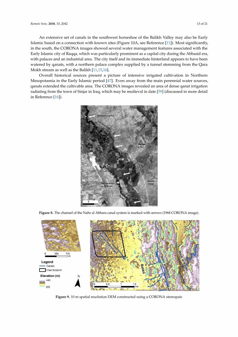
Remote Sens 2018 10 2042 13 of 21
An extensive set of canals in the southwest horseshoe of the Balikh Valley may also be EarlyIslamic based on a connection with known sites (Figure 10A see Reference [11]) Most significantlyin the south the CORONA images showed several water management features associated with theEarly Islamic city of Raqqa which was particularly prominent as a capital city during the Abbasid erawith palaces and an industrial area The city itself and its immediate hinterland appears to have beenwatered by qanats with a northern palace complex supplied by a tunnel stemming from the QaraMokh stream as well as the Balikh [111516]
Overall historical sources present a picture of intensive irrigated cultivation in NorthernMesopotamia in the Early Islamic period [47] Even away from the main perennial water sourcesqanats extended the cultivable area The CORONA images revealed an area of dense qanat irrigationradiating from the town of Sinjar in Iraq which may be medieval in date [59] (discussed in more detailin Reference [16])
Remote Sens 2018 10 2042 13 of 21
Figure 7 Irrigation systems in the Balikh Valley
Figure 8 The channel of the Nahr al Abbara canal system is marked with arrows (1968 CORONA image) Figure 8 The channel of the Nahr al Abbara canal system is marked with arrows (1968 CORONA image)Remote Sens 2018 10 2042 14 of 21
Figure 9 10 m spatial resolution DEM constructed using a CORONA stereopair
Figure 10 (A) Relict canals in the southwest Balikh Valley in 1968 which were (B) destroyed and replaced with a new irrigation system in 1972 (CORONA images)
4 Discussion
This research revealed an intensification of irrigation in most of the cultivable areas of Early Islamic Northern Mesopotamia particularly in the Balikh Valley The transformation of the environment that we observed fits the concept of ldquohydraulic landscapesrdquo Historical accounts and archaeological excavations have indicated that Raqqa was temporarily the centre of the Abbasid empire and a significant industrial town (eg see Reference [60]) which may offer an explanation for the intensification of water management features at this time In addition medieval irrigation in the Balikh may have been a response to deliberate policies of bringing marginal land into cultivation [17] policies that explain the increased application of water management technology throughout Northern Mesopotamia in the Early Islamic period This is an area where irrigation was not necessary but where employing it would have increased the reliability and quantity of agricultural yields developing and supporting powerful and demanding imperial economies Many existing hydraulic landscapes were maintained and developed while new ones were created in response to incentives
This intensive use of the landscape must have declined because until the later 20th century cultivation in Northern Mesopotamia was largely reported to be reliant on rainfall [61] (p 137) This transition followed the Early Islamic period By the 15th century the ancient water systems of Mesopotamia were falling into disrepair possibly due to plague and the depredations of the Mongols with subsequent depopulation and upheaval (eg see References [151662]) In many areas agriculture did not seem to have intensified again until the 2nd half of the 20th century
Figure 9 10 m spatial resolution DEM constructed using a CORONA stereopair
Remote Sens 2018 10 2042 14 of 21
4 Discussion
This research revealed an intensification of irrigation in most of the cultivable areas of Early IslamicNorthern Mesopotamia particularly in the Balikh Valley The transformation of the environment thatwe observed fits the concept of ldquohydraulic landscapesrdquo Historical accounts and archaeologicalexcavations have indicated that Raqqa was temporarily the centre of the Abbasid empire anda significant industrial town (eg see Reference [60]) which may offer an explanation for theintensification of water management features at this time In addition medieval irrigation in theBalikh may have been a response to deliberate policies of bringing marginal land into cultivation [17]policies that explain the increased application of water management technology throughout NorthernMesopotamia in the Early Islamic period This is an area where irrigation was not necessary but whereemploying it would have increased the reliability and quantity of agricultural yields developing andsupporting powerful and demanding imperial economies Many existing hydraulic landscapes weremaintained and developed while new ones were created in response to incentives
This intensive use of the landscape must have declined because until the later 20th centurycultivation in Northern Mesopotamia was largely reported to be reliant on rainfall [61] (p 137)This transition followed the Early Islamic period By the 15th century the ancient water systems ofMesopotamia were falling into disrepair possibly due to plague and the depredations of the Mongolswith subsequent depopulation and upheaval (eg see References [151662]) In many areas agriculturedid not seem to have intensified again until the 2nd half of the 20th century although traces of theancient irrigation systems remained embedded in the landscape until very recently (see travellersrsquoaccounts of abandoned canals eg [6364])
More recently however modern agricultural strategies in the Middle East have completelytransformed the landscape replacing ancient man-made hydraulic pathways with large-scale damsand canal systems and pumping from individual wells Many ancient irrigation systems have beenabandoned and destroyed to make way for new irrigation schemes A remote sensing methodologyusing interpretation from CORONA images dating from the period 1967ndash1972 proved to be a veryeffective strategy for recording ancient water management and for mapping its spread and distribution
When CORONA images (1968 and 1972) were compared (Figure 10) the initial construction ofthe modern field and irrigation systems in the 1970s Balikh is apparent This highlights the timelinessof the 1960s images which represent the last record of most of the ancient canal systems presented inFigures 5 and 7
Remote Sens 2018 10 2042 14 of 21
Figure 9 10 m spatial resolution DEM constructed using a CORONA stereopair
Figure 10 (A) Relict canals in the southwest Balikh Valley in 1968 which were (B) destroyed and replaced with a new irrigation system in 1972 (CORONA images)
4 Discussion
This research revealed an intensification of irrigation in most of the cultivable areas of Early Islamic Northern Mesopotamia particularly in the Balikh Valley The transformation of the environment that we observed fits the concept of ldquohydraulic landscapesrdquo Historical accounts and archaeological excavations have indicated that Raqqa was temporarily the centre of the Abbasid empire and a significant industrial town (eg see Reference [60]) which may offer an explanation for the intensification of water management features at this time In addition medieval irrigation in the Balikh may have been a response to deliberate policies of bringing marginal land into cultivation [17] policies that explain the increased application of water management technology throughout Northern Mesopotamia in the Early Islamic period This is an area where irrigation was not necessary but where employing it would have increased the reliability and quantity of agricultural yields developing and supporting powerful and demanding imperial economies Many existing hydraulic landscapes were maintained and developed while new ones were created in response to incentives
This intensive use of the landscape must have declined because until the later 20th century cultivation in Northern Mesopotamia was largely reported to be reliant on rainfall [61] (p 137) This transition followed the Early Islamic period By the 15th century the ancient water systems of Mesopotamia were falling into disrepair possibly due to plague and the depredations of the Mongols with subsequent depopulation and upheaval (eg see References [151662]) In many areas agriculture did not seem to have intensified again until the 2nd half of the 20th century
Figure 10 (A) Relict canals in the southwest Balikh Valley in 1968 which were (B) destroyed andreplaced with a new irrigation system in 1972 (CORONA images)
Remote Sens 2018 10 2042 15 of 21
While modern imagery such as IKONOS has been available for the study area since about 2000(Table 1) these images postdate major land use change that led to the destruction of most of the ancientcanals and therefore CORONA images are the only way of recording now-destroyed canal systemsFigure 11 shows how changes around the city of Raqqa between the 1960s and 2000s meant thatmuch of Early Islamic Raqqa and its environs (visible in the CORONA Figure 11A) had already beendestroyed by the time the IKONOS image (Figure 11B) was collected
Remote Sens 2018 10 2042 15 of 21
although traces of the ancient irrigation systems remained embedded in the landscape until very recently (see travellersrsquo accounts of abandoned canals eg [6364])
More recently however modern agricultural strategies in the Middle East have completely transformed the landscape replacing ancient man-made hydraulic pathways with large-scale dams and canal systems and pumping from individual wells Many ancient irrigation systems have been abandoned and destroyed to make way for new irrigation schemes A remote sensing methodology using interpretation from CORONA images dating from the period 1967ndash1972 proved to be a very effective strategy for recording ancient water management and for mapping its spread and distribution
When CORONA images (1968 and 1972) were compared (Figure 10) the initial construction of the modern field and irrigation systems in the 1970s Balikh is apparent This highlights the timeliness of the 1960s images which represent the last record of most of the ancient canal systems presented in Figures 5 and 7
While modern imagery such as IKONOS has been available for the study area since about 2000 (Table 1) these images postdate major land use change that led to the destruction of most of the ancient canals and therefore CORONA images are the only way of recording now-destroyed canal systems Figure 11 shows how changes around the city of Raqqa between the 1960s and 2000s meant that much of Early Islamic Raqqa and its environs (visible in the CORONA Figure 11A) had already been destroyed by the time the IKONOS image (Figure 11B) was collected
Figure 11 (A) CORONA image (May 1968) showing Early Islamic features of Raqqa including the 8th century AD walled city palace structures to the north of this and canals (B) IKONOS image (27 March 2000) showing that most of the medieval features were destroyed by modern buildings fields and roads
The Landsat sequence shows the intensification of agriculture underway from the 1980s (Figures 12 and 13) In Syria this was part of a programme involving construction of the Tabqa dam in 1966 30 km upstream of Raqqa [61] Figure 13 highlights the Balikh where we identified many ancient canal networks that corresponded neatly to the areas of modern irrigated agriculture highlighted by using a false colour visualisation By the 21st century modern agriculture had expanded throughout the valley including new fields and irrigation networks in the south the area known as the ldquohorseshoerdquo where several ancient canals supplied Early Islamic palaces and urban areas around Raqqa Recent disruption to irrigation infrastructure has been reported in the region due to the current conflict in Syria [1965] which is demonstrated by a slight reduction in the vegetated area between the 2010ndash2011 and 2016ndash2017 Landsat composites
Figure 11 (A) CORONA image (May 1968) showing Early Islamic features of Raqqa including the8th century AD walled city palace structures to the north of this and canals (B) IKONOS image(27 March 2000) showing that most of the medieval features were destroyed by modern buildingsfields and roads
The Landsat sequence shows the intensification of agriculture underway from the 1980s(Figures 12 and 13) In Syria this was part of a programme involving construction of the Tabqadam in 1966 30 km upstream of Raqqa [61] Figure 13 highlights the Balikh where we identifiedmany ancient canal networks that corresponded neatly to the areas of modern irrigated agriculturehighlighted by using a false colour visualisation By the 21st century modern agriculture had expandedthroughout the valley including new fields and irrigation networks in the south the area known asthe ldquohorseshoerdquo where several ancient canals supplied Early Islamic palaces and urban areas aroundRaqqa Recent disruption to irrigation infrastructure has been reported in the region due to the currentconflict in Syria [1965] which is demonstrated by a slight reduction in the vegetated area between the2010ndash2011 and 2016ndash2017 Landsat composites
Figure 12 shows a Landsat false colour composite of a large part of the Euphrates river in Syria in1985 and 1986 and again in 2016 and 2017 with Lake Assad in the top left and the Balikh and Haburtributaries joining from the north Figure 13 zooms in on the Syrian Balikh The red colours in theLandsat images seen in Figures 12 and 13 show the distribution of modern productive agriculturalland where changes shown in both figures reflect the intensification of agriculture the effect of whichhas been to remove traces of ancient water features The Landsat images emphasise the particularimportance of the Balikh which represents a large area of agricultural production within the wholeEuphrates valley The TurkeyndashSyria border can be clearly seen in the imagery (Figure 12) becauseof the contrast in water available for irrigation this serves as a reminder of the importance of thegeopolitics of water resources in the region from ancient times right up to the present day
Remote Sens 2018 10 2042 16 of 21Remote Sens 2018 10 2042 16 of 21
Figure 12 False colour Landsat composites showing the intensification of agriculture in Northern Mesopotamia over the past 40 years (A) Landsat 5 composite 1985ndash1986 (B) Landsat 8 composite 2016ndash2017 Images downloaded and mosaicked using Google Earth Engine
Figure 13 Landsat composites showing the expansion of modern irrigation in the Balikh (A) Landsat 5 1985ndash1986 (B) Landsat 7 2010ndash2011 (C) Landsat 8 2016ndash2017 Images downloaded and mosaicked using Google Earth Engine and visualised as false colour composites
Figure 12 False colour Landsat composites showing the intensification of agriculture in NorthernMesopotamia over the past 40 years (A) Landsat 5 composite 1985ndash1986 (B) Landsat 8 composite2016ndash2017 Images downloaded and mosaicked using Google Earth Engine
Remote Sens 2018 10 2042 16 of 21
Figure 12 False colour Landsat composites showing the intensification of agriculture in Northern Mesopotamia over the past 40 years (A) Landsat 5 composite 1985ndash1986 (B) Landsat 8 composite 2016ndash2017 Images downloaded and mosaicked using Google Earth Engine
Figure 13 Landsat composites showing the expansion of modern irrigation in the Balikh (A) Landsat 5 1985ndash1986 (B) Landsat 7 2010ndash2011 (C) Landsat 8 2016ndash2017 Images downloaded and mosaicked using Google Earth Engine and visualised as false colour composites
Figure 13 Landsat composites showing the expansion of modern irrigation in the Balikh (A) Landsat5 1985ndash1986 (B) Landsat 7 2010ndash2011 (C) Landsat 8 2016ndash2017 Images downloaded and mosaickedusing Google Earth Engine and visualised as false colour composites
There are some caveats to a methodology that relies principally on image interpretation Whetheror not water management features can be identified depends on a number of factors including imagequality and timing and natural conditions We identified rock-cut conduits and tunnels alongside
Remote Sens 2018 10 2042 17 of 21
dry streams in the Jerablus region during a survey in 2010 [48] that were not visible in the CORONA(1967 and 1972) and modern imagery There may well be other ancient irrigation features throughoutnorthern Syria and Iraq that have not yet been identified However many of the features we identifiedin the CORONA images were no longer visible on the ground having been destroyed to make way formodern agriculture This included the Nahr al Abbara canal system in the Balikh
Working with CORONA was difficult due to the panoramic and historical nature of the dataThe panoramic frames were distorted (eg see Reference [41] (p 228) Reference [66]) especiallytoward the edges and some image acquisition parameters were not available making constructing anaccurate camera model challenging The quality and time of collection of different images was variableSome higher resolution modern imagery was examined for example IKONOS imagery covering thearea around Raqqa in the southern Balikh However it was found that recent landscape changes haddestroyed much of the archaeology (see Figure 11) The CORONA data were often of the best timeperiod consistency of image quality (spatial and radiometric) and availability for large area coveragemaking it ideal for recording ancient water management features In fact we were able to obtainCORONA imagery for our entire 100000 km2 study area
5 Conclusions
Declassified CORONA satellite images from the 1960s and early 1970s are used to identify andreconstruct ancient hydraulic landscapes over large geographic areas The CORONA KH-4B camerahas stereoscopic capability which helps to identify and interpret water management features When theCORONA images were analysed in conjunction with modern satellite imagery DEMs and contextualinformation from archaeological and historical surveys the trajectory of the development of irrigationtechnology becomes clear
This study mapped water management features from the period ca 1200 BC to AD 1500 acrossthe entirety of Northern Mesopotamia for the first time (Figure 5) Irrigation increased in densitythroughout the region including within the zone traditionally regarded as ldquorain-fedrdquo and revealeda peak in the Early Islamic era Environmental considerations for understanding why and whereirrigation was undertaken during the period of the later empires also helped us to contextualise theresults An average rainfall of 200ndash250 mm a year is often interpreted as the limit of rain-fed cultivationfor modern and ancient agriculture (eg see References [186768]) and depicted as an isohyet lineHowever an analysis of modern rain gauge data indicates that much of the area encompassed byancient irrigation (receiving approximately 100ndash400 mm per year) experiences high variability today(20ndash40 see Reference [2] (p 158)) which makes irrigation necessary to mitigate against irregularrainfall [65] (p 5) If rainfall was similarly variable during the period of the later empires (eg atthe time of the MCA) our data suggests that they were investing in large-scale irrigation in a regionwhere rain-fed cultivation was technically possible but where it was risky due to the variability ofprecipitation Unlike in Southern Mesopotamia irrigation was not absolutely necessary for agriculturein Northern Mesopotamia but the construction of water management features was a way to ensureaccess to water in order to mitigate against disruptions to food supply
It is unlikely to be a coincidence that irrigation activity was intensified during the era of the firsttrue territorial empires when these powerful entities exerted and contested political control over thelandscape It is apparent that from the Neo-Assyrian period and by the Early Islamic period most ofthe perennial water courses in Northern Mesopotamia were used as sources of irrigation water andthat available groundwater was utilised The water management systems that we recorded includedmany reticulated and sophisticated systems that supported powerful states represented by traces ofprominent channels alongside the main rivers dense networks of irrigation in the tributaries andsignificant groundwater exploitation using qanats Many canals and parts of canal systems wouldhave been missed if examined through fieldwork alone Through interpretation of satellite imagesthis study was able to locate and map some previously unknown or understudied systems suchas numerous qanats in the Sinjar Plain of Iraq [1516] the qanat at Dibsi Faraj in Syria [1] and the
Remote Sens 2018 10 2042 18 of 21
real complexity of irrigation in the Balikh Valley in Syria [1111516] The combination of remotesensing archived data and fieldwork enabled further chronological and historical contextualisation ofthese remains
If fieldwork should become possible in the near future this reconstruction of ancient watermanagement in Northern Mesopotamia would benefit from ground sample testing using scientificdating techniques such as optically stimulated luminescence (OSL) (eg see Reference [69]) The use ofunmanned aerial vehicles (UAVs) dGPS and newer high-resolution DEMs such as TanDEM-X wouldprovide improved control data for photogrammetric processing of CORONA Several significant areasof relict channels require further investigation (for example qanats around Membij and Sinjar seeReferences [1516]) which itself might enable increased protection of this archaeological resource Dueto the current risk of looting and vandalism to archaeological sites in Mesopotamia it is not possible tomake the GIS database of canal locations publically available but these can be provided to verifiedheritage professionals via the EAMENA database if requested [70]
Conflict in Syria and Iraq has led to an ongoing humanitarian crisis and has impacted severelyon cultural heritage with deliberate destruction of many monumental sites including some of theIslamic remains in Raqqa Satellite imagery is being extensively used to highlight the destruction ofarchaeology in the Middle East during conflict [71] although its efficacy as a solution to stopping thedestruction is unclear Media reports often draw attention to damage to large monumental sites whilethe routine destruction of ancient canals by modern agricultural and urban development is frequentlyoverlooked Water management features may not be a particular target for vandalism but longer-termland use changes have wiped out many of their traces from the landscape making CORONA the lastrecord of the intensive hydraulic landscapes of the ancient empires
Supplementary Materials The following are available online at httpwwwmdpicom2072-429210122042s1 CORONA DEM triangulation reports Landsat comparisons SRTM CORONA and Landsat data availablefrom the US Geological Survey
Author Contributions Conceptualization LR and DD formal analysis LR funding acquisition DDinvestigation LR methodology LR and DD project administration LR supervision DD visualization LRwritingmdashoriginal draft LR writingmdashreview and editing LR and DD
Funding This PhD research was funded by the Faculty of Social Sciences and Health Durham University
Acknowledgments We would particularly like to acknowledge the role of the late Tony Wilkinson in supervisingsupporting and encouraging this research and for providing information about his surveys in the Balikh Valley
Conflicts of Interest The authors declare no conflicts of interest The funders had no role in the design of thestudy in the collection analyses or interpretation of data in the writing of the manuscript or in the decision topublish the results
References
1 Wilkinson TJ Rayne L Hydraulic Landscapes and Imperial Power in the near East Water Hist 2010 2115ndash144 [CrossRef]
2 Rayne L Water and Territorial Empires The Application of Remote Sensing Techniques to Ancient ImperialWater Management in Northern Mesopotamia PhD Thesis University of Durham Durham UK 2014
3 Schneider U Becker A Meyer-Christoffer M Ziese B Global Precipitation Analysis Products of theGpcc Available online httpwwwcgducareducascatalogsurfaceprecipgpcchtml (accessed on14 December 2018)
4 Wilkinson TJ Archaeological Landscapes of the near East University of Arizona Press Tucson AZ USA 20035 Oded B Mass Deportations and Deportees in the Neo-Assyrian Empire L Reichert Depew NY USA 19796 Jacobsen T Lloyd S Sennacheribrsquos Aqueduct at Jerwan University of Chicago Press Chicago IL USA 19557 Dalley S Nineveh Babylon and the Hanging Gardens Cuneiform and Classical Sources Reconciled Iraq
1994 56 45ndash58 [CrossRef]8 Ur J Sennacheribrsquos Northern Assyrian Canals New Insights from Satellite Imagery and Aerial Photography
Iraq 2005 67 317ndash345 [CrossRef]
Remote Sens 2018 10 2042 19 of 21
9 Wilkinson TJ Water and Human Settlement in the Balikh Valley Syria Investigations from 1992ndash1995J Field Archaeol 1998 25 63ndash87
10 Wilkinson TJ Peltenburg E McCarthy A Wilkinson EB Brown M Archaeology in the Land ofCarchemisch Landscape Surveys in the Area of Jerablus Tahtani 2006 Levant 2007 39 213ndash247 [CrossRef]
11 Rayne L Imperial Water Systems and Human Niche Construction in the Balikh Valley Water Hist 2015 7419ndash440 [CrossRef]
12 Harper RP Wilkinson TJ Excavations at Dibsi Faraj Northern Syria 1972ndash1974 A Preliminary Note onthe Site and Its Monuments with an Appendix Dumbarton Oaks Papers 1975 29 319ndash338 [CrossRef]
13 Berthier S DrsquoHont O Ressources Hydriques Et Peuplement Sur Le Moyen Euphrate Viiegraveme-Xix EgravemeSiegravecle In Proceedings of the RURALIA 2003 Lyon France 17 September 2003
14 Geyer B Monchambert JY La Basse Valleacutee De Lrsquoeuphrate Syrien Du Neacuteolithique Agrave Lrsquoavegravenement De LrsquoislamGeacuteographie Archeacuteologie Et Histoire IFAPO Paris France 2003
15 Rayne L Early Islamic Water Management in Northern Mesopotamia In Economic Integration and SocialChange in the Islamic World System 800ndash1000 Ce The Geography and Infrastructure of Trade in Early IslamBessard F Kennedy H Eds Oxford University Press Oxford UK in press
16 Rayne L Early Islamic Water Management in the Hinterland of Raqqa In New Agendas in Remote Sensing andLandscape Archaeology in the Near East Studies in Honor of T J Wilkinson Altaweel M Lawrence D Philip GEds Oriental Institute of the University of Chicago Chicago IL USA in press
17 Kennedy HN The Feeding of the Five Hundred Thousand Cities and Agriculture in Early IslamicMesopotamia Iraq 2011 73 177ndash199 [CrossRef]
18 Perrin de Brichambaut G Walleacuten CC FaoUnescoWmo Interagency Project on Agroclimatology 1962 DraftGeneral Report on a Study of Agroclimatology in Semi-Arid and Arid Zones of the Near East FAO Rome Italy 1962
19 Counting the Cost Agriculture in Syria after Six Years of Crisis Available online httpwwwfaoorgemergenciesresourcesdocumentsresources-detailenc878213 (accessed on 11 November 2018)
20 Wittfogel K Oriental Despotism A Comparative Study of Total Power Yale University Press New Haven CTUSA London UK 1957
21 Christensen P The Decline of Iranshahr Irrigation and Environments in the History of the Middle East 500 Bc toAd 1500 Museum Tusculanum Press Copenhagen Denmark 1993
22 Fisher WB The Middle East A Physical Social and Regional Geography 7th ed Completely Revised and Reseted Methuen London UK 1978
23 Jewitt TN Soils of Arid Lands In Arid Lands A Gographical Appraisal Hills ES Ed Methuen and Co LtdLondon UK 1966
24 Riehl S Bryson R Pustovoytov K Changing Growing Conditions for Crops During the near Eastern BronzeAge (3000ndash1200 Bc) The Stable Carbon Isotope Evidence J Archaeol Sci 2008 35 1011ndash1022 [CrossRef]
25 Bar-Matthews M Ayalon A Kaufman A Late Quaternary Paleoclimate in the Eastern MediterraneanRegion from Stable Isotope Analysis of Speleothems at Soreq Cave Israel Quat Res 1997 47 155ndash168[CrossRef]
26 Xoplaki E Fleitmann D Luterbacher J Wagner S Haldon JF Zorita E Telelis I Toreti A Izdebski AThe Medieval Climate Anomaly and Byzantium A Review of the Evidence on Climatic FluctuationsEconomic Performance and Societal Change Quat Sci Rev 2016 136 229ndash252 [CrossRef]
27 IPCC Climate Change 2013 The Physical Science Basis Contribution of Working Group I to the Fifth AssessmentReport of the Intergovernmental Panel on Climate Change Stocker TF Qin D Plattner G-K Tignor MAllen SK Boschung J Nauels A Xia Y Bex V Midgley PM Eds Cambridge University PressCambridge UK 2013
28 Kamash Z Archaeologies of Water in the Roman near East 63 Bc-Ad 636 Piscataway Gorgias Press PiscatawayNJ USA 2010
29 Kamash Z Water Supply and Management in the Near East 63 Bc-Ad 636 PhD Thesis University ofOxford Oxford UK 2007
30 Philip G Donoghue DNM Beck A Galiatsatos N Corona Satellite Photography An ArchaeologicalApplication from the Middle East Antiquity 2002 76 109ndash118 [CrossRef]
31 David K Bewley R Aerial Archaeology in Jordan Antiquity 2009 83 69ndash8132 Altaweel M The Imperial Landscape of Ashur Settlement and Land Use in the Assyrian Heartland OrientVerlag
Heidelberg Germany 2008
Remote Sens 2018 10 2042 20 of 21
33 Van Liere WJ Lauffray J Nouvelle Prospection Archaeologique Dans La Haute Jazireh Syrienne Les AnnalsArchaeologiques De Syrie 1954ndash1955 4 129ndash148
34 Gorelick N Hancher M Dixon M Ilyushchenko S Thau D Moore R Google Earth EnginePlanetary-Scale Geospatial Analysis for Everyone Remote Sens Environ 2017 202 18ndash27 [CrossRef]
35 Galiatsatos N Wilkinson TJ Donoghue DNM Philip G The Fragile Crescent Project (Fcp) Analysis ofSettlement Landscapes Using Satellite Imagery Available online httpdroduracuk6909 (accessed on18 December 2018)
36 Casana J Cothren J The Corona Atlas Project Orthorectification of Corona Satellite Imagery andRegional-Scale Archaeological Exploration in the near East In Mapping Archaeological Landscapes fromSpace Comer DC Harrower MJ Eds Springer Berlin Germany 2013
37 Farr TG Rosen PA Caro E Crippen R Duren R Hensley S Kobrick M Paller M Rodriguez ERoth L The Shuttle Radar Topography Mission Rev Geophys 2007 45 [CrossRef]
38 Schmidt M Goossens R Menz G Altmaier A Devriendt D The Use of Corona Satellite Images forGenerating a High Resolution Digital Elevation Model Paper Presented at the IEEE 2001 InternationalGeoscience and Remote Sensing Symposium Sydney NSW Australia 9ndash13 July 2001
39 Mugnier CJ Forstner W Wrobel B Paderes F Munjy R The Mathematics of Photogrammetry InManual of Photogrammetry McGlone JC Ed American Society of Photogrammetry and Remote SensingBethseda MD USA 2004 pp 181ndash316
40 Wong KW Basic Mathematics of Photogrammetry In Manual of Photogrammetry Slama CC Ed AmericanSociety of Photogrammetry Falls Church VA USA 1980 pp 37ndash101
41 Altmaier A Kany C Digital Surface Model Generation from Corona Satellite Images ISPRS J PhotogrammRemote Sens 2002 56 221ndash235 [CrossRef]
42 USGS Declassified Satellite Imagerymdash1 Available online httpsltacrusgsgovdeclass_1 (accessed on 18December 2018)
43 Galiatsatos N Donoghue DNM Philip G High Resolution Elevation Data Derived from StereoscopicCorona Imagery with Minimal Ground Control Photogramm Eng Remote Sens 2007 73 1093ndash1106 [CrossRef]
44 Casana J Cothren J Stereo Analysis Dem Extraction and Orthorectification of Corona Satellite ImageryArchaeological Applications from the near East Antiquity 2008 82 732ndash749 [CrossRef]
45 Boyle R Thomas RC Computer Vision A First Course Blackwell Scientific Publications Ltd Hoboken NJUSA 1988
46 Ur J Wilkinson TJ Settlement and Economic Landscapes of Tell Beydar and Its Hinterland Brepols TurnhoutBelgium 2008
47 Le Strange G The Lands of the Eastern Caliphate Mesopotamia Persia and Central Asia from the Moslem Conquestto the Time of Timur Cambridge University Press Cambridge UK 1905
48 Peltenburg E Wilkinson TJ Wilkinson EB Carchemish in Context Oxbow Books Oxford UK 201649 Wilkinson EB Wilkinson TJ Peltenburg E Revisiting Carchemish The Land of Carchemish Project in
Syria 2009 and 2010 Antiquity Bull 2011 85 329ndash33250 Ur J de Jong L Giraud J Osborne JF MacGinnis J Ancient Cities and Landscapes in the Kurdistan
Region of Iraq The Erbil Plain Archaeological Survey 2012 Season Iraq 2013 75 89ndash118 [CrossRef]51 Ur J Tell Hamoukar Volume 1 Urbanism and Cultural Landscapes in Northeastern Syria The Tell Hamoukar Survey
1999ndash2001 The Oriental Institute of the University of Chicago Chicago IL USA 201052 Bounni A Campaign and Exhibition from the Euphrates in Syria Annu Am Schools Orient Res 1977 44
1ndash453 Ergenzinger PJ Kuumlhne H Ein Regionales Bewaumlsserungssystem Am Habur In Die Rezente Umwelt Von Tell
Sheikh Hamad Und Daten Zur Umweltrekonstruktion Der Assyrischen Stadt Dur-Katlimmu Berichte Aus DerAusgrabungen Tell Sheikh HamadDur-Katlimmu Dietrich Reimer Verlag Berlin Germany 1991
54 Lightfoot JL Lucian on the Syrian Goddess Oxford University Press Oxford UK 200355 Van Liere WJ Lauffray J Capitals and Citadels of Bronze-Iron Syria in Their Relationship to Land and
Water Les Annales Archaeol De Syrie 1963 13 107ndash12256 Berthier S Peuplement Rural Et Ameacutenagements Hydroagricoles Dans La Moyenne Valleacutee De Lrsquoeuphrate Fin
Viie-Xixe Siegravecle Reacutegion De Deir Ez Zor-Abu Kemal Syrie Mission Meacutesopotamie Syrienne Archeacuteologie Islamique1986ndash1989 Institut Franccedilais drsquoEacutetudes Arabes de Damas Paris France 2001
Remote Sens 2018 10 2042 21 of 21
57 Heidemann S The Agricultural Hinterland of Baghdad Al-Raqqa and Samarra Settlement Patterns in theDiyar Mudar In Le Proche-Orient de Justinien aux Abbasides Peuplement et Dynamiques Spatiales Actes ducolloque Paris France 2011
58 Bartl K Fruumlhislamische Besiedlung Im Balı
Remote Sens 2018 10 2042 21 of 21
49 Wilkinson EB Wilkinson TJ Peltenburg E Revisiting Carchemish The Land of Carchemish Project in Syria 2009 and 2010 Antiquity Bull 2011 85 329ndash332
50 Ur J de Jong L Giraud J Osborne JF MacGinnis J Ancient Cities and Landscapes in the Kurdistan Region of Iraq The Erbil Plain Archaeological Survey 2012 Season Iraq 2013 75 89ndash118
51 Ur J Tell Hamoukar Volume 1 Urbanism and Cultural Landscapes in Northeastern Syria The Tell Hamoukar Survey 1999ndash2001 The Oriental Institute of the University of Chicago Chicago IL USA 2010
52 Bounni A Campaign and Exhibition from the Euphrates in Syria Annu Am Schools Orient Res 1977 44 1ndash4
53 Ergenzinger PJ Kuumlhne H Ein Regionales Bewaumlsserungssystem Am Habur In Die Rezente Umwelt Von Tell Sheikh Hamad Und Daten Zur Umweltrekonstruktion Der Assyrischen Stadt Dur-Katlimmu Berichte Aus Der Ausgrabungen Tell Sheikh HamadDur-Katlimmu Dietrich Reimer Verlag Berlin Germany 1991
54 Lightfoot JL Lucian on the Syrian Goddess Oxford University Press Oxford UK 2003 55 Van Liere WJ Lauffray J Capitals and Citadels of Bronze-Iron Syria in Their Relationship to Land and
Water Les Annales Archaeol De Syrie 1963 13 107ndash122 56 Berthier S Peuplement Rural Et Ameacutenagements Hydroagricoles Dans La Moyenne Valleacutee De Leuphrate Fin Viie-
Xixe Siegravecle Reacutegion De Deir Ez Zōr-Abu Kemāl Syrie Mission Meacutesopotamie Syrienne Archeacuteologie Islamique 1986ndash1989 Institut Franccedilais dEacutetudes Arabes de Damas Paris France 2001
57 Heidemann S The Agricultural Hinterland of Baghdad Al-Raqqa and Samarra Settlement Patterns in the Diyar Mudar In Le Proche-Orient de Justinien aux Abbasides Peuplement et Dynamiques Spatiales Actes du colloque Paris France 2011
58 Bartl K Fruumlhislamische Besiedlung Im Balī ḫ-Tal Nordsyrien Reimer Berlin Germany1994 59 Fuccaro N Aspects of the Social and Political History of the Yazidi Enclave of Jabal Sinjar (Iraq) under the British
Mandate 1919ndash1932 Durham University Durham UK 1994 60 Henderson J Challis K OrsquoHara S McLoughlin S Gardner A Priestnall G Experiment and
Innovation Early Islamic Industry at Al-Raqqa Syria Antiquity 2005 79 130ndash145 61 Beaumont P Agricultural and Environmental Changes in the Upper Euphrates Catchment of Turkey and
Syria and Their Political and Economic Implications Appl Geogr 1996 16 137ndash157 62 Dols MW The Second Plague Pandemic and Its Recurrences in the Middle East 1347ndash1894 J Econ Soc
Hist OrientJo Lhist Econ Soc lOrient 1979 22 162ndash189 63 Bell G Amurath to Amurath Macmillan and Co Ltd London UK 1924 64 Sykes M Journeys in North Mesopotamia Geogr J 1907 30 237ndash254 65 Tull K Agriculture in Syria In K4D Helpdesk Report 133 Institute of Development Studies Brighton UK
2017 66 Sohn HG Kim GH Yom JH Mathematical Modelling of Historical Reconnaissance Corona Kh-4b
Imagery Photogramm Record 2004 19 51ndash66 67 Wilkinson TJ The Structure and Dynamics of Dry-Farming States in Upper Mesopotamia Curr Anthropol
1994 35 483ndash520 68 Jas RM Rainfall and Agriculture in Northern Mesopotamia Nederlands Historisch-Archaeologische Instituut
te Istanbul Istanbul Turkey 2000 69 Bailiff IK Gerrard CM Gutieacuterrez A Snape-Kennedy LM Wilkinson KN Luminescence Dating of
Irrigation Systems Application to a Qanat in Aragoacuten Spain Quat Geochronol 2015 30 452ndash459 70 EAMENA Eamena Database Available online httpeamenaarchoxacukresourcesdatabase-2
(accessed on 4 December 2018) 71 Bjoslashrgo E Boccardi G Cunliffe E Fiol M Jellison T Pederson W Saslow C Satellite-Based Damage
Assessment to Cultural Heritage Sites in Syria UNITARUNOSAT 2014 Available online httpwww unitar orgunosatchs-syria (accessed on 1 October 2017)
copy 2018 by the authors licensee MDPI Basel Switzerland This article is an open access article distributed under the terms and conditions of the Creative Commons Attribution (CC BY) license (httpcreativecommonsorglicensesby40)
-Tal Nordsyrien Reimer Berlin Germany 199459 Fuccaro N Aspects of the Social and Political History of the Yazidi Enclave of Jabal Sinjar (Iraq) under the British
Mandate 1919ndash1932 Durham University Durham UK 199460 Henderson J Challis K OrsquoHara S McLoughlin S Gardner A Priestnall G Experiment and Innovation
Early Islamic Industry at Al-Raqqa Syria Antiquity 2005 79 130ndash145 [CrossRef]61 Beaumont P Agricultural and Environmental Changes in the Upper Euphrates Catchment of Turkey and
Syria and Their Political and Economic Implications Appl Geogr 1996 16 137ndash157 [CrossRef]62 Dols MW The Second Plague Pandemic and Its Recurrences in the Middle East 1347ndash1894 J Econ Soc
Hist OrientJo Lrsquohist Econ Soc lrsquoOrient 1979 22 162ndash189 [CrossRef]63 Bell G Amurath to Amurath Macmillan and Co Ltd London UK 192464 Sykes M Journeys in North Mesopotamia Geogr J 1907 30 237ndash254 [CrossRef]65 Tull K Agriculture in Syria In K4D Helpdesk Report 133 Institute of Development Studies Brighton
UK 201766 Sohn HG Kim GH Yom JH Mathematical Modelling of Historical Reconnaissance Corona Kh-4b
Imagery Photogramm Record 2004 19 51ndash66 [CrossRef]67 Wilkinson TJ The Structure and Dynamics of Dry-Farming States in Upper Mesopotamia Curr Anthropol
1994 35 483ndash520 [CrossRef]68 Jas RM Rainfall and Agriculture in Northern Mesopotamia Nederlands Historisch-Archaeologische Instituut
te Istanbul Istanbul Turkey 200069 Bailiff IK Gerrard CM Gutieacuterrez A Snape-Kennedy LM Wilkinson KN Luminescence Dating of
Irrigation Systems Application to a Qanat in Aragoacuten Spain Quat Geochronol 2015 30 452ndash459 [CrossRef]70 EAMENA Eamena Database Available online httpeamenaarchoxacukresourcesdatabase-2
(accessed on 4 December 2018)71 Bjoslashrgo E Boccardi G Cunliffe E Fiol M Jellison T Pederson W Saslow C Satellite-Based Damage
Assessment to Cultural Heritage Sites in Syria UNITARUNOSAT 2014 Available online httpwwwunitarorgunosatchs-syria (accessed on 1 October 2017)
copy 2018 by the authors Licensee MDPI Basel Switzerland This article is an open accessarticle distributed under the terms and conditions of the Creative Commons Attribution(CC BY) license (httpcreativecommonsorglicensesby40)
- Introduction
- Materials and Methods
-
- Satellite Imagery
- Hydraulic Context and Terrain Extraction
- Interpretation Criteria
- Archaeological Survey and Dating Evidence
-
- Results
- Discussion
- Conclusions
- References
-

Remote Sens 2018 10 2042 14 of 21
4 Discussion
This research revealed an intensification of irrigation in most of the cultivable areas of Early IslamicNorthern Mesopotamia particularly in the Balikh Valley The transformation of the environment thatwe observed fits the concept of ldquohydraulic landscapesrdquo Historical accounts and archaeologicalexcavations have indicated that Raqqa was temporarily the centre of the Abbasid empire anda significant industrial town (eg see Reference [60]) which may offer an explanation for theintensification of water management features at this time In addition medieval irrigation in theBalikh may have been a response to deliberate policies of bringing marginal land into cultivation [17]policies that explain the increased application of water management technology throughout NorthernMesopotamia in the Early Islamic period This is an area where irrigation was not necessary but whereemploying it would have increased the reliability and quantity of agricultural yields developing andsupporting powerful and demanding imperial economies Many existing hydraulic landscapes weremaintained and developed while new ones were created in response to incentives
This intensive use of the landscape must have declined because until the later 20th centurycultivation in Northern Mesopotamia was largely reported to be reliant on rainfall [61] (p 137)This transition followed the Early Islamic period By the 15th century the ancient water systems ofMesopotamia were falling into disrepair possibly due to plague and the depredations of the Mongolswith subsequent depopulation and upheaval (eg see References [151662]) In many areas agriculturedid not seem to have intensified again until the 2nd half of the 20th century although traces of theancient irrigation systems remained embedded in the landscape until very recently (see travellersrsquoaccounts of abandoned canals eg [6364])
More recently however modern agricultural strategies in the Middle East have completelytransformed the landscape replacing ancient man-made hydraulic pathways with large-scale damsand canal systems and pumping from individual wells Many ancient irrigation systems have beenabandoned and destroyed to make way for new irrigation schemes A remote sensing methodologyusing interpretation from CORONA images dating from the period 1967ndash1972 proved to be a veryeffective strategy for recording ancient water management and for mapping its spread and distribution
When CORONA images (1968 and 1972) were compared (Figure 10) the initial construction ofthe modern field and irrigation systems in the 1970s Balikh is apparent This highlights the timelinessof the 1960s images which represent the last record of most of the ancient canal systems presented inFigures 5 and 7
Remote Sens 2018 10 2042 14 of 21
Figure 9 10 m spatial resolution DEM constructed using a CORONA stereopair
Figure 10 (A) Relict canals in the southwest Balikh Valley in 1968 which were (B) destroyed and replaced with a new irrigation system in 1972 (CORONA images)
4 Discussion
This research revealed an intensification of irrigation in most of the cultivable areas of Early Islamic Northern Mesopotamia particularly in the Balikh Valley The transformation of the environment that we observed fits the concept of ldquohydraulic landscapesrdquo Historical accounts and archaeological excavations have indicated that Raqqa was temporarily the centre of the Abbasid empire and a significant industrial town (eg see Reference [60]) which may offer an explanation for the intensification of water management features at this time In addition medieval irrigation in the Balikh may have been a response to deliberate policies of bringing marginal land into cultivation [17] policies that explain the increased application of water management technology throughout Northern Mesopotamia in the Early Islamic period This is an area where irrigation was not necessary but where employing it would have increased the reliability and quantity of agricultural yields developing and supporting powerful and demanding imperial economies Many existing hydraulic landscapes were maintained and developed while new ones were created in response to incentives
This intensive use of the landscape must have declined because until the later 20th century cultivation in Northern Mesopotamia was largely reported to be reliant on rainfall [61] (p 137) This transition followed the Early Islamic period By the 15th century the ancient water systems of Mesopotamia were falling into disrepair possibly due to plague and the depredations of the Mongols with subsequent depopulation and upheaval (eg see References [151662]) In many areas agriculture did not seem to have intensified again until the 2nd half of the 20th century
Figure 10 (A) Relict canals in the southwest Balikh Valley in 1968 which were (B) destroyed andreplaced with a new irrigation system in 1972 (CORONA images)
Remote Sens 2018 10 2042 15 of 21
While modern imagery such as IKONOS has been available for the study area since about 2000(Table 1) these images postdate major land use change that led to the destruction of most of the ancientcanals and therefore CORONA images are the only way of recording now-destroyed canal systemsFigure 11 shows how changes around the city of Raqqa between the 1960s and 2000s meant thatmuch of Early Islamic Raqqa and its environs (visible in the CORONA Figure 11A) had already beendestroyed by the time the IKONOS image (Figure 11B) was collected
Remote Sens 2018 10 2042 15 of 21
although traces of the ancient irrigation systems remained embedded in the landscape until very recently (see travellersrsquo accounts of abandoned canals eg [6364])
More recently however modern agricultural strategies in the Middle East have completely transformed the landscape replacing ancient man-made hydraulic pathways with large-scale dams and canal systems and pumping from individual wells Many ancient irrigation systems have been abandoned and destroyed to make way for new irrigation schemes A remote sensing methodology using interpretation from CORONA images dating from the period 1967ndash1972 proved to be a very effective strategy for recording ancient water management and for mapping its spread and distribution
When CORONA images (1968 and 1972) were compared (Figure 10) the initial construction of the modern field and irrigation systems in the 1970s Balikh is apparent This highlights the timeliness of the 1960s images which represent the last record of most of the ancient canal systems presented in Figures 5 and 7
While modern imagery such as IKONOS has been available for the study area since about 2000 (Table 1) these images postdate major land use change that led to the destruction of most of the ancient canals and therefore CORONA images are the only way of recording now-destroyed canal systems Figure 11 shows how changes around the city of Raqqa between the 1960s and 2000s meant that much of Early Islamic Raqqa and its environs (visible in the CORONA Figure 11A) had already been destroyed by the time the IKONOS image (Figure 11B) was collected
Figure 11 (A) CORONA image (May 1968) showing Early Islamic features of Raqqa including the 8th century AD walled city palace structures to the north of this and canals (B) IKONOS image (27 March 2000) showing that most of the medieval features were destroyed by modern buildings fields and roads
The Landsat sequence shows the intensification of agriculture underway from the 1980s (Figures 12 and 13) In Syria this was part of a programme involving construction of the Tabqa dam in 1966 30 km upstream of Raqqa [61] Figure 13 highlights the Balikh where we identified many ancient canal networks that corresponded neatly to the areas of modern irrigated agriculture highlighted by using a false colour visualisation By the 21st century modern agriculture had expanded throughout the valley including new fields and irrigation networks in the south the area known as the ldquohorseshoerdquo where several ancient canals supplied Early Islamic palaces and urban areas around Raqqa Recent disruption to irrigation infrastructure has been reported in the region due to the current conflict in Syria [1965] which is demonstrated by a slight reduction in the vegetated area between the 2010ndash2011 and 2016ndash2017 Landsat composites
Figure 11 (A) CORONA image (May 1968) showing Early Islamic features of Raqqa including the8th century AD walled city palace structures to the north of this and canals (B) IKONOS image(27 March 2000) showing that most of the medieval features were destroyed by modern buildingsfields and roads
The Landsat sequence shows the intensification of agriculture underway from the 1980s(Figures 12 and 13) In Syria this was part of a programme involving construction of the Tabqadam in 1966 30 km upstream of Raqqa [61] Figure 13 highlights the Balikh where we identifiedmany ancient canal networks that corresponded neatly to the areas of modern irrigated agriculturehighlighted by using a false colour visualisation By the 21st century modern agriculture had expandedthroughout the valley including new fields and irrigation networks in the south the area known asthe ldquohorseshoerdquo where several ancient canals supplied Early Islamic palaces and urban areas aroundRaqqa Recent disruption to irrigation infrastructure has been reported in the region due to the currentconflict in Syria [1965] which is demonstrated by a slight reduction in the vegetated area between the2010ndash2011 and 2016ndash2017 Landsat composites
Figure 12 shows a Landsat false colour composite of a large part of the Euphrates river in Syria in1985 and 1986 and again in 2016 and 2017 with Lake Assad in the top left and the Balikh and Haburtributaries joining from the north Figure 13 zooms in on the Syrian Balikh The red colours in theLandsat images seen in Figures 12 and 13 show the distribution of modern productive agriculturalland where changes shown in both figures reflect the intensification of agriculture the effect of whichhas been to remove traces of ancient water features The Landsat images emphasise the particularimportance of the Balikh which represents a large area of agricultural production within the wholeEuphrates valley The TurkeyndashSyria border can be clearly seen in the imagery (Figure 12) becauseof the contrast in water available for irrigation this serves as a reminder of the importance of thegeopolitics of water resources in the region from ancient times right up to the present day
Remote Sens 2018 10 2042 16 of 21Remote Sens 2018 10 2042 16 of 21
Figure 12 False colour Landsat composites showing the intensification of agriculture in Northern Mesopotamia over the past 40 years (A) Landsat 5 composite 1985ndash1986 (B) Landsat 8 composite 2016ndash2017 Images downloaded and mosaicked using Google Earth Engine
Figure 13 Landsat composites showing the expansion of modern irrigation in the Balikh (A) Landsat 5 1985ndash1986 (B) Landsat 7 2010ndash2011 (C) Landsat 8 2016ndash2017 Images downloaded and mosaicked using Google Earth Engine and visualised as false colour composites
Figure 12 False colour Landsat composites showing the intensification of agriculture in NorthernMesopotamia over the past 40 years (A) Landsat 5 composite 1985ndash1986 (B) Landsat 8 composite2016ndash2017 Images downloaded and mosaicked using Google Earth Engine
Remote Sens 2018 10 2042 16 of 21
Figure 12 False colour Landsat composites showing the intensification of agriculture in Northern Mesopotamia over the past 40 years (A) Landsat 5 composite 1985ndash1986 (B) Landsat 8 composite 2016ndash2017 Images downloaded and mosaicked using Google Earth Engine
Figure 13 Landsat composites showing the expansion of modern irrigation in the Balikh (A) Landsat 5 1985ndash1986 (B) Landsat 7 2010ndash2011 (C) Landsat 8 2016ndash2017 Images downloaded and mosaicked using Google Earth Engine and visualised as false colour composites
Figure 13 Landsat composites showing the expansion of modern irrigation in the Balikh (A) Landsat5 1985ndash1986 (B) Landsat 7 2010ndash2011 (C) Landsat 8 2016ndash2017 Images downloaded and mosaickedusing Google Earth Engine and visualised as false colour composites
There are some caveats to a methodology that relies principally on image interpretation Whetheror not water management features can be identified depends on a number of factors including imagequality and timing and natural conditions We identified rock-cut conduits and tunnels alongside
Remote Sens 2018 10 2042 17 of 21
dry streams in the Jerablus region during a survey in 2010 [48] that were not visible in the CORONA(1967 and 1972) and modern imagery There may well be other ancient irrigation features throughoutnorthern Syria and Iraq that have not yet been identified However many of the features we identifiedin the CORONA images were no longer visible on the ground having been destroyed to make way formodern agriculture This included the Nahr al Abbara canal system in the Balikh
Working with CORONA was difficult due to the panoramic and historical nature of the dataThe panoramic frames were distorted (eg see Reference [41] (p 228) Reference [66]) especiallytoward the edges and some image acquisition parameters were not available making constructing anaccurate camera model challenging The quality and time of collection of different images was variableSome higher resolution modern imagery was examined for example IKONOS imagery covering thearea around Raqqa in the southern Balikh However it was found that recent landscape changes haddestroyed much of the archaeology (see Figure 11) The CORONA data were often of the best timeperiod consistency of image quality (spatial and radiometric) and availability for large area coveragemaking it ideal for recording ancient water management features In fact we were able to obtainCORONA imagery for our entire 100000 km2 study area
5 Conclusions
Declassified CORONA satellite images from the 1960s and early 1970s are used to identify andreconstruct ancient hydraulic landscapes over large geographic areas The CORONA KH-4B camerahas stereoscopic capability which helps to identify and interpret water management features When theCORONA images were analysed in conjunction with modern satellite imagery DEMs and contextualinformation from archaeological and historical surveys the trajectory of the development of irrigationtechnology becomes clear
This study mapped water management features from the period ca 1200 BC to AD 1500 acrossthe entirety of Northern Mesopotamia for the first time (Figure 5) Irrigation increased in densitythroughout the region including within the zone traditionally regarded as ldquorain-fedrdquo and revealeda peak in the Early Islamic era Environmental considerations for understanding why and whereirrigation was undertaken during the period of the later empires also helped us to contextualise theresults An average rainfall of 200ndash250 mm a year is often interpreted as the limit of rain-fed cultivationfor modern and ancient agriculture (eg see References [186768]) and depicted as an isohyet lineHowever an analysis of modern rain gauge data indicates that much of the area encompassed byancient irrigation (receiving approximately 100ndash400 mm per year) experiences high variability today(20ndash40 see Reference [2] (p 158)) which makes irrigation necessary to mitigate against irregularrainfall [65] (p 5) If rainfall was similarly variable during the period of the later empires (eg atthe time of the MCA) our data suggests that they were investing in large-scale irrigation in a regionwhere rain-fed cultivation was technically possible but where it was risky due to the variability ofprecipitation Unlike in Southern Mesopotamia irrigation was not absolutely necessary for agriculturein Northern Mesopotamia but the construction of water management features was a way to ensureaccess to water in order to mitigate against disruptions to food supply
It is unlikely to be a coincidence that irrigation activity was intensified during the era of the firsttrue territorial empires when these powerful entities exerted and contested political control over thelandscape It is apparent that from the Neo-Assyrian period and by the Early Islamic period most ofthe perennial water courses in Northern Mesopotamia were used as sources of irrigation water andthat available groundwater was utilised The water management systems that we recorded includedmany reticulated and sophisticated systems that supported powerful states represented by traces ofprominent channels alongside the main rivers dense networks of irrigation in the tributaries andsignificant groundwater exploitation using qanats Many canals and parts of canal systems wouldhave been missed if examined through fieldwork alone Through interpretation of satellite imagesthis study was able to locate and map some previously unknown or understudied systems suchas numerous qanats in the Sinjar Plain of Iraq [1516] the qanat at Dibsi Faraj in Syria [1] and the
Remote Sens 2018 10 2042 18 of 21
real complexity of irrigation in the Balikh Valley in Syria [1111516] The combination of remotesensing archived data and fieldwork enabled further chronological and historical contextualisation ofthese remains
If fieldwork should become possible in the near future this reconstruction of ancient watermanagement in Northern Mesopotamia would benefit from ground sample testing using scientificdating techniques such as optically stimulated luminescence (OSL) (eg see Reference [69]) The use ofunmanned aerial vehicles (UAVs) dGPS and newer high-resolution DEMs such as TanDEM-X wouldprovide improved control data for photogrammetric processing of CORONA Several significant areasof relict channels require further investigation (for example qanats around Membij and Sinjar seeReferences [1516]) which itself might enable increased protection of this archaeological resource Dueto the current risk of looting and vandalism to archaeological sites in Mesopotamia it is not possible tomake the GIS database of canal locations publically available but these can be provided to verifiedheritage professionals via the EAMENA database if requested [70]
Conflict in Syria and Iraq has led to an ongoing humanitarian crisis and has impacted severelyon cultural heritage with deliberate destruction of many monumental sites including some of theIslamic remains in Raqqa Satellite imagery is being extensively used to highlight the destruction ofarchaeology in the Middle East during conflict [71] although its efficacy as a solution to stopping thedestruction is unclear Media reports often draw attention to damage to large monumental sites whilethe routine destruction of ancient canals by modern agricultural and urban development is frequentlyoverlooked Water management features may not be a particular target for vandalism but longer-termland use changes have wiped out many of their traces from the landscape making CORONA the lastrecord of the intensive hydraulic landscapes of the ancient empires
Supplementary Materials The following are available online at httpwwwmdpicom2072-429210122042s1 CORONA DEM triangulation reports Landsat comparisons SRTM CORONA and Landsat data availablefrom the US Geological Survey
Author Contributions Conceptualization LR and DD formal analysis LR funding acquisition DDinvestigation LR methodology LR and DD project administration LR supervision DD visualization LRwritingmdashoriginal draft LR writingmdashreview and editing LR and DD
Funding This PhD research was funded by the Faculty of Social Sciences and Health Durham University
Acknowledgments We would particularly like to acknowledge the role of the late Tony Wilkinson in supervisingsupporting and encouraging this research and for providing information about his surveys in the Balikh Valley
Conflicts of Interest The authors declare no conflicts of interest The funders had no role in the design of thestudy in the collection analyses or interpretation of data in the writing of the manuscript or in the decision topublish the results
References
1 Wilkinson TJ Rayne L Hydraulic Landscapes and Imperial Power in the near East Water Hist 2010 2115ndash144 [CrossRef]
2 Rayne L Water and Territorial Empires The Application of Remote Sensing Techniques to Ancient ImperialWater Management in Northern Mesopotamia PhD Thesis University of Durham Durham UK 2014
3 Schneider U Becker A Meyer-Christoffer M Ziese B Global Precipitation Analysis Products of theGpcc Available online httpwwwcgducareducascatalogsurfaceprecipgpcchtml (accessed on14 December 2018)
4 Wilkinson TJ Archaeological Landscapes of the near East University of Arizona Press Tucson AZ USA 20035 Oded B Mass Deportations and Deportees in the Neo-Assyrian Empire L Reichert Depew NY USA 19796 Jacobsen T Lloyd S Sennacheribrsquos Aqueduct at Jerwan University of Chicago Press Chicago IL USA 19557 Dalley S Nineveh Babylon and the Hanging Gardens Cuneiform and Classical Sources Reconciled Iraq
1994 56 45ndash58 [CrossRef]8 Ur J Sennacheribrsquos Northern Assyrian Canals New Insights from Satellite Imagery and Aerial Photography
Iraq 2005 67 317ndash345 [CrossRef]
Remote Sens 2018 10 2042 19 of 21
9 Wilkinson TJ Water and Human Settlement in the Balikh Valley Syria Investigations from 1992ndash1995J Field Archaeol 1998 25 63ndash87
10 Wilkinson TJ Peltenburg E McCarthy A Wilkinson EB Brown M Archaeology in the Land ofCarchemisch Landscape Surveys in the Area of Jerablus Tahtani 2006 Levant 2007 39 213ndash247 [CrossRef]
11 Rayne L Imperial Water Systems and Human Niche Construction in the Balikh Valley Water Hist 2015 7419ndash440 [CrossRef]
12 Harper RP Wilkinson TJ Excavations at Dibsi Faraj Northern Syria 1972ndash1974 A Preliminary Note onthe Site and Its Monuments with an Appendix Dumbarton Oaks Papers 1975 29 319ndash338 [CrossRef]
13 Berthier S DrsquoHont O Ressources Hydriques Et Peuplement Sur Le Moyen Euphrate Viiegraveme-Xix EgravemeSiegravecle In Proceedings of the RURALIA 2003 Lyon France 17 September 2003
14 Geyer B Monchambert JY La Basse Valleacutee De Lrsquoeuphrate Syrien Du Neacuteolithique Agrave Lrsquoavegravenement De LrsquoislamGeacuteographie Archeacuteologie Et Histoire IFAPO Paris France 2003
15 Rayne L Early Islamic Water Management in Northern Mesopotamia In Economic Integration and SocialChange in the Islamic World System 800ndash1000 Ce The Geography and Infrastructure of Trade in Early IslamBessard F Kennedy H Eds Oxford University Press Oxford UK in press
16 Rayne L Early Islamic Water Management in the Hinterland of Raqqa In New Agendas in Remote Sensing andLandscape Archaeology in the Near East Studies in Honor of T J Wilkinson Altaweel M Lawrence D Philip GEds Oriental Institute of the University of Chicago Chicago IL USA in press
17 Kennedy HN The Feeding of the Five Hundred Thousand Cities and Agriculture in Early IslamicMesopotamia Iraq 2011 73 177ndash199 [CrossRef]
18 Perrin de Brichambaut G Walleacuten CC FaoUnescoWmo Interagency Project on Agroclimatology 1962 DraftGeneral Report on a Study of Agroclimatology in Semi-Arid and Arid Zones of the Near East FAO Rome Italy 1962
19 Counting the Cost Agriculture in Syria after Six Years of Crisis Available online httpwwwfaoorgemergenciesresourcesdocumentsresources-detailenc878213 (accessed on 11 November 2018)
20 Wittfogel K Oriental Despotism A Comparative Study of Total Power Yale University Press New Haven CTUSA London UK 1957
21 Christensen P The Decline of Iranshahr Irrigation and Environments in the History of the Middle East 500 Bc toAd 1500 Museum Tusculanum Press Copenhagen Denmark 1993
22 Fisher WB The Middle East A Physical Social and Regional Geography 7th ed Completely Revised and Reseted Methuen London UK 1978
23 Jewitt TN Soils of Arid Lands In Arid Lands A Gographical Appraisal Hills ES Ed Methuen and Co LtdLondon UK 1966
24 Riehl S Bryson R Pustovoytov K Changing Growing Conditions for Crops During the near Eastern BronzeAge (3000ndash1200 Bc) The Stable Carbon Isotope Evidence J Archaeol Sci 2008 35 1011ndash1022 [CrossRef]
25 Bar-Matthews M Ayalon A Kaufman A Late Quaternary Paleoclimate in the Eastern MediterraneanRegion from Stable Isotope Analysis of Speleothems at Soreq Cave Israel Quat Res 1997 47 155ndash168[CrossRef]
26 Xoplaki E Fleitmann D Luterbacher J Wagner S Haldon JF Zorita E Telelis I Toreti A Izdebski AThe Medieval Climate Anomaly and Byzantium A Review of the Evidence on Climatic FluctuationsEconomic Performance and Societal Change Quat Sci Rev 2016 136 229ndash252 [CrossRef]
27 IPCC Climate Change 2013 The Physical Science Basis Contribution of Working Group I to the Fifth AssessmentReport of the Intergovernmental Panel on Climate Change Stocker TF Qin D Plattner G-K Tignor MAllen SK Boschung J Nauels A Xia Y Bex V Midgley PM Eds Cambridge University PressCambridge UK 2013
28 Kamash Z Archaeologies of Water in the Roman near East 63 Bc-Ad 636 Piscataway Gorgias Press PiscatawayNJ USA 2010
29 Kamash Z Water Supply and Management in the Near East 63 Bc-Ad 636 PhD Thesis University ofOxford Oxford UK 2007
30 Philip G Donoghue DNM Beck A Galiatsatos N Corona Satellite Photography An ArchaeologicalApplication from the Middle East Antiquity 2002 76 109ndash118 [CrossRef]
31 David K Bewley R Aerial Archaeology in Jordan Antiquity 2009 83 69ndash8132 Altaweel M The Imperial Landscape of Ashur Settlement and Land Use in the Assyrian Heartland OrientVerlag
Heidelberg Germany 2008
Remote Sens 2018 10 2042 20 of 21
33 Van Liere WJ Lauffray J Nouvelle Prospection Archaeologique Dans La Haute Jazireh Syrienne Les AnnalsArchaeologiques De Syrie 1954ndash1955 4 129ndash148
34 Gorelick N Hancher M Dixon M Ilyushchenko S Thau D Moore R Google Earth EnginePlanetary-Scale Geospatial Analysis for Everyone Remote Sens Environ 2017 202 18ndash27 [CrossRef]
35 Galiatsatos N Wilkinson TJ Donoghue DNM Philip G The Fragile Crescent Project (Fcp) Analysis ofSettlement Landscapes Using Satellite Imagery Available online httpdroduracuk6909 (accessed on18 December 2018)
36 Casana J Cothren J The Corona Atlas Project Orthorectification of Corona Satellite Imagery andRegional-Scale Archaeological Exploration in the near East In Mapping Archaeological Landscapes fromSpace Comer DC Harrower MJ Eds Springer Berlin Germany 2013
37 Farr TG Rosen PA Caro E Crippen R Duren R Hensley S Kobrick M Paller M Rodriguez ERoth L The Shuttle Radar Topography Mission Rev Geophys 2007 45 [CrossRef]
38 Schmidt M Goossens R Menz G Altmaier A Devriendt D The Use of Corona Satellite Images forGenerating a High Resolution Digital Elevation Model Paper Presented at the IEEE 2001 InternationalGeoscience and Remote Sensing Symposium Sydney NSW Australia 9ndash13 July 2001
39 Mugnier CJ Forstner W Wrobel B Paderes F Munjy R The Mathematics of Photogrammetry InManual of Photogrammetry McGlone JC Ed American Society of Photogrammetry and Remote SensingBethseda MD USA 2004 pp 181ndash316
40 Wong KW Basic Mathematics of Photogrammetry In Manual of Photogrammetry Slama CC Ed AmericanSociety of Photogrammetry Falls Church VA USA 1980 pp 37ndash101
41 Altmaier A Kany C Digital Surface Model Generation from Corona Satellite Images ISPRS J PhotogrammRemote Sens 2002 56 221ndash235 [CrossRef]
42 USGS Declassified Satellite Imagerymdash1 Available online httpsltacrusgsgovdeclass_1 (accessed on 18December 2018)
43 Galiatsatos N Donoghue DNM Philip G High Resolution Elevation Data Derived from StereoscopicCorona Imagery with Minimal Ground Control Photogramm Eng Remote Sens 2007 73 1093ndash1106 [CrossRef]
44 Casana J Cothren J Stereo Analysis Dem Extraction and Orthorectification of Corona Satellite ImageryArchaeological Applications from the near East Antiquity 2008 82 732ndash749 [CrossRef]
45 Boyle R Thomas RC Computer Vision A First Course Blackwell Scientific Publications Ltd Hoboken NJUSA 1988
46 Ur J Wilkinson TJ Settlement and Economic Landscapes of Tell Beydar and Its Hinterland Brepols TurnhoutBelgium 2008
47 Le Strange G The Lands of the Eastern Caliphate Mesopotamia Persia and Central Asia from the Moslem Conquestto the Time of Timur Cambridge University Press Cambridge UK 1905
48 Peltenburg E Wilkinson TJ Wilkinson EB Carchemish in Context Oxbow Books Oxford UK 201649 Wilkinson EB Wilkinson TJ Peltenburg E Revisiting Carchemish The Land of Carchemish Project in
Syria 2009 and 2010 Antiquity Bull 2011 85 329ndash33250 Ur J de Jong L Giraud J Osborne JF MacGinnis J Ancient Cities and Landscapes in the Kurdistan
Region of Iraq The Erbil Plain Archaeological Survey 2012 Season Iraq 2013 75 89ndash118 [CrossRef]51 Ur J Tell Hamoukar Volume 1 Urbanism and Cultural Landscapes in Northeastern Syria The Tell Hamoukar Survey
1999ndash2001 The Oriental Institute of the University of Chicago Chicago IL USA 201052 Bounni A Campaign and Exhibition from the Euphrates in Syria Annu Am Schools Orient Res 1977 44
1ndash453 Ergenzinger PJ Kuumlhne H Ein Regionales Bewaumlsserungssystem Am Habur In Die Rezente Umwelt Von Tell
Sheikh Hamad Und Daten Zur Umweltrekonstruktion Der Assyrischen Stadt Dur-Katlimmu Berichte Aus DerAusgrabungen Tell Sheikh HamadDur-Katlimmu Dietrich Reimer Verlag Berlin Germany 1991
54 Lightfoot JL Lucian on the Syrian Goddess Oxford University Press Oxford UK 200355 Van Liere WJ Lauffray J Capitals and Citadels of Bronze-Iron Syria in Their Relationship to Land and
Water Les Annales Archaeol De Syrie 1963 13 107ndash12256 Berthier S Peuplement Rural Et Ameacutenagements Hydroagricoles Dans La Moyenne Valleacutee De Lrsquoeuphrate Fin
Viie-Xixe Siegravecle Reacutegion De Deir Ez Zor-Abu Kemal Syrie Mission Meacutesopotamie Syrienne Archeacuteologie Islamique1986ndash1989 Institut Franccedilais drsquoEacutetudes Arabes de Damas Paris France 2001
Remote Sens 2018 10 2042 21 of 21
57 Heidemann S The Agricultural Hinterland of Baghdad Al-Raqqa and Samarra Settlement Patterns in theDiyar Mudar In Le Proche-Orient de Justinien aux Abbasides Peuplement et Dynamiques Spatiales Actes ducolloque Paris France 2011
58 Bartl K Fruumlhislamische Besiedlung Im Balı
Remote Sens 2018 10 2042 21 of 21
49 Wilkinson EB Wilkinson TJ Peltenburg E Revisiting Carchemish The Land of Carchemish Project in Syria 2009 and 2010 Antiquity Bull 2011 85 329ndash332
50 Ur J de Jong L Giraud J Osborne JF MacGinnis J Ancient Cities and Landscapes in the Kurdistan Region of Iraq The Erbil Plain Archaeological Survey 2012 Season Iraq 2013 75 89ndash118
51 Ur J Tell Hamoukar Volume 1 Urbanism and Cultural Landscapes in Northeastern Syria The Tell Hamoukar Survey 1999ndash2001 The Oriental Institute of the University of Chicago Chicago IL USA 2010
52 Bounni A Campaign and Exhibition from the Euphrates in Syria Annu Am Schools Orient Res 1977 44 1ndash4
53 Ergenzinger PJ Kuumlhne H Ein Regionales Bewaumlsserungssystem Am Habur In Die Rezente Umwelt Von Tell Sheikh Hamad Und Daten Zur Umweltrekonstruktion Der Assyrischen Stadt Dur-Katlimmu Berichte Aus Der Ausgrabungen Tell Sheikh HamadDur-Katlimmu Dietrich Reimer Verlag Berlin Germany 1991
54 Lightfoot JL Lucian on the Syrian Goddess Oxford University Press Oxford UK 2003 55 Van Liere WJ Lauffray J Capitals and Citadels of Bronze-Iron Syria in Their Relationship to Land and
Water Les Annales Archaeol De Syrie 1963 13 107ndash122 56 Berthier S Peuplement Rural Et Ameacutenagements Hydroagricoles Dans La Moyenne Valleacutee De Leuphrate Fin Viie-
Xixe Siegravecle Reacutegion De Deir Ez Zōr-Abu Kemāl Syrie Mission Meacutesopotamie Syrienne Archeacuteologie Islamique 1986ndash1989 Institut Franccedilais dEacutetudes Arabes de Damas Paris France 2001
57 Heidemann S The Agricultural Hinterland of Baghdad Al-Raqqa and Samarra Settlement Patterns in the Diyar Mudar In Le Proche-Orient de Justinien aux Abbasides Peuplement et Dynamiques Spatiales Actes du colloque Paris France 2011
58 Bartl K Fruumlhislamische Besiedlung Im Balī ḫ-Tal Nordsyrien Reimer Berlin Germany1994 59 Fuccaro N Aspects of the Social and Political History of the Yazidi Enclave of Jabal Sinjar (Iraq) under the British
Mandate 1919ndash1932 Durham University Durham UK 1994 60 Henderson J Challis K OrsquoHara S McLoughlin S Gardner A Priestnall G Experiment and
Innovation Early Islamic Industry at Al-Raqqa Syria Antiquity 2005 79 130ndash145 61 Beaumont P Agricultural and Environmental Changes in the Upper Euphrates Catchment of Turkey and
Syria and Their Political and Economic Implications Appl Geogr 1996 16 137ndash157 62 Dols MW The Second Plague Pandemic and Its Recurrences in the Middle East 1347ndash1894 J Econ Soc
Hist OrientJo Lhist Econ Soc lOrient 1979 22 162ndash189 63 Bell G Amurath to Amurath Macmillan and Co Ltd London UK 1924 64 Sykes M Journeys in North Mesopotamia Geogr J 1907 30 237ndash254 65 Tull K Agriculture in Syria In K4D Helpdesk Report 133 Institute of Development Studies Brighton UK
2017 66 Sohn HG Kim GH Yom JH Mathematical Modelling of Historical Reconnaissance Corona Kh-4b
Imagery Photogramm Record 2004 19 51ndash66 67 Wilkinson TJ The Structure and Dynamics of Dry-Farming States in Upper Mesopotamia Curr Anthropol
1994 35 483ndash520 68 Jas RM Rainfall and Agriculture in Northern Mesopotamia Nederlands Historisch-Archaeologische Instituut
te Istanbul Istanbul Turkey 2000 69 Bailiff IK Gerrard CM Gutieacuterrez A Snape-Kennedy LM Wilkinson KN Luminescence Dating of
Irrigation Systems Application to a Qanat in Aragoacuten Spain Quat Geochronol 2015 30 452ndash459 70 EAMENA Eamena Database Available online httpeamenaarchoxacukresourcesdatabase-2
(accessed on 4 December 2018) 71 Bjoslashrgo E Boccardi G Cunliffe E Fiol M Jellison T Pederson W Saslow C Satellite-Based Damage
Assessment to Cultural Heritage Sites in Syria UNITARUNOSAT 2014 Available online httpwww unitar orgunosatchs-syria (accessed on 1 October 2017)
copy 2018 by the authors licensee MDPI Basel Switzerland This article is an open access article distributed under the terms and conditions of the Creative Commons Attribution (CC BY) license (httpcreativecommonsorglicensesby40)
-Tal Nordsyrien Reimer Berlin Germany 199459 Fuccaro N Aspects of the Social and Political History of the Yazidi Enclave of Jabal Sinjar (Iraq) under the British
Mandate 1919ndash1932 Durham University Durham UK 199460 Henderson J Challis K OrsquoHara S McLoughlin S Gardner A Priestnall G Experiment and Innovation
Early Islamic Industry at Al-Raqqa Syria Antiquity 2005 79 130ndash145 [CrossRef]61 Beaumont P Agricultural and Environmental Changes in the Upper Euphrates Catchment of Turkey and
Syria and Their Political and Economic Implications Appl Geogr 1996 16 137ndash157 [CrossRef]62 Dols MW The Second Plague Pandemic and Its Recurrences in the Middle East 1347ndash1894 J Econ Soc
Hist OrientJo Lrsquohist Econ Soc lrsquoOrient 1979 22 162ndash189 [CrossRef]63 Bell G Amurath to Amurath Macmillan and Co Ltd London UK 192464 Sykes M Journeys in North Mesopotamia Geogr J 1907 30 237ndash254 [CrossRef]65 Tull K Agriculture in Syria In K4D Helpdesk Report 133 Institute of Development Studies Brighton
UK 201766 Sohn HG Kim GH Yom JH Mathematical Modelling of Historical Reconnaissance Corona Kh-4b
Imagery Photogramm Record 2004 19 51ndash66 [CrossRef]67 Wilkinson TJ The Structure and Dynamics of Dry-Farming States in Upper Mesopotamia Curr Anthropol
1994 35 483ndash520 [CrossRef]68 Jas RM Rainfall and Agriculture in Northern Mesopotamia Nederlands Historisch-Archaeologische Instituut
te Istanbul Istanbul Turkey 200069 Bailiff IK Gerrard CM Gutieacuterrez A Snape-Kennedy LM Wilkinson KN Luminescence Dating of
Irrigation Systems Application to a Qanat in Aragoacuten Spain Quat Geochronol 2015 30 452ndash459 [CrossRef]70 EAMENA Eamena Database Available online httpeamenaarchoxacukresourcesdatabase-2
(accessed on 4 December 2018)71 Bjoslashrgo E Boccardi G Cunliffe E Fiol M Jellison T Pederson W Saslow C Satellite-Based Damage
Assessment to Cultural Heritage Sites in Syria UNITARUNOSAT 2014 Available online httpwwwunitarorgunosatchs-syria (accessed on 1 October 2017)
copy 2018 by the authors Licensee MDPI Basel Switzerland This article is an open accessarticle distributed under the terms and conditions of the Creative Commons Attribution(CC BY) license (httpcreativecommonsorglicensesby40)
- Introduction
- Materials and Methods
-
- Satellite Imagery
- Hydraulic Context and Terrain Extraction
- Interpretation Criteria
- Archaeological Survey and Dating Evidence
-
- Results
- Discussion
- Conclusions
- References
-

Remote Sens 2018 10 2042 15 of 21
While modern imagery such as IKONOS has been available for the study area since about 2000(Table 1) these images postdate major land use change that led to the destruction of most of the ancientcanals and therefore CORONA images are the only way of recording now-destroyed canal systemsFigure 11 shows how changes around the city of Raqqa between the 1960s and 2000s meant thatmuch of Early Islamic Raqqa and its environs (visible in the CORONA Figure 11A) had already beendestroyed by the time the IKONOS image (Figure 11B) was collected
Remote Sens 2018 10 2042 15 of 21
although traces of the ancient irrigation systems remained embedded in the landscape until very recently (see travellersrsquo accounts of abandoned canals eg [6364])
More recently however modern agricultural strategies in the Middle East have completely transformed the landscape replacing ancient man-made hydraulic pathways with large-scale dams and canal systems and pumping from individual wells Many ancient irrigation systems have been abandoned and destroyed to make way for new irrigation schemes A remote sensing methodology using interpretation from CORONA images dating from the period 1967ndash1972 proved to be a very effective strategy for recording ancient water management and for mapping its spread and distribution
When CORONA images (1968 and 1972) were compared (Figure 10) the initial construction of the modern field and irrigation systems in the 1970s Balikh is apparent This highlights the timeliness of the 1960s images which represent the last record of most of the ancient canal systems presented in Figures 5 and 7
While modern imagery such as IKONOS has been available for the study area since about 2000 (Table 1) these images postdate major land use change that led to the destruction of most of the ancient canals and therefore CORONA images are the only way of recording now-destroyed canal systems Figure 11 shows how changes around the city of Raqqa between the 1960s and 2000s meant that much of Early Islamic Raqqa and its environs (visible in the CORONA Figure 11A) had already been destroyed by the time the IKONOS image (Figure 11B) was collected
Figure 11 (A) CORONA image (May 1968) showing Early Islamic features of Raqqa including the 8th century AD walled city palace structures to the north of this and canals (B) IKONOS image (27 March 2000) showing that most of the medieval features were destroyed by modern buildings fields and roads
The Landsat sequence shows the intensification of agriculture underway from the 1980s (Figures 12 and 13) In Syria this was part of a programme involving construction of the Tabqa dam in 1966 30 km upstream of Raqqa [61] Figure 13 highlights the Balikh where we identified many ancient canal networks that corresponded neatly to the areas of modern irrigated agriculture highlighted by using a false colour visualisation By the 21st century modern agriculture had expanded throughout the valley including new fields and irrigation networks in the south the area known as the ldquohorseshoerdquo where several ancient canals supplied Early Islamic palaces and urban areas around Raqqa Recent disruption to irrigation infrastructure has been reported in the region due to the current conflict in Syria [1965] which is demonstrated by a slight reduction in the vegetated area between the 2010ndash2011 and 2016ndash2017 Landsat composites
Figure 11 (A) CORONA image (May 1968) showing Early Islamic features of Raqqa including the8th century AD walled city palace structures to the north of this and canals (B) IKONOS image(27 March 2000) showing that most of the medieval features were destroyed by modern buildingsfields and roads
The Landsat sequence shows the intensification of agriculture underway from the 1980s(Figures 12 and 13) In Syria this was part of a programme involving construction of the Tabqadam in 1966 30 km upstream of Raqqa [61] Figure 13 highlights the Balikh where we identifiedmany ancient canal networks that corresponded neatly to the areas of modern irrigated agriculturehighlighted by using a false colour visualisation By the 21st century modern agriculture had expandedthroughout the valley including new fields and irrigation networks in the south the area known asthe ldquohorseshoerdquo where several ancient canals supplied Early Islamic palaces and urban areas aroundRaqqa Recent disruption to irrigation infrastructure has been reported in the region due to the currentconflict in Syria [1965] which is demonstrated by a slight reduction in the vegetated area between the2010ndash2011 and 2016ndash2017 Landsat composites
Figure 12 shows a Landsat false colour composite of a large part of the Euphrates river in Syria in1985 and 1986 and again in 2016 and 2017 with Lake Assad in the top left and the Balikh and Haburtributaries joining from the north Figure 13 zooms in on the Syrian Balikh The red colours in theLandsat images seen in Figures 12 and 13 show the distribution of modern productive agriculturalland where changes shown in both figures reflect the intensification of agriculture the effect of whichhas been to remove traces of ancient water features The Landsat images emphasise the particularimportance of the Balikh which represents a large area of agricultural production within the wholeEuphrates valley The TurkeyndashSyria border can be clearly seen in the imagery (Figure 12) becauseof the contrast in water available for irrigation this serves as a reminder of the importance of thegeopolitics of water resources in the region from ancient times right up to the present day
Remote Sens 2018 10 2042 16 of 21Remote Sens 2018 10 2042 16 of 21
Figure 12 False colour Landsat composites showing the intensification of agriculture in Northern Mesopotamia over the past 40 years (A) Landsat 5 composite 1985ndash1986 (B) Landsat 8 composite 2016ndash2017 Images downloaded and mosaicked using Google Earth Engine
Figure 13 Landsat composites showing the expansion of modern irrigation in the Balikh (A) Landsat 5 1985ndash1986 (B) Landsat 7 2010ndash2011 (C) Landsat 8 2016ndash2017 Images downloaded and mosaicked using Google Earth Engine and visualised as false colour composites
Figure 12 False colour Landsat composites showing the intensification of agriculture in NorthernMesopotamia over the past 40 years (A) Landsat 5 composite 1985ndash1986 (B) Landsat 8 composite2016ndash2017 Images downloaded and mosaicked using Google Earth Engine
Remote Sens 2018 10 2042 16 of 21
Figure 12 False colour Landsat composites showing the intensification of agriculture in Northern Mesopotamia over the past 40 years (A) Landsat 5 composite 1985ndash1986 (B) Landsat 8 composite 2016ndash2017 Images downloaded and mosaicked using Google Earth Engine
Figure 13 Landsat composites showing the expansion of modern irrigation in the Balikh (A) Landsat 5 1985ndash1986 (B) Landsat 7 2010ndash2011 (C) Landsat 8 2016ndash2017 Images downloaded and mosaicked using Google Earth Engine and visualised as false colour composites
Figure 13 Landsat composites showing the expansion of modern irrigation in the Balikh (A) Landsat5 1985ndash1986 (B) Landsat 7 2010ndash2011 (C) Landsat 8 2016ndash2017 Images downloaded and mosaickedusing Google Earth Engine and visualised as false colour composites
There are some caveats to a methodology that relies principally on image interpretation Whetheror not water management features can be identified depends on a number of factors including imagequality and timing and natural conditions We identified rock-cut conduits and tunnels alongside
Remote Sens 2018 10 2042 17 of 21
dry streams in the Jerablus region during a survey in 2010 [48] that were not visible in the CORONA(1967 and 1972) and modern imagery There may well be other ancient irrigation features throughoutnorthern Syria and Iraq that have not yet been identified However many of the features we identifiedin the CORONA images were no longer visible on the ground having been destroyed to make way formodern agriculture This included the Nahr al Abbara canal system in the Balikh
Working with CORONA was difficult due to the panoramic and historical nature of the dataThe panoramic frames were distorted (eg see Reference [41] (p 228) Reference [66]) especiallytoward the edges and some image acquisition parameters were not available making constructing anaccurate camera model challenging The quality and time of collection of different images was variableSome higher resolution modern imagery was examined for example IKONOS imagery covering thearea around Raqqa in the southern Balikh However it was found that recent landscape changes haddestroyed much of the archaeology (see Figure 11) The CORONA data were often of the best timeperiod consistency of image quality (spatial and radiometric) and availability for large area coveragemaking it ideal for recording ancient water management features In fact we were able to obtainCORONA imagery for our entire 100000 km2 study area
5 Conclusions
Declassified CORONA satellite images from the 1960s and early 1970s are used to identify andreconstruct ancient hydraulic landscapes over large geographic areas The CORONA KH-4B camerahas stereoscopic capability which helps to identify and interpret water management features When theCORONA images were analysed in conjunction with modern satellite imagery DEMs and contextualinformation from archaeological and historical surveys the trajectory of the development of irrigationtechnology becomes clear
This study mapped water management features from the period ca 1200 BC to AD 1500 acrossthe entirety of Northern Mesopotamia for the first time (Figure 5) Irrigation increased in densitythroughout the region including within the zone traditionally regarded as ldquorain-fedrdquo and revealeda peak in the Early Islamic era Environmental considerations for understanding why and whereirrigation was undertaken during the period of the later empires also helped us to contextualise theresults An average rainfall of 200ndash250 mm a year is often interpreted as the limit of rain-fed cultivationfor modern and ancient agriculture (eg see References [186768]) and depicted as an isohyet lineHowever an analysis of modern rain gauge data indicates that much of the area encompassed byancient irrigation (receiving approximately 100ndash400 mm per year) experiences high variability today(20ndash40 see Reference [2] (p 158)) which makes irrigation necessary to mitigate against irregularrainfall [65] (p 5) If rainfall was similarly variable during the period of the later empires (eg atthe time of the MCA) our data suggests that they were investing in large-scale irrigation in a regionwhere rain-fed cultivation was technically possible but where it was risky due to the variability ofprecipitation Unlike in Southern Mesopotamia irrigation was not absolutely necessary for agriculturein Northern Mesopotamia but the construction of water management features was a way to ensureaccess to water in order to mitigate against disruptions to food supply
It is unlikely to be a coincidence that irrigation activity was intensified during the era of the firsttrue territorial empires when these powerful entities exerted and contested political control over thelandscape It is apparent that from the Neo-Assyrian period and by the Early Islamic period most ofthe perennial water courses in Northern Mesopotamia were used as sources of irrigation water andthat available groundwater was utilised The water management systems that we recorded includedmany reticulated and sophisticated systems that supported powerful states represented by traces ofprominent channels alongside the main rivers dense networks of irrigation in the tributaries andsignificant groundwater exploitation using qanats Many canals and parts of canal systems wouldhave been missed if examined through fieldwork alone Through interpretation of satellite imagesthis study was able to locate and map some previously unknown or understudied systems suchas numerous qanats in the Sinjar Plain of Iraq [1516] the qanat at Dibsi Faraj in Syria [1] and the
Remote Sens 2018 10 2042 18 of 21
real complexity of irrigation in the Balikh Valley in Syria [1111516] The combination of remotesensing archived data and fieldwork enabled further chronological and historical contextualisation ofthese remains
If fieldwork should become possible in the near future this reconstruction of ancient watermanagement in Northern Mesopotamia would benefit from ground sample testing using scientificdating techniques such as optically stimulated luminescence (OSL) (eg see Reference [69]) The use ofunmanned aerial vehicles (UAVs) dGPS and newer high-resolution DEMs such as TanDEM-X wouldprovide improved control data for photogrammetric processing of CORONA Several significant areasof relict channels require further investigation (for example qanats around Membij and Sinjar seeReferences [1516]) which itself might enable increased protection of this archaeological resource Dueto the current risk of looting and vandalism to archaeological sites in Mesopotamia it is not possible tomake the GIS database of canal locations publically available but these can be provided to verifiedheritage professionals via the EAMENA database if requested [70]
Conflict in Syria and Iraq has led to an ongoing humanitarian crisis and has impacted severelyon cultural heritage with deliberate destruction of many monumental sites including some of theIslamic remains in Raqqa Satellite imagery is being extensively used to highlight the destruction ofarchaeology in the Middle East during conflict [71] although its efficacy as a solution to stopping thedestruction is unclear Media reports often draw attention to damage to large monumental sites whilethe routine destruction of ancient canals by modern agricultural and urban development is frequentlyoverlooked Water management features may not be a particular target for vandalism but longer-termland use changes have wiped out many of their traces from the landscape making CORONA the lastrecord of the intensive hydraulic landscapes of the ancient empires
Supplementary Materials The following are available online at httpwwwmdpicom2072-429210122042s1 CORONA DEM triangulation reports Landsat comparisons SRTM CORONA and Landsat data availablefrom the US Geological Survey
Author Contributions Conceptualization LR and DD formal analysis LR funding acquisition DDinvestigation LR methodology LR and DD project administration LR supervision DD visualization LRwritingmdashoriginal draft LR writingmdashreview and editing LR and DD
Funding This PhD research was funded by the Faculty of Social Sciences and Health Durham University
Acknowledgments We would particularly like to acknowledge the role of the late Tony Wilkinson in supervisingsupporting and encouraging this research and for providing information about his surveys in the Balikh Valley
Conflicts of Interest The authors declare no conflicts of interest The funders had no role in the design of thestudy in the collection analyses or interpretation of data in the writing of the manuscript or in the decision topublish the results
References
1 Wilkinson TJ Rayne L Hydraulic Landscapes and Imperial Power in the near East Water Hist 2010 2115ndash144 [CrossRef]
2 Rayne L Water and Territorial Empires The Application of Remote Sensing Techniques to Ancient ImperialWater Management in Northern Mesopotamia PhD Thesis University of Durham Durham UK 2014
3 Schneider U Becker A Meyer-Christoffer M Ziese B Global Precipitation Analysis Products of theGpcc Available online httpwwwcgducareducascatalogsurfaceprecipgpcchtml (accessed on14 December 2018)
4 Wilkinson TJ Archaeological Landscapes of the near East University of Arizona Press Tucson AZ USA 20035 Oded B Mass Deportations and Deportees in the Neo-Assyrian Empire L Reichert Depew NY USA 19796 Jacobsen T Lloyd S Sennacheribrsquos Aqueduct at Jerwan University of Chicago Press Chicago IL USA 19557 Dalley S Nineveh Babylon and the Hanging Gardens Cuneiform and Classical Sources Reconciled Iraq
1994 56 45ndash58 [CrossRef]8 Ur J Sennacheribrsquos Northern Assyrian Canals New Insights from Satellite Imagery and Aerial Photography
Iraq 2005 67 317ndash345 [CrossRef]
Remote Sens 2018 10 2042 19 of 21
9 Wilkinson TJ Water and Human Settlement in the Balikh Valley Syria Investigations from 1992ndash1995J Field Archaeol 1998 25 63ndash87
10 Wilkinson TJ Peltenburg E McCarthy A Wilkinson EB Brown M Archaeology in the Land ofCarchemisch Landscape Surveys in the Area of Jerablus Tahtani 2006 Levant 2007 39 213ndash247 [CrossRef]
11 Rayne L Imperial Water Systems and Human Niche Construction in the Balikh Valley Water Hist 2015 7419ndash440 [CrossRef]
12 Harper RP Wilkinson TJ Excavations at Dibsi Faraj Northern Syria 1972ndash1974 A Preliminary Note onthe Site and Its Monuments with an Appendix Dumbarton Oaks Papers 1975 29 319ndash338 [CrossRef]
13 Berthier S DrsquoHont O Ressources Hydriques Et Peuplement Sur Le Moyen Euphrate Viiegraveme-Xix EgravemeSiegravecle In Proceedings of the RURALIA 2003 Lyon France 17 September 2003
14 Geyer B Monchambert JY La Basse Valleacutee De Lrsquoeuphrate Syrien Du Neacuteolithique Agrave Lrsquoavegravenement De LrsquoislamGeacuteographie Archeacuteologie Et Histoire IFAPO Paris France 2003
15 Rayne L Early Islamic Water Management in Northern Mesopotamia In Economic Integration and SocialChange in the Islamic World System 800ndash1000 Ce The Geography and Infrastructure of Trade in Early IslamBessard F Kennedy H Eds Oxford University Press Oxford UK in press
16 Rayne L Early Islamic Water Management in the Hinterland of Raqqa In New Agendas in Remote Sensing andLandscape Archaeology in the Near East Studies in Honor of T J Wilkinson Altaweel M Lawrence D Philip GEds Oriental Institute of the University of Chicago Chicago IL USA in press
17 Kennedy HN The Feeding of the Five Hundred Thousand Cities and Agriculture in Early IslamicMesopotamia Iraq 2011 73 177ndash199 [CrossRef]
18 Perrin de Brichambaut G Walleacuten CC FaoUnescoWmo Interagency Project on Agroclimatology 1962 DraftGeneral Report on a Study of Agroclimatology in Semi-Arid and Arid Zones of the Near East FAO Rome Italy 1962
19 Counting the Cost Agriculture in Syria after Six Years of Crisis Available online httpwwwfaoorgemergenciesresourcesdocumentsresources-detailenc878213 (accessed on 11 November 2018)
20 Wittfogel K Oriental Despotism A Comparative Study of Total Power Yale University Press New Haven CTUSA London UK 1957
21 Christensen P The Decline of Iranshahr Irrigation and Environments in the History of the Middle East 500 Bc toAd 1500 Museum Tusculanum Press Copenhagen Denmark 1993
22 Fisher WB The Middle East A Physical Social and Regional Geography 7th ed Completely Revised and Reseted Methuen London UK 1978
23 Jewitt TN Soils of Arid Lands In Arid Lands A Gographical Appraisal Hills ES Ed Methuen and Co LtdLondon UK 1966
24 Riehl S Bryson R Pustovoytov K Changing Growing Conditions for Crops During the near Eastern BronzeAge (3000ndash1200 Bc) The Stable Carbon Isotope Evidence J Archaeol Sci 2008 35 1011ndash1022 [CrossRef]
25 Bar-Matthews M Ayalon A Kaufman A Late Quaternary Paleoclimate in the Eastern MediterraneanRegion from Stable Isotope Analysis of Speleothems at Soreq Cave Israel Quat Res 1997 47 155ndash168[CrossRef]
26 Xoplaki E Fleitmann D Luterbacher J Wagner S Haldon JF Zorita E Telelis I Toreti A Izdebski AThe Medieval Climate Anomaly and Byzantium A Review of the Evidence on Climatic FluctuationsEconomic Performance and Societal Change Quat Sci Rev 2016 136 229ndash252 [CrossRef]
27 IPCC Climate Change 2013 The Physical Science Basis Contribution of Working Group I to the Fifth AssessmentReport of the Intergovernmental Panel on Climate Change Stocker TF Qin D Plattner G-K Tignor MAllen SK Boschung J Nauels A Xia Y Bex V Midgley PM Eds Cambridge University PressCambridge UK 2013
28 Kamash Z Archaeologies of Water in the Roman near East 63 Bc-Ad 636 Piscataway Gorgias Press PiscatawayNJ USA 2010
29 Kamash Z Water Supply and Management in the Near East 63 Bc-Ad 636 PhD Thesis University ofOxford Oxford UK 2007
30 Philip G Donoghue DNM Beck A Galiatsatos N Corona Satellite Photography An ArchaeologicalApplication from the Middle East Antiquity 2002 76 109ndash118 [CrossRef]
31 David K Bewley R Aerial Archaeology in Jordan Antiquity 2009 83 69ndash8132 Altaweel M The Imperial Landscape of Ashur Settlement and Land Use in the Assyrian Heartland OrientVerlag
Heidelberg Germany 2008
Remote Sens 2018 10 2042 20 of 21
33 Van Liere WJ Lauffray J Nouvelle Prospection Archaeologique Dans La Haute Jazireh Syrienne Les AnnalsArchaeologiques De Syrie 1954ndash1955 4 129ndash148
34 Gorelick N Hancher M Dixon M Ilyushchenko S Thau D Moore R Google Earth EnginePlanetary-Scale Geospatial Analysis for Everyone Remote Sens Environ 2017 202 18ndash27 [CrossRef]
35 Galiatsatos N Wilkinson TJ Donoghue DNM Philip G The Fragile Crescent Project (Fcp) Analysis ofSettlement Landscapes Using Satellite Imagery Available online httpdroduracuk6909 (accessed on18 December 2018)
36 Casana J Cothren J The Corona Atlas Project Orthorectification of Corona Satellite Imagery andRegional-Scale Archaeological Exploration in the near East In Mapping Archaeological Landscapes fromSpace Comer DC Harrower MJ Eds Springer Berlin Germany 2013
37 Farr TG Rosen PA Caro E Crippen R Duren R Hensley S Kobrick M Paller M Rodriguez ERoth L The Shuttle Radar Topography Mission Rev Geophys 2007 45 [CrossRef]
38 Schmidt M Goossens R Menz G Altmaier A Devriendt D The Use of Corona Satellite Images forGenerating a High Resolution Digital Elevation Model Paper Presented at the IEEE 2001 InternationalGeoscience and Remote Sensing Symposium Sydney NSW Australia 9ndash13 July 2001
39 Mugnier CJ Forstner W Wrobel B Paderes F Munjy R The Mathematics of Photogrammetry InManual of Photogrammetry McGlone JC Ed American Society of Photogrammetry and Remote SensingBethseda MD USA 2004 pp 181ndash316
40 Wong KW Basic Mathematics of Photogrammetry In Manual of Photogrammetry Slama CC Ed AmericanSociety of Photogrammetry Falls Church VA USA 1980 pp 37ndash101
41 Altmaier A Kany C Digital Surface Model Generation from Corona Satellite Images ISPRS J PhotogrammRemote Sens 2002 56 221ndash235 [CrossRef]
42 USGS Declassified Satellite Imagerymdash1 Available online httpsltacrusgsgovdeclass_1 (accessed on 18December 2018)
43 Galiatsatos N Donoghue DNM Philip G High Resolution Elevation Data Derived from StereoscopicCorona Imagery with Minimal Ground Control Photogramm Eng Remote Sens 2007 73 1093ndash1106 [CrossRef]
44 Casana J Cothren J Stereo Analysis Dem Extraction and Orthorectification of Corona Satellite ImageryArchaeological Applications from the near East Antiquity 2008 82 732ndash749 [CrossRef]
45 Boyle R Thomas RC Computer Vision A First Course Blackwell Scientific Publications Ltd Hoboken NJUSA 1988
46 Ur J Wilkinson TJ Settlement and Economic Landscapes of Tell Beydar and Its Hinterland Brepols TurnhoutBelgium 2008
47 Le Strange G The Lands of the Eastern Caliphate Mesopotamia Persia and Central Asia from the Moslem Conquestto the Time of Timur Cambridge University Press Cambridge UK 1905
48 Peltenburg E Wilkinson TJ Wilkinson EB Carchemish in Context Oxbow Books Oxford UK 201649 Wilkinson EB Wilkinson TJ Peltenburg E Revisiting Carchemish The Land of Carchemish Project in
Syria 2009 and 2010 Antiquity Bull 2011 85 329ndash33250 Ur J de Jong L Giraud J Osborne JF MacGinnis J Ancient Cities and Landscapes in the Kurdistan
Region of Iraq The Erbil Plain Archaeological Survey 2012 Season Iraq 2013 75 89ndash118 [CrossRef]51 Ur J Tell Hamoukar Volume 1 Urbanism and Cultural Landscapes in Northeastern Syria The Tell Hamoukar Survey
1999ndash2001 The Oriental Institute of the University of Chicago Chicago IL USA 201052 Bounni A Campaign and Exhibition from the Euphrates in Syria Annu Am Schools Orient Res 1977 44
1ndash453 Ergenzinger PJ Kuumlhne H Ein Regionales Bewaumlsserungssystem Am Habur In Die Rezente Umwelt Von Tell
Sheikh Hamad Und Daten Zur Umweltrekonstruktion Der Assyrischen Stadt Dur-Katlimmu Berichte Aus DerAusgrabungen Tell Sheikh HamadDur-Katlimmu Dietrich Reimer Verlag Berlin Germany 1991
54 Lightfoot JL Lucian on the Syrian Goddess Oxford University Press Oxford UK 200355 Van Liere WJ Lauffray J Capitals and Citadels of Bronze-Iron Syria in Their Relationship to Land and
Water Les Annales Archaeol De Syrie 1963 13 107ndash12256 Berthier S Peuplement Rural Et Ameacutenagements Hydroagricoles Dans La Moyenne Valleacutee De Lrsquoeuphrate Fin
Viie-Xixe Siegravecle Reacutegion De Deir Ez Zor-Abu Kemal Syrie Mission Meacutesopotamie Syrienne Archeacuteologie Islamique1986ndash1989 Institut Franccedilais drsquoEacutetudes Arabes de Damas Paris France 2001
Remote Sens 2018 10 2042 21 of 21
57 Heidemann S The Agricultural Hinterland of Baghdad Al-Raqqa and Samarra Settlement Patterns in theDiyar Mudar In Le Proche-Orient de Justinien aux Abbasides Peuplement et Dynamiques Spatiales Actes ducolloque Paris France 2011
58 Bartl K Fruumlhislamische Besiedlung Im Balı
Remote Sens 2018 10 2042 21 of 21
49 Wilkinson EB Wilkinson TJ Peltenburg E Revisiting Carchemish The Land of Carchemish Project in Syria 2009 and 2010 Antiquity Bull 2011 85 329ndash332
50 Ur J de Jong L Giraud J Osborne JF MacGinnis J Ancient Cities and Landscapes in the Kurdistan Region of Iraq The Erbil Plain Archaeological Survey 2012 Season Iraq 2013 75 89ndash118
51 Ur J Tell Hamoukar Volume 1 Urbanism and Cultural Landscapes in Northeastern Syria The Tell Hamoukar Survey 1999ndash2001 The Oriental Institute of the University of Chicago Chicago IL USA 2010
52 Bounni A Campaign and Exhibition from the Euphrates in Syria Annu Am Schools Orient Res 1977 44 1ndash4
53 Ergenzinger PJ Kuumlhne H Ein Regionales Bewaumlsserungssystem Am Habur In Die Rezente Umwelt Von Tell Sheikh Hamad Und Daten Zur Umweltrekonstruktion Der Assyrischen Stadt Dur-Katlimmu Berichte Aus Der Ausgrabungen Tell Sheikh HamadDur-Katlimmu Dietrich Reimer Verlag Berlin Germany 1991
54 Lightfoot JL Lucian on the Syrian Goddess Oxford University Press Oxford UK 2003 55 Van Liere WJ Lauffray J Capitals and Citadels of Bronze-Iron Syria in Their Relationship to Land and
Water Les Annales Archaeol De Syrie 1963 13 107ndash122 56 Berthier S Peuplement Rural Et Ameacutenagements Hydroagricoles Dans La Moyenne Valleacutee De Leuphrate Fin Viie-
Xixe Siegravecle Reacutegion De Deir Ez Zōr-Abu Kemāl Syrie Mission Meacutesopotamie Syrienne Archeacuteologie Islamique 1986ndash1989 Institut Franccedilais dEacutetudes Arabes de Damas Paris France 2001
57 Heidemann S The Agricultural Hinterland of Baghdad Al-Raqqa and Samarra Settlement Patterns in the Diyar Mudar In Le Proche-Orient de Justinien aux Abbasides Peuplement et Dynamiques Spatiales Actes du colloque Paris France 2011
58 Bartl K Fruumlhislamische Besiedlung Im Balī ḫ-Tal Nordsyrien Reimer Berlin Germany1994 59 Fuccaro N Aspects of the Social and Political History of the Yazidi Enclave of Jabal Sinjar (Iraq) under the British
Mandate 1919ndash1932 Durham University Durham UK 1994 60 Henderson J Challis K OrsquoHara S McLoughlin S Gardner A Priestnall G Experiment and
Innovation Early Islamic Industry at Al-Raqqa Syria Antiquity 2005 79 130ndash145 61 Beaumont P Agricultural and Environmental Changes in the Upper Euphrates Catchment of Turkey and
Syria and Their Political and Economic Implications Appl Geogr 1996 16 137ndash157 62 Dols MW The Second Plague Pandemic and Its Recurrences in the Middle East 1347ndash1894 J Econ Soc
Hist OrientJo Lhist Econ Soc lOrient 1979 22 162ndash189 63 Bell G Amurath to Amurath Macmillan and Co Ltd London UK 1924 64 Sykes M Journeys in North Mesopotamia Geogr J 1907 30 237ndash254 65 Tull K Agriculture in Syria In K4D Helpdesk Report 133 Institute of Development Studies Brighton UK
2017 66 Sohn HG Kim GH Yom JH Mathematical Modelling of Historical Reconnaissance Corona Kh-4b
Imagery Photogramm Record 2004 19 51ndash66 67 Wilkinson TJ The Structure and Dynamics of Dry-Farming States in Upper Mesopotamia Curr Anthropol
1994 35 483ndash520 68 Jas RM Rainfall and Agriculture in Northern Mesopotamia Nederlands Historisch-Archaeologische Instituut
te Istanbul Istanbul Turkey 2000 69 Bailiff IK Gerrard CM Gutieacuterrez A Snape-Kennedy LM Wilkinson KN Luminescence Dating of
Irrigation Systems Application to a Qanat in Aragoacuten Spain Quat Geochronol 2015 30 452ndash459 70 EAMENA Eamena Database Available online httpeamenaarchoxacukresourcesdatabase-2
(accessed on 4 December 2018) 71 Bjoslashrgo E Boccardi G Cunliffe E Fiol M Jellison T Pederson W Saslow C Satellite-Based Damage
Assessment to Cultural Heritage Sites in Syria UNITARUNOSAT 2014 Available online httpwww unitar orgunosatchs-syria (accessed on 1 October 2017)
copy 2018 by the authors licensee MDPI Basel Switzerland This article is an open access article distributed under the terms and conditions of the Creative Commons Attribution (CC BY) license (httpcreativecommonsorglicensesby40)
-Tal Nordsyrien Reimer Berlin Germany 199459 Fuccaro N Aspects of the Social and Political History of the Yazidi Enclave of Jabal Sinjar (Iraq) under the British
Mandate 1919ndash1932 Durham University Durham UK 199460 Henderson J Challis K OrsquoHara S McLoughlin S Gardner A Priestnall G Experiment and Innovation
Early Islamic Industry at Al-Raqqa Syria Antiquity 2005 79 130ndash145 [CrossRef]61 Beaumont P Agricultural and Environmental Changes in the Upper Euphrates Catchment of Turkey and
Syria and Their Political and Economic Implications Appl Geogr 1996 16 137ndash157 [CrossRef]62 Dols MW The Second Plague Pandemic and Its Recurrences in the Middle East 1347ndash1894 J Econ Soc
Hist OrientJo Lrsquohist Econ Soc lrsquoOrient 1979 22 162ndash189 [CrossRef]63 Bell G Amurath to Amurath Macmillan and Co Ltd London UK 192464 Sykes M Journeys in North Mesopotamia Geogr J 1907 30 237ndash254 [CrossRef]65 Tull K Agriculture in Syria In K4D Helpdesk Report 133 Institute of Development Studies Brighton
UK 201766 Sohn HG Kim GH Yom JH Mathematical Modelling of Historical Reconnaissance Corona Kh-4b
Imagery Photogramm Record 2004 19 51ndash66 [CrossRef]67 Wilkinson TJ The Structure and Dynamics of Dry-Farming States in Upper Mesopotamia Curr Anthropol
1994 35 483ndash520 [CrossRef]68 Jas RM Rainfall and Agriculture in Northern Mesopotamia Nederlands Historisch-Archaeologische Instituut
te Istanbul Istanbul Turkey 200069 Bailiff IK Gerrard CM Gutieacuterrez A Snape-Kennedy LM Wilkinson KN Luminescence Dating of
Irrigation Systems Application to a Qanat in Aragoacuten Spain Quat Geochronol 2015 30 452ndash459 [CrossRef]70 EAMENA Eamena Database Available online httpeamenaarchoxacukresourcesdatabase-2
(accessed on 4 December 2018)71 Bjoslashrgo E Boccardi G Cunliffe E Fiol M Jellison T Pederson W Saslow C Satellite-Based Damage
Assessment to Cultural Heritage Sites in Syria UNITARUNOSAT 2014 Available online httpwwwunitarorgunosatchs-syria (accessed on 1 October 2017)
copy 2018 by the authors Licensee MDPI Basel Switzerland This article is an open accessarticle distributed under the terms and conditions of the Creative Commons Attribution(CC BY) license (httpcreativecommonsorglicensesby40)
- Introduction
- Materials and Methods
-
- Satellite Imagery
- Hydraulic Context and Terrain Extraction
- Interpretation Criteria
- Archaeological Survey and Dating Evidence
-
- Results
- Discussion
- Conclusions
- References
-

Remote Sens 2018 10 2042 21 of 21
57 Heidemann S The Agricultural Hinterland of Baghdad Al-Raqqa and Samarra Settlement Patterns in theDiyar Mudar In Le Proche-Orient de Justinien aux Abbasides Peuplement et Dynamiques Spatiales Actes ducolloque Paris France 2011
58 Bartl K Fruumlhislamische Besiedlung Im Balı
Remote Sens 2018 10 2042 21 of 21
49 Wilkinson EB Wilkinson TJ Peltenburg E Revisiting Carchemish The Land of Carchemish Project in Syria 2009 and 2010 Antiquity Bull 2011 85 329ndash332
50 Ur J de Jong L Giraud J Osborne JF MacGinnis J Ancient Cities and Landscapes in the Kurdistan Region of Iraq The Erbil Plain Archaeological Survey 2012 Season Iraq 2013 75 89ndash118
51 Ur J Tell Hamoukar Volume 1 Urbanism and Cultural Landscapes in Northeastern Syria The Tell Hamoukar Survey 1999ndash2001 The Oriental Institute of the University of Chicago Chicago IL USA 2010
52 Bounni A Campaign and Exhibition from the Euphrates in Syria Annu Am Schools Orient Res 1977 44 1ndash4
53 Ergenzinger PJ Kuumlhne H Ein Regionales Bewaumlsserungssystem Am Habur In Die Rezente Umwelt Von Tell Sheikh Hamad Und Daten Zur Umweltrekonstruktion Der Assyrischen Stadt Dur-Katlimmu Berichte Aus Der Ausgrabungen Tell Sheikh HamadDur-Katlimmu Dietrich Reimer Verlag Berlin Germany 1991
54 Lightfoot JL Lucian on the Syrian Goddess Oxford University Press Oxford UK 2003 55 Van Liere WJ Lauffray J Capitals and Citadels of Bronze-Iron Syria in Their Relationship to Land and
Water Les Annales Archaeol De Syrie 1963 13 107ndash122 56 Berthier S Peuplement Rural Et Ameacutenagements Hydroagricoles Dans La Moyenne Valleacutee De Leuphrate Fin Viie-
Xixe Siegravecle Reacutegion De Deir Ez Zōr-Abu Kemāl Syrie Mission Meacutesopotamie Syrienne Archeacuteologie Islamique 1986ndash1989 Institut Franccedilais dEacutetudes Arabes de Damas Paris France 2001
57 Heidemann S The Agricultural Hinterland of Baghdad Al-Raqqa and Samarra Settlement Patterns in the Diyar Mudar In Le Proche-Orient de Justinien aux Abbasides Peuplement et Dynamiques Spatiales Actes du colloque Paris France 2011
58 Bartl K Fruumlhislamische Besiedlung Im Balī ḫ-Tal Nordsyrien Reimer Berlin Germany1994 59 Fuccaro N Aspects of the Social and Political History of the Yazidi Enclave of Jabal Sinjar (Iraq) under the British
Mandate 1919ndash1932 Durham University Durham UK 1994 60 Henderson J Challis K OrsquoHara S McLoughlin S Gardner A Priestnall G Experiment and
Innovation Early Islamic Industry at Al-Raqqa Syria Antiquity 2005 79 130ndash145 61 Beaumont P Agricultural and Environmental Changes in the Upper Euphrates Catchment of Turkey and
Syria and Their Political and Economic Implications Appl Geogr 1996 16 137ndash157 62 Dols MW The Second Plague Pandemic and Its Recurrences in the Middle East 1347ndash1894 J Econ Soc
Hist OrientJo Lhist Econ Soc lOrient 1979 22 162ndash189 63 Bell G Amurath to Amurath Macmillan and Co Ltd London UK 1924 64 Sykes M Journeys in North Mesopotamia Geogr J 1907 30 237ndash254 65 Tull K Agriculture in Syria In K4D Helpdesk Report 133 Institute of Development Studies Brighton UK
2017 66 Sohn HG Kim GH Yom JH Mathematical Modelling of Historical Reconnaissance Corona Kh-4b
Imagery Photogramm Record 2004 19 51ndash66 67 Wilkinson TJ The Structure and Dynamics of Dry-Farming States in Upper Mesopotamia Curr Anthropol
1994 35 483ndash520 68 Jas RM Rainfall and Agriculture in Northern Mesopotamia Nederlands Historisch-Archaeologische Instituut
te Istanbul Istanbul Turkey 2000 69 Bailiff IK Gerrard CM Gutieacuterrez A Snape-Kennedy LM Wilkinson KN Luminescence Dating of
Irrigation Systems Application to a Qanat in Aragoacuten Spain Quat Geochronol 2015 30 452ndash459 70 EAMENA Eamena Database Available online httpeamenaarchoxacukresourcesdatabase-2
(accessed on 4 December 2018) 71 Bjoslashrgo E Boccardi G Cunliffe E Fiol M Jellison T Pederson W Saslow C Satellite-Based Damage
Assessment to Cultural Heritage Sites in Syria UNITARUNOSAT 2014 Available online httpwww unitar orgunosatchs-syria (accessed on 1 October 2017)
copy 2018 by the authors licensee MDPI Basel Switzerland This article is an open access article distributed under the terms and conditions of the Creative Commons Attribution (CC BY) license (httpcreativecommonsorglicensesby40)
-Tal Nordsyrien Reimer Berlin Germany 199459 Fuccaro N Aspects of the Social and Political History of the Yazidi Enclave of Jabal Sinjar (Iraq) under the British
Mandate 1919ndash1932 Durham University Durham UK 199460 Henderson J Challis K OrsquoHara S McLoughlin S Gardner A Priestnall G Experiment and Innovation
Early Islamic Industry at Al-Raqqa Syria Antiquity 2005 79 130ndash145 [CrossRef]61 Beaumont P Agricultural and Environmental Changes in the Upper Euphrates Catchment of Turkey and
Syria and Their Political and Economic Implications Appl Geogr 1996 16 137ndash157 [CrossRef]62 Dols MW The Second Plague Pandemic and Its Recurrences in the Middle East 1347ndash1894 J Econ Soc
Hist OrientJo Lrsquohist Econ Soc lrsquoOrient 1979 22 162ndash189 [CrossRef]63 Bell G Amurath to Amurath Macmillan and Co Ltd London UK 192464 Sykes M Journeys in North Mesopotamia Geogr J 1907 30 237ndash254 [CrossRef]65 Tull K Agriculture in Syria In K4D Helpdesk Report 133 Institute of Development Studies Brighton
UK 201766 Sohn HG Kim GH Yom JH Mathematical Modelling of Historical Reconnaissance Corona Kh-4b
Imagery Photogramm Record 2004 19 51ndash66 [CrossRef]67 Wilkinson TJ The Structure and Dynamics of Dry-Farming States in Upper Mesopotamia Curr Anthropol
1994 35 483ndash520 [CrossRef]68 Jas RM Rainfall and Agriculture in Northern Mesopotamia Nederlands Historisch-Archaeologische Instituut
te Istanbul Istanbul Turkey 200069 Bailiff IK Gerrard CM Gutieacuterrez A Snape-Kennedy LM Wilkinson KN Luminescence Dating of
Irrigation Systems Application to a Qanat in Aragoacuten Spain Quat Geochronol 2015 30 452ndash459 [CrossRef]70 EAMENA Eamena Database Available online httpeamenaarchoxacukresourcesdatabase-2
(accessed on 4 December 2018)71 Bjoslashrgo E Boccardi G Cunliffe E Fiol M Jellison T Pederson W Saslow C Satellite-Based Damage
Assessment to Cultural Heritage Sites in Syria UNITARUNOSAT 2014 Available online httpwwwunitarorgunosatchs-syria (accessed on 1 October 2017)
copy 2018 by the authors Licensee MDPI Basel Switzerland This article is an open accessarticle distributed under the terms and conditions of the Creative Commons Attribution(CC BY) license (httpcreativecommonsorglicensesby40)
- Introduction
- Materials and Methods
-
- Satellite Imagery
- Hydraulic Context and Terrain Extraction
- Interpretation Criteria
- Archaeological Survey and Dating Evidence
-
- Results
- Discussion
- Conclusions
- References
-