a post-calumet shoreline along southern lake michigan, daniel k
TRANSCRIPT
Abstract The southern shore of Lake Michigan
is the type area for many of ancestral Lake
Michigan’s late Pleistocene lake phases, but
coastal deposits and features of the Algonquin
phase of northern Lake Michigan, Lake Huron,
and Lake Superior are not recognized in the area.
Isostatic rebound models suggest that Algonquin
phase deposits should be 100 m or more below
modern lake level. A relict shoreline, however,
exists along the lakeward margin of the Calumet
Beach that was erosional west of Deep River and
depositional east of the river. For this post-
Calumet shoreline, the elevation of basal fore-
shore deposits east of Deep River and the base of
the scarp west of Deep River indicate a slightly
westward dipping water plane that is centered at
~184 m above mean sea level. Basal foreshore
elevations also indicate that lake level fell ~2 m
during the development of the shoreline. The
pooled mean of radiocarbon dates from the
surface of the peat below post-Calumet shoreline
foreshore deposits indicate that the lake trans-
gressed over the peat at 10,560 ± 70 years B.P.
Pollen assemblages from the peat are consistent
with this age. The elevation and age of the post-
Calumet shoreline are similar to the Main
Algonquin phase of Lake Huron. Recent isostatic
rebound models do not adequately address a
high-elevation Algonquin-age shoreline along the
southern shore of Lake Michigan, but the
Goldthwait (1908) hinge-line model does.
Keywords Lake Michigan Æ Lake level ÆCalumet beach Æ Calumet phase Æ Algonquin
phase
Introduction
Three relict shoreline complexes, consisting of
mainland-attached beaches, spits, barriers, and
beach ridges, occur in northwestern Indiana and
northeastern Illinois, arcing subparallel to the
modern shoreline of Lake Michigan (Fig. 1). From
most landward to lakeward, they are formally
known as the Glenwood, Calumet, and Toleston
Beaches. They were defined in their current usage
by Leverett (1897), who established reference
D. K. CappsDepartment of Geological Sciences,Indiana University, Bloomington,IN 47405, USA
T. A. Thompson (&)Indiana Geological Survey,611 North Walnut Grove,Bloomington, IN 47405-2208, USAe-mail: [email protected]
R. K. BoothEarth and Environmental Science Department,Lehigh University, 31 Williams Drive, Bethlehem,PA 18015, USA
J Paleolimnol (2007) 37:395–409
DOI 10.1007/s10933-006-9046-1
123
ORIGINAL PAPER
A post-Calumet shoreline along southern Lake Michigan
Daniel K. Capps Æ Todd A. Thompson ÆRobert K. Booth
Received: 10 November 2004 / Accepted: 1 July 2006 / Published online: 13 December 2006� Springer Science+Business Media B.V. 2006
lake-level elevations of ancestral Lake Michigan
for each shoreline at 195, 189, and 184.5 m above
mean sea level (AMSL), respectively. More recent
workers (Hansel et al. 1985; Hansel and Mickelson
1988; Schneider and Hansel 1990; Thompson 1990,
1992; Thompson and Baedke 1997) added chro-
nological control on the ages of these shorelines
using radiocarbon dating, and refined lake-level
elevation changes through time.
An Algonquin-phase shoreline, present in the
Lake Huron, Lake Superior, and upper Lake
Michigan basins, is not generally recognized at
the southern end of the Lake Michigan basin.
Various theories were proposed concerning
the absence of Algonquin coastal features.
Goldthwait (1908) favored a hinge-line model
where the northern end of the lake was
rebounding at progressively higher rates than the
southern end, causing inundation and erosion of
the Algonquin features in southern Lake Michigan.
In this model, a bend, or hinge, occurs in rela-
tively flat isobases that rise abruptly north of
Grand Haven, Michigan. This idea was later
questioned by Larsen (1987), who proposed an
exponential uplift model with a mid-lake outlet to
explain the submergence of Algonquin coastal
features along the southern margin of the lake. In
his model, Algonquin features should be more
than 100 m below modern lake level. This model
is supported by the geophysical modeling of Clark
et al. (1990, 1994).
The absence of Algonquin-phase deposits in
southern Lake Michigan is widely accepted by
modern Great Lakes researchers (Hansel et al.
1985; Larsen 1987; Hansel and Mickelson 1988;
Colman et al. 1994a), although deposits and cor-
responding radiocarbon dates similar to the tim-
ing of the Algonquin phase do occur in southern
Lake Michigan (e.g., Schneider and Hansel 1990).
In a study of coastal deposits between Dune
Acres and Michigan City, Indiana, Thompson
(1987, 1990) recovered deposits interpreted as
foreshore (swash-zone) sediments at 184.2 m to
185.7 m AMSL along the Calumet Beach at
Mineral Springs Road just south of Dune Acres.
This elevation is approximately 4 m below the
189 m reference elevation for the Calumet Beach.
Additionally, radiocarbon dates of wood and peat
taken from within and below the foreshore
deposits range in radiocarbon age from
11,500 years to 10,350 years before the present
(year B.P.). These dates correspond better with
the Main Algonquin phase of Lake Huron, which
ranges from 11,200 year to 10,400 year B.P.
(Karrow et al. 1975), than with the 11,800- to
11,000-year-B.P. age for the Calumet phase in
Lake Michigan (Hansel et al. 1985; Hansel and
Mickelson 1988; Schneider and Hansel 1990).
Chrzastowski and Thompson (1992, 1994) corre-
lated the 184–185 m foreshore at Mineral Springs
Road to a 2.7-m-high erosional scarp (with a basal
elevation of 183 m) lakeward of the Calumet
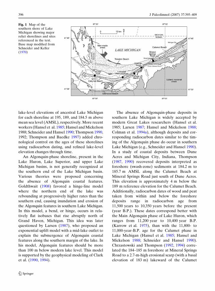
Fig. 1 Map of thesouthern shore of LakeMichigan showing majorrelict shorelines and sitesreferenced in the text.Base map modified fromSchneider and Keller(1970)
396 J Paleolimnol (2007) 37:395–409
123
Beach at Wicker Park (Highland, Indiana) near
the Illinois-Indiana state line. They suggested that
the similar elevation of these two features may
represent a former Algonquin water-plane in
southern Lake Michigan. Colman et al. (1994a),
however, dismissed this interpretation because of
inconsistencies in the age control of the shoreline.
Regardless of the rebound model and age control,
coastal features and deposits lakeward of the
Calumet Beach have been only partially ad-
dressed in reconstructions of past lake-level
change for the basin (e.g., Chrzastowski and
Thompson 1992, 1994). The main focus of this
study is to examine the geomorphological, sedi-
mentological, paleoecological, and radiocarbon
evidence for post-Calumet phase coastal features
and deposits along the Indiana shore of southern
Lake Michigan and to collect additional data to
support or refute their existence.
Methods
U.S. Geological Survey (USGS) 1:24,000-scale
topographic maps and 1938 aerial photos along
southern Lake Michigan in northwest Indiana
were examined to identify geomorphic features
associated with former shorelines. Landforms,
including beach ridges, terraces, and erosional
scarps, were traced. Particular attention was given
to the Calumet Beach complex and to proximal
lakeward features. Although northwestern
Indiana is heavily urbanized and industrialized,
relatively undisturbed sites in northwest Indiana
are present. In this study, north–south-oriented
(roughly onshore–offshore-oriented), transit-
surveyed topographic profiles were constructed
from the Calumet Beach lakeward at Wicker
Park, north of the former site of Crisman Sand
Company, Inc., and east of Mineral Springs Road
(Fig. 1). Elevations for the profiles were estab-
lished from U.S. Geological Survey and U.S.
National Park Service benchmarks and are re-
ported using the U.S. National Geodetic Vertical
Datum of 1929. Fourteen vibracores were col-
lected at strategic points along these profiles,
focusing on key geomorphic changes. A ground-
penetrating radar (GPR) line using a 250 MHz
Sensors and Software Inc. Noggin Smart Cart was
taken along the Wicker Park transect to obtain
preliminary stratigraphic information on the shallow
subsurface. GPR transect lines at the other two
sites were unsuccessful in imaging the subsurface
because of surface debris and tree roots.
Cores were transported back to the laboratory
where they were split, described, sampled, and
photographed. Latex peels were created from the
cores to preserve them and enhance the visibility
of sedimentary structures. Genetic facies, follow-
ing Thompson and Baedke (1997, their Fig. 2)
were defined based on sediment composition,
color, texture, and structures. Two different
grain-size analysis techniques based on overall
grain size were used to process 148 sediment
samples. Coarse-grained samples (sand-and
gravel-sized) were wet and dry sieved and finer-
grained samples (mud-and silt-sized) were ana-
lyzed using a hydrometer. Grain-size data were
plotted versus depth for each core, and onshore–
offshore-oriented cross sections were created and
correlated by facies. Peat samples for paleoeco-
logical analyses were collected from two cores.
Pollen analysis was performed on one sample in
each core, macrofossil analysis was performed on
two samples in each core, and two samples from
each core were scanned for testate amoebae.
Processing followed standard procedures (Hendon
and Charman 1997; Jackson 1999). One acceler-
ator mass spectrometry (AMS) radiocarbon date
and two conventional radiocarbon dates were
obtained on the peat. Radiocarbon analyses were
performed by Geochron Laboratories, and all
ages in this report are radiocarbon years before
1950.
Results
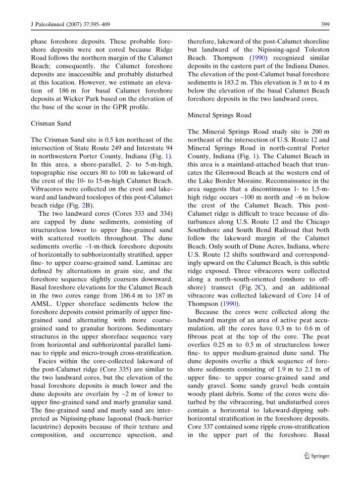
Wicker Park
Wicker Park is at the western end of the Calumet
Beach near the Illinois-Indiana state line and
north of Ridge Road in northwestern Lake
County, Indiana (Fig. 1). West of Wicker Park, the
Calumet Beach terminates in a spit but immedi-
ately south of the park it is a 10- to 15-m-high
J Paleolimnol (2007) 37:395–409 397
123
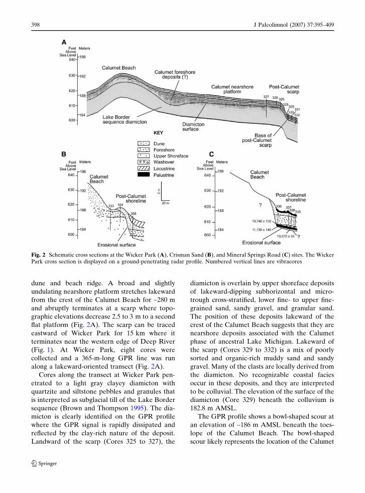
dune and beach ridge. A broad and slightly
undulating nearshore platform stretches lakeward
from the crest of the Calumet Beach for ~280 m
and abruptly terminates at a scarp where topo-
graphic elevations decrease 2.5 to 3 m to a second
flat platform (Fig. 2A). The scarp can be traced
eastward of Wicker Park for 15 km where it
terminates near the western edge of Deep River
(Fig. 1). At Wicker Park, eight cores were
collected and a 365-m-long GPR line was run
along a lakeward-oriented transect (Fig. 2A).
Cores along the transect at Wicker Park pen-
etrated to a light gray clayey diamicton with
quartzite and siltstone pebbles and granules that
is interpreted as subglacial till of the Lake Border
sequence (Brown and Thompson 1995). The dia-
micton is clearly identified on the GPR profile
where the GPR signal is rapidly dissipated and
reflected by the clay-rich nature of the deposit.
Landward of the scarp (Cores 325 to 327), the
diamicton is overlain by upper shoreface deposits
of lakeward-dipping subhorizontal and micro-
trough cross-stratified, lower fine- to upper fine-
grained sand, sandy gravel, and granular sand.
The position of these deposits lakeward of the
crest of the Calumet Beach suggests that they are
nearshore deposits associated with the Calumet
phase of ancestral Lake Michigan. Lakeward of
the scarp (Cores 329 to 332) is a mix of poorly
sorted and organic-rich muddy sand and sandy
gravel. Many of the clasts are locally derived from
the diamicton. No recognizable coastal facies
occur in these deposits, and they are interpreted
to be colluvial. The elevation of the surface of the
diamicton (Core 329) beneath the colluvium is
182.8 m AMSL.
The GPR profile shows a bowl-shaped scour at
an elevation of ~186 m AMSL beneath the toes-
lope of the Calumet Beach. The bowl-shaped
scour likely represents the location of the Calumet
Fig. 2 Schematic cross sections at the Wicker Park (A), Crisman Sand (B), and Mineral Springs Road (C) sites. The WickerPark cross section is displayed on a ground-penetrating radar profile. Numbered vertical lines are vibracores
398 J Paleolimnol (2007) 37:395–409
123
phase foreshore deposits. These probable fore-
shore deposits were not cored because Ridge
Road follows the northern margin of the Calumet
Beach; consequently, the Calumet foreshore
deposits are inaccessible and probably disturbed
at this location. However, we estimate an eleva-
tion of 186 m for basal Calumet foreshore
deposits at Wicker Park based on the elevation of
the base of the scour in the GPR profile.
Crisman Sand
The Crisman Sand site is 0.5 km northeast of the
intersection of State Route 249 and Interstate 94
in northwestern Porter County, Indiana (Fig. 1).
In this area, a shore-parallel, 2- to 5-m-high,
topographic rise occurs 80 to 100 m lakeward of
the crest of the 10- to 15-m-high Calumet Beach.
Vibracores were collected on the crest and lake-
ward and landward toeslopes of this post-Calumet
beach ridge (Fig. 2B).
The two landward cores (Cores 333 and 334)
are capped by dune sediments, consisting of
structureless lower to upper fine-grained sand
with scattered rootlets throughout. The dune
sediments overlie ~1-m-thick foreshore deposits
of horizontally to subhorizontally stratified, upper
fine- to upper coarse-grained sand. Laminae are
defined by alternations in grain size, and the
foreshore sequence slightly coarsens downward.
Basal foreshore elevations for the Calumet Beach
in the two cores range from 186.4 m to 187 m
AMSL. Upper shoreface sediments below the
foreshore deposits consist primarily of upper fine-
grained sand alternating with more coarse-
grained sand to granular horizons. Sedimentary
structures in the upper shoreface sequence vary
from horizontal and subhorizontal parallel lami-
nae to ripple and micro-trough cross-stratification.
Facies within the core-collected lakeward of
the post-Calumet ridge (Core 335) are similar to
the two landward cores, but the elevation of the
basal foreshore deposits is much lower and the
dune deposits are overlain by ~2 m of lower to
upper fine-grained sand and marly granular sand.
The fine-grained sand and marly sand are inter-
preted as Nipissing-phase lagoonal (back-barrier
lacustrine) deposits because of their texture and
composition, and occurrence upsection, and
therefore, lakeward of the post-Calumet shoreline
but landward of the Nipissing-aged Toleston
Beach. Thompson (1990) recognized similar
deposits in the eastern part of the Indiana Dunes.
The elevation of the post-Calumet basal foreshore
sediments is 183.2 m. This elevation is 3 m to 4 m
below the elevation of the basal Calumet Beach
foreshore deposits in the two landward cores.
Mineral Springs Road
The Mineral Springs Road study site is 200 m
northeast of the intersection of U.S. Route 12 and
Mineral Springs Road in north-central Porter
County, Indiana (Fig. 1). The Calumet Beach in
this area is a mainland-attached beach that trun-
cates the Glenwood Beach at the western end of
the Lake Border Moraine. Reconnaissance in the
area suggests that a discontinuous 1- to 1.5-m-
high ridge occurs ~100 m north and ~6 m below
the crest of the Calumet Beach. This post-
Calumet ridge is difficult to trace because of dis-
turbances along U.S. Route 12 and the Chicago
Southshore and South Bend Railroad that both
follow the lakeward margin of the Calumet
Beach. Only south of Dune Acres, Indiana, where
U.S. Route 12 shifts southward and correspond-
ingly upward on the Calumet Beach, is this subtle
ridge exposed. Three vibracores were collected
along a north–south-oriented (onshore to off-
shore) transect (Fig. 2C), and an additional
vibracore was collected lakeward of Core 14 of
Thompson (1990).
Because the cores were collected along the
landward margin of an area of active peat accu-
mulation, all the cores have 0.3 m to 0.6 m of
fibrous peat at the top of the core. The peat
overlies 0.25 m to 0.5 m of structureless lower
fine- to upper medium-grained dune sand. The
dune deposits overlie a thick sequence of fore-
shore sediments consisting of 1.9 m to 2.1 m of
upper fine- to upper coarse-grained sand and
sandy gravel. Some sandy gravel beds contain
woody plant debris. Some of the cores were dis-
turbed by the vibracoring, but undisturbed cores
contain a horizontal to lakeward-dipping sub-
horizontal stratification in the foreshore deposits.
Core 337 contained some ripple cross-stratification
in the upper part of the foreshore. Basal
J Paleolimnol (2007) 37:395–409 399
123
foreshore elevations increase landward and range
from 185.2 m to 185.9 m AMSL. The foreshore
deposits overlie fibrous peat in the landward
cores, but in the more lakeward core the fore-
shore deposits overlie 0.3 m of horizontally
stratified, upper fine- to upper medium-grained
sand containing disseminated and layered plant
debris. We interpret this sand as a possible
washover deposit.
Three of the four cores recovered fibrous peat
below the foreshore and washover deposits. Core
337 was unable to penetrate the gravelly basal
foreshore deposits above the peat. Macrofossil
analysis revealed that peat from Cores 336 and
338 was dominated by Sphagnum moss remains.
A few Viola (violet) seeds and Picea (spruce)
needles were also recovered from the peat in
Core 338. In the upper 8 cm of peat in Core 336,
there were also achenes of Carex and Scirpus
americanus (sedges), fruits and seeds of Pota-
mogeton and Najas (submerged aquatics), and
needles of Larix laricina (tamarack). Seven tes-
tate amoebae taxa were encountered in the peat
samples from Cores 336 and 338. These included
Arcella artocrea Leidy type, Assulina muscorum
Greef, Assulina seminulum (Ehrenberg) Leidy,
Bullinularia indica Penard, Centropysis cassis
(Wallich) Deflandre type, Cyclopyxis arcelloides
(Penard) Deflandre type, and Trigonopyxis arcula
(Leidy) Penard. Testate amoebae were not
recovered from the portion of the Core 336 that
contained submerged aquatic plants. The per-
centage of pollen taxa in two 1-cm-thick samples
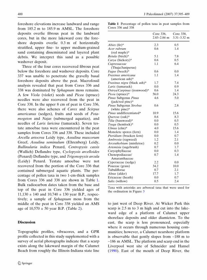
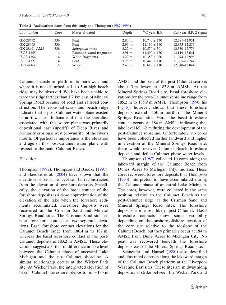
from Cores 336 and 338 are shown in Table 1.
Bulk radiocarbon dates taken from the base and
top of the peat in Core 336 yielded ages of
11,130 ± 140 and 10,740 ± 130 year B.P., respec-
tively; a sample of Sphagnum moss from the
middle of the peat in Core 338 yielded an AMS
age of 10,570 ± 50 year B.P. (Table 2).
Discussion
Topographic profiles, vibracores, and a GPR
profile collected in this study supplemented with a
survey of aerial photographs indicate that a scarp
exists along the lakeward margin of the Calumet
Beach from roughly the Illinois-Indiana state line
to just west of Deep River. At Wicker Park this
scarp is 2.5 m to 3 m high and cut into the lake-
ward edge of a platform of Calumet upper
shoreface deposits and older diamicton. To the
east, the scarp is less pronounced, especially
where it occurs through numerous housing com-
munities; however, a Calumet nearshore platform
is observable that gently slopes from ~188 m to
~186 m AMSL. The platform and scarp end in the
Liverpool west site of Schneider and Hansel
(1990). East of the mouth of Deep River, the
Table 1 Percentage of pollen taxa in peat samples fromCores 336 and 338
Core 336,2.83–2.84 m
Core 338,3.31–3.32 m
Abies (fir)* 2.3 0.5Acer rubrum
(red maple)*0.6 1.4
Betula (birch)* 5.1 7.8Carya (hickory)* 0.6 0.5Cupressaceae
(Thuja/Juniperus)1.1 6.4
Fagus (beech)* 0.6 0.0Fraxinus americana
(american ash)*1.1 1.4
Fraxinus nigra (black ash)* 1.7 7.4Larix (tamarack) 0.0 0.9Ostrya/Carpinus (ironwood)* 0.6 1.4Picea (spruce)* 56.0 24.3Pinus Subgenus Pinus
(jack/red pine)*4.6 5.0
Pinus Subgenus Strobus(white pine)*
0.6 2.8
Pinus undifferentiated* 10.9 15.6Quercus (oak)* 8.6 8.3Tilia (basswood)* 0.0 0.5Tsuga (hemlock)* 0.0 0.5Ulmus (elm)* 4.0 15.6Monolete spores (fern) 0.0 1.4Pteridium (bracken fern) 0.0 0.7Ambrosia (ragweed) 1.2 2.1Arceuthobium (mistletoe) 0.2 0.0Artemisia (sagebrush) 0.7 1.7Caryophyllaceae 0.0 0.3Chenopodiaceae/
Amaranthaceae0.7 1.4
Cyperaceae (sedge) 2.2 0.0Poaceae (grass) 34.2 10.0Tubuliflorae 0.7 2.1Alnus (alder) 17.7 1.7Ericaceae (heath) 0.0 0.7Salix (willow) 0.5 2.4
Taxa with asterisks are arboreal taxa that were used forthe ordination in Figure 3
400 J Paleolimnol (2007) 37:395–409
123
Calumet nearshore platform is narrower, and
where it is not disturbed, a 1- to 5-m-high beach
ridge may be observed. We have been unable to
trace the ridge farther than 1.7 km east of Mineral
Springs Road because of road and railroad con-
struction. The erosional scarp and beach ridge
indicate that a post-Calumet water plane existed
in northwestern Indiana and that the shoreline
associated with this water plane was primarily
depositional east (updrift) of Deep River and
primarily erosional west (downdrift) of the river’s
mouth. Of particular importance is the elevation
and age of this post-Calumet water plane with
respect to the main Calumet Beach.
Elevation
Thompson (1992), Thompson and Baedke (1997),
and Baedke et al. (2004) have shown that the
elevation of past lake level can be reconstructed
from the elevation of foreshore deposits. Specifi-
cally, the elevation of the basal contact of the
foreshore deposits is a close approximation of the
elevation of the lake when the foreshore sedi-
ments accumulated. Foreshore deposits were
recovered at the Crisman Sand and Mineral
Springs Road sites. The Crisman Sand site has
basal foreshore contacts at two separate eleva-
tions. Basal foreshore contact elevations for the
Calumet Beach range from 186.4 m to 187 m,
whereas the basal foreshore contact of the post-
Calumet deposits is 183.2 m AMSL. These ele-
vations suggest a 3- to 4-m difference in lake level
between the Calumet phase of ancestral Lake
Michigan and the post-Calumet shoreline. A
similar relationship occurs at the Wicker Park
site. At Wicker Park, the interpreted elevation of
basal Calumet foreshore deposits is ~186 m
AMSL and the base of the post-Calumet scarp is
about 3 m lower at 182.8 m AMSL. At the
Mineral Springs Road site, basal foreshore ele-
vations for the post-Calumet shoreline range from
185.2 m to 185.9 m AMSL. Thompson (1990, his
Fig. 5), however, shows that these foreshore
deposits extend ~150 m north of the Mineral
Springs Road site. Here, the basal foreshore
contact occurs at 184 m AMSL, indicating that
lake level fell ~2 m during the development of the
post-Calumet shoreline. Unfortunately, no cores
have been collected farther landward and higher
in elevation at the Mineral Springs Road site;
these would recover Calumet Beach foreshore
deposits and define Calumet phase water levels.
Thompson (1987) collected 10 cores along the
lakeward margin of the Calumet Beach from
Dunes Acres to Michigan City, Indiana. These
cores recovered foreshore deposits that Thompson
(1990) interpreted to have accumulated during
the Calumet phase of ancestral Lake Michigan.
The cores, however, were collected in the same
position relative to the Calumet Beach as the
post-Calumet ridge at the Crisman Sand and
Mineral Springs Road sites. The foreshore
deposits are most likely post-Calumet. Basal
foreshore contacts show some variability
depending on the onshore-offshore position of
the core site relative to the toeslope of the
Calumet Beach, but they primarily occur at 184 m
AMSL from Dune Acres to Michigan City. No
peat was recovered beneath the foreshore
deposits east of the Mineral Springs Road site.
Schneider and Hansel (1990) also described
and illustrated deposits along the lakeward margin
of the Calumet Beach platform at the Liverpool
West and East sites. These sites are midway along
depositional strike between the Wicker Park and
Table 2 Radiocarbon dates from this study and Thompson (1987, 1990)
Lab number Core Material dated Depth 14C year B.P. Cal year B.P. 2 sigma
GX-28492 336 Peat 2.80 m 10,740 ± 130 12,381–12,951GX-28493 336 Peat 2.96 m 11,130 ± 140 12,855–12,256GX-28491-AMS 338 Sphagnum moss 3.22 m 10,570 ± 50 12,550–12,776ISGS-1355 14 Rounded wood fragments 2.91 m 11,490 ± 130 13,119–13,641ISGS-1354 14 Wood fragments 3.22 m 10,350 ± 380 11,074–12,996ISGS-1327 14 Peat 3.26 m 10,440 ± 110 11,995–12,744Beta-20633 15 Wood 2.43 m 10,610 ± 110 12,340–12,844
J Paleolimnol (2007) 37:395–409 401
123
Crisman Sand study areas. At the Liverpool West
site, Calumet and post-Calumet deposits were
exposed in a currently flooded borrow pit. A
stratigraphic section for the Liverpool West site
(Schneider and Hansel, 1990, their fig. 7) shows a
basal till (diamicton) of the Lake Border se-
quence overlain by sand, gravel, clay, and peat. A
peat layer less than 1 m above the diamicton
surface was dated at 11,815 ± 640 year B.P. This
Two Creeks (pre-Calumet) phase peat is overlain
by ~6 m of stratified sand, clay, and cross-bedded
sand with gravel lenses. Two peat layers ~2 m
below the top of the exposure were dated at
9,110 ± 640 year B.P and 10,890 ± 560 year B.P.
Although detailed descriptions of the sediments
are not available, the lower sand, clay, and cross-
bedded sand with gravel lenses that are posi-
tioned lakeward of the main crest of the Calumet
Beach and on the Calumet Beach platform sug-
gests that they are probable Calumet upper
shoreface deposits. Sand and gravel overlying the
two upper peats may be post-Calumet foreshore
deposits, but these sediments are about 4 m
higher than post-Calumet foreshore deposits at
the Crisman Sand site. An examination of the
stratigraphic section suggests that it is plotted
about 3.5 to 4 m too high. The top of the section is
shown at 189 m (620 ft) AMSL, but the entire site
is enclosed by a 186-m (610-ft) AMSL contour on
the USGS Gary, Indiana, quadrangle topographic
map (1986). Also, the basal diamicton is shown at
183.4 m AMSL, but Brown (1994) mapped the
surface of the Lake Border sequence diamicton
from 177 m (580 ft) to 180 m (590 ft) throughout
the area. Clearly, the section is illustrated at the
wrong elevation. It would be more in line with the
Wicker Park and Crisman Sand sites if the plotted
section was ~3.7 m lower. The Liverpool East site
also exposes an organic horizon between two
~2-m-thick sands. The lower sand with gravel may
be Calumet upper shoreface deposits; the upper
sand is interpreted by Schneider and Hansel
(1990) as eolian. Unfortunately, no elevations are
reported for these deposits, but the peat and
associated organic materials were radiocarbon
dated five times resulting in ages ranging from
~11,300 year to 9,100 year B.P. A reexamination
of these sites is needed to clarify elevations of
coastal deposits, better describe sediment
characteristics and stratigraphic relationships,
and evaluate the paleoecology of the organic
horizons.
For the post-Calumet shoreline, combining all
the Calumet and post-Calumet sites together
indicates a slightly westward-dipping water plane
that is ~3 m below a similarly westward-dipping
Calumet Beach water plane. More cores of
Calumet Beach foreshore deposits are needed to
better define the elevation and long-term behavior
of Calumet phase lake level. Obtaining undis-
turbed Calumet Beach nearshore sediments will
be difficult in this heavily urbanized and indus-
trialized area.
Age
At the Mineral Springs Road site, foreshore
deposits overlie peat lakeward of the Calumet
Beach. This stratigraphic and spatial relationship
indicates that lake level fell from the Calumet
phase, a wetland developed lakeward of the
Calumet Beach, and the wetland was inundated
by a landward-transgressing post-Calumet shore-
line. Age determinations on the base and surface
peat, therefore, provide a minimum age for the
abandonment of the Calumet Beach and a maxi-
mum age for the development of the post-
Calumet shoreline, respectively. The base of the
peat in Core 336 was bulk radiocarbon dated at
11,130 ± 140 year B.P. Hansel et al. (1985),
Hansel and Mickelson (1988), and Schneider and
Hansel (1990) place the end of the Calumet Phase
at roughly 11,000 year to 11,200 year B.P. The
basal age on the peat at Minerals Springs Road
indicates that the wetland formed and began
accumulating organic material at the end of
the Calumet phase. The bulk radiocarbon age
determination from the top of the peat in
Core 336 is 10,740 ± 130 year B.P., suggesting
that washover and foreshore deposits from
the landward-translating post-Calumet shoreline
covered or partially covered the peatland by
~10,700 year B.P.
The AMS age determination for Sphagnum
moss from the upper few centimeters of the Core
338 peat is slightly younger at 10,570 ± 50 year.
B.P. than the bulk age from the top of the peat in
Core 336. Most Sphagnum species are intolerant
402 J Paleolimnol (2007) 37:395–409
123

of strong ground-water influence (Andrus 1986;
Crum 1988), therefore, the AMS radiocarbon
date on Sphagnum remains should not be influ-
enced by any radiocarbon-dead carbonates pres-
ent in the ground water. Testate amoebae,
amoeboid protozoans that produce a decay-
resistant shell, provide additional support for only
limited ground-water influence at the surface of
the peatland. The distribution of testate amoebae
in Sphagnum-dominated peatlands is primarily
controlled by moisture conditions, and secondar-
ily by pH, trophic status, and other aspects of
water chemistry (Woodland et al. 1998; Mitchell
et al. 2000; Booth 2001, 2002; Charman 2001).
The species of testate amoebae recovered from
the peat all have optimum abundance today in
relatively dry and low pH habitats (Booth 2001,
2002). Together, the macrofossil and testate
amoeba data suggest that the peatland lakeward
of the Calumet Beach at Minerals Springs Road
was a Sphagnum-dominated poor fen or bog,
with little standing water except for upper por-
tions of Core 336. Upper portions of Core 336
were probably deposited under fluctuating
hydrologic conditions that may possibly have
been caused by the landward-translating post-
Calumet shoreline.
Pollen data collected from the peat in Cores
338 and 336 are consistent with the 14C age
determinations. Pollen assemblages prior to
~11,500 to 10,000 year B.P. in northern Indiana
and southern Michigan are characterized by high
Picea, Pinus, and Cyperaceae percentages (e.g.,
Williams 1974; Futyma 1988; Singer et al. 1996),
probably reflecting the dominance of open Picea
woodlands at this time (Webb et al. 1983). Be-
tween 11,000 year and 10,000 year B.P., a mixed
forest dominated by Picea, Betula, Fraxinus, and
Ulmus developed, and by 10,000 year B.P. forests
dominated by Pinus and Quercus became estab-
lished (Webb et al. 1983; Singer et al. 1996). The
peat sample from Core 336 contains relatively
high percentages of Picea, Fraxinus, and Ulmus
(Table 1) and is characteristic of the mixed forest
that developed in the region between 11,000 year
and 10,000 year B.P. The sample from Core 338
contains very high percentages of Picea and
Poaceae pollen, as well as moderately high Ulmus
pollen (Table 1). The much larger Picea per-
centages in the sample from Core 338 suggest that
the sample may be several hundred years older
than the sample from Core 336. These interpre-
tations are also supported by a quantitative
comparison between the arboreal pollen assem-
blages in the Mineral Springs Road peat and the
pollen record of nearby AMS-dated Portage
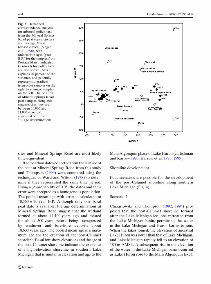
Marsh (Singer et al. 1996) (Fig. 1). Detrended
correspondence analysis reveals that pollen
assemblages from the Mineral Springs Road peat
are most similar to samples at Portage Marsh that
are between 10,000-years and 11,000-years old
(Fig. 3).
Additional bulk radiocarbon age determina-
tions on the peat at Mineral Springs Road are
available from Core 14 of Thompson (1990). This
core is similar to Cores 336 to 338 with dune
deposits over foreshore, washover, and paludal
deposits. The top of the peat was dated at
10,440 ± 140 year B.P., and wood fragments
from the base of overlying washover deposits
were dated at 10,350 ± 380 year B.P. Upsection,
rounded wood fragments were dated at
11,490 ± 130 year B.P. at the contact between the
washover and overlying foreshore deposits. The
wood fragments were obviously transported be-
cause they are rounded. Consequently, the age
determination is not meaningful because the
provenance of the wood cannot be determined,
and its position within the transgressive sequence
means that the radiocarbon date has no strati-
graphic significance. Thompson (1987, his Core
15) also collected a large wood fragment of Pinus
cf. banksiana between post-Calumet dune and
foreshore deposits 250 m west of Mineral Springs
Road. This piece of probable driftwood radio-
carbon dates at 10,610 ± 110 year B.P.; similar to
the rounded wood fragments in Core 14, the
radiocarbon date has limited stratigraphic signif-
icance. Radiocarbon dates on the probable post-
Calumet organic deposits at the Liverpool East
and West sites are similar to age determinations
at Minerals Springs Road, but no stratigraphic
correlation of palustrine deposits can be estab-
lished between the sites. The large error on the
Liverpool West samples and the lack of a strati-
graphic context for the Liverpool East site makes
these ages difficult to evaluate. We infer, how-
ever, that the palustrine deposits at the Liverpool
J Paleolimnol (2007) 37:395–409 403
123
sites and Mineral Springs Road are most likely
time-equivalent.
Radiocarbon dates collected from the surface of
the peat at Mineral Springs Road from this study
and Thompson (1990) were compared using the
techniques of Ward and Wilson (1978) to deter-
mine if they represented the same time period.
Using a v2-probability of 0.05, the dates and their
error were accepted as a homogenous population.
The pooled mean age with error is calculated at
10,560 ± 70 year B.P. Although only one basal
peat date is available, the age determinations at
Mineral Springs Road suggest that the wetland
formed at about 11,100 years ago and existed
for about 500 years before being transgressed
by washover and foreshore deposits about
10,600 years ago. The pooled mean age is a maxi-
mum age for the creation of the post-Calumet
shoreline. Basal foreshore elevations and the age of
the post-Calumet shoreline indicate the existence
of a high-elevation shoreline in southern Lake
Michigan that is similar in elevation and age to the
Main Algonquin phase of Lake Huron (cf. Eshman
and Karrow 1985; Karrow et al. 1975, 1995).
Shoreline development
Four scenarios are possible for the development
of the post-Calumet shoreline along southern
Lake Michigan (Fig. 4).
Scenario 1
Chrzastowski and Thompson (1992, 1994) pro-
posed that the post-Calumet shoreline formed
after the Lake Michigan ice lobe retreated from
the Lake Michigan basin, permitting the water
in the Lake Michigan and Huron basins to join.
When the lakes joined, the elevation of ancestral
Lake Huron was lower than that of Lake Michigan,
and Lake Michigan rapidly fell to an elevation of
180 m AMSL. A subsequent rise in the elevation
of the water in the Lake Michigan basin occurred
as Lake Huron rose to the Main Algonquin level.
Fig. 3 Detrendedcorrespondence analysisfor arboreal pollen taxafrom the Mineral SpringsRoad peat (open circles)and Portage Marsh(closed circles) (Singeret al. 1996), withradiocarbon ages (yearB.P.) for the samples fromPortage Marsh indicated.Centroids for pollen taxaare also shown. Axis 1explains 96 percent of thevariance, and generallyrepresents a gradientfrom older samples on theright to younger sampleson the left. The positionof Mineral Springs Roadpeat samples along axis 1suggests that they arebetween 10,000 and11,000 years old,consistent with the14C age determinations
404 J Paleolimnol (2007) 37:395–409
123
Scenario 2
The retreat of the Lake Michigan ice lobe joined
Lake Michigan and Lake Huron at the Main
Algonquin level or one of the post-Algonquin
phase levels. Combined with Lake Huron, Lake
Michigan underwent similar stair-step lowerings
of lake level throughout the post-Algonquin as
glacial ice margin retreated from northern Lake
Huron (cf. Eshman and Karrow 1985). The post-
Calumet shoreline is time-equivalent to one of
the post-Algonquin phase levels.
Scenario 3
The post-Calumet shoreline formed during the
Moorhead phase influx from glacial Lake Agassiz
around 10,900 year to 9,900 year B.P. (Clayton
1983; Teller 1985, 1987) that raised lake level in
the Lake Michigan basin high enough to reach the
post-Calumet level. Colman et al. (1994a, 1994b)
correlated the gray Wilmette Bed of Lake Michigan
to the Moorhead discharge, establishing glacial
Lake Agassiz influence in the Lake Michigan
basin at the time that the post-Calumet shoreline
formed. Kehew (1993) suggested that the influx of
this glacial Lake Agassiz water was also instru-
mental in eroding the Chicago outlet from the
Calumet to the Nipissing I level.
Scenario 4
The post-Calumet shoreline formed along the
southern margin of a lagoon between the Calumet
and Toleston Beaches sometime during the
Nipissing I phase of ancestral Lake Michigan.
Thompson (1990) showed that basal foreshore
deposits in the landward (Nipissing) part of the
Toleston Beach occur at an elevation of 182.8 m
AMSL. Water level in the lagoonal area landward
of the Toleston Beach would have been at the
same elevation as the base of the scarp at Wicker
Park.
Scenario 2 is the least likely of shoreline
development mechanisms, because it is not
possible for palustrine sediments to accumulate
beneath nearshore deposits during the post-
Algonquin lake-level fall. A lake-level rise is
needed to transgress the wetlands at the Mineral
Springs Road and Liverpool sites. The eroding
outlet model of Kehew (1993) suggests that lake-
level is at the elevation of the Calumet phase
when outburst water discharged from glacial lake
Agassiz. It is possible that the Morehead influx
downcut the Chicago outlet, but the palustrine
sediments beneath nearshore deposits for the
post-Calumet shoreline indicate that lake level
was already below the post-Calumet level prior to
being transgressed. Scenario 4 is also unlikely
because the ages of the palustrine deposits at
Mineral Springs Road and Liverpool are more
than 4,000 years older than the Nipissing I phase.
It is possible, however, that the peat was eroded
and that younger palustrine sediments were
removed, leaving only deposits that are
10,600 years old and older. In Scenario 4, the
Calumet Beach nearshore and underlying dia-
micton would be eroded and 3 m of dune and
nearshore sediments deposited along the south-
ern margin of a shallow-water lagoon. It is not
likely that wave activity was sufficient to erode
the Calumet nearshore and till, and a source of
Fig. 4 Schematiclake-level hydrographillustrating possiblelake-level behavior tocreate the post-Calumetshoreline
J Paleolimnol (2007) 37:395–409 405
123
littoral sediment would not be available landward
of the Toleston Beach to build the post-Calumet
beach ridge. Scenarios 1 and 3 both involve rising
water-levels in the basin at the appropriate time
that could scarp the Calumet nearshore and
transgress palustrine sediments. It is not possible
at this time to distinguish between the two pos-
sible scenarios, but we favor Scenario 1 because
Scenario 3 may have been too short-lived to have
significant impact on shoreline behavior along the
southern shore of Lake Michigan.
Rebound
A high-elevation Algonquin-aged shoreline along
the southern shore of Lake Michigan is inconsis-
tent with the rebound model of Larsen (1987) and
favors the longstanding model of Goldthwait
(1908). The Larsen (1987) model is theoretically
sound and adequately represents Algonquin-aged
shorelines north of the Goldthwait (1908) hinge
line. Some other behavior besides uniform expo-
nential uplift must be working within the basin to
permit the development of the post-Calumet
shoreline in Indiana.
A recent study of differential ground move-
ment between lake-level gages was conducted by
the Coordinating Committee on Great Lakes
Basic Hydraulic and Hydrologic Data [Coordi-
nating Committee] (2001) (Fig. 5). These data,
referenced to the Port Huron outlet for Lakes
Michigan and Huron, show that isostatic rebound
does not uniformly increase from the southern tip
of Lake Michigan northeastward. An area of de-
creased rate of rebound extends across the lake
from Milwaukee, Wisconsin, to Ludington,
Fig. 5 Map of the upper Great Lakes, showing rates ofvertical ground movement from historical lake-level gagerecords and the position of the Goldthwait (1908) hinge
line for the Main Algonquin phase. Modified fromCoordinating Committee (2001) and Goldthwait (1908)
406 J Paleolimnol (2007) 37:395–409
123
Michigan. Rates of rebound increase northward
and slightly southward from this area. In effect,
the modern gage data illustrate vertical ground
movement that is somewhat similar to the Gold-
thwait (1908) hinge model (Fig. 5). This new
interpretation of historical gage data is based on
longer data sets and additional gaging sites that
were not available to Larsen (1987) or Clark et al.
(1994) who used Coordinating Committee (1977)
data.
The post-Calumet shoreline of southern Lake
Michigan is elevation-and time-equivalent to the
Main Algonquin of southern Lake Huron. The
gage data of the Coordinating Committee (2001)
show that the southern shore of Lake Huron is
relatively rising 9 to 12 cm/century more rapidly
than the southern tip of Lake Michigan (Fig. 5).
Following the Coordinating Committee (2001)
data and projecting modern rates into the past,
the post-Calumet shoreline of southern Lake
Michigan should be 9.5 m to 13 m lower than
coastal features and deposits of similar age along
southern Lake Huron. Baedke and Thompson
(2000), however, have shown that during the late
Holocene the southern shore of Lake Michigan
was rising more rapidly (19 cm/century) than the
Port Huron outlet before 1,400 cal year B.P. and
less rapidly (–7 cm/century) than the Port Huron
outlet after 1,400 cal year B.P. The pattern ob-
served by the Coordinating Committee (2001),
therefore, may hold for only the past 14 centuries,
yielding an elevation difference between southern
Lake Michigan and southern Lake Huron of no
more than –1.2 m to –1.7 m. Such a slight dif-
ference in the elevation of coastal features and
deposits between locales that are 450 km apart is
probably not recognizable.
Conclusions
Geomorphological, sedimentological, paleoeco-
logical, and radiocarbon data indicate that
deposits and features of a relict shoreline are
present along the lakeward margin of the Calumet
Beach in northwestern Indiana. This post-
Calumet shoreline was primarily erosional west of
Deep River but primarily depositional east of the
river. The elevations of basal foreshore deposits
east of Deep River and the base of the scarp west
of Deep River indicate a slightly westward-
dipping water plane for the shoreline that is
centered at ~184 m AMSL. Basal foreshore ele-
vations also indicate that lake level fell ~2 m
during the development of the shoreline. Post-
Calumet foreshore deposits overlie peat at
Mineral Springs Road, and the pooled mean of
radiocarbon dates from the surface of the peat
indicates that the lake transgressed over the peat
at 10,560 ± 70 year B.P. Pollen assemblages from
the peat are consistent with this age. The elevation
and age of the post-Calumet shoreline is similar
to the Main Algonquin phase of Lake Huron.
Recent isostatic rebound models do not ade-
quately address a high-elevation Algonquin-age
shoreline along the southern shore of Lake
Michigan. The long-standing hinge-line model of
Goldthwait (1908) is consistent with a high-
elevation shoreline, and this model, or a model
very similar to it, may best fit reconstructions of
ground deformation in the upper Great Lakes
from historical gage records.
Acknowledgements Funding for this research was pro-vided by the Professional Geologists of Indiana. Wewould like to thank the Indiana Dunes National Lake-shore and Wicker Memorial Park for access to theirproperties. Permission to publish was granted by theDirector and State Geologist of Indiana, Dr. John C.Steinmetz, and the Indiana Geological Survey Publica-tion Committee.
References
Andrus RE (1986) Some aspects of Sphagnum ecology.Can J Bot 64:416–426
Baedke SJ, Thompson TA (2000) A 4,700-year record oflake level and isostasy for Lake Michigan. J GreatLakes Res 26(4):416–426
Baedke SJ, Thompson, TA, Johnston JW, Wilcox DA(2004) Reconstructing paleo lake levels from relictshorelines along the Upper Great Lakes. AquaEcosys Health Manag; Special Issue: Emerging Issuesin Lake Superior Research 7(4):435–449
Booth RK (2001) Ecology of testate amoebae in two LakeSuperior coastal wetlands: implications for paleo-ecology and environmental monitoring. Wetlands21:564–576
Booth RK (2002) Testate amoebae as paleoindicatorsof surface-moisture changes on Michigan peat-lands: modern ecology and hydrological calibration.J Paleolimn 28:329–348
J Paleolimnol (2007) 37:395–409 407
123
Brown SE (1994) Map showing geologic terraines of theGary 7.5¢ Quadrangle. Ind Geol Surv Open-File Rept94–15
Brown SE, Thompson TA (1995) Geologic terraines ofnorthwestern Lake County, Indiana. Ind Geol SurvOpen-File Rept 95-05
Charman DJ (2001) Biostratigraphic and palaeoenviron-mental applications of testate amoebae. Quat Sci Rev20:1753–1764
Chrzastowski MJ, Thompson TA (1992) Late Wisconsinanand Holocene coastal evolution of the southern shoreof Lake Michigan. In: Fletcher CH III, Wehmiller JF(eds) Quaternary costs of the United States: Marineand Lacustrine systems, vol 48. SEPM, Tulsa,Oklahoma. Spec Pub, USA, pp 397–413
Chrzastowski MJ, Thompson TA (1994) Late Wisconsinanand Holocene geologic history of the Illinois-Indianacoast of Lake Michigan. J Great Lakes Res 20(1):9–26
Clark JA, Pranger II HS, Walsh JK, Primus JA (1990)A numerical model of glacial isostasy in the LakeMichigan basin. In: Scheider AF, Fraser GS (eds)Late quaternary history of the Lake Michigan Basin,vol 251. Geological Society of America, Boulder,Colorado, USA, Spec Paper, pp 111–123
Clark JA, Hendriks M, Timmermans TJ, Struck C,Hilverda KJ (1994) Glacial isostatic deformation ofthe Great Lakes region. Geol Soc Am Bull 106:19–31
Clayton L (1983) Chronology of Lake Agassiz drainage toLake Superior. In: Teller JT, Clayton L (eds) GlacialLake Agassiz, vol 26. Geol Ass Can, St. John’sNewfoundland, Canada. Spec Paper, pp 291–307
Colman SM, Clark JA, Clayton L, Hansel AK, Larsen CE(1994a) Deglaciation, lake-levels, and meltwater dis-charge in the Lake Michigan Basin. Quat Sci Rev13:879–890
Colman SM, Keigwin LD, Forester RM (1994b) Twoepisodes of meltwater influx from glacial Lake Agas-siz into the Lake Michigan basin: contrasts in climaticand oceanographic effects. Geology 22:547–550
Coordinating Committee on Basic Hydraulic and Hydro-logic Data (1977) Apparent vertical movement overthe Great Lakes. Corps of Engineers, United StatesArmy, Detroit, pp 70
Coordinating Committee on Great Lakes Basic Hydraulicand Hydrologic Data (2001) Apparent verticalmovement over the Great Lakes-revisited. Coordi-nating Committee on Great Lakes Basic Hydraulicand Hydrologic Data, Chicago and Ottawa
Crum H (1988) A focus on peatlands and peat mosses. TheUniversity of Michigan Press, Ann Arbor, Michigan,p 306
Eschman DF, Karrow PF (1985) Huron Basin glaciallakes: a review. In: Karrow PF, Calkin PE (eds)Quaternary evolution of Great lakes, vol 30. Geol AssCan, St. John’s Newfoundland, Canada, Spec Paper,pp 79–93
Futyma RP (1988) Fossil pollen and charcoal analysis inwetland development studies at Indiana DunesNational Lakeshore. In: Wilcox DA (ed) Interdisci-plinary approaches to freshwater wetlands research.
Michigan State University Press, East Lansing,Michigan, pp 11–23
Goldthwait JW (1908) Abandoned shorelines of easternWisconsin. Wisc Geol and Nat Hist Surv Bull 17
Hansel AK, Mickelson DM (1988) Reevaluation of thetiming and causes of high lake phases in the LakeMichigan basin. Quat Res 29:113–128
Hansel AK, Mickelson DM, Schneider AF, Larsen CE(1985) Late Wisconsinan and Holocene history of theLake Michigan basin. In: Karrow PF, Calkin PE (eds)Quaternary evolution of the Great Lakes, vol 30.Geol Ass Can, St. John’s, Newfoundland, Canada,Spec Paper, pp 39–53
Hendon D, Charman DJ (1997) The preparation of testateamoebae (Protozoa: Rhizopoda) samples from peat.Holocene 7:199–205
Jackson ST (1999) Techniques for analyzing unconsoli-dated lake sediments. In: Jones TP, Rowe NP (eds)Fossil plants and spores: modern techniques. Geo-logical Society of London, London, pp 274–278
Karrow PF Anderson TW, Clarke AH, Delorme LD,Sreenivasa MR (1975) Stratigraphy, paleontology,and age of Lake Algonquin sediments in southwesternOntario, Canada. Quat Res 5:49–87
Karrow PF, Anderson TW, Delorme LD, Miller BB,Chapman LJ (1995) Late-glacial paleoenvironment ofLake Algonquin sediments near Clarksburg, Ontario.J Paleolimn 14:297–309
Kehew AE (1993) Glacial-lake outburst erosion of theGrand Valley, Michigan, and impacts on glacial lakesin the Lake Michigan basin. Quat Res 39:36–44
Larsen CE (1987) Geologic history of the glacial LakeAlgonquin and the upper Great Lakes. US Geol SurvBull 1801
Leverett F (1897) The Pleistocene features and deposits ofthe Chicago area. Chic Acad Sci, Geol Nat Hist SurvBull 2
Mitchell EAD, Buttler A, Grosvernier P, Rydin H,Albinsson C, Greenup AL, Heijmans MMPD, Hoos-beek MR, Saarinen T (2000) Relationships amongtestate amoebae (Protozoa), vegetation and waterchemistry in five Sphagnum-dominated peatlands inEurope. New Phytol 145:95–106
Schneider AF, Hansel AK (1990) Evidence for post-TwoCreeks age of the type Calumet shoreline of glacialLake Chicago. In: Schneider AF, Fraser GS (eds)Late quaternary history of the Lake Michigan Basin,vol 251. Geological Society of America, Boulder,Colorado, USA, Spec Paper, pp 1–8
Schneider AF, Keller SJ (1970) Geologic map of the1� · 2� Chicago Quadrangle, Indiana, Illinois, andMichigan, showing bedrock and unconsolidateddeposits. Ind Geol Surv, Reg Geol Map 4
Singer DK, Jackson ST, Madsen, BJ, Wilcox DK (1996)Differentiating climatic and successional influences onlong-term development of a marsh. Ecology 77:1765–1778
Teller JT (1985) Glacial Lake Agassiz and its influence onthe Great Lakes. In: Schneider AF, Fraser GS (eds)Quaternary Evolution Great Lakes, vol 30. Geol Ass
408 J Paleolimnol (2007) 37:395–409
123
Can, St. John’s Newfoundland, Canada, Spec Paper,pp 1–16
Teller JT (1987) Proglacial lakes and the southern marginof the Laurentide Ice Sheet. In: Ruddiman WF,Wright HE Jr (eds) North America and AdjacentOceans during the Last Deglaciation, vol K-3. Geo-logical Society of America, Dec North Am Geol,Boulder, Colorado, USA, pp 39–69
Thompson TA (1987) Sedimentology, internal architec-ture, and depositional history of the Indiana DunesNational Lakeshore and State Park [Ph.D. thesis].Ind. Univ., Bloom., Ind
Thompson TA (1990) Dune and beach complex andback-barrier sediments along the southeastern shoreof Lake Michigan: Cowles Bog area of the IndianaDunes National Lakeshore. In: Schneider AF,Fraser GS (eds) Late quaternary history of theLake Michigan Basin, vol 251. Geological Society ofAmerica, Boulder, Colorado, USA, Spec Paper,pp 9–19
Thompson TA (1992) Beach-ridge development and lake-level variation in southern Lake Michigan. Sed Geol80:305–318
Thompson TA, Baedke SJ (1997) Strandplain evidence forthe late Holocene lake-level variation in southernLake Michigan. Geol Soc Am Bull 109:666–682
Ward GK, Wilson SR (1978) Procedures for comparingand combining radiocarbon age determinations.Archaeometry 20:19–31
Webb III T, Cushing EJ, Wright HE Jr (1983) Holocenechanges in the vegetation of the Midwest. In: WrightHE Jr (ed) Late quaternary vegetation of the UnitedStates, vol 2. University of Minnesota Press, Minne-apolis, pp 142–165
Williams AS (1974) Late-glacial-postglacial vegetationalhistory of the Pretty Lake region, northeasternIndiana. U.S. Geol. Surv. Prof. Paper 686
Woodland WA, Charman DJ, Sims PC (1998) Quantitativeestimates of water tables and soil moisture in Holocenepeatlands from testate amoebae. Holocene 8:261–273
J Paleolimnol (2007) 37:395–409 409
123