a political ecology of green territoriali- zation
TRANSCRIPT

37DIE ERDE · Vol. 151 · 1/2020
A political ecology of green territoriali-zation: frontier expansion and conser-vation in the Colombian Amazon
Jonas Hein1,5, Carlos Del Cairo2, Daniel Ortiz Gallego2,4, Tomás Vergara Gutiérrez 2, Juan Sebastian Velez3,4, Jean Carlo Rodríguez de Francisco5
1 Department of Geography, Christian-Albrechts-University Kiel, Ludewig-Meyn-Straße 14, 24098 Kiel, Germany, [email protected] Departamento de Antropología, Pontificia Universidad Javeriana, Carrera 5 No. 39-00 Edificio 95- Manuel Briceño, Bogotá, Colombia3 Institute of Development Policy (IOB), Lange St. Annastraat 7, 2000 Antwerp, Belgium4 Center for Alternatives to Development – Cealdes, Bogotá, Colombia5 German Development Institute / Deutsches Institut für Entwicklungspolitik (DIE), Tulpenfeld 6, 53113 Bonn, Germany
Manuscript submitted: 20 June 2019 / Accepted for publication: 21 February 2020 / Published online: 02 March 2020
AbstractAfter decades of civil war, the Colombian government has recently declared the Amazon as a model region for green growth and low carbon development. The Amazon Vision programme, launched by the Colombian government in 2016, seeks to contribute to forest conservation, climate mitigation, poverty reduction and peace building. The Amazon Vision fundamentally reframes the Colombian Amazon from a ‘narco frontier’ that needs to be liberated from guerrilla influ-ence, organized crime and peasants destroying forests for coca cultivation, to a net CO2 sink with enormous potential for green growth and poverty reduction. Drawing on historical and empirical qualitative research in Guaviare and complemented by a quantitative land cover classification, this article builds on the concept of ‘green territoriality’ to in-vestigate the extent to which the shift towards conservation affects property rights and the ability of indigenous groups and peasants to access land and natural resources. We illustrate how the reframing of peasants from protagonists of development and frontier expansion to villains, and of indigenous communities from ‘underdeveloped’ forest dwellers to environmental guardians, has created land conflicts and affected the legitimacy of their respective property rights. In both cases, the Amazon Vision strengthens conservation policies and challenges existing land rights but also creates new windows of opportunity for the land claims of indigenous communities while reinforcing conceptualizations of so-cial differentiation among dwellers of the Amazon.
ZusammenfassungNach jahrzehntelangem Bürgerkrieg hat die kolumbianische Regierung den Amazonas zur Modellregion für grünes Wachstum und kohlenstoffarme Entwicklung erklärt. Das 2016 ins Leben gerufene Amazon Vision Pro-gramm der kolumbianischen Regierung soll zum Waldschutz, zur Minderung von Treibhausgasen, zur Armuts-bekämpfung und zur Friedenssicherung beitragen. Die Visión Amazonía postuliert einen grundlegenden Wandel. Die ehemalige narco frontier, welche von Guerilla, organisierter Kriminalität und vermeintlich waldzerstören-den Kleinbauern befreit werden muss, soll zu einer Region mit einem enormen Potenzial für grünes Wachstum, Armutsbekämpfung und REDD+ werden. Dieser Artikel stützt sich auf historische und empirische qualitative Forschung in Guaviare und ergänzend auf eine quantitative Landnutzungsklassifikation. Aufbauend auf dem
Vol. 151, No. 1 · Research article
D I E E R D EJournal of the
Geographical Society of Berlin
DOI:10.12854/erde-2020-456
Jonas Hein, Carlos Del Cairo, Daniel Ortiz Gallego, Tomás Vergara Gutiérrez, Juan Sebastian Velez, Jean Carlo Rodríguez de Francisco 2020: A political ecology of green territorialization: frontier expansion and conservation in the Colombian Amazon. – DIE ERDE 151 (1): 37-57

38 DIE ERDE · Vol. 151 · 1/2020
A political ecology of green territorialization: frontier expansion and conservation in the Colombian Amazon
1. Introduction
After decades of civil war, the Colombian government has recently declared the Amazon as a model region for green growth and low carbon development. The Amazon Vision is a cross sectorial programme led by the Ministry for Environment and Sustainable Devel-opment and the Ministry for Agriculture and Rural Development. The programme was launched in 2016 and seeks to contribute to forest conservation, cli-mate mitigation, poverty reduction and peace build-ing (Gobierno de Colombia 2015). To implement the strategy, the Colombian government receives finan-cial support from the REDD+1 Early Movers (REM) programme funded by Germany, Norway and the UK. The Amazon Vision is part of the national REDD+ strategy and fundamentally reframes the Colombian Amazon from a “narco frontier” (Ballvé 2019: 211) that needs to be liberated from guerrilla influence, criminal groups and peasants encroaching tropical rainforests for coca cultivation, to a region with enor-mous potential for green growth, poverty reduction and REDD+. Amazon Vision builds on earlier sustain-able development and conservation initiatives in the Amazon dating back to the 1980s and 1990s. At the same time, it fundamentally challenges existing vio-lent geographies of resource access and control (Zim-merer and Bassett 2003) by outlining that peace and green growth will facilitate transformation processes creating benefits for all people of the Amazon (Gobi-erno de Colombia 2015). Consequently, the Amazon Vi-sion challenges the coca- and cattle-driven agricultur-al frontier expansion and the dominant narratives of the 20th century that characterized the Amazon as an endless empty space, narratives that have been used to legitimize state territorialization processes and to categorize different social groups.
For example, peasants, in the past considered as de-velopment engines promoting frontier expansion and territorial control, have become villains cooperat-ing with guerrillas and organized crime. In contrast, indigenous groups, who through most of the 20th century were viewed as unproductive forest dwell-ers, have become forest stewards and environmental guardians (Del Cairo 2012). Although in many cases both indigenous groups and ‘peasants’ are farmers the differentiation between the two groups is highly relevant for understanding agrarian dynamics and conservation policies in the Amazon. The Colombian political constitution of 1991 introduced a multicul-tural paradigm that entitled ethnic communities, namely indigenous and Afro-Colombian communities, to ethnic minority rights including collective prop-erty rights to their ancestral lands (Chaves and Zam-brano 2006; Ng’weno 2007). In contrast, peasants are only recognised as ‘agrarian workers’ by the Colombi-an Constitution. This very essentialist constitutional representation of ethnic communities and ‘agrarian workers’ opened up new options for indigenous com-munities and allowed them to obtain land titles for 54.18% of the Colombian Amazon (LeGrand et al. 2017; Ng’weno 2007; SIAT-AC 2015). In contrast, a number of attempts by peasants’ organizations to conduct land reforms to reduce land inequality and improve living conditions have failed (Chaves and Zambrano 2006).
Drawing on historical and empirical qualitative re-search in Guaviare (in the north-west of the Colom-bian Amazon) and complemented by a land cover classification, this article builds on the concept of “green territoriality” (Woods 2019: 218) and seeks to contribute an empirical case to the growing body of literature focusing on territorialization, conservation and property rights (Hall et al. 2011; Hein 2019; Larsen
Konzept der green territoriality untersuchen wir, inwieweit sich diskursive Verschiebungen hin zu grünem Wachstum und Naturschutz auf Eigentumsrechte und den Landzugang von indigenen Gruppen und Kleinbau-ern auswirken. Wir veranschaulichen, wie Kleinbauern, die zuvor als Entwicklungstreiber angesehen wurden, im Kontext der diskursiven Verschiebung hin zu einem „grünen“ Amazonien zu Kriminellen und indigene Ge-meinschaften von „unterentwickelten“ Waldbewohnern zu Umweltschützern werden. Diese Prozesse führten zu Landkonflikten und veränderten die Legitimation von Eigentumsrechten. Die Visión Amazonía verstärkt be-stehende Naturschutzbemühungen, stellt bestehende Landrechte in Frage und schafft neue Möglichkeiten für die Landansprüche indigener Gemeinschaften, verstärkt dabei jedoch gleichzeitig die Essentialisierung unter-schiedlicher sozialer und ethnischer Gruppen im Amazonasgebiet.
Keywords territorialization, land tenure, REDD+, Colombia, Visión Amazonía, conservation, post-conflict, green growth

39DIE ERDE · Vol. 151 · 1/2020
2015; Lund 2016; Peluso and Lund 2011; Rodriguez-de-Francisco and Bolens 2016; Rasmussen and Lund 2018; Woods 2019). We investigate how the implementation of conservation policies such as REDD+ affects pro-perty rights and the ability of indigenous groups and peasants to access land and natural resources.
In order to do so, the concept of green territoriality helps to grasp the consequences of regulatory changes that provide the framework conditions for green growth. The concept of green growth builds on the assumption that economies can grow while “ensuring that natural assets continue to provide the resources and environmental services on which our well-being relies” (OECD 2018: n.p.). Policies such as REDD+, car-bon trade and biodiversity offsetting assign prices to ecosystem services and specific species and conse-quently open up new forms of capital accumulation that challenge pre-existing property rights and land-use patterns (Asiyanbi 2016; Benjaminsen and Bryceson 2012; Bluwstein 2017; Corson et al. 2013). We pursue the argument that the legitimation and delegitimation of property rights by state and non-state actors is a fundamental aspect of territorialization (Lund 2016; Rasmussen and Lund 2018). We consider Guaviare as a “transitional place” (Fold and Hirsch 2009: 96) af-fected by multiple disruptive frontier dynamics. The appropriation of land by the state, the creation of new enclosures, the violent expansion of cattle ranches and the formation of counter territories by insurgent groups have opened up new frontiers and challenged property rights and land-use practices of the (recent) past (Peluso and Lund 2011: 668).
In Guaviare, we focus on two cases with distinct his-tories of territorialization and property relations (see upcoming Fig. 1 and 2 in Sections 3 and 4.3 respec-tively). The first case focuses on the landscape of the Damas del Nare Backwaters at the margins of the Amazon Forest Reserve (Zona de Reserva Forestal de la Amazonía, ZRF). This case illustrates three in-timately connected dynamics related to modes of ac-cess and control over land in the context of agricul-tural expansion and green territorialization. First, it shows how peasants from other parts of Guaviare and from the central Colombian highlands have accessed land and property in the past. Second, it unravels the role of community-based organizations in accessing land. Third, it illustrates how protected areas create invisible and arbitrary lines in the landscape divid-ing peasants with de-jure title deeds living in official settlements from those living inside the reserve with
no de-jure titles in settlements that are not officially recognised.
The second case focuses on the Serranía de La Lindosa Conservation Zone (Zona de Preservación Serranía de La Lindosa, ZPSLL). This case illustrates how the state’s reframing of peasants and indigenous groups has affected the legitimacy of their property rights. In both cases, the Amazon Vision strengthens con-servation policies and related law enforcement and may challenge existing land rights but may also cre-ate new windows of opportunity for the land claims of indigenous communities while reinforcing conceptu-alizations of social differentiation among the dwellers of the Amazon.
In the following, we develop our conceptual frame-work based on political ecology and concepts of ter-ritoriality and property. Second, we describe different periods of territorialization in the Colombian Amazon. Third, we show how green territorialization unfolds in Guaviare before illustrating the relations between territorialization and property rights in the landscape of the Damas del Nare Backwaters and in the Serranía la Lindosa. Fourth, we illustrate the extent to which the Amazon Vision is driving reterritorialization.
2. Political ecology of green territorialization and property rights in the Amazon
In the aftermath of civil war between the state and the Eastern Bloc of the Revolutionary Armed Forces of Colombia – People’s Army (Fuerzas Armadas Revolu-cionarias de Colombia – Ejército del Pueblo, FARC-EP) land has become increasingly relevant as a political resource, as fertile ground for agroindustry and as a carbon sink of global significance. In this context “[...] the main questions of agrarian political economy are as relevant as ever: who owns what? who does what? and who gets what? [and] what do they do with it?” (Bernstein 2010: 22). The concepts of frontier, terri-tory and property are central for understanding these questions from a political economy and a political ecology perspective. Moreover, in the context of large-scale international conservation interventions such as REDD+, they are also essential for understanding questions of environmental and climate justice.
In many accounts, the frontier is either framed as a modernization project, as a contact zone or as an emp-ty space characterized by the absence of legitimate
A political ecology of green territorialization: frontier expansion and conservation in the Colombian Amazon

40 DIE ERDE · Vol. 151 · 1/2020
political institutions (Fold and Hirsch 2009; Kopytoff 2000; Korf and Raeymaekers 2013). A detailed review and discussion of the evolution of different frontier concepts is beyond the scope of this paper. We main-ly build on accounts emphasizing the contradictory character of frontier situations and its relations to territorialization. Tsing (2005) stresses the disruptive complexity and ambiguity that distinguish frontiers. In her conception, frontiers are salvage spaces “[…] where making, saving and destroying resources are utterly mixed up, where zones of conservation, pro-duction, and resource sacrifice overlap almost fully, and canonical time frames of nature’s study, use, and preservation are reserved, conflated, and confused” (ibid.: 32). Larsen (2015: 5), in contrast, questions the under-regulated and chaotic character of contempo-rary frontiers. He introduces the term “post-frontier” and argues that the spread of protected areas, indige-nous territories and the diffusion of social safeguards have changed the geographies of resource access at the former frontier (ibid.: 2). He adds that “post-fron-tier narratives” imagine forest conservation and sus-tainable development, terminating modernist frontier imaginaries (ibid.: 7). But the actual implications of these shifts for forest conservation and human rights, he clarifies, are greatly contested, leading to highly paradoxical situations where biodiversity loss and human rights abuses continue despite new regula-tions that should guarantee protection (ibid.: 10).
In line with Rasmussen and Lund (2018), we consider frontier making and territorialization as opposite but mutually constitutive social processes. Territorializa-tion is “[…] a strategy of using bounded space for par-ticular outcomes […]” (ibid.: 388). Territorialization implies the formulation and implementation of new regulatory mechanisms and the creation of new public authorities (e.g. involved in the legitimation of property rights). In contrast, frontier making sets the stage for territorialization by challenging the pre-existing regu-latory mechanisms and authorities (Peluso and Lund 2011: 668; Rasmussen and Lund 2018: 338). In our case the designation of the entire Colombian Amazon as tier-ra baldía (or vacant land) in 1936 can be considered as an initial step towards state territorialization, replac-ing pre-existing indigenous concepts of property and territoriality (Del Cairo 2012). Moreover, territorializa-tion goes beyond claiming land and involves a “process of naming”(Paasi 2003: 113), the creation of symbolic representations and the demarcation of boundaries and everyday social practices that reproduce and in-ternalize territoriality (ibid.).
The ability of the state to declare land areas as state property or as conservancies is an essential part of state making (Bassett and Gautier 2014; Brad et al. 2015; Peluso 1995; Peluso and Vandergeest 2001; Woods 2019). Protected areas are a spatial represen-tation of state power that redefine space, impose new regulations and borders (Woods 2019). Woods (2019: 219) subsumes these processes under the concept of “green territoriality” involving “[…] state-led territo-rial interventions to achieve environmental ends […]”.
We conceive of green territorialization having at least three important roles for state making and territori-alization in Colombia. First, it can facilitate the pres-ence of the state in areas controlled by rebel groups. Bocarejo and Ojeda (2016) for example unravelled how conservation and ecotourism initiatives around Tayrona National Park on Colombia’s Caribbean coast were deeply entangled with state objectives to retake national territory from guerrilla control. Second, the Amazon Vision and the designation of new national parks attracts public and private donors and conse-quently helps to access financial resources funda-mental for state making (Gobierno de Colombia 2015; Hein 2019; Rasmussen and Lund 2018). Third, we ar-gue that green territorialization is fundamental for market-based conservation. Green territorialization implicates the mapping and zoning of forest land, demarcation of forest boundaries and enactment of conservation laws, and it often implies land appro-priation by the state and by non-state actors and the homogenization of land tenure by replacing custom-ary land tenure regimes (Fairhead et al. 2012: 238; Woods 2019). Exactly these processes are considered as fundamental for the successful implementation of market-based conservation initiatives such as REDD+ and payment for ecosystem services (Agrawal and Angelsen 2009; Larson 2011; Wertz-Kanounnikoff and Angelsen 2009; Wunder 2005).
Property rights (to land) are deeply intertwined with territorialization and state making (Lund 2016; Ras-mussen and Lund 2018). Lund (2016: 1200) argues “[…] that the ability to entitle and disenfranchise people with regard to property, to establish the conditions under which they hold that property – together with the ability to define who belongs and who does not […] is constitutive of state power”. Successful territo-rialization involves new regulations, the social con-struction of rights holders e.g. of citizens that have the right to have rights (Arendt 1951), and the ability to allocate legitimate property rights (Rasmussen and
A political ecology of green territorialization: frontier expansion and conservation in the Colombian Amazon

41DIE ERDE · Vol. 151 · 1/2020
Lund 2018). The recognition of a political authority governing a certain territory can only be considered as such if the population shows a minimum of volun-tary compliance with rules imposed by that authority (Sikor and Lund 2009). Consequently, the creation of authority and territory is a process based on mutual recognition (Rasmussen and Lund 2018). The indige-nous Jiw community in Guaviare, for example, accepts state authority by recognizing property rights (e.g. indigenous reserves) allocated by a state agency.
The legitimacy of both property rights and public au-thority is again created by mutual recognition (Lund 2016). We define property rights here as legitimate access to objects of value (Macpherson 1978; Sikor and Lund 2009; von Benda-Beckmann et al. 2009). Our notion of legitimacy builds on the work of Alagappa (1995), Sikor and Lund (2009) and Hein (2019). We un-derstand legitimacy as a dynamic social process and not as a fixed measurable category (Sikor and Lund 2009: 6). Factors influencing the legitimacy of actors are shared norms and beliefs, laws and power (Ala-gappa 1995: 23). Actors gain legitimacy by using sym-bols of the state, by referring to laws or by establishing links to powerful ancestors (Hein 2019: 18; Lund 2006: 687). Furthermore, legitimacy is entangled with dif-ferent forms of power. Legitimate authorities usually have access to material and political resources, they are able to influence formal and informal regulations, and also associate their practices with relevant local, national and global discourses (e.g. development or conservation) (Hein 2019: 29, 90). Finally, we stress that which authorities and property rights are legiti-mate at a specific place and moment in time is often highly contested and depends on the power configu-rations at play (Hein 2019; Sikor and Lund 2009).
3. Methods and study region
This research follows a qualitative multi-sited ap-proach complemented by a quantitative land cover analysis. We followed the interactions between actors across field sites and scales. In the province of Guavi-are (Departamento de Guaviare) (in July and August 2017) and in Bogotá (in March 2017), we conducted semi-structured interviews with experts involved in or observing the implementation of the Amazon Vision, and semi-structured interviews and focus group discussions with representatives of govern-mental and non-governmental organizations about land tenure, forest governance, agrarian reform and
the implementation of the peace agreement. In both case study regions, we conducted in total 48 individ-ual interviews and four focus groups with peasants, indigenous communities, ex-guerrilla fighters and community leaders about landscape history, property rights, conservation regulation and land tenure con-flict. We selected interview partners based on snow-ball sampling and focus group participants with the support of community members who the authors met in the context of previous research (Del Cairo et al. 2018; Vergara 2016). Interview data was coded and analysed using the software MaxQDA.
In addition, this article builds on the analysis of sec-ondary information including scientific literature, project reports and promotion material. Especially relevant were documents describing the meaning, the scope and the content of property rights (e.g. for-est and land tenure regulations), political strategies (e.g. REDD+ strategies), documents published by state authorities, newspaper articles that provided com-plementary insights on conservation policies and agrarian conflicts in Colombia. We complemented qualitative research with a quantitative land cover classification based on Landsat 5 and 7 satellite im-ages provided by IDEAM (Colombian Institute of Envi-ronmental Analysis), a digital elevation model derived from Aster images and land cover maps from SINCHI (Amazonic Institute for Scientific Research). The land cover classification was conducted with ArcGIS 10.x software. We used this data for the maps and for Ta-ble 1.
We focus on the Guaviare province because it is one of the pilot provinces for the Amazon Vision due to its high deforestation rates (Gobierno de Colombia 2015). In Guaviare the programme is testing, among other measures, what it terms ‘zero-net deforestation’. This includes conservation contracts, reconversion to sil-vopasture and sustainable forestry (ibid.). Guaviare (Fig. 1) is located in a highly biodiverse region in the transition zone between the Amazon rainforest and the savannas of the Orinoquía. As in other parts of the Colombian Amazon, Guaviare has been influenced by a number of boom and bust cycles and violence, in-ducing frontier migration and depopulation (Molano 1987; Ramírez 2001; Ruiz 2010; Salgado 2012¸ Tobón 2010). Until recently Guaviare was a stronghold of the FARC-EP and a major battleground between the FARC-EP and military and paramilitary forces aiming to control the territory and its rich natural resources (Ibañez 2009; Maher 2015). In 2016 the Colombian
A political ecology of green territorialization: frontier expansion and conservation in the Colombian Amazon
42 DIE ERDE · Vol. 151 · 1/2020
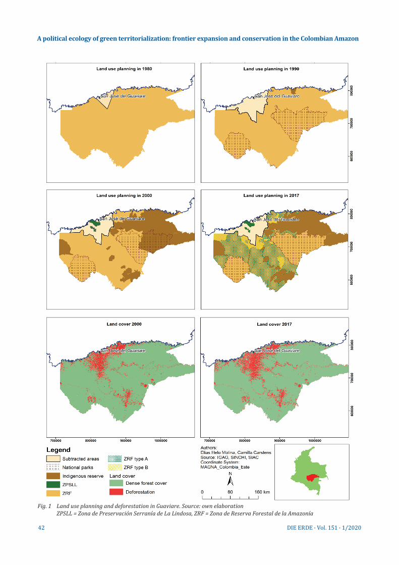
Fig. 1 Land use planning and deforestation in Guaviare. Source: own elaboration ZPSLL = Zona de Preservación Serranía de La Lindosa, ZRF = Zona de Reserva Forestal de la Amazonía
A political ecology of green territorialization: frontier expansion and conservation in the Colombian Amazon

43DIE ERDE · Vol. 151 · 1/2020
peace agreement “Final Agreement to End the Armed Conflict and Build a Stable and Lasting Peace”2 was signed by FARC-EP and the Colombian government and opened up a new window of change in Colombian territories including Guaviare. Regardless of the po-tential benefits that the peace agreement may have for the peasants, the retreat of FARC-EP from the ter-ritories paradoxically also poses new threats. The peace agreement has created a power void that has been filled by agrarian elites and illegal actors. The so-called “deforestation mafia” (Paz Cardona 2017: n.p.), seeks to (i)legally grab land for speculation. These actors expand the land market and associated process of agrarian differentiation and dispossession (Hall et al. 2011) to territories previously controlled by the guerrillas. Interviewed community members and representatives of NGOs reported for example that large cattle ranchers are well connected to mem-bers of the regional administration which in the past had close ties to paramilitary groups. These ranchers have forced peasants to sell land and merged the plots into large estates. Moreover, land concentration is fos-tered by the rural to urban migration of peasants, ris-ing land prices and investments in land by actors from central Colombia (Del Cairo 2018). The absence of the FARC-EP and state authorities has created a new fron-tier situation dissolving the pre-existing territoriali-zation of the guerrilla group and associated natural resource access regimes.
Within Guaviare we selected two case studies. They reflect different socio-ecological conditions and have distinct histories of territorialization, agricultural ex-pansion and conflicts. Moreover, they were selected because of the long experience of members of the au-thor team in both regions and the good security con-ditions for conducting fieldwork in 2017. The backwa-ters of Damas del Nare (see upcoming Fig. 4 in Section 6.1) are located to the south of the Guaviare River, in its middle course at the border of the ZRF in an area recently affected by violent conflict between FARC-EP and paramilitary groups. A mosaic of riparian forests, backwaters, agroforestry, annual crop systems and savannahs partly used for cattle ranching character-izes the landscape. The most relevant economic booms included extraction of forest products (rubber, jaguar skins, and timber), and marijuana and coca produc-tion. Today, most of the peasants in the region prac-tise subsistence-oriented agriculture complemented by commercial farming for regional market centres such as San José and Mapiripán. Recently, ecotourism has gained importance, as the Laguna of Damas Del
Nare is home to several Amazon River dolphins (Inia geoffrensis humboldtiana) (Del Cairo et al. 2018).
The other case study is the Serranía de La Lindosa. La Lindosa is located west of San José, in the northern part of the province (see upcoming Fig. 4 in Section 6.1). Rocky formations, riparian forests, savannahs, agroforestry and pasture characterize the landscape. Peasants started to colonize the area during the 1960s, supported by land titling and credit schemes. Since the late 1980s, the area has become a strategic conservation zone, framed as an ecological corridor linking Chiribiquete and Serranía de La Macarena national parks (SINCHI 2008; Vergara 2016). More re-cently, part of this area has been declared a protected archaeological area due to the presence of ancient rock pictograms. The indigenous Jiw, displaced by ru-ral violence from Llanos Orientales area north-east of the Guaviare River, claim that the area is part of their ancestral territory and seek to benefit from land res-titution policies.
4. Periods of territorialization3
State territoriality in Guaviare has been shaped and challenged by a number of different social actors. Peasant migrants became protagonists of frontier expansion and state territorialization. Indigenous groups have been present in the area since pre-colo-nial times but were mostly ignored by the Colombian state until the late 20th century (Del Cairo 2012.). Recently, the state acknowledged some of their col-lective land claims via, among others, Law 21/1991 supporting the ILO-Convention 169. At the same time, alternative territorial regimes have been established by armed groups but also by peasants and indigenous groups challenging the state’s sovereignty in Guavi-are and other parts of the Amazon. Thus, Guaviare is characterized by what John Agnew and Ulrich Oslender (2013: 122) call “overlapping territories”.
4.1 Initial state territorialization
The Colombian state’s interest in the Amazon became more prominent during the early 20th century. Rural violence in the Central Colombian highlands as a re-sult of tensions between (landless) peasants and large landholders led to the displacement of thousands of peasants to the Amazonian frontier regions (Garcia 2010; Martínez, 2004; Ortiz 1984). To solve the con-
A political ecology of green territorialization: frontier expansion and conservation in the Colombian Amazon

44 DIE ERDE · Vol. 151 · 1/2020
flicts, the liberal government of that era sought to transform the agrarian regime by stressing the role of peasant labour for establishing property rights and by promoting agricultural expansion. Law 200/1936 em-phasized the social function of property and declared almost the entire Amazon as vacant land (tierra baldía) (El Congreso de Colombia 1936). All ‘unused’, untrans-formed land became state property, allowing private actors (including peasants) to receive title deeds in cases where they could demonstrate ‘economic exploi-tation’ and ‘improvement’ (mejoras) of the land by in-vesting labour (Art. 1 Law 200/1936).
In 1959 (Law 2/1959) important additional regulations were enacted declaring the entire area (Fig. 1) that lat-er became the province of Guaviare as a forest reserve (ZRF) (El Congreso de Colombia 1959). The law restricts private land ownership, provides access to forests for commercial and domestic purposes through a conces-sion system, and includes provisions on soil, water and wildlife protection (El Congreso de Colombia 1959; Hinestroza-Cuesta and Mena-Valencia 2011). The state rationale behind this apparent policy shift was not conservation but rather to strengthen state ownership of land and to regain authority over the increasingly spontaneous character of the peasant colonization of the Amazon (Del Cairo 2012: 101). The forest reserve is literally a ‘land reserve’ that the state can allocate to direct colonization and promote rural development. Until today peasant land claims inside the ZRF require a legal act by the central government (ibid. 102)
In Guaviare state-assisted agrarian expansion started in the 1960s. INCORA4 (Instituto Colombiano para la Reforma Agraria), a central government land agency, reclassified parts of the forest reserve to land desig-nated for agrarian colonization. The reclassifications of, or in other words the subtractions from the forest reserve imply the legal reduction of the area designat-ed as forest reserve. Instead of solving land conflicts and changing the unequal land distribution – one of the root causes of rural violence in Colombia’s central high-lands – the government supported agrarian expansion to reduce political pressure from peasants and avoid conflicts with agrarian elites (Fajardo 2009). Thou-sands of peasants, some of them displaced by violence5 in Colombia’s central regions, moved to Guaviare and other parts of the Amazon and started forest conver-sion for agriculture and cattle ranching (Molano 1987; Salgado 2012). The state-assisted programmes prom-ised access to credits and de-jure title deeds for those ‘improving land’ by forest conversion.
4.2 Territorialization with indigenous peoples
Initially the existing indigenous territories located in the areas defined as vacant (or baldías) or as for-est reserve were not acknowledged by the Colombian state. From the late 1980s onwards, the Colombian state, under pressure from social movements, radi-cally changed its policies towards indigenous com-munities and developed a number of policies, includ-ing the Amazon Policy (Política Amazónica, Policy of the National Government in Defence of the Rights of Indigenous Peoples and the Ecological Conservation of the Amazon Basin) to protect their territorial and cultural rights (Agnew and Oslender 2013; Del Cairo 2012). In this context, indigenous communities that earlier were considered as the “last representatives of savagery and underdevelopment” (Del Cairo 2012: 47) became “environmental allies of the state” (ibid.). The Amazon Policy included provisions to “convert the Colombian Amazon into a great territory legally protected by establishing reservations, parks and na-ture reserves […]” and to realize the “[…] preservation of the immeasurable cultural and ecological riches which are found there” (República de Colombia 1990: 65 cited in Del Cairo 2012: 166). The Amazon Policy and the establishment of reserves strengthened the territorial control of the state and simultaneously integrated the indigenous population into the nation state (Domínguez and Gómez 1994). Currently, Guavi-are has 26 reserves with 8600 inhabitants, collective-ly owned by different ethnic groups such as Sikuani, Jiw, Nükak, Tucano, Desano, Piratapuyo, Cubeo, Gua-nano, Barasano, Siriano, Puinave, Piapoco, Curripacos and Guahibo.
4.3 Overlapping territories and the FARC-EP
The absence of public services and state control and the proximity to Colombia’s central highlands pro-vided ideal conditions for the narco economy. Espe-cially from the 1980s to the early 2000s vast areas of Guaviare were transformed into coca plantations and the coca shrub became the main cash crop in the peasant economy. In these years, the FARC-EP guer-rillas started to consolidate their territorial presence and became a powerful actor in the province (Salgado 2012). The FARC-EP formed an “alter-state within the state” (Agnew and Oslender 2013: 128) as they provid-ed public services to local communities and imposed and monitored various social and environmental regulations. The FARC-EP initially advocated against
A political ecology of green territorialization: frontier expansion and conservation in the Colombian Amazon

45DIE ERDE · Vol. 151 · 1/2020
coca cultivation on peasant farms, but soon started to tax the coca transactions in exchange for providing ‘security’ for the illegal economy (Molano 1987). Later on, during the 1990s, the FARC-EP started to directly control the cultivation of coca crops and the com-mercialization of cocaine (Ortiz 2016). Under these circumstances, peasants started to be vilified as drug cultivators and allies of leftist guerrillas and, as a re-sult, were no longer considered as heroes of frontier expansion and development to be supported with land titles and credit schemes (Del Cairo et al. 2014; Del Cairo and Montenegro-Perini 2015).
In areas controlled by the FARC-EP the Junta de Acción Comunal (JAC) became a public authority in land ten-ure issues and an intermediary between the armed group, the population and state agencies. The JACs are an institution established by the state through Law 19/1958. They are defined as civil society organiza-tions that together with subnational governments support the construction and maintenance of pub-lic infrastructure at local levels (Valencia 2010). The armed group strengthened the role of JACs and con-verted them to a legitimate public authority exercis-ing ‘social control’ and issuing documents legitimiz-ing land claims in the dispersed hamlets (vereda) of the province.
Until today the JACs remain a relevant authority le-gitimizing land claims by issuing certificates of sana posesión (ownership titles) and transactions but also coordinating community-based conservation regu-lations and mediating intra-communal conflicts in Guaviare (Torres et al. 2018). The JACs issue titles for plots of land located inside the forest reserve and ful-fil an important role in the landscape of the Damas del Nare backwaters and other peripheral parts of Guaviare where the various national land agencies are absent. The president of the Municipal Association of JACs of San José emphasized that the JACs do not have any de-jure authority over land tenure and in par-ticular not over the forest reserve (Fig. 2). However, the population legitimizes the JAC as an authority by accepting the land certificates and regulations it im-poses. Thereby peasants and JAC co-produce new sub-national territories that overlap with the ZRF. In some cases, state agencies accept the certificates providing additional legitimacy for the JAC in land tenure issues.
In the mid-1990s and 2000s, when the FARC-EP start-ed to directly control the coca economy, paramilitary groups arrived in the region, leading to violent clash-es with the FARC-EP. Paramilitary actions focused on two main objectives: to monopolize the illegal rents from the coca economy, and to undermine the social
Forest Reserve Subtracted areas
(outside the forest reserve)
Ministry of Environment and
Sustainable Development
National Natural Parks Agency
CDA
National Parks
Manages national parks
Environmental management
Protected areas (e.g. ZPSLL)
Request subtraction (since 1993)
Land management authorities
Environmental authorities
Subtraction and de-jure land titling
De-jure land titling
Guaviare regional and municipal government(s)
Local JAC’s
De-facto land titling
Ministry of Agriculture and Rural
Development
Agency for Land Restitution
National Land Agency (Formerly
Incoder)
Approves subtraction (since 1993)
Designates protected areas and national parks
Illegal actors e.g. “deforestation
mafia”
Drafted by the authors
Indigenous reserve
Notaries
Fig. 2 Mapping of land and environmental management authorities. Source: own elaboration
A political ecology of green territorialization: frontier expansion and conservation in the Colombian Amazon

46 DIE ERDE · Vol. 151 · 1/2020
basis of the guerrillas. In this context, peasants and indigenous people were displaced from their tradi-tional areas, and many people were killed in the cross-fire among armed actors. Also, aerial fumigations of coca plantations and staple crops were intensified as a direct consequence of the implementation of Plan Colombia, funded by the US Government (Ramírez and Iglesias 2010). Currently, and despite the politi-cal tensions it entails, the peace agreement seeks to tackle the root causes of the civil war: highly unequal land distribution in rural Colombia and a lack of pub-lic services in peripheral rural areas (Graser et al. 2020; Salazar et al. 2018; Republica de Colombia and las FARC-EP 2016). It is also intended to allocate land to landless peasants and formalize the land claims of peasants inside the ZRF (ibid).
5. Green territorialization and REDD+
Measures such as the designation of protected areas, regulatory changes, improved law enforcement and new incentive structures provide the framework con-ditions for REDD+ implementation. In the following, we will first unravel the specific forms of green ter-ritorialization taking place in Guaviare prior to im-plementation of the Amazon Vision. Second, we will discuss the relations between the Amazon Vision and the REDD+ Early Mover programme and ongoing (re)territorialization processes in Guaviare.
5.1 Green territorialization
We consider the designation of the forest reserve (ZRF) in 1959 as one of the first green territorializa-tion processes affecting Guaviare. The law declared large parts of Colombia and the entire Colombian Amazon (Fig. 1) as forest reserve zones (in total 38.6 million hectares) and delegated authority over these zones to the Ministry for Agriculture (today under the authority of the Ministry for Environment and Sustainable Development). Although the law declar-ing the ZRF is not a conservation law, it implied new land-use restrictions and even expropriations of land-owners. Moreover, private land ownership acquired through colonization and land occupation as had been permitted for tierra baldía became prohibited. How-ever, despite the de-jure restrictions frontier coloni-zation continued inside the ZRF and peasants from the central highlands of Colombia continued to settle there. Access to land inside the ZRF was facilitated by
local authorities such as the JAC, as they legitimized land transactions. Until 1989, peasant migrants con-verted up to 6 million hectares inside the ZRF for pas-ture and coca cultivation (Fontaine 2006).
Until the late 1980s INCORA and the Ministry of Ag-riculture continued to reduce the size of the ZRF in Guaviare (Fig. 1). In the following years conservation policies gained political traction. This was mainly trig-gered by two policy objectives. First, growing global concerns about forest destruction and climate change translated into new national conservation policies. Second, conservation became an important strategy to enhance territorial control in the context of the war against guerrilla groups (Bocarejo and Ojeda, 2016; Del Cairo et al. 2014; Del Cairo and Montenegro-Perini 2015). Indigenous groups, as described above, became important allies of the state to promote sus-tainability and millions of hectares of land became indigenous resguardos (reserves) (Fig. 1). In addition, large national parks such as the Chiribiquete Park (1989) were established with the support of interna-tional donors. Other areas designated for agriculture became part of the Integrated Management District of La Macarena (Área de Manejo Especial de La Macare-na, AMEM) (Ministry for Agriculture 1989).
The Integrated Management District of La Macarena (AMEM), as a new larger spatial planning category, aims to protect the Serrania de La Macarena mountain range and its surroundings, covering almost 4 million hectares in the provinces of Meta and Guaviare. With the implementation of the AMEM, the Colombian con-servation authorities for the first time acknowledged the presence of settlements and economic activities inside protected areas (Serna 2003), permitting eco-nomic activities in certain zones (Ministry for Agri-culture 1989). The Integrated Management District of La Macarena also overlaps with pre-existing spatial planning categories such as the ZPSLL and indigenous reserves and even includes a number of agro-industri-al clusters (Parques Nacionales Naturales de Colombia 2012).
More recently, in 2013, the Ministry of Environment and Sustainable Development established a new zon-ing approach to strengthen conservation inside the ZRF. Based on Resolution 1925/2013, the ZRF was subdivided into three different zones, with different protection status (A, B and C) (Ministry for the Envi-ronment and Sustainable Development 2013). The 5 million hectares located in Guaviare consist only of
A political ecology of green territorialization: frontier expansion and conservation in the Colombian Amazon

47DIE ERDE · Vol. 151 · 1/2020
areas classified as zones A and B. Zone A has the strict-est protection status. Activities permitted in zone A include ecosystem restoration and rehabilitation, sustainable production systems, REDD+ and carbon trading mechanisms, and ecotourism (ibid.). In zone B, activities are permitted that maintain air quality, climate and hydrological regulation, and avoid ero-sion. This includes commercial forest plantations, ecosystem restoration and agricultural production systems, REDD+ and Clean Development Mechanism projects (ibid).
5.2 Amazon Vision and REDD+
The Amazon Vision combines attempts to implement, enforce and control conservation regulations and to support productive activities considered as ‘green’. The national REDD+ strategy even declares Colom-bia’s forests as “life territories” (Bosques Territorios de Vida) (Visión Amazonía 2018a: 13). The German donor agencies KfW and GIZ consider REDD+ as central for “[…] peace building and shifting the development par-adigm for the Amazon region” (KfW and GIZ 2015: 6). The Amazon Vision has five focus areas, called pillars (Fig. 3). The first pillar (forest governance) focuses on territorialization and (re)-establishing state control by enhancing law enforcement, surveillance (includ-ing remote-sensing-backed monitoring of land use) and forest zoning. Initial results mentioned in the cur-rent work programme include additional operations involving environmental authorities and Colombia’s armed forces to control deforestation in the provinces of Caqueta and Guaviare, gazettement of 2.4 million hectares of forests and the formulation of manage-ment plans for 50,000 hectares of forests (Visión Ama-zonía 2018b). Pillar 2 focuses on improving sectoral coordination for sustainable development. Pillar 3 (agroecology and drivers of deforestation) focuses on addressing deforestation drivers from agricul-ture by improving the well-being of producers, and on promoting sustainable productive systems (e.g. beef, dairy, cocoa, rubber and non-timber products). Pil-lar 4 (environmental governance by indigenous com-munities) focuses on improving territorial govern-ance, and strengthening conservation and sustainable production by and in indigenous territories. Pillar 5 focuses on setting up the programme framework but also on monitoring, reporting and verification (MRV), and developing the national forest inventory and the registry for emission reductions (Gobierno de Colom-bia 2015).
By the end of 2020, the Amazon Vision will have re-ceived financial support of up to 122 million USD since 2015 through the REDD+ Early Movers programme (REM). REM funds are results-based, implying that the Colombian government is paid for emission reduc-tions achieved; the funds, however, should be invested in policies that again reduce deforestation (Gobierno de Colombia 2015; KfW and GIZ 2015; Visión Amazonía 2018a). At the time of our fieldwork in Guaviare, the first payment for the initial period from 2013-2017 had already been released. Requirements from the donor countries Germany, Norway and UK prescribe that at least 60 percent of the funds create benefits for ‘local actors’. Benefits for local actors in most cases do not imply direct cash payments for emission re-ductions. In the majority of cases, these are in-kind provisions, such as: agricultural extension services for peasant associations that have signed ‘zero-defor- estation’ contracts monitored by remote sensing; market access for sustainable products; and support for self-governance of indigenous territories (Gobier-no de Colombia 2015). Moreover, specific credit lines are planned to support zero-deforestation agricul-ture (Visión Amazonía 2018a).
Fig. 3 The pillars of the Amazon Vision programme.Source: own elaboration (drafted by M. Delfs based on infor-mation from Visión Amazonía 2018a)
A political ecology of green territorialization: frontier expansion and conservation in the Colombian Amazon

48 DIE ERDE · Vol. 151 · 1/2020
6. Green territorialization and conflictive pro-perty relations
Our two case studies illustrate the relations between (green) territorialization and property rights. Con-servation and development interventions have chal-lenged pre-existing land property rights of peasants and indigenous groups. At the same time, non-state actors such as the FARC-EP have empowered JACs to new public authority, legitimizing property rights in areas designated as forest reserve zones (ZRF).
6.1 Backwaters of Damas del Nare: a history of colo-nization, land tenure and conservation
The landscapes of the backwaters of Damas del Nare consist of three hamlets: Damas del Nare, Nare and La Fuga (Fig. 4). The three hamlets share a history of territorialization, violence and conservation. Until the 1960s, the area had a relatively low population density. The Guaviare River and its tributaries were the main transport routes. Statements made by vil-lagers in focus group discussions in August 2017 indi-
cate that prior to the 1950s only small indigenous Jiw and Sikuani groups lived in the region. These groups previously lived in the north of Guaviare and in the neighbouring Llanos Orientales region but were dis-placed by violence. A few years later, these indigenous groups played a key role in initial state territorializa-tion. A key informant in the hamlet of Damas del Nare reported that the first peasants driven by the state’s frontier expansion narratives moved to the region and received land from Jiw and Sikuani people. Carlos Sanchez,6 son of one of the first settlers in the area, explained that his father arrived in 1967. His father, he reported, bought an enormous amount of land for 2,500 pesos from an indigenous person who claimed to own that land. The area purchased was so large that his family did not know the exact borders of his property. Such land transactions were relatively com-mon during that period, according to key informants in the region. They can be considered an initial step towards commodification of land. Many of the set-tlers that bought land from indigenous people later subdivided their land into smaller plots, sold them to other migrants or used land to pay farm labourers. In this early period of colonization, land access was le-
Fig. 4 Forest cover and land use categories around the Serranía La Lindosa and the Damas Del Nare Backwaters. Source: own elaboration. ZPSLL = Zona de Preservación Serranía de La Lindosa, ZRF = Zona de Reserva Forestal de la Amazonía
A political ecology of green territorialization: frontier expansion and conservation in the Colombian Amazon
49DIE ERDE · Vol. 151 · 1/2020
gitimized and maintained by investing labour in land. Land transactions were legitimized by a handshake.
According to our interviews, the settlers felt the need to formalize land transactions once the population density increased. As a result of this demand, and probably also because of the interest of local elites in controlling access to land, new public authorities became involved in legitimizing property rights. No-taries and police officers approved documents called compra-venta (purchase-sale documents) or cartas de colonos (settler letters), replacing verbal agreements among actors. However, key informants explained that claiming land by investing labour in it (e.g. by convert-ing forest, cultivating crops or establishing pastures) was much more relevant than having a document cer-tifying ownership. The investment of labour in land as a means to claim ownership is backed by Article 1 of Law 200/1936 and by Law 4/19737. It became a com-mon strategy among migrants and a governance tool to strengthen territorial control of Colombia’s vast baldíos.
6.1.1 Territorialization, property and displacement
Interviewed community members reported that the marijuana and the coca boom induced a number of profound changes in the area (c.f. for other parts of Guaviare: Garcia 1995; López Loffsner 2018). First, the availability of land for coca cultivation attracted ad-ditional peasant migrants. Second, between the mid-1980s and 2000s the FARC-EP became a dominant actor in the area creating new territories overlapping with initial state territorialization. In Damas del Nare, the president of the JAC explained that the FARC-EP encouraged them to establish a JAC, and to request the formalization of their JAC from the administration of the commissar of Guaviare8 and later from the re-gional government in order to access public support for schools, health centres and roads. These develop-ments also had implications for property relations, facilitating the emergence of a new public authority, the JAC, which legitimized property rights and is-sued documents certifying land ownership within the hamlet’s territory.
Third, coca eradication campaigns by the Colombian Armed Forces and the increasing presence of para-military groups turned the region into a war zone leading to out-migration and evictions. The 2000s were known as the ‘era of displacement’. The hamlet
of Damas del Nare lost almost its entire population. Many peasants left for Mapiripán and San José, and abandoned their land or were forced to sell it. Violence dissolved the previous social order and led to the dis-placement of the population and to dispossession. After 2007, some peasants moved back, others sold their property. Powerful cattle ranchers benefited from the presence of paramilitary groups during the 2000s and from the power void after the peace agree-ment, and accumulated vast land resources particu-larly in the hamlets of Nare and La Fuga.
6.1.2 Conservation and imagined lines of division
The backwaters of Damas del Nare are located at the border of the ZRF. Parts of the hamlets of Damas del Nare, Nare and La Fuga are located within the strict-est conservation category of the ZRF, namely zone A (Fig. 4). However, the inhabitants of the three hamlets reported that they have never been officially informed about the borders of the reserve. The inhabitants dis-covered the implications of living inside or outside the ZRF in the context of interactions with agricul-tural extension services, agricultural credit agencies and development programmes. Living in the reserve implies not having a de-jure title deed and not having access to credits, agricultural extension services and benefits from the Amazon Vision. For the population, the border of the ZRF is an invisible line that separates people with de-jure title deeds and associated bundles of rights (Ribot and Peluso 2003) from those having no title deeds or only certificates issued by the JAC.
The line creates two distinct and arbitrary territo-ries. Vergara (2016) described this line of separation as ‘imaginary’, not because it is inappropriate or false but because it was drawn by bureaucrats with almost no knowledge about the specific place-based histo-ries. The border of the reserve established after the second subtraction in 1987 is the Caño La Fuga River, despite the fact that ecological conditions on both sides of the river are the same. As mentioned above, watercourses in the region were the main transport routes in the colonization period and migrants set-tled on both sides of the watercourse without know-ing that this decision would have a significant impact on their livelihoods. As Table 1 shows, forested and non-forested areas exist on both sides of the imagined line. The hamlet of Nare, for example, is entirely lo-cated in the ZRF but has forest cover of only 24.9%. In this case, the ZRF has a lot in common with what
A political ecology of green territorialization: frontier expansion and conservation in the Colombian Amazon
50 DIE ERDE · Vol. 151 · 1/2020
Peluso and Vandergeest (2001: 762) describe as “politi-cal forests” and Peluso (1992: 161) as a “forest without trees”. These areas cannot be described as forests in an ecological sense as they are not covered by trees but by pasture; the forest and the ZRF here are terri-torial categories with profound implications for land tenure.
Land use on both sides of the line is similar, despite the Resolution 1925/2013 A, B or C designation. Yet, according to interviewed peasants, the existence of the ZRF creates permanent and latent uncertainty, which translates into significantly higher land prices for plots located outside the reserve, as they can be registered by the national land agency. The legal and political implications for communities in the ZRF are even more complex and contradictory. The hamlets located inside the ZRF do not exist as territorial, legal and cadastral entities at the national scale. The JAC of Damas del Nare, for example, is not officially rec-ognized by the Ministry of the Interior, but it is rec-ognized by the municipal and regional governments. Moreover, land certificates issued by the JAC are ac-cepted by some rural development programmes. In addition, various state agencies provide school and health services, thus legitimizing the presence of peasant communities living in the ZRF, although they do not permit de-jure rights to land.
6.2 Serranía de La Lindosa: contested conservation and reconstitution of indigenous territories
Peasants colonized the Serranía de la Lindosa in the late 1950s but despite their presence the area became part of the ZRF in 1959. However, in 1971, the Ministry of Agriculture and the National Institute of Renew-able Natural Resources and Environment (Instituto Nacional de los Recursos Naturales Renovables y del Ambiente, INDERENA) subtracted approximately half of the mountain range from the ZRF and reclassified the areas for agrarian colonization (Del Cairo et al. 2014). Resolution 222 of 1971 justified this by argu-ing in favour of guided and organized colonization (Ministry for Agriculture 1971). With this subtraction, the state acknowledged and legitimized the presence of peasants in the mountain range and allocated land titles (Ortiz 2016). In 1989, the area became part of the Integrated Management District of La Macarena and various governmental and non-governmental or-ganizations started to implement different conserva-tion interventions in the area (Del Cairo et al. 2014). In particular, the establishment of the ZPSLL (Zona de Preservación Serranía de La Lindosa) again led to re-strictions affecting the land-use practices of peasants in the mountain range (Fig. 1 and 4). More recently, as we will explain below, the indigenous Jiw have claimed that the region is part of their ancestral terri-tory and hope that they will receive large parts of the mountain range, including areas managed by peas-ants through the land restitution process.
Hamlet
Area (ha)
Zona Reserva Forestal
(%)
Legally non-forest (subtracted)
(%)
Indigenous territory
(%)
Total
Spatial planning category
Sabanas de la Fuga
Nare
Damas del Nare
16,745.0
9,527.9
1,856.7
21.5
24.9
67.8
0.0
0.0
0.0
17.2
73.6
32.2
39.0
0.0
0.0
0.1
0.0
0.0
22.2
0.0
0.0
0.0
0.1
0.0
0.0
0.0
0.0
0.0
1.4
0.0
100
100
100
A B C A B C A B C
A = forest, B = deforestation rate, C = no forest
Table 1 Forest cover and deforestation in the landscapes of the backwaters of Damas del Nare. Source: authors’ own land cover analysis
A political ecology of green territorialization: frontier expansion and conservation in the Colombian Amazon

51DIE ERDE · Vol. 151 · 1/2020
6.2.1 Green territorialization and pre-existing rights
Implementation of the Integrated Management Dis-trict of La Macarena and ZPSLL indicated a paradigm shift changing state territorialization from an ap-proach based on the colonization of the Amazon by peasants to conservation and land-use restrictions (see Del Cairo and Montenegro-Perini 2015). In 2006, the Cooperation for Sustainable Development of the north-eastern Amazon (Corporación para el Desar-rollo Sostenible del Norte y el Oriente Amazónico CDA9), a public agency accountable to the Ministry of Environment and Sustainable Development and re-sponsible for natural resource management, monitor-ing and enforcement of environmental laws, started to develop a management plan for the ZPSLL and be-gan to determine the borders of the protected areas. The plan was mainly guided by a strict conservation approach. It imposed land-use restrictions in major parts of the mountain range, affecting the property rights that peasants had received a few years earlier. The affected peasants built on three different meas-ures to successfully lobby against the plan. First, they increasingly engaged with other state agencies and their rural development programmes such as the Programa de Familias Guardabosques of National Plan-ning Department (Del Cairo and Montenegro-Perini 2015: 65). The programme promoted coca substitu-tion through the development of agroforestry. Engaging with the programme provided additional legitimacy for their presence within the protected area. Second, they created the NGO corporation for the defence of the Ser-ranía de la Lindosa (Corpolindosa, Corporación para la Defensa de la Serranía de la Lindosa), which organized protest, stressing in particular the lack of adequate con-sultation. Third, they developed a co-management plan in cooperation with a local NGO (Corporación para la In-vestigación, el Desarrollo Agropecuario y el Medio Am-biente – Cindap), which was hired by the CDA to solve the conflict.
The acceptance of this co-management plan by the CDA can be considered an important success for the peas-ants as the plan reduced the area designated for strict conservation by more than 50%. Moreover, peasants received support for the border demarcation of their individual lands, regardless of the formal status of their land rights. But they have to adhere to conservation regulations. By acknowledging the presence of peasants within the ZPSLL and supporting border demarcation, the CDA changed from being an environmental agency into a public authority legitimizing access to land.
Peasants participating in a focus group discussion in August 2017 explained that the co-management plan implies the registration of their property and the con-ditional acknowledgement of their rights by the CDA and the Ministry of Environment and Sustainable De-velopment. Peasant resistance has transformed green territorialization from an exclusion-oriented process to a source of legitimacy, illustrating the dialectical nature of socio-spatial relations (Soja 1980): green territorialization structures social practices but re-sistance and the acceptance of the co-management plan allowed peasants to align their land claims with the conservation agenda and to push the state to in-clude land property rights as an important vector for environmental management.
6.2.2 Land restitutions, conservation and the expan-sion of indigenous reserves
Land restitution is one of a number of transitional justice initiatives by the central government which gained political traction during the presidency of Ma-nuel Santos (Ruiz 2018). The Victims and Land Resti-tution Law (Law 1448 of 2011) provides specific legal protection for victims of armed conflict and a land restitution regime (ibid.). In 2011, the Agency for Land Restitution (Unidad de Restitución de Tierras) initi-ated a process to expand the size of three indigenous territories of the Jiw people, namely the reserves of La María (Fig. 4), La Fuga and Barrancón. In the past, some Jiw people lived north of the Guaviare River and practised a semi-nomadic lifestyle. They usually lived in groups of about 25 people and practised shifting cultivation and fishing. In the 1950s, they fled from violence and moved to Guaviare, claiming to have reached the area prior to the peasants. In Guaviare, they lived from gathering rubber, hunting, and selling animal skins. In the context of increasing population density because of state-sponsored agrarian coloni-zation, the first land disputes with peasants occurred.
The Victims and Land Restitution Law and subsequent interventions of donor agencies created the expecta-tion that the Jiw would receive 35,000 ha of land. The expectations of the Jiw were also underpinned by the discursive shifts which reframed indigenous groups from ‘underdeveloped forest dwellers’ to ‘environ-mental guardians’. However, an expanded reserve would overlap with land currently used by peasants and by a number of large cattle ranchers. Consequent-ly, an expansion would only be possible if these actors
A political ecology of green territorialization: frontier expansion and conservation in the Colombian Amazon

52 DIE ERDE · Vol. 151 · 1/2020
accepted resettlement or compensation. The peas-ants in the Serranía de La Lindosa rejected the plans and organized protests. They claimed that they were not adequately informed about the potential expan-sion of the reserve and reported that Jiw people were entering their property, stealing animals and crops, and practising unsustainable hunting and fishing techniques on their land. Interestingly, the peasants from the Serranía de La Lindosa present themselves as stewards of the ecosystems of the mountain range and thus as the state’s allies, and characterize the Jiw people as a threat to the integrity of the ecosystem. In addition, the peasants argue that the Jiw do not have the right to restitution as they have never lived in the Serranía de La Lindosa. Some Jiw people in La María confirmed this. However, they argue that they have sacred sites in the mountain range that are important for their cultural reproduction. At present, land res-titution is creating a tense atmosphere in the region. Staff of the regional administration described the situation as a “time bomb” that might turn into open conflict.
7. Reterritorialization through implementing the Amazon Vision?
The Amazon Vision challenges the dominant narra-tives of the 20th century that promoted agricultural expansion, and promotes a new development model for the Amazon based on sustainable agriculture, zero deforestation and strong ‘environmental governance by indigenous people’. As with many REDD+ initia-tives, the suggested interventions combine a number of goals beyond emission reductions, such as poverty reduction and governance reform (Gobierno de Colom-bia 2015). So far, the Amazon Vision has had only a limited impact on the livelihoods of most peasants and indigenous groups in Guaviare. However, the Am-azon Vision does not operate in a social and political vacuum. The different policies are embedded in exist-ing socio-ecological conflicts and compete with the pre-existing territorialization strategies. Moreover, knowledge asymmetries, the exclusion of peasants living in the ZRF from benefit sharing, and stricter law enforcement have the potential to reproduce ex-isting power asymmetries and might further mar-ginalize actors who are not part of development and conservation networks. Nevertheless, the acceptance of zero-net deforestation contracts and of agricultural extension services, and support for marketing ‘sus-tainable’ products imply the recognition of state ac-
tors in peripheral areas and consequently contributes to state making and green territorialization.
The ability of peasants to negotiate and sign ‘zero deforestation’ contracts and to receive extensions services and other in-kind benefits is determined by land tenure. Only actors with de-jure land titles are able to access the benefits and to negotiate contracts. As described above, land tenure in Guaviare is high-ly complex. Some peasants and the Jiw people in La María have received de-jure title deeds from national agencies; others have a land certificate from a JAC, while others hold documents issued by a notary or consider a co-management plan for a protected area as legitimizing their property. Some do not hold any title deeds and live inside the ZRF, but have legitimate rights to land as they have invested labour in the land or received the land from an indigenous landowner. The re-territorialization of the ZRF based on the new zoning approach, which is also reaffirmed by the Amazon Vision, might create additional challenges for landowners without de-jure title deeds living in the reserve. However, previous green territorializa-tion approaches such as the new management plan for ZPSLL and in particular the designation of large parts of the ZRF for strict conservation (zone A), based on Resolution 1925/2013, have delegitimized the exist-ing property rights of peasants.
The Amazon Vision, in contrast to many early con-servation strategies for the Amazon, clearly acknowl-edges the presence and activities of humans in the landscape. However, at least to some extent, the Ama-zon Vision reproduces essentialist categories of tra-ditional indigenous forest stewards and peasants as encroachers. Indigenous groups have replaced peas-ants and become the main protagonists of state ter-ritorialization and the most important ally of the state in implementing the Vision and ultimately receiving payments from the donor countries. Consequently, the Amazon Vision further contributes to the “green-ing of Amazon indigenous identities” (Del Cairo 2012: 39). This might increase tensions among indigenous and peasant populations by creating specific benefits for specific indigenous communities (e.g. additional funds through the pillar for environmental govern-ance by indigenous communities) but it might also cre-ate challenges for those indigenous groups that do not want or are not able to fill the “tribal slot” (Li 2000: 1). Moreover, knowledge asymmetries among indigenous communities in Guaviare create additional problems. The Jiw people, for example, claim to have never been
A political ecology of green territorialization: frontier expansion and conservation in the Colombian Amazon

53DIE ERDE · Vol. 151 · 1/2020
informed about the Amazon Vision or about the pos-sibility of receiving support. Some Jiw people in the La María resguardo told us that “[...] here in La María the institutions always neglect us”. A representative from an implementing agency admitted communi-cation problems. He explained in a paternalistic but self-critical way: “[…] Jiw have weak leaders and are not represented at the national or at the local level […] it’s difficult to communicate with them […] we need to work on it”.
8. Conclusion
By changing access and property relations green ter-ritorialization influences the main questions of the agrarian political economy in important ways. Our ar-ticle illustrates the relations between different peri-ods of state territorialization, property rights and the roles that different social actors played in each territo-rialization period. In the context of initial state terri-torialization, the Colombian government declared the Amazon as a vast and empty space ready for coloniza-tion. Peasants became the main protagonists of state territorialization. By investing labour in land, they re-ceived property rights legitimized by the state or they benefited from state-backed colonization schemes. Green territorialization delegitimized peasants’ pro-perty rights in large parts of Guaviare but provided additional opportunities for peasants adapting to the new sustainability and zero deforestation paradigm and in particular for indigenous groups. Indigenous groups received (at least on paper) large amounts of land in the Colombian Amazon, which their ‘tradition-al land-use’ practices should protect, and more re-cently additional support through the Amazon Vision. However, green territorialization and the interrelated essentialist categorizations of the population as peas-ants and indigenous groups create and deepen social tensions within and among different social groups.
In fact, territorialization in Guaviare is not only a strat-egy pursued by state actors. The rise of the FARC-EP strengthened JAC as a new authority legitimizing property rights and thereby producing peasant ter-ritories that overlap with the forest reserve zones. At the national level, these areas remain forest zones and national legislation for the ZRF apply even where the reserves have no forest cover. Territory is produced at different scales leading to ambiguous and, in some cases, contradictory formations. Peasant land-use practices and community rules for land management,
land transactions and property rights within the peasant territories contribute to the spatial produc-tion of a peasant landscape in the ZRF.
We conclude that the Amazon Vision might not fulfil its environmental objectives but might support al-ternative forms of territorialization and land use by supporting the self-governance of indigenous lands, by offering zero-deforestation contracts to peasants acknowledging their organizational forms, and by creating new participatory mechanisms. By accepting these measures indigenous communities and peas-ants will contribute to state making at Guaviare’s for-est margins.
Notes
1 REDD+: Reducing emissions from deforestation and for-est degradation and the role of conservation, sustainable management of forests and enhancement of forest carbon stocks in developing countries (REDD-plus) (UNFCCC 2020).
2 The peace agreement has implications for the agrarian and environmental dynamics in the Amazon and beyond be-cause it aims to address the agrarian roots of Colombian violence. The agreement includes programmes to enable the formalization of peasants’ property rights, especially for small landowners and landless peasants (see Fajardo and Salgado 2017).
3 Sections 4 and 5 build on published sources including grey literature and on interviews conducted by the team of au-thors in 2017.
4 In 2003 INCORA was replaced by INCODER (Instituto Co-lombiano de Desarrollo Rural, Institute for rural develop-ment). Since 2015 the national land agency (Agencia Na-cional de Tierras) is in charge of land registration.
5 From 1948 to 1959, during the period known as ‘The Vio-lence’ (La Violencia), more than 400,000 peasants were evicted from their land, which was subsequently appro-priated by a few landholders from the highland and val-leys Andes region (Guzmán et al. 1962).
6 Fictitious name.7 Law 200/1936 declares all unused, untransformed land
as state property, Articles 1 of law 200/1936 and of law 4/1973 state among other issues that private land owner-ship implies the economic exploitation of land, for exam-ple by establishing plantations or cattle ranches. In addi-tion, Law 4/1973 fostered state-led agrarian colonization and credit schemes for peasants. Migrating peasants were directed towards areas that had been subtracted from the forest reserve (Montenegro 2014). These legal changes led
A political ecology of green territorialization: frontier expansion and conservation in the Colombian Amazon

54 DIE ERDE · Vol. 151 · 1/2020
to massive peasant migration from Central Colombian ar-eas such as Santander, Boyacá, Caldas, Valle del Cauca and Tolima.
8 Before 1991 Guaviare had the status of a Comisaría cor-responding to national territory controlled by the central government. This means that the commissar – the head of local government – was directly appointed by the central government in Bogotá.
9 For environmental surveillance and management outside of National Natural Parks and Indigenous Reserves, the Colombian territory is divided into several regions that do not coincide with the political-administrative division of the territory. Each region responds to particular ecosys-temic characteristics and its management is assigned to public institutions and named “Corporaciones Autónomas Regionales” (Regional Autonomous Corporations). CDA is the corporation in charge of environmental management of the mid and lower basin of the rivers Guayabero, Guavi-are, Inírida, Unilla, Itilla and Vaupés, in the northern and north-eastern part of the Colombian Amazonia.
Acknowledgements
This research was funded by the German Federal Ministry for Economic Cooperation and Development (BMZ) through the Klimalog project (Research and dialogue for a climate-smart and just transformation). The authors would like to thank all people that participated in this research and the organizations that provided information or facilitated this research, including the former Fundación de Estudios So-ciales y Ambientales (FESOA). Special thanks to Elias Helo (Pontificia Universidad Javeriana) who provided us valua-ble help with the spatial analysis, to Camilla Carstens (CAU Kiel) for drafting the maps, and to Mytree Delfs (CAU Kiel) for formatting the manuscript. Any errors that remain are the authors own responsibility.
References
Agnew, J. and U. Oslender 2013: Overlapping territorialities, sovereignty in dispute: empirical lessons from Latin America. – In: Nicholls, W., B. Miller and J. Beaumont (eds.): Spaces of Contention: Spatialities and Social Movements. – Abingdon et al.: 121-140
Agrawal, A. and A. Angelsen 2009: Using community forest management to achieve REDD+ goals. – In: Angelsen, A. (ed.): Realising REDD+: national strategy and policy op-tions. – Bogor: 201-212
Alagappa, M. 1995: Political legitimacy in Southeast Asia: The quest for moral authority. – Stanford
Arendt, H. 1951: The origins of totalitarianism. – New YorkAsiyanbi, A.P. 2016: A political ecology of REDD+: Property
rights, militarised protectionism, and carbonised exclu-sion in Cross River. – Geoforum 77: 146-156
Ballvé, T. 2019: Narco-frontiers: A spatial framework for drug-fuelled accumulation. – Journal of Agrarian Change 19: 211-224
Bassett, T.J. and D. Gautier 2014: Regulation by Territoriali-zation: The Political Ecology of Conservation & Develop-ment Territories. Introduction. – EchoGéo 29: 1-7
Benjaminsen, T.A. and I. Bryceson 2012: Conservation, green/blue grabbing and accumulation by dispossession in Tanzania. – Journal of Peasant Studies 39 (2): 335-355
Bernstein, H. 2010: Class dynamics of agrarian change. – Black Point
Bluwstein, J. 2017: Creating ecotourism territories: Environ-mentalities in Tanzania’s community-based conserva-tion. – Geoforum 83: 101-113
Bocarejo, D. and D. Ojeda 2016: Violence and conservation: Beyond unintended consequences and unfortunate coin-cidences. – Geoforum 69: 176-183
Brad, A., A. Schaffartzik, M. Pichler and C. Plank 2015: Con-tested territorialization and biophysical expansion of oil palm plantations in Indonesia. – Geoforum 64: 100-111
Chaves, M. and M. Zambrano 2006: From blanqueamiento to reindigenización: Paradoxes of mestizaje and multicul-turalism in contemporary Colombia. – Revista Europea de Estudios Latinoamericanos y del Caribe/European Review of Latin American and Caribbean Studies 80: 5-23
Corson, C., K.I. MacDonald and B. Neimark 2013: Grabbing “green”: markets, environmental governance and the materialization of natural capital. – Human Geography 6 (1): 1-15
Del Cairo, C. 2012. Environmentalizing Indigeneity: A Com-parative Ethnography on Multiculturalism, Ethnic Hier-archies and Political Ecology in the Colombian Amazon. Dissertation – University of Arizona – Ann Arbor
Del Cairo, C.L. and I. Montenegro-Perini 2015: Espacios, campesinos y subjetividades ambientales en el Guaviare. – Memoria y Sociedad 19 (39): 49-71
Del Cairo, C.L., S.G. Zúñiga, J.E. Ortega, D.O. Gallego, A.C.R. Maldonado, J.S.V. Triana and T.V. Gutiérrez 2018: Dinámi-cas socioecológicas y ecoturismo comunitario: un análi-sis comparativo en el eje fluvial Guayabero-Guaviare. – Cuadernos de Desarrollo Rural 15 (82): 1-23
Del Cairo, C.L., I. Montenegro-Perini and J.S. Vélez 2014: Naturalezas, subjetividades y políticas ambientales en el Noroccidente amazónico: reflexiones metodológicas para el análisis de conflictos socioambientales. – Boletín de Antropología 29 (48): 13-40
Del Cairo, J. 2018: Concentración de tierras en el Guaviare.
A political ecology of green territorialization: frontier expansion and conservation in the Colombian Amazon
55DIE ERDE · Vol. 151 · 1/2020
PID Amazonia, San Jose del GuaviareDomínguez, C. and A. Gómez 1994: Nación y etnias. Los con-
flictos territoriales en la Amazonia colombiana, 1750-1933. – Bogotá
El Congreso de Colombia 1936: Ley 200 de 1936, (diciembre 30), Sobre régimen de tierras. – Bogotá
El Congreso de Colombia 1959: Ley 2 de 1959 (diciembre 16), Sobre economía forestal de la Nación y conservación de recursos naturales renovables. – Bogotá
Fairhead, J., M. Leach and I. Scoones 2012: Green Grabbing: a new appropriation of nature? – Journal of Peasant Stud-ies 39 (2): 237-261
Fajardo, D. 2009: Territorios de la agricultura colombiana. Universidad Externado de Colombia – Bogotá
Fajardo, D. and H. Salgado 2017: El acuerdo agrario. – BogotáFold, N. and P. Hirsch 2009: Re-thinking frontiers in South-
east Asia. – The Geographical Journal 175 (2): 95-97Fontaine, G. 2006: La globalización de la Amazonía: una per-
spectiva andina. – Íconos: Revista de Ciencias Sociales 25: 25-36
García, H.A. 2010: The Unending Quest for Land: The Tale of Broken Constitutional Promises. – Texas Law Review 89 (3): 1895-1914
Garcia, M. 1995: Coca, guerrilla y sociedad civil en el Guavi-are: regulación de conflictos y otros controles. – Colom-bia Internacional 29: 18-29
Gobierno de Colombia 2015: Visión Amazonía. – BogotáGraser, M., M. Bonatti, L. Eufemia, H. Morales, M. Lana, K. Löhr
and S. Sieber 2020: Peacebuilding in Rural Colombia – A Collective Perception of the Integrated Rural Reform (IRR) in the Department of Caquetá (Amazon). – Land 9 (2): 1-17, doi:10.3390/land9020036
Guzmán, G., O. Fals and E. Umaña 1962: La violencia en Co-lombia. Estudio de un proceso social. – Tercer Mundo 10. – Bogotá
Hall, D., P. Hirsch and T.M. Li 2011: Powers of Exclusion: Land Dilemmas in Southeast Asia. – Honolulu
Hein, J. 2019: Political Ecology of REDD+ in Indonesia –Agrarian conflicts and forest carbon. – London
Hinestroza-Cuesta, L. and M. Mena-Valencia 2011: Análisis sobre el marco jurídico que regula el aprovechamiento forestal en Colombia. – Revista Biodiversidad Neotropi-cal 1: 73-90
Ibáñez, A.M. 2009: Forced displacement in Colombia: Magni-tude and causes. – The Economics of Peace and Security Journal 4 (1): 48-54
KfW and GIZ 2015: Rewarding REDD+ Action and Sup-porting Low-deforestation Development in the Colom-bian Amazon. – Online available at: https://www.kfw- entwicklungsbank.de/PDF/Entwicklungsfinanzierung/Themen-NEU/20151128-REM-Colombia-agreement-summaryFINAL.pdf., accessed 27/02/2017
Kopytoff, I. 2000: The internal African frontier: Cultural conservatism and ethnic innovation. – In: M. Rosler and T. Wendl (eds.): Frontiers and Borderlands: Anthropologi-cal Perspectives. – Berlin: 31-44
Korf, B. and T. Raeymaekers 2013: Introduction: Border, Frontier and the Geography of Rule at the Margins of the State. – In: Korf, B. and T. Raeymaekers (eds.): Violence on the Margins. – Palgrave Series in African Borderlands Studies 2. – New York: 3-27
Larsen, P. 2015: Post-frontier resource governance: indige-nous rights, extraction and conservation in the Peruvian Amazon – London
Larson, A.M. 2011: Forest tenure reform in the age of climate change: Lessons for REDD+. – Global Environmental Change 21(2): 540-549
LeGrand, C.C., L. van Isschot and P. Riaño-Alcalá 2017: Land, justice, and memory: challenges for peace in Colombia. – Canadian Journal of Latin American and Caribbean Stud-ies / Revue canadienne des études latino-américaines et caraïbes 42 (3): 259-276
Li, T.M. 2000: Articulating indigenous identity in Indonesia: Resource politics and the tribal slot. – Comparative stud-ies in society and history 42 (1): 149-179
López Loffsner, F. 2018: Deforestación, justicia ambiental y post-acuerdo en el noroccidente del Guaviare. – Master thesis, Universidad Nacional de Colombia, Sede Bogotá. – Bogotá
Lund, C. 2016: Rule and rupture: state formation through the production of property and citizenship. – Develop-ment and Change 47 (6): 1199-1228
Lund, C. 2006: Twilight institutions: public authority and lo-cal politics in Africa. – Development and change 37 (4): 685-705
Macpherson, C.B. 1978: Property Mainstream and Critical Positions. – Oxford
Maher, D. 2015: Rooted in violence: Civil war, international trade and the expansion of palm oil in Colombia. – New Political Economy 20 (2): 299-330
Martínez, M.E.P. 2004: La conformación territorial en Colombia: entre el conflicto, el desarrollo y el destierro. – Cuadernos de desarrollo rural 51: 61-90
Ministry for Agriculture 1971: Resolución 222 de 1971. – Bo-gotá
Ministry for Agriculture 1989: Decreto 1989 de 1989, Por el cual se declara Area de Manejo Especial La Macarena, la Reserva Sierra de La Macarena, se clasifica y zonifica su territorio y se fijan sus límites reales. – Bogotá
Ministry for the Environment and Sustainable Development 2013: Resolucion 1925 de 2013 Por la cual se adopta la zonificación y el ordenamiento de la Reserva Forestal de la Amazonía, establecida en la Ley 2ª de 1959, en los departamentos de Caquetá, Guaviare y Huila y se toman
A political ecology of green territorialization: frontier expansion and conservation in the Colombian Amazon

56 DIE ERDE · Vol. 151 · 1/2020
otras determinaciones. – BogotáMolano, A. 1987: Selva adentro. Una historia oral de la colo-
nización del Guaviare. – BogotáMontenegro, I. 2014: El ecoturismo en juego: procesos de
neoliberalización, tecnologías de gobierno y agencias campesinas en Playa Güío, Guaviare. – Bachelor thesis, Pontificia Universidad Javeriana – Bogotá
Ng’weno, B. 2007: Can ethnicity replace race? Afro-Colombi-ans, indigeneity and the Colombian multicultural state. – The Journal of Latin American and Caribbean Anthro-pology 12 (2): 414-440
OECD (Organisation for Economic Co-operation and Develop-ment) 2018: What is green growth and how can it help deliver sustainable development? – Online available at: http://www.oecd.org/greengrowth/whatisgreen-growthandhowcanithelpdeliversustainabledevelop-ment.htm., accessed 12/02/2020
Ortiz, D. 2016: Políticas de desarrollo alternativo en el Guaviare: formación local del estado y producción estatal del espacio. – Bachelor thesis [unpublished], Pontificia Universidad Javeriana – Bogotá
Ortiz, S. 1984: Colonization in the Colombian Amazon. Fron-tier expansion in Amazonia. – In: Schmink, M. and C.H. Wood (eds.): Frontier Expansion in Amazonia. – Gains-ville: 204-230
Paasi, A. 2003: Territory. – In: Agnew, J. and G. Toal (eds.): A Companion to Political Geography. – Malden: 95-108
Parques Nacionales Naturales de Colombia 2012: Principales Ajustes al componente diagnostico. – Online available at: http://www.ame-macarena.org/descargar_archivo.php?archivo_id=167&hash=bbd4de8dbbaf3542be1839aea87d3c., accessed 16/05/2019
Paz Cardona, A.J. 2017: Colombia: las mafias de la defor-estación en el Guaviare. – Online available at: https://es.mongabay.com/2017/07/colombia-las-mafias-la- deforestacion-guaviare/., accessed 11/10/2018
Peluso, N.L. 1992: Rich forest, poor people. – BerkeleyPeluso, N.L. 1995: Whose woods are these? Counter-mapping
forest territories in Kalimantan, Indonesia. – Antipode 27 (4): 383-406
Peluso, N.L. and C. Lund 2011: New frontiers of land control: Introduction. – Journal of Peasant Studies 38 (4): 667-681
Peluso, N.L. and P. Vandergeest 2001: Genealogies of the po-litical forest and customary rights in Indonesia, Malay-sia, and Thailand. – The Journal of Asian Studies 60 (03): 761-812
Ramírez, M.C. 2001: Entre el estado y la guerrilla: identi-dad y ciudadanía en el movimiento de los campesinos cocaleros del Putumayo. – Instituto Colombiano de An-tropología e Historia, Colciencias. – Bogotá
Ramírez, M.C. and J. Iglesias 2010: Paradojas del desarrollo
alternativo en la Amazonia occidental colombiana. – In: Chaves, M. and C. Del Cairo (eds.): Perspectivas antropológicas sobre la Amazonia contemporánea. – Bogotá: 537-562
Rasmussen, M. and C. Lund 2018: Reconfiguring Frontier Spaces: The territorialization of resource control. – World Development 101 (C): 388-399
Republica de Colombia and las FARC-EP 2016: Acuerdo Final para la Terminación del Conflicto y la Construc-ción de una Paz Estable y Duradera. – Online avail-able at: http://www.altocomisionadoparalapaz.gov.co/procesos-y-conversaciones/Documentos%20compartidos/24-11-2016NuevoAcuerdoFinal.pdf., accessed 13/06/2019
Ribot, J.C. and N.L. Peluso 2003: A Theory of Access. – Ru-ral sociology 68 (2): 153-181
Rodriguez-de-Francisco, J.C. and R. Boelens 2016: PES hy-drosocial territories: de-territorialization and re-pat-terning of water control arenas in the Andean high-lands. – Water International 41 (1): 140-156
Ruíz, D. 2010: Las premisas de la selva. Representaciones de la naturaleza en una zona de colonización campesi-na. – In: Chaves, M. and C. Del Cairo (eds.): Perspectivas antropológicas sobre la Amazonia contemporánea. – Bogotá: 355-361
Ruiz, M.A.V. 2018: The emergence and consolidation of transitional justice within the realm of Colombian peacebuilding. – In: Díaz Pabón, F. (ed.): Truth, Justice and Reconciliation in Colombia. – London: 50-65
Salazar, A., A. Sanchez, J.C. Villegas, J.F. Salazar, D.R. Car-rascal, S. Sitch, J.D. Restrepo, G. Poveda, K.J. Feeley, L.M. Mercado, P.A. Arias, C.A. Sierra M. del Rosario Uribe, A.M. Rendón, J.C. Pérez, G.M. Tortarolo, D. Mercado-Bettin, J.A. Posada, Q. Zhuang and J.S. Dukes 2018: The ecology of peace: preparing Colombia for new political and planetary climates. – Frontiers in Ecology and the Environment 16 (9): 525-531
Salgado, H. 2012: El campesinado de la Amazonia colom-biana: Construcción territorial, colonización forzada y resistencias. – Disertación Doctoral, Universidad de Montreal. – Montreal
Serna, D.R. 2003: Campesinos entre la selva, invasores de reservas. – Tabula Rasa 1: 183-210
Sikor, T. and C. Lund 2009: Access and property: a question of power and authority. – Development and change 40 (1): 1-22
SINCHI 2008: Flora de las formaciones rocosas Serranía de La Lindosa. – Instituto Amazónico de Investiga-ciones Científicas. – Bogotá
Sistema de Información Ambiental Territorial de la Ama-zonia colombiana (SIAT-AC) 2015: Resguardos Indíge-nas. – Online available at: http://siatac.co/web/guest/
A political ecology of green territorialization: frontier expansion and conservation in the Colombian Amazon
57DIE ERDE · Vol. 151 · 1/2020
productos/territorios-ancestrales/resguardos-indigenas., accessed 12/02/2020
Soja, E.W. 1980: The socio-spatial dialectic. – Annals of the Association of American Geographers 70 (2): 207-225
Tobón, M. 2010: Analizar para distinguir: Narraciones y ex-periencias del conflicto político armado entre la Gente de centro. – Revista Colombiana de Antropología 46 (1):157-185
Torres, J., D. Salamanca, D. Fajardo and D. Ortiz 2018: Puerto Gaviotas, Guaviare: la experiencia de una comunidad sobreviviente y constructora de institucionalidad co-munitaria. – In: Jefferson, J., C.H. Fabio and D. Ortiz (eds.): Instituciones comunitarias para la paz en Colombia: es-bozos teóricos, experiencias locales y desafíos sociales. – Bogotá: 119-151
Tsing, A.L. 2005: An ethnography of global connection. – Princeton
United Nations Framework Convention on Climate Change (UNFCCC) 2020: Reducing emissions from deforestation and forest degradation and the role of conservation, sus-tainable management of forests and enhancement of for-est carbon stocks in developing countries (REDD-plus). – Online available at: https://unfccc.int/topics/land-use/workstreams/reddplus., accessed 12/02/2020
Valencia, L.E. 2010: Historia, realidad, pensamiento y per-spectivas de la acción comunal en Colombia. – Online available at: http://viva. org. co/cajavirtual/svc0168/articulo0006. pdf., accessed 11/10/2018
Vergara, T. 2016: Las líneas sobre la selva: un análisis del
campo del ordenamiento territorial en el Guaviare. – Bachelor thesis in anthropology. [unpublished]. – Bogotá
Visión Amazonía 2018a: Plan de Trabajo Global, Programa REM Colombia. – Online available at: http://visionama-zonia.minambiente.gov.co/content/uploads/2018/09/PTG-aprobado.pdf., accessed 24/02/2020
Visión Amazonía 2018b: Desarollo Agroambiental. – Online available at: http://visionamazonia.minambiente.gov.co/ pilar-3-desarrollo-agroambiental/., accessed 22/11/ 2018
Von Benda-Beckmann, F., K. von Benda-Beckmann and M. Wiber 2009: The Properties of Property. – In: von Benda-Beckmann, F., K. von Benda-Beckmann and M. Wiber (eds.): Changing properties of property. – New York et al.: 1-39
Wertz-Kanounnikoff, S. and A. Angelsen 2009: Global and national REDD+ architecture. Realising REDD. – In: An-gelsen, A. (ed.): Realising REDD+: national strategy and policy options. – Bogor: 13-24
Woods, K.M. 2019: Green Territoriality: Conservation as State Territorialization in a Resource Frontier. – Human Ecology 47 (2): 217-232, doi:10.1007/s10745-019-0063-x
Wunder, S. 2005: Payments for environmental services: some nuts and bolts. – CIFOR Occasional Paper 42 – Bo-gor
Zimmerer, K.S. and T.J. Bassett 2003: Future directions in political ecology: nature-society fusions and scales of interaction. – In: Zimmerer, K.S. and T.J. Bassett (eds.): Po-litical ecology: An integrative approach to geography and environment-development studies. – New York: 275-296
A political ecology of green territorialization: frontier expansion and conservation in the Colombian Amazon