a multi-site statistical downscaling model for daily precipitation using global scale gcm...
TRANSCRIPT
INTERNATIONAL JOURNAL OF CLIMATOLOGYInt. J. Climatol. (2012)Published online in Wiley Online Library(wileyonlinelibrary.com) DOI: 10.1002/joc.3598
A multi-site statistical downscaling model for dailyprecipitation using global scale GCM precipitation outputs
D. I. Jeong,a* A. St-Hilaire,b T. B. M. J. Ouardab,c and P. Gachond
a Centre ESCER (Etude et Simulation du Climat a l’Echelle Regionale), Universite du Quebec a Montreal, Montreal, Quebec, Canadab INRS-ETE, Universite du Quebec, Quebec city, Quebec, Canada
c Water & Environmental Engineering, Masdar Institute of Science and Technology, Abu Dhabi, United Arab Emiratesd Atmospheric Science and Technology Directorate, Canadian Centre for Climate Modeling and Analysis (CCCMA) section, Climate Research
Division, Environment Canada, Montreal, Quebec, Canada
ABSTRACT: This study proposes a multi-site statistical downscaling model (MSDM), which can downscale dailyprecipitation series at multiple sites in a regional study area by utilizing Global Climate Models’ (GCMs) precipitationoutputs directly. The at-site precipitation occurrences and amount characteristics are reproduced by first-order Markovchain and probability mapping approaches, respectively. The spatial coherence of precipitation series among multiple sitesis reproduced by adding correlated random noise series to GCM precipitation outputs. The model is applied for tworegional study areas in southern Quebec (Canada). The MSDM results are compared to those of the local intensity scaling(LOCI) model, which is a single site downscaling model that uses GCM precipitation outputs. Both models reproduceprobabilities of precipitation occurrence and mean wet-day precipitation amounts. However, the MSDM reproduces theobserved precipitation occurrence Lag-1 autocorrelation, the standard deviation of the wet-day precipitation amounts,maximum 3-d precipitation total (R3days), and 90th percentile of the rain day amount (PREC90) better than the LOCImodel. The MSDM also accurately reproduces cross-site correlations of precipitation occurrence and amount amongmultiple observation series. Copyright 2012 Royal Meteorological Society
KEY WORDS downscaling; extreme; multi-site; precipitation; spatial coherence
Received 15 July 2011; Revised 27 July 2012; Accepted 9 August 2012
1. Introduction
Precipitation is a critical hydrological cycle variablewithin the climate system, and the processes responsi-ble for precipitation occurrence, duration and intensityappear on various large and small scales. Changes in pre-cipitation occurrence and amount patterns due to climatechange could affect the global and regional hydrolog-ical systems, water resource management, agriculture,forestry, and a broad range of natural and human systems(Meehl et al ., 2007). Global Climate Models (GCMs)are the basic source of projected future behaviours ofvarious climate variables (e.g. precipitation, wind, tem-perature, humidity, and air pressure). These models canquite reliably simulate the projected climate at the globalor continental scale, especially for the large scale upper-air field (Huth, 2002; Harding et al ., 2011). However, thecoarse resolution (typically larger than 2◦ latitude by 2◦
longitude) of GCM outputs can prevent their direct appli-cation at the regional and local scales, as well as for near-surface variables, which are more biased than the upper-air fields, mainly due to the difficulty of incorporating
* Correspondence to: Dr. D. I. Jeong, Centre ESCER, Universite duQuebec a Montreal, 201 Avenue President-Kennedy, Montreal, QuebecH3C 3P8, Canada. E-mail: [email protected]
sub-grid scale processes. The near-surface variablesstrongly affect the regional and local precipitation pat-terns through processes such as topography or throughregional/local sources of moisture that are not fully cap-tured by GCMs (Widmann et al ., 2003).
Dynamical and statistical downscaling (SD) method-ologies have been applied to generate surface climatevariables (e.g. precipitation and temperatures) at a finerscale than GCMs. Dynamical downscaling employsregional climate models (RCMs) to generate regional-scale climate variables physically using GCM outputsas boundary conditions. SDs are generally categorizedinto three groups such as weather typing, stochastic gen-erators, and regression-based approaches (Wilby et al .,2002; Fowler et al ., 2007). Regression-based SDs deriveempirical relationships between GCM atmospheric out-puts (predictors) and observed climate variables (predic-tands) with transfer functions. Although this approach canprovide coherent results from an employed GCM withthe appropriate selection or combination of predictors(e.g. sea level pressure, geopotential heights, humidities,and wind fields), downscaled values are highly sensi-tive to this selection (Wilby et al ., 2002; Fowler et al .,2007). The transfer functions, however, explain only aportion of the observed local predictand variability, espe-cially for precipitation. Therefore, regression-based SDs
Copyright 2012 Royal Meteorological Society

D. I. JEONG et al.
are followed by variance increase methods (von Storch,1999). One of the variance increase methods, the ran-domization procedure, represents unexplained temporalvariability by adding random noise (von Storch, 1999;Wilby et al ., 2002; Hessami et al ., 2008). The spatialvariability among multi-site local predictand variables isalso not reproduced accurately by the regression mappingfrom large-scale predictors (Wilby et al ., 2003; Harphamand Wilby, 2005; Burger and Chen, 2005). Spatially cor-related random noise can be employed to reproduce thespatial coherence of the multi-site precipitation series(Jeong et al ., 2012).
Widmann et al . (2003) and Schmidli et al . (2006) sug-gested employing GCM precipitation outputs directly aspredictors instead of using GCM air-circulation predic-tors for downscaling regional precipitation series. Theirmain reason was that the GCM precipitation output isalready (in principle) physically connected with variousrelevant air circulation GCM variables. However, it iswell-known that GCM-simulated precipitation generallyshows some strong systematic errors with respect to theobserved regional precipitation caused in part by thesimplified representation of the surface topography orregional-scale conditions and the poor representation ofmesoscale processes within the GCMs. Widmann et al .(2003) also expected that the direct use of GCM precip-itation as a predictor should be a safer choice than GCMair-circulation variables because differences betweenthe regional precipitation and GCM precipitation mightbe less variable than the relationships between regionalprecipitation and GCM air-circulation variables. Directlyusing GCM precipitation outputs to downscale regionalprecipitation series might be preferred because this canalleviate the problems associated with multiple predictorselection.
The local intensity scaling (LOCI) model suggestedby Schmidli et al . (2006) and applied by Schmidli etal . (2007) can be a good example of the aforementionedapproaches. The LOCI model can reproduce exactly theprecipitation occurrence frequency and mean wet-dayprecipitation amounts at a single site. However, thismodel cannot reproduce Lag-1 autocorrelation of precip-itation occurrence (i.e. the correlation between wet- ordry-days separated by one time step) and standard devi-ation of wet-day precipitation amounts. Weather states,such as continuous wet or dry spell days, could bereproduced by the Lag-1 autocorrelation of precipitationoccurrence. Temporal precipitation persistence can beapproximately generated by reproducing the Lag-1 auto-correlation of weather states (wet- or dry-days) (Mehrotraet al ., 2006). Furthermore, the LOCI needs to be extendedto reproduce the spatial coherence of precipitation occur-rences and amounts among multiple observation sites.
Reproducing the surface precipitation spatial coherenceseries among multiple observation sites in a targetedarea is often required in hydrological or agriculturalimpact analysis (e.g. flood control, water supply, anddrought management; Mehrotra and Sharma, 2007). Forthis reason, various SD methods have been developed to
provide multi-site precipitation series based on stochasticweather generation approaches (Wilks, 1998, 1999; Qianet al ., 2002; Mehrotra and Sharma, 2007; Khalili etal ., 2007, 2009), weather typing approaches (Palutikofet al ., 2002; Fowler et al ., 2005), regression-basedapproaches (Harpham and Wilby, 2005), and hybridapproaches that combine regression-based and stochasticgeneration methods (Wilby et al ., 2003; Harpham andWilby, 2005). None of them has been employed usingGCM precipitation input information.
Hence, the main objective of our study is to developand apply a multi-site statistical downscaling model(MSDM) to downscale the daily precipitation seriesdirectly from GCM precipitation outputs at multiplesouthern Quebec province (Canada) observation sites.The MSDM was designed to reproduce the Lag-1 pre-cipitation occurrence autocorrelation and the standarddeviation of wet-day precipitation amounts at a givenobservation site. This model can also reproduce cross-site correlation by adding correlated random noise seriesfrom a multivariate normal distribution to the GCMprecipitation series. The downscaled MSDM results arealso compared to those of LOCI. The strategies andassumptions used to project the future precipitation occur-rence and amount series using the MSDM are alsoprovided.
This article is organized as follows. Section 2describes the methodologies. Section 3 explains thestudy area and the data used, including the predictandand predictor datasets. Section 4 contains the studyresults, and section 5 provides the discussion andconclusions.
2. Methodology
If the physical and/or statistical relationships areunknown between the simulated GCM grid pointprecipitations and the observed local site precipitationseries, one can initially generate the local informationusing a spatial interpolation approach. In this study,the first step of statistical downscaling is calculatingthe initial observation site precipitation series (Y) bydistance-weighted averaging the GCM precipitationseries (G1, G2, . . . , Gg ) at g grid points around theobservation site as below:
Y =g∑
j=1
wj Gj (1)
wm = 1/dmg∑
j=1
1/dj
, m = 1, 2, . . . , g (2)
where dm represents distances between the local siteand grid point m (= 1, 2, . . . , g). The weights(w1, w2, . . . wg ) are estimated by the inverse dis-tance between GCM grid points and the observationsite.
Copyright 2012 Royal Meteorological Society Int. J. Climatol. (2012)

MULTI-SITE SDM FOR DAILY PRECIPITATION USING GCM PRECIPITATION OUTPUTS
2.1. LOCI model
The LOCI model suggested by Schmidli et al . (2006) hasthe following two steps for calibration. The first step isdetermining a wet-day threshold (yth) on the daily GCMprecipitation series (i.e. the initial precipitation seriesgenerated by Equation (1)) that attempts to match thenumber of wet-days to the observed series. An initialdaily precipitation value is replaced with zero (dry-day)when it is less than the wet-day threshold. In a secondstep, a precipitation amount scaling factor s is determinedfrom the observed and initially simulated precipitationamounts as below:
s = E (Y|Y ≥ yth) − yth
E(
Y|Y ≥ yth
)− yth
(3)
where Y and Y are the daily precipitation series vectorsof the observation and the initially downscaled precipi-tation series, respectively, y th (= 1 mm/d) is the wet-dayobservation threshold, yth is the wet-day threshold of theinitial precipitation series, and E(·) indicates the expec-tation value. The downscaled daily precipitation series yt
for a day t can be obtained by
yt = max (yth + s (yt − yth) , 0) (4)
where yt is a precipitation value on a day t in the initialprecipitation series Y.
2.2. Multi-site statistical downscaling model
2.2.1. At-site precipitation occurrence
With the LOCI model, the wet-day precipitation occur-rence probability (p1) can be exactly reproduced byemploying one threshold (the wet-day threshold (yth ))on the initial precipitation series Y. If Y reproduces theLag-1 autocorrelation adequately, LOCI could reproducethe Lag-1 autocorrelation (or transition probabilities) ofprecipitation occurrences. If Y does not reproduce theLag-1 autocorrelation, LOCI could not have the abilityto reproduce the Lag-1 autocorrelation because the Lag-1 precipitation occurrence autocorrelation cannot usuallybe reproduced by applying the threshold (yth ) to the Y.Simply put, the probabilities of a wet-day following adry-day (p01) and a wet-day following a wet-day (p11)need to be modelled to reproduce the Lag-1 autocorre-lation of the precipitation occurrence series. The MSDMemploys the first-order Markov chain model to reproducethe Lag-1 autocorrelation (or transition probabilities) forY.
ot
1, if yt ≥ F−1[1 − p01
]and ot−1 = 0
1, if yt ≥ F−1[1 − p11
]and ot−1 = 1
0, otherwise
(5)
where F− 1 indicates the inverse of the empirical cumu-lative Y distribution function, and yt is a precipitationvalue on a day t of the Y. F− 1[1 − p01] and F− 1[1 − p11]
are two thresholds for Y to reproduce the Lag-1 autocor-relation of the observed precipitation occurrence series. Ois a binary (0 for dry-day and 1 for wet-day) precipitationoccurrence vector transformed from Y by the first-orderMarkov chain approach. The precipitation occurrenceprobability p1 and Lag-1 auto-correlation r1 are definedas below at the first-order Markov chain.
p1 = p01
1 + p01 − p11(6)
r1 = p11 − p01 (7)
The first-order Markov chain model, however, canaccurately reproduce the Lag-1 autocorrelation (or thetransition probabilities) only when it is applied to thetime series that do not have Lag-1 autocorrelation. If thebasic first-order Markov chain model is applied on the Y,which already has Lag-1 autocorrelation, the recalculatedtransition probabilities p01 and p11 from the transformedvector O are different from the observed p01 and p11. Onecan expect the same p01 and p11 values as the observedp01 and p11 values by replacing them in Equation (5)with the empirically determined transition probabilitiesp ′
01 and p ′11, which can be estimated with the following
iteration scheme.
p ′k+111 = p ′k
11 + (p11 − pk11) (8a)
p ′k+101 = p1 − p ′k+1
11
1 − p1(8b)
where p1 and p11 are the observed precipitation occur-rence values and transition probabilities, respectively, k(= 1, 2, . . . ) is the number of iterations, p ′k
01 and p ′k11
are the empirical transition probabilities at the k th iter-ation, and pk
11 is the recalculated transition probabilityat each k th iteration from the binary vector Ok trans-formed by p ′k
01 and p ′k11. When k = 1, p ′1
01 and p ′111 are
same as p01 and p11. The iteration can be stopped whenthe difference between the observed transition probability(p01 or p11) and the adjusted transition probability (pk
01or pk
11) is less than a given tolerance. In this study, theiteration was stopped when the difference between p11
and pk11 is less than 5% of the observed probability p11.
Finally, the estimated empirical transition probabilitiesp ′
01 and p ′11 are employed in Equation (5) to reproduce
the Lag-1 autocorrelation and transition probabilities ofthe observations.
2.2.2. At-site precipitation amount
The precipitation amount LOCI scaling factor s canreproduce mean wet-day precipitation amounts accu-rately; however, it cannot reproduce the wet-dayprecipitation amount standard deviation. The MSDMemploys a probability distribution mapping technique toreproduce the observed precipitation amount distribution.In this method, empirical cumulative probabilities of allnonzero precipitation amounts in Y are calculated first.
Copyright 2012 Royal Meteorological Society Int. J. Climatol. (2012)
D. I. JEONG et al.
Adjusted precipitation amounts are then recalculated withcumulative nonzero precipitation amount probabilitiesfrom the gamma distributions fitted to the observed datafor each site.
The gamma distribution has been adopted to simulateor generate daily precipitation amounts in many studies(Stephenson et al ., 1999; Wilks, 1999; Yang et al ., 2005).The nonzero precipitation amount probability densityfunction is
f (y) = (y/β)α−1 exp (−y/β)
β � (α); α, β > 0 (9)
where α is the shape parameter, β, the scale parameter,and �(·), the gamma function. The mean (µ) and variance(σ 2) of the daily precipitation amounts on wet-days areas below:
µ = αβ andσ 2 = αβ2 (10)
2.2.3. Multi-site coherence
Typically, precipitation amounts at a site should be smallor close to zero when nearby stations are all dry. Repro-ducing the spatial precipitation series coherence is impor-tant for regional analyses. For instance, a streamflow sim-ulation model requires inputs of precipitation series thatare spatially distributed on the drainage basin. Stream-flows can be modelled adequately only when the spatialcoherences of precipitation occurrence amounts on thetargeted drainage basin are appropriately represented. Theprecipitation occurrence and amount series are generatedbased on the initial precipitation series Y at multipleobservation sites in this study. Therefore, the initial pre-cipitation series should have an appropriate spatial cor-relation to reproduce the observed spatial correlation ofprecipitation occurrence and amounts. If an RCM cangenerate the appropriate spatial coherence of the initialprecipitation series Y from the large-scale precipitationseries, the Y can be directly used to generate precipitationoccurrence and amount series without additional opera-tions. When the spatial coherences are not reproducedadequately for the initial precipitation series, one canadjust the cross-site correlation by adding correlated ran-dom series to the initial precipitation series. The detailedmethodology to adjust the cross-site correlation coeffi-cient in the initial precipitation series Y at multiple sitesbased on random noise is provided in Appendix. TheMSDM employs the correlated random number series toadjust the cross-site correlation among the initial precipi-tation series that are spatially interpolated from GCM pre-cipitation outputs. Therefore, the adjusted MSDM seriesare different from the series obtained using weather gen-erators, which usually generate cross-correlated seriesfrom random processes only. The suggested approach ofWilks (1998) is adopted to overcome the cross-site cor-relation differences between continuous series and trans-formed binary series (see Appendix for further details).Figure 1 presents the MSDM procedure to downscale
precipitation series for multiple observation sites usingGCM precipitation outputs.
2.2.4. Strategies to project future precipitation seriesusing the MSDM
Although the projection of future precipitation series isbeyond the scope of this study (i.e. the ultimate goalof the suggested approach, which will be used in fur-ther works), the strategies and assumptions employed toproject future precipitation series using the MSDM areprovided as follows. To project precipitation occurrenceseries, the future initial precipitation series YF should begenerated first using the spatial interpolation approachfrom GCM future precipitation outputs. The future pre-cipitation occurrence series can be projected with sametransition probabilities p ′
01 and p ′11 of the future ini-
tial precipitation series with the assumption that the twothresholds will not change.
The future precipitation amount series can be projectedusing the probability mapping technique and the futuregamma distribution. The shape and scale parameters ofthe ‘future’ gamma distributions can be predicted basedon differences of the means and standard deviations ofhistorical and future initial precipitation series (YandYF). The shape and scale parameters (αF and βF) of the‘future’ precipitation amount gamma distribution can bepredicted as
µF = µOM F
M, σF = σO
S F
S(11a)
αF = µ2F
σ 2F
, βF = σ 2F
µF(11b)
where µF and σ F are the predicted mean and standarddeviation of the final future precipitation amounts, and αF
and βF are the predicted gamma distribution’s shape andscale parameters at a site. µO and σ O, M and S , and M F
and S F are the means and standard deviations estimatedfrom the observed precipitation amount series, historicalinitial precipitation series and future initial precipitationseries, respectively.
For the spatial coherences of future precipitation occur-rence and amounts, the covariance matrices estimatedfrom calibration data can be employed under the assump-tion that the cross-site random series correlations remainstable under future climate conditions. Therefore, thefuture spatial coherences of precipitation occurrence andamounts are different from the historical spatial coher-ences only when the cross-site correlations between Yand YF are different.
3. Application
3.1. Study area and data
Observed daily precipitation data were obtained from thenational archive of Environment Canada with time seriesfrom 1961 to 2010. LOCI and the MSDM are calibrated
Copyright 2012 Royal Meteorological Society Int. J. Climatol. (2012)

MULTI-SITE SDM FOR DAILY PRECIPITATION USING GCM PRECIPITATION OUTPUTS
GCM precipitation seriesat multiple grid points
Initial precipitation seriesat multiple observation sites
Spatially correlated series forprecipitation occurrence
Spatially correlated series forprecipitation amount
Spatially correlated precipitationoccurrence series
Spatially correlated precipitationamount series
Downscaled precipitation seriesat multiple observation sites
Spatial interpolation[inverse distance weight]
Correlated random noise[Section 2.2.3 & Appendix]
Correlated random noise[Section 2.2.3 & Appendix]
First-orderMarkov chain[Section 2.2.1]
Probability mapping usinggamma distribution
[Section 2.2.2]
Figure 1. The multi-site statistical downscaling model procedure to downscale precipitation series at multiple observation sites from GCMprecipitation outputs. This figure is available in colour online at wileyonlinelibrary.com/journal/joc
for the period from 1961 to 1990 and validated for theperiod from 1991 to 2010.
The southern Quebec region in eastern Canada is thestudy area (Figure 2). Southern Quebec has a humid con-tinental climate with relatively warm and humid summersand cold and snowy winters. Due to the presence of reg-ular synoptic weather systems coming from the west andthe mid-western United States (with local re-developmentover the Great Lakes area), as well as through major sys-tems moving along the eastern Atlantic Ocean coasts, theannual precipitation is 887 ∼ 1260 mm (i.e. from the 30-year 1971–2000 climatological normal values; Table I).Precipitation is generally evenly distributed throughoutthe year, with a summer peak being observed during con-vective rainfall events. Two study areas were selected,and the MSDM was applied separately to the two studyareas to evaluate its ability to reproduce the spatial coher-ence over two different precipitation regimes. Area B,more affected by various meteorological systems devel-oping along the Gulf of St. Lawrence coastal areas orthe Atlantic region (Figure 2), has more heterogeneousprecipitation conditions than in area A. Twelve and fivemeteorological observation sites are located in study areasA and B, respectively.
The global-scale GCM precipitation outputs areoriginate from the CGCM3 model, which is the thirdversion of the coupled atmosphere-ocean GCM fromthe Canadian Center for Climate Modeling and Anal-ysis of Environment Canada. This version uses thesame ocean component as CGCM2 (Flato and Boer,2001), but it makes use of the substantially updatedatmospheric component AGCM3 (Atmospheric GCM,
version 3). This GCM output is regularly used fordownscaling and climate change impact research,especially in Canada and abroad (e.g. see its use forstatistical downscaling within the ENSEMBLES projectin Europe: http://www.meteo.unican.es/ensembles/).The CGCM3 precipitation outputs were obtainedfrom the DAI (Data Access and Integration) web sitehttp://loki.qc.ec.gc.ca/DAI/. Table I provides detailed thelocal observation sites’ location information and CGCM3grid points for study areas A and B. The climatologicalmean annual precipitation amounts (normal values ofthe 1971–2000 period) at all observation sites are alsoprovided.
3.2. Model application and evaluation indices
LOCI and the MSDM were calibrated separately for eachmonth and observation sites of each study area during1961–1990. As the first step, initial precipitation series(i.e. Y in Section 2) at each study area’s meteorologicalsites were generated from CGCM3 precipitation outputson four grid points located in the same study area usingdistance-weighted averaging.
In the calibration process, the MSDM producesrandom number series from a multivariate normaldistribution with the determined standard deviation(bi σ i , i = 1, 2, . . . , N ) and cross-site correlation γ R
ij(i , j = 1, . . . , N ; i �= j ) for each site. After adding themulti-site random series to the initial precipitation series,the parameters of the first-order Markov chain and prob-ability distribution mapping methodologies were esti-mated for each site and for each month to reproducethe observed precipitation occurrence (≥1 mm/d used as
Copyright 2012 Royal Meteorological Society Int. J. Climatol. (2012)

D. I. JEONG et al.
longitude (°W)
40
45
50
55
60
latit
ude
(°N
)
Area A
Area B
(a) Eastern Canada
80 75 70 65 60 55
Québec
Labrador Sea
Atlantic Ocean
Gulf of St. Lawrence
(b) Southern Québec
1
23
4
56
7
89
1011
12
A2
A1
A4
A3
13
14
15 1617
B2
B1
B4
B3
Area A
Area B
Figure 2. Locations of global-scale CGCM3 grid points and observation stations of daily precipitations in southern Quebec (Canada) study areasA and B. Numbers represent selected meteorological sites (see the names of the respective stations given in Table I). A1–A4 and B1–B4
represent CGCM3 grid points. This figure is available in colour online at wileyonlinelibrary.com/journal/joc
Table I. Names and locations of meteorological observation stations and CGCM3.1 grid points, which provide global-scaleprecipitation outputs for study areas A and B (see their locations in Figure 2). Annual precipitations were calculated from
the 30-year climatological period from 1971 to 2000.
Observation sites CGCM3.1 grid points
Area No. Name Latitude(◦N)
Longitude(◦W)
Altitude(m)
Annualprecipitation (mm)
Name Latitude(◦N)
Longitude(◦W)
A 1 Les Cedres 45.30 74.05 47.2 923.9 A1 46.39 75.002 St Jerome 45.80 74.05 169.5 1051.8 A2 42.68 75.003 Joliette 46.02 73.45 56.0 998.9 A3 46.39 71.254 Philipsburg 45.03 73.08 53.3 1078.7 A4 42.68 71.255 Vercheres 45.77 73.37 21.0 1006.06 Sorel 46.03 73.12 14.6 960.07 Granby 45.38 72.72 175.0 1210.38 Nicolet 46.20 72.62 30.4 917.89 Drummondville 45.88 72.48 82.3 1113.510 Magog 45.27 72.12 274.0 1116.311 Bromptonville 45.48 71.95 130.0 1123.212 Thetford Mines 46.10 71.37 381.0 1260.4
B 13 Bagotville A 48.33 71.00 159.1 919.3 B1 50.10 71.2514 Ste Lucie 46.73 70.02 373.0 1142.3 B2 46.39 71.2515 Grandes Bergeronnes 48.25 69.52 61.0 1029.6 B3 50.10 67.5016 Rimouski 48.45 68.52 35.7 886.5 B4 46.39 67.5017 Mont-Joli A 48.60 68.22 52.4 894.7
threshold to define wet-days) and amount characteristics.The LOCI model was directly calibrated from the ini-tial precipitation series without adding random numberseries. The calibrated LOCI and MSDM were applied toCGCM3 precipitation outputs over the independent timeperiod between 1991 and 2010 for validation. For sta-bility and robustness of the MSDM random process, 50precipitation series instances of equal length to that ofthe precipitation records were generated.
Basic statistics and extreme indices were employed toevaluate the downscaled daily precipitation series. Basicstatistics of the precipitation occurrences and amountsinclude the daily precipitation occurrence probability andLag-1 autocorrelation and the mean, standard deviation,
and Lag-1 autocorrelation of the mean daily precipita-tion amount per wet-day. For extreme indices, R3days(maximum 3-d precipitation total) and PREC90 (90thpercentile of rain day amount) are employed (as used ina similar study by Hessami et al ., 2008). These indicesare calculated per season, i.e. over spring (MAM), sum-mer (JJA), autumn (SON), and winter (DJF). The basicseries statistics and extreme indices downscaled by LOCIand MSDM are compared to those observed to evaluatethe downscaling ability of the two models. The cross-sitecorrelation coefficients among multiple observation siteswere used to evaluate the ability to reproduce the spatialcoherence of the precipitation occurrence and amountseries downscaled by the two models.
Copyright 2012 Royal Meteorological Society Int. J. Climatol. (2012)

MULTI-SITE SDM FOR DAILY PRECIPITATION USING GCM PRECIPITATION OUTPUTS
4. Results
Downscaled results by LOCI and the MSDM are pre-sented and discussed in this section. The MSDM gen-erates 50 precipitation occurrence and amount seriesinstances of equal length to the analysis period from 1961to 2010 to test the stability and robustness of the model’sstochastic procedure. Therefore, the MSDM results pre-sented in this section were calculated from the 50 gener-ated instances.
4.1. At-site results
As previously mentioned, the MSDM added randomseries to the CGCM3 output initial precipitation seriesat four grid points by the spatial interpolation approachto reproduce the multiple-site spatial coherence of theprecipitation occurrence and amounts. Figure 3 presents
the annual and seasonal variance percentages explainedby the CGCM3 output initial precipitation series in rela-tion to the whole precipitation occurrence and amountvariances at each observation site during the MSDMcalibration period. The other observed variance percent-ages have been supplied by random series. For the dailyprecipitation occurrence (Figure 3(a)), the variance per-centages of the initial precipitation series are larger inarea A than in area B and varied from 54 ∼ 60% to37 ∼ 48% for each respective area over the whole annualperiod. Therefore, larger variances associated with ran-dom series were required for the area B sites than thearea A sites to reproduce the observed natural varianceat the observation sites. Seasonally, the variance percent-ages of the initial precipitation series in spring were largerthan those in the other seasons on sites of both regions A
1 4 5 10 11 12 13 14 15 16 170
10
20
30
40
50
60
70
80
90
Per
cent
age
of v
aria
nce
(%)
Number of site (Area A) Number of site (Area B)
AnnualSpringSummerAutumnWinter
Precipitation occurrence
0
10
20
30
40
50
60
70
Per
cent
age
of v
aria
nce
(%)
AnnualSpringSummerAutumnWinter
Precipitation amount
2 3 6 7 8 9
1 4 5 10 11 12 13 14 15 16 17
Number of site (Area A) Number of site (Area B)
2 3 6 7 8 9
(a)
(b)
Figure 3. Annual and seasonal variance percentages of daily precipitation occurrence ( ≥1 mm) and amount explained by the CGCM3 outputinitial precipitation series relative to the entire MSDM precipitation occurrence and amount variances per station and per area (see their locationsand names in Figure 1 and in Table I) during the calibration period. The remaining variances at each site are provided by random noise. This
figure is available in colour online at wileyonlinelibrary.com/journal/joc
Copyright 2012 Royal Meteorological Society Int. J. Climatol. (2012)

D. I. JEONG et al.
and B. Surprisingly, for the strong majority of stations,the weaker values of explained variance appear in winter,when it is expected to have a dominant share of large-scale precipitation events more easily captured by GCMfields than in summer, when local or convective eventstake place (i.e. not explicitly resolved at the GCM gridscale).
For the precipitation amount (Figure 3(b)), the initialprecipitation series variance percentages were smallerthan those for precipitation occurrence and varied from34 to 45% for area A and from 25 to 36% for the wholeannual period. Again, percentages at area A sites werelarger than those of area B. In such cases, percentagesin summer were smaller (for certain sites by a factor ofnearly two) than for other seasons at almost all sites, thusimplying that larger random series variances should berequired in summer. In autumn, the variance percentagesoriginating from the initial precipitation series were largerthan those in the other seasons.
Figure 4 presents LOCI and MSDM downscaled versusobserved probability and Lag-1 autocorrelation values ofthe daily precipitation occurrence at all sites in studyareas A and B for the calibration and validation periods.Both downscaling models reproduced the observed dailyprecipitation occurrence probability notably well for thecalibration and validation periods (Figure 4(a)). For thevalidation period, the two models yielded almost the samevalue for this statistic, although LOCI yielded slightlygreater values (i.e. 0.29% on average; 0.8 wet-days peryear) than the MSDM. Ranges of 50 MSDM instances forthis statistic were not provided to simplify this figure. Onaverage, the standard deviations of the 50 MSDM seriesinstances for this statistics were 0.001 (i.e. 0.1%) for thecalibration period and 0.006 (i.e. 0.6%) for the validationperiod at each site. As shown in Figure 4(b), the MSDMreproduced the Lag-1 autocorrelations quite well, but theLOCI model systematically overestimated it during cal-ibration periods. Root mean square errors (RMSEs) ofLOCI and the MSDM were 5.4 and 0.4% during thecalibration period, respectively. The LOCI and MSDMyielded RMSEs of 4.1 and 2.4% for this statistic duringthe validation period. On average, standard deviations of50 MSDM series instances for this statistic were 0.001(i.e. 0.1%) for the calibration period and 0.002 (i.e. 0.2%)for the validation period at each site. The strong initialprecipitation series autocorrelation might be a reason forthe over-represented precipitation occurrence Lag-1 auto-correlation of LOCI. However, LOCI employs only onethreshold to determine wet- or dry-days from the initialprecipitation series and thus can reproduce the wet-dayprecipitation occurrence probability exactly, but it cannotguarantee the reproduction of the precipitation occurrencetransition probabilities and Lag-1 autocorrelation.
Figure 5 presents the LOCI and MSDM downscaledvalues versus observed values of daily wet-day precipi-tation amount mean, standard deviation, and Lag-1 auto-correlation for all sites in study areas A and B duringthe calibration and validation periods. In Figure 5(a),both downscaling models reproduced the observed daily
0.2 0.3 0.4 0.5
Observed probability of daily Pocc
0.2
0.3
0.4
0.5
Dow
nsca
led
prob
abili
ty o
f dai
ly P
occ
LOCI (cal)LOCI (val)MSDM (cal)MSDM (val)
LOCI (cal)LOCI (val)MSDM (cal)MSDM (val)
(a)Probability of daily Pocc
0 0.1 0.2 0.3
Observed Lag-1 autocorrelation of daily Pocc
0
0.1
0.2
0.3
Dow
nsca
led
Lag-
1 au
toco
rrel
atio
n of
dai
ly P
occ
Lag-1 autocorrelation of daily Pocc(b)
Figure 4. Scatter plot of downscaled versus observed (a) probabilityof occurrence and (b) Lag-1 autocorrelation of daily precipitationoccurrence (Pocc) ( ≥1 mm) from the LOCI and MSDM models for thecalibration (cal) and validation (val) periods. This figure is available in
colour online at wileyonlinelibrary.com/journal/joc
wet-day precipitation amount mean adequately during thecalibration and the validation periods. On average, thestandard deviations of the 50 MSDM series instancesfor this statistic were less than 0.01 mm for the calibra-tion period and 0.25 mm for the validation period at allsites. As shown in Figure 5(b), the MSDM reproducedthe daily wet-day precipitation amount standard deviationwell, although with a small underestimation, especiallyduring the calibration period (i.e. bias of −0.28 mm). Theimperfect observed precipitation amount representationby the gamma distribution should be the prime source ofthis systematic difference. During the calibration period,LOCI yielded worse performance for this variable withan RMSE of 0.44 mm, while the MSDM RMSE was0.28 mm. However, LOCI and the MSDM yielded an
Copyright 2012 Royal Meteorological Society Int. J. Climatol. (2012)

MULTI-SITE SDM FOR DAILY PRECIPITATION USING GCM PRECIPITATION OUTPUTS
5 9 11
Observed mean of daily Pamount (mm)
5
7
9
11
Dow
nsca
led
mea
n of
dai
ly P
amou
n (m
m)
LOCI (cal)LOCI (val)MSDM (cal)MSDM (val)
LOCI (cal)LOCI (val)MSDM (cal)MSDM (val)
Mean of daily Pamount on wet-days
4 7 10 11
Observed standard deviation of daily Pamount (mm)
4
5
6
7
8
9
10
11
Dow
nsca
led
sand
ad d
evia
ion
of d
aily
Pam
oun
(mm
)
(b)
Standard deviation of daily Pamounton wet-days
7 9865
(a)
LOCI (cal)LOCI (val)MSDM (cal)MSDM (val)
-0.1 0 0.1 0.2 0.3
Observed Lag-1 autocorrelation of daily Pamount
-0.1
0
0.1
0.2
0.3
Dow
nsca
led
Lag-
1 au
toco
rrel
atio
n of
dai
ly P
amou
nt
(c)
Lag-1 autocorrelation of daily Pamounton wet-days
Figure 5. Scatter plots of downscaled versus observed and (a) mean, (b) standard deviation, and (c) Lag-1 autocorrelation of precipitation amount(Pamount) on wet-days ( ≥ 1 mm) by LOCI and the MSDM. The LOCI and MSDM values for the validation period are plotted with observed
values for the calibration period. This figure is available in colour online at wileyonlinelibrary.com/journal/joc
RMSE of 0.51 and 0.64 mm, respectively, during thevalidation period. On average, the standard deviationsof the 50 MSDM series instances for this statistic were0.72 mm for the calibration period and 3.9 mm for val-idation period. As shown in Figure 5(c), the MSDMcannot adjust this characteristic theoretically, thus, themodel produced nearly constant values for all sites. LOCIyielded worse performance for this variable than MSDMand RMSEs of LOCI and MSDM were 0.045 and 0.033,respectively. For the validation period, LOCI and MSDMyielded slightly larger values (increase of 0.05 and 0.02,respectively) than for the calibration period. On average,standard deviations of 50 realizations of MSDM for thisstatistics were 0.026 (i.e. 2.6%) for the calibration periodand 0.032 (i.e. 3.2%) for validation period for each site.
In Figures 6 and 7, seasonal box-and-whisker plotswere used to compare the extreme variables (R3daysand PREC90) between observations and the downscalingmodels. The box-and-whisker plots are provided forrepresentative sites: site 8 in study area A and site 15 in
study area B. For the box-and-whisker plots, outliers wereidentified when a value falls below or above 1. 5 × IQR(i.e. median plus or minus 1. 5 × IQR), where IQR isthe interquartile range. The box-and-whisker plots weregenerated using values from the whole analysis periodfrom 1961 to 2010. In winter, LOCI overestimated theobserved R3days at both sites, and medians from LOCIfor this index were 12.8 and 14.4 mm larger than those ofsites 8 and 15 observations, respectively (Figure 6). LOCIcould not reproduce the R3days variability in summerat site 15. However, the MSDM reproduced R3daysfairly well with respect to the observations. As shownin Figure 7, LOCI tended to overestimate the PREC90 inwinter at both sites, while it slightly underestimated it insummer at both sites. The MSDM better reproduced theobserved PREC90 medians than LOCI except in autumnat site 15. The MSDM could have weaker performancesfor more extreme events than R3days and PREC90because of the inability of the gamma distribution toreproduce the precipitation distributions’ heavy tail.
Copyright 2012 Royal Meteorological Society Int. J. Climatol. (2012)

D. I. JEONG et al.
0
40
80
120
R3d
ays
(mm
)
Obs. LOCI MSDM Obs. LOCI MSDM
Site 8 of area A Site 15 of area B
Obs. LOCI MSDM Obs. LOCI MSDM
Site 8 of area A Site 15 of area B
Winter Spring
0
40
80
120
160
200
3day
s (m
m)
Summer
0
40
80
120
160
3day
s (m
m)
Autumn
(a)
0
40
80
120
R3d
ays
(mm
)
Obs. LOCI MSDM Obs. LOCI MSDM
Site 8 of area A Site 15 of area B
Obs. LOCI MSDM Obs. LOCI MSDM
Site 8 of area A Site 15 of area B
(b)
(c) (d)
Figure 6. Box-and-whisker plots of R3days from observations (Obs.), LOCI, and the MSDM for site 8 of study area A and site 15 of study areaB. A value outside of 1.5 times the interquartile range from the median is defined as an outlier (−).
4.2. Multi-site result analyses
In Figures 8 and 9, the modelled and observed cross-site correlation coefficients are presented for the pre-cipitation occurrence and amount, respectively, for eachpair of stations, the two regions A and B, and the cal-ibration/validation period. The MSDM reproduced theobserved precipitation occurrence series cross-site cor-relations quite well for both study areas (Figure 8(a)and (b)). However, LOCI systematically overestimatedthe correlations for all pairs in both study areas. Thebias of LOCI was 0.22 in area A and 0.36 in area B,respectively, for the calibration period. For the validationperiod, both models yielded similar correlation values asfor the calibration period.
As shown for the precipitation amount (Figure 9(a)and (b)), the MSDM reproduced the observed cross-sitecorrelations fairly well for both study areas, whereasLOCI showed difficulty in representing this variable andconsistently overestimated the correlation for all pairs ofstations in both study areas. The precipitation amountcross-site correlation biases of LOCI, which were 0.43
for area A and 0.54 for area B were larger than those forthe precipitation occurrence during the calibration period.For the validation period, both models yielded similarvalues for this statistic as their values for the calibrationperiod. On average, the standard deviations of the 50MSDM series instances for the precipitation occurrenceand amount cross-site correlations were small (i.e. 0.01for the calibration period and 0.02 during validationperiod for all sites). The initial precipitation seriesderived directly from global scale precipitation CGCM3outputs using the spatial interpolation approach alreadyhave strong cross-site correlations and are the maincause of the LOCI overestimated cross-site precipitationoccurrences and amount correlations. Note that the LOCImodel does not have any cross-site correlation adjustmentcomponent.
Although the MSDM can reproduce the cross-site cor-relation among the observation sites in a targeted regionalarea, it is not designed to reproduce the regional pre-cipitation amounts directly. However, the total precipita-tion amount in a targeted region or drainage basin is an
Copyright 2012 Royal Meteorological Society Int. J. Climatol. (2012)

MULTI-SITE SDM FOR DAILY PRECIPITATION USING GCM PRECIPITATION OUTPUTS
0
20
50
40
30
10
0
20
50
40
30
10
PR
EC
90 (
mm
)
0
20
50
40
30
10
0
20
50
40
30
10
PR
EC
90 (
mm
)
PR
EC
90 (
mm
)P
RE
C90
(m
m)
Obs. LOCI MSDM Obs. LOCI MSDM
Site 8 of area A Site 15 of area B
Obs. LOCI MSDM Obs. LOCI MSDM
Site 8 of area A Site 15 of area B
Winter Spring
Summer Autumn
(a)
Obs. LOCI MSDM Obs. LOCI MSDM
Site 8 of area A Site 15 of area B
Obs. LOCI MSDM Obs. LOCI MSDM
Site 8 of area A Site 15 of area B
(b)
(c) (d)
Figure 7. Box-and-whisker plots of PREC90 from observation (Obs.), LOCI, and the MSDM for site 8 of study area A and site 15 of study areaB. A value outside of 1.5 times the interquartile range from the median is defined as an outlier (−).
important variable for hydrological analysis. Therefore,the two extreme indices, R3days and PREC90, were eval-uated for regional average precipitation series, which areaveraged daily precipitation series at observation sitesin each study areas A and B. Figure 10 presents thebox-and-whisker plots of observed R3days and the twodownscaling models for each season for the A and Bregional average precipitation amount series. LOCI over-estimated the median R3days values in all seasons inboth study areas. Differences between the medians of theLOCI and observation box-and-whisker plots were largestin winter, while they were smallest in autumn. In win-ter, the LOCI medians were 50.3 and 52.5% greater thanthe observations for study areas A and B, respectively.The MSDM reproduced the observed medians within13% for all cases. Figure 11 presents box-and-whiskerplots of the observed PREC90 and the two downscal-ing models for each season for the A and B regionalaverage precipitation amount series. Again, LOCI over-estimated the PREC90 in all seasons at both study areas.The LOCI medians were 18.5 ∼ 40.9% and 35.6 ∼ 55.8%
larger than those observed for each season in study areasA and B, respectively. The MSDM slightly underesti-mated the observed medians (less than 16%) for all cases.As shown in Figure 9, the MSDM underestimates cross-site correlations of precipitation amounts especially whenthe cross-site correlations are large and inter-distances aresmall. The underestimated cross-site correlation could bea reason of the under-estimation of the regional PREC90.In Figures 7 to 11, it can be observed that the regionalaverage precipitation series for areas A and B yieldedsmaller median values and ranges of maximum and min-imum values than those for site 8 of area A and site 15of area B, respectively.
4.3. Comparison to a weather generator
The MSDM employs weather generating techniques suchas the first-order Markov chain and gamma distribution.However, the main difference between the MSDM anda weather generator is that the MSDM adopts GCMprecipitation output series, whereas a weather generatoruses random noise series to generate precipitation series.
Copyright 2012 Royal Meteorological Society Int. J. Climatol. (2012)

D. I. JEONG et al.
0 50 100 150 200 250
Distance (km)
0.0
0.2
0.4
0.6
0.8
1.0C
ross
-site
cor
rela
tion
coef
ficie
nt
Obs. (cal)
LOCI (cal)
MSDM (cal)LOCI (val)
MSDM (val)
Area A
Obs. (val)
Obs. (cal)
LOCI (cal)
MSDM (cal)LOCI (val)
MSDM (val)
Obs. (val)
Area B
(a)
0 50 100 150 200 300250
Distance (km)
0.0
0.2
0.4
0.6
0.8
1.0
Cro
ss-s
ite c
orre
latio
n co
effic
ient
(b)
Figure 8. Cross-site correlation coefficients between pairs of precipita-tion occurrence series from observation (Obs.), LOCI, and the MSDMas a function of inter-station distances for all possible station pair com-binations in study areas A and B. This figure is available in colour
online at wileyonlinelibrary.com/journal/joc
Therefore, the MSDM downscaled precipitation seriescan be more consistent with the results of a host GCMmodel than those by a weather generator in terms of time-domain variability.
The total annual precipitation inter-annual variabil-ity from LOCI, the MSDM, and a weather generatorapproach at site 8 of study area A are compared inFigure 12. In the figure, CGCM3 represents the initialprecipitation series spatially interpolated from CGCM3precipitation outputs. The weather generation has thesame first-order Markov chain and probability mappingprocedures as the MSDM; however, it uses random seriesgenerated by random processes and is independent fromthe host CGCM3 precipitation output. Precipitation seriesgenerated by LOCI and the MSDM follow the temporalvariability of the CGCM3 well, and the linear correla-tion coefficients between the LOCI and the CGCM3 andbetween the MSDM and the CGCM3 are 0.98 and 0.81,respectively. The weather generator, however, showedtotally different behaviour from the CGCM3 for theannual total precipitation.
0 50 100 150 200 250
Distance (km)
0.0
0.2
0.4
0.6
0.8
1.0
Cro
ss-s
ite c
orre
latio
n co
effic
ient
Obs. (cal)
LOCI (cal)
MSDM (cal)LOCI (val)
MSDM (val)
Area A
Obs. (val)
Obs. (cal)
LOCI (cal)
MSDM (cal)LOCI (val)
MSDM (val)
Obs. (val)
Area B
(a)
0 50 100 150 200 300250
Distance (km)
0.0
0.2
0.4
0.6
0.8
1.0
Cro
ss-s
ite c
orre
latio
n co
effic
ient
(b)
Figure 9. Cross-site correlation coefficients between pairs of precipita-tion amount series from observation (Obs.), LOCI, and the MSDM asa function of inter-station distances for all possible station pair combi-nations in study areas A and B. This figure is available in colour online
at wileyonlinelibrary.com/journal/joc
5. Summary and conclusion
Schmidli et al . (2006) suggested the LOCI model thatcan downscale precipitation series on a single observationsite directly from GCM (or RCM) precipitation outputs.In this study, the MSDM was suggested to reproducethe Lag-1 autocorrelation of precipitation occurrence, thestandard deviation of precipitation amount, and the spatialcoherence of precipitation occurrence and amount seriesamong multiple observation sites. LOCI and the MSDMwere applied to downscale daily precipitation series intwo regional areas in southern Quebec (Canada), andCGCM3 (i.e. GCM) precipitation outputs were used asthe initial sources to generate local scale precipitationseries.
In a single-site result analysis, MSDM adequatelyreproduced the precipitation occurrence Lag-1 autocor-relation and standard deviation of wet-day precipitationamounts. Therefore, the suggested methodologies, i.e.the empirical first-order Markov chain and probabilitymapping approaches in MSDM can be applied to
Copyright 2012 Royal Meteorological Society Int. J. Climatol. (2012)

MULTI-SITE SDM FOR DAILY PRECIPITATION USING GCM PRECIPITATION OUTPUTS
0
40
100
80
60
20
0
40
20
120
100
80
60
R3d
ays
(mm
)
0
120
80
40
0
60
120
100
80
40
20
R3d
ays
(mm
)
R3d
ays
(mm
)R
3day
s (m
m)
Obs. LOCI MSDM Obs. LOCI MSDM
Area A Area B
Obs. LOCI MSDM Obs. LOCI MSDM
Area A Area B
Winter Spring
Summer Autumn
(a)
Obs. LOCI MSDM Obs. LOCI MSDM
Area A Area B
Obs. LOCI MSDM Obs. LOCI MSDM
Area A Area B
(b)
(c) (d)
Figure 10. Box-and-whisker plots of R3days from observation (Obs.), LOCI, and the MSDM for regional average precipitation series in studyareas A and B. A value outside of 1.5 times the interquartile range from the median is defined as an outlier (−).
downscale at-site precipitation series from GCM orRCM precipitation output series. MSDM also yieldedmore reliable results than LOCI in reproducing theextreme precipitation amount indices (R3days andPREC90), especially in winter and summer. It is obviousthat the two extreme indices should be affected by theprecipitation occurrence and amount Lag-1 autocorrela-tions and wet-day precipitation amount standard devia-tion, which the MSDM reproduced better than did LOCI.
In the MSDM, random noise has been added to theinitial precipitation series from CGCM3 precipitation out-puts to reproduce the spatial coherence among multipleobservation sites. Regression-based statistical down-scaling models often employ statistical randomizationprocedures because regression models with large-scalepredictors explain only part of the natural variabilities ofprecipitation occurrence and amount. Therefore, thereasons for adding random noise to the MSDMand regression-based SDs are different. However,regression-based SDs might require as much as or largervariance than the MSDM to reproduce the precipitation
series natural variance. For example, Hessami et al .(2008) reported that their linear regression-based down-scaling model using large-scale reanalysis predictorsexplained only 10 ∼ 30% of the precipitation series nat-ural variance in southern Quebec (Canada). The MSDMmight be preferred over a regression-based downscalingapproach because it can avoid complicate predictor selec-tion procedures and systematic errors due to differencesbetween reanalysis and hosted GCM (CGCM3 in thisstudy) predictor variables. Regression-based SDs gener-ally require additional bias and variance adjustment pro-cedures to overcome the systematic differences betweenreanalyses and GCM outputs (Wilby and Dawson, 2004).
In a multi-site results analysis, the MSDM betterreproduced the daily precipitation occurrence and amountseries cross-site correlations among multiple observationseries than LOCI. LOCI systematically overestimatedthe observed correlations. Initial precipitation serieswere generated from CGCM3 global scale precipitationoutputs using a spatial interpolation approach, and thenthe LOCI and MSDM used the initial precipitation
Copyright 2012 Royal Meteorological Society Int. J. Climatol. (2012)

D. I. JEONG et al.
0
20
30
25
10
15
5
0
20
30
25
10
15
5
PR
EC
90 (
mm
)
0
20
40
30
10
0
30
20
10
PR
EC
90 (
mm
)
PR
EC
90 (
mm
)P
RE
C90
(m
m)
Obs. LOCI MSDM Obs. LOCI MSDM
Area A Area B
Obs. LOCI MSDM Obs. LOCI MSDM
Area A Area B
Winter Spring
Summer Autumn
(a)
Obs. LOCI MSDM Obs. LOCI MSDM
Area A Area B
Obs. LOCI MSDM Obs. LOCI MSDM
Area A Area B
(b)
(c) (d)
Figure 11. Box-and-whisker plots of PREC90 from observation (Obs.), LOCI, and the MSDM for regional average precipitation series in studyareas A and B. A value outside of 1.5 times the interquartile range from the median is defined as an outlier (−).
1961
1963
1965
1967
1969
1971
1973
1975
1977
1979
1981
1983
1985
1987
1989
1991
1993
1995
1997
1999
2001
2003
2005
2007
2009
Year
0
300
600
900
1200
1500
Ann
ual t
otal
pre
cipi
tatio
n (m
m)
CGCM3
LOCI
MSDM
Weather generation
Figure 12. Annual total precipitation of CGCM3, LOCI, the MSDM, and weather generation at site 8. CGCM3 represents the initial precipitationseries spatially interpolated from CGCM3 precipitation outputs, and weather generation is the precipitation series generated by random numbergeneration, first-order Markov chain, and a gamma distribution probability mapping approach. This figure is available in colour online at
wileyonlinelibrary.com/journal/joc
Copyright 2012 Royal Meteorological Society Int. J. Climatol. (2012)
MULTI-SITE SDM FOR DAILY PRECIPITATION USING GCM PRECIPITATION OUTPUTS
series to generate precipitation series at the observationsites. Therefore, strong cross-site correlations amongthe initial precipitation series already exist and arethe main causes of the over-represented LOCI modelcross-site correlations. If more accurately correlatedinitial precipitation series among sites are available thanthose of this study, LOCI can yield better performancein terms of spatial coherence. Furthermore, the MSDMshould require smaller random noise series variancesto reproduce the spatial coherence. RCMs can providebetter initial precipitation series for multiple local sites interms of cross-site correlation because they can usuallyreproduce better spatial coherence results than GCMsby considering regional-scale physical processes andtopography not explicitly incorporated in GCMs.
This study evaluated reproduction ability of MSDMbased on total precipitation amounts on targeted regions.MSDM reproduced R3days and PREC90 values ofobservations well, while LOCI were overestimated thisvariable for all cases. It is obvious that regional aver-age precipitation on a local area or drainage could bereproduced accurately only when spatial coherencesof precipitation occurrence and amounts are accuratelyreproduced.
In future work, the proposed MSDM will be appliedto other predictands, such as the daily maximum andminimum temperatures from multiple observation sites.The MSDM will be applied to RCM precipitation outputs,which most likely provide better spatial coherence for aregional area than a GCM. The downscaled results of thismodel should be compared to those of regression-baseddownscaling model outputs or RCM model outputs toobtain insight about the various downscaling approachesand the uncertainties related to using one particulardownscaling model.
Acknowledgements
We acknowledge the financial support provided by theNational Science and Engineering Research Council(NSERC) of Canada. We are also grateful to LucieVincent and Eva Mekis from Environment Canada forproviding observed data sets of homogenized tempera-ture. The authors would like to acknowledge also theDAI (http://quebec.ccsn.ca/DAI/) Team for providing thepredictors data and technical support. The DAI datadownload gateway is made possible through collabo-ration among the Global Environmental and ClimateChange Centre (GEC3), the Adaptation and ImpactsResearch Division (AIRD) of Environment Canada, andthe Drought Research Initiative (DRI).
Appendix
A.1 Cross-site correlation adjustment procedureusing random noise.
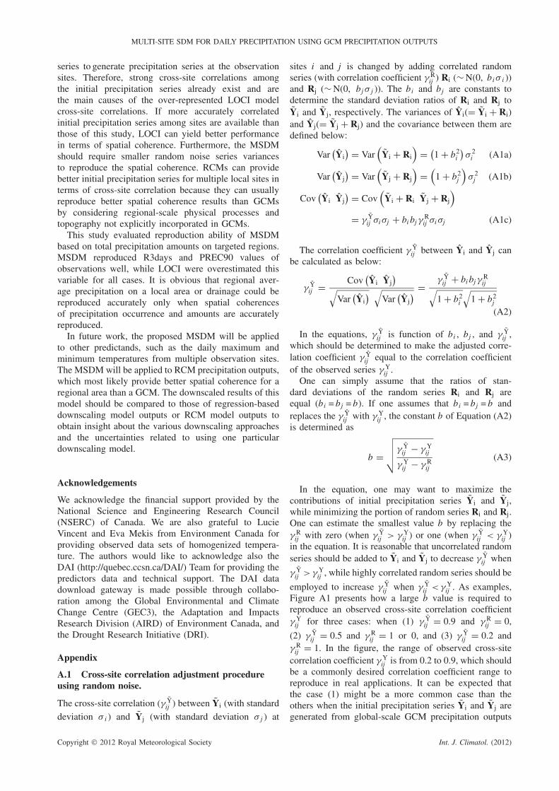
The cross-site correlation (γ Yij ) between Yi (with standard
deviation σ i ) and Yj (with standard deviation σ j ) at
sites i and j is changed by adding correlated randomseries (with correlation coefficient γ R
ij ) Ri (∼ N(0, bi σ i ))and Rj (∼ N(0, bj σ j )). The bi and bj are constants todetermine the standard deviation ratios of Ri and Rj toYi and Yj, respectively. The variances of Yi(= Yi + Ri)and Yj(= Yj + Rj) and the covariance between them aredefined below:
Var(Yi
) = Var(
Yi + Ri
)= (
1 + b2i
)σ 2
i (A1a)
Var(Yj
) = Var(
Yj + Rj
)=
(1 + b2
j
)σ 2
j (A1b)
Cov(Yi Yj
) = Cov(
Yi + Ri Yj + Rj
)
= γ Yij σi σj + bi bj γ
Rij σi σj (A1c)
The correlation coefficient γ Yij between Yi and Yj can
be calculated as below:
γ Yij = Cov
(Yi Yj
)√
Var(Yi
) √Var
(Yj
) = γ Yij + bi bj γ
Rij√
1 + b2i
√1 + b2
j
(A2)
In the equations, γ Yij is function of bi , bj , and γ Y
ij ,which should be determined to make the adjusted corre-lation coefficient γ Y
ij equal to the correlation coefficientof the observed series γ Y
ij .One can simply assume that the ratios of stan-
dard deviations of the random series Ri and Rj areequal (bi = bj = b). If one assumes that bi = bj = b andreplaces the γ Y
ij with γ Yij , the constant b of Equation (A2)
is determined as
b =
√√√√γ Yij − γ Y
ij
γ Yij − γ R
ij
(A3)
In the equation, one may want to maximize thecontributions of initial precipitation series Yi and Yj,while minimizing the portion of random series Ri and Rj.One can estimate the smallest value b by replacing theγ R
ij with zero (when γ Yij > γ Y
ij ) or one (when γ Yij < γ Y
ij )in the equation. It is reasonable that uncorrelated randomseries should be added to Yi and Yj to decrease γ Y
ij when
γ Yij > γ Y
ij , while highly correlated random series should be
employed to increase γ Yij when γ Y
ij < γ Yij . As examples,
Figure A1 presents how a large b value is required toreproduce an observed cross-site correlation coefficientγ Y
ij for three cases: when (1) γ Yij = 0.9 and γ R
ij = 0,
(2) γ Yij = 0.5 and γ R
ij = 1 or 0, and (3) γ Yij = 0.2 and
γ Rij = 1. In the figure, the range of observed cross-site
correlation coefficient γ Yij is from 0.2 to 0.9, which should
be a commonly desired correlation coefficient range toreproduce in real applications. It can be expected thatthe case (1) might be a more common case than theothers when the initial precipitation series Yi and Yj aregenerated from global-scale GCM precipitation outputs
Copyright 2012 Royal Meteorological Society Int. J. Climatol. (2012)

D. I. JEONG et al.
0.2
0.3
0.4
0.5
0.6
0.7
0.8
0.9
0.0 0.5 1.0 1.5 2.0 2.5
Obs
erve
d cr
oss-
site
cor
rela
tion
coef
ficie
nt
Value b
(1) gijY = 9.0, gij
R = 0~
(2a) gijY = 0.5, gij
R = 1~
(2b) gijY = 0.5, gij
R = 0~
(3) gijY = 0.2, gij
R = 1~
Figure A1. Relationships between b values and observed cross-site correlation coefficients γ Yij for three cases when (1) γ Y
ij = 0.9 and γ Rij = 0,
(2) γ Yij = 0.5 and γ R
ij = 1 or 0, and (3) γ Yij = 0.2 and γ R
ij = 1.
(see this study’s application result). It is obvious thatthe value b increases as the difference between γ Y
ij and
γ Yij increase. Note that the b values for precipitation
occurrence and amount series are different because thecross-site correlations of precipitation occurrence andamount series γ Y
ij s are generally different.For N observation sites, one can estimate the N − 1
number of constants b from the combinations betweensite i and all different sites j (j = 1, . . . , N , j �= i ). Foreach site i , the largest value among the calculated bsis determined as bi to recalculate γ R
ij to satisfy allcombinations and ensure that all γ R
ij remain positive.After determining bi and bj , the correlation coefficientγ R
ij is recalculated with the following equation, which is
driven from Equation (A2) by replacing γ Yij with γ Y
ij .
γ Rij =
γ Yij
√1 + b2
i
√1 + b2
j − γ Yij
bi bj(A4)
The covariance between different sites i and j issubsequently calculated from determined bi , bj , and γ R
ij .The correlated random number series for all observationsites are generated from a multivariate normal distributionwith estimated covariance matrix among N observationsites.
When continuous series Yi and Yj are transformedto binary series Oi and Oj, the binary series cross-sitecorrelation coefficient is usually smaller than that ofthe continuous series. Correlations between binary series(ξ ij ) and continuous series (ωij ) at locations i and jcan be derived empirically (Wilks, 1998). This study
employed a simple power function to derive the empiricalrelationships as below:
ωij = c × ξ dij (A5)
The parameters c and d have been estimated to yieldthe smallest RMSE between every N (N −1)/2 pairs ofcross-site correlation coefficients in the observed binaryseries and the same number of cross-site correlationcoefficients in the transformed binary series.
References
Burger G, Chen Y. 2005. Regression-based downscaling of spatialvariability for hydrologic applications. Journal of Hydrology 311:299–317.
Flato GM, Boer GJ. 2001. Warming asymmetry in climate changesimulations. Geophysical Research Letters 28: 195–198.
Fowler HJ, Kilsby CG, O’Connell PE, Burton A. 2005. A weather-typeconditioned multi-site stochastic rainfall model for the generation ofscenarios of climatic variability and change. Journal of Hydrology308: 50–66.
Harding A, Gachon P, Nguyen VTV. 2011. Replication of atmosphericoscillations and their patterns in Atmosphere-ocean Global ClimateModel derived predictors. International Journal of Climatology 31:1841–1847, DOI: 10.1002/joc.2191.
Fowler HJ, Blenkinsop S, Tebaldi C. 2007. Review: linking climatechange modeling to impacts studies: recent advances in downscal-ing techniques for hydrological modeling. International Journal ofClimatology 27: 1547–1578.
Harpham C, Wilby RL. 2005. Multi-site downscaling of heavy dailyprecipitation occurrence and amounts. Journal of Hydrology 312:235–255.
Hessami M, Gachon P, Ouarda TBMJ, St-Hilaire A. 2008. Automatedregression-based statistical downscaling tool. Environmental Mod-elling and Software 23: 813–834.
Huth R. 2002. Statistical downscaling of daily temperature in centralEurope. Journal of Climate 15(13): 1731–1742.
Copyright 2012 Royal Meteorological Society Int. J. Climatol. (2012)

MULTI-SITE SDM FOR DAILY PRECIPITATION USING GCM PRECIPITATION OUTPUTS
Jeong DI, St-Hilaire A, Ouarda TBMJ, Gachon P. 2012. Multisite sta-tistical downscaling model for daily precipitation combined by mul-tivariate multiple linear regression and stochastic weather generator.Climatic Change 114: 576–591, DOI: 10.1007/s10584-012-0451-3.
Khalili M, Leconte R, Brissette F. 2007. Stochastic multisite genera-tion of daily precipitation using spatial autocorrelation. Journal ofHydrometeorology 8: 396–412.
Khalili M, Brissette F, Leconte R. 2009. Stochastic multi-site genera-tion of daily weather data. Stochastic Environmental Research andRisk Assessment 23: 837–849.
Mehrotra R, Sharma A. 2007. Preserving low-frequency variabilityin generated daily rainfall sequences. Journal of Hydrology 345:102–120.
Mehrotra R, Srikanthan R, Sharma A. 2006. A comparison of threestochastic multi-site precipitation occurrence generators. Journal ofHydrology 331: 280–292.
Meehl GA, Stocker TF, Collins WD, Friedlingstein P, Gaye AT,Gregory JM, Kitoh A, Knutti R, Murphy JM, Noda A, RaperSCB, Watterson IG, Weaver AJ, Zhao Z-C. 2007. Global climateprojections. In Climate Change 2007: The Physical Science Basis .Contribution of Working Group I to the Fourth Assessment Reportof the Intergovernmental Panel on Climate Change, Solomon S, QinD, Manning M, Chen Z, Marquis M, Averyt KB, Tignor M, MillerHL (eds). Cambridge University Press, Cambridge/New York.
Palutikof JP, Goodess CM, Wathkins SJ, Holt J. 2002. Generatingrainfall and temperature scenarios at multiple sites: example fromthe Mediterranean. Journal of Climate 15(24): 3529–3548.
Qian B, Corte-Real J, Xu H. 2002. Multi-site stochastic weathermodels for impact studies. International Journal of Climatology 22:1377–1397.
Schmidli J, Frei C, Vidale PL. 2006. Downscaling from GCMprecipitation: a benchmark for dynamical and statistical downscalingmethods. International Journal of Climatology 26: 679–689.
Schmidli J, Goodess CM, Frei C, Haylock MR, Hundecha Y, Ribal-aygua J, Schmith T. 2007. Statistical and dynamical downscalingof precipitation: An evaluation and comparison of scenarios for theEuropean Alps. Journal of Geophysical Research 112: D04105, DOI:10.1029/2005JD007026.
Stephenson DB, Kumar KR, Doblas-Reyes FJ, Royer JF, Chauvin F,Pezzulli S. 1999. Extreme daily rainfall events and their impact onensemble forecasts of the Indian monsoon. Monthly Weather Review127: 1954–1966.
von Storch H. 1999. On the use of “inflation” in statistical downscaling. Journal of Climate 12: 3505–3506.
Widmann ML, Bretherton CS, Salathe EP Jr. 2003. Statistical pre-cipitation downscaling over the northwestern United States usingnumerically simulated precipitation as a predictor. Journal of Cli-mate 16: 799–816.
Wilby RL, Dawson CW. 2004. Using SDSM Version 3.1-A decisionsupport tool for the assessment of regional climate change impacts.User manual.
Wilby RL, Dawson CW, Barrow EM. 2002. SDSM-a decision sup-port tool for the assessment of regional climate change impacts.Environmental Modelling & Software 17: 147–159.
Wilby RL, Tomlinson OJ, Dawson CW. 2003. Multisite simulationof precipitation by conditional resampling. Climate Research 23:183–194.
Wilks DS. 1998. Multisite generation of a daily stochastic precipitationgeneration model. Journal of Hydrology 210: 178–191.
Wilks DS. 1999. Multisite downscaling of daily precipitation with astochastic weather generator. Climate Research 11: 125–136.
Yang C, Chandler RE, Isham VS, Wheater HS. 2005. Spatial-temporalrainfall simulation using generalized linear models. Water ResourcesResearch 41: W11415, DOI: 10.1029/2004 WR003739.
Copyright 2012 Royal Meteorological Society Int. J. Climatol. (2012)