a landscape restoration framework for wildlife and agriculture in the rural landscape
TRANSCRIPT

Landscape and Urban Planning, 27 ( 1993) 7-17 Elsevier Science Publishers B.V.. Amsterdam
7
A landscape restoration framework for wildlife and agriculture in the rural landscape
Janis M. Fedorowick School of Landscape Architecture, University of Guelph, 2665 Misener Cr., Mississauga, Ont. LSK IM9, Canada
(Accepted 26 May 1993)
Abstract
Landscape restoration is increasingly becoming a necessary management directive for the rural landscape. The addition of patches and corridors in a fragmented agricultural landscape is considered to restore ecological integrity to the landscape by enhancing the biogeochemical cycle. Agricultural benefits of erosion reduction and nutrient cycling, as well as wildlife enhancements in terms of providing habitat, movement corridors, etc., can also be attained by diversifying the fragmented landscape. The challenge lies in developing a restoration method which establishes a symbiotic relationship between agri- culture and wildlife. This research has developed one such method of implementing a regional landscape restoration de- sign. The number and location of the additional patches and corridors necessary to restore the landscape were determined for a case study site in southern Ontario. Three alternative restoration designs were then generated to simulate the struc- tural and functional changes in landscape composition. The placement of patches and corridors in the first alternative emphasizes wildlife enhancement. The second alternative emphasizes the existing grid-like pattern of the cultural features (e.g. road alignment, lot layout). The third alternative provides a compromise between maximizing either wildlife or agricultural benefits thereby emphasizing landscape functioning.
Introduction
Since European settlement, the southern Ontario rural landscape has changed dramati- cally. Vast, continuous virgin forests were cleared for agricultural production and settle- ment while hydrological resources were re- duced, removed or re-routed. Short-term, profit-oriented, reductionistic management practices (Hill, 1985 ) have resulted in a land- scape which contravenes the image of Canada as a place of wilderness.
The typical southern Ontario landscape con- sists of large agricultural tracts, fragmented forest patches, road, rail, utility and stream corridors, and scattered settlement distribu- tion. Conventional agricultural practices, re- quiring large inputs of labour, energy and nu- trients, dominate the farming scene. The fragmented forest patches and fencerows are
insufficient in size and frequency to offset the intense consumption of energy and resources associated with conventional agricultural ac- tivities. As a result, the landscape cannot sus- tain itself and requires a high level of human maintenance.
There is clearly a need to restore ecological integrity to the southern Ontario rural land- scape in order to reduce the dependence on al- ien inputs (Hill, 1985 ). A balance between the natural landscape and the human use of it needs to be attained. The intent of this re- search is to demonstrate one method of achieving this balance.
Study area
The study site consists of approximately 5 km2 of agricultural land typical of much of southern Ontario (Fig. 1). The distribution of
0 1993 Elsevier Science Publishers B.V. All rights reserved 0 169-2046/93/$06.00

f and Urban Planning 2 7 (1993) 7-17
Fig. 1. Case study landscape composition. Backus Woods, Regional Municipality of Haldimand-Norfolk.
landscape elements within the study area (Ta- ble 1) is indicative of a fragmented, agricultur- ally dominant rural landscape.
The topography of the site is fairly even but
Table 1 Landscape composition of the study area
Matrix Farm fields
PatchPs Forest Settlement Farmstead
Corridors Stream Fencerow Roads
Hectares %
1861.0 75.0
507.6 20.4 31.3 1.3 30.5 1.2
11.9 0.1 4.7 0.2
45.8 1.8
slopes very gently toward Lake Erie in a south erly direction. Several stream corridors wit1 steep embankments traverse the site emptyin; into Lake Erie. Most of the site consists o sandy loam soil with several deposits of Eolial sands (Gartshore et al., 1987). Vegetation consists of fragmented, small woodlots, seal tered fencerows, and some early successions areas associated with stream banks within th seasonally disturbed agricultural matrix.
Purpose
The study site is adjacent to part of Backs Woods which is one of the largest Carolinia forest tracts (approximately 420 ha) in Car ada. There is presently a strong desire to COI
nect Backus Woods with the surrounding lam

J.M. Fedorowick / Landscape and Urban Planning 27 (1993) 7-17 9
scape in order to assure the perpetuity of its ecological significance. The intent of the res- toration design for this study, then, is two-fold: first, to demonstrate a method of enhancing the agricultural and the ecological elements of the fragmented landscape in a symbiotic manner and, second, to show how such a restoration design can connect the environmentally signif- icant Backus Woods with the surrounding landscape.
Theoretical basis
The benefits of landscape functioning de- rived from an interconnected system of patches and corridors have been well documented (Harris, 1985; Forman and Godron, 1986; Harris and Gallagher, 1989; Zanaboni and Lorenzoni, 1989; Bennett, 1990; Burel and Baudry, 1990;). Briefly, the nutrient, matter and energy exchanges necessary to a self-per- petuating biogeochemical cycle are enhanced by increasing the amount of non-cultivated vegetation patches and corridors in the land- scape (Atkins and Cox, 1979). This type of landscape configuration, then, can help the landscape sustain itself.
Such an arrangement of interconnected landscape elements is beneficial to wildlife by providing movement corridors, habitat and resting sites (Forman and Godron, 1986). Re- search by biologists in southern Ontario (Weg- ner and Merriam, 1979; Henein and Merriam, 1990; Merriam and Lanoue, 1990) supports the notion that increased connectivity in the fragmented agricultural landscape benefits wildlife movement. The enhanced movement potential, in turn, may stimulate increased gene exchanges and species interactions (Forman and Godron, 1986). A greater diversity of wildlife and ecosystem stability is suggested by this arrangement.
Significant agricultural benefits can also be derived from an interconnected patch-corri- dor system. The inclusion of fencerows (i.e. one type of corridor) in the landscape pro-
duces significant ecological benefits in terms of inhibiting runoff and erosion, increasing nu- trient cycling, and providing microclimatic benefits (including reduced wind velocity, higher atmospheric and soil moisture), among others (Forman and Godron, 1986). Forest patches in low-lying areas can absorb agricul- tural inputs and runoff (Atkins and Cox, 1979) and provide habitat for species that prey on farming pests (Madden, 1984; Cacek, 1985).
The relationship between landscape form (e.g. fencerows, streams) and function (farm- ing, conservation) affects the associated eco- logical processes (gene exchanges, infiltration rates) that are prevalent (Baudry, 1989). In- troducing a patch-corridor network into the fragmented rural landscape can, therefore, en- hance both the human-induced (agricultural) activities and the landscape functioning (wild- life) of the ecosystem (Hobbs and Saunders, 1991).
Assumptions
Several assumptions guided the develop- ment of the restoration design. Primarily, the co-existence of farming and natural areas was assumed to be one of the restoration goals. This assumption implies that the rate of agricul- tural production would not be significantly di- minished by the restoration design. In other words, the removal of large tracts of land for nature reserves would not be considered as a restoration alternative. Instead, connecting ex- isting forest patches and establishing new small-scale ones that benefit both agriculture and ecosystem functioning became one of the design guidelines.
Secondly, the ability to sustain wildlife di- versity in the landscape was assumed to repre- sent adequate ecosystem functioning. This as- sumption is based on the idea that a diverse wildlife content indicates a healthy soil, a good mix of crops and natural cover, and low levels of toxicants (Cacek, 1985 ) . Since wildlife can only persist where the environment supplies

10 J.M. Fedorowrck /Landscape and Urban Plannrng 27 (1993) 7-l 7
adequate food, shelter and breeding habitat, wildlife was considered to be an appropriate indicator.
Finally, existing stream and road corridors were assumed to be fundamental restoration targets from which restoration alternatives would emanate. The case study site contains a non-linear distribution of the former and a grid pattern of the latter. Since these are existing, significant landscape features, they represent a relatively stable infrastructure for restoration (Kerkstra and Vrijlandt, 1990).
Method
The restoration design study consisted of a three-part process. Primarily, restoration goals for the case study site were first determined. Secondly, the design concept was generated from the restoration goals and connectivity concept. Finally, three design alternatives were created from the design concept based on soil, slope and shape characteristics.
To initiate the study process, secondary data for the site were collected and digitized into a LandCadd graphic design system. Information sources included air photos, Ontario base maps (similar to topographic maps at a scale of 1: 10 000), a soil survey report and a natural areas inventory conducted for the study area. The location and extent of all landscape ele- ments (other than soil) were then verified in the field.
Restoration goals
An understanding of the existing landscape structure is a necessary starting point from which to determine the design directives. To this end, the site was inventoried according to the typical grid-square survey method based on 40 ha units which represent the traditional farm management unit size. In order to generate restoration goals for the site, measurements of the degree of patchiness (the degree to which landscape elements differ from the matrix) and
contrast (the degree of difference between the elements’ appearance and function) were used.
Each of these criteria is an important indi- cator of how landscape elements relate to one another, or the landscape heterogeneity (For- man and Godron, 1986). Most of the southern Ontario rural landscape consists of a low de- gree of patchiness whereby isolated forest and settlement patches are interspersed through the dominant agricultural matrix. Restoring a moderate patchiness to the landscape would provide for adequate species-land interac- tions as well as maintaining the opportunity for different habitats and agricultural opportuni- ties. Likewise, a moderate contrast between elements would encourage habitat diversity, species-land exchanges and erosion reduction without the high level of conflict associated with a highly contrasting landscape (Fedorow- ick, 1992 ) .
Patchiness was derived by measuring the percentage area occupied by each landscape element per grid square. A high degree of patchiness was assigned to each unit that dis- played a low percentage occupied by the agri- cultural matrix (O-50%). Conversely, grid squares that contained a high percentage of the agricultural matrix ( 80- 100%) were assigned a low rating. A medium rating was assigned to those units lying between the two extremes (51-79%).
Contrast was derived by measuring the de- gree of similarity between groups of landscape elements (other than the matrix) in each grid square. Where the most common group yielded a high percentage (68- lOO%), there was a high similarity among the elements and, conse- quently, a low contrast. Conversely, high con- trast grid squares occurred where there was a low similarity among groups (O-49%). Again, a medium contrast was assigned where the de- gree of similarity fell between the two extremes ( 50-67%).
The patchiness and contrast measurements were combined in a matrix format. A value judgement was then made to transform the
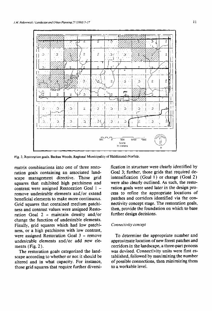
J.M. Fedorowick /Landscape and Urban Planning 27 (1993) 7-17 11
rLJ-Tl-- J L I / 500 0 500 1000 1500
Scale in meters CD
N
Fig. 2. Restoration goals. Backus Woods, Regional Municipality of Haldimand-Norfolk.
matrix combinations into one of three resto- ration goals containing an associated land- scape management directive. Those grid squares that exhibited high patchiness and contrast were assigned Restoration Goal 1 - remove undesirable elements and/or extend beneficial elements to make more continuous. Grid squares that contained medium patchi- ness and contrast values were assigned Resto- ration Goal 2 - maintain density and/or change the function of undesirable elements. Finally, grid squares which had low patchi- ness, or a high patchiness with low contrast, were assigned Restoration Goal 3 - remove undesirable elements and/or add new ele- ments (Fig. 2).
The restoration goals categorized the land- scape according to whether or not it should be altered and in what capacity. For instance, those grid squares that require further diversi-
fication in structure were clearly identified by Goal 3; further, those grids that required de- intensification (Goal 1) or change (Goal 2) were also clearly outlined. As such, the resto- ration goals were used later in the design pro- cess to refine the appropriate locations of patches and corridors identified via the con- nectivity concept stage. The restoration goals, then, provide the foundation on which to base further design decisions.
Connectivity concept
To determine the appropriate number and approximate location of new forest patches and corridors in the landscape, a three-part process was devised. Connectivity units were first es- tablished, followed by maximizing the number of possible connections, then minimizing them to a workable level.

12 J.M. Fedorowick / Lanhcape and Urban Plannrng 27 (1993) 7-17
w Existing forest patch ,/c 1
i: 0
“, connect~wtv circle __ Proposed Intra-clrcle
J unit connection uxxxx Existing fencerow corridor ‘-“’
FT=== Existing road corridor Proposed Inter-circle
- - - connection
Fig. 3. Connectivity units showing maximum number of connections. Backus Woods, Regional Municipality of Haldimand- Norfolk.
Connectivity units were derived to give spa- tial definition to the restoration design. In the poorly connected portions of the study area, circles were drawn between interconnected landscape patches to define the units. A 500 m minimum diameter was assigned to each circle based on the median distance that small mam- mals will travel from patch to patch in the open (Oxley et al., 1974; Gottfried, 1979; Bennett, 1990) (see Discussion for an outline of the limitations of these data). Since adequate wildlife movement represents landscape func- tionality, it was assumed that connections should be restored between elements that ex- ceed this minimum distance.
The maximum diameter of the circles was established by trying to avoid the inclusion of patches and/or corridors in the centre of each unit. (Objects in the centre can reduce the to- tal number of possible connections depending on the size of the particular element.) Having established the circles, the maximum number
of possible connections between landscape nodes abutting the circumference of the circle was then determined (Fig. 3 ) .
To reduce the number of connections to a workable amount, it was first assumed that all roads and streams would be restored to suita- ble corridor connections. Secondly, the dis- tances between patch nodes were then calcu- lated. Where the distance was less than 500 m, the connection was considered to be adequate and available. However, where the distance exceeded 500 m, potential corridors were added to the existing landscape structure to re- duce the distance to 500 m or less.
There were some instances where no amount of additional corridors could reduce the dis- tance between patches to the required 500 m distance because of the nature of the existing landscape structure. The addition of new for- est patches, or stepping stones, in these in- stances was considered necessary in order to encourage species movement. All new patches

J.M. Fedorowick /Lan&ape and Urban Planning 27 (1993) 7-17 13
@$$&$ Existing forest patch
0
STEPPING STONE
ux‘a311 Existing fencerow corridor , (3 ha woodlot)
- __ Existing road corridor CORRIDOR CONNECTION
I_ (fencerow that provides
a continuous link
between forest patches)
Fig. 4. Design concept. Backus Woods, Regional Municipality of Haldimand-Norfolk.
c -L_.
G2 Existing forest patch a Patch addition
6+% Existing fencerow corridor w Fencerow addition
$$$$ Restored road corridor 7 ,~_~ L Farmland
Fig. 5. Restoration Alternative 1. Backus Woods, Regional Municipality of Haldimand-Norfolk.

14 J.M. Fedorowick /Landscape and Urban Planning 27 (1993) 7-l 7
Fig. 6. Restoration
WE xlsting forest patch &_+ Patch addition
I+.-,+ Emsting fencerow corridor GG+’ Fencerow addmon
$q$,T Restored road corridor
Alternative 2. Backus Woods, Regional Municipality of Haldimand-Norfolk.
[ - I
a ?
m Exlstlng forest patch I. -,
L+_++ Patch addition
e Existing fencerow corridor G+ Fencerow addltlon
%A3 Restored road corridor
Fig. 7. Restoration Alternative 3. Backus Woods, Regional Municipality of Haldimand-Norfolk.

J.M. Fedorowick /Landscape and Urban Planning 27 (I 993) 7- I7 15
were designed to have a minimum area of 3 ha which is the minimum size that will support a mesic interior to prevent the replacement of flora by alien species (Levenson, 198 1; Ran- ney et al., 198 1). Patches were placed in the most appropriate locations to minimize the number of additional connections required. The placement of patches and corridors de- rived through this process constituted the con- nectivity concept.
Design concept
Generating the design concept involved the resolution of the connectivity concept in terms of the existing landscape structure. This pro- cess was enacted by overlaying the connectiv- ity concept on top of the restoration goals grid. The locations of proposed connections and patches could then be refined.
For instance, where a patch was located in two or more grid squares, it would be shifted to the square containing the ‘add’ or ‘change’ design directive, as opposed to the ‘de-inten- sify’ or ‘remove’ restoration goals. The refine- ment process in its completion formulated the overall design concept shown in Fig. 4.
Design alternatives
The translation of the design concept into a detailed restoration plan can be expressed in many different ways, depending on the resto- ration objectives. For the purpose of this study, three alternative designs were generated, all of which emphasize different aspects of land- scape restoration.
Alternative I The first alternative represented a direct
translation of the design concept into physical form (Fig. 5 ). This design maximized wildlife benefits since the most appropriate locations of patches and corridors derived through the design concept received top priority. Agricul- tural benefits were also evident as the previ-
ously open field matrix was enhanced by a denser hedgerow network (Altieri, 1988 ) thereby increasing trophic structure complex- ity (Atkins and Cox, 1979) and providing habitat for beneficial predators (Madden, 1984). Since no adjustments were made based on social, cultural or existing physical features, this design alternative emphasizes the ecologi- cal aspects of landscape restoration.
Alternative 2 The existing linear, grid-like landscape char-
acter guided the design of the second altema- tive (Fig. 6). The existing roads and field pat- terns provided the spatial structure for the appropriate locations of patches and corridors. The resulting design has the least impact on the existing landscape pattern. The optimum lo- cation for restoration additions that benefit wildlife and agriculture is somewhat compro- mised in this alternative since maintaining the existing landscape structure has been assigned top priority.
Alternative 3 The existing biophysical features of the study
area were the focus of the third alternative (Fig. 7). Patch and corridor locations followed ex- isting contour lines and changes in soil type. Agricultural benefits, in terms of the optimal location of restoration features, were empha- sized in this design because the biophysical features essentially determine the optimal field pattern layout. Wildlife benefits are also evi- dent since the locations of patches and corri- dors are not constrained by the grid-like land- scape pattern.
Discussion
The restoration framework described in this paper demonstrates a means of deriving differ- ent restoration design alternatives that can benefit both agriculture and wildlife in the fragmented southern Ontario rural landscape. It also demonstrates a means of applying the

16 J.M. Fedorowick /Landscape and Urban Planning 27 (I 993) 7-17
patch-corridor matrix theory developed by landscape ecologists, biologists, botanists, and foresters. A comprehensive, holistic approach was used in this study by concentrating on the landscape structure, rather than on a particu- lar species or process.
Selecting the parameters that ultimately de- fined the measurement criteria used in the study was constrained by the lack of available research into various aspects of landscape ecology. For instance, insufficient information was available concerning small mammal movement in a fragmented landscape. The op- timum corridor distance used in this study (500 m) was based on the median distance small mammals will travel as determined in three unrelated studies. Oxley et al. ( 1974) found that a distance of 90 m between habitat patches did not preclude medium-size forest animal movement across a road barrier. Gott- fried ( 1979 ) discovered that a 500 m distance between patches could support reproductively active small mammal populations. Finally, Bennett ( 1990) concluded that a 1000 m sep- aration did not preclude small mammal move- ments. Since all three studies measure differ- ent types of animal movement associated with distinct landscapes, the 500 m distance used in this study is, at best, a generalization.
More research is also needed, for example, regarding the optimum field size to promote sustainable agriculture, extending wildlife re- search beyond a species-oriented approach to simulating the workings of a simplified food chain, quantifying the preferred porosity val- ues for all landscape elements (the number of occurrences per unit area), and determining optimum sizes and shapes for landscape res- toration features. Further study of these sub- jects may help to bridge the gap between pure and applied research, and refine the method- ology used in this study.
A comparison of the design alternatives sug- gests that some alternatives may be more ac- ceptable to landowners, based on the degree of deviation from the existing landscape pattern.
In this regard, Alternative 1 may stimulate the most resistance from landowners since it re- quires the greatest changes in field pattern lay- out. Since wildlife and landscape functioning are emphasized in this alternative (as opposed to agricultural benefits), this scheme may seem burdensome to the landowner.
Alternative 2 would likely meet with the least resistance since there is a minimal degree of deviation from the existing farm field layout. The compromise between these two extremes is manifested in Alternative 3 which has a moderate degree of deviation from the existing field patterns, yet still provides significant ag- ricultural and wildlife benefits.
Selecting the most appropriate restoration design was not part of this research; that deci- sion ultimately rests with the landowners, pol- iticians, and municipal officials. However, providing alternatives such as these can in- duce a rational, comprehensive approach to future decision-making regarding the restora- tion of the regional landscape.
References
Altieri, M., 1988. Environmentally Sound Small-Scale Agri- cultural Projects: Guidelines for Planning. CODEL, New York, 162 pp.
Atkins, M. and Cox, G., 1979. Agricultural Ecology: An Anal- ysis of World Food Production Systems. W.H. Freeman, San Francisco, 72 1 pp.
Baudry, J., 1989. Interactions between agricultural and eco- logical systems at the landscape level. Agric. Ecosyst. En- viron., 27: 119-130.
Bennett, A., 1990. Habitat corridors and the conservation of small mammals in a fragmented forest environment. Landscape Ecol., 4: 109-122.
Burel, F. and Baudry, J., 1990. Structural dynamics of a hedg- erow network landscape in Brittany, France. Landscape Ecol., 4: 197-210.
Cacek, T.. 1985. Impacts of organic farming and reduced til- lage on fish and wildlife. In: T.C. Edens, C. Fridgen and S.L. Battentield (Editors), Sustainable Agriculture and Integrated Farming Systems. 1984 Conference Proceed- ings. Michigan State University Press, East Lansing, pp. 185-189.
Fedorowick, J., 1992. A landscape restoration model: wildlife enhancement in the agricultural landscape. Master’s The- sis, University of Guelph, Guelph, Ontario, 128 pp.
Forman, R. and Godron, M., 1986. Landscape Ecology. Wiley, New York, 6 19 pp.

J.M. Fedorowick / Landscape and Urban PIanning27(1993) 7-l 7 17
industrial agriculture: a proposed framework for rural areas. Landscape Urban Plann., 18: 275-287.
Levenson, J.B., 198 1. Woodlots as biogeographic islands in Southeastern Wisconsin. In: R. Burgess and D. Sharpe (Editors), Forest Island Dynamics in Man-Dominated Landscapes. Springer, New York, pp. 13-39.
Madden, J., 1984. Regenerative Agriculture: Beyond Organic and Sustainable Food Production. Cooperative Extension Service, Michigan State University, East Lansing, 8 pp.
Merriam, G. and Lanoue, A., 1990. Corridor use by small mammals: field measurements for three experimental types of Peromyscus Ieucopu.~. Landscape Ecol., 4: 123- 132.
Oxley, D., Fenton, M. and Carmody, G., 1974. The effects of roads on populations of small mammals. J. Appl. Ecol., 11: 51-59.
Ranney, J., Bruner, M. and Levenson, J., 1981. The impor- tance of edge in the structure and dynamics of forest is- lands. In: R. Burgess and D. Sharpe (Editors), Forest Is- land Dynamics in Man-Dominated Landscapes. Springer, New York, pp. 67-95.
Wegner, J. and Merriam, G., 1979. Movements by birds and small mammals between a wood and adjoining farmland habitats. J. Appl. Ecol., 16: 349-358.
Zanaboni, A. and Lorenzoni, G., 1989. The importance of hedges and relict vegetation in agroecosystems and envi- ronment reconstitution. Agric. Ecosyst. Environ., 27: 155- 161.
Gartshore, M., Sutherland, D. and McCracken, J., 1987. Fi- nal Report of the Natural Areas Inventory of the Regional Municipality of Haldimand-Norfolk 1985. 86, 1. Norfolk Field Naturalists, Simcoe, Canada, 111 pp.
Gottfried, B., 1979. Small mammal populations in Woodlot Islands. Am. Midl. Nat., 102: 105-l 12.
Harris, L., 1985. Designing landscape mosaics for integrated agriculture and conservation planning in the Southeastern United States. In: Technologies to Benefit Agriculture and Wildlife. Workshop Proceedings. Office of Technology Assessment, US Congress, Washington, DC, pp. 102-l 11.
Harris, L. and Gallagher, P., 1989. New initiatives for wild- life conservation: the need for movement corridors. In: G. Mackintosh (Editor), Preserving Communities and Cor- ridors. Defenders of Wildlife, Washington, DC, pp. 1 l- 34.
Henein, K. and Merriam, G., 1990. The elements of connec- tivity where corridor quality is variable. Landscape Ecol., 9: 157-170.
Hill, S., 1985. Soil, Food, Health and Holism - The Search for Sustainable Nourishment. MacDonald College, Mc- Gill University, Montreal, 80 pp.
Hobbs, R. and Saunders, D., 1991. Re-integrating frag- mented landscapes - a preliminary framework for the Western Australian wheatbelt. J. Environ. Manage., 2: 161-168.
Kerkstra, K. and Vrijlandt, P., 1990. Landscape planning for