a guideline to incorporate geological hazard information ... · a guideline to incorporate...
TRANSCRIPT

A Guideline to Incorporate Geological Hazard Information to Spatial Planning
for Local Governments in Indonesia
1) Andiani , Geological Agency, Ministry of Energy and Mineral Resources, Indonesia
2) Sulamith Kastl, Federal Institute for Geosciences and Natural Resources, Germany
Key words: Spatial Planning; Geological Hazards; Mitigation
SUMMARY
Spatial planning and Disaster management policies that have been developed since the Indian
Ocean Tsunami in 2004 are reflecting the importance of spatial planning for disaster risk mitigation
in Indonesia. Anyway, spatial planning does not sufficiently consider geological risks in many
regions. The lack of capacities in local governments, the often inapplicability and lack of clarity of
regulations and guidelines, the unavailability of geological hazard information in detailed scale and
lack of awareness are just some of the obstacles for a georisk- sensitive spatial planning. To slacken
these problems, the German Development Cooperation, implemented by the Federal Institute for
Geosciences and Natural Resources (BGR) with the Geological Agency of Indonesia (GAI) (2003-
2016) developed a Guideline for the incorporation of geological hazard information into spatial
plans targeting local governments. The guideline is a basic guide to promote a georisk-spatial
planning as a tool for sustainable development. The guideline gives an introduction to technical and
non-technical approaches of spatial planning and information about geological hazard data,
responsibilities, policies and assessment in a simple to read manner, through the evaluation of
existing regulations, actual discussions and case studies.The guideline has been developed in
coordination with stakeholders from the georisk and spatial planning sector, in order to assure the
utility of the product. Since 2015 the guideline has been socialized to local governments and the
content has been integrated in a training for the introduction to geology for spatial planning in the
Human Resources Development Agency for Geology, Mineral and Coal.
.
RINGKASAN
Kejadian Tsunami Lautan Hindia 2004, menjadi awal perlunya mempertimbangkan tata ruang
dalam mitigasi bencana di Indonesia. Banyak rencana tata ruang di Indonesia belum memuat
mitigasi risiko bencana. Kurangnya kapasitas pemerintah daerah, peraturan dan pedoman yang
kurang jelas dan tidak dapat diterapkan, tidak adanya informasi bahaya geologi skala rinci dan
kurangnya kepedulian merupakan hambatan tata ruang yang peka terhadap georisk. Untuk
mengurangi masalah ini, Kerjasama Pembangunan Jerman, dalam hal ini Federal Institute for
Geosciences and Natural Resources (BGR) bekerjasama dengan Badan Geologi Indonesia (2003-
2016) menyusun Pedoman Penerapan Informasi Geologi Dalam Tata Ruang Untuk Pemerintah
Daerah. Pedoman ini sebagai acuan untuk menyusun tata ruang yang peka terhadap Georisk dan
alat pembangunan berkelanjutan. Pedoman berisi pendekatan teknik dan non teknik penyusunan
A Guideline to Incorporate Geological Hazard Information to Spatial Planning for Local Governments in Indonesia
(8877)
Andiani Andiani (Indonesia) and Sulamith Kastl (Germany)
FIG Working Week 2017
Surveying the world of tomorrow - From digitalisation to augmented reality
Helsinki, Finland, May 29–June 2, 2017
tata ruang, data bahaya geologi, tanggung jawab, kebijakan melalui evaluasi peraturan, diskusi dan
studi kasus. Penyusunan pedoman berkoordinasi dengan berbagai pihak dari sektor Georisk dan
tata ruang, ini untuk memastikan pedoman dapat digunakan. Sejak 2015, pedoman telah
disosialisasikan kepada pemerintah daerah, serta telah di integrasikan dalam pelatihan pengenalan
geologi untuk tata ruang di Pusat Pengembangan Sumber Daya Manusia Geologi, Mineral dan
Batubara.
A Guideline to Incorporate Geological Hazard Information to Spatial Planning for Local Governments in Indonesia
(8877)
Andiani Andiani (Indonesia) and Sulamith Kastl (Germany)
FIG Working Week 2017
Surveying the world of tomorrow - From digitalisation to augmented reality
Helsinki, Finland, May 29–June 2, 2017
A Guideline to Incorporate Geological Hazard Information to Spatial Planning
for Local Governments in Indonesia
1) Andiani , Geological Agency, Ministry of Energy and Mineral Resources, Indonesia
2) Sulamith Kastl, Federal Institute for Geosciences and Natural Resources, Germany
1. BACKGROUND
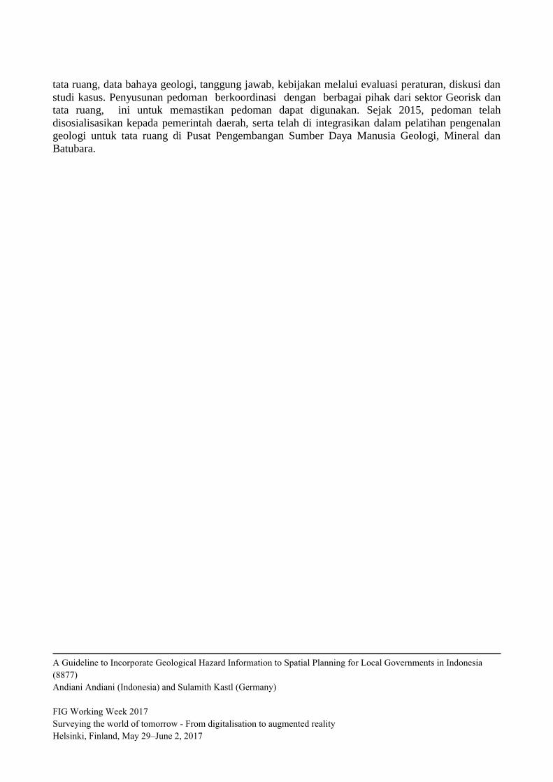
Indonesia is located in the meeting place of three tectonic plates, namely the Indo-Australian Plate,
the Eurasian Plate and Pacific Plate (Figure 1). The intersection of the three tectonic plates
contributes to the frequent occurrence of geological hazards, such as volcanic eruptions,
earthquakes, tsunamis and mass movement.
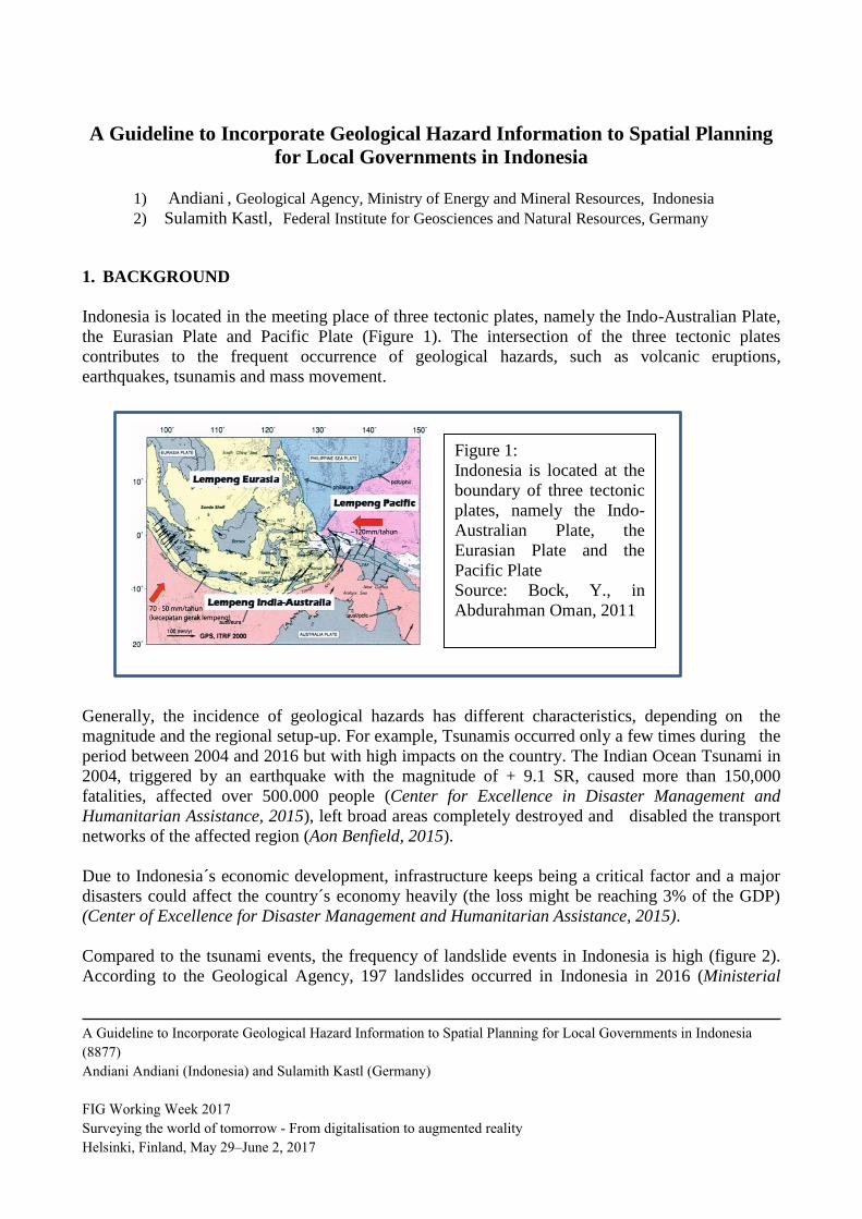
Generally, the incidence of geological hazards has different characteristics, depending on the
magnitude and the regional setup-up. For example, Tsunamis occurred only a few times during the
period between 2004 and 2016 but with high impacts on the country. The Indian Ocean Tsunami in
2004, triggered by an earthquake with the magnitude of + 9.1 SR, caused more than 150,000
fatalities, affected over 500.000 people (Center for Excellence in Disaster Management and
Humanitarian Assistance, 2015), left broad areas completely destroyed and disabled the transport
networks of the affected region (Aon Benfield, 2015).
Due to Indonesia´s economic development, infrastructure keeps being a critical factor and a major
disasters could affect the country´s economy heavily (the loss might be reaching 3% of the GDP)
(Center of Excellence for Disaster Management and Humanitarian Assistance, 2015).
Compared to the tsunami events, the frequency of landslide events in Indonesia is high (figure 2).
According to the Geological Agency, 197 landslides occurred in Indonesia in 2016 (Ministerial
Figure 1:
Indonesia is located at the
boundary of three tectonic
plates, namely the Indo-
Australian Plate, the
Eurasian Plate and the
Pacific Plate Source: Bock, Y., in
Abdurahman Oman, 2011
A Guideline to Incorporate Geological Hazard Information to Spatial Planning for Local Governments in Indonesia
(8877)
Andiani Andiani (Indonesia) and Sulamith Kastl (Germany)
FIG Working Week 2017
Surveying the world of tomorrow - From digitalisation to augmented reality
Helsinki, Finland, May 29–June 2, 2017
meeting, 2016). Anyway, the occurrence of landslide has caused few fatalities in comparison, but
causing the disruption of economic activity in a high number of areas in Indonesia on a day-to-day
basis.
Based on the frequency and intensity of geological hazard events in the past, the provision of maps
of geological hazard prone areas in Indonesia becomes absolutely necessary. The Geological
Agency of Indonesia under the Ministry of Energy and Mineral Resources has the mandate to
provide geological maps, including hazard maps for earthquakes, tsunamis, volcanoes and
landslides.
Related to this mandate, the Geological Agency of Indonesia has been supported by the German
Development Cooperation, implemented by the German Federal Institute for Geosciences and
Natural Resources (BGR), from 2003 until 2016, cooperating for the mitigation of georisks in
several fields of work. The experiences gained through the cooperation activities showed, that the
focus on the purely technical assessment of geological hazards is not enough to prevent geological
disasters, but that an integrated approach to disaster mitigation, including the implementation of
basic concepts of spatial planning are key features for a successful disaster prevention. This finding
encouraged the Geological Agency of Indonesia to develop a simple to understand guideline that
would promote concepts of spatial planning and decision making but also would approach the
weakness of data availability and lack of technical knowledge in data survey. The guideline was
meant to be an initial support for local governments towards the enforcement of a georisk-sensitive
spatial planning.
2. INFORMATION AVAILABILITY of GEOLOGICAL HAZARDS
Under Law 23/2014 on Regional (Local) Governments (Autonomy Law), the Geological Agency of
Indonesia has the obligation to provide geological hazard maps for the entire territory of Indonesia
and to take out hazard assessment. Earthquake and tsunami hazard maps have been created in a
Figure 2:
Frequency of geological hazards
and number of fatalities in
Indonesia (2004 -2014). Gempa
Bumi = Earthquake, Tanah
Longsor = Landslide. Tsunami=
Tsunami, Letusan Gunungapi =
Volcanic Eruption
Source: Andiani, Kastl et al.
2015
Figure 2 :
Frequency of geological
hazards and number of
casualties in Indonesia
(2004 -2014).
Source : Andiani, Kastl, et
all 2015
A Guideline to Incorporate Geological Hazard Information to Spatial Planning for Local Governments in Indonesia
(8877)
Andiani Andiani (Indonesia) and Sulamith Kastl (Germany)
FIG Working Week 2017
Surveying the world of tomorrow - From digitalisation to augmented reality
Helsinki, Finland, May 29–June 2, 2017
scale of 1: 100,000, while landslide maps are already available on a scale of 1: 50,000. Anyway,
more detailed maps in a scale of 1:25,000 or even bigger are not available in the Geological Agency
yet, and due to budget and human resource limitations the maps are only available in some areas of
Indonesia. Most complete are the volcano hazard maps, which are available for all the 127 active
Category A volcanoes of the country.
Even though the tsunami of 2004 showed that geological hazards information is indispenbsible for
disaster management and since then, hazard data is used as a reference for national disaster
mitigation (including as a reference for decision-making for the development of national projects),
disaster prevention is still not priority in the implementation of spatial plans.
3. SPATIAL PLANNING IN INDONESIA
After the tsunami in Aceh in 2004, the Indonesian government has formulated a number of laws and
regulations aiming at the mitigation of disaster risks,geological disasters.
Two important laws have been enacted in Indonesia, which can be considered as reference for the
development of regions in Indonesia, namely Law No. 24/2007 on Disaster Management and Law
No. 26/2007 on Spatial Planning. Law No. 24/2007 is implemented by the National Disaster
Management Agency (BNPB). The Spatial Planning Law 26/2007 is implemented by the Ministry
of Agraria and Spatial Planning (ATR formerly Ministry of Public Works). Both institutions are
represented on provincial and district levels.
Both laws are closely related, as the Disaster Management Law in article 35 states that spatial
planning is an element of disaster management and the Spatial Planning Law states in article 6 that
spatial plans need to consider the physical condition of Indonesia, which is disaster prone.
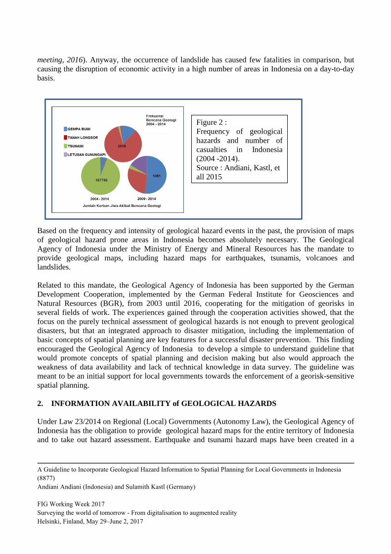
Generally, spatial planning can be located in the disaster risk management cycle most importantly
in the development and prevention phase, but already reconstruction should consider spatial
planning approaches.
Figure 3:
Location of Spatial Planning
in the Disaster Risk
Management cycle
Source: Andiani, Kastl et all, 2015
A Guideline to Incorporate Geological Hazard Information to Spatial Planning for Local Governments in Indonesia
(8877)
Andiani Andiani (Indonesia) and Sulamith Kastl (Germany)
FIG Working Week 2017
Surveying the world of tomorrow - From digitalisation to augmented reality
Helsinki, Finland, May 29–June 2, 2017
Various guidelines have been issued as technical guidance for geological hazards and spatial
planning, including the Ministerial Regulation No. 21 / PRT / M / 2007 on the Guidelines for
Spatial Planning in Prone Areas to Volcanic Eruptions and Earthquakes and the neighboring
Ministerial Regulation No. 22 / PRT / M / 2007 on the Guidelines for Spatial Planning in Landslide
Prone Areas. Both guidelines were issued by the Ministry of Public Works and regulate the
acquisition of geological hazards information related to the zoning regulation applied in Indonesia.
In addition there are general guidelines for the preparation of spatial plans, like the Ministerial
Regulation No. 21/PRT/ M/ 2007 on the Guidelines for the Preparation of Detailed Spatial Planning
(Scale 1: 25,000) by the Ministry of Public Works, that support local governments to fulfil their
duties.
In general, spatial plans in Indonesia differentiate between two land use patterns: built up areas and
protected (conserved) areas. Built up areas are settlements, industrial areas, trade areas and
agriculture, whereas protected areas are forests cultural heritage areas and areas prone to geological
disasters.
3.1. The Spatial Planning System in Indonesia
The Spatial planning System in Indonesia is based on a top-down- bottom-up approach which is
related to the National Development System. The National Development Planning System
establishes a Long-Term Development plan which is valid for 20 years and Mid-Term
DSevelopment Plan which is valid for 5 years for the national, provincial, and district/ city levels.
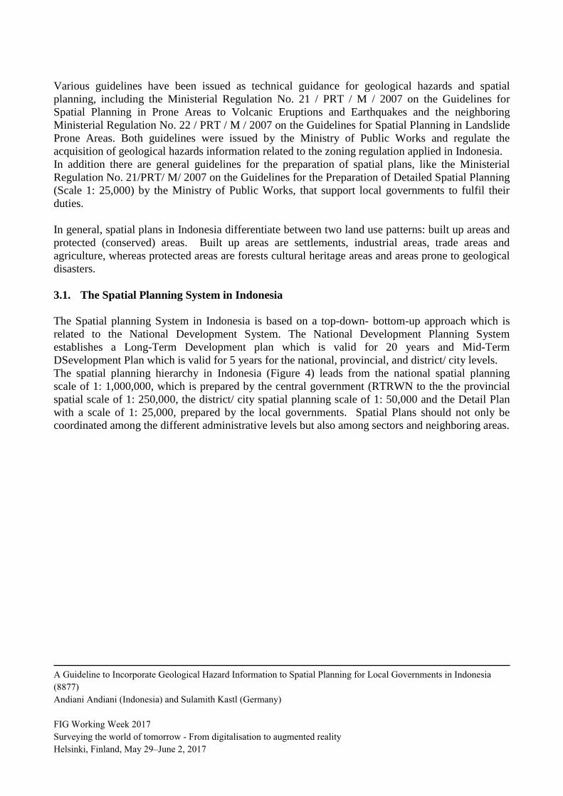
The spatial planning hierarchy in Indonesia (Figure 4) leads from the national spatial planning
scale of 1: 1,000,000, which is prepared by the central government (RTRWN to the the provincial
spatial scale of 1: 250,000, the district/ city spatial planning scale of 1: 50,000 and the Detail Plan
with a scale of 1: 25,000, prepared by the local governments. Spatial Plans should not only be
coordinated among the different administrative levels but also among sectors and neighboring areas.
A Guideline to Incorporate Geological Hazard Information to Spatial Planning for Local Governments in Indonesia
(8877)
Andiani Andiani (Indonesia) and Sulamith Kastl (Germany)
FIG Working Week 2017
Surveying the world of tomorrow - From digitalisation to augmented reality
Helsinki, Finland, May 29–June 2, 2017
Figure 4: Indonesia Spatial Planning Hierarchy and Scale
In terms of spatial planning coordination, the Spatial Planning Coordination Boards (BKPRN for
national level/ BKPRD for regional level) are the mandated bodies, consisting of line ministries and
related agencies, including the Geological Agency of Indonesia. Inputs and recommendations are
given through the board to make sure the alignment of spatial plans with national/ provincial
strategies and the representation of sectorial interests. After the approval of spatial planning
regulation drafts in the boards, documents are endorsed by regional leaders.
3.2. Spatial Planning Problems
The Geology Agency of Indonesia (GAI) has a mandate to provide inputs and comments/
recommendations on spatial planning related geological aspects and since the implementation of
Law 23/2014, the Agency is the central authority for geological hazard data survey.
Anyway, most of the spatial planning documents in 34 provinces and 514 districts /cities evaluated
in BKPRN, do not yet consider sufficiently geological hazards.
a. Spatial planning documents do not contain geological hazard maps at all
b. Spatial planning documents of use geological hazard map, that do not follow the regulations/
guidelines
A Guideline to Incorporate Geological Hazard Information to Spatial Planning for Local Governments in Indonesia
(8877)
Andiani Andiani (Indonesia) and Sulamith Kastl (Germany)
FIG Working Week 2017
Surveying the world of tomorrow - From digitalisation to augmented reality
Helsinki, Finland, May 29–June 2, 2017
c. Spatial planning documents do consider provided data in the description chapter only, but do not
adapt the decision taking based on that data.
Those problems occurre due to several reasons:
a. Local governments face difficulties in implementing the rule to designate geological disaster-
prone areas as protected area, due to the urbanized character of the planning area and the
urbanization pressure on land.
b. The existing regulations and guidelines, do not take into account the limited capacity of local
governments to create data and to analyze geological hazard information.
c. Data in detailed scale is still insufficient (data gap between data availability and data demand).
Guidelines for spatial planning were drawn up on a scale of 1: 50,000 or more detailed, while
the existing geological hazard information is provided on a scale of 1: 100,000 or 1: 50,000,
that then are not used in a proper manner. As a result, information in the planning process can
become biased and inconsistent.
d. The terms used in geological hazard maps are often not understood by the local governments
and planners (lack of technical capacities).
e. Lack of awareness. Often, the local government particularly the G, Head of District or City
Mayor do not take into consideration conditions of geological hazards in the region as a
reference for determining the vision of local development.
f. Outsourcing to consultant companies: The lack of technical ability and capacity of local
governments to conduct spatial analysis, leads to the tertiarization of spatial planning on local
level. Anyhow, the lack of capacity on local level makes even quality control difficult.
The preparation of a simple to understand guideline using best practice samples and introducing to
basic knowledge and approaches of spatial planning and hazard information is necessary to tackle
these problems and to give local governments the opportunity to take a first step towards a georisk-
sensitive spatial planning.
4. IMPLEMENTATION ON GEOLOGICAL GUIDELINE FOR SPATIAL
INFORMATION
Since 2013, the Geological Agency of Indonesia, supported by the German Development
Cooperation in the field of Mitigation of Georisks, implemented by the German Federal Institute for
geosciences and Natural Resources developed a guideline for the consideration of geological hazard
information in spatial plans to standardize the application of geohazard data in in spatial planning
and to promote a georisk-sensitive spatial planning. The purpose of the guideline mainly aims at:
a. the creation of a reference for planning institutions and consultants at the national, provincial and
local level for a georisk-sensitive spatial planning.
b. the discussion and explanation of existing and complementary regulations related to spatial
planning and geological hazard assessment.
c. the promotion of a georisk-sensitive decision making.
d. the explication of alternative simple (technically) approaches of data creation and analysis based
on data gaps.
A Guideline to Incorporate Geological Hazard Information to Spatial Planning for Local Governments in Indonesia
(8877)
Andiani Andiani (Indonesia) and Sulamith Kastl (Germany)
FIG Working Week 2017
Surveying the world of tomorrow - From digitalisation to augmented reality
Helsinki, Finland, May 29–June 2, 2017
e. the promotion as spatial planning and its non-technical elements as tools for sustainable
development.
f. the creation of a reference in drafting the Terms of Reference (TOR) for the preparation
(compilation) of national spatial planning or even for provincial and district / city.
4.1. Method of Compilation/Preparation
The Guideline for the Consideration of Geological Hazard Information for Spatial Planning has
been has been prepared through several stages:
a. Evaluation of laws and regulations in Indonesia related to spatial planning and geological
hazards by a working group from the Geological Agency of Indonesia together with
stakeholders like some regional planning and development agencies as well as the Ministry of
Home Affairs and the German Academy for Spatial Research and Planning (Hannover). As a
first outcome the initial draft of the guideline was prepared.
b. Workshop, involving relevant ministries / agencies and local governments. Some of the
participating ministries were: Ministry of Public Works, National Development Planning
Agency, National Disaster Management Agency; Provincial Governments such are: Aceh,
Central Java, West Java, the Ende Regency and Semarang City. The workshop's purpose was
to harmonize points of views and to obtain feedback to enrich and verify the content of the
document and its limitations.
c. Case study, focusing on the preparation of a detailed plan based on geological hazard
mitigation for the Gunungsari sub-district in West Lombok-NTB regencies/districts. The case
study was used as one best practice sample and supported the problem analysis and need
assessment of spatial planning on local level.
d. Comparative study of several German and Philippine institutions like the German Federal
Institute for Geosciences and Natural Resources (BGR), the German Academy for Spatial
Research and Planning (ARL), Philippine Institute of Volcanology and Seismology (PhiVolcS)
to determine planning approaches of disaster prone areas in other countries.
e. Testing the guideline to determine the possibilities and constraints faced by Local (Regional)
governments in implementing the contents of the guidelines in order to prepare (compile)
spatial planning.
f. Finalizing the Guideline
In 2015 the first edition oft he guideline was published. Since 2016 a second edition has been
developed, in which several new policies and approaches were integrated. Since 2016 approaches
and methods promoted in the guideline were incorporated in a training for geology based spatial
planning, which is applied in the Human Resources Developments Agency for Energy and Mineral
Resources (BPSDM ESDM).
4.2. Contents of Guidelines
The technical work on the guideline document were completed in 2014 and since then the
documents have been revised to conform to changes in policy development in Indonesia. These
A Guideline to Incorporate Geological Hazard Information to Spatial Planning for Local Governments in Indonesia
(8877)
Andiani Andiani (Indonesia) and Sulamith Kastl (Germany)
FIG Working Week 2017
Surveying the world of tomorrow - From digitalisation to augmented reality
Helsinki, Finland, May 29–June 2, 2017
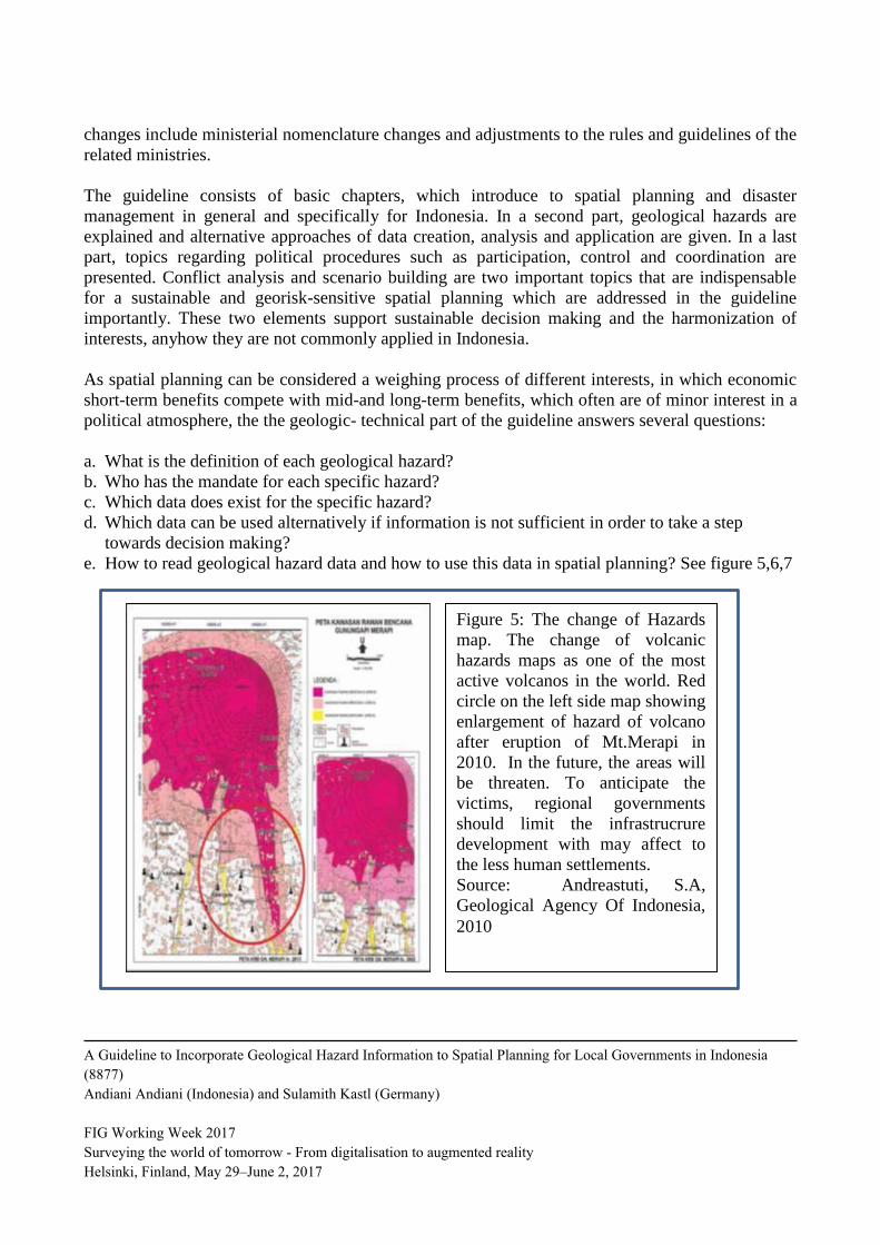
Figure 5: The change of Hazards
map. The change of volcanic
hazards maps as one of the most
active volcanos in the world. Red
circle on the left side map showing
enlargement of hazard of volcano
after eruption of Mt.Merapi in
2010. In the future, the areas will
be threaten. To anticipate the
victims, regional governments
should limit the infrastrucrure
development with may affect to
the less human settlements.
Source: Andreastuti, S.A,
Geological Agency Of Indonesia,
2010
changes include ministerial nomenclature changes and adjustments to the rules and guidelines of the
related ministries.
The guideline consists of basic chapters, which introduce to spatial planning and disaster
management in general and specifically for Indonesia. In a second part, geological hazards are
explained and alternative approaches of data creation, analysis and application are given. In a last
part, topics regarding political procedures such as participation, control and coordination are
presented. Conflict analysis and scenario building are two important topics that are indispensable
for a sustainable and georisk-sensitive spatial planning which are addressed in the guideline
importantly. These two elements support sustainable decision making and the harmonization of
interests, anyhow they are not commonly applied in Indonesia.
As spatial planning can be considered a weighing process of different interests, in which economic
short-term benefits compete with mid-and long-term benefits, which often are of minor interest in a
political atmosphere, the the geologic- technical part of the guideline answers several questions:
a. What is the definition of each geological hazard?
b. Who has the mandate for each specific hazard?
c. Which data does exist for the specific hazard?
d. Which data can be used alternatively if information is not sufficient in order to take a step
towards decision making?
e. How to read geological hazard data and how to use this data in spatial planning? See figure 5,6,7
A Guideline to Incorporate Geological Hazard Information to Spatial Planning for Local Governments in Indonesia
(8877)
Andiani Andiani (Indonesia) and Sulamith Kastl (Germany)
FIG Working Week 2017
Surveying the world of tomorrow - From digitalisation to augmented reality
Helsinki, Finland, May 29–June 2, 2017
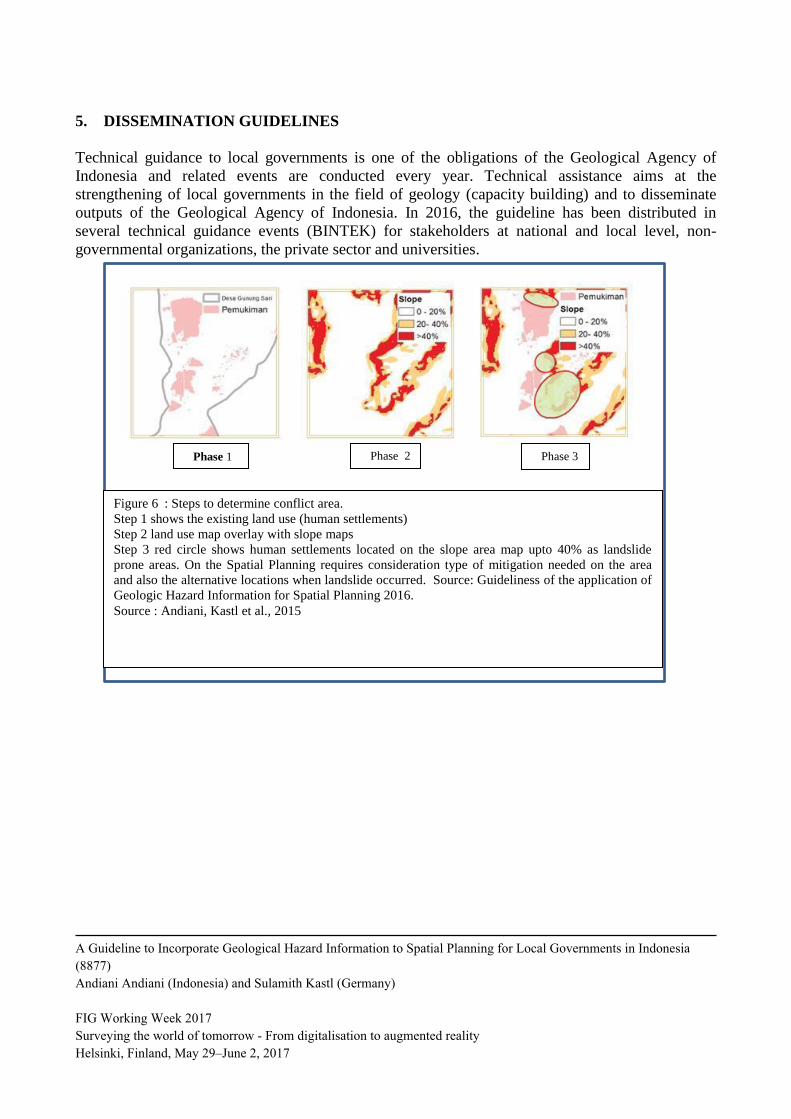
Figure 6 : Steps to determine conflict area.
Step 1 shows the existing land use (human settlements)
Step 2 land use map overlay with slope maps
Step 3 red circle shows human settlements located on the slope area map upto 40% as landslide
prone areas. On the Spatial Planning requires consideration type of mitigation needed on the area
and also the alternative locations when landslide occurred. Source: Guideliness of the application of
Geologic Hazard Information for Spatial Planning 2016.
Source : Andiani, Kastl et al., 2015
Phase 2 Phase 3 Phase 1
5. DISSEMINATION GUIDELINES
Technical guidance to local governments is one of the obligations of the Geological Agency of
Indonesia and related events are conducted every year. Technical assistance aims at the
strengthening of local governments in the field of geology (capacity building) and to disseminate
outputs of the Geological Agency of Indonesia. In 2016, the guideline has been distributed in
several technical guidance events (BINTEK) for stakeholders at national and local level, non-
governmental organizations, the private sector and universities.
A Guideline to Incorporate Geological Hazard Information to Spatial Planning for Local Governments in Indonesia
(8877)
Andiani Andiani (Indonesia) and Sulamith Kastl (Germany)
FIG Working Week 2017
Surveying the world of tomorrow - From digitalisation to augmented reality
Helsinki, Finland, May 29–June 2, 2017
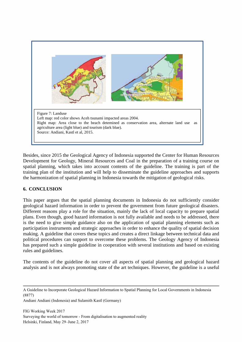
Figure 7: Landuse
Left map: red color shows Aceh tsunami impacted areas 2004.
Right map: Area close to the beach detemined as conservation area, alternate land use as
agriculture area (light blue) and tourism (dark blue).
Source: Andiani, Kastl et al, 2015.
Besides, since 2015 the Geological Agency of Indonesia supported the Center for Human Resources
Development for Geology, Mineral Resources and Coal in the preparation of a training course on
spatial planning, which takes into account contents of the guideline. The training is part of the
training plan of the institution and will help to disseminate the guideline approaches and supports
the harmonization of spatial planning in Indonesia towards the mitigation of geological risks.
6. CONCLUSION
This paper argues that the spatial planning documents in Indonesia do not sufficiently consider
geological hazard information in order to prevent the government from future geological disasters.
Different reasons play a role for the situation, mainly the lack of local capacity to prepare spatial
plans. Even though, good hazard information is not fully available and needs to be addressed, there
is the need to give simple guidance also on the application of spatial planning elements such as
participation instruments and strategic approaches in order to enhance the quality of spatial decision
making. A guideline that covers these topics and creates a direct linkage between technical data and
political procedures can support to overcome these problems. The Geology Agency of Indonesia
has prepared such a simple guideline in cooperation with several institutions and based on existing
rules and guidelines.
The contents of the guideline do not cover all aspects of spatial planning and geological hazard
analysis and is not always promoting state of the art techniques. However, the guideline is a useful
A Guideline to Incorporate Geological Hazard Information to Spatial Planning for Local Governments in Indonesia
(8877)
Andiani Andiani (Indonesia) and Sulamith Kastl (Germany)
FIG Working Week 2017
Surveying the world of tomorrow - From digitalisation to augmented reality
Helsinki, Finland, May 29–June 2, 2017
tool that meets the needs of local governements in Indonesia. It guides through the spatial planning
process and gives technical advice based on the challenges local governments in Indonesia face.
The guideline can be understood as a tool to encourage local governments to take the first step to
improve the realization of spatial planning based on geological hazard information in Indonesia,
considering limited data, limited human resources and capacities and confined governmental
budget.
BIBLIOGRAPHY
Andiani, Kastl, et al., 2015, A Guideline To Incorporate Geological Hazard Information To Spatial
Plan, Badan Geologi, Indonesia, 26-27
Andreastuti S.D. 2010, Map of Area Prone To Volcano Hazard Merapi, Geology Agency, Indonesia
Aon Benfield. 2015, 2004 Indian Ocean Tsunami. 10 years on, Aon plc.
Bock,Y,. 2003, in Abdurahman, Oman, 2011. “Hidup di Atas Tiga Lempeng”, Badan Geologi,
114.
Center for Excellence in Disaster Management and Humanitarian Assistance, 2015. Indonesia
Disaster Management Reference Handbook.
Law No. 24/2007 on Disaster Management, Indonesia
Law No. 26/2007 on Spatial Planning, Indonesia
Regulation of the Minister of Public Works No. 21 / PRT / M / 2007 Spatial Planning Guidelines
On Area Prone To Volcanic Eruptions And Earthquakes, Indonesia
Regulation of the Minister of Public Works No. 22 / PRT / M / 2007 Spatial Planning Guidelines
On Area Prone For Landslide, Indonesia.
Regulation of the Minister of Public Works No. 21 / PRT / M / 2007 Guidelines for Preparation of
Detailed Plans, Indonesia
BIOGRAPHICAL NOTES
Name: Ir. Andiani MT
Geological Agency of Indonesia
Ministry of Energy and Mineral Resources
Education: Geologist and Master Degree in urban and regional planning
A Guideline to Incorporate Geological Hazard Information to Spatial Planning for Local Governments in Indonesia
(8877)
Andiani Andiani (Indonesia) and Sulamith Kastl (Germany)
FIG Working Week 2017
Surveying the world of tomorrow - From digitalisation to augmented reality
Helsinki, Finland, May 29–June 2, 2017
Experience: Geologist working in the field of environmental management and Spatial Planning,
currently serves as Head of Environmental Geology, Geological Agency of Indonesia
Name: Sulamith Kastl
Federal Institute for Geosciences and Natural Resources (BGR)
Education: Geographer with focus on Physical Geography (Leibniz University, Hannover)
Experience:
2007-2011: GIS and Spatial Planning Expert in ORDAZUR, Paraguay (BGR)
2012-2015: Georisk-Sensitive Spatial Planning, Indonesia
2015-2016: Team-Leader Georisk-Project, Indonesia
CONTACTS
Andiani
Geological Agency, Ministry of Energy and Mineral Resources
Jalan Diponegoro 57 Bandung
Telp: +62 22 7274703
Fax: +62 22 7216444
Email: [email protected]
Website : www.bgl.esdm.id
Kastl, Sulamith
Federal Institute for Geosciences and Natural Resources
Stilleweg 2, 30655 Hannover
Phone: + 49 511 643 3054
Email: [email protected]
Website: www.bgr.bund.de
A Guideline to Incorporate Geological Hazard Information to Spatial Planning for Local Governments in Indonesia
(8877)
Andiani Andiani (Indonesia) and Sulamith Kastl (Germany)
FIG Working Week 2017
Surveying the world of tomorrow - From digitalisation to augmented reality
Helsinki, Finland, May 29–June 2, 2017