a guide for the geologic tourist to the york county ... guide for the geologic tourist to the york...
TRANSCRIPT

A guide for the geologic tourist to the
York County Heritage Rail Trail
Jeri L. Jones, York County Department of Parks & Recreation
Rose-Anna Behr, Bureau of Topographic and Geologic Survey
Trail of Geology
17–119.0
Material from this trail of geology pamphlet may be published if credit is
given to the Pennsylvania Geological Survey
Cover Photo: Howard Tunnel. Photo by A. Muren.
This report can be obtained through
the website of the Pennsylvania
Department of Conservation and Natural Resources
Suggested citation: Jones, J. L., and Behr, Rose-Anna, 2017, A guide for the geologic tourist
to the York County Heritage Rail Trail: Pennsylvania Geological Survey, 4th ser., Trail of
Geology 17–119.0, 25 p.
COMMONWEALTH OF PENNSYLVANIA Tom Wolf, Governor
DEPARTMENT OF CONSERVATION AND NATURAL RESOURCES
Cindy Adams Dunn, Secretary
OFFICE OF CONSERVATION AND TECHNICAL SERVICES Lauren Imgrund, Deputy Secretary
BUREAU OF TOPOGRAPHIC AND GEOLOGIC SURVEY
Gale C. Blackmer, Director

1
Introduction Geology is everywhere beneath our feet. Our landscape has been formed by many
slow processes that build up and erode the earth’s surface. Our communities and
transportation routes have developed upon the sculpted landscape. The Heritage Rail Trail
County Park follows the former Penn Central Railroad, originally known as the Northern
Central Railroad, which was built in 1838. The trail passes through the Lowland and
Upland sections of the Piedmont physiographic province (Figure 1). A physiographic
province is a region with a characteristic landscape. Within the province are sections whose
landforms are distinct. Most of the trail is in the Piedmont Upland section that you see in
the rugged landscape beside the trail. The hills of the Upland are underlain by harder, more
resistant rocks including sandstone, quartzite, conglomerate, and phyllite. North of Indian
Rock Dam Road lies the Piedmont Lowland section. The landform here is characterized by
the broad, open Conestoga Valley. The valley is underlain by limestone, dolostone, and
minor shale, which are all susceptible to erosion.
The corridor provides an excellent window for hikers and others to glimpse the
underlying bedrock of central and southern York County. Since the rock strata cross the
Figure 1. The physiographic provinces of Pennsylvania. In the Piedmont province,
the three physiographic sections are shown. Trail shown in red.
2
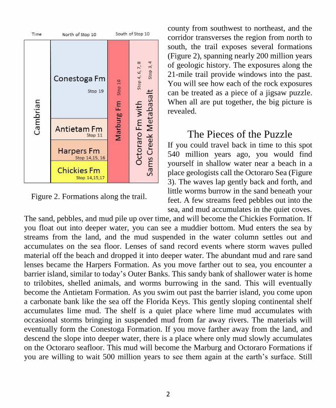
county from southwest to northeast, and the
corridor transverses the region from north to
south, the trail exposes several formations
(Figure 2), spanning nearly 200 million years
of geologic history. The exposures along the
21-mile trail provide windows into the past.
You will see how each of the rock exposures
can be treated as a piece of a jigsaw puzzle.
When all are put together, the big picture is
revealed.
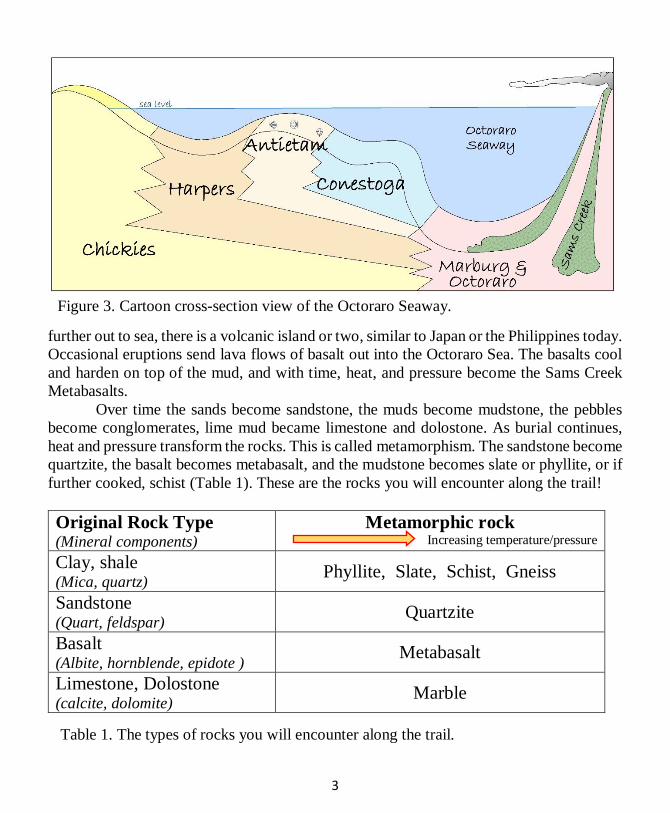
The Pieces of the Puzzle If you could travel back in time to this spot
540 million years ago, you would find
yourself in shallow water near a beach in a
place geologists call the Octoraro Sea (Figure
3). The waves lap gently back and forth, and
little worms burrow in the sand beneath your
feet. A few streams feed pebbles out into the
sea, and mud accumulates in the quiet coves.
The sand, pebbles, and mud pile up over time, and will become the Chickies Formation. If
you float out into deeper water, you can see a muddier bottom. Mud enters the sea by
streams from the land, and the mud suspended in the water column settles out and
accumulates on the sea floor. Lenses of sand record events where storm waves pulled
material off the beach and dropped it into deeper water. The abundant mud and rare sand
lenses became the Harpers Formation. As you move farther out to sea, you encounter a
barrier island, similar to today’s Outer Banks. This sandy bank of shallower water is home
to trilobites, shelled animals, and worms burrowing in the sand. This will eventually
become the Antietam Formation. As you swim out past the barrier island, you come upon
a carbonate bank like the sea off the Florida Keys. This gently sloping continental shelf
accumulates lime mud. The shelf is a quiet place where lime mud accumulates with
occasional storms bringing in suspended mud from far away rivers. The materials will
eventually form the Conestoga Formation. If you move farther away from the land, and
descend the slope into deeper water, there is a place where only mud slowly accumulates
on the Octoraro seafloor. This mud will become the Marburg and Octoraro Formations if
you are willing to wait 500 million years to see them again at the earth’s surface. Still
Figure 2. Formations along the trail.
3
further out to sea, there is a volcanic island or two, similar to Japan or the Philippines today.
Occasional eruptions send lava flows of basalt out into the Octoraro Sea. The basalts cool
and harden on top of the mud, and with time, heat, and pressure become the Sams Creek
Metabasalts. Over time the sands become sandstone, the muds become mudstone, the pebbles
become conglomerates, lime mud became limestone and dolostone. As burial continues,
heat and pressure transform the rocks. This is called metamorphism. The sandstone become
quartzite, the basalt becomes metabasalt, and the mudstone becomes slate or phyllite, or if
further cooked, schist (Table 1). These are the rocks you will encounter along the trail!
Original Rock Type (Mineral components)
Metamorphic rock Increasing temperature/pressure
Clay, shale (Mica, quartz)
Phyllite, Slate, Schist, Gneiss
Sandstone (Quart, feldspar)
Quartzite
Basalt (Albite, hornblende, epidote )
Metabasalt
Limestone, Dolostone (calcite, dolomite)
Marble
Figure 3. Cartoon cross-section view of the Octoraro Seaway.
Table 1. The types of rocks you will encounter along the trail.

4
The Pieces Get Jumbled
As if the story wasn’t already complicated enough, the rocks that experienced
different intensities of heat and pressure also got folded and faulted. This area has
experienced two different episodes of continental collision and separation. These events
built up mountains that erosion tore down. During collision, the earth’s crust shortened by
folding and faulting to accommodate the collision. There are two main types of folds
(Figure 4). Anticlines are up-warps and synclines are down-warps. In an anticline, the
younger rocks are on the outside. In a syncline, they are on the inside. These folds may be
further complicated by secondary and tertiary folds on folds, or by the folds getting turned
up onto their sides!
There are three main types of faults: normal, thrust, and strike-slip (Figure 5).
Normal faults occur most often during rifting, or pulling-apart events. The block above the
fault slides down. Thrust, or reverse, faults are the most common in crustal shortening
settings. The block above the fault moves farther up! There are also strike-slip faults, where
the two blocks move in opposite directions in the horizontal plane, like the San Andreas
fault. You will see several faults along the trail: the Martic Line, Reynolds Mill Fault, and
Stoner Overthrust. It is up to the geologists to sort out these pieces.
Figure 4. Sketch of
folds including
anticlines (up-warps)
and synclines (down-
warps).
Figure 5. Sketch of three common types of faults.

5
Figure 6. Geologic map of the rail trail. Map on the left is the southern half of the
trail. Map on the right is the northern half. Scale is the same for both.
Figure 7. Profile of the trail with twenty times vertical exaggeration.

6
Trail Log
Enjoy the ride back in time. The stops below are favorite locations of the authors.
Additional rock exposures are found between these points. The trail log begins at the
southern end, but you may start at any point. Mileage is estimated based on air photos and
mile markers posted along the trails. Stop refers to the numbered locations shown on Figure
6. Inc refers to the incremental mileage between points of interest, whereas Cum refers to
the total mileage from the beginning of the trail. Please stay on the trail, as property
adjacent to the trail is privately owned! Sorry, rock collecting is prohibited.
Inc Cum Location
0.0 0 Stop 1. Mason-Dixon Line 39.7210/-76.6979
The Mason-Dixon Line, the boundary between
Maryland and Pennsylvania, is one of the most famous
boundaries in the United States. It crosses the rail trail
here. It was surveyed from 1763 to 1767 by two British
astronomers, Charles Mason and Jeremiah Dixon, to
settle a dispute between the Calvert and Penn families.
Rectangular concrete markers, such as the one to the left,
still appear at many places where major roads and
railroads intersect the boundary. The Mason-Dixon Line
acted as the line between the free and slave states in the
middle of the 19th century. Did you ever want to be in two
states at once? Place one foot in Maryland and the other
in Pennsylvania!
Notice how the boundary shows up in an aerial photograph!
0.09 0.09 Cross Orwig Road.
0.43 0.52 Travel under Singer Road.
7
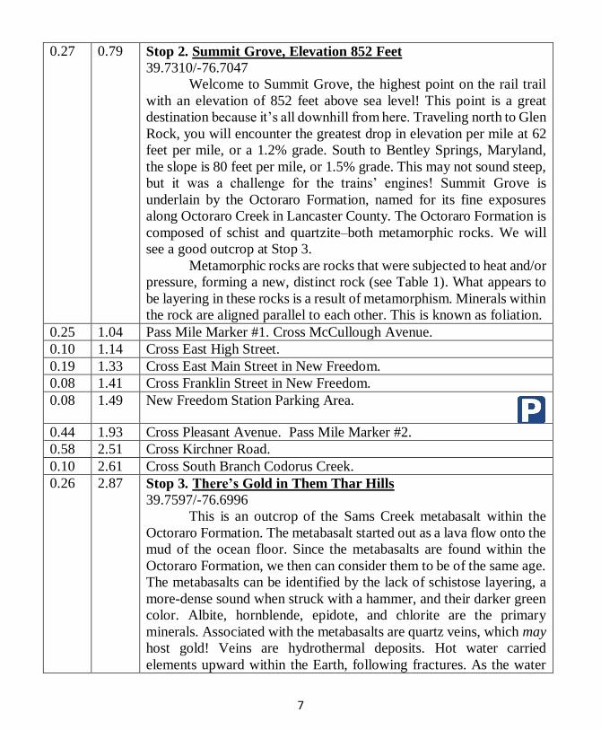
0.27 0.79 Stop 2. Summit Grove, Elevation 852 Feet
39.7310/-76.7047
Welcome to Summit Grove, the highest point on the rail trail
with an elevation of 852 feet above sea level! This point is a great
destination because it’s all downhill from here. Traveling north to Glen
Rock, you will encounter the greatest drop in elevation per mile at 62
feet per mile, or a 1.2% grade. South to Bentley Springs, Maryland,
the slope is 80 feet per mile, or 1.5% grade. This may not sound steep,
but it was a challenge for the trains’ engines! Summit Grove is
underlain by the Octoraro Formation, named for its fine exposures
along Octoraro Creek in Lancaster County. The Octoraro Formation is
composed of schist and quartzite–both metamorphic rocks. We will
see a good outcrop at Stop 3.
Metamorphic rocks are rocks that were subjected to heat and/or
pressure, forming a new, distinct rock (see Table 1). What appears to
be layering in these rocks is a result of metamorphism. Minerals within
the rock are aligned parallel to each other. This is known as foliation.
0.25 1.04 Pass Mile Marker #1. Cross McCullough Avenue.
0.10 1.14 Cross East High Street.
0.19 1.33 Cross East Main Street in New Freedom.
0.08 1.41 Cross Franklin Street in New Freedom.
0.08 1.49 New Freedom Station Parking Area.
0.44 1.93 Cross Pleasant Avenue. Pass Mile Marker #2.
0.58 2.51 Cross Kirchner Road.
0.10 2.61 Cross South Branch Codorus Creek.
0.26 2.87 Stop 3. There’s Gold in Them Thar Hills
39.7597/-76.6996
This is an outcrop of the Sams Creek metabasalt within the
Octoraro Formation. The metabasalt started out as a lava flow onto the
mud of the ocean floor. Since the metabasalts are found within the
Octoraro Formation, we then can consider them to be of the same age.
The metabasalts can be identified by the lack of schistose layering, a
more-dense sound when struck with a hammer, and their darker green
color. Albite, hornblende, epidote, and chlorite are the primary
minerals. Associated with the metabasalts are quartz veins, which may
host gold! Veins are hydrothermal deposits. Hot water carried
elements upward within the Earth, following fractures. As the water
8
cooled, the elements in the solution began to crystallize on the sides of
the fractures. Veins include minerals such as quartz, hematite, mica,
and gold. Amateur gold panners have found flakes in some of the
streams in the area.
The metabasalt often underlies the valleys in this area because
it is less resistant to erosion.
0.06 2.93 Cross East Main Street in Boro of Railroad, Route 851
Railroad Parking Area. Pass Mile Marker #3.
0.4 3.33 Cross North Main Street, Route 616 and South Branch Codorus
Creek on overpass built in 1871. Pass Mile Marker #4.
0.51 3.84 Cross Taylor Hill Road.
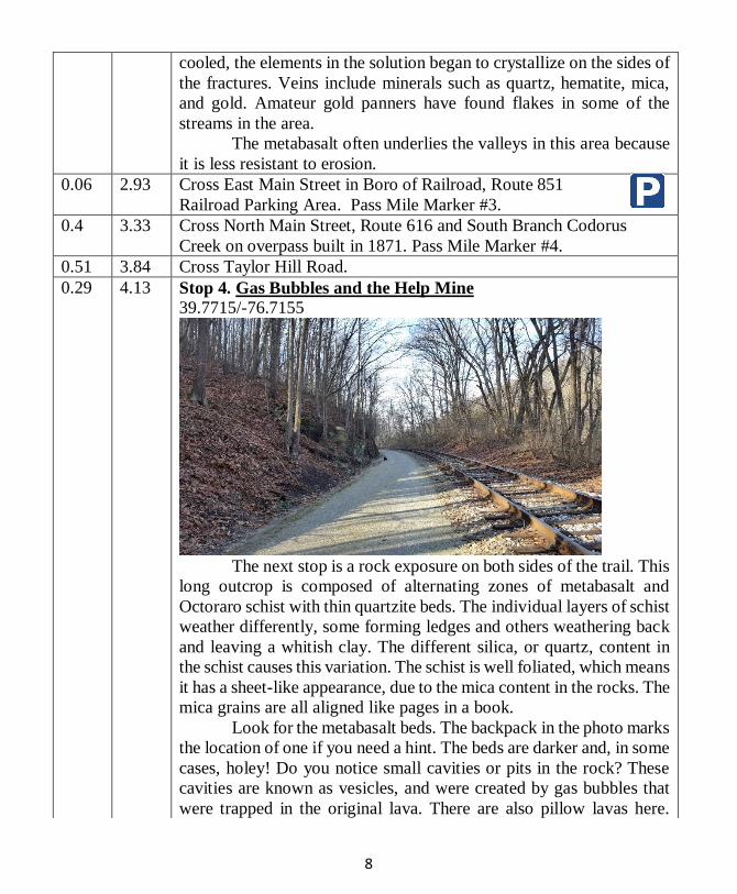
0.29 4.13 Stop 4. Gas Bubbles and the Help Mine 39.7715/-76.7155
The next stop is a rock exposure on both sides of the trail. This
long outcrop is composed of alternating zones of metabasalt and
Octoraro schist with thin quartzite beds. The individual layers of schist
weather differently, some forming ledges and others weathering back
and leaving a whitish clay. The different silica, or quartz, content in
the schist causes this variation. The schist is well foliated, which means
it has a sheet-like appearance, due to the mica content in the rocks. The
mica grains are all aligned like pages in a book.
Look for the metabasalt beds. The backpack in the photo marks
the location of one if you need a hint. The beds are darker and, in some
cases, holey! Do you notice small cavities or pits in the rock? These
cavities are known as vesicles, and were created by gas bubbles that
were trapped in the original lava. There are also pillow lavas here.
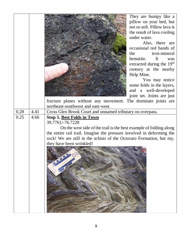
9
They are bumpy like a
pillow on your bed, but
not so soft. Pillow lava is
the result of lava cooling
under water. Also, there are
occasional red bands of
the iron-mineral
hematite. It was
extracted during the 19th
century at the nearby
Help Mine.
You may notice
some folds in the layers,
and a well-developed
joint set. Joints are just
fracture planes without any movement. The dominate joints are
northeast-southwest and east-west.
0.28 4.41 Cross Glen Brook Court and unnamed tributary on overpass.
0.25 4.66 Stop 5. Best Folds in Town 39.7761/-76.7228
On the west side of the trail is the best example of folding along
the entire rail trail. Imagine the pressure involved in deforming the
rock! We are still in the schists of the Octoraro Formation, but my,
they have been wrinkled!

10
The originally flat-lying beds have been folded into anticlines,
or up-warps, and synclines, or down-warps. On these large folds, are
smaller, similar folds. On these smaller folds, are even smaller folds
still. Without continuous exposures and with the complication of
folding, a geologist has a difficult time determining the true thickness
of the formation. It would be much simpler if you could pull on one
end of the exposure and straighten out the strata. Imagine the length of
the county if we could pull out the folds! This outcrop is an example
of crustal shortening. The rocks have been squished together!
There is a major fracture in the rock that dips 47° northwest. In
addition to the folding, there may be faulting, but geologists need to
collect more information to verify it.
While you are here, put your nose to the rock and see if you
can find some magnetite
cubes. These perfect little
cubes stick out of the rock,
and resist erosion until they
are plucked free, leaving a
square hole. If you had
brought along a refrigerator
magnet, you would see for
yourself why this mineral is
called magnetite.
Photo of tiny cubes of the
mineral magnetite.
0.10 4.76 Cross South Branch Codorus Creek and Pleasant Valley Road, Route
616 on overpass. Pass Mile Marker #5.
0.41 5.17 Cross Walker Road and Trout Run on the overpass built in 1871.
0.15 5.32 Cross West Clearview Drive.
0.06 5.38 Cross Rail View Court.
0.18 5.56 Stop 6. Somewhere in the Hills South of Glen Rock
39.7887/-76.7239
From here to where the trail crosses the tracks is a long
exposure of Octoraro schist. Notice the broken pieces below the
outcrop are very smooth and silvery. This is the result of the mineral
mica, which has a sheet-like structure. Look closely for quartz pods.

11
You will note some of these pods are
folded! This is testament to multiple
episodes of deformation.
As we travel north through the
Upland Section of the Piedmont
physiographic province, the ridges
decrease in elevation. The ridge that
passes through here reaches elevations
of over 900 feet above sea level. This
ridge is one of the highest points in
southwestern York County.
0.43 5.99 Cross Valley Street. Pass Mile Marker #6.
0.05 6.04 Cross an unnamed tributary that is following the metabasalt-schist
contact.
0.02 6.06 Stop 7. South of Main Street, Glen Rock
39.7937/-76.7308
This is a fine exposure of tightly folded albite-chlorite schists
of the Octoraro Formation with quartzite beds and quartz veins. The
outcrop starts in the woods on the old lane, just after you cross the
bridge. Schist is a metamorphic rock that started out as a mudstone.
Original layering may be lost, and new layering, or schistosity, is
formed by parallel sheets of the mineral mica. The rock varies in color
from a grayish-blue to green. This variation is due to the difference in
composition. Under a microscope, the minerals albite, chlorite,
muscovite, and quartz are easily seen. Epidote, garnet, ilmenite,
apatite, sphene, and iron oxide are usually present in small amounts.
12
Notice the small pits seen on the exposed surfaces due to the
weathering out of mineral grains. These may be magnetite or pyrite
cubes, but they are gone, so we don’t know which!
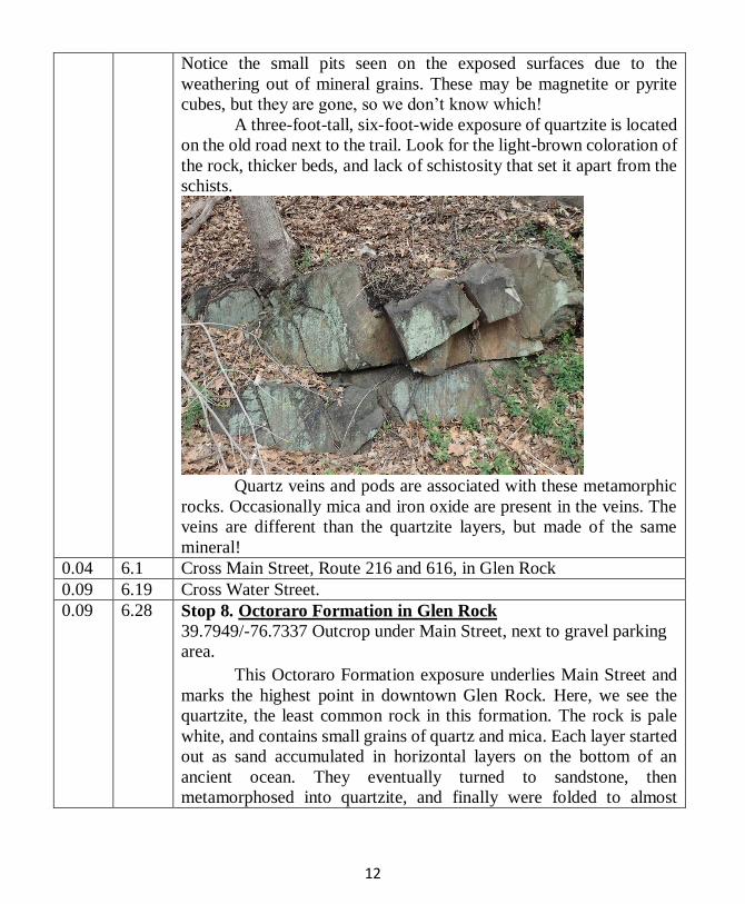
A three-foot-tall, six-foot-wide exposure of quartzite is located
on the old road next to the trail. Look for the light-brown coloration of
the rock, thicker beds, and lack of schistosity that set it apart from the
schists.
Quartz veins and pods are associated with these metamorphic
rocks. Occasionally mica and iron oxide are present in the veins. The
veins are different than the quartzite layers, but made of the same
mineral!
0.04 6.1 Cross Main Street, Route 216 and 616, in Glen Rock
0.09 6.19 Cross Water Street.
0.09 6.28 Stop 8. Octoraro Formation in Glen Rock
39.7949/-76.7337 Outcrop under Main Street, next to gravel parking
area.
This Octoraro Formation exposure underlies Main Street and
marks the highest point in downtown Glen Rock. Here, we see the
quartzite, the least common rock in this formation. The rock is pale
white, and contains small grains of quartz and mica. Each layer started
out as sand accumulated in horizontal layers on the bottom of an
ancient ocean. They eventually turned to sandstone, then
metamorphosed into quartzite, and finally were folded to almost

13
vertical. Although this rock has been metamorphosed, the original
bedding is preserved. Quartzite is generally harder than schist, thus not
eroding as fast, which is why we find it at the highest point in Glen
Rock.
The bedding planes face the trail, so when you look at the
outcrop you are looking at the original sea floor! To see the side of the
beds, stand at the southern end and look north! Beds are about a foot
and a half thick.
Notice the fractures
running across the outcrop.
These are joints, fractures
caused by stress in the
earth which show little or
no displacement. Because
the rocks fracture in a
regular pattern, they were
convenient to use for
building stones.
Note the planar, nearly
right-angle joints in
outcrop or loose pieces of
rock.

14
Do you know how Glen Rock received its name? A glen is a
narrow valley, usually with steep sides, such as Ricketts Glen or
Watkins Glen. Indeed, Glen Rock does sit in such a valley.
0.07 6.35 Cross South Branch Codorus Creek
0.40 6.75 Cross Seven Valleys Road, Route 616
0.12 6.87 Cross Centerville Creek.
0.03 6.9 Future Route 616 Parking Area
Pass Mile Marker #7.
0.46 7.36 Cross Owengarry Lane.
0.46 7.82 Cross unnamed tributary.
0.08 7.9 Cross Springfield Road. Pass Mile Marker #8.
0.48 8.38 Cross South Branch Codorus Creek.
0.04 8.42 Stop 9. The Highs, Lows, and Relief
39.8189/-76.7584
In this area, one can appreciate why this region is known as the
Upland Section. Relatively narrow valleys are separated by elongated
ridges, running in a northeast-southwest direction. Looking south, the
ridge you just crossed reaches an elevation of 734 feet above sea level.
You are 500 feet above sea level. The difference in elevation is 234
feet. This is the relief, the difference between the lowest point and the
highest point in any given area.
You are traveling on a floodplain underlain by the Marburg
Formation. The lack of rock exposures tells us that the rock is rather
soft and erodes easily. There were only a few small outcrops in the
ridges you passed through.
0.11 8.53 Cross Larue Road.
0.03 8.56 Cross unnamed tributary to South Branch Codorus Creek and Boose
Road.
0.43 8.99 Pass Mile Marker #9. Cross Granary Road.
0.24 9.23 Cross South Branch Codorus Creek.
0.05 9.28 Cross Seitzville Road. Pass Mile Marker #10 in about a half mile.
1.05 10.33 Cross Maple Street.
0.02 10.35 Cross unnamed tributary to South Branch Codorus Creek.
0.22 10.57 Hanover Junction Parking Area.
Notice the side rail bed. Trains on this route used to bring
ore from the Strickhouser Iron Mines at Raab Park to the main line.
0.05 10.62 Cross South Branch Codorus Creek.

15
0.30 10.92 Stop 10. The Martic Line
39.8486/-76.7761
Between the train station and here, there are several very small
exposures of the Marburg Formation. The Marburg Formation is
named for its exposures near the former town of Marburg, now under
Lake Marburg in Codorus State Park near Hanover. The rock is a light-
gray phyllite with excellent foliation. In places, the foliation is so well
developed, the rock almost resembles slate. Phyllite started out as
mudstone and was lightly metamorphosed. If it had experienced
greater heat and pressure, it would have evolved into a schist. Notice
how it is not as shiny as the schists we saw to the south. The foliation,
or layering, is dipping 78º northwest. This may not be its original
layering. Iron staining is present on weathered surfaces due to the
oxidation of pyrite within the rock.
At this stop there is a very interesting feature. Unfortunately, it
is invisible!! It is the Martic Line, a structure that runs southwest-
northeast from northern Maryland, across southeastern Pennsylvania
to north of Philadelphia. It is named from the village of Marticville in
Lancaster County. The true nature of the Martic Line is still being
debated among geologists. Some say it is only a contact between the
lightly metamorphosed rocks to the north and highly metamorphosed
rocks to the south. Others suggest it is a major thrust fault. With the
lack of outcrops showing the real relationship between these
formations, much has been speculated from other data collected.
0.29 11.21 Pass Mile Marker #11. Cross unnamed tributary to South Branch
Codorus Creek.
0.18 11.39 Cross over Main Street on the overpass in Seven Valleys.
0.1 11.49 Stop 11. Antietam: Outer Banks 540 Million Years Ago 39.8554/-76.7703
On the right side of the trail is a knee-high outcrop of the
Antietam Formation. This formation was laid down in a barrier island
setting similar to today’s Outer Banks! Most of the formation is
quartzite from the sands deposited on this off-shore bar. In this
outcrop, we see the less-common phyllite. If you look closely, you can
see the original compositional banding at about a 60° angle to the
foliation. Look for a flat slab. Then, on the shiny face, look for color
variations. Can you track those variations around to the back side of
the slab?
16
There are also tiny crystals of biotite that look like pepper
grains on the rocks in places.
0.31 11.8 Seven Valleys Parking Area.
0.50 12.3 Pass Mile Marker #12. Cross Fishel Creek.
Stop 12. A River Flows Through It 39.8622/-76.7583
This is a great place to view one of the valleys leading out of
Seven Valleys. This valley is in a syncline, or “u-shaped” fold in the
rocks (Figure 4). Imagine the vegetation missing and syncline
stretching across the valley. The lower portion of the surrounding
ridges are composed of the Antietam Formation, while the valley floor
is underlain by the younger Conestoga Formation. There are no
exposures of the Conestoga Formation in the valley, because it consists
of limestone, and is easily weathered. You will see it at Stop 19. In a
syncline, the younger rocks are in the center. Much of the Upland
Section of the Piedmont is composed of synclines and anticlines. In
this case, the geologic structure matches that of the topography, but
synclines don’t always form valleys and anticlines don’t always form
ridges. Notice the width of the valley that has been incised by the
migration of the South Branch of the Codorus Creek, the major
waterway in this section of the county. The stream flows north from
its headwater near New Freedom. It joins the main branch of the
Codorus Creek near Indian Rock Dam. Notice that the valley is wide
and flat through this section of the trail. The flat area between the
stream and surrounding ridges is known as the floodplain. The area
may be underwater during flooding. If you dig into the floodplain, a
layered profile of sand and clay represents flood events of the past.
How does a floodplain become so wide? You will notice that
the stream has bends and curves (referred to as meanders). As the
stream flows northward, the water seeks the easiest journey. When the
water encounters resistant bedrock, instead of trying to erode through
the rock, the water will travel around the barrier, forming a meander.
A lack of resistant rock may allow an even wider meandering pathway.
Erosion takes place along the outside of the meander in cutbanks,
while sediment is being deposited on the inside of the curve in point
bars. During flooding, the stream is carrying a large amount of
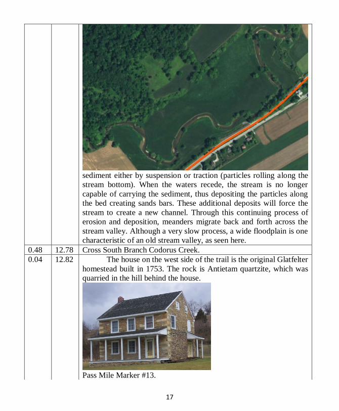
17
sediment either by suspension or traction (particles rolling along the
stream bottom). When the waters recede, the stream is no longer
capable of carrying the sediment, thus depositing the particles along
the bed creating sands bars. These additional deposits will force the
stream to create a new channel. Through this continuing process of
erosion and deposition, meanders migrate back and forth across the
stream valley. Although a very slow process, a wide floodplain is one
characteristic of an old stream valley, as seen here.
0.48 12.78 Cross South Branch Codorus Creek.
0.04 12.82 The house on the west side of the trail is the original Glatfelter
homestead built in 1753. The rock is Antietam quartzite, which was
quarried in the hill behind the house.
Pass Mile Marker #13.

18
0.31 13.13 Glatfelter Station Parking Area turn off to right.
0.25 13.38 Cross Glatfelters Station Road.
0.6 13.98 Pass Mile Marker #14.
Cross small unnamed tributary to South Branch Codorus Creek
Stop 13. Oxbows and Springs
39.8818/-76.7572
The South Branch of the Codorus Creek flows on the east side
of the rail trail. You can see good examples of meanders in the river,
oxbow lakes (shown above and accented with blue curve), and
meander scars, particularly in the winter when the trees are bare. Please
stay on the trail. As mentioned at Stop 12, a meander is a curve in the
river. A meander scar is an abandoned meander bend. Oxbow lakes are
lakes that form in these cut-off meanders.
Along the west side of the trail there are several springs. A
spring is the intersection of the water table at the earth surface. Often,
springs are created when a layer of rock acts as a barrier to water flow
(known as an aquiclude). A body of rock that allows water to be
transmitted is an aquifer. If the aquiclude is in a ridge such as this one,
the water will appear on the hillside in springs. Geologists use the
location of springs to assist them in determining the geology of an area.
Because faults are fractures in the bedrock, they provide a natural
channel for water to flow. In some cases, a line of springs could

19
represent a fault zone, a major joint system, or an outcrop belt of the
aquiclude.
Many people think spring water is the purest water.
Sometimes, this is true. But ask yourself “Where is this water coming
from before it gets to the spring?” There could be something higher on
the ridge that may harm the water, such as an old landfill, industrial
dump, junkyard, a farm that uses chemicals, or the rocks may be high
in uranium or arsenic. Water tests show roadside springs are often
contaminated. Would you drink this water? No, thanks.
0.27 14.25 Cross unnamed tributary to South Branch Codorus Creek.
0.3 14.55 Stop 14. Reynolds Mill Fault and Chickies Formation
Near bend in tracks- 39.8880/-76.7579
The northern half of the outcrop is phyllite and quartzite of the
Chickies Formation. The name comes from Chickies Rock along the
Susquehanna River in Lancaster County. That is the type locality for
these rocks. The original rock was shale, a sedimentary rock composed
of clay and minor sandstone. Heat and pressure during continental
collision caused the clay to recrystallize into mica, giving the rock a
new mineral composition and appearance, now known as phyllite. The
original layering within the shale has been nearly destroyed and can
only be seen with a microscope. The quartz in the sandstone layers
recrystallized to quartzite.
The Chickies Formation phyllite has a near-vertical foliation
parallel to the trail (orange hatches on photo). The southern half of the
exposure is Harpers Formation phyllite, which has a gentler southwest
dip to the foliation (red lines). The Reynolds Mill Fault runs through
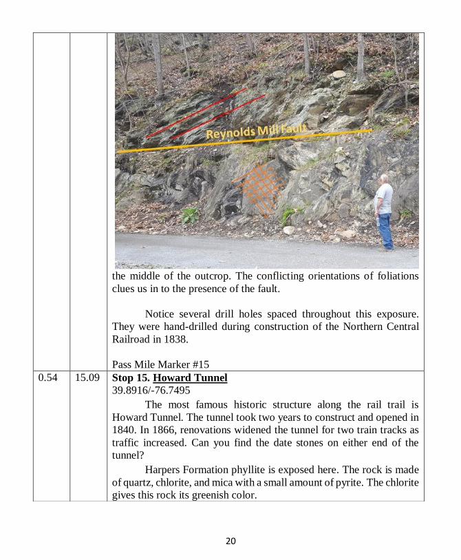
20
the middle of the outcrop. The conflicting orientations of foliations
clues us in to the presence of the fault.
Notice several drill holes spaced throughout this exposure.
They were hand-drilled during construction of the Northern Central
Railroad in 1838.
Pass Mile Marker #15
0.54 15.09 Stop 15. Howard Tunnel
39.8916/-76.7495
The most famous historic structure along the rail trail is
Howard Tunnel. The tunnel took two years to construct and opened in
1840. In 1866, renovations widened the tunnel for two train tracks as
traffic increased. Can you find the date stones on either end of the
tunnel?
Harpers Formation phyllite is exposed here. The rock is made
of quartz, chlorite, and mica with a small amount of pyrite. The chlorite
gives this rock its greenish color.

21
Look for quartz veins, some of which contain small perfect
quartz crystals. There are small folds on either side of the tunnel.
If you closely examine
the rocks on the
southwest side of the
tunnel, you will notice a
small step-like feature
going down the rock.
This feature is known as
slickensides. These are
formed by the grinding of
two rock surfaces as
faulting occurs. The
Reynolds Mill Fault
continues from the last
stop through here. The
Chickies Formation (Stop
14) is faulted against the
Harpers Formation.
Streams will always find
the easiest path through a
valley. When the stream
encounters resistant rock,
the water will go around
the rock instead of attempting to pass through it. The rocks within the
Reynolds Mill Fault have been highly fractured, thus intensifying the
weathering and erosion and forming an easier passage for the South
Branch of the Codorus Creek. For this reason, and the fact that the
creek is a mature-aged stream, the channel is well established with no
rapids, waterfalls, or strong currents visible.
0.47 15.56 Cross South Branch Codorus Creek and Twin Arch Road.
Pass Mile Marker #16.
0.77 16.33 Stop 16. Harpers Formation Phyllite
39.9059/-76.7492
This is the longest continuous rock exposure along the rail trail,
in places creating rock bluffs almost thirty feet high. It is the Harpers
Formation phyllite. The apparent layers, or foliation, is tilted 75-88°
southeast. The regional trend, or strike, is generally northeast-
22
southwest. If
you follow this
rock to the
southwest you
will eventually
arrive in
Harpers Ferry,
West Virginia,
where the rock
got its name.
Notice the
prominent joints
cutting through the exposure, many of which are parallel to each other.
Jointing is very common and can be seen in most of the exposures
along the rail trail. By measuring the joints, geologists can decipher
the direction and amount of the stress placed on the rocks during a
mountain-building event. The scenic ravines and small tributaries
found all along the trail often follow the joints. The joints broke the
bedrock, creating planes of weakness, which allowed for accelerated
weathering and erosion.
Take a closer look at the rocks for small cubes of limonite
pseudomorphs. These were originally cubes of pyrite, or “fool’s gold”
made of iron and sulfur. When it weathers, the sulfur in pyrite is
replaced by oxygen, forming
limonite, a dark-brown iron
oxide. The cubic shape
remains, but with a different
mineral, thus being a
pseudomorph, or “false form.”
In some cases, the crystal has
been weathered out, leaving a
square cavity. Can you locate
any?
0.60 16.93 Cross Days Mill Road. Brillhart Station Parking Area.
Pass Mile Marker #17.
0.14 17.07 Cross South Branch Codorus Creek.
0.5 17.57 Cross South Branch Codorus Creek, again.

23
0.28 17.85 Cross unnamed tributary to Codorus Creek.
0.15 18 Cross Indian Rock Dam Road. Pass Mile Marker #18
0.41 18.41 Stop 17. Reservoir Hill Railroad Cut Chickies Formation
39.9318/ -76.7524
In this 2,000-foot-long railroad cut, we see the cross section of
Reservoir Hill, which is the southern border of the Lowland Section.
Most the rocks from Maryland to this stop are metamorphic. To the
north, they are mostly sedimentary.
The rocks exposed here are phyllite with rare layers of quartzite
of the Chickies Formation. Can you find the beds of quartzite? The
rock is composed mainly of quartz, with minor amounts of mica and
iron. Remember, quartzite is the metamorphic equivalent of sandstone.
Look on broken rock faces for the sandy texture. The original sand was
probably deposited in a shallow ocean or perhaps on a beach. During
metamorphism, the quartz grains grew into larger crystals, which may
be seen with the naked eye.
Have you ever wanted to walk in a fault? At this location, you
are standing at the intersection of two faults!! A fault is a fracture or
tear in the Earth where rocks have moved. Usually, the movement is
measured in feet, or even in miles, along some of the more significant
faults in the world. One un-named normal fault is aligned northwest-
southeast, almost parallel to the trail. The rocks on the northeast side
of the fault have slid down relative to the southwest side on a plane
dipping east. The other fault is a thrust fault known as the Stoner
Overthrust. It is parallel to the north edge of Reservoir Hill. The Stoner
Overthrust is offset by the un-named fault, which tells us that the thrust
fault occurred first and is older. Some of the rocks have been folded during fault movement.
The small folds, the presence of quartz veins, and the erratic
appearance of the foliation suggest faulting took place nearby. The
faulting of the bedrock allowed the weathering and erosion processes
to work faster, cutting off Reservoir Hill to the southwest and allowing
Codorus Creek to flow through the gap.

24
West of here, on private
property along the Codorus
Creek, is Indian Rock. This
was a recreational area in
the 1920s, popular for
picnicking and swimming.
The rock resembles a
whaleback, measuring
about eighty feet long and
twenty feet high. It is an erosional remnant of an anticline. The
quartzite is more durable than the surrounding phyllite which has
weathered away.
0.18 18.59 Cross Indian Rock Dam Road on the overpass. Hyde sign.
0.25 18.84 Cross Golf Club Drive. Pass Mile Marker #19.
0.20 19.04 Cross over driveway of country club.
0.62 19.66 Stop 18. A View of the Lowland Section from 395 Feet
39.9451/ -76.7420
Looking back to the southeast, you can see Reservoir Hill, also
known as Violet Hill. This ridge reaches an elevation of 860 feet at
Sam Lewis State Park.
Looking north, you see the Conestoga, or York, Valley.
Geologically, this valley is rather complex–the result of folding and
faulting. This valley is a syncline, a u-shaped fold. The younger rocks
of the Conestoga Formation that you will see at Stop 19 are exposed
in the middle of the valley. The northern edge and southern edge are
made of the older Chickies Formation. With limited rock exposures, a
geologist must infer much of this knowledge. A few natural exposures,
and quarries, reveal that the valley is highly faulted. In places, the
bedrock has not only been moved several hundred feet, but also rotated
ninety degrees from its original position. Just think about the pressure
that was involved in such a crustal movement!!
0.02 19.68 Cross South Richland Avenue on the overpass.
0.40 20.08 Cross Grantley Road. Pass Mile Marker #20.
0.22 20.3 Cross unnamed tributary to Codorus Creek.
0.13 20.43 Cross Kings Mill Road.
0.20 20.63 Stop 19. Conestoga Formation
39.9559/ -76.7314 College Ave.
25
$
If you enjoyed this tour, check out the Trail of Geology 16–116.0, “A guide for the geologic
tourist to the Northern Extension of the York County Heritage Rail Trail” on the
Pennsylvania Department of Conservation and Natural Resources website.
Because limestone and dolostone are less resistant to erosion,
outcrops are somewhat rare. Small outcrops of the Conestoga
Formation limestone are found along the stream bank and in the
Codorus Creek bed. The bedrock creates small riffles that you can see
at low flow. The name Conestoga is derived from the village in
Lancaster County, where the best exposures of this rock were studied
by geologists in 1922.
Boulders of quartzite were placed along the creekbank by the
U.S. Army Corp of Engineers as part of the flood prevention plan for
York. The rocks were quarried in the Codorus Creek Gorge north of
U.S. Route 30. 0.04 20.67 Cross West College Street.
0.11 20.78 Cross West Princess Street.
0.11 20.89 Cross West King Street.
0.09 20.98 Stop 20. The York Valley
39.9609/-76.7314,
The trailhead is 370 feet above sea level. The York Valley runs
from Frederick, Maryland through Hanover, York, Wrightsville,
Lancaster, and Morgantown, Pennsylvania. The valley is in the
Piedmont Lowland Section, which is underlain predominantly by
limestone and dolostone with minor shale, which are all susceptible to
erosion. North and east of here, the valley is bordered by the Hellam
Hills. Sandstone, quartzite, conglomerate, and volcanic rocks within
the hills are resistant to erosion. To the south, the valley is bordered by
a highland, which is underlain by metamorphic rocks such as quartzite
and phyllite that you saw at Stop 17. Both highlands belong to the
Upland Section of the Piedmont Province.
Because rocks such as limestone, dolostone, and shale are less
resistant to erosion and weathering, these rocks typically form valleys.
The harder, more resistant rocks including sandstone, quartzite,
conglomerate, and phyllite are ridge-formers.
Mile Marker #21

Park Regulations The park is open year-round, dawn until dusk, and is patrolled by York County
Park Rangers.
Users must stay on the trail, as property adjacent to the trail is privately owned.
Motorized vehicles are prohibited on the trail except for emergency and
maintenance vehicles.
Pets are permitted on the trail, but must be kept on a leash. Owners must clean up
after their pets.
The railway is operational from New Freedom (Mile 1) to Hanover Junction
(Mile 11). Stay clear of the tracks at all times.
Do not walk on the railroad tracks!
Horseback riders should clean up after your horses.
All riders are encouraged to wear approved helmets.
For trail conditions, contact park headquarters at 717-840-7440 or follow on
Twitter “@yorkcountyparks”. Trails may be closed to certain users depending on
trail conditions, please call ahead.