a gis-aided monitoring system of groundwater level … · a gis-aided monitoring system of...
TRANSCRIPT

A GISA GIS--AIDED MONITORING AIDED MONITORING SYSTEM OF GROUNDWATER SYSTEM OF GROUNDWATER
LEVEL IN WIDE LAND LEVEL IN WIDE LAND SUBSIDENCE AREASUBSIDENCE AREA
MURAKAMI, S. , YASUHARA,K. and MOCHIZUKI,N.MURAKAMI, S. , YASUHARA,K. and MOCHIZUKI,N.Department of Urban and Civil Engineering, Ibaraki Department of Urban and Civil Engineering, Ibaraki
University, Ibaraki, JapanUniversity, Ibaraki, Japan
www.civil.ibaraki.ac.jpwww.civil.ibaraki.ac.jpmurakami@[email protected]
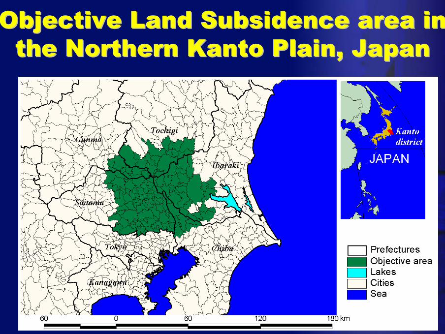
Objective Land Subsidence area in Objective Land Subsidence area in the Northern Kanto Plain, Japanthe Northern Kanto Plain, Japan
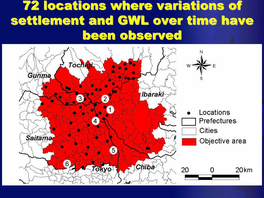
72 locations where variations of 72 locations where variations of settlement and GWL over time have settlement and GWL over time have
been observedbeen observed
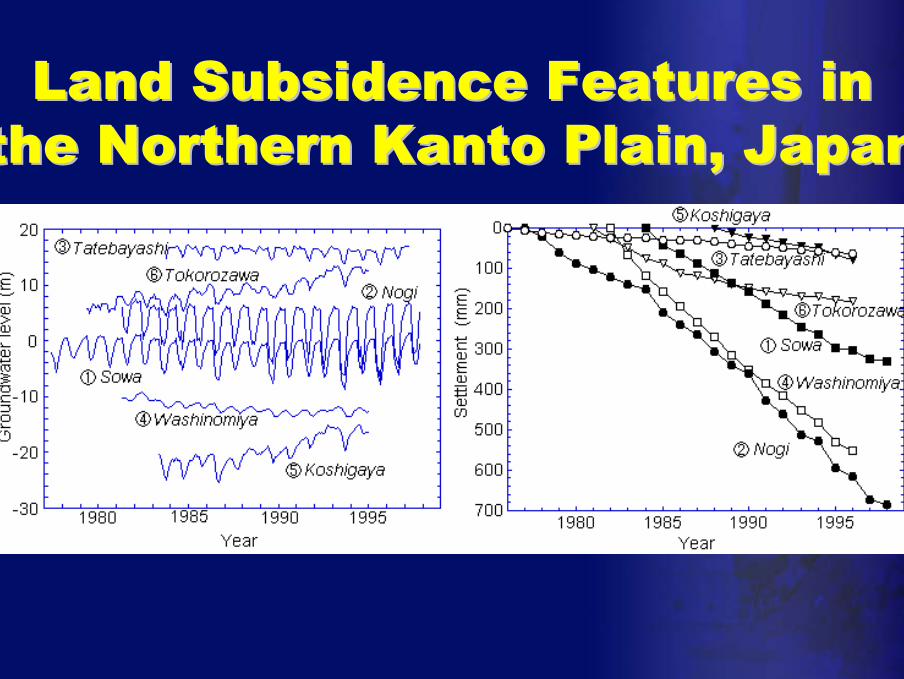
Land Subsidence Features in Land Subsidence Features in the Northern Kanto Plain, Japanthe Northern Kanto Plain, Japan

Damage due to Land SubsidenceDamage due to Land Subsidence
• Direct damage– Structures– Roads– Lifelines, etc…..

Damage due to Land SubsidenceDamage due to Land Subsidence
• Potential damage– Earthquake– River Flooding– Heavy Rain, etc…..

Infrastructures in wide land Infrastructures in wide land subsidence area subsidence area
• Maintenance plan with consideration of damage due to land subsidence
– Forecasting land subsidence
– Regulating land subsidence
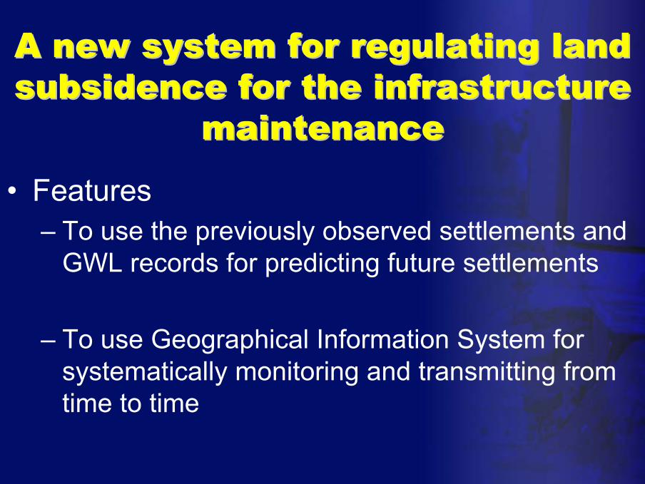
A new system for regulating land A new system for regulating land subsidence for the infrastructure subsidence for the infrastructure
maintenancemaintenance
• Features– To use the previously observed settlements and
GWL records for predicting future settlements
– To use Geographical Information System for systematically monitoring and transmitting from time to time

Observational Prediction of Observational Prediction of Land Subsidence with Land Subsidence with Consideration of GWL Consideration of GWL
fluctuationfluctuation
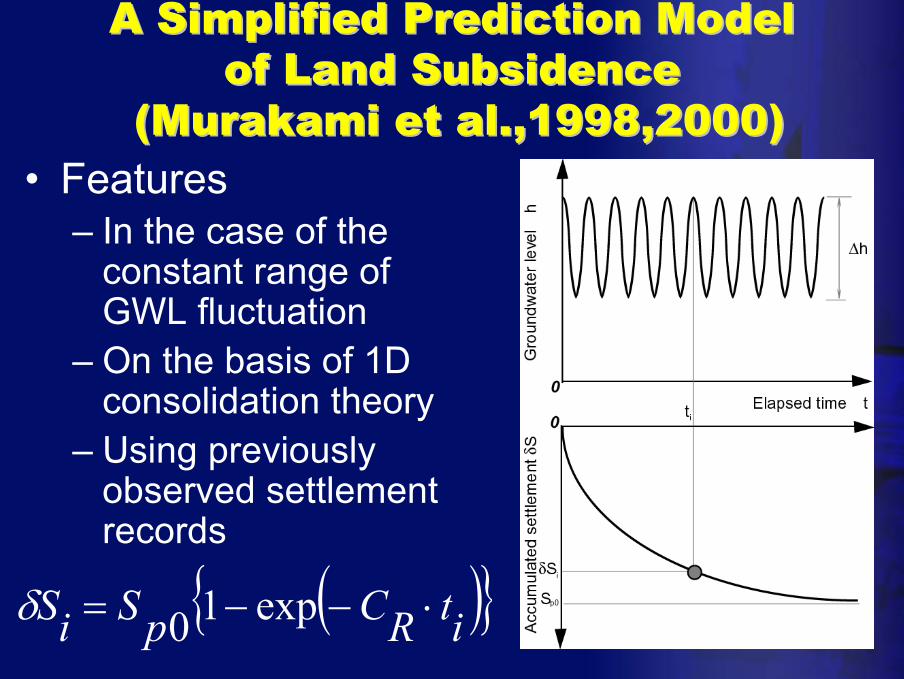
A Simplified Prediction Model A Simplified Prediction Model of Land Subsidenceof Land Subsidence
(Murakami et al.,1998,2000)(Murakami et al.,1998,2000)• Features
– In the case of the constant range of GWL fluctuation
– On the basis of 1D consolidation theory
– Using previously observed settlement records
( ){ }itRCpSiS ⋅−−= exp10δ

A Prediction Model with A Prediction Model with Consideration of GWL FluctuationConsideration of GWL Fluctuation
• Settlement-Time Relationships– Type I
– Type II
( ){ }itRCexpSS Ap
Ai ⋅−−= 10
( ){ }itRCexpSS Bp
Bi ⋅−−= 10
wwp BhAS +∆⋅=0

A Prediction Model with A Prediction Model with Consideration of GWL FluctuationConsideration of GWL Fluctuation
CSBhAS nn +⋅−∆⋅=+1δ
( ){ }Rw CexpAA −−⋅= 1
( )RCexpB −−=1( ){ }Rw CexpBC −−⋅= 1
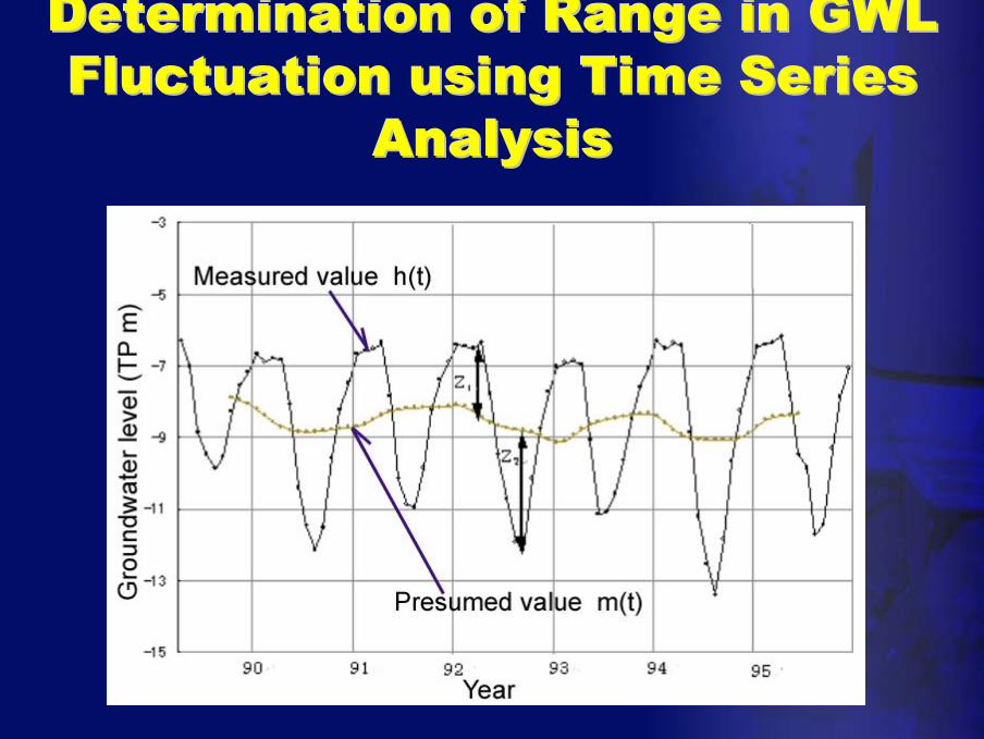
Determination of Range in GWL Determination of Range in GWL Fluctuation using Time Series Fluctuation using Time Series
AnalysisAnalysis
Application of the Proposed Application of the Proposed Method to Land Subsidence Method to Land Subsidence
PredictionPrediction
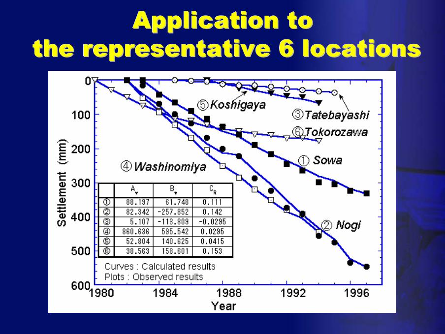
Application toApplication tothe representative 6 locationsthe representative 6 locations
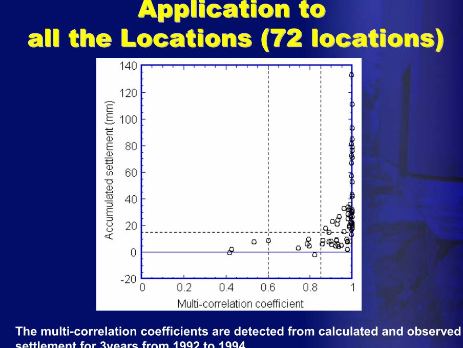
Application toApplication toall the Locations (72 locations)all the Locations (72 locations)
The multi-correlation coefficients are detected from calculated and observed settlement for 3years from 1992 to 1994

GWL fluctuation for regulating GWL fluctuation for regulating land subsidenceland subsidence
• Proposed Land Subsidence Prediction Model
• Permissible range of GWL fluctuation for regulating land subsidence
CSBhAS nn +⋅−∆⋅=+1δ
( )CSBSA
h nn −⋅+= −11 δ∆
A GISA GIS--aidedaidedGWL Monitoring SystemGWL Monitoring System
for Regulating Land Subsidencefor Regulating Land Subsidence

GWL Fluctuation MapGWL Fluctuation Mapfor Regulating settlementfor Regulating settlement
20mm
10mm
0mm
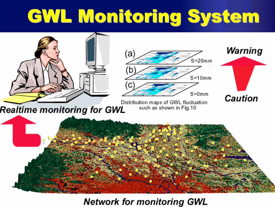
GWL Monitoring SystemGWL Monitoring System
CONCLUSIONSCONCLUSIONS
• An observational prediction method of land subsidence with consideration of GWL fluctuation by using previously observed settlements and GWL records is proposed.
• A GIS-aided monitoring system of GWL in wide land subsidence area is proposed.