a geological analysis of the appalachian basin and how it
TRANSCRIPT
A Geological Analysis of the Appalachian Basin and How It Affects the Oil & Gas Industry
By: Elizabeth Sweda
10 April 2019

Purpose
• The oil & gas industry is dependent on geology
• Identify attributes that are advantageous
• Identify attributes that may cause some challenges
Introduction
• An epicenter for one of the fastest growing industries in the country
• The largest natural gas reserve in the United States
• Produced 28 trillion cubic feet of natural gas and 102 million barrels of crude oil and condensate from 2011 to 2016
• Expected to account for 35% of total U.S. production
• Has provided abundant fossil fuels for over 150 years
Industry Overview• The fountainhead of the American petroleum industry
• Oil and natural gas were discovered in the Appalachian Basin long before they were ever commercially produced
• The first Americans to drill for oil and natural gas were salt miners
1814 – Noble County, Ohio
1815 – Charleston, West Virginia
• Most well known:
1859 – Titusville, Pennsylvania
• Others:
1859 – Petroleum, West Virginia
1860 – California, West Virginia
1860 – Burning Springs, West Virginia
1860 – Washington County, Ohio

Geology• Geological History
• Structural
• Oil and Gas Capabilities

Geological History

Taconic Orogeny
• A change in plate motions (mid Ordovician)
• Iapetus Plate collided with the North American Plate
• Resulted in the deposition of the Utica Shale

After the Taconic Orogeny
• Laurentia formed and the early Appalachians were born
• Volcanoes grew coincident with the initiation of subduction
• Thrust faulting uplifted and warped older sedimentary rocks
• Erosion set in and sediments were carried downslope to be deposited in nearby lowlands
• Shallow-marine conditions returned depositing primarily shale and limestone

Acadian Orogeny
• The Baltica Plate collided with the northern part of the Laurentia Plate
• Pennsylvania received enormous quantities of river and delta sediment – Catskill Delta
• The Marcellus Shale was deposited during the initial stage

Alleghanian Orogeny
• Gondwana and Laurentia collided
• Large portions of the Laurentian crust and overlying sedimentary sequence were thrust westward
• Above the thrust planes, the sedimentary strata were warped and folded as they were forced west
• During this time the Marcellus and Utica Shales were naturally fractured

Structural
• Comprises 230,000 sq mi of all or parts of ten states and some segments of Lakes Erie and Ontario
• Length – 1,000 miles from the Canadian border to Alabama
• Width – 75 to 350 miles; larger near the border and decreasing south
• Consists of:
Appalachian Plateau
Valley and Ridge
Blue Ridge
Piedmont

• Asymmetrical with the rocks on the west flank dipping eastward
• Appalachian Plateau – generally gently dipping strata
• Valley and Ridge – greatly thrust-faulted, folded, and telescoped during the Alleghanian Orogeny
• A major thrust-fault system which commonly formed anticlines
Known as the Eastern Overthrust Belt
Structural traps and zones of fracture porosity
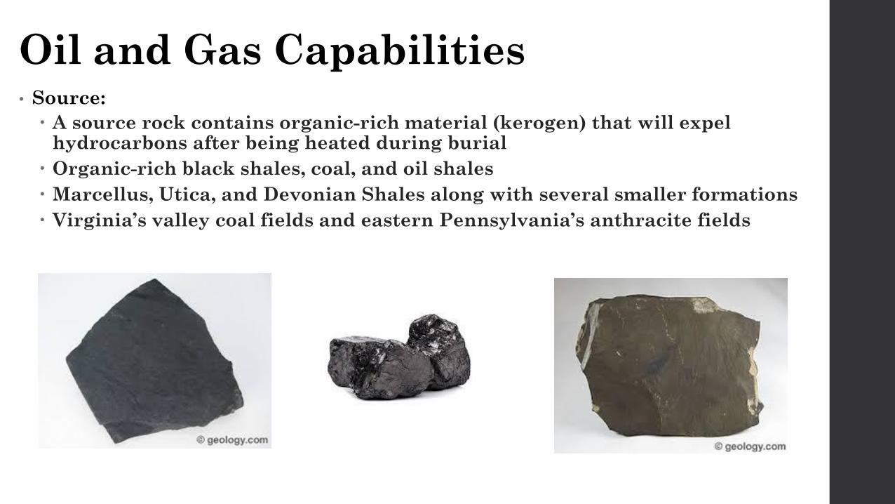
Oil and Gas Capabilities• Source:
A source rock contains organic-rich material (kerogen) that will expel hydrocarbons after being heated during burial
Organic-rich black shales, coal, and oil shales
Marcellus, Utica, and Devonian Shales along with several smaller formations
Virginia’s valley coal fields and eastern Pennsylvania’s anthracite fields

• Thermal Maturation:
The extent of heat-driven reactions that alter the composition of organic matter
Depends largely upon the thickness of sediment, depth of burial, and existing thermal gradient
Low thermal maturity = oil
High thermal maturity = gas
Overmatured = nothing
The basin’s Paleozoic sequence thickens from west to east
Thermal maturity increases west to east
Oil in the west and gas in the east
• Seal:
An impermeable layer that prohibits the migration of hydrocarbons
Common ones include gypsum and halite
Most important and most common is shale
Conventional reservoirs require a separate seal from the source rock
Unconventional reservoirs are considered self-sealing since the source acts as a seal
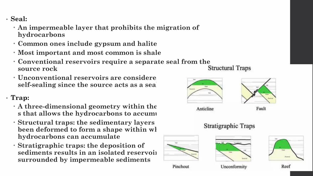
• Trap:
A three-dimensional geometry within the rock s that allows the hydrocarbons to accumulate
Structural traps: the sedimentary layers have been deformed to form a shape within which hydrocarbons can accumulate
Stratigraphic traps: the deposition of sediments results in an isolated reservoir surrounded by impermeable sediments

• Reservoir:
Conventional:
A porous and permeable rock in which hydrocarbons accumulate
Sandstone and limestone
Unconventional:
Lack adequate porosity and permeability to permit the flow of hydrocarbons
Shales, tight sands, and coal beds
Make up many of the most important trends in hydrocarbon industry plays today

Industry Challenges• Pad/Lease Road Construction and Location
• Water Supply and Brine/Cuttings Disposal
• Geomechanics

Pad/Lease Road Construction and Location
• The average pad size is between 4 and 25 acres
• The average number of wells per pad is about 10, however super pads containing up to 40 wells are starting to make appearances
• Also need space for the equipment, other vehicles, and people
• Longer lease road may be needed if location is farther away from already implemented roads
• Local roads may have weight, height, width and/or length restrictions
• The area tends to be very hilly and covered in trees
Vegetation may need to be removed in order to create open space
Dirt may need moved in order to create a flat space that’s large enough
• It is very easy for costs to accumulate during this stage

• What can be done:
Only have necessary equipment/amenities on pad at a certain time
Limit size, amount, and shape of the equipment/amenities
Try to find spaces in areas that are relatively flat and need little vegetation or dirt moved
Locate the pad not too remote in order to keep lease road construction costs down
Make sure local roads are able to handle the increase in traffic and weight they will see

Water Supply and Brine/Cuttings Disposal• Water plays a large role
Present when drilling, preparing for production, and producing the well
The largest need is during hydraulic fracturing
About 4 to 6 million gallons per well
A high production year in the Marcellus requires about 80 million gallons of water per day
• Sources include:
Local ponds or streams
Constructed reservoirs
The public water supply
Wastewater from other wells
• Complicated by the rapid changes in water quantity and quality over time

• Wastewater Management Techniques:
Injection into a disposal well
Removing metals and other contaminants to create clean brine
Desalinizing clean brine to create clean freshwater
Evaporating the water to dryness or crystalline form
Filtering the water to remove suspended solids and blending it with freshwater
• Reuse is being done in large amounts
Options for injection wells are limited
• More water being produced than can be recycled
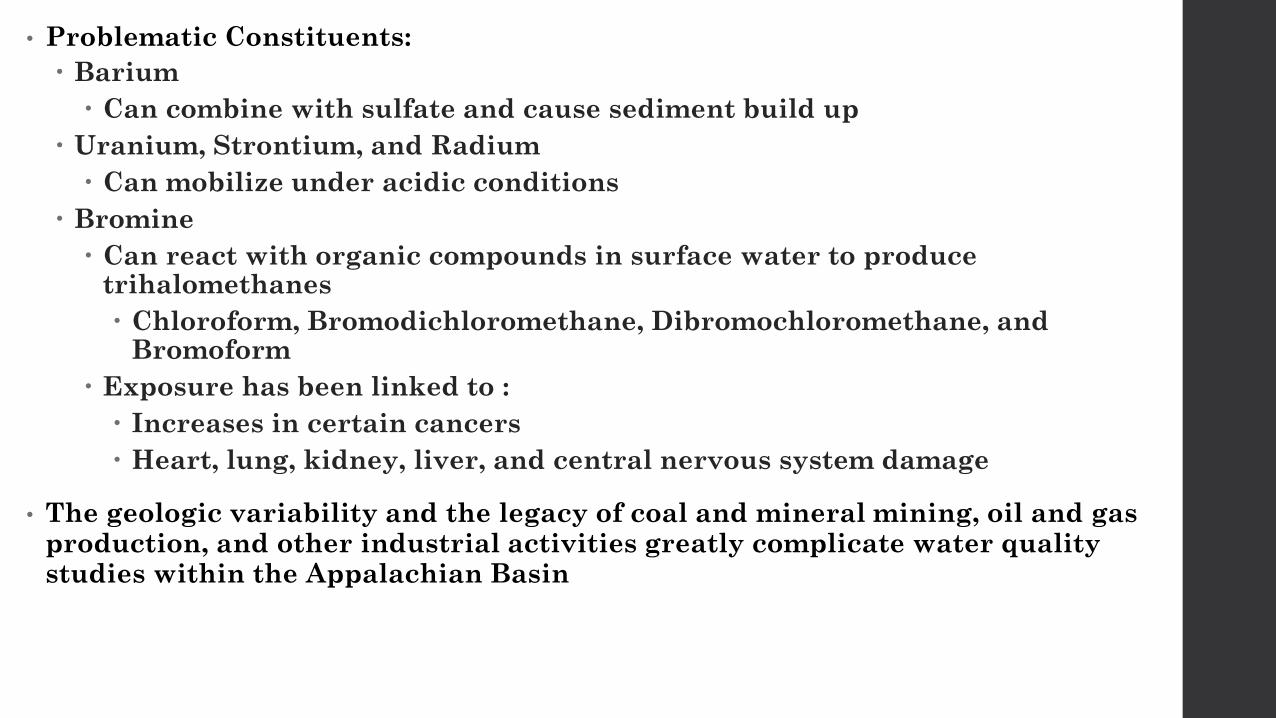
• Problematic Constituents:
Barium
Can combine with sulfate and cause sediment build up
Uranium, Strontium, and Radium
Can mobilize under acidic conditions
Bromine
Can react with organic compounds in surface water to produce trihalomethanes
Chloroform, Bromodichloromethane, Dibromochloromethane, and Bromoform
Exposure has been linked to :
Increases in certain cancers
Heart, lung, kidney, liver, and central nervous system damage
• The geologic variability and the legacy of coal and mineral mining, oil and gas production, and other industrial activities greatly complicate water quality studies within the Appalachian Basin

Geomechanics• The earth’s crust is constantly subjected to forces that push, pull, or twist it
• If we visualize a point within the earth as a cube it can be visualized as shown in Fig. A
The point is subjected to three normal stresses and six shear stresses
• A simple rotation can be applied which results in the principal stresses shown in Fig. B
Fig. A Fig. B

• Before we drill a well, the formation is in a state of stress equilibrium
• Drilling of the wellbore disrupts that equilibrium
Causes stress to redistribute around it
• Use mud weight to balance this dis-equilibrium
Commonly not enough to stop breakout or wellbore instability completely
• Stress directions can be estimated by looking at the damage in the borehole from drilling
• Breakouts occur in the direction of minimum horizontal stress
Maximum compression (where breakout occurs) happens 90 degrees from the maximum horizontal stress
Can estimate σH, the maximum horizontal stress direction

• Estimate their magnitudes
Overburden (σv) – information from density logs
Minimum horizontal (σh) – leak off tests, offset completion data, or mini fracture tests within the wellbore
Maximum horizontal (σH) – the hardest to estimate; advanced sonic measurements or the severity of wellbore breakouts
• The magnitudes define the type of faulting regime that the formation of interest lies in
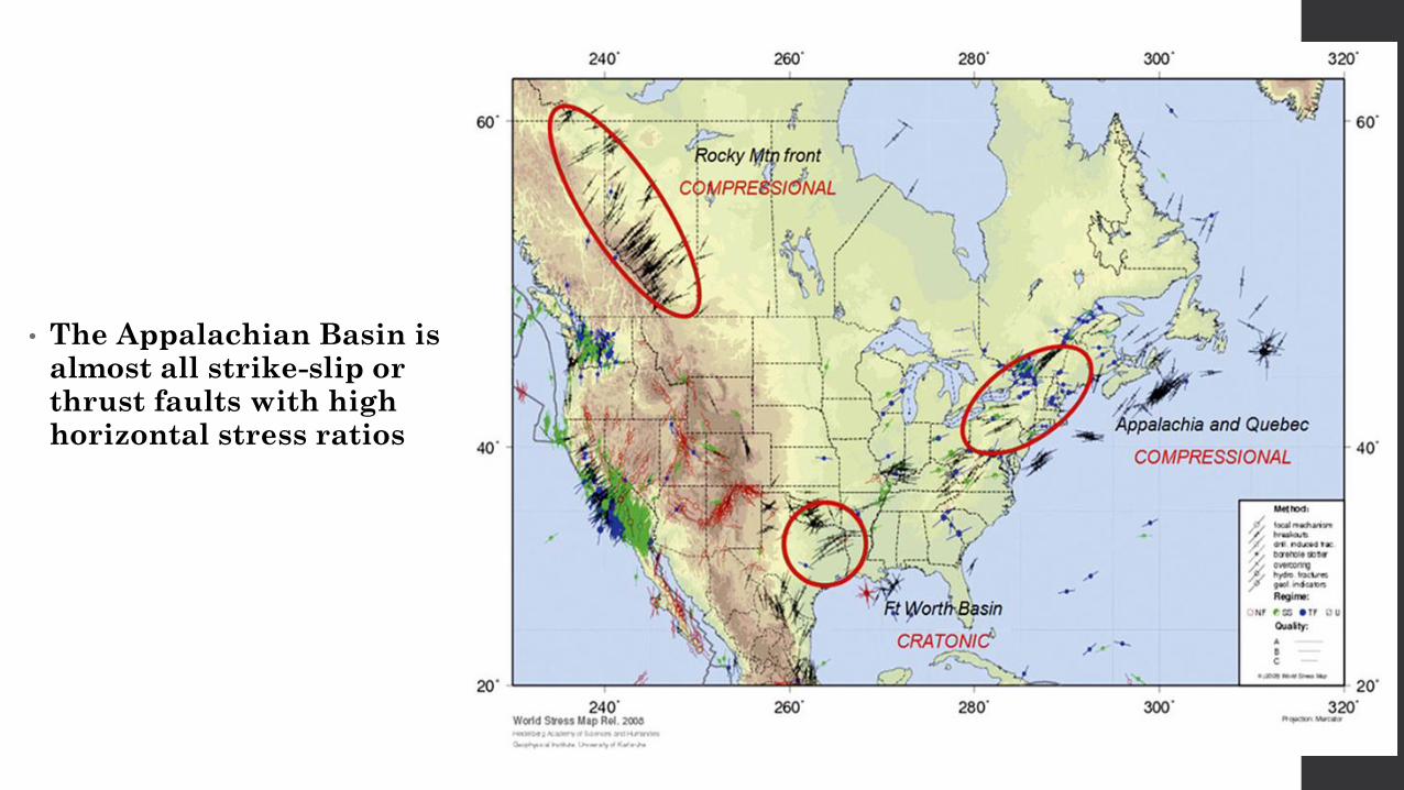
• The Appalachian Basin is almost all strike-slip or thrust faults with high horizontal stress ratios
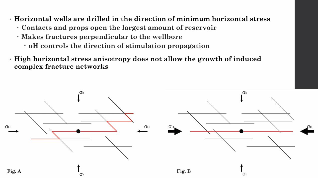
• Horizontal wells are drilled in the direction of minimum horizontal stress
Contacts and props open the largest amount of reservoir
Makes fractures perpendicular to the wellbore
σH controls the direction of stimulation propagation
• High horizontal stress anisotropy does not allow the growth of induced complex fracture networks
Fig. A Fig. B

• Ratios of stresses also control how the wellbore breaks out in both the vertical and horizontal sections of the well
• Highly compressive environments, like strike-slip or thrust fault regimes, breakout on the top and bottom of the wellbore instead of the sides
• May experience operational issues from stuck pipe, hole cleaning, well logging, and cement jobs
Fig. A Fig. B

Conclusion
• The unique geology of the Appalachian Basin is what makes it possible for the industry to be so prosperous in this area
• If one feature had even the slightest change, everything could be completely different
• Aspects such as water quality and geomechanics still pose operational complexities
• The industry continues to evolve every day and make advances in technology that will allow for safer, more efficient, and higher recoverability practices

Thank You!Questions?