a genealogy of data assemblages: tracing the geospatial open access and open data movements in...
TRANSCRIPT

AAG Session 4204
Data-based living: peopling and placing ‘big data
Tampa, Florida, April 11 2014
Tracey P. Lauriault and Rob Kitchin
National Institute for Regional and Spatial Analysis (NIRSA)
National University of Ireland at Maynooth (NUIM)
The Programmable City Project
A genealogy of data assemblages: tracing the geospatial open access and open data movements in Canada

1.Introduction

The Programmable City
• A European Research Council (ERC) and
Science Foundation of Ireland (SFI) funding
• SH3: Environment and Society
• Led by Dr Rob Kitchin, the Primary Investigator
• Based at the National Institute for Regional and
Spatial Analysis (NIRSA)
• At the National University of Ireland Maynooth
(NUIM)

Objectives
How is the city translated into software and data? How do software and data reshape the city?
Translation:
City into Code
Transduction:
Code Reshapes City
THE CITY SOFTWARE
Discourses, Practices, Knowledge, Models
Mediation, Augmentation, Facilitation, Regulation

2.Research Question

Research Question
How are digital data materially and
discursively supported and processed
about cities and their citizens?

3.Assemblages
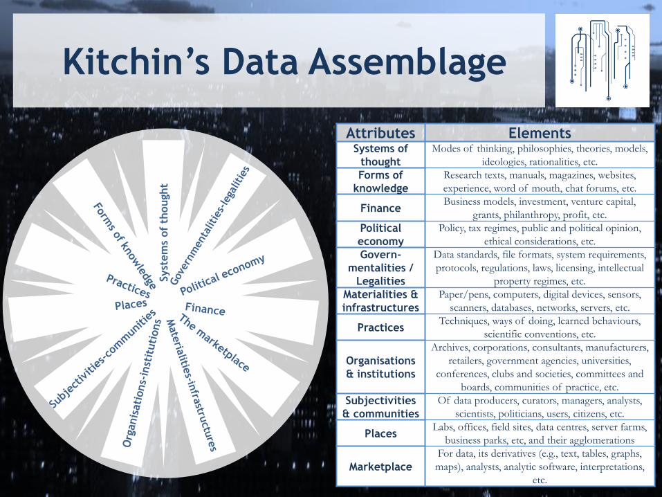
Kitchin’s Data Assemblage
Attributes Elements Systems of
thought
Modes of thinking, philosophies, theories, models,
ideologies, rationalities, etc.
Forms of
knowledge
Research texts, manuals, magazines, websites,
experience, word of mouth, chat forums, etc.
Finance Business models, investment, venture capital,
grants, philanthropy, profit, etc.
Political
economy
Policy, tax regimes, public and political opinion,
ethical considerations, etc.
Govern-
mentalities /
Legalities
Data standards, file formats, system requirements,
protocols, regulations, laws, licensing, intellectual
property regimes, etc.
Materialities &
infrastructures
Paper/pens, computers, digital devices, sensors,
scanners, databases, networks, servers, etc.
Practices Techniques, ways of doing, learned behaviours,
scientific conventions, etc.
Organisations
& institutions
Archives, corporations, consultants, manufacturers,
retailers, government agencies, universities,
conferences, clubs and societies, committees and
boards, communities of practice, etc.
Subjectivities
& communities
Of data producers, curators, managers, analysts,
scientists, politicians, users, citizens, etc.
Places Labs, offices, field sites, data centres, server farms,
business parks, etc, and their agglomerations
Marketplace
For data, its derivatives (e.g., text, tables, graphs,
maps), analysts, analytic software, interpretations,
etc.
S
yst
em
s of
thought

3. Geospatial
Data Infrastructure

1999
Canadian Geospatial Data
Infrastructure (CGDI)
2001 2005 2013

CGDI Principles
1. Open: enables better decision making, the CGDI is based on open, barrier-free data sharing and standards that allow users to exchange data.
2. Accessible: allows users to access data and services seamlessly, despite any complexities of the underlying technology.
3. Evolving: the network of organizations participating in the CGDI will continue to address new requirements and business applications for information and service delivery to their respective users.
4. Timely: the CGDI is based on technologies and services that support timely or real-time access to information.
5. Sustainable: is sustained by the contributions of the participating organizations and broad user community and through the infrastructure’s relevance to these groups.
6. Self-organizing the CGDI enables various organizations to contribute geospatial information, services and applications, and guide the infrastructure’s development.
7. User and community driven emphasizes the nurturing of and service to a broad user community. These users, including Canadians in general, will drive the CGDI’s development based on user requirements.
8. Closest to source maximizes efficiency and quality by encouraging organizations closest to source to provide data and services. Thereby eliminating duplication and overlap.
9. Trustworthy is continually enhanced to protect sensitive and proprietary data. The CGDI offers this protection through policies and mechanisms that enable data to be assessed for quality and trusted by users.
Source: : 2012, Canadian Geospatial Data Infrastructure Vision, Mission
and Roadmap - The Way Forward

Maps
6th Edition 1999
3rd Edition 1957
4th Edition 1974
1st Edition 1906 2nd Edition 1915
5th Edition 1985

Data

4. Access to Data Canada a. University
b. Federal Government
c. Civil Society
d. Research
e. Public Health

University Setting
Image source: http://www.geomatikk.ntnu.no/english/
University Geomatics 1992 Proposed, 1996 Launched
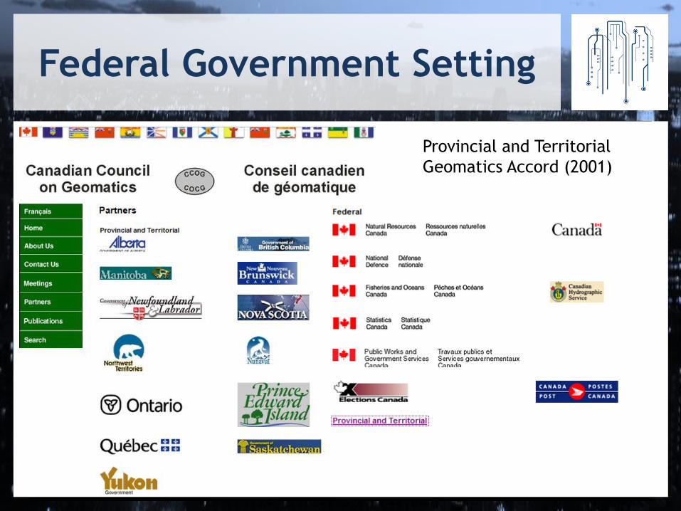
Federal Government Setting
Provincial and Territorial
Geomatics Accord (2001)

Geographic
and
Numeric
Information
Systems
Social
Planning
Network of
Ontario
Civil Society

Data Negotiation
http://cdc-dcc.info/mandate.php

Legal Action
1993, Filed 2007, Won 2009

Research Setting

Chief Medical Officer of Health
http://emis.santemontreal.qc.ca/

4. Open Data Canada a. Transition
b. Cities
c. Licenses and Collaboration
d. Research

Access to Public Data

Open Data Definitions (sample)
• 1959 Antarctic Treaty
• 1992 - UNCED – Agenda 21 Chapter 40, Information for Decision Making
• 1996 Global Map
• 2007 GEOSS - Data Sharing Principles for the Global Earth Observing System of Systems
• 2005 - Open Knowledge Foundation (OKNF) - 11 Principles (Licence specific)
• 2007 - US Open Government Working Group - 8 principles of Open Government Data
• 2007 Science Commons Protocol for Implementing Open Access Data
• 2007 Sunlight Foundation - 10 Principles for Opening Up Government Informatio
• 2007 OECD, Principles and Guidelines for Access to Research Data from Public Funding
• 2009 W3C - Publishing Open Government Data
• 2010 Tim Berners-Lee 5 Star of Open Data
• 2008 OECD, Recommendations on Public Sector Information
• 2010 Panton Principles for Open Data in Science
• 2010 Ontario Information Privacy Commissioner - 7 Principles
• 2013 Open Economics Principles
• US Association of Computing Machinery (USACM) – Recommendations on Open Government
• American Library Association (ALA) – Access to Government Information Principles

Foundational
ARTICLE III
1. In order to promote international cooperation in
scientific investigation in Antarctica, as provided for
in Article II of the present Treaty, the Contracting
Parties agree that, to the greatest extent feasible and
practicable:
(a) information regarding plans for scientific programs in
Antarctica shall be exchanged to permit maximum
economy and efficiency of operations;
(b) scientific personnel shall be exchanged in Antarctica
between expeditions and stations;
(c) scientific observations and results from Antarctica
shall be exchanged and made freely available
Agenda 21 – Chapter 40
INFORMATION FOR DECISION-MAKING
40.1. In sustainable development, everyone is a
user and provider of information considered in
the broad sense. That includes data,
information, appropriately packaged
experience and knowledge. The need for
information arises at all levels, from that of
senior decision makers at the national and
international levels to the grass-roots and
individual levels. The following two
programme areas need to be implemented to
ensure that decisions are based increasingly on
sound information:
a. Bridging the data gap;
b. Improving information availability.
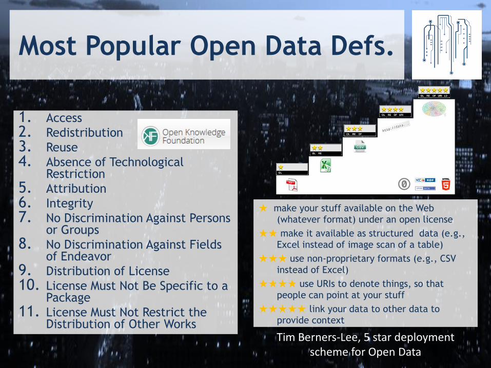
Most Popular Open Data Defs.
1. Access
2. Redistribution
3. Reuse
4. Absence of Technological Restriction
5. Attribution
6. Integrity
7. No Discrimination Against Persons or Groups
8. No Discrimination Against Fields of Endeavor
9. Distribution of License
10. License Must Not Be Specific to a Package
11. License Must Not Restrict the Distribution of Other Works
★ make your stuff available on the Web
(whatever format) under an open license
★★ make it available as structured data (e.g.,
Excel instead of image scan of a table)
★★★ use non-proprietary formats (e.g., CSV
instead of Excel)
★★★★ use URIs to denote things, so that
people can point at your stuff
★★★★★ link your data to other data to
provide context
Tim Berners-Lee, 5 star deployment scheme for Open Data

Cities take the lead in Canada

Licences & Collaboration
Ottawa, Toronto, Edmonton, Vancouver + Montreal

Open Data Cities
1. Banff Open Data Portal, (AB) Pilot
2. City of Brandon (MB)
3. City of Burlington (ON)
4. City of Calgary (AB)
5. City of Chilliwack (BC)
6. City of Edmonton (AB)
7. City of Fredericton (NB)
8. Portail de données ouvertes de la ville de
Gatineau
9. County of Grande Prairie (AB)
10. Open Data Guelph (ON)
11. Halifax Regional Municipality (NS)
12. City of Hamilton Open and Accessible Data (ON)
13. City of Kelowna Open Data Catalog (BC)
14. City of London (ON)
15. Township of Langley (BC)
16. Open Data Medicine Hat (AB)
17. Town of Milton (ON)
18. City of Mississauga (ON)
19. Ville de Montréal Portails données ouvertes (QC)
20. City of Nanaimo (BC)
20. City of Niagara Falls (ON)
21. Region of Niagara (ON)
22. Regional District of Central Okanagan
23. Regional District of North Okanagan (BC)
24. District of North Vancouver (BC)
25. City of Ottawa (ON)
26. Region of Peel (ON)
27. City of Prince George (BC)
28. Ville de Québec Catalogue de données (QC)
29. City of Red Deer, (AB)
30. City of Regina (SK)
31. District of Saanich Open Data (BC)
32. Open Data Saskatoon (SK)
33. Données ouvertes Sherbrookes (QC)
34. Strathcona County Open Data Portal (AB)
35. City of Surrey (BC)
36. City of Toronto (ON)
37. City of Vancouver (BC)
38. District of North Vancouver (BC)
39. City of Victoria (BC)
40. City of Waterloo (ON).
41. Region of Waterloo (ON)
42. City of Whitehorse (YK)
43. City of Windsor (ON)
44. York Region

Open Data Provinces
1. Data BC 2. Alberta Open Data 3. Open Data Saskatchewan, Citizen Led 4. Ontario Open Data 5. Données ouvertes Portail du Gouvernement du Québec,
Québec Ouvert – Citizen Led 6. Newfoundland and Labrador

Federal Open Data
• Geogratis & Geobase & Discovery Portal & Atlas of Canada
• Office of the Information Commissioners Open Government Resolutions
• OpenData.gc.ca
• Research Data Canada
• Canadian International Development Agency (CIDA) Open Data

Fed. Open Data Portal

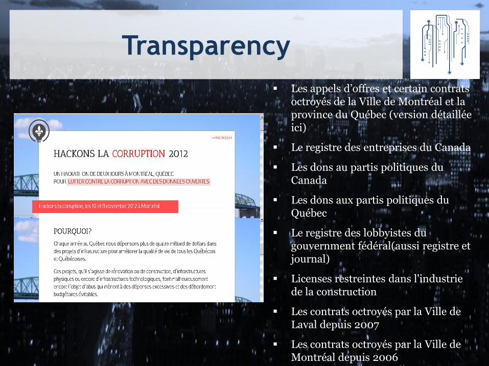
Transparency
Les appels d’offres et certain contrats octroyés de la Ville de Montréal et la province du Québec (version détaillée ici)
Le registre des entreprises du Canada
Les dons au partis politiques du Canada
Les dons aux partis politiques du Québec
Le registre des lobbyistes du gouvernment fédéral(aussi registre et journal)
Licenses restreintes dans l'industrie de la construction
Les contrats octroyés par la Ville de Laval depuis 2007
Les contrats octroyés par la Ville de Montréal depuis 2006

Hackathons
http://www.rhok.org/
http://montrealouvert.net/2011/11/23/compte-rendu-du-3e-
hackathon-montreal-ouvert/?lang=en
http://www.livinglabmontreal.org/TranspoCampMTL

Transportation Planning
Au niveau municipal, les données sont accessibles indirectement sur le site de la ville de Montréal. En d'autres termes, ces données n'ont pas été prévues pour être utilisées de manière directe mais sont affichées sur une carte dans la section Info-Travaux. Au niveau provinciale, les données viennent du Ministère des transports du Québec et de son service Québec 511. Là aussi le MTQ se démarque de ses homologues canadiens en étant a priori le premier à proposer des données GPS pour la localisation des chantiers.

Entrepreneurs
All 10,000 public and private foundations.
Exhaustive list of federal and provincial funding programs specifically for non-profits (over 700).
Corporate funders (500 and growing).

Advocacy
http://www.opendatabc.ca/index.html
http://opennorth.ca/

6. Observations

Research Data Canada
Archiving, Management and Preservation of Geospatial Data
National Consultation on Access to Scientific Data Final Report
(NCASRD)
2010 1990 1995 2000 2005
National Data Archive Consultation
(SSHRC)
Stewardship of Research Data in Canada: A Gap Analysis
The dissemination of government geographic data in Canada: guide to best practices
Research Data Strategy Working Group Standing Committee on Industry, Science and
Technology
Toward a National Digital Information Strategy: Mapping the Current Situation in
Canada (LAC)
Canadian Digital Information
Strategy (CDIS) (LAC)
IPY
1985 2014
Open Data Consultations
Mapping the Data
Landscape: Report of the
2011 Canadian Research
Data
Summit
Digital Economy Consultation,
Industry Canada
Community Data Roundtable Privacy (Geo) Sensitive Data (Geo) Resolution of Canada’s Access to Information and Privacy Commissioners
Geomatics Accord Signed Canadian Geospatial Data Policy
Liberating the Data Proposal
VGI Primer Cloud (Geo) OD Advisory Panel OGP
G8
Subjectivities &
Forms of Knowledge
• Policies
• Reports
• Proposals
• Recommendations
• Consultation
2008
MiningWatch Canada & Great Lakes United by
Ecojustice (formerly Sierra Legal Defence
Fund).Demand release of mine tailing data
Digital Infrastructure
Leadership Council

2010 1990 1995 2000 2005 1985 2014
Data Liberation Initiative (DLI)
Geogratis Data Portal
GeoBase Canadian
Internet Public Policy
Clinic
Maps Data and Government Information
Services (MADGIC) Carleton U
GeoConnections GeoGratis
Census Data Consortium Canadian Association of Research Libraries (CARL)
Atlas of Canada Online (1st)
CeoNet Discovery
Portal
Research Data
Network
How'd they Vote CivicAccess.ca
Campaign for Open
Government (FIPA)
Canadian Association
of Public Data Users
Datalibre.ca
VisibleGovernment.ca I Believe in Open Campaign
Change Camps Start
Nanaimo BC Toronto
Open Data Portals
Edmonton Mississauga launches open data
Citizen Factory B.C.'s Climate Change Data Catalogue
Open Parliament DatadotGC.ca
Ottawa
Ottawa, Prince George, Medicine Hat Data.gc.ca
Global TV Hansard in XML
Langley Let the Data Flow
GovCamp Fed. Expenses Montreal Ouvert Fed.Gov. Travel and Hospitality Expenses London Hamilton Windsor Open Data Hackfest
Aid Agency Proactive.ca DataBC
Hacking Health 14 Cities Quebec Ontario OGP
3 Cities Alberta
G8
Community Data Program
FCM Quality of Life Reporting System
Geographic and Numeric
Information System (GANIS)
Materialities / Infrastructures • Consortia
• Portals/Catalogs
• Maps
• Open data/Open Gov Events
2009

Data Types & Actors
Research Data
GovData
GeoData Physical
Sciences
AdminData
Public Sector Data
Access to Data Open Data
Social
Sciences
2005
GeoWeb?

Commercialization

6. Summary

Data & Infrastructures
do not exist independently of the ideas, techniques, technologies, people and contexts that produce,
process, manage, analyze and store them, regardless of them often being presented in this
manner... (The Data Revolution, Kitchin in Press 2014).
also mediate culture and society by constructing stories which create representations around which subjects are created & actions are taken shaping
and shaped by geographic imaginations (Data, Infrastructures and Geographical Imaginations, Lauriault 2012)

Kitchin’s Data Assemblage
Attributes Elements Systems of
thought
Modes of thinking, philosophies, theories, models,
ideologies, rationalities, etc.
Forms of
knowledge
Research texts, manuals, magazines, websites,
experience, word of mouth, chat forums, etc.
Finance Business models, investment, venture capital,
grants, philanthropy, profit, etc.
Political
economy
Policy, tax regimes, public and political opinion,
ethical considerations, etc.
Govern-
mentalities /
Legalities
Data standards, file formats, system requirements,
protocols, regulations, laws, licensing, intellectual
property regimes, etc.
Materialities &
infrastructures
Paper/pens, computers, digital devices, sensors,
scanners, databases, networks, servers, etc.
Practices Techniques, ways of doing, learned behaviours,
scientific conventions, etc.
Organisations
& institutions
Archives, corporations, consultants, manufacturers,
retailers, government agencies, universities,
conferences, clubs and societies, committees and
boards, communities of practice, etc.
Subjectivities
& communities
Of data producers, curators, managers, analysts,
scientists, politicians, users, citizens, etc.
Places Labs, offices, field sites, data centres, server farms,
business parks, etc, and their agglomerations
Marketplace
For data, its derivatives (e.g., text, tables, graphs,
maps), analysts, analytic software, interpretations,
etc.
S
yst
em
s of
thought

Objectives
How is the city translated into software and data? How do software and data reshape the city?
Translation:
City into Data
Transduction:
Data Reshape City
THE CITY DATA
Discourses, Practices, Knowledge, Models
Mediation, Augmentation, Facilitation, Regulation

6. Next Steps

2 strands
• Data landscape in the city:
• Dublin (Primary City)
• Boston (Secondary City)
• Ottawa/Montreal (Open Data CS)
• 5 in depth case studies
• Kitchin Data Assemblage framework
• Making Up People/Spaces framework

Typology / Landscape
Software/Hardware vendors
Analysis Consumers
Funders Data
Generators
Data
Infrastructures
Research
Centres Consultancies
Insight
providers
Inspired by The Irish Data Analytics/Big Data Landscape
(http://theanalyticsstore.com/wp-content/uploads/2013/08/BigDataLandscape.jpg

Abstract
Title: A genealogy of data assemblages: tracing the geospatial open access and open data movements in Canada
The field of geomatics has for decades concerned 'big data' about people and places, and the monitoring and managing of population, resources and territory. To better carry out this function global, regional, national and sub-national spatial data infrastructures have been built. SDIs are defined as the institutions, policies, technologies, processes and standards that direct the who, how, what and why geospatial data are collected, stored, manipulated, analyzed, transformed and shared. They are also inter-sectoral, cross-domain, inter-departmental, distributed and interoperable authoritative large biopolitical systems. As part of these projects a loose coalition of highly skilled actors have sought to open such geospatial data from state bodies for wider use. Some of these actors have been joined by a nascent open data movement. To date, however, the complex unfolding of the geospatial open access to/data movement has not been charted. In this paper we provide such a genealogical analysis, tracing the open access/data movement in Canada over the past three decades, unpacking the various overlapping, co-evolving and oppositional data assemblages. We conceive a data assemblage as a complex socio-technical system consisting of a number of inter-related elements — systems of thought; forms of knowledge; finance; political economy; governmentalities; materialities and infrastructures; practices; organisations and institutions; subjectivities and communities; places; and marketplaces — that work together to frame how data are produced, managed, analyzed, shared and used. We suggest that such a conception and approach has utility in understanding and contextualizing the wider changing data landscape.
Authors: Tracey P. Lauriault and Rob Kitchin, Programmable City Project, NIRSA, NUIM