a field guide for site identification and interpretation ... · a field guide for site...
TRANSCRIPT

A Field Guide for Site Identification andInterpretation for the NorthernRockies Portion of thePrince George Forest Region
Land ManagementHandbook NUMBER 29
1994
Province ofBritish ColumbiaMinistry ofForests

A Field Guide for Site Identification and Interpretation for the Northern
Rockies Portion of the Prince George Forest Region
C. DeLong, D. Tanner, and M.J. Jull
Ministry of Forests
Research Program
1994

Canadian Cataloguing in Publication Data DeLong, C.
A field guide for site identification and interpretation for the Northern Rockies portion of the Prince George Forest Region
(Land Management Handbook, ISSN 0229-1 622 ;29)
Field handbook format. Includes bibliographical references: p. ISBN 0-7726-21 27-6
1. Bioclimatology - British Columbia - Prince George Region. 2. Biogeography - British Columbia - Prince George Region. 3. Forest ecology - British Columbia - Prince George Region. 4. Forest management - British Columbia - Prince George Region. 5. Prince George Forest Region (B.C.) I. Tanner, D. II. Jull , Michael James, 1961- . Ill. British Columbia. Ministry of Forests. Research Branch. IV. Title. V. Series.
QH541.5.F6D44 1994 581.5'2642'0971 18 C94-960171-3
Authors and Affiliations:
Prepared by Craig DeLong, David Tanner and Mike Jull British Columbia Ministry of Forests Forest Sciences Section 1011 - 4th Avenue Prince George B.C. V2L 3H9
© 1994 Province of British Columbia Published by the Research Branch Ministry of Forests 31 Bastion Square Victoria, B.C. V8W 3E7
Copies of this and other Ministry of Forests titles are available from Crown Publications Inc., 546 Yates Street, Victoria, B.C. V8W 1K8.

ACKNOWLEDGEMENTS
The number of people who have contributed to the evolution of the classification system and the interpretations developed for the units in the classification are too numerous to acknowledge. An attempt has been made to acknowledge those who have contributed to the text contained in this specific document.
In addition to Craig DeLong, the senior author, Gary Bank, Wayne Blashill, Brian Broznitsky, Wai Lin Chee, Peggy Frank, Graeme Hope, Lori Jang, Stephen Jenvey, Andy MacKinnon, Ian McIver, Angus McLeod, Glen Porter, Ken Simonar, Duncan Williams, Terry Wood, Karen Yearsley, and Dave Yole assisted in field data collection. George Argus (Salicaceae), Adolf Ceska (Cyperaceae), and George Douglas identified or verified identification of vascular plant specimens. Frank Boas and Judy Godfrey (Hepaticae) identified the bryophytes and Trevor Goward identified the lichens.
This field guide is based on a correlated classification of the ecological plot data made possible by the Correlation Program coordinated by Del Meidinger. Tracy Fleming, Shirley Mah, Carmen Cadrin, and Karen Yearsley are thanked for data analysis of relevance to this guide. Data used to assist in developing the wildlife section (Section 5.3) were compiled by Kevin Hooge.
For the introductory portions of the guide, Allen Banner, Tom Braumandl, Mike Curran, Del Meidinger and Jim Pojar each provided text that was only adapted to form most of Sections 1 and 2 and portions of Section 3. Paul Sanborn contributed the soils, geology and landforms sections and Linda Murray the wildlife sections for the biogeoclimatic unit summary pages. Ruth Lloyd provided ideas and text that went into the wildlife section.
The introductory sections were reviewed by Del Meidinger, Brian Robinson of Industrial Forestry Service, and Heather Strongitharm. The site unit descriptions, edatopic grids, vegetation tables, and site identification keys were reviewed by Allan Banner and Andy MacKinnon. Much discussion with many wise operational and research personnel led to the development of many of the interpretations. In particular, Lome Bedford, Mike Bruhm, Heather Cullen, Rick Fahlman, Peter Forsyth, Les Herring, Richard Kabzems, and Judy Thomas assisted in the development and review of the forestry interpretation portions of the guide. Silviculture systems information was reviewed by Peter Bradford, Rick Fahlman, Dave Preslee, and Pasi Puttonen. Site preparation information was reviewed by Mark von der Gonna. The wildlife sections were reviewed by Scott Harrison and Dale Seip. Bob Hodgkinson and Richard Reich assisted in the development and review of the forest health information.
Graphics for edatopic grids, vegetation tables, site preparation keys, and the stand structure key were prepared by staff of T. D. Mock and Associates. The biogeoclimatic map was prepared by Rob Rice. All other graphics were prepared by the Research Branch, Research Extension Section, or by the authors. Final publication was coordinated by the Research Extension Section. Publication costs were supported by the Prince George Regional Silviculture Section.
iii

TABLE OF CONTENTS
ACKNOWLEDGEMENTS . . . . . . . . . . . . . . . . . . . . . . . . . . . . . . . . . . . iii
1 INTRODUCTION . . . . . . . . . . . . . . . . . . . . . . . . . . . . . . . . . . . . . 1 1.1 Objectives/Scope ................................. 1 1.2 Other Sources of Information . . . . . . . . . . . . . . . . . . . . . . . 2 1.3 Guide Contents . . . . . . . . . . . . . . . . . . . . . . . . . . . . . . . . . . 3 1.4 Training Courses . . . . . . . . . . . . . . . . . . . . . . . . . . . . . . . . . 3
THE BIOGEOCLIMATIC ECOSYSTEM CLASSIFICATION (BEC) SYSTEM . . . . . . . . . . . . . . . . . . . . . . . . . . . . . . . . . . . . . . . . . . . 3 2.1 Classification System . . . . . . . . . . . . . . . . . . . . . . . . . . . . . 3 2.2 Zonal (Climatic) Classification . . . . . . . . . . . . . . . . . . . . . . . 5 2.3 Site Classification . . . . . . . . . . . . . . . . . . . . . . . . . . . . . . . . 6
PROCEDURES FOR SITE DESCRIPTION. IDENTIFICATION. MAPPING. AND INTERPRETATION ..................... 8 3.1 Introduction . . . . . . . . . . . . . . . . . . . . . . . . . . . . . . . . . . . . 8
3.2 Identifying Biogeoclimatic Units (Subzone/Variant) . . . . . . . 9 3.3 Identifying Site Units ............................. 9 3.4 Site Identification . . . . . . . . . . . . . . . . . . . . . . . . . . . . . . . . 11
3.4.1 Hand texturing guides . . . . . . . . . . . . . . . . . . . . . . . . 12 3.5 Identifying Seral Ecosystems . . . . . . . . . . . . . . . . . . . . . . . . 23 3.6 Mapping Site Units . . . . . . . . . . . . . . . . . . . . . . . . . . . . . . . 23
3.6.1 Producing a preliminary legend . . . . . . . . . . . . . . . . . 23 3.6.2 Typing aerial photographs . . . . . . . . . . . . . . . . . . . . . 24 3.6.3 Field surveys (ground truthing) . . . . . . . . . . . . . . . . . 24
3.6.5 Producing the final map . . . . . . . . . . . . . . . . . . . . . . . 3.7 Management Interpretations . . . . . . . . . . . . . . . . . . . . . . . . 25
3.7.1 Direct interpretations . . . . . . . . . . . . . . . . . . . . . . . . . 25
3.7.2 Indirect and general interpretations . . . . . . . . . . . . . .
4 BIOGEOCLIMATIC AND SITE UNIT DESCRIPTIONS AND DIRECT INTERPRETATIONS . . . . . . . . . . . . . . . . . . . . . . . . . . . 27
4.1 Bullmoose Moist Very Cold Engelmann Spruce - Subalpine Fir . . . . . . . . . . . . . . . . . . . . . . . . . . . . . . . . . . . . . . . . . . . . 31
4.2 Graham Moist Very Cold Engelmann Spruce - Subalpine Fir . . . . . . . . . . . . . . . . . . . . . . . . . . . . . . . . . . . . . . . . . . . . 49
4.3 65 4.4
2
3
3.6.4 Refining and labelling map polygons . . . . . . . . . . . . . 24 24
26
Cariboo Wet Cold Engelmann Spruce - Subalpine Fir . . . . . Misinchinka Wet Cool Engelmann Spruce - Subalpine Fir . . . 77
5 INDIRECT AND GENERAL INTERPRETATIONS . . . . . . . . . . . . 96 5.1 Silvicultural Systems Interpretations . . . . . . . . . . . . . . . . . . 96
5.1.1 General terminology . . . . . . . . . . . . . . . . . . . . . . . . . . . 97 5.1.2 Descriptions of reproduction methods . . . . . . . . . . . . . 101
5.1.2.1 Clearcutting methods . . . . . . . . . . . . . . . . 103 5.1.2.2 Shelterwood methods . . . . . . . . . . . . . . . . 104 5.1.2.3 Selection methods . . . . . . . . . . . . . . . . . . . 107
5.1.3 Steps for choosing an appropriate silvicultural system . . . . . . . . . . . . . . . . . . . . . . . . . . . . . . . . . . . . 108
5.1.4 Collection of stand data . . . . . . . . . . . . . . . . . . . . . . . 111
v

5.2 Site Preparation Keys . . . . . . . . . . . . . . . . . . . . . . . . . . . . . 120 5.2.1 Reducing slash during harvesting . . . . . . . . . . . . . . . 128
5.3 Wildlife Interpretations . . . . . . . . . . . . . . . . . . . . . . . . 129 5.3.1 Important habitat characteristics of species
assemblages . . . . . . . . . . . . . . . . . . . . . . . . . . . . . . . . 129 5.3.2 Wildlife species of management concern . . . . . . . . . . . 133
New names for biogeoclimatic and site units in the Northern Rockies portion of the Prince George Forest Region . . . . . . . . . . . . . . . . . . . . . . . . . . . . . . . . . . . . 138
LITERATURE CITED . . . . . . . . . . . . . . . . . . . . . . . . . . . . . . . . . . . . . . 139
TABLES
APPENDIX 1 .
1. System of naming and coding interior biogeoclimatic units . . . . . . 6
2 . Site and soil factors to be collected . . . . . . . . . . . . . . . . . . . . . . . . 11
3. Hand texturing guide . . . . . . . . . . . . . . . . . . . . . . . . . . . . . . . . . . 13
4. Properties of soil separates . . . . . . . . . . . . . . . . . . . . . . . . . . . . . . 13
5. Identification of upland humus forms . . . . . . . . . . . . . . . . . . . . . . 17
6. Definitions of terms used in the identification of relative soil moisture regimes . . . . . . . . . . . . . . . . . . . . . . . . . . . . . . . . . . . . . 18
7. Sections and page numbers of biogeoclimatic unit subsections . . . 21
guide area . . . . . . . . . . . . . . . . . . . . . . . . . . . . . . . . . . . . . . . . . . 28
described in the guide . . . . . . . . . . . . . . . . . . . . . . . . . . . . . . . . . 29
Comparison of objectives of silvicultural system prescriptions
partial cutting stand entry . . . . . . . . . . . . . . . . . . . . . . . . . . . . . . 100
8 . Summary of climate data for biogeoclimatic units within the
9. Some important wildlife species that utilize ESSF variants
10 .
11.
. . . . 98
Comparison of residual stand structures retained after initial
12. Potential silvicultural system options based on effective stand structure . . . . . . . . . . . . . . . . . . . . . . . . . . . . . . . . . . . . . . . . . . . 114
13. Recommended prescriptions for implementing preferred silvicultural systems in mountain caribou habitat . . . . . . . . . . . . 116
silvicultural systems in mountain caribou habitat . . . . . . . . . . . . 118
Soil grouping for all combinations of coarse fragment content and soil texture . . . . . . . . . . . . . . . . . . . . . . . . . . . . . . . . . . . . . . . . . . 120
Figure and page numbers for site preparation keys . . . . . . . . . . . 121
14. Conditions and constraints on application of non-selection
15.
16.
vi

17.
18.
Fuel consumption for different prescribed burning severities . . . . 126
General habitat characteristics of representative bird species assemblages . . . . . . . . . . . . . . . . . . . . . . . . . . . . . . . . . . . . . . . . . 136
19. General habitat characteristics of representative species assemblages . . . . . . . . . . . . . . . . . . . . . . . . . . . . . . . . . . . . . . . . . 137
FIGURES
Biogeoclimatic units of the northern Rockies portion of the Prince George Forest Region . . . . . . . . . . . . . . . . . . . . . . . . . . . . . . . . . . 1
Hierarchical relationship between climatic-level (zonal) and site- level classifications . . . . . . . . . . . . . . . . . . . . . . . . . . . . . . . . . . . . 4
Typical sequence of combinations of relative soil moisture and soil nutrient regime within the guide area . . . . . . . . . . . . . . . . . . . . . 7
4. Slope position (mesoslope) . . . . . . . . . . . . . . . . . . . . . . . . . . . . . . 12
5. Soil texturing key . . . . . . . . . . . . . . . . . . . . . . . . . . . . . . . . . . . . . 14
1.
2.
3.
6. A key to the identification of relative soil moisture regimes . . . . . 19
7. Key for estimating relative soil nutrient regimes . . . . . . . . . . . . . 20
8. Zonal vegetation of biogeoclimatic units within and adjacent to area covered by the guide . . . . . . . . . . . . . . . . . . . . . . . . . . . . . . . 22
9. Edatopic grid displaying site series of the ESSFmv2 variant . . . . 33
10. ESSFmv2 vegetation table . . . . . . . . . . . . . . . . . . . . . . . . . . . . . . 34
11 . Edatopic grid displaying site series of the ESSFmv4 variant . . . . 51
12. ESSFmv4 vegetation table . . . . . . . . . . . . . . . . . . . . . . . . . . . . . 52
13. 67
14. ESSFwc3 vegetation table . . . . . . . . . . . . . . . . . . . . . . . . . . . . . . 68
15. . . . . . 79
16. ESSFwk2 vegetation table . . . . . . . . . . . . . . . . . . . . . . . . . . . . . . . 80
17. The major types of silvicultural systems . . . . . . . . . . . . . . . . . . . . 101
18. Schematic comparing selective logging to a true selection system 102
19. . . . . . . . . . . 105
20. Criteria for leave tree selection in seed-tree and shelterwood
Edatopic grid displaying site series of the ESSFwc3 variant . . . . .
Edatopic grid displaying site series of the ESSFwk2 variant
Application of reserves within a silvicultural system
systems . . . . . . . . . . . . . . . . . . . . . . . . . . . . . . . . . . . . . . . . . . . . 106
vii

21.
22.
23.
24.
25.
26.
Ideal diameter distribution under a single-tree selection system . . 108
Key for identification of stand structure type . . . . . . . . . . . . . . . . 110
Site preparation key number 1 (wet sites) . . . . . . . . . . . . . . . . . . 122
Site preparation key number 2 (moist sites) . . . . . . . . . . . . . . . . . 124
Site preparation key number 3 (very wet sites) . . . . . . . . . . . . . . . 125
Example of forest structure associated with seral stages . . . . . . . 132
viii

1 INTRODUCTION
1.1 Objectives/Scope
This guide presents site identification and interpretation information for forest ecosystems of the northern Rockies portion of the Prince George Forest Region (Figure 1).
FIGURE 1. Biogeoclimatic units of the northern Rockies portion of the Prince George Forest Region.

The classification system used is the Biogeoclimatic Ecosystem Classification (BEC) developed for the province by the B.C. Ministry of Forests (Pojar et al. 1987, Meidinger and Pojar 1991). The principles have evolved from the work of V.J. Krajina (1965, 1969) and are described in Chapter 2. The objectives of this classification are:
• to provide a framework for organizing ecological information and
• to promote further understanding of identified ecosystems and the
• to supply resource managers with a common language to describe forest
• to improve the user's ability to prescribe and monitor treatment regimes
management experience about ecosystems;
relationships among them;
sites; and
on a site-specific (ecosystem) basis.
The guide has two main goals: • to assist the user in classifying sample sites in the field; and • to provide interpretations for these site units that will assist the user
in preparing management prescriptions.
This version of the guide results from the recent completion of an inter- regional correlation of the BEC system. The correlation project was completed to ensure the consistency and quality of the ecological information base across the province. This guide replaces the following guides for use in the Prince George Forest Region: MacKinnon and McLeod (1986) for the ESSFwc3 (previously ESSFh3 above 1300 m), MacKinnon and McLeod (1986) for the ESSFwk2 (previously ESSFh3 below 1300 m), MacKinnon and McLeod (1987a) for the ESSFmv2 (previously ESSFn1), and MacKinnon and McLeod (1987b) for the ESSFmv4 (previously ESSFn2). Appendix 1 presents the correlation between the previous site and biogeoclimatic units and this classification.
All sites slated for harvest are required by law to be classified according to the biogeoclimatic classification system, under the 1988 Silviculture Regulations for PHSP's approved prior to April 1, 1994 and pursuant to the current Silviculture Practices Regulation for PHSP's approved on or after April 1, 1994. The new Silviculture Practices Regulation also requires a biogeoclimatic map that includes any site-specific variation within the area i.e., site series (Silviculture Practices Regulation 1994).
1.2 Other Sources of Information
Vegetation, soils, and ecosystem description and classification information for the northern Rockies portion of the Prince George Forest Region and adjoining areas can be found in Vold (1977) and Harcombe (1978).
A more comprehensive discussion of the BEC system and more complete descriptions of units at broader levels within the hierarchical structure, particularly site associations and site groups, will be available in a series of biogeoclimatic zone reports to be published by the B.C. Ministry of Forests, Research Branch. Information at the biogeoclimatic zone level is available in Ecosystems of British Columbia (Meidinger and Pojar 1991).
An excellent reference for plant identification is Plants of Northern British Columbia (MacKinnon et al. 1992). Page numbers for plants used in site unit identification keys found in each biogeoclimatic unit subsection refer to this
2

publication. It is available at major book stores or from Lone Pine Publishing in Edmonton, Alberta.
1.3 Guide Contents
This guide consists of five chapters. Chapter 2 follows the introduction and is a brief discussion of the classification system. Chapter 3 provides procedures for site description, identification, mapping, and interpretation. Chapter 4 contains information about the biogeoclimatic units described, tools for identification of biogeoclimatic and site units, descriptions of the site units, and direct management interpretations for the identified site units. Chapter 5 presents indirect interpretations for silvicultural systems, site preparation, and for some wildlife species of management concern.
Biogeoclimatic unit maps (1:250 000 scale) to be used in conjunction with this guide are available from each Ministry of Forests district office or from the Forest Sciences Section, Prince George Forest Region.
The classification is based on approximately 167 plots located in the northern Rockies portion of the Prince George Forest Region. The plots are generally well distributed geographically, proportional to the size of the biogeoclimatic unit. Most site units are characterized by at least five plots, although certain less common sites (i.e., very dry and wet sites) are typically characterized by a smaller number of plots.
1.4 Training Courses
It is assumed that the user of this guide is familiar with the basic concepts and methods of site, soil, and vegetation evaluation and has completed the training programs offered by the Forest Sciences Section. These courses are offered annually in various locations within the region. For information about such training courses, please contact the Forest Sciences Section, Prince George Forest Region.
2 THE BIOGEOCLIMATIC ECOSYSTEM
CLASSIFICATION (BEC) SYSTEM
This section briefly describes the biogeoclimatic classification system. For a more complete description refer to Ecosystems of British Columbia (Meidinger and Pojar 1991) or Biogeoclimatic Ecosystem Classification for British Columbia (Pojar et al. 1987).
2.1 Classification System
The BEC system is a hierarchical classification scheme that combines three classifications: climatic (or zonal), vegetation, and site. For practical purposes, users need only be concerned with the zonal and site classifications (Figure 2). The information presented in this guide will allow the user to apply BEC in the field.
3

Vegetation classification
plant class
plant order
plant alliance
plant
association
plant
subassociation
Climax and zonal concepts
Climax and , ecological equivalence,
concepts
Site classification
site association
site series
site types
Zonal classification
biogeoclimatic
formation
biogeoclimatic
region
biogeoclimatic
zone
biogeoclimatic subzone
i biogeoclimatic
variant
FIGURE 2. Hierarchical relationship between climatic-level (zonal) and site- level classifications (taken from Pojar et al. 1987). The highlighted classifications are described in this guide.
4

2.2 Zonal (Climatic) Classification
Biogeoclimatic units are the result of zonal (climatic) classification and they represent groups of ecosystems under the influence of the same regional climate. There is a hierarchy of climatic units, with the biogeoclimatic subzone as the basic unit. Subzones are grouped into zones, and divided into variants.
Data from long- and short-term stations have been used to help characterize subzones. Because climate stations are not well distributed within and among subzones, climax vegetation on zonal sites1 must serve as an indicator of the long-term climate of the area.
Each biogeoclimatic subzone has a distinct climax (or near-climax) plant association on zonal sites. Zonal sites have deep, broadly loamy soils and occupy midslope positions with mesic moisture regimes. The zonal climax vegetation is thought to best reflect the regional climatic conditions of the subzone.
Ecosystems within a subzone are influenced by this one type of regional climate. Edaphic (soil) and topographic conditions influence the climax vegetation of sites that are either drier or wetter than the zonal condition. Thus, subzones have distinctive sequences of related ecosystems ranging from dry to wet sites. For example, in a moist very cold variant of the Engelmann Spruce - Subalpine Fir (ESSF) zone, zonal sites are dominated by a white spruce and subalpine fir canopy with a diverse, moderately well-developed understory of shrubs and herbs; dry sites are dominated by a lodgepole pine and Engelmann spruce canopy with an understory dominated by shrubs; and wet sites in the same variant (regional climate) have Engelmann spruce overstories with an understory dominated by mountain alder and meadow horsetail.
The biogeoclimatic variant was defined because subzones contain considerable geographic variation. Variants reflect further differences in regional climate and are generally recognized for areas that are slightly drier, wetter, snowier, warmer, or colder than other areas in the subzone. For example, the Graham Moist Very Cold variant (ESSFmv4) of the ESSF is cooler and snowier than the Bullmoose Moist Very Cold variant (ESSFmv2) of the ESSF. These climatic differences result in corresponding differences in vegetation, soil, and ecosystem productivity. The differences in vegetation are evident as distinct zonal climax plant subassociations.
Subzones with similar climatic characteristics and zonal ecosystems are grouped into biogeoclimatic zones. A zone is a large geographic area with a broadly similar type of climate. A zone has typical patterns of vegetation and associated similarities in nutrient cycling and soil climate. Zones also have one or more typical zonal climax species of tree, shrub, herb, or moss.
Zones are usually named after one or more of the dominant climax species in zonal ecosystems and a geographic or climatic modifier (e.g., Engelmann Spruce - Subalpine Fir zone). Zones are given a two- to four-letter code that corresponds to the name. For example, the Engelmann Spruce - Subalpine Fir zone code is ESSF.
1 Zonal sites are sites that best reflect the mesoclimate or regional climate of an area.
5

Subzone names are derived from classes of relative precipitation and temperature. Subzone codes correspond to the climatic modifiers (Table 1). For example, the ESSFmm refers to the moist mild (mm) subzone of the Engelmann Spruce - Subalpine Fir (ESSF) zone. Variants are named by geographic area and numbered from south to north and from west to east. Hence, the ESSFmv2 variant is more southerly than the ESSFmv4 variant.
TABLE 1. System of naming and coding interior biogeoclimatic units
ZONE ab
a = precipitation regime b = temperature regime
x = very dry h = hot
d = dry w = warm m = moist m = mild w = wet k = cool v = very wet c = cold
v = very cold
2.3 Site Classification
The site series is the most commonly used unit of site classification (Figure 2). Site series occur within a biogeoclimatic subzone or variant. They are defined by using late seral or climax vegetation. This results in site units having similar environmental properties and vegetation. The potential vegetation and selected environmental properties are used in this guide to characterize site series.
Each biogeoclimatic unit has a characteristic sequence of site series according to soil moisture regime (SMR) and, to a lesser degree, soil nutrient regime (SNR). 2 Soil moisture regime is a relative scale of "available water" for plant growth within the climate of the biogeoclimatic unit. An eight-class scale is used; it ranges from 0 or very xeric (bare rock) to 7 or subhydric (water tables at or near the surface year round). Soil nutrient regime is a relative scale of "available nutrients" for plant growth. A five-class scale ranging from A (very poor) to E (very rich) is used. An example of where sites with different combinations of SMR and SNR would occur on a typical landscape within the guide area is presented in Figure 3.
Common names of one to four species are used to name site series, and tree species codes are usually substituted to shorten the name (e.g., Bl - Rhododendron - Oak fern site series).
Similar plant communities can occur in different biogeoclimatic units, but the relative moisture regime that they represent may differ among subzones. These communities belong to the same grouping of site series that is collectively called a site association.3
2
The site identification section (Section 3.4) contains soil moisture and soil nutrient regime identification information.
Site associations are not used in the classification presented in this manual. They are defined in Pojar et al. (1987).
3
6

MOISTURE REGIME
4 - mesic
5 - subhygric
6 - hygric
7 - subhydric
0 - very xeric
1 - xeric
2 - subxeric
3 - submesic
NUTRIENT REGIME 1
A - very poor
B - poor
C - medium
D - rich
E - very rich
FIGURE 3. Typical sequence o f combinations of relative soil moisturc and soil nutrient regime within the guide area.

For example:
ESSFmv2/Bl - Oak fern - Knight's plume site series = ESSFmv2/04 ESSFwkl/Bl - Oak fern - Knight's plume site series = ESSFwk1/03 ESSFwk2/Bl - Oak fern - Knight's plume site series = ESSFwk2/01
All three of these site series belong to the same site association, so their climax vegetation is similar, but their occurrence in the landscape, site conditions, and seral vegetation patterns may differ among the three biogeoclimatic units.
Each site series is given a two-digit numeric code that relates to its position on the relative moisture and nutrient scales. Within a biogeoclimatic unit, the forested units are numbered as follows: the 01 site series is the zonal or mesic site, with the rest ranked from driest (02) to wettest (generally 09 to 12) and, secondarily, poorest to richest. Seral and non-forested units use higher-order numbers to keep them distinct from the forested units. For example, grasslands are assigned numbers from 80 to 90.
Management interpretations are often made directly at the site series level. In some cases, however, interpretations are most efficiently dealt with at broader or finer levels of the classification. For example, interpretations less sensitive to site-level differences (e.g., wildlife) can be generalized for a group of related site series, while those affected more by variations in site and soil conditions than by climate or vegetation (e.g., site preparation) must be developed at the site series or finer level. See Sections 3.7 and 5 for further explanation of these interpretations.
3 PROCEDURES FOR SITE DESCRIPTION,
IDENTIFICATION, MAPPING, AND
INTERPRETATION
3.1 Introduction
Ecological site identification consists of collecting accurate site, soil, and vegetation information, and then using the various tools and descriptive material presented in the guide to identify the site unit that best fits the information collected. The development of an appropriate management prescription depends on accurate site description and other site-specific data (e.g., slope gradient, soil texture), as well as correct site unit identification. Combining site identification with the collection of site, soil, and vegetation data provides the most complete ecological description of the site.
The guide user must understand that there is much more natural variability in the forests than is portrayed in this field guide: thus, not every ecosystem encountered will be easily "pigeonholed" into an existing classification unit. The "cookbook" approach to site identification and interpretation is not encouraged. This field guide is intended to promote ecological thinking and a better understanding of forest ecosystems.
The guide assumes that the user has a basic knowledge of ecosystem classification concepts, soils description, and plant identification. Field courses coordinated by regional Forest Sciences staff are held in most forest districts
8

(depending on demand) in the Prince George Forest Region every summer. Pre- Harvest Silvicultural Prescription (PHSP) and silviculture survey courses, which have an ecological classification component, are also held annually. Regional Forest Sciences staff are available to assist with problems associated with field descriptions, identification, and management interpretations. The two sections that follow provide a complete description of tools for biogeoclimatic and site unit identification. Once on-site information has been gathered, a site can be identified using the step-by-step procedures outlined in the Site Identification section (Section 3.4). Information for mapping site units and using the interpretations portions of the guide are discussed in Sections 3.6 and 3.7, respectively.
3.2 Identifying Biogeoclimatic Units (Subzone/Variant)
The following is a list of the tools available for assisting the user in identifying and describing biogeoclimatic units.
Biogeoclimatic maps: Available at a scale of 1:250 000 from the regional Forest Sciences Section or from district offices, these maps provide a relatively detailed portrayal of geographic distribution of the biogeoclimatic units. This information will also be available in digital format within the inventory data base so that it can be accessed in a variety of ways using Geographic Information System (GIS) capabilities. The biogeoclimatic map should be referred to before leaving the ofice, but should not be relied on totally, especially if the area is near biogeoclimatic unit boundaries or in complex, mountainous terrain.
Biogeoclimatic/Vegetation �summary table: This table displays important vegetative differences among the biogeoclimatic units described as well as for bordering units not described in the guide. This table compares vegetation that is found on zonal sites (refer to Section 2.2). Once a zonal site has been identified, this table can be used either to identify or to reaffirm the identification of a biogeoclimatic unit.
Biogeoclimatic unit summary page: This page, located at the front of each biogeoclimatic unit subsection, contains a brief summary of geographic location, elevation range, climate, physiography, and wildlife, and lists key vegetation features to assist in distinguishing between adjoining biogeoclimatic units. The distinguishing features, location, and elevation range information can assist in the identification of a biogeoclimatic unit. The remainder of the information is useful as background material related to the particular biogeoclimatic unit.
3.3 Identifying Site Units
The following is a list of the tools available for assisting the user in identifying site units.
Edatopic grid The edatopic grid displays the relative position of each of the site series along the gradients of moisture and nutrient regime within a subzone or variant. Once relative moisture and nutrient regimes are determined (see Section 3.4), the unit(s) generally associated with that moisture and nutrient regime can be identified from the grid.
9

Vegetation table: This table indicates the prominence of widespread diagnostic species by site series for each biogeoclimatic unit. Prominence values are derived by multiplying the square root of species constancy by mean cover. For example, when a species is present in 100% of sample plots (i.e., constancy = 100) and has a mean cover of 5%, the prominence equals 50. Five prominence value classes are displayed by different-sized bars within the tables.
Prominence Value Prominence Class
0 - 4 0
5 - 15 1
16 - 50 2
51 - 100 3
101 - 200 4
201+ 5
Schematic
In general, the vegetation tables contain species that are useful in differentiating among site units. The actual abundance of plant species on any given site depends on several factors, including the successional status of the site and the type and degree of disturbance that initiated succession. The table values are derived from plots in mature forests (80 years or older). These tables should not be used in seral (i.e., early successional) stands that do not have a closed canopy (see Section 3.5). A possible solution is to find a mature stand adjacent to the seral stand, but the user must be fairly certain that this stand represents the same ecological unit as the site being assessed (e.g., same slope position, soil texture, etc.).
Site series key: The dichotomous key uses a series of paired statements containing a combination of site, soil, and vegetation features to direct the user to a site series identification. Since the lead statements often refer to the tree canopy and any understory vegetation comments relate to mature sites, the keys work best on sites that have achieved crown closure. When attempting to use the keys on disturbed sites, the user must have some knowledge of the canopy dominance prior to disturbance and must not rely on the understory vegetation features described in the key. Alternatively, an adjacent mature stand could be used, though the user must be fairly certain that the stand represents the same ecological unit as the site being assessed (e.g., same slope position, soil texture, etc.).
Site series summary page: For each site series there is a one-page summary of vegetation, site, and soil features. The vegetation list contains species that are found consistently (> 60% constancy) and develop reasonable cover (>1%). They are listed in order of constancy, and then in order of percent cover within the same level of constancy. Species in square brackets do not occur consistently (i.e., < 60% constancy), but when they do occur they have high cover. Three plants that generally characterize the unit are illustrated along the left-hand margin. For each site and soil feature, the range in conditions encountered during BEC sampling is indicated. Note that the range indicated may not completely express the true range of variability that may be encountered. Soil texture classes refer to those displayed on the soil texture triangle in Figure 5. Features preceded by an asterisk (*) are ones that can generally be relied on to differentiate or characterize the site.
10

3.4 Site Identification
This section outlines a step-by-step procedure to identify a site series. This procedure should be used until the user becomes intimately familiar with the site identification process and the site units in his or her area of operation.
Step 1
Locate an area for your assessment that appears to be representative of the unit being sampled, and is as homogeneous in plant cover and overstory canopy condition as possible. Avoid locating the sample area on sites that have recently received significant natural or artificial disturbance (e.g., landings).
Step 2
Determine and record site and soil information important for site identification and the prescription process. Table 2 lists some of the more important site and soil factors to be collected. (Note that more detailed site and soil information may be required for certain purposes.) Tools that will help you assess some of the factors include the mesoslope position diagram (Figure 4), soil texture table and key (Section 3.4.1), and humus form summary table (Table 5).
TABLE 2. Site and soil factors to be collected
Factor Definition
Slope gradient (%)
Aspect (°) - the compass direction a slope is facing.
Slope position
- measure of a slope's incline; equals vertical rise divided by horizontal distance 100% slope = 45° angle).
- relative position of sampling site within a catchment area (e.g., between slope breaks affecting surface water flow; see Figure 4).
relative proportion of sand, silt, and clay; defined proportions comprising textural classes (see Section 3.4.1).
% by volume of mineral soil fragments greater than 2 mm in diameter.
subjective assessment indicating the greatest depth to which root systems of forest trees freely penetrate; depth at which rooting abundance classes drop to "few" (see Luttmerding et al. 1990).
depth to a soil layer or condition that severely restricts root penetration (e.g., compact parent material or bedrock).
depth to area in soil profile from which water is seeping out; evidence of periodic seepage during the growing season may be indicated by gleying (orange-coloured mottles within a generally olive- to blue-coloured soil matrix).
depth of group of horizons located at the soil surface that have formed primarily from organic materials, and that may include mineral soil intermixed with organic material.
the quality of the humus layer classed into three main orders (mor, moder, mull) based on the rate and mode (fungal vs. animal) of decomposition within the layer (Table 5).
Soil texture
Coarse fragments (%)
Effective rooting depth -
(cm)
-
-
Depth to a restricting
layer (cm)
Depth to seepage
water (gleying) (cm)
-
-
Humus depth (cm) -
Humus form -
1 1

FIGURE 4. Slope position (mesoslope) (from Lloyd et al. 1990).
3.4.1 Hand texturing guides
Soil texture refers to the relative proportions of the sand, silt, and clay separates within a soil. These separates have their own distinctive properties of "feel," allowing one to estimate their proportions in a sample of soil by hand texturing, To obtain accurate results, texturing must be done with a sample that has the correct moisture content as described below. Both a table (Table 3 ) and a key procedure (Figure 5) are provided. The user should become familiar with both and use the procedure that feels most comfortable.
PROCEDURE FOR HAND TEXTURING USING TABLE 3
1. Crush a small handful of soil in the hand, and remove coarse fragments (particles greater than 2 mm in diameter).
Gradually add water to the soil and, with a soil knife or fingers, work it into a moist putty. The correct moisture content is important. If the putty flows with the force of gravity it is too wet. If it crumbles when rolled it is too dry, It should have the consistency of filler putty.
Determine stickiness of the soil putty by working it between the thumb and forefinger, pressing and then separating the digits. An estimate of clay content can be made in this way. (Clay limits below are approximate.)
non-sticky: Practically no soil material adheres to the thumb and forefinger (less than 10% clay). slightly sticky: Soil material adheres only to one of the digits and comes off the other rather cleanly. The soil does not stretch appreciably when digits are separated (10-25% clay). sticky: Soil material adheres to both digits and stretches slightly before breaking when digits are pulled apart (25-40% clay).
12
2.
3.

very sticky: Soil putty adheres strongly to both digits and stretches distinctly before breaking (greater than 40% clay).
Determine the graininess of the soil putty by rubbing it between thumb and forefinger. An estimate of sand content can be made in this way. (Sand limits below are approximate.)
non-grainy: Little or no graininess can be felt (less than 20% sand). slightly grainy: Some graininess is felt, but non-grainy material (silt and clay) is dominant (20-50% sand). grainy: Sand is felt as the dominant material. Some non-grainy material can be felt between sand grains (50-80% sand). very grainy: Sand is the only material felt. Little or no non-grainy material is present (> 80% sand).
After stickiness and graininess have been determined, use the texturing table as an approximate guide to the textural class of the soil. The textural triangle found in Figure 5 can be used for more accurately determining the textural class and it also displays the textural class used in the site unit descriptions.
4.
5.
TABLE 3. Hand texturing guide a
Non-grainy Slightly Grainy Very Grainy
(<20% sand) Grainy (50-80% sand) (>80% sand) (20-50% sand)
Very Sticky Silty Clay Clay Sandy Clay (>40% clay)
Sticky Silty Clay Clay Loam Sandy Clay (25-40% clay) Loam Loam
Slightly Sticky Silt Loam or Loamb
Sandy Loam
(10-25% clay) Silt
Non-sticky Loamy Sand (<l0% clay) or Sand
a
b Sand and clay limits are approximate. A loam is a textural class exhibiting physical properties intermediate between those of sand, silt, and clay.
TABLE 4. Properties of soil separates
Properties of Fine Fraction
Clay
Silt
- very hard when dry; feels smooth and is very sticky when wet; feels smooth
when placed between teeth.
- slightly hard to soft when dry; powder is floury when dry; feels slippery and
slightly sticky when wet; silt cannot be felt as grains between thumb and forefinger, but can be felt as a fine graininess when placed between teeth.
- loose grains when dry; very grainy when felt between thumb and forefinger;
non-sticky when wet. Sand
13

Soil Texturing Key Taste Test** Moist Cast Test Graininess Test Moist Cast Test Taste Test (grittiness)
Worm Test (Organic Matter Test) Stickiness Test Soapiness Test Worm Test Stickiness Test
SAND non-gritty non-sticky
worm: none (85-100% sand)
L O A M Y SAND non to s.gritty non to s.sticky
worm: none (70-90% sand)
SANDY LOAM non to s.gritty non to s.sticky worm: variable,
none or >3 mm dia (45-80% sand)
S
forms no cast (<10% clay)
L S v.weak cast
(no handling) (<15% clay)
START
S L
weak cast (careful handling)
(<20% clay)
>50% sand grainy to v.grainy
<50% sand non-grainy to s.grainy
moderate cast (easily handled) non to s.sticky (<30% clay)
FINE SANDY L O A M FSL* gritty to v.gritty non to s.sticky
worm: none, or 3 mm dia (45-85% fine sand)
strong cast (v.easily handled)
sticky (30-40% clay)
moderate cast (easily handled)
(< 20 % clay)
SILT S i * v.gritty v.soapy
worm: none or >3 mm dia (0-20% sand)
SILT L O A M s i L * gritty to v.gritty soapy to v.soapy
worm: none, or 3 mm dia (0-50% sand)
LOAM. s.gritty to gritty s.soapy to soapy
worm: none, or may equal 3 mm dia (25-50% sand)
L
SILTY C L A Y L O A M SiCL s.gritty to gritty s.soapy to soapy
worm: 3-1.5 mm dia (0-20% sand)
C L A Y LOAM C L non-gritty to s.gritty non-soapy to s.soapy worm: 3-1.5 mm dia
(20-45% sand)
14

SANDY C L A Y L O A M SCL non to s.gritty
s.sticky to sticky worm: 3 mm dia (45-80% sand)
S A N D Y C L A Y SC non-gritty
sticky to v sticky worm 3-1.5 mm dia
(45-65% sand)
strong cast (v.easily handled)
(20-55% clay)
>30% organic matter
very strong cast (v.easily handled)
v.sticky (>40% clav)
SILTY CLAY SIC
s.gritty to gritty s.soapy to soapy
worm: strong: 1.5 mm dia (0-20% sand)
CLAY or C o r HEAVY C L A Y HC
non-gritty to s.gritty non-soapy to s.soapy
worm: strong; 1.5 mm dia (0-45% sand)
ORGANIC O
(no texture)
* Silt feels slippery or soapy when wet; fine sand feels stiffer, like grinding compound or fine sand paper.
Key to Abbreviations Measurement Conversions
s = slightly v = very dia = diameter
3.0 mm = 1/8" 1.5 mm = 1/16"
Fine Fraction (particle diameter)
SAND ------------- (S) SILT --------------- (Si) CLAY ------------- (C) <.002 mm HEAVY CLAY - (HC) LOAM ------------ (L)
2 - .05 mm .05 - .002 mm
>60 % Clay mix of Sand, Silt, and Clay
** For description of soil texturing tests, see page 16.
FIGURE 5. Soil texturing key (from Braumandl and Curran 1992).

DESCRIPTION OF SOIL TEXTURING TESTS
1. Organic matter test: Well-decomposed organic matter (humus) imparts silt-like properties to the soil. It feels floury when dry and slippery or spongy when moist, but not sticky and not plastic. However, when subjected to a taste test (see below), it feels non- gritty. It is generally very dark when moist or wet, and stains the hands brown or black.
Graininess test: Rub the soil between your fingers. If sand is present, it will feel "grainy." Determine whether sand comprises more or less than 50% of the sample. Sandy soils often sound gritty when worked in the hand.
Moist cast test: Compress some moist (not wet) soil by clenching it in your hand. If the soil holds together (i.e., forms a "cast"), then test the durability of the cast by tossing it from hand to hand. The more durable it is (e.g., like plasticine), the more clay is present.
Stickiness test: Wet the soil thoroughly and compress between thumb and forefinger. Determine the degree of stickiness by noting how strongly the soil adheres to the thumb and forefinger when you release the pressure, and by how much it stretches. Stickiness increases with clay content.
Taste test: Work a small amount of soil between your front teeth. Silt particles are distinguished as fine "grittiness" (e.g., like driving on a dusty road), unlike sand, which is distinguished as individual grains (i.e., graininess). Clay has absolutely no grittiness.
Soapiness test: Slide thumb and forefinger over wet soil. Degree of soapiness is determined by how soapy/slippery it feels and how much resistance to slip there is (i.e., from clay and sand particles).
Worm test: Roll some moist soil on your palm with your finger to form the longest, thinnest "worm" possible. The more clay there is in the soil, the longer, thinner, and more durable the worm will be. Try with wetter or drier soil to ensure that you have the correct moisture content (best worm).
2.
3 .
4.
5.
6.
7.
16

TABLE 5. Identification of upland humus forms
Mors - matted F horizon a
- common fungal mycelium - little or no intermixing of organic and mineral materials - abrupt boundary between organic and mineral horizons
- loosely arranged F horizon - friableb
- insect droppings - fungal mycelium and soil organisms (arthropods and occasional
- intermixing of organic and mineral horizons - gradual transition between mineral and organic horizons
- often no F or H horizons c (thin if present) - insect droppings abundant - usually many soil organisms, but may form from decomposition of a
- considerable intermixing of mineral and organic layers, with
Moders
earthworms)
Mulls
dense network of roots (usually abundant earthworms)
incorporation of organic matter into surface mineral soil (Ah horizond)
a
b
c
d
F horizon: horizon in which partial (rather than entire) macroscopically recognizable vegetative structures are dominant (i.e., the horizon is partially decomposed). Residues break down upon rubbing. H horizon: horizon of highly decomposed organic matter in which original plant vegetative structures are no longer identifiable. Ah horizon: surface mineral horizon enriched with organic matter (characteristically darker in colour than lower soil layers).
17

Step 3
Using the site and soil factors recorded, determine the relative moisture regime and relative nutrient regime using the keys provided (Figure 6 and 7), and then proceed to Step 4.
TABLE 6. Definitions of terms used in the identification of relative soil moisture regimes a
Category Definition
Ridge crest - height of land; usually convex slope shape.
Upper slope
Middle slope
Lower slope
- the generally convex-shaped, upper portion of a slope.
- the portion of a slope between the upper and lower slopes; the slope
shape is usually straight.
- the area towards the base of a slope; the slope shape is usually
concave. It includes toe slopes, which are generally level areas located directly below and adjacent to the lower slope.
- any level area (excluding the slopes); the surface shape is generally
horizontal with no significant aspect.
- post-glacial, active floodplain deposits along rivers and streams in
valley bottoms; usually a series of low benches and channels.
any area that is concave in all directions; usually at the foot of a slope or in flat topography.
- depth from the mineral soil surface to a restricting layer, such as
bedrock, strongly compacted materials, or strongly cemented materials (e.g., "hardpan").
soils that have orange-coloured mottles indicative of a fluctuating water table. Permanently gleyed sods are dull yellowish, blue, or olive in colour.
- sandb with > 35% volume of coarse fragments, or loamyb with
> 70% volume of coarse fragments.
- silty b or clayeyb with < 20% volume of coarse fragments.
Flat
Alluvium
Depression
Soil depth
-
Gleyed -
Soil particle size coarse
Soil particle size fine
a
b Adapted from Lloyd et al. (1990) and Green et al. (1984). Sandy - LS, S; loamy - SL, L, SCL, clayey - SiCL, CL. SC, SiC, C; silty - SiL, Si.
Relative soil moisture regimes: Figure 6 is intended to assist the user in identifying relative soil moisture regimes using readily observable environmental features. It should be applied with caution on ridge crests, upper slopes, and middle slopes that have soils with thick (> 20 cm) organic layers, and on steep, northerly facing slopes. Moisture regime in these cases will generally be higher than indicated. The soil moisture regime classes 1 - 7, shown in the key, correspond to the terms very xeric (0) to subhydric (7) (see Figure 3). Table 6 provides definitions for the categories used in the key shown in Figure 6.
18

A key to the identification of soil moisture regimes
1 Generally moister if aspect is N or NE
FIGURE 6. A key to the identification of relative soil moisture regimes.
19
2 Generally drier if aspects S or SW

la Coarse textured 4
2a High coarse fragments (> 50%, very shallow soil ( < 30 cm), and/or shallow rooting depth (< 15 cm)
3a Mor humus form Verv Poor
3b Moder humus form Poor - Medium
Moderate to low coarse fragments without restricted rooting depth
4a Mor humus form Poor
4b Moder humus form Medium
4c Mull humus form Rich - Very Rich
2b
l b Moderately coarse and medium textured
5a High coarse fragments (> 50%), very shallow soil (< 30 cm), and/or shallow rooting depth (< 15 cm)
6a Mor humus form Poor
6b Moder humus form Medium
Moderate to low coarse fragments without restricted rooting depth
7a Mor humus form Poor - Medium
7b Moder humus form Medium - Rich
7c Mull humus form Very Rich
5b
1C Moderately fine and tine textured
8a High coarse fragments (rare), very shallow soil (< 30 cm), and/or shallow rooting depth (< 15 cm)
9a Mor humus form Poor - Very Poor
9b Moder humus form Poor - Medium
9c Mull humus form Rich
Moderate to low coarse fragments without restricted rooting depth
10a Mor humus form Medium
10b Moder or Mull humus form
Key for estimating relative soil nutrient regimes. Note: presence of base-rich parent materials (limestone, shale, basalt) may improve nutrient status.
8b
Rich
FIGURE 7.
4 Refer to soil textural triangle (p.15) for derivation of soil textures.
20 Click here to go to next page

Step 4
From a plot area of at least 0.04 ha (20 x 20 m), identify and record as many of the plant species (including tree species) in the plot as possible. Estimate the percent cover of each of the dominant species (i.e., species covering > 5% of the plot). Attempt to adjust the list and coverage estimates according to what you have seen over the remainder of the area covered by the same unit.
Step 5
If the biogeoclimatic unit has been previously determined, proceed to the appropriate biogeoclimatic unit subsection (Table 7). If not, use Figure 8 to determine it. Note that the vegetation used in Figure 8 is that occurring on zonal sites (e.g., edatopic grid 4-C) (see Section 2.2). If the site unit is other than zonal, try to locate a zonal site in the area and note the general floristic features (e.g., dominant tree and understory species), and compare this information to that found in Figure 8. If the area in question is near a subzone boundary and doubt remains after the verification step using Figure 8, then identify the site unit for both possible biogeoclimatic units. The descriptions and interpretations for both units should then be compared, and the most appropriate information applied.
TABLE 7. Sections and page numbers of biogeoclimatic unit subsections
Biogeoclimatic Unit Section Page Number
ESSFmv2 4.1 31
ESSFmv4 4.2 49
ESSFwc3 4.3 65
ESSFwk2 4.4 77
21

Biogeoclimatic units SBS ESSF ESSF BWBS SBS SBS ICH ESSF ESSF
mk2 mv2 mv4 wk1 wk1 vk vk2 wk2 wc3
Trees
Pinus contorta
Picea glauca x engelmannii
Abies lasiocarpa
Shrubs
Vaccinium membranaceum
Rhododendron albiflorum
Herbs and Dwarf Shrubs
Oplonanax horridus
Aralia nudicaulis
Clintonia uniflora
Mnium spp.
Figure 8. Zonal vegetation of biogeoclimatic units within and adjacent to area covered by the guide
lodgepole pine hybrid white spruce subalpine fir
prickly rose
false sarsaparilla
five-leaved bramble Indian hellebore Sitka valerian three-leaved foamflower oak fern
step moss leafy mosses
Prominence class:
Rosa acicularis
Viburnum edule highbush-cranberry black buckleberry white-flowered rhododendron devil's club
queen's cup heart-leaved arnica trailing raspberry
Arnica cordifolia
Rubus pubescens
Rubus pedatus
Veratrum viride
Valeriana sitchensis
Tiarella trifoliata
Gymnocarpium dryopteris
Mosses Hylocomium splendens
22

3.5 Identifying Seral Ecosystems
The biogeoclimatic classification was developed based on samples of climax and late seral vegetation (forest stands older than 80 years). Because of this, environmental features must be more heavily relied upon when attempting to assess recently disturbed or seral sites. Since there can be considerable overlap in environmental features among site series, disturbed sites are often difficult to identify. Remnant climax vegetation found in portions of the site not subjected to burning or heavy mechanical site preparation may help in the assessment. Otherwise, vegetation found in an adjacent mature stand with similar environmental features (e.g., same slope position, soil texture, etc.) can be used.
3.6 Mapping Site Units
An ecosystem map is an extremely useful tool for effective integrated planning within a management area. It provides a permanent record of the location and distribution of ecosystems, and thus a basic framework for developing site- specific management prescriptions that can be prepared for many resource values. A map also provides a means of monitoring prescriptions in the long term, and of refining interpretations. Pre-Harvest Silviculture Prescriptions (PHSPs) legally require biogeoclimatic classification of proposed cutblocks. Having done this, the extra effort required to produce a map of a small management area during an ecological stand survey is minimal. If the survey is initiated with mapping in mind, a more systematic, efficient, and thorough survey will result.
The steps involved in producing an ecosystem (or treatment unit) map at a scale of 1:5000 to 1:20 000 for a relatively small management unit (less than 500 ha) are outlined below. More complex ecosystem maps of large study areas (watersheds or local resource use planning areas) are generally produced by mapping specialists. Several consultants with experience in these larger projects are available throughout the province. Mitchell et al. (1989) outline standard methods and terminology for ecosystem mapping used by the Ministry of Forests, and Courtin et al. (1989) describe an approach to woodlot management that incorporates ecological stand mapping. The user should refer to these publications for greater detail on mapping concepts and procedures. The major steps required to produce an ecological stand map are: (1 ) production of a preliminary legend, (2) pre-stratification (typing polygons) of aerial photographs, (3) systematic field survey, (4) refinement of photo typing and labelling of map polygons, and (5) production of the final map.
3.6.1 Producing a preliminary legend
In its simplest form, a legend is a listing and explanation of abbreviations (numbers, letters, symbols) used to denote the site units that occur within the map area. For the most part, the listing of site units described for each of the biogeoclimatic units will serve as a preliminary legend. Other stand or site attributes can also be added, depending on the requirements of the survey. For example, symbols for stand age, tree species composition, or percentage of slope might supplement the site unit numbers or letters. Such a legend will enable you to place a preliminary label on polygons (map delineations) outlined on the aerial photos.
23

3.6.2 Typing aerial photographs
Assuming that aerial photographs of an appropriate scale are available (preferably 1:10 000 colour, but 1:20 000 or 1:15 840 black-and-white are also used), the next step is to delineate (using a stereoscope and grease pencil) logical, homogeneous units on the photos that reflect ecological site characteristics. Many features visible on aerial photos provide clues to identifying ecological site units. Important features to note are landform, slope position and degree, slope shape (concave versus convex), aspect, drainage pattern, and canopy characteristics (based on tone and texture) that will reflect crown closure, species composition, and relative growth or productivity. Skills improve with practice and with ground truthing of photo typing to calibrate the eyes. Use the various tools in the guide, and your experience, to predict which site units occur in each of your types (polygons). Then, put a tentative label (using site series numbers or other abbreviations from your legend) on each. Complex polygons comprised of two or three units require more checking on the ground. Polygons should not generally be smaller than 1 cm 2, which represents 0.25 ha and 1 ha at 1:5000 and 1:10 000 scales, respectively. Exceptions to this would be small, easily recognizable features such as wetlands and clearings, which aid in orientation and or may require special consideration.
3.6.3 Field surveys (ground truthing)
Accurately typed photos facilitate efficient field sampling. Once the typing is complete, compile a sampling plan, ensuring that at least two plots are present in each type. Complex types may require more plots. After establishing plots, sample and describe each of the types and identify site units as outlined in Section 3.4. Transects through the area should be walked with a compass and hip chain, in order to cover all the polygons that were pre-stratified. Take care to locate your plots and transects accurately on the photo. In addition to recording the plot information, take notes as you walk, and record changes that occur at specified distances along the transects.
3.6.4
The next step is to refine the map polygon boundaries and labels on the aerial photos, based on the results of the field survey. As the transects and sample plots are completed in the field, type lines and labels are modified while the information is fresh in your mind. The legend may have to be modified to accommodate previously undescribed units. Once back in the office, finalize the linework, polygon labels, and legend. It may be desirable to combine similar polygons into "treatment units" if you feel that the units are not significantly different ecologically to warrant different operational treatments. It is preferable, however, to maintain as much detail as possible on the original map. From this, more generalized interpretive maps can be produced for specific applications.
3.6.5 Producing the final map
The exact form of the final map will depend on its proposed use and the resources available to produce it. The final product may range from a simple sketch map to a sophisticated colour-themed digital (computer- generated) map. For small settings, where the topography does not vary
Refining and labelling map polygons
24

much and the map is not very complex, it may be adequate to trace the photo linework and some of the important planimetric detail (streams, lakes, roads) onto a mylar in order to produce the final map. For larger maps encompassing more than two aerial photos, or where the topography is variable and steep, the linework will have to be transferred to a base map using special plotting equipment (e.g., a Kail plotter, zoom transfer scope, or epidiascope) that corrects for distortion of scale on the photos. There are several mapping firms throughout the province that specialize in Geographic Information Systems (GIS) and the production of digital map products, either directly from aerial photos or from a plotted map. Digital maps are extremely useful for permanent storage of a large amount of field data by map polygon. They are ideal for producing interpretive maps and monitoring long-term treatments tied to specific map units.
3.7 Management Interpretations
Interpretations are provided in two areas of the guide. Within the biogeoclimatic unit subsections (4.1 - 4.4) are direct interpretations. These relate to specific site units and are contained on the page facing the appropriate unit. Section 5 contains interpretations that can be made at a more general level than the site series. or those that are best handled by indirect interpretation methods that incorporate factors other than moisture and nutrient regime.
3.7.1 Direct interpretations
On the page facing each site unit description is a variety of direct interpretations that have been grouped under the subheadings described below.
Site limitations: This section contains statements about ecological conditions that may place limitations on forest productivity or forest operations. The limitations may be either generally applicable to the site unit, or specific to sites with a particular, identified ecological condition. For example, the phrase "sites within this unit with thick organic horizons (> 10 cm) have reduced spring soil temperatures, slowing root development" refers only to sites within the site unit that have organic horizons >10 cm thick. After each site limitation listed there are recommendations to deal with the limitation. This information is in bold italic.
Silviculture system: This section contains information on silviculture system options, or directs the user to the appropriate section. Harvesting recommendations or cautions are also contained here.
Site preparation: This section contains site preparation options or directs the user to site preparation keys in Section 5.2. Specific comments relating to site preparation may also be found here.
Species choice: This section contains species selection information that has been correlated at the site series level across the province. General use species are shown in normal type. Species that have one or more restrictions are in bold italic. The restrictions relating to species in bold
25

italic are found in one of three sections: site limitations, reforestation, or concerns. When users encounter a species in bold italic, restrictions applicable to that species should be determined by examining these sections. Species found in square brackets (e.g., [Pl]) are species of secondary choice due to a lower ranking of reliability, productivity, or silvicultural feasibility. Species indicated with round brackets (e.g., (Sb)) are generally significantly less productive than other ecologically acceptable species on the site unit. These species are restricted to comprising a minor proportion (e.g., 20-30%) of the stand or area. These species could be used in only a few localities or blocks within an area, as a minor component of all plantations, or only in test trials. The most recent version of the correlated tree species selection guidelines (Silvicultural Interpretations Working Group 1993) was used to compile the species choice lists. Minor discrepancies may surface, however, so the user of the guide should attempt to get the most up-to-date guidelines before making final choices.
Vegetation potential: This section subjectively rates the potential of the site to produce shrubby and herbaceous vegetation following disturbances such as timber harvesting. Plant species posing the greatest potential threat to the crop trees target growth are listed in brackets when the potential is rated moderate or greater. Before treatments are prescribed to manage these species, the Wildlife Interpretations Section (Section 5.3) should be used to determine the importance of the species present to wildlife.
Reforestation: This section contains specific instructions related to reforestation on the site unit (e.g., try to preserve advance regeneration if it is abundant and likely to release and form an acceptable stand).
Concerns: This section contains concerns of which the user should be aware when preparing a prescription or carrying out forestry operations on a site. Potential solutions to alleviate these concerns are indicated in bold italic where appropriate.
3.7.2 Indirect and general interpretations
Indirect and general interpretations are contained within the following sections; Silviculture Systems (Section 5.1), Site Preparation (Section 5.2), and Wildlife (Section 5.3). Users should familiarize themselves with this information when using the guide.
26

4 BIOGEOCLIMATIC AND SITE UNIT DESCRIPTIONS AND DIRECT INTERPRETATIONS
The area which this guide covers is entirely within the Engelmann Spruce - Subalpine Fir (ESSF) zone (Figure 1). The ESSF biogeoclimatic units covered by this guide occur above the Interior Cedar Hemlock (ICH) zone in the southwest, above the Sub-boreal Spruce (SBS) zone in the northwest, and above the Boreal White and Black Spruce (BWBS) zone in the east. Above the ESSF forests are open parkland forests and alpine tundra. Being at high elevation (generally > 1000 m), the climate of the area is cold. Precipitation is variable with the windward slopes of the Rocky Mountains, characterized by the ESSFwk2 and ESSFwc3, being wetter than the lee slopes, characterized by the ESSFmv2 and ESSFmv4 (Table 8).
The ESSF has climax forests dominated by Engelmann spruce (Picea engelmannii) and subalpine fir (Abies lasiocarpa). In the ESSFmv variants, lodgepole pine (Pinus contorta) predominates on drier sites, and is found in combination with black spruce (Picea mariana) on poor sites. The understory is characteristically dominated by white-flowered rhododendron (Rhododendron albiflorum) which differentiates these sites from surrounding sites in other zones. Figure 8 compares characteristic vegetation of the different biogeoclimatic units described and can be a useful tool in determining biogeoclimatic units in the field, especially near unit boundaries. Table 9 summarizes important wildlife species which use the variants described. The four variants described in this guide are: ESSFmv2, ESSFmv4, ESSFwk2, and ESSFwc3.
27

TABLE 8. Summary of climate data for biogeoclimatic units within the guide area a
Biogeoclimatic Unit
Climatic ESSFwc3 ESSFwk2 ESSFmv2 ESSFmv4 Characteristics
Annual Precipitation Mean 1408.5 1537.8 780.4 N/Ab
(mm) Range 1177.1 - 1624.7 1190.4 - 1737.8 414.2 - 1259.3 N/A
Growing Season Mean 510.3 456.7 368.9 N/A Precipitation (mm) Range 401.6 - 631.0 229.9 - 683.7 243.8 - 507.5 N/A
Annual Snowfall Mean 782.1 N/A N/A N/A (cm) Range N/A N/A N/A N/A
Annual Temperature (°C) Mean -1.0 0.3 -0.3 N/A Range -3.1- 1.1 -0.5 - 1.0 -.9-1.9 N/A
Growing Degree Days Mean 67 1 N/A N/A N/A (>5C°) Range N/A N/A N/A N/A
Frost-Free Period Mean 75 N/A N/A N/A (days) Range N/A N/A N/A N/A
a Reynolds, G. 1989. Climatic data summaries for the biogeoclimatic zones of British Columbia. B.C Min. For., Research Branch. Victoria, B.C.
b N/A: not available. Unpublished report.

TABLE 9. Some important wildlife species that utilize ESSF variants described in the guide
Occurrence in Variants
Species ESSFmv2 ESSFmv4 ESSFwk2 ESSFwc3
Mountain Goat * * * *
Rocky Mountain Bighorn * Sheep a
Stone Sheep * *
Caribou a * * * *
Elk * *
Moose * * * *
Mule Deer * *
White-tailed Deer *
Grizzly Bear a * * * *
Furbearers * * * *
a denotes species "Blue Listed" by Managing Wildlife to 2001: A Discussion Paper. 1991. B.C. Wildl. Br., B.C. Min. Environ., Victoria, B.C. 152 pp. Because of major declines in their populations, they are considered sensitive and/or deserving of management attention.

NOTES
30

4.1 Bullmoose Moist Very Cold Engelmann Spruce - Subalpine Fir5
Location The ESSFmv2 occurs predominantly east of the Rocky Mountain divide as far south as Willmore Wilderness Park and as far north as the Peace Arm of Williston Reservoir. It generally occurs between 1000 - 1400 m, and above the SBSwk2 (MacKinnon et al. 1990) or BWBSwk1 (Delong et al. 1990).
Elevation range 950 - 1550 m
Climate The ESSFmv2 variant is the driest and coldest of the lower elevation ESSF variants, for which there are data, in the Prince George Forest Region. The coldness of this variant reflects its northern position and its dryness reflects its lee position with respect to the Rocky Mountains (Table 8).
Soils, Geology and Landforms This variant lies within the Rocky Mountain Foothills. Bedrock types consist predominantly of sandstones and shales of Jurassic and Cretaceous age, with minor amounts of limestone and dolomite of Devonian age. Colluvial deposits have gravelly coarse and medium textures related to the bedrock from which they were derived, and have soil profiles somewhat less strongly developed than those occurring on morainal materials of similar texture (i.e., Regosols and Brunisols vs. Podzols, Luvisols and Brunisols).
Distinguishing the ESSFmv2 from adjoining biogeoclimatic units SBSwk2 has:
• more highbush-cranberry but less white-flowered rhododendron in the
• trembling aspen and paper birch that occur occasionally in the canopy.
• less subalpine fir present in the canopy; • prickly rose but no white-flowered rhododendron in the shrub layer; and • more trailing raspberry but less five-leaved bramble in the herb layer,
shrub layer; and
BWBSwk1 has:
especially on mesic sites. ESSFmv4 has:
• fewer sites dominated by devil's club and oak fern. ESSFwk2 has:
• more oak fern and one- and three-leaved foamflower on mesic and wetter sites.
Forests Like most ESSF forests, climax forests in the ESSFmv2 are dominated by Engelmann spruce and subalpine fir. A greater incidence of fire than is found in most ESSF forests has led to a larger portion of the stands being dominated by lodgepole pine. Mixtures of lodgepole pine and black spruce also occur on
5 Formerly ESSFn1
31

poor sites at the lower elevational extent of this variant.
Wildlife The ESSFmv2 supports a wide variety of wildlife. Towards the southern portions of this variant, wind-swept ridges with terrestrial lichen are used by Caribou during heavy snowfall years. Alpine habitat associated with high elevation sites near tree line are used by Caribou in the summer. More rugged sites near escape terrain are used by Mountain Goats, especially in the winter. South of Narraway River, the most northerly population of Rocky Mountain Bighorn Sheep frequently summer near tree line if in proximity to high elevation lakes. Stone Sheep use lower elevation grass/shrub sites near the Peace Arm of Williston Reservoir and upper elevation grass/shrub sites north of the Hart Highway when these habitats are located near escape terrain. Coniferous stands are used by Elk during their annual movements from summer alpine habitats to winter open grass/aspen shrubland habitats. Moose are found throughout this variant in the summer. The higher foothills and mountain slopes support Mule Deer and White-tailed Deer in the summer. Mature coniferous forests are used by Wolverine, Marten, Red Squirrel, and Spruce Grouse. Mixed-aged stands with small openings and edges support Wolverine, Fisher, Grizzly Bear, and Great Horned Owl.
32

ESSFmv2 Edatopic Grid
Soil nutrient regime
Very poor Poor Medium Rich Very rich
A B C D E
Very xeric 0
Xeric 1
Subxeric 2
Submesic 3
Mesic 4
Subhygric 5
Hygric 6
Subhydric 7
01 Bl- Rhododendron 04 Bl- Oak fern - Knight's plume
02 Bl- Lingonberry 06 Bl- Alder - Horsetail 03 BlSb - Labrador tea
- Feathermoss 05 Bl- Devil's club - Rhododendron
FIGURE 9 . Edatopic grid displaying site series of the ESSFmv2 variant.
33

Site units 02 03 01 04 05 06
Trees
Pinus contorta
Picea mariana
Abies lasiocarpa
Picea engelmannii
Shrubs
Shepherdia canadensis Vaccinium membranaceum
Herbs and Dwarf Shrubs
Vaccinium vitis-idaea
Equisetum spp.
Cladonia spp. Mosses and Lichens
Figure 10. ESSFmv2 vegetation table.
lodgepole pine black spruce subalpine fir Engelmann spruce
soopolallie black huckleberry Labrador tea white-flowered rhododendron black gooseberry devil's club red raspberry
lingonberry twinflower five-leaved bramble stiff clubmoss
oak fern foamflowers horsetails
cladonia lichens red-stemmed feathermoss leafy mosses
bunchberry
Prominence class
Ledum groenlandicum
Rhododendron albiflorum
Ribes lacustre
Oplopanax horridus
Rubus idaeus
Linnaea borealis
Rubus pedatus
Lycopodium annotinum
Cornus canadensis
Gymnocarpium dryopteris
Tiarella spp.
Pleurozium schreberi
Mnium spp.

ESSFmv2 Site Series Key
la Canopy dominated by lodgepole pine or a combination of black spruce and lodgepole pine; occurring on mid to crest slope positions.
2a Canopy dominated by a combination of black spruce and lodgepole pine; Ledum groenlandicum (p. 40)6 present; generally occurring on mid-slope position.
ESSFmv2/03
Canopy dominated by lodgepole pine; Ledum groenlandicum absent; generally occurring on upper or crest slope positions.
2b
ESSFmv2/02
Canopy dominated by Engelmann spruce or subalpine fir, black spruce and/or lodgepole pine minor or absent; occurring on mid to level and depressional slope positions.
3a
lb
Canopy often dominated by Engelmann spruce; Oplopanax horridus (p. 36) or Equisetum spp. (p. 280) abundant ( > 10% cover).
4a Occurring on level or depressional slope positions near open water or bogs; Equisetum spp. abundant, Oplopanax horridus absent.
ESSFmv2/06
4b Generally occuring on lower slope or toe slope positions; Equisetum spp. absent, Oplopanax horridus abundant.
ESSFmv2/05
Canopy dominated by Engelmann spruce or subalpine fir; Oplopanax horridus and Equisetum spp. low cover (< 1% cover) or absent.
5a Generally occurring in mid to lower slope positions; Gymnocarpium dryopteris (p. 293) moderate cover (> 1% cover).
ESSFmv2/04
Slope position variable but often mid; Gymnocarpium dryopteris low cover (< 1% cover) or absent.
ESSFmv2/01
3b
5b
6 Page numbers refer to the publication Plants of Northern British Columbia (MacKinnon et al. 1992).
35

Rhododendron
albiflorum
Orthilia secunda
Pleurozium schreberi
Bl - Rhododendron - Feathermoss
VEGETATION
Tree Layer: 40% cover Engelmann spruce, subalpine fir, (lodgepole pine)
Shrub Layer: 60% cover Rhododendron albiflorum (white-flowered rhododendron) Vaccinium membranaceum (black huckleberry) Ribes lacustre (black gooseberry) subalpine fir
Herb Layer: 35% cover Cornus canadensis (bunchberry) Orthilia secunda (one-sided wintergreen) Lycopodium annotinum (stiff clubmoss) Arnica cordifolia (heart-leaved arnica) [Rubus pedatus (five-leaved bramble)] [Linnaea borealis (twinflower)]
Moss Layer: 70% cover Ptilium crista-castrensis (knight's plume) Pleurozium schreberi (red-stemmed feathermoss) [Hylocomium splendens (step moss)]
SOIL AND SITE
Moisture Regime: 3-4 (sm-m) Nutrient Regime: B-C (p-m) Slope Gradient (%): 0-53
* Slope Position: mid (upper - lower) variable, often morainal or colluvial over rock medium (- coarse) 6-57 (usually less than 30)
Parent Material:
* Soil Texture: Coarse Fragments (%):
Seepage Water: rarely present
DISTRIBUTION: very common
36

Bl - Rhododendron - Feathermoss (ESSFmv2/01)
INTERPRETATIONS
Site limitations: - sites within this unit with thick organic horizons (> 10 cm) have reduced spring soil temperatures, which slows root development; reduce organic horizon thickness during site preparation.
Silviculture system: - see Section 5.1 - log on firm snowpack to protect advance regeneration. - under a partial cutting system spruce regeneration
requires mineral soil exposure and/or planting. - minimize or align large slash accumulations when
logging to help meet site preparation objectives and reduce fire hazard.
- reduce spruce beetle hazard by avoiding high stumps and shaded slash > 15 cm diameter.
Site preparation:
Species choice:
Vegetation potential:
Reforestation:
- see Section 5.2
- Bl, Se, [Pl]
- moderate (white-flowered rhododendron, fireweed)
- try to preserve advance regeneration if it is abundant and likely to release and form an acceptable stand.
- advance Bl regeneration should only be accepted if it meets size and acceptability criteria (Section 5.1).
- plant stock with large caliper and low shoot-to-root ratio immediately after harvest.
Concerns: - site conditions may lead to frost damage of regeneration, especially in any naturally occurring or artificially created depression; leaving a partial canopy and/or preserving advance regeneration are advised.
- heavy snowpack may cause stem deformity, especially on steep slopes; obstacle planting is advised.
- i f heavy equipment is used in summer, during or after partial cutting, every attempt should be made to avoid disturbing roots of standing trees.
- spruce beetle may infest partial cut stands after harvesting: minimize blowdown and avoid mechanical damage to residuals.
- tomentosus root rot may cause low to moderate problems in mature spruce-dominated stands.
37

Vaccinium
membranaceum
Linnaea borealis
Cladonia spp.
Bl - Lingonberry
VEGETATION
Tree Layer: 35% cover Lodgepole pine, Engelmann spruce
Shrub Layer: 80% cover Vaccinium membranaceum (black huckleberry) Rhododendron albiflorum (white-flowered rhododendron) [Alnus tenuifolia (mountain alder)] [Alnus crispa ssp. sinuata subalpine fir
(Sitka alder)]
Herb Layer: 20% cover Cornus canadensis (bunchberry) Linnaea borealis (twinflower) Orthilia secunda (one-sided wintergreen) [Vaccinium vitis-idaea (lingonberry)]
Moss Layer: 40% cover Pleurozium schreberi (red-stemmed feathermoss) Ptilium crista-castrensis (knight’s plume) Cladonia spp. (cladonia lichens) Peltigera spp. (peltigera lichens) [Dicranum spp. (dicranum mosses)] [Hylocomium splendens (step moss)]
SOIL AND SITE
Moisture Regime: 2-3 (sx-sm) Nutrient Regime: B-C (p-m)
crest or upper colluvial or morainal over rock
Slope Gradient (%): 0-49 * Slope Position: * Parent Material: * Soil Texture: coarse
Coarse Fragments (%): 20-75
DISTRIBUTION: uncommon
COMMENTS: based on limited data
38

Bl - Lingonberry (ESSFmv2/02)
INTERPRETATIONS
Site limitations: - the combination of very poor productivity and high wildlife value means that these sites should be protected from harvesting.
Silvicultural system: - avoid logging
39

Ledum groenlandicum
Vaccinium vitis-idaea
Pleurozium schreberi
BlSb - Labrador tea
VEGETATION
Tree Layer: 35% cover Lodgepole pine, black spruce
Shrub Layer: 60% cover Vaccinium membranaceum (black huckleberry) Ledum groenlandicum (Labrador tea) Rhododendron albiflorum (white-flowered rhododendron) [Vaccinium myrtilloides (velvet-leaved blueberry)] subalpine fir black spruce
Herb Layer: 12% cover Cornus canadensis (bunchberry) Vaccinium vitis-idaea (lingonberry) [Rubus pedatus (five-leaved bramble)] [Lycopodium annotinum (stiff c1ubmoss)] [Empetrum nigrum (crowberry)] [Linnaea borealis (twinflower)]
Moss Layer: 80% cover Pleurozium schreberi (red-stemmed feathermoss) Cladonia spp. (cladonia lichens) Ptilium crista-castrensis (knight’s plume) Hylocomium splendens (step moss) Peltigera spp. (peltigera lichens)
SOIL AND SITE
Moisture Regime: 3-6 (sm-hg) Nutrient Regime: A-B (vp-p)
* Slope Gradient (%): 0-49, generally < 10 variable, often level or mid
coarse to medium 0-80, often > 40
Slope Position: Parent Material: morainal or colluvial
Coarse Fragments (%): * Soil Texture:
DISTRIBUTION: common
COMMENTS: sites in this unit always have one or both of black spruce and Ledum groenlandicum
40

BlSb - Labrador tea (ESSFmv2/03)
INTERPRETATIONS
Site limitations: - sites within this unit with thick organic horizons (> 10 cm) have reduced spring soil temperatures, which slows root development; reduce organic horizon thickness during site preparation.
- soils are saturated in the spring, but may experience drought in summer, both resulting in poor root development; poor productivity resulting from these limitations should dictate a limited intensive silvicultural investment.
Silviculture system: - see Section 5.1 - minimize or align large slash accumulations when
logging to help meet site preparation objectives and reduce fire hazard.
Site preparation: - light scarification for seed bed preparation or summer logging with no site preparation.
Species choice:
Vegetation potential: - low
Reforestation:
Concerns:
- Bl, Pl, Se, (Sb)
- attempt to regenerate naturally if potential exists.
- full tree harvesting will lead to nutrient depletion and seriously reduce cones; woody debris and cones should be distributed across these sites (i.e., lop and scatter).
- frost will cause regeneration damage, especially in any naturally occurring or artificially created depressions; leaving a partial canopy and/or planting a frost-resistant species (e.g., Pl) is advised.
- heavy snowpack may cause stem deformity, especially on steep slopes; obstacle planting is advised.
- trafficability may be a problem on these sites during the summer.
- western gall rust can cause stem damage and mortality in lodgepole pine stands.
41

Vaccinium
membranaceum
Gymnocarpium
dryopteris
Rubus pedatus
Bl- Oak fern - Knight’s plume
VEGETATION
Tree Layer: 40% cover Engelmann spruce, subalpine fir, [lodgepole pine]
Shrub Layer: 40% cover Rhododendron albiflorum (white-flowered rhododendron) Vaccinium membranaceum (black huckleberry) Ribes lacustre (black gooseberry) Sorbus scopulina (western mountain-ash) subalpine fir Engelmann spruce
Herb Layer: 55% cover Gymnocarpium dryopteris (oak fern) Rubus pedatus (five-leaved bramble) Cornus canadensis (bunchberry) Lycopodium annotinum (stiff clubmoss) Streptopus amplexifolius (clasping twistedstalk) Valeriana sitchensis (Sitka valerian) Orthilia secunda (one-sided wintergreen) Veratrum viride (Indian hellebore) [Tiarella trifoliata (three-leaved foamflower)]
Moss Layer: 50% cover Pleurozium schreberi Ptilium crista-castrensis (knight’s plume) [Hylocomium splendens (step moss)] [Mnium spp. (leafy mosses)]
(red-stemmed feathermoss)
SOIL AND SITE
Moisture Regime: 4-5 (m-shg) Nutrient Regime: C-D (m-r)
Slope Position: Parent Material: variable, often morainal
Coarse Fragments (%): 5-58
* Slope Gradient (%): 0-50, often < 20 mid - toe or depression
medium - coarse * Soil Texture:
DISTRIBUTION: common
42

Bl - Oak fern - Knight’s plume (ESSFmv2/04)
INTERPRETATIONS
Site limitations: - sites within this unit with thick organic horizons (> 10 cm) have reduced spring soil temperatures, which slows root development; reduce organic horizon thickness during site preparation.
Silviculture system: - see Section 5.1 - log on firm snowpack to protect advance regeneration. - under a partial cutting system spruce regeneration
- reduce spruce beetle hazard by avoiding high stumps requires mineral soil exposure and/or planting.
and shaded slash > 15 cm diameter.
Site preparation:
Species choice:
Vegetation potential:
- see Section 5.2
- Bl, Se, [Pl]
- high (white-flowered rhododendron, fireweed, Sitka alder)
Reforestation: - try to preserve advance regeneration if it is abundant and likely to release and form an acceptable stand.
- advance Bl regeneration should only be accepted if it meets size and acceptability criteria (Section 5.1).
- plant stock with large caliper and low shoot-to-root ratio immediately after harvest.
Concerns: - site conditions may lead to frost damage of regeneration, especially in any naturally occurring or artificially created depression; leaving a partial canopy and/or preserving advance regeneration are advised.
- heavy snowpack may cause stem deformity, especially on steep slopes; obstacle planting is advised.
- spruce beetle may infest partial cut stands after harvesting; minimize blowdown and avoid mechanical damage to residuals.
- if heavy equipment is used in summer, during or after partial cutting, every attempt should be made to avoid disturbing roots of standing trees.
- tomentosus root rot may cause low to moderate problems in mature spruce-dominated stands.
43

Oplopanax horridus
Gymnocarpium
dryopteris
Tiarella trifoliata
Bl- Devil’s club - Rhododendron
VEGETATION
Tree Layer: 25% cover Engelmann spruce, subalpine fir
Shrub Layer: 70% cover Rhododendron albiflorum (white-flowered rhododendron) Oplopanax horridus (devil’s club) Ribes lacustre (black gooseberry) Vaccinium ovalifolium (oval-leaved blueberry) Rubus parviflorus (thimbleberry) Vaccinium membranaceum (black huckleberry) subalpine fir
Herb Layer: 80% cover Cornus canadensis (bunchberry) Gymnocarpium dryopteris (oak fern) Tiarella trifoliata (three-leaved foamflower) Rubus pedatus (five-leaved bramble) Streptopus roseus (rosy twistedstalk) Clintonia uniflora (queen’s cup) Lycopodium annotinum (stiff clubmoss) Streptopus amplexifolius (clasping twistedstalk)
Moss Layer: 60% cover Pleurozium schreberi (red-stemmed feathermoss) Ptilium crista-castrensis (knight’s plume) Dicranum fuscescens (curly heron’s-bill moss)
SOIL AND SITE
Moisture Regime: 5 (shg) Nutrient Regime: D-E (r-vr)
lower - toe
glaciofluvial
Slope Gradient (%): 0-53 * Slope Position:
Parent Material: morainal, colluvial, or
Soil Texture: variable Coarse Fragments (%): 11-57
DISTRIBUTION: common
44

Bl- Devil’s club - Rhododendron (ESSFmv2/05)
INTERPRETATIONS
- sites within this unit with thick organic horizons (> 10 cm) have reduced spring soil temperatures, which slows root development; reduce organic horizon thickness during site preparation.
- clearcut (winter) or partial cut (see Section 5.1) - log on firm snowpack to protect advance regeneration. - under a partial cutting system spruce regeneration
- reduce spruce beetle hazard by avoiding high stumps
Silviculture system:
requires mineral soil exposure and/or planting.
and shaded slash > 15 cm diameter.
Site preparation:
Species choice:
Vegetation potential:
- see Section 5.2
- Bl, Se, [Pl]
- very high (white-flowered rhododendron, fireweed, thimbleberry)
Reforestation: - try to preserve advance regeneration if it is abundant and likely to release and form an acceptable stand.
- advance Bl regeneration should only be accepted if it meets size and acceptability criteria (Section 5.1).
- plant stock with large caliper and low shoot-to-root ratio immediately after harvest.
Concerns: - site conditions may lead to frost damage of regeneration, especially in any naturally occurring or artificially created depression; leaving a partial canopy and/or preserving advance regeneration are advised.
- heavy snowpack may cause stem deformity, especially on steep slopes; obstacle planting is advised.
- if heavy equipment is used in summer, during or after partial cutting, every attempt should be made to avoid disturbing roots of standing trees.
- sites within this unit with fine-textured soils are vulnerable to compaction under wet conditions; restrict traffic to winter operations.
- sites within this unit with thick organic horizons have increased windthrow hazard; block layouts must have wind-firm boundaries.
- spruce beetle may infest partial cut stands after harvesting; minimize blowdown and avoid mechanical damage to residuals.
- tomentosus root rot may cause low to moderate problems in mature spruce-dominated stands.
45
Site limitations:

Alnus tenuifolia
Equisetum pratense
Brachythecium spp.
Bl- Alder - Horsetail
VEGETATION
Tree Layer: 25% cover Engelmann spruce, lodgepole pine
Shrub Layer: 70% cover Alnus tenuifolia (mountain alder) Rhododendron albiflorum (white-flowered rhododendron) Ribes lacustre (black gooseberry) Rubus idaeus (red raspberry)
Herb Layer: 80% cover Equisetum pratense (meadow horsetail) Cornus canadensis (bunchberry) Gymnocarpium dryopteris (oak fern) Calamagrostis canadensis (bluejoint) Rubus pubescens (trailing raspberry) Arnica cordifolia (heart-leaved arnica) Equisetum arvense (common horsetail)
Moss Layer: 80% cover Brachythecium spp. (ragged mosses) Ptilium crista-castrensis (knight’s plume) Hylocomium splendens (step moss) Mnium spp. (leafy mosses)
SOIL AND SITE
Moisture Regime: 5-6 (shg-h) Nutrient Regime: C-D (m-r)
* Slope Gradient (%): 0-12
* Slope Position: level or depressional Parent Material: morainal or fluvial Soil Texture: coarse to medium Coarse Fragments (%): 0-35
DISTRIBUTION: uncommon and small in size
COMMENTS: based on limited data
46

Bl- Alder - Horsetail (ESSFmv2/06)
INTERPRETATIONS
Site limitations: very difficult sites to manage; serious consideration should be given to managing these sites as wildlife corridors.
(> 10 cm) have reduced spring soil temperatures, which slows root development; reduce organic horizon thickness during site preparation.
- saturated soils are poorly aerated, which slows root development; plant seedlings on naturally or artificially raised microsites.
- sites within this unit with thick organic horizons
Silviculture system:
Site preparation:
- clearcut (winter) or partial cut (see Section 5.1)
- see Section 5.2 - creating an excessive number of microsites (e.g.,
>300/ha) should be avoided, especially on sites with a water table < 30 cm from the surface.
Species choice:
Vegetation potential:
Reforestation: - plant stock in groups, using available raised microsites, rather than evenly across the site.
- try to preserve advance regeneration if it is abundant and likely to release and form an acceptable stand.
- advance Bl regeneration should only be accepted if it meets size and acceptability criteria (Section 5.1).
- Bl, Se, [Pl]
- very high (white-flowered rhododendron, fireweed)
Concerns: - site conditions may lead to frost damage of regeneration, especially in any naturally occurring or artificially created depression; leaving a partial canopy and/or preserving advance regeneration are advised.
- sites within this unit with high water tables, combined with thick organic horizons (> 10 cm), have increased windthrow hazard: block layouts must have wind- firm boundaries.
- water table will likely rise above the ground surface in the spring, causing seedling mortality.
- these units represent important wildlife habitat; discuss prescription with fish and wildlife personnel.
- this unit is critical to the control of runoff streamflow.
47

NOTES
48

ESSFmv4 Variant Summary
4.2 Graham Moist Very Cold Engelmann Spruce - Subalpine Fir7
Location
The ESSFmv4 occurs predominantly east of the Rocky Mountain divide as far south as the Peace Arm of Williston Reservoir and as far north as Cypress Creek. It generally occurs between the elevations of 1000 - 1400 m, and above the SBSwk2 (MacKinnon et al. 1990) or BWBSwk2 (DeLong et al. 1990).
Elevation range
950 - 1550 m
Climate
There are no available climatic data for the ESSFmv4 variant but it likely has a similar climate to the ESSFmv2 (Section 4.1). Since it is situated north of the ESSFmv2 it is likely to be somewhat colder, especially during the winter.
Soils, geology and landforms
The bulk of this subzone is within the Muskwa Range of the Rocky Mountains and the adjacent foothills. Bedrock consists of Precambrian metamorphic and sedimentary rocks east of the Williston Reservoir, and Paleozoic limestone, sandstone, and shales farther east. Parent materials are predominantly morainal and colluvial with variable textures related to the underlying bedrock. Soil genetic types consist dominantly of Brunisols and Luvisols in the Rocky Mountain Foothills, with Podzols occurring mostly on non-calcareous parent materials in the Rocky Mountains. A small portion of this subzone lies west of the Williston Reservoir within the Butler Range of the Omineca Mountains. Colluvial and morainal materials of varying thickness cover the underlying Precambrian sedimentary bedrock. Soils include Humo-Ferric Podzols and Dystric Brunisols.
Distinguishing the ESSFmv4 from adjoining biogeoclimatic units
SBSwk2 has: • more highbush-cranberry but less white-flowered rhododendron in the
• trembling aspen and paper birch that occur occasionally in the canopy.
• less subalpine fir in the canopy; • prickly rose but no white-flowered rhododendron in the shrub layer; and • more trailing raspberry but less five-leaved bramble in the herb layer,
shrub layer; and
BWBSwk2 has:
especially on mesic sites. ESSFmv2 has:
• more sites dominated by devil's club and oak fern. ESSFwk2 has:
• more oak fern and one- and three-leaved foamflower on mesic and wetter
sites.
7 Formerly ESSFn2.
49

Forests
Like most ESSF forests, climax forests in the ESSFmv4 are dominated by Engelmann spruce and subalpine fir. However, because fire occurs more frequently than in most of the ESSF in the region, a larger portion of the stands are dominated by lodgepole pine. Mixtures of lodgepole pine and black spruce also occur on poor sites at the lower elevational extent of this variant.
Wildlife
Steep high elevation shrub/grass habitats are used by Stone Sheep in the summer, while the more rugged sites near escape terrain are used by Mountain Goat. Avalanche tracks are important in the spring for Grizzly Bear and are also used by Mountain Goat, Caribou, Willow Ptarmigan and White-tailed Ptarmigan. Mature high elevation subalpine fir stands which contain arboreal lichen support Caribou during the winter. In summer, subalpine meadows are used by Moose, Caribou, a small number of Mule Deer, and Willow Ptarmigan. Older stands near the Peace Arm of Williston Reservoir are used by Elk in the summer. Mature coniferous forests support Wolverine, Marten, and Red Squirrel as well as Spruce Grouse, Great Gray Owl, Barred Owl, and Hawk Owl. Mixed age stands with small openings and edges support Grizzly Bear, Wolverine, Fisher and Great Homed Owl.
50

Soil nutrient regime
Very poor Poor Medium Rich Very rich
A B C D E
Very xeric 0
Xeric 1
Subxeric 2
Submesic 3
Mesic 4
Subhygric 5
Hygric 6
Subhydric 7
01 Bl - Rhododendron - Feathermoss
02 BlPl - Crowberry - Cladina
03 BlSb - Labrador tea
04 Bl - Rhododendron - Horsetail
05 Bl - Alder - Horsetail
FIGURE 11. Edatopic grid displaying site series of the ESSFmv4 variant.
51

Site units 02 03 01 04 05
Trees
Shrubs
Herbs and Dwarf Shrubs
Empetrum nigrum
Mnium spp.
Figure 12. ESSFmv4 vegetation table.
lodgepole pine
black spruce
subalpine fir
Engelmann spruce
white-flowered rhododendron
Labrador tea
black huckleberry
black twinberry
horsetails
cladina lichens
red-stemmed feathermoss
leafy mosses
Prominence class:
Pinus contorta
Picea mariana
Abies lasiocarpa
Picea engelmannii
Rhododendron albiflorum
Ledum groenlandicum
Vaccinium membranaceum
Lonicera involucrata
Alnus crispa ssp. sinuata
Linnaea borealis
Lycopodium annotinum
Arnica cordifolia
Cornus canadensis
Mertensia paniculata
Equisetum spp.
Cladina spp.
Pleurozium schreberi
Sitka alder
crowberry
twinflower
stiff clubmoss
heart-leaved arnica
bunchberry
tall bluebells

l a Canopy dominated by lodgepole pine or a combination of black spruce and lodgepole pine.
2a Canopy dominated by a combination of black spruce and lodgepole pine; Cladina spp. (p. 334) 8 or Cladonia spp. (pp. 332-334) low cover (< 1% cover) or absent. Occurring on lower to upper slope positions.
ESSFmv4/03
Canopy dominated by lodgepole pine; Cladina or Cladonia spp. moderate to high cover (> 1%). Occurring on crest slope position.
2b
ESSFmv4/02
Canopy dominated by Engelmann spruce or subalpine fir, black spruce and/or lodgepole pine minor or absent.
3a
lb
Generally occurring on lower to toe slopes or adjacent to open water or bogs; herb layer well developed, Mertensia paniculata (p. 218) or Equisetum spp. (p. 281-284) moderate cover (> 1% cover).
4a Occurring on level or depressional slope positions near open water or bogs; Equisetum spp. abundant (> 10% cover).
ESSFmv4/05
Generally occurring on mid to lower slope positions; Equisetum spp. moderate cover (> 1%) but not abundant (< 10% cover).
4b
ESSFmv4/04
Generally occurring on mid to upper slopes; herb layer generally poorly developed, Mertensia paniculata and Equisetum spp. low cover (<1% cover) or absent.
3b
ESSFmv4/01
8 Page numbers refer to the publication Plants of Northern British Columbia (Mackinnon et al. 1992).
53

Vaccinium
membranaceum
Orthilia secunda
Bl - Rhododendron - Feathermoss
VEGETATION
Tree Layer: 60% cover Engelmann spruce, subalpine fir, [lodgepole pine]
Shrub Layer: 65% cover Vaccinium membranaceum (black huckleberry) Rhododendron albiflorum (white-flowered rhododendron) [Alnus crispa ssp. sinuata subalpine fir [Engelmann spruce]
Herb Layer: 25% cover
(Sitka alder)]
Cornus canadensis (bunchberry) Orthilia secunda (one-sided wintergreen) Linnaea borealis (twinflower) Arnica cordifolia (heart-leaved arnica) Lycopodium annotinum (stiff clubmoss) [Rubus pedatus (five-leaved bramble)]
Moss Layer: 90% cover Hylocomium splendens (step moss) Pleurozium schreberi (red-stemmed feathermoss) Ptilium crista-castrensis (knight’s plume) Peltigera spp. (Peltigera lichens)
[Barbilophozia lycopodioides (common leafy liverwort)]
SOIL AND SITE
Moisture Regime: 3-4 (sm-m) Nutrient Regime : B-D (p-r) Slope Gradient (%): 0-62
* Slope Position: variable, often mid - upper
morainal or colluvial (coarse -) medium
Parent Material: variable, but generally
* Soil Texture: Coarse Fragments (%): 0-67
DISTRIBUTION: very common and widespread
Hylocomium splendens
54

Bl- Rhododendron - Feathermoss (ESSFmv4/01)
INTERPRETATIONS
Site limitations: - sites within this unit with thick organic horizons (> 10 cm) have reduced spring soil temperatures, which slows root development; reduce organic horizon thickness during site preparation.
Silviculture system: - see Section 5.1 - log on firm snowpack to protect advance regeneration. - under a partial cutting system spruce regeneration
requires mineral soil exposure and/or planting. - minimize or align large slash accumulations when
logging to help meet site preparation objectives and reduce fire hazard.
- reduce spruce beetle hazard by avoiding high stumps and shaded slash > 15 cm diameter.
Site preparation:
Species choice:
Vegetation potential:
- see Section 5.2
- Bl, Se, [Pl]
- moderate to high (white-flowered rhododendron, fireweed)
Reforestation: - try to preserve advance regeneration if it is abundant and likely to release and form an acceptable stand.
- advance Bl regeneration should only be accepted if it meets size and acceptability criteria (Section 5.1).
- plant in summer with stock which has already set bud.
Concerns: - site conditions may lead to frost damage of regeneration, especially in any naturally occurring or artificially created depression: leaving a partial canopy and/or preserving advance regeneration are advised.
- heavy snowpack may cause stem deformity, especially on steep slopes; obstacle planting is advised.
- if heavy equipment is used in summer, during or after partial cutting, every attempt should be made to avoid disturbing roots of standing trees.
- tomentosus root rot may cause low to moderate problems in mature spruce-dominated stands.
- spruce beetle may infest partial cut stands after harvesting; minimize blowdown and avoid mechanical damage to residuals.
55

Rhododendron
albiflorum
Empetrum nigrum
BlPl - Crowberry - Cladina
VEGETATION
Tree Layer: 25% cover Lodgepole pine, Engelmann spruce
Shrub Layer: 50% cover Rhododendron albiflorum (white-flowered rhododendron) Vaccinium membranaceum (black huckleberry) Sorbus scopulina (western mountain-ash)
Ledum groenlandicum (Labrador tea) subalpine fir
Herb Layer: 10% cover Linnaea borealis (twinflower) Empetrum nigrum (crowberry) Cornus canadensis (bunchberry) Calamagrostis canadensis (bluejoint)
Moss Layer: 80% cover Pleurozium schreberi (red-stemmed feathermoss) Cladonia spp. (cladonia lichens) Hylocomium splendens (step mass) Peltigera spp. (peltigera lichens) Cladina spp. (cladina lichens)
SOIL AND SITE
Moisture Regime: 2-3 (sx-sm) Nutrient Regime: B (p) Slope Gradient (%): 0-19
* Slope Position:
* Soil Texture: coarse
* Coarse Fragments (%):
crest - upper Parent Material: morainal or fluvial
generally >30
DISTRIBUTION: rare and generally small in extent
COMMENTS: based on limited data
Cladonia spp.
56

BlPl - Crowberry Cladina (ESSFmv4/02)
INTERPRETATIONS
Site limitations: - the combination of very poor productivity and high wildlife values means that these sites should be protected from harvesting.
Silvicultural system: - avoid logging
57

Ledum groenlandicum
Vaccinium vitis-idaea
BlSb - Labrador tea
VEGETATION
Tree Layer: 20% cover Lodgepole pine, black spruce, [Engelmann spruce]
Shrub Layer: 50% cover Vaccinium membranaceum (black huckleberry) Rhododendron albiflorum (white-flowered rhododendron) Ledum groenlandicum (Labrador tea) [Vaccinium myrtilloides (velvet-leaved b1ueberry)] subalpine fir
Herb Layer: 10% cover Orthilia secunda (one-sided wintergreen) Cornus canadensis (bunchberry) Linnaea borealis (twinflower) [Vaccinium vitis-idaea (lingonberry)]
Moss Layer: 95% cover Pleurozium schreberi (red-stemmed feathermoss) Hylocomium splendens (step moss) Ptilium crista-castrensis (knight's plume)
SOIL AND SITE
Moisture Regime: 3-6 (sm-hg) Nutrient Regime: A-B (vp-p)
* Aspect: generally northerly * Slope Gradient (%): 0-45, generally < 20
Slope Position: variable Parent Material: variable but often morainal Soil Texture: coarse - medium Coarse Fragments (%): 7-59
DISTRIBUTION: common
Pleurozium schreberi
58

BlSb - Labrador tea (ESSFmv4/03)
INTERPRETATIONS
Site limitations: - sites within this unit with thick organic horizons (> 10 cm) have reduced spring soil temperatures, which slows root development; reduce organic horizon thickness during site preparation.
- soils are saturated in the spring, but may experience drought in summer, both resulting in poor root development, poor productivity resulting from these limitations should dictate a limited intensive silvicultural investment.
Silviculture system: - clearcut - minimize or align large slash accumulations when
logging to help meet site preparation objectives and reduce fire hazard.
Site preparation - light scarification for seed bed preparation or summer logging with no site preparation.
Species choice
Vegetation potential - low
Reforestation
- Bl, P1, Se, (Sb)
- attempt to regenerate naturally if potential exists. - Sb is significantly less productive than the other tree
species on this site.
Concerns: - full tree harvesting will lead to nutrient depletion and seriously reduce cones; woody debris and cones should be distributed across these sites (i.e., lop and scatter).
- trafficability may be a problem on these sites during the summer, especially on sites where moisture regime is wetter than mesic
59
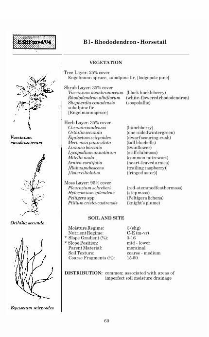
B l - Rhododendron - Horsetail
VEGETATION
Tree Layer: 25% cover Engelmann spruce, subalpine fir, [lodgepole pine]
Shrub Layer: 35% cover Vaccinium membranaceum (black huckleberry) Rhododendron albiflorum (white-flowered rhododendron) Shepherdia canadensis (soopolallie) subalpine fir [Engelmann spruce]
Herb Layer: 35% cover Cornus canadensis (bunchberry) Orthilia secunda (one-sided wintergreen) Equisetum scirpoides (dwarf scouring-rush) Mertensia paniculata (tall bluebells) Linnaea borealis (twinflower) Lycopodium annotinum (stiff clubmoss) Mitella nuda (common mitrewort) Arnica cordifolia (heart-leaved arnica) [Rubus pubescens (trailing raspberry)] [Aster ciliolatus (fringed aster)]
Moss Layer: 95% cover Pleurozium schreberi (red-stemmed feathermoss) Hylocomium splendens (step moss) Peltigera spp. (Peltigera lichens) Ptilium crista-castrensis (knight’s plume)
SOIL AND SITE
Moisture Regime: 5 (shg) Nutrient Regime: C-E (m-vr)
* Slope Gradient (%): 0-16 * Slope Position: mid - lower
Parent Material: morainal Soil Texture: coarse - medium Coarse Fragments (%): 15-50
DISTRIBUTION: common; associated with areas of imperfect soil moisture drainage
60

Bl- Rhododendron - Horsetail (ESSFmv4/04)
INTERPRETATIONS
Site limitations: - sites within this unit with thick organic horizons (> 10 cm) have reduced spring soil temperatures, which slows root development; attempt to reduce organic horizon thickness during site preparation.
Silviculture system: - clearcut (winter) or partial cut (see Section 5.1) - log on firm snowpack to protect advance regeneration. - under a partial cutting system spruce regeneration
requires mineral soil exposure and/or planting. - minimize or align large slash accumulations when
logging to help meet site preparation objectives and reduce fire hazard.
- reduce spruce beetle hazard by avoiding high stumps and shaded slash > 15 cm diameter.
Site preparation:
Species choice:
Vegetation potential:
- see Section 5.2
- Bl, Pl, Se
- high (white-flowered rhododendron, fireweed, Sitka alder)
Reforestation: - try to preserve advance regeneration if it is abundant and likely to release and form an acceptable stand.
- advance Bl regeneration should only be accepted if it meets size and acceptability criteria (Section 5.1).
- plant stock in groups, using available raised microsites, rather than evenly across the site.
- plant stock with large caliper and low shoot-to-root ratio immediately after harvest.
Concerns: - site conditions may lead to frost damage of regeneration, especially in any naturally occurring or artificially created depression; leaving a partial canopy and/or choosing a frost-resistant species (e.g., Pl) is advised.
- sites within this unit with restricted rooting and/or thick organic layers have a high windthrow hazard; block layouts must have wind-firm boundaries.
- spruce beetle may infest partial cut stands after harvesting; minimize blowdown and avoid mechanical damage to residuals.
- tomentosus root rot may cause minor problems in mature spruce-dominated stands.
61

Bl - Alder - Horsetail
VEGETATION
Tree Layer: 15% cover Engelmann spruce, subalpine fir
Shrub Layer: 15% cover Alnus crispa ssp. sinuata Salix spp. (willows) Ledum groenlandicum (Labrador tea) Lonicera involucrata (black twinberry) Ribes triste (red swamp currant) subalpine fir Engelmann spruce
Herb Layer: 85% cover
(Sitka alder)
Equisetum arvense (common horsetail) Aster ciliolatus (fringed aster) Mertensia paniculata (tall bluebells) Rubus pubescens (trailing raspberry) Senecio triangularis (arrow-leaved groundsel)
Moss Layer: 95% cover Brachythecium spp. (ragged mosses) Mnium spp. (leafy mosses) Hylocomium splendens (step moss) Drepanocladus spp. (drepanocladus mosses) Tomenthypnum nitens (golden fuzzy fen moss)
SOIL AND SITE
Moisture Regime: 6 (h) Nutrient Regime : B-D (p-r)
* Slope Gradient (%): 0-5 * Slope Position: * Parent Material: fluvial
level or depression
Soil Texture: medium - fine Coarse Fragments (%): generally low
DISTRIBUTION: uncommon and small in size
COMMENTS: based on limited data
62

Bl- Alder - Horsetail (ESSFmv4/05)
INTERPRETATIONS
Site limitations: - very difficult sites to manage; serious consideration should be given to managing these sites as wildlife corridors.
(> 10 cm) have reduced spring soil temperatures, which slows root development; reduce organic horizon thickness during site preparation.
- sites with saturated soils are poorly aerated, which slows root development; plant seedlings on naturally or artificially raised microsites.
- clearcut (winter) or partial cut (see Section 5.1)
- sites within this unit with thick organic horizons
Silviculture system:
Site preparation: - see Section 5.2 - creating an excessive number of microsites (e.g.,
>300/ha) should be avoided, especially on sites with a water table < 30 cm from the surface.
Species choice:
Vegetation potential:
Reforestation: - plant stock in groups, using available raised microsites, rather than evenly across the site.
- try to preserve advance regeneration if it is abundant and likely to release and form an acceptable stand.
- advance Bl regeneration should only be accepted if it meets size and acceptability criteria (Section 5.1).
- Bl, Se, [Pl]
- very high (white-flowered rhododendron, fireweed)
Concerns: - site conditions may lead to frost damage of regeneration, especially in any naturally occurring or artificially created depression; leaving a partial canopy and/or preserving advance regeneration are advised.
- sites within this unit with high water tables and thick organic horizons (> 10 cm) have increased windthrow hazard; block layouts must have wind- firm boundaries.
- water table will likely rise above the ground surface in the spring, causing seedling mortality.
- these units represent important wildlife habitat; discuss prescription with fish and wildlife personnel.
- this unit is critical to the control of runoff streamflow. - tomentosus root rot may cause minor problems in
mature spruce-dominated stands.
63

NOTES
64

4.3 Cariboo Wet Cold Engelmann Spruce - Subalpine Fir 9
Location
The ESSFwc3 in the guide area occurs in the Rocky Mountains above the ESSFwk2, predominantly west of the divide as far south as the Morkill River and as far north as the Ospika Arm of Williston Reservoir.
Elevation range
1300 - 1550 m
Climate
The ESSFwc3 climate is wet and cold. It is similar to the ESSFwk2 but occurs at higher elevations and is therefore colder with a more persistent snowpack.
Soils, geology and landforms
This variant lies south of the Peace River, within the Misinchinka, Hart and Park Ranges of the Rocky Mountains and the McGregor Plateau. The Misinchinka Ranges are the westernmost Rocky Mountain ranges in this subzone and have sedimentary and metamorphosed sedimentary bedrock, including sandstone, conglomerate, and phyllite. These rocks are less resistant to erosion than the limestones and quartzites of the Hart and Park Ranges to the east and southeast, resulting in more rounded summits. Soil parent materials are dominantly morainal and colluvial, with textures ranging from medium to coarse, depending on the underlying bedrock type. Brunisols and Luvisols are associated with calcareous materials (i.e., derived from limestone bedrock), while Podzols are found on non-calcareous parent materials. The McGregor Plateau is at the eastern edge of the Interior Plateau, between the offset ends of the northern and southern portions of the Rocky Mountain Trench. Bedrock types consist of sedimentary and metamorphosed sedimentary rocks of Cambrian and Precambrian age. Humo-Ferric Podzols have formed on parent materials consisting predominantly of medium-textured morainal and colluvial deposits.
Distinguishing the ESSFwc3 from adjoining biogeoclimatic units
ESSFwk2 has: • more devil's club but less Indian hellebore and Sitka valerian on mesic
and wetter sites.
Forests
Forests in the ESSFwc3 tend to be widely spaced and clumpy and are generally dominated by subalpine fir and/or Engelmann spruce.
Wildlife
High elevation rugged bedrock outcrops on warmer aspects near scrubby stands of subalpine fir and Engelmann spruce are used in winter by Mountain Goat. Moist subalpine sites are used in summer by Mountain Goat, Caribou, Moose, Wolverine, Gray Wolf, and Willow Ptarmigan. In the upper subalpine,
9
Formerly ESSFh2, and ESSFh3 above 1300 m.
65

subalpine fir stands with arboreal lichen support Caribou during the winter. Avalanche tracks are important for Grizzly Bear in the spring and are used by Mountain Goat, Caribou, Blue Grouse, Willow Ptarmigan, and White-tailed Ptarmigan.
66
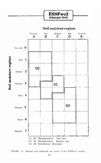
Soil nutrient regime
Very poor Poor Medium Rich Very rich
A B C D E
Very xeric 0
Xeric 1
Subxeric 2
Submesic 3
Mesic 4
Subhygric 5
Hygric 6
Subhydric 7
0 1 Bl- Rhododendron - Oak fern
0 2 Bl- Rhododendron - Queen’s cup
0 3 Bl- Globeflower - Horsetail
FIGURE 13. Edatopic grid displaying site series o f the ESSFwc3 variant.
67

Site Units 02 01 03
Trees
Abies lasiocarpa
Picea engelmannii
Rhododendron albiflorum
Vaccinium membranaceum
Vaccinium ovalifolium
Ribes lacustre
Clintonia uniflora
Rubus pedatus
Gymnocarpium dryopteris
Dryopteris expansa
Veratrum viride
Shrubs
Herbs and Dwarf Shrubs
Streptopus roseus
Valeriana sitchensis
Senecio triangularis
Cladonia spp. Barbilophozia lycopodioides
Pleurozium schreberi
Rhytidiopsis robusta
Mnium spp.
Brachythecium hylotapetum
Mosses and Lichens
Figure 14 ESSFwc3 vegetation table
subalpine fir
Engelmann spruce
white-flowered rhododendron
black huckleberry
oval-leaved blueberry
black gooseberry
queen's cup
five-leaved bramble
oak fern
spiny wood fern
Indian hellebore
rosy twistedstalk
Sitka valerian
arrow-leaved groundsel
cladonia lichens
common leafy liverwort
red-stemmed feathermoss
pipecleaner moss
leafy mosses
woodsy ragged moss
Prominence class:

la Soils generally shallow to bedrock (<35 cm thick); usually upper to crest slope postion; lichens dominate the moss layer; Gymnocarpium dryopteris (p. 293)10 or Senecio triangularis (p. 107) generally low cover (< 1% cover) or absent.
ESSFwc3/02
Soils generally deep (>35 cm thick); slope position variable; few lichens in moss layer; Gymnocarpium dryopteris or Senecio triangularis moderate to high cover (> 1% cover).
2a Seepage water generally absent during dry part of summer; Rhododendron albiflorum (p. 41) abundant (> 20% cover), Senecio triangularis generally absent.
ESSFwc3/0 1
Seepage water generally present during dry part of summer; Rhododendron albiflorum low to moderate cover (< 10%) or absent, Senecio triangularis present.
ESSFwc3/03
1b
2b
10 Page numbers refer to the publication Plants of Northern British Columbia (MacKinnon et al. 1992).
69

B l - Rhododendron - Oak fern
VEGETATION
Tree Layer: 30% subalpine fir, Engelmann spruce
Shrub Layer: 60% Rhododendron albiflorum (white-flowered rhododendron) Vaccinium membranaceum (black huckleberry) Vaccinium ovalifolium (oval-leaved blueberry) [Ribes lacustre (black gooseberry)] subalpine fir Engelmann spruce
Herb Layer: 40% Gymnocarpium dryopteris (oak fern) Veratrum viride (Indian hellebore) Valeriana sitchensis (Sitka valerian) Rubus pedatus (five-leaved bramble) Tiarella unifoliata (one-leaved foamflower) Streptopus roseus (rosy twistedstalk) Dryopteris expansa (spiny wood fern) [Arnica latifolia (mountain arnica)]
Moss Layer: 55% Mnium spp. (leafy mosses) [Pleurozium schreberi (red-stemmed feathermoss)] [Rhytidiopsis robusta (pipecleaner moss)] [Barbilophozia lycopodioides (common leafy liverwort)]
[Brachythecium spp. (ragged mosses)]
SOIL AND SITE
Moisture Regime: 3-4 (sm-m) Nutrient Regime: B-C (p-m) Slope Gradient (%): 0-60
* Slope Position:
* Soil Texture:
mid - (crest), often mid slope
medium - coarse Parent Material: morainal or colluvial
Coarse Fragments (%): 3-80
DISTRIBUTION: very common
70

B l - Rhododendron - Oak fern (ESSFwc3/01)
INTERPRETATIONS
Site limitations: - sites within this unit with thick organic horizons (> 10 cm) have reduced spring soil temperatures, slowing root development; reduce organic horizon thickness during site preparation.
Silviculture system: - partial cut (see Section 5.1) - log on firm snowpack to protect advance regeneration. - reduce spruce beetle hazard by avoiding high stumps
and shaded slash > 15 cm diameter.
- motor manual or no site preparation Site preparation:
Species choice: - Bl, Se
Vegetation potential: - high (white-flowered rhododendron. Sitka valerian) - vegetation competition not reduced during harvesting
must be addressed during site preparation.
Reforestation: - very difficult sites to regenerate; must preserve advance regeneration and some overstory trees for protection of the regeneration.
Concerns: - these sites represent important caribou habitat; discuss prescription with wildlife personnel.
- site conditions may lead to frost damage of regeneration, especially in any naturally occurring or artificially created depression; leaving a partial canopy and/or preserving advance regeneration are advised.
- trafficability will be a problem on these sites during the summer.
- heavy snowpack may cause stem deformity, especially on steep slopes; obstacle planting is advised.
- sites within this unit with restricted rooting and/or thick organic horizons, have increased windthrow hazard; block layouts must have wind-firm boundaries.
- spruce beetle may infest partial cut stands after harvesting; minimize blowdown and avoid mechanical damage to residuals.
- tomentosus root rot may cause minor problems in mature spruce-dominated stands.
71

Bl - Rhododendron - Queen’s cup
VEGETATION
Tree Layer: 20% subalpine fir, Engelmann spruce, [lodgepole pine]
Shrub Layer: 75% Rhododendron albiflorum (white-flowered rhododendron) Vaccinium membranaceum (black huckleberry) subalpine fir
Herb Layer: 10% Rubus pedatus (trailing raspberry) [Arnica latifolia (mountain arnica)] [Clintonia uniflora (queen’s cup)] [Gymnocarpium dryopteris (oak fern)]
Moss Layer: 75% Cladonia spp. (cladonia lichens) Pleurozium schreberi (red-stemmed feathermoss) Barbilophozia lycopodioides (common leafy liverwort) [Barbilophozia floerkei (mountain leafy liverwort)]
SOIL AND SITE
Moisture Regime: 1-3 (x-sm)
Slope Gradient (%):
Parent Material: colluvial or morainal
Nutrient Regime: A-B (vp-p) 0-62, often < 30 upper - crest
coarse - very coarse 15-80, usually > 50
* Slope Position:
* Soil Texture: * Coarse Fragments (%):
DISTRIBUTION: common in rocky areas and on upper slopes
COMMENTS: Shallow to bedrock (< 35 cm)
72

Bl- Rhododendron - Queen’s cup (ESSFwc3/02)
INTERPRETATIONS
Site limitations: - site and soil conditions of this unit result in marginal productivity; all attempts should be made to exclude logging from this unit.
Silvicultural system: - avoid logging
73

Bl- Globeflower - Horsetail
VEGETATION
Tree Layer: 30% Engelmann spruce, subalpine fir
Shrub Layer: 35% Vaccinium membranaceum (black huckleberry) Rhododendron albiflorum (white-flowered rhododendron) Ribes lacustre (black gooseberry) subalpine fir [Engelmann spruce]
Herb Layer: 65% Senecio triangularis (arrow-leaved groundsel) Viola spp. Valeriana sitchensis (Sitka valerian) Streptopus roseus (rosy twistedstalk) Thalictrum occidentale (western meadowrue) Veratrum viride (Indian hellebore) Trollius laxus (globeflower) Tiarella unifoliata (one-leaved foamflower) Arnica cordifolia (heart-leaved arnica) Heracleum lanatum (cow-parsnip) Mitella breweri (Brewer’s mitrewort) [Equisetum arvense (common horsetail)]
(violets)
Moss Layer: 60% Brachythecium hylotapetum (woodsy ragged moss) Mnium spp. (leafy mosses) [Marchantia polymorpha (green-tongue liverwort)]
SOIL AND SITE
Moisture Regime: 4-6 (m-h) Nutrient Regime: C-D (m-r)
* Slope Gradient (%): * Slope Position:
Parent Material: Soil Texture: medium - coarse Coarse Fragments (%): 34-60
0-67, often < 20 variable, often mid - lower morainal, colluvial or fluvial
DISTRIBUTION: common
COMMENTS: seepage water generally present
74

Bl - Globeflower - Horsetail (ESSFwc3/03)
INTERPRETATIONS
Site limitations: - site and soil conditions of this unit result in marginal productivity; all attempts should be m a d e to exclude logging from this unit.
Silviculture system: - avoid logging
75

NOTES
76

4.4 Misinchinka Wet Cool Engelmann Spruce - Subalpine Fir 11
Location
The ESSFwk2 occurs predominantly west of the Rocky Mountain divide as far south as the Morkill River and as far north as the Ospika Arm of Williston Reservoir. It occurs above the ICH at its southern boundary, and the SBS over the rest of its range. Throughout its range it occurs below the ESSFwc3.
Elevation range
950 - 1300 m
Climate
The climate of the ESSFwk2 is wetter and warmer than the ESSFmv variants (Table 8). Very high snow accumulations (3 m +) occur in this variant.
Soils, geology and landforms
This variant lies south of the Peace River, within the Misinchinka, Hart and Park ranges of the Rocky Mountains and the McGregor Plateau. The Misinchinka Ranges are the westernmost of Rocky Mountain ranges in this subzone and have sedimentary and metamorphosed sedimentary bedrock, including sandstone, conglomerate, and phyllite. These rocks are less resistant to erosion than the limestones and quartzites of the Hart and Park ranges to the east and southeast, resulting in more rounded summits. Soil parent materials are dominantly morainal and colluvial, with textures ranging from medium to coarse, depending on the underlying bedrock type. Brunisols and Luvisols are associated with calcareous materials (i.e., derived from limestone bedrock), while Podzols are found on non-calcareous parent materials. The McGregor Plateau is at the eastern edge of the Interior Plateau, between the offset ends of the northern and southern portions of the Rocky Mountain Trench. Bedrock types consist of sedimentary and metamorphosed sedimentary rocks of Cambrian and Precambrian age. Humo-Ferric Podzols have formed on parent materials consisting predominantly of medium-textured morainal and colluvial deposits.
Distinguishing the ESSFwk2 from adjoining biogeoclimatic units
SBSwk2 has: • more highbush-cranberry but no white-flowered rhododendron in the
• trembling aspen and paper birch that occur occasionally in canopy.
• less subalpine fir in the canopy; • prickly rose but no white-flowered rhododendron in shrub layer; and • more trailing raspberry but less five-leaved bramble in the herb layer,
shrub layer; and
BWBSwk1 has:
especially on mesic sites. ESSFmv2 has:
• more sites dominated by lodgepole pine; and
11 Formerly ESSFh3 below 1300 m.
77

• less oak fern and less one- and three-leaved foamflower on mesic and
wetter sites. ESSFmv4 has:
• more sites dominated by lodgepole pine; and • less sites dominated by devil's club and oak fern.
Forests
Climax forests are dominated by Engelmann spruce and subalpine fir. Very few seral stands exist in this variant because of the lack of fire history although some lodgepole pine stands do exist, especially at the southern end of the subzone. Sitka alder (Alnus crispa ssp. sinuata) swales are common, especially on north-facing slopes. These have been determined to be very old (200+ years).
Wildlife
Towards the north, upper elevation subalpine fir/Engelmann spruce forests in conjunction with alpine and subalpine are used by Mountain Goat. Extensive coniferous forests are used by Caribou during migratory periods in the spring and fall. Mature coniferous stands support Wolverine, Marten, Gray Wolf, and Red Squirrel, as well as Spruce Grouse, Great Gray Owl, Barred Owl, and Hawk Owl. Mixed age stands interspersed with openings support Moose, Gray Wolf, Grizzly Bear, Wolverine, Fisher, Blue Grouse, and Great Horned Owl.
78

Soil nutrient regime
Very poor Poor Medium Rich Very rich
A B C D E
Very xeric 0
Xeric 1
Subxeric 2
Submesic 3
Mesic 4
Subhygric 5
Hygric 6
Subhydric 7
01 Bl- Oak fern - Knight's plume 05 Bl- Rhododendron - Lady fern
02 Bl- Oak fern - Sarsaparilla 06 Bl- Horsetail - Sphagnum
03 Bl- Oak fern - Bluebells 31 Non-forested bog
04 Bl - Devil's club - Rhododendron
79 Click here to go to next page

Site units 02 01 03 04 05 06 31
Trees
Abies lasiocarpa
Picrea engelmannii
Shrubs
Rubus parviflorus
Vaccinium ovalifolium
Vaccinium membranaceum
Rhododendron albiflorum
Oplopanax horridus
Lonicera involucrata
Salix spp
Aralia nudicaulis
Clintonia uniflora
Cornus canadensis
Rubus pedatus
Gymnocarpium dryopteris
Mertensia paniculata
Dryopteris expansa
Tiarella spp.
Herbs and Dwarf Shrubs
Mosses and Lichens
Ptilium crista-castrensis
Pleurozium schreberi
Mnium spp.
Barbilophozia lycopodioides
Sphagnum spp
Figure 16. ESSFwk2 vegetation table.
subalpine fir
Engelmann spruce
black spruce
thimbleberry
oval-leaved blueberry
black huckleberry
white-flowered rhododendron
devil’s club
black twinberry
willows
wild sarsaparilla
queen’s cup
bunchberry
five-leaved bramble
oak fern
tall bluebells
spiny wood fern
foamflowers
lady fern
horsetails sedges
knight’s plume
red-stemmed feathermoss
leaf mosses
common leafy liverwort
sphagnum mosses
Prominence class:
Picea mariana
Athyrium filix-femina
Equisetum spp.
Carex spp.

ESSFwk2 Site Series Key
la Black spruce present in canopy; Carex spp. (pp. 258-274)12 moderate to high cover (> 1%): organic soils.
ESSFwk2/31
l b Black spruce absent from canopy; Carex spp. absent; soils variable.
2a Equisetum spp. (pp. 281-284) high cover (> 10%); mineral soils or organic over mineral soils.
ESSFwk2/06
2b Equisetum spp. low cover (< 3%) or absent: mineral soils.
3a Mid to upper slope or crest; Athyrium filix-femina (p. 291) or Dryopteris expansa (p. 291) low cover (< 1%) or absent.
4a Rhododendron albiflorum (p. 41) low to moderate cover (< 10%); Ribes lacustre (p. 32) cover (> 3%).
ESSFwk2/03
4b Rhododendron albiflorum high cover (> 25%); Ribes
ESSFwk2/02
Mid to toe slope or level; Athyrium filix-femina or Dryopteris expansa moderate to high cover (> 1%).
5a
lacustre low cover (< 2%) or absent.
3b
Oplopanax horridus (p. 36) high cover (usually > 10%).
ESSFwk2/05
5b Oplopanax horridus low cover (< 2%) or absent.
6a Athyrium filix-femina low cover (< 1%) or absent; seepage water generally absent.
ESSFwk2/01
Athyrium filix-femina high cover (> 10%); seepage water generally present.
ESSFwk2/04
6b
12 Page numbers refer to the publication, Plants of Northern British Columbia (MacKinnon
et al. 1992).
81

Rhododendron
albiflorum
Gymnocarpium
dryopteris
Rubus pedatus
Bl - Oak fern - Knight's plume
VEGETATION
Tree Layer: 20% cover subalpine fir, Engelmann spruce
Shrub Layer: 65% cover Rhododendron albiflorum (white-flowered rhododendron) Vaccinium membranaceum (black huckleberry) Vaccinium ovalifolium (oval-leaved blueberry) Ribes lacustre (black gooseberry) [Rubus parviflorus (thimbleberry)] subalpine fir Engelmann spruce
Herb Layer: 65% cover Gymnocarpium dryopteris (oak fern) Rubus pedatus (five-leaved bramble) Dryopteris expansa (spiny wood fern) Lycopodium annotinum (stiff clubmoss) Tiarella unifoliata (one-leaved foamflower) Streptopus roseus (rosy twistedstalk) [Veratrum viride (Indian hellebore)] [Clintonia uniflora (queen's cup)] [Cornus canadensis (bunchberry)]
Moss Layer: 75% cover Pleurozium schreberi (red-stemmed feathermoss)
Barbilophozia lycopodioides (common leafy liverwort) Ptilium crista-castrensis (knight's plume) Mnium spp. (leafy mosses) [Calliergon spp. (water mosses)]
SOIL AND SITE
Moisture Regime: 3-5 (sm-shg) Nutrient Regime: B-D (p-r) Slope Gradient (%):
* Slope Position: mid (upper) Parent Material: variable, often morainal
Soil Texture: Coarse Fragments (%): 3-48 Seepage Water: rarely present
3-69, often < 30
medium (fine - coarse)
DISTRIBUTION: extremely common and often large in size
82

Bl - Oak fern - Knight’s plume (ESSFwk2/01)
INTERPRETATIONS
Site limitations: - sites within this unit with thick organic horizons (> 10 cm) have reduced spring soil temperatures, which slows root development; reduce organic horizon thickness during site preparation.
Silviculture system: - see Section 5.1 - log on firm snowpack to protect advance regeneration. - under a partial cutting system spruce regeneration
requires mineral soil exposure and/or planting. - minimize or align large slash accumulations when
logging to help meet site preparation objectives, reduce snow creep and reduce fire hazard.
- reduce spruce beetle hazard by avoiding high stumps and shaded slash > 15 cm diameter.
Site preparation:
Species choice: - Bl, Se
Vegetation potential: - high (thimbleberry, fireweed, white-flowered
- see Section 5.2
rhododendron)
Reforestation: - try to preserve advance regeneration if it is abundant and likely to release and form an acceptable stand.
- advance Bl regeneration should only be accepted if it meets size and acceptability criteria (Section 5.1).
- plant stock with large caliper and low shoot-to-root ratio immediately after harvest.
Concerns: - site conditions may lead to frost damage of regeneration, especially in any naturally occurring or artificially created depression; leaving a partial canopy and/or preserving advance regeneration are advised.
- heavy snowpack may cause stem deformity, especially on steep slopes; obstacle planting is advised.
- if heavy equipment is used in summer, during or after partial cutting, every attempt should be made to avoid disturbing roots of standing trees.
- spruce beetle may infest partial cut stands after harvesting; minimize blowdown and avoid mechanical damage to residuals.
83

Rhododendron
albiflorum
Rubus pedatus
Ptilium crista-castrensis
Bl - Oak fern - Sarsaparilla
VEGETATION
Tree Layer: 20% cover Engelmann spruce, subalpine fir
Shrub Layer: 60% cover Rhododendron albiflorum (white-flowered rhododendron) Vaccinium membranaceum (black huckleberry) Rubus parviflorus (thimbleberry) Sorbus scopulina (western mountain-ash) [Vaccinium ovalifolium (oval-leaved b1ueberry)] subalpine fir Engelmann spruce
Herb Layer: 50% cover Cornus canadensis (bunchberry) Rubus pedatus (five-leaved bramble) Gymnocarpium dryopteris (oak fern) Lycopodium annotinum (stiff clubmoss) Clintonia uniflora (queen’s cup) Streptopus roseus (rosy twistedstalk) Aralia nudicaulis (wild sarsaparilla) [Dryopteris expansa (spiny wood fern)]
Moss Layer: 50% cover Ptilium crista-castrensis (knight’s plume) Pleurozium schreberi (red-stemmed feathermoss)
[Neckera pennatal
SOIL AND SITE
Moisture Regime: 2-3 (sx-sm) Nutrient Regime: B-C (p-m)
* Slope Gradient (%): 0-7 * Slope Position:
Parent Material: fluvial * Soil Texture: coarse
Coarse Fragments (%): 50-53
mid - upper
COMMENTS: Bedrock root-restricting layers occur occasionally
DISTRIBUTION: fairly common in upper slope positions
84

Bl - Oak fern - Sarsaparilla (ESSFwk2/02)
INTERPRETATIONS
Site limitations: - sites within this unit with high coarse fragment content (> 70%) will have significantly reduced soil moisture holding capacity and will be extremely difficult to plant; retain advance regeneration.
Silviculture system: - clearcut or partial cut (see Section 5.1) - log on firm snowpack to protect advance regeneration. - under a partial cutting system spruce regeneration
requires mineral soil exposure and/or planting. - minimize or align large slash accumulations when
logging to help meet site preparation objectives and reduce snow creep and fire hazard.
Site preparation:
Species choice: - Bl, Se
Vegetation potential: - low to moderate (white-flowered rhododendron,
- see Section 5.2
fireweed, thimbleberry)
Reforestation: - try to preserve advance regeneration if it is abundant and likely to release and form an acceptable stand.
- advance Bl regeneration should only be accepted if it meets size and acceptability criteria (Section 5.1).
- planting Pl may be an option on these sites below 1100 m, but provenances from high elevation, high snowpack areas must be used.
Concerns: - trafficability may be a problem on these sites during the summer.
85

Ribes lacustre
Rubus parviflorus
Gymnocarpium
dryopteris
Bl - Oak fern - Bluebells
VEGETATION
Tree Layer: 30% cover Engelmann spruce, subalpine fir
Shrub Layer: 70% cover Ribes lacustre (black gooseberry) Rubus parviflorus (thimbleberry) Vaccinium membranaceum (black huckleberry) Rhododendron albiflorum (white-flowered rhododendron) Ribes glandulosum (skunk currant) Rubus idaeus (red raspberry) Lonicera involucrata (black twinberry) [Spiraea betulifolia (birch-leaved spirea)] subalpine fir Engelmann spruce
Herb Layer: 45% cover Gymnocarpium dryopteris (oak fern) Cornus canadensis (bunchberry) Arnica cordifolia (heart-leaved arnica) Lycopodium annotinum (stiff clubmoss) Rubus pedatus (five-leaved bramble) Streptopus amplexifolius (clasping twistedstalk) Athyrium filix-femina (lady fern) Tiarella trifoliata (three-leaved foamflower) Mertensia paniculata (tall bluebells) Epilobium angustifolium (fireweed)
Moss Layer: 70% cover Ptilium crista-castrensis (knight’s plume) Pleurozium schreberi (red-stemmed feathermoss) Neckera pennata Brachythecium hylotapetum (woodsy ragged moss)
SOIL AND SITE
Moisture Regime: 4-5 (m-shg) Nutrient Regime : C-D (m-r)
* Slope Position: mid (upper) * Parent Material: morainal * Soil Texture:
Coarse Fragments (%): 15-47
Slope Gradient (%): 18-78
medium - coarse
DISTRIBUTION: common on the lee side of the Rocky Mountains
86

Bl- Oak fern - Bluebells (ESSFwk2/03)
INTERPRETATIONS
Site limitations: - sites within this unit with thick organic horizons (> 10 cm) have reduced spring soil temperatures, which slows root development: reduce organic horizon thickness during site preparation.
Silviculture system: - clearcut or partial cut (see Section 5.1) - log on firm snowpack to protect advance regeneration. - under a partial cutting system spruce regeneration
requires mineral soil exposure and/or planting. - minimize or align large slash accumulations when
logging to help meet site preparation objectives, reduce snow creep and reduce fire hazard.
- reduce spruce beetle hazard by avoiding high stumps and shaded slash > 15 cm diameter.
Site preparation:
Species choice:
Vegetation potential: - high (thimbleberry, fireweed, white-flowered
- see Section 5.2
- Bl, Se, (Pl)
rhododendron. lady fern)
Reforestation: - try to preserve advance regeneration if it is abundant and likely to release and form an acceptable stand.
- advance Bl regeneration should only be accepted if it meets size and acceptability criteria (Section 5.1).
- planting Pl may be an option on these sites below 1100 m, but provenances from high elevation, high snowpack areas must be used.
Concerns: - site conditions may lead to frost damage of regeneration, especially in any naturally occurring or artificially created depression; leaving a partial canopy and/or preserving advance regeneration are advised.
- sites within this unit with fine-textured soils are vulnerable to compaction under wet conditions; restrict traffic to winter operations.
- heavy snowpack may cause stem deformity, especially on steep slopes; obstacle planting is advised.
- spruce beetle may infest partial cut stands after harvesting; minimize blowdown and avoid mechanical damage to residuals.
- tomentosus root rot may cause low to moderate problems in mature spruce-dominated stands.
87

Oplopanax horridus
Dryopteris expansa
Rubus pedatus
Bl - Devil’s club - Rhododendron
VEGETATION
Tree Layer: 25% cover Engelmann spruce, subalpine fir
Shrub Layer: 85% cover Oplopanax horridus (devil’s club) Alnus crispa spp. sinuata (Sitka alder) Rhododendron albiflorum (white-flowered rhododendron) Vaccinium membranaceum (black huckleberry) Vaccinium ovalifolium (oval-leaved blueberry) subalpine fir Engelmann spruce
Herb Layer: 70% cover Dryopteris expansa (spiny wood fern) Gymnocarpium dryopteris (oak fern) Rubus pedatus (five-leaved bramble) Tiarella unifoliata (one-leaved foamflower) Veratrum viride (Indian hellebore)
Moss Layer: 50% cover Calliergon spp. (water mosses)
Ptilium crista-castrensis (knight’s plume) Barbilophozia lycopodioides (common leafy liverwort) Pleurozium schreberi (red-stemmed feathermoss)
SOIL AND SITE
Moisture Regime: 5-6 (shg-h) Nutrient Regime : B-C (p-m)
Slope Position: lower - toe
lacustrine medium - fine
* Slope Gradient (%): 30-40
* Parent Material: morainal, occasionally
* Soil Texture: Coarse Fragments (%): 16-24 Seepage Water: generally absent
DISTRIBUTION: fairly common; associated with areas of imperfect soil moisture drainage
COMMENTS: occasionally associated with compact till
88

Bl- Devil’s club - Rhododendron (ESSFwk2/04)
INTERPRETATIONS
Site limitations: - sites within this unit with thick organic horizons (> 10 cm) have reduced spring soil temperatures, which slows root development; reduce organic horizon thickness during site preparation.
- sites within this unit with medium- to fine-textured lacustrine soils often have poor soil structure, leading to poor root growth; plant stock which will achieve better lateral root development (e.g., Cu-treated) or protect advance regeneration.
Silviculture system: - clearcut (winter) or partial cut (see Section 5.1) - log on firm snowpack to protect advance regeneration. - under a partial cutting system spruce regeneration
requires mineral soil exposure and/or planting. - minimize or align large slash accumulations when
logging to help meet site preparation objectives, reduce snow creep and reduce fire hazard.
- reduce spruce beetle hazard by avoiding high stumps and shaded slash > 15 cm diameter.
Site preparation:
Species choice: - Bl, Se
Brush hazard:
- see Section 5.2
- very high (lady fern, white-flowered rhododendron, thimbleberry, fireweed)
Reforestation: - try to preserve advance regeneration if it is abundant and likely to release and form an acceptable stand.
- advance Bl regeneration should only be accepted if it meets size and acceptability criteria (Section 5.1).
- plant stock with large caliper and low shoot-to-root ratio immediately after harvest.
Concerns: - site conditions may lead to frost damage of regeneration, especially in any naturally occurring or artificially created depression; leaving a partial canopy and/or preserving advance regeneration are advised.
- sites with restricted rooting and/or thick organic horizons have increased windthrow hazard; block layouts must have wind-firm boundaries.
- spruce beetle may infest partial cut stands after harvesting; minimize blowdown and avoid mechanical damage to residuals.
- tomentosus root rot may cause low to moderate problems in mature spruce-dominated stands.
89

Oplopanax horridus
Dryopteris expansa
Gymnocarpium
dryopteris
Bl- Rhododendron - Lady fern
VEGETATION
Tree Layer: 15% cover Engelmann spruce, subalpine fir
Shrub Layer: 60% cover Vaccinium membranaceum (black huckleberry) Rhododendron albiflorum (white-flowered rhododendron) Rubus parviflorus (thimbleberry) Sambucus racemosa (red elderberry) subalpine fir Engelmann spruce
Herb Layer: 70% cover Athyrium filix-femina (lady fern) Dryopteris expansa (spiny wood fern) Gymnocarpium dryopteris (oak fern) Veratrum viride (Indian hellebore) Valeriana sitchensis (Sitka valerian) Rubus pedatus (five-leaved bramble) Tiarella unifoliata (one-leaved foamflower)
Moss Layer: 90% cover Mnium spp. (leafy mosses) Pleurozium schreberi (red-stemmed feathermoss)
SOIL AND SITE
Moisture Regime: 5 (shg) Nutrient Regime: C-E (m-vr)
Slope Position: variable Parent Material:
Soil Texture: Coarse Fragments (%): 5-55
* Slope Gradient (%): 0-18
morainal, occasionally fluvial or lacustrine medium (fine - coarse)
* Seepage Water: generally present
COMMENTS: A variable but distinctive site series; apparently possesses a considerably richer nutrient regime than the ESSFwk2/04
DISTRIBUTION: common and often large in size
90

Bl- Rhododendron - Lady fern (ESSFwk2/05)
INTERPRETATIONS
Site limitations: - sites within this unit with thick organic horizons (> 10 cm) have reduced spring soil temperatures, which slows root development; reduce organic horizon thickness during site prepamtion.
- sites within this unit with medium- to fine-textured
to poor root growth; plant stock which will achieve better lateral root development (e.g., Cu-treated) or protect advance regeneration.
lacustrine soils often have poor soil structure, leading
Silviculture system: - clearcut (winter) or partial cut (see Section 5.1) - log on firm snowpack to protect advance regeneration. - under a partial cutting system spruce regeneration
requires mineral soil exposure and/or planting. - minimize or align large slash accumulations when
logging to help meet site preparation objectives and reduce snow creep and fire hazard.
- reduce spruce beetle hazard by avoiding high stumps and shaded slash > 15 cm diameter.
Site preparation:
Species choice: - Bl, Se
Vegetation potential:
- see Section 5.2
- very high (lady fern, white-flowered rhododendron, fireweed, thimbleberry)
Reforestation: - try to preserve advance regeneration if it is abundant and likely to release and form an acceptable stand.
- advance Bl regeneration should only be accepted if it meets size and acceptability criteria (Section 5.1).
- plant stock with large caliper and low shoot-to-root ratio immediately after harvest.
Concerns: - site conditions may lead to frost damage of regeneration, especially in any naturally occurring or artificially created depression; leaving a partial canopy and/or preserving advance regeneration are advised.
- heavy snowpack may cause stem deformity, especially on steep slopes; obstacle planting is advised.
- spruce beetle may infest partial cut stands after harvesting; minimize blowdown and avoid mechanical damage to residuals.
- trafficability will be a problem on these sites during the summer.
91

Rhododendron
albiflorum
Equisetum arvense
Barbilophozia
lycopodioides
Bl - Horsetail - Sphagnum
VEGETATION
Tree Layer: 30% cover subalpine fir, Engelmann spruce
Shrub Layer: 75% cover Rhododendron albiflorum (white-flowered rhododendron) Vaccinium membranaceum (black huckleberry) Alnus crispa ssp. sinuata Lonicera involucrata (black twinberry) [Ribes lacustre (black gooseberry)] subalpine fir Engelmann spruce
Herb Layer: 75% cover
(Sitka alder)
Equisetum spp. (horsetails) Gymnocarpium dryopteris (oak fern) Rubus pedatus (five-leaved bramble) Tiarella unifoliata (one-leaved foamflower) Lycopodium annotinum (stiff clubmoss) Dryopteris expansa (spiny wood fern) [Valeriana sitchensis (Sitka valerian)]
Moss Layer: 90% cover Barbilophozia lycopodioides (common leafy liverwort) Pleurozium schreberi (red-stemmed feathermoss) Calliergon spp. (water mosses)
Ptilium crista-castrensis (knight’s plume) Sphagnum spp. (sphagnums)
SOIL AND SITE
Moisture Regime: 6 (h) Nutrient Regime: C-D (m-r) Slope Gradient (%): 5-30
* Slope Position: * Parent Material: lacustrine * Soil Texture: fine
Coarse Fragments (%): 0
lower, toe or level
DISTRIBUTION: uncommon and small in size
92

Bl- Horsetail - Sphagnum (ESSFwk2/06)
INTERPRETATIONS
Site limitations: - very difficult sites to manage; serious consideration should be given to managing these sites as wildlife corridors.
(> 10 cm) have reduced spring soil temperatures, which slows root development; reduce organic horizon thickness during site preparation.
- sites within this unit with saturated soils are poorly aerated, which slows root development; plant seedlings on naturally or artificially raised microsites.
- sites within this unit with thick organic horizons
Silviculture system: - clearcut (winter) or partial cut (see Section 5.1) - log on firm snowpack to protect advance regeneration. - under a partial cutting system spruce regeneration
requires mineral soil exposure and/or planting.
Site preparation: - see Section 5.2 - creating an excessive number of microsites (e.g.,
>300/ha) should be avoided, especially on sites with a water table < 30 cm from the surface.
Species choice: - Bl, Se
Vegetation potential: - high (white-flowered rhododendron, fireweed, Sitka valerian)
Reforestation: - plant stock in groups, using available raised microsites, rather than evenly across the site.
- try to preserve advance regeneration if it is abundant and likely to release and form an acceptable stand.
- advance Bl regeneration should only be accepted if it meets size and acceptability criteria (Section 5.1).
Concerns: - sites with high water tables and thick organic horizons ( > 10 cm) have increased windthrow hazard; block layouts must have wind-firm boundaries.
- site conditions may lead to frost damage of regeneration, especially in any naturally occurring or artificially created depression; leaving a partial canopy and/or preserving advance regeneration are advised.
- water table will likely rise above the ground surface in the spring, causing seedling mortality.
- this unit is critical to the control of runoff streamflow. - these units are important wildlife habitat; discuss prescription with fish and wildlife personnel.
93

Salix spp.
Carex spp.
Sphagnum spp.
Non-forested Bog
VEGETATION
Tree Layer: 10% cover Black spruce, subalpine fir, lodgepole pine, Engelmann spruce
Shrub Layer: 15% cover [Salix spp. (willows)] [Betula glandulosa (scrub birch)] black spruce
Herb Layer: 60% cover [Kalmia microphylla ssp. microphylla (alpine bog-1aurel)]
[Carex spp. (sedges)]
Sphagnum spp. (sphagnums) [Aulacomnium palustre (glow moss)]
Moss Layer: 95% cover
SOIL AND SITE
Moisture Regime: 6-7 (h-shd)
Nutrient Regime: A-B (vp-p) Slope Gradient (%): 0-2, usually 0
* Slope Position: toe-level * Parent Material: organic
* Coarse Fragments (%): 0 * Seepage Water:
Soil Texture: humic (organic material)
present, often at or near surface
DISTRIBUTION: uncommon
94

Non-forested Bog (ESSFwk2/31)
INTERPRETATIONS
Site limitations: - the combination of very poor productivity and high wildlife value means that these sites should be protected from harvesting.
Silvicultural System: - avoid logging
95

5 INDIRECT AND GENERAL INTERPRETATIONS
This section contains general interpretations for identification of silvicultural systems options (Section 5.1), indirect interpretive keys for site preparation (Section 5.2), and important site unit - wildlife habitat relationships (Section 5.3).
5.1 Silvicultural Systems Interpretations
This section is designed to assist the field guide user in the development of site- and stand-specific prescriptions for silvicultural systems that are compatible with stand management objectives. For the users of this section, a sound background knowledge of soils, tree silvics, stand development, and harvesting systems is assumed. This section is not intended as a substitute for adequate education, field experience, professional supervision, or training. This section should not be considered as a "cookbook" of recommended prescriptions.
The choice and execution of a silvicultural system in any given forest type must consider many site-specific and operational factors. The decision must be customized to the site type, stand structure, health, and vigour of the stand, and often unique combinations of local forest management objectives. For this reason, the decision cannot be reduced to simplistic duplication of standard, textbook techniques (Weetman et al. 1990). Smith (1986) has pointed out that "a rational silvicultural system for a particular stand should fit logically into the overall management plan for the forest of which the stand is a part. Second, it should represent the best possible amalgam of attempts to satisfy all ... basic forest management objectives." A silvicultural prescription developed for any stand should consider and integrate eight basic site-specific objectives (adapted from Cole 1985 and Smith 1986):
• development of stand conditions necessary for meeting stand-level integrated resource management goals over the longest possible time;
• provision for regeneration:
• enough control over competing vegetation to allow establishment of adequate numbers of trees growing at acceptable rates;
• development or maintenance of stand structures, species compositions, and stand conditions that minimize damage from pests, wind, and fire;
• effective use of growing space, and maintenance or improvement of existing stand and site productivity;
• compatibility with acceptable logging practices, so that future stands can be cultured and harvested:
• efficient use of resources and arrangement of operations; and
• provision for periodic monitoring and assessment of long-term silvicultural performance.
96

5.1.1 General terminology
Definitions of some key terms are essential for an understanding of silvicultural systems. A reproduction method is defined as any procedure (intentional or otherwise) that leads to the establishment of vigorous regeneration and growth of a new stand of trees (Smith 1986; Daniel et al. 1979). Reproduction methods can include the partial or complete removal of the old stand, establishment of the new one, and any treatments applied to create and maintain its early growth. Reproduction methods are broadly categorized by the pattern of cutting and the type of stand created. These include even-aged methods (clearcutting, seed-tree, or shelterwood) or uneven-aged (selection) methods (Smith 1986). The term silvicultural system is more comprehensive, however, and includes a planned program of silvicultural treatment throughout the life of a forest stand. This can include one or a series of reproduction cuttings, and any intermediate cuttings or other stand treatments. Figure 17 describes schematically the major types of silvicultural systems. Tables 10 and 11 are useful comparisons of silviculture systems.
Stand structure is defined, for the purposes of these interpretations, as the vertical arrangement and stocking of trees within individual crown classes (canopy layers) in a stand. Natural stand structure (referred to in Section 5.1.3, Step 5) describes the structure of an existing stand irrespective of any management interpretations. Effective stand structure (as referred to in Section 5.1.3, Step 5) is an interpretation of the natural stand structure. Determination of effective stand structure focuses only on trees within the stand that meet physical acceptability criteria for given management objectives (see Section 5.1.4). Effective stand structure may or may not be equivalent to the natural stand structure. It will depend on the unique distribution of acceptable and unacceptable trees within an individual stand. Therefore, identification of silvicultural system options for a given stand, site, and management objective is based on effective stand structure and not the existing natural stand structure.
Partial cutting is a generic term that includes certain even-aged and uneven-aged reproduction methods. These methods involve the partial or complete post-harvest retention of specific crown classes or species from the original stand (seed-tree, shelterwood. and selection). Partial cutting is used to refer to both present and historical harvesting methods that are not clearcutting (DeLong 1991). A partial cutting method, however, is not a reproduction method if it does not result in an adequately regenerated and stocked site. Like any reproduction method, a successful partial cutting treatment is only one element of a larger silvicultural system. For example, a partial cut designed to develop an uneven-aged stand is selection cutting only if subsequent operations are consistent with the original objective and result in the eventual development of the desired multi-layered stand.
It must also be stressed that the term selective logging should not be used in, or associated with, partial cutting prescriptions of any kind. Selective logging has no legitimate silvicultural meaning. To professional foresters and many others, this term is associated with uncontrolled logging practices in the past that high-graded many stands of their most valuable and highest-quality trees (Figure 18) (Weetman et al. 1990).
97

TABLE 10. Comparison of objectives of silvicultural system prescriptions
Silvicultural Goals of Prescription
Method Eventual Gap Width Establishment Release of Sanitation Quality Residual Maintain
Approximated
Produced Regeneration Regeneration Unacceptable on Large Objective Q-value,
< 12.5 cm dbh Trees Stems > 12.5 Max dbh
cm dbh
Balanced Uneven-aged <1/2 H1 max. Yes Yes Yes Yes Yes Yes Single-tree Selection
Small-group Selection Uneven-aged 2 H max. Yes Yes Yes, within Yes R2 R
groups
Selection with
Reserves
Uniform Shelterwood Even-aged < 1/2 H max. Yes (Possible) Yes Yes Desirable --3
Shelterwood openings
One-cut (Natural) Even-aged to Minimal Fill-planting of Yes Yes
Overstory Removal
Shelterwood with
Reserves
Uneven-aged Similar to above selection options, but with long-term retention of appropriate stand components through one or more cutting cycles for biodiversity and integrated resource management objectives.
Group or Strip Even-aged 2 H max. Yes (Possible) Yes, within R R
Shelterwood or Multi-aged gaps
Two-aged Similar to above shelterwood options, but with long-term retention of appropriate stand components through one or more rotations for biodiversity and integrated-resource management objectives.
--
-- -- --
Stand Form Created of New Advanced Removal of Increment Basal Area Specified

TABLE 10. (Continued)
Silvicultural Goals of Prescription
Method Eventual Gap Width Establishment Release of Sanitation Quality Residual Maintain
Approximated Stand Form Created of New Advanced Removal of Increment Basal Area Specified
Max dbh
Produced Regeneration Regeneration Unacceptable on Large Objective Q-value
< 12.5 cm dbh Trees Stems > 12.5
cm dbh
Clearcut Even-aged Variable, Planted or (Minor) Yes
Clearcut with Reserves Even-aged
> 100 m natural
Similar to clearcut option but with long-term retention of appropriate stand components through one or more rotations for biodiversity and integrated resource management objectives. with veterans
1 H = Canopy height 2 R
3 - - = Minimal concern or not applicable
= Regulation of cut by percentage of total stand area harvested per stand entry. For group selection, < 33% of the stand area is harvested per stand entry. For group or strip shelterwood, > 33% of the stand area is harvested per stand entry.
-- -- --

TABLE 11. Comparison of residual stand structures retained after initial partial cutting stand entry
Crown Classes Retained (1st Cut)
Reproduction Method Eventual Stand Gap Width C1 C2 C3 C4 Approximated Form Produced Created Overstory Intermediate Understory Seedling
Balanced Single-tree Uneven-aged <l/2 H 1 max. P 2 P P P
Small-group Selection Uneven-aged 2 H max. P P P C 3
Selection
Selection with Reserves Uneven-aged Similar to above options, but with planned long-term retention of appropriate stand components through one or more cutting cycles for biodiversity and integrated resource management objectives.
Uniform Shelterwood Even-aged < 1/2 H P T 4 T T
Group or Strip Even-aged 2 H max (Cut and leave patches are spatially separated) Shelterwood
One-cut (Natural) Shelterwood / Even-aged Minimal T T (P) C Overstory Removal
Shelterwood with Reserves Two-aged Similar to above options, but with planned long-term retention of appropriate stand components through one or more rotations for biodiversity and integrated-resource management objectives.
Clearcut Even-aged > 100m T T T T
Clearcut with Reserves Even-aged with veterans
Similar to above options but with planned long-term retention of appropriate stand component for biodiversity and integrated resource management objectives.
1 H = Canopy height 2 P = Partial Retention (25-75%) 3 C = Complete Retention (76-100%) 4 T = Total Removal (0% retention)

Even-aged systems
• clearcut systems
• seed-tree systems
• shelterwood systems
Uneven-aged systems
• selection systems
FIGURE 17. The major types of silvicultural systems.
5.1.2 Descriptions of reproduction methods
The ultimate distinction between reproduction methods is the form of forest produced. The size, shape, and position of the areas cut over, as well as the proportion of the timber removed, determine the arrangement of age classes within the stand. In a managed forest, each reproduction method is the chief factor governing forest form and, when systematically applied, produces a characteristic stand structure (Smith 1986).
The primary objective of all reproduction methods is the regeneration and perpetuation of a forest stand. Reproduction methods that use timber harvesting normally have wood production as one of their important
101

objectives. Stands may also be managed partially or exclusively for the provision of other non-timber resources. These include habitat for many faunal and floral species, landscape diversity, protection of water quality, scenic values, recreation, and spiritual values. Forests managed only for wood production do not necessarily contain characteristics that support other uses. Where it is decided that specified non-timber forest values should be integrated with conventional timber management, determinations must be made whether integrated management objectives can be best achieved at the stand or landscape level. It is not always practical, and may not be possible, to manage for all forest values within single stands. Similarly, it is unlikely that one silvicultural system, applied everywhere across the landscape, will achieve the diversity of forest values that is often desired.
Selective logging
or diameter-limit
logging
Selection
system
FIGURE 18. Schematic comparing selective logging to a true selection system.
102

Where specific combinations of forest resource values are to be integrated in the management of a single stand, the specific stand characteristics and components important to each resource value (e.g., large dominant trees of a certain species, understory cover, or coarse woody debris) must be identified in the prescription. For example, cavity- nesting birds such as woodpeckers may require a certain number of large decayed trees to be maintained in the stand, or some ungulates may require winter range areas that have stands containing large, arboreal lichen-bearing, standing live and dead trees. In many cases, specified stand characteristics can be incorporated within certain conventional silvicultural systems with, perhaps, long-term retention of certain live or dead trees for several rotations or cutting cycles. Specialized prescriptions in sensitive areas should be developed in consultation with appropriate agencies and organizations.
The success or failure of any silvicultural prescription should be evaluated by regular stand monitoring and by comparison to similar prescriptions carried out on similar site types located nearby. Long-term assessment carried out in this way will provide the feedback necessary to incorporate long-term results into future prescriptions.
5.1.2.1 Clearcutting methods
Background: The clearcutting method, like the seed-tree and shelterwood method, is a form of even-aged stand management. Clearcutting methods involve the complete removal of the entire stand in one cutting. Regeneration is obtained by planting, or by natural seeding from adjacent stands and cones shed from trees cut in the logging operation (Smith 1986). In concept, clearcutting is the simplest way of harvesting and replacing mature stands. It can mimic some of the conditions created by catastrophic disturbances. These conditions are responsible for regenerating certain species, particularly shade- intolerant and exposure-tolerant species. In some instances, catastrophic or rapidly deteriorating conditions in natural stands caused by insect epidemic, root disease, fire, or very heavy incidence of rots or dwarf mistletoes will dictate the use of clearcutting.
Open area dominates and edge situations are minimal in a clearcut (Daniel et al. 1979). Clearcutting as a technical term should not be used to refer to heavy overstory removal cuttings that release new stands already established beneath them as advanced growth. These types of cuttings are more appropriately referred to as one-cut (natural) shelterwoods and/or shelterwood overstory removals. The distinction is particularly important where site exposure after true clearcutting would greatly inhibit establishment of new seedlings. On such sites, preservation of pre-established advanced growth can be a distinct silvicultural advantage.
Silvicultural Objectives: Regeneration after clearcutting can be achieved by natural regeneration, planting, or a combination of both. Under appropriate conditions, natural regeneration of conifers can occur by seeding from the stand edges adjacent to clearcuts, or, in the case of lodgepole pine, by lopping and scattering of serotinous cones during harvest operations. The clearcut system can have a number of advantages. Clearcutting is an efficient means of harvesting timber and
103

completely clearing the site for (possible) intensive site preparation and planting of nursery-grown seedlings. Planting and even-aged plantation management can allow better control over a stand's species and genetic composition than natural regeneration. Plantations can potentially allow establishment ofmore uniform and evenly stocked stands, provide prompt occupation of the site by trees where competing vegetation is a problem, and reduce natural regeneration delays. The disadvantages of clearcutting with planting include: high planting costs; risks of plantation failure; long-term costs of plantation maintenance (brushing, weeding, and thinning); and possible reduction of stand-level biodiversity in the absence of natural regeneration or retention of larger residual trees and organic debris.
Clearcutting methods are the simplest silvicultural systems to plan and harvest. By definition, clearcuts remove all of the original stand and advanced regeneration is not specifically protected. Typically, site series, soil type, and terrain are the only determinants of logging method, desired species, stocking standards, and site preparation method. However, in extreme environments such as high-elevation sites, frost pockets, heavy snow zones, brush-prone areas, or areas with high sensitivity to mass wasting, the silvicultural benefits and costs of clearcutting systems should be assessed carefully. Because of undesirable aesthetic impacts, clearcutting should be used with discretion and in conjunction with careful planning in high-use recreational areas and highway scenic corridors. In particular, cutblock size, shape, and orientation may need to be modified to mitigate impacts.
Refer to Tables 10 and 11 to compare clearcutting systems with other silvicultural systems.
5.1.2.2 Shelterwood methods
Background: Shelterwood methods are even-aged management techniques in which a stand of timber is gradually removed in a series of cuts. These cuts extend over a relatively short portion of the rotation and are intended to facilitate understory regeneration and development. Regeneration is established by natural seedfall or supplemented by under-planting, and growth occurs under the overhead or lateral shelter of an existing overstory. Preparatory shelterwood cuttings may be uniformly dispersed throughout the stand (uniform shelterwood), or they may take place as a series of edge cuttings in patches or strips that are less than two tree heights wide (group or strip shelterwood). A portion of the stand in a group shelterwood may be reserved until later in the rotation creating a series of small, even-aged patches (Figure 19). In stands where an understory of acceptable natural regeneration already exists, one-cut shelterwoods, which completely remove overstory trees while protecting existing regeneration, are an option if the regeneration is tolerant of sudden exposure. Although the classical intent of a shelterwood is to eventually remove all of the overstory, modern variations may call for retention of part of the overstory in order to meet wildlife, biodiversity, aesthetic, or increment objectives.
Silviculture Objectives: For a preparatory shelterwood cut, leave at least 50% of the main tree canopy (C1 crown class) intact (75-200 stems
104

per hectare (sph) or 10-30 m 2 /ha basal area). This will help maintain windfirmness, provide protection to young advanced regeneration and new seedlings, and reduce understory vegetation competition. The trees will also serve for a number of years as an ongoing seed supply for natural regeneration. Many of the most thrifty and windfirm trees and tree groups are retained (Figure 20). Species and genotype of resulting regeneration under the shelterwood can be influenced by selection of shelterwood leave-trees of desirable species and form. Identified overstory leave-trees must be marked-to-leave on all four sides of the tree with conspicuous blue paint. Shelterwood preparatory cuts involve one or several overstory partial harvests. These are designed to gradually open up the canopy, simulate regeneration establishment and vigour, and create the desired stand structure in preparation for final overstory removal and regeneration release. This process will generally be completed 5-25 years after the first cut. Careful seedbed scarification (mineral soil exposure) is necessary for Se regeneration establishment, and desirable for prompt establishment of Bl. Conventional ground- based skidding or feller-bunchers can be used in winter for Se and Bl.
Can be used when:
• selected stems of mature trees are left
• these mature trees are not removed after
standing over the regeneration
normal time periods
FIGURE 19. Application of reserves within a silvicultural system.
105

It must be ensured that root systems of leave-trees are not disturbed. In some natural stands and old partial cuts, past light disturbances or other favourable conditions have stimulated the establishment of a vigorous, well-stocked advanced regeneration layer. In such stands, preparatory cuts may be unnecessary, and one-cut (natural) shelterwoods with complete overstory removal may be feasible. Careful pre-harvest skid trail layout, appropriate logging machinery (i.e., small tracked skidders), skilled operators, and intensive supervision are all important factors for ensuring the protection of existing regeneration. Post-harvest sanitation thinning will be necessary to remove badly scarred and broken stems of advanced regeneration, especially those of subalpine fir.
Refer to Tables 10 and 11 to compare shelterwood systems with other silvicultural systems.
Focus for leave-tree selection
• larger dominant trees
• wind firm
• desirable species
• desirable physical characteristics
• capable of good seed production
FIGURE 20. Criteria for leave tree selection in seed-tree and shelterwood systems.
106

5.1.2.3 Selection methods
Background: Selection methods refer to a series of planned treatments and partial harvests designed to create or maintain managed, uneven- aged stands. An uneven-aged stand contains at least three well-defined, intermingled age classes (not just size classes). In single-tree selection, the management unit of interest is the individual tree, or very small clumps of trees less than one-half of canopy tree height in width. Group selection involves the management of discrete even-aged groups of trees. Under the group selection system, even-aged aggregations of trees in the stand are small by definition and have a width less than twice the height of the tallest trees. A single-tree selection system prescription must include regulation of cut by basal area and diameter distribution (q-value). 13 Post-harvest maximum residual diameter of trees to be left should also be specified. Pre-harvest marking of trees to cut is strongly recommended as the means to achieve desired stand objectives. Group selection prescriptions include regulation of cut by the percentage of area harvested per stand entry. This is usually < 33%. The location of selected groups and access skid trails should be determined prior to harvest, and should be designed to accomodate future volume removals. Regeneration is continuous from natural seedfall and may be supplemented by under-planting. Continuous forest cover is maintained. Variations upon the selection system can be complex and numerous. Further discussion can be found in Smith (1986), Daniel et al. (1979), Matthews 1989), or the Silviculture Interpretations Working Group (1992).
Silviculture Objectives: Leave as complete a distribution of age and size classes as possible while improving stand vigour and quality (Figure 21). A residual basal area of at least 20 to 25 m 2 /ha and 50% of the pre-harvest stand basal area must be protected and retained during harvest. Maximum residual diameter and diameter distribution (specified q-value) of stems in each diameter class must be determined for the PHSP and approximated operationally. The cutting cycle, or period of years between selection harvests, should be specified. A detailed inventory of all tree size classes, vigour, and pathological condition should be conducted (as per section 5.1.4). This assists in determining stand suitability and planning tree marking. Trees to be harvested should be marked-to-cut with conspicuous red paint on all sides of the tree or, conversely, acceptable trees marked-to-leave with blue paint.
As with shelterwood systems, important factors for achieving a successful selection stand entry are: careful and knowledgeable skid road and landing layout; appropriate logging machinery (i.e., small tracked skidders); skilled operators; and rigourous harvest supervision. Winter logging on a compressible snowpack of 1 m is recommended to protect small advanced regeneration from damage during stand entries. Post-harvest seedbed preparation may be necessary to create mineral soil seedbeds for Se. Post-harvest sanitation thinning will be necessary to remove badly scarred and broken residual stems, especially those of subalpine fir.
13 Fractional increase in number of trees per hectare in a given diameter class over the number in the next higher diameter class.
107

Refer to Tables 10 and 11 to compare selection systems with other silvicultural systems.
Single-Tree Selection System
• the ideal balanced structural goal
FIGURE 21. Ideal diameter distribution under a single-tree selection system.
5.1.3 Steps for choosing an appropriate silvicultural system
The choice of an appropriate silvicultural system for a stand and site is complex and site-specific. For example, Tables 13 and 14 detail the requirements for implementing selection and non-selection silvicultural systems in Mountain Caribou habitat. The following materials are provided as decision aids. Careful examination of site characteristics and the existing stand will identify one or several ecologically suitable silvicultural system options. The final choice of a silvicultural system from these available options must be the best possible compromise of short- and long-term silvicultural objectives, technical (harvesting) feasibility, economic criteria, visual quality objectives (VQO's). and stand- and landscape-level biodiversity goals.
In the preparation of the silviculture prescription for an area, the following 7-step procedure should be followed:
108

Step 1
Identify and establish priorities for short-term and long-term stand-level and landscape-level management objectives and constraints. Be specific. Translate objectives into general stand structure goals.
Step 2
Based on aerial photos and a thorough field reconnaissance of the stand and site, stratify the area into relatively homogeneous units (see Section 3.6). This is important, because attempts to combine information from markedly different strata will result in errors in interpretation over the entire area.
Step 3
All site, soil, and vegetation information for the strata should be collected as described in Section 3.4 and Section 4 of this field guide. In particular, map out blowdown-prone sites with high water tables or root-restricting soil layers.
Step 4
Collect detailed stand information as described in Section 5.1.4 in conjunction, if desired, with standard timber-cruising activities.
Step 5
Using the stand structure key (Figure 22) identify the natural stand structure (refer to Section 5.1.1) of the existing stand based on total basal area of the C1 (overstory) and C2 (intermediate) crown classes, and total stems per hectare of the C3 (understory) and C4 (seedling) crown classes. Again using the key (Figure identify the effective stand structure based on acceptable basal area of the C1 (overstory) and C2 (intermediate) crown classes, and acceptable stems per hectare of the C3 (understory) and C4 (seedling) crown classes.
Step 6
Based on the effective stand structure, use Table 12 to determine which silvicultural systems options are potentially suited to the site unit, stand structure, species composition of the existing stand, and site-specific ecological requirements of the desired tree species.
Step 7
Refer to the descriptions of the different silvicultural systems (Section 5.1.2). Determine which options identified in Step 6 are most likely to meet management objectives, constraints, and related stand structure goals as stated in Step 1. When the most desirable option is identified, a detailed Pre-Harvest Silviculture Prescription (PHSP) for that silvicultural system should be prepared in accordance with regional guidelines and procedures. If no silvicultural system options meet both the management objectives and constraints in the short term, then deferral or rejection of current harvesting proposals for the stand should be considered.
109

STEP 1 Stratify planned cutblock area into relatively
homogeneous management units.
STEP 2
For each management unit, summarize stand information by: 1) Basal area in C1 and C2 layers 2) Stems/ha in C3 and C4 layers
Legend code crown class
Overstory Intermediate Understory
Basal area of C1 layer > 80% of total?
C 1 C 2 C3 C3 = regeneration > 1.3 m ht.
C4 = advance regeneration <1.3 m ht.
Basal area = cross-sectional area of stems (at 1.3 m ht) in m 2 /ha
< 7.5 cm dbh Combined basal area of
C1+ C2 > 20m 2 /ha?
Density of C3 (understory)
> 1500 sph?
Density of C3 (understory)
> 1500 sph?
Density of C3 + C4 layers
> 3000 sph?
Density of C3 + C4 layers
> 3000 sph?
IRREGULAR
TWO-STORIED SINGLE- STORIED
MULTI-STORIED
NATURAL SHELTERWOOD
FIGURE 22. Key for identification of stand structure type (modified from Weetman et al., 1990).
110

5.1.4 Collection of stand data
Stands and sites should be stratified into relatively homogeneous strata in the field before intensive sampling is started. The following data collection procedure has been developed in part from Weetman et al. (1990), Prince Rupert Forest Region (1991), and the Silviculture Interpretations Working Group ( 1992).
To determine potential silvicultural system options for a given stratum, detailed information on stand structure, vigour, condition, and species composition is required. Therefore, cruise data that is normally collected in all areas to be logged in British Columbia must be supplemented with additional information. Stand infomation will be collected from fixed-radius or prism plots located in representative areas within each treatment unit. It is recommended that a minimum of four to five plots be systematically established in each stratum being evaluated for possible silvicultural system options. The plot size should be large enough to contain an average of 20 trees > 7.5 cm dbh. Data to be collected for each tree > 7.5 cm dbh include:
• Diameter
• Species
• Crown class, defined as:
C1 (Overstory) C2 (Intermediate)
= trees occupying top 1/3 of canopy = trees > 7.5 cm dbh occupying middle 1/3 of
canopy or possibly lower
• Indicate whether each tree is acceptable or unacceptable as post- harvest leave-trees, where:
Acceptable = live crown ratio > 50% leave-trees = stem free of rots, physical defects or
pathological indicators = species ecologically suited to site as per
Tree Species Selection and Stocking Standards
Unacceptable = live crown ratio < 50% leave trees = stem contains physical defects or
pathological indicators = species not ecologically suited to site as
per Tree Species Selection and Stocking Standards
Approved modifications to the above acceptability criteria may be required in specific localities to meet site-specific, non-timber integrated resource objectives.
To collect information on stems less than 7.5 cm dbh, a fixed-radius plot of 5.64 m radius (0.01 ha) should be established at the same plot centre as for other stand data collections. The following information should be recorded:
111

• Acceptable sph by
a) species; and
b) crown class, defined as:
C3 (Understory)
C4 (Seedling)
= < 7.5 cm dbh but > 1.3 m height
= > 0.3 m height but < 1.3 m height
• Total sph by crown class (C3 and C4)
Finally, return to Step 5 in Section 5.1.3 to enter stand information into Figure 22. Stand data for each sampling strata should be summarized by:
• Acceptable basal area by species, and total basal area for each of the C1 and C2 crown classes; and
• Acceptable sph by species and total sph for each of the C3 and C4 crown classes.
Natural stand structure can be identified in Figure 22 using total basal area and sph while effective stand structure can be identified in Figure 22 using acceptable basal area and acceptable sph.
112

NOTES
113

TABLE 12. Potential silvicultural system options based on effective stand structure
Effective Clearcut Uniform Shelterwood One-cut Shelterwood / Selection / or Uneven-aged Stand Preparatory Cut Overstory Removal Structure
Single- Acceptable if compatible with storied management objectives and site- least 50% of original basal area. cut and successful regeneration entries needed to create desired
specific ecological requirements Seedbed disturbance required for required before overstory multi-storied structure. At least of desired species. Se. removal. 20-25 m 2 /ha and 50% of basal area
Se and Bl. Light removal, leave at At least 1 preparatory or seed Difficult. At least 2-3 light stand
must be retained. Sanitation cutting likely.
At least 2 light to moderate stand
stand structure. At least 20-25 m 2 /ha and 50% of basal area must be retained. Sanitation cutting.
1 or more stand entries needed to management objectives and site- stimulate new regeneration and specific ecological requirements trees. Light removal, leave at Basal area stocking targets may create desired stand structure. As of desired species. least 50% of original basal area be appropriate. above for natural shelterwoods.
Natural Shelterwood management objectives and site- protected and is acceptable can be protected during harvest entries needed to create desired
Acceptable if compatible with
specific ecological requirements of desired species.
Not required if understory can be
species. density, and quality. See Shelterwood Overstory Removal.
Ideal if advanced regeneration
and is of acceptable species, density, and quality
Two-storied Acceptable if compatible with Se and Bl. Harvest intermediate layer and weaker co-dominant
Release C2 (intermediate) layer if adequate stocking and quality.
Seedbed disturbance required for Se.

TABLE 12. (Continued)
Effective Clearcut Uniform Shelterwood One-cut Shelterwood / Selection / or Uneven-aged Stand Preparatory Cut Overstory Removal Structure
Multi-storied Acceptable if compatible with Se and Bl. Not necessary if understory can be protected and
and quality. Selection systems may be more appropriate.
Release either C2 or C3/C4 layer if either crown class has
Advanced growth must be protected. Selection systems also appropriate. retained.
Ideal initial structure. Cuts must management objectives and maintain and enhance existing site-specific ecological is of acceptable species, density, adequate stocking and quality. structure, quality, composition, requirements of desired species. and stocking. 20-25 m 2 /ha and
50% of basal area must be
At least 1 stand entry needed to Irregular Acceptable if compatible with If sufficient stocking of dominant As above for multi-storied management objectives and and co-dominant layer. Harvest stands. attain target stand structure and site-specific ecological intermediates Selection systems stocking. In previously high- requirements of desired species. or overstory removal may be
more appropriate. graded stands, an extended cutting cycle may be necessary to allow basal area stocking to recover to optimum levels of 20 m 2 /ha or more. Sanitation cutting likely.

TABLE 13. Recommended prescriptions for implementing preferred silvicultural systems in Mountain Caribou habitat
Effective Pre- Single-tree Selection System Group Selection System Harvest Stand Structure
Single-storied Stand Structure
Difficult and protracted prescription: Conversion to multi-storied stand structure requires at least 2 to 3 light stand entries on 40- year cutting cycles (maintain 75% of initial basal area and B-level stocking targets) to promote desired stand condition. Careful post- harvest sanitation stand-tending is essential. Protect and maintain high-rated lichen-bearing trees. Mineral soil exposure or underplanting is necessary to promote spruce regeneration if existing stocking is unacceptable.
At least 2 light to moderate stand entries (maintain 60 to 75% of initial basal area and B-level stocking targets) to promote growth of advanced regeneration and develop multi-storied stand structure. Careful post-harvest sanitation stand-tending is essential. Protect and maintain existing high-rated lichen-bearing trees. Winter logging on deep compressible snowpack will help protect advanced regeneration during harvest.
One or more moderate stand entries (maintain 60 to 65% of initial basal area as well as B-level stocking targets) to release thrifty C2 (pole-sized intermediate trees), stimulate seed production in overstory, and promote understory regeneration. Mineral soil exposure or underplanting is necessary to promote spruce regeneration if existing stocking is unacceptable. Careful post- harvest sanitation stand-tending is essential. Protect and maintain high-rated lichen trees. Ensure protection of pole-sized trees during felling and skidding. 50 to 70-year cutting cycle.
Harvested groups must be less than 0.5 ha in size and the stand and soil type should be reasonably windfirm. Each stand entry should remove no more than 30% of the stand by area or volume. Cutting cycles should be 50 to 70 years. Mineral soil exposure or planting of cut patches may facilitate regeneration of desired species. Group selection may be preferred over single-tree selection due to the difficulty in converting these stands to a multi-storied structure.
In natural shelterwoods, implementation of either group selection systems (with protection, where feasible, of existing advanced regeneration within groups) or conversion to multi-storied stands through single-tree selection are equally acceptable. For single- storied stands, removal over a 40 - 60 year cycle should be < 30% of the stand. Winter logging on a deep compressible snowpack will assist in protection of advanced regeneration during harvest.
On suitable terrain, conversion of two-storied stands to multi-storied stands via single-tree selection is preferable to group selection systems. Group selection is acceptable under terrain conditions that preclude single-tree selection or where retention of snags is a management objective. For group selection in these stands, follow recommendations for single-storied stands.
Natural Shelterwood Stand Structure
Two-storied Stand Structure

TABLE 13. (Continued)
Effective Pre- Single-tree Selection System Group Selection System Harvest Stand structure
Multi-storied Stand Structure
Ideal initial structure for single-tree selection management. Stand entries must maintain and enhance existing structure, species composition quality, and stocking. Moderate removals (B-level stocking) are acceptable depending on the wind exposure of the stand. Maintain at least 20 m2/ha of basal area per entry. Careful post-harvest sanitation thinning is essential. Protect and maintain high-rated lichen-bearing trees. Mineral soil exposure or underplanting is necessary to promote spruce regeneration if existing stocking is unacceptable.
At least one stand entry is needed, possibly as an improvement cut, to promote the desired multi-storied stand structure and allow basal area stocking to increase over time to acceptable minimum levels (i.e., 20 m 2 /ha). In previously high-graded, diameter-limit cut stands, an extended cutting cycle may be necessary to allow basal area stocking to recover to optimum levels. Post-harvest sanitation stand-tending will be required.
Single-tree selection should be used to maintain this stand structure wherever terrain and harvest feasibility permit. Group selection should be used on moderately difficult terrain where single-tree selection is infeasible, or where snag retention using feller-buncher harvesting is one of the stand management objectives. Follow the recommendations given for group selection in single-stoned stands.
Irregular Stand Structure
Gradual conversion of irregular stands to multi-storied stands through single-tree selection and extended cutting cycles should be a preferred option wherever terrain and harvest feasibility permits. Group selection can be used on moderately steep terrain where single-tree selection is infeasible, or where snag retention using feller-buncher harvesting is one of the stand management objectives. Follow the recommendations given for group selection in single- storied stands.

TABLE 14. Conditions and constraints on application of non-selection silvicultural systems in Mountain Caribou habitat
Effective Pre- Clearcut System Natural Shelterwood Overstory Removal Harvest Stand Structure
Single-Storied Stand Structure
Individual cutblocks may be provisionally acceptable if ALL of the following constraints are met: • Documented stand and terrain conditions preclude
Individual cutblocks are provisionally acceptable IF; • ALL constraints as with clearcut system in single-storied stands are
met; and • At least 1 effective preparatory seed cut and successful regeneration
can be achieved before final overstory removal. Mineral soil exposure is needed for spruce regeneration. Shelterwood preparatory cuts can be converted to multi-storied stands and single- tree selection in the future, if desired.
application of group selection and single-tree selection systems;
level habitat management objectives; and
desired tree species.
• Cutblock and roads are compatible with approved landscape-
• Prescription meets site-specific ecological requirements of
Manipulation of block size and shape may mitigate harvest impacts on caribou cover and migration routes.
Individual cutblocks may be provisionally acceptable if ALL of the following constraints are met: • Constraints as with clearcut systems in single-storied stands. Overstory removal harvest and/or retention of advanced regeneration reserve areas will provide vertical structure in the early post-harvest regeneration period.
Individual cutblocks may be provisionally acceptable if ALL of the following constraints are met: • Constraints as with clearcut systems i n single-storied stands Retention of discrete windfirm reserved areas of pole-sized tree will provide vertical structure in the immediate post-harvest regeneration period. • Basal area stocking targets may be appropriate.
Natural Shelterwood Stand Structure
Individual cutblocks are provisionally acceptable IF: • ALL constraints as with clearcut system in single-storied stands are
met; • Sufficient densities of advanced regeneration can be protected during
harvest; and • Advanced regeneration is of acceptable species and density.
Sanitation cutting will be necessary.
Individual cutblocks are provisionally acceptable IF: • ALL constraints as with clearcut system in single-storied stands are
met; • C2 (intermediate) layer can be protected during harvest, is
reasonably windfirm, and is of adequate quality and stocking; and
Two-storied Stand Structure
Where feasible, convert to multi-storied structure with selection system.

TABLE 14. (Continued)
Effective Pre- Clearcut System Natural Shelterwood Overstory Removal Harvest Stand structure
Multi-storied Stand Structure
Individual cutblocks may be provisionally acceptable if ALL of the following constraints are met: • Constraints as with clearcut systems in single-storied stands. Retention of windfirm reserved areas or areas of large advanced regeneration within the cutblock may provide long- term lichen sources and vertical structure.
Individual cutblocks are provisionally acceptable I F • ALL constraints as with clearcut system in single-storied stands are
met; and • Sufficient stocking of either C2 or C3/C4 layers can be protected
during harvest, and stocking is reasonably windfirm and is of adequate quality. Sanitation cutting will be necessary.
If possible, retain windfirm reserve areas within the block for provision of long-term lichen sources and vertical structure.
Ideal stand structure for selection system. Maintain multi- storied structure if possible.
Individual cutblocks are provisionally acceptable IF: • ALL constraints as with natural shelterwoods in multi-storied stands
are met; Where feasible. delayed stand entry, improvement cuts, and conversion to selection system will likely be appropriate to promote multi-storied structure. Retain windfirm reserves within block for hiding cover and vertical structure.
Irregular Stand Structure
Individual cutblocks may he provisionally acceptable if ALL of the following constraints are met: • Constraints as with clearcut systems in single-storied stands.

5.2 Site Preparation Keys
The keys provided in this section are intended to provide the user with a variety of site preparation treatment options based on the characteristics of the site for which treatments are prescribed. Two publications, Mechanical Site Preparation Equipment in North Central British Columbia (Coates and Haeussler 1987) and Site Preparation Strategies to Manage Soil Disturbance (Curran et al. 1990), were used extensively in preparing these keys. The keys are not meant to replace these documents and they should be consulted before making a final site preparation decision. Another useful reference is Chapters 11 and 12 in Regenerating British Columbia's Forests (Lavender et al. 1990). Before using the site preparation keys, site and soil information should have been collected and the site unit identified. The following steps should then be followed.
Step 1 Using Table 15, identify the appropriate soil grouping for the site unit using coarse fragment content and soil texture information previously collected.
Using Table 16, identify the appropriate site group for the site unit you have previously identified.
Proceed to appropriate site group key and, using site and soil information, advance step by step through the key until a site preparation code box is reached.
Refer to site preparation code descriptions and decide which site preparation alternative best suits the site limitations and management objectives for the site.
Step 2
Step 3
Step 4
TABLE 15. Soil grouping for all combinations of coarse fragment content and soil texture (from Lewis and Carr 1993)
Texture Coarse Fragment Content
< 30% 30 - 70% > 70%
S, Ls, SL Coarse Very Coarse Very Coarse
vfSL, Si Medium Coarse Very Coarse
SiL, Loam Medium Medium Coarse
SC, Sic, SCL Fine Medium Medium SiCL, CL, C
S = sand, sandy Si = silt, silty
C = clay, clayey L = loam, loamy
vfSL = very fine sandy loam
120

TABLE 16. Figure and page numbers for site preparation keys
Site Series Site Group Figure Page Number Number
ESSFmv2/01 Bl - Rhododendron - Knight’s plume 24 124 ESSFmv4/01,04
ESSFmv2/04 Bl - Rhododendron - Oak fern 23 122 ESSFwk2/01,02,03,04
ESSFmv2/05 Bl - Devil’s club 23 122 ESSFwk2/05
ESSFmv4/05 Bl - Horsetail - Sphagnum 25 125
ESSFwk2/06 Bl - Horsetail - Oak fern 25 125
ESSFmv2/06 undescribed 25 125
121

FIGURE 23. Site preparation key number 1 (wet sites).

* LGP vehicles must be used as prime mover for mechanical site preparation on these soils and soils must be dry or frozen.
FIGURE 23. (continued).

* LGP vehicles must be used as prime mover for mechanical site preparation on these soils and soils must be dry or frozen.
FIGURE 24. Site preparation key number 2 (moist sites).
124

FIGURE 25. Site preparation key number 3 (very wet sites).

SITE PREPARATION CODES
np: No Site Preparation - this option requires that slash reduction and alignment of slash become important components of the harvesting prescription (see Section 5.2.1). If brush hazard is high to extreme (see individual site unit interpretations), large sturdy stock should be planted in planter-prepared screefs. Areas receiving no site preparation should be monitored carefully to assess the need for brushing and weeding.
Brush Blading Normal - this technique includes all equipment capable of blading on sites up to 30% slope. The intent of this treatment is to pile slash and remove a portion of the organic layer without removing mineral soil. Increasingly complex microtopography makes this treatment more difficult to perform. A skilled operator, small equipment, and close supervision are required for this treatment to be effective without damaging the site.
Broadcast Burning - broadcast burning has been separated into severity classes based on Trowbridge et al. (1989) (see Table 17). Operational experience will be needed to meet the objectives stated in the tables. When prescribing a broadcast bum it is important to consider other units that may be included in the block to be harvested and are more sensitive to burning (e.g., drier units with thinner humus layers or shallow soils). The probable impact of the treatment on these units will need to be determined. If the treatment is felt to be too severe for these other units, an attempt should be made to either exclude them from the block or guard these areas from the burn impact. Broadcast burning will generally stimulate species that regenerate from buried seed (e.g., raspberry, currants, and gooseberries) or rhizomes (e.g., thimbleberry). Brushing and weeding will be required if these types of species are present.
bn:
b#:
TABLE 17. Fuel consumption for different prescribed burning severities
Severity Fuel Consumption
Slash (%)
Duff <7 cm Diam. >7 cm Diam.
1 moss/litter 40 15
2 1-2 cm 50 20
3 2-5 cm 60-70 30
4 5-8 cm 80 40
5 8-15 cm 90 50
126

ch: Chemical or Biological - this technique includes biological controls (e.g., sheep) and any type of chemical or biological herbicide control. If prescribing this option, slash reduction and alignment of slash will become important components of the harvesting prescription (see Section 5.2.1). The Wildlife Interpretation section of this guide (Section 5.3) should be referred to when using this method so that important browse species for wildlife can be identified. Choose the treatment that best meets wildlife and site preparation objectives.
Drag Scarification - drag scarification can be used to prepare sites for planting but is more generally used to enhance natural regeneration of lodgepole pine. It is important to include a cone survey in the prescription when implementing drag scarification for natural regeneration. A lop-and-scatter clause may also need to be included if the harvesting is to be done by feller-bunchers. On sites with moderate or higher brush hazard (see individual site unit interpretations), the site should be carefully monitored in case brushing and weeding are required.
Excavator Mounding - this option requires that slash reduction and alignment of slash become components of the harvesting prescription (see Section 5.2.1), or excavators must windrow at time of mounding. AS
slash loading increases on slopes, the productivity of the excavator decreases. Vegetation growth generally increases with amount of organic matter incorporated in the mound capping. Careful monitoring will determine if brushing and weeding are required on sites with thick organic layers, although this may not be required where mounds are sufficiently large.
Excavator Patch Scarification - the intent of this treatment is to remove zero or a very limited amount of mineral soil during treatment. This option requires that slash reduction and alignment of slash become components of the harvesting prescription (see Section 5.2.1), or excavators must windrow at time of patch scarification. As slash loading increases on slopes, the productivity of the excavator decreases.
Light Piling - this category includes any equipment capable of placing slash in piles without the use of a blade (e.g., rake with retractable teeth excavator). This equipment should be capable of piling while causing very minimal disruption of the upper soil layers, including the humus. There will be minimal effect on competing vegetation and no increase in soil warming using this treatment.
Mounding - this category includes all site preparation equipment capable of producing well-distributed raised profiles of organic and/or mineral soil. On sites where heavy slash accumulations are expected, alignment of slash will become an important component of the harvesting prescription (see Section 5.2.1). Vegetation growth generally increases with amount of organic matter incorporated in the mound capping. Careful monitoring will determine if brushing and weeding are required on sites with thick organic layers. Soils that are fine and have blocky structure should not be mounded, unless using some form of mixed mounds. This is especially true on drier sites or in drier biogeoclimatic units.
ds:
em:
ep:
lp:
md:
127

mm: Motor Manual - this category includes brush saws and hand-held spot scarifiers. This option requires that slash reduction and alignment of slash become important components of the harvesting prescription (see Section 5.2.1). On sites where potentially competing species are present and will be stimulated by the action of the treatment chosen (e.g., thimbleberry if spot scarifying), large sturdy stock should be planted.
Patch Scarification - this category includes all site preparation equipment capable of producing well-distributed patches of mineral soil for planting. The intent of this treatment is to remove the humus layer and a thin layer of mineral soil from the prepared patch. On sites where heavy slash accumulations are expected, alignment of slash will become an important component of the harvesting prescription (see Section 5.2.1). Patch scarification will generally stimulate species that regenerate from on-site seeding (e.g., fireweed and grasses) or rhizomes (e.g., thimbleberry). Brushing and weeding will be required if these types of species are present.
Trenching - this category includes all site preparation equipment capable of producing shallow continuous trenches (e.g., disc trencher). Trenches should be made by contouring the slope where slopes are continuously or intermittently > 15%. Trenching will generally stimulate species that regenerate from on-site seeding (e.g., fireweed and grasses). Brushing and weeding will be required if these types of species are present. Trees should usually be planted high up on the hinge in the units covered by this guide. Trench depth should never exceed 2/3 of the effective rooting depth on the site (see Table 2).
ps:
tr:
5.2.1 Reducing slash during harvesting
Slash reduction to reduce fire and pest risks and improve planter access is often one of the reasons that site preparation is conducted. On ecologically sensitive sites, however, many site preparation techniques used to reduce slash may also damage the site. Slash can often be reduced during harvesting if the need is identified in the PHSP. There are several good references on the subject of reducing slash during harvesting. Two which should be referred to are Treatment of Logging Residues: Alternatives to Prescribed Burning (Hedin 1991) and Alternatives to Prescribed Burning (Burton 1991). Some of the techniques that can be used are slash alignment using feller-bunchers or grapples, increasing utilization, and on-site processing of residue (e.g., chipping).
128

5.3 Wildlife Interpretations
The following text provides information on habitat characteristics that are important to wildlife species assemblages. Section 5.3.1 provides a description of information found in Tables 18 and 19 and how it might be applied. Section 5.3.2 describes the wildlife habitats required for wildlife species of management concern. Descriptions of the information found in Tables 18 and 19 and how it might be applied are outlined in the following text.
5.3.1 Important Habitat Characteristics of Species Assemblages
Because much of B.C. is forested and many wildlife species have adapted to use forested habitats, maintenance and enhancement of wildlife will largely depend on the integration of forest and wildlife management. Forest road construction, timber harvesting, and silvicultural practices can strongly affect wildlife populations. Wildlife species have ecological requirements that dictate which habitats are suitable for them. These requirements reflect the strategies that species have evolved for finding food, avoiding predation. regulating temperature, or finding mates. By maintaining the ecological requirements for each species, the impact of forest practices on wildlife diversity can be minimized.
Wildlife species assemblages are delineated on the basis of shared habitat characteristics among many wildlife species. Within these species assemblages, certain habitat characteristics are of particular importance to the group. The coding and importance of the various habitat characteristics are outlined in the following commentary:
CWD: Coarse Woody Debris - this includes sound and rotting logs and stumps and provides cover for small mammals and their predators. It is widely used by invertebrates and hence as a foraging substrate by insectivorous birds. CWD provides nesting and denning sites for birds and larger mammals and can be important in courtship rituals. It provides a sheltered environment for reptiles and amphibians that cannot tolerate extremes of temperature or drought. CWD also provides subnivean access routes that are particularly important for Marten. CWD has a limited lifespan, depending on their size and degree of decomposition. CWD is vulnerable to destruction by prescribed fire. However, large diameter wood is generally only charred, especially if fire is used in spring or after heavy rain when fine fuels have dried out but larger fuels have not. Although charred logs are made more durable by fire hardening, they also become less valuable to wildlife in the short term as loose bark is removed and they are made too hard to be utilized by wood-boring insects.
DT: Deciduous Trees - this component is important to songbirds such as warblers, vireos and flycatchers as foraging and nesting areas. Many primary cavity nesters prefer aspen and cottonwood to conifers, probably because cavity excavation is easier. Living and dead cottonwood trees are particularly important because of their large size.
SP: Slash/Brush Piles - this structural feature provides snow interception and cover for small birds and mammals. As it is such an important structural attribute for voles, predators such as Marten, Red Fox, Coyote and weasels will benefit when piles are associated with corridors of standing trees or are within 75 m of block edges. Leaving small slash piles unburned
129

could increase populations of voles and porcupines.
WT: Wildlife Trees - otherwise known as snags and/or dying trees, these are important for cavity dwellers such as woodpeckers, Common and Barrow’s Goldeneye, Marten and Fisher. They also provide perching sites for owls and raptors and foraging substrates for insectivorous birds. Bats commonly roost under the loose bark of snags. Small wildlife trees are used only by small species, such as the Downy Woodpecker, that require a tree of 15 cm dbh for nesting. Larger wildlife trees of at least 50 cm dbh are required by Pileated Woodpeckers for nesting. Many species such as Marten, Fisher, and cavity nesting ducks also require the large cavities excavated by Pileated Woodpeckers. Wildlife trees have a limited lifespan, depending on their size, species, and degree of decomposition, and isolated wildlife trees are of limited value to wildlife. A preferred option for wildlife tree management would be to leave groups of wildlife trees with some large green trees (future wildlife trees), possibly where harvesting would be difficult or uneconomical. Wildlife trees are vulnerable to destruction by prescribed fire, although larger diameter trees may be only charred, especially if fire is used in spring or after heavy rain when fine fuels have dried out but larger fuels have not. Although charred wildlife trees are made more durable by fire hardening, they also become less valuable to wildlife in the short term as loose bark is removed and they are made too hard to be utilized by many wood-boring insects or by cavity-excavating birds.
ED: Edges - these occur between vegetation types (such as mature timber- clearcut or forested wetland-mesic forest) and are important for species that utilize either area. Species using both areas often prefer the juxtaposition of habitat types. Edges also provide habitat for species that prefer the transition zone (ecotone) between them. Induced edge effects can be maximized by creating a few smaller clearcuts instead of one large one, by creating irregularly shaped clearcuts, and by extending the time between passes. Maximizing edge may be detrimental to species that require large tracts of undisturbed habitat.
LGS: Low-Gradient Streams - as one component of riparian habitats, these areas are extremely important for fish and wildlife. These areas provide a water source for many organisms and create a more moderate microclimate than is found in more upland forests. Streams may also function as corridors that facilitate genetic interchange, daily and seasonal movements, and range extension. Streams with gradients < 6% are valuable for many fish and wildlife species.
RU: Riparian Upland - this area is adjacent to the Riparian Area and usually is comprised of large, coniferous trees. The Riparian Upland is an important feeding and travel corridor for many wildlife species, particularly furbearers and large mammals. The effective width of a Riparian Upland depends on factors such as the type of water course (lake versus meandering river) and the surrounding topography (plateau versus steep mountain valley).
RZ: Riparian Area - these areas represent important wildlife habitats. A disproportionately high number of wildlife species are associated with these areas. Riparian Areas are found adjacent to the normal high water line around lakes, ponds, seeps, bogs, wetland meadows, springs, rivers, and streams. The Riparian Area is that domain where water has an influence on
130

the vegetation. The Riparian Area provides abundant vegetation for forage and cover, horizontal and vertical diversity, large invertebrate populations, and water sources for drinking. For many species, the habitat value of the Riparian Area is contingent on the ecotone created by the presence of the Riparian Upland.
SA: South Aspects - this feature, because of increased solar radiation, is associated with reduced snow accumulation. This favours many species of ungulates and furbearers. These sites are among the first sites to provide spring forage. South aspects have an increasingly marked influence as latitude increases.
SL: Shelter - provides thermal and hiding cover for all wildlife species. Thermal cover intercepts snow, rain, and wind and reduces the energy expenditure of wildlife. Hiding cover reduces the impact of predation on prey species. This is particularly important during birthing and hunting seasons.
SU: Spring use - occurs on those sites that provide important early season foraging opportunities. As such, it is closely related to southerly aspect and early disappearance of snow cover. These areas are important for hibernating species and for those that do not tolerate deep snow.
Seral Stage(s): this column within the tables indicates the seral stage(s) that are important to the wildlife species being managed for. Seral stages are defined on the basis of several attributes that change over time, including stand age, vegetation physiognomy, stand structure, mortality/replacement relationships and stand diversity. Figure 26 offers a schematic representation of various seral stages. The Seral Stage column in Tables 18 and 19 indicates the seral stages that are important for each wildlife species assemblage. For many assemblages a mosaic of seral stages is required across the landscape unit (e.g., a watershed). In certain instances where seral stage features are of critical importance (e.g., old-growth), retention during harvesting may be necessary. The importance, extent, and distribution of a certain ecological unit/seral stage combination within a management area (e.g., watershed) will assist in determining if the unit should be deferred from harvesting. The following descriptions are intended to assist in the recognition and classification of seral stages:
SH: Shrub-herb - this stage develops after a disturbance in which the forest canopy is completely or significantly removed (e.g., after clearcut logging or a severe fire) and typically lasts up to thirty years, although it may persist much longer. The vegetation is characterized by the dominance of shrubs and herbs; young trees are also abundant, although not dominant. Establishment is the primary process: biomass increases rapidly and floristic diversity is often high.
PS: Pole-sapling - this stage typically begins about thirty to fifty years after a disturbance, when the young trees overtop the shrubby or herbaceous vegetation. It usually lasts for up to fifty years, although dense, stagnant stands can persist much longer. Trees at this stage are characterized by their vigorous growth and lack of dead lower branches. Stands are more or less even-aged, having been planted or established naturally within a relatively short time. Establishment remains the dominant process with stand biomass continuing to increase. Understory biomass declines as the canopy closes in.
131

Seral stage
Seral plant association (common name)
Site association
Shrub-herb
(SH)
Pole-sapling
(PS)
Young forest
(YF)
Mature forest
(MF)
Old-growth
(OG)
$ Fireweed - Red raspberry Thimbleberry
CwHw - Oak fern
$ - indicates a seral association
$ Pl - Western hemlock
CWHW - Oak fern
FIGURE 26. Example of forest structure associated with seral stages (from Hamilton 1988).
$ Pl -

YF: Young Forest - this stage begins when self-thinning becomes evident. A second cycle of trees begin to show a significant presence in the ground layer by the end of this stage. Differentiation of the initial tree species into dominant, co-dominant and suppressed layers, self-thinning, low stand diversity, and increasing biomass through rapid height growth are characteristic of this stage. Understory development is often limited by the dense forest canopy. This stage usually starts about 80 years after a succession-initiating disturbance and lasts for up to fifty years. In open forests where self-thinning may not be evident and a second cycle of trees is lacking, this stage will be characterized more by the vigorous growth of the trees.
MF: Mature Forest - this stage extends until the initial trees mature, height growth slows, and some of the initial trees begin to die. A second cycle of trees may show a significant presence in the lower tree layers. In some cases the first cycle of trees may begin to die from old age before significant development of a replacement layer begins; in other cases the next cycle of trees may be well developed before significant mortality of the initial trees occurs. Generally, the even age distribution typical of early stages changes as new trees become established and older trees begin to die. Gap phase replacement may begin to be important at this stage. The understory re- develops as the canopy opens.
OG: Old-growth - old-growth stands generally have an all-age class distribution. Growth slows and volume is lost through rot. Stands show structural heterogeneity as gaps develop in the canopy after trees fall. The understory biomass increases as light becomes available. The presence of dead wildlife trees and rotting logs scattered on the forest floor enhances the value of forests at this seral stage for wildlife. This stage often begins from 150 - 250 years after a succession-initiating disturbance.
Important Forage Species: this column within Table 19 indicates what vegetation is important to each wildlife assemblage. The vegetation species are generally listed by their scientific seven letter code, the first four letters indicating the genus and the second three letters indicating the species. For example, thimbleberry (Rubus parviflorus ) would be labelled Rubu par. Plant species presence and use by wildlife is a very important consideration when choosing site preparation and brushing and weeding options. Information on how some vegetation species are affected by different treatments is provided in A Preliminary Guide to the Response of Major Species of Competing Vegetation to Silvicultural Treatments (Coates and Haeussler 1986). In certain cases (e.g., Bryoria spp.) the species can only be retained by leaving older trees on the site.
5.3.2
Grouping wildlife into species assemblages is useful for broad-based resource management planning. However, there are some species for which this coarse-filter approach is not sufficient. Some species are of particular concern because of low population numbers, specialized habitat or space requirements, or gaps in our understanding of specific ecological requirements. These species require more focused management.
Wildlife Species of Management Concern
Many of the wildlife species in British Columbia and most of the species of management concern must be managed at the landscape level. These
133

species have habitat requirements that extend over large areas (10 000 - 90 000 ha). The need for particular habitats may be temporal, such as winter ranges and calving grounds, or spatial, such as denning and feeding sites. Management plans for these species must recognise that the effects of road development and stand level practices are cumulative. The timing and spatial distribution of all forestry activities within the landscape unit must be known in order to determine the implications for these wildlife species.
Grizzly Bear (Blue-listed species) - Manage at the landscape level. Grizzly Bears require large, relatively undeveloped tracts of land with a mosaic of vegetative types and seral stages. Timber harvesting and road layout must be planned to meet spatial and temporal concerns across the entire landscape unit. Critical feeding habitats or areas of high use should be identified and protected. These critical habitats include riparian areas, riparian uplands, berry patches, and avalanche chutes. Grizzly Bears are extremely sensitive to disturbance by humans, and it is essential that human intrusion into grizzly habitat is limited.
Caribou (Blue-listed species) - Manage at the landscape level. TWO
ecotypes of caribou, Mountain and Northern, exist in British Columbia. In winter, generally, Mountain Caribou feed on arboreal lichens and Northern Caribou crater through the snow and feed on terrestrial lichens. Both ecotypes avoid predation by maintaining low population densities over large undeveloped areas. Timber harvesting and road layout must be planned to meet spatial and temporal concerns across the entire landscape unit. The negative impacts of forestry operations are related to three issues: the impact of logging on winter ranges, the effects of road access on distribution and mortality rates, and the effects of habitat alterations on predator/prey relationships. See Tables 13 and 14 for application of silvicultural systems in Mountain Caribou habitat.
Wolverine (Blue-listed species) - Manage at the landscape level. These animals are solitary and wide-ranging. They require large, relatively undeveloped tracts of land with a mosaic of vegetative types and seral stages. Riparian areas and riparian uplands are critical for feeding and population dispersal. Timber harvesting and road layout must be planned to meet spatial and temporal concerns across the entire landscape unit. Wolverine are sensitive to human intrusions.
Fisher (Blue-listed species) - Manage at the landscape level. Fishers require the characteristics provided by old-growth and mature forests. Snags and coarse woody debris are important habitat elements. Riparian zones and riparian uplands provide for feeding and population dispersal.
Marten - Manage at the landscape level. The characteristics provided by old-growth and mature forests are required. An abundance of vertical and horizontal structure in the form of snags, live trees, and coarse woody debris are essential to provide subnivean access. Riparian zones and uplands are critical for feeding and population dispersal. Marten tend to avoid areas without suitable cover within 100 m. Cutblock design and timber-harvest rotation must be appropriate to maintain suitable habitat.
Little Brown Myotis - This bat requires snags in various states of decay. Day roosts may be under sloughing bark while overwintering roosts will be in caves or large-snag cavities. Riparian areas and riparian uplands are
134

vital for feeding sites due to the abundance of insects.
Big Brown Bat - Require snags in various states of decay. Day roosts may be under sloughing bark while overwintering roosts will be in caves or large-snag cavities. Riparian zones and riparian uplands are vital for feeding sites due to the abundance of insects.
Pileated Woodpecker - Manage at the landscape level. The species requires large tracts of suitable habitat. The breeding territory for a single pair may be as high as 240 ha. Moreover, large snags (> 50 cm dbh and over 10 m tall) are required for nesting and courtship displays.
Northern Goshawk - Manage at the landscape level. This is an interior- forest species and has habitat requirements linked to mature and old- growth forest characteristics. Maintenance of large tracts of intact mature forests is key to avoiding negative impacts of habitat fragmentation.
Great Gray Owl - Manage at the landscape level. The species requires large snags. This is an interior-forest species and has habitat requirements linked to mature and old-growth forest characteristics. Maintenance of large tracts of intact mature forests is key to avoiding negative impacts of habitat fragmentation.
Warblers - As a group, warblers use a variety of habitats. Some warblers require mature coniferous habitat while others require mature mixedwood or deciduous habitat. See Table 18 for red- and blue-listed species.
Stone Sheep (Blue-listed species) - Although Stone Sheep are associated with alpine and subalpine habitats, timber harvesting can have severe impacts on this species. Forestry roads provide access into remote areas. This has obvious implications for legal and illegal hunting pressures. Timber harvest also has the potential to isolate populations by removing cover from valley corridors that connect alpine areas. Timber harvesting and road layout must be planned to meet spatial and temporal concerns across the entire landscape unit.
Rocky Mountain Bighorn Sheep (Blue-listed species) - Although this species is associated with alpine and subalpine habitats, timber harvest can have severe impacts. Forestry roads provide access into remote areas. This has obvious implications for legal and illegal hunting pressures. Timber harvest also has the potential to isolate populations by removing cover from valley corridors that connect alpine areas. Timber harvesting and road layout must be planned to meet spatial and temporal concerns across the entire landscape unit.
Mountain Goat - Although Mountain Goats are associated with alpine and subalpine habitats, timber harvest can have severe impacts on this species. Mountain Goat populations are extremely sensitive to mortality of individuals. Forestry roads provide access into remote areas. This has obvious implications for legal and illegal hunting pressures, and can lead to animal-vehicle collisions. Timber harvesting also has the potential to isolate Mountain Goat populations by removing cover from valley bottom corridors that connect alpine areas. Timber harvesting and road layout must be planned to meet spatial and temporal concerns across the entire landscape unit.
135

TABLE 18. General habitat characteristics of representative bird species assemblages
Species Representative Important Habitat Seral Assemblages Species1 Characteristics Stages
primary cavity-nesters, Black-backed Woodpecker, Three-toed WT MF, OG mainly in conifers
primary cavity-nesters, Red-breasted Sapsucker, Northern Flicker, WT, DT MF, OG mainly in deciduous trees
Woodpecker, Pileated Woodpecker
Hairy Woodpecker
secondary cavity-nesters Barrow’s Goldeneye, Common Goldeneye, WT, RZ, RU, LGS MF Bufflhead, Hooded Merganser, Common Merganser, Northern Hawk Owl, Boreal Owl, Northern Saw-whet Owl; many passerines
Mallard, Northern Pintail, Blue-winged Teal, Cinnamon Teal, American Wigeon, Ring-necked Duck, Lesser Scaup, White-winged Scoter
ground-nesters near water Eared Grebe, Canada Goose, Green-winged Teal, RZ, RU, LGS MF
deciduous tree and thicket Ruffed Grouse, warblers, vireos, flycatchers, CWD, ED ALL 4
dwellers thrushes; other migrating passerines
mature coniferous forest Northern Goshawk, Red-breasted Nuthatch, WT MF, OG dwellers Brown Creeper, Townsend's Warbler, Red
Crossbill, Great Gray Owl
subalpine parkland Golden-crowned Sparrow, Fox Sparrow, SH dwellers American Robin, Rufous Hummingbird
Species of Management Concern
Blue List 2
- Swainson’s Hawk Surf Scoter Yellow-bellied Flycatcher Short-eared Owl Sandhill Crane Redhead Philadelphia Vireo Long-eared Owl Eared Grebe Canvasback Bald Eagle Bay-breasted Warbler Black-throated Green Warbler Mourning Warbler
Red List 3
- Canada Warbler Cape May Warbler Connecticut Warbler Sharp-tailed Sparrow Trumpeter Swan Western Grebe
1
2
Because of insufficient data on species occurrence in the ESSF, representative species and species of management concern are not necessarily found within the biogeoclimatic units covered in the guide. Blue list species are sensitive/vulnerable: indigenous species that are not threatened but are particularly at risk. The reasons include low or declining numbers, and occurrence at the fringe of their range or in restricted areas. Species that are generally suspected of being vulnerable, but for which information is too limited to allow designation in another category, are included in this category. Red list species are considered endangered or threatened or are being considered as potential designates because they run the risk of extirpation or extinction. Provision of required seral stages must occur as a mosaic across the landscape.
3
4

TABLE 19. General habitat characteristics of representative species assemblages
Species Representative Important Habitat Seral Important Forage Assemblage Species 1 Characteristics Stage Species
Amphibians Western Toad, Spotted Frog, Wood Frog, CWD, RZ, RU. LGS MF, OG
Bats Little Brown Myotis, Big Brown Bat WT, RZ, RU SH, MF, OF
Small shrews, voles, mice, lemmings, Chipmunk, WT, CWD, SP, LGS, RZ, ALL3
Mammals Red Squirrel, Northern Flying Squirrel, RU Snowshoe Hare, Beaver, Muskrat
Mid-sized Fisher, Marten, Ermine, Least Weasel, Mink, WT, CWD, SP, RZ, RU ALL Carnivores 4 Red Fox, Long-tailed Weasel, River Otter
Large Grizzly Bear, Gray Wolf, Cougar, Black Bear, ED, SU, SL, RZ, RU ALL, Equi spp. Hera lan Carnivores Lynx, Coyote, Wolverine
Ungulates Rocky Mountain Elk, Mule Deer, White-tailed ED, SA, SU, SI, RZ, RU ALL Vacc spp. Rubu par
Long-toed Salamander
deer, Rocky Mountain Bighorn Sheep, Care spp. Forbs Mountain Goat, Moose, Stone Sheep, Mountain Caribou
Epil ang
Species of Management Concern
Blue List 2
- Grizzly Bear Fisher Wolverine Mountain Caribou
1
2
Because of insufficient data on species occurrence in the ESSF, representative species and species of management concern are not necessarily found within the biogeoclimatic units covered in the guide. Blue list species are sensitive/vulnerable: indigenous species that are not threatened but are particularly at risk The reasons include low or declining numbers, and occurrence at the fringe of their range or in restricted areas. Species that are generally suspected of being vulnerable, but for which information is too limited to allow designation in another category, are included in this category. Provision of required seral stages must occur as a mosaic across the landscape. Management is required at the landscape level.
3
4
4
4

APPENDIX 1. New names for biogeoclimatic and site units in the Northern Rockies portion of the Prince George Forest Region
Old Biogeoclimatic Units and New Biogeoclimatic Units and Site Ecosystem Associations Series
ESSFn1 ESSFmv2
01 White-flowered Rhododendron - Black 01 Bl - Rhododendron - Feathermoss
02 Pine - Black huckleberry 02 Bl - Lingonberry
03 Bunchberry - Stiff Clubmoss 01 Bl - Rhododendron - Feathermoss
04 White-flowered Rhododendron - Oak 04 Bl - Oak fern - Knight’s plume
05 Pine - Black Spruce 03 BlSb - Labrador tea
06 Devil’s club - Oak fern 05 Bl - Devil’s club - Rhododendron
Not previously described
ESSFn2 ESSFmv4
01 White-flowered Rhododendron - Black 01 Bl - Rhododendron - Feathermoss
02 Pine - Black huckleberry
03 White-flowered Rhododendron - Step
04 Currant - Gooseberry 04 Bl - Rhododendron - Horsetail
05 Pine - Black Spruce 03 BlSb - Labrador tea
06 Spruce - Horsetail 05 Bl - Alder - Horsetail
ESSFh3 (above 1300 m) ESSFwc3
01 Rhododendron - Oak fern 01 Bl - Rhododendron - Oak fern
Not previously described
Not previously described
ESSFh3 (below 1300 m) ESSFwk2
01 Rhododendron - Oak fern 01 Bl - Oakfern - Knight’s plume
02 Rhododendron - Black huckleberry
03 Devil’s club - Oak fern 04 Bl - Devil’s club - Rhododendron
04 Thimbleberry - Oak fern (in part)
04 Thimbleberry - Oak fern (in part)
05 Rhododendron - Horsetail 06 Bl - Horsetail - Sphagnum
06 Bog Ecosystems 31 Non-forested Bog
huckleberry
fern
06 Bl - Alder - Horsetail
huckleberry
02 BlPl - Crowberry - Cladina
01 Bl - Rhododendron - Feathermoss moss
02 Bl- Rhododendron - Queen's cup
03 Bl - Globeflower - Horsetail
02 Bl - Oakfern - Sarsaparilla
03 Bl - Oakfern - Bluebells
05 Bl - Rhododendron - Lady fern
138

6 LITERATURE CITED
Braumandl, T.F. and M.P. Curran (editors). 1992. A guide to site identification and interpretation for the Nelson Forest Region. B.C. Min. For., Victoria, B.C., Land Manage. Handb. No. 20.
Burton, G.D. (compiler and editor). 1991. Alternatives to prescribed burning. B.C. Min. For., Victoria, B.C. Contract report.
Coates, D. and S. Haeussler. 1986. A preliminary guide to the response of major species of competing vegetation to silvicultural treatments. B.C. Min. For., Victoria, B.C., Land Manage. Handb. No. 9.
Coates, D. and S. Haeussler. 1987. A guide to the use of mechanical site preparation equipment in north central British Columbia. Revised 2nd ed. A. MacKinnon. L. Bedford, and J. Maxwell. Min. For., Victoria, B.C. and For. Can., Victoria, B.C. FRDA Res. Handb. No. 2.
Cole, D.M. 1985. Acceptable silviculture systems in relation to desired stand character and successional roles of lodgepole pine. In Integrating management strategies for the mountain pine beetle with multiple- resource management of lodgepole pine forests. M. MacGregor and D.M. Cole (editors) U.S. Dep. Agric. For. Serv., Intermountain Forest and Range Exp. Stn., Gen. Tech. Rep. INT-174, pp.45-56.
Courtin, P.J., R.N. Green, and G. Shishkov. 1989. An ecological approach to organizing forests for woodlot management. B.C. Min. For., Victoria, B.C., Land Manage. Handb. Rep. No. 58.
Curran, M., B. Fraser, L. Bedford, M. Osberg, and B. Mitchell. 1990. Site preparation strategies to manage soil disturbance. B.C. Min. For., Victoria, B.C. Land Manage. Handb. No. 5, Field Guide Insert 2.
Daniel, T.W., J.A. Helms, and F.S. Baker. 1979. Principles of silviculture. 2nd ed. McGraw-Hill Series in Forest Resources. New York, N.Y.
DeLong, C., A. MacKinnon, and L. Jang. 1990. A Field Guide for Identification and Interpretation of Ecosystems of the Northeast Portion of the Prince George Forest Region, B.C. Min. For., Victoria, B.C. Land Manage. Handb. No. 22.
Delong, D. 1991. Partial-cutting prescriptions in southern B.C. Forest Engineering Research Institute of Canada, Western Division, Vancouver, B.C. Interim report.
Green, R.N., K. Courtin, K. Klinka, R.F. Slaco, and C.A. Ray. 1984. Site diagnosis, tree species selection and slashburning guidelines for the Vancouver Forest Region. B.C. Min. For., Victoria B.C., Land Manage. Handb. No. 8.
Hamilton, E. 1988. A system for the classification of seral ecosystems within the biogeoclimatic ecosystem classification. First approx. B.C. Min. For. Lands, Victoria, B.C. Res. Rep. RR87004-HQ.
139

Harcombe, A. 1978. Vegetation resources of the Northeast Coal Study Area, 1976-1977. B.C. Min. Environ., Resource Analysis Br., Kelowna, B.C.
Hedin, I.B. 1991. Treatment of logging residues: alternatives to prescribed burning. Forest Engineering Research Institute of Canada, Western Division, Vancouver, B.C. Contract report.
Krajina, V.J. 1965. Biogeoclimatic zones and biogeocoenoses of British Columbia. Ecol. West. N. Amer. 1:1-17.
. 1969. Ecology of forest trees in British Columbia. Ecol. West. N. Amer. 2: 1-146.
Lavender, D.P., R. Parish, C.M. Johnson, G. Montgomery, A. Vyse, R.A. Willis, and D. Winston (editors). 1990. Regenerating British Columbia’s forests. For. Can., Victoria, B.C. and B.C. Min. For., Victoria. B.C. Dist. by Univ. B.C. Press. Vancouver, B.C.
Lewis, T. and W. Carr. 1993. Hazard assessment keys for evaluating site sensitivity to soil-degrading processes - Interior Sites. B.C. Min. For., Victoria, B.C. Land Manage. Handb. Field Guide Insert No. 8.
Lloyd, D., K. Angove, G. Hope, and C. Thompson. 1990. A guide to site identification and interpretation for the Kamloops Forest Region. B.C. Min. For., Victoria, B.C.. Land Manage. Handb. No. 23.
Luttmerding H.A., D.A. Demarchi, E.C. Lea, D.V. Meidinger, and T. Vold (editors). 1990. Describing ecosystems in the field. 2nd ed. B.C. Min. For., Victoria, B.C. and B.C. Min. Environ., Victoria, B.C. Min. Environ. Manual No. 11.
MacKinnon, A. and A. McLeod. 1986. A field guide for the identification and interpretation of ecosystems of the ESSFh3 in the Prince George Forest Region. First approx. B.C. Min. For., Prince George, B.C. Draft Report.
MacKinnon, A. and A. McLeod. 1987a. A field guide for the identification and interpretation of ecosystems of the ESSFn1 in the Prince George Forest Region. First approx. B.C. Min. For., Prince George, B.C. Draft Report.
MacKinnon, A. and A. McLeod. 1987b. A field guide for the identification and interpretation of ecosystems of the ESSFn2 in the Prince George Forest Region. First approx. B.C. Min. For., Prince George, B.C. Draft Report.
MacKinnon, A., C. DeLong, and D. Meidinger. 1990. A Field Guide for Identification and Interpretation of Ecosystems of the Northwest Portion of the Prince George Forest Region. B.C. Min. For., Victoria, B.C. Land Manage. Handb. No. 21.
MacKinnon, A., J. Pojar, and R. Coupé (editors). 1992. Plants of Northern British Columbia. B.C. Min. For., Victoria, B.C. Lone Pine Publishers, Edmonton, Alta.
Matthews, J.D. 1989. Silviculture systems. Oxford University Press. New York, N.Y.
140

Meidinger, D. and J. Pojar (editors). 1991. Ecosystems of British Columbia. B.C. Min. For., Victoria, B.C. Special Rep. Series No. 6.
Mitchell, W.R., R.N. Green, G.D. Hope, and K. Klinka. 1989. Methods for biogeoclimatic ecosystem mapping. B.C. Min. For., Victoria, B.C. Res. Rep. 89002-KL.
Pojar, J., K. Klinka. and D.V. Meidinger. 1987. Biogeoclimatic ecosystem classification in British Columbia. For. Ecol. Manage. 22:119-154.
Prince Rupert Forest Region. 1991. Interim procedures for preparation of partial cut pre-harvest silviculture prescriptions. B.C. Min. For., Smithers, B.C. Silviculture Manual Insert "L".
Reynolds, G. 1989. Climatic data summaries for the biogeoclimatic zones of British Columbia. B.C. Min. For., Research Branch, Victoria, B.C. Unpubl. Rep.
Silviculture Interpretations Working Group. 1992. First approximation of correlated guidelines for management of uneven-aged dry-belt Douglas-fir stands in British Columbia. B.C. Min. For., Victoria, B.C. Draft No. 5.
Silviculture Interpretations Working Group. 1993. Correlated guidelines for tree species selection (1st approx.) and stocking standards (2nd approx.) for the ecosystems of British Columbia. B.C. Min. For. and For. Can., Victoria, B.C.
Silviculture Practices Regulation. 1994. B.C. Reg 147/88; O.C. 593188. Queen's Printer, Victoria. B.C.
Smith, D. 1986. The practice of silviculture. 8th ed. John Wiley and Sons, New York, N.Y.
Trowbridge, R., S . Schmidt, and L. Bedford. 1989. Prescribed Fire Severity Guidelines for the Moist Cold Sub-Boreal Spruce Subzone in the Prince Rupert Forest Region. First Approx. B.C. Min. For., Victoria, B.C. Sub- Boreal Spruce Zone Field Guide Insert.
Vold, T. 1977. Biophysical soil resources and land evaluation of the Northeast Coal Study Area, 1976-1977.2 vol. B.C. Min. Environ., Resource Analysis Br., Victoria, B.C.
Weetman, G.F., E. Panozzo, M. Jull, and K. Marek. 1990. An assessment of opportunities for alternative silviculture systems in the SBS, ICH, and ESSF biogeoclimatic subzone of the Prince Rupert Forest Region. B.C. Min. For., Smithers, B.C. Contract report.
141