a directory of important wetlands in australia - third...
TRANSCRIPT

A Directory of Important
Wetlands in AustraliaThird Edition
A cooperative project between theCommonwealth, State and TerritoryGovernments of Australia, coordinatedby Environment Australia and involving:
• Environment ACT
• New South Wales National Parks and Wildlife Service
• Parks and Wildlife Commission of the Northern Territory
• Queensland Environmental Protection Agency
• South Australian Department forEnvironment and Heritage
• Tasmanian Department of PrimaryIndustry, Water and Environment
• Victorian Department of NaturalResources and Environment
• Western Australian Department of Conservation and LandManagement
Published by Environment Australia
P
NaturalHeritageTrust

Cite this document as:Environment Australia (2001). A Directory of Important Wetlands in Australia, Third Edition.Environment Australia, Canberra.
© Commonwealth of Australia 2001ISBN 0 642 54721 1
The information in this publication was collected by various Commonwealth, State andTerritory government agencies through funding assistance from the National WetlandsProgram of the Natural Heritage Trust.
The views and opinions expressed in this publication are those of the authors and do notnecessarily reflect those of the Commonwealth Government or the Minister for theEnvironment and Heritage.
Material presented in this volume may be copied for personal use or published foreducational purposes, provided that any extracts are fully acknowledged.
A Directory of Important Wetlands in Australia is now online at:http://www.environment.gov.au/water/wetlands
Available fromCommunity Information UnitEnvironment AustraliaGPO Box 787CANBERRA ACT 2601ph: 1800 803 772email: [email protected]
National editorsGeoff LarmourSarah YoungKathy EylesWetlands Section—Environment Australia
Map productionRodney NowrojeeMathew BrooksERIN Biodiversity Team—Environment Australia
DesignCatriona Niven Design, Canberra
Front cover photographsRiver Red Gums along the Paroo River, south-west QueenslandGreat Egret (Ardea alba), Darling River billabong, north-west NSWAndrew Tatnell, Big Island Photographics

It is well recognised that wetlands play an important role in maintaining
biological diversity. They also perform vital functions such as water purification,nutrient retention, maintenance of water tables, storm protection, flood mitigation,shoreline stabilisation, erosion control, and groundwater recharge—all of which areimportant for Australia’s unique natural resources and landscape. Wetlands also provide forsocial and cultural wellbeing and, if managed wisely, they can provide economic benefits.
The special values and functions of wetlands can only be maintained if ecological processesare allowed to continue to function. Unfortunately, wetlands are amongst the mostthreatened ecosystems worldwide due largely to destructive practices such as draining,infilling, pollution and overexploitation of their resources. In order to prevent further loss of important wetland habitat in Australia, building and maintaining a comprehensiveinventory of our wetlands is crucial so that we gain a better understanding of their valuesand location.
The Commonwealth Government has invested around $2 million through the NationalWetlands Program to do just that—to undertake, in cooperation with State and Territorygovernments, a comprehensive inventory of Australia’s nationally important wetlandsknown as A Directory of Important Wetlands in Australia (the Directory). Since the release of the first and second editions of the Directory in 1993 and 1996 respectively, funding has been provided for comprehensive reviews of existing data and to investigate regions of Australia that were previously under-represented or not represented in the Directory.
At the time of the launch of the second edition of the Directory, the CommonwealthGovernment made a commitment to investigate means by which the information containedin the Directory could be made electronically available via the Internet. This will make itmore widely available to a wide variety of potential users wishing to access the information.The Commonwealth Government has honoured this commitment — A Directory of ImportantWetlands in Australia is now available “online” on the Environment Australia website.
With this shift from hard copy to electronic format, the Directory data set is now easier to update—as new information becomes available it will be immediately uploaded. Fromnow on the electronic Directory will greatly facilitate more rapid availability of the data for nationally important wetland sites.
I envisage that the Directory will become a much more useful tool for policy makers,biodiversity professionals and the community. It provides information useful for makingdecisions on the protection of wetlands and how wetland resources will be utilised. It will enable those who wish to restore or rehabilitate wetlands to access a valuable source of information on wetland characteristics. It can also provide a substantial basis for thefuture development of a national wetlands inventory to document all of Australia’s wetlands,not just those that are considered to be nationally or internationally important.
Foreword
iii

iv
A Directory of Important Wetlands in Australia
It is particularly auspicious that both the summary publication of the third edition of theDirectory and the online database are launched on 2 February 2001—World Wetlands Day. It marks the 30th anniversary of the signing of the Convention on Wetlands (Ramsar, Iran, 1971) to which Australia was one of the first signatories, and is cause for celebration.Australia has made a valuable contribution to wetland conservation during this time andthese launches provide an opportunity to promote not only to all Australians but to theInternational community alike that the Australian Government is continuing to meet its strong commitment to the conservation of Australia’s important wetlands.
Robert Hill
Minister for the Environment and Heritage
February 2001

The Wetlands Section would like to thank the authors who produced theIntroductory text for their respective State and Territory Chapters for their input to thispublication. The primary authors and contributors are Mark Lintermans (ACT), Paul Adamand Deb Stevenson (NSW), Gavin Blackman (Qld), Stewart Blackhall (Tas), Janet Holmes(Vic), and Jim Lane (WA).
No new Introductory text was provided for NT and SA. The text for these chapters was editedand updated by the national editors.
We would also like to thank NHT National Wetlands Program project proponents whocontributed new site information to the Directory.
Geoff Larmour produced the summary statistics for the Introduction and Convention onWetlands Chapters, and the Summary analysis sections for the State and Territory Chapters.
Our colleagues in ERIN provided invaluable assistance. Rod Nowrojee and Mathew Brookscontributed to the publication through the production of maps and underlying GIS layers,and through the production of summary statistics for the Directory sites.
Tony Rosling developed the database to hold both Directory and Ramsar data, andaccomplished the transfer of all of the existing site information from text form to the database, enabling the information to be widely accessible via the Internet.
Acknowledgments
v
Foreword iii
Acknowledgments v
1. Introduction — Alison Russell-French 1Context 1Brief Summary and Analysis of Directory Data 2Interim Biogeographic Regionalisation for Australia (IBRA) analysis 3Drainage Basin analysis 5Applications of Directory data 6Future of the inventory project 6
2. Wetland classification system, Criteria for inclusion and Data presentation — Geoff Larmour 9Wetland classification system 9Criteria for determining important wetlands 11Data presentation 12
3. Use and future development of the Directory — Geoff Larmour 15Using the Directory 15Future development of the Directory 15
4. The Convention on Wetlands in Australia — Sarah Young 17The Convention on Wetlands 17Ramsar Criteria for Inclusion 18Management of Listed Ramsar Sites 20Ramsar in Australia 21Looking to the Future 24
5. Australian Capital Territory 29Introduction — Mark Lintermans 29Summary analysis 30List of nationally important wetlands in the Australian Capital Territory 32
6. New South Wales 35Introduction — Associate Professor Paul Adam 35Summary analysis 36List of nationally important wetlands in New South Wales 39
Contents
vii
page no.

viii
A Directory of Important Wetlands in Australia
7. Northern Territory 47Introduction — Peter J. Whitehead and Ray Chatto 47Summary analysis 49List of nationally important wetlands in the Northern Territory 51
8. Queensland 55Introduction — J.G. Blackman 55Summary analysis 59List of nationally important wetlands in Queensland 62
9. South Australia 73Introduction — Josephine Morelli and Mark C. de Jong 73Summary analysis 75List of nationally important wetlands in South Australia 77
10. Tasmania 81Introduction — Stewart A. Blackhall, Anne C. McEntee and Elizabeth Rollins 81Summary analysis 84List of nationally important wetlands in Tasmania 86
11. Victoria 91Introduction — Janet Holmes 91Summary analysis 93List of nationally important wetlands in Victoria 95
12. Western Australia 103Introduction — Jim Lane, Roger Jaensch, Romeny Lynch and Sue Elscot 103Summary analysis 107List of nationally important wetlands in Western Australia 110
13. External Territories — Geoff Larmour 117Introduction 117Summary analysis 118List of nationally important wetlands in the External Territories 120
References 123
Abbreviations 129
Contact List — ANZECC Wetlands and Migratory Shorebirds Taskforce 131
Appendix 1
Summary analysis of Directory sites by Wetland types and Criteria for inclusion — Geoff Larmour 133
Appendix 2
The Interim Biogeographic Regionalisation for Australia — Geoff Larmour 137

ix
Contents
Appendix 3
Summary analysis of Directory sites by Drainage Basin — Geoff Larmour 145
Appendix 4
Ramsar Classification System for Wetland Type 155
List of Figures
Figure 1 Australia’s Nationally Important Wetlands 7
Figure 2 Australia’s Ramsar Sites 27
Figure 3 Internationally and Nationally Important Wetlands of the Australian Capital Territory 33
Figure 4 Internationally and Nationally Important Wetlands of New South Wales 45
Figure 5 Internationally and Nationally Important Wetlands of the Northern Territory 53
Figure 6 Internationally and Nationally Important Wetlands of Queensland 71
Figure 7 Internationally and Nationally Important Wetlands of South Australia 79
Figure 8 Internationally and Nationally Important Wetlands of Tasmania 89
Figure 9 Internationally and Nationally Important Wetlands of Victoria 101
Figure 10 Internationally and Nationally Important Wetlands of Western Australia 115
Figure 11 Internationally and Nationally Important Wetlands of the External Territories 121
Figure 12 Interim Biogeographic Regionalisation for Australia, version 4.0 143
Figure 13 Australia’s Drainage Divisions and Basins 153
List of Tables
Table 1.1 Changes to Directory listings in each jurisdiction 2
Table 1.2 Number of wetlands and approximate area in each jurisdiction 2
Table 1.3 IBRA regions containing ten or more nationally important wetlands 4
Table 1.4 Drainage Basins containing 10 or more nationally important wetlands 5
Table 4.1 Number and area of Ramsar sites in each Australian jurisdiction 21
Table 4.2 Summary List of Australia’s Ramsar sites 22
Table 4.3 Number of Ramsar sites in each wetland type by jurisdiction 25
Table 5.1 Number and area of nationally important wetlands in the ACT by IBRA region 31
Table 5.2 Number of ACT sites in each Wetland type 31
Table 5.3 Number of ACT sites included under each Criterion 31
Table 6.1 Number and area of nationally important wetlands in NSW by IBRA region 37
Table 6.2 Number of NSW sites in each Wetland type 37
Table 6.3 Number of NSW sites included under each Criterion 38
Table 7.1 Number and area of nationally important wetlands in the NT by IBRA region 49
Table 7.2 Number of NT sites in each Wetland type 50
Table 7.3 Number of NT sites included under each Criterion 50

x
A Directory of Important Wetlands in Australia
Table 8.1 Qld Sites meeting all six Criteria for inclusion 57
Table 8.2 Number and area of nationally important wetlands in Qld by IBRA region 60
Table 8.3 Number of Qld sites in each Wetland type 61
Table 8.4 Number of Qld sites included under each Criterion 61
Table 9.1 Number and area of nationally important wetlands in SA by IBRA region 75
Table 9.2 Number of SA sites in each Wetland type 76
Table 9.3 Number of SA sites included under each Criterion 76
Table 10.1 Number and area of nationally important wetlands in Tas by IBRA region 84
Table 10.2 Number of Tas sites in each Wetland type 85
Table 10.3 Number of Tas sites included under each Criterion 85
Table 11.1 Number and area of nationally wetlands in Vic by IBRA region 94
Table 11.2 Number of Vic sites in each Wetland type 94
Table 11.3 Number of Vic sites included under each Criterion 94
Table 12.1 Number and area of nationally important wetlands in WA by IBRA region 108
Table 12.2 Number of WA sites in each Wetland type 109
Table 12.3 Number of WA sites included under each Criterion 109
Table 13.1 Number and area of nationally important wetlands in the External Territories occurring in IMCRA Regions 118
Table 13.2 Number of External Territories sites in each Wetland type 119
Table 13.3 Number of External Territories sites included under each Criterion 119
Table A1.1 Number of Directory sites in each jurisdiction with multiple Wetland types 133
Table A1.2 Number of Directory sites in each Wetland type by jurisdiction: A—Marine and Coastal Zone wetlands 134
Table A1.3 Number of Directory sites in each Wetland type by jurisdiction: B—Inland wetlands 134
Table A1.4 Number of Directory sites in each Wetland type by jurisdiction: C—Human-made wetlands 135
Table A1.5 Number of Directory sites in each jurisdiction meeting multiple Criteria for inclusion 135
Table A1.6 Number of Directory sites included under each Criterion by jurisdiction 136
Table A2.1 Number and area of Directory sites by IBRA region 139
Table A2.2 Interim Biogeographical Regionalisation for Australia, version 4.0 142
Table A3.1 Number and area of sites in Drainage Basins containingnationally important wetlands 146
Table A3.2 Number of Drainage Basins with less than ten nationally important wetlands 150
Table A3.3 Drainage Basins with no nationally important wetlands 150
Table A3.4 Australia’s Drainage Divisions and Basins 152

Context
To develop A Directory of Important Wetlands in Australia (the Directory)
is an ambitious undertaking that encompasses a number of important elements. The Directory not only identifies important wetlands, it provides a substantial knowledgebase of what defines wetlands, their variety and the dependence on them of many flora and fauna species. Many of Australia’s wetlands are unique and very distinct. Without the Directory we would not have the valuable catalogue of these unique ecosystems that now exists.
The first edition of A Directory of Important Wetlands in Australia (ANCA 1993) was acollaborative effort between the Commonwealth Government and each of the State andTerritory nature conservation agencies. A total of 517 wetlands qualified as nationallyimportant and were included in the Directory. The second edition of A Directory of ImportantWetlands in Australia (ANCA 1996) built on the information of the first edition, with a review of existing entries and the addition of 181 new site entries, bringing the total to 698 nationally important wetlands.
The information used to populate the Directory data set is provided in the main by State and Territory agencies, some of which are receiving funds for inventory projects under theNational Wetlands Program of the Natural Heritage Trust to update and expand their Stateand Territory Chapters.
Since publication of the second edition of the Directory in 1996, extensive survey work hasbeen undertaken, particularly in the north-west and south coast regions of New South Walesand in Victoria, to assess important streams and rivers. An inventory of important wetlandson Commonwealth owned and managed areas has also been undertaken.
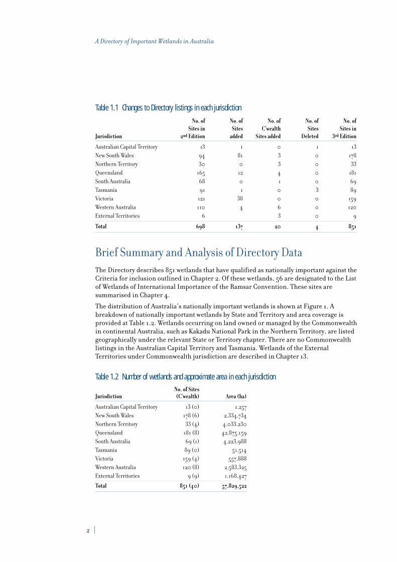
Table 1.1 charts the changes to Directory listings since the second edition by jurisdiction.The total number of sites in the third edition of the Directory is 851 sites (refer to Figure 1),the net increase is 153, mostly from New South Wales and Victoria, including a significantnumber of important rivers and streams. The inventory of wetlands on Commonwealthowned and managed areas resulted in the addition of 20 wetlands to the Directory, three in the External Territories and 17 in the Defence Estate on mainland Australia, includingBeecroft Peninsula which is managed by the Department of Environment and Heritage for the Department of Defence.
1. IntroductionAlison Russell-French
Assistant Secretary Marine, Coasts and Wetlands Branch
Environment Australia
1
2
A Directory of Important Wetlands in Australia
Table 1.1 Changes to Directory listings in each jurisdiction
No. of No. of No. of No. of No. ofSites in Sites C’wealth Sites Sites in
Jurisdiction 2nd Edition added Sites added Deleted 3rd Edition
Australian Capital Territory 13 1 0 1 13
New South Wales 94 81 3 0 178
Northern Territory 30 0 3 0 33
Queensland 165 12 4 0 181
South Australia 68 0 1 0 69
Tasmania 91 1 0 3 89
Victoria 121 38 0 0 159
Western Australia 110 4 6 0 120
External Territories 6 3 0 9
Total 698 137 20 4 851
Brief Summary and Analysis of Directory Data
The Directory describes 851 wetlands that have qualified as nationally important against theCriteria for inclusion outlined in Chapter 2. Of these wetlands, 56 are designated to the Listof Wetlands of International Importance of the Ramsar Convention. These sites aresummarised in Chapter 4.
The distribution of Australia’s nationally important wetlands is shown at Figure 1. Abreakdown of nationally important wetlands by State and Territory and area coverage isprovided at Table 1.2. Wetlands occurring on land owned or managed by the Commonwealthin continental Australia, such as Kakadu National Park in the Northern Territory, are listedgeographically under the relevant State or Territory chapter. There are no Commonwealthlistings in the Australian Capital Territory and Tasmania. Wetlands of the ExternalTerritories under Commonwealth jurisdiction are described in Chapter 13.
Table 1.2 Number of wetlands and approximate area in each jurisdictionNo. of Sites
Jurisdiction (C’wealth) Area (ha)
Australian Capital Territory 13 (0) 1,257
New South Wales 178 (6) 2,334,734
Northern Territory 33 (4) 4,033,230
Queensland 181 (8) 42,875,159
South Australia 69 (1) 4,223,988
Tasmania 89 (0) 51,514
Victoria 159 (4) 557,888
Western Australia 120 (8) 2,583,325
External Territories 9 (9) 1,168,427
Total 851 (40) 57,829,522

3
1. Introduction
The Wetland Classification System used in the Directory and the Criteria for determiningnationally important wetlands are described in Chapter 2. Tables showing the breakdown of sites in each wetland type by jurisdiction and the number of sites included in theDirectory against each criterion by jurisdiction are included in Appendix 1.
Interim Biogeographic Regionalisation for Australia(IBRA) analysis
Wetlands listed in the Directory (with the exception of the External Territories) aredescribed against IBRA version 4.0 (Thackway and Creswell 1995) which is used for thisanalysis. Some wetlands, particularly rivers, occur in more than one bioregion and in thissituation the first named bioregion is used for analytical purposes, on the assumption thatmost of the wetland occurs within that bioregion. For the few sites where no bioregion isidentified, an overlay of the IBRA coverage was used to determine bioregion. An overview of the IBRA regionalisation, a map of IBRA regions and a table showing the number ofnationally important wetlands by bioregion, are at Appendix 2.
There are some significant biases in the distribution and representation of nationallyimportant wetlands in relation to bioregions, reflecting climatic regime and other factorssuch as remoteness and gaps in primary information.
Five bioregions (Mulga Lands, Murray-Darling Depression, Riverina, Sydney Basin andSouth Eastern Highlands) in the east and south of the Continent, contain 30 or more listedwetlands accounting for 227 wetlands, or 26.5% of the total number of wetlands in theDirectory.
Twenty-nine of the 80 IBRA regions contain 10 or more nationally important wetlands(refer Table 1.3). These bioregions contain 664 or 78% of the listed wetlands. Theremaining 187 listed wetlands occur across 42 bioregions.
Nine bioregions have no recognised nationally important wetlands: Broken Hill Complex;Burt Plain; Central Arnhem; Cobar Peneplain; Gawler; Hampton; Nandewar; Nullarbor; andSturt Plateau. The combined area of these bioregions is 633,794 square kilometres or 8.25%of the continental landmass. Not all of these bioregions are arid zone areas or remote frommajor population centres.

4
A Directory of Important Wetlands in Australia
Table 1.3 IBRA regions containing ten or more nationally important wetlandsIBRA region No. of sites Area (ha)
Mulga Lands 57 897,860
Murray-Darling Depression 48 657,620
Riverina 46 204,031
Sydney Basin 43 93,745
South Eastern Highlands 31 34,874
South East Corner 29 82,364
Swan Coastal Plain 29 30,470
Wet Tropics 29 163,079
Victorian Volcanic Plain 26 47,107
Channel Country 25 3,057,435
Cape York Peninsula 23 2,429,936
NSW North Coast 23 232,209
South East Coastal Plain 23 154,284
Naracoorte Coastal Plain 20 301,193
Tasmanian Midlands 20 2,128
Lofty Block 18 50,750
Australian Alps 16 1,012
Eyre and Yorke Blocks 16 38,238
Ben Lomond 15 281
Gulf Plains 15 2,221,612
Central Mackay Coast 14 703,220
Furneaux 14 3,729
Brigalow Belt South 14 247,754
Einasleigh Uplands 13 132,170
South Eastern Queensland 13 667,130
Central Highlands 12 2,420
Top End Coastal 12 978,900
Brigalow Belt North 10 475,697
Woolnorth 10 35,179
Total 664 13,946,427
A new version of the national bioregionalisation, IBRA version 5.1, with revised boundariesand 5 additional regions, was agreed by all States and Territories during the production of this publication. It is anticipated that wetland site information will be updated using therevised IBRA boundaries, where relevant.

5
1. Introduction
Drainage Basin analysis
Analysis of the distribution and representation of nationally important wetlands in drainagebasins was undertaken using the Australian Water Resources Commission DrainageDivision and Basins coverage. The coverage defines 245 drainage basins in continentalAustralia.
Twenty-two drainage basins contain 10 or more nationally important wetlands (refer toTable 1.4). These basins occur from the arid to humid zones. The Paroo River basin containsthe largest number of nationally important wetlands with 33 wetlands covering an area ofapproximately 780,000 hectares. Of those drainage basins containing important wetlands,89 (48%) contain 2 or less nationally important wetlands. Fifty-six drainage basins containno recognised nationally important wetlands. Further analysis and a map of drainage basinsis included at Appendix 3.
Table 1.4 Drainage Basins containing 10 or more nationally important wetlandsDrainage Basin No. of Sites Area (ha)
Paroo River 33 779,561
Murrumbidgee River 29 205,789
Condamine-Culgoa Rivers 20 288,002
Loddon River 18 28,282
Swan Coast 17 6,094
Wimmera-Avon Rivers 16 89,322
Mallee 16 41,320
Lake Corangamite 16 35,824
Millicent Coast 14 155,262
Snowy River 14 54,254
Flinders-Cape Barren Islands 14 3,729
Tamar River 14 164
Clyde River-Jervis Bay 13 53,789
Kangaroo Island 13 50,304
Derwent River 13 4,016
Burdekin River 12 171,582
East Coast 12 7,940
Piper-Ringarooma Rivers 12 256
Cooper Creek 11 2,418,502
Lower Murray River 10 175,147
Avoca River 10 25,752
Hawkesbury River 10 5,222
Total 337 4,600,113
Note: area figures are approximate only and are not available for all wetlands.

6
A Directory of Important Wetlands in Australia
Applications of Directory data
The brief analyses above demonstrate the potential applications of the wetland site data held in the Directory. Specific projects that are being pursued using the Directory databaseinclude the identification of new Ramsar sites in Australia, implementing Resolution 15.11 “Strategic framework and guidelines for the future development of the list of Wetlands ofInternational Importance” adopted at the 7th Conference of Parties in Costa Rica, 1999 whichurges Contracting Parties to develop a systematic approach to identifying future Ramsarsites for designation to the List of Wetlands of International Importance (RamsarConvention Bureau 2000 a).
Identification of the new Ramsar sites in Western Australia (sites 54–56) was undertakenusing a strategic and systematic approach, consistent with this resolution (Jaensch andWatkins 1998). The Western Australian chapter of the second edition of A Directory ofImportant Wetlands in Australia was used as the primary data source for identifying potentialcandidate Ramsar wetlands.
The Directory will also be used to identify sites of importance for particular species,including threatened or migratory species, assisting with the implementation ofconservation initiatives to protect migratory waterbirds, through identification of importanthabitat and the addition of new Australian sites to the East Asian—Australasian ShorebirdSite Network.
Future of the inventory project
Work is ongoing in most jurisdictions to assess under-represented regions, and futureadditions to the Directory are expected from survey projects underway in Western Australia,Queensland, South Australia and the arid zone of the Northern Territory. EnvironmentAustralia will continue to examine wetlands occurring on Commonwealth land to identifyany further sites that meet the criteria for inclusion in the Directory. Regular updates of existing listings will also be sought to revise information on wetland sites.
There is a need however for ongoing survey work, particularly in regions where significantgaps in information exist so that comprehensive State/Territory wetland inventories can be developed and aggregated towards a national wetlands inventory. Some States havealready embarked on a comprehensive assessment of wetland types and coverage and will be producing digital data sets that could form the basis of a national wetland inventory.
Environment Australia, through the ANZECC Wetlands and Migratory Shorebird Taskforce,will be working with the States and Territories to develop a protocol and methodology forthe future development of a national wetland inventory.

Wetland classification system
The definition of a wetland used in the Directory continues to be that adopted
by the Ramsar Convention under Article 1.1, namely:
“wetlands are areas of marsh, fen, peatland or water, whether natural or artificial,permanent of temporary, with water that is static or flowing, fresh, brackish or salt,including areas of marine water the depth of which at low tide does not exceed six metres.”
Within this broad definition, the wetland classification system used in the Directoryidentifies 40 different wetland types in three categories: A—Marine and Coastal Zonewetlands, B—Inland wetlands, and C—Human-made wetlands (refer below). This system has not been altered since it was agreed to by the then ANZECC Wetlands Network1 in 1994,hence it remains the same as that used in the second edition.
The system is based on that used by the Ramsar Convention in describing Wetlands ofInternational Importance, but was modified slightly to suit the Australian situation indescribing wetlands of national importance. Notable alterations to the Ramsar classificationsystem included the addition of non-tidal freshwater forested wetlands (A12) and rockpools (B17). Inland karst systems were also added (B19), although the Ramsar classificationsystem now includes karst systems under all categories.
2. Wetland classification system, Criteria for inclusion and Data presentationGeoff Larmour
Wetlands SectionEnvironment Australia
9
A—Marine and Coastal Zone wetlands1 Marine waters—permanent shallow waters less than six metres deep at low tide;
includes sea bays, straits
2 Subtidal aquatic beds; includes kelp beds, seagrasses, tropical marine meadows
3 Coral reefs
4 Rocky marine shores; includes rocky offshore islands, sea cliffs
5 Sand, shingle or pebble beaches; includes sand bars, spits, sandy islets
1 ANZECC, the Australian and New Zealand Environment and Conservation Council, is the Council ofEnvironment Ministers from the Australian Federal Government, the New Zealand Government and allAustralian State and Territory Governments. The ANZECC Wetlands Network, now known as the ANZECCWetlands and Migratory Shorebirds Taskforce, is a group of officers representing each of the natureconservation agencies of the Governments represented in ANZECC. The Taskforce is responsible forcoordinating implementation of the Ramsar Convention in Australia.

10
A Directory of Important Wetlands in Australia
6 Estuarine waters; permanent waters of estuaries and estuarine systems of deltas
7 Intertidal mud, sand or salt flats
8 Intertidal marshes; includes saltmarshes, salt meadows, saltings, raised saltmarshes, tidal brackish and freshwater marshes
9 Intertidal forested wetlands; includes mangrove swamps, nipa swamps, tidalfreshwater swamp forests
10 Brackish to saline lagoons and marshes with one or more relatively narrowconnections with the sea
11 Freshwater lagoons and marshes in the coastal zone
12 Non-tidal freshwater forested wetlands
B—Inland wetlands 1 Permanent rivers and streams; includes waterfalls
2 Seasonal and irregular rivers and streams
3 Inland deltas (permanent)
4 Riverine floodplains; includes river flats, flooded river basins, seasonally floodedgrassland, savanna and palm savanna
5 Permanent freshwater lakes (> 8 ha); includes large oxbow lakes
6 Seasonal/intermittent freshwater lakes (> 8 ha), floodplain lakes
7 Permanent saline/brackish lakes
8 Seasonal/intermittent saline lakes
9 Permanent freshwater ponds (< 8 ha), marshes and swamps on inorganic soils;with emergent vegetation waterlogged for at least most of the growing season
10 Seasonal/intermittent freshwater ponds and marshes on inorganic soils; includessloughs, potholes; seasonally flooded meadows, sedge marshes
11 Permanent saline/brackish marshes
12 Seasonal saline marshes
13 Shrub swamps; shrub-dominated freshwater marsh, shrub carr, alder thicket on inorganic soils
14 Freshwater swamp forest; seasonally flooded forest, wooded swamps; on inorganic soils
15 Peatlands; forest, shrub or open bogs
16 Alpine and tundra wetlands; includes alpine meadows, tundra pools, temporarywaters from snow melt
17 Freshwater springs, oases and rock pools
18 Geothermal wetlands
19 Inland, subterranean karst wetlands

11
2. Wetland classification system, Criteria for inclusion and Data presentation
C—Human-made wetlands 1 Water storage areas; reservoirs, barrages, hydro-electric dams, impoundments
(generally > 8 ha)
2 Ponds, including farm ponds, stock ponds, small tanks (generally < 8 ha)
3 Aquaculture ponds; fish ponds, shrimp ponds
4 Salt exploitation; salt pans, salines
5 Excavations; gravel pits, borrow pits, mining pools
6 Wastewater treatment; sewage farms, settling ponds, oxidation basins
7 Irrigated land and irrigation channels; rice fields, canals, ditches
8 Seasonally flooded arable land, farm land
9 Canals
Criteria for determining important wetlands
The criteria for determining nationally important wetlands in Australia, and henceinclusion in the Directory, are those agreed to by the ANZECC Wetlands Network in 1994and used in the second edition.
A wetland may be considered nationally important if it meets at least one of the followingcriteria:
1. It is a good example of a wetland type occurring within a biogeographic region in Australia.
2. It is a wetland which plays an important ecological or hydrological role in the naturalfunctioning of a major wetland system/complex.
3. It is a wetland which is important as the habitat for animal taxa at a vulnerable stage in their life cycles, or provides a refuge when adverse conditions such as drought prevail.
4. The wetland supports 1% or more of the national populations of any native plant or animal taxa.
5. The wetland supports native plant or animal taxa or communities which are consideredendangered or vulnerable at the national level.
6. The wetland is of outstanding historical or cultural significance.
Many of the sites in the Directory meet more than one of the criteria. Application of thecriteria to individual wetland sites involves a degree of subjectivity. Not only may certainaspects of a site’s significance be interpreted differently by different investigators, butinformation gaps often exist which make it difficult to judge whether or not a site meets a particular criterion.
The Interim Biogeographic Regionalisation for Australia (IBRA) is used as the frameworkfor applying Criterion 1, which identifies wetlands that are unique or representative within a biogeographic region in Australia. An overview of the IBRA regionalisation and a map of IBRA regions is included in Appendix 2.

12
A Directory of Important Wetlands in Australia
Data presentation
The ANZECC Wetlands Network also agreed in 1994 to conform to a standard format todescribe wetlands included in the Directory. This format is considered the “minimum dataset” for describing wetlands.
Now that the Directory is in database format these information descriptors have becomefield descriptors. Again there is some subjective interpretation of these descriptors, and in the current database not all fields contain information. Information is still presentedunder these headings by the online Directory. In moving the Directory from a hard copypublication to an online database the format for reference numbers has been changed toenable easier addition of sites to the database. Changes have also been introduced to thenotable flora and fauna sections to reflect the categories of threatened species introducedunder the Commonwealth Environment Protection and Biodiversity Conservation Act 1999.
If additional information on particular sites in the online Directory is required, usersshould either consult the online reference list, or contact the relevant member of theANZECC Wetlands and Migratory Shorebirds Taskforce (see Contacts list).
Standard format for describing wetlands in the DirectoryName of wetland: The name of the site.
Reference number: Each site has been allocated an individual reference number. The codeused has been amended since the second edition. This is now a sequential number with a two or three letter prefix for the State or Territory in which the wetland occurs. There is no longer any reference to the bioregion. The State and Territory lists of important wetlandsin their respective chapters give both old and new reference numbers for sites that wereincluded in the second edition. Sites listed since 1996 have only the new reference number.An example showing both old and new reference numbers follows:
Old Reference No. Wetland name New Reference No.
NET001NS Little Llangothlin Lagoon NSW022
NET002NS New England Wetlands NSW023
NET003NS Round Mountain Swamps NSW024
Location: Latitude and longitude at the centre of the wetland. If the site consists of two ormore discrete entities, the centre coordinates of each of these entities is given. A generaldescription of the location of the wetland including the distance from the nearest landmark,town, reserve or access point. This also includes bioregion name (IBRA, see Appendix 2)and local government area where applicable.
Area: In hectares.
Elevation: In metres above sea level (m ASL).
Other wetlands in same aggregation: Those wetlands included in the Directory, listed by reference number. Wetlands in the same aggregation are those where there is ahydrological, ecological or biological connection apparent.

13
2. Wetland classification system, Criteria for inclusion and Data presentation
Wetland type: All wetland habitat types occurring at the site using the wetland classificationsystem code (A1, A2, etc) discussed above and including an indication of the dominantwetland type.
Criteria for inclusion: Reference numbers for criteria (1–6) discussed above indicatingwhy the wetland is nationally important.
Site description: A brief summary of the important characteristics of the wetland, ie thosethat make it nationally important.
Further details of the features of the site are supplied under the following subheadings:
Physical features: Description of the following where relevant: landform, geology,geomorphology, origin, soil types and climate, including rainfall and evaporation.
Hydrological features: A brief description of the principal hydrological features such assource of water supply, maximum water depth, persistence, salinity regime and pH values.Other features may include the role of the wetland in recharge and discharge of groundwater, flood mitigation, and maintenance of water quality.
Ecological features: A brief description of the main habitats, listing dominant plantcommunities, species present and describing any seasonal variation or long-term changesin species composition. This includes information on adjacent areas where appropriate, to put the wetland in context.
Significance: The significance of the site within its bioregion.
Specific features of significance are also addressed under the following subheadings. Forthreatened species of flora and fauna the common name and scientific name (in italics) is followed by the appropriate code of conservation status in brackets:
National Conservation status Code State/Territory Conservation status 2 Code
Critically endangered (CR) 1 Ncr Critically endangered (CR) Scr
Endangered (E) Ne Endangered (E or EN) Se
Vulnerable (V) Nv Vulnerable (V or VU) Sv
Conservation dependent (CD) 1 Ncd Lower Risk (LR) Slr
Rare (R) Nr Rare (R) Sr
Data Deficient (DD) Sdd
1 these categories established under the Commonwealth Environment Protection and Biodiversity Conservation Act 1999.
2 conservation status categories and definitions vary between jurisdictions.
Notable flora: Threatened species: threatened flora at national or State level that occur on the site (includes any threatened species identified under national or State legislation,ANZECC lists or action plans). Composition: information on the composition of any plantspecies or communities for which the wetland is particularly important (eg local endemicspecies or good examples of native plant communities).

14
A Directory of Important Wetlands in Australia
Notable fauna: Threatened species: list of threatened fauna at national or State level that are present at the site (includes any threatened species identified under national or State legislation, ANZECC lists or action plans). Composition: information regardingcomposition of important fauna that may inhabit the wetland permanently or seasonally,including migratory species. An indication of population sizes, breeding colonies,migration stopover etc is also given where available.
Social and cultural values: Social and/or cultural values of the wetland. Social values mayinclude tourism, recreation, scientific research, education, grazing, water supply, fisheriesproduction etc. Cultural values include specific prehistoric or historical associationswhether they relate to indigenous or non-indigenous culture.
Land tenure: Using standard terminology, land tenure is addressed under the followingsubheadings:
On site: Details of land ownership of the wetland site.
Surrounding area: Details of the tenure type that is dominant in the surrounding areas if possible.
Current land use: Using standard terminology, land use is addressed under the followingsubheadings:
On site: Current human use of the designated wetland area.
Surrounding area: Human use on land adjacent to the wetlands, and more broadly in thesurrounding catchment.
Disturbances or threats: Disturbances or threats are defined as any direct or indirecthuman activities at the site or in the catchment area that may have a detrimental effect on the ecological character of the wetland. The effect may be a low level disturbance (eg low intensity grazing) or a major threat (eg water diversion schemes). Examples include disturbance by stock, water extraction, river regulation, siltation, salinity, urbandevelopment, drainage, pollution, excessive human activity, and impact of invasive species.Disturbances or threats are addressed under the following subheadings:
Current: Activities or features that are adversely affecting the wetland at present. An indication of the severity or degree of threat may be given where known, eg high,moderate, or low.
Potential: Potential future threats, for example planned changes in land use or degradationof the site from current land use practices (eg increased salinity).
Conservation measures taken: Details of conservation measures being undertaken at thesite, and where appropriate, the names of any protected areas established at or around thewetland. This includes details of any management plans for the site and whether they arebeing implemented. It also includes the status of the site in terms of National Estate,Ramsar or World Heritage listing, or whether it falls within a Biosphere Reserve.
Management authority and jurisdiction: The name of the body or bodies responsible for management of the wetland.
Compiler & date: The name of individuals and associated organisations who providedinformation for the site description, with the date of compilation and that of the mostrecent update.
Using the Directory
The Directory is now essentially an online tool, and unlikely to appear again
in print as in the first two editions (ANCA 1993, 1996). The site information withinthese two publications has been transferred to an Oracle database that is now accessible via the Internet.
This is an important advance for the Directory and fulfils a commitment made in the secondedition to make the information available electronically. In practical terms it means that thelatest information on existing and new nationally important wetlands can be made availableas soon as it is entered into the Directory database. Inventory work currently in progress,funded through the National Wetlands Program, can be immediately uploaded when it iscompleted.
The Directory Internet site includes a map of the listed wetland where available. Thepresent coverage used to illustrate Directory sites has been derived largely from a 1:250,000coverage of waterbodies produced by the Australian Surveying and Land Information Group (1994). Environment Australia is negotiating with the States and Territories, andCommonwealth land managers, for the supply of more accurate spatial data where these are available.
The Directory interface is being set up to provide users with as much functionality aspossible. Site data can be sought through a search form that allows users to query the data on a number of fields, such as State, Bioregion, Wetland type and Criteria for inclusion from a menu, and user-defined text in other fields. Users can also use a spatial data engineto select an area on the map to search for listed wetlands. A Help facility for the onlineDirectory is included.
Access to Directory data is via the Wetlands Section—Environment Australia homepage:http://www.environment.gov.au/water/wetlands
Future development of the Directory
Now that the wetland data are in electronic format it is possible to perform the types ofanalyses illustrated in this publication. These provide a useful snapshot of the currentrepresentation of wetland types and criteria for inclusion across jurisdictions and, perhapsmore importantly, across biogeographic regions.
3. Use and future development of the DirectoryGeoff Larmour
Wetlands SectionEnvironment Australia
15

16
A Directory of Important Wetlands in Australia
The summary statistics presented in this publication utilise the data most readily accessiblein the database. Information on wetland types and criteria has been stored according to theappropriate codes, making it much easier to extract and manipulate. Most of theinformation is text based and hence analyses are not so straight forward, for example,analyses on land tenure and management arrangements for wetlands listed in the Directoryis currently quite difficult. Environment Australia will be investigating how best to maketext based data more easily accessible for analytical purposes.
The Directory entries also contain useful information about wetland taxa, but these datahave also been entered in text fields. Of particular interest from a conservation point ofview, and in meeting legislative obligations, is information about threatened and migratoryspecies. The database has been set up with taxon tables to allow for entry, and hencesearching and reporting, of taxon specific information for wetland sites. Extracting data in the existing site descriptions and seeking additional survey data not previously includedto populate these tables is a large undertaking, but it is anticipated that this will be doneprogressively to increase the usefulness of the Directory as a resource.
The fact that the data are now in electronic format and can be displayed in a GIS has allowedsome analysis of the distribution of sites in relation to Drainage Divisions and Basins. It isintended to add these data to the Directory information for future reference.
Feedback on the Directory from all users is welcome. If your comments relate to siteinformation contained in the Directory, or information relating to possible new sites, thesewould be best directed to the ANZECC Taskforce member in your State or Territory. If youhave comments relating to the online Directory and how this may be improved, pleasedirect your comments to Geoff Larmour in the Environment Australia Wetlands Section.Contact details are provided at the end of the publication.

The Convention on Wetlands
The Convention on Wetlands (Ramsar, Iran, 1971), more commonly known as the
Ramsar Convention, is an intergovernmental treaty dedicated to the conservation and“wise use” of wetlands. The Convention’s mission is ‘…the conservation and wise use ofwetlands by national action and international cooperation as a means to achieving sustainabledevelopment throughout the world’ (Ramsar Convention Bureau 2000b).
The “wise use” of wetlands is a key concept of the Convention and is defined as:
‘the sustainable utilisation of wetlands for the benefit of mankind in a way compatible with the maintenance of the natural properties of the ecosystem’ (Recommendation 3.3).
Sustainable utilisation of a wetland is defined as:
‘human use of a wetland so that it may yield the greatest continuous benefit to presentgenerations while maintaining its potential to meet the needs and aspiration of futuregenerations’ (Recommendation 3.3).
Australia was one of the first of 18 countries to become a signatory to the Convention in 1971, and in 1974 designated the first wetland to the Ramsar List of Wetlands ofInternational Importance – Cobourg Peninsula Aboriginal Land and Wildlife Sanctuary.
As of December 2000, there are 123 Contracting Parties to the Convention with 1044wetland sites designated for inclusion in the List of Wetlands of International Importance,totalling 78.5 million hectares (Ramsar Convention Bureau 2000b). Australia has 56Ramsar sites covering an area of approximately 5.3 million hectares (refer to Figure 2).
Further information on the Convention on Wetlands can be obtained by visiting the RamsarConvention Bureau’s website at http://ramsar.org
4. The Convention on Wetlands in Australia Sarah Young
Wetlands SectionEnvironment Australia
17

18
A Directory of Important Wetlands in Australia
Ramsar Criteria for Inclusion
A wetland is identified as being of international importance if it meets at least one of a number of criteria relating to the site’s uniqueness, rarity, or representativeness, or theflora, fauna or ecological communities it supports. The current criteria, agreed upon byContracting Parties at the seventh Conference of Parties held in Costa Rica, May 1999 have been applied to sites designated since that time and to any sites where the RamsarInformation Sheet (RIS) has been reviewed and updated. The criteria are set out below:
Group A of the Criteria. Sites containing representative, rare or unique wetland types
Criterion 1: A wetland should be considered internationally important if it contains a representative, rare, or unique example of a natural or near-natural wetland typefound within the appropriate biogeographic region.
Group B of the Criteria. Sites of international importance for conserving biological diversity
Criteria based on species and ecological communities
Criterion 2: A wetland should be considered internationally important if it supportsvulnerable, endangered, or critically endangered species or threatened ecologicalcommunities.
Criterion 3: A wetland should be considered internationally important if it supportspopulations of plant and/or animal species important for maintaining the biologicaldiversity of a particular biogeographic region.
Criterion 4: A wetland should be considered internationally important if it supportsplant and/or animal species at a critical stage in their life cycles, or provides refugeduring adverse conditions.
Specific criteria based on waterbirds
Criterion 5: A wetland should be considered internationally important if it regularlysupports 20,000 or more waterbirds.
Criterion 6: A wetland should be considered internationally important if it regularlysupports 1% of the individuals in a population of one species or subspecies ofwaterbird.
Specific criteria based on fish
Criterion 7: A wetland should be considered internationally important if it supports asignificant proportion of indigenous fish subspecies, species or families, life-historystages, species interactions and/or populations that are representative of wetlandbenefits and/or values and thereby contributes to global biological diversity.
Criterion 8: A wetland should be considered internationally important if it is animportant source of food for fishes, spawning ground, nursery and/or migration path on which fish stocks, either within the wetland or elsewhere, depend.

19
4. The Convention on Wetlands in Australia
The following criteria are applicable to those sites designated prior to May 1999. As sites arereviewed, the new criteria will be applied and the RIS for the site will be updated.
1. Criteria for representative or unique wetlands
A wetland should be considered internationally important if:
(a) it is a particularly good representative example of a natural or near-natural wetland,characteristic of the appropriate biogeographical region; or
(b) it is a particularly good representative example of a natural or near-natural wetland,common to more than one biogeographical region; or
(c) it is a particularly good representative example of a wetland which plays a substantialhydrological, biological or ecological role in the natural functioning of a major riverbasin or coastal system, especially where it is located in a trans-border position; or
(d) it is an example of a specific type of wetland, rare or unusual in the appropriatebiogeographical region.
2. General criteria based on plants or animals
A wetland should be considered internationally important if:
(a) it supports an appreciable assemblage of rare, vulnerable or endangered species or subspecies of plant or animal, or an appreciable number of individuals of any one or more of these species; or
(b) it is of special value for maintaining the genetic and ecological diversity of a regionbecause of the quality and peculiarities of its flora and fauna; or
(c) it is of special value as the habitat of plants or animals at a critical stage of theirbiological cycle; or
(d) it is of special value for one or more endemic plant or animal species orcommunities.
3. Specific criteria based on waterfowl
A wetland should be considered internationally important if:
(a) it regularly supports 20,000 waterfowl; or
(b) it regularly supports substantial numbers of individuals from particular groups of waterfowl, indicative of wetland values, productivity or diversity; or
(c) where data on populations are available, it regularly supports 1% of the individualsin a population of one species or subspecies of waterfowl.

20
A Directory of Important Wetlands in Australia
4. Specific criteria based on fish
A wetland should be considered internationally important if:
(a) it supports a significant proportion of indigenous fish subspecies, species orfamilies, life-history stages, species interactions and/or populations that arerepresentative of wetland benefits and/or values and thereby contributes to global biological diversity; or
(b) it is an important source of food for fishes, spawning ground, nursery and/ormigration path on which fish stocks, either within the wetland or elsewhere,depend.
Management of Listed Ramsar SitesOnce a site is designated to the List of Wetlands of International Importance under theConvention, the relevant Contracting Party must ensure that the site is managed such thatits ecological character is maintained. The ecological character of a site is ‘…the sum of thebiological, physical, and chemical components of the wetland ecosystem, and their interactions,which maintain the wetland and its products, functions, and attributes’ (Ramsar ConventionBureau 2000b).
Management planning provides an appropriate framework for ensuring that the ecologicalcharacter of a Ramsar site is maintained. The Ramsar Convention has developedmanagement planning guidelines to assist Contracting Parties to develop managementplans for each Ramsar site. Australia currently has management plans in place or inpreparation for 44 (79%) of its 56 Ramsar sites.
Australia’s obligations to protect and maintain the ecological character of its Ramsar siteshave recently been recognised in national legislation through the Environment Protection andBiodiversity Conservation (EPBC) Act 1999. The Act introduces an environmental assessmentand approval regime for actions that have, may have or are likely to have a significant impacton Ramsar Wetlands and most importantly, establishes new standards for managing Ramsar wetlands through the Australian Ramsar Management Principles which have been established as regulations under the Act.
Further information on the EPBC Act can be obtained from Environment Australia’s EPBCwebsite at http://www.environment.gov.au/epbc

21
4. The Convention on Wetlands in Australia
Ramsar in AustraliaAustralia has designated 56 wetlands to the Ramsar List of Wetlands of InternationalImportance (Figure 2). Table 4.1 indicates the number of Ramsar sites in each managementjurisdiction and the total area coverage. A summary of the area, wetland types and Ramsarcriteria for each site is listed at Table 4.2 (The Ramsar Classification System for WetlandType is at Appendix 4). A Ramsar Information Sheet describing each Ramsar site and a mapshowing the site’s boundary can be obtained through the Wetlands Section—EnvironmentAustralia website: http://www.environment.gov.au/water/wetlands
Table 4.1 Number and area of Ramsar sites in each Australian jurisdictionManagement authority No. of sites Area (ha)
Australian Capital Territory ACT 1 343
Commonwealth COMM 4 1,376,062.33
New South Wales NSW 9 74,382.50
Northern Territory NT 1 220,700
Queensland QLD 5* 632,374
South Australia SA 4 2,154,300
Tasmania TAS 10 26,207
Victoria VIC 10 306,844
Western Australia WA 12 517,970
Total 56 5,309,182.83
* includes Shoalwater Bay which is jointly managed with the Commonwealth

Table 4.2 Summary List of Australia’s Ramsar sitesSite Management Areano. Site name authority (ha) Wetland type Ramsar Criteria
1 Cobourg Peninsula NT 220,700 C, D, E, F, G, I, N, Sp 1a, 2a, 3a, 3b
2 Kakadu National Park (Stage 1) COMM 683,000 A, B, E, F, G, H, I, K, L, 1a, 1b, 1c, 2a 2b, 3a, 3b, 3c(Including the extension of boundaries of M, N, R, Sp, Tp, Ts, Xp, 6Stage I to incorporate wetland componentsof Kakadu National Park Stage III)
3 Moulting Lagoon Game Reserve TAS 4,496 F, G, H, M, R 1a, 2a, 3b, 3c
4 Logan Lagoon Conservation Area TAS 2,172 E, J, N 1a, 2c, 3b
5 Lavinia Nature Reserve TAS 6,904 F, G, H, K, M, 2a, 2c, 2dO, Sp, Ts, W, Xf
6 Pitt Water—Orielton Lagoon TAS 3,289 F, G, H, M, Q, R 2a, 2b, 2d, 3b
7 Apsley Marshes TAS 865 F, R, Tp 2a, 2b
8 East Coast Cape Barren Island Lagoons TAS 4,480 J 2b, 2d
9 Flood Plain Lower Ringarooma TAS 3,407 M, Tp, Ts 2a, 2bRiver including ‘The Chimneys’
10 Jocks Lagoon TAS 19 E, K 2b
11 Interlaken Lakeside Reserve TAS 519 O, R 2a, 2b(Lake Crescent)
12 Little Waterhouse Lake TAS 56 K 1b, 2b
13 Corner Inlet VIC 67,186 A, G, H, I 1a, 1b, 1c, 2b, 3a, 3b, 3c
14 Barmah Forest VIC 28,515 N, O, Ts, Xf 1a, 2b, 3a, 3b, 3c
15 Gunbower Forest VIC 19,931 N, Ts, Xf 2b, 3a, 3b, 3c
16 Hattah—Kulkyne Lakes VIC 955 O, P 2b, 3a, 3b, 3c
17 Kerang Wetlands VIC 9,419 O, Q, Tp, Ts 1a, 1b, 2b, 3a, 3b, 3c
18 Port Phillip Bay (Western Shoreline) VIC 22,897 A, D, E, F, G, H, 1a, 1b, 2b, 3a, 3b, 3cand Bellarine Peninsula M, Tp, 3, 8
19 Western Port VIC 59,297 B, G, H, I 1a, 1b, 3a, 3b, 3c
20 Western District Lakes VIC 32,898 O, Q 1a, 3a, 3b, 3c
21 Gippsland Lakes VIC 60,015 J, Sp, Tp 1a, 3a, 3b, 3c
22 Lake Albacutya VIC 5,731 P 1a, 1b, 3a, 3b, 3c
23 Towra Point Nature Reserve NSW 386.50 E, F, G, H 1a, 2a, 2b, 3b, 3c
24 Kooragang Nature Reserve NSW 2,926 D, E, F, G, H, I, J, K 1a, 2a, 2b, 3b, 3c
25 The Coorong, and Lakes Alexandrina SA 140,500 F, J, M, O, Q, 6 1, 2, 3, 4, 5, 6and Albert Wetland
26 Bool and Hacks Lagoons SA 3,200 N, O, P, Tp 1a, 1b, 1c, 2a, 2b, 2c, 3a, 3c
27 Coongie Lakes SA 1,980,000 M, N, P, Sp, Tp, Ts 1b, 1c, 2a, 2b, 2c, 2d, 3a, 3c
28 The Macquarie Marshes NSW 18,726 N,P,Tp,Ts,W, Xf 1, 2, 3, 4, 5
22
A Directory of Important Wetlands in Australia

Site Management Areano. Site name authority (ha) Wetland type Ramsar Criteria
29 “Riverland” SA 30,600 M, O, P, R, Tp 1a, 1b, 1c, 3b
30 Kakadu National Park (Stage 2) COMM 692,940 A, B, E, F, G, H, I, M, 1a, 1c, 2b, 2c, 3a, 3b, 3cN, R, Sp, Tp, Xp
31 Ord River Floodplain WA 141,453 F, G, H, I, J, K, N, 1, 2, 3Tp, Ts, W, Xf, Y
32 Lakes Argyle and Kununurra WA 150,000 M, O, 6 2a, 3a
33 Roebuck Bay WA 55,000 G 1a, 3a, 3c
34 Eighty-mile Beach WA 125,000 G, R, Sp 1a, 2c, 3a, 3c
35 Forrestdale and Thomsons Lakes WA 754 P 1a, 2b, 3c
36 Peel—Yalgorup System WA 26,530 F, G, H, Q, Tp, Ts, W, Xf 1a, 2c, 3a, 3c
37 Lake Toolibin WA 493 Xf 1, 2, 3, 4
38 Vasse—Wonnerup System WA 1,115 J, N, Ss, Xf 5, 6
39 Lake Warden System WA 2,300 J, Q, R 1a, 3a, 3c
40 Hosnie’s Spring, Christmas Island COMM 0.33 M, Xf, Y 1a, 2a, 2d
41 Moreton Bay QLD 113,314 A, B, C, D, E, F, G, H, I, J, L, 1b, 1c, 2a, 2b, M, O, Q, Tp, Ts, W, Xf, Xp, 9 2c, 3a, 3b, 3c
42 Bowling Green Bay QLD 35,500 A, D, E, F, G, H, I, J, 1a, 1b, 1c, 2a, 2b, N, R, Ss, Ts, Xf, 2 2c, 3a, 3b, 3c
43 Currawinya Lakes QLD 151,300 N, O, P, Q, Ts 1a, 1b, 2a, 2b,(Currawinya National Park) 2c, 3a, 3b, 3c
44 Shoalwater and Corio Bays Area QLD & 239,100 A, B, D, E, F, G, H, I, J 1a, 1c, 2a, 2b, 2c, (Shoalwater Bay Training Area, COMM 2d, 3a, 3b, 3cin part—Corio Bay)
45 Ginini Flats Wetland Complex ACT 343 U 1a, 2a, 2b, 2c
46 Pulu Keeling National Park COMM 122 B, C, D, E 1a, 1d, 2a, 2b, 2c(North Keeling Island)
47 Little Llangothlin Nature Reserve NSW 258 P, Q 1a, 2a, 2c
48 Blue Lake NSW 320 Vt 1a, 1d, 2b, 2d
49 Lake Pinaroo (Fort Grey Basin) NSW 800 R 1a, 2a, 2c, 2d, 3b
50 Gwydir Wetlands: Gingham and Lower NSW 823 L, N, P, Tp, Ts, W, Xf 1a, 1b, 1c, 1d, 2a, Gwydir (Big Leather) Watercourses 2b, 2c, 3a, 3b
51 Great Sandy Strait (including Great Sandy QLD 93,160 A, B, C, E, F, G, 1a, 1b, 1d, 2a, 2b, Strait, Tin Can Bay and Tin Can Inlet) H, I, J, K, U, Xf 3a, 3b, 3c, 4b
52 Myall Lakes NSW 44,612 D, E, F, H, I, J, K 1a, 1c, 2a, 3b
53 Narran Lake Nature Reserve NSW 5,531 N, P, Ts, W, Xf 1a, 2c, 3c
54 Becher Point Wetlands WA 677 Ts, W 1, 2
55 Lake Gore WA 4,017 R, Ss 4, 5, 6
56 Muir—Byenup System WA 10,631 O, R, Tp, Ts, U, W, Xf 2, 4, 5, 6
23
4. The Convention on Wetlands in Australia

24
A Directory of Important Wetlands in Australia
Looking to the Future
Contracting Parties to the Convention on Wetlands adopted the Strategic Framework andguidelines for the future development of the List of Wetlands of International Importance (RamsarConvention Bureau 2000a) at the seventh Conference of Parties in May 1999. Its purpose is to provide a clearer vision of the long-term targets which the Convention is seeking to achieve through the Ramsar List, and to assist Contracting Parties to take a systematicapproach to identifying priorities for future designations. Contracting Parties also agreed to a short-term target of 2,000 sites for the Ramsar List by the year 2005, recognising thatthe Strategic Framework and Guidelines should be taken into consideration.
A Global Review of Wetland Resources and Priorities for Wetland Inventory, undertaken byWetlands International (Finlayson and Spiers 1999), highlighted wetland types for whichinventory data was lacking and which are poorly represented in the Ramsar List of Wetlandsof International Importance. Resolution VII.20 calls upon Contracting Parties to giveattention to these priority wetland habitats which include: seagrasses, coral reefs, saltmarshes and coastal flats, mangroves, arid zone wetlands, peatlands, rivers and streams,and artificial wetlands.
An analysis of Australian Ramsar sites indicates that a number of wetland types are notrepresented or are under-represented on the List of Wetlands of International Importance(Table 4.3). These include karst and cave systems; peatlands; coral reefs; and arid zonewetlands (which may include permanent and seasonal/intermittent saline/brackish/alkaline water bodies, and freshwater springs).
The Commonwealth Government will be undertaking a systematic review of its wetlandholdings to determine which sites satisfy the Ramsar criteria, with a view to listing newsites. Priority will be placed on these wetland types when considering new sites for listingunder the Convention on Wetlands. The States and Territories will also be encouraged to undertake a similar analysis for wetlands within their jurisdiction.
Several State and Territory governments are currently undertaking wetland inventoryprojects with funding provided by the National Wetlands Program of the Natural HeritageTrust. Particular focus is being placed on wetland types and bioregions that are eitherunder-represented or not represented in the Directory (refer to Appendices 1 and 2). In particular, the Parks and Wildlife Commission of the Northern Territory is undertakingan inventory of wetlands in the arid zone of the Northern Territory. The project covers 10 bioregions, including the MacDonnell Ranges and Burt Plain. The QueenslandEnvironmental Protection Agency is surveying the South East Queensland, EinasleighUplands, and the Brigalow Belt North and South bioregions. Not only will these projectsdeliver new listings for the Directory, it is also likely that potential Ramsar wetlands will be identified.

25
4. The Convention on Wetlands in Australia
Table 4.3 Number of Ramsar sites in each wetland type by jurisdiction
(The Ramsar Classification System for Wetland Type is at Appendix 4).
Marine /coastal wetlands
Wetland type: A B C D E F G H I J K Zk(a)
ACT 0 0 0 0 0 0 0 0 0 0 0 0
COMM 2 3 1 1 3 2 2 2 2 0 1 0
NSW 0 0 0 2 3 3 2 3 2 2 2 0
NT 0 0 1 1 1 1 1 0 1 0 0 0
QLD 4 3 2 3 4 4 4 4 4 4 1 0
SA 0 0 0 0 0 1 0 0 0 1 0 0
TAS 0 0 0 0 2 4 3 3 0 2 3 0
VIC 2 1 0 1 1 1 3 3 2 1 0 0
WA 0 0 0 0 0 2 4 2 1 3 1 0
Total* 8 7 4 8 14 18 19 17 12 13 8 0
Inland wetlands
Wetland type: L M N O P Q R Sp Ss Tp Ts U Va Vt W Xf Xp Y Zg Zk(b)
ACT 0 0 0 0 0 0 0 0 0 0 0 1 0 0 0 0 0 0 0 0
COMM 1 3 2 0 0 0 2 2 0 2 1 0 0 0 0 1 2 1 0 0
NSW 1 0 3 0 4 1 1 0 0 2 3 0 0 1 3 3 0 0 0 0
NT 0 0 1 0 0 0 0 1 0 0 0 0 0 0 0 0 0 0 0 0
QLD 1 1 2 2 1 2 1 0 1 1 3 1 0 0 1 0 1 0 0 0
SA 0 3 2 3 3 1 1 1 0 3 1 0 0 0 0 0 0 0 0 0
TAS 0 4 1 2 0 1 4 1 0 2 2 0 0 0 1 1 0 0 0 0
VIC 0 1 2 4 2 2 0 1 0 3 3 0 0 0 0 2 0 0 0 0
WA 0 1 2 2 1 2 4 1 2 3 4 1 0 0 4 5 0 1 0 0
Total* 3 13 15 13 11 9 13 7 3 16 17 3 0 1 9 12 3 2 0 0
Human-made wetlands
Wetland type: 1 2 3 4 5 6 7 8 9
ACT 0 0 0 0 0 0 0 0 0
COMM 0 0 0 0 0 1 0 0 0
NSW 0 0 0 0 0 0 0 0 0
NT 0 0 0 0 0 0 0 0 0
QLD 0 1 0 0 0 0 0 0 1
SA 0 0 0 0 0 1 0 0 0
TAS 0 0 0 0 0 0 0 0 0
VIC 0 0 1 0 0 0 0 1 0
WA 0 0 0 0 0 1 0 0 0
Total* 0 1 1 0 0 3 0 1 1
* A wetland listing/site may be counted against more than one wetland type

Introduction
Mark Lintermans, Environment ACT
The Australian Capital Territory (ACT) is the smallest of Australia’s States and
Territories (235,600 ha) but has a diverse range of aquatic habitats ranging from smallsubalpine bogs to the larger riverine systems such as the Murrumbidgee River. However thegeographic location and altitude of the ACT preclude some wetland types which are commonin other States and the Northern Territory.
For example the inland location of the ACT means that there are no marine, estuarine orbrackish wetlands. Similarly, with the location of the ACT in the south-eastern highlands,large lowland floodplain systems are also absent.
The first substantial review of aquatic ecosystems in the ACT was conducted by Hogg andWicks (1989). This review dealt mainly with lotic systems and did not attempt to cover the high altitude wetlands such as fens and bogs. Subsequently Evans and Keenan (1993)reviewed the published and unpublished literature on high altitude wetlands in the ACT.
The ACT is located within two biogeographic regions defined by Thackway and Cresswell(1995) as the Australian Alps, and the South Eastern Highlands, with the majority of itsimportant wetlands being found in the Australian Alps bioregion.
Most of the significant high altitude wetlands of the ACT are located in the Cotter andGudgenby River catchments. The Cotter River catchment lies between the BrindabellaRange in the west, the Bimberi and Scabby Ranges in the south and the Cotter/Gudgenbydivide in the east. The tops of these ranges form the western and southern borders of theACT. The Naas and Gudgenby rivers lie further to the east and have a catchment boundarywith the Cotter River catchment. Locations of each of the wetland sites are shown in Figure3. Most of the wetlands described here are above 1,000 metres altitude with the highestbeing Cotter Source Bog at 1,718 metres.
In the subalpine and montane zones of the ACT, vegetation communities in wet areas oftenconstitute Sphagnum bog or Carex fen (or swamp) interspersed with patches of wet heathand wet herbfield. The bogs are generally acidic and have a low nutrient content (Hope andSouthern 1983). Bog and fen are distinguished in this region as indicated by Costin (1954)who stated that bogs are dominated by hummock-forming mosses whereas fens lackhummock-forming mosses (Beadle 1981) and contain mainly grass-like plants, such as sedges or rushes (Hope and Southern 1983).
5. Australian Capital Territory
29
30
A Directory of Important Wetlands in Australia
As a representative example of subalpine ecosystems, the wetland sites included here are of ‘National Significance’ (National Capital Planning Authority 1990) as well as regional or local significance.
The ACT is fortunate in that the vast majority of its remaining wetlands are protected innature reserves or national parks. Approximately 52% of the ACT is managed for natureconservation purposes with the largest reserved area being Namadgi National Park, covering105,900 ha. This park contains all the wetlands within the Australian Alps bioregion listedin this chapter.
The majority of the larger lowland aquatic habitats in the ACT are also protected in naturereserves such as the Jerrabomberra Wetlands Nature Reserve and the four nature reserveswhich make up the Murrumbidgee River Corridor. Since the publication of the secondedition of A Directory of Important Wetlands in Australia in 1996, a preliminary survey oflowland wetlands in the ACT has been completed. This survey was based on aerial photointerpretation and did not locate any additional wetlands of national or regionalimportance.
The Cotter Source Bog has been added to the list of nationally important wetlands in theACT since the second edition. Big Creamy Flats has been removed from the list because it is no longer considered to exhibit the characteristics of the wetland types it was nominatedfor, and is no longer considered to be of regional or national significance.
The ACT does not have a formal wetlands policy but wetlands issues are addressed in themanagement plans for the respective nature reserves (ACT Parks and Conservation Service1986, 1994; ACT Government 1998a, 1997b), or in action plans for threatened aquaticspecies (ACT Government 1997a, 1999a,b,c,d). The ACT Nature Conservation Strategy (ACTGovernment 1998b) also recognises the importance of aquatic communities and wetlandsand provides a framework for guiding the development of nature conservation prioritiesand directions, and their integration into the overall planning and management process.
This chapter updates the work of Evans and Keenan (1993) and Lintermans and Ingwersen(1996).
Summary analysis
The Directory describes 13 nationally important wetlands in the Australian CapitalTerritory. The distribution of nationally important wetlands in the ACT (including Ramsarwetlands) is shown in Figure 3. A list compiling data on bioregion, site area, wetland typeand criteria for inclusion for each wetland is provided at the end of this chapter.
Only two bioregions occur in the ACT, both of which are shared with Victoria and New SouthWales (refer to Table 5.1). The total of nine wetlands listed in the Australian Alps bioregionin the ACT is more than the combined number of sites listed in this bioregion for the other two States, although the ACT contains only 3.4% of the 11,718 km2 total area of thebioregion. An overview of the IBRA regionalisation and a map of IBRA regions is includedin Appendix 2.

31
5. Australian Capital Territory
Table 5.1 Number and area of nationally important wetlands in the ACT by IBRA regionIBRA Region IBRA code No. of Sites Area (ha)
Australian Alps AA 9 909
South Eastern Highlands SEH 4 348
Total 2 13 1257
The geographic location of the ACT in the elevated south-east of the continent, and its smallarea, significantly limit the range of wetland types present (refer to Table 5.2). Only eight of the 40 types are represented, with the most common being B10—Seasonal/intermittentfreshwater ponds and marshes (n=6). The Wetland classification system and Criteria forinclusion in the Directory are explained in Chapter 2.
Table 5.2 Number of ACT sites in each Wetland type
A—Marine and Coastal Zone wetlands
A1 A2 A3 A4 A5 A6 A7 A8 A9 A10 A11 A12
Total 0 0 0 0 0 0 0 0 0 0 0 0
B—Inland wetlands
B1 B2 B3 B4 B5 B6 B7 B8 B9 B10 B11 B12 B13 B14 B15 B16 B17 B18 B19
Total 3 1 0 1 0 0 0 0 3 6 0 0 0 0 3 0 0 0 0
C—Human-made wetlands
C1 C2 C3 C4 C5 C6 C7 C8 C9
Total 1 0 0 0 0 1 0 0 0
Most ACT wetlands are included in the Directory as good examples of their types withintheir bioregion (Criterion 1, n=9), but a high number are also included for their outstandinghistorical or cultural significance (Criterion 6, n=7) (refer to Table 5.3).
Table 5.3 Number of ACT sites included under each Criterion1 2 3 4 5 6
Total 9 3 2 1 3 7

List of nationally important wetlands in the Australian Capital Territory
Old NewReference Reference IBRA Area Wetland Criteria for
Wetland name No. No. Region (ha) type(s) inclusion
Big Creamy Flats AA001AC Deleted
Cotter Flats AA004AC ACT001 AA 41 B1, B10 1
Ginini and Cheyenne Flats AA006AC ACT002 AA 125 B15 1, 2, 4, 5, 6
Rock Flats AA010AC ACT003 AA 12 B10 1
Rotten Swamp AA011AC ACT004 AA 30 B10 1, 6
Scabby Range Lake AA012AC ACT005 AA 5 B10 2
Snowy Flats AA014AC ACT006 AA 35 B10, B15 5
Upper Cotter River AA015AC ACT007 AA 600 B1 1, 6
Upper Naas Creek AA016AC ACT008 AA 56 B9 1
Bendora Reservoir SEH002AC ACT009 SEH 81 B1, C1 5
Horse Park Wetland SEH007AC ACT010 SEH 40 B2, B9 1, 3, 6
Jerrabomberra Wetlands SEH009AC ACT011 SEH 174 B4, B10, C6 3, 6
Nursery Swamp SEH018AC ACT012 SEH 53 B9 1, 6
Cotter Source Bog ACT013 AA 5 B15 1, 2, 6
Note: area figures for the above tables are approximate only.
32
A Directory of Important Wetlands in Australia

Introduction
Associate Professor Paul Adam, School of Biological Sciences, University of New South Wales
New South Wales (NSW) has a great diversity of wetlands, from alpine to
subtropical and from the coastal to the arid zone.
There has been increasing recognition of the value of these wetlands, not only as individualentities in their own right, but as essential components of the broader landscape. Sincepublication of the second edition of A Directory of Important Wetlands in Australia, the valueof the State’s wetlands has been acknowledged through the adoption of the whole-of-Government NSW Wetlands Management Policy and numerous on-ground managementinitiatives developed through Total Catchment Management, and other, community-basedprograms.
Conservation of the wetland resource will require continuing management, and theinvolvement of a wide range of agencies, as well as a broad cross section of the community,will be essential. However, whole wetland management should be adaptive, continuallybuilding on new knowledge; the starting point being a broad overview of the nature andcondition of wetlands across the State. A Directory of Important Wetlands in Australia thusprovides an important foundation for wetlands management.
As with the earlier editions of the Directory, this third edition is a work in progress. The accounts of previously listed sites in NSW have been updated and new entries have been added.
A further 81 wetlands have been added by NSW National Parks & Wildlife Service. A significant number of these have come from the Mulga Lands bioregion in the west of the State. Five wetlands in the Sydney Basin bioregion have been nominated inconjunction with Shoalhaven City Council.
There is still much to be discovered about wetlands in New South Wales, and the absence of particular sites from the Directory should not be taken as an indication that they are notimportant.
Information about some of the wetland types (defined in Chapter 2) in NSW is inadequate at present to determine whether particular sites meet the criteria for inclusion in theDirectory. However, as these information gaps are addressed, a broader selection of wetlandtypes will inevitably be nominated to the Directory.
6. New South Wales
35

36
A Directory of Important Wetlands in Australia
Further information about sites included in NSW, and suggestions for additional sites to beincluded in the Directory, should be provided to:
Deb StevensonNSW National Parks & Wildlife ServiceGPO Box 1967Hurstville NSW 2220Ph: (02) 9585 6692Fax: (02) 9585 6495
The information for the third edition of A Directory of Important Wetlands in Australiawas compiled by Tania Laity, NSW National Parks and Wildlife Service. Much assistance was provided by officers in the Regional offices of National Parks & Wildlife Service withinformation about specific sites being provided by relevant local experts, and members ofthe Editorial Committee. Members of the Editorial Committee included Cath Webb (WorldWide Fund for Nature), Phil Straw (Birds Australia), Dayle Green (Department of Land & Water Conservation), Paul Adam (University of NSW), Jim Noble (CSIRO), DuncanLeadbitter (Ocean Watch), and John Porter (National Parks & Wildlife Service).
Other sources of information for the Directory included many individuals andorganisations. These contributors are acknowledged throughout the text under theindividual site entries to which they provided input.
Summary analysis
The Directory describes 178 nationally important wetlands in New South Wales. Thedistribution of nationally important wetlands in NSW (including Ramsar wetlands) is shown in Figure 4. A list compiling data on bioregion, site area, wetland type and criteriafor inclusion for each wetland is provided at the end of this chapter.
Seventeen bioregions occur in NSW (refer to Table 6.1); 15 of these are shared with adjacentStates and Territories and the Northern Territory. Most of the nationally important wetlandslisted in this edition of the Directory occur in the Sydney Basin (n=43) and Mulga Lands(n=42) bioregions, reflecting to a large degree survey effort and information availability and to a certain extent tenure, as there is more known about wetlands on public lands. Only one or two nationally important wetlands have been listed in four other bioregions:Brigalow Belt South, Channel Country, Murray-Darling Depression and Simpson-StrzeleckiDunefields. Of the three bioregions where no wetlands are listed, Cobar Peneplain is whollycontained in NSW and the majority of Nandewar and Broken Hill Complex occur in theState. An overview of the IBRA regionalisation and a map of IBRA regions is included inAppendix 2.

37
6. New South Wales
Table 6.1 Number and area of nationally important wetlands in NSW by IBRA regionIBRA Region IBRA code No. of Sites Area (ha)
Australian Alps AA 4 90
Brigalow Belt South BBS 1 6,385
Broken Hill Complex BHC 0 0
Channel Country CHC 2 179,125
Cobar Peneplain CP 0 0
Darling Riverine Plains DRP 7 400,566
Mulga Lands ML 42 780,929
Murray-Darling Depression MDD 2 469,000
Nandewar NAN 0 0
NSW North Coast NNC 23 232,209
NSW South Western Slopes NSS 5 22,875
New England Tableland NET 3 588
Riverina RIV 16 117,370
Simpson-Strzelecki Dunefields SSD 2 5,816
South East Corner SEC 15 8,120
South Eastern Highlands SHE 13 17,916
Sydney Basin SB 43 93,745
Total 17 178 2,334,734
There is a wide representation of wetland types listed in NSW, with 36 of the 40 typesincluded (refer to Table 6.2). Most numerous is type B6—Seasonal/intermittent freshwaterlakes (n=44), followed by B10—Seasonal/intermittent freshwater ponds and marshes (n=34)and A8—Intertidal marshes (n=33) (refer to Table 6.2).
Table 6.2 Number of NSW sites in each Wetland type
A—Marine and Coastal Zone wetlands
A1 A2 A3 A4 A5 A6 A7 A8 A9 A10 A11 A12
Total 2 20 1 9 13 31 24 33 31 16 23 15
B—Inland wetlands
B1 B2 B3 B4 B5 B6 B7 B8 B9 B10 B11 B12 B13 B14 B15 B16 B17 B18 B19
Total 10 25 2 23 16 44 7 8 18 34 1 2 31 26 26 2 2 0 0
C—Human-made wetlands
C1 C2 C3 C4 C5 C6 C7 C8 C9
Total 7 1 0 1 1 1 1 1 0

38
A Directory of Important Wetlands in Australia
NSW wetlands are most often included in the Directory because they represent goodexamples of a particular wetland type characteristic of a certain bioregion (Criterion 1,n=159) (refer to Table 6.3). The next most common reason for inclusion is because sites provide a refuge or habitat for animal taxa at a vulnerable stage in their life cycles (Criterion 3, n=106). The Wetland classification system and Criteria for inclusion in theDirectory are explained in Chapter 2.
Table 6.3 Number of NSW sites included under each Criterion1 2 3 4 5 6
Total 159 76 106 34 82 42

List of nationally important wetlands in New South WalesOld NewReference Reference IBRA Area Wetland Criteria for
Wetland name No. No. Region (ha) type(s) inclusion
Blue Lake (Kosciuszko) AA002NS NSW001 AA 14 B5, B16 1, 4, 5
Kosciuszko Alpine Fens, AA007NS NSW002 AA 30 B2, B5, B9, 1, 4, 5Bogs and Lakes B10, B15, B16
Rennex Gap AA009NS NSW003 AA 45 B15 1, 3
Snowgum Flat AA013NS NSW004 AA 1 B15 1
Goran Lake BBS007NS NSW005 BBS 6385 B6 1, 3, 4
Bulloo Overflow/Carypundy Swamp CHC003NS NSW006 CHC 178560 B2, B4, B6, 1, 3, 4B10, B13, B14
Salisbury Lake (Lake Altibouka) CHC023NS NSW007 CHC 565 B8 1, 5
Gwydir Wetlands DRP002NS NSW008 DRP 102120 B2, B4, B5, 1, 3, 5B6, B10, B14
Macquarie Marshes DRP003NS NSW009 DRP 200000 B1, B2, B4, B9, 1, 3B10, B13, B14
Menindee Lakes DRP004NS NSW010 DRP 45000 B2, B4, B5, B6, 1 3, 4, 5B13, B14, C1
Narran Lakes DRP005NS NSW011 DRP 30000 B2, B4, B6, 1, 2, 3, 4, 6B10, B13, B14
Talyawalka Anabranch and DRP006NS NSW012 DRP — B2, B4, B6, B10, 1, 4Teryawynia Creek B12, B13, B14
Green Creek Swamp ML001NS NSW013 ML — B10, B13, B14 1, 3, 4
Lake Burkanoko ML002NS NSW014 ML 271 B8 1
Lake Nichebulka ML003NS NSW015 ML 348 B8 1
Murphys Lake ML007NS NSW016 ML 1000 B8 1, 3
Paroo River Distributary Channels ML008NS NSW017 ML 720000 B2, B4, B6, B8, 1, 3, 5B10, B12, B13, B14
Willeroo Lake ML009NS NSW018 ML 113 B10, B14 1, 3
Yantabulla Swamp ML010NS NSW019 ML 37200 B2, B10, B13, B14 1, 3, 4, 5(Cuttaburra Basin)
Darling Anabranch Lakes MDD005NS NSW020 MDD 269000 B2, B4, B6, 1, 2, 5B10, B13, B14
Lowbidgee Floodplain MDD021NS NSW021 MDD 200000 B1, B2, B4, B6, B9, 1, 2, 3, 4, 5B10, B13, B14, C1, C7
Little Llangothlin Lagoon NET001NS NSW022 NET 258 B5, B6, B15 1, 3, 4, 5
New England Wetlands NET002NS NSW023 NET 30 B5, B6, B9, B10, B15 1, 2, 3, 4, 6
Round Mountain Swamps NET003NS NSW024 NET 300 B9, B15 1
Barrington Tops Swamps NNC001NS NSW025 NNC 1500 B15 1, 2, 5
39
6. New South Wales

Old NewReference Reference IBRA Area Wetland Criteria for
Wetland name No. No. Region (ha) type(s) inclusion
Bundjalung National Park NNC002NS NSW026 NNC 17738 A4, A5, A6, A8, 1, 3, 5, 6A9, A10, A11
Clarence River Estuary NNC003NS NSW027 NNC 1700 A2, A6, A7, 1, 2, 3, 4, 5A8, A9, A10
Clybucca Creek Estuary NNC004NS NSW028 NNC 1817 A2, A6, A7, A8, A9 1, 3, 6
Crowdy Bay National Park NNC005NS NSW029 NNC 9519 A4, A5, A9, A11, A12, 1, 3, 5, 6
Everlasting Swamp NNC006NS NSW030 NNC 1930 A11, A12 1, 3
Lake Hiawatha and Minnie Water NNC007NS NSW031 NNC 367 A11 1, 3, 5
Limeburners Creek Nature Reserve NNC008NS NSW032 NNC 9123 A4, A5, A6, A8, 1, 2, 5, 6A9, A10, A11
Myall Lakes NNC009NS NSW033 NNC 31777 A2, A4, A5, 1, 2, 5A6, A7, A8, A9,
A10, A11, A12
Port Stephens Estuary NNC010NS NSW034 NNC 30253 A2, A6, A7, A8, A9 1, 3, 5
Swan Pool / Belmore Swamp NNC011NS NSW035 NNC 6350 A11, A12 1, 3
The Broadwater NNC012NS NSW036 NNC 2800 A2, A6, A7, 1, 3, 5A9, A11, A12
Upper Coldstream NNC013NS NSW037 NNC 1995 B4, B5, B9, B10 1, 3
Wallis Lake and adjacent NNC014NS NSW038 NNC 8556 A2, A6, A7, A8, A9 1, 3, 5estuarine islands
Wooloweyah Lagoon NNC015NS NSW039 NNC 2390 A2, A6, A7, A8, A9 1, 3, 5
Lake Cowal/Wilbertroy Wetlands NSS002NS NSW040 NSS 20500 B3, B6, B13, B14 1, 2, 3
Tomneys Plain NSS004NS NSW041 NSS 90 B15 1
Black Swamp and Coopers Swamp RIV002NS NSW042 RIV 350 B10, B13, B14 1, 3, 5
Booligal Wetlands RIV004NS NSW043 RIV 5000 B2, B4, B10, B13, B14 1, 2, 3
Cuba Dam RIV007NS NSW044 RIV 1680 B2, B4, B9, B13, C1 1, 3, 4
Great Cumbung Swamp RIV010NS NSW045 RIV 16000 B1, B2, B4, B6, B9, B10, B13, B14 1, 2, 3, 4
Koondrook and Perricoota Forests RIV015NS NSW046 RIV 31150 B1, B2, B4, B10, B14 1, 2
Lachlan Swamp RIV017NS NSW047 RIV 6600 B1, B2, B4 1, 2, 3(Part of mid Lachlan Wetlands) B6, B10, B14
Lake Brewster RIV019NS NSW048 RIV 6140 B6 1, 3, 5
Lake Merrimajeel/ RIV023NS NSW049 RIV 300 B2, B4, B6, 1, 3, 6Murrumbidgil Swamp B13, B14
Lower Mirrool Creek Floodplain RIV028NS NSW050 RIV — B2, B4, B6, B10 1, 2 ,3, 5
Merrowie Creek (Cuba Dam to Chillichil Swamp) RIV029NS NSW051 RIV 2500 B6, B13, C2 1, 2, 3
Mid Murrumbidgee Wetlands RIV030NS NSW052 RIV — B1, B2, B4, B6, 1, 2, 3, 5B9, B10, B14, C1
40
A Directory of Important Wetlands in Australia

Old NewReference Reference IBRA Area Wetland Criteria for
Wetland name No. No. Region (ha) type(s) inclusion
Millewa Forest RIV031NS NSW053 RIV 33636 B1, B2, B4, 1, 2, 3, 4, 5B6, B10, B14
Tuckerbil Swamp RIV039NS NSW054 RIV 280 B8 4, 5, 6
Wakool—Tullakool RIV040NS NSW055 RIV 2100 C1, C4, C6 1, 3Evaporation Basins
Werai Forest RIV042NS NSW056 RIV 11234 B1, B4, B10, B14 1, 2, 5
Sturt National Park Wetlands SSD003NS NSW057 SSD — B8, B10, B13, B14 1, 3, 5
The Salt Lake SSD004NS NSW058 SSD 5816 B8 1
Clyde River Estuary SEC001NS NSW059 SEC 2900 A2, A6, A7, A8, A9 1, 3, 5
Cullendulla Creek and Embayment SEC002NS NSW060 SEC 220 A2, A6, A7, A8, A9 1, 6
Merimbula Lake SEC006NS NSW061 SEC 450 A2, A6, A7, A8, A9 1
Bega Swamp SEH001NS NSW062 SEH 23 B15 1, 6
Big Badja Swamp SEH003NS NSW063 SEH 106 B4, B15 1, 5, 6
Coopers Swamp SEH006NS NSW064 SEH 18 B15 1, 3
Jacksons Bog SEH008NS NSW065 SEH 150 B15 1, 6
Lake Bathurst SEH010NS NSW066 SEH 1350 B6 1, 3, 6
Lake George SEH012NS NSW067 SEH 15000 B6 1, 3, 5, 6
Micalong Swamp SEH015NS NSW068 SEH 526 B15 1, 6
Monaro Lakes SEH016NS NSW069 SEH 215 B9, B10, B15 1, 2, 5
Yaouk Swamp SEH024NS NSW070 SEH 258 B10, B15 1
Bicentennial Park SB001NS NSW071 SB 56 A6, A7, A8 1, 2, 3, 5
Blue Mountains Sedge Swamps SB002NS NSW072 SB 35 B15 1, 2, 5
Botany WetlandsC SB003NS NSW073 SB 64 B5, B13 1, 6
Boyd Plateau Bogs SB004NS NSW074 SB — B15 1, 2, 5
Budderoo National Park and SB005NS NSW075 SB 1150 B13, B15 1, 2, 5Barren Grounds Nature Reserve Heath swamps
Coomonderry Swamp SB006NS NSW076 SB 670 A11, A12 1, 3, 4
Eve St. Marsh, Arncliffe SB007NS NSW077 SB 2 A7, A8 3, 6
Jervis BayC SB008NS NSW078 SB 41044 A2, A6, A7, 1, 3, 4, 5 6A8, A9, B2, B7
Killalea Lagoon SB009NS NSW079 SB 20 A11 1, 3
Kooragang Nature Reserve SB010NS NSW080 SB 2926 A4, A5, A6, 1, 3, 4, 5, 6A7, A8, A9, A11
Lake Illawarra SB011NS NSW081 SB 3227 A10 1, 3, 5
Long, Hanging Rock, Mundego SB012NS NSW082 SB 88 B15 1, 3, 5and Stingray Swamps (Paddys River Swamps)
41
6. New South Wales

Old NewReference Reference IBRA Area Wetland Criteria for
Wetland name No. No. Region (ha) type(s) inclusion
Longneck Lagoon SB013NS NSW083 SB 24 B9, B10 3, 5, 6
Minnamurra River Estuary SB014NS NSW084 SB 200 A2, A6, A7, A8, 1, 5A9, A10, A11
Newington Wetlands SB015NS NSW085 SB 71 A8, B1, B11 1, 2, 6
O’Hares Creek Catchment SB016NS NSW086 SB 9000 B9, B10, B13, B15 1, 3, 5, 6
Pitt Town Lagoon SB017NS NSW087 SB 41 B10 1
Shoalhaven / Crookhaven Estuary SB018NS NSW088 SB 2500 A2, A5, A6, 1, 3, 4, 5A7, A8, A9
Shortland Wetlands Centre SB019NS NSW089 SB 45 A11, A12 3, 6
St. Georges Basin SB020NS NSW090 SB 4400 A2, A6, A7, A8, A9 1, 3
Thirlmere Lakes SB021NS NSW091 SB 50 B5, B15 1, 2, 3, 4, 6
Towra Point Estuarine Wetlands SB022NS NSW092 SB 1161 A2, A5, A6, 1, 3, 4, 5, 6A7, A8, A9
Wingecarribee Swamp SB023NS NSW093 SB 691 B15, C1, C5 1, 4, 5, 6
Wollumboola Lake SB024NS NSW094 SB 850 A2, A8, A9, A10 1, 2, 3, 5, 6
Morella Watercourse / NSW095 DRP 460 B5 1, 2, 3, 6Boobera Lagoon / Pungbougal Lagoon
Blue Lake (Paroo) NSW096 ML 237 B13 2, 3, 5
Gilpoko Lake NSW097 ML 436 B6 1, 3, 4, 5
Great Artesian Basin Springs NSW098 ML & DRP — B17 1, 2, 3, 4
Green Lake NSW099 ML 392 B13 2, 3, 5
Mullawoolka Basin NSW100 ML 2026 B6 1, 2, 3, 5
Peery Lake (Peri Lake) NSW101 ML 5026 B6, B17 1, 2, 3, 4, 5, 6
Poloko Lake (Olepoloko Lake) NSW102 ML 3722 B6 1, 2, 3, 5
Tongo Lake NSW103 ML 524 B13 1, 2, 3, 5
Yantabangee Lake NSW104 ML 1427 B6 1, 2, 3, 5
Billinudgel Nature Reserve NSW105 NNC 713 A12 1, 3
Cook Island Nature Reserve NSW106 NNC 5 A4 1, 3
Cowans Pond Reserve NSW107 NNC 5 B9 3
Cudgen Nature Reserve NSW108 NNC 614 A9 1, 2, 3, 5
Solitary Islands Marine Park NSW109 NNC 100000 A1, A2, A3, A4, A5, A6, A7, A8 1, 5, 6
Stotts Island Nature Reserve NSW110 NNC 142 A12 1, 5
Ukerebagh Nature Reserve NSW111 NNC 125 A6, A7, A9 1, 2, 3, 4, 5, 6
Bethungra Dam Reserve NSW112 NNS 385 C1 3
Doodle Corner Swamp NSW113 NNS 1700 B14 1
Walla Walla Swamp (Gum Swamp) NSW114 NNS 200 B6 1, 3
42
A Directory of Important Wetlands in Australia

Old NewReference Reference IBRA Area Wetland Criteria for
Wetland name No. No. Region (ha) type(s) inclusion
Fivebough Swamp NSW115 RIV 400 B7 4
Bondi Lake NSW116 SEC 50 A11 1, 6
Coila Creek Delta NSW117 SEC 40 A7, A8, A10 1, 4
Durras Lake NSW118 SEC 400 A2, A10 1, 6
Moruya River Estuary Saltmarshes NSW119 SEC 50 A8 1, 2
Nargal Lake NSW120 SEC 25 A11 1, 3
Nelson Lagoon NSW121 SEC 200 A8, A10 1
Pambula Estuarine Wetlands NSW122 SEC 200 A6 2, 3, 5, 6
Tuross River Estuary NSW123 SEC 1200 A6 1, 2, 5
Twofold Bay NSW124 SEC 850 A1, A6, A10 1, 3, 5, 6
Waldrons Swamp NSW125 SEC 225 A10 1, 3
Wallaga Lake NSW126 SEC 950 A2, A5, A6 5, 6
Wallagoot Lagoon (Wallagoot Lake) NSW127 SEC 360 A2, A5, A6 5, 6
Coree Flats NSW128 SEH 40 B10, B15 1
Nunnock Swamp NSW129 SEH 100 B2, B9, B13, B15 1, 2, 3, 5
Packers Swamp NSW130 SEH 40 B2, B9, B15 1, 2
Tomneys Plain NSW131 SEH 90 B15 1
Brisbane Water Estuary NSW132 SB 2768 A5, A6, A7, A8, A9 2, 3, 4
Budgewoi Lake Sand Mass NSW133 SB 112 A5, A6, A7, A9 2, 3, 5
Colongra Swamp NSW134 SB 60 A11 3
Coomaditchy Lagoon NSW135 SB 4 A11 1, 3, 6
Ellalong Lagoon NSW136 SB 250 A11, A12 1, 3
Five Islands Nature Reserve NSW137 SB 1 A4 1, 3
Hexham Swamp NSW138 SB 1750 A6, A8, A9, 1, 2, 3, 4, 5, 6A10, A11, C8
Jervis Bay Sea CliffsC NSW139 SB 175 A4 1, 2, 6
Swan Lagoon NSW140 SB 6 A10 3, 6
Tuggerah Lake NSW141 SB 600 A5, A6, A7, A8, A9 3, 4
Voyager Point NSW142 SB 50 A6, A7, A9, 1, 5A11, A12
Wyong Racecourse Swamp NSW143 SB 60 A11 2, 3, 5
Blue Lake (overflow) NSW144 ML 307 B5 1, 2, 3, 5
Budtha Waterhole NSW145 ML 124 B6 1, 2, 5
Calbocaro Billabong NSW146 ML 66 B6 1, 2, 5
Camel Lake NSW147 ML 126 B5 1, 2, 5
Coona Coona Lake NSW148 ML 75 B6 1, 2
Deadmans Swamp NSW149 ML 471 B6 1, 2, 5
43
6. New South Wales

Old NewReference Reference IBRA Area Wetland Criteria for
Wetland name No. No. Region (ha) type(s) inclusion
Dick Lake NSW150 ML 708 B5 1, 2, 5
Dry Lake NSW151 ML 87 B5 1, 2, 3, 5
Gidgee Lake NSW152 ML 81 B7 1, 2, 3
Gypsum Swamp NSW153 ML 82 B6 1, 2
Horseshoe Lake NSW154 ML 90 B6 1, 2
Horseshoe Lake (Bartons Ck) NSW155 ML 513 B7 1, 2
Pelora Lake NSW156 ML 50 B6 1, 2
Pirillie Lake NSW157 ML 129 B6 1, 2, 5
Taylors Lake NSW158 ML 46 B7 1, 2
Tenannia Waterhole NSW159 ML 624 B6 1, 2, 3
Waitchie Lake NSW160 ML 205 B5 1, 2, 3
Wirrania Swamp NSW161 ML 86 B6 1, 2
Yammaramie Swamp NSW162 ML 3082 B6 1, 2, 3
Birdsnest Swamp NSW163 ML 117 B6 1, 2, 5
Bottom Lila Lake NSW164 ML 286 B5 1, 2, 5
Lake Yandaroo NSW165 ML 33 B7 1, 3
Racecourse Swamp NSW166 ML 358 B6 1, 2
The Dry Lake NSW167 ML 133 B6 1, 2, 3
Toms Lake NSW168 ML 239 B6 1, 2
Yarran Swamp NSW169 ML 89 B6 1, 2
Culgoa River Floodplain NSW170 DRP 22986 B2, B10, B14 1, 4, 5
Tabourie Lake NSW171 SB 285 A8, A9, A10, 1,2,3A12, B10, B13
Cormorant Beach NSW172 SB 12 A11, A12, B9, B13 1
Lagoon Head NSW173 SB 6 A10, A11, A12, 1B10, B13
Lake Termeil Wetland Complex NSW174 SB 71 A8, A9, A11, 1,2,3A12, B13
Meroo Lake Wetland Complex NSW175 SB 176 A8, A9, A12, B13 1,2,3
Beecroft PeninsulaC NSW176 SB 4044 A8, A9, B2, B7 1, 3, 6
Liverpool Military Training AreaC NSW177 SB 15000 B1, B3, B4, B9 1, 5
Salt Ash Air Weapons RangeC NSW178 NNC 2790 A6, A8, A9, B4, 1, 2, 3, 5B9, B10, B13, B14
C wetlands occurring in part on land owned or managed by the Commonwealth (six sites).
Note: area figures for the above tables are approximate only and are not available for all wetlands.
44
A Directory of Important Wetlands in Australia

Introduction
Peter J. Whitehead and Ray Chatto, Parks and Wildlife Commission of the Northern Territory (reprinted from the second edition)
Aside from the famous monolith in the deserts of Uluru, wetland scenes
provide the best recognised images of the Northern Territory (NT) landscape.
Yet this apparent familiarity is misleading. Our knowledge of the flora and fauna of theseenvironments is patchy, and understanding of their ecological functioning often little betterthan rudimentary.
The constraints that this knowledge deficit places on the robust discrimination of therelative conservation significance of different sites was explicitly recognised in the firstedition of this Directory. Rather than create a potentially misleading list of ‘best’ sites, a small number of wetlands, thought to represent a reasonable sample of the range ofwetland environments existing in the NT, was identified and their better knowncharacteristics summarised.
In that first edition, another critical point of interpretation was made, which bearsrepetition in the introduction to this slightly different list. In a landscape dominated by environments that are most often structurally intact, preoccupation with features ofindividual sites, as required by an attempt to list and rank, is a less than ideal way to analyseand present the conservation values of many wetland types. Under the influence of northAustralia’s erratic climate and harsh seasonal droughts, wetlands are better viewed ascomplexes, as functionally integrated systems made up of highly dynamic and resource-richpatches in a matrix of drier, often nutrient-poor lands.
In combination, as components of this complex mosaic, they reliably support anextraordinarily diverse and abundant flora and fauna, in a way that no individual site couldduplicate. A quest to assign importance to the separate pieces of the jigsaw is quixotic,because we can ill afford to lose any of them. It is the integrity and linked ecologicalfunction of the whole that must be protected and maintained.
In the period between issue of the first edition and the preparation of this secondstatement, there have been some improvements in the knowledge base, particularly inregard to the coast, and the subhumid wetlands of the middle latitudes of the NT. In thisedition, most revisions of prior listings derive from enhanced information on coastal sites, and the few additions are for new sites in the subhumid tropics, for which a usefulknowledge base was provided by the extensive surveys of Jaensch (1994) and Jaensch andBellchambers (1997).
7. Northern Territory
47

Since the first edition of the Directory was produced, the Australian and New ZealandEnvironment and Conservation Council (ANZECC) has adopted the Interim BiogeographicRegionalisation of Australia (IBRA: Thackway and Cresswell 1995). Criteria for inclusion of sites in this Directory have accordingly been revised (Chapter 2) to include an objectiveto rank sites within bioregional boundaries (Criterion 1). Given the knowledge deficitalready discussed, a requirement to discriminate at this finer level of resolution is an evenless profitable exercise than at the Territory-wide level. Our response has been to review thecriteria under which existing sites were listed rather than to attempt a detailed re-analysisfrom a biogeographic perspective. We conclude that retention of all of the sites listed in thefirst edition is justified on grounds other than biogeographic uniqueness orrepresentativeness. Thus there have been no deletions of sites listed in the first edition,despite the obvious bias towards the wetlands of the Top End Coastal bioregion.
The NT regards this contribution to the Directory, and the resultant lists, as insignificant inthemselves, but rather as small steps in a larger and much more important process. That is,to derive conservation strategies that embed the conservation of the region’s extraordinarywetlands in sustainable management arrangements encompassing entire landscapes. Toreplace the spurious notion of relative importance, we look forward to recognition andfurther development of the Directory as a comprehensive inventory of all substantialwetlands. This will ultimately allow presentation to reflect functional wetland groupings,better indicate the role of wetland systems in the regional ecology, and the managementactions needed to maintain that role.
AcknowledgmentsThe NT chapter of A Directory of Important Wetlands in Australia was originally compiled by Roger P. Jaensch, for the Conservation Commission of the Northern Territory (CCNT).This revision was completed by Peter Whitehead and Ray Chatto of the Parks and WildlifeCommission for the Northern Territory (PWCNT) and, in respect of the wetlands of thesubhumid inland, by Roger Jaensch, Oceania Program of Wetlands International.
Funds for the desk revision were provided to PWCNT by the then Australian NatureConservation Agency through the National Wetlands Program, and additional survey workwas performed with the financial support of the Australian Heritage Commission and theParks and Wildlife Commission of the Northern Territory (formerly ConservationCommission).
The following people gave general support and/or information on wetlands. At PWCNT:John Woinarski, Keith Bellchambers, Dave Liddle, Rod Kennett, Keith Saalfeld, Tom Vigus,Peter Brocklehurst, and Peter Latz. Others: Brett Ottley (Wildlife Management InternationalP/L), Helen Larson (NT Museum), Richard Noske (NT University, NT Naturalists’ Club),Roland Griffin and Tim Wood (Department of Primary Industries and Fisheries), AustralianHeritage Commission, Arthur Georges (University of Canberra).
48
A Directory of Important Wetlands in Australia

Summary analysis
The Directory describes 33 nationally important wetlands in the Northern Territory. The distribution of nationally important wetlands in the NT (including Ramsar wetlands) is shown in Figure 5. A list compiling data on bioregion, site area, wetland type and criteriafor inclusion for each wetland is provided at the end of this chapter.
Twenty bioregions occur in the NT (refer to Table 7.1), with 12 of these shared with adjacentStates. Eight of the bioregions contain no wetlands currently recognised as nationallyimportant. The most nationally important wetlands are in the Top End Coastal bioregion(n=12). Mitchell Grass Downs (n=6) is the only other region to have more than threewetlands listed. Five bioregions have only one important wetland listed. An overview of the IBRA regionalisation and a map of IBRA regions is included in Appendix 2.
Table 7.1 Number and area of nationally important wetlands in the NT by IBRA regionIBRA Region IBRA code No. of Sites Area (ha)
Burt Plain BRT 0 0
Central Arnhem CA 0 0
Central Ranges CR 0 0
Channel Country CHC 0 0
Daly Basin DAB 1 1,650
Finke FIN 1 30,000
Gulf Fall and Uplands GFU 1 100
Great Sandy Desert GSD 2 133,700
Gulf Coastal GUC 3 303,890
Gulf Plains GUP 0 0
MacDonnell Ranges MAC 1 10
Mitchell Grass Downs MGD 6 333,090
Ord-Victoria Plains OVP 2 25,000
Pine-Creek Arnhem PCA 2 1,376,090
Simpson-Strzelecki Dunefields SSD 0 0
Stony Plains STP 0 0
Sturt Plateau STU 0 0
Tanami TAN 1 800
Top End Coastal TEC 12 978,900
Victoria Bonaparte VB 2 880,000
Total 20 33 4,033,230
49
7. Northern Territory

The 33 nationally important wetlands currently recognised in the NT exhibit 24 of the 40wetland types (refer to Table 7.2). The most numerous type included is B14—Freshwaterswamp forest (n=17), and the next most numerous B10—Seasonal/intermittent freshwaterponds and marshes (n=15). The most numerous Marine and Coastal Zone wetland type is A6—Estuarine waters (n=14). The Wetland classification system and Criteria for inclusion inthe Directory are explained in Chapter 2.
Table 7.2 Number of NT sites in each Wetland type
A—Marine and Coastal Zone wetlands
A1 A2 A3 A4 A5 A6 A7 A8 A9 A10 A11 A12
Total 3 4 1 0 1 14 13 11 13 1 1 0
B—Inland wetlands
B1 B2 B3 B4 B5 B6 B7 B8 B9 B10 B11 B12 B13 B14 B15 B16 B17 B18 B19
Total 14 7 1 11 1 12 0 2 6 15 0 0 9 17 0 0 2 0 0
C—Human-made wetlands
C1 C2 C3 C4 C5 C6 C7 C8 C9
Total 2 1 0 0 0 0 0 0 0
All Criteria for inclusion are well represented in the NT wetlands listed (refer to Table 7.3).Twenty-seven wetlands are included under each of Criteria 1,2 and 3. All wetlands exceptone, Lake Amadeus which is included only as representative of its wetland type within thebioregion (Criterion 1), meet multiple criteria for inclusion. Four sites have been includedunder all six criteria.
Table 7.3 Number of NT sites included under each Criterion1 2 3 4 5 6
Total 27 27 27 18 11 18
50
A Directory of Important Wetlands in Australia

List of nationally important wetlands in the Northern TerritoryOld NewReference Reference IBRA Area Wetland Criteria for
Wetland name No. No. Region (ha) type(s) inclusion
Daly River Middle Reaches DAB001NT NT001 DAB 1650 B1, B6 1, 2, 3, 4
Finke River Headwater FIN001NT NT002 MAC 10 B1 1, 2, 3, 5, 6Gorges System
Mataranka Thermal Pools GFU002NT NT003 GFU 100 B17 1, 6
Karinga Creek GSD002NT NT004 FIN 30000 B8 1, 4, 6Palaeodrainage System
Lake Amadeus GSD003NT NT005 GSD 103700 B8 1
Borroloola Bluebush Swamps GUC001NT NT006 GUC 90 B13, B14 1, 3
Limmen Bight (Port Roper) GUC002NT NT007 GUC 184800 A2, A6, A7, A8, A9 1, 2, 3, 4, 5, 6Tidal Wetlands System
Port McArthur Tidal GUC003NT NT008 GUC 119000 A1, A2, A6, 1, 2, 3, 4, 5Wetlands System A7, A8, A9, B5
Corella Lake MGD002NT NT009 MGD 15000 B1, B6, B13, B14 1, 2, 3
Eva Downs Swamp MGD004NT NT010 MGD 17000 B6, B10, B13, B14 1, 2, 3
Lake de Burgh MGD005NT NT011 MGD 35000 B6, B13, B14 1, 2, 3, 4
Lake Sylvester MGD006NT NT012 MGD 41000 B1, B6, B10, B13, B14 1, 2, 3, 4, 6
Lake Woods MGD007NT NT013 MGD 5090 B1, B6, B10, B13, B14 1, 2, 3, 4
Tarrabool Lake MGD008NT NT014 MGD 220000 B6, B10, B13, B14 1, 2, 3
Birrindudu Waterhole OVP001NT NT015 OVP 19000 B4, B6, B10, B13, B14 1, 2, 3and Floodplain
Nongra Lake OVP002NT NT016 OVP 6000 B6, B14 1, 2, 3, 6
Kakadu National ParkC PCA001NT NT017 PCA 1375940 A1, A2, A5, A6, A7, 1, 3, 4, 5, 6A8, A9, B1, B2, B3,
B9, B10, B14, B17, C1
Katherine River Gorge PCA002NT NT018 PCA 150 B1 1, 2, 6
Lake Surprise (Yinapaka) TAN002NT NT019 TAN 800 B6 1, 2, 3
Adelaide River Floodplain System TEC001NT NT020 TEC 134800 A6, A7, A8, A9, 2, 3, 4, 5, 6B1, B4, B6, B9,
B10, B14, C1
Arafura Swamp TEC002NT NT021 TEC 71400 B1, B2, B4, 2, 3, 4, 6B9, B10, B14
Blyth—Cadell Floodplain and TEC003NT NT022 TEC 35500 A6, A7, A8, 1, 2, 3, 4, 5, 6Boucaut Bay System A9, B4, B10
Cobourg Peninsula System TEC004NT NT023 TEC 84000 A6, A7, A8, 1, 2, 3, 4, 5, 6A9, A10, B14
Daly—Reynolds Floodplain— TEC005NT NT024 TEC 159300 A6, A7, A8, A9, B1,Estuary System B2, B4, B9, B10, B14 1, 2, 3, 4, 5
51
7. Northern Territory

Old NewReference Reference IBRA Area Wetland Criteria for
Wetland name No. No. Region (ha) type(s) inclusion
Finniss Floodplain and TEC006NT NT025 TEC 81300 A6, A7, A8, A9, 1, 2, 3, 4, 6Fog Bay System B2, B4, B9, B10, B14
Mary Floodplain System TEC007NT NT026 TEC 127600 A6, A7, A8, A9, B1, B4, B9, B10, B14 1, 2, 3, 4, 6
Moyle Floodplain and TEC008NT NT027 TEC 48100 A6, A7, A9, B1, Hyland Bay System B2, B4, B10, B14 1, 2, 3, 4, 6
Murgenella—Cooper TEC009NT NT028 TEC 81500 A6, A7, A8, A9, 1, 2, 3, 4, 6Floodplain System B1, B2, B4, B10
Port Darwin TEC010NT NT029 TEC 48800 A1, A2, A3, A6, A7, A9 1, 2, 3, 4, 5, 6
Legune Wetlands VB003NT NT030 VB 9000 B6, B10, B13, C2 1, 2, 3
Mount Bundey Training Area—Mary River FloodplainC NT031 TEC 105000 B1, B2, B4 2, 5
Shoal Bay—Micket CreekC NT032 TEC 1600 A6, A7, A8, A9, A11 3, 6
Bradshaw Field Training AreaC NT033 VB 871000 A6, B4 2, 5
C wetlands occurring in part on land owned or managed by the Commonwealth (four sites).
Note: area figures for the above tables are approximate only.
52
A Directory of Important Wetlands in Australia

Introduction
J.G. Blackman, Queensland Environmental Protection Agency
The wetlands included in this third edition of A Directory of Important
Wetlands in Australia provide a biogeographically based Statewide sample of wetlandswhich meet the criteria for inclusion. The listings encompass the full range of diversity in natural wetland types occurring within Queensland (Qld) (Blackman et al. 1999). Anadditional 12 wetlands in the Mulga Lands bioregion and four sites on land owned ormanaged by the Commonwealth are included, bringing the current Qld listing to a total of 181 wetlands. Of these, 178 are terrestrial sites covering about 8.5 million ha, and threeare eastern seaboard marine sites covering about 34.2 million hectares. The location of eachof the sites is illustrated in Figure 6.
Wetland information contained in the Directory has been derived from Department ofEnvironment and Heritage field surveys of wetlands in the Gulf Plains, western Cape YorkPeninsula, north-east and south-western Queensland as part of the Queensland WetlandInventory Program; the Natural Resource Analysis Program of the Cape York PeninsulaLand Use Strategy; published and unpublished information on wetlands; field data anddescriptions solicited from others; and interpretation of satellite image data and aerialphotography, supported by existing natural resource mapping (geology, soil, vegetation andland systems). The wetlands listed have been mapped as digital coverages in a geographicinformation system (GIS).
The Queensland EnvironmentNineteen bioregions are currently recognised for Queensland (Thackway and Cresswell1995). Thirteen of these fall entirely or predominantly within the State, seven of these have coastal sections bordering tropical or subtropical marine environments.
Queensland has an area of approximately 1.7 million km2, with an additional 5,780 km2
comprising 1,165 offshore islands. It has a total coastline of 5,700 km. Approximately 55%of the State and 4,600 km of shoreline lie north of the Tropic of Capricorn. The GreatBarrier Reef extends along the northern and central sections of the eastern seaboardbetween latitudes approximately 10˚ 41’ S and 24˚ 30’ S.
Queensland falls within three broad climatic zones (Anon. 1989). North Queensland, abovethe Tropic of Capricorn, has a tropical climate characterised by a generally hot, humidsummer with strongly seasonal rainfall, and a mild to warm, dry winter. Below the Tropic
8. Queensland
55
of Capricorn, the south-eastern half of the State is subtropical with a similarly hot, humidsummer and seasonal rainfall, but with some significant rainfall occurring during the mildwinter. The remaining south-western portion of the State experiences an arid subtropicalclimate where summers can be extremely hot and dry, with variable rainfall, and winters are mild to warm and dry, with irregular light rain.
Accounts of Qld’s wetlands (Stanton 1975, Arthington and Hegerl 1988, Blackman et al.1993, Blackman et al. 1996, Blackman et al. 1999) have increasingly confirmed theiroutstanding biological richness, diversity, geographical extent, and importance as habitatfor a similarly rich and diverse biota. Only two of the 40 classes of wetland types used in theDirectory, class B3–Permanent inland deltas, and class B16–Alpine and tundra wetlands, do not occur in Qld. The present compilation of sites includes wetlands with representativesof 37 of the remaining 38 wetland types.
Queensland Wetland Policy and ProgramsThe Environmental Protection Agency (EPA—formerly Department of Environment andHeritage) is the lead agency for wetlands in Qld. The EPA is implementing the QueenslandGovernment’s Strategy for the Conservation and Management of Queensland Wetlands(Environmental Protection Agency 1999) in cooperation with other relevant State agencies,local and Commonwealth governments, landholders, and the community. The Strategyprovides the enabling framework through which all government departments exercisingcontrol in wetland areas can work towards managing the State’s wetlands in accordance with the goal, core objectives and guiding principles set out in the National Strategy forEcologically Sustainable Development (Commonwealth of Australia 1992). Wetlands, lakes and springs that are listed in A Directory of Important Wetlands in Australia and subsequentupdates are designated as significant under both the State Policy for Vegetation Managementon Freehold Land (Department of Natural Resources, 2000a), and the Broadscale Tree ClearingPolicy for State Lands (Department of Natural Resources, 2000b).
A number of wetland programs aimed at supporting the above strategy are in progress.These include development of management plans for Ramsar sites, and ongoing Statewideassessment of wetlands (currently focussing on South East Queensland, Brigalow BeltNorth, Desert Uplands and Einasleigh Uplands) through the Queensland Wetland InventoryProgram. Bioregions and their component provinces provide the framework for theprogram (Stanton and Morgan 1977; Blackman, Gardiner and Morgan, 1996; Sattler andWilliams 1999), as well as the regionalisation for systematic classification and assessment of Queensland’s wetlands and deepwater habitats (Blackman, Spain and Whiteley 1992).
Range of wetlands incorporatedWith the exception of several bioregions, wetlands listed in the first edition of the Directorywere mostly chosen arbitrarily, based on available information. In the second edition,selection of new sites was much less arbitrary for the Cape York Peninsula, ChannelCountry, Gulf Plains and Wet Tropics bioregions, and for coastal areas of the two BrigalowBelt bioregions, because of new broadly based information becoming available for these.With regard to broad representation across the State, the number of bioregions with ten or more representative wetlands was increased from three to eight.
56
A Directory of Important Wetlands in Australia

Taken overall, the criteria for importance and the wetland types (see Chapter 2) presentedfor each wetland are a minimum set. Absence of a criterion or a wetland type for a particularwetland does not imply that either are absent; each may simply have been omitted due tolack of information. The frequency in which criteria for inclusion in the Directory wererecorded is shown in the summary Table 8.4. Nineteen sites, listed in Table 8.1 below, met all six criteria for importance.
Table 8.1 Qld Sites meeting all six Criteria for inclusionNo. of
Site Name Bioregion wetland types Area (ha)
Burdekin—Townsville Coastal Aggregation BBN 22 149,198
Burdekin Delta Aggregation BBN 18 31,724
Moreton Bay SEQ 17 300,177
Noosa River Wetlands SEQ 15 9,945
Fraser Island SEQ 14 163,294
Bowling Green Bay BBN 14 32,541
Edmund Kennedy Wetlands WT 14 11,084
Tully River—Murray River Floodplains WT 12 39,154
Northern Holroyd Plain Aggregation CYP 10 1,114,325
Southeast Karumba Plain Aggregation GUP 10 336,234
Northeast Karumba Aggregation CYP 10 182,149
Great Basalt Wall EIU 10 100,254
Missionary Bay WT 10 11,230
Great Sandy Strait SEQ 9 93,160
Southern Gulf Aggregation GUP 8 553,382
Great Barrier Reef Marine Park GBR 8 3,250,000
Hinchinbrook Channel WT 7 30,682
Lake Numalla Aggregation ML 4 10,724
Lake Wyara ML 4 6,021
The incidence of wetland types present at sites are: coastal wetland types (64 sites), inlandwetland types (140 sites), and human-made wetland types (23 sites). Twenty seven siteseach had 10 or more wetland types: South East Queensland (4 sites), Cape York Peninsula (5 sites), Wet Tropics (6 sites), Gulf Plains (4 sites), Brigalow Belt North (3 sites), CentralMackay Coast (5 sites), and Einasleigh Uplands (1 site). The largest number of wetland typesrecorded for any site was 26 at Herbert River Floodplain in the Wet Tropics bioregion.
The most commonly recorded wetland type was B2—Seasonal and irregular rivers andstreams, appearing in 40% of the sites. Six other wetland types (A7, A9, B4, B6, B10, B14)appeared in more than 30% of sites. A further ten wetland types (A1, A2, A5, A6, A8, B1, B4,B5, B9, B13) appeared in more than 20% of sites; four wetland types appeared in more than10% of sites (A4, A10, A11, A12); and seven wetland types (A3, B8, B12, B15, B17, C1, C2)appeared in more than 5% of sites. Finally, seven wetland types (B7, B11, B19, C3, C6, C7,C8) appeared in less than 5% of sites, and three wetland types (B18, C4, C5) were recordedat only one site each. Type C9—Canals, is the only class of human-made wetlands notincluded in any site.
57
8. Queensland

In general, there is a positive relationship between the number of wetland types present and the area of sites, however, the number of criteria recorded is not necessarily related toeither numbers of wetland types or the area of a site. Very large sites, eg Great Barrier ReefMarine Park and Northern Holroyd Plain, are not necessarily the most diverse; the mostdiverse sites, eg Herbert River Floodplain, are not necessarily the largest; and sites withhigh importance, eg Lake Numalla and Lake Wyara, may comprise few wetland types and be relatively small.
Caveats on DataThe listings added in the second edition, and subsequently, appreciably increasedbioregional representation throughout the State. Nonetheless, the list is far from exhaustiveand large areas are under-represented. Because of this it is not appropriate to rank thepresent sites in terms of their overall conservation importance until there has been a moreeven coverage of all areas of the State. Notwithstanding this, it is likely that the wetlandslisted that meet all six criteria are amongst the most significant in Qld (refer to Table 8.1). It is notable that these include four of the State’s Ramsar sites: Bowling Green Bay, MoretonBay, Currawinya Lakes (Lake Numalla and Lake Wyara wetlands) and Great Sandy Strait(refer to Figure 6).
Remaining GapsThe current listings partially define the geographical distribution of both the major areas of wetland development across the State, as well as the strengths and weaknesses of currentinformation on which to make assessments of wetlands. For example, the betterrepresentation of Channel Country, Cape York Peninsula, Gulf Plains, Mulga Lands and Wet Tropics bioregions reflects that these bioregions contain the most extensive areas ofwetland development in Qld and are amongst the best known. Other bioregions are poorlyrepresented because they are little known, particularly the Mitchell Grass Downs. TheSimpson-Strzelecki Dunefields, Nandewar, New England Tableland, and New South WalesNorth Coast bioregions are not represented at all. With the exception of the Simpson-Strzelecki Dunefields, the latter bioregions have very small Qld extents. Althoughrepresentation has been increased for the Einasleigh Uplands, Desert Uplands, and the two Brigalow Belt bioregions, these are still under-represented, and are known to contain a range of very significant wetlands (Blackman unpublished).
On a Statewide basis, coastal freshwater, estuarine and intertidal marine wetlands are nowreasonably well represented, but other marine wetlands, notably coral reefs, are poorlyrepresented as individual sites. Of the 178 terrestrial wetlands, 121 (totalling almost 6.6million hectares) lie north of the Tropic of Capricorn; while 57 (totalling approximately 1.9 million hectares) lie south of this latitude. While this partially reflects real differencesin the natural occurrence of wetlands, the southern areas are none-the-less clearly under-represented.
The present work underscores the relative paucity of regional scale primary data derivedfrom systematic field surveys, as well as the lack of overall comparative informationthroughout the State. Completion of the field surveys necessary to provide such data is a priority but also a considerable undertaking because of the huge areas involved. In thisrespect bioregions have proved to be a suitable framework for inventory of wetlands in Qld’s
58
A Directory of Important Wetlands in Australia

terrestrial environments, and this should now be extended to corresponding marineenvironments.
The major priority is regional scale identification and delineation of at least all majorwetland aggregations to allow statewide assessment at the resolution of the presentDirectory. At the same time this will identify areas which require additional systematic field surveys to complete this assessment.
AcknowledgmentsIndividuals and organisations that provided assistance in the preparation and compilationof information included in previous editions of the Directory are acknowledged for theircontribution.
The work was undertaken as part of the Queensland Wetland Inventory Program. It wasjointly funded by Queensland Department of Environment and Heritage, the formerAustralian Nature Conservation Agency and Environment Australia under the NationalWetlands Program, and Australian Heritage Commission under the National EnvironmentGrants Program, and subsequent incarnations of these organisations. This assistance andsupport is gratefully acknowledged.
Summary analysis
The Directory describes 181 nationally important wetlands in Queensland. The distributionof nationally important wetlands in Qld (including Ramsar wetlands) is shown in Figure 6.A list compiling data on bioregion, site area, wetland type and criteria for inclusion for eachwetland is provided at the end of this chapter.
Generally speaking, the nationally important wetlands are well spread across the 19bioregions that occur in Qld (refer to Table 8.2). Eleven bioregions are shared with NewSouth Wales and the Northern Territory. The four bioregions that do not have nationallyimportant wetlands listed are all shared and have minor extents in Qld, as are thebioregions where there are only one or two wetlands listed. Not surprisingly the Wet Tropicsbioregion contains the most sites (n=29). An overview of the IBRA regionalisation and a map of IBRA regions is included in Appendix 2.
59
8. Queensland

Table 8.2 Number and area of nationally important wetlands in Qld by IBRA regionIBRA Region IBRA code No. of Sites Area (ha)
Brigalow Belt North BBN 10 475,697
Brigalow Belt South BBS 13 241,369
Channel Country CHC 20 898,310
Central Mackay Coast CMC 14 703,220
Cape York Peninsula CYP 23 2,429,936
Desert Uplands DEU 5 50,560
Darling Riverine Plains DRP 1 24,000
Einasleigh Uplands EIU 13 132,170
Gulf Fall and Uplands GFU 1 1,133
Gulf Plains GUP 15 2,221,612
Mitchell Grass Downs MGD 2 69,795
Mount Isa Inlier MII 4 329,204
Mulga Lands ML 15 116,506
Nandewar NAN 0 0
New England Tableland NET 0 0
NSW North Coast NNC 0 0
South Eastern Queensland SEQ 13 667,130
Simpson-Strzelecki Dunefields SSD 0 0
Wet Tropics WT 29 163,079
Great Barrier Reef 3 34,251,468
Total 19 181 42,775,189
Thirty-seven of the 40 wetland types are exhibited by the nationally important wetlands in Qld, giving it the best representation of wetland types in any jurisdiction (refer to Table8.3). Most numerous are B2—Seasonal and irregular rivers and streams (n=72), followed byB10—Seasonal/intermittent freshwater ponds (n=65) and A9—Intertidal forested wetlands(n=64). Queensland contains the only example of wetland type B18—Geothermal wetlandsin Australia: Innot Hot Springs. The Wetland classification system and Criteria for inclusionin the Directory are explained in Chapter 2.
60
A Directory of Important Wetlands in Australia

Table 8.3 Number of Qld sites in each Wetland type
A—Marine and Coastal Zone wetlands
A1 A2 A3 A4 A5 A6 A7 A8 A9 A10 A11 A12
Total 43 42 11 22 52 51 56 51 64 28 35 23
B—Inland wetlands
B1 B2 B3 B4 B5 B6 B7 B8 B9 B10 B11 B12 B13 B14 B15 B16 B17 B18 B19
Total 49 72 0 56 40 54 5 13 45 65 2 9 48 62 10 0 13 1 2
C—Human-made wetlands
C1 C2 C3 C4 C5 C6 C7 C8 C9
Total 15 9 2 1 1 3 3 3 0
With the exception of RAAF Townsville, each wetland is listed because it is a good exampleof a wetland type occurring within its biogeographic region (Criterion 1, n=180). The nextmost important criterion for inclusion is Criterion 3—wetlands that provide a refuge orhabitat for animal taxa at a vulnerable stage in their life cycles (n=135).
Table 8.4 Number of Qld sites included under each Criterion1 2 3 4 5 6
Total 180 117 135 48 85 43
61
8. Queensland
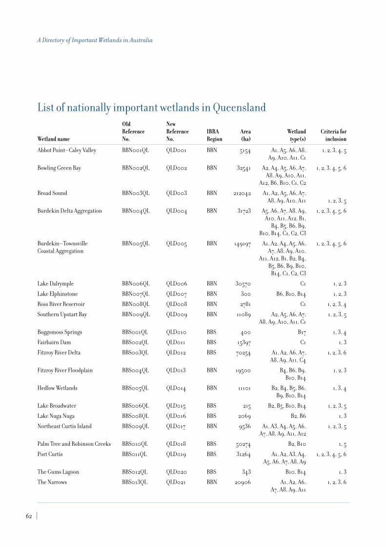
List of nationally important wetlands in QueenslandOld NewReference Reference IBRA Area Wetland Criteria for
Wetland name No. No. Region (ha) type(s) inclusion
Abbot Point—Caley Valley BBN001QL QLD001 BBN 5154 A1, A5, A6, A8, 1, 2, 3, 4, 5A9, A10, A11, C1
Bowling Green Bay BBN002QL QLD002 BBN 32541 A2, A4, A5, A6, A7, 1, 2, 3, 4, 5, 6A8, A9, A10, A11,
A12, B6, B10, C1, C2
Broad Sound BBN003QL QLD003 BBN 212042 A1, A2, A5, A6, A7, A8, A9, A10, A11 1, 2, 3, 5
Burdekin Delta Aggregation BBN004QL QLD004 BBN 31723 A5, A6, A7, A8, A9, 1, 2, 3, 4, 5, 6A10, A11, A12, B1,
B4, B5, B6, B9, B10, B14, C1, C2, C3
Burdekin—Townsville BBN005QL QLD005 BBN 149197 A1, A2, A4, A5, A6, 1, 2, 3, 4, 5, 6Coastal Aggregation A7, A8, A9, A10,
A11, A12, B1, B2, B4, B5, B6, B9, B10,
B14, C1, C2, C3
Lake Dalrymple BBN006QL QLD006 BBN 30570 C1 1, 2, 3
Lake Elphinstone BBN007QL QLD007 BBN 300 B6, B10, B14 1, 2, 3
Ross River Reservoir BBN008QL QLD008 BBN 2781 C1 1, 2, 3, 4
Southern Upstart Bay BBN009QL QLD009 BBN 11089 A2, A5, A6, A7, 1, 2, 3, 5A8, A9, A10, A11, C1
Boggomoss Springs BBS001QL QLD010 BBS 400 B17 1, 3, 4
Fairbairn Dam BBS002QL QLD011 BBS 15397 C1 1, 3
Fitzroy River Delta BBS003QL QLD012 BBS 70254 A1, A2, A6, A7, 1, 2, 3, 6A8, A9, A11, C4
Fitzroy River Floodplain BBS004QL QLD013 BBN 19500 B4, B6, B9, 1, 2, 3B10, B14
Hedlow Wetlands BBS005QL QLD014 BBN 11101 B2, B4, B5, B6, 1, 3, 4B9, B10, B14
Lake Broadwater BBS006QL QLD015 BBS 215 B2, B5, B10, B14 1, 2, 3, 5
Lake Nuga Nuga BBS008QL QLD016 BBS 2069 B2, B6 1, 3
Northeast Curtis Island BBS009QL QLD017 BBN 9536 A1, A3, A4, A5, A6, 1, 2, 3, 5A7, A8, A9, A11, A12
Palm Tree and Robinson Creeks BBS010QL QLD018 BBS 50274 B2, B10 1, 5
Port Curtis BBS011QL QLD019 BBS 31264 A1, A2, A3, A4, 1, 2, 3, 4, 5, 6A5, A6, A7, A8, A9
The Gums Lagoon BBS012QL QLD020 BBS 343 B10, B14 1, 3
The Narrows BBS013QL QLD021 BBN 20906 A1, A2, A6, 1, 2, 3, 6A7, A8, A9, A11
62
A Directory of Important Wetlands in Australia

Old NewReference Reference IBRA Area Wetland Criteria for
Wetland name No. No. Region (ha) type(s) inclusion
Yeppoon—Keppel Sands BBS014QL QLD022 BBN 10110 A1, A4, A5, A6, A7, 1, 3, 5Tidal Wetlands A8, A9, A11, A12
Birdsville—Durrie CHC001QL QLD023 CHC 32656 B2, B4, B5, B6, B9, B13 1, 2, 3Waterholes Aggregation
Bulloo Lake CHC002QL QLD024 CHC 83227 B2, B4, B6, B10, B13 1, 2, 3
Cooper Creek Overflow CHC005QL QLD025 CHC 124853 B2, B4, B13 1Swamps—Windorah
Cooper Creek Swamps CHC006QL QLD026 CHC 106311 B2, B4, B9, 1, 2, 3—Nappa Merrie B10, B13, B14
Cooper Creek—Wilson CHC007QL QLD027 CHC 63925 B2, B4, B9, 1, 2River Junction B10, B13, B14
Diamantina Lakes Area CHC008QL QLD028 CHC 393 B2, B4, B5, B13 1, 2, 3
Diamantina Overflow Swamp CHC009QL QLD029 CHC 29196 B2, B4, B13 1, 2—Durrie Station
Georgina River— CHC011QL QLD030 CHC 138347 B2, B4, B9, B13 1, 2King Creek Floodout
Lake Bullawarra CHC012QL QLD031 CHC 1287 B2, B4, B6, B13 1, 3
Lake Constance CHC013QL QLD032 CHC 1841 B2, B4, B6, B13 1, 2
Lake Cuddapan CHC014QL QLD033 CHC 1704 B6 1
Lake Mipia Area CHC015QL QLD034 CHC 69691 B2, B4, B6, B9, B13 1, 2, 3
Lake Phillipi CHC016QL QLD035 CHC 16086 B6 1
Lake Torquinie Area CHC017QL QLD036 CHC 15242 B2, B4, B8, B10 1, 2, 4
Lake Yamma Yamma CHC018QL QLD037 CHC 86548 B8, B13 1
Moonda Lake—Shallow CHC019QL QLD038 CHC 14738 B6, B13 1Lake Aggregation
Mulligan River—Wheeler CHC020QL QLD039 CHC 17014 B2, B4, B8, B9, B13 1, 2, 3Creek Junction
Muncoonie Lakes Area CHC021QL QLD040 CHC 88767 B2, B4, B8, B9, 1, 3B10, B13
Nooyeah Downs Swamps CHC022QL QLD041 CHC 6241 B2, B4, B13 1Aggregation
Toko Gorge and Waterhole CHC025QL QLD042 CHC 243 B2, B4, B9, B14, B17 1, 3, 6
Corio Bay WetlandsC CMC001QL QLD043 CMC 6909 A1, A2, A4, A5, A6, 1, 2, 3, 5A7, A8, A9, A10,
A11, B1, B2, B10, B14
Dismal Swamp—Water Park CreekC CMC002QL QLD044 CMC 1000 A11, A12, B5, B15 1, 2, 3, 5
Edgecumbe Bay CMC003QL QLD045 CMC 4593 A1, A2, A5, A7, 1, 3, 5A8, A9, A10, A11
Eungella Dam CMC004QL QLD046 CMC 797 B1, B4, C1 1, 2, 3
63
8. Queensland

Old NewReference Reference IBRA Area Wetland Criteria for
Wetland name No. No. Region (ha) type(s) inclusion
Four Mile Beach CMC005QL QLD047 CMC 7130 A1, A2, A5, 1, 3A6, A7, A8, A10
Island Head Creek— CMC006QL QLD048 CMC 27042 A1, A2, A3, A4, 1, 2, 3, 5Port Clinton Area A5, A6, A7, A8,
A9, A11, A12
Iwasaki Wetlands CMC007QL QLD049 CMC 646 A7, A8, A9, A11, A12 1, 2, 3
Proserpine—Goorganga Plain CMC008QL QLD050 CMC 16851 A1, A5, A6, A7, A8, 1, 2, 3, 4, 5A9, A10, A11, B1, B4, B6, B10, B14
Sand Bay CMC009QL QLD051 CMC 10182 A1, A4, A5, A6, 1, 2, 3, 4, 5A7, A8, A9
Sandringham Bay— CMC010QL QLD052 CMC 7372 A1, A4, A5, 1, 2, 3, 4, 5Bakers Creek Aggregation A6, A7, A8, A9
Sarina Inlet—Ince Bay Aggregation CMC011QL QLD053 CMC 27945 A1, A2, A3, A4, A5, 1, 2, 3, 4, 5A6, A7, A9, A11, C1
Shoalwater BayC CMC012QL QLD054 CMC 122672 A1, A2, A4, A5, 1, 2, 3A6, A7, A8, A9, A10
St. Helens Bay Area CMC013QL QLD055 CMC 16081 A1, A2, A3, A4, 1, 2, 3, 4, 5A5, A6, A7, A9
Archer Bay Aggregation CYP001QL QLD056 CYP 29911 A1, A2, A5, A6, A7, 1, 2, 3, 5, 6A8, A9, A10, A11,
A12, B10, B13, B14
Archer River Aggregation CYP002QL QLD057 CYP 149761 B1, B2, B4, B5, 1, 2, 3, 5, 6B6, B10, B14
Bull Lake CYP003QL QLD058 CYP 26 B5, B14 1, 2, 3, 6
Cape Flattery Dune Lakes CYP004QL QLD059 CYP 44034 B5, B6, B17 1, 2, 3
Cape Grenville Area CYP005QL QLD060 CYP 7304 A1, A2, A5, A6, A9, 1B1, B2, B4, B5, B6, B7,
B8, B10, B13, B14
Cape Melville—Bathurst Bay CYP006QL QLD061 CYP 5480 A8, A9, B2, 1, 5B9, B10, B12
Harmer River— CYP007QL QLD062 CYP 31751 A9, B2, B5, B6, 1, 3, 5Shelburne Bay Aggregation B9, B10
Jardine River Wetlands Aggregation CYP008QL QLD063 CYP 81740 A2, A5, A6, A7, 1, 2, 6A8, A9, A10, A11,
B1, B2, B4, B5, B6, B9, B10, B14
Lloyd Bay CYP009QL QLD064 CYP 15682 A1, A2, A5, 1, 3, 5, 6A6, A7, A8, A9
Marina Plains— CYP010QL QLD065 CYP 392333 B1, B2, B4, B6, B9, 1, 2, 3, 5Lakefield Aggregation B10, B12, B13, B14
64
A Directory of Important Wetlands in Australia

Old NewReference Reference IBRA Area Wetland Criteria for
Wetland name No. No. Region (ha) type(s) inclusion
Newcastle Bay—Escape CYP011QL QLD066 CYP 42307 A1, A2, A5, A6, A7, 1, 2, 3, 6River Estuarine Complex A8, A9, A10, B11, B12
Northeast Karumba CYP012QL QLD067 CYP 182418 A1, A2, A5, A6, A7, 1, 2, 3, 4, 5, 6Plain Aggregation A8, A9, A10, A11, A12
Northern Holroyd CYP013QL QLD068 CYP 1114324 B1, B2, B4, B5, B6, 1, 2, 3, 4, 5, 6Plain Aggregation B9, B10, B13, B14, C2
Olive River CYP014QL QLD069 CYP 17609 A8, A9, B1, B2, B4,B9, B10, B13, B14 1, 2, 3, 5
Orford Bay—Sharp Point CYP015QL QLD070 CYP 17239 B5, B10, B13, B14 1, 5Dunefield Aggregation
Port Musgrave Aggregation CYP016QL QLD071 CYP 52685 A1, A2, A6, A7, A8, 1, 3, 5A9, A10, A11, A12
Princess Charlotte Bay Marine Area CYP017QL QLD072 CYP 87835 A2, A7, A8, A9 1, 2, 3, 5
Silver Plains— CYP018QL QLD073 CYP 44834 A2, A7, A8, A9, 1, 3, 5Nesbit River Aggregation A10, B2, B13, B14
Skardon River— CYP019QL QLD074 CYP 63194 A7, A8, A9, 1, 2, 3, 5Cotterell River Aggregation B4, B9, B13, B14
Somerset Dunefield Aggregation CYP020QL QLD075 CYP 8095 B5, B10, B13, B14 1, 5
Temple Bay CYP021QL QLD076 CYP 4424 A2, A7, A9, B2 1, 2, 3, 5
The Jack Lakes Aggregation CYP022QL QLD077 CYP 35054 B2, B5, B13, B14 1
Violet Vale CYP023QL QLD078 CYP 1896 B2, B5, B6, B9, B10 1
Aramac Springs DEU001QL QLD079 DEU 400 B17 1, 3
Cauckingburra Swamp DEU002QL QLD080 DEU 782 B2, B6, B10 1, 2, 3, 4, 5
Doongmabulla Springs DEU003QL QLD081 DEU 399 B17 1, 3
Lake Buchanan DEU004QL QLD082 DEU 23201 B8, B12 1, 2, 3, 4, 5
Lake Galilee DEU005QL QLD083 DEU 25778 B8, B10 1, 2, 3, 4, 5
Balonne River Floodplain DRP001QL QLD084 DRP 24000 B1, B2, B4, 1, 2, 3B5, B10, B14
Blencoe Falls—Blencoe Creek EIU001QL QLD085 EIU 87 B1, B9 1, 3
Great Basalt Wall EIU002QL QLD086 EIU 100253 B1, B2, B4, B5, B6, 1, 2, 3, 4, 5, 6B9, B10, B14, B17, C2
Herbert River Gorge EIU003QL QLD087 EIU 21536 B1, B2 1, 2
Innot Hot Springs EIU004QL QLD088 EIU 78 B1, B18 1
Lake Lucy Wetlands EIU005QL QLD089 EIU 1078 B2, B4, B6, B10, B14 1, 3
Laura Sandstone EIU006QL QLD090 EIU 1090 B5, B6, B13, B17 1
Minnamoolka Area EIU007QL QLD091 EIU 589 B2, B4, B6, B10 1, 2, 3
Poison Lake EIU008QL QLD092 EIU 785 B6 1
Spring Tower Complex EIU009QL QLD093 EIU 75 B2, B17, B19 1, 3
Undara Lava Tubes EIU010QL QLD094 EIU 1254 B19 1, 2, 3, 5, 6
65
8. Queensland

Old NewReference Reference IBRA Area Wetland Criteria for
Wetland name No. No. Region (ha) type(s) inclusion
Valley of Lagoons EIU011QL QLD095 EIU 3645 B1, B2, B6, 1, 2, 3, 4, 6B10, B14, B17
Wairuna Lake EIU012QL QLD096 EIU 152 B2, B4, B6, B10, C2 1, 3
Walters Plains Lake EIU013QL QLD097 EIU 1548 B6 1
Cairncross Reef Complex GBR001QL QLD098 238 A1, A3, A4, A5, A7, A9 1, 3, 4, 5
Clack Reef Complex GBR002QL QLD099 1230 A1, A2, A3, A4, A5, 1, 3, 5, 6A7, A9, B13
Great Barrier Reef Marine Park GBR003QL QLD100 34250000 A1, A2, A3, A4, 1, 2, 3, 4, 5, 6A5, A6, A7, A9
Lawn Hill Gorge GFU001QL QLD101 GFU 1133 B1 1, 2, 3, 6
Bluebush Swamp GUP001QL QLD102 GUP 879 B10, B13 1, 2, 3
Buffalo Lake Aggregation GUP002QL QLD103 GUP 1909 B8 1, 2, 3
Dorunda Lakes Area GUP003QL QLD104 GUP 6801 B1, B2, B4, B6, 1, 2, 3B9, B10, B14
Forsyth Island Wetlands GUP004QL QLD105 GUP 6388 A1, A2, A3, A5, A7, A9 1, 3, 5, 6
Lignum Swamp GUP005QL QLD106 GUP 282 B2, B9, B10, B13 1, 2, 3
Macaroni Swamp GUP006QL QLD107 GUP 258 B6 1, 2, 3
Marless Lagoon Aggregation GUP007QL QLD108 GUP 167009 B6, B9, B10, B14 1, 2, 3
Mitchell River Fan Aggregation GUP008QL QLD109 GUP 714886 B1, B2, B4, B5, B6, 1, 2, 3, 4, 6B9, B10, B13, B14, C1
Musselbrook Creek Aggregation GUP009QL QLD110 GUP 45157 B2, B4, B10, B13, B14 1, 2, 3
Nicholson Delta Aggregation GUP010QL QLD111 GUP 63640 A6, A7, A8, A9, A10, 1, 2, 3A11, A12, B1, B2, B4, B5,
B6, B9, B10, B14, C2
Smithburne— GUP011QL QLD112 GUP 250320 B1, B2, B4, B5, B6, 1, 2, 3, 4Gilbert Fan Aggregation B10, B13, B14
Southeast Karumba GUP012QL QLD113 GUP 336233 A1, A5, A6, A7, A8, 1, 2, 3, 4, 5, 6Plain Aggregation A9, A10, A11, A12, C1
Southern Gulf Aggregation GUP013QL QLD114 GUP 545353 A1, A2, A5, A6, 1, 2, 3, 4, 5, 6A7, A8, A9, A10
Stranded Fish Lake GUP014QL QLD115 GUP 67 A10 1, 2
Wentworth Aggregation GUP015QL QLD116 GUP 82430 A5, A6, A7, A8, A9, 1, 2, 3, 4A10, A11, B1, B2, B4,
B5, B9, B10, B13, B14
Austral Limestone Aggregation MGD001QL QLD117 MGD 69395 B2, B6 1
Elizabeth Springs MGD003QL QLD118 MGD 400 B17 1, 3
Gregory River MII001QL QLD119 MII 26639 B1 1, 2, 3, 4
Lake Julius MII002QL QLD120 MII 1935 C1 1, 2, 3
Lake Moondarra MII003QL QLD121 MII 1742 C1 1, 2, 3
66
A Directory of Important Wetlands in Australia

Old NewReference Reference IBRA Area Wetland Criteria for
Wetland name No. No. Region (ha) type(s) inclusion
Thorntonia Aggregation MII004QL QLD122 MII 298888 B1, B2 1, 2, 3, 6
Lake Numalla Aggregation ML002QL QLD123 ML 10724 B2, B5, B6, B8 1, 2, 3, 4, 5, 6
Lake Wyara ML003QL QLD124 ML 6020 B2, B7, B8, B12 1, 2, 3, 4, 5, 6
Lakes Bindegolly and Toomaroo ML004QL QLD125 ML 9677 B4, B5, B6, B12 1, 2, 3, 5
Burrum Coast SEQ001QL QLD126 SEQ 15128 A1, A2, A5, A6, A7, 1, 2, 3A8, A9, A11, A12
Bustard Bay Wetlands SEQ002QL QLD127 SEQ 21850 A1, A2, A3, A4, A5, A6, 1, 2, 3, 5, 6A7, A8, A9, A11, A12
Carbrook Wetlands Aggregation SEQ003QL QLD128 SEQ 329 B9, B13, B14 1, 2
Colosseum Inlet—Rodds Bay SEQ004QL QLD129 SEQ 24307 A1, A2, A4, A5, 1, 2, 3, 4, 5A6, A7, A8, A9
Conondale Range Aggregation SEQ005QL QLD130 SEQ 1983 B1 1, 3, 4, 5
Fraser Island SEQ006QL QLD131 SEQ 163294 A4, A5, A6, A7, 1, 2, 3, 4, 5, 6A8, A9, A11, B1, B5,
B9, B13, B14, B15, B17
Great Sandy Strait SEQ007QL QLD132 SEQ 93160 A1, A2, A5, A6, 1, 2, 3, 4, 5, 6A7, A8, A9, A11, A12
Lake Weyba SEQ008QL QLD133 SEQ 2860 A8, A10, A11, 1, 2, 3, 4, 5A12, B14, B15
Moreton Bay SEQ009QL QLD134 SEQ 300177 A1, A2, A3, A4, A5, 1, 2, 3, 4, 5, 6A6, A7, A8, A9, A10,
A11, B1, B2, B4, B5, B7, B9
Noosa River Wetlands SEQ010QL QLD135 SEQ 9945 A5, A6, A7, A8, 1, 2, 3, 4, 5, 6A9, A11, A12, B1,
B4, B5, B7, B9, B10, B14, B15
Pumicestone Passage SEQ011QL QLD136 SEQ 9442 A1, A2, A5, 1, 2, 4, 5A6, A7, A8, A9
Alexandra Bay WT001QL QLD137 WT 841 A5, A6, A9, B14 1, 5
Alexandra Palm Forest WT002QL QLD138 WT 146 B1, B14 1, 2, 5
Bambaroo Coastal Aggregation WT003QL QLD139 WT 5360 A2, A5, A7, A9, 1, 3, 5A11, B1, B2
Birthday Creek WT004QL QLD140 WT 43 B1 1
Bromfield Swamp WT005QL QLD141 WT 63 B5, B15 1, 3, 6
Cowley AreaC WT006QL QLD142 WT 8344 A1, A2, A5, A6, A7, 1, 3, 5A9, A12, B1, B2,
B9, B10, B14
Edmund Kennedy Wetlands WT007QL QLD143 WT 11083 A5, A6, A7, A8, A9, 1, 2, 3, 4, 5, 6A10, A11, A12, B1,
B2, B4, B9, B10, B14
67
8. Queensland

Old NewReference Reference IBRA Area Wetland Criteria for
Wetland name No. No. Region (ha) type(s) inclusion
Ella Bay Swamp WT008QL QLD144 WT 1315 A5, A7, A8, A9, B1, B2, B14 1, 3, 5
Eubenangee—Alice River WT009QL QLD145 WT 1991 B1, B2, B4, B9, 1, 3, 5B10, B13, B14, B15
Herbert River Floodplain WT010QL QLD146 WT 44496 A1, A2, A5, A6, 1, 2, 3, 4, 5A7, A8, A9, A10, A11,
B1, B2, B4, B5, B6, B7, B8, B9, B10, B11, B12,
B14, C2, C5, C6, C7, C8
Hilda Creek Headwater WT011QL QLD147 WT 5 B1, B10, B13, B17 1, 2, 4, 5
Hinchinbrook Channel WT012QL QLD148 WT 30382 A1, A2, A4, 1, 2, 3, 4, 5, 6A5, A7, A8, A9
Innisfail Area WT013QL QLD149 WT 1220 B1, B4, B9, B14, B15 1, 5
Kurrimine Area WT014QL QLD150 WT 754 A1, A4, A5, 1, 3A6, A9, B14
Lake Barrine WT015QL QLD151 WT 99 B5 1, 2, 6
Lake Eacham WT016QL QLD152 WT 43 B5 1, 6
Licuala Palm Forest WT017QL QLD153 WT 232 B2, B14 1, 2, 3, 4, 5
Lower Daintree River WT018QL QLD154 WT 5276 A6, A9, B1, B14 1, 2, 3, 5
Missionary Bay WT019QL QLD155 WT 1129 A1, A2, A5, A6, 1, 2, 3, 5, 6A7, A8, B1, B2,
B10, B14
Nandroya Falls WT020QL QLD156 WT 19 B1 1, 2, 5
Port of Cairns and Trinity Inlet WT021QL QLD157 WT 6389 A1, A2, A5, A6, 1, 2, 3, 4A7, A8, A9, A10,
A12, C6, C7, C8
Russell River WT022QL QLD158 WT 2377 A5, A6, A9, A12, 1, 5B1, B2, B14, B15
Russell River Rapids WT023QL QLD159 WT 235 B1, B4, B9, B14 1, 2, 3, 5, 6
Sunday Creek, Broad-leaved WT024QL QLD160 WT 39 B14 1, 2, 5Paperbark Site
Tully River—Murray WT025QL QLD161 WT 39154 B1, B4, B5, B6, 1, 2, 3, 4, 5, 6River Floodplains B9, B10, B14, B15,
C2, C6, C7, C8
West Mulgrave Falls WT026QL QLD162 WT 7 B1 1, 5
Wyvuri Swamp WT027QL QLD163 WT 1492 B9, B14 1
Yuccabine Creek WT028QL QLD164 WT 529 B1 1, 6
Zillie Falls WT029QL QLD165 WT 16 B1, B14 1, 3, 5
Wyandra—Cunnamulla QLD166 ML 30000 B6, B10, B13 1, 2, 3 Claypans Aggregation
68
A Directory of Important Wetlands in Australia

Old NewReference Reference IBRA Area Wetland Criteria for
Wetland name No. No. Region (ha) type(s) inclusion
Quilpie (Bulloo River QLD167 ML 30 B2, B4, B5, B6, 1, 2, 3Floodplain) Waterholes B10, B13, B14
Lake Dartmouth Area QLD168 ML 10000 B2, B4, B6, B9, 1, 2, 3B10, B13, B14
Warrego River Distributary System QLD169 ML 12000 B2, B4, B5, B6, B9, 1, 2, 3 B10, B13, B14, C1
Mitchell Swamp QLD170 ML 5000 B6, B10, B13 1
Warrego River Waterholes QLD171 ML 500 B2, B4, B5, 1, 2, 3(Charleville—Wyandra) B6, B9, B10
“Old Bando” Swamp QLD172 ML 2000 B6, B10, B13 1
“Myola” —“Mulga Downs” Salt Lake QLD173 ML 8000 B8, B10, B12, B13 1and Claypans
“Murrawondah” Lakes QLD174 ML 2500 B6, B10, B13 1
Lake Wombah—Kungie Lake Group QLD175 ML 20000 B2, B6, B8, 1, 2, 3, 5B10, B12, B13
Paroo River Waterholes QLD176 ML 25 B2, B4, B5, B6, B9, 1, 2, 3, 6(“Caiwarro” Area) B10, B13, B14
Eulo Artesian Springs Supergroup QLD177 ML 30 B17 1, 2, 3, 4, 5
Shoalwater Bay Training QLD178 CMC 454000 A1, A2, A4, A6, A7, 1, 2, 3, 5Area Overview C A8, A9, A10, A11,
A12, B2, B5, B15
Wide Bay Military Training Area C QLD179 SEQ 19990 A2, A5, A6, A9 1, 2, 3, 4, 5
Greenbank Army Training Area C QLD180 SEQ 4665 B1, B4 1, 5
RAAF Townsville C QLD181 BBN 300 B2, B4, B9, B10 2, 3
C wetlands occurring in part on land owned or managed by the Commonwealth (eight sites).
Note: area figures for the above tables are approximate only.
69
8. Queensland

Introduction
Josephine Morelli and Mark C. de Jong, Department of Natural Resources and Environment(abridged from the second edition)
The State of South Australia (SA), encompassing some 984,000 km2
, is by far the
driest of all Australian States with 75% receiving less than 200 mm of rainfall.
In spite of this being the driest State in the driest continent, SA contains an array ofsignificant wetlands. The arid interior is notable for its mound springs, salt lakes andpristine freshwater river-floodplain systems of the Lake Eyre Basin. The coastline is 4,000 km long containing two Gulf regions; notable features include sheer cliffs, sandybeaches for thousands of shorebirds, coastal embayments, and several mangrove/samphireand estuarine mud flat systems. Notable in the South East are the coastal salt lakes,freshwater ponds and shallow lagoons, peat fens and marshes. The Riverland region is noted for its freshwater swamps, channels, lakes and floodplains.
Since European settlement, many wetlands, particularly in the southern agriculturalregions, have been significantly altered through stock grazing, vegetation clearance,pollution, urban development or hydrological changes. Even so, there are some magnificentareas of wetlands remaining, areas which are highly valued for wildlife, of cultural, scientificand historical interest, and possessing great aesthetic and recreational appeal.
In the first edition of A Directory of Important Wetlands in Australia (ANCA 1993), 43 wetlandswere listed. Most of these wetlands have been retained and updated while others, such as Serpentine Lakes, Ooldea Soak and Warbla Cave Lakes, have been omitted from theDirectory mainly because they either lack site information or no longer meet the criteria for inclusion. The Directory now contains a total of 69 South Australian wetland sites (referto Figure 7); four of which have been nominated as Ramsar sites. No new sites have beennominated by the State since the second edition of the Directory was published (ANCA1996), however, one site on Commonwealth land has been added.
The selected sites are categorised according to the Wetland Classification System (seeChapter 2) and described by their physical, hydrological and biological attributes. Atpresent, knowledge of the Riverland, South East, and coastal wetlands is relatively adequate.Work is currently underway to investigate wetlands on the Eyre and Yorke Peninsulas, NorthAdelaide Plains, and Kangaroo Island. The least known wetland areas remain within thesouthern Mt Lofty Ranges, Flinders Ranges, Great Victoria Desert and far north-easterndesert and gibber plains.
9. South Australia
73

In the site descriptions, common and scientific names of waterbirds follow Christidis andBoles (1994). The taxonomy of other vertebrates is from Watts (1990). Current botanicalnames for dominant wetland plant species follow Jessop (1993). Wetlands that supportnative plant and animal species which are listed as rare, vulnerable or endangered at theState level were identified according to the species scheduled in the South AustralianNational Parks and Wildlife Act, 1972 as amended at July 1988. Nationally threatenedvertebrate fauna were determined using the ANZECC List of Endangered Vertebrate FaunaApril 1991. The status of threatened flora species was determined from the ThreatenedAustralian Flora June 1993 listing prepared by ANZECC.
Conservation and ManagementManagement of wetlands in South Australia has largely been through the establishment of reserves under the National Parks and Wildlife Act, 1972. In recent years there has been anincreased recognition by private landholders of the values and roles of wetlands and this hasresulted in the protection and management of a number of wetland sites outside the reservesystem, particularly in the South East region. So far, there are approximately 120 wetlandsin the State’s reserve system. Management plans have been prepared for most of theseareas. Much of the River Murray floodplain contained within the Riverland Ramsar site(Chowilla, Calperum) is included in the Bookmark Biosphere Reserve. It is noteworthy thatthe four Ramsar sites within the State are entirely or partially designated as formal naturereserves.
Future ResearchWhile the establishment of a reserve system provides a basis for wetland protection andmanagement, the lack of data available for some wetlands highlights the need for systematicinventories, biological surveys and research programs in many areas of the State. In thisDirectory the lack of systematic broadscale surveys shows in the gaps of informationpresented and in the omission of some poorly known yet potentially important sites. Thischapter of the Directory remains incomplete until these gaps are filled. It is recommendedthat a statewide survey be conducted to compare with the results of Lloyd and Balla (1986).Special attention should be given to the bioregions of the Great Victoria Desert, Flindersand Olary Ranges and Nullarbor since present survey information is severely inadequate.One of the obvious gaps in this Directory is the lack of nominations from the FlindersRanges, therefore future work should be directed towards obtaining information on thewetlands that occur in this bioregion. Any future revisions of the Directory should alsoinclude the supplementary list of wetlands included in the second edition (ANCA 1996) thatmeet one or more of the criteria but remain too poorly known for inclusion at this stage.
AcknowledgmentsThe South Australian entries in A Directory of Important Wetlands in Australia were compiledby Josephine Morelli and Mark C. de Jong, for the then South Australian Department ofEnvironment and Natural Resources (DENR). Funds for this work were provided by thethen Australian Nature Conservation Agency through the National Wetlands Program. Many people contributed information or expertise in compiling the South Australianentries in the Directory, and their contribution is acknowledged once again.
74
A Directory of Important Wetlands in Australia

Summary analysis
The Directory describes 69 nationally important wetlands in South Australia. The distribution of nationally important wetlands in SA (including Ramsar wetlands) is shown in Figure 7. A list compiling data on bioregion, site area, wetland type and criteriafor inclusion for each wetland is provided at the end of this chapter.
Of the 15 bioregions in South Australia, 11 are shared with adjacent jurisdictions and onlyeight contain nationally important wetlands (refer to Table 9.1). Of these eight, only fourhave more than three nationally important wetlands listed. The four bioregions with moreextensive listings all occur in the more humid south and east of the State. Lofty Blockbioregion, in which Adelaide is located, has 18 (26%) of the wetlands listed in the State. Anoverview of the IBRA regionalisation and a map of IBRA regions is included in Appendix 2.
Table 9.1 Number and area of nationally important wetlands in SA by IBRA regionIBRA Region IBRA code No. of Sites Area (ha)
Broken Hill Complex BHC 0 0
Central Ranges CR 0 0
Channel Country CHC 3 1,980,000
Eyre and Yorke Blocks EYB 16 38,238
Finke FIN 0 0
Flinders and Olary Ranges FOR 1 —
Gawler GAW 0 0
Great Victoria Desert GVD 0 0
Hampton HAM 0 0
Lofty Block LB 18 50,750
Murray-Darling Depression MDD 14 44,927
Naracoorte Coastal Plain NCP 13 293,073
Nullarbor NUL 0 0
Simpson-Strzelecki Dunefields SSD 2 1,798,000
Stony Plains STP 2 19,000
Total 15 69 2,205,750
Note: area figure for Flinders and Olary Ranges not available.
A total of 30 of the 40 wetland types are represented in South Australia (refer to Table 9.2).Most commonly included is type A7—Intertidal mud, sand or salt flats (n=17), followed by A1—Marine waters (n=16), B4—Riverine floodplains (n=15) and B6—Seasonal/intermittentfreshwater lakes (n=15). The Wetland classification system and Criteria for inclusion in theDirectory are explained in Chapter 2.
75
9. South Australia
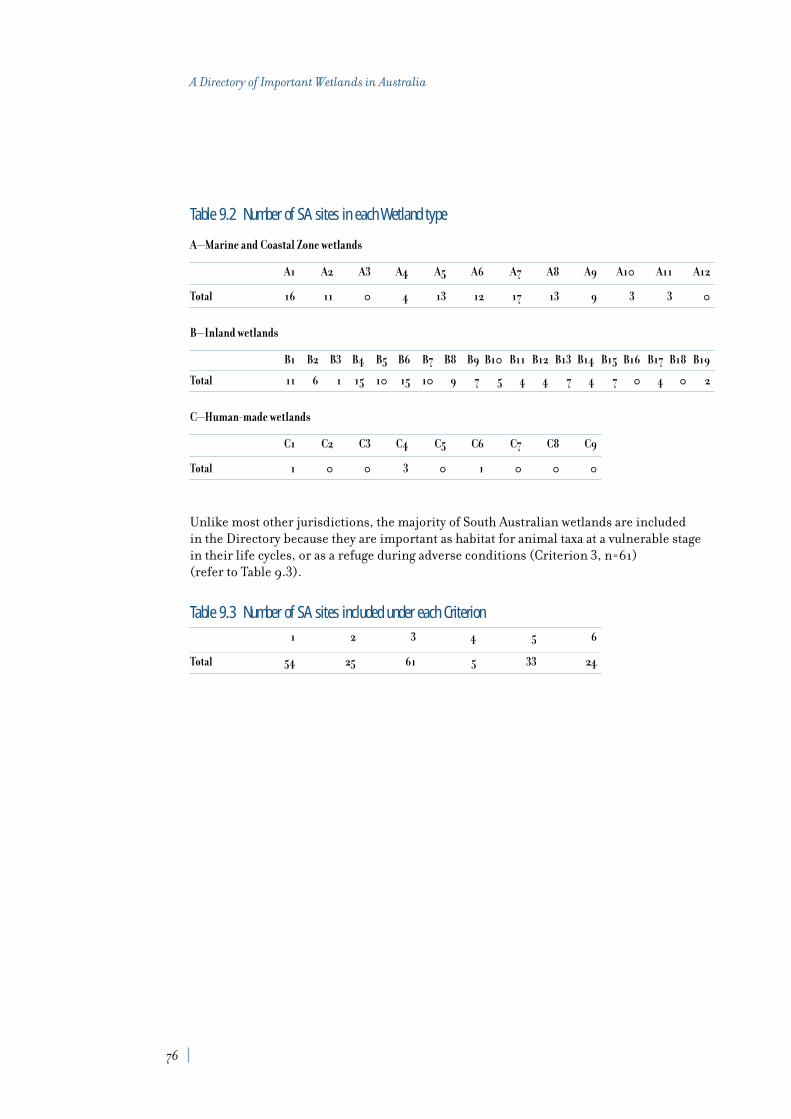
Table 9.2 Number of SA sites in each Wetland type
A—Marine and Coastal Zone wetlands
A1 A2 A3 A4 A5 A6 A7 A8 A9 A10 A11 A12
Total 16 11 0 4 13 12 17 13 9 3 3 0
B—Inland wetlands
B1 B2 B3 B4 B5 B6 B7 B8 B9 B10 B11 B12 B13 B14 B15 B16 B17 B18 B19
Total 11 6 1 15 10 15 10 9 7 5 4 4 7 4 7 0 4 0 2
C—Human-made wetlands
C1 C2 C3 C4 C5 C6 C7 C8 C9
Total 1 0 0 3 0 1 0 0 0
Unlike most other jurisdictions, the majority of South Australian wetlands are included in the Directory because they are important as habitat for animal taxa at a vulnerable stagein their life cycles, or as a refuge during adverse conditions (Criterion 3, n=61) (refer to Table 9.3).
Table 9.3 Number of SA sites included under each Criterion1 2 3 4 5 6
Total 54 25 61 5 33 24
76
A Directory of Important Wetlands in Australia

List of nationally important wetlands in South AustraliaOld NewReference Reference IBRA Area Wetland Criteria for
Wetland name No. No. Region (ha) type(s) inclusion
Coongie Lakes CHC004SA SA001 CHC 1980000 B2, B4, B6 1, 2, 3, 4, 5, 6
Diamantina River Wetland System CHC010SA SA002 CHC — B1, B2, B4, B13 1, 2, 3
Strzelecki Creek Wetland System CHC024SA SA003 CHC — B2, B4, B6 1, 2, 3
Baird Bay EYB001SA SA004 EYB 250 A1, A4, A5, A7, A8 3
Barker Inlet & St Kilda EYB002SA SA005 EYB — A1, A2, A6, A7, A8, A9, C4 1, 2, 3, 5, 6
Big Swamp EYB003SA SA006 EYB 200 B6 1, 3
Clinton EYB004SA SA007 EYB 1964 A1, A2, A6, A7, A8, A9 1, 3
Coffin Bay Coastal Wetland System EYB005SA SA008 EYB — A1, A4, A5, A7 3, 5, 6
Davenport Creek EYB006SA SA009 EYB — A1, A4, A5, A7, A8, A9 1, 3, 5, 6
Franklin Harbour EYB007SA SA010 EYB 1500 A1, A2, A6, A7, A8, A9 1, 3, 6
Lake Hamilton EYB008SA SA011 EYB 2000 B8 1
Lake Newland EYB009SA SA012 EYB 8448 B7 1, 3, 5
Point Davenport EYB010SA SA013 EYB 181 A10 1, 3, 5
Point Labatt EYB011SA SA014 EYB 147 A4, A5 3, 5
Port Gawler & Buckland Park Lake EYB012SA SA015 EYB 434 A1, A2, A6, A7, 1, 3, 5, 6A8, A9, C4, B6
Streaky Bay EYB013SA SA016 EYB — A1, A2, A5, A7, A8, A9 3, 5
Tod River Wetland System EYB014SA SA017 EYB 21240 A6, A7, B1, C1 1, 2, 3
Tumby Bay EYB015SA SA018 EYB 1000 A1, A2, A5, A6, 1, 3A7, A8, A9
Wills Creek EYB016SA SA019 EYB 874 A1, A2, A7, A8, A9, C4 1, 3
Upper Spencer Gulf FOR001SA SA020 FOR — A1, A2, A6, A7, A8, A9 1, 3, 5, 6
American River Wetland System LB001SA SA021 LB 2000 A1, A2, A5, A7, A8, A10 1, 3, 5, 6
Birchmore Lagoon LB002SA SA022 LB 150 B7 3
Busby and Beatrice Islets LB003SA SA023 LB 1525 A1, A5, A7 3
Cygnet Estuary LB004SA SA024 LB 1300 A1, A5, A6, A7, A8 1, 2, 3, 5
Cygnet River LB005SA SA025 LB — B1, B4 1, 2, 3
D’Estrees Bay LB006SA SA026 LB 140 A1, A2, A5, A7 3, 5
Flinders Chase River Systems LB007SA SA027 LB 40450 B1, B6, B13, B17 1, 2, 3, 5
Grassdale Lagoons LB008SA SA028 LB 135 A6, A11 1, 3, 5
Lake Ada LB009SA SA029 LB 994 B7 1, 3
Lanacoona Road Swamps LB010SA SA030 LB 30 B15 1, 5
Lashmar Lagoon LB011SA SA031 LB 130 A6, A11 3, 5
Murrays Lagoon LB012SA SA032 LB 2200 B7 3, 5
Onkaparinga Estuary LB013SA SA033 LB 60 A1, A2, A6, A7, A8 1, 3, 6
Tookayerta & Finniss Catchments LB014SA SA034 LB 300 B9, B15 1, 3, 5, 6
Upper Hindmarsh River Catchment LB015SA SA035 LB 6 B15 1, 2, 5
77
9. South Australia

Old NewReference Reference IBRA Area Wetland Criteria for
Wetland name No. No. Region (ha) type(s) inclusion
Upper Tunkalilla Creek Swamps LB016SA SA036 LB 50 B9, B15 1, 2, 5
Waidrowski Lagoon LB017SA SA037 LB 530 B7 1, 3, 5
White Lagoon Wetland System LB018SA SA038 LB 750 B6, B7 1, 3, 5
Banrock Swamp Wetland Complex MDD001SA SA039 MDD 1220 B1, B4, B5, B6 1, 2, 3
Gurra Lakes Wetland Complex MDD006SA SA040 MDD 660 B1, B4, B5 3
Irwin Flat MDD010SA SA041 MDD 50 B4, B5, B6 1, 3
Loch Luna Wetland Complex MDD019SA SA042 MDD 1905 B1, B4, B5 1, 2, 3, 6
Loveday Swamps MDD020SA SA043 MDD 479 B2, B4, B5, B6, B7, B8 1, 2, 3, 6
Lower Murray Swamps MDD022SA SA044 MDD 155 B4, B5, B9 1, 2, 3
Marne River Mouth MDD024SA SA045 MDD 40 B2, B3, B4 1, 2, 3
Noora Evaporation Lakes MDD027SA SA046 MDD 500 B7, B11 3
Pike—Mundic Wetland Complex MDD028SA SA047 MDD 6700 B1, B4, B5 1, 3, 6
Riverland Wetland Complex MDD032SA SA048 MDD 30600 B1, B4, B5, B6, B13, B14 1, 2, 3, 4, 6
Spectacle Lakes MDD034SA SA049 MDD 427 B2, B4, B6 1, 2, 3
Stockyard Plain MDD035SA SA050 MDD 1870 A5, B7, B11 3, 5
Swan Reach Wetland Complex MDD036SA SA051 MDD 250 B1, B4, B6, B9 1, 2, 3
Bool & Hacks Lagoons NCP001SA SA052 NCP 3221 B5, B10, B13 1, 2, 3, 4, 6
Butchers & Salt Lakes NCP002SA SA053 NCP 40 A5, B8, B12 1, 3, 5
Deadmans Swamp NCP003SA SA054 NCP 545 B9, B10 1, 3
Ewens Ponds NCP004SA SA055 NCP 5 B1, B9, B15, B19 1, 5, 6
Honans Scrub NCP006SA SA056 NCP 842 B10, B14 1, 5
Lake Frome & Mullins Swamp NCP007SA SA057 NCP 3216 B8, B11, B12 1, 2, 3
Marshes Swamp NCP010SA SA058 NCP 665 B10, B13, B15 1, 3, 5
Naen Naen Swamp & Gum Lagoon NCP012SA SA059 NCP 335 B6, B8, B10, B13 3, 5
Piccaninnie Ponds NCP013SA SA060 NCP 300 A5, B9, B15, B19 1, 5, 6
Poocher & Mundulla Swamps NCP014SA SA061 NCP 300 B5, B6, B14 2, 6
South East Coastal Salt Lakes NCP015SA SA062 NCP 137444 A6, B8, B17 1, 3, 6
The Coorong, Lake Alexandrina NCP016SA SA063 NCP 140500 A10, A11, B8, B12 1, 2, 3, 4, 5, 6& Lake Albert
Watervalley Wetlands NCP017SA SA064 NCP 5660 B6, B7, B11, 1, 3, 4B12, B13, B14
Inland Saline Lakes SSD001SA SA065 SSD 829000 B8 1, 2, 3, 6
Lake Eyre SSD002SA SA066 SSD 969000 B8 1, 2, 3, 6
Dalhousie Springs STP001SA SA067 STP 19000 B17 1, 3, 6
Lake Eyre Mound Springs STP002SA SA068 STP — B17 1, 2, 3, 5, 6
Murray Bridge Army Training SA069 MDD 71 C6 3, 5Area WetlandsC
C wetlands occurring in part on land owned or managed by the Commonwealth (one site).
Note: area figures for the above tables are approximate only and are not available for all wetlands.
78
A Directory of Important Wetlands in Australia

Introduction
Stewart A. Blackhall, Anne C. McEntee and Elizabeth Rollins, Tasmania Parks and Wildlife Service
Despite its size of 68,330 km2
, the island of Tasmania (Tas) has a wide diversity
of habitats. The great geographic and altitudinal variation found on the island means that rainfall varies from 700 to 2,300 mm per annum. There are also wide variations intopography, geology, soil fertility, and other ecological factors such as fire frequency and the presence of light-robbing tannin in the water. This ecological variation, together withTasmania’s placement in the path of the Roaring Forties trade winds and its long coastlineof approximately 3,200 km, including offshore islands, has resulted in an unusually richabundance and diversity of wetlands at all altitudes (Hill and Orchard 1999). Tasmania hasrepresentatives of almost every wetland type in the classification system, except for coralreefs and mangroves.
Tasmania’s wetlands contain a high proportion of endemic species (eg Bowling et al. 1993;Kirkpatrick and Tyler 1988), as well as a disproportionately large percentage of all of theState’s vascular species (Kirkpatrick and Harris 1999). Tasmania also provides a significantlink in the understanding of southern hemisphere biogeographic processes, with the biotashowing elements of its Gondwanan heritage, not evident on the mainland of Australia, aswell as distinctly Australian elements (Jackson 1999). Wetlands, including ancient wetlands,provide one of the primary reservoirs of palaeogeographic information (Hill et al. 1999).Limnological studies of Tasmanian wetlands have also revealed some unique lenticenvironments (eg Bowling and Tyler 1988, Edgar et al. 1996) and scientific mysteries (eg Cheng and Tyler 1976). In combination, these factors create the unusually highscientific and biological value of Tasmania’s wetlands.
Tasmanian wetlands also provide an important resource for many significant migratorybirds. Tasmania is the southern-most area in Australia where these birds can rest and feedduring their annual migration from the high Arctic.
Tasmania has 89 wetlands listed in A Directory of Important Wetlands in Australia. Thelocation of each of the listed sites is illustrated in Figure 8. In this edition, a very significantarea including Boullanger Bay and Robbins Passage has been added. A nomination is beingprepared to list this area on the Convention on Wetlands (Ramsar, Iran, 1971). CurrentlyTasmania has ten sites listed under this Convention. Twenty-eight sites are known to hostspecies listed on the Japan—Australia Migratory Bird Agreement (JAMBA) and/or theChina—Australia Migratory Bird Agreement (CAMBA).
10. Tasmania
81

The 89 sites listed here represent only a fraction of the State’s wide range of wetlands. There are at least 800 sites listed on the inventory of Tasmanian wetlands (about onequarter of the estimated number in Tasmania), and it remains the case that much of ourknowledge of these wetlands is inadequate or outdated. As discussed by Blackhall et al.(1996), about half the State’s land area is yet to be investigated for wetlands. In particular,many flowing, artificial and marine waters are still awaiting investigation.
The wetlands are included under a number of Criteria (see Chapter 2), primarily relating to flora and fauna, but some are also listed for significant hydrological or cultural values.Further investigation and increasing recognition of the values of the State’s wetlands willundoubtedly lead to the listing of more nationally or internationally significant sites. Sadly,new information has also lead to the de-listing of some wetlands that have been severelydisturbed or destroyed. Three sites previously included because they were thought tosupport threatened taxa have been removed from the Directory because no further work has been done to confirm their presence.
As in other States, Tasmania continues to lose wetlands, primarily to agricultural landclearing, urban development and hydro-electric development. The original extent ofwetlands is unknown, and therefore the loss is difficult to quantify. With a small humanpopulation of approximately 454,000, the impact has probably been less than in some morepopulous areas. None-the-less, the inventory of Tasmanian wetlands shows that in 1981some 51% of known wetlands were disturbed, and 12% were severely disturbed or destroyed(Kirkpatrick and Harwood 1981).
In Tasmania, development has largely concentrated on the relatively fertile North and East coasts, with large, relatively undisturbed areas on the South and West coasts wherehydro-electric power generation and logging have been the only industrial activities. Thistrend has resulted in certain vegetation types such as grasslands being threatened andpoorly reserved. Doubtless, this has also led to disproportionate vulnerability of wetlandtypes which predominantly occur in the North and East coasts, and Central Highlands of Tasmania.
Few of the listed wetlands are afforded protection in reserves under the Tasmanian NationalParks and Wildlife Act 1970 or Crown Lands Act 1976. These forms of legal “protection” are alsooften ineffective, as existing buffer zones are frequently inadequate to protect the wetlandsfrom adjacent land use, and the reserve status and corresponding proscriptions are oftennot adequate to prevent damage. Proscriptions have commonly been ignored by adjacentlandowners or other land users with activities such as grazing, clearing and four-wheeldriving extending into reserved areas, often to the shoreline. Activities occurring within a wetland’s catchment, for example siltation, eutrophication, introduction of weeds etc.pose difficult management problems. Many of these activities in and near the wetlands aregenerally not monitored, due to shortage of policing resources, and the location of mostwetlands near or within private land.
The diversity of Tasmania’s wetlands itself poses a management challenge. Importantwetlands are widely distributed geographically and very varied in nature. Land managers,planners and developers are sometimes unaware of the existence, form or function ofwetlands. The Tasmanian Wetland Inventory (Atkinson 1991) has been useful in timelyprovision of informed advice in response to development proposals, but is desperately in need of information gathering and updating, and the funds to do so.
Some promising developments include an enhanced interest in “off reserve conservation”;with programs such as Landcare, Coastcare, Rivercare, Bushcare, Land for Wildlife, and
82
A Directory of Important Wetlands in Australia

Whole Farm Planning providing support for, and education about, conservation on privateland. Catchments are now widely regarded as the basic minimum unit for ecologicalmanagement, and much of the conservation/management funding is catchment oriented.The Natural Heritage Trust has enabled the formation of a number of catchmentmanagement groups that are now preparing plans that should greatly benefit wetlands in the future.
Implementation of the Regional Forest Agreement (RFA—an agreement between theTasmanian and Commonwealth governments) and subsequent State legislation has led toreservation of new areas, and upgrading of some existing reserves, with the aim of providinga “Comprehensive, Adequate and Representative Reserve System” for forest communities.Many of these areas are, and will remain, in private hands. However, the implementation of the RFA on private land is leading to new, more flexible, more consultative mechanismsfor conservation and appropriate management by landowners, as well as (minimal)compensation and legal mechanisms of protection (eg covenants). As monitoring andpolicing of activities within and around reserves has been and continues to be, one of themain problems of wetland conservation, mechanisms such as extension, compensation andconsultation which are inclusive of stakeholders should lead to more effective conservation.
AcknowledgmentsThe update and addition of information for this edition of A Directory of Important Wetlandsin Australia was made possible by funding through the National Wetlands Program ofEnvironment Australia. Two people were employed to carry out the work and many othersgave freely of their time and made information available for inclusion. In particular, MrsPriscilla Park of Birds Tasmania provided records from that organisation for many of thesites. Michael Pemberton, Senior Earth Scientist with the Nature Conservation Branch of the Department of Primary Industries, Water and Environment provided much of theinformation used in the site descriptions and Stephen Harris, Senior Botanist providedinformation on vegetation.
We also wish to thank Brendan Edgar, Sarah Young, Geoff Larmour and Belinda Thorpe of the Wetlands Section for their support and guidance during the project.
Note: Grid references are given in the site information, as well as latitudes and longitudes,and the TASMAP No. refers to the appropriate 1:100 000 series map (available from theTasmanian Department of Primary Industries, Water and Environment,http://www.tas.gov.au). The Department of Primary Industries, Water and Environment,which includes the Parks and Wildlife Service, has previously been known by a number of names. The National Parks and Wildlife Service (NPWS) and Lands Department becamethe Department of Lands Parks and Wildlife, then the Departments of Parks, Wildlife andHeritage (PWH), and Environment and Planning, then the Department of Environment and Land Management (DELM).
83
10. Tasmania

Summary analysis
The Directory describes 89 nationally important wetlands in Tasmania. The distribution of nationally important wetlands in Tas (including Ramsar wetlands) is shown in Figure 8. A list compiling data on bioregion, site area, wetland type and criteria for inclusion for eachwetland is provided at the end of this chapter.
Eight bioregions occur in Tasmania, with Furneaux the only one that is shared withneighbouring Victoria. All bioregions contain nationally important wetlands (refer to Table 10.1). The six smallest bioregions are found in Tasmania and the remaining two areamong the smallest. The second smallest bioregion of D’Entrecasteaux covers 4,203 km2
but has only three wetlands listed, covering an approximate area of 61 ha. The largest of theTasmanian bioregions, West and South West, covers 18,269 km2 and has seven wetlandslisted. An overview of the IBRA regionalisation and a map of IBRA regions is included in Appendix 2.
Table 10.1 Number and area of nationally important wetlands in Tas by IBRA regionIBRA Region IBRA code No. of Sites Area (ha)
Ben Lomond BEN 15 281
Central Highlands CH 12 2,420
D’Entrecasteaux DE 3 61
Freycinet FRE 8 7,650
Furneaux FUR 14 3,729
Tasmanian Midlands TM 20 2,128
West and South West WSW 7 66
Woolnorth WOO 10 35,179
Total 8 89 51,514
Nineteen of the 40 wetland types are represented in Tasmania, with a majority of theseMarine and Coastal Zone wetlands (refer to Table 10.2). Apart from the ACT and the islandsof the External Territories, Tasmanian wetlands exhibit the smallest range of Inland wetlandtypes, with only seven represented. The most commonly listed type is A11—Freshwaterlagoons and marshes in the coastal zone (n=20), and the next most common types are A10—Brackish to saline lagoons and marshes (n=13) and B15—Peatlands (n=13). The Wetland classification system and Criteria for inclusion in the Directory are explainedin Chapter 2.
84
A Directory of Important Wetlands in Australia

Table 10.2 Number of Tas sites in each Wetland type
A—Marine and Coastal Zone wetlands
A1 A2 A3 A4 A5 A6 A7 A8 A9 A10 A11 A12
Total 4 2 0 3 2 5 1 4 1 13 20 0
B —Inland wetlands
B1 B2 B3 B4 B5 B6 B7 B8 B9 B10 B11 B12 B13 B14 B15 B16 B17 B18 B19
Total 11 0 0 0 9 2 3 2 3 0 0 0 0 0 13 0 0 0 0
C —Human-made wetlands
C1 C2 C3 C4 C5 C6 C7 C8 C9
Total 1 0 0 2 0 0 0 0 0
Unlike all other jurisdictions, Tasmanian wetlands are most often included in the Directorybecause they support taxa or communities that are nationally threatened (Criterion 5,n=74). The next most important reason for inclusion is because they are good examples of a wetland type within a particular bioregion (Criterion 1, n=31) (refer to Table 10.3).
Table 10.3 Number of Tas sites included under each Criterion1 2 3 4 5 6
Total 31 6 9 4 74 6
85
10. Tasmania

List of nationally important wetlands in TasmaniaOld NewReference Reference IBRA Area Wetland Criteria for
Wetland name No. No. Region (ha) type(s) inclusion
Blackmans Lagoon BEN001TA TAS001 BEN 28 A11 5
Jocks Lagoon BEN002TA TAS002 BEN 19 A11 5
Little Waterhouse Lake BEN003TA TAS003 BEN 56 A11 1, 5
Surveyors Creek BEN004TA TAS004 BEN 10 B1 5
The Chimneys (Lower BEN005TA TAS005 BEN 90 A11 5Ringarooma River floodplain)
Tregaron Lagoons 1 BEN006TA TAS006 BEN 16 A11 5
Tregaron Lagoons 2 BEN007TA TAS007 BEN 20 A10 5
Unnamed Wetland BEN008TA TAS008 BEN 1 A11 5
Unnamed Wetland BEN009TA TAS009 BEN 7 A10 5
Unnamed Wetland BEN010TA TAS010 BEN 2 A8 5
Unnamed Wetland BEN011TA TAS011 BEN 10 A10 5
Unnamed Wetland BEN012TA TAS012 BEN 5 A6 5
Unnamed Wetland BEN013TA TAS013 BEN 12 A8 5
Unnamed Wetland BEN014TA TAS014 BEN 2 A11 5
Unnamed Wetland BEN015TA TAS015 BEN 3 B15 5
Allwrights Lagoons CH001TA TAS016 CH 6 B15 5
Clarence Lagoon CH002TA TAS017 CH 100 B5 5
Dublin Bog CH003TA TAS018 CH 1 B15 5
Eagle Tarn Sphagnum CH004TA TAS019 CH 1 B15 5
Great Lake CH005TA TAS020 CH 1400 C1 5
Interlaken Lakeside Reserve CH006TA TAS021 CH 519 B5 1, 3, 5(Lake Crescent)
Kemps Marsh (Lake Sorell) CH007TA TAS022 CH 230 B15 2, 3, 5
Lake Kay CH008TA TAS023 CH 60 B5 5
Lake Lea CH009TA TAS024 CH 100 B5 1
Maggs Mountain Sphagnum CH010TA TAS025 CH 1 B15 5
Mt Rufus Sphagnum CH011TA TAS026 CH 1 B15 1, 5
Shadow Lake Sphagnum CH012TA TAS027 CH 1 B15 1, 5
D’Arcy’s Lagoon DE001TA TAS028 DE 26 A11 5
Oyster Cove DE002TA TAS029 DE 25 A1 6
South East Cape Lakes DE003TA TAS030 DE 10 A11 1, 5
Apsley Marshes FRE001TA TAS031 FRE 865 A11 2, 5
Douglas River FRE002TA TAS032 FRE 100 B1 1, 5
Earlham Lagoon FRE003TA TAS033 FRE 220 A5, A10 5
86
A Directory of Important Wetlands in Australia

Old NewReference Reference IBRA Area Wetland Criteria for
Wetland name No. No. Region (ha) type(s) inclusion
Freshwater Lagoon FRE004TA TAS034 FRE 14 A10 5
Hardings Falls Forest Reserve FRE005TA TAS035 FRE 1009 B1 5
Maria Island Marine Reserve FRE006TA TAS036 FRE 1500 A1, A2, A4 1, 3
Moulting Lagoon FRE007TA TAS037 FRE 3930 A6 1, 3, 6
Unnamed Wetland FRE008TA TAS038 FRE 12 A11 5
Fergusons Lagoon FUR001TA TAS039 FUR 75 A11 5
Flyover Lagoon 1 FUR002TA TAS040 FUR 18 A10 5
Flyover Lagoon 2 FUR003TA TAS041 FUR 24 A10 5
Hogans Lagoon FUR004TA TAS042 FUR 85 A11 5
Little Thirsty Lagoon FUR005TA TAS043 FUR 30 A10 5
Logan Lagoon FUR006TA TAS044 FUR 2172 A11 1, 2, 3, 5
Sellars Lagoon FUR007TA TAS045 FUR 1200 A10 5
Stans Lagoon FUR008TA TAS046 FUR 20 B15 5
Syndicate Lagoon FUR009TA TAS047 FUR 1 A10 5
Thompsons Lagoon FUR010TA TAS048 FUR 55 B15 5
Unnamed wetland FUR011TA TAS049 FUR 25 B15 5
Unnamed wetland FUR012TA TAS050 FUR 4 B15 5
Unnamed wetland FUR013TA TAS051 FUR 2 A10 5
Unnamed wetland FUR014TA TAS052 FUR 18 A11 5
Bells Lagoon TM001TA TAS053 TM 80 B7 1, 6
Blackman River 1 TM002TA TAS054 TM 1 B1 1
Calverts Lagoon TM003TA TAS055 TM 46 A10 1
Cataract Gorge TM004TA TAS056 TM 1 B1 5, 6
Elizabeth River Gorge TM005TA TAS057 TM 1 B1 5
Folly Lagoon TM006TA Deleted
Glen Morey Saltpan TM007TA TAS058 TM 15 C4 1
Glen Morriston Rivulet 1 TM008TA TAS059 TM 1 B1 1, 5
Goulds Lagoon TM009TA TAS060 TM 3 A10 3
Lake Dulverton TM010TA TAS061 TM 200 B6 5
Lake Tiberias TM011TA TAS062 TM 900 B6 5
Macquarie River 2 TM012TA TAS063 TM 1 B1 5
Macquarie River 4 TM013TA TAS064 TM 1 B1 5
Mona Vale Saltpan TM014TA TAS065 TM 26 C4 1
Near Lagoon TM015TA TAS066 TM 15 B8 1, 5
Pitt Water and Orielton Lagoon TM016TA TAS067 TM 265 A8 3, 4, 5
River Derwent TM017TA TAS068 TM 550 A6 5
87
10. Tasmania

Old NewReference Reference IBRA Area Wetland Criteria for
Wetland name No. No. Region (ha) type(s) inclusion
South Esk River 1 TM018TA TAS069 TM 1 B1 5
Tin Dish Rivulet 1 TM019TA TAS070 TM 1 B1 1, 5
Township Lagoon TM020TA TAS071 TM 10 B7 1, 4, 5
White Lagoon TM021TA TAS072 TM 10 B8 1, 6
Bungaree Lagoon WOO001TA TAS073 WOO 11 B7 5
Lake Flannigan WOO002TA TAS074 WOO 150 B5 5
Lavinia Nature Reserve WOO003TA TAS075 WOO 6904 A6, A9, B5 3, 4, 5(Lake Martha Lavinia, SeaElephant Wildlife Sanctuary, Nook Swamps
Pearshape Lagoon 1 WOO004TA TAS076 WOO 6 A11 1
Pearshape Lagoon 2 WOO005TA TAS077 WOO 2 A11 1
Pearshape Lagoon 3 WOO006TA TAS078 WOO 1 A11 1, 5
Pearshape Lagoon 4 WOO007TA TAS079 WOO 2 A11 1, 5
Rocky Cape Marine Area WOO008TA TAS080 WOO 100 A1, A4 1, 5
Unnamed wetland WOO009TA TAS081 WOO 3 A11 5
Hatfield Sphagnum WSW001TA TAS082 WSW 1 B15 1, 5
Lake Ashwood WSW002TA TAS083 WSW 12 B5 1, 5
Lake Bantick WSW003TA TAS084 WSW 5 B9 1, 5
Lake Chisholm WSW004TA TAS085 WSW 5 B9 2
Lake Garcia WSW005TA TAS086 WSW 8 B9 1, 5
Lake Surprise WSW006TA TAS087 WSW 25 B5 5
Lake Sydney WSW007TA TAS088 WSW 10 B5 2
Little Bellinger WSW008TA Deleted
Unnamed wetland WSW009TA Deleted
Boullanger Bay—Robbins Passage TAS089 WOO 28000 A1, A2, A4, A5, 1, 2, 3, 4, 5, 6A6, A7, A8
Note: area figures for the above tables are approximate only.
88
A Directory of Important Wetlands in Australia

Introduction
Janet Holmes, Department of Natural Resources and Environment
The third edition of the directory lists 159 nationally important wetlands for
Victoria (Vic). The location of each of these sites is illustrated in Figure 9. The wetlandentries provide a valuable resource aimed at raising awareness in the Victorian communityabout the values of important wetlands. The information on individual wetlands alsoprovides a basis for community organisations, water and land managers, planners in localgovernment, and catchment management authorities to undertake actions that willcontribute towards the conservation of the wetlands listed.
Victoria, located in south-eastern Australia, is one of the smaller States with an area of227,600 km2. The State has a relatively high population density by Australian standards.Wetlands in Victoria are diverse and range from alpine bogs, riverine wetlands, fresh andsaline lakes, coastal estuaries, shores and bays to human-made impoundments, sewageponds and farm dams.
Wetlands are concentrated in the following bioregions: the Naracoorte Coastal Plain, theVictorian Volcanic Plain, the South East Coastal Plain, the Riverina and the southern andnorthern parts of the Murray-Darling Depression and the Victorian Embayments marinebioregion. In bioregions of higher relief (the Australian Alps and the South EasternHighlands), and in the north west of the State in the mallee dunefields of the MurrayDarling Depression, wetlands are much less common.
The largest areas of wetlands are in the south-east of the State where there are extensiveareas of intertidal flats, including Western Port, Corner Inlet and the Gippsland Lakes. Inaddition, large freshwater wetlands occur along the lower reaches of rivers discharging intothe Gippsland Lakes. Large numbers of smaller wetlands predominate in the south-west ofthe State with extensive areas of shallow freshwater marshes and meadows. Major riverinewetlands exist along the Murray and Goulburn Rivers in the north of the State. Human-made wetlands of significance include current or former saltworks near Melbourne andGeelong and sewage treatment plants servicing Melbourne.
Wetland classification and mapping was undertaken across Victoria from 1980 onwardsculminating in a Statewide wetland inventory and publication of a report assessingVictoria’s wetlands in 1992 (DCE and OOE 1992) and completion of a geospatial wetlandslayer in 1994. The inventory lists approximately 13,000 naturally occurring wetlands (overone hectare in size) covering about 635,000 hectares. These have been classified into sixcategories: freshwater meadows, shallow freshwater marshes, deep freshwater marshes,
11. Victoria
91

permanent open freshwater wetlands, semi-permanent saline wetlands and permanentsaline wetlands. The inventory also records the extent of wetlands in these categories at thetime of European settlement. In addition, it also lists approximately 3,600 human-madewetlands. These form about 100,000 hectares of mainly permanent open freshwaterwetland, sewage ponds and salt works habitats.
The Victorian wetland classification system differs from that used in the Directory in thatthe latter covers a wider range of wetland types. Wetland types in Victoria covered by theDirectory definition of wetlands but not listed in the inventory include:
• beaches• rocky marine shores• subtidal aquatic beds and marine waters, including bays• rivers and streams• freshwater springs• subterranean karst wetlands• excavations• irrigated land and irrigation channels• alpine wetlands; and • farm ponds (less than one hectare).
A significant proportion of wetland area in Victoria (about 75%) is on public land and is managed for a variety of public purposes such as biodiversity conservation, forestry,irrigation and water supply, wastewater treatment and recreation. Public land wetlandsmostly include the large and more permanent wetlands, which make up only about 20% ofthe total number. The remaining 80% of wetlands are on private land and tend to be smallerand less permanent and are mostly located on land used for agriculture. One hundred andsixty four species of vertebrates and 841 species of vascular plants have been recorded inVictoria’s wetlands.
European settlement and development has had serious impacts on wetlands. The Victorianinventory shows that thirty-seven percent of wetland area has been lost, mainly due todrainage. The impact has been greatest for natural freshwater meadows (43% of originalarea lost), shallow freshwater marshes (60% of original area lost) and deep freshwatermarshes (70% of original area lost). Over 90% of the wetland area lost was on private land.Areas most affected by drainage are south-west Victoria and the irrigation areas aroundKerang and Shepparton.
Additional threats to the hydrological regime of wetlands result from changes to local orregional water tables, use of wetlands for water storage or wastewater disposal and riverregulation. Salinisation also presents a significant threat to wetlands where irrigation andland clearing have resulted in raised saline water tables, where saline irrigation tailwatersare disposed into wetlands, or where estuaries are artificially opened to the sea. Otherthreats include increased nutrient loads from runoff in urban and agricultural areas,sedimentation, dredging in coastal wetlands and invasion by pest plants and animals.
A number of the actions have contributed to the identification of important wetlands for inclusion in the Directory. These include:
• establishment of criteria and a process to identify high value wetlands in Victoria and identification of 104 such wetlands or wetland systems by the end of 1993;
• completion of a Statewide inventory of wetlands in 1994;
92
A Directory of Important Wetlands in Australia

• inclusion of most high value wetlands and some additional wetlands in the firstedition of the Directory (with Commonwealth funding assistance);
• review and updating of the first edition Directory entries and addition of alpine andsubalpine wetlands (with Commonwealth funding assistance) to the second edition of the Directory in 1996;
• addition of 21 wetlands in north-west, south-west Victoria and east Gippsland and 17 rivers and streams for the third edition.
The Directory in its current form is the result of many years’ work by Department of NaturalResources and Environment (NRE) staff, field naturalists and many other individuals.It provides an informative and practical summary of the State’s significant wetlands.
NRE is currently planning a project to map Directory wetlands on a geospatial layer.
This revised edition of the Directory largely completes the representation of wetlandcategories in the Victorian inventory across Victoria and the representation of alpinewetlands and rivers and streams. Wetlands in other categories covered by the Directory but not the Victorian inventory will be considered for addition to the Directory as resources permit.
Summary analysis
The Directory describes 159 nationally important wetlands in Victoria. The distribution of nationally important wetlands in Vic (including Ramsar wetlands) is shown in Figure 9. A list compiling data on bioregion, site area, wetland type and criteria for inclusion for eachwetland is provided at the end of this chapter.
Victoria comprises 11 bioregions, eight of which it shares with adjacent States and the ACT(refer to Table 11.1). The only bioregion not having any nationally important wetlands listedis Furneaux, the smallest of all the bioregions, 17.8% of which occurs in Victoria. Mostwetlands are listed for Murray-Darling Depression bioregion (n=32) in the north-west of the State, and Riverina (n=30) in the north central area. A number of the newly addedVictorian rivers traverse more than one bioregion; only the first listed bioregion for thesesites is used for the analysis below on the assumption that this is where the larger part of theriver lies. An overview of the IBRA regionalisation and a map of IBRA regions is included in Appendix 2.
93
11. Victoria

Table 11.1 Number and area of nationally wetlands in Vic by IBRA regionIBRA Region IBRA code No. of Sites Area (ha)
Australian Alps AA 3 13
Furneaux FUR 0 0
Murray-Darling Depression MDD 32 143,693
NSW South Western Slopes NSS 2 18,525
Naracoorte Coastal Plain NCP 7 8,120
Riverina RIV 30 86,661
South East Coastal Plain SCP 23 154,284
South East Corner SEC 14 74,244
South Eastern Highlands SEH 14 16,610
Victorian Midlands VM 8 8,631
Victorian Volcanic Plain VVP 26 47,107
Total 11 159 557,888
Twenty-nine of the 40 wetland types used to categorise sites are represented in Victoria,with the greatest number included being types B10—Seasonal/intermittent freshwaterponds and marshes (n=30), and B7—Permanent saline/brackish lakes (n=27) (refer to Table 11.2). The Wetland classification system and Criteria for inclusion in the Directory are explained in Chapter 2.
Table 11.2 Number of Vic sites in each Wetland type
A—Marine and Coastal Zone wetlands
A1 A2 A3 A4 A5 A6 A7 A8 A9 A10 A11 A12
Total 6 6 0 3 8 7 9 16 3 14 13 0
B—Inland wetlands
B1 B2 B3 B4 B5 B6 B7 B8 B9 B10 B11 B12 B13 B14 B15 B16 B17 B18 B19
Total 25 6 0 23 20 19 27 22 5 30 3 16 11 17 8 0 0 0 0
C—Human-made wetlands
C1 C2 C3 C4 C5 C6 C7 C8 C9
Total 8 2 0 5 0 2 0 0 3
Victoria’s 159 wetlands are most often included in the Directory because they are goodexamples of a wetland type within the bioregion (Criterion 1, n=132) or because they providehabitat for taxa at a vulnerable stage of their lives (Criterion 3, n=122) (refer to Table 11.3).
Table 11.3 Number of Vic sites included under each Criterion1 2 3 4 5 6
Total 132 73 122 50 52 38
94
A Directory of Important Wetlands in Australia
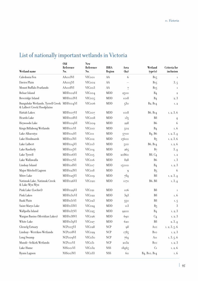
List of nationally important wetlands in VictoriaOld NewReference Reference IBRA Area Wetland Criteria for
Wetland name No. No. Region (ha) type(s) inclusion
Caledonia Fen AA003VI VIC001 AA 6 B15 1
Davies Plain AA005VI VIC002 AA — B15 3, 5
Mount Buffalo Peatlands AA008VI VIC003 AA 7 B15 1
Belsar Island MDD002VI VIC004 MDD 2500 B4 2
Beveridge Island MDD003VI VIC005 MDD 1018 B4 2, 3
Bunguluke Wetlands, Tyrrell Creek MDD004VI VIC006 MDD 530 B2, B14 1, 2& Lalbert Creek Floodplains
Hattah Lakes MDD007VI VIC007 MDD 1018 B6, B14 1, 2, 3, 6
Heards Lake MDD008VI VIC008 MDD 135 B8 4
Heywoods Lake MDD009VI VIC009 MDD 228 B6 6
Kings Billabong Wetlands MDD011VI VIC010 MDD 502 B4 1, 6
Lake Albacutya MDD012VI VIC011 MDD 5700 B4, B6 1, 2, 3, 4
Lake Hindmarsh MDD013VI VIC012 MDD 15600 B5 1, 2, 3, 6
Lake Lalbert MDD014VI VIC013 MDD 500 B6, B14 1, 2, 6
Lake Ranfurly MDD015VI VIC014 MDD 265 B7 3, 4
Lake Tyrrell MDD016VI VIC015 MDD 20860 B8, C4 1, 2
Lake Wallawalla MDD017VI VIC016 MDD 828 B6 1, 3
Lindsay Island MDD018VI VIC017 MDD 15000 B4 1, 2, 3
Major Mitchell Lagoon MDD023VI VIC018 MDD 9 B5 6
Mitre Lake MDD025VI VIC019 MDD 784 B8 1, 2, 3, 4
Natimuk Lake, Natimuk Creek MDD026VI VIC020 MDD 1170 B6, B8 1, 3, 4& Lake Wyn Wyn
Pink Lake (Lochiel) MDD029VI VIC021 MDD 106 B8 1
Pink Lakes MDD030VI VIC022 MDD 393 B8 1, 6
Raak Plain MDD031VI VIC023 MDD 550 B8 1, 5
Saint Marys Lake MDD033VI VIC024 MDD 113 B5 3
Wallpolla Island MDD037VI VIC025 MDD 9200 B4 1, 2, 3
Wargan Basins (Meridian Lakes) MDD038VI VIC026 MDD 690 C4 1, 2, 3
White Lake MDD039VI VIC027 MDD 620 B8 2, 3, 4
Glenelg Estuary NCP005VI VIC028 NCP 98 A10 1, 2, 3, 5, 6
Lindsay—Werrikoo Wetlands NCP008VI VIC029 NCP 1785 B10 1, 2, 3
Long Swamp NCP009VI VIC030 NCP 764 A11 1, 3, 5, 6
Mundi—Selkirk Wetlands NCP011VI VIC031 NCP 2032 B10 1, 2, 3
Lake Hume NSS001VI VIC032 NSS 18465 C1 1, 2, 6
Ryans Lagoon NSS003VI VIC033 NSS 60 B4, B10, B14 1, 6
95
11. Victoria

Old NewReference Reference IBRA Area Wetland Criteria for
Wetland name No. No. Region (ha) type(s) inclusion
Barmah—Millewa Forest RIV001VI VIC034 RIV 29500 B1, B2, B4 1, 2, 3, 5
Black Swamp RIV003VI VIC035 RIV 176 B14 1, 3
Broken Creek RIV005VI VIC036 RIV 2500 B4 1, 2, 3
Cemetery Swamp RIV006VI VIC037 RIV 89 B4 1, 2
First Marsh (The Marsh) RIV008VI VIC038 RIV 780 B6 2, 3
Fosters Swamp RIV009VI VIC039 RIV 219 B8 2, 3
Gunbower Island RIV011VI VIC040 RIV 19500 B4, B14 1, 2, 3
Hird’s Swamp RIV012VI VIC041 RIV 344 B10 1, 2, 3
Johnson’s Swamp RIV013VI VIC042 RIV 411 B10 1, 2, 3
Kanyapella Basin RIV014VI VIC043 RIV 2581 B10, B14 1, 2, 3
Kow Swamp RIV016VI VIC044 RIV 2724 B5, C1 1, 2, 3, 6
Lake Bael Bael RIV018VI VIC045 RIV 648 B5 1, 2, 3
Lake Charm RIV020VI VIC046 RIV 520 B5, C1 2, 3
Lake Cullen RIV021VI VIC047 RIV 632 B8 1, 2, 3, 4, 6
Lake Kelly & Stevensons Swamp RIV022VI VIC048 RIV 320 B8, C4 1 , 3, 4
Lake William RIV024VI VIC049 RIV 96 C4 3, 4
Little Lake Charm, Kangaroo RIV025VI VIC050 RIV 1332 B5, C1 2, 3Lake & Racecourse Lake
Lower Broken River RIV026VI VIC051 RIV 1268 B1, B4 3, 6
Lower Goulburn River Floodplain RIV027VI VIC052 RIV 13000 B4, B14 1, 2
Muckatah Depression RIV032VI VIC053 RIV 2909 B4, B10 1, 2
Second Marsh (Middle Marsh) RIV033VI VIC054 RIV 233 B14 2, 3
Tang Tang Swamp RIV034VI VIC055 RIV 103 B6, B14 1, 2, 3, 6
Third Marsh (Top Marsh) RIV035VI VIC056 RIV 946 B14 1, 2, 3
Third, Middle and Reedy Lakes RIV036VI VIC057 RIV 598 B5, C1 1, 2, 3
Town Swamp RIV037VI VIC058 RIV 80 B10 1, 2
Tragowel Swamp (McPhails Swamp) RIV038VI VIC059 RIV 262 B6 3
Wallenjoe Wetlands RIV041VI VIC060 RIV 303 B14 1 , 2, 3
Woolshed Swamp RIV043VI VIC061 RIV 353 B6, B14 1, 3
Anderson Inlet SCP001VI VIC062 SCP 2230 A1, A5, A6, A7, A9 2, 3, 4
Bald Hills State Wildlife Reserve SCP002VI VIC063 SCP 1 B9 1, 3, 5
Billabong Reserve SCP003VI VIC064 SCP 23 B10 1, 5
Bosses/Nebbor Swamp SCP004VI VIC065 SCP 235 B10 1, 3
Corner Inlet SCP005VI VIC066 SCP 51500 A1, A2, A4, A5, 1, 3, 4, 5A7, A8, A9
Deep Water Morass SCP006VI VIC067 SCP 30 B1, B10, B13 1, 3, 5
96
A Directory of Important Wetlands in Australia

Old NewReference Reference IBRA Area Wetland Criteria for
Wetland name No. No. Region (ha) type(s) inclusion
Edithvale—Seaford Wetlands SCP007VI VIC068 SCP 215 B4, B7, B8, B9, B10, B13 1, 3, 6
Jack Smith Lake State SCP008VI VIC069 SCP 2730 A10 1, 3, 5Game Reserve
Lake Connewarre State SCP009VI VIC070 SCP 3100 A6, A8, B4, B5, B10 1, 2, 3, 4, 5Wildlife Reserve
Lake King Wetlands SCP010VI VIC071 SCP 7100 A8, A10, A11 1, 2, 3, 4, 5
Lake Victoria Wetlands SCP011VI VIC072 SCP 10850 A8, A10 1, 2, 3, 5, 6
Lake Wellington WetlandsC SCP012VI VIC073 SCP 18000 A11, B1, B4, B7, B8, B13 1, 2, 3, 4, 5, 6
Lindenow Wildlife Sanctuary SCP013VI VIC074 SCP 26 B9, C6 1, 3
Lower Merri River Wetlands SCP014VI VIC075 SCP 146 A10, A11 1, 2 ,3 ,5
Macleod Morass SCP015VI VIC076 SCP 520 A11 1, 3
Mud Islands SCP016VI VIC077 SCP 656 A2, A5, A7, A8 1, 2, 3, 4, 5
Powlett River Mouth SCP017VI VIC078 SCP — A6, A8, A10 6
Russells Swamp SCP018VI VIC079 SCP 125 A10 3
Shallow Inlet Marine & Coastal Park SCP019VI VIC080 SCP 1342 A1, A2, A5, A7, A8 1, 3, 4
Swan Bay & Swan IslandC SCP020VI VIC081 SCP 2800 A1, A2, A7, A8 1, 2, 3, 4, 5
Tambo River (Lower Reaches) SCP021VI VIC082 SCP 33 A10, A11 3East Swamps
Western PortC SCP022VI VIC083 SCP 52325 A1, A2, A4, A5, 1, 2, 3, 4, 5, 6A7, A8, A9
Yambuk Wetlands SCP023VI VIC084 SCP 297 A8, A10 1, 2, 3, 5
Lake Bunga SEC003VI VIC085 SEC 460 A10 1, 5
Lake Tyers SEC004VI VIC086 SEC 1186 A10 1, 3, 5
Lower Snowy River SEC005VI VIC087 SEC 2000 A7, A8, A11, B13 1, 2, 3, 5Wetlands System
Central Highlands Peatlands SEH005VI VIC088 SEH 33 B15 1
Lake Dartmouth SEH011VI VIC089 SEH 5990 C1 6
Lake Tali Karng SEH013VI VIC090 SEH 16 B5 1, 3, 6
Lower Aire River Wetlands SEH014VI VIC091 SEH 84 A10, A11 1, 2, 3
Nuniong Plateau Peatlands SEH017VI VIC092 SEH 10 B15 1
Princetown Wetlands SEH019VI VIC093 SEH 119 A8, A10, A11 1, 2, 3
Rooty Break Swamp SEH020VI VIC094 SEH 1 B15 1
Tea Tree Swamp (Delegate River) SEH021VI VIC095 SEH 52 B15 1, 3, 5
Wongungarra River SEH023VI VIC096 SEH — B1 1, 3, 4, 5
Creswick Swamp VM001VI VIC097 VM 16 B10 1, 3, 5
Lake Muirhead VM002VI VIC098 VM 330 B10 1, 3, 4
Mount William Swamp VM003VI VIC099 VM 635 B10 1, 3, 4
97
11. Victoria

Old NewReference Reference IBRA Area Wetland Criteria for
Wetland name No. No. Region (ha) type(s) inclusion
Banongill Network VVP001VI VIC100 VVP 59 B10 1
Cobden—Terang Volcanic Craters VVP002VI VIC101 VVP 613 B5, B7, B10, B13 1
Cundare Pool/Lake Martin VVP003VI VIC102 VVP 3730 B7, B12, C1 1, 3, 4
Kooraweera Lakes VVP004VI VIC103 VVP 427 B5, B7, B8, B12 1, 2, 4, 5
Lake Beeac VVP005VI VIC104 VVP 662 B7, B12 1, 3, 4, 5
Lake Bookaar VVP006VI VIC105 VVP 500 B7, B12 1, 3, 5
Lake Colongulac VVP007VI VIC106 VVP 1400 B7 1, 3
Lake Corangamite VVP008VI VIC107 VVP 23300 B7, B12 1, 2, 3, 4, 5
Lake Cundare VVP009VI VIC108 VVP 395 B7 1, 3, 4
Lake Gnarpurt VVP010VI VIC109 VVP 2350 B7, B12 1, 2, 3
Lake Linlithgow Wetlands VVP011VI VIC110 VVP 1432 B5, B7, B8 1, 3, 4, 5
Lake Milangil VVP012VI VIC111 VVP 125 B7 1, 2, 3, 5
Lake Murdeduke VVP013VI VIC112 VVP 1550 B7, B12 1, 2, 3
Lake Terangpom VVP014VI VIC113 VVP 208 B7 1, 2, 3
Lower Lough Calvert & VVP015VI VIC114 VVP 878 B6, B7, B8, B10, B12 1, 2Lake Thurrumbong
Middle Lough Calvert VVP016VI VIC115 VVP 578 B7, B8, B12 1, 2, 3, 4
Point Cook & Laverton SaltworksC VVP017VI VIC116 VVP 900 A1, A2, A4, A5, 1, 2, 3, 4, 5A6, A7, A8, A11, B1,
B5, B7, B10, B12, C4
Red Rock Lakes & The Basins VVP018VI VIC117 VVP 223 B5, B7, B8, B10 1, 6
Stonyford—Bungador Wetlands VVP019VI VIC118 VVP B10, B15 1
Tower Hill VVP020VI VIC119 VVP 311 B5, B8 1, 3, 6
Upper Lough Calvert VVP021VI VIC120 VVP 824 B7, B12 1, 2, 3
Werribee—Avalon Area VVP022VI VIC121 VVP 5460 A7, A8, C6 1, 3, 4, 5
Bitter Swamp VIC122 MDD 32 B6 1, 3
Cardross Lake VIC123 MDD 296 B5, B7 1, 3, 5
Friedman’s Salt Lake VIC124 MDD 55 B8 1
Grass Flat (Telfer’s) Swamp VIC125 MDD 34 B7, B12 1, 3
Hately’s Lake (Swamp) VIC126 MDD 267 B7, B11 1, 3
Lake Buloke Wetlands VIC127 MDD 8270 B6, B8, B12, B14, C2 1, 3, 4, 5, 6
Oliver’s Swamp (Lake) VIC128 MDD 400 B7 1, 3, 4
Boiler Swamp System VIC129 NCP 193 B6, B9, B10, 1, 2B12, B13, C9
Dergholm (Youpayang) Wetlands VIC130 NCP 228 B2, B9, B10, B13 1, 3
Avoca Floodway (Tutchewop Plains) VIC131 RIV 484 B12, B13, C9 1, 2, 3
Ewing’s Marsh (Morass) VIC132 SEC 1326 A11, B10, B13 1, 5
98
A Directory of Important Wetlands in Australia

Old NewReference Reference IBRA Area Wetland Criteria for
Wetland name No. No. Region (ha) type(s) inclusion
Mallacoota Inlet Wetlands VIC133 SEC 3797 A5, A6, A11, B1, B4, 1, 3, 5, 6B10, B11, B13, B14
Sydenham Inlet Wetlands VIC134 SEC 1216 A6, A8, A10 1, 3, 5
Tamboon Inlet Wetlands VIC135 SEC 669 A5, A6, A8, A11, B1, B2 1, 3, 5
Lake Buninjon VIC136 VM 287 B7, B12 1, 3, 5
Lake Wendouree VIC137 VM 224 B5 1, 3, 6
Merin Merin Swamp VIC138 VVP 215 B6, B10, B14 1, 3
Woorndoo—Hopkins Wetlands VIC139 VM 584 B6, B7, B8, B10, 1, 2B11, B12, C1, C2, C9
Lake Condah VIC140 VVP 82 B2, B6, B13 1, 6
Nerrin Nerrin Wetlands VIC141 VVP 526 B5, B6, B10, B14 1, 3, 4, 5
Widderin Swamps VIC142 VVP 359 B10 1, 3, 4, 6
Mitta Mitta River VIC143 SHE and AA 2400 B1 3, 4, 5, 6
Ovens River VIC144 RIV and VM 3750 B1 3, 4, 6
Howqua River VIC145 SHE and AA 1520 B1 1, 2, 3, 4, 5, 6
Big River VIC146 SHE and AA 1465 B1 2, 3, 4, 5, 6
Wimmera River VIC147 MDD 56020 B1, B2, B5, B6 1, 2, 3, 4, 5, 6
Genoa River VIC148 SEC 1080 B1 1, 3, 4, 5, 6
Bemm, Goolengook, Arte VIC149 SEC 5920 B1 1, 2, 3, 4and Errinundra Rivers
Snowy River VIC150 SEC and AA 46690 B1 1, 3, 4, 5, 6
Suggan Buggan and Berrima VIC151 SEC and AA 1840 B1 2, 3, 4Rivers
Upper Buchan River VIC152 SEC and AA 1780 B1 1, 2, 3, 4, 5
Wonnangatta River VIC153 SHE and AA 4100 B1, B4 1, 2, 3, 4, 5, 6
Benedore River VIC154 SEC 3360 B1, B4 1, 2, 3, 4, 5
Thurra River VIC155 SEC 2920 B1, B4 1, 3, 5
Yarra River VIC156 VM and SEH 1065 B1 1, 3, 4
Lerderderg River VIC157 VM and VVP 5490 B1, B4 3, 4, 5, 6
Aire River VIC158 SHE 820 B1, B4 1, 3, 4
Glenelg River VIC159 NCP 3020 B1 1, 3, 4
C wetlands occurring in part on land owned or managed by the Commonwealth (four sites).
Note: area figures for the above tables are approximate only and are not available for all wetlands.
99
11. Victoria

Introduction
Jim Lane1, Roger Jaensch2, Romeny Lynch1 and Sue Elscot1
1. Department of Conservation and Land Management, 2. Wetlands International–Oceania
The nature of Western Australia and its wetlands The mainland part of Western Australia (WA) lies between latitudes 14° and 35°South and longitudes 113° and 129° East and has an area of 2,525,500 km2. The highestpoint in the State is 1,245 m ASL, most land is below 500 m ASL. The coastline is 12,500 km;notable features are escarpment-edged coast in the far north, mangrove in the north andnorth-west, long sandy beaches and granite headlands in the south-west and precipitouscliff in the south-east and central west. A major ocean current of tropical origin (theLeeuwin Current) influences marine environments along the west coast, south of 22° S.There are several thousand islands around the coast but few support other than marinewetlands.
There are three main climatic regimes. A monsoonal regime, with hot wet summer andwarm dry winter, affects the north of the State and a Mediterranean regime, with warm to hot dry summer and cool wet winter, affects the south-west. The remainder experienceshot dry summers and cool to warm dry winters. Rainfall ranges from less than 250 mm (with high variability) over most of the interior, to more than 1,000 mm (with lowvariability) in extreme south-western and northern parts.
Most of the 40 wetland types recognised in this Directory occur in WA. Notable in the far north are the State’s only substantial riverine floodplains and several major estuarinemudflat and mangrove systems. The south-west is notable for its many estuaries withintermittent (sand-barred) connections to the sea and for its thousands of freshwater (and many salinised) lakes, swamps and damplands. The arid interior is notable for itspalaeodrainage systems, now occupied by salt lakes, its many rockholes and for the karstdrainage of the Nullarbor Plain.
Maximum depths of natural wetlands are generally less than a few metres but in somewetlands of higher rainfall areas may be up to 10 m; artificial Lake Argyle is up to 45 m deep.While most of the coast experiences a tidal range of a few metres or less, parts of the north-west and north experience tides more than 9 m.
Some of the longest river systems are, from north to south, the Ord, Fitzroy, Fortescue,Gascoyne, Murchison, Swan—Avon and Blackwood. The largest marine embayments are
12. Western Australia
103
King Sound and Shark Bay. Lakes notable for their size are Lake Argyle (largest artificialfreshwater lake), Lake MacKay (largest saline lake) and Lake Jasper (largest naturalfreshwater lake). The most extensive intertidal mudflats are in the north; some exceed 10 km in width.
Wetland plant communities in WA include seagrass beds, mangroves, freshwaterwoodlands/shrublands, sedgelands and samphire (chenopod) shrublands; peat swamp andfreshwater grassland communities occur but are not common. At least 2,000 wetland plantspecies occur in WA and endemism is relatively high, especially in ephemeral wetlands ofthe south-west.
The State’s wetland fauna includes crocodiles (2 spp.), freshwater turtles (~ 6 spp.),waterbirds (~ 150 spp.), inland fishes (~ 55 spp.) and frogs (~ 60 wetland spp.). Endemismis high among all major groups of wetland vertebrate fauna except waterbirds. Thus 3species of freshwater turtles, at least 30 wetland frogs and approximately 28 inland fishesare found only in Western Australia. The macroinvertebrate fauna of inland waters of thesouth-west is relatively species poor (250–300 taxa in some wetland suites) compared with eastern Australia, but is also characterised by a high level of endemism.
Human utilisation of wetlands in Western AustraliaAboriginal people used freshwater and tidal wetlands as sources of water, food and otherresources before European settlement and continue to do so in some parts of WesternAustralia. The Aboriginal Sites Register for WA includes a number of wetland sites, notablystone fish traps and major campsites.
The earliest European impacts on WA wetlands were in the south-west, near Albany andPerth, where clearing of natural vegetation for agriculture began in the 1830s. Europeanland management practices have since impacted upon most WA wetlands, apart from someof those in major conservation reserves, in the deserts and in parts of the north that are notreadily accessible to livestock.
The human population of WA in December 1999 was 1.87 million and growing rapidly. Most live in the south-west where the most extensive impacts on wetlands have beenclearing and drainage of coastal plain swamps and winter-wet areas; salinisation andexcessive inundation of wetlands following clearance of catchments; and eutrophication due to leaching of agricultural fertilisers. Some wetlands face localised threats, eg rubbishdumping and landfill, too frequent wildfire and some insect (mosquito or midge) controlmeasures. Other threats include extraction of groundwater for domestic or agricultural use,weed invasion and the spread of introduced fauna such as fish and molluscs. Elsewhere inthe State, pastoral grazing has impacted upon wetlands through damage to river banks andriparian vegetation, degradation of catchments and associated increases in erosion, runoffand siltation.
Most of WA’s nationally and internationally significant (and many regionally significant)wetlands are in existing or proposed conservation reserves managed by the WA Departmentof Conservation and Land Management (CALM). The WA Water and Rivers Commission also has a substantial role in managing wetlands, both directly and indirectly through water allocation. The WA Environmental Protection Authority has a major influence on the management of wetlands through statutory environmental protection policies andenvironmental impact assessments. Land use planning by the WA Ministry for Planning andby local government also impacts on wetlands. Most WA wetlands are on privately owned
104
A Directory of Important Wetlands in Australia

land or pastoral leases and their conservation depends upon positive community attitudestowards both wetlands and landcare in general.
In Western Australia there is substantial community interest in wetlands, especially nearPerth and other parts of the south-west. Recent research by, or funded by, Commonwealth,State and Local Government, universities, natural history and conservation groups,companies and individuals has added significantly to our knowledge of the wetlands, their types and distribution, their values and the processes that sustain or threaten them.
Purpose, scope and content of the Western Australian part of the DirectoryThe purpose of the Western Australian chapter of the Directory is to present a summary of existing knowledge of important wetland sites in WA and of their values. No systematicsurvey of wetlands or wetland values across the entire State has yet been conducted. In thecurrent Directory this is manifest in gaps in the information presented and in the omissionof some poorly known, yet potentially important, sites. This chapter of the Directory istherefore not definitive. It is hoped that the document will stimulate and guide any searchfor missing information, especially of poorly studied regions, sites and taxa.
Site accounts for Western Australia were compiled mainly from published and unpublishedreports, from databases held by CALM and from consultations with wetland scientists,managers and others with relevant knowledge. The terminology and categories of Semeniuk(1987) and Semeniuk et al. (1990) have been used to describe certain physical, hydrological(salinity) and structural (vegetation) characteristics of the wetlands.
The 120 site accounts for WA cover several hundred discrete wetlands, which is a smallfraction of the total (and unknown) number of wetlands in the State. Because most is known about south-west wetlands, half (60) of the sites included in the WA chapter of theDirectory are from this region. However, most major wetland types occurring in WA arerepresented in the range of sites that has been selected.
In preparing the second edition of the Directory, most effort was directed towardsincreasing the representation of wetlands in bioregions (Thackway and Cresswell 1995)from which few or no wetlands had previously been selected. In the main, these were inremote arid areas such as the Central Ranges, Gascoyne, Gibson Desert, Great VictoriaDesert and Little Sandy Desert. This proved to be a time consuming, though rewarding,process as much of the information needed to select and adequately describe suitable siteswas found only in the knowledge, notebooks and unpublished reports of scientists, Stategovernment field officers, wildlife consultants, nature tour operators, Aboriginal linguistsand naturalists scattered widely across the State. In the course of this work we (Lane, J andLynch, R) became much more aware of the great significance of the many rockholes of thedeserts for Aboriginal inhabitants, early European explorers and wildlife. For manythousands of years life in the deserts has revolved around these very small but vital sourcesof permanent and semi-permanent freshwater. While dependence on these water featuresfor survival is now much reduced, many Aboriginal people still retain strong cultural ties to these sites.
Other new sites of particular interest include the mound springs (Bunda-Bunda and WillieCreek) of Dampierland, the gorges of the Pilbara and Gascoyne, the Banded Stilt breedingsites of Lakes Ballard and Marmion (Murchison), the tidally influenced microbialitecommunities of Lake Thetis (Swan Coastal Plain), the frog swamps of Mount Soho and the freshwater snail site at Cape Leeuwin (Warren).
105
12. Western Australia

Preparation of the third edition has largely been limited to updating descriptions of the 110 sites of the second edition, plus the addition of four new State sites. These are BigSprings (Dampierland), Gladstone Lake (Central Kimberley), Mount Bruce Coolibah—Lignum Flats (Pilbara) and Lake Bryde—East Lake Bryde (Mallee). An additional sixwetlands occurring on land owned or managed by the Commonwealth have also beenincluded, bringing the total number of nationally important WA wetlands to 120.
With the completion of the third edition, all but three (Hampton, Nullarbor and Ord-Victoria Plains) of the 26 bioregions of Western Australia (eight shared with SA and/or NT)now have wetlands included in the Directory. Representation is generally limited to two tofour sites per bioregion, however, and more field work is needed to ensure that the greatdiversity of wetlands in this western one-third of the continent is truly represented infuture editions. Government funding for formal wetland inventory and evaluation is limited and information will continue to be collected by other means. For the next edition,we encourage readers to advise one of us (Lane, J., c/o CALM, Busselton) of any newinformation that would add usefully to descriptions of the 120 existing sites and to bring to our attention any additional wetlands of outstanding significance.
AcknowledgmentsThe assistance of all those who have contributed to the compilation of the first, second and third editions is gratefully acknowledged.
The Western Australian chapter of A Directory of Important Wetlands in Australia (firstedition) was compiled by Roger Jaensch, with general guidance from Jim Lane of theWestern Australian Department of Conservation and Land Management (CALM), in1992–1993. The second edition was prepared by Romeny Lynch and Jim Lane in 1995 and the third by Sue Elscot and Jim Lane in 1999–2000.
Preparation of the third edition was funded by Environment Australia under the NationalWetlands Program of the Natural Heritage Trust. Substantial in-kind support and input was provided by CALM.
The following people have provided invaluable assistance in the preparation of theDirectory, by bringing sites to our attention, providing information for site descriptions,checking and commenting on drafts, directing us to additional sources of information, and other help. This assistance is gratefully acknowledged.
Aboriginal Affairs Dept, WA: L. Bloor, P. Vinnicamb (Perth), R. Graham (Kalgoorlie).Agriculture WA: A.A. Mitchell. Australian Heritage Commission: R. Webb. Birds Australia:C.D.T Minton, V. Pattinson. Department of Conservation and Land Management, WA: J. Blyth,A. Brown, A.A. Burbidge, A.H. Burbidge, V. English, P.J. Fuller, N. Gibson, S. Halse, S.Hamilton-Brown, G. Keighery, N. McKenzie, D. Pearson, G.B. Pearson, R.I.T. Prince, M.Smith, G. Wardell-Johnson (CALMScience Division, Woodvale); K.J. Atkins, Alex Chapman,K.F. Kenneally, P. Lambert (Como); C. Broadbent, P. Hanly, B. Read (Central ForestRegion); Andrew Chapman, I. Kealley (Goldfields Region); C. Done, A. Grosse, G. Graham,A.N. Start, T. Willing (Kimberley Region); K. Bancroft (Marine Conservation Branch). K.Cunningham, G. Leaman, D. Rose, N. Sercombe, R. Shepherd (Midwest Region); P.Kendrick, M. Parker, S. van Leeuwen (Pilbara Region); P. Collins, M. Fitzgerald, K. Gillen,K. Tiedemann, J. Watson (South Coast Region); R. Hearne, V. Metcalfe (Southern ForestRegion); J. Alford, P. Lambert, D. Mitchell, R. Towers (Swan Region); M. Graham, D. Hilder,L. Silvester, A. Smith, K.J. Wallace (Wheatbelt Region). Department of Environmental
106
A Directory of Important Wetlands in Australia

Protection, WA: V. Cox (Perth), S. Vellacott (Karratha). Department of Transport, WA: R.Mahoney. Edith Cowan University: R. Froend, P. Horwitz. Environment Australia: B. Phillips,S. Young, S. Usback (Canberra). Heritage Council of WA: J. Williams. Murdoch University: J.Davis, J. Newsome, E. Paling, I. Potter. University of Western Australia: D. Edward, B. Knott, J. Roberts, A. Storey. Victorian Dept of Conservation and Environment: M. Newton. Water &Rivers Commission: M. Allen, A. Hill, N. Arrowsmith, P. Clews, L. Moore, R. Paice, R. Shams,S. Stratico. WA Museum: G. Allen, W.F. Humphreys, R.E. Johnstone, D.J. Kitchener, S.M.Slack-Smith. Wetlands International: R.P. Jaensch, C. Prentice, D. Watkins. World Wide Fundfor Nature: M. Handley. Also: H. Amez, Mike Bamford, W.H. Butler, E.A. & R.J. Gard, W.Klau, T. Morrissey, J.A. Raines, L. Rive, V. & C. Semeniuk, G. Swann, B. & G. Wells.
Special thanks are also due to Alan Clarke (CALM) for assistance in collating informationand Lisa Wright (CALM) for library support.
Summary analysis
The Directory describes 120 nationally important wetlands in Western Australia. The distribution of nationally important wetlands in WA (including Ramsar wetlands) is shown in Figure 10. A list compiling data on bioregion, site area, wetland type and criteriafor inclusion for each wetland is provided at the end of this chapter.
As the largest State, Western Australia has the most bioregions in 26, eight of which itshares with South Australia and the Northern Territory. All but three of the 26 bioregionscontain nationally important wetlands (refer to Table 12.1). By far the greatest number ofsites is in the Swan Coastal Plain bioregion (n=29), the only region that contains more thaneight sites. Seven bioregions contain only one or two nationally important wetlands. Anoverview of the IBRA regionalisation and a map of IBRA regions is included in Appendix 2.
107
12. Western Australia
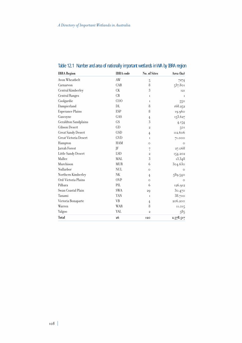
Table 12.1 Number and area of nationally important wetlands in WA by IBRA regionIBRA Region IBRA code No. of Sites Area (ha)
Avon Wheatbelt AW 5 7274
Carnarvon CAR 8 537,801
Central Kimberley CK 3 121
Central Ranges CR 1 1
Coolgardie COO 1 550
Dampierland DL 8 168,252
Esperance Plains ESP 8 19,960
Gascoyne GAS 4 153,627
Geraldton Sandplains GS 3 4,154
Gibson Desert GD 2 501
Great Sandy Desert GSD 4 112,606
Great Victoria Desert GVD 1 71,000
Hampton HAM 0 0
Jarrah Forest JF 7 27,068
Little Sandy Desert LSD 2 154,202
Mallee MAL 3 13,348
Murchison MUR 6 304,630
Nullarbor NUL 0 0
Northern Kimberley NK 4 589,540
Ord-Victoria Plains OVP 0 0
Pilbara PIL 6 126,912
Swan Coastal Plain SWA 29 30,470
Tanami TAN 1 38,700
Victoria Bonaparte VB 4 206,200
Warren WAR 8 11,015
Yalgoo YAL 2 585
Total 26 120 2,578,517
108
A Directory of Important Wetlands in Australia
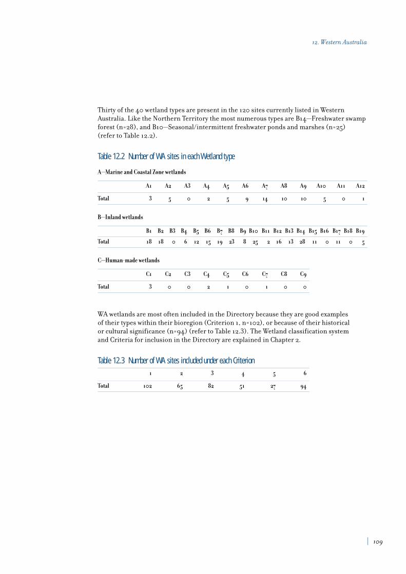
Thirty of the 40 wetland types are present in the 120 sites currently listed in WesternAustralia. Like the Northern Territory the most numerous types are B14—Freshwater swampforest (n=28), and B10—Seasonal/intermittent freshwater ponds and marshes (n=25) (refer to Table 12.2).
Table 12.2 Number of WA sites in each Wetland type
A—Marine and Coastal Zone wetlands
A1 A2 A3 A4 A5 A6 A7 A8 A9 A10 A11 A12
Total 3 5 0 2 5 9 14 10 10 5 0 1
B—Inland wetlands
B1 B2 B3 B4 B5 B6 B7 B8 B9 B10 B11 B12 B13 B14 B15 B16 B17 B18 B19
Total 18 18 0 6 12 15 19 23 8 25 2 16 13 28 11 0 11 0 5
C—Human-made wetlands
C1 C2 C3 C4 C5 C6 C7 C8 C9
Total 3 0 0 2 1 0 1 0 0
WA wetlands are most often included in the Directory because they are good examples of their types within their bioregion (Criterion 1, n=102), or because of their historical or cultural significance (n=94) (refer to Table 12.3). The Wetland classification system and Criteria for inclusion in the Directory are explained in Chapter 2.
Table 12.3 Number of WA sites included under each Criterion1 2 3 4 5 6
Total 102 65 82 51 27 94
109
12. Western Australia

List of nationally important wetlands in Western AustraliaOld NewReference Reference IBRA Area Wetland Criteria for
Wetland name No. No. Region (ha) type(s) inclusion
Coyrecup Lake AW001WA WA001 AW 500 B7, B12 2, 3, 4, 6
Dumbleyung Lake AW002WA WA002 AW 5561 B7 2, 3, 4, 6
Toolibin Lake AW003WA WA003 AW 437 B14 1, 2, 3, 6
Yealering Lakes System AW004WA WA004 AW 775 B8 2, 3, 4, 5, 6
Yorkrakine Rock Pools AW005WA WA005 AW 1 B10 1, 2, 6
Cape Range Subterranean CAR001WA WA006 CAR 175000 B19 1, 2, 3, 4, 6Waterways C
Exmouth Gulf East CAR002WA WA007 CAR 120000 A2, A7, A8, A9 1, 2, 3
Hamelin Pool CAR003WA WA008 CAR 90000 A1, A5, A7 1, 6
Lake MacLeod CAR004WA WA009 CAR 150000 A9, B7, B8, B10, 1, 2, 3, 4, 6B11, B12, B19, C4
McNeill Claypan System CAR005WA WA010 CAR 2500 B6, B13 1
Shark Bay East CAR006WA WA011 CAR — A1, A2, A7, A8, A9 1, 2, 3, 4, 5, 6
Tunnel Creek CK001WA WA012 CK 1 B19 1, 6
Windjana Gorge CK002WA WA013 CK 20 B1 1, 3, 6
Rock Pools of the CR001WA WA014 CR 1 B17 1, 3, 6Walter James Range
Rowles Lagoon System COO001WA WA015 COO 550 B6, B10, B13 1, 2, 6
Bunda-Bunda Mound Springs DL001WA WA016 DL 22 B17 1, 6
Camballin Floodplain DL002WA WA017 DL 30000 B1, B2, B4, B6, 1, 2, 3, 4, 6(Le Lievre Swamp System) B10, B14, C1, C7
Eighty Mile Beach System DL003WA WA018 DL 40000 A5, A7, B4, B10 1, 2, 3, 4, 5, 6
Geikie Gorge DL004WA WA019 DL 130 B1 1, 2, 6
Roebuck Bay DL005WA WA020 DL 50000 A2, A4, A5, A7, A8, A9 1, 2, 3, 4, 5, 6
Roebuck Plains System DL006WA WA021 DL 48000 B4, B5, B6, B10 1, 2, 3, 4, 6
Willie Creek Wetlands DL007WA WA022 DL 20 B8, B9 1, 3, 6
Balicup Lake System ESP001WA WA023 ESP 1400 B8, B12 1, 4, 5
Culham Inlet System ESP002WA WA024 ESP 11349 B1, B7, B12 1, 3, 4, 6
Fitzgerald Inlet System ESP003WA WA025 ESP 1200 A10, B2, B8, B12 1, 3, 5, 6
Lake Gore System ESP004WA WA026 ESP 1500 B7, B8, B12, B14 2, 3, 4, 5, 6
Lake Warden System ESP005WA WA027 ESP 1200 B7, B12 1, 2, 3, 4, 5, 6
Mortijinup Lake System ESP006WA WA028 ESP 750 B7, B10, B14 1, 3, 6
Pink Lake ESP007WA WA029 ESP 1061 B7 1, 5, 6
Yellilup Yate Swamp System ESP008WA WA030 ESP 1500 B7, B14 1, 2, 3, 6
Kookhabinna Gorge GAS001WA WA031 GAS 125 B2, B14 1, 3
110
A Directory of Important Wetlands in Australia
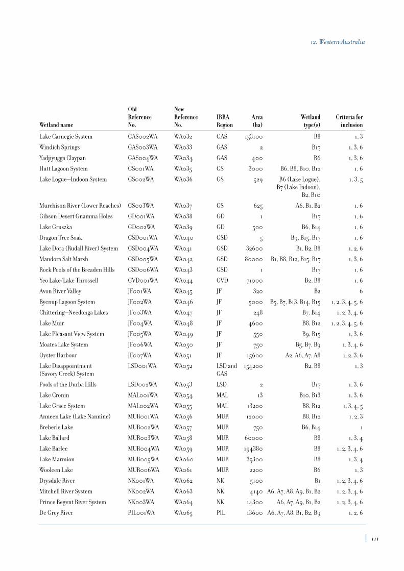
Old NewReference Reference IBRA Area Wetland Criteria for
Wetland name No. No. Region (ha) type(s) inclusion
Lake Carnegie System GAS002WA WA032 GAS 153100 B8 1, 3
Windich Springs GAS003WA WA033 GAS 2 B17 1, 3, 6
Yadjiyugga Claypan GAS004WA WA034 GAS 400 B6 1, 3, 6
Hutt Lagoon System GS001WA WA035 GS 3000 B6, B8, B10, B12 1, 6
Lake Logue—Indoon System GS002WA WA036 GS 529 B6 (Lake Logue), 1, 3, 5B7 (Lake Indoon),
B2, B10
Murchison River (Lower Reaches) GS003WA WA037 GS 625 A6, B1, B2 1, 6
Gibson Desert Gnamma Holes GD001WA WA038 GD 1 B17 1, 6
Lake Gruszka GD002WA WA039 GD 500 B6, B14 1, 6
Dragon Tree Soak GSD001WA WA040 GSD 5 B9, B15, B17 1, 6
Lake Dora (Rudall River) System GSD004WA WA041 GSD 32600 B1, B2, B8 1, 2, 6
Mandora Salt Marsh GSD005WA WA042 GSD 80000 B1, B8, B12, B15, B17 1, 3, 6
Rock Pools of the Breaden Hills GSD006WA WA043 GSD 1 B17 1, 6
Yeo Lake/Lake Throssell GVD001WA WA044 GVD 71000 B2, B8 1, 6
Avon River Valley JF001WA WA045 JF 320 B2 6
Byenup Lagoon System JF002WA WA046 JF 5000 B5, B7, B13, B14, B15 1, 2, 3, 4, 5, 6
Chittering—Needonga Lakes JF003WA WA047 JF 248 B7, B14 1, 2, 3, 4, 6
Lake Muir JF004WA WA048 JF 4600 B8, B12 1, 2, 3, 4, 5, 6
Lake Pleasant View System JF005WA WA049 JF 550 B9, B15 1, 3, 6
Moates Lake System JF006WA WA050 JF 750 B5, B7, B9 1, 3, 4, 6
Oyster Harbour JF007WA WA051 JF 15600 A2, A6, A7, A8 1, 2, 3, 6
Lake Disappointment LSD001WA WA052 LSD and 154200 B2, B8 1, 3(Savory Creek) System GAS
Pools of the Durba Hills LSD002WA WA053 LSD 2 B17 1, 3, 6
Lake Cronin MAL001WA WA054 MAL 13 B10, B13 1, 3, 6
Lake Grace System MAL002WA WA055 MAL 13200 B8, B12 1, 3, 4, 5
Anneen Lake (Lake Nannine) MUR001WA WA056 MUR 12000 B8, B12 1, 2, 3
Breberle Lake MUR002WA WA057 MUR 750 B6, B14 1
Lake Ballard MUR003WA WA058 MUR 60000 B8 1, 3, 4
Lake Barlee MUR004WA WA059 MUR 194380 B8 1, 2, 3, 4, 6
Lake Marmion MUR005WA WA060 MUR 35300 B8 1, 3, 4
Wooleen Lake MUR006WA WA061 MUR 2200 B6 1, 3
Drysdale River NK001WA WA062 NK 5100 B1 1, 2, 3, 4, 6
Mitchell River System NK002WA WA063 NK 4140 A6, A7, A8, A9, B1, B2 1, 2, 3, 4, 6
Prince Regent River System NK003WA WA064 NK 14300 A6, A7, A9, B1, B2 1, 2, 3, 4, 6
De Grey River PIL001WA WA065 PIL 13600 A6, A7, A8, B1, B2, B9 1, 2, 6
111
12. Western Australia

Old NewReference Reference IBRA Area Wetland Criteria for
Wetland name No. No. Region (ha) type(s) inclusion
Fortescue Marshes PIL002WA WA066 PIL 100000 B4, B6 1, 2, 3, 6
Karijini (Hamersley Range) Gorges PIL003WA WA067 PIL 80 B2, B17 1, 6
Leslie (Port Hedland) PIL004WA WA068 PIL 13000 A7, A8, A9, C4 1, 2, 3, 4, 5, 6Saltfields System
Millstream Pools PIL005WA WA069 PIL 150 B1, B9, B17 1, 2, 3, 6
Barraghup Swamp SWA001WA WA070 SWA 25 B14 1, 2, 3, 6
Becher Point Wetlands SWA002WA WA071 SWA 10 B10, B14 1, 6
Benger Swamp SWA003WA WA072 SWA 572 B10, B14 3, 4, 6
Booragoon Lake SWA004WA WA073 SWA 13 B5, B14 1, 2, 3, 6
Brixton Street Swamps SWA005WA WA074 SWA 30 B13 1, 5, 6
Chandala Swamp SWA006WA WA075 SWA 100 B14 1, 2, 3, 4, 6
Ellen Brook Swamps System SWA007WA WA076 SWA 20 B13 1, 3, 4, 5, 6
Forrestdale Lake SWA008WA WA077 SWA 250 B8 1, 2, 3, 4, 5, 6
Gibbs Road Swamp System SWA009WA WA078 SWA 70 B13, B14 1, 2, 3, 6
Guraga Lake SWA010WA WA079 SWA 350 B7, B12 1, 2, 3, 4, 6
Herdsman Lake SWA011WA WA080 SWA 250 B5, B10, B14, B15 2, 3, 4, 6
Joondalup Lake SWA012WA WA081 SWA 530 B5 1, 2, 4, 6
Karakin Lakes SWA013WA WA082 SWA 600 B10 2
Lake McLarty System SWA014WA WA083 SWA 400 B12, B13, B14 1, 2, 3, 4, 6
Lake Thetis SWA015WA WA084 SWA 7 B7 1, 6
Loch McNess System SWA016WA WA085 SWA 255 B5, B9, B14, B15, B19 1, 3, 6
McCarley’s Swamp (Ludlow Swamp) SWA017WA WA086 SWA 25 B14 1, 2, 3, 6
Peel—Harvey Estuary SWA018WA WA087 SWA 14000 A6, A7, A8 1, 2, 3, 4, 5, 6
Perth Airport Woodland Swamps C SWA019WA WA088 SWA 23 B10, B14, C5 1, 3, 5, 6
Rottnest Island Lakes SWA020WA WA089 SWA 180 B7, B8, B12 1, 2, 3, 6
Spectacles Swamp SWA021WA WA090 SWA 142 B10, B14 1, 2, 3, 6
Swan—Canning Estuary SWA022WA WA091 SWA 3300 A6, A7, A8 1, 2, 3, 4, 5, 6
Thomsons Lake SWA023WA WA092 SWA 213 B8 1, 2, 3, 4, 6
Vasse—Wonnerup Wetland System SWA024WA WA093 SWA 1000 A10, B8, B11 2, 3, 4, 5, 6
Wannamal Lake System SWA025WA WA094 SWA 470 B6, B7, B13 2, 3, 4, 5, 6
Yalgorup Lakes System SWA026WA WA095 SWA 5600 B7 1, 2, 3, 4, 5, 6
Lake Gregory System TAN001WA WA096 TAN 38700 B2, B7, B8 1, 2, 3, 4, 6
Lake Argyle VB001WA WA097 VB 100000 C1 2, 3, 4, 6
Lake Kununurra VB002WA WA098 VB 2500 B1, B9, C1 2, 3, 4, 6
Ord Estuary System VB004WA WA099 VB 94700 A6, A7, A8, A9 1, 2, 3, 6
Parry Floodplain VB005WA WA100 VB 9000 B1, B2, B4, B6, 1, 2, 3, 4, 6B10, B14, B17
112
A Directory of Important Wetlands in Australia
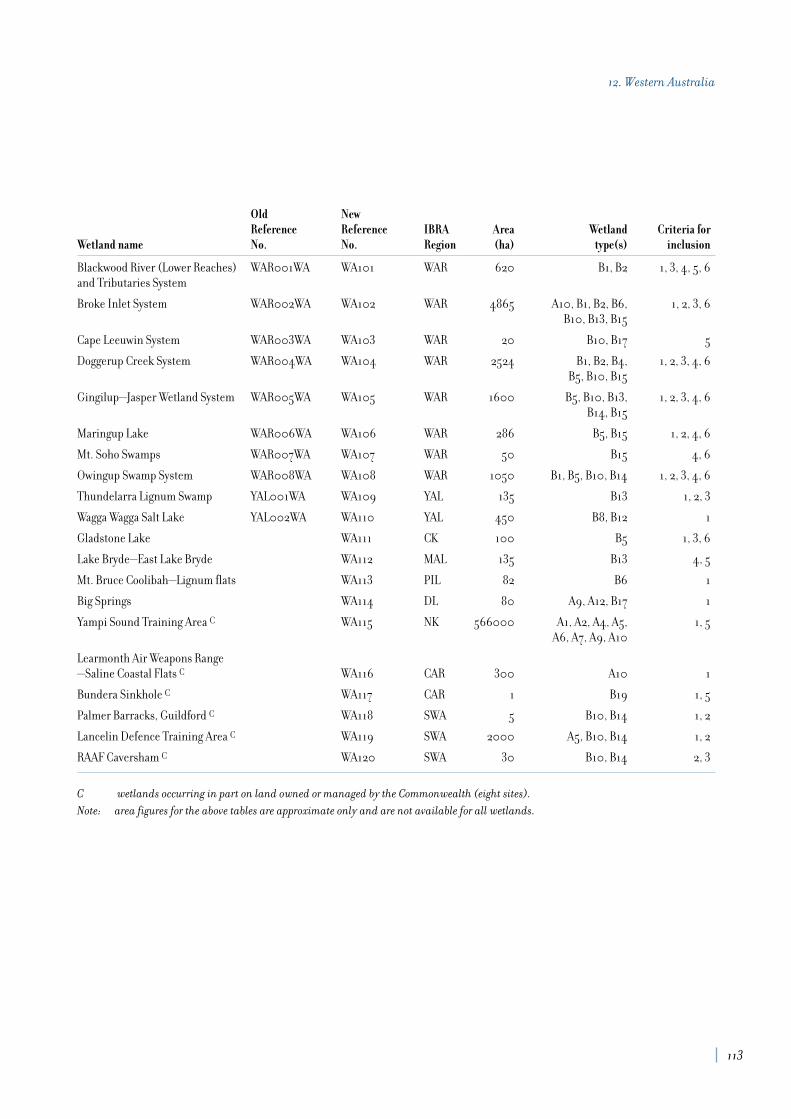
Old NewReference Reference IBRA Area Wetland Criteria for
Wetland name No. No. Region (ha) type(s) inclusion
Blackwood River (Lower Reaches) WAR001WA WA101 WAR 620 B1, B2 1, 3, 4, 5, 6and Tributaries System
Broke Inlet System WAR002WA WA102 WAR 4865 A10, B1, B2, B6, 1, 2, 3, 6B10, B13, B15
Cape Leeuwin System WAR003WA WA103 WAR 20 B10, B17 5
Doggerup Creek System WAR004WA WA104 WAR 2524 B1, B2, B4, 1, 2, 3, 4, 6B5, B10, B15
Gingilup—Jasper Wetland System WAR005WA WA105 WAR 1600 B5, B10, B13, 1, 2, 3, 4, 6B14, B15
Maringup Lake WAR006WA WA106 WAR 286 B5, B15 1, 2, 4, 6
Mt. Soho Swamps WAR007WA WA107 WAR 50 B15 4, 6
Owingup Swamp System WAR008WA WA108 WAR 1050 B1, B5, B10, B14 1, 2, 3, 4, 6
Thundelarra Lignum Swamp YAL001WA WA109 YAL 135 B13 1, 2, 3
Wagga Wagga Salt Lake YAL002WA WA110 YAL 450 B8, B12 1
Gladstone Lake WA111 CK 100 B5 1, 3, 6
Lake Bryde—East Lake Bryde WA112 MAL 135 B13 4, 5
Mt. Bruce Coolibah—Lignum flats WA113 PIL 82 B6 1
Big Springs WA114 DL 80 A9, A12, B17 1
Yampi Sound Training Area C WA115 NK 566000 A1, A2, A4, A5, 1, 5A6, A7, A9, A10
Learmonth Air Weapons Range—Saline Coastal Flats C WA116 CAR 300 A10 1
Bundera Sinkhole C WA117 CAR 1 B19 1, 5
Palmer Barracks, Guildford C WA118 SWA 5 B10, B14 1, 2
Lancelin Defence Training Area C WA119 SWA 2000 A5, B10, B14 1, 2
RAAF Caversham C WA120 SWA 30 B10, B14 2, 3
C wetlands occurring in part on land owned or managed by the Commonwealth (eight sites).
Note: area figures for the above tables are approximate only and are not available for all wetlands.
113
12. Western Australia

Introduction
The second edition of A Directory of Important Wetlands in Australia in 1996
contained information on six wetlands in Australia’s External Territories (Usback1996). Information on these wetlands has been updated for this edition, including thebioregional classification used. In the intervening period the majority of wetlands on landowned or managed by the Commonwealth have been examined in detail, many for the firsttime. A significant number of these sites meet the Criteria for inclusion and have beenincluded in the Directory (refer Table 1.1).
Three new wetlands in the External Territories have been added in this edition: MermaidReef, “The Dales” on Christmas Island, and Heard and McDonald Islands. The location of each of the listed sites is illustrated in Figure 11.
The External Territories wetlands occur across a wide range of Biospheres, located as theyare in the Indian, Pacific and Southern Oceans, and are subject to different climatic andoceanic influences that have shaped the characteristics of the wetlands present. The islandsor reefs themselves originate from oceanic, continental and coralline influences. Thewetlands therefore contain a diversity of wetland types and associated physical, hydrologicaland ecological values.
The variety of the wetlands in the External Territories is well illustrated by comparing HeardIsland in the south and Ashmore Reef in the tropics. Heard Island contains the only activevolcano on Australian soil, is 80% covered by ice and is actively shaped by glaciers, whereasAshmore Reef has a monsoonal climate and has close biological affinities with Indonesia in the coral fauna it supports.
One of the wetland types least well represented in the Directory, A3—Coral reefs, is wellrepresented in the Commonwealth wetlands of the External Territories.
Most of the External Territories areas were originally proclaimed and protected under theNational Parks and Wildlife Conservation Act 1975, in recognition of their high conservationvalue. All of these are now protected under the Environment Protection and BiodiversityConservation Act 1999, and some sites, such as Heard and McDonald Islands, have specificlegislation that also applies. All of the sites in the External Territories are managed for theCommonwealth by the Department of the Environment and Heritage.
The Department of the Environment and Heritage is required to prepare management plans for these wetlands or the protected areas that contain them. The plans identify and outlinestrategies for dealing with both current and potential threats that would adversely affecttheir values, including the ecological character of the wetlands.
13. External TerritoriesGeoff Larmour
Wetlands SectionEnvironment Australia
117

118
A Directory of Important Wetlands in Australia
Summary analysis
The Directory describes 9 nationally important wetlands in the External Territories. Thedistribution of nationally important wetlands in the External Territories (including Ramsarwetlands) is shown in Figure 11. A list compiling data on bioregion, site area, wetland typeand criteria for inclusion for each wetland is provided at the end of this chapter.
The bioregional information for nationally important wetlands in the External Territorieshas been updated since the second edition of the Directory. The bioregional frameworkintroduced by the Interim Marine and Coastal Regionalisation for Australia (IMCRA)version 3.3, has been used to replace bioregional information previously derived from theIUCN regional classification (Kelleher et al. 1995). Further information on IMCRA version3.3 is available in the ANZECC report Interim Marine and Coastal Regionalisation forAustralia (Thackway and Cresswell 1998). The number and area of nationally importantwetlands occurring in IMCRA regions is detailed in Table 13.1.
Table 13.1 Number and area of nationally important wetlands in the External Territories occurring in IMCRA RegionsIMCRA Region IMCRA code No. of Sites Area (ha)
Oceanic Shoals OSS 2 112,284
Norfolk Province NorfP 1 188,000
Sunda Province SunP 3 22,123
Kerguelen Province KergP 1 1,860
Group 16 Group 16 2 844,160
Total 9 1,168,427

Fourteen of the 40 wetland types are found in the External Territories, with the majority of these being Marine and Coastal Zone wetland types (refer to Table 13.2). The mostcommonly represented types are A3—Coral reefs (n=6) and A6—Estuarine waters (n=6).Only five of the Inland wetland types and no Human-made wetlands are represented. The Wetland classification system and Criteria for inclusion in the Directory are explainedin Chapter 2.
Table 13.2 Number of External Territories sites in each Wetland type
A —Marine and Coastal Zone wetlands
A1 A2 A3 A4 A5 A6 A7 A8 A9 A10 A11 A12
Total 1 3 6 2 6 0 2 0 1 1 1 0
B— Inland wetlands
B1 B2 B3 B4 B5 B6 B7 B8 B9 B10 B11 B12 B13 B14 B15 B16 B17 B18 B19
Total 0 0 0 0 0 1 0 0 0 0 0 0 0 1 1 1 2 0 0
C—Human-made wetlands
C1 C2 C3 C4 C5 C6 C7 C8 C9
Total 0 0 0 0 0 0 0 0 0
The most common reason for inclusion in the Directory is because these wetlands are goodexamples of their types within their biogeographic region (Criterion 1, n=8) (refer to Table 13.3).
Table 13.3 Number of External Territories sites included under each Criterion1 2 3 4 5 6
Total 8 5 6 6 7 3
119
13. External Territories

List of nationally important wetlands in the External TerritoriesOld NewReference Reference IMCRA Area Wetland Criteria for
Wetland name No. No. Region (ha) type(s) inclusion
Ashmore Reef XT001CO EXT001 OSS 58300 A2, A3, A4, A5, A7 1, 3, 4, 5
Coringa Islet, Herald and XT002CO EXT002 Group 16 160 A3, A5 2, 3, 4, 5Magdelaine Cays
Elizabeth and Middleton Reefs XT003CO EXT003 Norf P(b) 188000 A3 1, 4, 5, 6
Hosnie’s Spring, Christmas Island XT004CO EXT004 SunP(b) 1 A9, B14, B17 1, 2, 5, 6
Lihou Reef XT005CO EXT005 Group16 844000 A3, A5 1, 2, 3, 4, 5
Pulu Keeling National Park XT006CO EXT006 SunP(a) 122 A2, A3, A4, A5 1, 3, 5, 6
Mermaid Reef EXT007 OSS 53984 A1, A2, A3, A5, A7 1, 2, 3
“The Dales”, Christmas Island EXT008 SunP(b) 22000 B17 1, 4
Heard and McDonald Islands EXT009 KergP 1860 A5, A10, A11, 1, 2, 3, 4, 5B6, B15, B16
Note: area figures for the above tables are approximate only.
120
A Directory of Important Wetlands in Australia

ACT Government (1997a). Corroboree Frog (Pseudophryne pengilleyi): A vulnerable species.Action Plan No. 6, Environment ACT, Canberra.
ACT Government (1997b). Tidbinbilla Nature Reserve Draft Management Plan. ConservationSeries No. 11, Environment ACT, Canberra.
ACT Government (1998a). Murrumbidgee River Corridor Management Plan. ConservationSeries No. 12, Environment ACT, Canberra.
ACT Government (1998b). The ACT Nature Conservation Strategy. Conservation Series No. 15,Environment ACT, Canberra.
ACT Government (1999a). Two-spined Blackfish (Gadopsis bispinosus): A vulnerable species.Action Plan No. 11, Environment ACT, Canberra.
ACT Government (1999b). Trout Cod (Maccullochella macquariensis): An endangered species.Action Plan No. 12, Environment ACT, Canberra.
ACT Government (1999c). Macquarie Perch (Macquaria australasica): An endangered species.Action Plan No. 13, Environment ACT, Canberra.
ACT Government (1999d). Murray River Crayfish (Euastacus armatus): A vulnerable species.Action Plan No. 14, Environment ACT, Canberra.
ACT Parks and Conservation Service (1986). Namadgi National Park Management Plan. ACT Parks and Conservation Service, Canberra.
ACT Parks and Conservation Service (1994). Jerrabomberra Wetlands Nature ReserveManagement Plan. Conservation Series No. 6, ACT Parks and Conservation Service,Canberra.
ANCA (1993). A Directory of Important Wetlands in Australia. Australian Nature ConservationAgency, Canberra.
ANCA (1996). A Directory of Important Wetlands in Australia, Second Edition. AustralianNature Conservation Agency, Canberra.
Anon. (1989). Climate of Australia. Bureau of Meteorology, Department of AdministrativeServices, Canberra.
References
123

124
A Directory of Important Wetlands in Australia
Arthington, A.H. and Hegerl, E.J. (1988). The Distribution, Conservation Status andManagement Problems of Queensland’s Athalassic and Tidal Wetlands. Pp. 59–85. In:McComb, A.J. and Lake, P.S. (Eds). The Conservation of Australian Wetlands. Surrey Beatty & Sons in association with World Wildlife Fund, Australia.
Atkinson, J. (1991). An Inventory System for Tasmanian Wetlands. Project Report, Departmentof Parks, Wildlife Heritage, Tasmania.
Australian Surveying and Land Information Group (1994). “GEODATA TOPO—250KARC/INFO Application Form Guide. Vector, topographic data for GIS. Source scale1:250,000.” Australian Surveying and Land Information Group. Department ofAdministrative Services. First edition. Released: October 1992.
Beadle, N.C.W. (1981). The vegetation of Australia. Cambridge University Press, Melbourne.
Blackhall, S.A., Lynch, A. J. and Corbett, C. (1996). Tasmania. In: A Directory of ImportantWetlands in Australia, Second Edition. Australian Nature Conservation Agency, Canberra.
Blackman, J.G., Gardiner S.J. and Morgan, M.G. (1996). Framework for biogeographicinventory, assessment, planning and management of wetland systems: the Queenslandapproach. In: Proceedings of the Wetland Management in the Wet—Dry Tropics Workshop, 22–24March 1995. Jabiru, Northern Territory.
Blackman, J.G., Perry, T.W., Ford, G.I., Craven, S.A., Gardiner, S.J. and De Lai, R.J. (1996).Queensland. In: A Directory of Important Wetlands in Australia, Second Edition. AustralianNature Conservation Agency, Canberra.
Blackman, J.G., Perry, T.W., Ford, G.I., Craven, S.A., Gardiner, S.J. and De Lai, R.J. (1999).Characteristics of Important Wetlands in Queensland. Environmental Protection Agency,Queensland.
Blackman, J.G., Spain, A.V. and Whiteley, L.A. (1992). Provisional handbook for theclassification and field assessment of Queensland wetlands and deepwater habitats. Draft report,Queensland Department of Environment and Heritage.
Blackman, J.G., Spain, A.V., Preece, H.J. and Whiteley, L.A. (1993). Queensland. In: A Directory of Important Wetlands in Australia. Australian Nature Conservation Agency,Canberra.
Bowling, L.C. and Tyler, P.A. (1988). Lake Chisholm, a polyhumic forest lake in Tasmania.Hydrobiologia 161:55–67.
Bowling, L.C., Banks, M.R., Croome, R.L. and Tyler, P.A. (1993). Reconnaissance limnologyof Tasmania II. Limnological features of Tasmanian freshwater coastal lagoons. Archiv furHydrobiologie 126(4):385–403.
Cheng, D.M.H. and Tyler, P.A. (1976). Primary productivity and trophic status of LakesSorell and Crescent, Tasmania. Hydrobiologia 48(1): 59–64.

Christidis, L. and Boles, W.E. (1994). The taxonomy and species of birds of Australia and itsTerritories. Royal Australasian Ornithologists Union Monograph 2, Victoria.
Commonwealth of Australia (1992). National Strategy for Ecologically Sustainable Development.Australian Government Publishing Service, Canberra.
Costin, A.B. (1954). A study of the ecosystems of the Monaro Region of New South Wales. A. H.Pettifer, Government Printer, Sydney.
DCE and OOE (1992). An Assessment of Victoria’s Wetlands. Department of Conservation & Environment and Office of the Environment, Melbourne.
Department of Natural Resources (2000a). State Policy for Vegetation Management on FreeholdLand: Explanatory Notes to Code. Queensland Government, Department of Natural Resources,Brisbane.
Department of Natural Resources (2000b). Broadscale Tree Clearing Policy for State Lands(under Part 6 of the Land Act 1994): Explanatory Notes). Queensland Government, Departmentof Natural Resources, Brisbane.
Edgar, G. J., Moverley, J., Peters, D., and Reed, C. (1996). Regional Classification of Tasmanian Coastal Waters and preliminary identification of representative marine protectedarea sites. Australian Nature Conservation Agency, Canberra.
Environmental Protection Agency (1999). Strategy for the Conservation and Management of Queensland Wetlands. Queensland Government, Environmental Protection Agency,Brisbane.
Evans, L. and Keenan, C. (1993). Australian Capital Territory. In: A Directory of ImportantWetlands in Australia, Australian Nature Conservation Agency, Canberra.
Finlayson, C.M. and Spiers, A.G. (Eds) (1999). Global Review of Wetland Resources andPriorities for Wetland Inventory. Supervising Scientist Report No 144, Canberra.
Hill, R.S. and Orchard, A.E. (1999). Composition and Endemism of Vascular Plants. In:Reid, J.B., Hill, R.S., Brown, M.J. and Hovenden, M.J. (Eds). Vegetation of Tasmania. Flora of Australia, Supplementary Series, Number 8. Australian Biological Resources Study,Canberra.
Hill, R.S., Macphail, M.K. and Jordan, G.J. (1999). Tertiary History and Origins of the Floraand Vegetation. In: Reid, J.B., Hill, R.S., Brown, M.J. and Hovenden, M.J. (Eds). Vegetationof Tasmania. Flora of Australia, Supplementary Series, Number 8. Australian BiologicalResources Study, Canberra.
Hogg, D. McC. and Wicks, B.A. (1989). The aquatic ecological resources of the AustralianCapital Territory. Report to the National Capital Development Commission, Canberra.
Hope, G.S. and Southern, W. (1983). Organic deposits of the Southern Tablelands Region, New South Wales. National Parks and Wildlife Service of New South Wales, Sydney.
125
References

Jackson, W.D. (1999). Vegetation Types. In: Reid, J.B., Hill, R.S., Brown, M.J. andHovenden, M.J. (Eds). Vegetation of Tasmania. Flora of Australia, Supplementary Series,Number 8. Australian Biological Resources Study, Canberra.
Jaensch, R.P. (1994). An inventory of wetlands in the sub-humid tropics of the Northern Territory.Report to the Australian Nature Conservation Agency, Conservation Commission of theNorthern Territory, Darwin.
Jaensch, R.P. and Bellchambers, K. (1997). Waterbird conservation values of ephemeralwetlands of the Barkly Tablelands, Northern Territory. Final report to the Australian HeritageCommission, Parks and Wildlife Commission of the Northern Territory, Darwin.
Jaensch, R. and Watkins, D. (1998). Nomination of additional Ramsar wetlands in WesternAustralia. Report by Wetlands International—Oceania to the Western Australian Departmentof Conservation and Land Management.
Jessop, J.P. (Ed.) (1993). A list of vascular plants of South Australia, 4th edition. The BotanicGardens of Adelaide and State Herbarium, Adelaide.
Kelleher, G., Bleakley, C. and Wells, S. (1995). A Global Representative System of MarineProtected Areas. Volume IV. South Pacific, Northeast Pacific, Northwest Pacific, Southeast Pacificand Australia/New Zealand. Great Barrier Reef Marine Park Authority, The World Bank, andThe World Conservation Union (IUCN), Washington DC.
Kirkpatrick, J.B. and Harris, S. (1999). Coastal, Heath and Wetland Vegetation. In: Reid,J.B., Hill, R.S., Brown, M.J. and Hovenden, M.J. (Eds). Vegetation of Tasmania. Flora of Australia, Supplementary Series, Number 8. Australian Biological Resources Study,Canberra.
Kirkpatrick, J.B. and Harwood, C.E. (1981). The conservation of Tasmanian wetlandmacrophytic species and communities. A Report to the Australian Heritage Commission from the Tasmanian Conservation Trust Inc., Hobart.
Kirkpatrick, J.B. and Tyler, P.A. (1988). Tasmanian wetlands and their conservation. In:McComb, A.J. and Lake, P.S. (Eds). The conservation of Australian wetlands, pp 1–16. SurreyBeatty & Sons, Sydney.
Lintermans, M. and Ingwersen, F. (1996). Australian Capital Territory. In: A Directory ofImportant Wetlands in Australia, Second Edition. Australian Nature Conservation Agency,Canberra.
Lloyd, L.N. and Balla, S.A. (1986). Wetlands and water resources of South Australia.Conservation Projects Branch, South Australian Department of Environment and Planning,Adelaide.
National Capital Planning Authority (1990). Sites of Significance in the ACT. Volume 9: TheGudgenby Area. Technical Paper 56, Canberra.
NSW Government (1996). The NSW Wetlands Management Policy. Department of Land andWater Conservation, Sydney.
126
A Directory of Important Wetlands in Australia
Ramsar Convention Bureau (2000a). Ramsar handbooks for the wise use of wetlands. RamsarConvention Bureau, Gland, Switzerland.
Ramsar Convention Bureau (2000b). The Ramsar Convention on Wetlands.http://www.ramsar.org/. Ramsar Convention Bureau. (November 2000).
Sattler, P.S. and Williams, R.D. (Eds) (1999). The Conservation Status of Queensland’sBioregional Ecosystems. Environmental Protection Agency, Brisbane
Semeniuk, C.A. (1987). Wetlands of the Darling system—a geomorphic approach to habitatclassification. J R Soc W Aust 69: 95–112.
Semeniuk, C.A., Semeniuk, V., Cresswell, I.D. and Marchant, N.G. (1990). Wetlands of theDarling system, southwestern Australia: a descriptive classification using vegetation patternand form. J R Soc W Aust, 72: 109–121.
Stanton, J.P. (1975). A preliminary assessment of wetlands in Queensland. TechnicalMemorandum 75/10, Division of Land Use Research, CSIRO, Australia.
Stanton, J.P. and Morgan M.G. (1977). The rapid selection and appraisal of key and endangeredsites: the Queensland case study. Project ‘Rakes’, P.R.4. School of Natural Resources,University of New England, Armidale.
Thackway, R. and Cresswell, I.D. (Eds) 1995. An Interim Biogeographic Regionalisation forAustralia: A framework for setting priorities in the national reserves system cooperative program,Version 4.0. Australian Nature Conservation Agency, Canberra.
Thackway, R. and Cresswell, I.D. (Eds) (1998). Interim Marine and Coastal Regionalisation forAustralia: an ecosystem-based classification for marine and coastal environments. EnvironmentAustralia, Canberra.
Usback, S. (1996). External Territories. In: A Directory of Important Wetlands in Australia,Second Edition. Australian Nature Conservation Agency, Canberra.
Watts, C.H.S. (Ed.) (1990). A list of the vertebrates of South Australia. Biological SurveyCoordinating Committee and the South Australian Department of Environment andPlanning, Adelaide.
127
References

ACT Australian Capital Territory
ANCA Australian Nature Conservation Agency (now Environment Australia)
ANZECC Australian and New Zealand Environment and Conservation Council
ASL above sea level
CALM Department of Conservation and Land Management (Western Australia)
CAMBA China—Australia Migratory Bird Agreement
COMM Commonwealth Government of Australia
CSIRO Commonwealth Scientific and Industrial Research Organisation
Directory A Directory of Important Wetlands in Australia
EPA Environmental Protection Agency (Queensland)
EPBC Commonwealth Environment Protection and Biodiversity Conservation Act 1999
ERIN Environmental Resources Information Network (Environment Australia)
EXT External Territories (Australia)
GIS geographic information system
ha hectare(s)
IBRA Interim Biogeographic Regionalisation for Australia
IMCRA Interim Marine and Coastal Regionalisation for Australia
IUCN World Conservation Union (formerly International Union for the Conservationof Nature and Natural Resources)
JAMBA Japan—Australia Migratory Bird Agreement
km kilometre(s)
km2 square kilometre(s)
Abbreviations
129
m metres
mm millimetres
NHT Natural Heritage Trust (initiative of the Commonwealth Government)
NRE Department of Natural Resources and Environment (Victoria)
NSW New South Wales
NT Northern Territory
pH measure of acidity/alkalinity of a solution
PWCNT Parks and Wildlife Commission of the Northern Territory
Qld Queensland
RAAF Royal Australian Air Force
Ramsar Convention on Wetlands (Ramsar, Iran, 1971)
RFA Regional Forest Agreement
RIS Ramsar Information Sheet
SA South Australia
spp. more than one species
Tas Tasmania
Vic Victoria
WA Western Australia
130
A Directory of Important Wetlands in Australia

Contact List – ANZECC Wetlands and Migratory Shorebirds Taskforce
131
Commonwealth
Mr Mark Butz (Chair)Director, Wetlands SectionEnvironment Australia GPO Box 787 CANBERRA ACT 2601Ph (02) 6274 2777 Fax (02) 6274 2735email: [email protected]
Australian Capital Territory
Mr Mark LintermansWildlife Research and MonitoringEnvirionment ACT PO Box 144LYNEHAM ACT 2602Ph (02) 6207 2117 Fax (02) 6207 2122email: [email protected]
New South Wales
Interim Contact:Ms Deb StevensonNSW National Parks and Wildlife ServiceGPO Box 1967HURSTVILLE NSW 2220Ph (02) 9585 6692 Fax (02) 9585 6495
Dr Richard Kingsford (Waterbird Contact)NSW National Parks and Wildlife ServicePO Box 1967HURSTVILLE NSW 2220Ph (02) 9585 6488 Fax (02) 9585 6495email: [email protected]
Northern Territory
Mr David LawsonAssistant Director of Conservation
ManagementParks and Wildlife Commission of the NTPO Box 496PALMERSTON NT 0831Ph (08) 8999 4561 Fax (08) 8999 4793email: [email protected]
Queensland
Mr Paul CoughlanManagerCoasts, Wetlands and WaterwaysEnvironmental Protection AgencyPO Box 155BRISBANE ALBERT STREET QLD 4002Ph (07) 3227 8498 Fax (07) 3221 9768email: [email protected]
South Australia
Mr Brenton GrearManager, Biodiversity Planning, SEDept. of Environment and Heritage PO Box 1046MOUNT GAMBIER SA 5290Ph (08) 8735 1118 Fax (08) 8735 1135email: [email protected]

Tasmania
Mr Stewart BlackhallParks and Wildlife ServiceGPO Box 44AHOBART TAS 7001Ph (03) 6233 6585 Fax (03) 6233 3477email: [email protected]
Victoria
Ms Janet HolmesParks ProgramDepartment of Natural Resources and
Environment8 Nicholson StreetEAST MELBOURNE VIC 3002Ph (03) 9637 8450 Fax (03) 9637 8117email: [email protected]
Western Australia
Mr Jim LanePrincipal Research ScientistDepartment of Conservation and Land
Management14 Queen StBUSSELTON WA 6280Ph (08) 9752 1677 Fax (08) 9752 1432email: [email protected]
Environment Australia,Wetlands Inventory Contact
Mr Geoff LarmourSenior Project Officer, Wetlands SectionEnvironment AustraliaGPO Box 787CANBERRA ACT 2601Ph (02) 6274 2473 Fax (02) 6274 2735email: [email protected]
132
A Directory of Important Wetlands in Australia

Wetland Types
The Wetland Classification System used in the Directory, which identifies 40 different wetland types in three categories: A—Marine and Coastal Zone wetlands, B—Inland wetlands, and C—Human-made wetlands, is described in Chapter 2.
The sites listed in the Directory may be of only one wetland type, but more often theycomprise a number of wetland types; 505 of the 851 wetlands (59.3%) exhibit multiplewetland types (refer to Table A1.1). This is the case for all jurisdictions except the ACT,where five out of 13 (38.5%) wetlands show multiple types, and Tasmania, where five outof 89 (5.6%) sites listed show multiple wetland types. Amongst the other jurisdictions the
average proportion of listed sites with multiple wetland types is 70.2%.
Table A1.1 Number of Directory sites in each jurisdiction with multiple Wetland typesACT NSW NT QLD SA TAS VIC WA EXT Total
Total no. sites 13 178 33 181 69 89 159 120 9 851
No. sites with multiple wetland types 5 97 27 154 54 5 78 78 7 505
% sites with multiplewetland types 38.5 54.5 81.8 85.1 78.3 5.6 49.1 65.0 77.8 59.3
All 40 wetland types are represented in the Directory. Queensland (37) and New SouthWales (36) have the most comprehensive range of wetland types. The Australian CapitalTerritory (8) and the External Territories (14) have the least by virtue of size andgeographical location.
Of the three categories, the Inland wetlands are the most recorded, being represented 1570 times in the wetlands listed in the Directory. Marine and Coastal Zone wetlands occur1088 times, and Human-made wetlands occur least, being recorded 90 times. The four mostcommonly reported types are all Inland wetlands. The breakdown of sites in each wetlandtype by jurisdiction is detailed in Tables A1.2, A1.3 and A1.4.
Appendix 1. Summary analysis of Directory sites by Wetland types and Criteria for inclusion
Geoff Larmour
Wetlands SectionEnvironment Australia
133

Table A1.2 Number of Directory sites in each Wetland type by jurisdiction:A–Marine and Coastal Zone wetlandsState A1 A2 A3 A4 A5 A6 A7 A8 A9 A10 A11 A12
ACT 0 0 0 0 0 0 0 0 0 0 0 0
NSW 3 20 1 9 13 31 24 33 31 16 23 15
NT 3 4 1 0 1 14 13 11 13 1 1 0
QLD 43 42 11 22 52 51 56 51 64 28 35 23
SA 16 11 0 4 13 12 17 13 9 3 3 0
TAS 4 2 0 3 2 5 1 4 1 13 20 0
VIC 6 6 0 3 8 7 9 16 3 14 13 0
WA 3 5 0 2 5 9 14 10 10 5 0 1
EXT 1 3 6 2 6 0 2 0 1 1 1 0
Total 80 93 19 45 100 129 136 138 132 81 96 39
The most common of the 12 Marine and Coastal Zone wetland types are A8—Intertidalmarshes (n=138), A7—Intertidal mud, sand or salt flats (n=136), A9—Intertidal forestedwetlands (n=132) and A6—Estuarine waters (n=129) (refer to Table A1.2). These fourwetland types account for 49% of the total of 1088 representations of Marine and CoastalZone wetlands. The least well represented wetland type in this category is A3—Coral reefs(n=19), which accounts for just 1.75% of the representation. The other two poorlyrepresented wetland types are A12—Non-tidal freshwater forested wetlands (n=39, 3.6%)and A4—Rocky marine shores (n=45, 4.1%).
Table A1.3 Number of Directory sites in each Wetland type by jurisdiction:B–Inland wetlandsState B1 B2 B3 B4 B5 B6 B7 B8 B9 B10 B11 B12 B13 B14 B15 B16 B17 B18 B19
ACT 3 1 0 1 0 0 0 0 3 6 0 0 0 0 3 0 0 0 0
NSW 10 25 2 23 16 44 7 8 18 34 1 2 31 26 26 2 1 0 0
NT 14 7 1 11 1 12 0 2 6 15 0 0 9 17 0 0 2 0 0
QLD 49 72 0 56 40 54 5 13 45 65 2 9 48 62 10 0 13 1 2
SA 11 6 1 15 10 15 10 9 7 5 4 4 7 4 7 0 4 0 2
TAS 11 0 0 0 9 2 3 2 3 0 0 0 0 0 13 0 0 0 0
VIC 25 6 0 23 20 19 27 22 5 30 3 16 11 17 8 0 0 0 0
WA 18 18 0 6 12 15 19 23 8 25 2 16 13 28 11 0 11 0 5
EXT 0 0 0 0 0 1 0 0 0 0 0 0 0 1 1 1 2 0 0
Total 141 135 4 135 108 164 71 79 95 180 12 47 119 155 79 3 33 1 9
Amongst the 19 Inland wetland types, the three most numerous are B10—Seasonal/intermittent freshwater ponds and marshes (n=180), B6—Seasonal/intermittentfreshwater lakes (n=164), and B14—Freshwater swamp forest (n=155) (refer to Table A1.3).These three types make up 31.8% of the total of 1570 representations of inland wetlands inthe Directory. The least represented type is B18—Geothermal wetlands with just one site inQueensland. In addition to B18, four other wetland types are represented by less than 1%:B3—Inland deltas (permanent) (n=4), B11—Permanent saline/brackish marshes (n=12),
134
A Directory of Important Wetlands in Australia

B16—Alpine and tundra wetlands (n=3), and B19—Inland, subterranean karst wetlands(n=9). Wetland type B17—Freshwater springs, oases and rock pools is also under-represented (n=33, 2.1%).
Table A1.4 Number of Directory sites in each Wetland type by jurisdiction:C–Human-made wetlandsState C1 C2 C3 C4 C5 C6 C7 C8 C9
ACT 1 0 0 0 0 1 0 0 0
NSW 7 1 0 1 1 1 1 1 0
NT 2 1 0 0 0 0 0 0 0
QLD 15 9 2 1 1 3 3 3 0
SA 1 0 0 3 0 1 0 0 0
TAS 1 0 0 2 0 0 0 0 0
VIC 8 2 0 5 0 2 0 0 3
WA 3 0 0 2 1 0 1 0 0
EXT 0 0 0 0 0 0 0 0 0
Total 38 13 2 14 3 8 5 4 3
Of the three wetland categories, Human-made wetlands are the least often recorded,accounting for just 3.3% of the representation of all wetland types. The most numerous istype C1—Water storage areas (n=38, 42%), followed by C4—Salt exploitation (n=14) and C3—Aquaculture ponds (n=13) (refer to Table A1.4). These three types account for 72% of therepresentation of human-made wetlands.
Criteria for determining important wetlands
The six Criteria for determining nationally important wetlands are described in Chapter 2.
To be considered nationally important a wetland need only meet one of the criteria, but the majority of the wetlands listed (83.3%) meet more than one of the criteria for inclusionin the Directory (refer to Table A1.5). The only jurisdiction where the majority of wetlandslisted meet only one of the criteria is Tasmania, where 31.5% of sites were assessed asmeeting multiple criteria.
Table A1.5 Number of Directory sites in each jurisdiction meeting multiple Criteria for inclusionACT NSW NT QLD SA TAS VIC WA EXT Total
Total no. sites 13 178 33 181 69 89 159 120 9 851
No. sites with multiple criteria 7 158 32 162 63 28 139 111 9 709
% sites with multiple criteria 53.8 88.8 97.0 89.5 91.3 31.5 87.4 92.5 100.0 83.3
135
Appendix 1. Summary analysis of Directory sites by Wetland types and Criteria for inclusion

Table A1.6 details the number of sites meeting the criteria for inclusion by jurisdiction.Most wetlands are included in the Directory under Criterion 1—“a good example of a wetlandtype occurring within a biogeographic region in Australia” (n=702). This criterion is the mostrecorded or equally most recorded in all jurisdictions except South Australia and Tasmania,where it ranked second.
Table A1.6 Number of Directory sites included under each Criterion by jurisdiction1 2 3 4 5 6
ACT 9 3 2 1 3 7
NSW 159 76 106 34 82 42
NT 27 27 27 18 11 18
QLD 180 117 135 48 85 43
SA 54 25 61 5 33 24
TAS 31 6 9 4 74 6
VIC 132 73 122 50 52 38
WA 102 65 82 51 27 94
EXT 8 5 6 6 7 3
Total 702 397 550 217 374 275
The next most common is Criterion 3—“a wetland which is important as the habitat for animaltaxa at a vulnerable stage in their life cycles, or provides a refuge when adverse conditions such asdrought prevail” (n=550). This was the most important criterion in South Australia, equalmost important in the Northern Territory, and ranked second in New South Wales,Queensland and Victoria.
By far the most common reason for inclusion in Tasmania was Criterion 5—“wetlandsupports native plant or animal taxa or communities which are considered endangered orvulnerable at the national level” (n=74).
The least common reason for inclusion overall is Criterion 4—“The wetland supports 1% ormore of the national populations of any native plant or animal taxa” (n=217), which is amongthe most difficult to accurately apply as it is heavily data dependent and assumes a high levelof confidence in the estimation of population numbers.
136
A Directory of Important Wetlands in Australia

Introduction
As part of an ongoing process, Environment Australia has worked with the
States and Territories since 1994 in the cooperative development of the InterimBiogeographic Regionalisation for Australia (IBRA). IBRA is a nationwide frameworkemployed by Australia’s nature conservation agencies to define the major ecosystems in continental Australia.
The term “biogeographic region” is used to denote landscapes containing ecosystems thathave a high level of similarity. Biogeographic regions are defined according to specifiedenvironmental and biological attributes, including combinations of terrain, climate,geology, soil, vegetation and information on flora and fauna. Based as they are onenvironmental and biological attributes, they are not confined by political boundaries and often extend across State and Territory borders. As implied by the use of the word“interim” in its title, the nature of IBRA is such that it will continue to be refined andimproved as additional information on these attributes becomes available.
IBRA version 4.0 (Thackway and Cresswell 1995) divides Australia into 80 distinctbiogeographic regions (see Figure 12) which can be further divided into smaller sub-regions, based strongly on geomorphology, but also using vegetation and other data. As suchit can provide a regional planning framework within which inventory requirements can besystematically prioritised.
One of the difficulties faced in applying the criteria for determining “important” wetlandsin the first edition of the Directory was in assessing the representativeness or uniqueness of sites. In the first edition, this required the comparison of a site relative to those ofsimilar wetland types across Australia.
The ANZECC Wetlands Network agreed in August 1994 that a biogeographic approach wouldgreatly assist in making such assessments less subjective and more meaningful. Indeed, this was the approach adopted by the Queensland Department of Environment and Heritagein preparing the first edition. While various systems of biogeographic regions have beendeveloped, the Network agreed that IBRA was the preferred model as it had the widestacceptance nationally.
Accordingly, the criteria for determining nationally important wetlands were amended toallow a site to be selected as important on the basis of it being “a good example of a wetlandtype occurring within a biogeographic region in Australia.”
Appendix 2.The Interim Biogeographic Regionalisation for Australia
Geoff Larmour
Wetlands SectionEnvironment Australia
137

Of the 80 bioregions identified by IBRA 4.0, 29 cross jurisdictional boundaries, and a total of 25 bioregions within this category contain wetlands listed in the Directory. Theapplication of the above criterion during the assessment process has enabled neighbouringState and Territory agencies to consult in order to ensure adequate consideration is given to wetlands occurring in shared bioregions. A summary of the environmental characteristicsfor each of the 80 IBRA regions is given in Thackway and Cresswell (1995) and is alsoavailable online at http://www.environment.gov.au/bg/nrs/ibraimcr/ibra_95/index2.htm
During the course of compiling information for this edition of the Directory agreement was reached on a revised version of IBRA. IBRA version 5.1 (Environment Australia 2000)defines 85 bioregions, adding another 5 to the total, and more accurately defines theboundaries of the remaining bioregions. Further information on IBRA 5.1 can also be foundat the Internet address above.
All wetlands in the Directory except those in the External Territories have been describedaccording to IBRA 4.0, and subsequent analyses included in this publication used thesedata. This description remains valid even though a revised version has been introduced. It is anticipated that wetland information will be updated where required using the revisedIBRA boundaries.
IBRA summary
Table A2.1 lists all bioregions defined in IBRA 4.0 and their codes, which have been used to identify areas in Figure 12. It also gives the number and area of nationally importantwetlands occurring in each bioregion at the time of publication.
In total, 71 out of the 80 bioregions are represented in this Directory (refer to Table A2.1).Seven bioregions contain only one important wetland, while the highest number ofnationally important wetlands identified are found in the Mulga Lands (n=57), Murray-Darling Depression (n=48) and Riverina (n=46) bioregions.
138
A Directory of Important Wetlands in Australia

Table A2.1 Number and area of Directory sites by IBRA regionIBRA Area of No. of Area of
IBRA Region code bioregion (km2) wetlands wetlands (ha)
Australian Alps AA 11,718 16 1,012
Avon Wheatbelt AW 94,148 5 7,274
Ben Lomond BEN 8,645 15 281
Brigalow Belt North BBN 112,780 10 475,697
Brigalow Belt South BBS 279,496 14 247,754
Broken Hill Complex BHC 57,055 0 0
Burt Plain BRT 71,809 0 0
Cape York Peninsula CYP 115,477 23 2,429,936
Carnarvon CAR 91,960 8 537,801
Central Arnhem CA 36,898 0 0
Central Highlands CH 11,032 12 2,420
Central Kimberley CK 76,907 3 121
Central Mackay Coast CMC 14,343 14 703,220
Central Ranges CR 97,061 1 1
Channel Country CHC 305,543 25 3,057,435
Cobar Peneplain CP 73,501 0 0
Coolgardie COO 125,398 1 550
D’Entrecasteaux DE 4,203 3 61
Daly Basin DAB 20,921 1 1,650
Dampierland DL 89,595 8 168,252
Darling Riverine Plains DRP 105,511 8 424,566
Desert Uplands DEU 68,816 5 50,560
Einasleigh Uplands EIU 128,075 13 132,170
Esperance Plains ESP 35,370 8 19,960
Eyre and Yorke Blocks EYB 60,661 16 38,238
Finke FIN 75,157 1 30,000
Flinders and Olary Ranges FOR 77,490 1 —
Freycinet FRE 6,414 8 7,650
Furneaux FUR 2,372 14 3,729
Gascoyne GAS 181,273 4 153627
Gawler GAW 60,308 0 0
Geraldton Sandplains GS 38,272 3 4,154
Gibson Desert GD 155,530 2 501
Great Sandy Desert GSD 394,599 5 216,306
Great Victoria Desert GVD 423,751 1 71,000
Gulf Coastal GUC 27,807 3 303,890
139
Appendix 2. The Interim Biogeographic Regionalisation for Australia

IBRA Area of No. of Area ofIBRA Region code bioregion (km2) wetlands wetlands (ha)
Gulf Fall and Uplands GFU 118,975 2 1,233
Gulf Plains GUP 211,584 15 2,221,612
Hampton HAM 12,235 0 0
Jarrah Forest JF 46,078 7 27,068
Little Sandy Desert LSD 109,613 2 154202
Lofty Block LB 23,752 18 50,750
MacDonnell Ranges MAC 36,986 1 10
Mallee MAL 79,874 3 13,348
Mitchell Grass Downs MGD 319,788 8 402,885
Mount Isa Inlier MII 66,586 4 329,204
Mulga Lands ML 257,850 57 897,435
Murchison MUR 278,360 6 304,630
Murray-Darling Depression MDD 197,480 48 657,620
NSW North Coast NNC 60,794 23 232,209
NSW South Western Slopes NSS 84,278 7 41,400
Nandewar NAN 27,322 0 0
Naracoorte Coastal Plain NCP 28,905 20 301,193
New England Tableland NET 29,347 3 588
Northern Kimberley NK 87,017 4 589,540
Nullarbor NUL 194,946 0 0
Ord-Victoria Plains OVP 125,177 2 25,000
Pilbara PIL 179,287 6 126,912
Pine-Creek Arnhem PCA 51,576 2 1,376,090
Riverina RIV 90,534 46 204,031
Simpson-Strzelecki Dunefields SSD 277,876 4 1,803,816
South East Coastal Plain SCP 18,813 23 154,284
South East Corner SEC 27,477 29 82,364
South Eastern Highlands SEH 82,576 31 34,874
South Eastern Queensland SEQ 68,726 13 667,130
Stony Plains STP 181,591 2 19,000
Sturt Plateau STU 99,719 0 0
Swan Coastal Plain SWA 15,181 29 30,470
Sydney Basin SB 36,655 43 93,745
Tanami TAN 316,656 2 39,500
Tasmanian Midlands TM 7,762 20 2,128
Top End Coast TEC 68,681 12 978,900
Victoria Bonaparte VB 72,970 6 1,086,200
140
A Directory of Important Wetlands in Australia

IBRA Area of No. of Area ofIBRA Region code bioregion (km2) wetlands wetlands (ha)
Victorian Midlands VM 37,025 8 8,631
Victorian Volcanic Plain VVP 22,139 26 47,107
Warren WAR 10,420 8 11,015
West and South West WSW 18,269 7 66
Wet Tropics WT 18,497 29 163,079
Woolnorth WOO 9,645 10 35,179
Yalgoo YAL 36,115 2 585
Great Barrier Reef 3 34,251,468
Total 80 7,685,033 842* 56,556,317
* the nine External Territories wetlands are not included in this table.
Note: area figures for wetlands are approximate only and are not available for all wetlands.
References
Thackway, R and Cresswell, I.D. (Eds) 1995. An Interim Biogeographic Regionalisation forAustralia: A framework for setting priorities in the national reserves system cooperative program,Version 4.0. Australian Nature Conservation Agency, Canberra.
Environment Australia (2000). Revision of the Interim Biogeographic Regionalisation ofAustralia (IBRA) and Development of Version 5.1—Summary Report. Environment Australia,Canberra.
141
Appendix 2. The Interim Biogeographic Regionalisation for Australia

Table A2.2 Interim Biogeographic Regionalisation for Australia, version 4.0
142
A Directory of Important Wetlands in Australia
IBRA code IBRA Region
AA Australian Alps
AW Avon Wheatbelt
BEN Ben Lomond
BBN Brigalow Belt North
BBS Brigalow Belt South
BHC Broken Hill Complex
BRT Burt Plain
CYP Cape York Peninsula
CAR Carnarvon
CA Central Arnhem
CH Central Highlands
CK Central Kimberley
CMC Central Mackay Coast
CR Central Ranges
CHC Channel Country
CP Cobar Peneplain
COO Coolgardie
DE D'Entrecasteaux
DAB Daly Basin
DL Dampierland
DRP Darling Riverine Plains
DEU Desert Uplands
EIU Einasleigh Uplands
ESP Esperance Plains
EYB Eyre and Yorke Blocks
FIN Finke
FOR Flinders and Olary Ranges
FRE Freycinet
FUR Furneaux
GAS Gascoyne
GAW Gawler
GS Geraldton Sandplains
GD Gibson Desert
GSD Great Sandy Desert
GVD Great Victoria Desert
GUC Gulf Coastal
GFU Gulf Fall and Uplands
GUP Gulf Plains
HAM Hampton
JF Jarrah Forest
IBRA code IBRA Region
LSD Little Sandy Desert
LB Lofty Block
MAC MacDonnell Ranges
MAL Mallee
MGD Mitchell Grass Downs
MII Mount Isa Inlier
ML Mulga Lands
MUR Murchison
MDD Murray-Darling Depression
NNC NSW North Coast
NSS NSW South Western Slopes
NAN Nandewar
NCP Naracoorte Coastal Plain
NET New England Tableland
NK Northern Kimberley
NUL Nullarbor
OVP Ord-Victoria Plains
PIL Pilbara
PCA Pine-Creek Arnhem
RIV Riverina
SSD Simpson-Strzelecki Dunefields
SCP South East Coastal Plain
SEC South East Corner
SEH South Eastern Highlands
SEQ South Eastern Queensland
STP Stony Plains
STU Sturt Plateau
SWA Swan Coastal Plain
SB Sydney Basin
TAN Tanami
TM Tasmanian Midlands
TEC Top End Coast
VB Victoria Bonaparte
VM Victorian Midlands
VVP Victorian Volcanic Plain
WAR Warren
WSW West and South West
WT Wet Tropics
WOO Woolnorth
YAL Yalgoo

Analysis of the distribution and representation of nationally important
wetlands in drainage basins was undertaken via GIS, using the Australian WaterResources Commission Drainage Division and Basins coverage. The coverage defines 245drainage basins in continental Australia. The coverage of nationally important wetlandsproduced to generate the State and Territory maps for this publication uses centroids toidentify sites, hence these are represented as points not areas, and wetlands were assignedto only one drainage basin. As a result there are some limitations with this analysis.
Some coastal sites that had centroids offshore were assigned to drainage basins manually. In some instances this involved a subjective assessment and was somewhat arbitrary; forexample Moreton Bay receives input from five drainage basins, only one of which (BrisbaneRiver) was included.
The coverage of Drainage Divisions and Basins is shown at Figure 13. Table A3.4 can be usedto refer to Drainage Division and Drainage Basin numbers given on the map.
Of the 245 drainage basins, 189 contain nationally important wetlands (refer to Table A3.1).Sixteen “offshore” wetlands are not included in this analysis: the nine External Territoriessites; three Great Barrier Reef sites in Queensland; Five Islands Nature Reserve, SolitaryIslands Marine Park and Cook Island Nature Reserve in New South Wales; and Mud Islandsin Victoria, hence the total of 835 wetlands.
Appendix 3.Summary analysis of Directory sites by Drainage Basin
Geoff Larmour
Wetlands SectionEnvironment Australia
145

Table A3.1 Number and area of sites in Drainage Basins containing nationally important wetlandsDrainage
Drainage Basin Basin No. Drainage Division No. and Name No. sites Area (ha)
Adelaide River 17 VIII Timor Sea 2 239,800
Albany Coast 2 VI South-west Coast 6 26,108
Archer River 22 IX Gulf of Carpentaria 1 149,761
Arthur River 12 III Tasmania 1 5
Ashburton River 6 VII Indian Ocean 3 607
Avoca River 8 IV Murray-Darling 10 25,752
Avon River 15 VI South-west Coast 5 14,124
Baffle Creek 34 I North-east Coast 2 46,157
Barkly 9 XII Western Plateau 5 328,000
Barron River 10 I North-east Coast 1 43
Barwon River 33 II South-east Coast 3 7,450
Bega River 19 II South-east Coast 5 1,583
Bellinger River 5 II South-east Coast 1 367
Benanee 13 IV Murray-Darling 2 7,102
Blackwood River 9 VI South-west Coast 6 8,438
Blyth River 24 VIII Timor Sea 1 35,500
Border Rivers 16 IV Murray-Darling 1 460
Brisbane River 43 I North-east Coast 2 304,842
Broken River 4 IV Murray-Darling 4 66,904
Broughton River 7 V South Australian Gulf 3 3,019
Brunswick River 2 II South-east Coast 2 1,327
Bulloo River 1 XI Bulloo-Bancannia 7 279,587
Bunyip River 28 II South-east Coast 2 52,540
Burdekin River 20 I North-east Coast 12 171,582
Burrum River 37 I North-east Coast 1 15,128
Busselton Coast 10 VI South-west Coast 2 1,025
Calliope River 32 I North-east Coast 1 31,264
Cape Leveque Coast 1 VIII Timor Sea 4 98,042
Clarence River 4 II South-east Coast 8 28,816
Clyde River-Jervis Bay 16 II South-east Coast 13 53,789
Coleman River 20 IX Gulf of Carpentaria 2 182,444
Collie River 12 VI South-west Coast 1 572
Condamine-Culgoa Rivers 22 IV Murray-Darling 20 288,002
Cooper Creek 3 X Lake Eyre 11 2,418,502
Curtis Island 31 I North-east Coast 2 30,442
Daintree River 8 I North-east Coast 3 6,122
Daly River 14 VIII Timor Sea 3 161,100
Darling River 25 IV Murray-Darling 3 314,000
De Grey River 10 VII Indian Ocean 1 13,600
Derwent River 4 III Tasmania 13 4,016
Diamantina River 2 X Lake Eyre 6 79,224
Don River 21 I North-east Coast 2 16,243
Drysdale River 7 VIII Timor Sea 1 5,100
Ducie River 26 IX Gulf of Carpentaria 3 197,619
East Alligator River 21 VIII Timor Sea 2 165,500
East Coast 2 III Tasmania 12 7,940
East Gippsland 21 II South-east Coast 7 18,962
Esperance Coast 1 VI South-west Coast 5 15,860
146
A Directory of Important Wetlands in Australia

Drainage Drainage Basin Basin No. Drainage Division No. and Name No. sites Area (ha)
Eyre Peninsula 12 V South Australian Gulf 4 22,440
Finke River 5 X Lake Eyre 2 19,010
Finniss River 15 VIII Timor Sea 3 131,700
Fitzroy River (Qld) 30 I North-east Coast 8 169,295
Fitzroy River (WA) 2 VIII Timor Sea 3 30,230
Fleurieu Peninsula 1 V South Australian Gulf 2 56
Flinders River 15 IX Gulf of Carpentaria 2 349
Flinders-Cape Barren Islands 1 III Tasmania 14 3,729
Fortescue River 8 VII Indian Ocean 3 100,230
Forth River 15 III Tasmania 1 100
Fraser Island 39 I North-east Coast 1 163,294
Gairdner 1 XII Western Plateau 6 10,845
Gascoyne River 4 VII Indian Ocean 1 2,500
Gawler River 5 V South Australian Gulf 1 434
Georgina River 1 X Lake Eyre 9 414,785
Gilbert River 17 IX Gulf of Carpentaria 3 251,832
Glenelg River 38 II South-east Coast 6 6,863
Gordon River 8 III Tasmania 2 26
Goulburn River 5 IV Murray-Darling 6 18,902
Goyder River 25 VIII Timor Sea 1 71,400
Greenough River 1 VII Indian Ocean 1 3,000
Gwydir River 18 IV Murray-Darling 1 102,120
Harvey River 13 VI South-west Coast 3 20,000
Hastings River 7 II South-east Coast 2 18,642
Haughton River 19 I North-east Coast 2 181,738
Hawkesbury River 12 II South-east Coast 10 5,222
Herbert River 16 I North-east Coast 6 72,086
Hinchinbrook Island 15 I North-east Coast 1 1,129
Holroyd River 21 IX Gulf of Carpentaria 1 1,114,324
Hopkins River 36 II South-east Coast 9 3,491
Hunter River 10 II South-east Coast 4 4,971
Huon River 6 III Tasmania 2 —
Isdell River 4 VIII Timor Sea 1 566,000
Jacky Jacky Creek 1 I North-east Coast 4 89,457
Jardine River 27 IX Gulf of Carpentaria 1 17,239
Jeannie River 6 I North-east Coast 2 49,514
Johnstone River 12 I North-east Coast 6 10,416
Kangaroo Island 13 V South Australian Gulf 13 50,304
Karuah River 9 II South-east Coast 3 64,820
Keep River 10 VIII Timor Sea 2 103,700
Kent River 4 VI South-west Coast 2 1,100
Kiewa River 2 IV Murray-Darling 1 60
King Edward River 6 VIII Timor Sea 1 4,140
King Island 13 III Tasmania 7 7,076
King-Henty Rivers 9 III Tasmania 3 25
Kingston Coast 5 III Tasmania 2 51
Lachlan River 12 IV Murray-Darling 8 52,120
Lake Bancannia 2 XI Bulloo-Bancannia 2 5,816
Lake Corangamite 34 II South-east Coast 16 35,824
147
Appendix 3. Summary analysis of Directory sites by Drainage Basin

Drainage Drainage Basin Basin No. Drainage Division No. and Name No. sites Area (ha)
Lake Frome 4 X Lake Eyre 4 1,798,000
Lake George 11 IV Murray-Darling 1 15,000
Leichhardt River 13 IX Gulf of Carpentaria 3 549,030
Lennard River 3 VIII Timor Sea 3 101
Lockhart River 3 I North-east Coast 2 60,516
Loddon River 7 IV Murray-Darling 18 28,282
Logan-Albert Rivers 45 I North-east Coast 1 329
Lower Murray River 26 IV Murray-Darling 10 175,147
Lyndon-Minilya Rivers 5 VII Indian Ocean 6 535,301
Mackay 6 XII Western Plateau 7 197,402
Macleay River 6 II South-east Coast 4 8,497
Macquarie-Bogan Rivers 21 IV Murray-Darling 1 200,000
Macquarie-Tuggerah Lakes 11 II South-east Coast 4 832
Mallee 14 IV Murray-Darling 16 41,320
Mambray Coast 8 V South Australian Gulf 1 —
Manning River 8 II South-east Coast 1 1,500
Maroochy River 41 I North-east Coast 1 9,442
Mary River (Qld) 38 I North-east Coast 1 1,983
Mary River (NT) 18 VIII Timor Sea 1 127,600
McArthur River 7 IX Gulf of Carpentaria 2 119,090
Mersey River 16 III Tasmania 2 2
Millicent Coast 39 II South-east Coast 14 155,262
Mitchell River (Vic) 24 II South-east Coast 6 11,776
Mitchell River (WA) 19 IX Gulf of Carpentaria 3 1,051,194
Moorabool River 32 II South-east Coast 1 5,460
Moore-Hill Rivers 17 VI South-west Coast 5 3,486
Morning Inlet 14 IX Gulf of Carpentaria 1 1,909
Mornington Island 11 IX Gulf of Carpentaria 1 6,388
Moruya River 17 II South-east Coast 1 50
Moyle River 13 VIII Timor Sea 1 48,100
Mulgrave-Russell Rivers 11 I North-east Coast 9 14,051
Murchison River 2 VII Indian Ocean 4 15,575
Murray River (Qld) 14 I North-east Coast 4 80,658
Murray River (WA) 14 VI South-west Coast 4 390
Murray-Riverina 9 IV Murray-Darling 3 44,484
Murrumbidgee River 10 IV Murray-Darling 29 205,789
Myponga River 2 V South Australian Gulf 1 30
Namoi River 19 IV Murray-Darling 1 6,385
Nicholson River 12 IX Gulf of Carpentaria 7 603,345
Noosa River 40 I North-east Coast 4 125,955
Normanby River 5 I North-east Coast 5 518,208
O’Connell River 24 I North-east Coast 2 26,263
Olive-Pascoe Rivers 2 I North-east Coast 2 22,033
Onkaparinga River 3 V South Australian Gulf 1 60
Ord River 9 VIII Timor Sea 3 111,500
Otway Coast 35 II South-east Coast 4 1,382
Ovens River 3 IV Murray-Darling 4 6,842
Paroo River 24 IV Murray-Darling 33 779,561
Pieman River 10 III Tasmania 1 1
148
A Directory of Important Wetlands in Australia

Drainage Drainage Basin Basin No. Drainage Division No. and Name No. sites Area (ha)
Piper-Ringarooma Rivers 19 III Tasmania 12 256
Plane Creek 26 I North-east Coast 3 42,447
Port Hedland Coast 9 VII Indian Ocean 1 13,000
Portland Coast 37 II South-east Coast 2 379
Proserpine River 22 I North-east Coast 2 21,444
Roper River 3 IX Gulf of Carpentaria 1 100
Rosie River 6 IX Gulf of Carpentaria 2 3,081
Salt Lake 4 XII Western Plateau 8 514,832
Sandy Desert 5 XII Western Plateau 7 306,808
Settlement Creek 10 IX Gulf of Carpentaria 1 82,430
Shannon River 6 VI South-west Coast 5 17,275
Shoalhaven River 15 II South-east Coast 4 5,170
Shoalwater Creek 28 I North-east Coast 3 788,714
Smithton-Burnie Coast 14 III Tasmania 3 28,103
Snowy River 22 II South-east Coast 14 54,254
South Alligator River 20 VIII Timor Sea 1 1,375,940
South Gippsland 27 II South-east Coast 7 68,653
South-west Coast 7 III Tasmania 1 10
Spencer Gulf 11 V South Australian Gulf 1 1,500
Staaten River 18 IX Gulf of Carpentaria 1 6,801
Swan Coast 16 VI South-west Coast 17 6,094
Sydney Coast-Georges River 13 II South-east Coast 8 25,404
Tamar River 18 III Tasmania 14 164
Tambo River 23 II South-east Coast 6 2,049
Thomson River 25 II South-east Coast 4 18,045
Torrens River 4 V South Australian Gulf 1 —
Towamba River 20 II South-east Coast 3 1,500
Towns River 4 IX Gulf of Carpentaria 1 184,800
Tully River 13 I North-east Coast 1 232
Tuross River 18 II South-east Coast 3 1,265
Tweed River 1 II South-east Coast 2 267
Upper Murray River 1 IV Murray-Darling 5 26,885
Victoria River 11 VIII Timor Sea 1 871,000
Warrego River 23 IV Murray-Darling 6 1,146
Water Park Creek 29 I North-east Coast 5 45,707
Watson River 23 IX Gulf of Carpentaria 1 29,911
Werribee River 31 II South-east Coast 2 6,390
Wimmera-Avon Rivers 15 IV Murray-Darling 16 89,322
Wiso 8 XII Western Plateau 2 5,890
Wollongong Coast 14 II South-east Coast 4 3,451
Wooramel River 3 VII Indian Ocean 1 —
Yarra River 29 II South-east Coast 1 1,065
Yarra Yarra Lakes 18 VI South-west Coast 2 585
Total 835 22,294,655
Note: area figures are approximate only and are not available for all wetlands.
149
Appendix 3. Summary analysis of Directory sites by Drainage Basin
The 22 drainage basins with ten or more nationally important wetlands hold 337 or 40.3%of the 835 continental wetlands, with an approximate area of 4.6 million hectares (refer toTable 1.4). The number of drainage basins containing listed wetlands, but with less than ten,is shown below in Table A3.2.
Table A3.2 Number of Drainage Basins with less than ten nationally important wetlandsNo. of No. of Area of
Drainage Basins wetlands wetlands (ha)
9 wetlands 3 27 432,327
8 wetlands 5 40 790,467
7 wetlands 7 49 1,481,833
6 wetlands 12 72 783,154
5 wetlands 9 45 971,128
4 wetlands 17 68 2,346,611
3 wetlands 24 72 3,907,092
2 wetlands 35 70 1,693,364
1 wetland 55 55 5,288,566
Total 167 498 17,694,542
Note: area figures are approximate only and are not available for all wetlands.
The fifty-six drainage basins listed in Table A3.3 do not currently contain wetlandsrecognised as nationally important, reflecting in most instances gaps in primaryinformation.
Table A3.3 Drainage Basins with no nationally important wetlandsDrainage
Drainage Basin Basin No. Drainage Division No. and Name
Bathurst and Melville Islands 16 VIII Timor Sea
Black River 17 I North-east Coast
Boyne River 33 I North-east Coast
Buckingham River 26 VIII Timor Sea
Burnett River 36 I North-east Coast
Burt 7 XII Western Plateau
Calvert River 9 IX Gulf of Carpentaria
Campaspe River 6 IV Murray-Darling
Castlereagh River 20 IV Murray-Darling
Coal River 3 III Tasmania
Denmark River 3 VI South-west Coast
Donnelly River 8 VI South-west Coast
Embley River 24 IX Gulf of Carpentaria
Endeavour River 7 I North-east Coast
Fitzmaurice River 12 VIII Timor Sea
Frankland River 5 VI South-west Coast
Goomadeer River 22 VIII Timor Sea
Groote Eylandt 29 IX Gulf of Carpentaria
Hay River 7 X Lake Eyre
Kolan River 35 I North-east Coast
150
A Directory of Important Wetlands in Australia

Drainage Drainage Basin Basin No. Drainage Division No. and Name
Koolatong River 1 IX Gulf of Carpentaria
Lake Torrens 10 V South Australian Gulf
Latrobe River 26 II South-east Coast
Limmen Bight River 5 IX Gulf of Carpentaria
Liverpool River 23 VIII Timor Sea
Maribyrnong River 30 II South-east Coast
Moonie River 17 IV Murray-Darling
Mossman River 9 I North-east Coast
Ninghan 19 VI South-west Coast
Norman River 16 IX Gulf of Carpentaria
Nullarbor 2 XII Western Plateau
Onslow Coast 7 VII Indian Ocean
Pentecost River 8 VIII Timor Sea
Pine River 42 I North-east Coast
Pioneer River 25 I North-east Coast
Preston River 11 VI South-west Coast
Prince Regent River 5 VIII Timor Sea
Richmond River 3 II South-east Coast
Robinson River 8 IX Gulf of Carpentaria
Ross River 18 I North-east Coast
Rubicon River 17 III Tasmania
Sandy Cape Coast 11 III Tasmania
South Coast 46 I North-east Coast
Stewart River 4 I North-east Coast
Stradbroke Island 44 I North-east Coast
Styx River 27 I North-east Coast
Todd River 6 X Lake Eyre
Torres Strait Islands 28 IX Gulf of Carpentaria
Wakefield River 6 V South Australian Gulf
Walker River 2 IX Gulf of Carpentaria
Warburton 3 XII Western Plateau
Warren River 7 VI South-west Coast
Wenlock River 25 IX Gulf of Carpentaria
Whitsunday Island 23 I North-east Coast
Wildman River 19 VIII Timor Sea
Willochra Creek 9 V South Australian Gulf
151
Appendix 3. Summary analysis of Directory sites by Drainage Basin

152
A Directory of Important Wetlands in Australia
Table A3.4 Australia’s Drainage Divisions and Basins
I NORTH-EAST COAST
1 Jacky Jacky Creek2 Olive-Pascoe Rivers3 Lockhart River4 Stewart River5 Normanby River6 Jeannie River7 Endeavour River8 Daintree River9 Mossman River10 Barron River11 Mulgrave-Russell
Rivers12 Johnstone River13 Tully River14 Murray River (Qld)15 Hinchinbrook Island16 Herbert River17 Black River18 Ross River19 Haughton River20 Burdekin River21 Don River22 Proserpine River23 Whitsunday Island24 O'Connell River25 Pioneer River26 Plane Creek27 Styx River28 Shoalwater Creek29 Water Park Creek30 Fitzroy River (Qld)31 Curtis Island32 Calliope River33 Boyne River34 Baffle Creek35 Kolan River36 Burnett River37 Burrum River38 Mary River (Qld)39 Fraser Island40 Noosa River41 Maroochy River42 Pine River43 Brisbane River44 Stradbroke Island45 Logan-Albert Rivers46 South Coast
II SOUTH-EAST COAST
1 Tweed River2 Brunswick River3 Richmond River4 Clarence River5 Bellinger River6 Macleay River7 Hastings River
8 Manning River9 Karuah River10 Hunter River11 Macquarie-Tuggerah
Lakes12 Hawkesbury River13 Sydney Coast-
Georges River14 Wollongong Coast15 Shoalhaven River16 Clyde River-Jervis Bay17 Moruya River18 Tuross River19 Bega River20 Towamba River21 East Gippsland22 Snowy River23 Tambo River24 Mitchell River (Vic)25 Thomson River26 Latrobe River27 South Gippsland28 Bunyip River29 Yarra River30 Maribyrnong River31 Werribee River32 Moorabool River33 Barwon River34 Lake Corangamite35 Otway Coast36 Hopkins River37 Portland Coast38 Glenelg River39 Millicent Coast
III TASMANIA
1 Flinders-Cape BarrenIslands
2 East Coast3 Coal River4 Derwent River5 Kingston Coast6 Huon River7 South-west Coast8 Gordon River9 King-Henty Rivers10 Pieman River11 Sandy Cape Coast12 Arthur River13 King Island14 Smithton-Burnie
Coast15 Forth River16 Mersey River17 Rubicon River18 Tamar River
19 Piper-RingaroomaRivers
IV MURRAY-DARLING
1 Upper Murray River2 Kiewa River3 Ovens River4 Broken River5 Goulburn River6 Campaspe River7 Loddon River8 Avoca River9 Murray-Riverina10 Murrumbidgee River11 Lake George12 Lachlan River13 Benanee14 Mallee15 Wimmera-Avon
Rivers16 Border Rivers17 Moonie River18 Gwydir River19 Namoi River20 Castlereagh River21 Macquarie-Bogan
Rivers22 Condamine-Culgoa
Rivers23 Warrego River24 Paroo River25 Darling River26 Lower Murray River
V SOUTH AUSTRALIANGULF
1 Fleurieu Peninsula2 Myponga River3 Onkaparinga River4 Torrens River5 Gawler River6 Wakefield River7 Broughton River8 Mambray Coast9 Willochra Creek10 Lake Torrens11 Spencer Gulf12 Eyre Peninsula13 Kangaroo Island
VI SOUTH-WESTCOAST
1 Esperance Coast2 Albany Coast3 Denmark River4 Kent River5 Frankland River
6 Shannon River7 Warren River8 Donnelly River9 Blackwood River10 Busselton Coast11 Preston River12 Collie River13 Harvey River14 Murray River (WA)15 Avon River16 Swan Coast17 Moore-Hill Rivers18 Yarra Yarra Lakes19 Ninghan
VII INDIAN OCEAN
1 Greenough River2 Murchison River3 Wooramel River4 Gascoyne River5 Lyndon-Minilya
Rivers6 Ashburton River7 Onslow Coast8 Fortescue River9 Port Hedland Coast10 De Grey River
VIII TIMOR SEA
1 Cape Leveque Coast2 Fitzroy River (WA)3 Lennard River4 Isdell River5 Prince Regent River6 King Edward River7 Drysdale River8 Pentecost River9 Ord River10 Keep River11 Victoria River12 Fitzmaurice River13 Moyle River14 Daly River15 Finniss River16 Bathurst and Melville
Islands17 Adelaide River18 Mary River (NT)19 Wildman River20 South Alligator River21 East Alligator River22 Goomadeer River23 Liverpool River24 Blyth River25 Goyder River26 Buckingham River
IX GULF OFCARPENTARIA
1 Koolatong River2 Walker River3 Roper River4 Towns River5 Limmen Bight River6 Rosie River7 McArthur River8 Robinson River9 Calvert River10 Settlement Creek11 Mornington Island12 Nicholson River13 Leichhardt River14 Morning Inlet15 Flinders River16 Norman River17 Gilbert River18 Staaten River19 Mitchell River (WA)20 Coleman River21 Holroyd River22 Archer River23 Watson River24 Embley River25 Wenlock River26 Ducie River27 Jardine River28 Torres Strait Islands29 Groote Eylandt
X LAKE EYRE
1 Georgina River2 Diamantina River3 Cooper Creek4 Lake Frome5 Finke River6 Todd River7 Hay River
XI BULLOO-BANCANNIA
1 Bulloo River2 Lake Bancannia
XII WESTERN PLATEAU
1 Gairdner2 Nullarbor3 Warburton4 Salt Lake5 Sandy Desert6 Mackay7 Burt8 Wiso9 Barkly


The Ramsar Convention definition of “wetland” andclassification system for wetland type
DefinitionUnder the Convention on Wetlands (Ramsar, Iran, 1971) “wetlands” are defined by Articles1.1 and 2.1 as shown below:
Article 1.1:
“For the purpose of this Convention wetlands are areas of marsh, fen, peatland or water, whethernatural or artificial, permanent or temporary, with water that is static or flowing, fresh, brackish or salt, including areas of marine water the depth of which at low tide does not exceed six metres.”
Article 2.1 provides that wetlands:
“may incorporate riparian and coastal zones adjacent to the wetlands, and islands or bodies of marine water deeper than six metres at low tide lying within the wetlands”.
Ramsar Classification System for Wetland TypeThe codes are based upon the Ramsar Classification System for Wetland Type as approved byRecommendation 4.7 and amended by Resolution VI.5 of the Conference of the ContractingParties. The categories listed herein are intended to provide only a very broad framework toaid rapid identification of the main wetland habitats represented at each site.
Appendix 4.Ramsar Classification System for Wetland Type
155

Marine/Coastal Wetlands
A Permanent shallow marine waters in most cases less than six metres deep at lowtide; includes sea bays and straits.
B Marine subtidal aquatic beds; includes kelp beds, sea-grass beds, tropicalmarine meadows.
C Coral reefs.
D Rocky marine shores; includes rocky offshore islands, sea cliffs.
E Sand, shingle or pebble shores; includes sand bars, spits and sandy islets;includes dune systems and humid dune slacks.
F Estuarine waters; permanent water of estuaries and estuarine systems of deltas.
G Intertidal mud, sand or salt flats.
H Intertidal marshes; includes salt marshes, salt meadows, saltings, raised saltmarshes; includes tidal brackish and freshwater marshes.
I Intertidal forested wetlands; includes mangrove swamps, nipah swamps and tidalfreshwater swamp forests.
J Coastal brackish/saline lagoons; brackish to saline lagoons with at least onerelatively narrow connection to the sea.
K Coastal freshwater lagoons; includes freshwater delta lagoons.
Zk(a) Karst and other subterranean hydrological systems, marine/coastal
Inland Wetlands
L Permanent inland deltas.
M Permanent rivers/streams/creeks; includes waterfalls.
N Seasonal/intermittent/irregular rivers/streams/creeks.
O Permanent freshwater lakes (over 8 ha); includes large oxbow lakes.
P Seasonal/intermittent freshwater lakes (over 8 ha); includes floodplain lakes.
Q Permanent saline/brackish/alkaline lakes.
R Seasonal/intermittent saline/brackish/alkaline lakes and flats.
Sp Permanent saline/brackish/alkaline marshes/pools.
Ss Seasonal/intermittent saline/brackish/alkaline marshes/pools.
Tp Permanent freshwater marshes/pools; ponds (below 8 ha), marshes and swampson inorganic soils; with emergent vegetation water-logged for at least most of thegrowing season.
Ts Seasonal/intermittent freshwater marshes/pools on inorganic soils; includessloughs, potholes, seasonally flooded meadows, sedge marshes.
U Non-forested peatlands; includes shrub or open bogs, swamps, fens.
Va Alpine wetlands; includes alpine meadows, temporary waters from snowmelt.
Vt Tundra wetlands; includes tundra pools, temporary waters from snowmelt.
156
A Directory of Important Wetlands in Australia

W Shrub-dominated wetlands; shrub swamps, shrub-dominated freshwatermarshes, shrub carr, alder thicket on inorganic soils.
Xf Freshwater, tree-dominated wetlands; includes freshwater swamp forests,seasonally flooded forests, wooded swamps on inorganic soils.
Xp Forested peatlands; peatswamp forests.
Y Freshwater springs; oases.
Zg Geothermal wetlands
Zk(b) Karst and other subterranean hydrological systems, inland
Note : “floodplain” is a broad term used to refer to one or more wetland types, which mayinclude examples from the R, Ss, Ts, W, Xf, Xp, or other wetland types. Some examples offloodplain wetlands are seasonally inundated grassland (including natural wet meadows),shrublands, woodlands and forests. Floodplain wetlands are not listed as a specific wetland type herein.
Human-made wetlands
1 Aquaculture (e.g., fish/shrimp) ponds
2 Ponds; includes farm ponds, stock ponds, small tanks; (generally below 8 ha).
3 Irrigated land; includes irrigation channels and rice fields.
4 Seasonally flooded agricultural land (including intensively managed or grazedwet meadow or pasture).
5 Salt exploitation sites; salt pans, salines, etc.
6 Water storage areas; reservoirs/barrages/dams/impoundments (generally over 8 ha).
7 Excavations; gravel/brick/clay pits; borrow pits, mining pools.
8 Wastewater treatment areas; sewage farms, settling ponds, oxidation basins, etc.
9 Canals and drainage channels, ditches.
Zk(c) Karst and other subterranean hydrological systems, human-made
157
Appendix 4. Ramsar Classification System for Wetland Type
Reprinted from Appendix A of the Strategic Framework and guidelines for the future development of the List of Wetlands of International Importance (refer to http://ramsar.org)