a brief history of the suburb 1871-1890 ... - vincent...
TRANSCRIPT
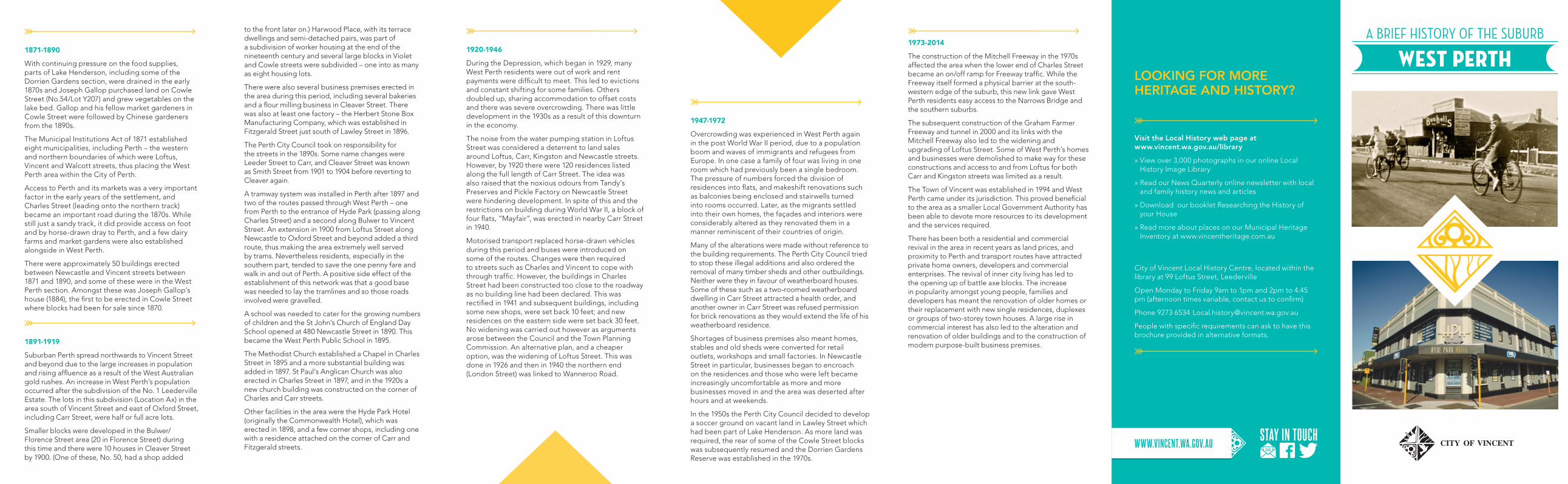
A BRIEF HISTORY OF THE SUBURB
1871-1890
With continuing pressure on the food supplies, parts of Lake Henderson, including some of the Dorrien Gardens section, were drained in the early 1870s and Joseph Gallop purchased land on Cowle Street (No.54/Lot Y207) and grew vegetables on the lake bed. Gallop and his fellow market gardeners in Cowle Street were followed by Chinese gardeners from the 1890s.
The Municipal Institutions Act of 1871 established eight municipalities, including Perth – the western and northern boundaries of which were Loftus, Vincent and Walcott streets, thus placing the West Perth area within the City of Perth.
Access to Perth and its markets was a very important factor in the early years of the settlement, and Charles Street (leading onto the northern track) became an important road during the 1870s. While still just a sandy track, it did provide access on foot and by horse-drawn dray to Perth, and a few dairy farms and market gardens were also established alongside in West Perth.
There were approximately 50 buildings erected between Newcastle and Vincent streets between 1871 and 1890, and some of these were in the West Perth section. Amongst these was Joseph Gallop’s house (1884), the first to be erected in Cowle Street where blocks had been for sale since 1870.
1891-1919
Suburban Perth spread northwards to Vincent Street and beyond due to the large increases in population and rising affluence as a result of the West Australian gold rushes. An increase in West Perth’s population occurred after the subdivision of the No. 1 Leederville Estate. The lots in this subdivision (Location Ax) in the area south of Vincent Street and east of Oxford Street, including Carr Street, were half or full acre lots.
Smaller blocks were developed in the Bulwer/Florence Street area (20 in Florence Street) during this time and there were 10 houses in Cleaver Street by 1900. (One of these, No. 50, had a shop added
to the front later on.) Harwood Place, with its terrace dwellings and semi-detached pairs, was part of a subdivision of worker housing at the end of the nineteenth century and several large blocks in Violet and Cowle streets were subdivided – one into as many as eight housing lots.
There were also several business premises erected in the area during this period, including several bakeries and a flour milling business in Cleaver Street. There was also at least one factory – the Herbert Stone Box Manufacturing Company, which was established in Fitzgerald Street just south of Lawley Street in 1896.
The Perth City Council took on responsibility for the streets in the 1890s. Some name changes were Leeder Street to Carr, and Cleaver Street was known as Smith Street from 1901 to 1904 before reverting to Cleaver again.
A tramway system was installed in Perth after 1897 and two of the routes passed through West Perth – one from Perth to the entrance of Hyde Park (passing along Charles Street) and a second along Bulwer to Vincent Street. An extension in 1900 from Loftus Street along Newcastle to Oxford Street and beyond added a third route, thus making the area extremely well served by trams. Nevertheless residents, especially in the southern part, tended to save the one penny fare and walk in and out of Perth. A positive side effect of the establishment of this network was that a good base was needed to lay the tramlines and so those roads involved were gravelled.
A school was needed to cater for the growing numbers of children and the St John’s Church of England Day School opened at 480 Newcastle Street in 1890. This became the West Perth Public School in 1895.
The Methodist Church established a Chapel in Charles Street in 1895 and a more substantial building was added in 1897. St Paul’s Anglican Church was also erected in Charles Street in 1897, and in the 1920s a new church building was constructed on the corner of Charles and Carr streets.
Other facilities in the area were the Hyde Park Hotel (originally the Commonwealth Hotel), which was erected in 1898, and a few corner shops, including one with a residence attached on the corner of Carr and Fitzgerald streets.
1920-1946
During the Depression, which began in 1929, many West Perth residents were out of work and rent payments were difficult to meet. This led to evictions and constant shifting for some families. Others doubled up, sharing accommodation to offset costs and there was severe overcrowding. There was little development in the 1930s as a result of this downturn in the economy.
The noise from the water pumping station in Loftus Street was considered a deterrent to land sales around Loftus, Carr, Kingston and Newcastle streets. However, by 1920 there were 120 residences listed along the full length of Carr Street. The idea was also raised that the noxious odours from Tandy’s Preserves and Pickle Factory on Newcastle Street were hindering development. In spite of this and the restrictions on building during World War II, a block of four flats, “Mayfair”, was erected in nearby Carr Street in 1940.
Motorised transport replaced horse-drawn vehicles during this period and buses were introduced on some of the routes. Changes were then required to streets such as Charles and Vincent to cope with through traffic. However, the buildings in Charles Street had been constructed too close to the roadway as no building line had been declared. This was rectified in 1941 and subsequent buildings, including some new shops, were set back 10 feet; and new residences on the eastern side were set back 30 feet. No widening was carried out however as arguments arose between the Council and the Town Planning Commission. An alternative plan, and a cheaper option, was the widening of Loftus Street. This was done in 1926 and then in 1940 the northern end (London Street) was linked to Wanneroo Road.
WEST PERTH
1947-1972
Overcrowding was experienced in West Perth again in the post World War II period, due to a population boom and waves of immigrants and refugees from Europe. In one case a family of four was living in one room which had previously been a single bedroom. The pressure of numbers forced the division of residences into flats, and makeshift renovations such as balconies being enclosed and stairwells turned into rooms occurred. Later, as the migrants settled into their own homes, the façades and interiors were considerably altered as they renovated them in a manner reminiscent of their countries of origin.
Many of the alterations were made without reference to the building requirements. The Perth City Council tried to stop these illegal additions and also ordered the removal of many timber sheds and other outbuildings. Neither were they in favour of weatherboard houses. Some of these such as a two-roomed weatherboard dwelling in Carr Street attracted a health order, and another owner in Carr Street was refused permission for brick renovations as they would extend the life of his weatherboard residence.
Shortages of business premises also meant homes, stables and old sheds were converted for retail outlets, workshops and small factories. In Newcastle Street in particular, businesses began to encroach on the residences and those who were left became increasingly uncomfortable as more and more businesses moved in and the area was deserted after hours and at weekends.
In the 1950s the Perth City Council decided to develop a soccer ground on vacant land in Lawley Street which had been part of Lake Henderson. As more land was required, the rear of some of the Cowle Street blocks was subsequently resumed and the Dorrien Gardens Reserve was established in the 1970s.
Visit the Local History web page at www.vincent.wa.gov.au/library
» View over 3,000 photographs in our online Local History Image Library
» Read our News Quarterly online newsletter with local and family history news and articles
» Download our booklet Researching the History of your House
» Read more about places on our Municipal Heritage Inventory at www.vincentheritage.com.au
City of Vincent Local History Centre, located within the library at 99 Loftus Street, Leederville
Open Monday to Friday 9am to 1pm and 2pm to 4.45 pm (afternoon times variable, contact us to confirm)
Phone 9273 6534 [email protected]
People with specific requirements can ask to have this brochure provided in alternative formats.
WWW.VINCENT.WA.GOV.AU
LOOKING FOR MORE HERITAGE AND HISTORY?
1973-2014
The construction of the Mitchell Freeway in the 1970s affected the area when the lower end of Charles Street became an on/off ramp for Freeway traffic. While the Freeway itself formed a physical barrier at the south-western edge of the suburb, this new link gave West Perth residents easy access to the Narrows Bridge and the southern suburbs.
The subsequent construction of the Graham Farmer Freeway and tunnel in 2000 and its links with the Mitchell Freeway also led to the widening and upgrading of Loftus Street. Some of West Perth’s homes and businesses were demolished to make way for these constructions and access to and from Loftus for both Carr and Kingston streets was limited as a result.
The Town of Vincent was established in 1994 and West Perth came under its jurisdiction. This proved beneficial to the area as a smaller Local Government Authority has been able to devote more resources to its development and the services required.
There has been both a residential and commercial revival in the area in recent years as land prices, and proximity to Perth and transport routes have attracted private home owners, developers and commercial enterprises. The revival of inner city living has led to the opening up of battle axe blocks. The increase in popularity amongst young people, families and developers has meant the renovation of older homes or their replacement with new single residences, duplexes or groups of two-storey town houses. A large rise in commercial interest has also led to the alteration and renovation of older buildings and to the construction of modern purpose-built business premises.
Client Insert Date
Campaign Size (HxW)
Description
Filename Proof/Alt #
Publication Date/Time
Prod Mgr
Studio Mgr
Studio Op
Acc Dir
Acc Coor
Art Dir
Writer
Notes: Grey fields for internal sign off on hard copy proof.
PDF may appear on screen not at actual size.
Vincent, City of (VIN001) 2015-08-31
VIN001000136 Local History Suburb Brochures 210.0 x 685.0
2015
VIN001000136_14PPDL_WESTPERTH_1-1 1
DL 2015-10-15 15:10
1 Hyde Park Hotel, 331-367 Bulwer Street, (cnr of Fitzgerald Street)
A tall two-storey building erected in 1898 as the Commonwealth Hotel. It has operated continuously as a hotel since that time. The name was changed to the Hyde Park Hotel at the beginning of the 1940s. Extensions, which included a live
performance venue and home to the WA Jazz Club and Perth Jazz Society (until 2007), were designed by architect Howlett & Bailey in the early 1970s. These extensions have been further adapted since then. In 2007 the hotel was purchased by the Woolworths group and extensively remodelled, including a large bottle shop being added.
2 Greek Orthodox Church of Evangelismos, 59 Carr Street, (cnr Charles Street)
This was erected sometime in the 1920s as St Paul’s Anglican Church and No.125 Charles Street (next door) was purchased as the Presbytery. In March 1958 St Paul’s and the Presbytery were purchased by the Greek Orthodox community. The church was then reconsecrated as the Greek Annunciation of Our Lady.
3 Methodist Church and Parish Hall, 113 Charles Street
The land was reserved for the Methodist Church in 1873. The timber Chapel on the south side constructed in 1890. Following an increase in congregation a large Gothic-style limestone church was erected in 1896. The original weatherboard
church was used as a parish hall and became a popular youth club until the 1960s. In the 1970s the services moved to the Chapel with the Church being used by youth groups. From 1983 the buildings were leased by TAFE and in 1986 the Uniting Church reluctantly sold the site to the State Government, with the last service being held in February that year. The buildings were used by TAFE for some years before falling into disuse. State Heritage listed.
4 Florence Hummerston Lodge, 61-73 Cleaver Street
Built between 1910 and 1914 in the Federation Queen Anne style for John H Prowse, Manager of the United Insurance Co.
The last occupant was Perth City Councillor Florence Hummerston, who was the foundation president of the League of Home Help for the Sick and Aged (Inc) in 1953 and a co-founder of Meals on Wheels the following year. The League purchased No. 67 in 1956 as a headquarters and for the Meals on Wheels service. It was officially opened as the Florence Hummerston Lodge in 1969 providing accommodation for the frail and aged. Adjoining properties between Nos. 61-73 were purchased over the years to increase the capacity.
5 Residence at 54 Cowle Street
Built c.1884 by Joseph Gallop, an early market gardener who grew vegetables on the drained lake bed. It is one of the few pre-gold boom houses left in the area. An addition
at the front was made in 1904, making it different to the other houses in the street. Albert Roworth, who already owned No. 40, purchased the property in 1941 and operated a garden nursery at the rear of this and several other houses on the north side of Cowle Street. Some of his nursery land was transferred to the Perth City Council to extend Dorrien Gardens Reserve in the 1970s and as compensation he acquired Nos. 28-30,32,60,70A and 70B Cowle Street.
6 Shop and residence, 167-169 Fitzgerald Street, (cnr Carr Street)
This single-storey shop and attached residence were constructed in 1895 and have remained in continuous use until today. Over that period the shop has operated as a bakery, grocer and delicatessen and is currently a lunch bar and corner store.
7 WA Italian Club, 217-225 Fitzgerald Street
Original building opened in 1937 as Casa D’Italia. Designed by architect W Wolfenden Lever it consisted of a main hall, men’s committee room, women’s lounge, library,
and large stage flanked by dressing rooms. The organisation disbanded when members were interned after Italy entered World War II. The premises were leased to the Northern Suburbs Police Boys Club from August 1941 to January 1947. In 1946, following the war, the Italian Club constitution was redrafted with a duty being to aid the assimilation of Perth’s 20,000 former Italians. They moved back into their premises, changing the name to the Italian Club. By 1954 membership
was 1,000 including 100 Australians to give the Italians direct contact with members of the local community. Adjoining houses were purchased in 1954; they were demolished to add new licensed premises to the existing building. The original building was then used to provide social, recreational, cultural and educational facilities for those under 21.
The function rooms are available for hire by Italian and non-Italian members of the community.
8 Dorrien Gardens, Lawley Street
Originally part of Lake Henderson, part had been developed from the 1870s for market gardening. In the 1950s AR Roworth operated a nursery at the rear of several blocks, and the Everitt family (also residents of the street) operated the Star tennis courts at the rear of their property. Developed between the late 1940s and 1974 by the Perth City Council as Dorrien Gardens soccer ground. Located near the Italian Club it became the home of their soccer team Azzuri, which formed in 1949 and merged with Perth Italia in 1996 to become the Perth Soccer Club. A portion of the reserve was leased to the Italian Club in 1975 for a bocce rink.
9 Purtell’s Building, 380-388 Newcastle Street, (cnr Fitzgerald Street)
Constructed 1906, this two-storey building has six shops on the lower level with residential areas above. Each has a separate hipped iron roof hidden by the distinct parapet which has Purtell’s Building embossed. The first businesses in the shops appear to have been a butcher, costumier, dealer, grocer, boot maker and
Sam Kee’s laundry. From 1910 there was a tea rooms. Tenancies changed frequently. In 1930 the laundry was replaced with a fish and chip shop, reflecting the changing ethnic composition of the area. Tenancies began to decline from the 1950s as people moved out into the newer suburbs and the building fell into disrepair. It was renovated in 1986 and a pizza parlour opened, followed by various other businesses.
10 Newcastle Street Government School, 480 Newcastle Street
Originally established as St John’s Church of England Day School (Assisted) in 1890, it was unusual that it changed to West Perth Public School in 1895. The current building was completed in 1897. In 1898 a new Infants’ School was built on the north-west side which operated until 1928. A Senior School and Junior Technical School were subsequently opened following alterations. The Primary School closed in December 1977. It was later used as a TAFE Extension College and by Edith Cowan University’s Academy of Performing Arts. From 2008 it has been the home of the Centre for Interdisciplinary Arts Studios and the Department of Training and Workforce Development. State Heritage listed in 2001.
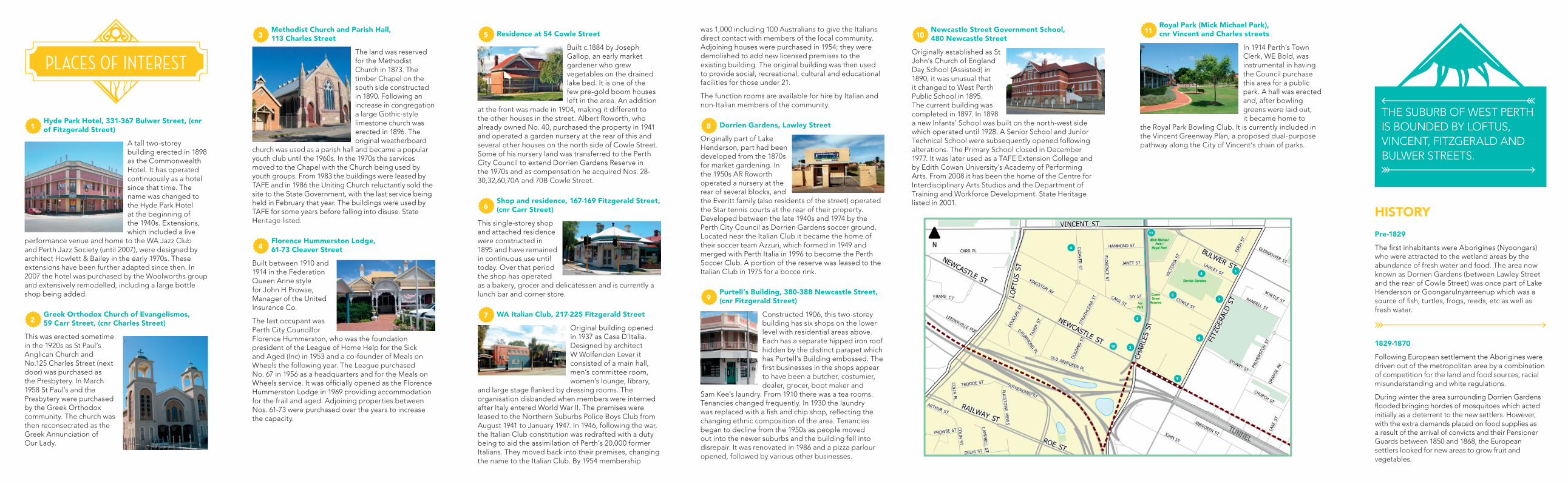
PLACES OF INTEREST
1
9
8
10
11
7
6
2
3
4
5
11 Royal Park (Mick Michael Park), cnr Vincent and Charles streets
In 1914 Perth’s Town Clerk, WE Bold, was instrumental in having the Council purchase this area for a public park. A hall was erected and, after bowling greens were laid out, it became home to
the Royal Park Bowling Club. It is currently included in the Vincent Greenway Plan, a proposed dual-purpose pathway along the City of Vincent’s chain of parks.
THE SUBURB OF WEST PERTH
IS BOUNDED BY LOFTUS,
VINCENT, FITZGERALD AND
BULWER STREETS.
HISTORY
Pre-1829
The first inhabitants were Aborigines (Nyoongars) who were attracted to the wetland areas by the abundance of fresh water and food. The area now known as Dorrien Gardens (between Lawley Street and the rear of Cowle Street) was once part of Lake Henderson or Goongarulnyarreenup which was a source of fish, turtles, frogs, reeds, etc as well as fresh water.
1829-1870
Following European settlement the Aborigines were driven out of the metropolitan area by a combination of competition for the land and food sources, racial misunderstanding and white regulations.
During winter the area surrounding Dorrien Gardens flooded bringing hordes of mosquitoes which acted initially as a deterrent to the new settlers. However, with the extra demands placed on food supplies as a result of the arrival of convicts and their Pensioner Guards between 1850 and 1868, the European settlers looked for new areas to grow fruit and vegetables.
Client Insert Date
Campaign Size (HxW)
Description
Filename Proof/Alt #
Publication Date/Time
Prod Mgr
Studio Mgr
Studio Op
Acc Dir
Acc Coor
Art Dir
Writer
Notes: Grey fields for internal sign off on hard copy proof.
PDF may appear on screen not at actual size.
Vincent, City of (VIN001) 2015-08-31
VIN001000136 Local History Suburb Brochures 210.0 x 685.0
2015
VIN001000136_14PPDL_WESTPERTH_2-2 1
DL 2015-10-15 15:10