999 town & country town & country table of contents initial study/mitigated negative...
TRANSCRIPT

999 TOWN & COUNTRY
MITIGATED NEGATIVE DECLARATION NO. 1856-17
Lead Agency:City of Orange
Community Development Department • Planning Division300 East Chapman Avenue
Orange, CA 92866-1591(714) 744 7220
(714) 744 7222 (Fax)www.cityoforange.org
Prepared by:
CAJA Environmental Services, LLC11990 San Vicente Boulevard, Suite 250
Los Angeles, CA 90049(310) 469 6700
April 2017

MITIGATED NEGATIVE DECLARATION NO. 1856-17
Project Title:
999 Town & Country
Reference Application Numbers:
Tentative Parcel Map No. 0012-16Major Site Plan Review No. 0866-16Design Review No. 4864-16Administrative Adjustment No. 0254-17
Lead Agency:
City of Orange300 E. Chapman AvenueOrange, CA 92886
Contact Person and Telephone No.:
Anne Fox, Contract Staff Planner(714) 744-7220
Project Proponent and Address:
Westcore Properties4435 Eastgate Mall, Suite 300San Diego, CA 92121
Contact Person and Telephone No.:
Nick Markos(858) 367-7173
Project Location:
The Site is located at 999 Town and Country Road, in Orange, California (Assessor’s Parcel No. 041-214-05.The Project Site is located in the western portion of the City, and is bordered by the eastbound SR-22 Freewayto the north, the on-ramp/off-ramp for the SR-22 Freeway and a commercial office complex to the west, acommercial office building to the east, and West Town and Country Road on the south. Freeway access to theProject Site is provided via the Main Street/I-5 Interchange, La Veta Avenue/SR-22 Westbound Ramp, andTown and Country Road/SR-22 Eastbound Ramps. Local access is provided by Town and Country Road,Lawson Way, and Main Street.
Existing General Plan Designation:
Urban Mixed Use (UMIX)
Existing Zoning Classification:
UMU (Urban Mixed Use District)

999 Town & Country Table of ContentsInitial Study/Mitigated Negative Declaration Page 1
TABLE OF CONTENTS
Section Page #
Section 1: Existing Setting ............................................................................................................................. 1-1Section 2: Project Description ......................................................................................................................... 2-1
Section 3: Impact Analysis ............................................................................................................................. 3-11. Aesthetics ..................................................................................................................................... 3-4
2. Agriculture and Forestry Resources ............................................................................................. 3-93. Air Quality ................................................................................................................................. 3-12
4. Biological Resources .................................................................................................................. 3-305. Cultural Resources ...................................................................................................................... 3-35
6. Geology and Soils ....................................................................................................................... 3-407. Greenhouse Gas Emissions ........................................................................................................ 3-47
8. Hazards and Hazardous Materials ..............................................................................................3-869. Hydrology and Water Quality .................................................................................................... 3-96
10. Land Use and Planning ............................................................................................................. 3-11111. Mineral Resources .................................................................................................................... 3-122
12. Noise ......................................................................................................................................... 3-12413. Population and Housing ........................................................................................................... 3-139
14. Public Services .......................................................................................................................... 3-14315. Recreation ................................................................................................................................. 3-154
16. Transportation and Traffic ........................................................................................................ 3-15617. Tribal Cultural Resources ......................................................................................................... 3-193
18. Utilities and Service Systems ................................................................................................... 3-19719. Mandatory Findings of Significance ........................................................................................ 3-209
Section 4: Mitigation Monitoring Report ...................................................................................................... 4-1Section 5: Preparers and Persons Consulted .................................................................................................. 5-1
Figures
Figure 1-1 Regional and Local Vicinity Map ......................................................................................... 1-3
Figure 1-2 Aerial Map ............................................................................................................................. 1-4Figure 1-3 Views of the Project Site, 1-3 ................................................................................................ 1-5
Figure 1-4 Views of the Project Site, 4-6 ................................................................................................ 1-6Figure 1-5 Views of the Project Site, 5-8 ................................................................................................ 1-7
Figure 2-1 Site Plan ................................................................................................................................. 2-6Figure 2-2 Level 1 and 2 Building Plans ................................................................................................. 2-7
Figure 2-3 Levels 3-6 Building Plans...................................................................................................... 2-8Figure 2-4 Office Parking Structure Plans .............................................................................................. 2-9
City of Orange April 2017
999 Town & Country Table of ContentsInitial Study/Mitigated Negative Declaration Page 2
Figure 2-5 Elevations 1 .......................................................................................................................... 2-10Figure 2-6 Elevations 2 .......................................................................................................................... 2-11
Figure 2-7 Elevations 3 .......................................................................................................................... 2-12Figure 2-8 Elevations 4 .......................................................................................................................... 2-13
Figure 2-9 3D View from Town and Country Road ............................................................................. 2-14Figure 2-10 3D View from the 22 Freeway ............................................................................................ 2-15
Figure 2-11 Additional 3D View from Town and Country Road .......................................................... 2-16Figure 3.16-1 Vicinity Map ...................................................................................................................... 3-160
Tables
Table 1-1 Project Site Information ......................................................................................................... 1-1Table 3.3-1 State and National Ambient Air Quality Standards and Attainment Status For the South Coast Air Basin ............................................................................................. 3-18
Table 3.3-2 Estimated Daily Construction Emissions - Unmitigated ................................................... 3-23Table 3.3-3 Estimated Daily Construction Emissions - Mitigated ........................................................ 3-25
Table 3.3-4 Estimated Daily Operations Emissions - Unmitigated ...................................................... 3-26Table 3.7-1 Global Warming Potential for Greenhouse Gases ............................................................. 3-49
Table 3.7-2 Estimated Construction Emissions – Unmitigated (Metric Tons per Year) ..................... 3-64Table 3.7-3 Estimated Annual CO2e Emissions (Metric Tons per Year) .............................................. 3-65
Table 3.7-4 Project Consistency with AB 32 Scoping Pan Greenhouse Gas Reduction Strategies ..... 3-69Table 3.7-5 Project Consistency with SCAG 2012-2035 RTP/SCS ...................................................... 3-70
Table 3.7-6 Project Consistency with SCAG 2016-2949 RTP/SCS ...................................................... 3-81Table 3.9-1 Peak Flow Summary .......................................................................................................... 3-103
Table 3.9-2 2-Year, 24-Hour Storm Summary ..................................................................................... 3-109Table 3.10-1 Project Consistency with Applicable Policies of the Land Use Element of the City of Orange General Plan .................................................................................. 3-118
Table 3.12-1 A-Weighted Decibel Scale ............................................................................................... 3-125Table 3.12-2 Construction Noise Levels - Unmitigated ........................................................................3-130
Table 3.12-3 2016 Estimated Peak Hour Mobile Source Noise Levels ................................................ 3-133Table 3.13-1 City of Orange Population Growth Forecasts, 2010-2030 .............................................. 3-140
Table 3.13-2 City of Orange Population and Housing Estimates ......................................................... 3-140Table 3.16-1 Level-of-Service Criteria for Signalized Intersections ..................................................... 3-161
Table 3.16-2 Level-Of-Service Criteria for Unsignalized Intersections ................................................ 3-162Table 3.16-3 Roadway Link Capacities – City of Orange .................................................................... 3-163
Table 3.16-4 Existing Peak Hour Levels of Service .............................................................................. 3-165Table 3.16-5 Existing Roadway Segment Level of Service Summary .................................................. 3-166
Table 3.16-6 Project Traffic Generation Forecast .................................................................................. 3-167Table 3.16-7 Description of Cumulative Projects .................................................................................. 3-169
Table 3.16-8 Existing Plus Project Peak Hour Intersection Capacity Analysis .................................... 3-173Table 3.16-9 Existing Plus Project Roadway Segment Level of Service Summary ............................. 3-175

City of Orange April 2017
999 Town & Country Table of ContentsInitial Study/Mitigated Negative Declaration Page 3
Table 3.16-10 Year 2019 Peak Hour Intersection Capacity Analysis ..................................................... 3-179Table 3.16-11 Level of Service Criteria For Signalized Intersections (HCM Methodology) ................ 3-182
Table 3.16-12 Existing Plus Project Peak Hour Intersection Capacity Analysis - Caltrans ................... 3-185Table 3.16-13 Year 2019 Peak Hour Intersection Capacity Analysis (Caltrans) ................................... 3-185
Table 3.16-14 Project Driveway Peak Hour Levels of Service ............................................................... 3-187Table 3.16-15 Vehicular Queuing Analysis Summary .............................................................................3-189
Table 3.18-1 Treatment Plants ................................................................................................................ 3-200Table 3.18-2 Water Demand ................................................................................................................... 3-204
Table 3.18-3 Water Supplies ................................................................................................................... 3-204Table 3.18-4 Landfills ............................................................................................................................. 3-206
Appendices
A Air Quality and Greenhouse Gas Modeling
B Geotechnical Report
C Phase I Environmental Site Assessment
D Hydrology Study
E Noise Modeling
F Traffic Impact Analysis

999 Town & Country 1. Existing SettingInitial Study/Mitigated Negative Declaration Page 1-1
1. EXISTING SETTING
EXISTING SETTING
Regional Setting:
The Project Site (or “Site”) is located in the City of Orange, in the north-central portion of OrangeCounty, approximately 12 miles northeast of the Pacific Ocean. The City of Orange shares its boundaries
with the Cities of Anaheim to the north and west, Garden Grove to the west, Santa Ana to the west andsouth, and Tustin to the southeast. To the east of Orange is unincorporated Orange County. The City of
Villa Park is completely contained within the borders of Orange.
Existing Site Conditions:
The Project Site is approximately six acres and is designated as Assessor Parcel Number (APN) 041-214-
05, and is developed with a four-story, 98,551 square foot office building on the eastern three acressurrounded by a surface parking lot containing 449 parking spaces, and related landscape/hardscape
improvements.
The Project Site information is listed in Table 1-1, Project Site Information. See also Figure 1-1, Regional
and Local Vicinity Map, for the location of the Site within the context of the City and Figure 1-2, AerialMap, for a depiction of the Project Site and surrounding areas.
Table 1-1Project Site Information
Address APN Zone Land Use
999 Town and Country Road 041-214-05UMU (Urban Mixed Use
District)Urban Mixed Use (UMIX)
Table by CAJA Environmental Services, January 2017.
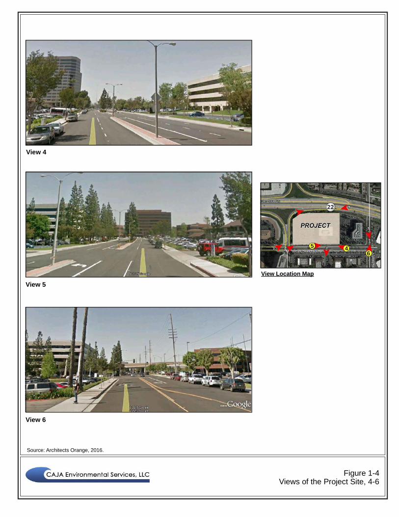
Views of the Project Site are shown in Figures 1-3 through 1-5.
Access:
Regional access to the Project Site is provided by Interstate 5 (I-5/Santa Ana Freeway) and State Route 22
(SR-22/Garden Grove Freeway). Freeway access to the Project Site is provided via the Main Street/I-5Interchange, La Veta Avenue/SR-22 Westbound Ramp, and Town and Country Road/SR-22 Eastbound
Ramps. Local access is provided by Town and Country Road, Lawson Way, and Main Street.

City of Orange April 2017
999 Town & Country 1. Existing SettingInitial Study/Mitigated Negative Declaration Page 1-2
Public Transit:
The Orange County Transportation Authority (OCTA) provides bus service in the City of Orange. The
OCTA operates the following local bus stops in the immediate Project Site vicinity:1
Line 453, at the corner of Lawson Way and Town and Country Road.
Lines 53, 83, and 757 at the corner of Main Street and Town and Country Road.
Surrounding Land Uses:
The Site is bound by the following uses:
On the north, the Site is bound by SR-22 (Garden Grove Freeway), followed by a multi-familyresidential complex (La Veta Monterey Condominiums) and medical offices (Orange Health &
Wellness Centre).
On the south, the Site is bound by Town & Country Road, followed by a commercial office complex(Town and Country Office Park), which are primarily occupied by medical offices.
To the southwest is a 16-story office building (Orange Executive Tower) and a multi-familyresidential complex currently under construction (Eleven10 West).
To the immediate west are the SR-22 freeway on- and off-ramps, beyond which are commercial
offices (Town and Country Business Plaza).
To the east is a five-story professional office building.
1 Orange County Transportation Authority, http://www.octa.net/sysmap0512/index.html.

210
10
915
605
22
405
Pasadena
Whittier
60
LongBeach
Lakewood
Montebello
Monterey Pk
Anaheim
Fullerton
City ofIndustry
Walnut
MonroviaAzusa
San Dimas
RIVERSIDECOUNTY
Corona
ChinoHills
Diamond Bar
Orange
YorbaLinda
HuntingtonBeach
Santa FeSprings
Santa Ana
Irvine
Chino
RanchoCucamonga
Pomona
15
60
66
2
83
210
5
90
55
91Cerritos
Los Alamitos
Brea
Ontario
ORANGECOUNTY
241
241
LOS ANGELESCOUNTY
39
ArcadiaBaldwin Park
West Covina
Villa Park
LOS ANGELESCOUNTY
SAN BERNARDINOCOUNTY
Miles
0 105
PacificOcean
57
55
261
133
Tustin
Costa Mesa
Bellflower
Downey
39 PROJECTLOCATION
Source: Google Maps and CAJA Environmental Services, LLC., 2017.
Figure 1-1Regional and Local Vicinity Map
Legend
Project Site
Scale (Feet)
0 100 200

Source: Google Maps, 2017.
Figure 1-2Aerial Map
Legend
Project Site
Scale (Feet)
0 100 200
22

Source: Architects Orange, 2016.
Figure 1-3Views of the Project Site, 1-3
View 1
View 2
View 3
1 2 3
View Location Map
Source: Architects Orange, 2016.
Figure 1-4Views of the Project Site, 4-6
View 4
View 5
View 6
65 4
View Location Map

Source: Architects Orange, 2016.
Figure 1-5Views of the Project Site, 5-8
View 7
View 8
View 9
9
7
8
View Location Map

999 Town & Country 2. Project DescriptionInitial Study/Mitigated Negative Declaration Page 2-1
2. PROJECT DESCRIPTION
PROJECT DESCRIPTION
Project Overview
The Project proposes the creation of a horizontal mixed-use development by adding a separate multi-family residential building to a commercially developed six-acre site that currently contains a four-story,
98,551 square foot office building surrounded by 449 surface parking spaces and relatedlandscape/hardscape improvements located on the north side of Town and Country Road between the SR-
22 freeway eastbound on-ramp and Memory Lane. The General Plan land use designation for the Site isUrban Mixed Use (UMIX) and is zoned UMU (Urban Mixed Use District). New development at the Sitewould also provide two parking structures, one to serve the new residential component and the other to
replace a majority of the surface level parking that serves the existing office building. The entire Sitewould be re-landscaped and new hardscape elements and surfaces would also be added to provide either
recreational space for the residential component and/or to refurbish the existing commercially developedportion of the Site that will remain. Construction is anticipated to occur in phases to maintain the
availability of parking for the existing tenants/employees of the office building, with the parking structureserving the commercial component of the Site being constructed first. Upon its completion, demolition
and construction of the new residential building and associated parking structure would be undertaken.The Project also includes a parcel map to create two-lots, and although the lot line generally divides the
residential component and office component improvements, Site access, utilities, water quality features,and emergency access will be reciprocal and in some instances shared through recorded agreements,
covenants, conditions and restrictions to tie the lots and to ensure long-term cooperative maintenance ofimprovements. The Project also includes a request for an overall ten percent reduction in the amount of
parking provided for the residential component, which represents the equivalent of the amount of requiredguest parking spaces.
Office Component Breakdown
The Project proposes to retain the existing office building and will redevelop portions of the associated
surface level parking and landscape/hardscape areas. A new five-level parking structure, providing 345parking stalls, covered motorcycle parking, and a trash enclosure will be constructed on the northeastern
portion of the Site to serve the existing office tenant/employees. The remaining surface level parkingareas located to the east and south of the existing office building will be restriped to provide an additional
49 parking stalls. Combined, a total of 394 parking stalls will be provided satisfying the minimumrequired by the Orange Municipal Code (OMC), which requires a minimum of four spaces per 1,000
gross square feet for Professional Office type occupancies.

City of Orange April 2017
999 Town & Country 2. Project DescriptionInitial Study/Mitigated Negative Declaration Page 2-2
The new five-level parking structure will be partially screened from view from Town and Country Roadby the existing office building. Views of the structure will largely be from the SR-22 freeway and the
existing commercially developed property immediately east. The structure has been designed to pick upsome of the architectural elements found on the Project’s residential building and additional landscapingbuffers that include lineal tree types are provided along the structure’s north and east sides to screen itsappearance.
New landscape and hardscape elements will be added to tie the existing office component of the Projectwith the newly created residential component on the western portion of the Site to create an integrated
appearance consistent with the OMC design criteria for horizontal mixed-use development. Features ofthe landscape/hardscape elements of the office component portion of the Site include the creation of a 25-
foot wide area of decorative paving leading directly from/to the public sidewalk and main entry door, avisually enhanced (decorative wood walls, lighting, trees) main entry door, and an outdoor seating area
with tables for employees of the office building located on the building’s north side.
The existing primary access driveway will be retained and will serve both the office and new residentialcomponent through reciprocity agreements. This area will be provided with new decorative pavers
extending from the driveway area westerly leading towards the Project’s residential building parkingstructure entrance and the new secondary (right-in/right-out) driveway.
Residential Component Breakdown
The Project proposes construction of a new five-level, approximately 316,541 square foot, residential
building containing 262 apartment units. The building is proposed to wrap around six full levels and onepartial level of a 453-parking stall parking structure. The apartment building will contain a mix of unit
types consisting of 60 studio units, 87 one-bedroom units, 96 two-bedroom units, and 19 three-bedroomunits. Access to individual units is from an interior corridor system that ties in with each of the levels of
the parking structure. The interior system of corridors also provides access to each assigned, lockablestorage area associated with each unit. All units have a private balcony/deck area with views to interior
courtyard areas containing resident recreational amenities, or face towards Town and Country Road, withground level units having gated patios and entry “stoops.” The ground floor of the apartment building alsocontains a 2,684 square foot leasing office and resident mail area; and a 3,359 square footclubhouse/fitness room.
The Project plans are provided in Figures 2-1 through 2-4. Concept elevations and 3D views are providedin Figures 2-5 through 2-11. The residential component of the Project has been designed to respond to the
building’s location and the surrounding architectural forms, particularly the horizontal character of theexisting office building on the Site. However, the building will have greater articulation in its appearance
due to vertical elements, variations in colors/materials, and recessed walls and portions of the buildingdue to private courtyards and private deck/balcony areas. The building will also feature sculptural pop-
outs and “green” walls. Since the apartment building will envelope the residential parking structure, views

City of Orange April 2017
999 Town & Country 2. Project DescriptionInitial Study/Mitigated Negative Declaration Page 2-3
of the structure are almost non-existent, with exception to the gated entry point, which faces east towardsthe office component portion of the Site.
The residential component of the Project will also add landscaping and hardscape elements thatcomplement the apartment building’s design and coordinate with the improvements proposed for theProject’s office component to create integration of the overall appearance of the Site. Thelandscaping/hardscaping also provide the future residents with private recreational amenities that include
a pool/spa, outdoor kitchen, outdoor lounge, barbeque areas, sport courts, a par course workout, a dogpark, and passive open space areas with common seating.
As mentioned previously, the primary access to the Site is from the existing 40-foot wide drivewaylocated on the office component and parcel. A secondary, 30-foot wide, right turn in and right turn out
driveway is proposed to replace the existing one located on the western portion of the existing Site. Thisdriveway straddles the lot line that divides the Site into two parcels. An additional 20-foot wide driveway
is located along the westerly property line to provide a fire lane serving as emergency access only. All ofthese driveways will be designed with decorative pavers on the surface.
As described above, parking for the residential component of the Project is being provided within a
structure that is surrounded by the apartment building. However, six surface-level parking stalls areprovided across the 30-foot secondary access driveway on the parcel containing the office component. A
sidewalk connects these spaces to the entrance for the leasing office. Guests of the residents may alsoutilize these spaces, or they may request access to the residential parking structure by using a call-box to
be able to park in designated guest parking spaces. Based upon the number of unit types, the OMC has aspecific parking ratio plus guest spaces that would calculate to a total Project required parking amount for
the residential component equaling 510 stalls. The Project provides 453 stalls in the residential parkingstructure and 6 spaces at surface level, a deficiency of 51 stalls, representing a shortage of ten percent;
and therefore, requires approval of an Administrative Adjustment by the City.
Green/Conservation Features
The Project would comply with the CalGreen requirements of the California Building Code.
Project Design Features
The Project would utilize central air conditioning and heating in each new residential unit. In addition, theProject would include double-paned windows on all of the exterior windows for each residential unit.
Project Construction Standards
The Project would be constructed in compliance with current California Building Code and City of
Orange building codes and requirements. The impact analysis which follows assumes compliance withthese mandatory code requirements as part of the Project description.

City of Orange April 2017
999 Town & Country 2. Project DescriptionInitial Study/Mitigated Negative Declaration Page 2-4
Construction Schedule and Information
The Project would be constructed in two phases. The first phase would include development of the five-
level parking structure on the northeast portion of the Site to serve the existing office building.Construction is anticipated to commence in 2017 and take approximately 6-8 months to complete. The
second phase would include development of the apartment project on the western half of the Site.Construction is anticipated to commence in 2017 or 2018 and take approximately 14 months to complete,
with Project operation beginning in 2019.1 Equipment on-site would include a forklift, concrete pump,scraper, bulldozer, compaction roller, crane, and excavator.
APPLICANT’S ACCEPTANCE OF PROPOSED MITIGATION
Prior to the public circulation and review of this Mitigated Negative Declaration, the Project Applicant
has agreed to incorporate into the Project all mitigation measures proposed in this MND.
PROJECT OBJECTIVES
The objectives of the Project are as follows:
To implement the City of Orange General Plan’s mixed-use vision and transform a commercialsite into a horizontal mixed-use office and residential development thereby creating a highly
desirable urban environment.
To support the City of Orange’s initiative for effective Growth Management. Office andresidential uses within this mixed-use environment are highly complementary in that they offer
quality housing in close proximity to employment centers and, in some instances, withinimmediate walking distance to jobs.
To develop a currently underutilized Site to provide housing to serve the local community.
To provide a well-designed development that is economically feasible and complementary tosurrounding land uses.
To improve the aesthetic quality of the Site by providing a new and efficient building that issensitive to adjacent uses.
1 While it is likely that Project construction will occur over two phases as described herein, it is possible thatthe construction phases will overlap. Therefore, the analysis contained in this IS/MND assumesconstruction will occur in a single phase, which provides the most conservative, worst-case estimate of theProject’s impacts. If construction does in fact occur over two phases, the impacts would be less than thosedocumented in this IS/MND.

City of Orange April 2017
999 Town & Country 2. Project DescriptionInitial Study/Mitigated Negative Declaration Page 2-5
DISCRETIONARY ACTIONS
The City of Orange is the lead agency for the Project. In order to construct the Project, the Applicant is
requesting approval of the following discretionary actions from the City:
Environmental No. 1856-17 (Mitigated Negative Declaration (MND)).
Tentative Parcel Map No. 0012-16
Major Site Plan Review No. 0866-16.
Design Review No. 4864-16.
Administrative Adjustment No. 0254-17
Other Public Agencies Whose Approval is Required (Responsible or Trustee Agencies):
Regional Water Quality Control Board – permitting authority over surface water runoff andwater quality impacts with enforcement of any applicable mitigation measures.
South Coast Air Quality Management District – permitting authority over localized and regionalair quality impacts and enforcement of any applicable air quality mitigation measures.

Figure 2-1Site Plan
Source: Architects Orange, 2017. Scale (Feet)
0 60 120

Figure 2-2Level 1 and 2 Building Plans
Source: Architects Orange, 2017. Scale (Feet)
0 60 120

Figure 2-3Levels 3-6 Building Plans
Source: Architects Orange, 2017. Scale (Feet)
0 60 120

Figure 2-4Office Parking Structure Plans
Source: Architects Orange, 2017.

Figure 2-5Elevations 1
Source: Architects Orange, 2017.

Figure 2-6Elevations 2
Source: Architects Orange, 2017.

Figure 2-7Elevations 3
Source: Architects Orange, 2017.

Figure 2-8Elevations 4
Source: Architects Orange, 2017.

Figure 2-93D View from Town and Country Road
Source: Architects Orange, 2017.
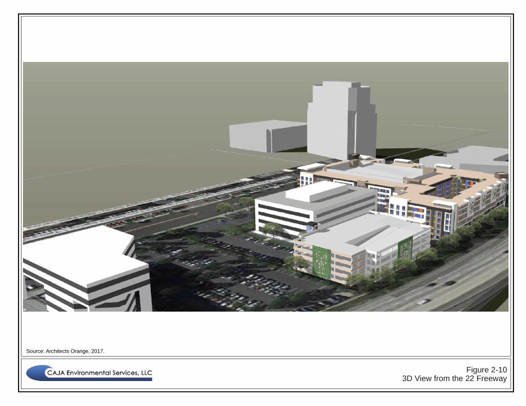
Figure 2-103D View from the 22 Freeway
Source: Architects Orange, 2017.

Figure 2-11Additional 3D View from Town and Country Road
Source: Architects Orange, 2017.