9.0 soil, geology & hydrogeologysoil, geology & hydrogeology kingspan insulation limited...
TRANSCRIPT

SOIL, GEOLOGY & HYDROGEOLOGY Kingspan Insulation Limited
Kingspan EIS Chapter 9, Page 1
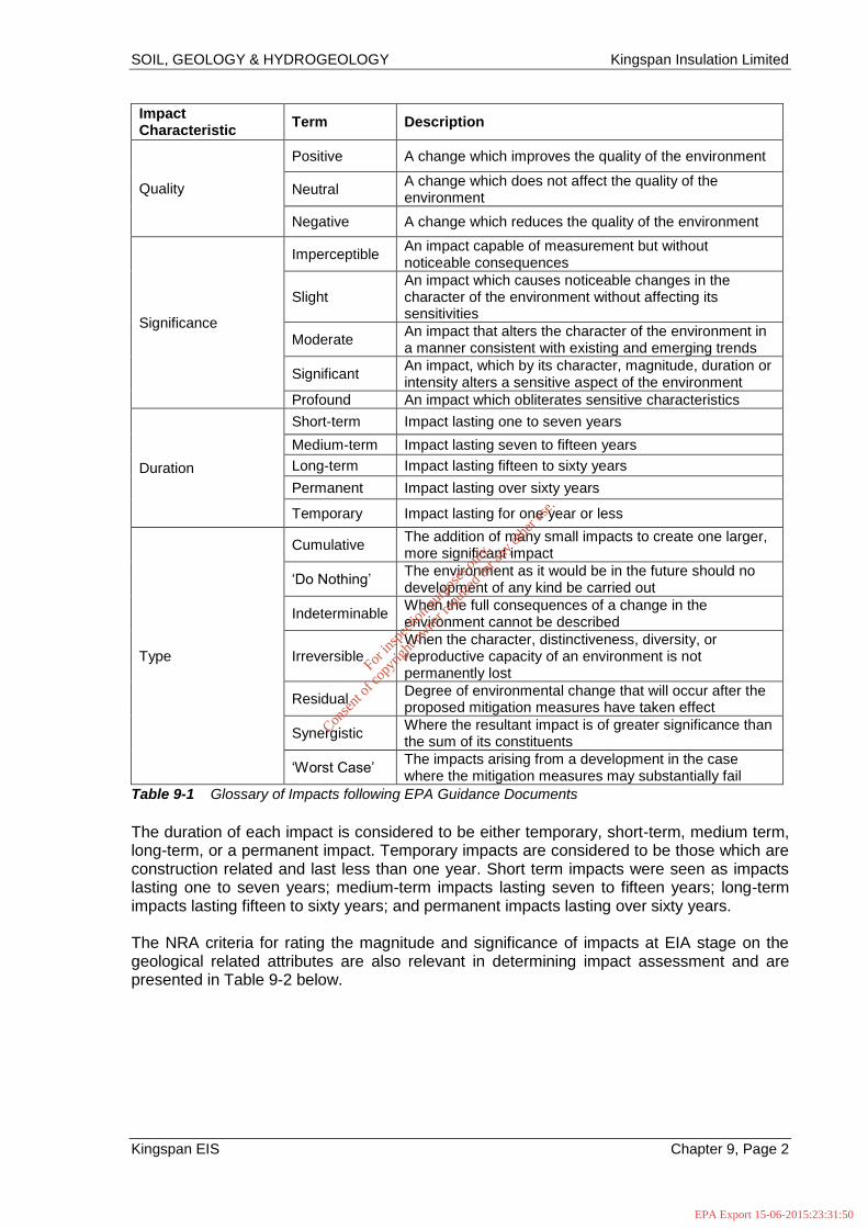
9.0 SOIL, GEOLOGY & HYDROGEOLOGY 9.1 INTRODUCTION The proposed Regenerative Thermal Oxidiser (RTO) will be located within the existing fence of the Kingspan Insulation Ltd facility in Castleblayney, Co. Monaghan. This chapter assesses and evaluates the potential impacts on the soil, geological and hydrogeological aspects of the site and surrounding area. In assessing likely potential and predicted impacts, account is taken of both the importance of the attributes and the predicted scale and duration of the likely impacts. 9.2 STUDY METHODOLOGY 9.2.1 General The methodology for rating impacts for the EIS is completed in accordance with the EPA Guidelines on the Information to be contained in Environmental Impact Statements, EPA (2002). The EPA document entitled Advice Notes on Current Practice in the Preparation of Environmental Impact Statements (2003) is also followed in this geological assessment and classification of environmental impacts. Due consideration is also given to the guidelines provided by the Institute of Geologists of Ireland (IGI) in the document entitled Guidelines for the Preparation of Soils, Geology and Hydrogeology Chapters of Environmental Impact Statements (2013). In addition, the document entitled Guidelines on Procedures for Assessment and Treatment of Geology, Hydrology and Hydrogeology for National Road Schemes by the National Roads Authority (NRA) (2009) is referenced where the methodology for assessment of impact is appropriate. 9.2.2 Criteria for Rating Impacts The rating of potential environmental impacts on the soils, geology and hydrogeological environment is based on the matrix presented in Table 9-1 below which takes account of the quality, significance, duration and type of impact characteristic identified. In the EIS assessment, consideration is given to both the importance of an attribute and the magnitude of the potential environmental impacts of the proposed activities on that cited attribute. The impact ratings presented in Table 9-1 below are in accordance with impact assessment criteria provided in the EPA (2002) publication.
For
insp
ectio
n pur
pose
s only
.
Conse
nt of
copy
right
owne
r req
uired
for a
ny ot
her u
se.
EPA Export 15-06-2015:23:31:50
SOIL, GEOLOGY & HYDROGEOLOGY Kingspan Insulation Limited
Kingspan EIS Chapter 9, Page 2
Impact Characteristic
Term Description
Quality
Positive A change which improves the quality of the environment
Neutral A change which does not affect the quality of the environment
Negative A change which reduces the quality of the environment
Significance
Imperceptible An impact capable of measurement but without noticeable consequences
Slight An impact which causes noticeable changes in the character of the environment without affecting its sensitivities
Moderate An impact that alters the character of the environment in a manner consistent with existing and emerging trends
Significant An impact, which by its character, magnitude, duration or intensity alters a sensitive aspect of the environment
Profound An impact which obliterates sensitive characteristics
Duration
Short-term Impact lasting one to seven years
Medium-term Impact lasting seven to fifteen years
Long-term Impact lasting fifteen to sixty years
Permanent Impact lasting over sixty years
Temporary Impact lasting for one year or less
Type
Cumulative The addition of many small impacts to create one larger, more significant impact
‘Do Nothing’ The environment as it would be in the future should no development of any kind be carried out
Indeterminable When the full consequences of a change in the environment cannot be described
Irreversible When the character, distinctiveness, diversity, or reproductive capacity of an environment is not permanently lost
Residual Degree of environmental change that will occur after the proposed mitigation measures have taken effect
Synergistic Where the resultant impact is of greater significance than the sum of its constituents
‘Worst Case’ The impacts arising from a development in the case where the mitigation measures may substantially fail
Table 9-1 Glossary of Impacts following EPA Guidance Documents
The duration of each impact is considered to be either temporary, short-term, medium term, long-term, or a permanent impact. Temporary impacts are considered to be those which are construction related and last less than one year. Short term impacts were seen as impacts lasting one to seven years; medium-term impacts lasting seven to fifteen years; long-term impacts lasting fifteen to sixty years; and permanent impacts lasting over sixty years. The NRA criteria for rating the magnitude and significance of impacts at EIA stage on the geological related attributes are also relevant in determining impact assessment and are presented in Table 9-2 below.
For
insp
ectio
n pur
pose
s only
.
Conse
nt of
copy
right
owne
r req
uired
for a
ny ot
her u
se.
EPA Export 15-06-2015:23:31:50

SOIL, GEOLOGY & HYDROGEOLOGY Kingspan Insulation Limited
Kingspan EIS Chapter 9, Page 3
Magnitude of Impact
Criteria Typical Examples
Large Adverse Results in loss of attribute
Loss of high proportion of future quarry or pit reserves Irreversible loss of high proportion of local high fertility soils Removal of entirety of geological heritage feature Requirement to excavate / remediate entire waste site Requirement to excavate and replace high proportion of peat, organic soils and/or soft mineral soils beneath alignment
Moderate Adverse Results in impact on integrity of attribute or loss of part of attribute
Loss of moderate proportion of future quarry or pit reserves Removal of part of geological heritage feature Irreversible loss of moderate proportion of local high fertility soils Requirement to excavate / remediate significant proportion of waste site Requirement to excavate and replace moderate proportion of peat, organic soils and/or soft mineral soils beneath alignment
Small Adverse
Results in minor impact on integrity of attribute of loss of small part of attribute
Loss of small proportion of future quarry or pit reserves Removal of small part of geological heritage feature Irreversible loss of small proportion of local high fertility soils and/or high proportion of local low fertility soils Requirement to excavate / remediate small proportion of waste site Requirement to excavate and replace small proportion of peat, organic soils and/or soft mineral soils beneath alignment
Negligible
Results in an impact on attribute but not of sufficient magnitude to affect either use or integrity
No measurable changes in attributes
Minor Beneficial Results in minor improvement of attribute quality
Minor enhancement of geological heritage feature
Moderate Beneficial Results in moderate improvement of attribute quality
Moderate enhancement of geological heritage feature
Major Beneficial Results in major improvement of attribute quality
Major enhancement of geological heritage feature
Table 9-2 Criteria for rating impact magnitude at EIS stage - Estimation of magnitude of impact on soil/geology attribute (NRA)
The NRA criteria for estimation of the importance of soil and geology and hydrogeological attributes at the site during the EIA stage are summarised below in Table 9-3 and Table 9-4 respectively.
For
insp
ectio
n pur
pose
s only
.
Conse
nt of
copy
right
owne
r req
uired
for a
ny ot
her u
se.
EPA Export 15-06-2015:23:31:50

SOIL, GEOLOGY & HYDROGEOLOGY Kingspan Insulation Limited
Kingspan EIS Chapter 9, Page 4
Importance Criteria Typical Examples
Very High
Attribute has a high quality,
significance or value on a
regional or national scale
Degree or extent of soil
contamination is significant on a
national or regional scale
Volume of peat and/or soft
organic soil underlying route is
significant on a national or
regional scale*
Geological feature rare on a regional or
national scale (NHA)
Large existing quarry or pit
Proven economically extractable mineral
resource
High
Attribute has a high quality,
significance or value on a local
scale
Degree or extent of soil
contamination is significant on a
local scale
Volume of peat and/or soft
organic soil underlying route is
significant on a local scale*
Contaminated soil on site with previous
heavy industrial usage
Large recent landfill site for mixed wastes
Geological feature of high value on a local
scale (County Geological Site)
Well drained and/or highly fertility soils
Moderately sized existing quarry or pit
Marginally economic extractable mineral
resource
Medium
Attribute has a medium quality,
significance or value on a local
scale
Degree or extent of soil
contamination is moderate on a
local scale
Volume of peat and/or soft
organic soil underlying route is
moderate on a local scale*
Contaminated soil on site with previous light
industrial usage
Small recent landfill site for mixed wastes
Moderately drained and/or moderate fertility
soils
Small existing quarry or pit
Sub-economic extractable mineral resource
Low
Attribute has a low quality,
significance or value on a local
scale
Degree or extent of soil
contamination is minor on a
local scale
Volume of peat and/or soft
organic soil underlying route is
small on a local scale*
Large historical and/or recent site for
construction and demolition wastes
Small historical and/or recent landfill site for
construction and demolition wastes
Poorly drained and/or low fertility soils
Uneconomically extractable mineral
resource
Table 9-3 Estimation of Importance of Soil and Geology Attributes (NRA)
For
insp
ectio
n pur
pose
s only
.
Conse
nt of
copy
right
owne
r req
uired
for a
ny ot
her u
se.
EPA Export 15-06-2015:23:31:50

SOIL, GEOLOGY & HYDROGEOLOGY Kingspan Insulation Limited
Kingspan EIS Chapter 9, Page 5
Importance Criteria Typical Examples
Extremely High Attribute has a high quality or value on an international scale
Groundwater supports river, wetland or surface water body ecosystem protected by EU legislation e.g. SAC or SPA status
Very High Attribute has a high quality or value on a regional or national scale
Regionally Important Aquifer with multiple well fields Groundwater supports river, wetland or surface water body ecosystem protected by national legislation – NHA status Regionally important potable water source supplying >2500 homes Inner source protection area for regionally important water source
High Attribute has a high quality or value on a local scale
Regionally Important Aquifer Groundwater provides large proportion of baseflow to local rivers Locally important potable water source supplying >1000 homes Outer source protection area for regionally important water source Inner source protection area for locally important water source
Medium Attribute has a medium quality or value on a local scale
Locally Important Aquifer Potable water source supplying >50 homes Outer source protection area for locally important water source
Low Attribute has a low quality or value on a local scale
Poor Bedrock Aquifer Potable water source supplying <50 homes
Table 9-4 Estimation of Importance of Hydrogeology Attributes (NRA)
The principal attributes (and impacts) to be assessed include the following:
Geological heritage sites in the vicinity of the perimeter of the subject site;
Landfills, industrial sites in the vicinity of the site and the potential risk of encountering contaminated ground;
The quality, drainage characteristics and range of agricultural uses of soil around the subject site;
Quarries or mines in the vicinity, the potential implications (if any) for existing activities and extractable reserves;
The extent of topsoil and subsoil cover and the potential use of this material on site as well or requirement to remove it off-site as waste for disposal or recovery;
High yielding water supply springs/wells in the vicinity of the site to within a 2km radius and the potential for increased risk presented by the proposed development;
Classification (regionally important, locally important) and extent of aquifers underlying the site perimeter area and increased risks presented to them by the proposed development associated with aspects such as for example removal of subsoil cover, removal of aquifer (in whole or part), drawdown in water levels, alteration in established flow regimes, change in groundwater quality;
Natural hydrogeological/karst features in the area and potential for increased risk presented by the activities at the site; and
Groundwater-fed ecosystems and the increased risk presented by operations both spatially and temporally.
For
insp
ectio
n pur
pose
s only
.
Conse
nt of
copy
right
owne
r req
uired
for a
ny ot
her u
se.
EPA Export 15-06-2015:23:31:50

SOIL, GEOLOGY & HYDROGEOLOGY Kingspan Insulation Limited
Kingspan EIS Chapter 9, Page 6
9.2.3 Sources of Information Desk-based geological information on the substrata (both Quaternary deposits and bedrock geology) underlying the extent of the site was obtained through accessing publically available databases and other archives where available. Data was sourced from the following:
Geological Survey of Ireland (GSI) – www.gsi.ie on-line mapping, Geo-hazard Database, Geological Heritage Sites & Sites of Special Scientific Interest, Bedrock Memoirs and 1:100,000 mapping.
Teagasc soil and subsoil database;
Ordnance Survey Ireland - aerial photographs and historical mapping;
Environmental Protection Agency (EPA) – www.epa.ie on-line mapping and database information;
National Parks and Wildlife Services (NPWS) – www.npws.ie on-line database; Protected Site Register; and
Soil & Groundwater Baseline Report (Industrial Emission Directive) 2015, AWN Consulting.
The methodology for the assessment and mitigation measures proposed has regard to the following guideline documents:
CIRIA, (2011). Environmental good practice on site; Construction Industry Research and Information Association publication C692 (3rd Edition - an update of C650 (2005); (I. Audus, P. Charles and S. Evans), 2011; and
CIRIA, (2012). Environmental good practice on site – pocket book; Construction Industry Research and Information Association publication C715 (P. Charles, and G. Wadams), 2012.
9.3 RECEIVING ENVIRONMENT 9.3.1 Site Area Description The Kingspan facility is located within the Killycard/ Bree Industrial estate in Castleblayney, Co. Monaghan, which is lies adjacent to the N2 (National Road). The site is accessible from the N2 and from a local road of the R181. The proposed location for the RTO is close to the truck access point (north-west) of the site. Figure 9-1 (at the end of this chapter) shows the Kingspan site area and the proposed location for the RTO. 9.3.2 Topography The regional topography consists of undulating landscape with associated drumlins. The Kingspan site itself is relatively flat and lies at approximately 128 m-129 m above Ordnance Datum (Malin Head). 9.3.3 Drainage The drainage is discussed in more detail in Chapter 10.0 Water & Hydrology. The Kingspan is located within the Fane River Catchment which forms part of the Neagh Bann River Basin District (IE06_03) as defined under the EU Water Framework Directive (2000/60EC) European Communities Directive 2000/60EC, establishing a framework for community
For
insp
ectio
n pur
pose
s only
.
Conse
nt of
copy
right
owne
r req
uired
for a
ny ot
her u
se.
EPA Export 15-06-2015:23:31:50

SOIL, GEOLOGY & HYDROGEOLOGY Kingspan Insulation Limited
Kingspan EIS Chapter 9, Page 7
action in the field of water policy, (commonly known as the Water Framework Directive [WFD]). There are no surface streams or open drainage ditches on the site itself. All surface runoff water from process areas is captured by the storm water system and discharges via one of the two petrol interceptors before discharging into the public storm water network. Additional discharges take rainwater from roof areas or car parking direct to public storm sewer. 9.3.4 Land Use The site is located within the Killycard Industrial Estate which comprises light industrial and commercial units. The closest businesses are a Shabra plastics and Packaging, a recycling facility and MC Building Chemicals Ltd and ECI (European Chemical Industries Limited) are located across the road to the north-west. The lands to the north and north-east are residential and generally agricultural to the south and west of the site. Kingspan Insulation Limited has been manufacturing high performance rigid urethane insulation products in Ireland since 1981. Previous land-use on part of the current Kingspan site consisted of a print works, the rest of the site was greenfield. Solvents and hydrocarbons would have been used for raw materials and energy supply for the print works. 9.3.5 Bedrock Geology The site is underlain predominately by the Kehernaghkilly Formation which is commonly characterised by black shales and minor rhyolitic tuffs, and regionally referred to as Ordovician Meta-sediments. The eastern corner of the site is underlain by the Oghill Formation commonly characterised by massive sandstone and micro-conglomerate, regionally referred to as Silurian Meta-sediments. The underlying geology according to the GSI (2015) is illustrated in Figure 9-2 (at the end of this chapter). A large structural fault trending in a north-northwest to south-southeast direction is also inferred to crosscut the site as shown in Figure 9-2, according to GSI (2015). A detailed site investigation carried out by AWN Consulting in February (2015), confirmed the presence of dark grey to black shales at a depth of approximately 0.50 m – 1.70 m below surface level at the Kingspan site. The location of soil boreholes and groundwater monitoring locations are illustrated in Insert 9-1. Soil bore SP2 is located within the proposed RTO unit area. Borehole logs which illustrate the local geology beneath the Kingspan facility are given in Appendix D. The depth to bedrock at the proposed RTO location is 0.80 m below ground level.
For
insp
ectio
n pur
pose
s only
.
Conse
nt of
copy
right
owne
r req
uired
for a
ny ot
her u
se.
EPA Export 15-06-2015:23:31:50

SOIL, GEOLOGY & HYDROGEOLOGY Kingspan Insulation Limited
Kingspan EIS Chapter 9, Page 8
Insert 9-1 Site Investigation (Feb 2015)
9.3.6 Soil & Subsoil According to the GSI mapping (Figure 9-3, at the end of this chapter), the soils beneath the Kingspan facility consists of made ground (north), deep poorly drained mineral derived from mainly non-calcareous parent materials (AminPD) in the east and shallow well drained mineral soils derived from mainly non-calcareous parent materials (AminSW) in the south.
The subsoil type underlying the Kingspan site according to the GSI (2015) is made ground to the north, Lower Palaeozoic Sandstone and Shale Fill (TLPSsS) and bedrock at the southern corner of the site. Subsoil classification according to the GSI (2014) is presented in Figure 9-4 (at the end of this chapter). 9.3.6.1 Soil Quality The (AWN 2015) site investigation as part of the Industrial Emission Directive Licence reference P0057-02, included the testing of a small number of baseline soil quality data. The location of soil boreholes and groundwater monitoring locations are illustrated in Insert 9-1. Soil bore SP2 is located within the proposed RTO unit area. There is no legislative threshold criteria for soil quality in Ireland. As such, international (UK and Dutch) standards data is used for comparison. Soil quality data, summarised in Table 9-5, highlighted that despite slight exceedances of some heavy metals concentrations (arsenic: 8.8-34.2 mg/kg, copper: 39-49 mg/kg, selenium: 1-4 mg/kg, and nickel: 56.4-93.8 mg/kg) above the Dutch S values at four shallow soil locations at Kingspan, none of these metal concentrations exceeded the Dutch Intervention (I) values or the UK Land Quality Management Generic Assessment Criteria (AWN 2015).
For
insp
ectio
n pur
pose
s only
.
Conse
nt of
copy
right
owne
r req
uired
for a
ny ot
her u
se.
EPA Export 15-06-2015:23:31:50

SOIL, GEOLOGY & HYDROGEOLOGY Kingspan Insulation Limited
Kingspan EIS Chapter 9, Page 9
Sample ID SP1 SP2 SP5 MW1
Depth (m) 0.25 0.7 0.7 0.4
Date Samples 12/02/2015 12/02/2015 12/02/2015 23/02/2015
Units LOD
Arsenic 640 SGV 29 55 mg/kg <0.5 8.8 14.3 34.2 21.9
Cadmium 230 SGV 0.8 12 mg/kg <0.1 0.1 0.2 0.6 -
Chromium 35 LQM GAC 100 380 mg/kg <0.5 74.9 67.2 50.3 39.6
Copper 71700 LQM GAC 39 190 mg/kg <1 46 39 42 46
Mercury 3600 SGV 0.3 10 mg/kg <0.1 - - - -
Selenium 13000 SGV 0.7 100 mg/kg <1 - 2 1 4
Nickel 1800 SGV 35 210 mg/kg <0.7 86.9 93.8 56.4 57.3
Lead 85 530 mg/kg <5 14 32 35 30
Zinc 665000 LQM GAC 140 720 mg/kg <5 80 153 100 74
EPH (C8-C40) # mg/kg <30 - - 276 -
Legend 222 Above Dutch S Value - Below detection limit
Above Dutch I Value LOD Limits of Detection
222 exceed GAC
Dutch
S-
Value
COMMER-
CIAL/
INDUST-
RIAL
HHRA
Dutch I-
ValueSoilRef.
Table 9-5 Soil Quality Data
In addition, the concentration of metals in soil at the site were compared with values recorded by the EPA in the National Soil Database (NSDB). The NSDB is a national baseline database of soil geochemistry including data point maps and spatial distribution maps. The Soil Geochemical Atlas of Ireland published by Teagasc and the EPA in 2007 (based on the NSDB graphical interpretation maps) show that concentrations around the Castleblayney area for Arsenic corresponds to 9.1-15 mg/kg, > 30 mg/kg but less than 100 mg/kg for Copper, 0.75-1.0 mg/kg for Selenium and > 37.5 mg/kg but less than 100 mg/kg for Nickel. Note; these are only guideline concentrations and local exceedances can originate from the parent nature of the bedrock. EPH concentrations (of 276 mg/kg) were detected in in SP5 location at 0.70 m below ground level (mbgl), down gradient of the fuel storage area. However no EPH concentration were detected (Table 9-6) from the same soil leachate sample which would indicate that this would not impact on underlying groundwater quality.
For
insp
ectio
n pur
pose
s only
.
Conse
nt of
copy
right
owne
r req
uired
for a
ny ot
her u
se.
EPA Export 15-06-2015:23:31:50

SOIL, GEOLOGY & HYDROGEOLOGY Kingspan Insulation Limited
Kingspan EIS Chapter 9, Page 10
Sample ID SP2 SP5
Depth (m) 0.5 0.7
Date Samples 12/02/2015 12/02/2015
Units LOD
Arsenic (Dissolved) 7.5 10 ug/l <2.5 5.3 3.6
Cadmium (Dissolved) 3.75 5 ug/l <0.5 - -
Chromium (Dissolved) 37.5 30 ug/l <1.5 - -
Copper (Dissolved) 1500 30 ug/l <7 12 8
Mercury (Dissolved) 0.75 1 ug/l <1 - -
Nickel (Dissolved) 15 20 ug/l <2 2 5
Lead (Dissolved) 18.75 10 ug/l <5 - -
Zinc (Dissolved) 100 ug/l <3 - -
Selenium (Dissolved) ug/l <3 - -
EPH (C8-C40) # 10 (Total ) ug/l - - -
Legend Above Groundw ater Regs 2010 - Below detection limit
222 above EPA Interim Value LOD Limits of Detection
Ground-
water
Regs SI No
9 of 2010
Soil Leachates
EPA
Interim
Ground-
water
Table 9-6 Soil Leachate Quality Data
9.3.7 Geological Heritage The GSI Public Viewer on-mapping (www.gsi.ie/mapping) was reviewed to identify sites of geological heritage for the site and surrounding area. There is no evidence of any site which could be considered suitable for protection under this programme. The nearest recorded site is the Carrickatee Hill Site (MN004 - an excellent Ordovician Volcanics exposure) located approximately 10 km south-west of the site. 9.3.8 Economic Geology The Extractive Industry Register (www.epa.ie) and the GSI mineral database were consulted to determine whether there were/ are any mineral sites close to the subject site. There are no active localities located within 5 km of the site; there is a non-mineral locality of clay/ brick (location no. 2026) approximately 1 km north of the site and a mineral locality of Iron Oxide approximately 1 km north east of the site. The EPA ENVision website also confirmed that there are no mines on/ near the subject site. 9.3.9 Geo-Hazards According to the GSI on-line database, there are presently no records of geo-hazards such as landslides, within a radius of 10 km of the site. 9.3.10 Rating of Importance of Geological Attribute Based on the NRA methodology (2009) presented in Table 9-3 - Criteria for rating site importance of geological features - the importance of the bedrock and soil features at this site is rated as Low Importance based on the assessment that the attribute has a low quality, significance or value on a local scale.
For
insp
ectio
n pur
pose
s only
.
Conse
nt of
copy
right
owne
r req
uired
for a
ny ot
her u
se.
EPA Export 15-06-2015:23:31:50

SOIL, GEOLOGY & HYDROGEOLOGY Kingspan Insulation Limited
Kingspan EIS Chapter 9, Page 11
9.3.11 Hydrogeology 9.3.11.1 Aquifer Classification The bedrock aquifer beneath the Castleblayney area is classed (following the GSI/EPA classification system) as Pl which is ‘Generally Unproductive except for Local Zones”. Figure 9-5 (at the end of this chapter) presents the aquifer classification for the site according to the GSI (2014). 9.3.11.2 Aquifer Vulnerability Figure 9-6 presents the GSI groundwater vulnerability index. Aquifer vulnerability is related to the type and thickness of subsoils in the region. Note in the areas where drumlins exist the vulnerability is lower due to increase subsoil thickness.
There are no drumlin deposits beneath the site, and aquifer vulnerability ranges from moderate to extreme where rock is at or close to the surface. From site investigation data in February (AWN 2015), the subsoil thickness was confirmed to be between 0.3-1.5 m of generally low permeability till, which indicates an ‘Extreme’ local vulnerability. The depth to bedrock at the proposed RTO location is 0.80 m below ground level based on the SP2 soil bore log (Appendix D).
9.3.11.3 Groundwater Body & Status The site is located within the Castleblayney 1 Groundwater body. The status is based on overall chemical status and quantities and has been categorised as ‘Good’ between 2007-2009 and 2010-2012. The WFD risk is 1b which means it is ‘possibly at risk of not achieving good statues’ by 2015. 9.3.11.4 Groundwater Quality The (AWN 2015) site investigation included the testing of a small number of baseline groundwater quality data. The locations of groundwater monitoring points are illustrated in Insert 9-1. Groundwater Well MW2, is the closest monitoring point to the proposed RTO unit area. The groundwater samples (4 no.) were analysed for metals, hydrocarbons, volatile organic compounds (VOCS), semi-volatile organic compounds (PAHs) and Polychlorinated BiPhenols (PCBs). Groundwater quality (in Table 9-7) was assessed by comparing analytical results to the European Communities Environmental Objectives (Groundwater) Regulations, 2010 (Statutory Instrument No. 9 of 2010) and the Environmental Protection Agency’s Draft Interim Guidelines Values (IGVs) for the Protection of Groundwater, 2003. The results are summarised below. Heavy Metals With the exception of Arsenic, Nickel and Zinc, no other heavy metals were detected above laboratory detection limit in the groundwater site at Kingspan (Table 9.7). A slight exceedance in Arsenic concentration (10.1 µg/l) above the 2010 Groundwater Regulations 2010 (7.5 µg/l) was noted in MW3, with the remaining detected metals remaining below the 2010 Groundwater Regulations.
Inorganics Almost all inorganic parameter concentrations were below Groundwater Regulations (2010), and EPA IGVs. Slight exceedances of Ammoniacal Nitrogen concentrations (0.24 mg/l in
For
insp
ectio
n pur
pose
s only
.
Conse
nt of
copy
right
owne
r req
uired
for a
ny ot
her u
se.
EPA Export 15-06-2015:23:31:50

SOIL, GEOLOGY & HYDROGEOLOGY Kingspan Insulation Limited
Kingspan EIS Chapter 9, Page 12
MW3 and 0.19 mg/l in MW4) above the Groundwater Regulations 2010 (0.175 mg/l) were observed (Table 9-6). Sample ID MW1 MW2 MW3 MW4
Groundw ater Groundw ater Groundw ater Groundw ater
Date Samples 02/03/2015 02/03/2015 02/03/2015 02/03/2015
Inorganics Units LOD
Alkalinity (Total) N.A.C mg CaCO3/l <1 144 80 106 160
Chloride 187.5 30 mg/l <0.3 8.2 25.8 64.2 66.8
Ammoniacal Nitrogen 0.175 0.15 mg/l <0.03 0.06 0.06 0.24 0.19
Sulphate 187.5 200 mg/l <0.05 187.19 71.03 89.03 64.02
Total Oxidised Nitrogen as N NAC mg/l <0.2 - 0.4 - 1.8
Nitrate as NO3 37.5 25 mg/l <0.2 0.8 2 - 8.1
Calcium 200 mg/l <0.2 74.3 48.3 60.6 60.3
Potassium 5 mg/l <0.1 1.4 3.8 3 5.1
Magnesium 50 mg/l <0.1 26.9 6.6 14.9 18.1
Sodium 150 150 mg/l <0.1 10.9 14.4 39.5 34.5
Arsenic (Dissolved) 7.5 10 ug/l <2.5 - 2.9 10.1 4
Cadmium (Dissolved) 3.75 5 ug/l <0.5 - - - -
Chromium (Total) 37.5 30 ug/l <1.5 - - - -
Copper (Dissolved) 1500 30 ug/l <7 - - - -
Mercury (Dissolved) 0.75 1 ug/l <1 - - - -
Nickel (Dissolved) 15 20 ug/l <2 4 7 13 8
Lead (Dissolved) 18.75 10 ug/l <5 - - - -
Zinc (Dissolved) 100 ug/l <3 - - 4 7
Selenium (Dissolved) ug/l <3 - - - -
Foramaldehyde mg/l <0.5 - - - -
PCB 28 ug/l <0.1 - - - -
PCB 52 ug/l <0.1 - - - -
PCB 101 ug/l <0.1 - - - -
PCB 118 ug/l <0.1 - - - -
PCB 138 ug/l <0.1 - - - -
PCB 153 ug/l <0.1 - - - -
PCB 180 ug/l <0.1 - - - -
Total 7 PCBs ug/l <0.7 - - - -
Legend - Below detection limit NAC No abnormal change
Above Groundw ater Regs 2010 LOD Limits of Detection
222 above EPA Interim Value
Ground-
water
Regs SI No
9 of 2010
EPA
Interim
Ground-
water
Total
0.01ug/l
Table 9-7 Groundwater Quality Data (Inorganics)
Other No PCBs, VOCs or Formaldehyde concentrations were detected in any of the 4 no. groundwater samples (See Table 9-8)
For
insp
ectio
n pur
pose
s only
.
Conse
nt of
copy
right
owne
r req
uired
for a
ny ot
her u
se.
EPA Export 15-06-2015:23:31:50

SOIL, GEOLOGY & HYDROGEOLOGY Kingspan Insulation Limited
Kingspan EIS Chapter 9, Page 13
Sample ID MW1 MW2 MW3 MW4
Groundw ater Groundw ater Groundw ater Groundw ater
Date Samples 02/03/2015 02/03/2015 02/03/2015 02/03/2015
VOCs Units LOD
Dichlorodif luoromethane µg/l 2 - - - -
Methyl Tertiary Butyl Ether ug/l 0.1 - - - -
Chloromethane µg/l 3 - - - -
Vinyl Chloride 0.375 µg/l 0.1 - - - -
Bromomethane µg/l 1.0 - - - -
Chloroethane µg/l 1.0 - - - -
Trichlorofluoromethane µg/l 3.0 - - - -
1,1-Dichloroethene 30 µg/l 3.0 - - - -
Trans 1,2-Dichloroethene µg/l 3.0 - - - -
1,1-Dichloroethane µg/l 3.0 - - - -
cis 1,2-Dichloroethene µg/l 3.0 - - - -
Bromochloromethane µg/l 2.0 - - - -
Dichloromethane (DCM) µg/l 3.0 - - - -
1,1,1-Trichloroethane 500 µg/l 2.0 - - - -
2,2-Dichloropropane µg/l 1.0 - - - -
1,1-Dichloropropene µg/l 3.0 - - - -
Benzene 0.75 1 µg/l 0.5 - - - -
1,2-Dichloroethane 2.25 30 µg/l 2.0 - - - -
Trichloroethene 7.5 70 µg/l 3.0 - - - -
1,2-Dichloropropane µg/l 2.0 - - - -
Dibromomethane µg/l 3.0 - - - -
Bromodichloromethane µg/l 2.0 - - - -
cis-1,3-Dichloropropene µg/l 2.0 - - - -
Toluene 10 µg/l 0.5 - - - -
Trans-1,3-Dichloropropene µg/l 2.0 - - - -
1,1,2-Trichloroethane µg/l 2.0 - - - -
Tetrachloroethene 7.5 40 µg/l 3.0 - - - -
1,3-Dichloropropane µg/l 2.0 - - - -
Dibromochloromethane µg/l 2.0 - - - -
1,2-Dibromoethane µg/l 2.0 - - - -
Chlorobenzene 1 µg/l 2.0 - - - -
1,1,1,2-Tetrachloroethane µg/l 2.0 - - - -
Ethylbenzene 10 µg/l 0.5 - - - -
m & p-Xylene 10 µg/l 1.0 - - - -
o-Xylene 10 µg/l 0.5 - - - -
Styrene µg/l 2.0 - - - -
Bromoform µg/l 2.0
1,1,2,2-Tetrachloroethane µg/l 4.0
Chloroform µg/l 2.0 - - - -
Isopropylbenzene µg/l 3.0 - - - -
Bromobenzene µg/l 2.0 - - - -
1,2,3-Trichloropropane µg/l 3.0 - - - -
N-Propylbenzene µg/l 3.0 - - - -
2-Chlorotoluene µg/l 3.0 - - - -
1,3,5-Trimethylbenzene µg/l 3.0 - - - -
4-Chlorotoluene µg/l 3.0 - - - -
Tert-Butylbenzene µg/l 3.0 - - - -
1,2,4-Trimethylbenzene µg/l 3.0 - - - -
Sec-Butylbenzene µg/l 3.0 - - - -
1,3-Dichlorobenzene 10 µg/l 3.0 - - - -
4-Isopropyltoluene µg/l 3.0 - - - -
1,4-Dichlorobenzene µg/l 3.0 - - - -
N-Butylbenzene µg/l 3.0 - - - -
1,2-Dichlorobenzene µg/l 3.0 - - - -
1,2-Dibromo-3-Chloropropane µg/l 2.0 - - - -
1,2,4-Trichlorobenzene 0.4 µg/l 3.0 - - - -
Hexachlorobutadiene µg/l 3.0 - - - -
1,2,3-Trichlorobenzene 0.4 µg/l 3.0 - - - -
Legend Above Groundw ater Regs 2010 - Below detection limit
222 above EPA Interim Value LOD Limits of Detection
Ground-
water
Regs SI No
9 of 2010
EPA
Interim
Ground-
water
Values
Table 9-8 Groundwater Quality Data (Volatiles Organic Compounds)
For
insp
ectio
n pur
pose
s only
.
Conse
nt of
copy
right
owne
r req
uired
for a
ny ot
her u
se.
EPA Export 15-06-2015:23:31:50

SOIL, GEOLOGY & HYDROGEOLOGY Kingspan Insulation Limited
Kingspan EIS Chapter 9, Page 14
Hydrocarbons (PAH) No aliphatic hydrocarbons were detected. A narrow range of aromatics hydrocarbons (EC21-EC25) was detected in MW4 (7090 µg/l), located near an over ground fuel tank area Table 9.8). The sample from MW4 also detected the presence of a small number of PAH parameters with a total PAH (16) of 0.34 µg/l, exceeding the Groundwater Regulations (2010) of 0.075 µg/l (Table 9-8). A repeat sampling was undertaken MW4 on the 6th of May (2015) to confirm the above results. The (Jones Environmental) laboratory results are presented in Appendix D (JEL 15-7025). No aliphatic or aromatic hydrocarbons were detected from this sample (Table 9-9). Although, a slight presence of Naphthalene (0.05 µg/l) was detected in this repeat sample of MW4, the concentration did not exceed groundwater regulations (Table 9-10). Sample ID MW1 MW2 MW3 MW4 MW4
Groundw ater Groundw ater Groundw ater Groundw ater Groundw ater
Date Samples 02/03/2015 02/03/2015 02/03/2015 02/03/2015 06/05/2015
Aliphatics Units LOD
>C5-C6 ug/l <5 - - - - -
>C6-C8 ug/l <5 - - - - -
>C8-C10 ug/l <5 - - - - -
>C10-C12 ug/l <5 - - - - -
>C12-C16 ug/l <10 - - - - -
>C16-C21 ug/l <10 - - - - -
>C21-C35 ug/l <10 - - - - -
Total aliphatics C5-35 ug/l <10 - - - - -
Aromatics
>C5-EC7 ug/l <5 - - - - -
>EC7-EC8 ug/l <5 - - - - -
>EC8-EC10 ug/l <5 - - - - -
>EC10-EC12 ug/l <5 - - - - -
>EC12-EC16 ug/l <10 - - - - -
>EC16-EC21 ug/l <10 - - - - -
>EC21-EC35 ug/l <10 - - - 7090 -
Total aromatics C5-35 ug/l <10 - - - 7090 -
Total aliphatics and aromatics(C5-35) ug/l <10 - - - 7090 -
Legend Above Groundw ater Regs 2010 - Below detection limit
222 above EPA Interim Value LOD Limits of Detection
Ground-
water
Regs SI No
9 of 2010
EPA Interim
Ground-water
Values 2003
10 (Total
Hydrocarbons)
Table 9-9 Groundwater Quality Data (Hydrocarbons)
The Soil & Groundwater Baseline Report (AWN 2015) concluded that there is no significant evidence of any impact from current or previous use of the site.
For
insp
ectio
n pur
pose
s only
.
Conse
nt of
copy
right
owne
r req
uired
for a
ny ot
her u
se.
EPA Export 15-06-2015:23:31:50

SOIL, GEOLOGY & HYDROGEOLOGY Kingspan Insulation Limited
Kingspan EIS Chapter 9, Page 15
Sample ID MW1 MW2 MW3 MW4 MW4
Groundw ater Groundw ater Groundw ater Groundw ater Groundw ater
Date Samples 02/03/2015 02/03/2015 02/03/2015 02/03/2015 06/05/2015
PAHs Units LOD
Naphthalene 1 ug/l <0.014 - - - 0.05 0.05
Acenaphthylene ug/l <0.013 - - - 0.06 -
Acenaphthene ug/l <0.013 0.03 0.02 0.04 0.05 -
Fluorene ug/l <0.014 - - - 0.11 -
Phenanthrene ug/l <0.011 - - - 0.07 -
Anthracene 10000 ug/l <0.013 - - - - -
Fluoranthene 1 ug/l <0.012 0.02 - 0.02 - -
Pyrene ug/l <0.013 - - 0.02 - -
Benzo[a]anthracene ug/l <0.015 - - - - -
Chrysene ug/l <0.011 - - - - -
Benzo[b]f luoranthene 0.5 ug/l <0.01 - - - - -
Benzo[k]f luoranthene 0.5 ug/l <0.01 - - - - -
Benzo[a]pyrene 0.0075 0.01 ug/l <0.016 - - - - -
Indeno(1,2,3-c,d)Pyrene 0.05 ug/l <0.011 - - - - -
Dibenz(a,h)Anthracene ug/l <0.01 - - - - -
Benzo[g,h,i]perylene 0.05 ug/l <0.011 - - - - -
Total 16 PAH 0.075 0.1 ug/l <0.195 - - - 0.34 -
Legend Above Groundw ater Regs 2010 - Below detection limit
222 above EPA Interim Value LOD Limits of Detection
Ground-
water
Regs SI No
9 of 2010
EPA Interim
Ground-
water
Values 2003
Table 9-10 Groundwater Quality Data (PAHs)
9.3.12 Water Supply Wells The GSI database shows that there are no public supply or source protection areas surrounding the facility. A small number of private/ domestic wells are located approximately 1 km south of the site (see Figure 9-7 at the end of this chapter). These wells tend to produce generally ‘poor’ well yields. It should be noted that the GSI put in confirmed database is not a comprehensive database therefore unidentified wells may be located closer to the site. Table 9-11 below summarises the GSI well data including available descriptions.
GSI Name TypeDepth of
Borehole
Depth to
BedrockTownland Source
Yield
Class
Yield
m3/d
Water
Strike (m)
2631NEW002 Borehole 28 6 MORAGHY - Poor 34.6 -
2631NEW100 Borehole 38.1 12.2 DRUMILLARD BIG Domestic use only Poor 21.8 -
2631SEW117 Borehole 91.4 9.1 TULLANACRUNAT Domestic use only Poor 10.9 82.3
2631SEW122 Borehole 48.8 8.2 MORAGHY - Moderate 54.5 -
2631SEW129 Borehole 5 5 BREE Other - - -
2631SEW137 Borehole 61 16.8 TATTYGARE Agri & domestic use Poor 21.8 16.8
2631SEW139 Borehole 36.6 2.4 CABRAGH Agri & domestic use Poor 27.3 -
2631SEW006 Dug well 3.1 0.6 CLARE OGHILL - Poor 9.8 -
2631SEW009 Dug well 7.3 - KILLYCARD - Poor 16.4 -
2631SEW013 Borehole 48.8 21 CONNABURY - Poor 13.1 -
2631SEW066 Dug well 4.3 1.2 DRUMCREW - Poor 13.1 -
2631SEW067 Dug well 6.1 1.2 TULLYVIN - Poor 10.9 -
2631SEW068 Dug well 4.3 - CAVANAGUILLAGH - Poor 10.9 - Table 9-11 GSI Well Descriptions
For
insp
ectio
n pur
pose
s only
.
Conse
nt of
copy
right
owne
r req
uired
for a
ny ot
her u
se.
EPA Export 15-06-2015:23:31:50

SOIL, GEOLOGY & HYDROGEOLOGY Kingspan Insulation Limited
Kingspan EIS Chapter 9, Page 16
The available GSI depth to bedrock data in the study area indicates a large range in depth to bedrock across the region form 0.6 – 21.0 metres below ground level (mbgl). This is primarily due to the presence of drumlins. The closes well (2631SEW129) only 100-200 m northeast of the Kingspan site records a depth of bedrock of 5 metres. The site investigation (AWN 2015) confirmed the depth to bedrock at 0.5-1.7 mbgl at the Kingspan site. 9.3.13 Groundwater Flow Based on static water levels taken from the groundwater monitoring wells at the Kingspan site, the local flow direction is towards the southeast with a fairly flat hydraulic gradient of approximately 0.01, as illustrated in Figure 9-8 (at the end of this chapter). The nearest surface water feature is Muckno Lough, located approximately 1.5 km north east of the site to the north east of the site. Surface Drainage is likely to be towards Muckno Lough. 9.3.14 Areas of Conservation The GSI database presently lists no special areas of conservation or special protected areas in the immediate vicinity or the site (refer also Chapter 5.0). The nearest site designated for nature conservation is the proposed Natural Heritage Area (pNHA) Muckno Lake (000563), located approximately 1.5 km north east of the site. 9.3.15 Overall evaluation of Hydrogeological Features Based on the NRA methodology (refer Table 9.4), the criteria for rating site importance of hydrogeological features at the site is rated as Low Importance. This is based on the assessment that the attribute has a low quality significance or value on a local scale. The aquifer is a poorly productive bedrock aquifer and not used for public water supply or generally for potable use. 9.3.16 Conceptual Model Interpretative cross sections have been finalised for the site with views appropriate to the characterisation of the site in terms of the geological and hydrogeological environment. These figures are based on available data for the site including subsoil, solid geology and hydrogeological from site investigation data in February 2015. Figure 9-9 (at the end of this chapter) presents the schematic site cross sections within a local and regional setting. The geological sections in Figure 9-9 indicate the following:
The profile on site is relatively consistent and comprises of permeable made ground overlying a thin unit of gravelly CLAY in places at the Kingspan site.
Depth to bedrock is extremely shallow across the site with made ground sitting on top of the bedrock. The depth to bedrock across the site ranges from 0.5-1.7 m below ground level (mbgl).
The site is situated on relatively flat ground within lands zoned for industrial development and with a ground elevation of between 128 mAOD (Malin Head datum).
Depth to the water table in generally within the weathered bedrock, which based on site investigation data is estimated at approximately 2 m in thickness.
For
insp
ectio
n pur
pose
s only
.
Conse
nt of
copy
right
owne
r req
uired
for a
ny ot
her u
se.
EPA Export 15-06-2015:23:31:50

SOIL, GEOLOGY & HYDROGEOLOGY Kingspan Insulation Limited
Kingspan EIS Chapter 9, Page 17
Review of the geology and hydrogeology in the surrounding region indicates that sensitive receptors include domestic supply wells in the aquifer and Lough Muckno (Surface water) which could be impacted by the proposed development.
Previous use of the site and recent soil quality data from the Kingspan site indicate that there is no significant impact from the use of the site previously.
Based on the NRA methodology (refer Table 9-3 and 9-4 previous), the criteria for rating site importance of geological and hydrogeological features, the importance of the features at this site is rated as Low Importance. This is based on the assessment that the attribute has a low quality significance or value on a local scale. The aquifer is a poorly productive bedrock aquifer and not used for public water supply, only for potable use of less than 50 homes.
9.4 CHARACTERISTICS OF THE PROPOSED DEVELOPMENT Kingspan produces the insulation boards for use in all elements of the building industry and building types using a number of organic chemicals during the production process. The proposed thermal oxidiser will treat organic compounds used in the process. The compounds are broken down within a carefully controlled system in the presence of heat and air into combustion products including carbon dioxide and water. Oxides of nitrogen and carbon monoxide can be produced from the combustion process. The combustion of one of the VOC’s will generate hydrogen chloride that will be removed by an absorber where the gas is contacted with a water based solution. Treated emissions will then be discharged to atmosphere in a stack 12 m in height. The height of the absorber unit will be approximately 10 m. During Operation, there will be no discharges to the ground from the RTO. The RTO unit will be installed in an area furthest away from the housing in Bree townland that borders the site to the north as illustrated in Figure 9-1. The unit footprint will be approximately 5 m wide, 18 m in length and less than 4 m in height except for the absorber unit and stack. All equipment except for the 12 m high exhaust stack (installed to ensure appropriate dispersion in the atmosphere) and the 10m high absorber unit will be below the roofline of existing buildings. The oxidiser will be located on an existing concreted area and existing buildings will shield the unit from all angles to domestic housing except for the adjacent road access point. The nearest housing to the oxidiser unit in line with this access point is approximately 200 m away. The proposed regenerative thermal oxidiser (RTO) proposed is suitable for the treatment of the organic compounds concerned and will achieve the required emission limits for VOC. The system recovers heat to maximise energy efficiency and minimise emissions (carbon dioxide) associated with fuel use that can contribute to climate change. A quench system will also be used to rapidly reduce the temperature of the exhaust from the oxidiser and to prevent complex, chlorinated hydrocarbon compounds being formed and to control the incoming gas temperature into the absorber. A new aqueous effluent discharge will be sent to sewer comprising principally of a saline solution (chloride salts in water). 9.5 POTENTIAL IMPACT OF THE PROPOSED DEVELOPMENT 9.5.1 General An analysis of the potential impacts of the proposed development on the soils, geology and hydrogeological environment during the construction and operation are outlined below. Due
For
insp
ectio
n pur
pose
s only
.
Conse
nt of
copy
right
owne
r req
uired
for a
ny ot
her u
se.
EPA Export 15-06-2015:23:31:50

SOIL, GEOLOGY & HYDROGEOLOGY Kingspan Insulation Limited
Kingspan EIS Chapter 9, Page 18
to the inter-relationship between soils, geology and hydrogeology, and surface water (hydrology) the following impacts discussed will be considered applicable to Chapter 10.0 and of the EIS. The proposed development will comprise the construction of the RTO on a 90 m2 footprint on existing made ground within the Kingspan facility boundary. The key civil engineering works which will have potential impact on the soils, geology and hydrogeology environment during construction and operation are summarised below. 9.5.2 Construction Phase The key civil engineering works which will have potential impact on the soils, geology and hydrogeology environment during construction are summarised below.
Bedrock in this area is 0.8 m below ground. To install the plant, excavation of made ground, any soil to bedrock will be undertaken. This corresponds to a volume of c. 100 m3 of made ground and soil, for removal off site or reuse on site.
Excavation of made ground to facilitate connection to onsite utility services including water, gas (from onsite LPG) and public sewer line (estimated soil removal is 10-15 m3)
Importation of engineering fill, crushed stone, concrete, reinforcement and other construction materials will be required.
No significant dewatering is required during construction. The potential impacts of construction in relation to the soil, geology and hydrogeological environment have been assessed based under the following headings: 9.5.2.1 Excavation and Infilling Localised excavation of made ground, soil and possibly near-surface rock head will be required. Site investigation and laboratory analysis has not identified any existing contamination at this location and the previous use of the site for agriculture does not indicate that any contaminated soil or water should be encountered. However, if contaminated soil/ water is encountered, it will be required to be removed by a licensed waste contractor. Clean fill and concrete will be imported for foundations. 9.5.2.2 Accidental Spills and Leaks During construction of the development, there is a minimal risk of localised accidental pollution incidences from the following sources:
Spillage or leakage of oils and fuels from construction machinery; and
Run-off from concrete and cement during pad foundation construction. As the construction required is small scale, there is no need for any additional oil storage at the site for construction equipment refuelling or need for cement batching works on site. This reduces the construction hazards. As the aquifer vulnerability at the site is currently classified as “extreme”, accidental spillages which are not mitigated may result in localised contamination of soils and groundwater underlying the site, should contaminants migrate through the subsoils and impact underlying
For
insp
ectio
n pur
pose
s only
.
Conse
nt of
copy
right
owne
r req
uired
for a
ny ot
her u
se.
EPA Export 15-06-2015:23:31:50

SOIL, GEOLOGY & HYDROGEOLOGY Kingspan Insulation Limited
Kingspan EIS Chapter 9, Page 19
groundwater. Concrete (specifically, the cement component) is highly alkaline and any spillage would be detrimental to groundwater quality. The localised soil stripping for pad foundation construction will reduce the thickness of subsoils and the natural protection they provide to the underlying aquifer. However, the footprint of the RTO (90 m2) is extremely small or localised on the regional aquifer scale. In addition the aquifer vulnerability is already classified as “extreme”, and the reinstatement of the concrete surface will limit any vertical migration post construction. 9.5.2.3 Surface Water Run-off Surface water run-off during the short construction phase may contain increased silt levels or if a cement/fuel spill occurs become polluted from construction activities. All surface water run-off from process areas is captured by the onsite storm water system which discharges via one of the two petrol interceptors. Based on the points stated above in relation to the construction phase the potential impact on the soils, geology and hydrogeology during construction (following EPA, 2002) is considered to have a Neutral Quality, Temporary Duration and Imperceptible Impact, i.e. an impact capable of measurement but without noticeable consequences. Based on the NRA guidance the impact magnitude is considered Negligible. 9.5.3 Operation Phase There is no impact on the Soils Geology and Hydrogeology during the operation of the RTO.
The RTO unit uses LPG fuel to heat the chamber to reach the target oxidation temperature which will be connected from the existing LPG tank.
Process waste water (saline solution) from the RTO process will be discharged to the foul sewer system and not to ground.
A 6 m³ Sodium Hydroxide (NaOH - aka Caustic Soda) storage tank will be required for the Scrubber/ Neutralisation system. Suitable containment (bunding) will be provided to protect the environment from the risk of accidental spills. Chemical unloading will use the existing spill protection measures in place including a ‘spill apron’ where tankers will be parked whilst unloading and can capture any accidental spills in the unlikely event of their occurrence.
There is no likely impact on the geological heritage or underlying aquifer. The concrete capping prevents contamination of the underlying aquifer. The potential impact on soils, geology and hydrogeology during operation (following EPA, 2002) is considered to have a Neutral Quality, Long term duration and Imperceptible impact i.e. an impact capable of measurement but without noticeable consequences. Based on the NRA guidance the impact magnitude is considered Negligible. 9.6 Do-Nothing Scenario This section considers the Proposed Development in the context of the likely impacts upon the receiving environment should the proposed development not take place. Based on information from the Soil & Groundwater Baseline Report (2015) the results show that generally there is no significant impact from current or historical use of the site (AWN 2015). For the Kingspan facility, the current operations represent the “do-nothing” scenario.
For
insp
ectio
n pur
pose
s only
.
Conse
nt of
copy
right
owne
r req
uired
for a
ny ot
her u
se.
EPA Export 15-06-2015:23:31:50

SOIL, GEOLOGY & HYDROGEOLOGY Kingspan Insulation Limited
Kingspan EIS Chapter 9, Page 20
9.7 Remedial & Mitigation Measures The design of the proposed development has taken account of the potential impacts on the soils, geology and hydrogeology environment local to the area where construction will take place and containment of contaminant sources during operation. Measures have been incorporated into the design to mitigate the potential effects on the surrounding soils, geology and hydrogeology. These are described in further detail below. 9.7.1 Construction Phase All ready-mixed concrete will be brought to site by truck. A suitable risk assessment for wet concreting will be completed prior to works being carried out which will include measures to prevent discharge of alkaline waste waters or contaminated storm water to the underlying subsoil of the 15 m by 8 m footprint area. 9.7.2 Operation Phase Operation of the plant will be according to BAT (Best Available Technology) principles and incompliance with the licence for the site to ensure that inputs to, and subsequent contamination of soil and water environments does not occur during normal and/or emergency conditions. Only LPG fuel is used for the operation of the RTO. Saline solution waste water generated during the RTO operation process will be discharged to the foul sewer system, and not to ground. Storage of hazardous materials i.e. Sodium hydroxide (used in the scrubber/ neutralisation system) will be stored in a 6 m³ storage tank inside on a bunded concrete hard stand. The design of all bunds will conform to standard bunding specifications - BS8007:1987. As the site will be paved any accidental emissions from fuel spills or contaminated run-off will be directed through the surface water drainage system through oil interceptors prior to discharge to the proposed attenuation pond on site rather than infiltrate directly to ground. 9.8 PREDICTED IMPACT OF THE PROPOSED DEVELOPMENT The residual impacts are those that would occur after the mitigation measures have taken effect. The loss of made ground/ soil, in an existing industrial development is considered negligible. There are no planned discharges to ground or likely changes to the natural groundwater regime. As such, for the proposed development the residual impact is considered to be Neutral in terms of quality and of Imperceptible significance as a result of this proposed development on the surrounding soils, geology and hydrogeological environment. Following the NRA criteria for rating the magnitude and significance of impacts on the geological and hydrogeological related attributes, the magnitude of impact is considered Negligible.
For
insp
ectio
n pur
pose
s only
.
Conse
nt of
copy
right
owne
r req
uired
for a
ny ot
her u
se.
EPA Export 15-06-2015:23:31:50

SOIL, GEOLOGY & HYDROGEOLOGY Kingspan Insulation Limited
Kingspan EIS Chapter 9, Page 21
9.9 MONITORING Groundwater monitoring and testing of bund integrity will be undertaken as part of the current EPA licence requirements during the operational phase of development. 9.10 REINSTATEMENT No reinstatement is required. 9.11 INTERACTIONS Assessment of soils, geology and aquifers overlaps with ecology and hydrology considerations. As such any measures identified in these studies have been considered in this assessment. 9.12 DIFFICULTIES ENCOUNTERED IN COMPILING THE EIS No difficulties were encountered in this assessment.
For
insp
ectio
n pur
pose
s only
.
Conse
nt of
copy
right
owne
r req
uired
for a
ny ot
her u
se.
EPA Export 15-06-2015:23:31:50

SOIL, GEOLOGY & HYDROGEOLOGY Kingspan Insulation Limited
Kingspan EIS Chapter 9, Page 22
9.13 REFERENCES
AWN Consulting (2015) Kingspan Insulation Ltd, Castleblayney, Co. Monaghan: Soil & Groundwater Baseline Report (IED)
EPA (2002). EPA Guidelines on the information to be contained in Environmental Impact Statements; (March 2002); Environmental Protection Agency, Co. Wexford, Ireland
EPA (2003). EPA Advice Notes on Current Practice in the Preparation of Environmental Impact Statements; Environmental Protection Agency, Co. Wexford, Ireland
EPA & Teagasc (2007) Soil Geochemical Atlas of Ireland. Printed by Colourbooks Ltd., Dublin.
IGI (2013). Guidelines for the Preparation of Soils, Geology and Hydrogeology Chapters of Environmental Impact Statements
NRA (2009). Guidelines on Procedures for Assessment and Treatment of Geology, Hydrology and Hydrogeology for National Road Schemes; June 2009. National Roads Authority, Dublin
For
insp
ectio
n pur
pose
s only
.
Conse
nt of
copy
right
owne
r req
uired
for a
ny ot
her u
se.
EPA Export 15-06-2015:23:31:50

SOIL, GEOLOGY & HYDROGEOLOGY Kingspan Insulation Limited
Kingspan EIS Chapter 9, Page 23
FIGURES
For
insp
ectio
n pur
pose
s only
.
Conse
nt of
copy
right
owne
r req
uired
for a
ny ot
her u
se.
EPA Export 15-06-2015:23:31:50

© OpenStreetMap (and) contributors, CC-BY-SA
±
Lough Muckno
0 21Kilometers
Copyright AWN CONSULTING LIMITEDAll rights reserved. No part of this workmay be modified or reproduced or copiedin any form or by means - graphic, electronicor mechanical, including photcopying,recording, taping or information retrieval system, or used for any purpose other thanits designated purpose, without the written permission of AWN Consulting Limited
AWN Consulting LtdThe Tecpro Building,Clonshaugh Business & Technology ParkDublin 17,Tel: + 353 1 847 4220Fax: + 353 1 847 4257
CLIENT:
PROJECT Ref: 14_8217
DRAWING TITLE:
REVISION DESCRIPTION
DRAWN: CHECKED: APPROVED: APP'D DATE:
No. of Sheets SIZE: SCALE:
SHEET REV
Kingspan Insulation Ltd.
Site Location(Local setting)
J.N. T.H. T.H. 27/04/2015
1 A4 1:30,000Figure 9.1
EIS for a Regenerative Thermal Oxidiser atBree Industrial EstateCastleblayneyCo. Monaghan
PROJECT:
LegendSite Outline
Note: Drawing is for illustrative purposes only; Do not scale
For
insp
ectio
n pur
pose
s only
.
Conse
nt of
copy
right
owne
r req
uired
for a
ny ot
her u
se.
EPA Export 15-06-2015:23:31:51

Source: Esri, DigitalGlobe, GeoEye, Earthstar Geographics, CNES/Airbus DS, USDA, USGS, AEX, Getmapping,Aerogrid, IGN, IGP, swisstopo, and the GIS User Community
±
Copyright: Ordnance Survey Ireland/ Government of Ireland, DCENR, GSI. Ordnance Survey Ireland Licence No. EN 0047212. AWN licence no. EN 0007513
0 2 41Km
LegendSite OutlineStructural faults (GSI 100k)Carrickatee FormationCentral Belt (undifferentiated)Central Clare GroupDioriteKehernaghkilly FormationLaragh FormationLough Avaghon FormationMullanalt MemberOghill FormationShercock FormationTaghart Mountain FormationVolcanics
GIS source: http://www.gsi.ie/Mapping
Copyright AWN CONSULTING LIMITEDAll rights reserved. No part of this workmay be modified or reproduced or copiedin any form or by means - graphic, electronicor mechanical, including photcopying,recording, taping or information retrieval system, or used for any purpose other thanits designated purpose, without the written permission of AWN Consulting Limited
AWN Consulting LtdThe Tecpro Building,Clonshaugh Business & Technology ParkDublin 17,Tel: + 353 1 847 4220Fax: + 353 1 847 4257
CLIENT:
PROJECT Ref: 14_8217
DRAWING TITLE:
REVISION DESCRIPTION
DRAWN: CHECKED: APPROVED: APP'D DATE:
No. of Sheets SIZE: SCALE:
SHEET REV
Kingspan Insulation Ltd.
Bedrock Geology
J.N. T.H. T.H. 27/04/2015
1 A4 1:60,000Figure 9.2
EIS for a Regenerative Thermal Oxidiser atBree Industrial EstateCastleblayneyCo. Monaghan
PROJECT:
For
insp
ectio
n pur
pose
s only
.
Conse
nt of
copy
right
owne
r req
uired
for a
ny ot
her u
se.
EPA Export 15-06-2015:23:31:51

Source: Esri, DigitalGlobe, GeoEye, Earthstar Geographics, CNES/Airbus DS, USDA, USGS, AEX, Getmapping,Aerogrid, IGN, IGP, swisstopo, and the GIS User Community
±
Copyright: Ordnance Survey Ireland/ Government of Ireland, DCENR, GSI. Ordnance Survey Ireland Licence No. EN 0047212. AWN licence no. EN 0007513
0 2 41Km
LegendSite OutlineAlluvMINAminDWAminPDAminPDPTAminSRPTAminSWCutMadeWater
Copyright AWN CONSULTING LIMITEDAll rights reserved. No part of this workmay be modified or reproduced or copiedin any form or by means - graphic, electronicor mechanical, including photcopying,recording, taping or information retrieval system, or used for any purpose other thanits designated purpose, without the written permission of AWN Consulting Limited
AWN Consulting LtdThe Tecpro Building,Clonshaugh Business & Technology ParkDublin 17,Tel: + 353 1 847 4220Fax: + 353 1 847 4257
CLIENT:
PROJECT Ref: 14_8217
DRAWING TITLE:
REVISION DESCRIPTION
DRAWN: CHECKED: APPROVED: APP'D DATE:
No. of Sheets SIZE: SCALE:
SHEET REV
Kingspan Insulation Ltd.
Soils
J.N. T.H. T.H. 27/04/2015
1 A4 1:40,000Figure 9.3
EIS for a Regenerative Thermal Oxidiser atBree Industrial EstateCastleblayneyCo. Monaghan
PROJECT:
GIS source: http://www.gsi.ie/Mapping
For
insp
ectio
n pur
pose
s only
.
Conse
nt of
copy
right
owne
r req
uired
for a
ny ot
her u
se.
EPA Export 15-06-2015:23:31:51

Source: Esri, DigitalGlobe, GeoEye, Earthstar Geographics, CNES/Airbus DS, USDA, USGS, AEX, Getmapping,Aerogrid, IGN, IGP, swisstopo, and the GIS User Community
±
0 2 41Km
LegendSite OutlineACutRckTLPSsSMadeWater
Copyright: Ordnance Survey Ireland/ Government of Ireland, DCENR, GSI. Ordnance Survey Ireland Licence No. EN 0047212. AWN licence no. EN 0007513 GIS source: http://www.gsi.ie/Mapping
Copyright AWN CONSULTING LIMITEDAll rights reserved. No part of this workmay be modified or reproduced or copiedin any form or by means - graphic, electronicor mechanical, including photcopying,recording, taping or information retrieval system, or used for any purpose other thanits designated purpose, without the written permission of AWN Consulting Limited
AWN Consulting LtdThe Tecpro Building,Clonshaugh Business & Technology ParkDublin 17,Tel: + 353 1 847 4220Fax: + 353 1 847 4257
CLIENT:
PROJECT Ref: 14_8217
DRAWING TITLE:
REVISION DESCRIPTION
DRAWN: CHECKED: APPROVED: APP'D DATE:
No. of Sheets SIZE: SCALE:
SHEET REV
Kingspan Insulation Ltd.
Subsoils
J.N. T.H. T.H. 27/04/2015
1 A4 1:40,000Figure 9.4
EIS for a Regenerative Thermal Oxidiser atBree Industrial EstateCastleblayneyCo. Monaghan
PROJECT:
For
insp
ectio
n pur
pose
s only
.
Conse
nt of
copy
right
owne
r req
uired
for a
ny ot
her u
se.
EPA Export 15-06-2015:23:31:51