9. tony taylor and an eruption time cluster:...
TRANSCRIPT

179
9. Tony Taylor and an Eruption Time Cluster: 1951–1966
... within a few minutes the roar of a full-scale eruption could be heard all over the island [Manam]. Activity �uctuated but was always on a gigantic scale … The main crater began roaring like an enormous blow lamp and huge blocks were ejected as far as the forest margins on the northern slopes. So great was the pressure of this emission that … barometric readings on the island were impossible.
G.A.M. Taylor (1960)
Eruptions of 1951–1957 The Lamington disaster of January 1951 had an immediate impact on public and Administration attitudes towards volcanic threats in the Territory, including fears of other volcanoes soon breaking out in concert with Lamington. Such immediate responses might seem in hindsight to be based on an understandable nervousness following the Lamington tragedy, but good reasons emerged for such public anxiety. This is because the seven-year period from 1951 to 1957 turned out to be another example of a ‘pulse’ or volcanic time cluster of eruptions in Near Oceania, one in which eight or nine di�erent volcanoes became active. Four of these volcanoes — active in 1953–1956 — were in the western part of the Bismarck Volcanic Arc alone.
The eruption at Lamington also had longer term consequences. Its terrible death toll was regarded as a clear reason why instrumental early warning of eruptions should be carried out by the Rabaul Volcanological Observatory (RVO) throughout the Territory — and by the authorities in the British Solomon Islands Protectorate too — and it provided the rationale for the development of RVO capability in particular. Volcanologist G.A.M. ‘Tony’ Taylor was now a respected authority with in�uence and reputation signi�ed by the award of his George Cross. His career had been launched spectacularly by the Lamington disaster, and he was now well positioned to develop the Territory’s volcanological service.
Lamington volcano, by the end of 1952, was no longer presenting a threat. Taylor returned to Canberra �rst on recreation leave, and then began to write Bureau of Mineral Resources (BMR) Bulletin 38. He did not resume full-time duty in the Territory again until 1957. BMR geologist John G. Best was in charge of RVO and was joined by M.A. ‘Max’ Reynolds in late 1954. They were the �rst
Fire Mountains of the Islands
180
of many expatriates from Australia and other countries to work at RVO over the following decades. Furthermore, N.H. Fisher together with John Grover in 1956 — and later Taylor in 1959 — visited the geothermally active Savo Island in the British Solomon Islands Protectorate, noting the similarity of its geology to that of Mount Lamington, and thus raising questions about future safety on the volcanic island.1 Similar questions of safety were raised about other ‘sleeper’ volcanoes in the region.
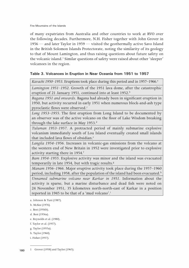
Table 3. Volcanoes in Eruption in Near Oceania from 1951 to 1957
Kavachi 1950–1953. Eruptions took place during this period and in 1957–1966.a
Lamington 1951–1952. Growth of the 1951 lava dome, after the catastrophic eruption of 21 January 1951, continued into at least 1952.b
Bagana 1951 and onwards. Bagana had already been in signi�cant eruption in 1950, but activity recurred in early 1951 when numerous block-and-ash type pyroclastic �ows were observed.c
Long 1953–1955. The �rst eruption from Long Island to be documented by an observer was of the active volcano on the �oor of Lake Wisdom breaking through the lake surface in May 1953.d
Tuluman 1953–1957. A protracted period of mainly submarine explosive volcanism immediately south of Lou Island eventually created small islands that included lava �ows of obsidian.e
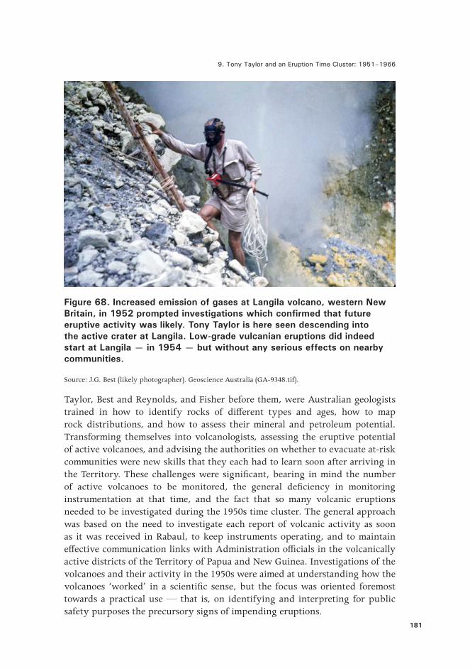
Langila 1954–1956. Increases in volcanic-gas emissions from the volcano at the western end of New Britain in 1952 were investigated prior to explosive activity starting there in 1954.f
Bam 1954–1955. Explosive activity was minor and the island was evacuated temporarily in late 1954, but with tragic results.g
Manam 1956–1966. Major eruptive activity took place during the 1957–1960 period, including 1958, after the population of the island had been evacuated.h
Unnamed submarine volcano near Karkar in 1951. Information about the activity is sparse, but a marine disturbance and dead �sh were noted on 24 November 1951, 35 kilometres north-north-east of Karkar in a position reported in 1945 to be that of a ‘mud volcano’.i
a. Johnson & Tuni (1987).
b. McKee (1976).
c. Best (1956b).
d. Best (1956a).
e. Reynolds et al. (1980).
f. Taylor et al. (1957).
g. Taylor (1955a).
h. Taylor (1960).
i. Fisher (1957).
1 Grover (1958) and Taylor (1965).
9. Tony Taylor and an Eruption Time Cluster: 1951–1966
181
Figure 68. Increased emission of gases at Langila volcano, western New Britain, in 1952 prompted investigations which confirmed that future eruptive activity was likely. Tony Taylor is here seen descending into the active crater at Langila. Low-grade vulcanian eruptions did indeed start at Langila — in 1954 — but without any serious effects on nearby communities.
Source: J.G. Best (likely photographer). Geoscience Australia (GA-9348.tif).
Taylor, Best and Reynolds, and Fisher before them, were Australian geologists trained in how to identify rocks of di�erent types and ages, how to map rock distributions, and how to assess their mineral and petroleum potential. Transforming themselves into volcanologists, assessing the eruptive potential of active volcanoes, and advising the authorities on whether to evacuate at-risk communities were new skills that they each had to learn soon after arriving in the Territory. These challenges were signi�cant, bearing in mind the number of active volcanoes to be monitored, the general de�ciency in monitoring instrumentation at that time, and the fact that so many volcanic eruptions needed to be investigated during the 1950s time cluster. The general approach was based on the need to investigate each report of volcanic activity as soon as it was received in Rabaul, to keep instruments operating, and to maintain e�ective communication links with Administration o�cials in the volcanically active districts of the Territory of Papua and New Guinea. Investigations of the volcanoes and their activity in the 1950s were aimed at understanding how the volcanoes ‘worked’ in a scienti�c sense, but the focus was oriented foremost towards a practical use — that is, on identifying and interpreting for public safety purposes the precursory signs of impending eruptions.

Fire Mountains of the Islands
182
Experiments in Prediction
A foremost challenge for RVO sta� in the early 1950s was being able to pro�er realistic and scienti�cally based recommendations to authorities who were faced with signs of an impending eruption, or with a volcano that had already started activity. A general framework was required for understanding volcanoes and their activity and this is what Taylor began to address.
Taylor developed a three-part hypothesis for volcanic outbreaks and eruption prediction against which observational data could be assessed and interpretations tested. The �rst part of what Taylor called an ‘experimental’ approach was assessing the condition of each volcano itself, including the behaviour of the underlying magma. Visual observations of crater activity were critical. So, too, were the data obtained from seismographs, tiltmeters, thermometric instruments, and volcanic-gas tests, although instrumentally based techniques for volcano monitoring and interpretation of the recorded data were all primitive by present-day standards. Taylor also developed a particular fascination with volcanic sound, in part because he thought it might indicate the nature of crater activity where the tops of the active volcanoes were covered in weather cloud, but also where particular types or trends in sound might presage an eruption.
The second part of the hypothesis represented Taylor’s conviction that volcanoes at low latitudes, such as in New Guinea, were in�uenced by the changing positions of the Sun and Moon relative to the Earth at di�erent times of the year and month. Taylor took the advice of the well-known American volcanologist Frank Perret who, before the Second World War, had recommended access to an ephemeris of tide times before planning �eldwork on active volcanoes. Taylor had noticed such ‘earth tide’ relationships during the 1951 Lamington eruption where the gravitational pull of the Sun and Moon seemed to have had a triggering e�ect, particularly during the early and highly explosive phase.2 He later pointed out other, similar correlations during the 1951–1957 period, including the use of solstice and equinoctial times to remarkable e�ect in forecasting major explosive activity at Manam volcano.3
The third part of Taylor’s hypothesis was that any upsurge of tectonic earthquake activity near a volcano might lead to an eruption, as Fisher had proposed for the 1941 eruption at Tavurvur, Rabaul. Taylor himself became convinced of the usefulness of this relationship between ‘regional tectonic-stress release’ and subsequent volcanic activity after investigating eruptive activity at Ambrym volcano in the New Hebrides.4 He believed that tectonic earthquakes in 1949–1950 had triggered the 1951–1957 volcanic upsurge and proposed, too, that the
2 Taylor (1958a). 3 Taylor (1960).4 Taylor (1952, 1956).

9. Tony Taylor and an Eruption Time Cluster: 1951–1966
183
severe earthquake and tsunami damage reported by Miklouho-Maclay on the Rai coast in the mid-1870s was the tectonic trigger for the subsequent pulse of eruptive activity.5
The earthquake data available to Taylor was, on present-day standards, severely limited for testing these ideas, as he could use only relatively imprecise data on large earthquakes recorded at worldwide recording stations and supplied from the Riverview Observatory in Australia. Taylor therefore urged the establishment in the Territory of volcanological observatories on Manam Island and at Esa’ala on Dawson Strait in the D’Entrecasteaux Islands, where regional earthquake recording could also be undertaken. These two observatories were planned to complement the earthquake recording already being done at Rabaul, and at Lamington, and to provide a capability for the detection of precursors of possible eruptions at Manam and from volcanoes in Dawson Strait.6
There were three reasons why Taylor recommended establishment of a full-scale observatory at Esa’ala. He was concerned, �rst, about reports in 1953–1955 of numerous, generally small, local earthquakes being felt in the Dawson Strait area — some taking place soon after others in so-called ‘seismic storms’. Second, he was aware of the geological youthfulness of the volcanoes of Dobu, Oiau and Lamonai in Dawson Strait. And, third, there were ongoing and worrying reports about changes to the character of geothermal �elds in the area, especially the large ones at Deidei and Iamelele on Fergusson Island. Taylor thought that the Dawson Strait earthquakes were part of a pattern of regional tectonic-stress release in eastern Papua, which, following the volcanic eruptions at Goropu in 1943–1944 and then Lamington in 1951, might mean new explosive outbursts taking place in the Dawson Strait area.7 The signs of unrest at Esa’ala in the 1950s, however, became of less importance when no volcanic eruptions took place and as the volcanic threat at other volcanoes began to dominate the time of RVO volcanologists during 1953–1957. Those Esa’ala earthquakes would nevertheless resonate historically in 1969 when new earthquake activity and the fear of a volcanic outbreak in Dawson Strait would cause the evacuation of thousands of people.
Long Island Evacuation of 1953–1954
Most of the 1951–1957 volcanic activity a�ected only under-populated areas, but three of the volcanoes — Long, Bam and Manam — in the western part of the Bismarck Volcanic Arc — caused disaster management problems for local communities and involved decisions to evacuate by the Territory Administration. Long Island was the �rst of these.
5 Taylor (1955c, 1960). 6 Taylor (1966).7 Taylor (1955b).

Fire Mountains of the Islands
184
A Lutheran missionary on Umboi Island reported to RVO on Saturday 9 May 1953 that an eruption appeared to be taking place in the vicinity of Long Island to the north-west of Umboi. Best was then in charge of RVO, and that afternoon in Rabaul he requested that an aircraft of Qantas Empire Airways divert over Long to investigate the eruption. The pilot reported back to RVO and to aviation authorities that ‘a small horseshoe island’ in the centre of Lake Wisdom was ‘hurtling jets of mud and steam every ten minutes to a height of three to �ve hundred feet’.8 News of the eruption, however, did not reach the District Commissioner, C.D. Bates, at Madang until the following morning, Sunday 10 May. Bates immediately organised a �ight over the lake, saw the eruptive activity for himself, and concluded that ‘present indications were a major eruption was imminent’. He then put in place arrangements for a seaborne evacuation of the whole island. Long Island villagers live on the coast, rather than on the shores of the lake, and they evidently had been unaware that an eruption was taking place. All 377 islanders were, with their concurrence, taken on board three vessels that left Long Island before dawn on Wednesday 13 May. Furthermore, arrangements began to be made by the District Commissioner for the permanent settlement of the evacuees at Saidor on the mainland, near to Long Island.
No volcanological advice concerning the evacuation was sought from RVO, and neither was the District Commissioner’s head of department in Port Moresby involved in the prompt decision to evacuate the Long population permanently. Any such rapid decision to evacuate presumably would have had to be balanced against the longer term e�ects that the social dislocation may have on the lives of evacuees, which are put ‘on hold’ in a new and often stressful environment. Evacuees are away from their homeland, their own traditional lands and may, against their own will, have to become strongly dependent on, and subservient to, the requirements and resources of the people hosting them. Furthermore, there are �nancial costs involved for the governing authorities. There seems little doubt, however, that the District Commissioner put the safety of the islanders ahead of any such di�culties likely to be faced by the Long evacuees, and the Administration, on the mainland.
Best undertook an aerial inspection of the active volcano in Lake Wisdom on 12 May, and that day discussed the situation with the authorities in Madang, but he was not in a position to make any useful, evidence-based recommendations regarding the likely development of the Long Island eruptions. Best was the only volcanologist in the Territory at that time. Long Island was a long way from Rabaul, the island could be reached only by sea, and RVO had neither instrumentation nor sta� on the island. Also, Best had insu�cient background knowledge on the nature of the volcano, and monitoring the dangerously active centre itself presented insurmountable practical di�culties — that is, in the
8 Bates (1953), p. 1. See also Best (1955, 1956a).

9. Tony Taylor and an Eruption Time Cluster: 1951–1966
185
middle of a lake situated several kilometres from the lake shore. Best had to rely almost entirely on observations made during aerial inspections to determine how the eruption was playing out. He was, however, aware from �eldwork on Long Island with Taylor in 1952 that a major caldera-forming eruption had taken place at Long within recent centuries.9 Best saw that the current eruptions in the lake were minor in comparison to these earlier events, but he exercised caution and thus, initially at least, supported the need for the evacuation.
Figure 69. Villages and prehistoric settlements on Long Island are restricted to the coast. No people live on the shores of the freshwater caldera lake where the active lake-floor volcano periodically forms the island of Motmot, the local name for ‘island’. Dauwoi and Bonanga are extinct stratovolcanoes at either end of Long Island.
Source: Ball & Hughes (1982, Figure 2). Reproduced with the permission of the authors.
9 Taylor (1953).

Fire Mountains of the Islands
186
Figure 70. This explosive volcanic activity in Lake Wisdom, Long Island, was photographed during an aerial inspection on 24 May 1953. Strong winds are forming a curtain of dark ash and white water vapour away from an island that is building up out of the lake water. The type of eruption can now be identified as surtseyan.
Source: J.G. Best. This photograph is one of several taken during the same aerial inspection. Geoscience Australia (no registered number for this photograph, but see others in the GA series MRG-2 to 13).
Mention of previous major eruptions at Long Island understandably caused a great deal of concern and uncertainty in the minds of Administration sta� about ever returning the evacuated people to the island — even in June 1953, during which no further eruptive activity was reported and, in July, when Best visited the island and con�rmed that the eruptions apparently had stopped.10 Opinions about the situation were provided by Taylor and Fisher, both in Canberra, and a view was soon reached in RVO that a recommendation to return the Longs was warranted. Some senior sta� in the Administration, however, thought that the volcanological advice should be disregarded and that permanent relocation to the mainland was still the safest option. For example, the Assistant Government Secretary, Claude Champion, on 5 October wrote: ‘After the terrible disaster of Mount Lamington, I am of the opinion that the natives should remain on the mainland, and not return to Long Island’.11 Champion had seen, �rsthand, the horror of the devastation and human toll at Higaturu on 23 January 1951, and
10 See National Archives of Papua New Guinea (1953–1954) for Administration correspondence.11 Champion (1953), p. 2.
9. Tony Taylor and an Eruption Time Cluster: 1951–1966
187
this experience clearly in�uenced his strong opinion. Nevertheless, ongoing discussions continued for weeks, those in authority gradually moved away from the idea of permanent relocation, and the Administrator, Brigadier D.M. Cleland, by end of December 1953 had authorised the return of the displaced people to Long Island. The islanders were taken home between 9 and 17 March 1954, ten months after the benign lake eruptions had �rst been observed, and a few weeks after what may have been a �nal outburst from the lake, at least for this eruptive period, in January 1954.
Memories of the 1953–1954 evacuation remained as the most dramatic event of the lives of Long Island people for at least a generation, even though the eruptions had not a�ected them directly.12 The volcanic eruptions from the lake at Long Island in 1953 were in fact too distant and too small to be of any danger to the sea coastal villages, and similar eruptions in 1955, 1968, 1973 and 1976, for example, never again triggered the need for evacuation of the Long Island people.
Bam Tragedy of 1954–1955
Almost 430 people in the mid-1950s lived in three villages on a narrow coastal shelf on the northern tip of Bam Island. Their lives seemed volcanically precarious to any visitor, as Bam is only 3.2 kilometres from north to south, and the volcano rises steeply out of the sea to an active summit crater at 640 metres above sea level, less than two kilometres from the villages. Furthermore, the island has no natural harbours or safe anchorages for larger vessels. Bam people were, nevertheless, committed to life on the island and did not doubt its sustainability. They were expert canoeists and �shermen, and had traditional ties with neighbouring communities, particularly on the nearby islands of Kadovar and Blup Blup. They grew coconuts and fed on the abundant marine life of the surrounding waters that were enriched by out�ows from the nearby Sepik River. Bam Island evidently was also relatively free from diseases such as malaria and tuberculosis, which meant, however, that the Bams would have been vulnerable to them elsewhere if exposed to infection.
Bam people were familiar with the normally mild eruptions from the volcano. They also had stories of stronger eruptive activity — in the 1860–1870s, for example, when the islanders escaped to safety on Kadovar and Blup Blup.13 Other eruptive activity had been noted by the Bam people in about 1909, the early 1920s, and the late 1940s. They had observed, too, that volcanic explosions seemed to coincide with the change in seasons or with eruptive activity at Manam. Europeans had recorded eruptions at Bam before 1954, although the
12 Ball & Hughes (1982).13 Cooke & Johnson (1981).
Fire Mountains of the Islands
188
descriptions in most cases are somewhat brief and unclear. Miklouho-Maclay saw some sort of activity there on 13 November 1877, in one account stating — without elaboration — that both Bam and Manam were ‘in full eruption’.14
News of renewed volcanic eruptions on Bam was received at RVO on 4 November 1954 and the activity was investigated by Best a few days later.15 He noted that the eruptions had been mild and had not a�ected the villages, but that lava blocks had been expelled and were hot enough to have scorched grass near the summit crater. Best concluded that the immediate threat was not signi�cant, but that the longer term risk of stronger and potentially disastrous volcanic activity was too great. He therefore recommended to the Territory Administration the somewhat drastic action of permanent evacuation of the island and the resettlement of the people elsewhere.
RVO volcanologist Reynolds visited the island a few days later, but he could �nd no good reasons to justify an evacuation.16 The islanders themselves seemed unperturbed by the behaviour of the volcano and told him that the eruptions had been normal. Reynolds indeed was more concerned about new reports of a possible resurgence of volcanic activity at Long Island and left Bam for Long to investigate. Taylor, in Canberra, however supported an evacuation of Bam on the basis of his assessment that a period of volcanic ‘regional unrest’ was underway and that further eruptions at Bam might be expected.17 Other options to enforced evacuation, he said, were to establish a European observer and volcano-monitoring equipment on the island, and to provide additional boats for the islanders in the event of a large eruption.
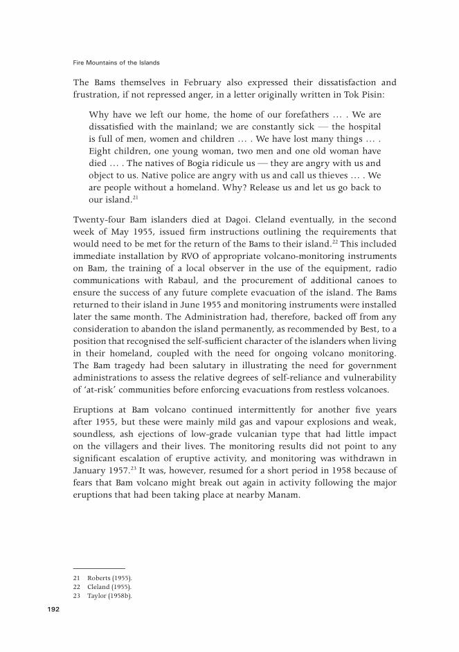
The Administrator, on 25 November 1954, authorised evacuation of Bam Island, having taken all of the volcanological assessments into account; and the removal of the islanders was completed by 2 December under the overall direction of the District Commissioner at Madang, F.E. Bensted. The Bams were taken to the mainland and were allocated some land at Dagoi, a few kilometres east of Bogia, for a new village and gardens where they could become farmers. There was a swamp nearby that needed draining.
Life for the Bams at Dagoi began to deteriorate in the weeks after their evacuation from Bam in 1954. Their decline on the mainland was reported by the Port Moresby news media in February 1955, and comments were made about the ‘disgraceful’ and unhygienic conditions at Dagoi, about two deaths from dysentery, and about the absence of supervision of anti-malarial medication.18 The Bams were evidently vulnerable to mainland diseases and had problems
14 Miklouho-Maclay (1884–1885), p. 965.15 Best (1954) and Taylor (1955a).16 Reynolds (2005). 17 Lambert (1954). 18 Anonymous (1955).

9. Tony Taylor and an Eruption Time Cluster: 1951–1966
189
adapting to a new diet. Furthermore, cultural ties with their ancestral island home were too strong for them simply to start a new life in a strange, if not alien environment, and serious psychological e�ects began to be noticed. The number of deaths at Dagoi continued to rise. An evacuation based on a scienti�c assessment of the volcano and recommended with the best of intentions, was turning into a tragedy.
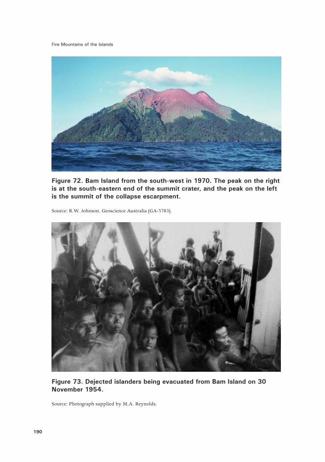
Figure 71. The prominent escarpment running north-eastwards across Bam Island and down towards the villages was probably formed by a prehistoric gravitational collapse or collapses of the volcano towards the south-east. Later eruptions from the central crater then built up the volcano alongside the older, north-western part of the island.
Source: Adapted from Cooke & Johnson (1981, Figure 3).
Fire Mountains of the Islands
190
Figure 72. Bam Island from the south-west in 1970. The peak on the right is at the south-eastern end of the summit crater, and the peak on the left is the summit of the collapse escarpment.
Source: R.W. Johnson. Geoscience Australia (GA-5783).
Figure 73. Dejected islanders being evacuated from Bam Island on 30 November 1954.
Source: Photograph supplied by M.A. Reynolds.

9. Tony Taylor and an Eruption Time Cluster: 1951–1966
191
The Director of Public Health, John T. Gunther, was critical and terse in a memorandum, dated 14 February 1955 that he sent to the Administrator through the Government Secretary. Gunther pointed out that his headquarters in Port Moresby did not become aware of the evacuation until the second week of December and that, had they known, they would have been able to manage the evacuation and resettlement more e�ectively and humanely than had actually been the case. He and his sta�, after all, had experience managing the health aspects of the relief and recovery phases of the 1951 Lamington eruption. Gunther wrote:
Resettlement needs good and constant leadership. If it is to succeed such leadership must ensure, if possible, that the people are gently led into their new environment and that sanitation is satisfactory, disease is prevented, food is proper and adequate, and that occupation and recreation maintains mental health against the longings for a lost home. We did none of these things until it was too late. We had made no [Health] sta� available at the beginning to meet the impacts, and, as so often occurs, we are trying to correct errors and undo harm.
He added:
Vulcanologists are in a most invidious position when asked to assess the need for evacuation. If they are conservative a great tragedy might occur, thus they must tend, if there is any doubt, to recommend the safest precautions … I believe their position is very like a medical practitioner’s … In surgery there are risks. Every surgeon must measure the risks …
Bam Island was like that. The history of its behaviour was scanty and a constant watch could not be kept. The islanders apparently agreed to go because too many of the pros for going (e.g. Mt. Lamington) were stressed to them.19
Gunther recommended that the Bams be allowed to return to the island, subject to another visit and assessment of the situation at Bam by a volcanologist. Others were of the same opinion. For example, Bishop A.A. Noser of the Vicariate Apostolic of Alexhaven wrote to the Administrator on 16 February 1955 concerning the physical and mental state of the Bams on the mainland:
I have serious doubts about the �nal outcome of the present arrangement. Dissatisfaction can be very contagious and burst into con�agration at a most inopportune moment. Personally I think it is best to let them return home.20
19 Gunther (1955).20 Noser (1955).
Fire Mountains of the Islands
192
The Bams themselves in February also expressed their dissatisfaction and frustration, if not repressed anger, in a letter originally written in Tok Pisin:
Why have we left our home, the home of our forefathers … . We are dissatis�ed with the mainland; we are constantly sick — the hospital is full of men, women and children … . We have lost many things … . Eight children, one young woman, two men and one old woman have died … . The natives of Bogia ridicule us — they are angry with us and object to us. Native police are angry with us and call us thieves … . We are people without a homeland. Why? Release us and let us go back to our island.21
Twenty-four Bam islanders died at Dagoi. Cleland eventually, in the second week of May 1955, issued �rm instructions outlining the requirements that would need to be met for the return of the Bams to their island.22 This included immediate installation by RVO of appropriate volcano-monitoring instruments on Bam, the training of a local observer in the use of the equipment, radio communications with Rabaul, and the procurement of additional canoes to ensure the success of any future complete evacuation of the island. The Bams returned to their island in June 1955 and monitoring instruments were installed later the same month. The Administration had, therefore, backed o� from any consideration to abandon the island permanently, as recommended by Best, to a position that recognised the self-su�cient character of the islanders when living in their homeland, coupled with the need for ongoing volcano monitoring. The Bam tragedy had been salutary in illustrating the need for government administrations to assess the relative degrees of self-reliance and vulnerability of ‘at-risk’ communities before enforcing evacuations from restless volcanoes.
Eruptions at Bam volcano continued intermittently for another �ve years after 1955, but these were mainly mild gas and vapour explosions and weak, soundless, ash ejections of low-grade vulcanian type that had little impact on the villagers and their lives. The monitoring results did not point to any signi�cant escalation of eruptive activity, and monitoring was withdrawn in January 1957.23 It was, however, resumed for a short period in 1958 because of fears that Bam volcano might break out again in activity following the major eruptions that had been taking place at nearby Manam.
21 Roberts (1955). 22 Cleland (1955).23 Taylor (1958b).

9. Tony Taylor and an Eruption Time Cluster: 1951–1966
193
Evacuation of Manam and the 1956–1966 Eruptions
Eruptions at seven or eight volcanoes of the 1951–1957 ‘cluster’ had already started by 1955–1956, but Manam — the region’s most frequently active volcano — had remained ‘anomalously quiet’24 since its previous signi�cant eruptions in 1936–1939 and 1946–1947.25 Thus, the start of new strombolian activity at the volcano in December 1956 that lasted until the following February, was not wholly unexpected. Indeed, a detailed evacuation plan for Manam had been drawn up by district authorities in Madang as early as October 1955, triggered by cautious remarks in volcanological reports by Taylor and Best.26 Taylor related the volcanic outburst in December 1956 to previous tectonic earthquake activity west of Manam in the nearby Sepik area. More eruptive activity at Manam followed in May–July 1957, and pyroclastic �ows were observed in October 1957, alerting Taylor to the danger of this kind of volcanic hazard to the population on the island.
An observation post was established at Waris, or Warisi, village on the east coast of Manam Island in June 1957. It was manned by a local villager, Nelson Wangiga, who had previous observatory experience on Bam Island. Wangiga was provided with a low-magni�cation earthquake recorder, a single-component bubble tiltmeter, a barometer and a thermometer. Taylor was required to make a prognosis about eruptive activity, but was hard pressed to do so on the basis of the instrumental data, particularly bearing in mind there was no ‘baseline’ information available for comparative purposes. He nevertheless, in early November 1957, informed the Administration’s district headquarters in Madang that ‘the volcano was building up to a phase of climactic release probably in December–January 1957–58 or June–July 1958’27 — that is, during the southern summer or winter solstices.
Further activity culminated in a series of powerful outbursts on 6–8 December 1957, the islanders themselves expressed a desire to leave the island, and an evacuation was initiated by the Administration, starting on 11 December and completed by 13 December. The evacuation was expedited e�ciently without signi�cant incident, using the detailed plan and a �otilla of district vessels that plied between Manam and Bogia and which were assisted by good weather and calm seas.28 More than 3,300 Manams were evacuated and then accommodated in mainland villages stretching 70–80 kilometres along the coast. The e�ciency
24 Taylor (1960), p. 8.25 Palfreyman & Cooke (1976).26 Skinner (1955).27 Taylor (1960), p. 6.28 Williams (1957).
Fire Mountains of the Islands
194
of the Administration response was reminiscent of that characterising the relief phase at Lamington in 1951, and was in marked contrast to the failures resulting from the earlier Bam evacuation.
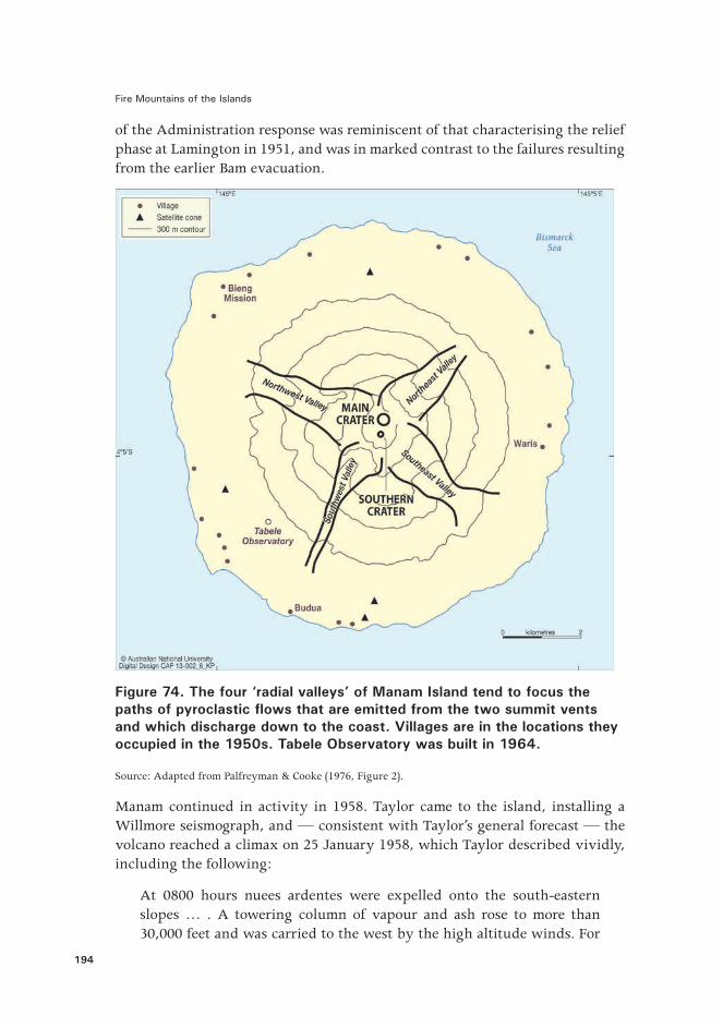
Figure 74. The four ‘radial valleys’ of Manam Island tend to focus the paths of pyroclastic flows that are emitted from the two summit vents and which discharge down to the coast. Villages are in the locations they occupied in the 1950s. Tabele Observatory was built in 1964.
Source: Adapted from Palfreyman & Cooke (1976, Figure 2).
Manam continued in activity in 1958. Taylor came to the island, installing a Willmore seismograph, and — consistent with Taylor’s general forecast — the volcano reached a climax on 25 January 1958, which Taylor described vividly, including the following:
At 0800 hours nuees ardentes were expelled onto the south-eastern slopes … . A towering column of vapour and ash rose to more than 30,000 feet and was carried to the west by the high altitude winds. For

9. Tony Taylor and an Eruption Time Cluster: 1951–1966
195
the next �ve hours the column was fed by incessant explosions roaring and rumbling from the summit vents. Near midday the emission reached a new peak of intensity … .
Heavy nuees ardentes … came down the four great valleys dissecting the cone. The nuees from the southern crater were voluminous enough to enter the sea below the south-eastern and south-western valleys. Part of the evacuated village of Budua was completely destroyed and new areas of forest were annihilated.29
The fallout of ash and dust from the eruption of 25 January caused village houses to collapse, gardens to be destroyed, and leaves to be stripped from forests across much of the island.30 Wangiga was still based at Waris maintaining observations as best he could, but he was compelled to abandon his quarters and to occupy one of the remaining houses in the village. E�ects from the pyroclastic �ows were devastating but, signi�cantly, they were con�ned mainly to the four main radial valleys. Few coastal villages were sited at the openings to these valleys, the villagers apparently having recognised the vulnerability of such areas. Budua village, however, in the south-west was an exception.
Figure 75. Damage was caused by volcanic ash falling on houses and vegetation in a Manam village in 1958.
Source: G.A.M. Taylor. Geoscience Australia (no reference number).
29 Taylor (1960), p. 5.30 Taylor (1958c).

Fire Mountains of the Islands
196
Administration o�cials were impressed by the way the mainland villages accepted the 3,341 Manam evacuees, given that the villagers did not know how long their guests would be staying: ‘the Bogia Coastal natives have set to and a�orded every possible aid to the evacuated people billeted on them. The nearer inland villages have also come to the aid of all by keeping up a continuous supply of building materials for the construction of houses and latrines’.31 In addition, land was made available to the Manams for temporary gardens, and e�orts were made even to �nd government-owned land where the islanders might settle more permanently. The extent to which provincial government authorities at this time were aware of the true nature of the strong traditions binding the Manams to their island is unclear, including the islanders’ views of the cause of these particular eruptions and what could be done to stop them. Nevertheless, an Australian anthropologist had been working in the southern part of Madang Province since 1949, concentrating particularly on the recent rise of di�erent cults of cargoism, and including the key role played by Yali, a famous messiah-like �gure from a village on the Rai coast. The anthropologist wrote in 1964:
In 1953 and 1957, there had been volcanic eruptions on Long and Manam Islands, which [Yali] was said to have caused by invoking the local deities in order to express his hatred of Europeans. In 1957–8, the natives of Manam and the north coast approached him clandestinely to stop the volcano by interceding with the gods once more, and appeared to have o�ered him a considerable sum of money as payment.32
Major eruptions continued at Manam until March 1958 when, on the 4 –5 March, there was a powerful and sustained eruption. Such activity prevented any decision on a return of the evacuees to the island, and added great uncertainty to considerations of their future.33 Evacuations and resettlement involved �nancial costs, and Administration o�cials had other, more routine duties to perform in the district, such as patrolling and the collection of taxes. There was concern, too, for the older Manams who, not seeing any prospect of a return to their island, might lose heart and die.34 Eruptive activity fortunately declined after March and, following a mid-year recurrence of some strombolian activity, preparations were made for the evacuees to return to Manam. This followed favourable advice from Taylor and from W.L. Conroy of the Department of Agriculture who undertook an agricultural and soil survey of the island.35 A staged return began and much of the island was reoccupied by October 1958.
31 Donaldson (1957), p. 1.32 Lawrence (1964), p. 268.33 Williams (1958a). 34 Williams (1958b).35 Conroy (1958).
9. Tony Taylor and an Eruption Time Cluster: 1951–1966
197
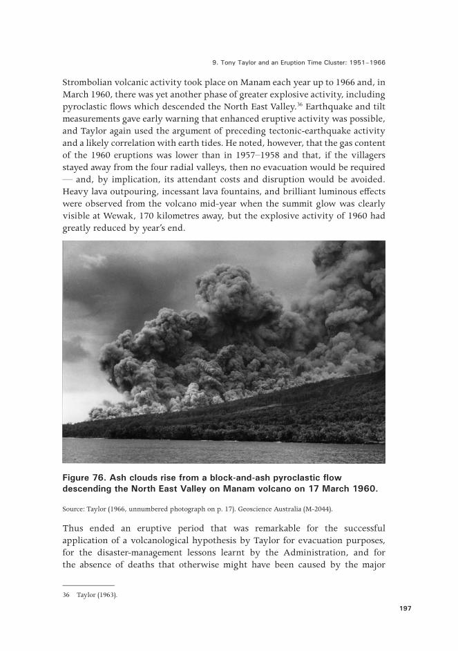
Strombolian volcanic activity took place on Manam each year up to 1966 and, in March 1960, there was yet another phase of greater explosive activity, including pyroclastic �ows which descended the North East Valley.36 Earthquake and tilt measurements gave early warning that enhanced eruptive activity was possible, and Taylor again used the argument of preceding tectonic-earthquake activity and a likely correlation with earth tides. He noted, however, that the gas content of the 1960 eruptions was lower than in 1957–1958 and that, if the villagers stayed away from the four radial valleys, then no evacuation would be required — and, by implication, its attendant costs and disruption would be avoided. Heavy lava outpouring, incessant lava fountains, and brilliant luminous e�ects were observed from the volcano mid-year when the summit glow was clearly visible at Wewak, 170 kilometres away, but the explosive activity of 1960 had greatly reduced by year’s end.
Figure 76. Ash clouds rise from a block-and-ash pyroclastic flow descending the North East Valley on Manam volcano on 17 March 1960.
Source: Taylor (1966, unnumbered photograph on p. 17). Geoscience Australia (M-2044).
Thus ended an eruptive period that was remarkable for the successful application of a volcanological hypothesis by Taylor for evacuation purposes, for the disaster-management lessons learnt by the Administration, and for the absence of deaths that otherwise might have been caused by the major
36 Taylor (1963).

Fire Mountains of the Islands
198
explosive eruptions of 1957–1958 and 1960. This work also drew attention to the importance for disaster-management purposes of the four radial valleys on the island. These have the strong e�ect of channelling pyroclastic �ows and lava �ows originating from the summit craters.37
Wangiga was recommended for an award,38 but nothing seems to have come of it. The course of Wangiga’s subsequent life appears not to have been documented.
Figure 77. Deposits of pyroclastic flows laid down in 1958 in the South West Valley on Manam volcano, are shown in the foreground of this photograph taken in 1963. RVO volcanologist Colin Branch is looking up at the summit where minor explosive activity is taking place. The smaller of the two peaks on the mid-slope, down to the right of the summit, is Iabu Rock.
Source: G.A.M. Taylor. Geoscience Australia (G-5501).
37 See also McKee (1981).38 Taylor (1958d).
9. Tony Taylor and an Eruption Time Cluster: 1951–1966
199
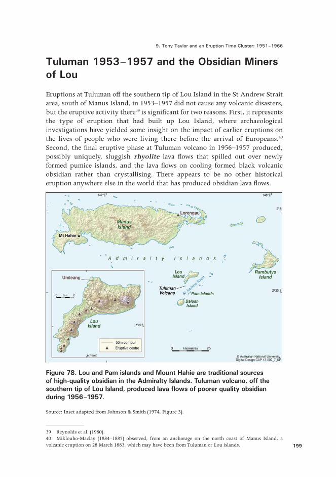
Tuluman 1953–1957 and the Obsidian Miners of Lou
Eruptions at Tuluman o� the southern tip of Lou Island in the St Andrew Strait area, south of Manus Island, in 1953–1957 did not cause any volcanic disasters, but the eruptive activity there39 is signi�cant for two reasons. First, it represents the type of eruption that had built up Lou Island, where archaeological investigations have yielded some insight on the impact of earlier eruptions on the lives of people who were living there before the arrival of Europeans.40 Second, the �nal eruptive phase at Tuluman volcano in 1956–1957 produced, possibly uniquely, sluggish rhyolite lava �ows that spilled out over newly formed pumice islands, and the lava �ows on cooling formed black volcanic obsidian rather than crystallising. There appears to be no other historical eruption anywhere else in the world that has produced obsidian lava �ows.
Figure 78. Lou and Pam islands and Mount Hahie are traditional sources of high-quality obsidian in the Admiralty Islands. Tuluman volcano, off the southern tip of Lou Island, produced lava flows of poorer quality obsidian during 1956–1957.
Source: Inset adapted from Johnson & Smith (1974, Figure 3).
39 Reynolds et al. (1980).40 Miklouho-Maclay (1884–1885) observed, from an anchorage on the north coast of Manus Island, a volcanic eruption on 28 March 1883, which may have been from Tuluman or Lou islands.
Fire Mountains of the Islands
200
RVO volcanologists John Best and Max Reynolds were to identify seven separate phases of eruption and eight di�erent eruption centres during the 1953–1957 activity at Tuluman. Their counted number of phases and centres, however, may be imprecise as the two men were unable to make continuous observations over the entire three-and-a-half years of the eruption, because of the need to attend to more important crises at other active volcanoes. The �rst eruption at Tuluman began in June 1953 a few days after the winter solstice in the Southern Hemisphere — one of several apparent correlations between Tuluman eruptions and earth tides. Much of the Tuluman activity was submarine and, at times, it consisted of blocks of gas-in�ated lava which �oated up from sea �oor vents and exploded on reaching the sea surface.
Lou is arcuate and made up of pumice, ash and obsidian lava �ows produced from 12 volcanoes that form the prominent and curved 12-kilometre chain.41 Tuluman represents the 13th, and most southerly, volcano in the Lou–Tuluman arc, which in a general geological sense seems to be growing anticlockwise along a ring fracture. The pumice and ash layers on Lou Island provide evidence for four main explosive eruptions in the recent past, separated by buried soil horizons that have been radiocarbon dated at about 1,650, 1,920, and 2,100 years ago.42 These soils in turn contain evidence of early human occupation at times between the eruptions when the island was suitable for horticulture.
People on Lou made use of the island obsidian resource by knapping pieces of high-quality obsidian for the manufacture of blades for knives and spears. Obsidian is a remarkable material, able to be struck into exceptionally sharp edges and therefore valuable for cutting and scraping and, in turn, for use in trade and exchange. The cutting edges are brittle, but obsidian itself is archaeologically durable. Furthermore, obsidian sources are found in only three areas in Near Oceania, one of them being the Admiralty Islands which includes not only Lou but the two nearby Pam Islands, as well as Mount Hahie in western Manus Island.43 Obsidian from the three main areas, and from sub-sources within each area, can be chemically ‘�ngerprinted’, meaning that trade-and-exchange routes can be traced archaeologically. Lou obsidian has been found in archaeological sites as far west as Malaysia and as far east as the Santa Cruz Islands in Remote Oceania.44
41 Johnson & Smith (1974).42 Ambrose (1988). See also Pain (1981).43 The cultural use of obsidian by people on Manus Island was described by Moseley (1877), the naturalist on board HMS Challenger, which anchored o� north-western Manus on 3–10 March 1875. Moseley noted obsidian-headed spears or lances, which served as knives, as well as tattooing, which he thought was probably made with obsidian �akes. The Manus people pointed to the mountains of Manus itself as the source of their obsidian — most likely Mount Hahie.44 See, for example, Summerhayes (2009).

9. Tony Taylor and an Eruption Time Cluster: 1951–1966
201
Figure 79. Tuluman Island on 12 January 1957 looking east-south-eastward towards Pam Lin Island, in the right background, and showing — in the centre — the dark, new, obsidian flows from Cone 7 joined to the paler island of Cones 2 and 4. The sea to the north-east is stained by volcanic effluent and the remnant islet of Cone 3 is seen in the foreground.
Source: Reynolds et al. (1980, Figure 22). Geoscience Australia (MRG-732).
Artefacts on the surface of the 2,100-year-old soil on Lou Island include obsidian �akes and triangular-sectioned points, charcoal and hearth stones, and similar evidence of reoccupation is also found on the 1,650-year-old soil that was sealed by the latest of the four pumice-and-ash layers.45 This upper layer evidently concealed obsidian of high quality because people were prepared to dig numerous shafts at Umleang — one 17 metres deep — in order to reach and exploit it.46 Human remains as evidence of eruption fatalities have yet to be found on the buried-soil surfaces of Lou.
The picture that emerges for Lou Island from the available archaeological evidence is of small settlements of self-su�cient, shoreline peoples who gathered seafood from coastline waters, grew crops, were long-range seafarers, �shed in deeper waters, and traded and exchanged high-quality obsidian, possibly over
45 Ambrose et al. (1981) and Ambrose (1988).46 Fullagar & Torrence (1991).

Fire Mountains of the Islands
202
large distances. They evidently coped with repeated volcanic eruptions on their small island — at least, escape in canoes to nearby islands in St Andrew Strait, or further, at times of devastating eruptions seems likely. They were perhaps motivated to return in order to access again the valuable obsidian resource. This general view of self-su�ciency, mobility and resilience has some relevance, albeit contrasting, to what happened on Bam, also a small island when colonial authorities intervened in 1954, evacuated the island population, and caused a disaster rather than preventing one.
References
Ambrose, W.R., 1988. ‘An Early Bronze Artefact from Papua New Guinea’, Antiquity, 62, pp. 483–91.
Ambrose, W.R., J.R. Bird & P. Duerden, 1981. ‘The Impermanence of Obsidian Sources in Melanesia’, in F. Leach & J. Davidson (eds), Archaeological Studies of Paci�c Stone Resources. British Archaeological Records, International Series 104, pp. 1–19.
Anonymous, 1955. ‘Six Bam Islanders Die in Mainland Home’, South Paci�c Post, Port Moresby, 16 February.
Ball, E.E. & I.M. Hughes, 1982. ‘Long Island, Papua New Guinea — People, Resources and Culture’, Records of the Australian Museum, 34, pp. 463–25.
Bates, C.D., 1953. Summary of Volcanic Disturbance at Lake Wisdom, Long Island, Madang District. National Archives of Papua New Guinea, 1953–54, Re-establishment of Long Island Natives. SN667, AN247, BN 319, File CA 35/7/39, Folios 1–4.
Best, J.G., 1954. ‘Preliminary Report Bam Island, Madang Sub-District, New Guinea’, Bureau of Mineral Resources, Canberra, Record 1954/59.
——, 1955. ‘Volcanic Activity Lake Wisdom, Long Island, T.N.G. May, 1953’, Bureau of Mineral Resources, Canberra, Record 1955/78.
——, 1956a. ‘Investigations of Recent Volcanic Activity in the Territory of New Guinea’. Proceedings of 8th Pan Paci�c Science Congress, Manila, 1953; 2: Geology, Geophysics and Meteorology, pp. 180–204.
——, 1956b. ‘Investigation of Eruptive Activity at Mt. Bagana, Bougainville — March 1952’, Bureau of Mineral Resources, Canberra, Record 1956/14.

9. Tony Taylor and an Eruption Time Cluster: 1951–1966
203
Champion, C., 1953. Memorandum to Government Secretary, 5 October. National Archives of Papua New Guinea (1953–54). Re-establishment of Long Island Natives. SN667, AN247, Box 319, File CA 35/7/39, Folios 31–32.
Cleland, D.M., 1955. Bam Islanders. Memorandum to Government Secretary, Port Moresby, 10 May. National Archives of Papua New Guinea, Port Moresby, SN 677, AN 247, Box 320, File CA 35/7/51, folios 74–75.
Conroy, W.L., 1958. Survey Report — Manam Island. Memorandum to Director, Department of Agriculture, Stock and Fisheries, from Chief of Division of Agricultural Extension, Port Moresby, 6 October. National Archives of Papua New Guinea, Port Moresby, SN 088, AN 82, File 59-2-16, folios 134–39.
Cooke, R.J.S. & R.W. Johnson, 1981. ‘Bam Volcano: Morphology, Geology, and Reported Eruptive History’, in R.W. Johnson (ed.), Cooke-Ravian Volume of Volcanological Papers. Geological Survey of Papua New Guinea Memoir, 10, pp. 13–21.
Donaldson, P., 1957. Progress Report of Activities re Manam Island Evacuation. Memorandum to District Commissioner, Madang, from Acting Assistant District O�cer, 22 December. PNG National Archives, Port Moresby, SN 088, AN 82, File 59-2-16, folios 68–71.
Fisher, N.H., 1957. Catalogue of the Active Volcanoes and Solfatara Fields of the World, 5: Melanesia. International Volcanological Association, Napoli.
Fullagar, R. & R. Torrence, 1991. ‘Obsidian Exploitation at Umleang, Lou Island’, in J. Allen & C. Gosden (eds), Report of the Lapita Homeland Project. Department of Prehistory, Occasional Papers in Prehistory, The Australian National University, Canberra, 20, pp. 113–43.
Grover, J.C., 1958. ‘Savo Volcano — A Potential Danger to its Inhabitants’. Geological Survey of the British Solomon Islands, Memoir 2, pp. 102–108.
Gunther, J.T., 1955. Volcano: Bam Island. Memorandum to the Administrator, 14 February. National Archives of Papua New Guinea, Port Moresby, SN 677, AN 247, BN 320, File CA 35/7/51, folios 23–26.
Johnson, R.W. & I.E. Smith, 1974. ‘Volcanoes and Rocks of St. Andrew Strait, Papua New Guinea’, Journal of the Geological Society of Australia, 21, pp. 333–52.
Johnson, R.W. & D. Tuni, 1987. ‘Kavachi, An Active Forearc Volcano in the Western Solomon Islands: Reported Eruptions between 1950 and 1982’, in
Fire Mountains of the Islands
204
B. Taylor & N.F. Exon (eds), Marine Geology, Geophysics, and Geochemistry of the Woodlark Basin–Solomon Islands. Circum-Paci�c Council for Energy and Mineral Resources Earth Science Series, 7, pp. 89–112.
Lambert, C.R., 1954. Volcano: Bam Island. Memorandum to the Administrator, 30 November 1954. National Archives of Papua New Guinea, Port Moresby, SN 677, AN 247, BN 320, File CA 35/7/51, folio 12.
Lawrence, P., 1964. Road Belong Cargo. Melbourne University Press, Carlton.
McKee, C.O., 1976. ‘Investigations at Mount Lamington 1960–75’, Geological Survey of Papua New Guinea Report 76/21.
——, 1981. ‘Geomorphology, Geology, and Petrology of Manam Volcano’, in R.W. Johnson (ed.), Cooke-Ravian Volume of Volcanological Papers. Geological Survey of Papua New Guinea Memoir, 10, pp. 23–38.
Miklouho-Maclay, N. de, 1884–1885. ‘On Volcanic Activity on the Islands Near the North-East Coast of New Guinea and Evidence of Rising of the Maclay-Coast in New Guinea’, Linnean Society of New South Wales Proceedings, 9, pp. 963–67.
Moseley, H.N., 1877. ‘On the Inhabitants of the Admiralty Islands, &c’, Journal of the Anthropological Institute of Great Britain and Ireland, 6, pp. 379–29.
National Archives of Papua New Guinea, 1953–1954. Re-establishment of Long Island Natives. SN667, AN247, Box 319, File CA 35/7/39.
Noser, A.A., 1955. Letter to the Administrator, 16 February. National Archives of Papua New Guinea, Port Moresby, SN 677, AN 247, BN 320, File CA 35/7/51, folio 37.
Pain, C.F., 1981. ‘Stratigraphy and Chronology of Volcanic-Ash Beds on Lou Island’, in R.W. Johnson (ed.), Cooke-Ravian Volume of Volcanological Papers. Geological Survey of Papua New Guinea Memoir, 10, pp. 221–25.
Palfreyman, W.D. & R.J.S. Cooke, 1976. ‘Eruptive History of Manam Volcano, Papua New Guinea’, in R.W. Johnson (ed.), Volcanism in Australasia. Elsevier, Amsterdam, pp. 117–31.
Reynolds, M.A., 2005. ‘Experiences in Volcanology and Life in the Territory of Papua New Guinea 1953–1957’, unpublished memoirs, Geoscience Australia, Canberra.
Reynolds, M.A., J.G. Best & R.W. Johnson, 1980. 1953–57 Eruption of Tuluman Volcano: Rhyolitic Volcanic Activity in the Northern Bismarck Sea. Geological Survey of Papua New Guinea Memoir, 7.
9. Tony Taylor and an Eruption Time Cluster: 1951–1966
205
Roberts, A.A., 1955. Petition from All of the People of Bam Island to the Administrator, Including English Translation. National Archives of Papua New Guinea Port Moresby, SN 677, AN 247, BN 320, File CA 35/7/51, folios 50–52.
Skinner, R.I., 1955. Evacuation Plan — Manam Island, Madang. Report to Director, Department of Native A�airs, Port Moresby, from Madang District Headquarters, 28 October (copy in papers of the late G.A.M. Taylor).
Summerhayes, G.R., 2009. ‘Obsidian Network Patterns in Melanesia — Sources, Characterisation and Distribution’, Bulletin of the Indo-Paci�c Prehistory Association, 29, pp. 109–23.
Taylor, G.A., 1952. ‘Report on Volcanic Activity on Ambrym Island’, Bureau of Mineral Resources, Canberra, Record 1952/4.
——, 1953. ‘Notes on Ritter, Sakar, Umboi and Long Island Volcanoes’, Bureau of Mineral Resources, Canberra, Record 1953/43.
——, 1955a. ‘Report on Bam Volcano and an Inspection of Kadovar and Blup Blup’, Bureau of Mineral Resources, Canberra, Record 1955/73.
——, 1955b. ‘Notes on Volcanic Activity and Thermal Areas in the D’Entrecasteaux Islands’, Bureau of Mineral Resources, Canberra, Record 1955/75.
——, 1955c. ‘Tectonic Earthquakes and Recent Volcanic Activity’, Bureau of Mineral Resources, Canberra, Record 1955/123.
——, 1956. ‘Review of Volcanic Activity in the Territory of Papua-New Guinea, the Solomon and New Hebrides Islands, 1951–53’, Bulletin Volcanologique, 18, pp. 25–37.
——, 1958a. ‘The 1951 Eruption of Mount Lamington, Papua’, Bureau of Mineral Resources, Canberra, Bulletin 38.
——, 1958b. Evacuation — Bam Island. Memoranda to District Commissioner, Wewak, 15 April and 26 June. National Archives of Papua New Guinea, Port Moresby, SN 088, AN 82, File 59-2-17, folios 25–26, 31.
——, 1958c. ‘Volcanological Report for January 1958. Manam Volcano’, Rabaul Volcanological Observatory Monthly Reports, 3 February 1958.
——, 1958d. Untitled Letter to Assistant Administrator, Department of the Administrator, Port Moresby, 1 May. PNG National Archives, Port Moresby, SN 088, AN 82, File 59-2-16, folio 175.

Fire Mountains of the Islands
206
——, 1960. ‘An Experiment in Volcanic Prediction’, Bureau of Mineral Resources, Canberra, Record 1960/74.
——, 1963. ‘Seismic and Tilt Phenomena Preceding a Pelean Type Eruption from a Basaltic Volcano’, Bulletin Volcanologique, 26, pp. 5–11.
——, 1965. ‘Notes on Savo Volcano, 1959’, British Solomon Islands Geological Record, 2, pp. 168–73.
——, 1966. ‘The Surveillance of Volcanoes in the Territory of Papua and New Guinea’, South Paci�c Bulletin, 16, no. 2, pp. 15–20.
Taylor, G.A., J.G. Best & M.A. Reynolds, 1957. ‘Eruptive Activity and Associated Phenomena, Langila Volcano, New Britain’, Bureau of Mineral Resources, Canberra, Report 26.
Williams, H.L., 1957. Evacuation of Manam Island. Memorandum to Assistant Administrator, Department of the Administrator, Port Moresby, from District Commissioner, Madang, 16 December. PNG National Archives, Port Moresby, SN 088, AN 82, File 59-2-16, folios 60–67.
——, 1958a. Resettlement — Manam Evacuees. Memorandum to Assistant Administrator, Department of the Administrator, Port Moresby, from District Commissioner, Madang, 7 February, pp. 81–84.
——, 1958b. Manam Island. Memorandum to Assistant Administrator, Department of the Administrator, Port Moresby, from District Commissioner, Madang, 6 March. PNG National Archives, Port Moresby, SN 088, AN 82, File 59-2-16, folios 91–93.