830-178 wereham conservation area - king's lynn
TRANSCRIPT

WerehamConservation AreaCharacter Statement
WEREHAM is a pleasant village, on a gentle acclivity, 2 miles N. W. of Stoke Ferry, and 12 miles S. by E. of Lynn, including in its parish 625 inhabitants, and 2,145 acres of land, more than half of which is grass.
William White 1845
Character Statement Designated: July 1977Revised March 2009
2Introduction
2Setting and Location
3Origins and Historical Development
5Character
6Spaces and Buildings
11Listed Buildings
12Important Unlisted Buildings
13Post War Development
13Traditional Materials
14Archaeological Interest
14Detractors
15Conservation Objectives
Wereham Conservation Area

Introduction
A Conservation Area – “An area of specialarchitectural or historic interest, thecharacter of appearance of which it isdesirable to preserve or enhance”.
The conservation of the historic environmentis part of our quality of life, helping to fostereconomic prosperity and providing anattractive environment in which to live orwork. The Borough Council is committed tothe protection and enhancement of WestNorfolk’s historic built environment andsignificant parts of it are designated asconservation areas.
Conservation areas were introduced by the1967 Civic Amenities Act. Local Authoritieswere required to identify areas of specialarchitectural or historic interest, whosecharacter or appearance it is desirable topreserve or enhance, and to designate themas conservation areas. This duty is now partof the 1990 Planning (Listed Buildings &Conservation Areas) Act which also requiresthe review of existing conservation areasand, where appropriate, the designation ofnew ones. The quality and interest of aconservation area depends upon acombination of factors including therelationship and architectural quality ofbuildings, materials, spaces, trees and otherlandscape features, together with views intoand out of the area.
Wereham Conservation Area wasdesignated in 1977 and revised in 1992.The present statement was prepared in 2001and revised and updated in 2009. Thisdocument highlights the special qualitieswhich underpin the character of theconservation area, justifying its designation.It also seeks to increase awareness of thosequalities so that where changes to the
environment occur, they do so in asympathetic way without harm to theessential character of the area. This type ofassessment has been encouraged byGovernment Advice (PPG15) and it has beenadopted as supplementary planningguidance.
This character statement does not addressenhancement proposals. Community ledenhancement schemes will be consideredas part of a separate process.
Setting and Location
Wereham is situated just north of the A134main road connecting the towns of King’sLynn 27 kilometres (13 miles) to the north,Downham Market 7 kilometres (4½ miles)to the west and Thetford 27 kilometres (17miles) to the south-east. The main roadoriginally ran through the village but wasdiverted as a by-pass in the 1970s, much tothe residents’ relief. This busy road noweffectively separates the original village coreof Wereham with development to the south.
The village is in an agricultural setting whichgenerated its origins. The land falls quitedramatically from north to south, from eastto west and vice versa, again a majordeterminant of settlement pattern; the village
www.west-norfolk.gov.uk2
Character Statement

core centred around the pond being a naturalcollection point for surface water run off fromthe surrounding fields and roads at thesehigher levels. Apart from the main road, thevillage is located around the meeting pointof other minor roads and tracks whichconnect the settlement to the surroundingfield system and adjacent village of Boughton2½ kilometres (1½ miles) and BartonBendish 5½ kilometre (3½ miles) to thenorth, The main north/south route isCavenham Road which leads to Finchamand Barton Bendish. Stoke Ferry lies to 3kilometres (2 miles) the south-east.Important views of the village are gainedfrom the main road when travelling west andfrom the north. The presence of the villageis not readily discerned from the main roadin the east-west direction however and onlythe larger new houses in Cavenham Roadare readily visible.
Origins and HistoricalDevelopment
“Wereham” was originally thought to be aSaxon settlement. The name has beentranslated as referring to a “homestead bythe River Vigora”, the latter being a possibleprevious name for the River Wissey. Theword Vigora is derived from the old name ofa French river (now the Vière). “Wereham”
should not be confused with the similarNorfolk village name of “Warham” whichrefers to a homestead by a weir or dam.
In any case, the basis of the village form isone of a settlement related to a water featureof some type. These components are still inevidence today.
Clearly the original settlement was based onagriculture, the presence of water either inthe form of a natural pond, weir or previousriver, and the convergence of several accesstracks and pathways.
The settlement pattern remained constantfor several hundred years up until the 20thCentury. Wereham was essentially afarming community, the farms themselvesactually forming a large part of the builtenvironment with workers’ dwellings andaccommodation for associated trades andcrafts forming the essential villageinfrastructure typical of such communities.
The nucleus of the village has always beenthe important enclosed open space centredon the pond and church. The village street,known as Church Road, was also animportant element in the character of thesettlement. It meant a continuous throughputof traffic and was a natural location for furtherbuildings and “backland” development over
Wereham Conservation Area

time. All the important ‘set piece’ listedbuildings are located along this route, anindication of its previous importance as aconnecting thoroughfare. Its character isnow thankfully saved by the modern by-pass.
The current settlement pattern is a result ofthe gradual acquisition, ownership andtransfer of land for building and developmentwhich is typical of any village with origins asearly as the Anglo Saxon period. As timewent on and as a result of dramatic changesin agriculture and the pattern of living thesegroups of properties were graduallydispersed and are now almost entirely owneroccupied.
The pressure of 20th Century life on suchsettlements has been dramatic. ForWereham, the construction of the by-pass
in the late 1970s was a major event whichhas enabled the character of the village coreto remain relatively untarnished.
Recent years have seen the developmentof several infill sites with new housing. Thearea is still a popular one in which to livebeing near to both Downham Market, King’sLynn and associated major transport routes.
The 20th Century has also seen the gradualerosion of the traditional village infrastructurementioned earlier. The school has closed,the village shop and post office also, andone pub is still open, but there is little elseto prevent people needing their owntransport for many tasks of everyday life.The situation has been exacerbated by themain road by-pass which has effectivelysevered the original community in two. Thesettlement south of this road is now beingexpanded with further new housing and iseffectively cut off from Wereham Villagecentre itself.
www.west-norfolk.gov.uk4
Character Statement

In the village core the componentsresponsible for its origin are still very muchintact however and it is pleasing to still seeSt. Margaret’s Farm, to the north of thechurch, in working order. In terms ofhistorical development, several buildingscontain evidence of each major architecturalperiod as they have responded to varyingownership, fashion and life styles. Theseare by definition the listed buildings ofintrinsic historic importance, but also severalunlisted buildings which contribute greatlyto the character of the locality and are shownon the map.
Character
Wereham is an attractive historic village, thespecial character of which is generated bya combination of built fabric, the spaces
formed between the buildings, ancient streetpattern, and natural elements such as pond,mature trees, hedges, grass verges, andfarming landscape both within theconservation area itself and in thesurrounding landscape.
The conservation area boundaryencapsulates the main village core centredon the pond and church and the associatedranges of buildings to north, east and west.The main road to the south forms a natural‘edge’ to the conservation area. To the east,the boundary contains the modern housingeast of St. Margaret’s Farm paddock andextends southwards to contain “OrchardLeigh” at the junction of the main road. Tothe west, the boundary takes in the “HighHouse” and “Vicarage”, the last westernmostbuildings related to the village. Finally, thenorthern conservation area boundary isformed by the line of built development alongSchool Lane and the natural “edge” betweenfarmland and village settlement.
Wereham Conservation Area

Within the village core itself the street patterngenerates a delightful sequence of variedviews and vistas, the scale of which isgenerally modest but with enhancedgrandeur around the set piece buildings ofSt Margaret’s Church, the Manor House,White House and Vine House.
The general ‘ad hoc’ nature of the settlementpattern over time has also created a varietyof open spaces within the core.
All these ingredients contribute to theessential quality of Wereham ConservationArea.
Spaces and Buildings
Wereham Conservation Area contains aseries of distinct areas generated by thestreet pattern and natural topographydescribed above.
The most important space, the village core,is created by a delightful combination ofcomponents:
the central pond is large and prominent,surrounded to the north and west by aline of mature willows with buildingsbehindthe church, churchyard and churchyardwall provide a tranquil sceneto the south the varied building lineconsisting of Pitt House, the pub, andoutbuildings of the Manor House providevariety and interest
Interspersed among these buildings are thefive access roads/tracks converging on St.Margaret’s Hill, the wide expanse of spacebetween pond and churchyard.These routesprovide an attractive array of vistas closedby the winding nature of the street pattern ina classic “townscape” manner. There arehowever several other important thoughsubsidiary, areas.
www.west-norfolk.gov.uk6
Character Statement

Church Road goes from St Margaret’s Hilleastwards and in itself provides an extremelyattractive range of views and vistas as theroad gently rises and bends to the south.There are two narrow tracks off this road tothe south, one giving access to MalthouseRow and one, further east, a narrow alleygiving access to Back Lane. These giveadded interest to the street and itscharacter. The churchyard wall too gives astrong sense of enclosure as do a numberof attractive cottages hard on the edge ofthe road.
Church Road contains four listed buildings(The Cottage, The Limes, Lime TreeCottage, to the north and the old VicarageHouse to the south), and several importantunlisted buildings which add to the overallcharacter of the street scene. A range ofmodern infill semi-detached houses has
been inserted along the southern side of theroad which, whilst relatively undistinguished,are modest in scale and impact.
Church Road culminates to the east inanother ‘core’ space formed by the WhiteHouse, Vine House, and Tudor Lodge, alllocated around the four access routes whichfeed into it, namely Church Road itself (toeast and west) Cavenham Road (to thenorth) and Back Lane (to the south). Again,this confluence of routes gives a range ofattractive views in all directions.
The space itself is a mini square and isenhanced by Vine House (the former shopand post office), and the scale and grandeurof the buildings. The east elevation of WhiteHouse is a particularly fine assembly ofarchitectural components and climbingvegetation.
Wereham Conservation Area

Church Road then continues southwardsback to the main road and although thetownscape quality is not quite so dramaticthe assembly of high screen walls, grassverges, mature trees beyond, and attractivevernacular buildings all create a pleasantunified character.
The “set back” position of the Crown Househas contrived to turn a leftover expanse ofgrass into a further open space just north ofthe Nags Head (now an dwelling) andadjacent to the junction with Back Lane
The sense of enclosure and intimacy is lostat the termination of Church Road and itsjunction with the main road due to the needfor sight lines and visibility splays.
Back Lane is a further east-west road whichlinks the “square” with the main road. Thisarea is in a sense ‘backland’ space toChurch Road lying to the north. Olderproperties lie to the east and west butmodern housing development has takenplace on infill sites to both the north andsouth. In design terms the new building isof reasonable scale without being particularlyexciting. It fits in well with its surroundingshowever, and the newest developmentsucceeds in creating a more appropriateresponse to ‘context’. Interesting spaces aregenerated, particularly by the orientation ofCedar House at right angles to Back Laneitself. It is sad to see the demise of thebutchers shop to the south, a further erosionof village infrastructure.
www.west-norfolk.gov.uk8
Character Statement

To the west, the presence of the main roadis more uncomfortably felt even though anattempt at introducing a landscape bufferhas been made.
Returning to the “square” and travellingnorthwards up Cavenham Road, thebuildings to the south nearest the WhiteHouse ‘core’ are, not surprisingly, the oldestand are all considered worthy of ‘townscape’significance. The more modern northerndwellings are typical of the 20th Century andare best described as ‘anywhere’ housing.They do nevertheless form an importantbackdrop and eastern edge to the majoropen space of the paddock, on a high pointwith the paddock sloping back to the village.The subtle change in direction of CavenhamRoad offers interesting and pleasant viewsin both directions with contrasting visualevents at each end; the dramatic open spaceof the paddock and countryside beyond tothe north; the more contained and intimate‘square’ of the ‘White House core’ to thesouth.
The presence of St. Margaret’s Farm, itsassociated paddock to the east and the lineof buildings forming the ‘edge’ of thesettlement along the northern and easternboundaries naturally delineate the northernpart of the Conservation Area. Open
farmland stretches away to the north andgood views are obtained, especially fromCavenham Road.
Turning left (westwards) at a small island ofgrass, the northern range of buildings alongSchool Lane is again a mixture of old andnew with modern infill housing interspersedwith the older fabric. These houses aregenerally ‘face-on’ to School Lane whichdivides them from the farm paddock to thesouth. School Lane itself again providespleasant views due to its change of directionand a general fall in level towards the mainvillage core. The final bend in the roadbefore it meets St. Margaret’s Hill is quitedramatic and the disposition of buildings andbuilding plots provide interesting and variedviews in both directions.
The next major defined area lies further tothe west. It contains the northern andwestern ranges of buildings surrounding thepond, the two westernmost dwellings of theconservation area (The Vicarage and HighHouse) the major open space of the playingfield, and the village hall and “left over” spaceto the south of it.
The western edge of this defined area isformed by Ben’s Lane, a rough track whichconnects the open field system to the central
Wereham Conservation Area

core of the village at St. Margaret’s Hill andhas good views up and down it ( particularlynorth/south towards the pond).
Whilst there are no listed buildings here,there are several dwellings of significance.Several sites have been the subject of ‘infill’development (of varying age) but the overallunity of the conservation area’s characterhas been maintained in terms of buildingscale. The quality of the infill buildings isundistinguished although the most recentinsertions show a more sympatheticapproach to vernacular design and use ofappropriate materials.
Reference has been made to the buildingsfronting the pond above, as they are also anessential component of the main village core.They also form an edge to the playing field,which was designated as such in relativelyrecent times. A children’s playground lies tothe east of the playing field and the villagehall to the south. The latter is anundistinguished building but is no worse thancountless other examples of this important
building type. It does not provide a very goodvisual entrance to the village and it presentsan opportunity for future refurbishment.
The two dwellings to the west are both of20th Century date and are relatively large inscale. Their presence in the conservationarea is modest in that they are bothsurrounded by mature landscape and theyare a natural ‘stop’ to the settlement.
To the south, the ill-defined triangle of scrubland acts as an important buffer from themain road and as a setting for the ManorHouse, a major listed building.This propertyis a fine architectural ‘set-piece’ andmagnificent views of it are afforded from themain road when travelling west to east. Thelandscape ‘buffer’ could be improved by alandscape scheme and further planting toscreen noise and fumes, and generallyenhancing the setting.
www.west-norfolk.gov.uk10
Character Statement

In summary, the special character of theconservation area is generated by acombination of many interwoven factorswhich contribute to a high degree of unityand architectural interest. The impact of thebuilt fabric, natural landscaping with manymature trees, intimate street pattern, andtopography have all been referred to above.In addition, the role of screen walls, the manyand varied outbuildings associated with thehistoric fabric, and hedges all play a crucialrole in creating a sense of enclosure andintimacy. Their importance should not beforgotten in defining the essential characterof the area.
Listed Buildings
There are ten listed buildings in WerehamConservation Area. The statutory list wasrevised in 1985 and there was a re-issue ofpart of the list in 1995 for clarification.
Grade 2* Buildings
Church of St. Margaret, Church Road.13th Century, early 14th Century andrestored in 1866. Carstone, flint andclunch with ashlar quoins. Slate roofwith leaded south aisle.West tower, twostages.
Grade 2 Buildings
The Limes, Church Road. 18th Centuryoriginally two houses now one dwelling.Restored 20th Century. Brick, carstonewalling, pantile/plaintile roofs.Lime Tree Cottage, Church Road. Mid18th Century house. Brick, carstone;pantile hipped roof.The Manor House, The Green. 18thCentury, originally brick and carstoneand refaced in brick; black glazedpantile roof. 2 storeys and dormer attic
Wereham Conservation Area
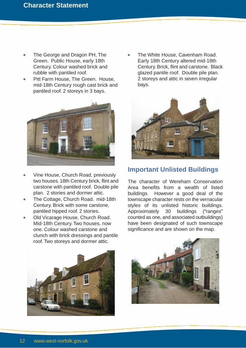
The George and Dragon PH, TheGreen. Public House, early 18thCentury. Colour washed brick andrubble with pantiled roof.Pitt Farm House, The Green. House,mid-18th Century rough cast brick andpantiled roof. 2 storeys in 3 bays.
Vine House, Church Road, previouslytwo houses. 18th Century brick, flint andcarstone with pantiled roof. Double pileplan. 2 stories and dormer attic.The Cottage, Church Road. mid-18thCentury. Brick with some carstone,pantiled hipped roof. 2 stories.Old Vicarage House, Church Road.Mid-18th Century. Two houses, nowone. Colour washed carstone andclunch with brick dressings and pantileroof. Two storeys and dormer attic.
The White House, Cavenham Road.Early 18th Century altered mid-18thCentury. Brick, flint and carstone. Blackglazed pantile roof. Double pile plan.2 storeys and attic in seven irregularbays.
Important Unlisted Buildings
The character of Wereham ConservationArea benefits from a wealth of listedbuildings. However a good deal of thetownscape character rests on the vernacularstyles of its unlisted historic buildings.Approximately 30 buildings (“ranges”counted as one, and associated outbuildings)have been designated of such townscapesignificance and are shown on the map.
www.west-norfolk.gov.uk12
Character Statement

Post War Development
Most post war development in WerehamConservation Area comprises infill housingand small terraces such as that on the southof Church Road and on the south side ofBack Lane or on the east side of CavenhamRoad and the west side of School Lane..Theonly non-domestic structures erected in postwar years are the Village Hall andagricultural buildings of St. Margaret’s Farm.
The construction of the main road by-passin the late 1970s was a major event in thehistory of the settlement and, whilst somedegree of life and vitality has been lost, thereis an overwhelming sense of relief that theessential character of the conservation areahas been saved and enhanced.
There has, at the same time, been a gradualloss of village infrastructure in terms ofschool, shop and post office, pubs and theindustry associated with agriculture. Thelatter has had a dramatic impact on suchsettlements as Wereham, which up until nowhad been inextricably linked to this use. Thecommunity and historic buildings and sitesare still feeling the associated effects of suchchanges. The village has not sprawled tonorth or east and the tightly knit nature ofthe conservation area is a major componentof its character and appearance.
Traditional Materials
The character of Wereham ConservationArea owes a great deal to the use of localtraditional materials in the construction of itshistoric buildings. These materials include:-
Chalk (clunch)Random and coursed field flint nodules.Knapped flint.Dressed limestone.Norfolk red brick.Clay pantiles – both natural red andblack glazed.Welsh slate.Colour washed brick, flint and render.Carstone and carstone galetting.
Wereham Conservation Area

Archaeological Interest
There are no Scheduled Ancient Monumentsin Wereham Conservation Area.
Detractors
The special quality of conservation areascan easily be eroded by seemingly minoralterations such as unsuitable replacementwindows and doors, inappropriate materialsor unsympathetic paintwork, removal ofwalls, railings, trees and hedges. The mostserious detractors in Wereham are:-
Unsympathetic replacement windowsand doors.Inappropriate means of enclosure -fencing/walls etc.Unsympathetic landscape planting –evergreen, leylandii etc.Unsympathetic and unbroken areas oftarmac particularly around St.Margaret’s Green.The impact of the main road, especiallyalong the southern conservation areaboundary. Increased buffer planting isessential here.Unfinished repairs to building to thewest of St. Margaret’s Farm – previousfarmhouse.
www.west-norfolk.gov.uk14
Character Statement

Conservation Objectives
The overall conservation objective isto protect and reinforce theestablished special character ofConservation Areas and their setting.
This will be achieved by:
Encouraging the retention andmaintenance of buildings whichcontribute to the overall characterof each conservation areaEnsuring that new development issympathetic to the special qualitiesand character of each conservationareaProtecting the setting of theconservation area fromdevelopment which adverselyaffects views into or out of the areaThe retention, maintenance andlocally appropriate new planting oftreesMaintaining and enhancing localfeatures and details whichcontribute towards an area's localdistinctivenessWorking with the community toprepare schemes of enhancementEncouraging the removal ofdetractors to the special characterof each conservation area
Wereham Conservation Area
Contacts and advice
Within conservation areas, a number of special controls apply and it is advisable that anyone proposing to carry out new development, alteration, extensions, installations or demolition should seek advice from Development Services at an early stage. Special controls also apply to the trees sand some may be subject to Tree Preservation Orders. Anyone wishing to carry out work to trees within a Conservation Area should therefore seek advice from Development Services.
King’s CourtChapel StreetKing’s LynnNorfolk PE30 1EXTel: (01553) 692722Fax: (01553) 691663DX 57825 KING’S LYNN
830-177-1

Wereham
Playing Field
The Hollies Farm
St Margaret's
FarmDownham House
Well
Posts
TCB
15.9m
15.7m
14.8m
19.1m
19.7m
PO
Pond
El
War Meml
Spring
PHMS
Sta
Church
Drain
A 134
Roses
Rose
HillHall
Beeches
Tudor Lodge
Forge
Com
pass
Ros
e
ROAD
Croft
Peach Tree
Brookside
Toadhall
Cliffella
Kiem
CROWN
The
Lim
es
BACK LANE
SCHOOL LANE
GARDENS
Leigh
Longacre
CAVENHAM ROAD
The Paddock
Poplars
Tinsley
The
Hor
sesh
oe C
otta
ge
Valencia
Stone
CottageBE
N'S
LANE
Home
The
Old
The Homestead
The Springs
LYNN ROADKe
swic
k
Windy Willows
Warren Cottage
Cott
The Cottage
View
Mosslea
Tui Grove
Enderby
Inglebright
Caw
taffo
rd C
ott
White House
Willow
Gothic
April Cottage
House
Flintstones
Vica
rage
Hou
se
Vine House
Cedar House
The Hollies
Lindon
Sandene
Stone Pit
Lilac
Bale
Hou
se
The Retreat
Chapel
CHURCH ROAD
Hillside
LYNN
Grange
Orchard House
Chile
Nag's Head
Meadow View
Map
le H
ouse
Salamis
Orchard
Salisbury House
The Old Dairy
Holme Oak
The Bungalow
Sharnbrook
High House
Pitt Farm
Autu
mn
Cot
t
CHURCH
Ralmir
Crown
Aurora
Hill House
The Manor
Nutkin Cottage
Mill View
Brix
Archway
Mulberry
Park
Casa-Mia
Barila
Sunray
Natanya
12
5
3
7
12
24
15
18
4
7
1
ROAD
A 134
12
The Old
1
View
7
Farm
The
Willow
House
House
1
3
Dra
in
Pond
Pond
The
Cot
tage
Farm
House
1
Cottage
St Margaret's
Pond
3
N
This Map is reproduced from Ordnance Survey material with the permission of Ordnance Survey on behalf of the Controllerof Her Majesty’s Stationery Office © Crown Copyright. Unauthorised reproduction infringes Crown Copyright and may leadto prosecution or civil proceedings. Borough Council of King’s Lynn and West Norfolk. LA086045. 2001
DESIGNATED 14.07.77
REVISED April 2009
WEREHAMCONSERVATION AREA
NOTATION
CONSERVATION AREA BOUNDARY
LISTED BUILDINGS
IMPORTANT UNLISTED BUILDINGS