82nd ave plan - portland.gov
TRANSCRIPT

82nd Ave PlanPLANNING FOR A FUTURE CIVIC CORRIDOR
PRELIMINARY DISCUSSION DRAFT 02.08.2019
April Bertelsen Transit Coordinator and Project Lead
Mauricio LeclercArea & Project Planning Supervising Planner
Kevin Donohue Mapping and Project Support
Taylor CampiStephanie LonsdaleCorrine MontanaPlan Production Support
Mike SerritellaLayout and Graphics
Wendy Cawley Traffic Engineer
PROJECT TEAM
The City of Portland complies with all non-discrimination, Civil Rights laws including Civil Rights Title VI and ADA Title II. To help ensure equal access to City programs, services and activities, the City of Portland will reasonably modify policies/procedures and provide auxiliary aids/services to persons with disabilities. Call 503.823.5282, TTY 503.823.6868 or Oregon Relay Service: 711 with such requests, or visit http://bit.ly/13EWaCg
To obtain a copy of this document or more information about this project, please contact:
April Bertelsen Portland Bureau of Transportation 1120 SW 5th Avenue, Suite 800 Portland, OR 97204 Phone: 503-823-6177 Website: www.portlandoregon.gov/transportation/82ndAve
Bureau of Planning and Sustainability, companion website: 82nd Ave Study: Understanding Barriers to Development https://www.portlandoregon.gov/bps/72125
82nd Ave PlanPLANNING FOR A FUTURE CIVIC CORRIDOR

PLAN CONTENTS:
1 Introduction
2 82nd Ave Today
3 Safety, Access and Transit Improvements
4 Maintenance Needs
5 New Right-of-Way Dedication & Frontage Improvements
6 Recommendations for Future Study
7 82nd Ave Public Engagement
Appendix: Maps
82nd Ave PlanPLANNING FOR A FUTURE CIVIC CORRIDOR


82ND AVE PLAN | 1PRELIMINARY DISCUSSION DRAFT 02.08.2019
Introduction82nd Avenue Is Becoming a Civic Corridor
The purpose of this plan is to identify capital improvement projects, policies, design practices and other recommendations to support the incremental transformation of 82nd Avenue into a Civic Corridor, as envisioned in the Portland 2035 Comprehensive Plan.
This plan is also intended to be in service to a larger effort underway, the eventual transfer of ownership of 82nd Avenue (OR 213) from Oregon Department of Transportation (ODOT) to the City of Portland, under the stewardship of the Portland Bureau of Transportation (PBOT).
CHAPTER 1
NE KILLINGSWORTH ST
SE CLATSOP ST
7 M
ILES

2 | 82ND AVE PLAN PRELIMINARY DISCUSSION DRAFT 02.08.2019
Over the course of the planning process along 82nd Ave, community members have advocated for transformation of 82nd Ave more in line with the Civic Corridor envisioned in the Portland 2035 Comprehensive Plan. They advocated for jurisdictional transfer of the roadway from ODOT to PBOT to help facilitate that transformation.
Jurisdictional transfer of 82nd Ave will require extensive negotiations between the State and the City to reach agreeable terms to support a transfer of ownership, particularly around resources. A host of improvements are needed to bring the road to a state of good repair and address safety and other basic transportation needs. Therefore, significant funding is needed to address deferred maintenance, increase safety and make improvements to begin the transformation of 82nd Ave to a Civic Corridor.
Meanwhile, the City intends to seek increased design and engineering flexibility for improvements made under ODOT ownership.
The City, ODOT and State Legislators have begun meeting to chart a path forward. This has resulted in a commitment between the City and ODOT to address feasible improvements in the near-term while working towards a longer-term plan.
WHY CHANGE NOW?
In June 2018, PBOT and ODOT Region 1 leadership jointly documented the following priorities and next steps:
Planning Context
1. Work to ensure the best interim safety and maintenance improvements while 82nd Avenue is still under ODOT’s jurisdiction.
2. Ensure that ODOT and PBOT develop a shared understanding of jurisdictional costs associated with a transfer.
3. Ensure adequate funding to develop a conceptual plan that will be completed in time for potential funding opportunities.
4. Work together to develop a broad and successful partnership to secure future funding for the transfer and future planned improvements.

82ND AVE PLAN | 3PRELIMINARY DISCUSSION DRAFT 02.08.2019
Per the Portland 2035 Comprehensive Plan, pages GP3-16 & 17:
“Civic Corridors are the city’s busiest, widest, and most prominent streets. They provide major connections among centers, the rest of the City, and the region. They support the movement of people and goods across the city, with high levels of traffic and pedestrian activity. Civic Corridors provide opportunities for growth and transit-supportive densities of housing, commerce, and employment. Development in Civic Corridors is intended to be up to mid-rise in scale, with lower scale generally more appropriate in locations far from the Central City or transit stations. Mid-rise development typically ranges from five to seven stories.
Abundant trees and high-quality landscaping beautify Civic Corridors and offset the impacts of their large paved areas. These corridors exemplify the benefits of green infrastructure by cleaning and soaking up stormwater runoff and minimizing urban heat island effects, while also being enjoyable places to live, work, and gather. Civic corridors are safe for all types of transportation. Civic Corridors policies apply to the roadway, the public realm of the street, and the buildings that line the street.
Policy 3.48 Integrated land use and mobility. Enhance Civic Corridors as distinctive places that are models of ecological urban design, with transit-supportive densities of housing and employment, prominent street trees and other green features, and high-quality transit service and pedestrian and bicycle facilities.
Policy 3.49 Design great places. Improve public streets and sidewalks along Civic Corridors to support the vitality of business districts, create distinctive places, provide a safe, healthy, and attractive pedestrian environment, and contribute to quality living environments for residents.
Policy 3.50 Mobility corridors. Improve Civic Corridors as key mobility corridors of citywide importance that accommodate all modes of transportation within their right-of-way or on nearby parallel routes.
Policy 3.51 Freight. Maintain freight mobility and access on Civic Corridors that are also Major or Priority Truck Streets.”
Policy Vision for Civic Corridors
Lents
JadeDistrict
Midway
Parkrose
122ndHazelwood
MontavillaGateway Regional Center
NE 60thNorth Tabor
Roseway
Heart of Foster

4 | 82ND AVE PLAN PRELIMINARY DISCUSSION DRAFT 02.08.2019
How We Got Here
There are many adopted policies and events informing the development of this plan for 82nd Ave. In addition, there are ongoing projects, policies, and programs that coincide with this planning process and objectives. These adopted policies inform and, in some cases, serve as the origin for the projects outlined in this plan. Some of the most important policies, plans, programs and events affecting 82nd Ave include:
Pedestrian Master Plan & Pedestrian Design Guide (1998)The Pedestrian Master Plan established a 20-year framework for improvements and investments to enhance the pedestrian environment and increase opportunities to choose walking mode of transportation.
82nd Avenue of Roses High Crash Corridor Safety Plan (2008)
Climate Action Plan (2009)The Climate Action Plan identifies objectives and actions to put Portland on a path to reduce carbon emissions by 80 percent of 1990 levels by 2050. Specificially outlined in this plan are goals to reduce automobile dependency and increase walking and biking mode-splits.
Vision Zero Action Plan (2016)This action plan takes an equitable and data-driven approach to eliminate deaths and serious injuries on Portland’s streets by 2025. 82nd Ave is one of the city’s most dangerous streets.
Fixing Our Streets (2016) This program uses revenue from Measure 26-173 and the Heavy Vehicle Use Tax to generate money for investing in street improvements and safety project across the entire city. Fixing Our Streets helps PBOT expand preventative street maintenance that saves money and prevents potholes. It will also support investments that make it safer for children to walk to school. Investments include crossing improvements on 82nd Ave.
BPS initiates the 82nd Ave Study – Understanding Barriers to Development (2016) In 2016, the City of Portland accepted a Community Planning and Development Grant (CPDG) grant from Metro to fund the 82nd Ave Study – Understanding Barriers to Development. The Bureau of Planning and Sustainability (BPS) is the lead agency for the study. BPS and PBOT are working together to address barriers within the corridor.
City Council Town Hall on 82nd Ave (2017) On July 11, 2017, City Council held a town hall meeting on 82nd Ave at the JAMS space in partnership with the Jade District, APANO, 82nd Ave Improvement Coalition and the U of O Architecture School – Urban Design Studio. Community members and U of O students shared their vision for 82nd Ave and discussed jurisdictional transfer.

82ND AVE PLAN | 5PRELIMINARY DISCUSSION DRAFT 02.08.2019
ODOT 82nd Ave of Roses Implementation Plan (2018) In January 2018, ODOT completed the 82nd Ave of Roses Implementation Plan. This was a transportation planning effort to create a list of feasible projects to improve safety, mobility, and access for people using 82nd Avenue (in the 7 mile segment between NE Killingsworth Street and SE Johnson Creek Boulevard).
Enhanced Transit Corridors Plan (2018) In June 2018, City Council adopted the Enhanced Transit Corridors (ETC) Plan. This plan identifies a new vision for frequent, reliable, high-ridership transit and how we can achieve it in Portland. Enhanced Transit is a key part of that vision. This plan identifies where transit priority, streamlining, and access treatments could be most beneficial on the planned TriMet Frequent Service network within the City of Portland, including buses and streetcar. 82nd Ave was identified as an Enhanced Transit Corridor.
Comprehensive and Transportation System Plan (2018)City Council adopts the 2035 Comprehensive Plan and Transportation System Plan and sets ambitious targets to increase and prioritize walking, biking, and transit trips throughout the City of Portland.
Safe Routes to School (2018)Safe Routes to School (SRTS) is a partnership between the City of Portland, schools, neighborhoods, community organizations and agencies that advocate for and implement programs that make walking and biking around our neighborhoods and schools fun, easy, safe and healthy for all students and families while reducing congestion around schools.
Community Forum hosted by the 82nd Ave Improvement Coalition (2018) On November 17, 2018, the 82nd Ave Improvement Coalition hosted a community forum about 82nd Ave. It included a panel discussion with civic leaders, including Representative Alissa Keny-Guyer, Senator Michael Dembrow (staff representative), ODOT Region 1 Manager Rian Windsheimer, PBOT Interim Director Chris Warner.
PedPDX, Portland’s Citywide Pedestrian Plan (2019)PedPDX is Portland’s citywide pedestrian plan. It will prioritize sidewalk and crossing improvements and other investments to make walking safer and more comfortable across the city. The plan will identify key strategies and tools to help make Portland a great walking city for everyone.

6 | 82ND AVE PLAN PRELIMINARY DISCUSSION DRAFT 02.08.2019
Chapter 2: 82nd Ave TodayThis chapter contains a brief summary of existing conditions along 82nd Ave.
Chapter 3: Safety, Access sand Transit Conceptual ImprovementsThis chapter contains basic safety, access and transit capital improvements to help support the incremental transformation of 82nd Avenue into a Civic Corridor, as envisioned in the Portland 2035 Comprehensive Plan, and support a jurisdictional transfer.
Chapter 4: Maintenance NeedsThis chapter will contain a summary of the asset improvements required along 82nd Ave to bring the facility to a state of good repair in support of a jurisdictional transfer.
Chapter 5: New right-of-way dedication and frontage improvementsThis chapter contains changes to PBOT’s current property dedications required during redevelopment to provide wider sidewalk corridors along 82nd Ave. These improvements will be made incrementally over time, as redevelopment occurs. The change would bring PBOT right-of-way dedication requirements more in line with the existing 45 feet from each side of the center line Special Setback requirement along 82nd Ave in the Portland Zoning Code, Title 33.
Chapter 6: Recommendations for Future StudyThis chapter contains recommendations that are beyond the scope of this plan or require additional planning, analysis and public engagement.
Chapter 7: Public Engagement
This plan contains recommendations to inform and facilitate the above priorities and next steps.
82nd Plan Overview

82ND AVE PLAN | 7PRELIMINARY DISCUSSION DRAFT 02.08.2019
82nd Ave TodayCurrently, 82nd Ave is a High Crash Corridor with high usage by people moving by all modes of travel and goods. It does not adequately serve all modes. It is a difficult and stressful environment to walk, bike, cross the street and access transit. The street is typically a five-lane arterial. There is no on-street parking and no bike lanes. The sidewalks are often narrow and substandard. Most of 82nd Avenue does not meet the City’s new guidelines for marked crosswalk spacing. Buses, and all the passengers of them, experience delays, including slow average speeds, high dwell time at stops and significant travel speed variability during peak travel times.
The maintenance needs are considerable, some of which by ODOT is incrementally addressing through the Statewide Transportation Improvement Program (STIP). Still many street assets, such as the paving and signals, are old, deficient, sub-standard and in need of repair or replacement.
CHAPTER 2
8 | 82ND AVE PLAN PRELIMINARY DISCUSSION DRAFT 02.08.2019
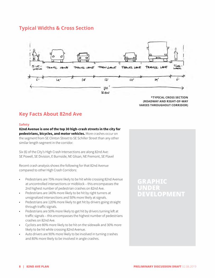
Safety82nd Avenue is one of the top 30 high-crash streets in the city for pedestrians, bicycles, and motor vehicles. More crashes occur on the segment from SE Clinton Street to SE Schiller Street than any other similar length segment in the corridor.
Six (6) of the City’s High Crash Intersections are along 82nd Ave:SE Powell, SE Division, E Burnside, NE Glisan, NE Fremont, SE Flavel
Recent crash analysis shows the following for that 82nd Avenue compared to other High Crash Corridors:
• Pedestrians are 75% more likely to be hit while crossing 82nd Avenue at uncontrolled intersections or midblock – this encompasses the 2nd highest number of pedestrian crashes on 82nd Ave.
• Pedestrians are 140% more likely to be hit by right turners at unsignalized intersections and 50% more likely at signals.
• Pedestrians are 120% more likely to get hit by drivers going straight through traffic signals.
• Pedestrians are 50% more likely to get hit by drivers turning left at traffic signals – this encompasses the highest number of pedestrians crashes on 82nd Ave.
• Cyclists are 80% more likely to be hit on the sidewalk and 30% more likely to be hit while crossing 82nd Avenue.
• Auto drivers are 90% more likely to be involved in turning crashes and 80% more likely to be involved in angle crashes.
GRAPHIC
GRAPHIC
GRAPHIC
Typical Widths & Cross Section
Key Facts About 82nd Ave
GRAPHICUNDER DEVELOPMENT
*TYPICAL CROSS SECTION(ROADWAY AND RIGHT-OF-WAY
VARIES THROUGHOUT CORRIDOR)

82ND AVE PLAN | 9PRELIMINARY DISCUSSION DRAFT 02.08.2019
Demographics82nd Avenue is home to one of the most diverse populations in the region; the census tract around 82nd Avenue and Powell Boulevard is the most diverse in the state.
Transit ridershipLine 72 has the highest number of boarding rides in the TriMet bus system. More than 14,000 boarding rides on an average weekday. The segment of the line 72 (southbound) between the 82nd Avenue MAX station and 82nd and Powell has the 11th highest average passenger delay per mile in the frequent service network - this would be an important place to focus on priority treatments for transit. The segment of the line 72 (northbound) between 82nd and Flavel and 82nd and Powell has the 19th highest average passenger delay per mile in the frequent service network – this would be an important place to focus on priority treatments for transit.
Motor vehicle volumes (daily)15,000 near NE Prescott; 20,000 north of NE Fremont Street, 22,000 to 27,000 from NE Fremont Street to SE Clatsop Street.
Roadway WidthGenerally, about 60 feet between the curbs, providing two lanes in each direction and a center turn lane. This is not including sidewalks (width varies). The existing right-of-way is typically about 72 ft, though wider where bus pull-outs have been provided or sidewalk dedications have been made.
SidewalksMost of the existing sidewalks corridors along 82nd Ave are narrow and substandard. The sidewalks vary in width from 3 feet to 15 feet on both sides of the street. They are often only 8 ft to 10 ft. A few areas have no sidewalk at all. Not all sidewalks and corners meet current Americans with Disabilities Act (ADA) design requirements. Many stretches of sidewalk lack street trees and are currently too narrow to accommodate the addition of street trees.
CrosswalksMost of 122nd Avenue does not meet the City’s new guidelines for marked crosswalk spacing.
Special Setback along 82nd AveMeasured 45 feet from each side of the center line of the roadway along NE and SE 82nd Ave. Special street setbacks apply to all buildings, structures, signs, off-street parking areas, and exterior display, storage, and activities fronting a street with a special street setback designation on the Official Zoning Maps. This typically results in a minimum of 90 ft between buildings and other development on private property.
GRAPHICUNDER DEVELOPMENT
GRAPHICUNDER DEVELOPMENT
GRAPHICUNDER DEVELOPMENT

10 | 82ND AVE PLAN PRELIMINARY DISCUSSION DRAFT 02.08.2019

82ND AVE PLAN | 11PRELIMINARY DISCUSSION DRAFT 02.08.2019
Safety, Access and Transit Improvements
CHAPTER 3
This chapter contains basic safety, access and transit capital improvements to help support the incremental transformation of 82nd Avenue into a Civic Corridor, as envisioned in the Portland 2035 Comprehensive Plan, and support a jurisdictional transfer.
The primary focus of these improvement is increasing safety and removing transportation barriers. Most of the recommended projects are enhanced pedestrian and bicycle crossings, increased lighting, signal changes to reduce conflicts and other minor improvements to existing signals. In addition, Enhanced Transit priority treatments and bus stop improvements are recommended along 82nd Ave to improve the reliability, speed and capacity of TriMet bus line 72.
Once combined with the incremental widening of sidewalks as redevelopment occurs, these improvements will help create a more accessible, comfortable and inviting environment along 82nd Ave. Together, these changes will support more walking, rolling, biking and transit ridership along 82nd Ave. This will increase transportation capacity and provide more equitable and efficient movement of people and goods along the corridor and between centers.
These basic improvements will help bring the road to a state of good repair and address safety and other basic transportation needs to help support a jurisdictional transfer.
The total estimated cost for these conceptual improvements is still being determined. Additional project development, design and engineering is needed to determine the total cost with more confidence.

12 | 82ND AVE PLAN PRELIMINARY DISCUSSION DRAFT 02.08.2019
Safety and Access Improvements
Enhanced CrossingsThis plan recommends a total of twenty-two (22) enhanced crossings to help meet the new PBOT spacing guidelines for marked crosswalks. The estimated cost is $22 million. This includes crossing treatments, lighting rebuilding corners, improvements to meet ADA accessibility guidelines and other associated electrical and civil engineering improvements. Crossing enhancements and marked crosswalks are recommended at the following locations.
Extend Existing Islands and Add Enhanced Pedestrian and Bicycle Crossings (north – south):• NE Wygant• NE Thompson• NE Pacific or new enhanced crossing at NE Holladay*• SE Ash• SE Salmon• SE Hawthorne• SE Cooper (Safe Route to School)
New Enhanced Pedestrian and Bicycle Crossings:• NE Beech• NE Klickitat• NE Russell (Safe Route to School)• NE Schuyler• SE Harrison• SE Clinton (Safe Route to School)• SE Tibbetts/Brooklyn (Neighborhood Greenway)• SE Rhone• SE Schiller• SE Mitchell (Safe Route to School)• SE Ramona• SE Tolman• SE Ogden/Knapp (Safe Route to School)*• SE Lambert• SE Clatsop
All crossings treatments and cost estimates are preliminary and subject to change. Final decisions on crossing treatments will be made during design based on a traffic engineering analysis and approvals. Based on current PBOT engineering practice and technology, the crossings are scoped to include Pedestrian Hybrid Beacons or Rectangular Rapid Flashing Beacons (RRFB). They will either be mounted overhead on mast arms or mounted on poles behind the curb and on median islands. All marked crosswalks on State-owned highways require review and approval by the State Traffic Engineer.
Examples of potential types of crossing treatments:
RECTANGULAR RAPID FLASHING BEACON
PEDESTRIAN HYBRID BEACON (HAWK SIGNAL)
A rectangular rapid flashing beacon provides an additional visual stimulus to alert motorists to the presence of people using a crosswalk. These flashing lights are push-button activated by people crossing and can improve yielding compliance. These treatments are typically used in higher volume or higher speed locations.
PBOT PEDESTRIAN CROSSWALK SPACING GUIDELINES: Generally no more than 800’ between pedestrian crossings except in areas des¬ignated as Pedestrian Districts and Centers where the standard is 530’ between crossings.

82ND AVE PLAN | 13PRELIMINARY DISCUSSION DRAFT 02.08.2019
SLOWER SPEEDS
Improvements to Existing Signals to Reduce ConflictsAt existing signals along the whole corridor, add detection and activation for pedestrians and side street, where missing. Add protected left turns from 82nd Ave onto side streets to existing signals, where feasible. Investigate the feasibility of also adding protected left turns from the side streets onto 82nd Ave at signals where there is room between the existing curbs or additional right-of-way can be acquired without causing building impacts. Avoid the use of flashing yellow permissive left turning phases against the pedestrian walk signal phases.
Add protected left turns at existing signals:• NE Prescott• NE Fremont• NE Siskiyou• NE Tillamook• SE Woodstock
Other Improvements to Existing Signals:• NE Webster -Rebuild southeast corner with smaller radius and sidewalk. This the moves stop bar north and shortens
intersection, brings signal head location into compliance, slows drivers as they enter 82nd Ave NB, provides configuration for south leg pedestrian crossing. Add south leg pedestrian crossing with pedestrian push buttons as a separate pedestrian phase to meet PBOT crossing spacing and serve TriMet stop. Change the northbound right turn arrow signal to green ball.
• Madison High School signalized main entrance driveway - Add signalized crosswalk on north leg of signal• SE Stark and SE Washington – Switch the current left turn allowance between SE Stark and SE Washington. Currently, left
turns are allowed from 82nd Ave to SE stark (westbound) and left turns are prohibited from 82nd Ave to SE Washington (eastbound). This change would reconfigure the left turn lane in the block between the SE Stark and Washington couplet to allow left turns on to SE Washington instead. Project includes signal modifications and signage directing drivers to the appropriate route for reaching SE Stark. The intent is to reduce cut-through traffic impacts on local residential street.
Other Safety Improvements to Reduce ConflictsThis plan recommends implementing left turn calming measures to reduce left turning conflicts and crashes. This includes motor vehicle to motor vehicle crashes as well as motor vehicle crashes involving pedestrians and cyclists. Apply the following tools along the corridor as opportunities arise through future capital projects and review of private development.
• Driveways. Work with property owners to address driveways that do not meet current standards. This may include any or all of the following: narrowing, right in/right out restrictions, consolidation, relocation, closures.
• Median treatments and left turn traffic calming. Median islands, skinny traffic separators.
In combination with the above array of safety improvements, PBOT recommends pursing State approval to lower the posted Speed Limit to 30mph, potentially 25 mph in active centers (Jade, Montavilla, MAX station, Madison High School).

14 | 82ND AVE PLAN PRELIMINARY DISCUSSION DRAFT 02.08.2019
Enhanced Transit Improvements
Enhanced Transit improves transit capacity, reliability, and travel time through capital and operational treatments of moderate cost. There are many ways that cities can enhance transit, to make it faster and more reliable: smart traffic signals, the placement of bus stops, the use of lanes and road striping, and other tools that are controlled by the City but very effective in enhancing TriMet service.
Enhanced Transit improvements can provide the following benefits:• Make it possible to get to more places sooner, which is the essence of how we make transit more
useful.• Help make transit more attractive and reliable for people to get to work, school, and to meet their
daily needs.• Benefit people who depend on transit while also making transit the logical choice for many trips
that go by car today.• Help make transit more efficient and cost-effective.
Enhanced Transit treatments:• Transit Signal Priority (TSP) equipment and other Intelligent Transportation Systems (ITS)
technology upgrades to interconnect existing signals and make them ready for next generation TSP.
• Improve bus stops (coordinate with crossings, locate far side of intersections where possible, lengthen to accommodate articulated buses, potentially consolidate)
• Queue jumps and other treatments
More details forthcoming*

82ND AVE PLAN | 15PRELIMINARY DISCUSSION DRAFT 02.08.2019
Funded ImprovementsPBOT and our agency partners are already working to seek and secure funds to make improvements along 82nd Ave. This includes projects recently funded by the Oregon Department of Transportation (ODOT), Metro Regional Flexible Funds program and Portland Public Schools. The maps of the following pages display improvements recommended in this plan that now funded or likely funded.
PBOT Funded Projects:• 82nd Ave Crossing Improvements Fixing our Streets project (2019-
2020) • Division Multi-Modal Safety Project (2019-2020)• 70s Neighborhood Greenway Project (2020-21)• Halsey Safety Access to Transit Projects (2020-21)• Jade and Montavilla Connected Centers Project (2020-21)• Brentwood-Darlington Safe Routes to School (2020-21)
PBOT has $700,000 of Fixing Our Streets funding allocated to constructing one or more enhanced pedestrian crossing of 82nd Avenue. Priority locations were previously recommended in the ODOT-led 82nd Avenue of the Roses Implementation Plan. All of the recommended locations have been incorporated into the enhanced crossing location recommended in this plan.
ODOT and Portland Public Schools have recently funded enhanced crossings and signal upgrades at the following locations:• Signal at the Madison High School main entrance driveway• NE Russell• NE Thompson• SE Mitchell• SE Clatsop

16 | 82ND AVE PLAN PRELIMINARY DISCUSSION DRAFT 02.08.2019
N
SE SALMON ST
SE YAMHILL ST
SE WASHINGTON ST
SE STARK ST
SE ASH ST
E BURNSIDE ST
Vestal Elementary
School
NE DAVIS ST
NE GLISAN ST
Montavilla Park
NE PACIFIC ST
NE MULTNOMAH ST
NE WASCO ST
NE CLACKAMAS ST
NE HALSEY STNE JONESMORE ST
NE SCHUYLER ST
NE TILLAMOOK ST
Rose City Park Golf Course
Hancock City Park
NE THOMPSON ST
NE THOMPSON ST
NE RUSSEL ST
Glenhaven Park
Madison High School
NE SISKIYOU ST
Roseway Heights Middle School
NE KLICKITAT ST
NE FREMONT ST
NE BEECH ST
NE MASON ST
NE SANDY BLVD
NE PRESCOTT ST
NE ALBERTA STSacajawea Park
Berrydale Park
Creative Science School at ClarkMt. Tabor Park
Rosemont Blu� Natural Area
Jason Lee Elementary School
NE PRESCOTT STNE KILLINGSWORTH ST
NE WEBSTER ST
NE WYGANT ST
SE HAWTHORNE
Proposed Corridor Improvements(not mapped)
Safety
• Increase Lighting
• Signal detection and activation for pedestrians and side streets
• Lower Speed Limit to 30mph, potentially 25 mph in active centers (Jade, Montavilla, MAX station, Madison High School)
Enhanced Transit to improve transit reliability, speed, and capacity
• Transit Signal Priority equipment and other ITS upgrades (Next generation capable)
• Improve bus stops (coordinate with crossings, locate far side of intersections where possible, lengthen to accommodate articulated buses, potentially consolidate)
• Queue jumps and other treatments
Existing Tra�c Signal
Safe Routes to School
Existing, funded, or planned bikeway
Existing, funded, or planned greenway
Existing, funded, or planned multi-use path
Pedestrian District
School
Park
Existing or Planned Elements
Comprehensive Plan Center
Existing Enhanced Pedestrian Crossing
82nd Avenue
Proposed Spot Improvements
Add Protected Left at Existing Signal
Signal and Civil Improvements
New Enhanced Crossing
Extend Island and Add Enhanced Crossing
Switch current left turn allowance betweenSE Stark and Washington
Commissioner: CHLOE EUDALY | Interim Director: CHRIS WARNER
82nd Avenue Improvements:Safety, Access, and TransitNorth of SE Market St:
DRAFT v. 02/08/2019

82ND AVE PLAN | 17PRELIMINARY DISCUSSION DRAFT 02.08.2019
N
Existing Tra�c Signal
Safe Routes to School
Existing, funded, or planned bikeway
Existing, funded, or planned greenway
Existing, funded, or planned multi-use path
Pedestrian District
School
Park
Existing or Planned Infrastructure
Comprehensive Plan Center
Existing Enhanced Pedestrian Crossing
Proposed Corridor Improvements(not mapped)
Safety
• Increase Lighting
• Signal detection and activation for pedestrians and side streets
• Lower Speed Limit to 30mph, potentially 25 mph in active centers (Jade, Montavilla, MAX station, Madison High School)
Enhanced Transit to improve transit reliability, speed, and capacity
• Transit Signal Priority equipment and other ITS upgrades (Next generation capable)
• Improve bus stops (coordinate with crossings, locate far side of intersections where possible, lengthen to accommodate articulated buses, potentially consolidate)
• Queue jumps and other treatments
Proposed Spot Improvements
Add Protected Left at Existing Signal
New Enhanced Crossing
Extend Island and Add Enhanced Crossing
82nd Avenue
SE CLATSOP ST
SE CRYSTAL SPRINGS BLVD
SE LAMBERT ST
SE FLAVEL ST
SE OGDEN STSE KNAPP ST
Flavel ParkWhitman
Elementary School
Glenwood City Park
Kelly Elementary School
SE COOPER STSE GLENWOOD ST
Mt. Scott Park
SE DUKE ST
SE TOLLMAN ST
SE WOODSTOCK BLVD
SE RAMONA STSE RAMONA ST
SE HAROLD ST
SE FOSTER RD
SE 72ND
AVE
Lents Park
EssexPark
SE RAYMOND CTSE MITCHELL ST
SE RAYMOND ST SE LEIBE ST
SE SCHILLER STMarysville
Elementary School
Woodmere Elementary School
SE HOLGATE BLVD
Biztech High School
SE BOISE ST
SE RHONE ST
SE POWELL BLVD
SE TIBBETTS STSE BROOKLYN ST
SE WOODWARD ST
Youngson Pioneer School
SE CLINTON ST
SE DIVISION ST
Harrison Park
Harrison Park School
SE MILL STBridger School
SE FRANCIS ST
Commissioner: CHLOE EUDALY | Interim Director: CHRIS WARNER
82nd Avenue Improvements:Safety, Access, and TransitSouth of SE Market St:
DRAFT v. 02/08/2019

18 | 82ND AVE PLAN PRELIMINARY DISCUSSION DRAFT 02.08.2019
N
SE MADISON ST
SE SALMON ST
SE YAMHILL ST
SE WASHINGTON ST
SE STARK ST
SE ASH ST
E BURNSIDE ST
Vestal Elementary
School
NE DAVIS ST
NE GLISAN ST
Montavilla Park
NE PACIFIC ST
NE MULTNOMAH ST
NE WASCO ST
NE CLACKAMAS ST
NE HALSEY STNE JONESMORE ST
NE SCHUYLER ST
NE TILLAMOOK ST
Rose City Park Golf Course
Hancock City Park
NE THOMPSON ST
NE THOMPSON ST
NE RUSSEL ST
Glenhaven Park
Madison High School
NE SISKIYOU ST
Roseway Heights Middle School
NE KLICKITAT ST
NE FREMONT ST
NE BEECH ST
NE MASON ST
NE SANDY BLVD
NE PRESCOTT ST
NE ALBERTA STSacajawea Park
Berrydale Park
Creative Science School at ClarkMt. Tabor Park
Rosemont Blu� Natural Area
Jason Lee Elementary School
NE PRESCOTT STNE KILLINGSWORTH ST
Crossing Improvements
Funded New Enhanced Crossing
Funded Island Extension andNew Enhanced Crossing
Existing Tra�c Signal
Safe Routes to School
Existing, funded, or planned bikeway
Existing, funded, or planned greenway
Existing, funded, or planned multi-use path
Pedestrian District
School
Park
Existing or Planned Elements
Comprehensive Plan Center
Existing Enhanced Pedestrian Crossing
Potentially Funded New Enhanced Crossing
Commissioner: CHLOE EUDALY | Interim Director: CHRIS WARNER
82nd Avenue Safety ImprovementsNorth of SE Market St.
DRAFT v. 02/07/2019
FUNDED

82ND AVE PLAN | 19PRELIMINARY DISCUSSION DRAFT 02.08.2019
N
New Enhanced Crossings
Funded
Existing Tra�c Signal
Safe Routes to School
Existing, funded, or planned bikeway
Existing, funded, or planned greenway
Existing, funded, or planned multi-use path
Pedestrian District
School
Park
Existing or Planned Infrastructure
Comprehensive Plan Center
Existing Enhanced Pedestrian Crossing
Potentially Funded
SE CLATSOP ST
SE CRYSTAL SPRINGS BLVD
SE LAMBERT ST
SE FLAVEL ST
SE OGDEN STSE KNAPP ST
Flavel ParkWhitman
Elementary School
Glenwood City Park
Kelly Elementary School
SE COOPER STSE GLENWOOD ST
Mt. Scott Park
SE DUKE ST
SE TOLLMAN ST
SE WOODSTOCK BLVD
SE RAMONA STSE RAMONA ST
SE HAROLD ST
SE FOSTER RD
SE 72ND
AVE
Lents Park
EssexPark
SE RAYMOND CTSE MITCHELL ST
SE RAYMOND ST SE LEIBE ST
SE SCHILLER STMarysville
Elementary School
Woodmere Elementary School
SE HOLGATE BLVD
Biztech High School
SE BOISE ST
SE RHONE ST
SE POWELL BLVD
SE TIBBETTS STSE BROOKLYN ST
SE WOODWARD ST
Youngson Pioneer School
SE CLINTON ST
SE DIVISION ST
Harrison Park
Harrison Park School
SE MILL STBridger School
SE FRANCIS ST
Commissioner: CHLOE EUDALY | Interim Director: CHRIS WARNER
82nd Avenue Safety ImprovementsSouth of SE Market St.
DRAFT v. 02/07/2019
FUNDED

20 | 82ND AVE PLAN PRELIMINARY DISCUSSION DRAFT 02.08.2019

82ND AVE PLAN | 21PRELIMINARY DISCUSSION DRAFT 02.08.2019
Maintenance Needs
CHAPTER 4
This chapter will contain a summary of the asset improvements required along 82nd Ave to bring the facility to a state of good repair in support of a jurisdictional transfer.
ODOT and PBOT are currently working together to develop a shared understanding of the maintenance needs along 82nd Ave. More information will be forthcoming.
PBOT is conducting a preliminary evaluation of costs to upgrade assets along the 82nd Avenue corridor from SE Clatsop to NE Killingsworth in order to meet City of Portland standards. The focus of this preliminary review is estimating the cost to upgrade or improve existing assets through repair, rehabilitation, or replacement to meet City definition of State of Good Repair. The initial assessment will include:
• pavement system• traffic operations: existing signs and pavement markings• reconstruction of sidewalks in disrepair and ADA-compliant curb ramps• existing traffic signals• street lighting• structures, such as bridges and retaining walls• stormwater drainage systems
Other assets may also be included as information becomes available.

22 | 82ND AVE PLAN PRELIMINARY DISCUSSION DRAFT 02.08.2019

82ND AVE PLAN | 23PRELIMINARY DISCUSSION DRAFT 02.08.2019
New right-of waydedication & frontage improvements
CHAPTER 5
Existing Conditions: Sidewalk Corridor Standards and Dedication RequirementsMost of the existing sidewalk corridors along 82nd Ave are narrow and substandard. The sidewalks vary in width from 3 feet to 15 feet on both sides of the street. They are often only 8 ft to 10 ft. The current City standards are 12 ft sidewalk corridors along City Walkways, which includes most of 82nd Ave, and 15 ft sidewalk corridors in Pedestrian Districts.
Not all sidewalks and corners meet current Americans with Disabilities Act (ADA) design requirements. Many stretches of sidewalk lack street trees and are currently too narrow to accommodate the addition of street trees.
The sidewalk corridors need to be wider to provide adequate space for providing ADA-compliant curb ramps, meet other ADA clearance, slope and other design requirements, accommodate bus shelters, street trees and provide ample room for people to walk side by side and pass one another on the sidewalk.
To help transform 82nd Ave into a vibrant Civic Corridor and the series of Centers it connects, it is essential that it have ample sidewalk corridors to support increased pedestrian activity, bus stops, street trees, lighting, poles and all the other street furniture that is located along the sidewalk.
This chapter contains changes to PBOT’s current property dedications required during redevelopment to provide wider sidewalk corridors along 82nd Ave. These improvements will be made incrementally over time, as redevelopment occurs.

24 | 82ND AVE PLAN PRELIMINARY DISCUSSION DRAFT 02.08.2019
Current Special Setback Development Requirement along 82nd AveCurrently, a Special Setback requirement exists along NE and SE 82nd Ave within the City of Portland. Special street setbacks apply to all buildings, structures, signs, off-street parking areas, and exterior display, storage, and activities fronting a street with a special street setback designation on the Official Zoning Maps.
The Special Setback along 82nd Ave is measured 45 feet from each side of the center line of the roadway. This typically results in a minimum of 90 ft between buildings and other development on private property that is subject to Special Setback requirement.
City Council established the setback lines on NE and SE 82nd Ave through the adoption of Ordinance No. 110507 in 1959 and Ordinance No. 132139 in 1971. Later, these setback lines became Special Setbacks incorporated into the City Zoning Code and the Official Zoning Maps. Currently, Special Setback requirements are located in Chapter 33.288 of the Zoning Code (Title 33).

82ND AVE PLAN | 25PRELIMINARY DISCUSSION DRAFT 02.08.2019
Current Sidewalk Corridor Standards and Dedication RequirementsThe Sidewalk Corridor is typically located within the public right-of-way between the curb or roadway edge and the property line. The Sidewalk Corridor contains four distinct zones: the Curb Zone, the Furnishings Zone, the Through Pedestrian Zone, and the Frontage Zone.
Construction and maintenance of the sidewalk is the responsibility of the adjacent property owner, per City Code, Title 17, Chapter 17.28. Typically, sidewalk corridors are built and widened to City standards when private properties develop or redevelop. Where sidewalks are substandard, property owners may be required to dedicate additional public right-of-way and build sidewalks through the City’s permitting process.
Sidewalk corridor dedication requirements are typically measured for each property based upon the existing curb location, the distance between the curb and existing private property line and the relevant sidewalk corridor standard. Actual property dedication widths vary for each property depending upon these conditions.
WHAT IS A SIDEWALK CORRIDOR?The Sidewalk Corridor is typically located within the public right-of-way between the curb or roadway edge and the property line. The Sidewalk Corridor contains four distinct zones: the Curb Zone, the Furnishings Zone, the Through Pedestrian Zone, and the Frontage Zone.
Construction and maintenance of the sidewalk is the responsibility of the adjacent property owner.

26 | 82ND AVE PLAN PRELIMINARY DISCUSSION DRAFT 02.08.2019
Sidewalk Corridor Application Recomended Configuration
3.7 M (12’-0”) Recommended for City Walksways, especially for arterial streets or where ROW width is 18.2 m (60’-0”0)
Sidewalk Corridor Application Recomended Configuration
4.6 M (15’-0”) Recommended in Pedestrian Districts, especially for arterial streets or where ROW width is 24.5 m (80’-0”0)
PBOT has established sidewalk corridor standards through the Portland Pedestrian Design Guide that correspond to the pedestrian street classification in the Portland Transportation System Plan. The current sidewalk standards relevant to 82nd Ave include:
MONTAVILLA PEDESTRIAN DISTRICT 82ND AVE MAX STATION AREA PEDESTRIAN DISTRICT
Current Sidewalk Corridor Standards
City Walkway standard: 12-ft sidewalk corridors with a 6 ft clear Pedestrian Through Zone
Pedestrian District standard: 15-ft sidewalk corridors with a 8 ft clear Pedestrian Through Zone
Currently, there are two Pedestrian Districts along 82nd Ave:

82ND AVE PLAN | 27PRELIMINARY DISCUSSION DRAFT 02.08.2019
Existing sidewalk corridor standards & right-of-way dedication examples
Example of an existing sub-standard sidewalk width
Current sidewalk corridor standards for City Walkways and Pedestrian Districts

28 | 82ND AVE PLAN PRELIMINARY DISCUSSION DRAFT 02.08.2019
Through the Ped PDX Plan, additional Pedestrian Districts are recommended along 82nd Ave. The recommendations include adding Pedestrian Districts to correspond to the Centers designated in the 2035 Comprehensive Plan.
Comprehensive Plan Centers:
• Roseway Neighborhood Center• Montavilla Neighborhood Center• Jade District Neighborhood Center• Lents Town Center
Potential Future Pedestrian Districts

82ND AVE PLAN | 29PRELIMINARY DISCUSSION DRAFT 02.08.2019
New Right-of-Way Dedication Requirements
The new property dedication and frontage improvement requirements along 82nd Ave are as follows:
Within Pedestrian Districts: Dedications: provide 45 feet of public right-of-way from each side of the center line of NE and SE 82nd Ave, or a minimum of 15 feet behind the existing curb line, whichever is greater.Frontage Improvements: Construct concrete sidewalks and sidewalk corridor improvements per the Portland Pedestrian Design Guide and other relevant current City Code.
Outside Pedestrian Districts, along City Walkways: Dedications: provide 45 feet of public right-of-way from each side of the center line of NE and SE 82nd Ave, or a minimum of 12 feet behind the existing curb line, whichever is greater.Frontage Improvements: Construct concrete sidewalks and sidewalk corridor improvements per the Portland Pedestrian Design Guide and other relevant current City Code.
The purpose of this change to property dedications is to provide wider sidewalk corridors along 82nd Ave. This will accommodate increased pedestrian activity as forecasted with future development along this Civic Corridor. It will provide more room for more prominent street trees and other green features along 82nd Ave.
This change will help meet Comprehensive Plan policy, including:
Policy 3.49 Design great places. Improve public streets and sidewalks along Civic Corridors to support the vitality of business districts, create distinctive places, provide a safe, healthy, and attractive pedestrian environment, and contribute to quality living environments for residents.
This change will result in sidewalk corridors that range from 12 feet to 15 feet in width after dedications are complete. Where the sidewalk corridor is 12 feet or wider, the clear Pedestrian Through Zone shall be a minimum of 6 feet. Where the sidewalk corridor is 15 feet or wider, the clear Pedestrian Through Zone shall be a minimum of 8 feet.
This change will bring PBOT right-of-way dedication requirements more in line with the existing Special Setback requirement of 45 feet from each side of the center line along 82nd Ave in the Portland Zoning Code, Title 33. This will result in a minimum of 90 feet of public right-of-way over time. These dedications and improvements will be made incrementally over time, as redevelopment occurs.
• location of existing public right-of-way and private property lines and sidewalks corridors.
• property dedication requirements to meet the current 12 ft Sidewalk Corridor standard and dedication requirements
• property dedication requirements under the new dedication requirements
• the difference in width between the two standards, that is the 12 ft Sidewalk Corridor standard versus the 45 feet from each side of the centerline.
SEE APPENDIX FOR DETAILED MAPS
Maps displaying the new right-of-way dedication requirements are in the appendix. These maps display the following along 82nd Ave:

30 | 82ND AVE PLAN PRELIMINARY DISCUSSION DRAFT 02.08.2019

82ND AVE PLAN | 31PRELIMINARY DISCUSSION DRAFT 02.08.2019
Recommendations for Future Study
CHAPTER 6
This chapter contains recommendations that are beyond the scope of this plan or require additional planning, analysis and public engagement.
• Develop conceptual design plan for the long-term future transformation of 82nd Ave.
• Address the future of transit on 82nd Ave
• Address the future of bikes on 82nd Ave
• Any future changes to the number of lanes or other cross-section changes on 82nd Ave.

32 | 82ND AVE PLAN PRELIMINARY DISCUSSION DRAFT 02.08.2019
82ND AVE PLAN | 33PRELIMINARY DISCUSSION DRAFT 02.08.2019
82nd Ave Public Engagement
CHAPTER 7
CONTENT UNDER
DEVELOPMENT

82nd Ave PlanPLANNING FOR A FUTURE CIVIC CORRIDOR