8/13/2014 mapping and analysisof land subsidence land ... · zonasi kawasan subsidence jakarta...
TRANSCRIPT

8/13/2014
1
Mapping and Analysis ofLand Subsidence Impacts in Jakarta Area
Hasanuddin Z. Abidin,Heri Andreas, Irwan Gumilar,
Arif RohmanGeodesy Research Group
FITB, Institute of TechnologyBandung (ITB)
The Asahi Glass FoundationGrant Ceremony &
Seminar on Research FindingITB, 20 August 2014
Hasanuddin Z. Abidin, 2012
Land Subsidence
San Joaquin Valley
subsidence
Land subsidence is the downwarddisplacement of the land surfacerelative to certain reference surface,such as mean sea level (MSL) orreference ellipsoid.
It may occurs in active volcanic andtectonic areas, mining areas, oil andgas exploration areas, and largeurban areas.
Can be caused by natural and/orhuman activities.
Ref: Polland (1984)
Land Subsidence in Indonesian Cities
Denpasar
Cilegon
Denpasar
Cilegon
• Jakarta• Bandung• Semarang
• Surabaya• Denpasar• Cilegon
• Medan
Observed land subsidence : Expected land subsidence :
observed decreasein groundwater level
Hasanuddin Z. Abidin, 2011 Hasanuddin Z. Abidin, 2011
JAKARTA
9.6 million people 661.52 km2
13 rivers 43 reservoirs
Jakartaand its
Surrounding
JakartaMetropolitanRegion (JMR)
7500 km2
total population27.9 million
Hasanuddin Z. Abidin, 2011
T. Firman (1999)
• excessive groundwater extraction
• load of constructions and infrastuctures
(i.e. settlement of high compressibility soil)
• natural consolidation of alluvium soil
• tectonic activity
Land subsidence in urban areas (cities) can becaused by the following factor(s) :
Land Subsidence
Hasanuddin Z. Abidin, 2006
8/13/2014
2
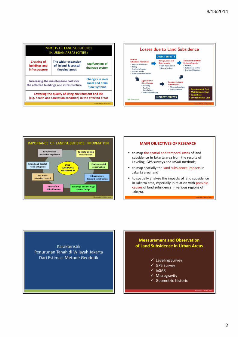
IMPACTS OF LAND SUBSIDENCEIN URBAN AREAS (CITIES)
Cracking ofbuildings andinfrastructure
The wider expansionof inland & coastal
flooding areas
Malfunction ofdrainage system
Increasing the maintenance costs forthe affected buildings and infrastructure
Changes in rivercanal and drain
flow systems
Lowering the quality of living environment and life(e.g. health and sanitation condition) in the affected areas
Hasanuddin Z. Abidin, 2012
Losses due to Land Subsidence
Hasanuddin Z. Abidin, 2012
• Development Cost• Maintenance Cost
• Social Cost• Environmental Cost
Ref. : Viets (2010)
DIRECT EFFECTS
INDIRECT EFFECTS
PrimarySubsidence Phenomena
Vertical subsidence Tilting Horizontal strains Ground breaks Subsurface deformation
Aggravation ofOther Hazards
Flooding Faulting Dam failures Induced seismicity
Damage, Costs andOther Impacts
Man-made system Natural system
Adjustments and theirCosts and Impacts
Studies Subsidence control Damage Mitigation
Damage, Costs andOther Impacts
Man-made system Natural system
Spatial planningconsideration
Infrastructuredesign & construction
(Inland and Coastal)Flood Mitigation
Sea waterintrusion control
Groundwaterextraction regulation
Environmentalconservation
LANDSUBSIDENCE
INFORMATION
IMPORTANCE OF LAND SUBSIDENCE INFORMATION
Hasanuddin Z. Abidin, 2012
Sewerage and DrainageSystem Design
Sub-surfaceUtility Planning
to map the spatial and temporal rates of landsubsidence in Jakarta area from the results ofLeveling, GPS surveys and InSAR methods;
to map spatially the land subsidence impacts inJakarta area; and
to spatially analyse the impacts of land subsidencein Jakarta area, especially in relation with possiblecauses of land subsidence in various regions ofJakarta.
MAIN OBJECTIVES OF RESEARCH
Hasanuddin Z. Abidin, 2014
KarakteristikPenurunan Tanah di Wilayah Jakarta
Dari Estimasi Metode Geodetik
Measurement and Observationof Land Subsidence in Urban Areas
Leveling Survey GPS Survey InSAR Microgravity Geometric-historic
Hasanuddin Z. Abidin, 2012
8/13/2014
3
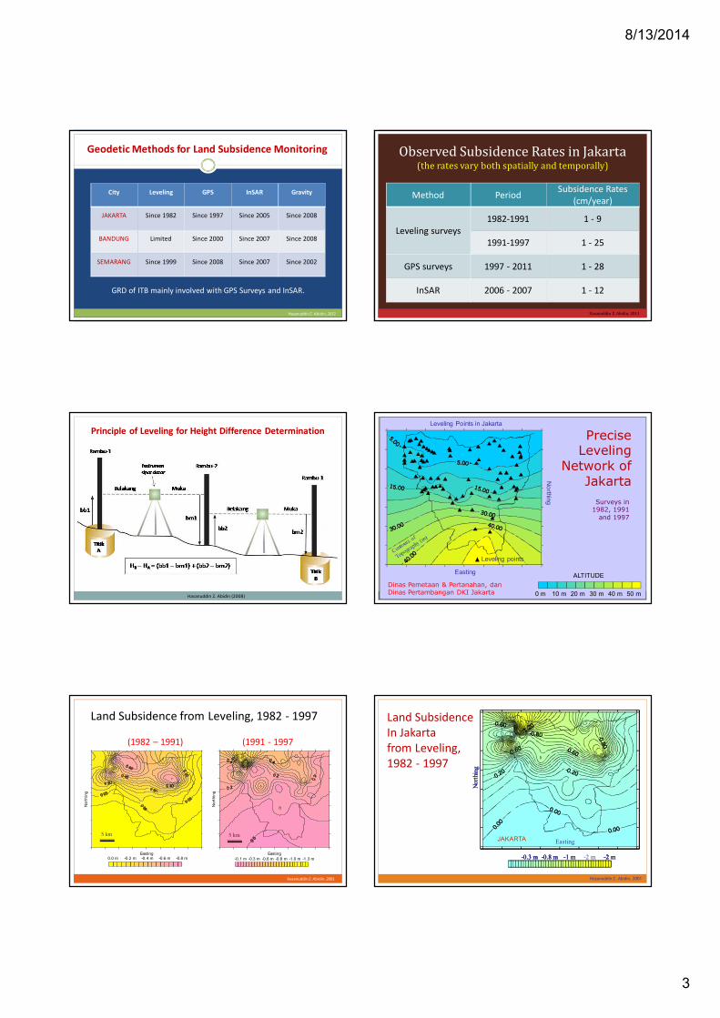
City Leveling GPS InSAR Gravity
JAKARTA Since 1982 Since 1997 Since 2005 Since 2008
BANDUNG Limited Since 2000 Since 2007 Since 2008
SEMARANG Since 1999 Since 2008 Since 2007 Since 2002
Geodetic Methods for Land Subsidence Monitoring
GRD of ITB mainly involved with GPS Surveys and InSAR.
Hasanuddin Z. Abidin, 2012
Method PeriodSubsidence Rates
(cm/year)
Leveling surveys1982-1991 1 - 9
1991-1997 1 - 25
GPS surveys 1997 - 2011 1 - 28
InSAR 2006 - 2007 1 - 12
Observed Subsidence Rates in Jakarta(the rates vary both spatially and temporally)
Hasanuddin Z. Abidin, 2011
Principle of Leveling for Height Difference Determination
Hasanuddin Z. Abidin (2008) 0 m 10 m 20 m 30 m 40 m 50 m
PreciseLeveling
Network ofJakarta
ALTITUDEEasting
Leveling Points in Jakarta
Leveling points
No
rthing Surveys in1982, 1991
and 1997
Dinas Pemetaan & Pertanahan, danDinas Pertambangan DKI Jakarta
Land Subsidence from Leveling, 1982 - 1997
Easting
Land Subsidence from Levelling, 1982 - 1991
Nort
hin
g
-0.8 m-0.6 m-0.4 m-0.2 m0.0 m
5 km
Easting
Land Subsidence from Level ling, 1991-1997
No
rthin
g
-1.3 m-1.0 m-0.8 m-0.6 m-0.3 m-0.1 m
5 km
(1982 – 1991) (1991 - 1997
Hasanuddin Z. Abidin, 2001
Land SubsidenceIn Jakartafrom Leveling,1982 - 1997
Hasanuddin Z. Abidin, 2001
JAKARTA Easting
Nort
hing
-2 m-2 m-1 m-0.8 m-0.3 m
JAKARTA Easting
Nort
hing
-2 m-2 m-1 m-0.8 m-0.3 m
JAKARTA Easting
Nort
hing
-2 m-2 m-1 m-0.8 m-0.3 m -2 m-2 m-1 m-0.8 m-0.3 m

8/13/2014
4
Hasanuddin Z. Abidin, 2006
PRINCIPLE OF LAND SUBSIDENCE MONITORINGUSING REPEATED GPS SURVEY METHOD
Coordinates from Survey # 1
Coordinates from Survey # 2
GPS networkCovering thestudy area
GPS satellites
LANDSUBSIDENCE
HEIGHTDIFFERENCES
LAND SUBSIDENCECHARACTERISTICS
Modeling
Statistical andGeometrical
Testings
GPS Stationsfor StudyingLand Subsidencein Jakarta
Surveys since 1997 Yearly basis There about 65 GPS
stations in 2012 Reference Station :
IGS BAKO Stationat Cibinong
Hasanuddin Z. Abidin, 2012
Contoh Penurunan Tanahdi Cekungan Jakarta dari GPS (2000 – 2005) in cm
Hasanuddin Z. Abidin, 2006
-80
-70
-60
-50
-40
-30
-20
-10
0June-2000 June-2001 Oct-2001 July-2002 Dec-2002 Sept-2005
JatinegaraTimur(BSKI)
TIJ Ancol
Klp. Gading
KamalMuara
Cilincing
DaanMogot
Kalideres
Land Subsidencein Jakarta Basin
-80
-70
-60
-50
-40
-30
-20
-10
0June-2000 June-2001 Oct-2001 July-2002 Dec-2002 Sept-2005
JatinegaraTimur(BSKI)
TIJ Ancol
Klp. Gading
KamalMuara
Cilincing
DaanMogot
Kalideres
Land Subsidencein Jakarta Basin in cm
Land Subsidencein Jakarta Basin(2007 – 2008)
dari Survei GPS
Hasanuddin Z. Abidin, 2008KK Geodesi ITB
Land Subsidencein Jakarta Basin(2008 – 2009)
dari Survei GPS
Hasanuddin Z. Abidin, 2009KK Geodesi ITB
Land Subsidencein Jakarta Basin(2009 – 2010)
dari Survei GPS
Hasanuddin Z. Abidin, 2010KK Geodesi ITB

8/13/2014
5
ZONASI KAWASAN SUBSIDENCE JAKARTA (2002 – 2010)
Lokasi yang mengalami landsubsidence cukup besar :
Jakarta Utara seperti MutiaraBaru, Pantai Mutiara, PantaiIndah Kapuk, dan Ancol ;
Jakarta Barat yaituCengkareng Barat ;
Jakarta Timur yaitusekitar Kelapa Gading
116 cm65 cm
47 cm
11 cm
15 cm
Hasanuddin Z. Abidin, 2010KK Geodesi ITB
Hasanuddin Z. Abidin, 2007
• perbedaan orbit• perbedaan paralaks• perbedaan kondisi
permukaan tanahdan troposfir
Citra Radar - 1
Citra Radar - 2
Interferogram Medan DeformasiPengolahan Citra
PRINCIPLE OF DEFORMATION STUDYUSING INSAR TECHNIQUE
0 30km
LandSubsidence
from InSAR
June 2006to February 2007
(8 months)
Cooperation withERSDAC Japan
Deguchi, 2007
CONES OF SUBSIDENCE
Pantai Mutiara Estate(Reclamation land)
Cooperation with ERSDAC Japan
Land Subsidence in Jakarta from InSARJanuary – June 2007 January – November 2007
Deguchi, 2008
CONES OF SUBSIDENCE CONES OF SUBSIDENCE
Watch out other color fringes
© P.T. Hatfield Indonesia
Land Subsidence in Jakarta from PSI, ALOS PALSAR, 2007 to 2010
DampakPenurunan Tanahdi Wilayah Jakarta

8/13/2014
6
IMPACTS OF LAND SUBSIDENCEIN URBAN AREAS (CITIES)
Cracking ofbuildings andinfrastructure
The wider expansionof inland & coastal
flooding areas
Malfunction ofdrainage system
Increasing the maintenance costs forthe affected buildings and infrastructure
Changes in rivercanal and drain
flow systems
Lowering the quality of living environment and life(e.g. health and sanitation condition) in the affected areas
Hasanuddin Z. Abidin, 2012
Genangan Rob(Gunung sahari)
Genangan Rob(Tongkol)
Struktur jembatan turun(mutiara)
Bangunan miring (Tongkol)
Genangan Rob(Gunung sahari)
Impacts of Subsidence in Jakarta
Hasanuddin Z. AbidinKK Geodesi ITB 2010
TIDAL FLOOD TIDAL FLOODTIDAL FLOOD
TIDAL FLOODLOWERING IN BRIDGESTRUCTURE TILTED BUILDING
Impacts of Subsidence in Jakarta
Hasanuddin Z. Abidin, 2008 Hasanuddin Z. Abidin, 2008
Impacts of Coastal Subsidence in Jakarta
Land Subsidence and Flooding in Jakarta
GPS-derived subsidence (2000-2011)
Hasanuddin Z. Abidin, 2013
Water depth (m) of 2007 Flooding
www.detik.com
Land Subsidence and Flooding (1)
Expanded coverage and deeper water depthof flooded (inundated) areas
Hasanuddin Z. Abidin, 2013
Flooded area(without subsidence)
Flooded area(with subsidence)
subsidence

8/13/2014
7
Land Subsidence and Flooding (2)
Hasanuddin Z. Abidin, 2013
Expanded coverage and deeper water depthof coastal flooded (inundated) areas
Coastal flooded area(without subsidence)
Mean sea level
Sea Level Rise + High Tide
Coastal flooded area(with subsidence)
subsidenceMean sea level
Sea Level Rise + High Tide
Land Subsidence and Flooding (3)
Changes of water flow patternin drainage, canal and river systems
passing the subsidence areaHasanuddin Z. Abidin, 2013
Water flow(without subsidence)
Water flow(with subsidence)
subsidence
Land Subsidence and Flooding in Jakarta
Hasanuddin Z. Abidin, 2013
JAKARTA Easting
-2 m-2 m-1 m-0.8 m-0.3 m
Leveling-derived subsidence (1982-1997)
2002 Jakarta Flooding(flooding map based on LAPAN data)
Inundated area
Land Subsidence and Flooding in Jakarta
Hasanuddin Z. Abidin, 2013
Jan.2013Flooding
InSAR-derived subsidence (2007-2011)(Koudogbo et al., 2012)
CoastalSubsidenceand Flooding
Watch out subsidence alongthe coastal areas of North Jakarta
Hasanuddin Z. Abidin, 2008
Sea Level Rise:0.1 – 0.5 cm/year (IPCC)
Coastal Subsidence:1 - 15 cm/year
Tidal Flooding Surface water degradation Decrease in livelihood quality
Rob in Priok HarborRob in Rukindo Priok
Rob in Pluit Rob in Tongkol Ps Ikan
Rob in PLTGU PriokRob in Muara Baru
Rob in Pluit
Rob in Muara BaruRob in Kamal Muara
Rob in G. SahariRob in G.SahariRob in P. JayakartaRob in P.Jayakarta
Floods “ROB” in northern Part of Jakarta
Rob in Kel Ancol
Ref: Brinkman (2011)
8/13/2014
8
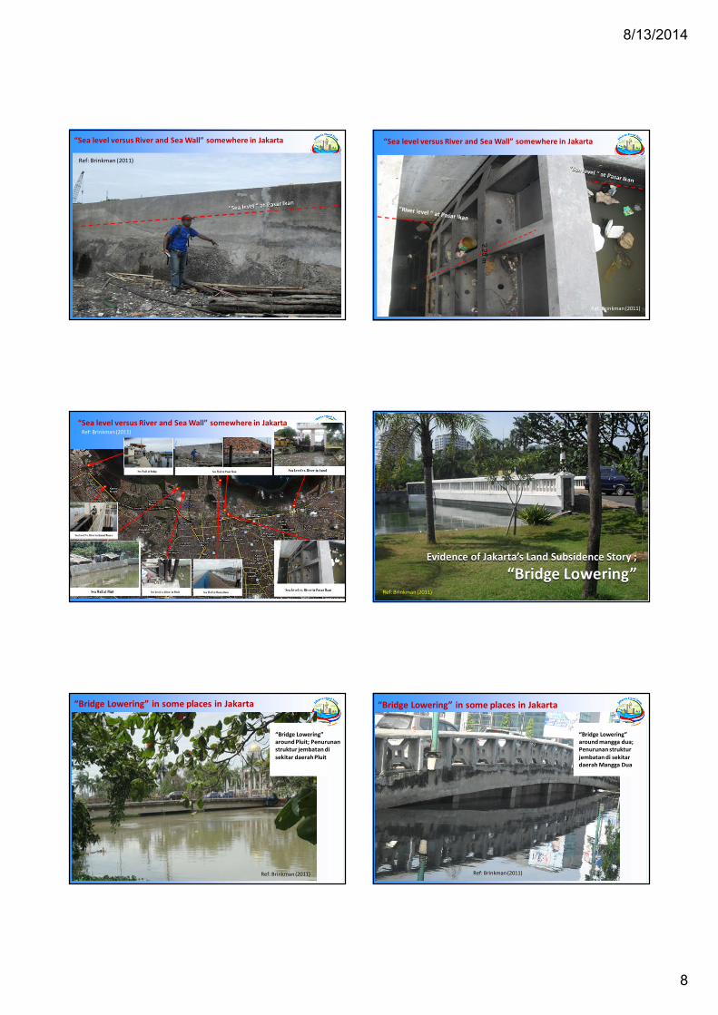
“Sea level versus River and Sea Wall” somewhere in Jakarta
Ref: Brinkman (2011)
“Sea level versus River and Sea Wall” somewhere in Jakarta
2.2
5m
Ref: Brinkman (2011)
Sea Level vs. River in Ancol
Sea Wall at Muara BaruSea Wall at Pluit Sea Level vs. River in Pasar Ikan
Sea Wall at Pasar Ikan
Sea Level vs. River in Pluit Sea Wall at Muara Baru
Sea Wall at Dadap
Sea Level Vs. River in Kamal Muara
“Sea level versus River and Sea Wall” somewhere in JakartaRef: Brinkman (2011)
Evidence of Jakarta’s Land Subsidence Story ;
“Bridge Lowering”Evidence of Jakarta’s Land Subsidence Story ;
“Bridge Lowering”Ref: Brinkman (2011)
“Bridge Lowering”around Pluit; Penurunanstruktur jembatan disekitar daerah Pluit
“Bridge Lowering” in some places in Jakarta
Ref: Brinkman (2011)
“Bridge Lowering”around mangga dua;Penurunan strukturjembatan di sekitardaerah Mangga Dua
“Bridge Lowering” in some places in Jakarta
Ref: Brinkman (2011)

8/13/2014
9
“Bridge Lowering”around Gunung sahari;Penurunan strukturjembatan di sekitardaerah Gunung Sahari
“Bridge Lowering” in some places in Jakarta
Ref: Brinkman (2011)
Bridge Lowering at Ancol
“Bridge Lowering” in someplaces in Jakarta
Bridge Lowering at Mangga Dua
Bridge Lowering at Pantai MutiaraBridge Lowering at Pluit
Bridge Lowering at Kamal Muara
Bridge Lowering at Kamal Muara
Bridge Lowering at G. Sahari Bridge Lowering at Mangga Dua
Ref: Brinkman (2011)
Extensometer at old Geology Office Jalan Tongkol
41 cm
4,5 cm
3 cm
1997
Ref: Brinkman (2011)
PenyebabPenurunan Tanahdi Wilayah Jakarta
• excessive groundwater extraction
• load of constructions and infrastuctures
(i.e. settlement of high compressibility soil)
• natural consolidation of alluvium soil
• tectonic activity
Land subsidence in urban areas (cities) can becaused by the following factor(s) :
Land Subsidence
Hasanuddin Z. Abidin, 2006
Geodetic-derived Total Subsidence
Tota
lSu
bsi
den
ce
Observed byGeodetic
Techniques
Subsidence due togroundwater extraction
Subsidence due to
natural consolidation
Subsidence due tobuilding/infrastructure loading
Subsidence due totectonic activity
?
?
?
?
Modeling andestimationusing other
external data
Hasanuddin Z. Abidin, 2012
Hidrogeology Geoctechnical Geomorphology Tectonic
displacements Land use and
land cover
8/13/2014
10
Hasanuddin Z. Abidin, 2011
URBANDEVELOPMENT
LANDSUBSIDENCE
Land use planning
Groundwater extraction regulation
Building and infrastructure codes
Flood management and control
Sea water intrusion control
Increase in built-up areas
Increase in population
Increase in economic and
industrial activities
Increase in groundwater extraction
will cause will lead to
will affect should be
considered in
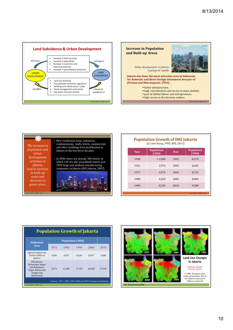
Land Subsidence & Urban Development Increase in Populationand Built-up Areas
Urban development in Jakartais going-on rapidly
better infrastructure, high concentration and access to mass markets pool of skilled labour and entrepreneurs high access to the decision makers
Jakarta has been the most attractive area in Indonesiafor domestic and direct foreign investment because of[Firman and Dharmapatni, 1994] :
Hasanuddin Z. Abidin, 2009
The increase inpopulation and
urbandevelopmentactivities in
Jakartalead to increase
in built-upareas and
decrease ingreen areas.
New residential areas, industries,condominiums, malls, hotels, commercialsand office buildings have proliferated inJakarta in the last three decades.
In 2006, there are already 306 hotels, inwhich 135 are star (classified) hotels; and1955 large and medium manufacturingcompanies in Jakarta [BPS Jakarta, 2007].
www.pbase.com
Hasanuddin Z. Abidin, 2009
YearPopulation
('000)Year
Population('000)
1948 ≈ 2,000 2002 8,379
1961 2,973 2003 8,603
1971 4,579 2004 8,725
1980 6,503 2005 8,864
1990 8,259 2010 9,588
Population Growth of DKI Jakarta[Lo and Yeung, 1995; BPS, 2011]
Hasanuddin Z. Abidin, 2011
Population Growth of Jakarta
DefinitionArea
Population ('000)
1971 1980 1990 2000 2010
Special Capital CityDistrict (DKI) of
Jakarta4,546 6,072 8,228 8,347 9,588
DKI Jakarta,Kotamadya Bogor,
and Kabupaten
Bogor, Bekasi andTanggerang(Jabotabek)
8,374 11,485 17,105 20,438 27,940
Sources : 1971, 1980, 1990, 2000 and 2010 Censuses of Indonesia
Hasanuddin Z. Abidin, 2011
Land Use Changesin Jakarta
Red color indicatesthe built-up areas
In 1965, the green areasmade up more than 35% of
the Jakarta's area and in2008 it is only 9.3%
Ref : Djakapermana (2008)

8/13/2014
11
Increase inBuilt-up Areas
and Populationof Jakarta
Source : http://earthobservatory.nasa.gov/
INCREASEIN BUILT-UPAREAS AND
POPULATION
Increase inGroundwaterConsumption& Extraction
Decrease inWater Recharge
Areas
Increase inBuilding and
InfrastructureLoading
Decrease inrechargeability
of withdrawngroundwater
LANDSUBSIDENCE
Hasanuddin Z. Abidin, 2009
-40
-30-20-10
-10
-20-30 -40
0
0 mKramat Jati
JAVA SEA
GambirPulogadung
Tanjungpriok
Kalideres
Kebayoran
-10
-20
-25
-30-35-40
-25
0
+10
+20
0 m
JAVA SEA
Middle Aquifer (40 - 140 m) in 1992 Lower Aquifer (140 - 250 m) in 1992
Piezometric water level contours (in metres) insideMiddle and Lower Aquifers of Jakarta in 1992,
adapted from [Murdohardono and Tirtomihardjo, 1993]
Hasanuddin Z. Abidin, 2001
Land Subsidence from Leveling, 1982 - 1997
Easting
Land Subsidence from Levelling, 1982 - 1991
Nort
hin
g
-0.8 m-0.6 m-0.4 m-0.2 m0.0 m
5 km
Easting
Land Subsidence from Level ling, 1991-1997
No
rthin
g
-1.3 m-1.0 m-0.8 m-0.6 m-0.3 m-0.1 m
5 km
(1982 – 1991) (1991 - 1997
Hasanuddin Z. Abidin, 2001
BSKI -0.0404 m
CIBU -0.0357 m
DADP -0.1448 m
KLGD -0.0926 m
KUNI -0.0432 m
MARU -0.0396 m
MERU -0.0788 m
MUTI -0.1355 m
PIKA -0.1611 m
TOMA -0.0546 m
439B -0.0845 m
ANBA -0.0908 m
CDTB -0.0479 m
CKNI -0.038 m
KBN1 -0.1742 m
KLDR -0.0162 m
MUBA -0.2611 m
RUKI -0.0813 m
T002 -0.1859 m
TNKL -0.0329 m
SUBSIDENCE J AKARTA PERIODESEPTEMBER 2007 – AGUSTUS 200 8
Land Subsidence in Jakarta Basin (2007 – 2008)
Hasanuddin Z. Abidin, 2008
26 cm/year
18 cm/year
17 cm/year
CONES OFSUBSIDENCE
-60
-50
-40
-30
-20
-10
0
HE
IGH
TC
HA
NG
ES
(CM
)
Sept. 2007
Dec. 1997
Sept. 2005
Dec. 2002
Subsidence ofKWITGPS Station
June-99 June-00July 2002
June 2001
July 2006
Oct-01
-12
-10
-8
-6
-4
-2
0
KWIT Lower KWIT Middle
GR
OU
ND
WA
TER
LEV
ELC
HA
NG
ES(C
M)
2002 2003 2004 2005 2006 2007
SUBSIDENCEand
GROUNDWATER
Jakarta basin
Hasanuddin Z. Abidin, 2008

8/13/2014
12
http://megapolitan.kompas.com/read/2010/09/27/12531425/Jakarta.Kurang.Ruang.Terbuka.Hijau
Laju Penyedotan Air Tanah di Jakarta (1879-2007)
-2.50
-2.00
-1.50
-1.00
-0.50
0.00
MARU(M) KAMR(L) PIKA (M) KLGD(L) KLGD(M) KLDR(M) RUKI(L) MERU(M) KWIT(L) KWIT(M) KUNI(U) KEBA(M) PLGD(M)
GRO
UN
DW
ATE
RLE
VEL
RA
TES
(M/Y
EAR)
Closest GPS Station Name (U=Upper, M=Middle, L=Lower Aquifer)
Rates of Groundwater Level Lowering
Hasanuddin Z. Abidin, 2008
Source: Mining Agency of DKI Jakarta
Lowering rates : 0.2 – 2.0 meter/year
Subsidence rates (typical) : 0.02 – 0.20 meter/year
TectonicContribution to
Land Subsidencein Jakarta Basin ?
Geological structuresin Jakarta area, derived
based on Landsat imagesand seismic profiling;
from Harsolumakso (2001)
Closing Remarks
GEOSPATIALINFORMATION
LAND SUBSIDENCE
Characteristics Causes Impacts Cost
Leveling data Observed heightdifferences in
spatial andtemporal domain
GPS data Location of land subsidence features in the field
InSAR data
Gravity data
Satellite images spatial distribution of man-made and naturalfeatures (e.g. built-up areas, industries, buildings
andinfrastructures, forest, paddy fields, etc.)
Aerial photos
Topographicmaps
Hydro-geologicalinformation
Numericalestimation and
modeling ofsubsidence
spatial characteristics and dynamics ofgroundwater, aquifers and confining
beds
Geotechnicalinformation
physical properties of soil and rock inspatial domain
Socio-economyinformation
spatial distribution and characteristics ofpopulation and economic activities
Roles of Geospatial Information for Risk Assessment of Subsidence in Urban Areas
Hasanuddin Z. Abidin, 2012 Hasanuddin Z. Abidin, 2012
Roles of Geospatial Informationfor Risk Assessment of Subsidence in Urban Areas
Geospatial Information
Sea Level Rise
Urban Development
Land Subsidence • People• Environment• Infrastructure Structural
Cultural
Mitigation
Adaptation
Collateral Hazards
Characteristics ● Causes ● Impacts ● Costs

8/13/2014
13
Abidin, H.Z., H. Andreas, I. Gumilar, T.P. Sidiq and Y. Fukuda (2013). “On the Roles of Geospatial Informationfor Risk Assessment of Land Subsidence in Urban Areas of Indonesia“ In S. Zlatanova et al. (eds.),Intelligent Systems for Crisis Management, Lecture Notes in Geoinformation and Cartography, DOI:10.1007/978-3-642-33218-0_19, Springer-Verlag Berlin Heidelberg, pp. 277-288.
Abidin, H.Z., H. Andreas, I. Gumilar, and J.J. Brinkman (2013). “Spatial Correlation between Land Subsidenceand Flooding in Urban Areas of Indonesia”, Paper presented at the EGU General Assembly 2013,Vienna, Austria, 7-12 April.
Abidin, H.Z., H. Andreas, I. Gumilar, B. D. Yuwono, T.P. Sidiq, Supriyadi, Y. Fukuda, T. Schöne, I.Sofian (2013).“Integration of Geodetic Observation Results for Assessment of Land Subsidence Hazard Risk in UrbanAreas of Indonesia“, Paper presented at the IAG Scientific Meeting, Potsdam, Germany, 1-6 Sept.
Abidin, H.Z., Heri Andreas, Irwan Gumilar, and Bambang D. Yuwono (2014). “Performance of the Geometric-Historic Method for Estimating Land Subsidence in Urban Areas of Indonesia”, Proceedings of the XXVFIG Congress, TS 10B Session – Earth Geodynamics and Monitoring 2, Kuala Lumpur, 16-21 June.
Abidin, H.Z, H. Andreas, I. Gumilar, J.J. Brinkman, S.B. Kusuma, S.Hadi (2014). “Assessment of NaturalHazards Affecting the Delta City of Jakarta”, Paper to be presented at the Deltas in Times of ClimateChange II International Conference,Rotterdam, the Netherlands, 24 - 26 September 2014.
Abidin, H.Z, H. Andreas, I. Gumilar, J.J. Brinkman, (2014) “Mapping and Analysis of Land Subsidence Impactsin Jakarta Area”, Paper to be presented at the ISG 2014, Kuala Lumpur, 14-16 October.
Publikasi Terkait Riset
Terima Kasih
Hasanuddin Z. Abidin, 2009