8. 8 soils and geology - south cambs district council |€¦ · 8. 8 soils and geology 8.1...
TRANSCRIPT

ENVIRONMENTAL STATEMENT Soils and Geology
CIR.U.0102 North West Cambridge
8. 8 SOILS AND GEOLOGY
8.1 Introduction
8.1.1 This chapter is formed of three parts. Part 1 provides an assessment of the likely significant effects associated with the Proposed Development arising from any existing contamination of soil or groundwater or the presence of ground-gas. Geotechnical information has been included but is generally presented in qualitative terms only to indicate the potential effect on the Proposed Development.
8.1.2 Part 2 of this chapter relates to an area within the Application Site which is designated a Mineral Safeguarding Area in the Cambridgeshire and Peterborough Minerals and Waste Plan.
8.1.3 Part 3 of the chapter relates to an area within the Application Site which is designated as a Site of Special Scientific Interest (SSSI); the Traveller’s Rest Pit. This area has been notified as a SSSI due to the presence of nationally important geology. A copy of the most recent notification issued in 2010 is provided in Appendix 8.6.
8.1.4 In respect of all three parts, the likely significant effects with respect to both the construction and operational phases of the Proposed Development have been considered as at both 2014, when Phase 1 of the Proposed Development will be completed and at 2026 when the Proposed Development will be completed. More detail about the proposed phasing is included in Chapter 3 of this ES.
8.1.5 For this chapter the following reports have been referred to throughout:
Scott Wilson: ‘North West Cambridge Geo-environmental Ground Conditions Report’ August 2011 which includes the Landmark Envirocheck Report (Reference 31572446_1_1 dated 16th June 2010 and 35805182_1_1 dated 18 August 2011) (included in Appendix 8.1)
Scott Wilson ‘North West Cambridge Geotechnical Report’ (included in Appendix 8.2) Brownfield Solutions: Geo-Environmental Factual Report dated October 2010 (Appendix
8.3) Scott Wilson: ‘Mineral Safeguarding Area’ Report (included in Appendix 8.4) Evans and Newman: ‘Northwest Cambridge, University of Cambridge: Archaeological
Evaluation Fieldwork. Cambridge Archaeological Unit Report No. 921 dated 2010
8.1.6 The Scott Wilson geo-environmental report (Appendix 8.1) included relevant data from existing information that was made available for the development area. This included:
Peter Brett Associates (PBA): ‘North-West Cambridge – Preliminary Geotechnical and Geo-environmental Baseline Condition Study’ (March 2007)
Traveller’s Rest Pit, SSSI Report – UoC/NWC/AAP/B8 Cambridge Archaeological Unit: ‘North West Cambridge, An Archaeological Desk Based
Assessment Report 455’ (2001) Cambridge Archaeological Unit: ‘Gravel Hill Farm, North West Cambridge, An
Archaeological Evaluation Report 513’ (2002)
PART 1 – GEO-ENVIRONMENTAL CONSIDERATIONS
8.1.7 The sections below firstly consider the methodologies that have been used for defining the effects of the Proposed Development associated with land contamination. The assessment has been made assuming appropriate design and construction methodologies, inherent in a development such as this, will be incorporated in both the design and construction of the Proposed Development. This chapter also provides a summary of the baseline conditions, which form the basis of the assessment of contamination risks.
8.1.8 Review of historical data and assessment findings of the Scott Wilson Geo-environmental report, confirms a general absence of significant contamination at the Application Site. This is largely to be expected given that the Application Site has predominantly been used for agricultural purposes.

ENVIRONMENTAL STATEMENT Soils and Geology
CIR.U.0102 North West Cambridge
8.1.9 The assessment assumes that current construction industry best practice as articulated in Chapter 2 will be adopted during the pre-construction planning and construction phases to include waste and material management, environmental monitoring and control and adherence to health and safety legislation. The assessment also considers mitigation inherent in the design, which would be addressed by planning conditions.
Legislation and Policy Framework
8.1.10 The following legislation/policy applies to contamination and contamination issues associated with waste management at the national, regional and local levels:
Legislation
Environment Act 1995; Environmental Protection Act 1990 Part II (as amended); Waste Management Licensing Regulations 1994 (as amended); Control of Pollution (amendment) Act 1989; Controlled Waste (Registration of Carriers and Seizure of Vehicles) Regulations 1991 (as
amended); Controlled Waste Regulations 1992; Hazardous Waste (England and Wales) Regulations 2005; and Environmental Protection (Duty of Care) Regulations 1991 (as amended).
National Policy
Planning Policy Statement 23: Planning and Pollution Control 2005; Planning Policy Statement 10: Planning for Sustainable Waste Management;
“The Draft National Planning Policy Framework (“the Draft NPPF”) 8.1.11 While the NPPF is to be read as a whole in the context of soils and geology the Draft NPPF states at paragraph 171 that Local policies and decisions should ensure that:
new development is appropriate for its location, having regard to the effects of pollution on health, the natural environment or general amenity, taking account of the potential sensitivity of the area or proposed development to adverse effects from pollution; and
the site is suitable for its new use taking account of ground conditions, pollution arising from previous uses and any proposals for land remediation.
Regional Policy
East of England Plan (May 2008)
8.1.12 Within the East of England Plan, Policy ENV4, WM1 and WM6 were noted to be applicable to the discipline of contaminated land. Policy ENV4 encouraged the sustainable use of soil resources and, where soil and land have been degraded, maximisation of opportunities for restoration to beneficial after uses. Policy WM1 encouraged the view that waste is a resource that should be maximised for re-use. Within the context of contaminated land this is relevant as excavated soil is considered to be a waste. In addition, Policy WM6 refers to the sustainable management of waste materials.
8.1.13 The Localism Act, enacted in November 2011, provides for the abolition of Regional Spatial Strategies; although the abolition of individual Regional Spatial Strategies is not expected to take effect until the consequence of abolition has been the subject of Strategic Environmental Assessment. Until the East of England Plan is formally abolished it remains, therefore, part of the statutory Development Plan. The current state of play is that decisions must be in accordance with the statutory Development Plan unless material considerations require otherwise. In the meantime, Local Planning Authorities are entitled to take account of the Government's intention to abolish Regional Strategies as a material consideration but the weight to be given will for the time being be limited.
ENVIRONMENTAL STATEMENT Soils and Geology
CIR.U.0102 North West Cambridge
Local Policy
Cambridge City Council and South Cambridgeshire District Council Joint Area Action Plan (2009).
8.1.14 Within the Joint Area Action Plan, Policy NW2 states that planning permission would not be granted where a proposed development would have unacceptable adverse effects on quality of ground or surface water and geological resources. Policy NW28 promotes recycling of construction waste and maximisation of material re-use during construction.
Scoping Criteria 8.1.15 In accordance with the Scoping Opinion received from CCC (incorporating comments from SCDC and CCC), the baseline conditions for the site with respect to the potential for contaminated land and ground hazards have been established. This has been done by desk study review of existing reports and environmental information for the Application Site. The data has then been used to develop an initial Conceptual Site Model (CSM) which has been supplemented by limited intrusive surveys. Subsequent detailed quantitative risk assessment has been carried out to define the significance and magnitude of any land contamination.
8.1.16 The Scoping Opinion has specified that the assessment methodology to be adopted should seek to identify and evaluate any likely significant land contamination effects on the Proposed Development as well as the Proposed Development on land contamination during both the construction and operational phases.
8.1.17 In addition it was stated that recommendations should be provided for mitigation over and above those assumed to be standard as part of the Proposed Development.
8.2 Assessment Approach
Methodology 8.2.1 For contamination to present a significant effect, it must be demonstrated that there is an identifiable source of contamination (be it an on site or off site source), potential sensitive receptors and potential pathways through which the former may affect the latter. This methodology is consistent with the risk-based framework adopted in the Environment Agency document Model Procedures for the Management of Land Contamination – CLR11 (Environment Agency, 2004).
8.2.2 The Conceptual Site Model (CSM) for the site is reported in Scott Wilson’s Geo-environmental Ground Conditions report (included in Appendix 8.1).
8.2.3 The assessment considers both the existing land quality on the Application Site, and the potential for the Proposed Development to in turn affect land quality.
Hazard Source Identification
8.2.4 Potential and actual sources of contamination associated with the Application Site have been identified by consideration of:
Current and previous land use from a study of existing desktop study reports, current and historic maps, photos, local history sources, environmental database information, a site inspection covering both the Application Site itself and the surrounding area; and
Site investigation data as reported in Scott Wilson’s Geo-environmental Ground Conditions report (included in Appendix 8.1).
8.2.5 Once potential sources were defined, a review of the ground conditions and laboratory test data against generic and site-specific screening criteria was undertaken, as detailed in the Scott Wilson Geo-environmental report. This revealed a general absence of significant contamination associated with the potential contamination sources identified at the Application Site. Of particular note was the minimal
ENVIRONMENTAL STATEMENT Soils and Geology
CIR.U.0102 North West Cambridge
presence of Made Ground at the Application Site. The report also concluded that there was no conceivable significant risk from groundwater sampled to the defined receptors.
8.2.6 As a precaution, it is anticipated that standard contamination planning conditions may be applied to the proposed planning permission and implemented as the Scheme develops. Examples of this are summarised below and further detail can be found in Appendix 8.1.
Additional ground investigation will be undertaken as part of the detailed design and would focus on recovering additional samples of Made Ground (where present) to further quantify any risk from identified benzo(a)pyrene, together with samples of the Gault Clay to confirm the absence of significant pyrite potential.
Where residential development with private gardens is planned it is anticipated that the sampling frequency will be increased given the higher sensitivity of these receptors. Any additional investigation will also consider cut and fill requirements for the Proposed Development and will target sampling as required.
Further ground gas monitoring is to be undertaken to confirm the ground gas conditions and the need for any ground gas mitigation. Ground gas mitigation will be specified as required as part of the detailed design.
The potential effect of any proposed foundation solution will be considered, e.g. if piling is required, a methodology and risk assessment will be prepared to account for any perceived groundwater risks. Building loads will be designed so as not to require a piled solution that could penetrate any sensitive groundwater resources. Where this is unavoidable, piling would be designed and undertaken in accordance with Environment Agency guidance.
8.2.7 It is assumed that standards of environmental management will be incorporated into the Proposed Development once operational, and designed to avoid the likelihood of any future contamination arising as a result of the Proposed Development.
Receptor Identification 8.2.8 The presence and sensitivity of receptors at risk from potential land contamination are identified by consideration of the following:
Surrounding land uses, based on mapping and site visits and existing planning designations;
Proposed end-use, based on the nature of the Proposed Development; Type of construction operations that will be necessary as part of the Proposed
Development; Surrounding sites of nature conservation importance; and Geology, hydrogeology and hydrology of the Application Site and surrounding area.
8.2.9 The sensitivity of potential receptors can then be described qualitatively according to the categories shown in Table 8.1.
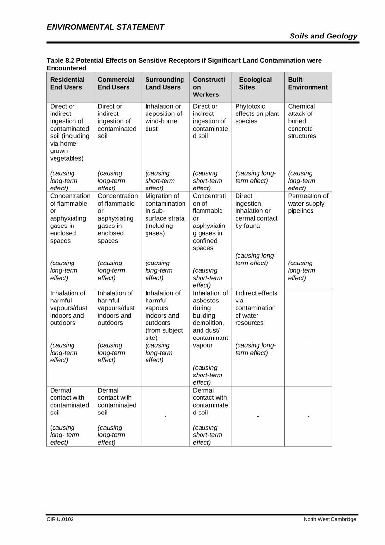
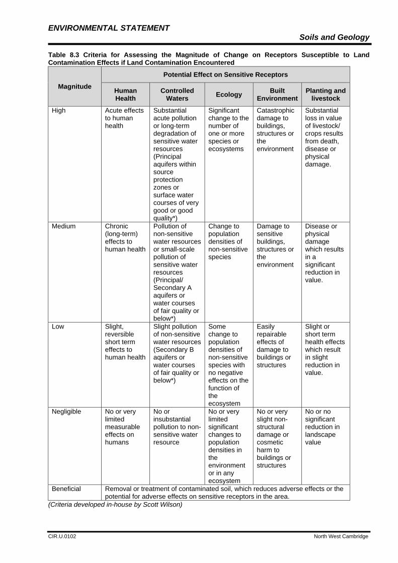
Likely Significant Effects 8.2.10 Where a significant source has been identified and potential sensitive receptors are present, then the potential effects can be determined by considering the pathways through which the source/hazard may affect the receptors. Table 8.2 indicates the most likely significant effects that may occur for different classes of receptor. The magnitude of effect has been determined on the basis of the criteria shown in Table 8.3.
8.2.11 The significance of the effect (Table 8.4) also needs to take account of the strength of pathway between a source and a receptor. The strength of pathway is a function of distance between the two and the ease or otherwise of the migration pathway. If the pathway is considered weak, then the significance has been reduced by a category.

ENVIRONMENTAL STATEMENT Soils and Geology
CIR.U.0102 North West Cambridge
Table 8.1 Descriptive Scale for Sensitivity of Receptors to Contaminated Land.
Sensitivity
Receptors Susceptible to Land Contamination Effects (Assuming a Plausible Pathway)
High
Future site users (residents)
Residential areas (residents) within 50 m of construction works
Schools and playing fields/areas (site users) within 50 m of construction works
Allotments, arable farmland, livestock, market gardens
Construction workers involved in extensive, below ground and demolition work
Water features deemed to be of high value
Ecological features deemed to be of high value
Medium
Future site users (commercial)
Residential areas (residents) within 50 to 200 m of construction works
Schools and playing fields/areas (site users) within 50m and 200 m of construction works
Commercial developments located within 50 m of construction works
Construction workers involved in limited and above ground works
Water features deemed to be of moderate value
Ecological features deemed to be of moderate value
Low
Future site users (industrial areas, car parks, highways and railways)
Residential areas located between 200 m and 500 m of construction works
Commercial development located between 50 m and 200 m of construction works
Forestry areas, ornamental plant nurseries
Buildings including services and foundations
Water features deemed to be of low value
Ecological features deemed to be of low value
Negligible
Residential areas located >500 m of construction works
Commercial development located between 200 m and 500 m of construction works
Areas where there are no built structures, no crops, timber, livestock, etc.
Ecological features and proposed planting deemed to be of negligible value
(Criteria developed in-house by Scott Wilson)
ENVIRONMENTAL STATEMENT Soils and Geology
CIR.U.0102 North West Cambridge
Table 8.2 Potential Effects on Sensitive Receptors if Significant Land Contamination were Encountered
Residential End Users
Commercial End Users
Surrounding Land Users
Construction Workers
Ecological Sites
Built Environment
Direct or indirect ingestion of contaminated soil (including via home-grown vegetables) (causing long-term effect)
Direct or indirect ingestion of contaminated soil (causing long-term effect)
Inhalation or deposition of wind-borne dust (causing short-term effect)
Direct or indirect ingestion of contaminated soil (causing short-term effect)
Phytotoxic effects on plant species (causing long-term effect)
Chemical attack of buried concrete structures (causing long-term effect)
Concentration of flammable or asphyxiating gases in enclosed spaces (causing long-term effect)
Concentration of flammable or asphyxiating gases in enclosed spaces (causing long-term effect)
Migration of contamination in sub-surface strata (including gases) (causing long-term effect)
Concentration of flammable or asphyxiating gases in confined spaces (causing short-term effect)
Direct ingestion, inhalation or dermal contact by fauna (causing long-term effect)
Permeation of water supply pipelines (causing long-term effect)
Inhalation of harmful vapours/dust indoors and outdoors (causing long-term effect)
Inhalation of harmful vapours/dust indoors and outdoors (causing long-term effect)
Inhalation of harmful vapours indoors and outdoors (from subject site) (causing long-term effect)
Inhalation of asbestos during building demolition, and dust/ contaminant vapour (causing short-term effect)
Indirect effects via contamination of water resources (causing long-term effect)
-
Dermal contact with contaminated soil (causing long- term effect)
Dermal contact with contaminated soil (causing long-term effect)
-
Dermal contact with contaminated soil (causing short-term effect)
- -
ENVIRONMENTAL STATEMENT Soils and Geology
CIR.U.0102 North West Cambridge
Table 8.3 Criteria for Assessing the Magnitude of Change on Receptors Susceptible to Land Contamination Effects if Land Contamination Encountered
Magnitude
Potential Effect on Sensitive Receptors
Human Health
Controlled Waters
Ecology Built
Environment Planting and
livestock
High Acute effects to human health
Substantial acute pollution or long-term degradation of sensitive water resources (Principal aquifers within source protection zones or surface water courses of very good or good quality*)
Significant change to the number of one or more species or ecosystems
Catastrophic damage to buildings, structures or the environment
Substantial loss in value of livestock/ crops results from death, disease or physical damage.
Medium Chronic (long-term) effects to human health
Pollution of non-sensitive water resources or small-scale pollution of sensitive water resources (Principal/ Secondary A aquifers or water courses of fair quality or below*)
Change to population densities of non-sensitive species
Damage to sensitive buildings, structures or the environment
Disease or physical damage which results in a significant reduction in value.
Low Slight, reversible short term effects to human health
Slight pollution of non-sensitive water resources (Secondary B aquifers or water courses of fair quality or below*)
Some change to population densities of non-sensitive species with no negative effects on the function of the ecosystem
Easily repairable effects of damage to buildings or structures
Slight or short term health effects which result in slight reduction in value.
Negligible No or very limited measurable effects on humans
No or insubstantial pollution to non-sensitive water resource
No or very limited significant changes to population densities in the environment or in any ecosystem
No or very slight non-structural damage or cosmetic harm to buildings or structures
No or no significant reduction in landscape value
Beneficial Removal or treatment of contaminated soil, which reduces adverse effects or the potential for adverse effects on sensitive receptors in the area.
(Criteria developed in-house by Scott Wilson)

ENVIRONMENTAL STATEMENT Soils and Geology
CIR.U.0102 North West Cambridge
(* according to the Environmental Agency General Quality Assessment classification scheme)
8.2.12 For each of the potential effects assessed to be likely, a qualitative assessment can be made on the significance of the effect to the receptor using Table 8.4. The significance of effect is based on a seven-point scale:
Major adverse Moderate adverse Minor adverse Negligible Minor beneficial Moderate beneficial Major beneficial
Table 8.4 Criteria for Assessing the Significance of Effects
Sensitivity of Receptor
Magnitude of Effect
High Medium Low Negligible
High Major Major Moderate Negligible
Medium Major Moderate Minor to
Moderate Negligible
Low Moderate Minor to
Moderate Minor Negligible
Negligible Negligible Negligible Negligible Negligible
8.2.13 If significant adverse effects are assessed to be likely due to the presence of contaminated ground, measures can be proposed to mitigate these effects. The assessment reports only significance after measures to avoid or manage any adverse effects included as part of the scheme and anticipated to be secured by planning condition or Section 106 obligation have been applied.
8.3 Geo-environmental Baseline Conditions
Site Description and Context 8.3.1 The baseline conditions, against which the likely significant effects of the Proposed Development have been assessed, are those conditions, which currently exist at the Application Site. The baseline survey presented here is set out in full within Appendix 8.1.
Baseline Survey Information 8.3.2 According to the British Geological Survey (BGS) 1:50 000 scale geological map of the area, Sheet 188 (Cambridge) the Application Site is underlain in part by Head Gravels and Observatory Gravels, which form a low ridge running north to south across the eastern part of the Application site. These overlie the Lower Beds (Chalk Marl) of the Lower Chalk and the Gault Clay Formation with the Lower Greensand at depth. The Chalk Marl has been largely eroded and is only shown on the eastern part of the Application Site (see Figure 8.4).
8.3.3 Although not shown on the geological map it is possible that Recent Alluvial Deposits are present along the line of Washpit Brook that flows north across the western part of the Application Site. In addition, it is anticipated that the Gault Clay is overlain by Head Deposits associated with reworking of the underlying strata by natural geomorphological processes whilst some Made Ground is also likely to be present at the Application Site associated with the historical and existing developments.

ENVIRONMENTAL STATEMENT Soils and Geology
CIR.U.0102 North West Cambridge
8.3.4 An intrusive ground investigation took place between the 11th and 26th August 2010. The investigation comprised a mixture of trial pits, cable percussion boreholes and window sample boreholes and was undertaken in two phases. A summary of the ground conditions encountered is presented in Table 8.5.
Table 8.5 Summary of Ground Conditions
Strata General Description General Distribution
Depth to Top of Strata (mbgl)
Thickness of Strata (m)
Topsoil Brown locally clayey/silty sandy Topsoil
Site wide 0.0 0.2 – 1.3
Made Ground Variable brown silty sand/sand and gravel and soft to stiff brown and white sandy clay including fragments of flint, cement, brick, coal and plastic.
Limited to south eastern corner
0.0 – 0.3 0.9 – 3.2
Yellow brown silty sand and gravel. Gravel/fragments included black ash and clinker
North (Cambridge University Farm)
0.15 0.25
Head Gravels and Observatory Gravels (1)
Dense (locally loose, medium dense and very dense) orange/brown locally silty gravelly sand, clayey sandy gravel or clayey/silty sand and gravel (gravel of chalk, flint)
North east 0.2 – 3.4 0.1 – 4.0 (NFP)
Head Deposits Firm to stiff (locally very stiff) orange/brown/grey locally sandy, gravelly clay. Gravel is flint and chalk
Variable and intermittent
0.2 – 6.1 0.2 – 3.8
Chalk Marl Light grey locally clayey and sandy weathered Chalk
Eastern corner(2) 0.4 – 0.5 0.7 – 3.25
Gault Clay Stiff to very stiff (becoming hard) grey/brown occasionally mottled orange brown desiccated clay with occasional calcareous nodules and locally occasional shell fragments
Generally site-wide 0.2 – 6.5 25 m (maximum proven depth and NFP)
NFP – Not Fully Penetrated (1) The Head Gravels and Observatory Gravels could not be distinguished from borehole log information, and hence were described as one unit. (2) Although the Chalk is considered to be naturally present in this area of the site, there is evidence to suggest that the Chalk might be backfilled (i.e. reworked materials) – based on the absence of Coprolite Beds beneath the Chalk. 8.3.5 According to the Envirocheck report (Appendix 8.1), the Application Site lies within a Radon affected area, as between 1 and 3% of homes are reported to be above the action level.
8.3.6 Mineral extraction and mining (Coprolite) has taken place. Further discussion is provided within the site history below.

ENVIRONMENTAL STATEMENT Soils and Geology
CIR.U.0102 North West Cambridge
Hydrogeology 8.3.7 According to the Environment Agency (EA) website, the eastern corner of the Application Site lies on a Principal Aquifer. This relates to the Chalk Marl. Principal Aquifers are defined as layers of rock or drift deposits that have high permeability meaning they usually provide a high level of water storage. They may support water supply and/or river base flow on a strategic level. The thickness of the aquifer in this part of the Application Site is quite limited.
8.3.8 A significant proportion of the northern and eastern parts of the Application Site are classified by the EA as a Secondary Undifferentiated Aquifer. This relates to the overlying Head Gravels and Observatory Gravels. This classification is assigned by the EA in cases where it has not been possible to attribute either category A or B to a rock type.
8.3.9 The remaining areas of the Application Site are classified as Unproductive Strata and relate to the Gault Clay Bedrock. Unproductive Strata are rock layers or drift deposits with low permeability that have negligible significance for water supply or river base flow.
8.3.10 The deep Lower Greensand Formation is classed a Principal Aquifer, but this is confined by the Gault Clay.
8.3.11 The Soil Classification of the Application Site has been determined using the EA’s Groundwater Vulnerability map for the Application Site presented in the Envirocheck Report (Appendix 8.1). The soil classification in relation to the vast majority of the Principal Aquifer (Chalk Marl) at the site is ‘High Leaching Potential (H3)’. This applies to coarse textured or moderately shallow soils which readily transmit non-absorbed pollutants and liquid discharges but which have some ability to attenuate absorbed pollutants because of their large clay or organic matter contents.
8.3.12 Soil Classification in relation to the Secondary Undifferentiated Aquifer is ‘Intermediate Leaching Potential (I1)’ which applies to soils which can possibly transmit a wide range of pollutants. Soils are not classified in relation to Unproductive Strata.
8.3.13 South eastern parts of the Application Site are suggested by historical map data to have been quarried and backfilled with imported material that might have different leaching properties.
8.3.14 According to the Environment Agency website, the Application Site is not located within a groundwater Source Protection Zone (SPZ).
8.3.15 During the intrusive investigation groundwater or damp conditions were observed in seven exploratory holes during drilling. In five of these instances, this was between approximately 0.90 m bgl and 3.80 m bgl within the Head Gravels and Observatory Gravels (often within the lower part). Groundwater was only encountered within the Gault Clay on one occasion at 19.45 m bgl, rising to 17.95 m bgl, in BH101, whilst it was recorded at approximately 2.00 m bgl in the Chalk Marl in WS220.
8.3.16 Subsequent post survey monitoring revealed that only three installations contained groundwater, with two being indicative of a perched water unit above the Gault Clay within the gravels and one of a unit within the Gault Clay. However, in this latter case it was also acknowledged that in this location the data may be misleading due to the presence of an intermittent and variable water table throughout the monitoring period, and the possibility that the installation is acting as a sump collecting perched water from above the Gault Clay.
8.3.17 In the remaining borehole installations, the inconsistent presence of shallow groundwater and variation in relative levels across the site, suggest that encountered groundwater is largely indicative of perched water above the Gault Clay, and strongly influenced by seasonal fluctuations in rainfall and in the shorter term, can be affected by antecedent weather conditions.
8.3.18 There are no active groundwater abstractions present within 500 m of the Application Site.

ENVIRONMENTAL STATEMENT Soils and Geology
CIR.U.0102 North West Cambridge
Surface Water Features 8.3.19 The closest surface water feature of note is the Washpit Brook (a tributary of the River Great Ouse), which flows north across the western part of the site from a small area of woodland named Pheasant Plantation. No River Quality Data is available via the Environment Agency website for the brook. Several ditches are present in the fields on site which drain into the Washpit Brook whilst Pellow’s Pond is located in the east of the site.
8.3.20 Trinity Head Conduit (to the south east of the Application Site) flows south west. This is believed to form the origin for the water supply for the fountain at Trinity Hall.
8.3.21 There are no active surface water abstractions present within 500 m of the Application Site.
Current/Recent Land Use (Development Site and Surrounds) 8.3.22 The majority of the Application Site comprises open farm land, which is used for the growing of crops, primarily wheat and barley. Portions of the Application Site also comprise grass and fallow areas and a proportion of the farming area located within the central northern part of the Application Site is used for potato research/growing. Small hedgerow and wooded areas are located within the southern part of the Application Site.
8.3.23 University buildings incorporating hardstanding for car parking are located in the north western portion of the Application Site. This includes the main administration building and animal research station buildings. Recently constructed buildings are located in the approximate centre of the Application Site and additional farm buildings are located at the southern end of the Application Site.
8.3.24 No significant evidence of field contamination was identified during the site walkover in 2010. Minor staining most likely associated with hydrocarbon was noted on the hardstanding at the base of the above ground storage tank in the north-western part of the Application Site. This hard standing is approximately 3 m2 in area.
8.3.25 Extensive disruption of the Application Site, in the area of the potato farm had occurred at the time of the site walkover, but this was associated with planting activities only. Additionally, disturbed land was noted towards the south-eastern portion of the Application Site, although this was associated with archaeological investigations in this area.
8.3.26 The Envirocheck Data Report (Appendix 8.1) lists one potentially active contaminative industry within 250 m of the site. This relates to Pace Petroleum Ltd 168 m north-east of the Application Site. This relates to a vehicle refuelling station that is regulated under Local Authority Pollution Prevention and Control (PG1/14 Petrol filling station).
8.3.27 The closest active Registered Radio Active Substances licensed site is currently reported to be 162 m south of the Application Site at the University of Cambridge’s waste stores.
8.3.28 The Traveller’s Rest Pit located on the eastern part of the Application Site is a designated SSSI. This is addressed in Part 3 of this chapter.
Historical Land Use (Development Site and Surrounds) 8.3.29 Around 1888 to 1904 the Application Site was undeveloped and appeared to be used primarily for agriculture. Within the surrounding area noteworthy features included a cemetery and gravel pit immediately beyond the eastern and south eastern site boundaries, a cemetery located next to Girton College and a gravel pit 50 m and 100 m north east of the Application Site, respectively.
8.3.30 By 1927 a gravel pit (later referred to as Traveller’s Rest Pit) was indicated on the eastern part of the site. Between 1938 and 1973 an Animal Research Station was developed in the north-west corner of the Application Site and the aforementioned Travellers Rest Pit expanded further east up until 1960. By 1970 the pit had been partly infilled and laboratories had been developed.

ENVIRONMENTAL STATEMENT Soils and Geology
CIR.U.0102 North West Cambridge
8.3.31 By 1983 the M11 motorway had been constructed and the Washpit Brook was re-aligned to run alongside.
8.3.32 The 2000 to 2003 maps indicate that many of the laboratory buildings on the Application Site of the former gravel pit were by this time no longer present and facilities for the Agronomy Centre and World Conservation Monitoring Centre as well as a pond (denoted Pellow’s Pond) had instead been created. Laboratories were labelled in the southern corner of the Application Site.
8.3.33 Coprolite was historically mined for on-site. According to the PBA report referred to within Scott Wilson’s Geo-environmental report (Appendix 8.1), this is expected to relate to the working of the Cretaceous ‘Cambridge Greensand’. This comprises a 0.25 m thick bed of rolled phosphatic nodules (the Coprolite) and fossils in a glauconitic chalky matrix resting between the Chalk Marl and Gault Clay.
8.3.34 Coprolite diggings were a major industry in the Cambridge area during the late 1800s, being used for agriculture, and briefly, by the explosives industry. Figure 8.3 delineates the area of Coprolite mining and the extent of the identified gravel workings whilst also outlining the extent of other possible Coprolite workings.
8.3.35 There is a Local Authority recorded landfill known as University Farm Cambridge present on Application Site. This received inert excavated natural material between 1984 and 1986. There is also historical evidence of local extraction of clay for brick making in the north west of the Application Site.
Potential Sources of Contamination 8.3.36 Whether there is potential for significant sources of land contamination to exist on the Application Site has been considered, including historic and current activities in the immediate vicinity. For the purposes of the assessment relevant activities within 100 m of the site boundary were considered. Due to the potential for ground gas migration from landfill sources across greater distances, any landfill activities within 250 m of the Application Site were also considered.
Ground Investigation (2010) 8.3.37 This ground investigation did not identify any significant contamination risks to potential receptors associated with the proposed development. A summary of this assessment is provided as follows.
Contamination Risks to Human Health
8.3.38 A total of 33 samples were considered in the assessment and these comprised 13 samples of Topsoil, 4 samples of Made Ground and 16 samples of natural strata (sand and gravel, sandy clay, Gault Clay or Chalk).
8.3.39 Given the vertical and lateral distribution of samples it was considered appropriate to undertake a statistical assessment on the Topsoil and natural samples separately. Made Ground was found to be only very localised. In this instance a simple comparison of the maximum value against the respective contaminant screening criteria was undertaken.
8.3.40 Initially a generic level of assessment against CLEA vs.1.06 derived generic assessment criteria was undertaken. Where a contaminant failed the generic level of screening, site specific assessment criteria were derived using actual measurements of Soil Organic Matter in the CLEA vs.1.06 software. The exposure scenario adopted in the assessment was a residential end use without plant uptake (private gardens).
8.3.41 The generic level of assessment undertaken has confirmed the absence of a significant risk from the soils sampled to human health with exception to mercury in Topsoil and Made Ground, and benzo(a)pyrene in Made Ground.
8.3.42 Mercury failed because analysis for total mercury was undertaken (as a screening tool), yet guideline comparison was conservatively undertaken, assuming all mercury was in the elemental (the most toxic) form. In reality, it would be reasonable to expect a significant proportion of this total to be the less toxic

ENVIRONMENTAL STATEMENT Soils and Geology
CIR.U.0102 North West Cambridge
inorganic and methyl forms of mercury. However, best practice recommends that conservativeness is built into the early stages of environmental assessment.
8.3.43 A detailed quantitative assessment was undertaken for mercury and benzo(a)pyrene. This level of assessment involved the generation of a site-specific screening values using data specific to the site. The assessment undertaken confirmed the absence of a significant risk from mercury within the Topsoil and Made Ground sampled.
8.3.44 Benzo(a)pyrene was found to have failed the assessment in one sample although it was acknowledged that it was unlikely to be representative of the site as a whole. Made Ground did not appear to be widespread across the site and was predominantly located in the eastern area.
Contamination Risks to Controlled Waters
8.3.45 Groundwater samples were recovered on one occasion from three cable percussion boreholes (BH102, BH106 and BH109). Groundwater was interpreted to be perched above the Gault Clay or within the upper, weathered Gault Clay in BH102 and BH109.
8.3.46 In terms of BH106 it was acknowledged that the groundwater encountered here possibly originates from a more permeable layer at depth within the Gault Clay as occasional gravel was noted at approximately 18 mbgl corresponding to a groundwater strike recorded during drilling. However, groundwater recorded in this installation in September may be indicative of perched water infiltrating into the base of the installation, rather than groundwater within the Gault Clay.
8.3.47 Chalk Marl was encountered in the vicinity of this borehole overlying the Gault Clay and is classified as a Principal Aquifer. Although these deposits are classed as a Principal Aquifer, there is an absence of groundwater abstractions from the strata within the vicinity of the Application Site. However, there is also evidence to suggest that the Chalk might be backfilled (i.e. reworked materials) based on the absence of Coprolite Beds beneath the Chalk.
8.3.48 BH102 and BH109 are situated in the north west of the Application Site. These are located approximately 400 m from the Washpit Brook (a tributary of the River Great Ouse) which flows north across the western part of the Application Site. The principal receptor to any soil leachate is groundwater, which in turn would provide a potential mechanism to transport contaminants to surface water features if groundwater is in hydraulic continuity. In the north west area of the site, the surface water feature is deemed to be the critical receptor and it is plausible that this could be in continuity with groundwater.
8.3.49 To assess the risks to controlled waters a tiered methodology was adopted. Tier 1 involved the comparison of the maximum concentration recorded in groundwater against published limits. Where any contaminants exceeded the tier 1 screen then further more detailed risk assessment (tier 2) was undertaken. Tier 2 was carried out using the ‘Remedial Targets Worksheets, Release 3.1’ (Environment Agency, 2006) and the Environment Agency (EA) 'Methodology for the Derivation of Remedial Targets for Soil and Groundwater to Protect Water Resources' (Research and Development Publication 20, 1999).
8.3.50 The groundwater interpreted to be perched (in BH102 and BH109) was assessed separately to the groundwater encountered in BH106. For BH106, two assessments were undertaken; one assumed the groundwater to be of deeper origin and the other assumed the groundwater to be perched. Each assessment considered the critical receptor only.
8.3.51 The risk assessment undertaken for perched groundwater in BH102 and BH109 to the Washpit Brook did not indicate any failures of the maximum concentration against the tier 1 and tier 2 screening criteria adopted for any of the determinants assessed.
8.3.52 The risk assessment undertaken to the Chalk Marl aquifer, assuming the groundwater sampled in BH106 is perched did not indicate any failures of the maximum concentration against the tier 1 and tier 2 screening criteria adopted for any of the determinants assessed.
8.3.53 The risk assessment undertaken to the Chalk Marl aquifer, assuming the groundwater sampled in BH106 is representative of deep groundwater, only identified a risk for nitrate. The site is within a nitrate vulnerable zone which suggests that nitrate would be elevated in groundwater across the wider area. It

ENVIRONMENTAL STATEMENT Soils and Geology
CIR.U.0102 North West Cambridge
should be noted that with an absence of pathway for deep groundwater only a tier 1 screen was carried out. Deep groundwater would not realistically effect a more sensitive aquifer above, nor is it expected to be in hydraulic continuity with the nearest surface water feature of significance located 700 m away.
Contamination Risks to Landscaping and Planting
8.3.54 An assessment of the laboratory results was undertaken to confirm the suitability of the soils sampled in terms of risk to areas of landscaping. A statistical assessment of the data has been undertaken against maximum permissible concentrations published in BS 3882 ‘Specification for Topsoil and Requirements for Use’, dated 2007. No significantly elevated phytotoxic contaminant concentrations were recorded within each soil type assessed, therefore there was not perceived to be a significant risk to current or proposed areas of landscaping and planting.
Contamination Risks to Infrastructure (Chemical Attack on Buried Concrete)
8.3.55 In accordance with BRE Special Digest 1 (2005) sulphate assessment was undertaken on selected soil samples. The assessment identified the likely requirement for below ground concrete structures to be designed taking into account potentially aggressive ground conditions at the site.
8.3.56 This assessment also took the potential for pyrite into consideration. BRE Special Digest 1 (2005) gives a list of geological formations in the UK known to contain pyrite; this includes the Gault Clay.
8.3.57 Five soil samples had been tested for total sulphate and total sulphur which are both required to calculate the potential for pyrite. In accordance, with BRE Special Digest 1, the total potential sulphate content and amount of oxidisable sulphides were calculated. This revealed that Gault Clay was likely to contain pyrite
8.3.58 Further ground investigation assessment at the detailed design stage would be used to determine the concrete classification for below ground structures within the Gault Clay Formation.
Risks from Ground Gas
8.3.59 Based on the concentrations and flow rates of the gases recorded during the first two monitoring visits, the Application Site falls into the category of a Characteristic Situation 1 (CS1). The Characteristic Situation is used to classify the ground gas risk and the level of ground gas mitigation required. Under CS1 no specific ground gas protection measures would be required.
8.3.60 Further monitoring undertaken as a planning condition would confirm the Characteristic Situation of the Application Site, and determine any requirement for special precautions/gas protective measures in buildings.
Geotechnical Considerations
8.3.61 The ground profile encountered during the current GI generally confirmed the anticipated geology as inferred from the BGS map and historical borehole data showing Cretaceous Gault Clay (in the eastern part of the site) underlying the site under a cover of Quaternary superficial deposits (Head and ‘Head Gravel and Observatory Gravels’).The Head Gravel and Observatory Gravels were predominantly encountered in the central and northern part of the Application Site to a maximum depth of 5.0m (BH306). It is suggested that these deposits are part of a channel feature which is aligned northwest / southeast of which parts are designated as a Mineral Safeguarding Area (MSA).
8.3.62 Materials derived from the Chalk were encountered in the eastern part of the Application Site and are considered to be backfilled material associated with the former mining activities and might therefore have variable geotechnical characteristics.
8.3.63 Materials of adverse geotechnical characteristics might locally be encountered in the areas of former quarry activities. However, no significantly adverse conditions have been identified during the ground investigations.
8.3.64 The natural strata shown above are considered to be suitable for foundations supporting low loads. For heavier building loads where piled foundations might be required the Gault Clay is considered to be an

ENVIRONMENTAL STATEMENT Soils and Geology
CIR.U.0102 North West Cambridge
appropriate bearing stratum. Determination of the interface between the Gault Clay and Lower Greensand Formation at the detailed design stage if deep piles are required would confirm this.
8.3.65 Based on the available groundwater data it is considered that water will only locally be encountered in granular Made Ground and superficial deposits perched on the Gault Clay, with no evidence of groundwater within the identified Chalk backfill during GI works. Some seepage would be anticipated within the Gault Clay associated with slightly more sandy and silty pockets within this stratum. Since only limited ground water monitoring data was available at the time of report writing this should be reviewed following analysis of the ongoing groundwater monitoring in the future months.
8.3.66 The deposits encountered over the majority of the site were predominantly of cohesive nature (Gault Clay and Head) and therefore it is unlikely that soakaways will be a cost effective drainage solution as supported by the results of soakaway tests.
8.3.67 The cohesive deposits encountered at the Application Site are potentially frost susceptible and based on the modified plasticity index the Gault Clay has a high volume change potential. This will need to be taken into consideration in the design.
8.4 Likely Significant Effects
Construction Phase
8.4.1 The Construction Environmental Management Plan (CEMP) outlines the measures necessary:
to avoid harm to soils and geology as a consequence of the Proposed Development; to manage any unexpected contamination found on the Application Site during
development; to identify how materials are to be treated and re-used on site wherever practicable; and To ensure compliance with relevant legislation.
8.4.2 These measures include:
The adoption of spill management procedures and the use of well maintained plant to minimise the potential for leakage incidents and impacts to soils;
Identification of procedures to be followed in the event that unexpected contamination is subsequently found on site
Adoption and development of the Site Waste Management Plan; Adherence to the use of designated haul roads to minimise compaction/degradation of soils; Adoption of dust and emission control measures; and Surveying and recording the geology in the SSSI to avoid the potential loss of localised
areas of the Observatory Gravels. 8.4.3 A robust Site Waste Management Plan and Sustainability Strategy will commit the project to sustainability through appropriate management of the excavation, demolition and construction phase.
8.4.4 It is apparent that the previous and recent land use has resulted in only very low levels of contamination present on the Application Site in either soil or groundwater. Hence in accordance with the assessment methodology it is assessed that there are unlikely to be any significant effects from any likely sources of contamination identified.
8.4.5 Significant quantities of surplus soils are unlikely to be generated as part of the Proposed Development, based on the chemical results of the ground investigation, and therefore there is unlikely to be a significant effect associated with this e.g. use of landfill void space. The contamination assessment has indicated only low levels of contaminant concentrations present on the Application Site and therefore the potential for excavated materials to be chemically acceptable for re-use, both on-site and off-site is considered high. Where Demolition materials are generated, these would be re-used on site wherever practicable, thus avoiding or minimising any need to export these materials from the Application Site.

ENVIRONMENTAL STATEMENT Soils and Geology
CIR.U.0102 North West Cambridge
Operational Phase
8.4.6 Since there are not considered to be any significant areas of contamination present on the Application Site there are not assessed to be any likely significant land contamination effects once the Proposed Development is operational either at 2014 or at 2026.
8.4.7 There is not expected to be any change between the 2014 assessment year and the 2026 finished development assessment year as the Application Site has been sampled in locations that represent the entire Application Site area and activities are not expected to take place that could result in a significant change to current land quality.
Effects of Highway and Utility Works
Construction Phase
8.4.8 In respect of the highway and utility works that are to be undertaken in the highway and road verges along Huntingdon Road and Madingley Road, these will also be undertaken in accordance with the CEMP and the Site Waste Management Plan and Sustainability Strategy.
8.4.9 It is apparent that the previous and recent land use on the main Application Site has resulted in only very low levels of contamination present in soil or groundwater. A qualitative assessment to determine the potential for contamination to have been caused from historical and current land use along the sections of Madingley Road and Huntingdon Road has been carried out. The extent of any contamination is expected to be similar to those defined on parts of the Application Site with these areas historically being used as a road corridor with a mix of agricultural, residential and commercial premises on either side. Hence in accordance with the assessment methodology it is assessed that there are unlikely to be any significant effects from any likely sources of contamination identified.
8.4.10 An exception would concern the small quantity of road planings/sub-base materials that would be excavated as part of the development. However, given the scale of the highway and utility works quantities of surplus soils will be small and therefore there is unlikely to be a significant effect associated with the generation of large volumes of materials requiring off site disposal and the use of landfill void space. Given that only low contaminant concentrations are expected to be present in the areas of these works the potential for excavated materials to be chemically acceptable for re-use, both on-site and off-site is considered high. The proposed re-use of road planings will be subject to further assessment to ensure the absence of a significant effect once placed.
8.4.11 It is considered, therefore, that the highway and utility works in Huntingdon Road and Madingley Road will not give rise to significant adverse effects.
8.4.12 In relation to the potable water main extension works, there are two possible route options for the off-site 450mm diameter water main extension. Option 1 would require installation across third party land; Option 2 would install the extension along existing roads.
8.4.13 A qualitative assessment to determine the potential for contamination to have been caused from historical and current land use along the northern and southern alignments of Option 1, either side of the Application Site, has been carried out. There is a low potential for contamination to be encountered along this section and hence the potential for excavated materials to be chemically acceptable for re-use, both on and off site is considered high. Option 1 to the south of the Application Site crosses predominantly agricultural land except for a former developed plot of land 200 m south of Madingley Road. This site is recorded to have historically had at least four above ground bulk storage tanks on the site, one of which appears in the approximate proposed alignment. Further assessment will be undertaken to further quantify the potential for contamination to be present in this area.
8.4.14 In terms of Option 2 there is also a low potential for contamination to be encountered, although consideration will need to be given to the re-use of road materials given that the alignment is entirely confined to the existing road network.
8.4.15 Both Option 1 and 2 pass adjacent to a current and former petrol station and the potential for these sites to have impacted the soils within the proposed working areas would need to be considered, together

ENVIRONMENTAL STATEMENT Soils and Geology
CIR.U.0102 North West Cambridge
with contingency options in the event of contamination being encountered. The potential for residual herbicides and pesticides within agricultural soils would also need to be considered during the detailed design
8.4.16 Given the scale of the utility works quantities of surplus soils are likely to be small and they will be re-used where possible to minimise any significant effect associated with off site disposal. Given that generally only low levels of contaminant concentrations are expected to be present in the areas of these works the potential for excavated materials to be chemically acceptable for re-use, both on-site and off-site is considered high.
Operation Phase
8.4.17 Since there are not considered to be any significant areas of contamination present on the Application Site there are not assessed to be any likely significant land contamination effects once the highway and utility works are operational either at 2014 or at 2026. Moreover activities are not expected to take place that could result in a significant change to current land quality.
Assessment of Cumulative Effects 8.4.18 Cumulative effects are not anticipated with regards contamination as the ground investigation identified no site derived significant soil, groundwater or ground gas contamination. Hence there are no likely significant effects to add to those of any other. The investigations have also demonstrated that there is no off-site contamination that will affect the Application Site.
Measures to Avoid, Reduce or Manage Effects
8.4.19 No significant mitigation and enhancement requirements have been identified, over and above the design and construction methodology measures contained in the CEMP and the Site Waste Management Plan, or those which can be conditioned as part of the planning permission for the Proposed Development.
Conclusions
8.4.20 The assessment has confirmed a general absence of significant contamination at the Application Site which reflects its former site use status. Consequently there have been no significant effects identified and hence the effect of soil quality on the Proposed Development, and of the Proposed Development on geology and soil quality, is assessed as negligible.
8.4.21 There is not expected to be any change between the 2014 assessment year and the 2026 finished development assessment year as the Application Site has been sampled in locations that represent the entire Application Site area (taking into account the periods up to and after 2014). Activities are not expected to take place that could result in a significant change to soil quality from a land contamination perspective.
8.4.22 The assessment in this chapter assumes that current construction industry best practice will be adopted during the pre-construction planning and construction phases to include waste and material management, environmental monitoring and control and adherence to health and safety legislation. The assessment also considers mitigation inherent in the design such as, for example, the provision of hard standing as a physical barrier to soil exposure.
Summary
Geology and Ground Conditions 8.4.23 According to the British Geological Survey (BGS) 1:50 000 scale geological map of the area, Sheet 188 (Cambridge) the Application Site is underlain in part by gravels (Head and Observatory). These overlie the Chalk Marl and clay (Gault Clay). A formation called the Lower Greensand is present beneath the clay at depth. The Chalk Marl is only shown on the eastern part of the Application Site.
8.4.24 A ground investigation broadly confirmed the published geology, although the gravels were shown to have been on the whole excavated from across the northern and eastern parts of the site.

ENVIRONMENTAL STATEMENT Soils and Geology
CIR.U.0102 North West Cambridge
Groundwater and Surface Water 8.4.25 According to the Environment Agency (EA) website, the eastern corner of the Application Site lies on a highly sensitive aquifer. This relates to the Chalk Marl.
8.4.26 A significant proportion of the northern and eastern parts of the Application Site are classified by the EA as a moderately sensitive aquifer although this relates to the overlying gravels, much of which has been extracted.
8.4.27 The remaining areas of the Application Site have a low groundwater sensitivity and this relates to the clay Bedrock.
8.4.28 The deep Lower Greensand Formation is also a highly sensitive aquifer, but due to the high clay content over it there would be protection from any contaminant movement to the deep groundwater.
8.4.29 There are no active groundwater abstractions present within 500 m of the Application Site.
8.4.30 The closest surface water feature of note is the Washpit Brook (a tributary of the River Great Ouse), which flows north across the western part of the Application Site from a small area of woodland named Pheasant Plantation. There are no surface water abstractions present within 500 m of the Application Site.
Potentially Contaminating Activities 8.4.31 No significant evidence of contamination was identified during the site walkover undertaken as part of the survey. Some staining, most likely associated with oils, was noted on the hardstanding at the base of the above ground storage tank in the north-western part of the Application Site. This area of hard standing was approximately 3 m2 in area.
8.4.32 Historically the Application Site was predominantly used for agricultural purposes. The gravel pit that has since become known as the Traveller’s Rest Pit was indicated on the eastern part of the Application Site by 1927 and continued to expand up until 1960. Partial infilling had occurred by 1970.
8.4.33 Coprolite was historically mined at the Application Site and in the immediate surrounds. Coprolite diggings were a major industry in the Cambridge area during the late 1800’s being used for agriculture, and briefly by the explosives industry. Previous studies report coprolite workings are present across the east of the Application Site. Former gravel extraction has resulted in limited landfill activity at the Application Site and the University Farm Cambridge landfill is recorded within local Authority records. This reportedly received excavated natural materials between 1984 and 1986.
Ground Investigation (2010) Contamination Risk to Human Health
8.4.34 Generic and detailed levels of risk assessment were undertaken in accordance with UK guidelines on the assessment of risk from potentially contaminated land.
8.4.35 Benzo(a)pyrene was found to have failed the assessment in one sample although it was acknowledged that it was unlikely to be representative of the site as a whole. Made Ground did not appear to be widespread across the site and was predominantly located in the eastern area.
8.4.36 For all other determinants tested there were no significantly elevated contaminant concentrations identified.
Contamination Risk to Controlled Waters
8.4.37 A tiered assessment of risk from groundwater, considering both deep groundwater and perched groundwater, and considering plausible pathways in which groundwater might effect on the Washpit Brook or more sensitive groundwater units (Chalk Marl) was undertaken.

ENVIRONMENTAL STATEMENT Soils and Geology
CIR.U.0102 North West Cambridge
8.4.38 This did not identify a significant effect. Elevated nitrate concentrations in what was perceived likely to be deep groundwater within the Gault Clay were encountered. This was concluded to be pervasive and more attributable to a wider effect from agricultural land in the area. This is supported by the Application Site being within a nitrate vulnerable zone.
Contamination Risk to Landscaping and Planting
8.4.39 An assessment of risk to landscaping and planting was undertaken against screening criteria presented in BS 3882 ‘Specification for Topsoil and Requirements for Use’ (2007).
8.4.40 No significantly elevated phytotoxic contaminant concentrations were recorded within each soil type assessed, therefore there was not perceived to be a significant risk to current or proposed areas of landscaping.
Contamination Risk to Infrastructure (Chemical Attack on Buried Infrastructure)
8.4.41 In accordance with BRE Special Digest 1 (2005) sulphate assessment was undertaken on selected soil samples
8.4.42 This revealed that one of the five samples would be considered to potentially contain significant pyrite. This sample was taken within the Gault Clay towards the northern part of the site.
8.4.43 Further ground investigation assessment at the detailed design stage would be used to determine the concrete classification for below ground structures within the Gault Clay Formation.
Risks from Ground Gas
8.4.44 Based on the concentrations and flow rates of the gases recorded during the first two monitoring visits undertaken during Ground Investigation works in 2010, the Application Site falls into the category of a Characteristic Situation 1 (CS1). Under CS1 no specific ground gas protection measures would be required.
Geotechnical Constraints
8.4.45 Based on the data obtained from the ground investigation and historical information only minor potential geotechnical constraints have been identified. It is considered that the ground and groundwater conditions to be encountered will not have a significantly adverse effect on the development. Depending on final loads of the structures, the depth of the Greensand Formation underlying the Gault Clay at depth might need to be determined in order to ensure adequate pile design.
Likely Significant Effects Construction Phase
8.4.46 The Construction Environmental Management Plan (CEMP) outlines the measures necessary:
to avoid harm to soils and geology as a consequence of the Proposed Development; to manage any contamination found on the Application Site during development; to identify how materials are to be treated and re-used on site wherever practicable; and To ensure compliance with relevant legislation.
8.4.47 A robust site waste management plan and Sustainability Strategy will commit the project to sustainability through appropriate management of the excavation, demolition and construction phase.
8.4.48 It is apparent that the previous and recent land use has resulted in only very low levels of contamination present on the Application Site in either soil or groundwater and hence in accordance with the assessment methodology it is assessed that there are unlikely to be any significant effects from any likely sources of contamination identified.
8.4.49 Significant quantities of surplus soils are unlikely to be generated as part of the Proposed Development, therefore there is unlikely to be a significant effect associated with this e.g. use of landfill void
ENVIRONMENTAL STATEMENT Soils and Geology
CIR.U.0102 North West Cambridge
space. The contamination assessment has indicated only low levels of contaminant concentrations present on the Application Site and therefore the potential for excavated materials to be chemically acceptable for re-use, both on-site and off-site is considered high. Where demolition materials are generated, these would be re-used on site wherever practicable, thus avoiding or minimising any need to export these materials from the Application Site.
Operational Phase
8.4.50 Since there are not considered to any significant areas of contamination present on the Application Site there are not assessed to be any likely significant land contamination effects once the Proposed Development is operational either at 2014 or at 2026.
8.4.51 There is not expected to be any change between the 2014 assessment year and the 2026 finished development assessment year as the site has been sampled in locations that represent the entire site area and activities are not expected to take place that could result in a significant change to current land quality.
Effects of Highway and Utility Works
Construction Phase
8.4.52 It is considered that the highway and utility works are unlikely to give rise to significant adverse effects as all works will be undertaken in accordance with the CEMP.
8.4.53 A qualitative assessment to determine the potential for contamination to have been caused from historical and current land use along the sections of Madingley Road and Huntingdon Road has been carried out. The extent of any contamination is expected to be similar to those defined on parts of the Application site. Hence in accordance with the assessment methodology it is assessed that there are unlikely to be any significant effects from any likely sources of contamination identified.
8.4.54 An exception would concern the small quantity of road planings/sub-base materials that would be excavated as part of the development. However, given the scale of the highway and utility works quantities of surplus soils will be small and therefore there is unlikely to be a significant effect associated with the generation of large volumes of materials requiring off site disposal and the use of landfill void space. The proposed re-use of road planings will be subject to further assessment to ensure the absence of a significant effect once placed.
8.4.55 It is considered, therefore, that the highway and utility works in Huntingdon Road and Madingley Road will not give rise to significant adverse effects.
8.4.56 In relation to the potable water main extension works, there are two possible route options for the off-site 450mm diameter water main extension. Option 1 would require installation across third party land; Option 2 would install the extension along existing roads.
8.4.57 For Option 1 it has been assessed that there is a low potential for contamination to be encountered along this section and hence the potential for excavated materials to be chemically acceptable for re-use, both on and off site is considered high. Option 1 to the south of the Application Site crosses predominantly agricultural land except for a former developed plot of land 200 m south of Madingley Road. This site is recorded to have historically had at least four above ground bulk storage tanks on the site, one of which appears in the approximate proposed alignment. Further assessment will be undertaken to further quantify the potential for contamination to be present in this area.
8.4.58 In terms of Option 2 there is also a low potential for contamination to be encountered, although consideration will need to be given to the re-use of road materials given that the alignment is entirely confined to the existing road network.
8.4.59 Both Option 1 and 2 pass adjacent to a current and former petrol station and the potential for these sites to have impacted the soils within the proposed working areas would need to be considered, together with contingency options in the event of contamination being encountered. For Option 1 the potential for residual herbicides and pesticides within agricultural soils would also need to be considered during the detailed design

ENVIRONMENTAL STATEMENT Soils and Geology
CIR.U.0102 North West Cambridge
8.4.60 Given the scale of the utility works quantities of surplus soils are likely to be small and they will be re-used where possible to minimise any significant effect associated with off site disposal. Given that generally only low levels of contaminant concentrations are expected to be present in the areas of these works the potential for excavated materials to be chemically acceptable for re-use, both on-site and off-site is considered high.
Operational Phase
8.4.61 Since there are not considered to be any significant areas of contamination present on the Application Site there are not assessed to be any likely significant land contamination effects once the highway and utility works are operational either at 2014 or at 2026. Moreover activities are not expected to take place that could result in a significant change to current land quality.
Assessment of Cumulative Effects 8.4.62 Cumulative effects are not anticipated with regards contamination as the ground investigation identified no site derived significant soil, groundwater or ground gas contamination. Hence there are no likely significant effects to add to those of any other. The investigations have also demonstrated that there is no off-site contamination that will affect the Application Site.
Measures to Avoid Reduce or Manage Effects 8.4.63 No significant mitigation and enhancement requirements have been identified, over and above the design and construction methodology measures comprised in the CEMP and the Site Waste Management Plan, or those which can be conditioned as part of the planning permission for the Proposed Development.
Conclusions
8.4.64 The assessment has confirmed a general absence of significant contamination at the site which reflects its former site use status. Consequently there have been no significant effects identified and hence the effect of soil quality on the Proposed Development, and the Proposed Development on geology and soil quality, is assessed as negligible.
8.4.65 There is not expected to be any change between the 2014 assessment year and the 2026 finished development assessment year as the Application Site has been sampled in locations that represent the entire Application Site area (taking into account the periods up to and after 2014). Activities are not expected to take place that could result in a significant change to soil quality from a land contamination perspective.
8.4.66 The assessment in this chapter assumes that current construction industry best practice will be adopted during the pre-construction planning and construction phases to include waste and material management, environmental monitoring and control and adherence to health and safety legislation. The assessment also considers mitigation inherent in the design such as, for example, the provision of hard standing as a physical barrier to soil exposure.
Part 2 Mineral Safeguarding Area (MSA)
8.5 Introduction
8.5.1 The Cambridgeshire and Peterborough Minerals and Waste Plan, includes an MSA within the Application Site. The MSA covers an area of approximately 15.9 hectares.
8.5.2 The assessment considers the likely significant effects of the Proposed Development on the Mineral Safeguarding Area. It identifies the quantity and quality of mineral resource available in the MSA and makes an assessment of the economic viability of this mineral resource.
Legislation and Policy Framework
8.5.3 The following legislation, policies and guidance notes are considered applicable to Mineral Safeguarding:

ENVIRONMENTAL STATEMENT Soils and Geology
CIR.U.0102 North West Cambridge
Legislation Local Government, Planning and Land Act (1980) Town and Country Planning Act (1990) Planning and Compulsory Purchase Act (2004)
National Policy
Minerals Policy Statement 1 (2006) Local Policy
Cambridgeshire Aggregates (Minerals) Local Plan (1991) Cambridgeshire and Peterborough Waste Local Plan (2003) Cambridgeshire and Peterborough Minerals and Waste Core Strategy (July 2011)
Guidance
A Guide to Mineral Safeguarding in England, report CR/07/060 (2007) Cambridgeshire and Peterborough Waste Partnership (RECAP) : Waste Management
Design Guide Draft Supplementary Planning Document (2010)
8.6 Assessment Approach
Methodology 8.6.1 As part of the aforementioned ground investigation, selected boreholes and trial pits/trenches were undertaken specifically within the MSA and along its boundaries to enable an assessment to be made of the volume and quality (economic viability) of the mineral resource present. The exploratory hole locations within the MSA are shown on Figure 8.5.
8.6.2 The British Geological Survey report for the area and archaeological evidence for historic mining were also examined.
Determining Significance Effects 8.6.3 Significance reflects the relationship between two factors:
The magnitude or severity of an effect (i.e. the actual change taking place to the environment); and
The sensitivity, importance or value of the resource or receptor.
8.6.4 The MSA is based on a sand and gravel resource which is located within agricultural land and has little ability to absorb change without fundamentally altering its present character. The sensitivity of this receptor is considered to be high.
8.6.5 The magnitude of change to the sand and gravel in the MSA has been determined using the seven point scale shown in Table 8.6.
Table 8.6: Criteria for Assessing Significance of effect by reference to Magnitude of Changes to the MSA
Significance of effect
Definition
Major Adverse Built development over the entire MSA without any prior exploitation of resources, thereby sterilising the entire safeguarded resource.
Moderate Adverse Built development over more than half of the MSA without any prior exploitation.
Minor Adverse Built development over less than half the MSA without any prior exploitation
Negligible No Built development or exploitation of the mineral resources

ENVIRONMENTAL STATEMENT Soils and Geology
CIR.U.0102 North West Cambridge
Significance of effect
Definition
Minor Beneficial Delay built development over less than half of the MSA until mineral resources have been extracted and levels restored by landfill.
Moderate Beneficial
Delay built development over more than half of the MSA until mineral resources have been extracted and levels restored by landfill.
Major Beneficial Delay built development development until mineral resources have been extracted from the entire MSA and levels restored by landfill.
8.6.6 The effects of the Proposed Development on the MSA have been considered for the 2014 and 2026 years of assessment using the phasing for the Proposed Development described in chapter 3.
8.6.7 An assessment was also made of the likely economic viability of the resource.
8.6.8 The impact of planning policy for the North West Cambridge area on the MSA was examined in the assessment.
8.7 MSA Baseline Information
8.7.1 The British Geological Survey (formerly Institute of Geological Sciences) Mineral Assessment Report 53, TL46 and 47 Cottenham, Cambridgeshire, (1980) identifies an area of sand and gravel with an uncertain boundary along the north western and south western sides. This broadly corresponds to the MSA.
8.7.2 The Evans and Newman report titled ‘Northwest Cambridge, University of Cambridge: Archaeological Evaluation Fieldwork Cambridge Archaeological Unit Report No. 921’ dated 2010, referred to in the Scott Wilson Geo-environmental report suggests that intensive strip quarrying had taken place over the majority of the north western half of the MSA, with less intensive localised strip quarrying in the south eastern half of the MSA.
8.7.3 The minerals encountered during the ground investigation were described as orange brown to brown, clayey or silty fine to coarse gravelly sand varying to sandy gravel. Thirteen particle size distribution tests were undertaken which revealed an average fines content of 18%, average sand content of 42% and average gravel content of 39%. Of the samples tested there were two which varied from the general grading given above; one indicating a fines content of 41% and one indicating a sand content of 94% and these were not included in the average figures for the general grading given above.
8.7.4 The investigation concluded that the thicker deposits are generally along the north eastern side of the MSA with the thickness decreasing from 4m at the north eastern margin to around 0.7m thick at the north western end. Furthermore, the MSA appears to occupy an area on the edge of a channel with the north eastern margin being closer to the centre of the channel and the south western margin being on the outer edge of the channel.
8.8 Assessment of Significance
Quantity and Quality
8.8.1 Using the historical and site investigation evidence the MSA was broken down into four blocks as illustrated on Figure 8.5. The volume of mineral resource based on these blocks was estimated at 240,000m3, (about 385,000 tonnes) which is approximately 65% of the estimated volume using information from the Mineral Assessment Report 53.
8.8.2 Mineral resources, if extracted at this location, would require the fines content to be removed/reduced if it was to meet the granular material requirements of BS EN 12620: 2002 Aggregates for Concrete, BS 882: 1992 Specification for aggregates from natural sources for concrete (superseded but quoted in some Building Regulations) and the Highway Agency Specification for Highway Works.

ENVIRONMENTAL STATEMENT Soils and Geology
CIR.U.0102 North West Cambridge
Significance of Built Development
8.8.3 The location of the Proposed Development in relation to the MSA is shown on Figure 8.5. This indicates that the resource within the MSA will be sterilised by the development and will not be available for extraction after the Proposed Development is completed.
8.8.4 The Applicant will consider exploitation for use as fill material where there are excavations within the MSA as part of the Proposed Development. No basements are envisaged to residential properties in the area of the MSA so excavations will mainly be for foundations and utilities.
8.8.5 An estimate has been made of the likely volume of sands and gravels (Head Gravel and Observatory Gravels) that might be excavated during the construction of strip foundations for load bearing external walls to residential properties within the area of the MSA. Assuming that strip foundations are 0.75m deep and 0.75m wide, and the upper 0.5m is topsoil, the anticipated foundation excavations may yield some 2,000m3 of the mineral resource. A similar volume could arise from excavation of services trenches and installations resulting in perhaps 4,000 to 5,000m3 in total. Depending on its suitability, material arising from excavations within the MSA will be reused in the works, together with other such excavated subsoil. In view of the volumes and nature of the arisings, it is likely that the reuse will be mainly as general fill.
8.8.6 In view of the relatively deep topsoil found at the site it is unlikely that excavations related to road construction will yield significant amounts of mineral resources and such volumes as do arise are likely to be reused as road fill to maintain levels.
8.8.7 The Proposed Development will have a Major Adverse effect on the MSA.
Economic Viability
8.8.8 The Mineral & Waste Core Strategy Development Plan (2011) indicates in Appendix D Methodology for Defining Mineral Safeguarding Areas that ‘isolated or truncated sand and gravel resources where deposits are less than 25 hectares in area’ are ‘unlikely to be economically viable as stand alone operations.’ The MSA within the Proposed Development has an area of 15.9 hectares within the boundary defined on the Mineral & Waste Core Strategy Development Plan (2011) Proposals Maps (Map C: Minerals Safeguarding Areas Document Map 178). An area of 14.3 hectares has been established using the ground investigation data.
8.8.9 The Cambridgeshire Aggregates (Minerals) Local Plan (1991) presents the assessment procedure used to identify future mineral working areas before it was superseded by the Mineral & Waste Core Strategy Development Plan (2011). Although the procedure has not been reproduced in the more recent policy document it is useful as an initial assessment of the economic viability of a mineral resource. The procedure outlines five Resource Factors used to identify Preferred Areas with potential resources. The mineral resource in the MSA meets the criteria for particle grading and overburden to deposit ratio. A large proportion of the MSA has a deposit thickness less than the criterion of 2m minimum thickness. Although the gross yield may produce an average of 25,000 tonnes per hectare it is unlikely that after removing/reducing fines to meet the standard specifications referred to above, the net saleable yield per hectare will meet this criterion.
8.8.10 The Cambridgeshire Aggregates (Minerals) Local Plan (1991) assessment procedure also indicates that for new workings resources of less than 1 million tonnes are unlikely to attract investment and that ‘minimum potential reserves in the order of 2 million tonnes are considered more realistic.’ The MSA has a resource of about 0.4 million tonnes.
8.8.11 The resource does not appear to be of sufficient quantity to be economically viable and would probably require treatment for most end uses except general fill.
8.8.12 Were the mineral resource to be extracted for treatment off site to remove fines and thereby improve the resource quality there is likely to be significant environmental impact on local transportation networks and residential areas due to lorry movements during extraction. Similar impacts would arise if the excavation was subsequently backfilled (with landfill) and capped.

ENVIRONMENTAL STATEMENT Soils and Geology
CIR.U.0102 North West Cambridge
8.9 Planning Policy Effects
8.9.1 The Government’s Department for Communities and Local Government Minerals Policy Statement 1 (2006) states that there is ‘no presumption that resources defined in MSAs will be worked’.
8.9.2 The Cambridgeshire and Peterborough Mineral and Waste Core Strategy Development Plan (2011) discusses MSAs in Section 9 and contains Policy ‘CS26 Mineral Safe Guarding Areas’ which outlines criteria for consideration of proposed major developments by the Mineral Planning Authority.
8.9.3 Examination hearings for the proposed Core Strategy were held in late 2010. The University of Cambridge made submissions to this hearing in relation to the MSA on the site. The following were concluded and are referred to in the Planning Inspectorate’s ‘Report to Cambridgeshire County Council and Peterborough City Council’ (2011).
The MSA designation needs to remain in place to safeguard the gravel resource
The presence of the MSA should not be allowed to slow down the planning process for Development
Policy CS26 allows development to proceed at an MSA where ‘there is overriding need for the development and prior extraction cannot reasonably be undertaken’. It was considered that this criterion should apply to the Proposed Development.
The Planning Policy Context section of Chapter 4 of this ES establishes the overriding need for the Proposed Development in the context of the development of Cambridge.
Correspondence with Cambridgeshire County Council (e-mail 27 June 2011 between Emma Fitch and Scott Wilson see Appendix 8.4) after the Core Strategy Examination hearings, resulted in the following guidance from the Council: ‘Taking account of the ground investigation data supplied, information submitted on the MSA as part of the Core Strategy Examination and Drawing No. D127313-SK-045, the Council is content the University has examined the use of the material within the MSA as part of its development. Subject to all materials being used sustainably onsite and considered as part of the ongoing Masterplanning process the Council is happy Policy CS26 in the Core Strategy has been met.’ Drawing No. D127313-SK-045 shows an overlay of the illustrative Masterplan on the MSA.
With reference to the sustainable use of the MSA resource the Council guidance was to ‘make use of the excavated material onsite as part of the emerging scheme, albeit only in relation to a small percentage of the material onsite.’
Policy CS26 also states that ‘applications for development on land which is allocated in other adopted local development plan documents’ are excluded from the need to consult the Mineral Planning Authority. The North West Cambridge Area Action Plan Development Plan Document was adopted by the Local Planning Authorities in October 2009. The Northwest Cambridge AAP forms part of the Cambridge Local Development Framework (LDF) and the South Cambridgeshire LDF, and replaces part of the existing Cambridge Local Plan 2006. It forms a part of the Statutory Development Plan.
Operational Phase
During operation and on-going construction in the 2014 year of assessment, the phasing strategy outlined in Chapter 3, indicates that development will have taken place at the south eastern end of the MSA site. This development will sterilise the mineral resource in this area.
For the 2026 year of assessment the Proposed Development will have been completed and will have covered the MSA sterilising all the mineral resource.

ENVIRONMENTAL STATEMENT Soils and Geology
CIR.U.0102 North West Cambridge
8.10 Summary
8.10.1 A MSA is indicated within the Application Site covering an area of approximately 15.9 hectares.
8.10.2 As part of the ground investigation, selected boreholes and trial pits/trenches were undertaken specifically within the MSA and along its boundaries. Following an interpretation of the findings the volume of mineral resource was estimated at 239,434m3, which is approximately 65% of the estimated volume estimated using information from the Mineral Assessment Report 53.
8.10.3 The assessment indicates that the mineral resource is of insufficient quantity to classify the MSA as economically viable.
8.10.4 The Proposed Development will sterilise the mineral resource.
8.10.5 The overriding need for the Proposed Development and the allocation of the Application Site for development in adopted local development plans removes any restriction on the Proposed Development that the MSA designation might impose.
8.10.6 The Applicant will re-use onsite any resource excavated as a consequence of the Proposed Development within the MSA.
8.10.7 It is estimated the likely volume of sands and gravels (Head Gravel and Observatory Gravels) that might be excavated and be available for reuse on site during the construction may be of the order of 4,000 to 5,000m3.
8.10.8 Cambridgeshire County Council acknowledge that planning requirement override the MSA designation and that the Applicant will sustainably use onsite any mineral resource excavated as a consequence of the Proposed Development.
PART 3 – Traveller’s Rest Pit SSSI
8.11 Introduction
8.11.1 The assessment considers the likely significant effects of the Proposed Development on the Traveller’s Rest Pit SSSI. The assessment has been made assuming appropriate design and construction methodologies, inherent in a development such as this, will be incorporated in both the design and construction of the Proposed Development and the content of the Management Plan discussed with Natural England.
Legal and Policy Framework
Legislation
8.11.2 The Traveller’s Rest Pit site is designated as a SSSI as a result of its nationally important geology. The site was originally designated in 1959 under the National Park and Access to Countryside Act 1949. It was first notified in 1983 under Section 28A of the Wildlife and Countryside Act 1981. The 1983 notification was varied by Natural England in July 2010 under Section 28B of the Wildlife and Countryside Act 1981, as inserted by Schedule 9 to the Countryside and Rights of Way Act 2000 and amended by Section 56 of the Natural Environment and Rural Communities Act 2006.
8.11.3 The Traveller’s Rest Pit SSSI notification documents contain a list of operations which cannot take place at the site without the consent of Natural England (See Appendix 8.5).
National Policy
8.11.4 The Government’s position on the conservation and enhancement of geological sites is given in Planning Policy Statement 9 (PPS9). PPS9 outlines the Government’s objectives in relation to national planning policies with regard to biodiversity and the conservation of geology and is taken into account by local planning authorities when preparing regional or local development plans. The main aim in relation to

ENVIRONMENTAL STATEMENT Soils and Geology
CIR.U.0102 North West Cambridge
geology is to ensure the conservation and enhancement of geological diversity by making it an integral part of social, environmental and economic development.
8.11.5 The SSSI has been selected by the Joint Nature Conservation Committee (JNCC) as a Geological Conservation Review Site (GCR no. 1315).
8.11.6 Guidance on the conservation of geologically important sites is given by Natural England in their publication ‘Geological Conservation, a Guide to Good Practice’. This includes suggested methods for conserving and enhancing a range of geological sites and several case studies.
Regional Policy
East of England Plan POLICY ENV2: Landscape Conservation In their plans, policies, programmes and proposals planning authorities and other agencies should, in accordance with statutory requirements, afford the highest level of protection to the East of England’s nationally designated landscapes (Figure 5) – the Norfolk and Suffolk Broads, the Chilterns, Norfolk Coast, Dedham Vale, and Suffolk Coast and Heaths Areas of Outstanding Natural Beauty (AONBs), and the North Norfolk and Suffolk Heritage Coasts. Within the Broads priority should be given to conserving and enhancing the natural beauty, wildlife and cultural heritage of the area, promoting public enjoyment and the interests of navigation. Within the AONBs priority over other considerations should be given to conserving the natural beauty, wildlife and cultural heritage of each area. Planning authorities and other agencies should recognise and aim to protect and enhance the diversity and local distinctiveness of the countryside character areas identified on Figure 6 by: • developing area-wide strategies, based on landscape character assessments, setting long-term goals for landscape change, targeting planning and land management tools and resources to influence that change, and giving priority to those areas subject to most growth and change; • developing criteria-based policies, informed by the area-wide strategies and landscape character assessments, to ensure all development respects and enhances local landscape character; and • securing mitigation measures where, in exceptional circumstances, damage to local landscape character is unavoidable. 8.8 This is a region of contrasts. Its landscape varies in character from the long, low-lying coastline, with beaches, dunes, saltmarsh and estuaries, to the large scale open fen landscapes, the Norfolk and Suffolk heaths, and the rolling farmland with woodland and hedgerows characteristic of much of the rest of the region. 8.9 Some 7.5% of the land area is designated as nationally important landscape: the Norfolk and Suffolk Broads, which has equivalent status to a National Park, and the four areas of outstanding natural beauty (only part of the Chilterns AONB is within the East of England). The Broads Management Plan and AONB Management Plans set out the visions for these areas and provide more detailed context for Local Development Documents. The character of the Broads has implications for decision makers beyond the Broads Authority’s boundaries and local authorities should be aware of the requirement to take account of the statutory purposes of the Broads, particularly in planning for adjacent areas. Figure 5 shows the main landscape and nature conservation areas designated in the region. 8.10 National policy for sustainable development in rural areas in PPS7 emphasises the continuing need to protect the countryside for the sake of its intrinsic character and beauty. Countryside character areas have been mapped and described by Natural England, see Figure 6. Many local authorities have also published landscape strategies, supported by character assessments and related studies that provide a finer level of analysis and these should inform Local Development Document preparation. Further work is proposed, aimed at developing a regional landscape strategy to inform the next RSS review.
Local Policy
8.11.7 The site is mentioned in Cambridge City Council’s Local Development Framework North West Cambridge Area Action Plan (2009) as requiring protection.

ENVIRONMENTAL STATEMENT Soils and Geology
CIR.U.0102 North West Cambridge
Policy NW2: Development Principles 1. North West Cambridge will be planned and developed: a) As an attractive and distinctive mixed-use development well integrated with the City and connected to surrounding communities and the countryside; b) To a high level of design quality for all parts of the community to create accessible developments and neighbourhoods with their own character and legibility; c) As a balanced, viable and socially inclusive community where people can live in a healthy and safe environment; d) To a flexible design which will be energy efficient, and built to be an exemplar of sustainable living with low carbon and greenhouse gas emissions and able to accommodate the impacts of climate change; e) To avoid the necessity for noise and air quality mitigation measures that would detract from the landscape setting of Cambridge. 2. Development proposals should, as appropriate to their nature, location, scale and economic viability: f) Protect and enhance the geodiversity and biodiversity of the site and incorporate historic landscape and geological features; g) Provide a high quality landscape framework for the development and its immediate setting; h) Provide safe and convenient access for all to public buildings and spaces, and to public transport, including those with limited mobility or those with other impairment such as of sight or hearing; i) Have a design and layout that minimises opportunities for crime; j) Provide integrated refuse and recycling facilities and reduce the amount of waste produced through good design. 3. Planning permission will not be granted where the proposed development or associated mitigation measures would have an unacceptable adverse impact: k) On residential amenity; l) On the quality of the urban edge; m) On air quality; n) On biodiversity, archaeological, historic landscape and geological interests; o) On flooding and flood risk; p) On quality of ground or surface water; q) On local traffic movement; r) On adjacent Conservation Areas and Listed Buildings; or s) On protected trees and trees of significance. 4. Planning permission will not be granted where a development would be exposed to levels of noise, vibration, air pollution, lighting and other forms of pollution that are unacceptable in relation to the nature of that development. 2.10 Consideration will need to be given as to how to protect the special geological importance of the Traveller’s Rest Pit SSSI which provides a unique exposure of fossiliferous cold stage gravels, sands and silts of a high-level terrace (Observatory Gravels) of the River Cam. Recent studies confirm that the special geological interest is located on the southern part of the existing SSSI and on land to its south and west, while the northern part of the existing SSSI no longer has any special geological importance. Natural England has carried out a review of the scientific information from surveys by Boreham (2008a, b & c) and Green (2008). In the light of this it appears that additional land is eligible for notification. The Local Team therefore intends to develop a case for reviewing the SSSI boundary (including additional land to the south and west and removing land to the north), although no definite timescale for this has been agreed at present. Development proposals will need to take into account advice from Natural England that a 10m buffer around the SSSI will be required during the masterplanning and planning applications stages to ensure that the scientific value of the site is not compromised by the development of North West Cambridge. Policy NW28: Construction Process Where practicable the development will: a. Recycle construction waste; b. Accommodate construction spoil within the development, taking account of the local urban and landscape character and avoiding creation of features alien to the topography; c. Maximise the reuse and recycling of any suitable raw materials currently available on site during construction, such as redundant buildings or infrastructure; d. Avoid disruption to adjacent parts of the City and Girton.

ENVIRONMENTAL STATEMENT Soils and Geology
CIR.U.0102 North West Cambridge
10.4 The development of North West Cambridge will take place over a number of years and the construction process can have implications for amenity, public safety, and the landscape setting of Cambridge and Girton if not properly planned. The construction process will therefore need careful management in order to avoid or minimise disruption to the adjacent parts of the City and Girton as well as parts of North West Cambridge which have already been built. Realistically, it will not be possible to avoid any impact when development is being undertaken immediately adjoining existing areas but measures should be undertaken to reduce the impact as far as possible. It will also be important to ensure that there is no adverse impact on the Traveller’s Rest Pit Site of Special Scientific Interest (SSSI).
Development Assumptions
8.11.8 The assessment considers the likely significant effects of the Proposed Development on the Traveller’s Rest Pit SSSI. It identifies reasons to protect and enhance the geological resource and suggests mitigating measures where necessary, building on discussions had with Natural England. The assessment has been made assuming appropriate design and construction methodologies, inherent in a development such as this, will be incorporated in both the design and construction of the Proposed Development.
8.11.9 The assessment has been based on the information contained within the Parameter Plans, which shows the Traveller’s Rest Pit SSSI will be left as primary open land.
8.11.10 The Parameter Plans which form part of the planning application for the Proposed Development will identify the use of this area as recreational space and any reserved matters applications will come forward in accordance with the approved parameters.
8.12 Assessment Approach
Methodology
8.12.1 SSSI status is assigned to the Traveller’s Rest Pit . The sensitivity of this receptor is considered to be high.
8.12.2 The magnitude of change to the Traveller’s Rest Pit SSSI has been determined using the seven point scale shown in Table 8.7.
Table 8.7: Criteria for Assessing Significance of Effect by Reference to Magnitude of Changes to Geological SSSI
Significance of effect
Definition
Major Adverse Complete disturbance or destruction/ removal of the Observatory Gravels over a large area of the SSSI.
Limiting the access to the geology for research purposes over an extensive area of the SSSI.
Moderate Adverse Significant disturbance or destruction /removal of the Observatory Gravels in localised areas of the SSSI.
Significant changes to the groundwater regime within the SSSI resulting in degradation of the Observatory Gravels.
Limiting access to the geology for research in substantial localised areas.
Minor Adverse Minor changes/disturbance to strata and groundwater regime resulting in degradation of the Observatory Gravels.
Limiting access to the geology for research in small localised areas.

ENVIRONMENTAL STATEMENT Soils and Geology
CIR.U.0102 North West Cambridge
Significance of effect
Definition
Negligible Changes or disturbance to the Observatory Gravels or groundwater of insufficient magnitude to affect the use or integrity of the SSSI.
No material change to access for future research.
No material positive or negative effects on the site.
Minor Beneficial Limited positive effects such as small scale measures to increase public awareness of the site.
No change in accessibility.
Preservation of the resource in its current state.
Moderate Beneficial
Measures implemented to increase public awareness of the importance of the Observatory Gravels.
Some increase in accessibility of the Observatory Gravels for research purposes.
Significant scale measures adopted to improve the state and preservation of the Observatory Gravels.
Major Beneficial Major positive effects in terms of improving access to the Observatory Gravels for research and improving public awareness.
Measures implemented to significantly enhance the current state and preservation of the Observatory Gravels.
8.12.3 The effects of the Proposed Development on the Traveller’s Rest Pit SSSI have been considered for the 2014 and 2026 years of assessment using the phasing for the Proposed Development described in chapter 3.
8.12.4 Natural England has produced an advice note (10th November 2009) that outlines its position with regard to the effects of certain aspects of development on the Traveller’s Rest Pit SSSI. This is discussed further in Section 8.13.
8.13 SSSI Baseline Conditions
Site Description and Context
8.13.1 The Traveller’s Rest Pit SSSI is located in the south-eastern part of the Application Site centred around grid reference TL 429598, immediately south of the World Conservation Monitoring Centre. The location of the SSSI is shown in Figure 8.1.
8.13.2 The Traveller’s Rest Pit SSSI covers an area of disused gravel pit and an area of adjacent undisturbed ground to the southwest and west of the gravel pit.
8.13.3 Part of the Traveller’s Rest Pit SSSI included in the 1983 notification was denotified in 2010 following surveys conducted by Cambridge University in 2008 which indicated that the geology of interest had been removed from part of the site during the original quarrying works (see the Supporting Information to the SSSI notification document by Natural England, 2010). The total area of the Traveller’s Rest Pit SSSI is now 2.25 hectares (Appendix 8.6).
8.13.4 Natural England has completed the process to denotify the area outside the new site boundary. As part of this process, Natural England has published the papers necessary to confirm the List of Operations requiring their consent. This chapter considers the Traveller’s Rest Pit SSSI within the 2010 notified SSSI boundaries as indicated on Figure 8.1.
8.13.5 The larger part of the Traveller’s Rest Pit SSSI is composed of a level grassed area surrounded on three sides to the northwest, southwest and southeast by steeply sloping degraded quarry faces. The surrounding ground around the disused quarry is gently sloping to the northeast.

ENVIRONMENTAL STATEMENT Soils and Geology
CIR.U.0102 North West Cambridge
8.13.6 The steep slopes around the quarry edges are between 3.3 and 3.8m high and have gradients of between 1v:2h and 1v:3h.
8.13.7 The base of the disused quarry has been laid to pasture and the higher ground around the quarry to arable use. The quarry slopes are generally overgrown with long grass, stinging nettles, shrubs and small trees. In places there is evidence of extensive animal burrowing within the slopes. To the southwest of the quarry a concrete single track road is present running parallel with the edge of the quarry leading to University Farm.
8.13.8 Further details are given in the Scott Wilson Traveller’s Rest Pit Baseline Report (February 2011) given in Appendix 8.5. This document was produced to inform the re-notification and has been included for information. The current notification is included in Appendix 8.6.
Baseline Survey Information
8.13.9 Within the Traveller’s Rest Pit SSSI are Observatory Gravels containing non-marine cold water mollusc fossils and ice wedge casts, both of which indicate deposition under cold climatic conditions. The gravels have also yielded fossil remains of large vertebrates (red deer and horse) and Palaeolithic worked flints.
8.13.10 Beneath the Observatory Gravels across much of the site is the Gault Clay bedrock. This is generally described as firm to very stiff clay.
8.13.11 The 2008 surveys by Cambridge University indicate the presence of deeper superficial deposits between the Observatory Gravels and the Gault Clay. These deposits are not present in all areas and geophysical survey sections suggest these materials are infilling channel features cut into the Gault Clay. The Observatory Gravels generally consist of sand and gravel composed of flint and chalk with silt and clay present in the top metre of the deposit. It has been postulated that these deposits represent ‘tunnel valley’ sediments – i.e. they were deposited from a subglacial river that carved a valley into the Gault Clay beneath the ice sheets that covered this part of the country, possibly during the Anglian period glaciation (see Boreham, S. (2008) A Short Report on Ground Conditions at Traveller’s Rest Pit, Girton, Cambridgeshire). Further information can be found in Appendix 8.5.
8.14 Measures to avoid, manage or reduce effects
8.14.1 All the built development is indicated outside the 10m buffer zone around the Traveller’s Rest Pit SSSI. Moreover no construction activities (e.g. storage of materials, access for movement of construction traffic) will take place in the Traveller’s Rest Pit SSSI without the consent of Natural England..
8.14.2 The Development contractor will be required by the CEMP to avoid and prevent damage or disturbance of the Traveller’s Rest Pit SSSI. If the contractor considers it necessary, in order to meet this obligation, the Traveller’s Rest Pit SSSI will be securely fenced at the start of construction and limited access only will be allowed during Development for enhancement works and research purposes. Therefore likely effects on the Traveller’s Rest Pit SSSI will not be directly related to the creation of buildings and roads to be constructed as part of the Proposed Development.
8.14.3 Where it is necessary for paths to cross the SSSI, the form of path chosen should enable it to be moveable and/or demountable (‘roll-up’) to allow future access for research. Paths shall be raised to ensure that they do not introduce a requirement for the Observatory Gravels to be removed during their construction. Concrete or bituminous paths will not be permitted as they would effectively sterilise the ground below and thereby preclude future research.
Street lighting, litter bins, benches, signs and other street furniture will not be placed within the Traveller’s Rest Pit SSSI. The path will therefore be unlit and signs will be erected outside the Traveller’s Rest Pit SSSI boundary to warn the general public that access is only suitable during daylight hours.
As much as possible access will be made in areas outside the 2010 notified SSSI boundary. Ramps for disabled access will be formed outside the 2010 notified SSSI boundary.

ENVIRONMENTAL STATEMENT Soils and Geology
CIR.U.0102 North West Cambridge
The design of any steps down the quarry slopes, within the Traveller’s Rest Pit SSSI boundary, will be discussed and agreed with local planning authorities and relevant consultees, including Natural England, at the detailed planning stage. The use of steps formed by cutting into the slope will not be permitted as they could potentially destroy the local geology. Natural England will not permit Observatory Gravels to be re-used. Before the steps are installed, mitigation measures will be required, including a survey of the geology.
Deep rooting shrubs, plants and trees will not be permitted as roots penetrating into the Observatory Gravels could have the potential to disturb the sedimentary structures within the geological sequence and toppling trees could significantly disturb the sequence of strata within the root zone. Similarly, shrub and tree roots can encourage burrowing animals which can have an adverse effect on the geological interest.
Structures will not be located within the Traveller’s Rest Pit SSSI as their foundations would have the potential to disturb the geology in localised areas or to restrict access to underlying areas.
Children’s play areas and hard surface sports facilities will not be located within the Traveller’s Rest Pit SSSI boundary as they would effectively sterilise an area of ground by preventing future access for research and the reinstatement of the surfacing following intrusive investigation would be difficult and expensive.
Formal turf sports facilities, such as football or cricket pitches, will not be laid out or constructed within the Traveller’s Rest Pit SSSI. Informal turf sports may take place and are considered compatible with the conservation of the geology by Natural England. Levelling of the ground surface within the Traveller’s Rest Pit SSSI should not be undertaken.
Ponds will not be located within the Traveller’s Rest Pit SSSI as they have a high probability of disturbing or destroying the geological resource and are likely to restrict access to significant areas of the resource for future research.
A control strategy will be implemented to actively manage access to the Traveller’s Rest Pit SSSI for study and research purposes during construction (Appendix 8.7).
Drainage pipes and buried services will not be laid through the Traveller’s Rest Pit SSSI, as they have the potential to damage the geological resource during the trenching operation.
8.14.4 Natural England’s advice note, dated 10th November 2009, related to effects on the Traveller’s Rest Pit SSSI from the development of the Application Site that includes the following operations. These operations can only take place with consent from Natural England and may require a method statement to be submitted by whoever undertakes the works.
Cultivation, including ploughing, rotovating, harrowing, and re-seeding.
Dumping, spreading or discharging of any materials.
Tree and/or woodland management and alterations to tree and/or woodland management (including planting, felling, pruning arid tree surgery, thinning, coppicing, changes in species composition, removal of fallen timber).
Draining (including the use of mole, tile, tunnel or other artificial drains).
Infilling or digging of ditches, dykes, drains, ponds or pits.
Extraction of minerals, including hard rock, sand, gravel, silt, clay, topsoil, subsoil, chalk and spoil.
Destruction, construction, removal, rerouting or regarding of roads, tracks, walls, fences, hardslands, banks, ditches or other earthworks, including soiland soft rock exposures or the laying, maintenance or removal of pipelines and cables, above or below ground.
Storage of materials.
Erection of permanent or temporary structures, or the undertaking of engineering works, including drilling.
Modification of natural or man-made features, (including cave entrances) and clearance of boulders, large stones, loose rock or scree,

ENVIRONMENTAL STATEMENT Soils and Geology
CIR.U.0102 North West Cambridge
Battering, buttressing or grading of geological exposures and cuttings (rock and soil) and infilling of pits and quarries.
Removal of geological specimens, including rock samples, minerals and fossils,
Recreational or other activities likely to damage or disturb the features of special interest.
8.14.5 Natural England may not give consent if the operations are likely to damage the geological feature of interest.
8.14.6 A Geological Site Management Plan has been prepared (Appendix 8.7). This assessment assumes that the measures included within the plan will also be implemented.
8.15 Likely Significant Effects
Construction Effects
8.15.1 The Proposed Development is shown on Figures 2.1 to 2.5 which are the parameter plans for the Proposed Development. A summary of the main elements of the Proposed Development, as it affects the Traveller’s Rest Pit SSSI, is shown in Figure 8.2.
8.15.2 Figure 8.2 indicates that the entire area of the 2010 SSSI notified areas of the Traveller’s Rest Pit SSSI and a 10m wide buffer zone around the boundary will be occupied by primary open land. Additional land to the north, east and southwest will also be utilised as primary open land. The existing buildings to the north (including the World Conservation Monitoring Centre) will remain.
8.15.3 Dual purpose foot/cycle routes are proposed to run along the southwest and northwest boundaries of the Traveller’s Rest Pit SSSI.
8.15.4 Zones containing residential properties are proposed to the north and east of the area of open land, these lie over 60m from the 2010 boundary.
8.15.5 An area designated for academic and research facilities is proposed to the south. This zone may be as close to the southern corner of the Traveller’s Rest Pit SSSI as the edge of the 10m wide buffer zone. Where possible, soft development such as open space/landscaping will be included within the Proposed Development, adjacent to the buffer zone.
8.15.6 A zone containing residential and complementary mixed use properties is proposed to the southwest. This will be separated from the Traveller’s Rest Pit SSSI by more than 30m of open green land.
8.15.7 A school is proposed to the west and northwest, approximately 18.5m from the edge of the SSSI. A triangular piece of school-related open land will lie between the Traveller’s Rest Pit SSSI and the zone containing the school buildings. Entrances/fencing to the school will be designed in a way which does not encourage access across the Traveller’s Rest Pit SSSI
8.15.8 Figures 2.1 to 2.5 show the Traveller’s Rest Pit SSSI will be left as primary open land. Some or all of the following changes to the Traveller’s Rest Pit SSSI may be anticipated (where such changes are anticipated the measures to avoid, mange or reduce effects described in section 8.14 will be applicable):
Creation of an unlit moveable and/or demountable (‘roll-up’) footpath.
Creation of steps or a ramp to take the footpath down the steep slopes of the disused quarry.
Planting of flowers and grass.
Installation of information points adjacent to the Traveller’s Rest Pit SSSI.
Operational Phase
8.15.9 During operation and on-going construction in the 2014 year of assessment, the phasing strategy outlined in Chapter 3, indicates that no development will have taken place on the Traveller’s Rest Pit SSSI.
ENVIRONMENTAL STATEMENT Soils and Geology
CIR.U.0102 North West Cambridge
With the measures described above there will be negligible effects up to and including this year of assessment.
8.15.10 For the 2026 year of assessment the Traveller’s Rest Pit SSSI geological resource will have been enhanced as part of the Proposed Development. This will be achieved by implementing measures that improve the condition of the resource, and also by improving public awareness of the importance of the site and improving access to the Traveller’s Rest Pit SSSI for study. Enhancement measures, that will need to be agreed with Natural England, and may need formal consent specific to the Traveller’s Rest Pit SSSI in relation to the Proposed Development (see Table 8.7 for Significance Criteria) include:
Major Beneficial
Existing fencing and gates will be removed from the edges of the Traveller’s Rest Pit. The boundary of the Traveller’s Rest Pit SSSI will be marked by appropriate boundary posts, located outside the Traveller’s Rest Pit SSSI.
The farm access track and storage area outside the pit, but within the Traveller’s Rest Pit SSSI, will be removed. The area within the Traveller’s Rest Pit SSSI currently occupied by the road, storage area and farmland will be reinstated as grassland.
Vegetation within the Traveller’s Rest Pit SSSI will be managed, in particular by removal of trees and shrubs in poor condition from the degraded quarry slopes and regular maintenance of grass height and trees/shrubs to ensure that the geological resource is not damaged. Trees that need to be removed will be cut down to leave the roots and a stump. Full removal is not required as this could destabilise the pit faces and potentially damage the geological interest. Tree stumps will be treated to prevent re-growth. Exposed gravels on the slopes will be covered with topsoil and seeded to reduce erosion and help stabilise the slopes. This work will be carried out in accordance with guidance provided in the Biodiversity Strategy and any planting and landscaping in the Traveller’s Rest Pit SSSI or the SSSI buffer will be agreed with Natural England.
Ongoing maintenance will be required to maintain the grassed surface. At the detailed design stage, a variety of grass species could be sown and a range of grass heights maintained with the aftercare arrangements being agreed with Natural England.
The impact and extent of animal burrowing on the slopes will be monitored in conjunction with Natural England during the Development. A disturbance threshold, if required, may be set at some time in the future in consultation with Natural England.
If deemed necessary public access to the most sensitive areas, such as the slopes, could be controlled or discouraged by designating accesses and routes and by use of barriers or planting. This will be agreed with Natural England.
Moderate Beneficial
To facilitate access by the general public, students and researchers, an unlit path will be provided within the Traveller’s Rest Pit SSSI. This path will be designed so that it can be relocated to facilitate future research.
Installing public information points outside of the Traveller’s Rest Pit SSSI that explain the importance of the geology in its regional and national context.
8.15.11 Natural England, in its publication Geological Conservation – A Guide to Good Practice, suggests that a method to enhance historic quarry sites is to open up a fresh face that exposes part of the geology that is of special interest. As the main stratum of importance at this site (the Observatory Gravel) is an unconsolidated gravel deposit, any exposure will require regular trimming as it will degrade rapidly through wash out and slumping to its natural angle of repose. Furthermore, as the gravels are of limited extent, regular trimming would significantly erode the resource over time. In consultation with Natural England it has been agreed that preservation of the deposit by retaining the soil cover is more appropriate than attempting to provide permanent exposures of the geology for public observation.
8.15.12 The main effect that the Proposed Development will have on the Traveller’s Rest Pit SSSI will be related to the increase in the number of people likely to visit the site and improvements in the enhancement and level of maintenance of the Traveller’s Rest Pit SSSI (to be agreed with Natural England). The changes
ENVIRONMENTAL STATEMENT Soils and Geology
CIR.U.0102 North West Cambridge
to the site brought about by the Proposed Development are therefore likely to be negligible to minor beneficial.
Effects of Highway and Utility Works
8.15.13 The highway and utility works on Huntingdon Road and Madingley Road and the potable water main extension are to be undertaken on land outside the Traveller’s Rest Pit SSSI boundary and the buffer zone and therefore, no likely significant effects on the Traveller’s Rest Pit SSSI will arise.
Overview
8.15.14 All the built development is indicated outside the 10m buffer zone around the Traveller’s Rest Pit SSSI. Therefore likely effects on the Traveller’s Rest Pit SSSI will not be directly related to the creation of buildings and roads. The main effect that the Proposed Development will have on the Traveller’s Rest Pit SSSI will be related to the increase in the number of people likely to visit the Traveller’s Rest Pit SSSI and improvements in the level of maintenance of the Traveller’s Rest Pit SSSI (refer to 8.15.10).
8.16 Cumulative Effects
8.16.1 The Traveller’s Rest Pit SSSI is situated towards the centre of the Proposed Development and will not be affected by any of the other developments in the vicinity of the Application Site which are identified in Chapter 1 of this ES either at 2014 or at 2026. There would not therefore be any effects from other developments on the Traveller’s Rest Pit SSSI, with which to accumulate those of the Proposed Development.
8.17 Summary
Introduction 8.17.1 Within the Application Site a disused gravel quarry known as the Traveller’s Rest Pit SSSI is an area designated as a Site of Special Scientific Interest (SSSI). This area includes a nationally important sequence of fossiliferous gravels, known as the Observatory Gravels.
8.17.2 This chapter has identified potential effects on the Traveller’s Rest Pit SSSI from the Proposed Development.
Baseline Conditions 8.17.3 The Traveller’s Rest Pit SSSI is located in the southeastern part of the Application Site, immediately south of the World Conservation Monitoring Centre. The Traveller’s Rest Pit SSSI covers an area of disused gravel pit and an area of adjacent undisturbed ground to the southwest and west of the gravel pit. The total area is 2.25 hectares.
8.17.4 The 2010 notification has amended the area previously notified in 1983 as surveys conducted in 2008 concluded that the Observatory Gravels are not present under part of the site. The process of denotification has been completed and the figures referenced in this chapter refer to the final boundaries for the Traveller’s Rest Pit SSSI.
8.17.5 The Traveller’s Rest Pit SSSI consists of a large level area, the former quarry floor, surrounded on three sides to the northwest, southwest and southeast by steeply sloping degraded quarry faces. The surrounding ground around the disused quarry is gently sloping to the northeast.
8.17.6 The base of the disused quarry has been laid to pasture and the higher ground around the quarry to arable use. The quarry slopes are generally overgrown with long grass, stinging nettles, shrubs and small trees. In places there is evidence of extensive animal burrowing within the slopes.
8.17.7 Observatory Gravels are present within the SSSI. These contain non-marine cold water mollusc fossils and ice wedge casts, both of which indicate deposition under cold climatic conditions. The gravels have also yielded fossil remains of large vertebrates (red deer and horse) and Palaeolithic worked flints.
ENVIRONMENTAL STATEMENT Soils and Geology
CIR.U.0102 North West Cambridge
Measures to avoid, reduce or manage any adverse effects and enhance any beneficial effects 8.17.8 The following measures (enhancement works) have been assumed to have been included as part of the scheme that has been assessed:-
Removal of existing fences and concrete surfaces.
Demarcation of the Traveller’s Rest Pit SSSI with boundary posts.
Removal of trees and shrubs in poor condition from the degraded pit slopes. Where it is necessary to remove trees the roots and a stump will be left in place so that the Observatory Gravels are not disturbed. Stumps will be treated to prevent re-growth. Topsoiling and grassing over exposed areas of gravel and where farmland and concrete surfaces are currently present. Maintenance to encourage grass growth and discourage the return of trees, shrubs and undergrowth.
Monitoring of burrowing animals in accordance with guidance provided in the Biodiversity Strategy.
Improved access to the public by installing a path which can be easily removed to facilitate access to the strata for research purposes.
The details of any steps or ramp proposed (if required) would be discussed and agreed with local planning authorities and relevant consultees, including Natural England, at the detailed planning stage. Natural England will require full details before they are able to consent the creation of steps within or affecting the SSSI. A separate consenting process will need to be followed, as required under the Wildlife and Countryside Act 1981 (as amended). Further details regarding the proposed works are likely to be required at the consent application stage. Approval of this Application does not constitute consent for works affecting a SSSI.
Improved public awareness of the importance of the site and its geology through installation of public information points outside of the Traveller’s Rest Pit SSSI.
Likely Significant Effects 8.17.9 The Proposed Development includes the Traveller’s Rest Pit SSSI, a 10m buffer zone and areas beyond the Traveller’s Rest Pit SSSI boundary as primary open land.
8.17.10 The Traveller’s Rest Pit SSSI will be left as primary open land. Some or all of the following changes to the Traveller’s Rest Pit SSSI may be anticipated (where such changes are anticipated the measures to avoid, mange or reduce effects described in section 8.14 will be applicable):
Creation of an unlit footpath.
Creation of access down the steep disused quarry slopes, in association with the footpath.
Planting of herbaceous plants.
Installation of information points adjacent to the Traveller’s Rest Pit SSSI.
8.17.11 The following activities are not considered appropriate within the Traveller’s Rest Pit SSSI boundary or within a 10m wide buffer zone around the Traveller’s Rest Pit SSSI as they would result in unacceptable damage to, or restriction of access to, the underlying geology. The Proposed Development will come forward in accordance with the Parameter Plans to make sure these activities are not carried out.
Creation of permanent paths.
Construction of small structures such as toilet facilities, sheds for gardening equipment and shelters.
Installation of street furniture such as litter bins and benches.
Provision of formal turf sports facilities for football or athletics etc.
Creation of children’s play areas.
Installation of street lighting with associated cable runs.

ENVIRONMENTAL STATEMENT Soils and Geology
CIR.U.0102 North West Cambridge
Formation of hard surfaced sports facilities such as tennis or basket ball courts and five-a-side football pitches.
Ponds and landscaping.
Installation of drainage for hard standing areas and toilet facilities.
Installation of water pipes and other services for sheds, toilets, ponds and plant watering.
Service routes, such as cabling, drainage and water crossing the SSSI to service adjacent areas of development
Conclusions 8.17.12 The Traveller’s Rest Pit SSSI is designated as a Site of Special Scientific Interest and it is protected under law. Any development should not significantly affect the geology of special interest, or suitable mitigation measures should be put in place where a development does affect the Traveller’s Rest Pit SSSI.
8.17.13 Parameter plans have been produced to define appropriate land uses within the Proposed Development, which indicate that the Traveller’s Rest Pit SSSI will be left as primary open land. Use of the site as an informal playing field / football field etc is satisfactory, provided no levelling is carried out and no other works are undertaken such as the installation of goal posts. Any changes to the site will need to be agreed with Natural England and may require consent under the Wildlife and Countryside Act 1981 (as amended).
8.17.14 Developments that enhance the protected geology and facilitate public awareness of the importance of the site while maintaining access for scientific research are beneficial. These developments typically include vegetation management to remove unwanted deep rooted vegetation and prevent its return, allowing public access to the site and provision of information points outside of the Traveller’s Rest Pit SSSI.
8.17.15 During operation in the 2014 year of assessment, the phasing strategy outlined in Chapter 3, indicates that no development will have taken place on the Traveller’s Rest Pit SSSI. With the mitigation described above there will be no effect in this year of assessment. During construction of the remainder of the Proposed Development, the mitigation measures will remain in place, resulting in no effect on the Traveller’s Rest Pit SSSI.
8.17.16 Appropriate measures to avoid or manage any adverse effects on the Traveller’s Rest Pit SSSI and to enhance any beneficial effects have been identified and are included as part of the scheme that has been assessed. The assessment of overall significant effects in the 2026 year of assessment indicates that the Proposed Development is likely to have negligible to minor beneficial effect on the Traveller’s Rest Pit SSSI. Any proposals for the site which include activities listed in section 8.14.4 above and section 6.2 of Appendix 8.7, will need agreement with and consent from Natural England. Consent will not automatically be granted.
8.17.17 The Traveller’s Rest Pit SSSI is situated towards the centre of the Proposed Development and will not be affected by any of the other developments in the vicinity of the Application Site which are identified in Chapter 1 of this ES either at 2014 or at 2026.