65 district alabama - congressional district 5 5 lynn mentone muscle shoals phil campbell piedmont...

1
U.S. DEPARTMENT OF COMMERCE Economics and Statistics Administration U.S. Census Bureau Prepared by the Geography Division For general information, contact the Congressional Affairs Office at (301) 763-6100. For more information regarding congressional district plans as a result of the 2010 Census, redistricting, and voting rights data, contact the Census Redistricting Data Office at (301) 763-4039 or www.census.gov/rdo. For information regarding other U.S. Census Bureau products, visit www.census.gov. Map Legend Labels for entities located both inside and outside of Congressional District 5 include a ‘*’. Source: U.S. Census Bureau’s MAF/TIGER database (TAB10) Projection: State-based Alber’s Equal Area Congressional districts are those in effect for the 113th Congress of the United States (January 2013-2015); all other legal boundaries and names are as of January 1, 2010. The boundaries shown on this map are for Census Bureau statistical data collection and tabulation purposes only; their depiction and designation for statistical purposes does not constitute a determination of jurisdictional authority or rights of ownership or entitlement. DISTRICT 5 Alabama Congressional District 5 DISTRICT 2 Other Alabama Congressional District Poarch Creek American Indian Reservation / Off-Reservation Trust Land (Federal) Pamunkey American Indian Reservation (State) KANSAS OKLAHOMA State or Statistically Equivalent Entity ERIE County or Statistically Equivalent Entity Turley Census Designated Place (CDP) (Inside of Congressional District 5) Fort Belvoir Military Installation Walton St Other Road or Ferry Chelsea Incorporated Place (Outside of Congressional District 5) Justice Census Designated Place (Outside of Congressional District 5) Water Body Bristol Hbr 44 Interstate 56 U.S. Highway State Highway or State Recognized Road 32 Collinsville Incorporated Place (Inside of Congressional District 5) Congressional District 5 Profile Change in Number of People by Census Tract: 2000 to 2010 Note: Only the portions of the 2010 census tracts within the congressional district are shown for tracts that extend beyond the boundary of the district. Source: Census 2000 and 2010 Census Redistricting Data Summary File; 2010 Census boundaries 5,000 to 6,810 Decrease Increase 1,000 to 4,999 0 to 999 1 to 493 water tract Source: 2010 Census Total (in bold) includes partial entities (in parentheses). American Indian Reservations/ Off-Reservation Trust Lands: Counties: Incorporated Places: Census Designated Places (CDPs): ZIP Code Tabulation Areas: Census Tracts: (0) (1) (0) (0) (19) (2) Geographic Entity Tallies 0 5 38 7 74 149 3,677.31 9.6% 90.4% Total Land Area (square miles): Percent Land Area - Urban: Percent Land Area - Rural: Land 301,081 90.8% 70.7% 29.3% 9.2% Housing Total Housing Units: Percent Occupied: Percent Owner-Occupied: Percent Renter-Occupied: Percent Vacant: Population Total Population: Age - Under 5: Age - 5 to 17: Age - 18 to 24: Age - 25 to 39: Age - 40 to 54: Age - 55 to 64: Age - 65+: Percent Male: Percent Female: Persons per Square Mile: 682,819 41,835 118,072 65,474 130,076 153,212 81,927 92,223 49.1% 50.9% 185.7 7 2 4 3 1 6 GEORGIA MISSISSIPPI FLORIDA TENNESSEE LA NC Gulf of Mexico DISTRICT 5 87°W 87°W 84°W 84°W 85°W 85°W 86°W 86°W 88°W 88°W 89°W 89°W 34°N 34°N 33°N 33°N 32°N 32°N 31°N 30°N 30°N Location of Alabama's 5 th Congressional District - 7 Districts Total Weiss Reservoir Carlisle- Rockledge Guntersville Lk Fairview Baileyton West Point Addison Haleyville Littleville Hillsboro Town Creek Leighton Hatton Cherokee 231 Holly Pond Grant Decatur (pt.) Decatur (pt.) 231 78 43 43 231 411 64 64 64 31 70 11 72 11 72 72 231 431 431 278 64 278 43 11 431 74 3 1 65 65 759 65 24 59 59 565 278 278 31 641 278 43 72 411 412 41 78 278 231 78 41 31 31 64 431 43 431 64 72 43 72 72 65 71 5 102 160 157 75 243 17 195 40 75 13 117 227 129 91 79 79 65 69 19 24 13 35 99 53 67 Borderline Rd State Line Rd Arnold AFB Redstone Arsenal Wilson Lk Tennessee Riv Wheeler Lk DISTRICT 5 DISTRICT 3 DISTRICT 4 DISTRICT 6 LAWRENCE ITAWAMBA TISHOMINGO MARSHALL COFFEE BEDFORD HARDIN PERRY GILES WAYNE DECATUR MOORE HICKMAN WARREN GRUNDY VAN BUREN FRANKLIN MARION LINCOLN DADE MISSISSIPPI ALABAMA ALABAMA GEORGIA ALABAMA TENNESSEE LAMAR COLBERT LAUDERDALE WINSTON MARION FRANKLIN CHEROKEE DEKALB CLEBURNE ETOWAH JACKSON CALHOUN FAYETTE MORGAN MARSHALL CULLMAN WALKER BLOUNT LIMESTONE MADISON ST. CLAIR LAWRENCE Ardmore Athens Decatur (pt.) Eva Florence Hartselle Hollywood Huntsville Killen Langston Lester Madison New Hope Pisgah Scottsboro Section Stevenson Trinity Woodville Anderson Bridgeport Dutton Elkmont Falkville Gurley Hytop Lexington Mooresville Owens Cross Roads Paint Rock Pleasant Groves Priceville Rogersville St. Florian Skyline Somerville Triana Waterloo Albertville Altoona Arab Arley Attalla Bear Creek Beaverton Boaz Brilliant Carbon Hill Cedar Bluff Cleveland Courtland Crossville Detroit Fyffe Geraldine Glencoe Good Hope Guin Hackleburg Henagar Hodges Hokes Bluff Ider Jacksonville Leesburg Lynn Mentone Muscle Shoals Phil Campbell Piedmont Powell Rainbow City Rainsville Red Bay Rosa Sardis City Sheffield Snead Southside Steele Sulligent Sylvania Trafford Twin Valley Head Vina Warrior Winfield Ashville Centre Cullman Double Springs Fort Payne Gadsden Guntersville Hamilton Jasper Moulton Oneonta Russellville Tuscumbia Harvest Hazel Green Moores Mill New Market Redstone Arsenal Meridianville Underwood- Petersville Ballplay Bristow Cove Coats Bend Egypt Gallant Ivalee Joppa Lookout Mountain New Union Smoke Rise Tidmore Bend Whitesboro 1:355,000 Scale: 0 3 6 9 12 Miles 0 3 6 9 12 Kilometers 113 th Congress of the United States Alabama - Congressional District 5 Representative Mo Brooks

Upload: vodat

Post on 26-May-2018

213 views

Category:

Documents


0 download

TRANSCRIPT

U.S. DEPARTMENT OF COMMERCE Economics and Statistics Administration U.S. Census Bureau Prepared by the Geography Division

For general information, contact the Congressional Affairs Office at (301) 763-6100.For more information regarding congressional district plans as a result of the 2010Census, redistricting, and voting rights data, contact the Census Redistricting DataOffice at (301) 763-4039 or www.census.gov/rdo. For information regarding otherU.S. Census Bureau products, visit www.census.gov.

Map Legend

†Labels for entities located both inside and outside of Congressional District 5 include a ‘*’.

Source: U.S. Census Bureau’s MAF/TIGER database (TAB10)Projection: State-based Alber’s Equal Area

Congressional districts are those in effect for the 113th Congress of the United States (January 2013-2015); all other legal boundaries and names are as of January 1, 2010.The boundaries shown on this map are for Census Bureau statistical data collection and tabulation purposes only; their depiction and designation for statistical purposes does notconstitute a determination of jurisdictional authority or rights of ownership or entitlement.

DISTRICT5 Alabama Congressional District 5

DISTRICT2 Other Alabama Congressional District

Poarch Creek American Indian Reservation /Off-Reservation Trust Land (Federal)†

Pamunkey American Indian Reservation (State)†

KANSASOKLAHOMA State or Statistically Equivalent Entity

ERIE County or Statistically Equivalent Entity

Turley Census Designated Place (CDP)(Inside of Congressional District 5)†

Fort Belvoir Military Installation

Walton St Other Road or Ferry

Chelsea Incorporated Place(Outside of Congressional District 5)†

Justice Census Designated Place(Outside of Congressional District 5)†

Water BodyBristolHbr

44 Interstate

56 U.S. Highway

State Highway or State Recognized Road32

Collinsville Incorporated Place(Inside of Congressional District 5)†

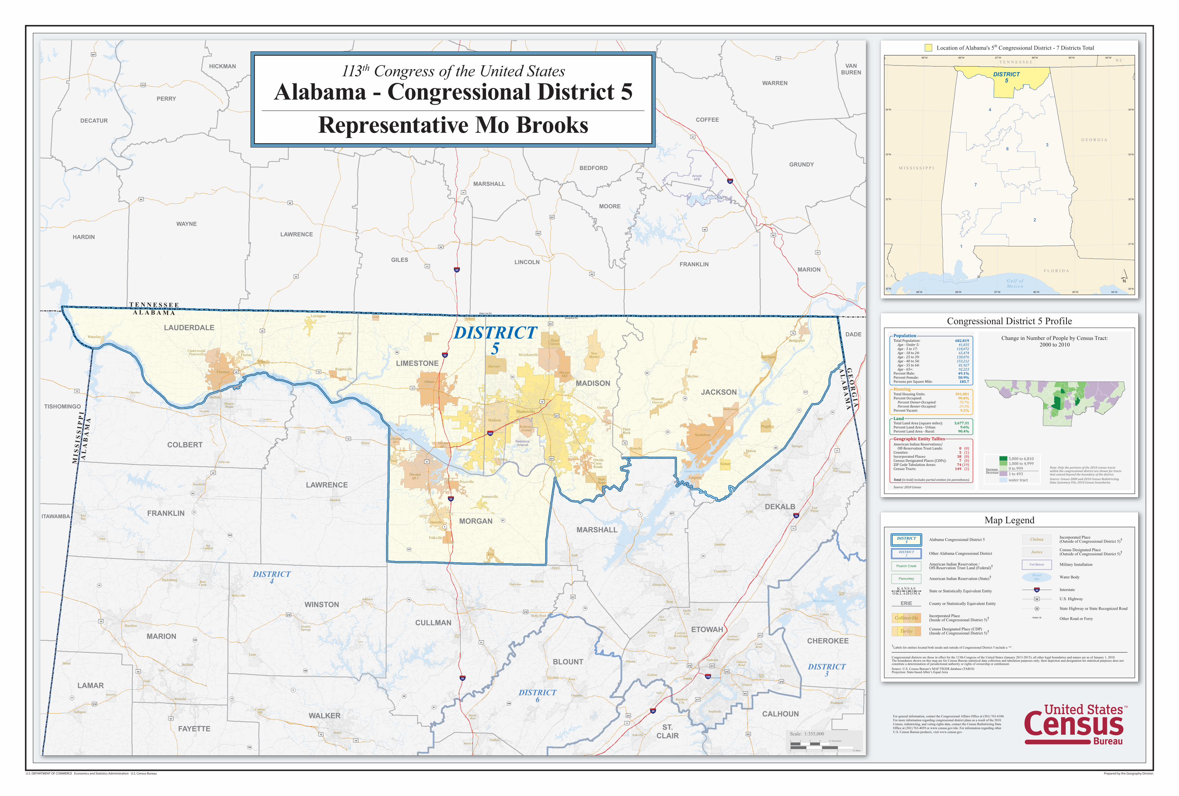
Congressional District 5 ProfileChange in Number of People by Census Tract:

2000 to 2010

Note: Only the portions of the 2010 census tractswithin the congressional district are shown for tractsthat extend beyond the boundary of the district.Source: Census 2000 and 2010 Census RedistrictingData Summary File; 2010 Census boundaries

5,000 to 6,810

DecreaseIncrease

1,000 to 4,999

0 to 999

1 to 493

water tract

Source: 2010 Census

Total (in bold) includes partial entities (in parentheses).

American Indian Reservations/ Off-Reservation Trust Lands:Counties:Incorporated Places:Census Designated Places (CDPs):ZIP Code Tabulation Areas:Census Tracts:

(0)(1)(0)(0)

(19)(2)

Geographic Entity Tallies

05

387

74149

3,677.319.6%

90.4%

Total Land Area (square miles):Percent Land Area - Urban:Percent Land Area - Rural:

Land

301,081 90.8%

70.7%29.3% 9.2%

HousingTotal Housing Units:Percent Occupied: Percent Owner-Occupied: Percent Renter-Occupied:Percent Vacant:

PopulationTotal Population: Age - Under 5: Age - 5 to 17: Age - 18 to 24: Age - 25 to 39: Age - 40 to 54: Age - 55 to 64: Age - 65+:Percent Male:Percent Female:Persons per Square Mile:

682,81941,835

118,07265,474

130,076153,212

81,92792,22349.1%50.9%185.7

7

2

4

3

1

6

G E O R G I A

M I S S I S S I P P I

F L O R I D A

T E N N E S S E E

L A

N C

Gu l f o fMex i co

DISTRICT5

87°W

87°W

84°W

84°W

85°W

85°W

86°W

86°W

88°W

88°W

89°W

89°W

34°N 34°N

33°N 33°N

32°N 32°N

31°N

30°N 30°N

Location of Alabama's 5th Congressional District - 7 Districts Total

Weiss Reservoir

Carlisle-Rockledge

Guntersville Lk

FairviewBaileyton

West Point

AddisonHaleyville

Littleville

Hillsboro

Town Creek

Leighton

Hatton

Cherokee

231

Holly Pond

Grant

Decatur(pt.) Decatur

(pt.)

231

78

43

43

231

411

64

64

64

31

70

11

72

11

72

72

231

431

431

278

412

64

278

43

11

431

412

6

74

3

1

65

65

24

75965

24

59

59

65

565

278

278

31

641

278

43

72

411

412

412

41

78

278

231

43

78

41

231

231

41

31

231

23131

431

31

231

31

4131

31

31

431

231

31

31

231

64

431

43

41

231

231

231231

3131

231

431

31

231

231

231

41

231

64

72

31

43

31

31

72

72

65

71

5

102

160

157

75

243

17

195

40

75

13

117

227

129

91

79

79

65

69

19

24

13

35

99

53

67

Borderline Rd

State Line Rd

ArnoldAFB

RedstoneArsenal

Wilson Lk

Tennessee Riv

WheelerLk

DISTRICT5

DISTRICT3

DISTRICT4

DISTRICT6

LAWRENCE

ITAWAMBA

LEWIS

TISHOMINGO

MARSHALL

COFFEE

BEDFORD

HARDIN

PERRY

GILES

WAYNE

DECATUR

MOORE

MAURY

HICKMAN

WARREN

GRUNDY

VANBUREN

FRANKLINMARION

LINCOLN

RUTHERFORD

DADE

WILLIAMSON

MI S

SI S

SI P

PI

AL

AB

AM

A

AL

AB

AM

AG

EO

RG

I A

A L A B A M AT E N N E S S E E

LAMAR

COLBERT

LAUDERDALE

WINSTON

MARION

FRANKLIN

CHEROKEE

DEKALB

CLEBURNE

ETOWAH

JACKSON

CALHOUN

FAYETTE

MORGANMARSHALL

CULLMAN

WALKER

BLOUNT

LIMESTONE

MADISON

ST.CLAIR

LAWRENCE

Ardmore

Athens

Decatur(pt.)

Eva

Florence

Hartselle

HollywoodHuntsville

Killen

Langston

Lester

Madison

NewHope

Pisgah

Scottsboro

Section

Stevenson

Trinity

Woodville

Anderson

Bridgeport

Dutton

Elkmont

Falkville

Gurley

Hytop

Lexington

Mooresville

OwensCrossRoads

PaintRock

PleasantGroves

Priceville

Rogersville

St.Florian

Skyline

Somerville

Triana

Waterloo

Albertville

Altoona

Arab

Arley

Attalla

BearCreek

Beaverton

Boaz

Brilliant

CarbonHill

CedarBluff

Cleveland

Courtland

Crossville

Detroit

Fyffe

Geraldine

Glencoe

GoodHope

Guin

Hackleburg

Henagar

Hodges

HokesBluff

Ider

Jacksonville

Leesburg

Lynn

Mentone

MuscleShoals

PhilCampbell

Piedmont

Powell

RainbowCity

Rainsville

RedBay

Rosa

SardisCity

Sheffield

Snead

Southside

Steele

Sulligent

Sylvania

Trafford

Twin

ValleyHead

Vina

Warrior

Winfield

Ashville

Centre

Cullman

DoubleSprings

FortPayne

Gadsden

Guntersville

Hamilton

Jasper

Moulton

Oneonta

Russellville

Tuscumbia

Harvest

HazelGreen

MooresMill

NewMarket

RedstoneArsenal

MeridianvilleUnderwood-Petersville

Ballplay

BristowCove

CoatsBendEgypt

Gallant

Ivalee

Joppa

LookoutMountain

NewUnion

SmokeRise

TidmoreBend

Whitesboro

1:355,000Scale:

0 3 6 9 12 Miles

0 3 6 9 12 Kilometers

113th Congress of the United StatesAlabama - Congressional District 5

Representative Mo Brooks