64. hachijojima - data.jma.go.jp
TRANSCRIPT
(64. Hachijojima)
1
64. Hachijojima
Continuously Monitored by JMA Latitude: 33°08'13" N, Longitude: 139°45'58" E, Elevation: 854 m
(Nishiyama) (Triangulation Point - Hachijo-Fuji) Latitude: 33°05'31" N, Longitude: 139°48'44" E, Elevation: 701 m
(Higashiyama) (Triangulation Point - Miharayama)
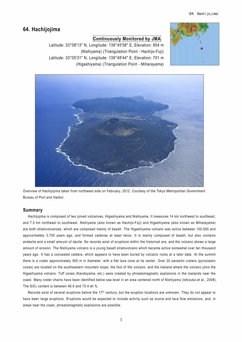
Overview of Hachijojima taken from northwest side on February, 2012. Courtesy of the Tokyo Metropolitan Government
Bureau of Port and Harbor.
Summary
Hachijojima is composed of two joined volcanoes, Higashiyama and Nishiyama. It measures 14 km northwest to southeast,
and 7.5 km northeast to southwest. Nishiyama (also known as Hachijo-Fuji) and Higashiyama (also known as Miharayama)
are both stratovolcanoes, which are composed mainly of basalt. The Higashiyama volcano was active between 100,000 and
approximately 3,700 years ago, and formed calderas at least twice. It is mainly composed of basalt, but also contains
andesite and a small amount of dacite. No records exist of eruptions within the historical era, and the volcano shows a large
amount of erosion. The Nishiyama volcano is a young basalt stratovolcano which became active somewhat over ten thousand
years ago. I t has a concealed caldera, which appears to have been buried by volcanic rocks at a later date. At the summit
there is a crater approximately 500 m in diameter, with a flat lava cone at its center. Over 20 parasitic craters (pyroclastic
cones) are located on the southeastern mountain slope, the foot of the volcano, and the lowland where the volcano joins the
Higashiyama volcano. Tuff cones (Kandoyama, etc.) were created by phreatomagmatic explosions in the lowlands near the
coast. Many crater chains have been identi fied below sea level in an area centered north of Nishiyama (Ishizuka et al., 2008). The SiO2 content is between 46.6 and 73.4 wt %.
Records exist of several eruptions before the 17 th century, but the eruption locations are unknown. They do not appear to
have been large eruptions. Eruptions would be expected to include activi ty such as scoria and lava flow emissions, and, in
areas near the coast, phreatomagmatic explosions are possible.
(64. Hachijojima)
2
Photo
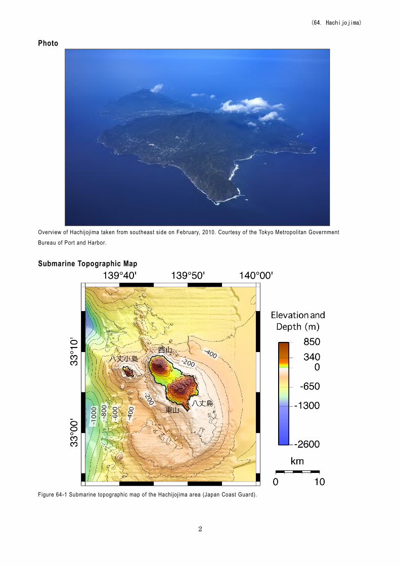
Overview of Hachijojima taken from southeast side on February, 2010. Courtesy of the Tokyo Metropolitan Government
Bureau of Port and Harbor.
Submarine Topographic Map
Figure 64-1 Submarine topographic map of the Hachijojima area (Japan Coast Guard).
(64. Hachijojima)
3
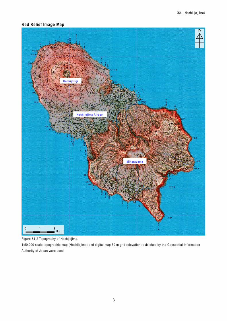
Red Relief Image Map
Figure 64-2 Topography of Hachijojima. 1:50,000 scale topographic map (Hachijojima) and digital map 50 m grid (elevation) published by the Geospatial Information
Authori ty of Japan were used.
Hachijofuji
Hachijojima Airport
Miharayama
(64. Hachijojima)
4
Geological Map
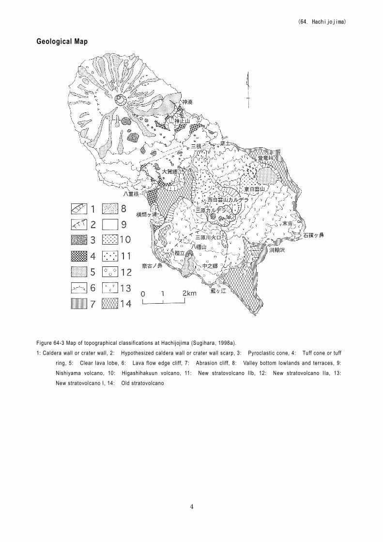
Figure 64-3 Map of topographical classifications at Hachijojima (Sugihara, 1998a).
1: Caldera wall or crater wall , 2: Hypothesized caldera wall or crater wall scarp, 3: Pyroclastic cone, 4: Tuff cone or tuff
ring, 5: Clear lava lobe, 6: Lava flow edge cliff, 7: Abrasion cliff, 8: Valley bottom lowlands and terraces, 9:
Nishiyama volcano, 10: Higashihakuun volcano, 11: New stratovolcano IIb, 12: New stratovolcano IIa, 13:
New stratovolcano I, 14: Old stratovolcano
(64. Hachijojima)
5
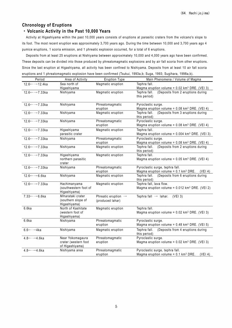
Chronology of Eruptions ・Volcanic Activity in the Past 10,000 Years
Activi ty at Higashiyama within the past 10,000 years consists of eruptions at parasitic craters from the volcano's slope to
its foot. The most recent eruption was approximately 3,700 years ago. During the time between 10,000 and 3,700 years ago 4
pumice eruptions, 1 scoria emission, and 1 phreatic explosion occurred, for a total of 6 eruptions. Deposits from at least 25 eruptions at Nishiyama between approximately 10,000 and 4,000 years ago have been confirmed.
These deposits can be divided into those produced by phreatomagmatic explosions and by air fall scoria from other eruptions. Since the last eruption at Higashiyama, all activity has been confined to Nishiyama. Deposits from at least 10 air fall scoria
eruptions and 1 phreatomagmatic explosion have been confirmed (Tsukui, 1993a,b; Suga, 1993; Sugihara, 1998a,b). Period Area of Activity Eruption Type Main Phenomena / Volume of Magma
12.6←→12.4ka Sea north of Higashiyama
Magmatic eruption Tephra fall. Magma eruption volume = 0.02 km3 DRE. (VEI 3)
12.6←→7.33ka Nishiyama Magmatic eruption Tephra fall. (Deposits from 2 eruptions during this period)
12.6←→7.33ka Nishiyama Phreatomagmatic eruption
Pyroclastic surge. Magma eruption volume = 0.08 km3 DRE. (VEI 4)
12.6←→7.33ka Nishiyama
Magmatic eruption Tephra fall. (Deposits from 3 eruptions during this period)
12.6←→7.33ka Nishiyama
Phreatomagmatic eruption
Pyroclastic surge. Magma eruption volume = 0.08 km3 DRE. (VEI 4)
12.6←→7.33ka Higashiyama parasitic crater
Magmatic eruption Tephra fall. Magma eruption volume = 0.004 km3 DRE. (VEI 3)
12.6←→7.33ka Nishiyama Phreatomagmatic eruption
Pyroclastic surge. Magma eruption volume = 0.08 km3 DRE. (VEI 4)
12.6←→7.33ka Nishiyama Magmatic eruption Tephra fall. (Deposits from 2 eruptions during this period)
12.6←→7.33ka Higashiyama northern parasitic crater
Magmatic eruption Tephra fall. Magma eruption volume = 0.05 km3 DRE. (VEI 4)
12.6←→7.33ka Nishiyama Phreatomagmatic eruption
Pyroclastic surge, tephra fall. Magma eruption volume = 0.1 km3 DRE. (VEI 4)
12.6←→6.6ka Nishiyama Magmatic eruption Tephra fall. (Deposits from 6 eruptions during this period)
12.6←→7.33ka Hachimanyama (southwestern foot of Higashiyama)
Magmatic eruption Tephra fall, lava flow. Magma eruption volume = 0.012 km3 DRE. (VEI 2)
7.33←→6.6ka Miharataki crater (southern slope of Higashiyama)
Phreatic eruption → (produced lahar)
Tephra fall → lahar. (VEI 3)
6.6ka North of Kashitate (western foot of Higashiyama)
Magmatic eruption Tephra fall. Magma eruption volume = 0.02 km3 DRE. (VEI 3)
6.6ka Nishiyama Phreatomagmatic eruption
Pyroclastic surge. Magma eruption volume = 0.48 km3 DRE. (VEI 5)
6.6←→4ka Nishiyama Magmatic eruption Tephra fall. (Deposits from 4 eruptions during this period)
4.8←→4.6ka Near Yokomagaura crater (western foot of Higashiyama)
Phreatomagmatic eruption
Pyroclastic surge. Magma eruption volume = 0.02 km3 DRE. (VEI 3)
4.8←→4.6ka Nishiyama area Phreatomagmatic eruption
Pyroclastic surge, tephra fall. Magma eruption volume = 0.1 km3 DRE. (VEI 4)
(64. Hachijojima)
6
Period Area of Activity Eruption Type Main Phenomena / Volume of Magma 4 ka horseshoe-shaped
crater on northern slope of Higashihakuunzan (northeastern foot of Higashiyama)
Magmatic eruption Tephra fall. Magma eruption volume = 0.004 km3 DRE. (VEI 3)
4 ka Kandoyama area (southeastern foot of Nishiyama)
Phreatomagmatic eruption
Tephra fall, pyroclastic surge. Magma eruption volume = 0.48 km3 DRE. (VEI 5)
4←→2.4 ka Nishiyama Magmatic eruption Tephra fall. (Deposits from 2 eruptions during this period)
3.8←→2.4 ka Kandoyama (southeastern foot of Nishiyama)
Phreatomagmatic eruption
Tephra fall → pyroclastic surge. (Deposits from 3 eruptions during this period)
2.7←→1.9 ka Yaene crater group (northwestern foot of Higashiyama)
Phreatomagmatic eruption
Pyroclastic surge, tephra fall. Magma eruption volume = 0.02 km3 DRE. (VEI 3)
2.7 ka> Nishiyama Magmatic eruption Lava flow. 2.4←→2.2 ka Nishiyama summit Magmatic eruption Tephra fall.
1.218←→0.984 ka Pyroclastic cone near western side of Kandoyama (southwestern foot of Nishiyama)
Magmatic eruption Tephra fall.
1.218←→0.984 ka Pyroclastic cone near western side of Kandoyama (southwestern foot of Nishiyama)
Magmatic eruption Tephra fall.
1.218←→0.984 ka Nishiyama summit Magmatic eruption Lava flow → tephra fall. * Volcanic periods, areas of activity, and eruption types taken from the Active Volcano Database of Japan, AIST (Kudo and
Hoshizumi, 2006 ). All years are noted in calendar yeat "ka" within the table indicates "1000 years ago", with the year 2000 set as 0 ka.
A←→B: Eruption events taking place at some point between year A and year B A>: Eruption event after year A.
・Historical Activity
Year Phenomenon Activi ty Sequence, Damages, etc. 1487 (Chokyo 1) Eruption December 7. The eruption occurred at Nishiyama. The eruption resulted in
a famine. 1518 to 1523 (Eisho
15 to Daiei 3) Magmatic eruption The eruption began on February 18, at the summit of Nishiyama.
It resulted in significant mulberry farm damage. 1605 (Keicho 10) Moderate:
Magmatic eruption October 27. Tephra fall, lava flow. The eruption occurred at the fissure crater chains on the southeastern slope of Nishiyama. I t resulted in agricultural land damage. Magma eruption volume = 0.0046 km3 DRE. (VEI 2)
1606 (Keicho 10) Eruption January 23. A submarine eruption near Hachijojima produced a volcanic island. (Note: I ts position and following status is unknown)
1691 to 1692 (Genroku 4 to 5)
Earthquake 10 to 20 felt-earthquakes occurred per month.
1696 to 1697 (Genroku 9 to 10)
Earthquake Several felt-earthquakes occurred per month.
2002 (Heisei 14) Earthquake, crustal deformation
Mid- to late August. The seismic activity increased, with hypocenters at depths of 10 to 20 km, from Hachijojima Nishiyama to the sea to the northwest (JMA scale seismic intensity of 2 on the island itself). Crustal deformation resulting in a displacement by Hachijojima of 5 cm to the east was confirmed. Based on the deep low-frequency earthquakes and crustal deformation, it has been deduced that there was magma intrusion directly below Nishiyama. In mid-December there was also a slight temporary increase in earthquakes at a depth of approximately 10 km near Hachijojima Nishiyama.
* Reference documents have been appended with reference to the Active Volcano Database of Japan, AIST (Kudo and
(64. Hachijojima)
7
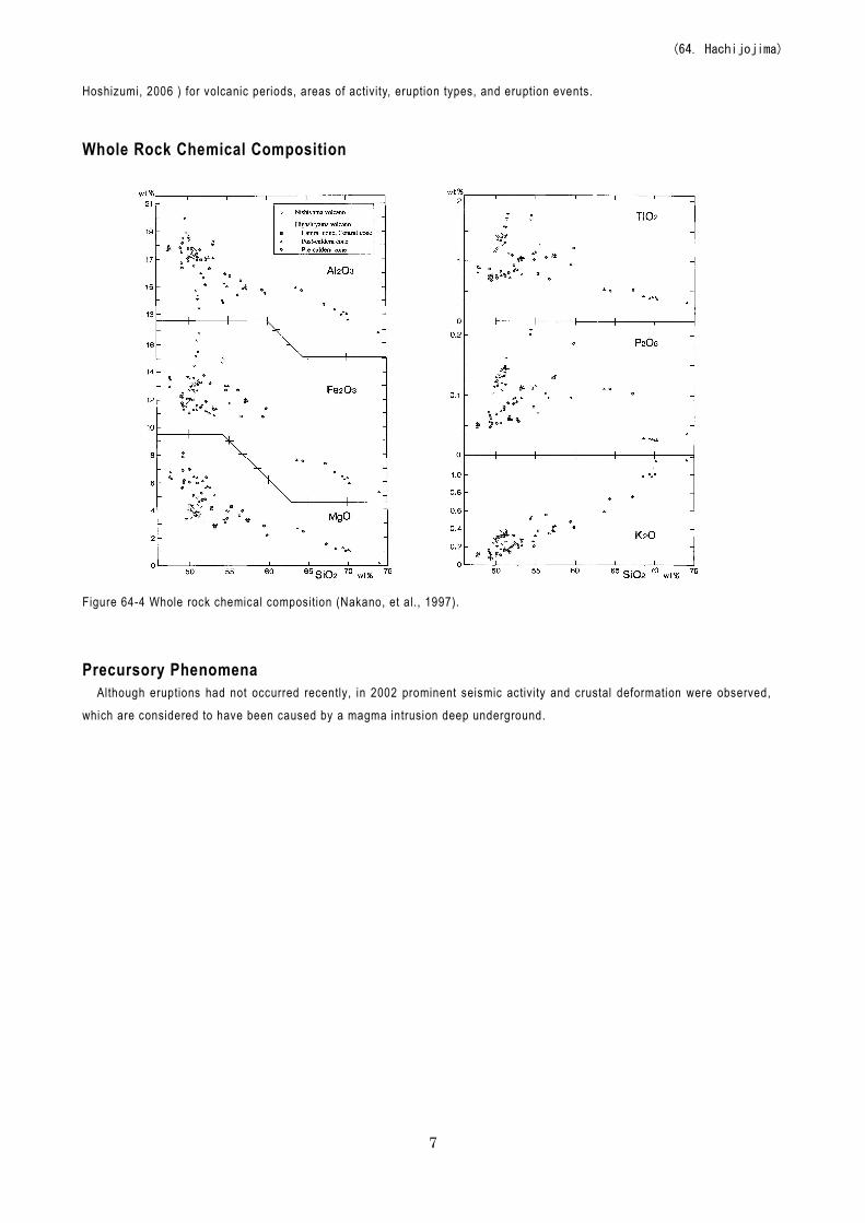
Hoshizumi, 2006 ) for volcanic periods, areas of activity, eruption types, and eruption events. Whole Rock Chemical Composition
Figure 64-4 Whole rock chemical composition (Nakano, et al., 1997).
Precursory Phenomena
Although eruptions had not occurred recently, in 2002 prominent seismic activi ty and crustal deformation were observed,
which are considered to have been caused by a magma intrusion deep underground.
(64. Hachijojima)
8
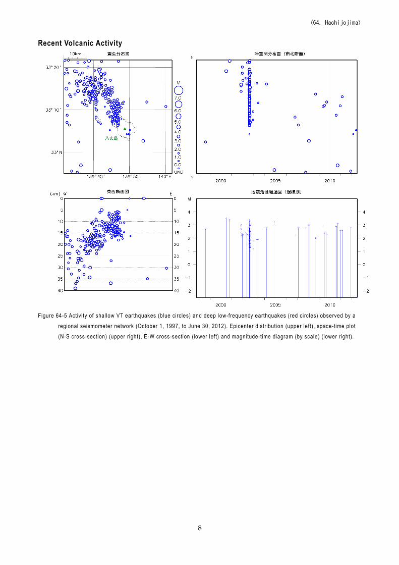
Recent Volcanic Activity
Figure 64-5 Activi ty of shallow VT earthquakes (blue circles) and deep low-frequency earthquakes (red circles) observed by a
regional seismometer network (October 1, 1997, to June 30, 2012). Epicenter distribution (upper left), space-time plot
(N-S cross-section) (upper right), E-W cross-section (lower left) and magnitude-time diagram (by scale) (lower right).
(64. Hachijojima)
9
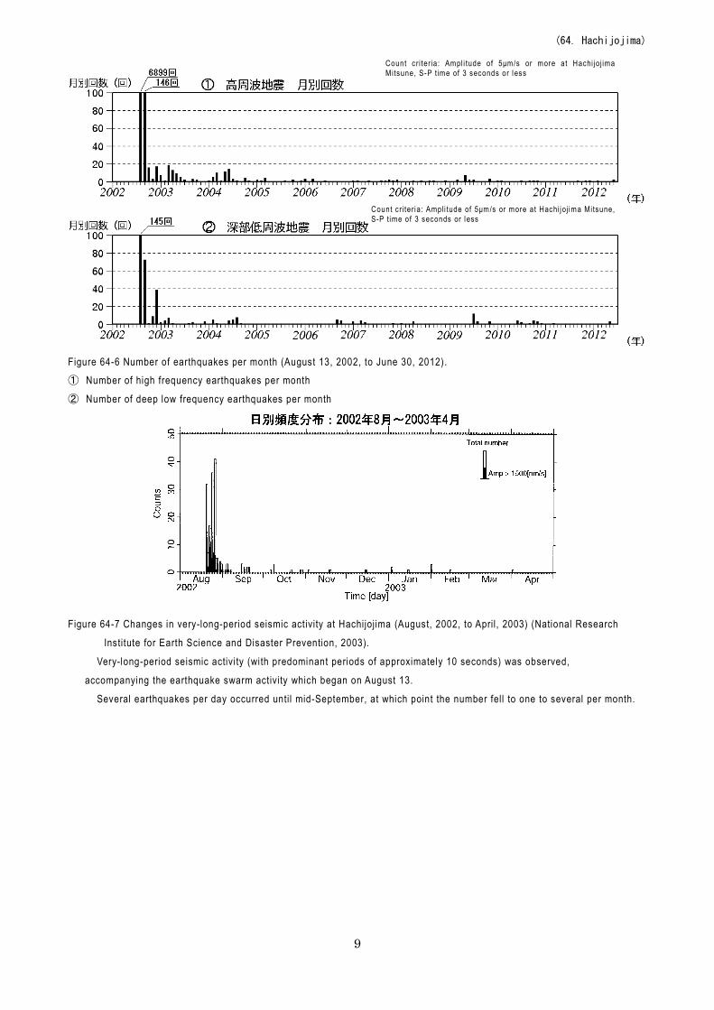
Figure 64-6 Number of earthquakes per month (August 13, 2002, to June 30, 2012). ① Number of high frequency earthquakes per month
② Number of deep low frequency earthquakes per month
Figure 64-7 Changes in very-long-period seismic activity at Hachijojima (August, 2002, to April, 2003) (National Research
Institute for Earth Science and Disaster Prevention, 2003).
Very-long-period seismic activi ty (with predominant periods of approximately 10 seconds) was observed,
accompanying the earthquake swarm activity which began on August 13. Several earthquakes per day occurred until mid-September, at which point the number fell to one to several per month.
Count c r i ter ia: Ampl i tude of 5μm/s or more at Hachi joj ima Mitsune, S-P time of 3 seconds or less
Count c r i ter ia: Ampl i tude of 5μm/s or more at Hachi joj ima Mitsune, S-P time of 3 seconds or less
(64. Hachijojima)
10
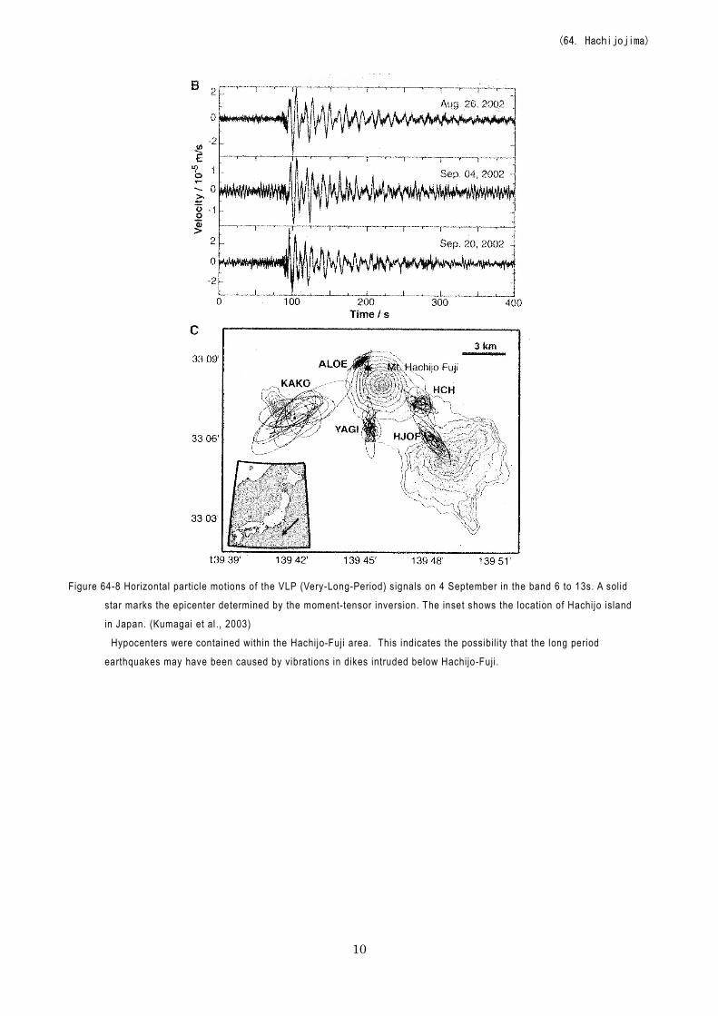
Figure 64-8 Horizontal particle motions of the VLP (Very-Long-Period) signals on 4 September in the band 6 to 13s. A solid
star marks the epicenter determined by the moment-tensor inversion. The inset shows the location of Hachijo island
in Japan. (Kumagai et al., 2003)
Hypocenters were contained within the Hachijo-Fuji area. This indicates the possibility that the long period
earthquakes may have been caused by vibrations in dikes intruded below Hachijo-Fuji.
(64. Hachijojima)
11
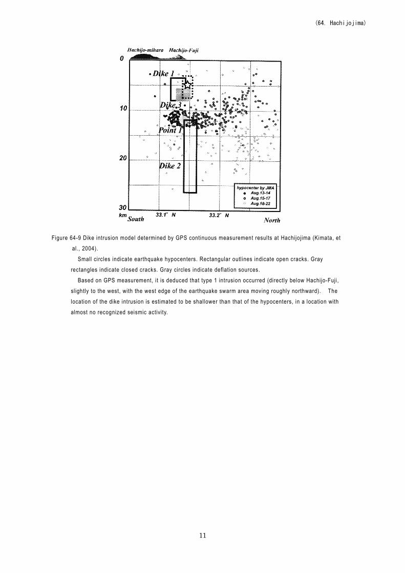
Figure 64-9 Dike intrusion model determined by GPS continuous measurement results at Hachijojima (Kimata, et
al., 2004).
Small circles indicate earthquake hypocenters. Rectangular outlines indicate open cracks. Gray
rectangles indicate closed cracks. Gray circles indicate deflation sources.
Based on GPS measurement, i t is deduced that type 1 intrusion occurred (directly below Hachijo-Fuji ,
slightly to the west, with the west edge of the earthquake swarm area moving roughly northward). The
location of the dike intrusion is estimated to be shallower than that of the hypocenters, in a location with
almost no recognized seismic activity.
(64. Hachijojima)
12
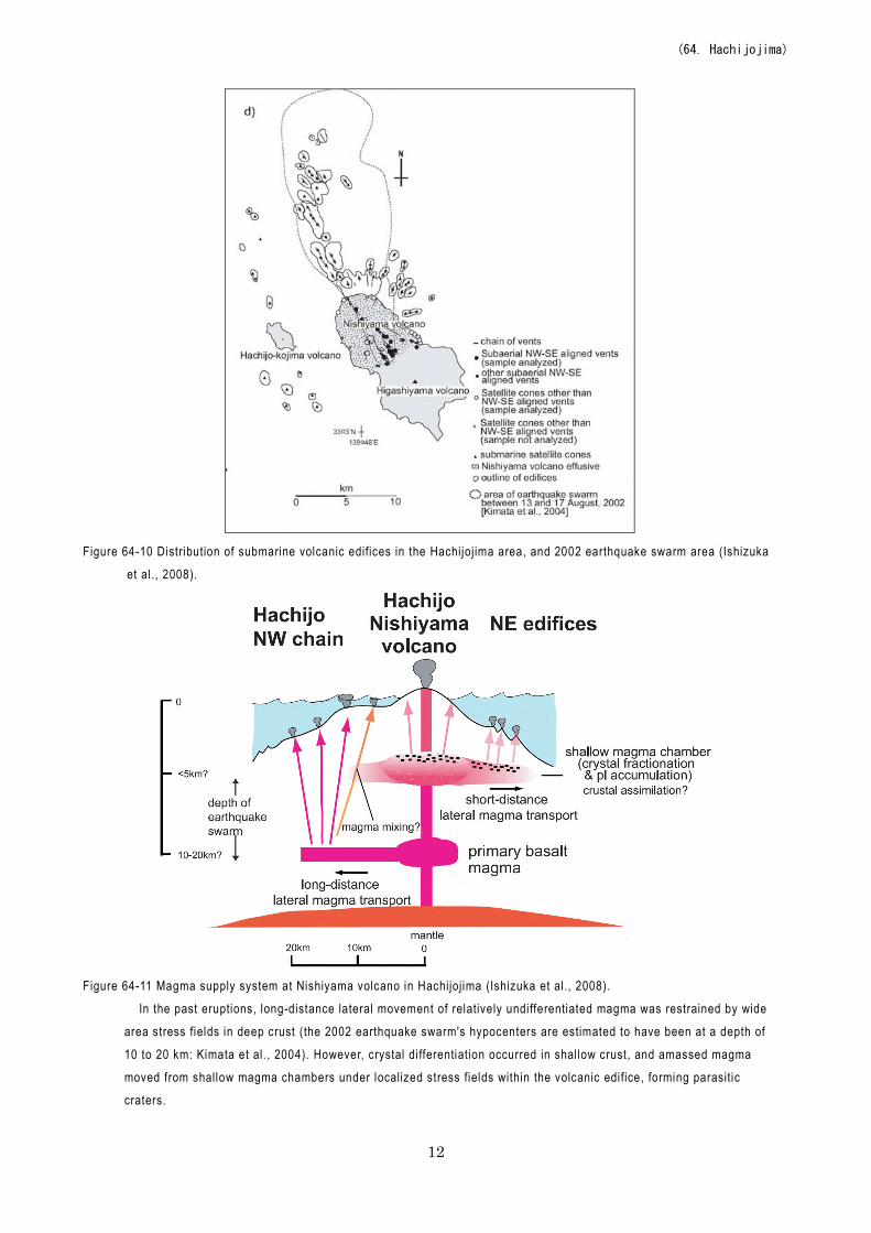
Figure 64-10 Distribution of submarine volcanic edifices in the Hachijojima area, and 2002 earthquake swarm area (Ishizuka
et al., 2008).
Figure 64-11 Magma supply system at Nishiyama volcano in Hachijojima (Ishizuka et al., 2008).
In the past eruptions, long-distance lateral movement of relatively undifferentiated magma was restrained by wide
area stress fields in deep crust (the 2002 earthquake swarm's hypocenters are estimated to have been at a depth of
10 to 20 km: Kimata et al., 2004). However, crystal differentiation occurred in shallow crust, and amassed magma
moved from shallow magma chambers under localized stress fields within the volcanic edifice, forming parasitic
craters.
(64. Hachijojima)
13
Information on Disaster Prevention ①Hazard Map None Social Circumstances ①Populations
・ Island population: 8,206 (according to Hachijo statistics as of December 1, 2011) ・Volcano foot residential area, etc.: 2.0 km from the Hachijo-Fuji crater.
②National Parks, Quasi-National Parks, Number of Climbers ・Fuji-Hakone-Izu National Park Hachijojima
Number of sightseers per year: Approximately 100,000 (according to Hachijo statistics) Number of mountain-climbers per year: Unknown
③Facilities ・Port facilities Kaminato Port (Sokodo Port), Yaene Port Hachijo Visitor Center
Hachijo City Hall Museum of History and Folklore
(64. Hachijojima)
14
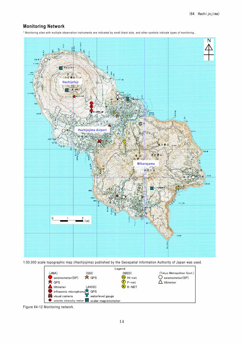
Monitoring Network * Moni tor ing si tes wi th multiple observat ion ins truments are indicated by smal l b lack dots , and other symbols indicate types of moni tor ing. .
1:50,000 scale topographic map (Hachijojima) published by the Geospatial Information Authority of Japan was used.
(JMA) (GSI) (NIED)
seismometer(SP) GPS Hi-net seismometer(SP)
GPS F-net tiltmeter
tiltmeter (JHOD) K-NET
infrasonic microphone GPS
visual camera waterlevel gauge
seismic intensity meter scalar magnetometer
(Tokyo Metropolitan Govt.)
Legend
Figure 64-12 Monitoring network.
Hachijofuji
Miharayama
Hachijojima Airport
(64. Hachijojima)
15
Bibliography Ishizuka, O., et al. (2008) J. Geophys. Res., 113, doi:10.1029/2007JB005325. Kimata, F., et al. (2004) Bull. Volcanol. Soc. Jpn., 49, 13-22 (in Japanese with English Abstract). Kumagai, H., et al. (2003) Science, 299, 2058-2061. Nakano, S., et al. (1997) Bull. Geol. Surv. Japan, 48, 93-105 (in Japanese with English Abstract). National Research Institute for Earth Science and Disaster Prevention (NIED) (2003) Report of Coordinating
Committee for Prediction of Volcanic Eruption, 85, 79-81 (in Japanese). Suga, K. (1994) Bull. Volcanol. Soc. Jpn., 39, 13-24 (in Japanese with English Abstract). Suga, K. (1993) Bull. Volcanol. Soc. Jpn., 38, 115-127 (in Japanese with English Abstract). Sugihara, S. (1998a) Jour. Geography (Chigaku Zasshi), 107, 390-420 (in Japanese). Sugihara, S. (1998b) Jour. Geography (Chigaku Zasshi), 107, 695-712 (in Japanese). Tsukui, M. et al. (1991) Bull. Volcanol. Soc. Jpn., 36, 345-356 (in Japanese with English Abstract). Tsukui, M et al. (1993) Bull. Volcanol. Soc. Jpn., 38, 199-212 (in Japanese with English Abstract). Tsukui, M. (2003) Report of Coordinating Committee for Prediction of Volcanic Eruption, 83, 67-69 (in
Japanese).
(Tsukui, M.)