62nd dr, 63rd rd, and grand central py
TRANSCRIPT
62nd Dr, 63rd Rd,
and Grand Central PkwyPresentation to Queens Community Board 6
June 17, 2021

nyc.gov/visionzero
GREEN WAVE: A PLAN FOR CYCLING IN NYC
2
Citywide Protected Bike Lane Network:
• Build 30 miles of protected bicycle lane annually
Better Design:
• Implement new design standards based on national &
international best practices to enhance safety
• Continue piloting new designs with rigorous safety
analysis
Education and Outreach:
• Launch next phase of Vision Zero public awareness
campaign, educating drivers, focusing on cyclist safety
• Educate all street users about safety on city streets
• Increase helmet giveaways and helmet use
encouragement
Background: Expanding the Protected Bike Network
+35% growth in daily cycling in New York City
between 2013 and 2018
On a typical day, there are about 510,000 cycling
trips made in New York City
Cycling in Numbers
Plan Goals
nyc.gov/visionzero
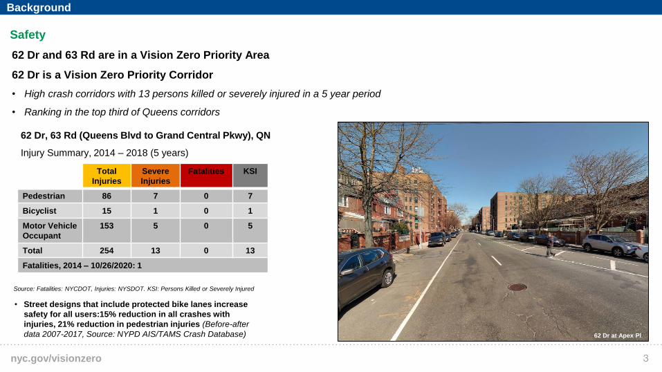
Safety
62 Dr and 63 Rd are in a Vision Zero Priority Area
62 Dr is a Vision Zero Priority Corridor
• High crash corridors with 13 persons killed or severely injured in a 5 year period
• Ranking in the top third of Queens corridors
Source: Fatalities: NYCDOT, Injuries: NYSDOT. KSI: Persons Killed or Severely Injured
62 Dr at Apex Pl
3
62 Dr, 63 Rd (Queens Blvd to Grand Central Pkwy), QN
Injury Summary, 2014 – 2018 (5 years)
Total
Injuries
Severe
Injuries
Fatalities KSI
Pedestrian 86 7 0 7
Bicyclist 15 1 0 1
Motor Vehicle
Occupant
153 5 0 5
Total 254 13 0 13
Fatalities, 2014 – 10/26/2020: 1
• Street designs that include protected bike lanes increase
safety for all users:15% reduction in all crashes with
injuries, 21% reduction in pedestrian injuries (Before-after
data 2007-2017, Source: NYPD AIS/TAMS Crash Database)
Background

nyc.gov/visionzero
Improve Safety For All
Road Users
• Reduce speeding
• Safer pedestrian crossings
• Create safer bike connection
between Flushing Meadows
Park and Queens Blvd (links to
Kosciuszko and Queensboro
Bridges)
Requested Improvements
4

nyc.gov/visionzero
Data from 25 separate protected bicycle lane projects installed from 2007-2014
with 3 years of after data. Includes portions of 1 Ave, 2 Ave, 8 Ave, 9 Ave,
Broadway, Columbus Ave, Hudson St, Lafayette St / 4 Ave, Sands St, Allen/Pike St,
Kent Ave, Prospect Park West, Flushing Ave, Bruckner Blvd & Longfellow Ave,
Imlay St / Conover St, Paerdegat Ave. Only sections of projects that included
protected bike lanes were analyzed.
Source: NYPD AIS/TAMS Crash Database
SAFETY – COMPLETE STREET REDESIGN
111th St, ,Queens
Street designs that include protected bike lanes increase
safety for all users
-15% drop in all crashes with injuries and
-21% drop in pedestrian injuries on streets with
protected bike lanes installed 2007-2017
Injuries to cyclists increased only 3%, despite a 61% bike
volume increase
Protected Bike Lanes Before and After Crash Data, 2007 - 2017
1,477
627 628
224
1,263
533 499
231 -
200
400
600
800
1,000
1,200
1,400
1,600
Total Injuries MV OccupantInjuries
PedestrianInjuries
Cyclist Injuries
To
tal o
f 3-y
ear
Av
era
ges
Before5
Background: Expanding the Protected Bike Network
nyc.gov/visionzero
1Existing
6
nyc.gov/visionzero
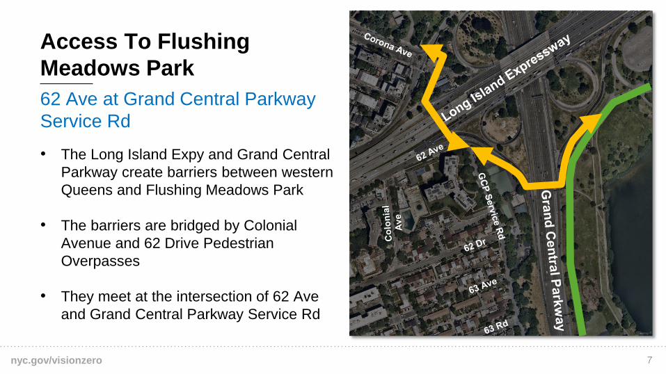
62 Ave at Grand Central Parkway
Service Rd
• The Long Island Expy and Grand Central
Parkway create barriers between western
Queens and Flushing Meadows Park
• The barriers are bridged by Colonial
Avenue and 62 Drive Pedestrian
Overpasses
• They meet at the intersection of 62 Ave
and Grand Central Parkway Service Rd
Access To Flushing
Meadows Park
7
nyc.gov/visionzero
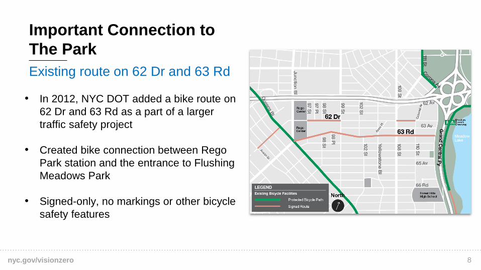
Existing route on 62 Dr and 63 Rd
Important Connection to
The Park
• In 2012, NYC DOT added a bike route on
62 Dr and 63 Rd as a part of a larger
traffic safety project
• Created bike connection between Rego
Park station and the entrance to Flushing
Meadows Park
• Signed-only, no markings or other bicycle
safety features
8
nyc.gov/visionzero
10 years of expansion
Surrounding Bike Network
Has Improved
• Protected bike routes link Bridges to Forest Hills
and Astoria via Queens Blvd and Crescent St
• Neighbood bike networks to the north and west in
Jackson Heights, Elmhurst, and Corona
• Continued expansion to the east of the park in
Flushing and Briarwood
West of Project Location
East of Project Location
9

nyc.gov/visionzero
Existing Routes on 62 Dr and 63 Rd
are ripe for improvement
Gap in the Bike Network
• Current route lacks dedicated bicycle travel
space
• Current design asks cyclists to ride with
moving vehicle traffic
• Excess road space can be repurposed to
create safer pedestrian and bicycle
connections
63 Rd
Skillman Ave Queen Plaza
Queens Blvd Queens Blvd Bridge
10

nyc.gov/visionzero
2Proposed
11

nyc.gov/visionzero
Close The Gap By Adding
Protected Lanes
• Narrow the roadway
• Cyclists are given more protection
and greater comfort on their way
to the park by creating a bike path
between the curb and parking
lanes
• Roadways with protected bike
lanes improve safety for all
roadway users.
Upgrade To Protected
Route and Calm Traffic
12
nyc.gov/visionzero
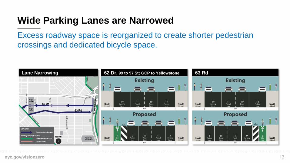
Excess roadway space is reorganized to create shorter pedestrian
crossings and dedicated bicycle space.
Wide Parking Lanes are Narrowed
62 Dr, 99 to 97 St; GCP to Yellowstone 63 RdLane Narrowing
13
nyc.gov/visionzero
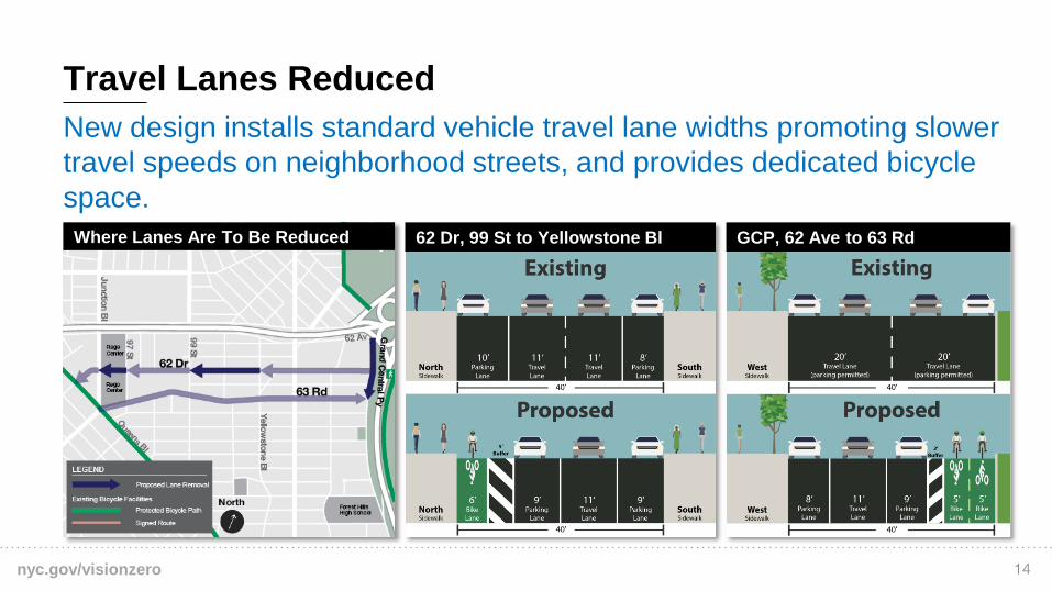
New design installs standard vehicle travel lane widths promoting slower
travel speeds on neighborhood streets, and provides dedicated bicycle
space.
Travel Lanes Reduced
62 Dr, 99 St to Yellowstone Bl GCP, 62 Ave to 63 RdWhere Lanes Are To Be Reduced
14

nyc.gov/visionzero
Vertical protection added where parking is not currently allowed
Gaps In Parking Protection Closed
62 Dr, Junction Bl to 97 StGap To Be Closed
15

nyc.gov/visionzero
New Treatments Added Where
Vehicles Cross Bike Lane
• New design will increase visibility at
driveways and intersections,
boosting safety for all road users
• Slower, safer turning vehicles
Intersections Safety
Measures Added
Offset Crossing
Mixing Zone
16

nyc.gov/visionzero
3Summary
17
nyc.gov/visionzero
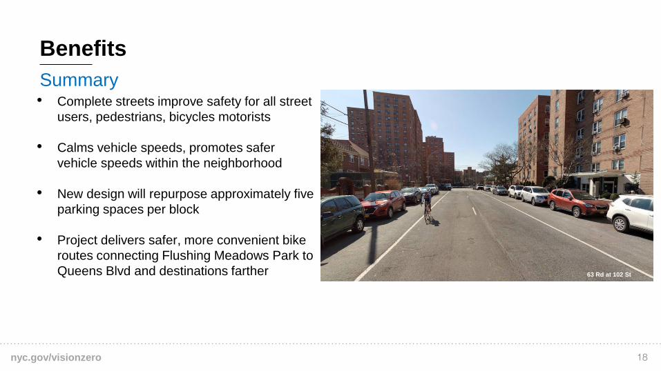
Summary
Benefits
• Complete streets improve safety for all street
users, pedestrians, bicycles motorists
• Calms vehicle speeds, promotes safer
vehicle speeds within the neighborhood
• New design will repurpose approximately five
parking spaces per block
• Project delivers safer, more convenient bike
routes connecting Flushing Meadows Park to
Queens Blvd and destinations farther 63 Rd at 102 St
18
nyc.gov/visionzero
NYCDOT nyc_dot nyc_dot NYCDOT
Questions?
Thank You.
19