61613 cumbrae walks & cycling - north-ayrshire.gov.uk · seen ben lomond and the hills...
TRANSCRIPT

Starting Point: Millport PierDistance: 4.4 miles / 7.0km
Max. Elevation: 181'/55m
Starting off from the Old Pier, head off up Cardiff Streetkeeping uphill by Golf Road. Just before the car park forthe golf club the route forks left onto the farm road.Skirting the steading the path goes right through a kissinggate and follows the line of the fence as it disappears overthe horizon parallel to the sea.
Spectacular views can be enjoyed from the top of the hilland on the descent. To the left you can see Kilchattan Bayon the Island of Bute and also Mount Stuart the residenceof the Marquess of Bute. Ahead on a clear day, beyond thechimney at Inverkip Power Station and Dunoon can beseen Ben Lomond and the hills surrounding Loch Lomond,whilst to the left are the hills of Argyll and the CowalPeninsula.
The path continues down to the road where a choiceawaits. Either turn right to Fintry Bay for a picnic withon a good day a pleasant swim off a safe beach. Alternativelyturn left on the footpath and coastal walk back to Millport.
www.ayrshirepaths.org.ukAyr
Brodick
GreatCumbrae
Little Cumbrae
Irvine
Firth ofClyde
Paisley
Greenock
Largs
Millport
Glasgow
Starting Point: Ferry Terminal/Millport Pier/Ferry TerminalDistance: 7.2 Miles / 11.4kmMax. Elevation: 419'/127m
From the starting point at the Ferry slip, take a left towards theNational Water Sports Centre. After the centre you will pass awhitewashed house, at which point the walk takes the right forkup the hill onto the Ferry Road. This was the original connectionto Millport before the construction of the shore road. As youenjoy the wonderful scenery, look out for the signpost, whichdirects you through the woods, and along the edge of the field.This will take you to a high point called Broomy Knowes whereyou can obtain excellent view’s over Largs, Fairlie and the NorthAyrshire hills. Follow along the field edge until you reach a track, then turn leftalong the track which comes out near Ballochmartin Farm andthen leads back onto the Ferry Road. Follow the road on untilyou turn right up the hill to junction for the Inner Circle Road.Continue along past Figgatoch Farm on your right and look outfor the remains of a former mineral well opposite the farm roadend. The walk continues to the top of the hill where the GlaidStone is situated. On the stone there is an indicator which willhelp identify various landmarks.The descent towards Millport, passing Breakough Farm on theright provides a pleasant detour downhill towards the housingestate. From where you turn right up Cow Lane past theCathedral of the Isles. The Cathedral, designed by WilliamButterfield, is reputed to be the smallest in Britain if not Europe.It is well worth a visit and contains many interesting featuresincluding magnificent stained glass and a 123-foot steeple, allof which have recently been refurbished. From here descend down the steps out to College Street and ontowards the seafront turning right into the town and old pier orleft along the seafront and back up Ferry Road to the ferryterminal. For the weary a bus service can be used back to theFerry Terminal.
Starting Point: Millport PierDistance: 3.4 Miles / 5.4km
Max. Elevation: Sea Level
From the Old Pier, follow the seafront promenade along thecoast. On your left you will pass the Garrison House, soon tobe refurbished. The familiar face of Crocodile Rock can also beseen on the right as you follow the path all the way aroundKames Bay. As you take the path on the right, keen anglersmay also be seen fishing from the rocks.
Cast your eye over the mainland, where you will see the DeepWater Terminal (the deepest in Britain) and the Nuclear PowerStation at Hunterston. These are backed by Cloudberry Hilland on clear days the Windfarm can be seen on the skyline. Atthe end of this stretch of the mainland coastline is the ruinedPortencross Castle and there is also a similar structure on “WeeCumbrae”. There is also a clear view to Ailsa Craig otherwiseknown as Paddy’s milestone but perhaps best known forsupplying the granite to form curling stones.
From here follow the path round to the road and on theright you will see the University Marine Biological Stationat Keppel Pier. A small museum and aquarium in the mainbuilding is open at various times throughout the holidayseason and is well worth a visit. Turning left follow the roadand prom back to the old pier.
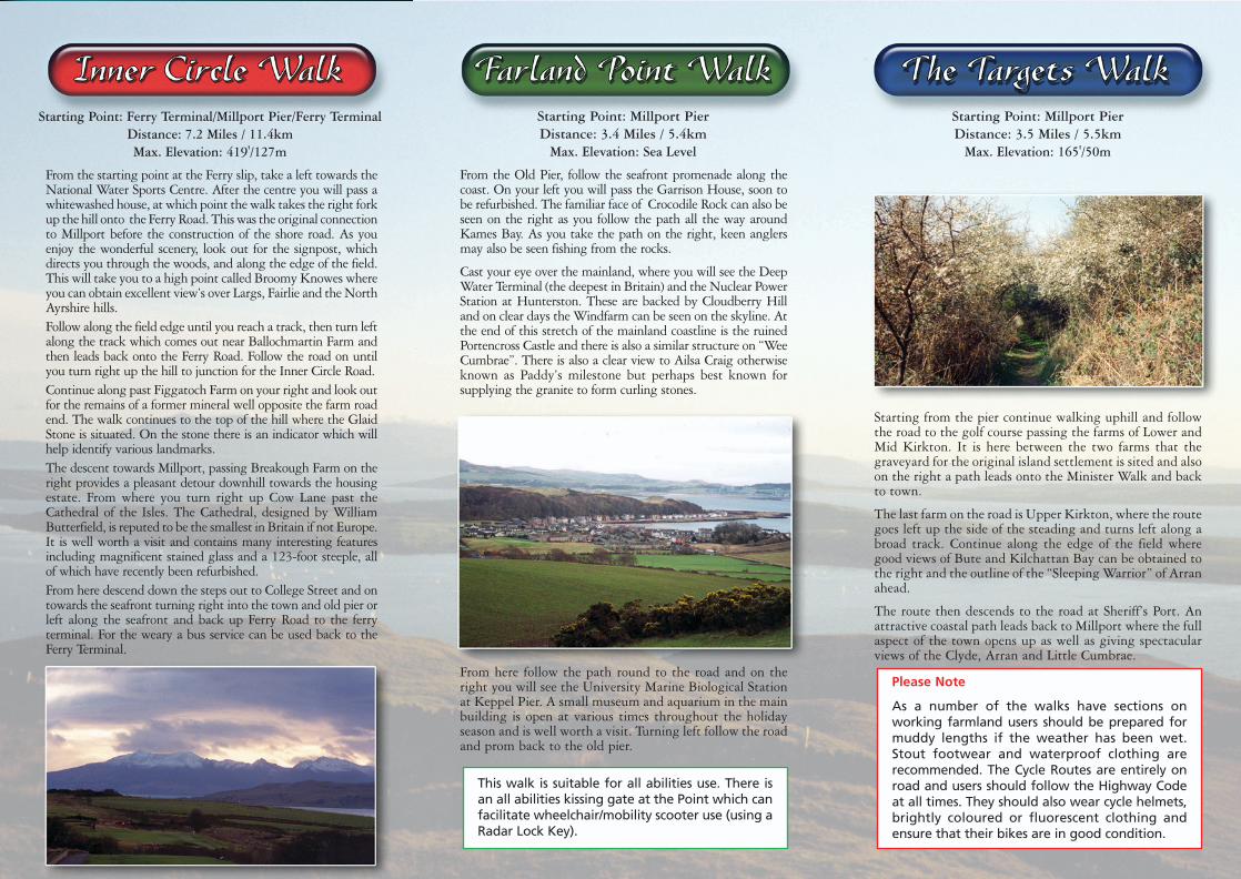
Starting Point: Millport PierDistance: 3.5 Miles / 5.5km
Max. Elevation: 165'/50m
Starting from the pier continue walking uphill and followthe road to the golf course passing the farms of Lower andMid Kirkton. It is here between the two farms that thegraveyard for the original island settlement is sited and alsoon the right a path leads onto the Minister Walk and backto town.
The last farm on the road is Upper Kirkton, where the routegoes left up the side of the steading and turns left along abroad track. Continue along the edge of the field wheregood views of Bute and Kilchattan Bay can be obtained tothe right and the outline of the “Sleeping Warrior” of Arranahead.
The route then descends to the road at Sheriff’s Port. Anattractive coastal path leads back to Millport where the fullaspect of the town opens up as well as giving spectacularviews of the Clyde, Arran and Little Cumbrae.
www.north-ayrshire.gov.uk/outdooraccess
Know the Code before you go ...Enjoy Scotland’s outdoors - responsibly!Everyone has the right to be on most land and inland water providingthey act responsibly. Your access rights and responsibilities areexplained fully in the Scottish Outdoor Access Code.Whether you’re in the outdoors or managing the outdoors, the keythings are to:• take responsibility for your own actions• respect the interests of other people• care for the environmentFind out more by visiting www.outdooraccess-scotland.comor phoning your local Scottish Natural Heritage office.
Please Note
As a number of the walks have sections on working farmland users should be prepared formuddy lengths if the weather has been wet. Stout footwear and waterproof clothing arerecommended. The Cycle Routes are entirely onroad and users should follow the Highway Codeat all times. They should also wear cycle helmets,brightly coloured or fluorescent clothing andensure that their bikes are in good condition.
This walk is suitable for all abilities use. There isan all abilities kissing gate at the Point which canfacilitate wheelchair/mobility scooter use (using aRadar Lock Key).
The walks in this leaflet are supported by
Starting Point: Millport PierDistance: 4.4 miles / 7.0km
Max. Elevation: 181'/55m
Starting off from the Old Pier, head off up Cardiff Streetkeeping uphill by Golf Road. Just before the car park forthe golf club the route forks left onto the farm road.Skirting the steading the path goes right through a kissinggate and follows the line of the fence as it disappears overthe horizon parallel to the sea.
Spectacular views can be enjoyed from the top of the hilland on the descent. To the left you can see Kilchattan Bayon the Island of Bute and also Mount Stuart the residenceof the Marquess of Bute. Ahead on a clear day, beyond thechimney at Inverkip Power Station and Dunoon can beseen Ben Lomond and the hills surrounding Loch Lomond,whilst to the left are the hills of Argyll and the CowalPeninsula.
The path continues down to the road where a choiceawaits. Either turn right to Fintry Bay for a picnic withon a good day a pleasant swim off a safe beach. Alternativelyturn left on the footpath and coastal walk back to Millport.
www.ayrshirepaths.org.ukAyr
Brodick
GreatCumbrae
Little Cumbrae
Irvine
Firth ofClyde
Paisley
Greenock
Largs
Millport
Glasgow
Starting Point: Ferry Terminal/Millport Pier/Ferry TerminalDistance: 7.2 Miles / 11.4kmMax. Elevation: 419'/127m
From the starting point at the Ferry slip, take a left towards theNational Water Sports Centre. After the centre you will pass awhitewashed house, at which point the walk takes the right forkup the hill onto the Ferry Road. This was the original connectionto Millport before the construction of the shore road. As youenjoy the wonderful scenery, look out for the signpost, whichdirects you through the woods, and along the edge of the field.This will take you to a high point called Broomy Knowes whereyou can obtain excellent view’s over Largs, Fairlie and the NorthAyrshire hills. Follow along the field edge until you reach a track, then turn leftalong the track which comes out near Ballochmartin Farm andthen leads back onto the Ferry Road. Follow the road on untilyou turn right up the hill to junction for the Inner Circle Road.Continue along past Figgatoch Farm on your right and look outfor the remains of a former mineral well opposite the farm roadend. The walk continues to the top of the hill where the GlaidStone is situated. On the stone there is an indicator which willhelp identify various landmarks.The descent towards Millport, passing Breakough Farm on theright provides a pleasant detour downhill towards the housingestate. From where you turn right up Cow Lane past theCathedral of the Isles. The Cathedral, designed by WilliamButterfield, is reputed to be the smallest in Britain if not Europe.It is well worth a visit and contains many interesting featuresincluding magnificent stained glass and a 123-foot steeple, allof which have recently been refurbished. From here descend down the steps out to College Street and ontowards the seafront turning right into the town and old pier orleft along the seafront and back up Ferry Road to the ferryterminal. For the weary a bus service can be used back to theFerry Terminal.
Starting Point: Millport PierDistance: 3.4 Miles / 5.4km
Max. Elevation: Sea Level
From the Old Pier, follow the seafront promenade along thecoast. On your left you will pass the Garrison House, soon tobe refurbished. The familiar face of Crocodile Rock can also beseen on the right as you follow the path all the way aroundKames Bay. As you take the path on the right, keen anglersmay also be seen fishing from the rocks.
Cast your eye over the mainland, where you will see the DeepWater Terminal (the deepest in Britain) and the Nuclear PowerStation at Hunterston. These are backed by Cloudberry Hilland on clear days the Windfarm can be seen on the skyline. Atthe end of this stretch of the mainland coastline is the ruinedPortencross Castle and there is also a similar structure on “WeeCumbrae”. There is also a clear view to Ailsa Craig otherwiseknown as Paddy’s milestone but perhaps best known forsupplying the granite to form curling stones.
From here follow the path round to the road and on theright you will see the University Marine Biological Stationat Keppel Pier. A small museum and aquarium in the mainbuilding is open at various times throughout the holidayseason and is well worth a visit. Turning left follow the roadand prom back to the old pier.
Starting Point: Millport PierDistance: 3.5 Miles / 5.5km
Max. Elevation: 165'/50m
Starting from the pier continue walking uphill and followthe road to the golf course passing the farms of Lower andMid Kirkton. It is here between the two farms that thegraveyard for the original island settlement is sited and alsoon the right a path leads onto the Minister Walk and backto town.
The last farm on the road is Upper Kirkton, where the routegoes left up the side of the steading and turns left along abroad track. Continue along the edge of the field wheregood views of Bute and Kilchattan Bay can be obtained tothe right and the outline of the “Sleeping Warrior” of Arranahead.
The route then descends to the road at Sheriff’s Port. Anattractive coastal path leads back to Millport where the fullaspect of the town opens up as well as giving spectacularviews of the Clyde, Arran and Little Cumbrae.
www.north-ayrshire.gov.uk/outdooraccess
Know the Code before you go ...Enjoy Scotland’s outdoors - responsibly!Everyone has the right to be on most land and inland water providingthey act responsibly. Your access rights and responsibilities areexplained fully in the Scottish Outdoor Access Code.Whether you’re in the outdoors or managing the outdoors, the keythings are to:• take responsibility for your own actions• respect the interests of other people• care for the environmentFind out more by visiting www.outdooraccess-scotland.comor phoning your local Scottish Natural Heritage office.
Please Note
As a number of the walks have sections on working farmland users should be prepared formuddy lengths if the weather has been wet. Stout footwear and waterproof clothing arerecommended. The Cycle Routes are entirely onroad and users should follow the Highway Codeat all times. They should also wear cycle helmets,brightly coloured or fluorescent clothing andensure that their bikes are in good condition.
This walk is suitable for all abilities use. There isan all abilities kissing gate at the Point which canfacilitate wheelchair/mobility scooter use (using aRadar Lock Key).
The walks in this leaflet are supported by

Millport Bay
Millport Pier
Farland Point
Fintry Bay
Tea Room
Curling Pond
UpperKirkton
100
200
MidKirkton
Glaid Stone
Indian’sFace
MineralWell
Broomy Knowes
FarlandHills
NationalWatersportsCentre
Tomont End& Monument
FerrySlip
WishingWell
LionRockCrocodile
Rock
Palm TreeView
GarrisonHouse
BreakoughFarm
Cathedral
Boatyard
Sheriff’sPort
Forces’Memorial
MarineBiologicalStation
Millport
GreatCumbrae
Island
Inner Circle Walk
Farland Point Walk
Targets Walk
Fintry Bay Walk
Cumbrae Cycle RouteRound IslandInner Circle to Glaid Stone(On road)
Ballochmartin
Portrye
FiggatochFarm
Local Area KnowledgeFrank Corcoran and JRD Campbell
PhotographyFrank Corcoran and David Gray
More detailed map informationcan be obtained fromORDNANCE SURVEY
LANDRANGER SERIES No. 70EXPLORER SERIES No. 341
N